GEOLOGY 408/508 FORMATION OF SOILS FROM PARENT MATERIALS...
30
CHAPTER 2 Brady & Weil, Rev. 14th ed. GEOLOGY 408/508 FORMATION OF SOILS FROM PARENT MATERIALS
Transcript of GEOLOGY 408/508 FORMATION OF SOILS FROM PARENT MATERIALS...

CHAPTER 2
Brady & Weil, Rev. 14th ed.
GEOLOGY 408/508
FORMATION OF SOILSFROM
PARENT MATERIALS

Weathering is the physical and chemical breakdown of particles
Rock classes:
Igneous - formed from cooled magma- comprised of primary minerals- basalt, granite, gabbro, diorite, peridotite
Sedimentary - compacted, cemented, weathered particles - sandstones, shales, limestones
Metamorphic - altered by heat and/or pressure- gneiss, schist, marble, slate, quartzite
WEATHERING OF ROCKS & MINERALS

THE ROCK CYCLE

IGNEOUS ROCK CLASSIFICATION

Temperature - heating and cooling cause alternate expansion and contraction of minerals- differential expansion causes physical stress- exfoliation - peeling of layers of rock- ice formation
Abrasion by Water, Ice, & Wind-stream load- glaciers- windblown sand and dust
Plants & Animals (minor effects)- force of plant roots- burrowing animals
PHYSICAL WEATHERING (DISINTEGRATION)

Hydration - binding of water molecules
5Fe2O3 + 9H2O → Fe10O15 • 9H2O hematite ferrihydrite
CaSO4 + 2H2O → CaSO4 • 2H2O anhydrite gypsum
Hydrolysis - splitting of water molecule, reaction of H+
or OH- with mineral
KALSi3O8 + HOH ⇔ HALSi3O8 + K+ + OH-
microcline
2HAlSi3O8 + 11HOH ⇔ Al2O3 + 6H4SiO4 (solution)
CHEMICAL WEATHERING (DECOMPOSITION)

Dissolution - solubilization
CaSO4 • 2H2O →dissolution→ Ca+2 + SO4-2 + 4H2O
Carbonation and Other Reactions
CO2 + H2O →← H2CO3
H2CO3 →dissociation← H+ + HCO3-
H2CO3 + CaCO3 →carbonation← Ca+2 + 2HCO3-
CHEMICAL WEATHERING (DECOMPOSITION)

Oxidation-Reduction - loss/gain of electrons:
4FeO + O2 + 2H2O →oxidation← 4FeOOHreduction
2FeS2 + 7.5O2 + H2O → 2Fe+3 + 4SO4-2 + 2H+
(H2SO4)
Complexation - inorganic/organic complexes:
K2[Si6Al2]Al4O20(OH)4 + 6 C2H4O2 + 8H2O →
2K+ + 8OH- + 6C2H4Al+ + 6Si(OH)40
CHEMICAL WEATHERING (DECOMPOSITION)
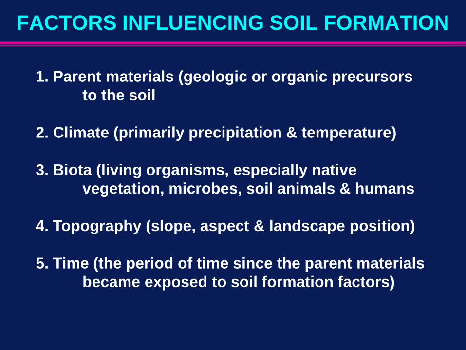
1. Parent materials (geologic or organic precursors to the soil
2. Climate (primarily precipitation & temperature)
3. Biota (living organisms, especially native vegetation, microbes, soil animals & humans
4. Topography (slope, aspect & landscape position)
5. Time (the period of time since the parent materials became exposed to soil formation factors)
FACTORS INFLUENCING SOIL FORMATION

How various kinds of parent material are formed, transported, and deposited. (FIGURE. 2.10)
Classification:
PARENT MATERIALS
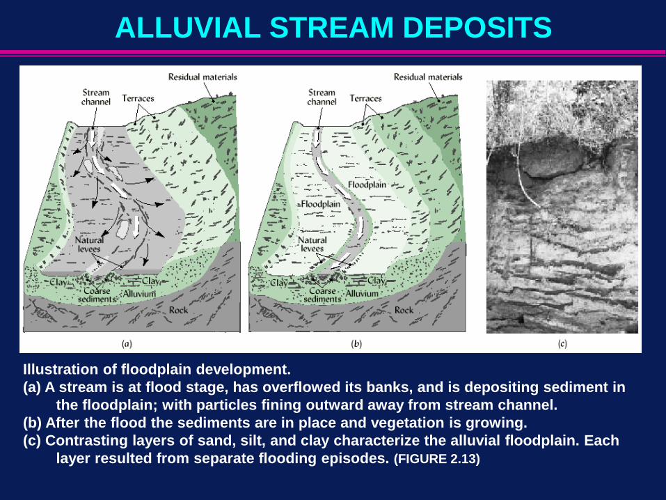
Illustration of floodplain development. (a) A stream is at flood stage, has overflowed its banks, and is depositing sediment in
the floodplain; with particles fining outward away from stream channel. (b) After the flood the sediments are in place and vegetation is growing.(c) Contrasting layers of sand, silt, and clay characterize the alluvial floodplain. Each
layer resulted from separate flooding episodes. (FIGURE 2.13)
ALLUVIAL STREAM DEPOSITS

DEPOSITIONAL ENVIRONMENTS
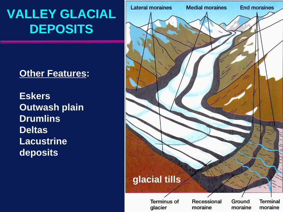
glacial tills
Other Features:
EskersOutwash plainDrumlinsDeltasLacustrine deposits
VALLEY GLACIAL DEPOSITS

Dune sand: found along coastlines and in deserts
Loess: primarily silt with some clay and very fine sand
Aerosolic dust: very fine particles (≈1-10 µm); travel thousands of km; significant for CaCO3 transport
Volcanic ash: cinders near volcano; ash downwind
PARENT MATERIALS TRANSPORTED BY WIND

LOESS DEPOSITS IN THE US

Peat - unconsolidated material consisting largely of undecomposed or slightly decomposed organic matter
Types of Peat Materials:
1. Moss peat - remains of mosses such as sphagnum
2. Herbaceous peat - residues of herbaceous plants such as sedges, reeds a & cattails
3. Woody peat - remains of woody plants
4. Sedimentary peat - remains of aquatic plants & animals
ORGANIC DEPOSITS

Stages in the development of a typical woody peat bog and the area after clearing and draining.
(a) Nutrient runoff from the surrounding uplands encourages aquatic plant growth, especially around the pond edges.
(b, c) Organic debris fills in the bottom of the pond.
(d) Eventually trees cover the entire area.
(e) If the land is cleared and a drainage system installed, the area becomes a most productive muck soil. (FIGURE 2.22)

Climate is probably the most influential of the four factors acting on parent material - determines nature and intensity of weathering
Effective precipitation - amount that enters and percolates downward through the profile [See Box 2.1]
Temperature - for every 10˚ rise in temperature, rates of biochemical reactions more than double
Temperature & moisture both influence plant growth, OM content of soils
CLIMATE

A generalized illustration of the effects of two climatic variables,temperature and precipitation, on the depths of regolith weathered in bedrock.
(FIGURE 2.24)
EFFECTS OF TEMPERATURE & VEGETATION

(FIGURE 2.26)
VEGETATIONALINFLUENCES
ON SOILDEVELOPMENT

Conifers:- low nutr. req’mts- uptake low- leaf decomp slow
Deciduous:- higher nutr. Req’mt- higher uptake- leaf decomp fast
NUTRIENT CYCLING
CONIFER VSDECIDUOUSVEGETATION

Topography influences soil properties, including soil depth. The diagram on the left shows the effect of slope on the profile characteristics and the depth of a soil on which forest trees are the natural vegetation. The photo on the right illustrates the same principle under grassland vegetation. (FIGURE 2.32)
TOPOGRAPHY

An interaction of topography and parent material as factors of soil formation. (FIGURE 2.33)
TOPOGRAPHY & PARENT MATERIAL INTERACTION

(Figure 2.34)
SOIL DEVELOPMENT OVER TIME FROM IGNEOUS ROCK

Interaction of Factors of Soil Formation
Parent material, topography, climate, and organisms (vegetation and animals) do not act independently. Their effects are highly interactive. The influence of each factor shown is modified by the length of time it has been acting, although time as a soil-forming factor is not shown here. [Adapted from Monger et al. (2005)] (FIGURE 2.35)

A schematic illustration of additions, losses, translocations, and transformations as the fundamental processes driving soil-profile development. (FIGURE 2.36)
PROFILE PROCESSES
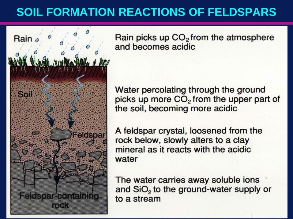
SOIL FORMATION REACTIONS OF FELDSPARS

(FIGURE 2.37)
SOIL FORMING PROCESSES IN ACTION

Hypothetical mineral soil profile showing the major horizons that may be present in a well-drained soil in the temperate humid region.
Any particular profile may exhibit only some of these horizons, and the relative depths vary. In addition, however, a soil profile may exhibit more detailed sub-horizons than indicated here.
The solum includes the A, E, and B horizons plus some cemented layers of the C horizon.
(FIGURE 2.40)

Notable Features:
•Young soil• Multiple layers of PM• Buried soil
(Figure 2.42)
Atlantic Coastal PlainAlluvial Soil