British Columbia Geological Survey Geological Fieldwork 2003

92
Table 5.1 - Geological history
GEOLOGICAL PERIOD
TIME SCALE (Million yrs)
MAJOR EVENTS MAP UNIT
Quaternary 0 Formation of river/creek terraces Qa
Deposition of unconsolidated clays, sand and gravels from Loddon and Campaspe Rivers, forming Riverine Plain
Qap
Olivine basalt flow at end of Tertiary and beginning of Quaternary periods
Qb
Formation of hill wash, fan deposits at end of Tertiary and beginning of Quaternary periods
Tf
Tertiary 1.8 Deposition of highly siliceous sediments in Epsom valley.
Formation and deposition of ironstone gravels in Leichardt area.
Ts
Cretaceous 65 No rock formation. Gradual erosion of Ordovician rock, exposing granodiorite and the metamorphic aureole (Big Hill Range)
Devonian 367 Upwelling of an acid igneous batholith; the Harcourt Granodiorite.
Metamorphism of adjacent Ordovician rock, producing hornfels, slate and quartzite
D
Silurian 416 No rock formation
Ordovician 448 Formation of thinly bedded shale and mudstone interbedded with quartz rich sandstones. Strata folded, faulted and uplifted to produce a NS strike
Os
Cambrian 509675
Marine depositional basin with some active volcanism

5. DESCRIPTION OF THE ENVIRONMENT
5.1 Geomorphology
The Marong Rural City study area comprises a number of geomorphological types including sedimentary hills, granodiorite hills, basalt and alluvial plains, and Tertiary deposits. The varying geologies and landform developments of each type have produced a terrain dominated by very gentle to gentle topography and low relief. For a geological history refer Table 5.1.
The highest point of elevation in the area is 417 m at Big Hill in the south-east corner. From this point elevation decreases gradually to 300 m in the south, 160 min the west and less than 120 m in the north (Figure 5.1). The majority of the study area lies within the Loddon River catchment. A small area in the north-east, including Bendigo outskirts, drains into the Campaspe River.
For the discussion of geomorphology, terrain has been classified according to the method used in McDonald et al (1984). (Table 5.2)
5.1.1 Sedimentary gently undulating
he Ordovician sedimentary terrain is common
rests usually have a cover of surface stone
rises/rolling low hills
Tand characteristic of the Bendigo Region. It covers 35.3% of the study area. Being the oldest rock type in the area, it is highly weathered and consequently consists mainly of gently undulating rises and rolling low hills (Figure 5.1). The rolling low hills generally occur in the west of the area close to Bendigo and have side slopes ranging mainly between 3 and 10%. There are a few occurrences of slopes greater than 10%. The undulating rises have side slopes between 1 and 3%. They usually occur on the outer margins of the sedimentary terrain, for instance in the north towards Raywood and in the east.
Cfragments and at higher relief sedimentary beds often outcrop. The beds are a mixture of resistant sandstone and softer mudstone with the former often outcropping and the later eroding to form stream channels. The strike of the steeply dipping beds runs north-south and this influences the direction of the drainage pattern.
igure 5.2 - Sedimentary rolling low hills F
93

Figure 5.1 - Rural City of Marong cross section
94

95
Table 5.2 - Simple types of erosion landform pattern characterised by relief and modal slope
Relief LE Level < 1% (About
1:300)
Modalterrain VG Very gently
inclined 1%-3%
(About 2%)
slopeGE
Gentle inclined 3%-10%
(About 6%)
MOModerately
inclined 10%-32%
(About 20%)
STSteep
32%-56% (About 40%)
VSVery steep 56%-100%
(About 70%)
PRPrecipitous
> 100% (About150%)
Very high > 300 m (About 500 m)
- - - RMRollingmountains
SMSteepmountains
VMVery steep mountains
PMPrecipitousmountains
High90-300 m (About 150 m)
- - UHUndulatinghills
RHRollinghills
SHSteephills
VHVery steep hills
PHPrecipitoushills
Low 30-90 m (About 50 m)
- - ULUndulatinglow hills
RLRollinglow hills
SLSteeplow hills
VLVery steep low hills
BBadlands
Very low 9-30 m (About 15 m)
- GRGently undulatingrises
URUndulatingrises
RRRollingrises
SR
Steeprises
BBadlands
BBadlands
Extremely low
< 9 m
(About 5 m)
LPLevel Plain
GP Gently Undulatingplain
UPUndulatingplain
RPRollingplain
BBadlands
BBadlands
BBadlands
Source: McDonald et al (1984)
5.1.2 Sedimentary rolling hills
Along the southern margin of the sedimentary rises/low hills is a metamorphic aureole ridge, now known as Big Hill Range (Figure 5.3). This ridge was produced as a result of contact between the existing sedimentary-country rock and the upwelling granodiorite batholith. Subsequent erosion has removed the overlying sedimentary rock to expose the harder metamorphic rock of hornfels, slate and quartzite.
The landscape is classified as rolling low hills/hills and is characterised by moderate to steep slopes, (10-35%), high relief and narrow, rocky ridges. The metamorphic aureole is only a small component of the study area, approximately 1%, but because of its relatively high elevation, is important in terms of drainage, erosion and potential recharge to the groundwater system.
5.1.3 Granodiorite undulating rises/low hills/rolling hills
The Devonian Harcourt granitic batholith in the south-east corner of the study area has been deeply weathered and eroded to form extensive, gentle and mainly rock free slopes; undulating rises (Figure 5.4), and less common steeper hills with abundant rock outcrop (Figure 5.5). In the gentler terrain, slopes range mostly between 3 and 10% while in the rolling hills side slopes can reach 32%. As with other granitic areas, slopes are characteristically convex. The granodiorite landscape is approximately 9% of the area.

Figure 5.3 - Metamorphic aureole
Figure 5.4 - Granodiorite undulating rises
Figure 5.5 - Granodiorite rocky hill
96

5.1.4 Tertiary sediments gently undulating rises
The Tertiary sediments in Leichardt and Epsom are a minor component of the study area, covering only 1743 ha or approximately 1% of the area. Being relatively recent deposits, they are low lying and gently undulating with slopes no greater than 3%.
During the Tertiary period ferruginisation and laterisation of clays produced hard, shelf like deposits. These deposits were then weathered, eroded and redeposited in the Leichardt area as gravels.
The siliceous Epsom sediments were transported from the highlands in the south and deposited in low lying valleys.
5.1.5 Tertiary fans gently undulating rises/undulating low hills/undulating hills
On the southern slopes of Big Hill Range, overlying the granodiorite, fans have formed as a result of surface wash off the metamorphic aureole (Figure 5.6). The majority of these fans are undulating hills with slopes ranging between 3 and 10% and relief greater than 90 m, a small area has slopes between 10 and 32%.
Fans originating from sedimentary low hills overly the very eastern part of the granodiorite. These undulating rises and low hills have slopes ranging from 2% to 9%.
Figure 5.6 - Gently sloping fans of the metamorphic aureole
5.1.7 Alluvial plain
he alluvial plain extends across the northern
5.1.8 Alluvial terraces
arrow, level terraces occur alongside major
5.1.6 Basaltic undulating plain
A tongue of basalt runs from its eruption point, Bald Hill in the centre of the study area, north-west to Bridgewater. The Quaternary lava flow was fast and shallow and consequently travelled a long distance to cover approximately 9,450 ha or 6.5% of the study area. The resultant landform is a very gently undulating plain with slopes averaging 2%, and a cone with side slopes between 5 and 20% (Figure 5.7).
The lava followed the original valley of the Loddon River and consequently overlies stream gravels now known as the Loddon Deep Lead system. The River was forced to its current position, west of the flow.
As the basalt is young geologically and relatively resistant to weathering, it remains largely in its original form and surface rock is common (Figure 5.8). Swamps have formed in the lower parts of the landscape (Figure 5.9).
Tthird of the study area (Figure 5.10). This plain is part of the extensive Riverine Plain formed by flooding of the Loddon and Campaspe Rivers in the Quaternary Period. It slopes very gently down to the Murray River. The plain is generally featureless except for occasional swamps and when it enters narrow valleys it becomes gently undulating. It covers approximately 47% of the study area.
Ncreeks, including the Bendigo and Bullock Creeks, and the Loddon River (Figure 5.11). These terraces have been formed by overbank stream flow but are no longer active because deepening of the stream channel has reduced the frequency of flooding. The source of parent material for each terrace will vary depending on the geology of the surrounding catchment. Terraces are only a small component of the study area but are significant because of their fertile soils, their proximity to streams and their unique characteristics.
97

Figure 5.7 - Bald Hill basalt cone
Figure 5.8 - Rock outcrop on the basalt plain
Figure 5.9 - Basalt swamp
98

Figure 5.10 - Alluvial plain
Figure 5.11 - Bullock Creek Terrace
Uniform soils: Soil profiles with very little, if any, textural change with depth 5.2 Soils Gradational soils: Soil profiles that become increasingly finer textured (greater clay content) with depth.
Soil development is dependent upon a number of interrelating factors which include parent material, topography, vegetation, climate and time. The many soil types in the Rural City of Marong reflect the variations in these factors. Schoknecht (1988), described the major soil types occurring within each land system in the area whereas this report identifies the specific location of each of these soils and describes their properties in detail.
Duplex soils: Soil profiles that have a clearly pronounced texture contrast between the A and B horizons.
5.2.1 Sedimentary gently undulating rises/rolling low hills/rolling hills
Four major soil types occur on the sedimentary rock; red duplex, yellow duplex, uniform barns and gradational soils.
In this chapter the soils are discussed in general terms and have been grouped into the geomorphic units already described in the preceding chapter. More detailed descriptions of the soils and their corresponding map units are provided in Section 4.2.
Red duplex soilsFactual Key: Dr2.33 Map Units: Oaf, Ose, Osc Plate: 1.
The soil types have been described and categorised, into three major groups, according to the method of Northcote (1979).
The most common soils occurring on country of sedimentary origin are red duplex soils consisting of fine sandy loam top soils, sporadically bleached, hardsetting A2 horizons
99

and an abrupt change to sodic, medium-heavy, whole coloured red clay subsoils. They occur on slopes ranging from 2% to 32% with soil depth decreasing and gravel content increasing with slope increases.
The profiles are moderately deep, with moderate to high nutrient status, alkaline trends and slow permeability rates. These properties give the soils versatility with respect to land use and so are used for broadacre cropping on the gentler slopes.
Yellow duplex soils Factual Key: Dy2.41 Map Unit: Osd Plate: 2.
Yellow duplex soils with sporadically bleached, hardsetting A2 horizons and bright brown clay subsoils occur on the crests of rises and low hills. Depth of the soil profile often varies but is generally shallow and coarse fragments are common throughout. Outcropping bed-rock is likely particularly on the hills and soil permeability is rapid. These soils are most commonly left under native forest, cleared as marginal grazing country or used for residential development because of their inherent low nutrient status, stoniness and shallow depth. On crests of lower relief these undesirable characteristics can be diminished, allowing broadacre cropping.
Factual Key: Dy3.42Map Unit: Osg Plate: 3.
Like many alluvial landforms, the soils in the sedimentary alluvium are variable. The dominant soils are yellow duplex with fine sandy loam top soils, bleached, hardsetting A2 horizons and medium, mottled clay subsoils.
These units are narrow but occur frequently throughout the landscape in a dendritic pattern. When minor in extent these soils are cultivated and cropped with the adjacent sedimentary gentle slopes, but if major then the depth of the channel and wetness limit the soil to native vegetation and grazing use.
Uniform stony loams Factual Key: Uc6.1Map Units: Osa, Osb Plate: 4.
Uniform fine sandy stony foams have developed on the narrow crests of the metamorphic aureole hills and along the very centre of crests on the sedimentary rolling hills. The profile development of these shallow, stony soils is limited to an accumulation of organic matter in the surface and a very weak structure. These
properties cause them to have excessive permeability rates and limit the use of the soils to native forest and grasses and grazing by sheep.
Greyish brown gradational soils Factual Key: Gn4.64 Map Unit: Osc Plate: 5.
Shallow, gravelly and highly permeable greyish brown gradational soils with bleached A2 horizons and acidic trends occur on the moderately sloping upper slopes of the metamorphic aureole hills. These uncommon soils are transitional between the uniform stony foams on the ridges and the red duplex soils on the lower slopes. Although these soils are slightly deeper and more developed than the adjacent crest soils, shallowness of the profile, gravel content, low nutrient status and poor soil structure limit their use to native forest and grazing.
5.2.2 Granodiorite undulating rises/low hills/rolling hills
Within the granodiorite there are two major soil types; uniform coarse sands and yellow duplex soils.
Uniform coarse sandsFactual Key: Ucl.23 Map Units: Dga, Dgb, Dgc Plate: 6.
Shallow coarse sands occur on the granodiorite crests and moderate to steep slopes, usually among outcropping boulders. Profile development is generally limited to an accumulation of organic matter at the surface and a small clay content. These soils are generally only used to support native vegetation and grazing because of their excessive permeability, low water holding capacity, poor soil structure and low nutrient status.
Deeper sands and duplex soils can develop in the less rocky pockets amongst these normally very rocky units.
Factual Key: UcMap Unit: Dgg Plate: 7.
The soils in the granodiorite major drainage lines are very variable. The most common soil type, uniform coarse sands containing clay and silt lenses from different flood periods are mixed with gradational soils and pockets of yellow duplex soils from adjacent slopes.
The flood risk associated with this unit limits its use to native forests and pastures, and sheep
100

101
grazing.
Yellow duplex soilsFactual Key: Dy3.41 Map Units: Dgc, Dgd, Dge, Dgf, Dgg Plate: 8.

Plate 1: Red duplex soil,map units Osc/Ose/Osf
Plate 2: Yellow duplex soil, map unit Osd
Plate 3: Yellow duplex alluvial soil, map unit Osg
Plate 4: Uniform stony loam, map units Osa/Osb
102

Plate 5: Greyish brown gradational soil, map unit Osc
Plate 6: Uniform coarse sand, map units Dga/Dgb/Dgc
Plate 7: Alluvial coarse sands, amp units Dgg
Plate 8: Yellow duplex soil, map units Dgc/Dgd/Dge/Dgf/Dgg
103

104
These yellow duplex soils occur on the gentle crests of lower relief, the very gentle to gentle slopes and occasionally the moderate slopes in the granodiorite. They have sandy loam top soils, bleached, structureless, sandy loam A2 horizons and yellow medium to heavy clay subsoils with abundant red mottles. They are underlain by a siliceous hardpan and have an acidic soil reaction trend. Soil permeability is very slow. Minor drainage lines in these units have similar soil types but are slightly wetter.
In winter and spring a perched water table may exist in the sandy A2 horizon above the relatively impermeable subsoil. While in the drier months the sandy top soil horizons lose water quickly and cause plant growth to cease.
These phenomena, along with poorly structured top soils and low nutrient status, prevent any major cropping enterprises on these soils. They are used mainly for grazing and native vegetation.
5.2.3 Tertiary sediments gently undulating rises
Two very different soil types occur on these sediments; red duplex and yellow duplex.
Red duplex soilsFactual Key: Dr2.13 Map Units: Tsfl, Tsdl, Tsgl Plate: 9
Soils that have developed on Tertiary sediments near Leichardt in the north-west of the area, have brownish black loam top soils and reddish brown medium to heavy clay subsoils that become mottled with depth. The pronounced red colour is a result of a high free ferric oxide content and subsequent mobilisation of iron throughout the profile. Concentrated iron nodules are distributed throughout the profile and calcium carbonate nodules are common at approximately one metre. These nodules are most likely aeolian in nature and part of the "Parna" deposit. The soil has a strong structure and an alkaline soil reaction trend. These properties, in combination with a high nutrient status and gentle slopes, have resulted in the soils being intensively cropped. Soil permeability is very slow.
The drainage lines associated with these sediments are minor and their soil types do not differ significantly from those on the very gentle slopes except that moisture levels are higher. The gentle crests also have similar soils.
Yellow duplex soils Factual Key: Dy3.33 Map Unit: Tsf2 Plate: 10
The Tertiary sediments in the east of the study area, near Epsom, are covered by yellow duplex soils with fine sandy loam top soils, sporadically bleached loam A2 horizons and mottled, yellow brown light clay subsoils. Quartz and ironstone gravels are scattered throughout the profile, and are particularly concentrated in the bleached horizon. Soil reaction trend is alkaline and permeability is slow.
These soils are mainly used for grazing and rural residential blocks because of their close proximity to Bendigo.
5.2.4 Tertiary fans gently undulating rises/undulating low hills/undulating hills
There are two major soil types associated with the Tertiary fans; Red Duplex and Yellow Duplex.
Red duplex soilsFactual Key: Dr2.13 Map Units: TM, Tfel Plate: 11
These red duplex soils have dark reddish brown, silty clay loam top soils and whole coloured, reddish brown medium-heavy clay subsoils that grade into mottled clays with depth. Throughout the profile there is a moderate to strong structure and small amounts of ironstone gravel indicating a high iron content. Calcareous nodules are common below one metre and permeability is very slow.
These soils have been extensively cleared of native vegetation and are used primarily for grazing and cropping.
Yellow duplex soils Factual Key: Dy3.41Map Units: Tfe2, Tfc2
The soils that have developed on these particular colluvial fans contain high percentages of randomly distributed, metamorphic sedimentary fragments. They also have deep, hardsetting and bleached A2 horizons and extensively mottled clay subsoils. The combination of fragments and clay produces a hard, cement like mixture when dry but permeability is moderate.
These soils have been mostly cleared of native vegetation and their main use is now grazing.

Plate 9: Red duplex soil, map units Tsfl/Tsdl/Tsg1
Plate 10: Yellow duplex soil, map unit Tsf2
Plate 11: Red duplex soil, map units Tffl/Tfel
Plate 12: Red duplex soil, map unit Qbf
105

5.2.5 Basaltic undulating plain
The basalt plain has produced four major soil types; red duplex, yellow duplex, red gradational, and shallow, red uniform clay loams.
Red duplex soilsFactual Key: Dr2.13 Map Unit: Qbf Plate: 12
These soils have developed on non-rocky, very gentle slopes across the basalt plain. They are used extensively for cropping because of their deep soil profiles, moderate to strong soil structure and gentle slopes. They have dark reddish brown clay loam top soils which overlie reddish brown heavy clays and bright brown, mottled heavy clays at depth. Calcium carbonate nodules occur deep in the subsoil.
Permeability rates are rapid, possibly because of good soil structure, consequently run-off is low and drainage lines are only minor and have similar soil types. The difference between the two soils is greater development of grey and yellow mottles.
Factual Key: Dr2.11 Map Unit: Qbe
On the lower slopes of the cone occur shallow red duplex soils with dark brown clay loam top soils and red clay subsoils. The soils are well drained but their shallow profile, terrain slope of up to 10% and abundant gravel fragments make cropping marginal.
Yellow duplex soils Factual Key: Dy3.42Map Units: Qbg Plate: 13
Yellow duplex soils have developed in the infrequent low lying swamps of the basalt plain. They consist of grey silty loam top soils, bleached A2 horizons and greyish brown, mottled heavy clay subsoils. Quartz grains that have blown in and deposited in these low lying areas from neighbouring geologies, are found throughout the profile.
Use of these soils is generally limited to native vegetation and grazing by sheep and cattle because of inundation. Some swamps have been drained and levelled in an attempt to establish more intensive land use such as irrigated lucerne and broadacre crops.
Shallow red gradational soils Factual Key: Gn4.12Map Units: Qba, Qbc
The eruption point, Bald Hill, is a lava cone with a scoria summit. On this cone the soils are very shallow and weakly structured, and have silty clay loam top soils and red, light clay subsoils. The subsoils consist of at least 50% scoria fragments.
Detailed analyses were not conducted for these soils because they cover only a small percentage of the study area and their uses are obviously limited. Soil permeability is estimated to be very rapid based on soil profile characteristics.
Red uniform clay loams Factual Key: Um6.43Map Units: Qbd, Qbr Plate: 14
Amongst the basalt rock outcrops are shallow, gravelly, red clay loams with very rapid permeability. Rock outcrops are extensive across the basalt plain and consequently these soils are a common feature. Their use is mainly limited to grazing and native forest and pasture, but in some areas rocks have been removed to allow cultivation and cropping.
5.2.6 Alluvial plain
Two major soil types occur on the very homogeneous alluvial plain; red duplex and yellow brown gradational.
Red duplex soils Factual Key: Dr2.43 Map Units: Qap Plate: 15
Red duplex soils have developed extensively across the alluvial plain. Their distinctive features are bleached, structureless and hardsetting sandy loam A2 horizons overlying reddish brown, whole coloured and moderately structured light clays which become yellowish brown and mottled at depth. Occasionally the bleached horizon is absent, particularly on higher points of the landscape. Underlying the light clays is orange sandy clay loam parent material. This is underlain by an older profile consisting of a reddish brown alkaline medium clay with a few calcium carbonate nodules. Soil permeability is moderate.
These soils are used extensively for cereal cropping mainly because of the flat terrain and deep soil profiles, but the hardsetting nature of the top soils and poor soil structure can produce seedling emergence problems and compaction.
106

107
Yellow brown gradational soils Factual Key: Dy2.22 Map Units: Qag Plate: 16

Plate 13: Yellow duplex soil, map unit Qbg
Plate 14: Red uniform clay loam, map unit Qbd/Qbr
Plate 15: Red duplex soil, map unit Qap Plate 16: Yellow brown gradational soil, map unit Qag
108

Plate 17: Loddon River uniform loam, map unit Qa2
Plate 18: Bullock Creek uniform clay loam/loam, map unit Qa3
109

Swampy drainage depressions on the main alluvial plain contain yellowish brown duplex soils with fine sandy clay loam top soils and whole coloured heavy clay subsoils. The A2 horizon contains ferruginous stains and ironstone gravels indicating the occurrence of waterlogging. Soil reaction trends are neutral.
Because these areas are often inundated with water, land use is usually limited to Red Gum communities and grazing. Attempts have been made to drain and crop these soils.
5.2.7 Alluvial terraces
The soils on alluvial terraces vary considerably from one terrace to the other because of the parent material source from which the terrace was formed, and its age. Four terrace soils exist in the study area; red duplex, uniform loams and uniform clay loams.
Red duplex soils Factual Key: Dr2.21 Map Unit: Qal
These red duplex soils are not common in the study area as they occur only on an intermittent Loddon River terrace near Newbridge. Their alluvial nature means that these soils vary, usually in fine sand and silt content. Generally they have yellow-brown silty to fine sandy loam top soils which overly reddish brown light clays with moderate structure. There are no coarse fragments or mottles in the profile and they are well drained.
The small area of these soils and their close proximity to the river usually limits their uses to grazing, native vegetation and recreation, although they have been used for intensive small acre cropping.
Uniform loams Factual Key: Um6Map Unit: Qa2 Plate: 17
These soils are situated on a very young Loddon River terrace, and consequently have undergone little profile development. They consist of two distinctive layers that represent two periods of deposition. The top layer is a greyish yellow silty loam with a fine sandy influence and obvious depositional
layering. An abrupt boundary separates the two layers. The bottom layer is a brownish grey silty loam which grades into a silty clay. The profile has a neutral reaction trend and a moderate nutrient status. Soil permeability is slow.
Like the previous small terrace, the use of these soils is limited to recreation and grazing.
Uniform clay loams/loams Factual Key: Um/Uc Map Unit: Qa3 Plate: 18
Young alluvial soils occur on the terrace alongside Bullock Creek. A recent deposit of brownish black silty clay loam overlies yellow brown fine sandy loams and bleached clayey sands. The soil structure is weak to massive throughout. Permeability is very rapid.
This land unit is mostly used for recreation because of its picturesque nature and proximity to the creek. It is also used for grazing.
Uniform clay loams Factual Key: UmMap Unit: Qa4
A young terrace of yellow duplex soils is associated with the Bendigo Creek. These soils are very similar to those on the Bullock Creek terrace; weakly structured with high contents of fine sand and silt. A brownish black silty clay loam overlies a yellowish brown loamy sand. Underneath this horizon a yellowish brown silty clay loam changes to a light clay. Permeability rates for this profile is estimated to be rapid.
The extent of this terrace is only minor. It is used principally for grazing.
Uniform clay loams Factual Key: Um5.31Map Unit: Qa5
A large drainage line containing a mix of basaltic and sedimentary alluvium located on the boundaries of these geologies. A shallow dark reddish brown moderately structured loam topsoil overlies massive reddish brown fine sandy clay loams and loams.
110

111
5.3 Climate
The climate in the Rural City of Marong is characterised by warm, dry summers and cool, wet winters: a Mediterranean type climate. Local variation is small. There is higher rainfall in the south east while the northern plains tend to be more arid.
5.3.1 Temperature
January and February are the warmest months with average monthly maximum temperatures greater than 28°C and minima greater than 14°C. July is the coldest month with an average maximum temperature of 12.1°C and minimum of 3.5°C (Table 5.3).
It is generally regarded that plant growth is retarded minima below 6°C. The months of April, May, when temperatures drop below 10°C (Trumble 1939), September and October will also have periods of plant and ceases when below 6°C (Martin and Leonard 1967). growth retardation as their mean minimum temperatures In the Rural City June, July and August are the most limiting periods for plant growth with respect to temperature with average temperatures below 10°C and are below 10°C (Figure 5.12).

Table 5.3 - The mean maximum, minimum and average monthly temperatures for Bendigo
Jan Feb Mar Apr May Jun Jul Aug Sep Oct Nov Dec
Max. 28.9 28.6 25.5 20.7 16.0 13.1 12.1 13.7 16.4 19.8 23.6 26.5
Min. 14.3 14.6 12.7 9.3 6.6 4.4 3.5 4.5 5.9 8.2 10.6 12.6
Av. 21.6 21.6 19.1 15.0 11.3 8.9 7.8 9.1 11.2 14.0 17.1 19.6
Source: Commonwealth Bureau of Meteorology
Figure 5.12 - The mean maximum, minimum and average monthly temperatures for Bendigo
112

5.3.2 Rainfall Table 5.4 - Average monthly and yearly rainfall and number of rain days for Bendigo, Laanecoorie and Raywood
Jan Feb Mar Apr May Jun Jul Aug Sep Oct Nov Dec Total
Bendigo (mm) 34 32 36 42 55 61 56 59 54 53 38 33 553
Rain days 5 4 5 7 10 12 13 13 11 10 7 6 103
Laanecoorie(mm)
26 31 29 32 46 48 48 49 44 45 32 29 459
Rain days 4 4 4 6 8 10 12 12 10 9 6 5 90
Raywood (mm) 26 32 30 32 44 43 45 45 43 40 31 27 438
Rain days 3 3 4 5 7 8 9 9 8 7 5 4 72
Source: Commonwealth Bureau of Meteorology.
Figure 5.13 The average monthly rainfall for selected towns in the Rural City of Marong
The average annual rainfall in the Rural City varies between approximately 550 mm in the south east to less than 450 mm in the north (Table 5.4, Figure 5.13). The western half of the Rural City lies in a slight rainfall shadow and consequently receives less rainfall than the east, approximately 450 mm. The wettest months of the year are May through to October, and the driest December to March. At Laanecoorie and Raywood, most rainfall of the drier months occurs in February. These figures possibly relate to summer thunderstorm activity. Winter rainfall is approximately 170% that of summer rainfall.
5.3.3 Effective rainfall and evapotranspiration
Potential evapotranspiration is an estimate of the amount of moisture that a fully vegetated area can lose by evaporation and transpiration when soil moisture is not limiting. In this study approximations of potential evapotranspiration have been calculated using a modification of Thornwaite's formula (Leeper 1950), and then compared to rainfall figures. The period when rainfall is greater than evapotranspiration is an important factor used to determine the length of the growing season as at this time moisture is not limiting for plant growth.
113

Effective rainfall is that which is left remaining for plant growth after the requirements of evapotranspiration and soil storage have been satisfied. The average soil storage requirement is 100 m.
In the Bendigo area rainfall exceeds evapotranspiration from April/May through to October (Figure 5.14). This is the period when precipitation is not limiting in the growth of annual plants. Perennials and native species are better equipped to access soil stored water outside of this time and consequently can extend their growing season with regards to moisture.
5.3.4 Length of growing season
The length of growing season is determined by combining rainfall and evapotranspiration information, with temperature. The Bendigo region has an average growing season of 5.5 months per year. Between mid April and the beginning of October, average monthly rainfall exceeds evapotranspiration and average monthly temperatures are greater than 6°C. It should be noted, however, that the optimum times for plant growth are in April/May and September when temperatures are greater than 10°C.
Length of growing season = 12 - No. of months where P (monthly Et > Av. monthly R) > 50% - No. of months where ay. mean monthly temp. < 6°C
where P : Probability Et : Evapotranspiration R : Rainfall
Figure 5.14 The average monthly rainfall and evapotranspiration for Bendigo
5.3.5 Frost
Table 5.5 - The mean maximum, minimum and average frost occurrences for Bendigo
Jan Feb Mar Apr May Jun Jul Aug Sep Oct Nov Dec Av. 0 0 0 0 2 7 9 6 3 0 0 0Max. 0 0 0 3 9 18 17 13 8 3 1 0Min. 0 0 0 0 0 1 2 0 0 0 0 0Source: Commonwealth Bureau of Meteorology
In Bendigo frosts most commonly occur in the winter months, although occurrences have been recorded as early as April and as late as November (Table 5.5). The occurrence of frosts is site specific and when assessing an area in the Rural City for susceptibility, individual factors such as slope, location of windbreaks position in the landscape and vegetation cover should be
considered.
The importance of frost frequency is related to plant growth. Introduced species can experience growth retardation and death under frosts, especially when immature or flowering.
114

5.3.6 Wind
The winds in the Bendigo area may come from any direction, but slightly favour the west. In summer and autumn southerlies, south westerlies and westerlies are slightly more common; in spring southerlies through to north westerlies are slightly more common and in winter, south westerlies and north westerlies are predominant.
Wind direction will have an effect upon which slopes are most susceptible to wind erosion depending on their aspect. For example, a slope with a northerly aspect will be most susceptible to winds from a north
west to north east direction.
Approximately 50% of Bendigo's winds have speeds less than 11 km/hr (Table 5.6). Erosive winds, those with the potential to erode, need to reach speeds greater than 30 km/hr (Lorimer 1985). In the Bendigo area only 9% of winds reach this level with the most frequent strong winds occurring from September to December. In most years, at this time, there is a good ground cover and the soils are moist, therefore wind erosion is likely to be minimal. However if these erosive winds are coupled with light textured, dry and exposed soils which occur in drier years and in drier months, wind erosion is likely to occur.
115
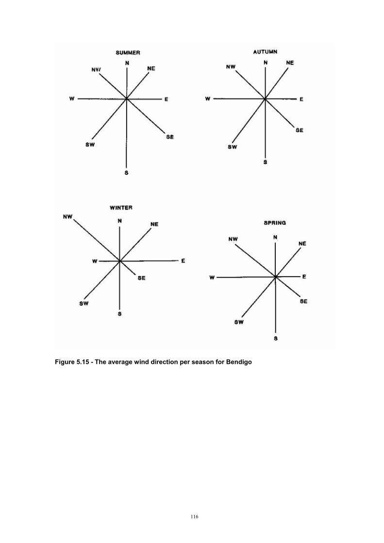
Figure 5.15 - The average wind direction per season for Bendigo
116
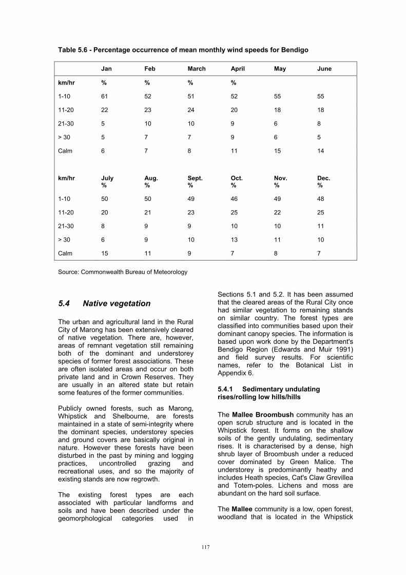
Table 5.6 - Percentage occurrence of mean monthly wind speeds for Bendigo
Jan Feb March April May June
km/hr % % % %
1-10 61 52 51 52 55 55
11-20 22 23 24 20 18 18
21-30 5 10 10 9 6 8
> 30 5 7 7 9 6 5
Calm 6 7 8 11 15 14
km/hr July %
Aug. %
Sept.%
Oct.%
Nov. %
Dec.%
1-10 50 50 49 46 49 48
11-20 20 21 23 25 22 25
21-30 8 9 9 10 10 11
> 30 6 9 10 13 11 10
Calm 15 11 9 7 8 7
Source: Commonwealth Bureau of Meteorology
5.4 Native vegetation
The urban and agricultural land in the Rural City of Marong has been extensively cleared of native vegetation. There are, however, areas of remnant vegetation still remaining both of the dominant and understorey species of former forest associations. These are often isolated areas and occur on both private land and in Crown Reserves. They are usually in an altered state but retain some features of the former communities.
Publicly owned forests, such as Marong, Whipstick and Shelbourne, are forests maintained in a state of semi-integrity where the dominant species, understorey species and ground covers are basically original in nature. However these forests have been disturbed in the past by mining and logging practices, uncontrolled grazing and recreational uses, and so the majority of existing stands are now regrowth.
The existing forest types are each associated with particular landforms and soils and have been described under the geomorphological categories used in
Sections 5.1 and 5.2. It has been assumed that the cleared areas of the Rural City once had similar vegetation to remaining stands on similar country. The forest types are classified into communities based upon their dominant canopy species. The information is based upon work done by the Department's Bendigo Region (Edwards and Muir 1991) and field survey results. For scientific names, refer to the Botanical List in Appendix 6.
5.4.1 Sedimentary undulating rises/rolling low hills/hills
The Mallee Broombush community has an open scrub structure and is located in the Whipstick forest. It forms on the shallow soils of the gently undulating, sedimentary rises. It is characterised by a dense, high shrub layer of Broombush under a reduced cover dominated by Green Malice. The understorey is predominantly heathy and includes Heath species, Cat's Claw Grevillea and Totem-poles. Lichens and moss are abundant on the hard soil surface.
The Mallee community is a low, open forest, woodland that is located in the Whipstick
117
forest. It occurs adjacent to drainage lines and areas of impeded drainage within the gently undulating, sedimentary rises. Because this community exists on soils with higher moisture contents, it has a higher floristic diversity. It is characterised by a well developed shrub layer dominated by Drooping Cassinia (Chinese Scrub) and Gold-dust Wattle. Other dominant species in the community include Bristly Wallaby Grass, Bull Malice and Blue Malice.
The Grey Box - Yellow Gum woodland is scattered throughout the study area in forests and road reserves. It occurs on the duplex soils of the gently undulating sedimentary rises. The dominant canopy species are Grey Box and Yellow Gum. The understorey is dominated by an open shrub layer which contains Drooping Cassinia and Wattle species.
The Box - Ironbark open forest, woodland community occurs on the slopes of the sedimentary gentle rises and low hills. The top storey is dominated by Grey Box and Red Ironbark. Less common species include Red Box, at higher altitudes and drier conditions, Yellow Gum, at lower altitudes, Red Stringybark on the upper slopes and Yellow Box and River Red Gum in the wetter areas. The shrubby, grassy understorey contains Golden Wattle, Drooping Cassinia, Bristly Wallaby Grass, Black-anther Flax-lily and Large Quaking Grass.
Elevated Grey Box woodland exists on the shallow, rocky soils of the metamorphic aureole moderate slopes and crests. The dominant canopy species are Grey Box and Red Stringybark. There is a minimal understorey consisting of Wattle species, and a ground stratum dominated by the herb, Tall Rapswort.
The Grey Box woodland occurs in small, remnant patches on the sedimentary rises in the Leichardt area. It is floristically rich, but like the other communities has suffered disturbance. Grey Box is the dominant species in the upper storey and White Box occurs occasionally. The shrub layer includes Wattle Species, and Drooping Cassinia. The ground cover has a number of distinctive species; Small Flower Mat-lily, Common Eutaxia, Lemon Beauty Heads and Woolly New Holland Daisy. In other locations the understorey is dominantly grassy, containing Large Quaking Grass and Lesser Quaking Grass. In this case the community is referred to as a Dry Schlerophyll forest.
5.4.2 Granodiorite undulating rises/low hills/rolling hills
A Grey Box - Yellow Box woodland occurs across the granodiorite, mostly as remnant patches, roadside reserves and isolated trees. Grey Box is the dominant canopy species. Associated canopy species include Yellow Box on the crests and steeper slopes, River Red Gum in the drainage depressions, and Lightwood throughout. Wallaby Grass is the common understorey species.
5.4.3 Tertiary sediments gently undulatingThe Leichardt Tertiary sediments have been almost totally cleared of native vegetation. Scattered Grey Box and Buloke form the upper storey. The understorey includes Hedge Wattle and Wallaby Grass.
A Grey Box - Yellow Gum woodland exists on the Tertiary sediments near Epsom. The top storey is dominated by Grey Box and Yellow Gum. The shrub layer includes Round-leaf Wattle, Whirrakee Wattle and Drooping Cassinia. Wallaby Grass and Spear Grass dominate the ground stratum. Salt indicator plants, such as Spiny Rush, occasionally occur in the lower parts of the landscape.
5.4.4 Tertiary fans gently undulating rises/undulating low hills/undulating hills
A Grey Box - Yellow Box community exists on these tertiary fans. The upper storey is dominated by Grey Box and Yellow Box with some occurrences of Lightwood and Red Stringybark. The understorey includes Hedge Wattle and Spreading Wattle.
5.4.5 Basaltic and alluvial plains
The Grey Box - Yellow Box - Buloke open woodland, woodland was once a prevalent community across the basalt plains and some of the Riverine Plain. It is now only represented by occasional remnant pockets on farms and road reserves. It is difficult to tell from these areas, the original form of the community. Grey Box is the dominant canopy species in association with Yellow Box and Buloke. River Red Gum occurs in drainage areas. The understorey is predominantly grassy with Wallaby Grass, Kangaroo Grass and Black-anther Flax-lily.
The Black Box community is uncommon in the Shire. It occurs in the northern section of
118

the Riverine Plain along stream sides and on the swampy depression soils above the River Red Gum line.
5.4.6 Alluvial terraces
The floodplain Complex is an open forest, woodland found in scattered remnant patches along river terraces and creeks. River Red Gum is dominant in the canopy layer. The shrub layer is absent and the ground layer is dominated by sedges, grasses and rushes, including Tall Sedge, Quaking Grass species and Prairie Grass. On the Riverine Plain the associated canopy species are Grey Box, and Yellow Box and Yellow Gum in swampy depressions.
5.4.7 Significant areas/species rises
Three roadside areas in the Rural City have been noted by the Department of Conservation and Natural Resources (Robley 1992) as significant remnant vegetation sites.
i) Grey-Box community
Location: approximately 8 km SE of Bridgewater (Map Sheet 7624, Grid Ref. 368669).
It contains good examples of Buloke, a significant species, and native grassland communities.
ii) Yellow Box - Grassland community
Location: north of Woodstock, (Map Sheet 7724, Grid Ref. 352270).
It is a Yellow Box-Grey Box community with a well preserved understorey and significant amounts of Kangaroo Grass, Wattles and other native grasses.
iii) Kangaroo Grass
Location: 6 km NE of Newbridge, (Map Sheet 7624, Grid Ref. 322652).
The site is 4.5 km long and is dominated by Kangaroo Grass with Buloke, Wallaby Grass and an unusual occurrence of Balcarra Grass.
Other significant plant species found in the Rural City include; Ashfeld's Wattle, Whirrrakee Wattle, Shrubby Dampiera, Kamarooka Malice, Sweet Quandong, Spear Grass, Leafy Templetonia and Whipstick
Westringia (Edwards and Muir 1991).
5.5 Land degradation: incidence and susceptibility
The fragile nature of our soils and landscapes, coupled with intensive land use, can result in deterioration of the land resource. In this particular study we look at a soil's potential to resist degradation under different management systems. Some land deterioration processes are natural, such as soil creep, but their rate has been accelerated since European settlement and associated changes in land use. The Rural City of Marong hosts many different uses, as outlined in the Land Use section, and contains a wide variety of landscapes and soils with varying resistance to land degradation. More detailed information on a particular map unit's susceptibility to degradation is outlined in Section 4.2.
5.5.1 Dryland salinity
Dryland salinity is the result of saline ground water reaching the soil surface or plant root zone and affecting plant growth and soil properties. It is caused by excess water infiltrating through the soil profile into the groundwater system. This process is aggravated in areas where native vegetation has been removed and replaced with shallow-rooted species, causing rain water, in excess of plant requirements to run off as surface flow or percolate through the profile to the groundwater table. The ground water level then rises until it reaches the surface at lower points in the landscape.
The areas within the landscape that contribute to the groundwater are known as recharge areas. The areas showing signs of salinity and high watertables are discharge areas. High recharge areas generally have shallow soils which contain a large percentage of coarse material, such as gravel or sand. They usually occur on the higher parts of the landscape such as ridges and crests. Potential recharge refers to the ability of an area to contribute to the groundwater system. Land management has a major influence on recharge to groundwater, for example, an area has a high potential recharge but because of existing dense tree cover, accession to the groundwater is low. However, accession would be high if the trees were replaced with shallow-rooted native pastures.
Contributions to the groundwater system
119

On the adjacent sedimentary slopes, recharge potential is moderate. Clay contents and soil profile depths increase, reducing permeability to 37 mm/day.
can be either on a regional basis; carried through to adjacent subcatchments, or local; within the subcatchment boundary. The Rural City of Marong, with its range of geomorphological types, possesses a number of potentially high recharge areas. Saline discharge occurs at the break of
slope, particularly the sedimentary - alluvial plain boundary. i) Sedimentary rolling hills
iii) Granodiorite undulating rises/rolling low hills/hills
The metamorphic aureole hills have the potential to be major contributors to groundwater recharge and discharge in both the adjacent sedimentary and granite country, if cleared of native vegetation (Figure 5.16). The shallow, rocky soils on the crests and moderate slopes have very rapid permeability rates > 1500 mm/day). Groundwater systems develop in rock fractures with saline discharge possibly occurring in drainage lines and at breaks of slope. In the adjacent sedimentary country, where rock weathering may be minimal, groundwater originating from the aureole can travel up to 10 km (Kevin 1993).
The uniform coarse sands, found at high elevation amongst the granodiorite rock outcrops, have excessive permeabilities, (> 20 000 mm/day). Their contributions to saline discharge, however, are uncertain as freshwater springs and saline discharge occur together in close proximity. Groundwater flows in the weathered zone above the hard unweathered granitic rock. Saline discharge occurs at the break of slope and more often in the drainage lines when the weathered material has a high salt store. When this weathered material is absent, fresh water springs occur (Kevin 1993). The majority of the remaining granodiorite landscape has low recharge potential because it is covered by yellow duplex soils with heavy clay subsoils and slow permeability (10 mm/day).
ii) Sedimentary gently undulating rises/rolling low hills
On the crests of the sedimentary low rises the soils are relatively shallow and rock outcrop can occur therefore permeability rates are greater than 1000 mm/day and potential recharge is high. The underlying weathered rock has a low permeability and confines the groundwater to sub catchments so that local groundwater systems develop (Kevin 1993).
The adjacent metamorphic aureole, Big Hill Range, is thought to be a large contributor to the saline discharge occurring in this granodiorite area.
Figure 5.16 - Cleared metamorphic aureole with outcropping beds
120

iv) Tertiary sediments gently undulating rises
The Leichardt Tertiary sediments have very slow permeabilities, (5 mm/day), and low recharge potential. Any discharge in the area is most likely due to groundwater systems in the underlying sedimentary bedrock.
The Epsom tertiary gravels are also considered to have low recharge potential because of their heavy clay subsoils and slow permeability rates, (29 mm/day). The adjacent sedimentary country could be contributing to any saline discharge occurring at the breaks of slope.
v) Undulating basaltic plains
On the volcanic plain, saline discharge occurs most frequently in low lying areas, such as the swamps, where underlying sedimentary bed-rock is close to the surface. In the Woodstock area, several swamps and depressions overlying the Loddon Deep Lead have become saline. The thinning of the deep lead in this area has most lady produced high groundwater pressures which have impeded drainage from the overlying basalt. Recharge in the basalt then discharges in the low lying areas (Kevin 1993).
High recharge areas in the basalt include the shallow soils amongst the rock outcrop and on the cone itself. Permeability rates are very rapid, (> 2 000 mm/day). Localised groundwater mounds can develop under these points and the fractures in the bed-rock will enable the groundwater flow to cover large distances across the plains. The red duplex soils of the non rocky areas have rapid permeability rates, (> 1 000 mm/day), but they are considered to have only moderate recharge potential because of their high clay contents and deep profiles.
vi) Alluvial plain
The Riverine plain is mainly a low recharge area except for perhaps the small, sandy lenses that have developed on old river beds. There is no obvious discharge on the plain in the Rural City area.
5.5.2 Sheet erosion
Sheet erosion arises when the forces due to rainfall, flowing water and gravity overcome the cohesion and weight of the soil particles. This usually occurs when rainfall exceeds
the infiltration capacity of the soil and run-off results.
The soils most susceptible to sheet erosion have low infiltration capacities, exist on steep slopes, have heavy textures, poor structure and are dispersive, and have minimal vegetation cover. They generally have had a change in land management, for example to cropping and grazing from native vegetation.
Many of the soils in the Rural City of Marong are either moderately or highly susceptible to sheet erosion. Those that are highly susceptible include soils on the metamorphic aureole, the fans developed from the aureole, the sedimentary crests and the basalt cone. The granite slopes are less susceptible because of their light textured topsoils, and the basalt and alluvial plains because of their very gentle slopes.
5.5.3 Gully erosion
Gully erosion is the removal of soil resulting in the formation of channels deeper than 300 mm that will disrupt normal farming operations (Charman and Murphy 1991). Gullies generally evolve in drainage lines where water runoff and seepage accumulates. The lower drainage lines in the catchment are particularly prone as they receive a greater volume of water. Gullies are most common in catchments with moderate to steep slopes and where native vegetation removal is extensive.
In the Rural City, gullies occur in the granodiorite, particularly close to the metamorphic aureole, in the fans off the aureole and in the sedimentary rises. Gully formation is escalated on the sedimentary soils because of their high slaking and dispersion characteristics.
5.5.4 Mass movement
Mass movement occurs when gravitational stresses on soils exceed resistance and the soil moves down slope. Usually a combination of factors will contribute to mass movement. Rock and soil weathering, increases in soil water content, vegetation removal, slope and man made interferences, such as road building, are all important causes.
The incidence of mass movement in the Rural City is low because of low rainfall. The areas most susceptible, however, are those
121

with steep slopes, such as the aureole, and the steeper granodiorite and sedimentary slopes. If these areas experience a combination of tree removal, road construction and excavation and high rainfall, mass movement is possible.
5.5.5 Wind erosion
Wind erosion is the movement of soil particles by wind. It occurs on soils of light texture under conditions of low rainfall and strong winds, and is most extensive on the inland farming areas where rainfall is below 375 mm per annum (Charman and Murphy 1991). In most years the incidence of wind erosion in the Rural City is small as the probability of erosive winds (> 30 km/hr) is low. The granitic soils on exposed crests and steeper slopes, are susceptible because of their light textured top soil. The alluvial plain soils in the north are at risk from wind erosion because of their lower annual rainfall. In drought years, soil removal by wind erosion can be extensive. In 1982-1983, up to SO mm of top soil was removed from specific areas on granitic slopes and the alluvial plain (Schoknecht 1988).
5.5.6 Soil structure decline
Soil structure decline is a result of cropping practices. It costs the State approximately $40 million per annum in lost productivity and unfortunately is difficult to detect and often goes unrecognised. Traditional cultivation techniques, not designed for Australia's weakly structured topsoils, break down soil aggregates into finer particles. These finer particles can slump together forming a seal on the soil surface which impedes the flow of water and air. This reduction in permeability and aeration decreases plant germination and growth, and increases run-off and consequently soil erosion. Excessive cultivation can also produce a hard pan at the bottom of the cultivation layer.
The soils most susceptible to soil structure decline are those with light textured top soils and those that have been in cropping rotations for a number of years. In the Rural City this includes the red duplex soils of the alluvial plain and the sedimentary rises.
5.5.7 Soil acidification
Soil acidification is a land degradation problem that has only been recognised in recent years. It involves declining pH values
to levels low enough to retard plant growth through associated nutritional and microbiological changes (Maheswaran and Crawford 1992). This decline is caused by a number of processes associated with agricultural systems; application of ammonium based fertilisers, large amounts of product removal and nitrate leaching from subclover based pastures.
Soil types most susceptible to soil acidity include those with light textures, low organic matter contents and moderate acidity, and those used for agriculture (Maheswaran and Crawford 1992). Those soils that are naturally strongly acidic are not susceptible to further acidity. Most of the soils in the Rural City are susceptible to acidity, particularly the light textured granodiorite, alluvial plain and aureole fan soils.
5.6 Existing land uses
Past and present land use will provide some indication of the nature of the land. Historically the Rural City of Marong has hosted many uses including agriculture, gold mining, timber harvesting, industry and residential. Relict mullock heaps, Eucalyptus regrowth and old homesteads are all indicators of past uses. Today land use in the area is just as varied.
5.6.1 Public land
The areas of public land in the Rural City of Marong are largely State owned forests with a Box-Ironbark dominance. These areas are interspersed with privately owned land because of the past extent of gold mining and closer settlement. Public land is essentially land that was not utilised for settlement in the past. These areas are used for a number of purposes including forestry, mining, recreation, honey production, eucalyptus oil production, grazing and conservation.
The Whipstick State Park, of 2 400 ha, is located within the Rural City. It is a good example of Box-Ironbark open forest and its special features include the Whipstick Mallee Scrub, spectacular wildflower displays and one of the highest concentrations of songbirds in Australia (Land Conservation Council 1978).
Eaglehawk Regional Park, of 900 ha, is another popular area renowned for its wildflowers, grevilleas and birds.
122

123
5.6.4 Grazing
heep farming is common in the Rural City.
razing licenses are issued for
5.6.5 Cropping
roadacre cropping is a major farm
inimum tillage and direct drilling practices
5.6.2 Forestry
The Bendigo region contains the largest area of hard and durable Box/Ironbark timbers in the state. The Rural City contains a number of forest areas of this type and approximately 2 300 ha are available for harvesting. These forests have been intensively used since settlement, particularly in the mining era when timber was used for mining construction, transport and housing. They have always been harvested for firewood with recent demand increasing towards the pre gas and electricity levels because of the popularity of wood burning heaters. There is also a great demand for timber in the production of railway sleepers and fence posts. All these demands far exceed the supply. The Department of Conservation and Natural Resources is aiming to manage the forest resource so that production of timber is sustainable and the resource is not degraded.
There is no harvesting of softwood in the Rural City.
5.6.3 Mining
In the Bendigo region, mining products are obtained from public and private land. They include hard rock and gravel for road building and sand for concrete production. In the Rural City there is the Shelbourne hard rock quarry of 20 ha.
There is still a great interest in gold mining in this traditional gold-mining region around Bendigo. Prospecting with metal detectors in the forests is a very popular activity with visitors. However there is no mine currently operating in the Rural City.
SWool, mainly Merino or Merino Cross, is produced on native and improved pastures. Cattle raised for veal and beef production are less common. There are small areas of irrigated pasture along the Loddon River to supplement feeding of these animals. A number of deer farms have been established in recent years, particularly around Shelbourne.
Gapproximately a fifth of the Rural City's State Forests and for a high number of unused roads and water frontages. The latter requires a high level of management because of the erosion prone nature of these areas.
Benterprise in the Rural City. It is generally located on the lower sedimentary slopes, the basalt plain and the alluvial plain. Crops frequently grown include wheat, oats, barley, lupins and in later years canola, with wheat still the dominant crop (Figure 5.17).
Mare being promoted by state departments and gradually accepted by farmers in an effort to reduce soil erosion. Fallowing has been all but eliminated. Dryland lucerne and clover based pastures are often harvested to produce hay for fodder conservation (Figure 5.18).
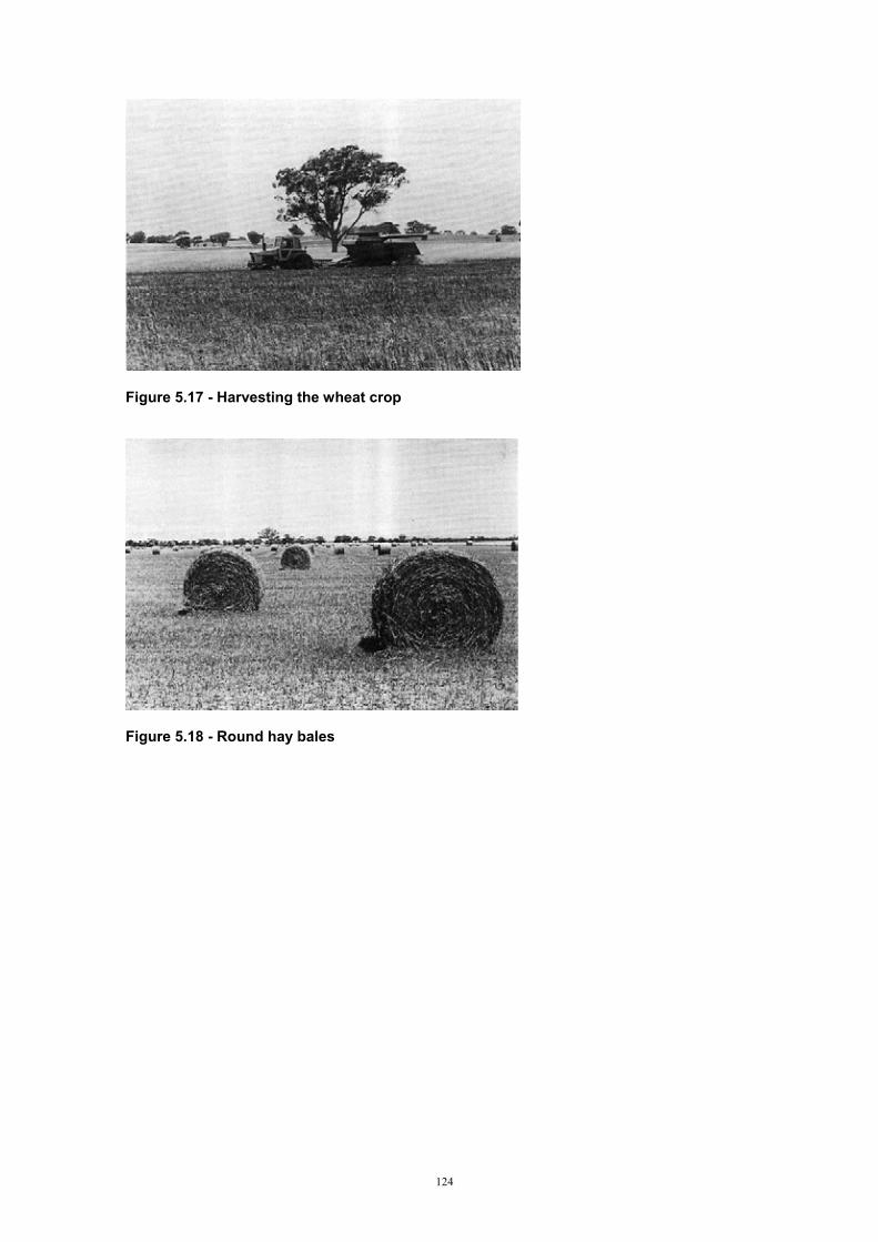
Figure 5.17 - Harvesting the wheat crop
Figure 5.18 - Round hay bales
124

5.6.6 Poultry Due to the increased popularity of chicken meat over the last decade, intensive poultry
fanning in the Rural City has increased. This fanning involves large scale chicken housing and automatic feed systems (Figure 5.19).
Figure 5.19 - Poultry sheds
5.6.7 Viticulture
As with poultry, the growing popularity of vine growing and wine making has increased the number of vineyards in the Bendigo region. There are a number of these small vineyards in the Rural City of Marong.
5.6.8 Recreation
Public land, run by committees of management is used for private recreation activities which include race-courses and community sports grounds. A small proportion of public land is controlled by private persons or clubs under tenure for purposes such as golfing and tennis. The remainder of public land used for recreational purposes is in the form of uncommitted reserves or forest areas designated for future timber production. These areas provide opportunities for picnicking, sight seeing, bush walking, fossicking, hunting, horse riding, trail bike riding and orienteering.
Recreational fishing is important in the Bendigo region and Rural City of Marong. The Loddon River provides fishing opportunities but is limited by low flows and increasing salinity. Laanecoorie Reservoir in the south west corner is also a popular
fishing spot. These water resources are also used for other water sports such as swimming and boating, and their surrounding reserves for picnicking.
5.6.9 Residential development
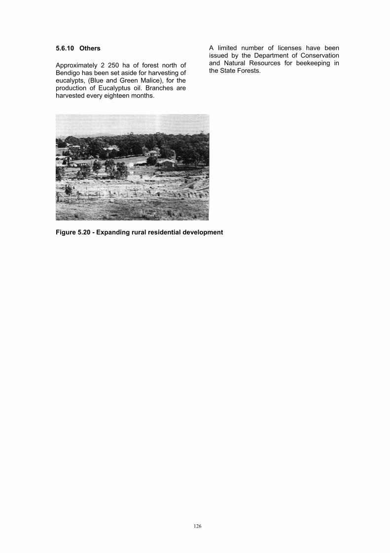
Urban expansion and small lot development is rapidly changing the nature of the land in the zone adjacent to Bendigo, in small towns such as Marong, Laanecoorie, Newbridge, Bridgewater and Lockwood, and in isolated pockets amongst rural land. Large areas of private land and some public land have been converted from their previous uses to residential development to accommodate expansions in the population, and many areas will be converted in the future. Residential development, when not properly managed, can cause land degradation such as erosion and effluent pollution, particularly in high density areas. Sizes of residential blocks range between 0.1 ha to 40 ha.
These extensive changes in land use are a concern to the Rural City because of the services residential areas require, and because of the importance of agriculture, recreation and conservation.
125
5.6.10 Others
Approximately 2 250 ha of forest north of Bendigo has been set aside for harvesting of eucalypts, (Blue and Green Malice), for the production of Eucalyptus oil. Branches are harvested every eighteen months.
A limited number of licenses have been issued by the Department of Conservation and Natural Resources for beekeeping in the State Forests.
Figure 5.20 - Expanding rural residential development
126
5.7 Land systems
The hierarchy of the Land System concept has been maintained in this study. At the broadest level - Land Systems of Victoria - Rowan (1990) identified eleven land systems in the Rural City of Marong at a scale of 1:250,000. At a more-detailed scale (1:100,000) Lorimer and Schoknecht (1987) identified thirteen land systems, which subdivided into a total of 20 land components.
In this study, at a scale of 1:25,000 and 1:50,000, 36 map units have been identified and in Table 5.7, the close relationship between the soils of the two more-detailed studies can be seen. Where clear relationships do not occur, the 1:25,000/1:50,000 land capability study has invariably been able to locate and map more accurately the dominant soil.
127

Table 5.7 - Comparisons of scale and detail in land inventory studies
Landsystems
of Victoria (1:25,000)
(i)
Land systems in the Campaspe River
Catchment(1:100,000) (ii)
Land Inventory of the Loddon
River catchment (1:100,000) (iii)
Map Units in the Rural City of Marong (1:25,000/1.50,000) (iv)
LandSystem
Land System Component Soil LandSystem
Soil Map Unit Soil
Ss54 LHrs Um5.51 Osa Uc6.1 Um5.51
S255 Lu2rs Dy3.21/2 Osb Uc6.1 Um5.51
Gs54 Gn Osc Dr/2.33 Gn4.54
Gs42 Wellsford 1 Gn3.14 RuS Gn3.75 Osd Dy2.41 Dr2.31
2 Dr2.41 Dr2.41 Ose Dr2.33 Dr2.13
3 Dy3.41 Osf D2.33 Dr2.13
Dr3.41
Osg Dy3.42
Gs43 Glenholt 1 Gn3.1, Dr2.41 RgS Dr2.21/2/3 Tsfl/Tsdl/Tsgl D2.13*
Gs46 2 Dr2.41, Dy3.41 D2.11/2/3 Ts12 Dy3.33*
Gs46 3 Dr2.41, D2.112 Gn3, Dy Tfel Dr2.13
Gs53 4 Dy3.41, D2.4 TM Dr2.13
5 Dy3.41 Tfc2 Dy3.41
Tfe2 Dy3.41
Sg5 L/HrG Uc1/5, Dy3.41 Dga Ucl.23 Dy3.41
Dgb Ucl.23 Dy3,41
Dgc Ucl.23 Dy3.41
Gg55 R/LuG Dy3.41, Uc2 Dgd Dy3.41 Uc5.11
Dgc Dy3.41
Dgf Dy3.41
Dgg Uc5.11 Dy3.41
Pvf42 PgB Gn3.12, Um Qbc Gn3.12
Qbc Gn3.12
Qbd Um6.43 Gn3.12
Qbe D2.11
Qbf Dr2.13 Gn3.12
Uf6
Qbg Dy3.42 Uf6
Qbr Um6.43 Gn3.12
Qa5 Um5.31
Pf41 PIAl/Dr2.13/2
Dr2.3 Qap D2.43 D2.12
A3Dr2.23
Ug, Urn Qag Dy2.22 Gn3.92
Runnymede Um1.43 Uf
Qa1 D2.21
PIgA, Dr2.13
D2.22/3 Qa2 Um6.14
Uc/Um Qa3 Um/Uc
Qa4 Um/Uc
* The more-detailed mapping scale has identified areas of different geologies within the land component i) Rowan (1990) ii) Lorimer and Schoknecht (1987) iii) Schoknecht (1988) iv) Bryant and Lorimer (1993)
128