Geological Fieldwork 1978 - British Columbiacmscontent.nrs.gov.bc.ca/geoscience/Publication... ·...
145
Geological Fieldwork 1978 a summary of field ac,tivities of the geological division, mineral resources branch Paper 1979 -1 Province of British Columbia Ministry of Energy, Mines and Petroleum Resources
Transcript of Geological Fieldwork 1978 - British Columbiacmscontent.nrs.gov.bc.ca/geoscience/Publication... ·...

Geological Fieldwork 1978
a summary of field ac,tivities of the geological division, mineral resources branch
Paper 1979 -1
Province of British Columbia Ministry of Energy, Mines and Petroleum Resources

I S N 0381-243X
Victoria British Columbia
Canada
January 1979

FOREWORD
This is the f i f th year of publication of Geological Fieldwork, a publication designed tc. acquaint the interested public with the preliminary results of fieldwork of the Geological Division as soon as possible after completion. The reports are written without the benefit of extensive laboratory or office studies. To speed publication, figures have generally been draughted by the authors.
This edition of Geological Fieldwork has a revised format with three major sections. Project Geology includes reports of metallic and coal field investigations. Applied Geology contains reports of District Geologists and property examinations related to some mineral properties funded in part by Ministry programs. Other Investigations section includes a number of reports by graduate students and professors of geology dealing with studies related to ongoing projectsof the Division.
The cover photograph depicts 1978 fieldwork on Flathead Ridge in the Crowsnest Coalfield.
Technical editing of this publication was done by N. C. Carter and productiom, editing and layout by Rosalyn J. Moir.
A. Sutherland Brown, Chief Geologist,
Geolqlical Division, Mineral Resources Branch.
3

TABLE OF CONTENTS
PROJECT GEOLOGY
METALLIC INVESTIGATIONS
SOUTHEAST BRITISH COLUMBIA
Church, 6. N.: Tertiary Stratigraphy and Resource Potential in South-Central British Columbia . . . . . . . . . . . . . . . . . . . . . . . . . . . . . . . . . .
Hoy. T.: Study of Purcell Supergroup Rocks, Southeastern British Columbia .
Cedar Claims. Galloway . . . . . . . . . . . . . . . . . . . . . . . . . . . . . . Cotton LeadiZinc Deposit . . . . . . . . . . . . . . . . . . . . . . . . , . . .
Hoy. T. and McMillan. W. J.: Geology in the Vicinity of Frenchman Cap Gneiss Dome . , . . . . . .
Preto, V. A,: Barriere Lakes-Adam Plateau Area
SOUTHWEST BRITISH COLUMBIA
Eastwood, G. E. P.: Sicker Project . . . . . . . . . . . . . . . . . . . . . . . . . . . . , . , . . . .
McMillan. V i . J.: Nicola Project-Merritt Area . . . . . . . . . , , , . . . . . , . . . . . . . , .
NORTHWEST BRITISH COLUMBIA
Christopher, P. A,: Logtung . .
Panteleyev, A,: Cassiar Map-Area . . . . . . . . . . . . . . . . . . . . . . , . . . . . . , , . . .
COAL INVESTIGATIONS
Pearson, David E. and Grieve, D. A,: Crowsnest Coalfield . . . . . . . . . . . . . . . . . . . . . . . . . .
Eastwood, G. E. P.: Quinsam Area, Vancouver Island
Karst, R. H.: Coal Property Examinations, Peace River Coalfield . , . . . . . . . . . .
Vitrinite Reflectance as a Correlation Tool in the Carbon Creek Coal Measures . . . . . . . . . . . . . , . , . . . . , , . . . . . . . . , . . , . .
Gilchrist, R. D.: Burnt River Area . . . . . . . . . . . . . . . . . . . . . , , . . . Groundhog Coalfield . . , . . . . . , . . . . . , . , . . , , , . .
7
1 16 6,
19
25
31
38
41
47
51
61
66
67
73
79
84
5

TABLE OF CONTENTS - /Conrinued/
COAL INVESTIGATIONS - (Continued)
Duff, P. McL. D.: Correlation Studies in the Peace River Coalfield . . . . . . . .
STRUCTURAL MATERIAL INVESTIGATION
Hora, 2. D.: Gravel Inventory in the Lower Mainland . . . . . . . . . . . . .
APPLIED GEOLOGY
MINERAL PROPERTY EXAMINATIONS
Addie, G. G.: Southeast British Columbia . . . . . . . . . . . . . . . . . . . . .
Lewis, T. D.: Southern and Southeastern British Columbia . . . . . . . . . .
Klein, G. H.: North-Central and Central British Columbia. . . . . . . . . . .
Schroeter, T. G.: West-Central and Northwest British Columbia . . . . . . . . .
Grove, E. W.: General Review . . . . . . . . . . . . . . . . . . . . . . . . . . . . .
OTHER INVESTIGATIONS
. . . .
. . . .
. . . .
. . . .
. . . .
. . . .
. . . .
Page
. . 86
. . 87
. . 89
. . 92
. . 97
. . 99
. . 109
Sills, T. K.: Geology and Geochemistry of Possible Uranium Source Rocks in the East Okanagan Uranium Area . . . . . . . . . . . . . . . . . . . . . . . 11 1
McMechan, Margaret E.: Geology of the Purcell Supergroup between Wildhorse River and SandCreek . . . . . . . . . . . . . . . . . . . . . . . . . . . . . . . . . . . . . . 113
Ewing, Thomas: Geology of the Kamloops Group . . . . . . . . . . . . . . . . . . . . . . . . 119
Miller, J. H. L. and Sinclair, A. J.: Geology of an Area Including Northair Mines Ltd.'s Callaghan Creek Property. . . . . . . . . . . . . . . . . . . . . . . . . . . . . . . . . . . . 125
Wetherell, D. G., Sinclair, A. J., and Schroeter, T. G.: Preliminary Report on the Sam Goosly Copper-Silver Deposit . . . . . 133
Mesard, P. M., Godwin, C. 1, and Carter, N. C.: Geology of the Poplar Copper-Molybdenum Deposit
Carter, N. C., Kalnins, T. E., and Nordin, G. D.: Reconnaissance Geochemical Survev
139
145
6

P R O J E C T G E O L O G Y
METALLIC INVESTIGATIONS
SOUTHEAST BRITISH COLUMBIA
TERTIARY STRATIGRAPHY AND RESOURCE POTENTIAL
IN SOUTH-CENTRAL BRITISH COLUMBIA
(82 E, L)
By B. N. Church
The interior of British Columbia is characterized by many fault-bounded Tertiary basins filled with felsic lavas and associated fluvial and lacustrine sedimentary rocks reminiscent of the Basin and Rarlge Province of the southern Cordillera. The main volcanic and sedimentary rocks are of Eocene age and lie in a northwesterly trending belt about 160 kilometres wide, extending 800 kilometres northwest from the Republic Mining District in Washington state to the Babine Lake area of central British Columbia. Basal units are often shoestring in plan and valley filling whereas upper formations are mostly sheet-like plateau lavas. Olivine basalt flows of Miocene and Pliocene age frequently overlie the Eocene volcan'c units of acid or intermediate composition.
Current investigation of these rocks has been stimulated by recent uranium discoveries and renewed interest in sub-bituminous coal. Only scattered information is available on the composition, regional stratigraphy, structure, and history of the Tertiary assemblage and it is the purpose of the present study to expand on the existing data.
STRATIGRAPHY
The accompanying table of formations for the Okanagan-Boundary region is based on work performed by the writer intermittently during the period 1963 to 1978, and on detailed reports assembled .for the various Tertiary sections in 1973 and 1975. The areas of special investigation include segments of the Penticton, Kelowna, Vernon, and Rock Creek areas covered by the Uranium Reconnaissance Program in 1976. Approximately 1 200 square kilometres was mapped in the 1977 and 1978field seasonsat 1:50000 scale by way of 145 separate traverses and 2 675 geological stations.
Working laterally from the White Lake area between Keremeos and Penticton, the various Tertiary formations can be followed without much difficulty using stratigraphic subdivisions proposed by the writer in 1967 and 1973. A few new sedimentary units have been recognized in the Marron section but these are only locally important. The Springbrook basal conglomerate is largely missing in the northern part of the area where these rocks are replaced by rhyolite ash and breccia deposits that apwar to lhave had their
7
ldegroot
1978

ZEDCO
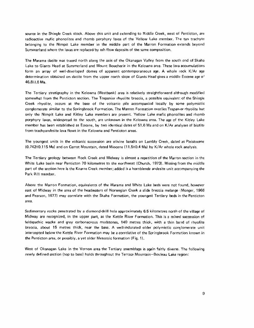
Figure 1. Diamonddrill section of the basal Tertiary units 6.5 kilometres north of Midway
8
source in the Shingle Creek stock. Above this unit and extending to Riddle Creek, west of Penticton, are radioactive mafic phonolites and rhomb porphyry lavas of the Yellow Lake member. The tan trachyte belonging to the Nimpit Lake member in the middle part of the Marron Formation extends beyond Summerland where the lavas are replaced by ash flow deposits of the same composition.
The Marama dacite was traced north along the axis of the Okanagan Valley from the south end of Skaha Lake to Giants Head a t Summerland and Mount Boucherie in the Kelowna area. These lava accumulation!; form an array of well-developed domes of apparent contemporaneous age. A whole rock KlAr agt!
determination obtained on dacite from the upper north slope of Giants Head gives a middle Eocene age o f
46.Bf1.6 Ma.
The Tertiary stratigraphy in the Kelowna (Westbankl area is relatively straightforward although modified somewhat from the Penticton section. The Trepanier rhyolite breccia, a possible equivaleni: of the Shingle Creek rhyolite, occurs a t the base of the volcanic pile accompanied locally by solne polymictic conglomerate similar to the Springbrook Formation. The Marron Formation overliesTrepan,er rhyolite but only the Nimpit Lake and Kitley Lake members are present. Yellow Lake mafic phonolites and rhomb porphyry lavas, widespread to the south, are unknown in the Kelowna area. The age of tile Kitley Laks member has been established as Eocene, by two identical dates of 51.6 Ma and on KIAr analyses of biotite from trachyandesite lava flows in the Kelowna and Penticton areas.
The youngest units in the volcanic succession are olivine basalts on Lambly Creek, dated as Pleistocene (0.742f0.115 Mal and on Carrot Mountain, dated Miocene ( 1 1.5t0.4 Ma) by KIAr whole rock analysis.
The Tertiary geology between Rock Creek and Midway is almost a repetition of the Marrorl section in the White Lake basin near Penticton 70 kilometres to the northwest (Church, 1973). Missing from the middle part of the section here is the Kearns Creek member; added is a hornblende andesite unit acoxnpanying the Park Rill member.
Above the Marron Formation, equivalents of the Marama and White Lake beds were not found. however east of Midway in the area of the headwaters of Norwegian Creek a slide breccia melange (Monger, 1966 and Pearson, 1977) may correlate with the Skaha Formation, the youngest Tertiary beds in the Penticton area.
Sedimentary rocks penetrated by a diamond-drill hole approximately 6.5 kilometres north of the village of Midway are recognized, in the upper part, as the Kettle River Formation. This is a mixecl succession of feldspathic wacke and grey carbonaceous mudstones, 140 metres thick, with a thin balld of rhyolite breccia, about 15 metres thick, near the base. A well-indurated older polymictic conclomerate unit intercepted below the Kettle River Formation may be a correlative of the Springbrook Formation known in the Penticton area, or possibly, a yet older Mesozoic formation (Fig. 1).
West of Okanagan Lake in the Vernon area the Tertiary assemblage is again fairly diverse. The following newly defined section (top to base) holds throughout the Terrace Mountain-Bouleau Lake region:
9

L

TAHAETKUN BASALT is the youngest unit in the section. Feeder dykes and remnants of olivine basal? lava assigned to this formation are found scattered on numerous hillsides and ridge tops.
NASWHlTO CREEK FORMATION consists of a thick succession of mostly dacite lava (about 300 metres thick) exposed extensively in the area drained by the headwaters of Naswhito Creek near Bouleau Lake.
BOULEAU RHYOLITE forms a distinctive marker unit of breccia and glassy lava, 15 to 60 metres thick, viewed mostly on the bluffs north of Bouleau Lake and on the upper slopes of Terrace Mountain.
KITLEY LAKE MEMBER (MARRON FORMATION) occurs as a belt of feldspar porphyry lava and breccia, about 300 metres thick, extending north and south from a Coryell-type stock exposed on Whiteman Creek - a Drobable source vent for these rocks.
ATTENBOROUGH CREEK FORMATION is a widely distributed assemblage of thinly bedded, fine- grained andesite and dacite lavas. A complete section of these rocks, about 450 metres thick, is exposed on Shorts Creek and its tributary Attenborough Creek.
SHORTS CREEK FORMATlON is a wedge of brown and grey fossiliferous sandstones, shales, and coarse polymictic conglomerates (8 to 30 metres thick) exposed a t the base of the Tertiary Section in Shorts Creek canyon.
Correlation of the principal volcano-stratigraphic units much beyond the area of immediate study does not appear to be feasible. There is good evidence that the alkaline volcanic province of the Okanagan" Boundary region, manifest in the Marron Formation, does not extend much beyond the Vernon area on the north and northwest nor the Washington state border on the south and southeast.
STRUCTURE
As indicated by previous studies (Church, 1973, 1975) the Tertiary basins have been influenced during thelr course of development by major normal faults - some of which show vertical disp1acemen.t in the order of several hundreds of metres.
In general, structural control of the Tertiary outliers seems to relate to a herringbone pattern of conjugate shears of northeast and northwest orientation (Fig. 2). These appear to be important elements in a northlsouth stress scheme responsible for the many northerly trending graben structures extending across the interior of the Province from the Fraser River lineament to the Rocky Mountain Trench.
The period 45 to 53 Ma witnessed intense volcanic and tectonic activity, according to Mathews (19641, including major disturbances in the Rocky Mountains. It is interesting to note here that this intervi3l corresponds rather well with the period of northerly movement of the Pacific plate (41 to 55 Ma, Rona,ot a/., 1978).

A
UEDDED ROCKS
LEGEND
MARAMA F DACITE LAVA
UNDIVIDED I;olI;IIII VOLCS
FdlARRON F NIMPIT LAAE MBR
6;3 KITLEY LAKE MBR Fa CLARK BUTTE PORPHYRY YELLOW LAKE MBR (LAVA 8 SEDS)
GRANITE PEBBLE CONGL. 8 KETTLE RIVER F
RHYOLITE
IGNSOUS INTRliiIONS
CORYELL MONZONITE a SYENITE [:-I SHIWGLE CREEK PORPHYRY [m BASEMENT GRANITOIDS
,4 BEDDING
SYMBOLS
- LINEAMENT
0 LAKE
x STREAM
I RADIOACIIYL SEDS IhCLUDED
& ROAD
Figure 3. The Penticton Uranium-Thorium Belt.
12

This coincidence suggests that the same stresses acting on the Pacific plate may have been active in the Cordillera during the Eocene. A complex inter-relationship of shears, tension faults, and folds such as, proposed by Brown (19281 and Illies. et a/., (1976) might also explain the simultaneous development of grabens and thrusting in the southern interior and eastern British Columbia.
URANIUM AND THORIUM IN THE ALKALINE VOLCANIC ROCKS
The Yellow Lake member of the Marron Formation is a major unit near the base of the Tertiary section comprising locally as many as 20 consecutive flows and attaining a thickness of 500 metres in a few places. It underlies approximately 600 square kilometres in the Okanagan-Boundary region (Fig. 2). Source of the lavas i s believed to be the necks and composite stocks of Coryell monzonite. shonkinite, and syenite such a6 exposed near Rock Creek, Riddle Creek, and Allendale Lake.
Particular interest in the Yellow Lake lavas as a source of uranium was aroused when it was mted that thew rocks displayed several times normal background radioactivity. Random testing during the course of the geological survey. using a model GRS-101 Exploranium scintillometer, gave an average reading of 164k32 cps for 127 stations. A few especially high readings, in excess of 1 000 cps, were obtained in the Penticton area.
A suite of 202 samples of Yellow Lake rocks was collected during the geological survey and submitted t o the Government laboratory for quantitative uranium and thorium analyses. The results show a mean composition of 11.15+4.63 ppm uranium and 43.09t9.97 ppm thorium.
The actual presence of mobilized uranium was first detected in water samples by the 1976 Uranium Reconnaissance Program geochemical survey. This showed that lngram Creek, which fallows a strong Tertiary fault lineament near Midway, and similar streams associated with Tertiary rocks in the Penticton area, are enriched in uranium as are a number of nearby springs and alkaline ponds.
The release of uranium is probably achieved by weathering and leaching of the Yellow Lake volcanic rocks and associated intrusive formations and the comminuted equivalent in glacial drift. The rnobiliration of uranium would be enhanced by the simultaneous removal of alkalies from the host assemblage although thorium would probably remain fixed.
The large potential source area for uranium such as offered by the Yellow Lake lavas does lnot itself prove or necessitate a significant uranium concentration. This would require the interplay of suitable stratigraphic and structural factors with favourable climatic and weathering conditions. The concentratior of uranium in ponds is interesting, if not commercially important, because this may reflect similar conditions recorded earlier in the local Tertiary stratigraphy. Possible traps for dispersed uranium are numerolls and may be zeolite fillings or pyritiferous accumulations on fissures, manganese pitch on cracks in weathered source rocks, reolitized tuff beds, or carbonaceous sediments, etc.
Current exploration work of some promise is located near Penticton (Fig. 3). Recent diamond drilling a t Farleigh Lake by Pacific Petroleum Ltd. and Riddle Creek by Brinex. has intersected peculiar radioactive

sedimentary rocks in the Yellow Lake member. The target is a pink feldspathic grit and volcanic conglomerate that appears to be mostly reworked volcanic breccias and ash flow material. The beds are commonly 10 to 25 metres thick and are often associated with grey volcanic wacke and coarse rhomb porphyry lava flows. At Farleigh Lake these rocks rest on rhyolite breccias and granite boulder conglomerate of the Kettle River Formation. In the Riddle Creek area, to the northwest, the radioactive sedimentary rocks are exposed on the flank of an alkalic volcanic centre that appears to be rooted on a partly exposed Coryell-type syenite intrusion. Similar radioactive pink grits have been found on the Penticton Indian Reserve occurring in a faulted somewhat discontinuous band between Farleigh Lake and the lower section of Skaha Creek. The full belt of radioactive anomalies extending between Skaha Lake on the southeast and the headwaters of Riddle Creek on the northwest is approximately 25 kilometres long.
Field testing of pink grits yield scintillometer readings in the range of 300 to 600 cps. Laboratory analyses of the same rocks show an excess of thorium over uranium in the ratio 210 ppm Th, 50 ppm U. Higher uranium values have been obtained on some samples with manganese stain and much higher values are reported from examination of certain carbonaceous seams associated with the grits. Further geochemical data and mineralogical studies await ongoing field and laboratory investigations.
CENOZOIC FORMATIONS IN THE OKANAGAN - BOUNDARY REGION
14

REFERENCES
Brown. R. W. (1928): Experiments Relating to the Results of Horizontal Faulting, Amer. Assoc. Pet. Geol., Bull., Vol. 12. pp. 715-720.
Church, B. N. (1973): Geology of the White Lake Basin, B.C. Ministry of Mines& Pet. Res., Bull. 61, 120 PP.
..___..... (1975): Geology of the Hat Creek Coal Basin, B.C. Ministry of Mines& Pet. Res., Geology in B.C.. 1975, pp. G99-G 11 8.
.......___ (1977): Tertiary Stratigraphy in South-Central British Columbia, B.C. Ministry of Mines& Pet. Res., Geological Fieldwork, 1977, pp. 7-1 1.
Church, €3. N. and Johnson, W. M. (1978): Uranium and Thorium in Tertiary Alkaline Vol8:anic Rocks in South-Central British Columbia, Western Miner, Vol. 51, No. 5, pp. 33, 34.
Culbert, R. R . and Leighton. D.G. (1978): Geological, Geochemical, and Geophysical Report on the Agur-Ash Property, Riddle Creek, B.C.. Assessment Report 6750.
Culbert, R. R . and Leighton D. G. (1978): Uranium in Alakline Waters, Okanagan Area, British Columbia, ClM, Bull., Vol. 71, No. 783, pp. 103-110.
Department of Energy, Mines and Resources and British Columbia Ministry of Mines ,and Petroleum Resources, Regional Stream Sediment and Water Geochemical Reconnaissance Data, Southeasterr, British Columbia, NTS 82 E, L, M, Open Files 409, 410, 41 1 (NGR 5-76. 6-76, 7-76).
Gabelman, J.W. (1977): Migration of Uranium and Thorium - Exploration Significance, Amer. Assoc. Petrol. Geologists, Studies in Geology No. 3, 168 pp.
Illies, J. H. and Greiner, G. (1976): The Rhinegraben Rift Belt and the Alpine System,25t,h lnternational Geological Congress, Abstracts, p. 90.
Mathews, W. H . (1964): Potassium-Argon Age Determinations of Cenozoic Volcanic Rocks from British
Monger, J.W.H. (1967): Early Te~rtiary Stratified Rocks, Greenwood Map-Area, B.C.. Geol. Surv., Canada,.
Pearson, R . C. and Obradovich, J. D. (1977): Eocene Rocks in Northwest Washington - Radiometric Age:;
Columbia, Geol. SOC. Amer., Bull., Vol. 75, pp. 465-4158.
Paper 67-42. 39 pp.
and Correlation, U.S.G.S., Bull. 1433, 41 pp. Rona, P. A. and Richardson, E. S. (1978): Early Cenozoic Plate Reorganization, GAGMAC-GSA,.
Abstracts of the 1978 Meeting, Toronto, Ont., p. 480.
2 1 !5

STUDY OF PURCELL SUPERGROUP ROCKS
SOUTHEASTERN BRITISH COLUMBIA
(826)
By Trygue HSy
Mapping of rocks of the Purcell Supergroup was continued northward from the Estella-Kootenay King area (H6y. 1978) to the southern boundary of the Canal Flats map sheet (Leech, 1958). M. McMechan, a graduate student a t Queen’s University supported by the Ministry of Mines and Petroleum Resources, completed mapping of Purcell rocks southward to Elko. The results of these studies will be published in the spring of 1978 in the form of two preliminary map sheets a t scales of 1:50 000.
Reconnaissance mapping of Purcell rocks in the Moyie Lake area, on the west side of the Rocky Mountain Trench, commenced late in the field season and will continue during the 1979 season. The project is intended to focus attention on the structural and stratigraphic controls of leadlzinc mineralization in the Aldridge Formation in southeastern British Columbia. It involves both detailed and regional mapping of areas underlain by Purcell rocks in the vicinity of these deposits.
REFERENCES
Hoy. T. (1978): Geology of the Estella-Kootenay King Area, Southeastern British Columbia, B.C. Minisfry of Mines & Pet. Res., Prelim. Map 28.
Leech, G. B. (1958): Canal Flats, Kootenay District, British Columbia, Geol. Surv., Canada, Map 24-1958.
CEDAR CLAIMS, GALLOWAY
(82Gll2E)
By David Grieve and Trygve Hoy
The Cedar claims, staked by Mr. R . H. Stanfield of Galloway. are located 40 kilometres east of Cranbrook and 45 kilometres north of the United States border. They are accessible using well-maintained exploration roads which branch off the main haulage road, 2 kilometres north of Galloway. The authors visited the property in late August 1978 when an adit was being driven and had reached a length of 150 metres. A number of raises had been driven from the adit to intersect the mineralization.
Mineralization consists of a few pods of massive galena in a fault zone in dark grey. laminated argillites of the upper Aldridge Formation, Purcell Supergroup. The fault zone trends eastlwest and dips steeply northward, crosscutting the regional trend of the sedimentary rocks. This zone contains heavy, grey, fine-grained material deeply encrusted with limonite, and rare similarly encrusted pods of massive galena. Original gangue and sulphide minerals are for the most part oxidized and leached, leaving a residue of rusty weathering argillaceous material.
16
ldegroot
1978

Mineralization within the country rock is generally lacking although wallrock within the adit contairls laminations of fine-grained, well.crystallized pyrite. Logs of diamond drill holes from this and adjacent properties reveal only minor amounts of galena, sphalerite, or chalcopyrite (Assessment Reports 5900, 5901,5902,5942,6031,6244).
The Cedar showing is similar to numerous other vein-type deposits in Purcell rocks in southeastern British Columbia. Like many other lead-bearing vein deposits in Purcell rocks, the tonnage potential for the Cedar showing appears to be limited. However, deposits of this type have exploration potelltial for small, relatively high-grade deposits.

Figure 4. Regional geology of the Cottonbelt area.
18

COTTONBELT LEADIZtNC DEPOSIT
(82Mnl
By Trygve Hijy
INTRODUCTION
A study of the structure, stratigraphy. and mineralization of the Cottonbelt area along the western and northwestern margin of the Frenchman Cap gneiss dome was initiated in July 1978. The project will continue in 1979, extending the mapping around the north end of Frenchman C:ap dome and routheastward to Fortynine Creek. This mapping will largely complete detailed stratigraphic and structural study of the southern (Fyles, 1970). western (McMillan, 1970). and northern periphery of Frenchman Cap dome.
Cottonbelt is one of a number of stratiform leadlzinc deposits in the Shuswap Complex. Ruddock Creek (Fyles, 19701, located approximately 30 kilometres north of the Cottonbelt area, is currenlly being drilled by Cominco Ltd. King Fissure, situated on the southern flank of Frenchman Cap dome, was drilled by Bralorne Pioneer Mines Limited in 1963, 1965, and 1966 (Fyles, 1970). Big Ledge, in the mantling gneisses of the Thor-Odin gneiss dome 60 kilometres south of Revelstoke, has been explored intelmittently sinc,? the late 1920s (Hoy, 1976).
The Cottonbelt property is located on the northwestern margin of the Frenchman Cap gneiss dome, 60 kilometres northwest of Revelstoke. The property received considerable attention in the 1!320's. indudinma drilling, trenching, and some underground work. Metallgesellschaft Canada Limited optioned the property in 1978 and in July drilled two holes in an attempt to intersect mineralization in the hinge zone of ,a synformal structure.
This report is based on three week's field work in the area in July 1978. Discussions with J. Kovacik and F. Wellrner of Metallgesellschaft and with W. J. McMillan of the Ministry of Mines and Petroleum Resources were most helpful. David Johnson provided cheerful and able field assistance.
STRUCTURE
The structure of the Cottonbelt area is dominated by a tight, early syncline that is draped around the northwestern margin of Frenchman Cap gneiss dome (Figs. 4 and 5). Mineralization in the Cottonbelt area occurs on both limbs of the syncline. The structure, informally named the Grace Mountain syncline, is the nose of a westerly closing fold that extends from just west of the Columbia River opposite Goldstrearn River, through the Cottonbelt area to south of RatchfordCreek (see following paper by H6y and McMillan).
Minor structures related to this early (phase 1 ?I fold are uncommon. Tight to isoclinal, commonly rootler,s phase 1 fold hinges swing from southeasterly trends southeast of Blair Creek to southwesterly trends to the north.
19

Figure 5. Composite vertical section through.the Cottonbelt area (for location,see Figure 41.
20
Figure 6. Detailed section through the upper mineralized limb of the Grace Mountain syncline (for location, see Figure 41.

The only phase 2 structure that is large enough to appear on Figure 4 is an S-shaped fold outlined by quartzite north of Blais Creek. It's axis plunges 20 to 30 degrees to the west. However, phase 2 mineral lineations and minor folds are abundant throughout the area. They plunge 30 to 40 degrees toward the west and southwest, south of Grace Mountain and swing to northwesterly plunges north of Blais Creek.
STRATIGRAPHY
Rock units comprise a sequence of quartzites, calcareous schists, marbles, and pelitic schist!. repeated on both limbs of the Grace Mountain syncline. A number of occurrences of crossbedded and graded quartzites in both the upper and lower limb provide reliable top determinations and allow a stratigraphic succession to be established.
The oldest rocks (unit 11 comprise a well-layered sequence of hornblende gneisses, minor ampllibolites, and rare calc-silicate gneisses. A leucocratic. rusty weathering and more massive biotitequartz ieldspar layer several tens of metres thick within unit 1 contains disseminated molybdenite. It forms a prominent band structurally above the folded quartzite in the northwest corner of the map-area.
Quartzites of unit 2 stratigraphically overlie the banded gneisses. A well-exposed section on a cliff south of the north fork of Blais Creek shows that the quartzite grades upward from a coarser grained feldspathic grit unit, cemented by carbonate or silica, through thinner bedded, fine-grained quartzite to thinly interbedded quartzite and micaceous schist a t the top. Crossbedded quartzites of unit 2 in the northernmost part of the maparea indicate that these northwestward-dipping beds are inverted. To the southwest, unit 2 is substantially thickened in the core of a phase 2 fold. East of Grace Mountain, crossbedded feldspathic quartzite is overlain to the west by a thick sequence of interlayered quartzite and micaceous schist. This sequence may result from complex interfolds of units 2, 3, and 4. or alternatively may reflect variations in the original sedimentary character of unit 2. To the south in the Perry River area, the same unit changes in character as it is traced northward. Near Bews Creek it is a relatively thin, pure quartzite. :Northward it thickens considerably and further north, near Myoff Creek it forms a thicker sequence of interbedded quartzite, schist, and calc-silicate gneiss (McMillan, 1970).
Calc-silicate gneiss, impure marble, and micaceous schist of unit 3 are well exposed on both limbs of the Grace Mountain syncline along the north fork of Blais Creek. They are structurally thickened by northwesterly trending phase 3 folds in the south limb of the syncline.
Quartz feldspathic gneiss and micaceous schist of unit 4 overlie unit 3. They are in turn ov<?rlain by the 'Cottonbelt sequence,' unit 5, a heterogeneous package of dominantly calcareous rocks that hosts the Cottonbelt mineralization (Fig. 61. A buff-weathering carbonatite layer, lithologically similar to the 'type 2' carbonatite of McMillan (1974) is at the base or close to the base of the Cottonbelt sequence. It occurs on both limbs of the Grace Mountain syncline over a strike length of a t least 16 kilometres. In the Perry River area, 15 kilometres to the southeast, it occurs a t approximately the same stratigraphic level and there has also been traced intermittently along strike length of 15 kilometres westward (McMillan. 1970). In the Grace Mountain area, the carbonatite is stratigraphically overlain by calcareous schists and a (calcareous to relatively pure white quartzite (54. A grey-weathering, white limestone (5d) overlies the qllartzite. The
21

limestone is one of the more distinctive and persistent marker units in the maparea. lnterlayered micaceous and calcareous schists (5e). and an impure grey-weathering crumbly limestone (5f) overlie 5d. The sulphide layer (5g), enveloped by a thin layer of very siliceous calcareous schist and a garnet-sillimanite schist, defines the top of the Cottonbelt sequence. Elsewhere. calcareous and quartz-rich schists occur at the top of unit 5.
Unit 6, the youngest rocks in the map-area, comprise the core of the Grace Mountain syncline. They wnsist dominantly of kyanite and sillimanite schist, quartz feldspathic gneiss, and occasional thin quartzite layers.
MINERALIZATION
Mineralization in the Grace Mountain area comprises an oxide-sulphide layer that can be traced intermittently through a strike length of approximately 5 kilometres in the western (upper) limb of the Grace Mountain syncline and 2 kilometres in the lower limb. The succession of calcareous rocks that hosts the mineralization has been traced a further 5 kilometres northeastward from Blais Creek. There, mineralization is erratic, consisting mainly of disseminated magnetite and chalcopyrite in either an impure, very siliceous calc-silicate gneiss or in a rusty weathering white crystalline marble. Elsewhere, the 'mineralized layer' i s represented by a zone of rusty weathering calcareous schist.
The sulphide layer in the Grace Mountain area has teen trenched along virtually i t s entire length. It varies in thickness from a few tens of centimetres to approximately 2 metres. Mineralization generally consists of fairly coarsegrained sphalerite, magnetite, galena, and minor pyrrhotite in a dark green, pyroxene- amphibole-quartz-garnet 'skarn' rock or, as layers within a lighter coloured, more siliceous calcareous gneiss or as disseminated grains in a siliceous granular marble. Assay values of a grab sample and chip samples across the mineralized layer are listed below.
Sample No. Sample Type l P P d
Ag (per cent1 lper cent1
FS (per cent) lper cent1
C" Pb 2"
CB 4-1 grab sample 30 0.0125 CB 4-2 30 cm chip
34.4 4.45 0.0155 18.3
CB 4-3 7.81
150 cm chip 65 19.1 11.25 0.007 CB 4-4b 120 crn chip CB 4 4 c
0.009 150 cm chip 52 0.006 30.0
23.8 4.18 6.75
78 0.27 0.87 1.03 0.35 1.40
23
REFERENCES
Fyles, James T. (1970): The Jordan River Area near Revelstoke. British Columbia, B.C. Ministry of Mines& Pet. Res., Bull. 57, 64 pp.
H0y.T. (1976): Big Ledge.B.C. MinistwofMines&Pet. Res., Geology in B.C., 1975. pp. G12-Gl6.
22

...._..... (1978): Geology of the Goldstream Area, Selkirk Mountains, Southeastern British Columbia, B.C. Ministry of Mines & Pet. Res., Bull. 71, in preparation.
McMillan, W. J. (19701: West Flank, Frenchman's Cap Gneiss Dome, Shuswap Terrane, British Columbia, Geol. Assoc. Can., Special Paper 6, pp. 99.106.
.___...._. (1974): Gneissic Alkalic Rocks and Carbonates in the Frenchman's Cap Gneiss Dome, Shuswap Complex, British Columbia, Cdn. Jour. Earth Sci., Vol. 11, No. 2, pp. 304-318.
3 23

h , 1
24
Figure 7. Regional compilation of the geology of the flanks of Frenchman Cap gneiss dome ffrom Fyls, 1969; Hoy, 1979; Hey, 1978; MeMillan, 1973; and Wheeler, 1963).
GEOLOGY IN THE VICINITY OF FRENCHMAN CAP GNEISS DOME
(82Ml
By T. Hoy and W. J. McMillan
INTRODUCTION
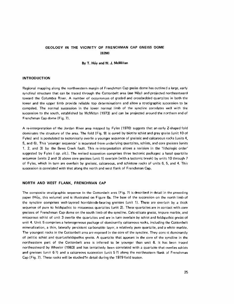
Regional mapping along the northwestern margin of Frenchman Cap gneiss dome has outlined a large, early synclinal structure that can be traced through the Cottonbelt area (see Hoyl and projected northeastward toward the Columbia River. A number of occurrences of graded and crossbedded quartzites in both the lower and the upper limb provide reliable top determinations and allow a stratigraphic succession to be compiled. The normal succession in the lower normal limb of the syncline correlates well with the succession to the south, established by McMillan (1973) and can be projected around the northern end of Frenchman Cap dome (Fig. 7).
A re-interpretation of the Jordan River area mapped by Fyles (19701 suggests that an early Z-shapedfold dominates the structure of the area. The fold (Fig. 9) is cored by biotite schist and grey gncsiss (unit 10 of Fylesl and is postulated to tectonically overlie a younger sequence of gneissic and calcareous rocks (units 4, 5, and 6). This 'younger sequence' is separated from underlying quartzites. schists, and core gneisses (units 1. 2, and 31 by the Bews Creek fault. This re-interpretation allows a revision in the 'lithologic order' suggested by Fyles ( op. cit.). The revised succession comprises three tectonic packages: a Ibasal quartzite sequence (units 2 and 3) above core gneisses (unit 1 ) overlain (with a tectonic break1 by units 10 through 7 of Fyles, which in turn are overlain by gneissic, calcareous, and schistose rocks of units 6, 5, and 4. This succession is correlated with that along the north and west flank of Frenchman Cap.
NORTH AND WEST FLANK, FRENCHMAN CAP
The composite stratigraphic sequence in the Cottonbelt area (Fig. 7) i s described in detail in the preceding paper (Hoy, this volume1 and is illustrated on Figure 8a. The base of the succession on the north limb of the syncline comprises well-layered hornblende-bearing gneisses (unit 1). These are overlain by a thick sequence of pure to feldspathic to micaceous quartzites (unit 2). These quartzites are in contact with core gneisses of Frenchman Cap dome on the south limb of the syncline. Calc-silicate gneiss, impure marble, and micaceous schist of unit 3 overlie the quartzites and are in turn overlain by schist and feldspathic gneiss of unit 4. Unit 5 comprises a heterogeneous package of dominantly calcareous rocks, including 1 he Cottonbelt mineralization, a thin, laterally persistent carbonatite layer, a relatively pure quartzite, and a white marble. The youngest rocks in the Cottonbelt area are exposed in the core of the syncline. They cons s t dominantly of pelitic schist and quartzofeldspathic gneiss. A quartzite that appears in the core of the syncline in the northeastern part of the Cottonbelt area is inferred to be younger than unit 6. It has been traced northeastward by Wheeler (1963) and has tentatively been correlated with a quartzite that overlies schists and gneisses (unit 6 ?) and a calcareous succession (unit 5 ?I along the northeastern flank 3f Frenchman Cap (Fig. 7). These rocks will be studiedln detail during the 1979field season.
25
ldegroot
1978

8b 8 C
PERRY RIVER AREA
t STRATIGRAPHIC TOP
Figure8. Stratigraphic succession% in the Cottonbelt. Perry River, and Jordan River areas, and suggested correlations.
26

The stratigraphic succession in the Perry River area (Fig. 7). mapped by McMillan (1973). is, illustrated on Figure 8b. A thick sequence of quartzites, locally crossbedded, and in part containing grit and conglomerate interbeds (unit 2, rests on core gneisses. They are overlain by calc-silicate gneiss, biotite schist, and impure marble, then a biotite schist that contains two (thin ?) quartzite beds (unit 3). These are overlain by calc-silicate gneisses and biotite schists with occasional interlayered quartzites (unit 4). a carbonatite layer and a relatively pure marble (unit 5). Kyanite-sillimanite schist (unit 6) overlies this calcareous sequence. Overlying quartzites (unit 7) contain a number of sections of feldspathic gneiss and sillimanite-bearing micaceous schist. The quartzites are overlain by a heterogeneous largely pelitic package of rocks, including kyanite and sillimanite schists, with variable amounts of calcareous schist, calc-silicate gneiss, and rare quartzite and marble beds (unit 8). A nepheline syenite gneiss is present locally between the basal quartzite (unit 2) and overlying calcareous rocks (unit 31 (McMillan, 1973).
The successions in the Perry River and Cottonbelt area are homotaxial. Of particular note is the carbonatite layer that is restricted to a single stratigraphic horizon through a strike length of a t least l f i kilometres in the Cottonbelt and a similar distance in the Perry River area. It stratigraphically overlies the syenite gneiss unit. The remarkable lateral extent of a relatively thin carbonatite layer. projected and traced intermittently along a strike length of approximately 45 kilometres, supports the suggestion that it ‘reached or formed a t the surface’ (McMillan and Moore, 1974, p. 317). probably as a pyroclastic deposit.
JORDAN RIVER AREA
The Jordan River area, mapped in detail by Fyles (19701, is underlain by highly deformed and metamorphosed rocks which form the southern margin of Frenchman Cap dome. Phase 1 iolds there are ’isoclinal, recumbent, similar folds with warped axial planes and axes which plunge a t various angles dominantly to the southwest, west, and east. Phase 2 folds are overturned with axial planes dipping southwest and south’ (Fyles, 1970, p. 7).
A re-interpretation of the structure of the area, particularly of the role of phase 1 folding, resulted in a re-interpretation of the stratigraphy. However, to facilitate comparison with Fyles’ map, his numerical system for stratigraphy has been conserved.
Although outcrop patterns are wmplex because of phase 2 folding, the structure to the south of unit 6 (Fig. 9) is dominated by an eastlwest-trending, recumbent 2-shaped phase 1 fold. The structurally lowest fold closure is cored by nepheline syenite gneiss and closes southward, whereas the upper fold is cored by unit 10 and closes northward. The closure of the lower fold has been mapped by Fyles in the southern part of the area. There nepheline syenite gneiss is enveloped by quartzite and calcareous schist of units 8 and 9. The upper fold closure occurs a t the most northerly exposures of unit 10. In the central part of the area calcareous schists of unit 8 (and in part quartzite of unit 9) occur on the limbs of both the upper and lower fold closures of the phase 1 fold. To the w e s t unit 9 is similarly distributed. The upper fold closure opens to the south, therefore to the south there is a large area of outcrop of the gneisses of unit 10.
The Z-shaped phase 1 fold, schematically illustrated on Figure 10, is inferred to tectonically overlie gneissic rocks of unit 6. The contact is a fault that is folded by phase 2 structures, and hence may have initiated
27

b5'
LOWER P A L E O Z O I C ( ? ) A N E P H E L I N E S Y E N I T E G N E I S S 4 P E L I T I C SCHIST F A U L T 5 M A R B L E , S C H I S T , Q U A R T Z I T E 6 G N E I S S
1 0 S C H I S T , G N E I S S
,$ A X I A L T R A C E O F P H A S E 1 FOLD i' BEWS CREEK FAULT
0 9 , 8 , 7 Q U A R T Z I T E , C A L C . S C H I S T , Q U A R T Z I T E
PRECAMBRIAN a 2 ,3 Q U A R T Z I T E , S C H I S T
rn CORE G N E I S S
Figure 9. Geology of the Jordan River area (after Fyles, 19691.
Figure 10. Schematic vertical section in the Jordan River area.
28

during development of the phase 1 structure. In the eastern part of the area the fault is inferred to be entirely in unit 6. Minor phase 1 fold closures south of the fault involve units 6 and 7, implyirlg that there is no loss of stratigraphy between these units.
The lower panel (units 4, 5, and 6) is separated from core gneiss, quartzite, and schist (units 'I. 2, and 31 by the Bews Creek fault.
Crossbedding in quartzite (unit 2) in the lowest structural panel indicates that it is righl-way-up. It is believed to be the oldest because it contacts core gneiss. Because units 6 and 7 are folded together in the nose of a phase 1 fold just west of Jordan River there appears to be no major stratigraphic break between units 4 through 10. It is suggested that unit 10 is the oldest. It cores the larger northward-closing fold and allows a normal stratigraphic panel, the upper limb, to be exposed south of the map-area. The interpreted stratigraphic succession for the Jordan River area is illustrated on Figure 8c.
DISCUSSION
The interpreted stratigraphic succession in Jordan River area (Fig. 8C) has a number of important regional implications, Three major quartzites are represented, separated by mica schist and gneiss, calcareous schists, and marbles. It is possible that the Bews Creek fault repeats the lower part of the sequence, and that the two lower quartzites (units 2 and 9) are equivalent. The oldest units ( 1 and 10 ?) are schistoie and gneissic rocks lacking prominent quartzites or calcareous rocks. A lead-zinc sulphide layer and associated calcareous rocks (unit 5) occur near the top of the succession above the prominent quartzites.
Correlation of this succession with sequences to the northwest is, in part, tenuous. The basal quartzite and overlying schist and quartzite (units 2 and 3) are similar lithologically to the basal quartzite on the west flank of Frenchman Cap. Both contain crossbedded quartzites and grit layers, and bot11 overlie core gneisses. Unit 10 (Jordan River) may correlate with unit 1 in the Cottonbelt area, and the overlying quartzite-calcareous package-quartzite succession is common to both areas. The youngest ( ? I rocks in the Jordan River area, units 6, 5, and 4, are only partially represented a t the top of the successicn in the Perry River area.
These correlations imply that the nepheline syenites are a t approximately the same stratigraphic positions in both the Jordan River and Perry River areas. The carbonatite therefore occurs higher in the succession than the nepheline syenite gneisses. not below as proposed by Currie (19761. Currie's argurnent against a pyroclastic origin for the carbonatite is therefore invalid.
The age of these rocks is unknown. Core gneisses are probably Precambrian, based on recent whole rock rubidiumlstrontium dates of approximately 3 Ga from core gneisses in the Thor-Odin gneiss dome (Duncan. 19781. The overlying metasedimentary rocks, with the exclusion of unit 10 which may correlate with Precambrian rocks, appear to be an outer shelf succession. We believe that they may represent a western, more calcareous and pelitic equivalent of Lower Paleozoic shelf sediments exposed in the Selkirk Mountains to the east. We do not believe that they are equivalents of the Hadrynian Horsethief Creek Group or Helikian Belt Purcell Group. We recognize that there is a considerable thickness of these older rocks missing
29

in the vicinity of Frenchman Cap gneiss dome. Either these were not deposited because the location of the present dome was controlled by a topographic high in Late Precambrian time, or the gneissic core rose diapirically through these rocks. This interpretation requires a major unconformity or tectonic break between the core gneisses and the mantling gneisses of Frenchman Cap gneiss dome.
ACKNOWLEDGMENTS
Discussions with Dr. James T. Fyles of the British Columbia Ministry of Mines and Petroleum Resources helped clarify some problems we had in interpreting the geology of the Jordan River area. Discussions of different aspects of the paper with D. E. Pearson and V. A. Preto, also of the Ministry of Mines and Petroleum Resources, were most helpful. The support and cooperation of Metallgeselschaft Ltd. while mapping the Cottonbelt area is gratefully acknowledged. Discussion with Bruce Mawer of Cominco Ltd. on the interpretation of the geology of the northern and northeastern margin of Frenchman Cap gneiss dome proved most informative and useful.
REFERENCES
Currie, K. L. (1976): Notes on the Petrology of Nepheline Gneisses near Mount Copeland, British Columbia, Geol. Surv., Canada, Bull. 265, 28 pp.
Duncan, I. J. (1978): RbISr Whole Rock Evidence for Three Precambrian Events in the Shuswap Complex, Southeast British Columbia, Geol. Assoc. Canada, abstracts with program, annual meeting, 1978, p. 392.
Fyles. James T. (19701: The Jordan River Area near Revelstoke, British Columbia, 5.C. Ministry of Mines & Pet. Res., Bull. 57, 64 pp.
Hoy. T. (19781: Cottonbelt Lead-Zinc Deposits, 6.C. Ministry of Mines& Pet. Res, this volume. .......... (in preparation): Geology of the Goldstream Area, Southeastern British Columbia, 5.C. Ministry of
McMillan, W. J. (19731: Petrology and Structure of the West Flank, Frenchman's Cap Dome, near Mines& Pet. Res., Bull. 71 (in preparation).
Revelstoke, British Columbia, Geol. Surv., Canada, Paper 71-29. McMillan, W. J. and Moore, J. M. (1974): Gneissic Alkalic Rocks and Carbnatites in Frenchman's Cap
Gneiss Dome, Shuswap Complex. British Columbia, Cdn. Jour. Earth Si., Vol. 11, pp. 304-318. Wheeler, J. 0. (19651: Big Bend MapArea, British Columbia. Geol. Surv., Canada, Paper 64-32.
30

BARRIERE LAKES - ADAMS PLATEAU AREA
(82L113E. 82M/4,5W; 92P/lE, 8E)
By V. A. Preto
INTRODUCTION
A geological survey of the Barriere Lakes-Adams Plateau region was begun during the 1978 field season. This project was aimed a t better understanding the stratigraphy and structure of rocks alortg the western flank of the Shuswap Complex and their possible correlation with some of the known structuralllithologic units within the Complex. The study was also designed to achieve a better knowledge of the Setting and nature of numerous base metal deposits, several of which are stratabound and appear to be o f volcanogenic origin.
Mapping was carried out using 20-chain aerial photographs and 1:1320 interim maps, due to lack of better topographic coverage.
During the field season an area of approximately 900 square kilometres was covered (Fig. 11). most of it thoroughly but part only roughly. The area mapped extends from the southern contact of lhe Cretaceous Baldy batholith in the vicinity of Birk Creek and Harper Creek southeasterly to the Adams Plateau, and is underlain by rocks of the Eagle Bay Formation (Okulitch, 1974), Fennel Formation (CampLwll and Tipper, 1971). and the Cretaceous Baldy batholith (Campbell, 1963).
LITHOLOGY
The Eagle Bay Formation is a very complex unit both structurally and lithologically. As previously indicated (Okulitch, 1974). i t s stratigraphy is very poorly known and, as presently outlined, the Eagle Bay might include units equivalent to parts of the Nicola Group, Sicamous, Tsalkom, and Silver Creek Formations. The status of the Eagle Bay as a formation, group, or otherwise is therefore far from clear a t
this time.
Between Barriere River and Johnson Creek (Fig. 11) the Eagle Bay Formation consists of a structurally lower and complexly folded sedimentary sequence of quartzite. impure quartzite, some grit. calcareous siltstone, impure limestone, and grey phyllite which is best exposed between Dixon Creek and Forest Lake (unit 31. This dominantly sedimentary package is interlayered with, and structurally overlain to the northeast by. a sequence of clearly recognizable basic pillow lavas, flows, breccias, and tuffs (unit 9) which in the vicinity of Johnson Creek are either infolded with, or grade northeasterly into, a sequence of black phyllite and interbedded grit, sandstone, siltstone, and argillite (unit 5) that in places displays sedimentary features indicative of a turbidite environment of deposition.
Northeast of Sinmax Creek, between Johnson Creek and Adams Lake, the structurally lovvest Eagle Bay rocks are highly sheared and intensely foliated pyritic acid tuffs (unit 6 ) which are overlain by intermediate
3 'I
ldegroot
1978


33

to acid tuffs (unit 7), and by acid, intermediate, and basic coarse volcanic’breccias (units 8, 9). These grade upward into a thick sequence of pillow and massive lavas and breccias (unit 9) with large, laterally discontinuous intercalated lenses of impure quartzitic and calcareous sediments and some basic tuffs.
On Adam Plateau a rather monotonous but not very thick sequence of very fine-grained cherty tuff, calc-silicate, thin layers of impure limestone, and minor argillaceous sediments (unit 5a) is structurally overlain by a prominent sequence of basic, massive, and pillowed flows and associated breccias and tuffs (unit 9). Throughout the central and eastern part of the map-area, from South Barriere Lake to the northern part of Adam Plateau, the sequence of basic lavas is sharply overlain by a prominent, light grey to nearly white, massive, finely crystalline limestone several hundred metres thick that is informally known as the Tshinakin limestone (unit 10). Although this prominent carbonate is by far the most continuous and easily traced marker horizon encountered during the course of mapping, it suddenly disappears south of South Barriere Lake for reasons that are not well understood. North of Johnson Lake the Tshinakin limestone is structurally overlain by more basic volcanic rocks which are followed by a thin unit of grey phyllite and a thin, but apparently laterally continuous, grey limestone. Contrary to previously published maps (Okulitch, 1974) no evidence was found that this upper limestone is equivalent to the Tshinakin limestone and thus outlines a large east-west-trending recumbent fold. The two limestones are clearly distinct and separate as are the lithologies above and below them, and thus no such large fold structure i s indicated in this area.
North of Barriere River, Eagle Bay rocks consist mainly of a prominent unit of black phyllite and interbedded grit, sandstone, siltstone, and argillite (unit 5) which are structurally overlain to the east by a sequence of acid tuffs (unit 7a). basic and intermediate tuffs and flows (unit 9). quartzite (unit 4). minor grey phyllite, a prominent, thick but discontinous, light grey to nearly white limestone (probably Correlative with the Tshinakin limestone), and other different carbonate units. The whole succession in many aspects resembles the better exposed sequence north of Sinmax Creek but much detail here is missing because of poor and sparse outcrop. To the west the Eagle Bay rocks are flanked by rocks of the Fennel Formation (unit 1). and the contact has previously been regarded as being a lowangle fault (Campbell and Okulitch, 1976). A close examination of this contact during the current work revealed no evidence of a fault but rather, indicated a gradual change westward from phyllite through a transition zone of interbedded massive basalt, phyllite, chert, and intraformational chert breccia into a zone of massive and then pillowed basaltic flows. All indications are that the contact between the Fennel and Eagle Bay Formations in this area is conformable, but it is not clear which of the two formations is the youngest. Early Mississippian conodonts have been identified from a limestone unit interbedded with phyllite and turbiditic sediments of the Eagle Bay Formation a short distance south of the confluence of Barriere River and Haggard Creek (Campbell and Okulitch, 19731, but the Fennel Formation is also thought to be of Early Mississippian age and correlative with the Antler Formation of the Slide Mountain Group (Campbell and Tipper, 19711. Locally the stratigraphic relationships between the Fennel and Eagle Bay Formations are not clear. Although the contact appears to be conformable, the Fennel could either underlie or overlie the Eagle Bay. A gradual decrease in metamorphic grade and deformation westward from the east end of East Barriere Lake could either mean younging of the succession in this direction or be a function of the lithologies involved and of their relative position to a metamorphic high to the east. Bedding in the Fennel flows dips vertically or very steeply to the west with no reliable indications of tops. Within the phyllite unit the best exposures indicate that tops are to the east and that bedding is overturned to the west near the
34

contact with the Baldy batholith. Folding is also complex and strong in this unit. By tracing the lithologic succession northwestward from Adam Lake it appears that greenschists and intercalated quartzite and carbonate east of North Barriere River are roughly a t the same structural position as the Tshinakin limestone and thus would overlie both structurally and stratigraphically the phyllite unit west of the river. This would therefore suggest that the Fennel Formation underlies the Eagle Bay phyllite and is a lateral equivalent of the thick succession of sediments with some interlayered pillow lavas which underlie a similar phyllite south of Barriere River. If this were the case then the thick pile of Fennel pillow and massive basalt would essentially represent the southern edge of a gigantic sea mound that is flanked to the south by a sedimentary basin of considerable thickness. The fault that is inferred along Barriere River would then mark the edge of such a basin. Although this interpretation requires some assumptions and correlations which cannot yet be rigorously documented, it is preferred by the writer as it best agrees with the available data.
Post-tectonic granitic rocks of the Cretaceous Baldy batholith (Campbell and Tipper, 1971) intrude Eagle Bay and Fennel Formation rocks north of North Barriere Lake. Metamorphic grade increases toward the batholith southeast of North Barriere Lake, and migmatitic and gneissic rocks occur near the east end of East Barriere Lake. This gradient does not appear to have been produced by the Baldy batholith but rather to be due to an older metamorphic high (Belik, 1973) which localized the intrusion.
Two smaller granitic and dioritic intrusions cut Fennel rocks north of Barriere River and a granitic stock and numerous northeast-trending dykes cut Eagle Bay rocks along and west of Kwikoit Creek. The age of these intrusions is not precisely known but a l l are post tectonic and probably correlative with the Thuya and Baldy batholiths (Campbell and Tipper, 1971).
A succession of flat-lying basaltic flows with some interbedded poorly indurated mudstone unconformably overlies Eagle Bay rocks in an area of poor exposures southwest of Haggard Creek. These strata are probably of Pleistocene or Late Tertiary age (Campbell, 1963).
STRUCTURE
Previous workers (Fyson, 1970; Campbell and Okulitch, 1973; Preto, 1977) have reported four phases of mesoscopic structures in rocks of the Eagle Bay Formation. The present work confirms this 'complex array of structures (Fig. 12). Earliest recognizable folds are generally tight, isoclinal mesorcopic structures with recumbent axial planes which are parallel to the schistosity and to the compositional layering of the various rock units. These structures usually have gentle to moderate plunges and trend arywhere from northwesterly to northeasterly. Although it is suspected that these folds may be related to larger nappe-like structures, none of these have yet been identified and only medium-scale structures a few hlmdred metres in maximum dimension, probably belonging to this generation, can be inferred by attempting to trace some local markers. A later phase of folds clearly warps the schistosity and has axes parallel to a pronounced and widespread crenulation lineation. These structures have been observed to range from a few $:entimetres to several scores of metres in maximum dimension and have generally upright axial plane!. parallel to a pronounced crenulation cleavage. Fold axes have gentle easterly and westerly plunges along Adams Lake and moderate northerly to northwesterly plunges in the rest of the maparea. Later broad northerly to northeasterly trending warps, kinks, and faults have been observed throughout the map-area and are commonly followed by post-tectonic granitic dykes.
35

0 ,5
Kllometrer
1
Figure 12. Cross-sections to accompany Figure 11 .
1 MINERAL DEPOSITS
Numerous base metal occurrences, many of which are clearly stratabound massive sulphide deposits syngenetic with their host rock, occur throughout the map-area but are mainly concentrated in two camps. In the north, along Birk Creek and on both shores of North Barriere Lake, several massive sulphide occurrences are hosted in a pyritic quartz-eye sericite schist which was most probably derived from an acid tuff. Amongst these, the Rainbow and Copper Cliff showings on Birk Creek are in a unit of massive to semi-massive pyrite with minor copper, lead, and zinc values that is a t least 4 to 5 metres thick and parallel to the main schistosity. Of these the Rainbow showing is structurally overlain by a pyritic metacon- glomerate or breccia which contains pebbles and cobbles of the massive pyrite mineralization below. To the east, on both sides of North Barriere Lake, a similar schist hosts several occurrences of semi-massive pyrrhotite-pyrite-chalcopyrite mineralization with some lead and zinc values which are also sfratabound. The EBL prospect is on the ridge between North and East Barriere Lake in an area of poor exposure. This prospect has been extensively drilled and is reported to contain a large tonnage of low-grade copper mineralization that is localized parallel to the schistosity in intermediate to felsic schists.
The Homestake mine occurs in highly pyritic quartz sericite schist along the north side of Sinmax Creek valley. Mineralization includes pyrite, tetrahedrite, galena, sphalerite, and ruby silver and occurs as quartz-barite infillings andlor shear zones which cut the schistosity a t a small angle. Various estimates indicate that this deposit still contains 1 to 2 million tonnes of ore. Although the stopes mined to date were
36
in ore which clearly cuts across the schistosity. the types of ore and gangue involved and the setting of this deposit indicate that it may be part of a remobilized or intensely deformed massive sulphide body.
Numerous stratabound deposits of massive and semi-massive pyrite-pyrrhotite-chalcopyrite-galena and sphalerite occur in felsic tuff and in fine-grained cherty tuff on Adam Plateau. Although several of thew? deposits are of excellent grade, most are discontinuous, lensy, and very small in size. Them is little doubt that most of these occurrences are volcanogenic massive sulphides, but it is not yet well known whethel, their small size and modest lateral continuity are original or due to later deformation. One of the largest o f these deposits, the Lucky Coon, occurs a t the head of Spillman Creek. Massive, semi-massive. and banded pyrite-arsenopyrite-galena-sphalerite-tetrahedrite.argentite mineralization occurs parallel to the main foli- ation in a felsic schist and locally attains a thickness in excess of 1 metre. The mineralized layer has beer! exposed in two stripped areas approximately 500 metres apart and reportedly has been traced intermittently for more than 1 kiiometre. During 1977, 496 tonnes of ore was shipped from this deposit yielding 62 033 kilograms lead, 41 367 kilograms zinc, 222 669 grams silver, 274 grams gold, and 114 kilogramsof cadmium.
ACKNOWLEDGMENTS
The writer was ably and cheerfully assisted in the field by Graeme McLaren, Paul Schiarizza, Normarl Ryder. and Gregory Gudgeon.
REFERENCES
Belik, G. D. (1973): Geology of the Harper Creek Copper Deposits, unpublished MSc. thesi.;, Universityoi’ British Columbia.
Campbell, R. B. (1963): Adams Lake, Geological Survey of Canada, Map 48-1963. Campbell, R . 8 . and Okulitch, A. V. (1973): Stratigraphy and Structure of the Mount Ida Oroup, Vernorl
(82L). Adams Lake (82MNV%). and Bonaparte (92P) MapAreas, Geol. Surv., Canada, Paper 73-1. .......... (1976): Valemount to Kamloops, the Omineca Crystalline Belts and the Eastern Edge of the
Intermontane Zone. in Geology of the Canadian Cordillera between Edmonton and Vancouver, Geol.
Campbell, R . 6. and Tipper, H. W. (1971): Bonaparte Lake Map-Area, British Columbia, Geol. Surv., Assoc. of Canada, Guidebook for Field Trip C-11, Annual Meeting, 1976, Edmonton, Alberta.
Canada, Mem. 363. Fyson, W. K. (1970): Structural Relations in Metamorphic Rocks, Shuswap Lake Area, British Columbia, in
Structure of the Southern Canadian Cordillera, J. 0. Wheeler, editor, Geol. A m c . of Canada, Special Paper 6, pp. 107.122.
Okulitch, A. V. 119741: Stratigraphy and Structure of the Mount Ida Group, Vernon (82L). Seymour Arm (82M). Bonaparte Lake (92PI. and Kettle River (@E) MapAreas, British Columbia, Geol. Surv., Canada, Paper 74-1. Part A, pp. 25-30.
Preto, V. A. (1977): Rexspar Uranium Deposit (82M/12W), B.C. Ministry of Mines&Pet. Rea, Geological Fieldwork, 1977, pp. 19-22.
37

SOUTHWEST BRITISH COLUMBIA
SICKER PROJECT
(92B/13; 92C/16El
By G.E.P. Eastwood
INTRODUCTION
The Sicker Group was named and mapped in the Duncan area by Clapp and Cooke (1917) in the early years of this century. In the Cowichan Lake area to the west Fyles (1955) demonstrated that the group is capped by Permian limestone, With this limestone as an intermittent marker the Sicker Group could be correlated with rocks in other areas, notably the 8uttle Lake area where certain members are hosts to the orebodies of Western Mines Limited which are localized along faults. On Big Sicker Mountain. north of Duncan, the Lenora-Tyee orebodies occur along a shear zone that appears to be the axis of a schist belt, along which exploration was concentrated for some years.
An alternative hypothesis would have the orebodies remobilized from primary deposits, possibly of Kuroko type. Fyles’ (1955) observation that the Sicker Group underwent facies changes across strike in the northeast corner of the Cowichan Lake area gives this hypothesis some credence, and a restudy of the Sicker Group was initiated involving some road reconnaissance and systematic mapping of two areas.
Clapp and Cooke (1917) showed that eastward from the Cowichan Lake area the belt of Sicker rocks is split into three by tongues of Nanaimo Group sedimentary rocks and that the two southerly belts are partly covered by these sedimentary rocks, reappearing on Mount Tzuhalem and Stoney Hill south of Crofton. No significant mineralization has been reported from the southerly belts, and only minor volcanic rocks are shown. The northerly belt appeared to have more potential, in spite of extensive intrusion by quartz feldspar porphyry and gabbro, which break up the section and obliterate parts of it. Another problem is the intense shearing within the schist belt, which has obliterated bedding and rendered other primary features difficult to recognize. Preliminary examination of rocks along the Osborn Bay Road south of Crofton and along the Lenora-Tyee access road showed that they were mostly intensely sheared. Since Fyles (1955) does not mention widespread shearing in the Cowichan Lake area it seemed likely that i t s intensity diminished to the west.
WEST CHIPMAN VALLEY
Fyles (1955) shows amygdaloidal lava in the core of an anticline on the north side of the west fork of Chipman Creek. It was hoped that this structure would provide the starting point for working out the detailed stratigraphy and demonstrating a t least the trend of facies changes, but the results of 10 days of mapping were disappointing.
38
ldegroot
1978

Natural exposures are rather scarce in the West Chipman Valley, and do not give a good indication of the nature of the rocks. Artificial exposures along logging roads built in recent years show thilt the anticlinal axis coincides approximately with the axis of the schist belt. The core rocks are chlorite ancl locally sericit,? schists. To the north they are interbanded over a short distance with black schist, which grildes outward to strongly cleaved but recognizable argillite. Northward the rocks consist of interbanded and intergradin43 chert, argillite, siltite, and fine-grained quartzite or greywacke, and several generally thin bands of greenstone. Clearly defined bedding was found about 1 200 metres north of the axis of the schist belt, but appeared to be dragged into parallelism with the cleavage a few metres to the south. Weakly graded beddin'a indicated that the north-dipping beds were right-side-up. The south side of the schist belt is less well exposed, and relations are further obscured by intrusions of porphyry, gabbro, and quartz diorite, and by some overlying Nanaimo Group conglomerate. The few exposures of less-sheared Sicker rocks are mostly greenstone, suggesting that there may have been a southward increase of volcanic material. The crest of tha ridge overlooking the Chemainus River is definitely south of the schist belt and massive black argillite is
exuosed.
STRATFORD-WESTHOLME AREA
At the Island Highway the schist belt is restricted to the northern third of the Sicker belt, Fairly massiv,? Sicker volcanic rocks of the central part are well exposed in fresh road cuts and in outcrops along the adjacent transmission line. Mostly they are characterized by somewhat rounded medium grains of feldspar and by coarse plates of partly rounded crystals of hornblende or by epidote-rich bodies rangsng from one to several centimetres in diameter. The coarse-grained hornblende and the epidote-rich bodies tend to b. mutually exclusive. In places bands marked by coarse-grained hornblende, of the order of 15 centimetres wide, alternate sharply with thinner or thicker bands marked by medium-grained hornblende, or by epidote-rich bodies, or by neither. These bands would appear to be tuff beds, and heme most of th,? sequenrr would appear to be made up of tuff or volcanic breccia. Cooke (1917) interpreted the epidote nodules as flow-top breccia fragments, but their wide distribution in the central part of the belt and their variable concentration would indicate that they were erupted as fragments. Most of the identifiable tuff beds lie close to vertical, and no tops could be determined. Intercalated in the tuff sequence are 1 to 3-metre-thick bands of schistose fine-grained mafic rock of uncertain origin. They appear too thin to be flows, too schistose to be offshoots of the gabbro, and too mafic to be fine-grained phases of the tuff.
To the west, these tuffs have been traced to the base of the bluff on Little Sicker Mountain, and to the east,
over the hill northwest of Mount Richards and thence southeast along Richards Trail past Jackson Valley Road. On the hill northwest of Mount Richards, a band marked by coarse-grained hornblende, 5 metres wide, was traced through almost continuous outcrop for 350 metres, to a point where the hornblendes had decreased in size and abundance and the band was distinguishable no farther. The strike is 2190 degrees and the dip is essentially vertical.
The tuffs contain many bodies of quartz porphyry and quartz feldspar porphyry. West of the Island Highway they have the form of fairly persistent dykes, generally 12 metres or less in width. Eastward they are less persistent, and west of Mount Richards the bodies are irregular and unconnected. Possibly these are

boudins, but the enclosing tuffs do not show flowage around them. Southwest of Jackson Valley Road there are one or more large inclusions of porphyry in gabbro. Though variable in character, the porphyry is commonly highly siliceous, consistingof round quartz eyes in a dense, chert-like groundmass.
The Sicker belt is traversed by a t least five large dykes of gabbro. In the central and southern parts it is massive and medium to coarse grained. The largest dyke forms the south boundary of the belt between the south slope of Little Sicker Mountain and Richards Trail, but just to the east of the trail a l i t t le tuff is exposed south of the dyke. Farther southeast along the trail there is an outcrop of chert-like rock of uncertain origin. A gabbro and a porphyry dyke passing under the north end of Eves Park effectively form the north boundary of the tuffs and the south boundary of the schist belt.
The schist belt is not well exposed east of the Island Highway; most outcrops are sheared gabbro and a sheared country rock which may be of sedimentary origin. Most of the country rock is dense and chert-like. Quartz eyes are present in a few places, indicating the presence of porphyry dykes. On the transmission line to Crofton, near the third crossing of Nimmo Road, bands of cleaved black argillite occur in sericite-quartz schist. At the most northerly exposure along the Island Highway a grey schist is probably sheared argillite. If the siliceous rocks are largely sheared cherts the tuffs are flanked by sediments and the overall structure is probably anticlinal.
REFERENCES
Clapp, C. H. (1917): Sooke and Duncan MapArea, Vancouver Island, British Columbia, with Sections on the Sicker Series and the Gabbros of East Sooke and Rocky Point by H. C. Cooke, Geol. Surv., Canada, Mem. 96, pp. 1251 72. Map 42A.
Fyles, James T. (1955): Geology of the Cowichan Lake Area, Vancouver Island, E.C. Ministry of Mines& fer. Res., Bull. 37, pp. 13-18, 25. 26, Fig. 2.
40

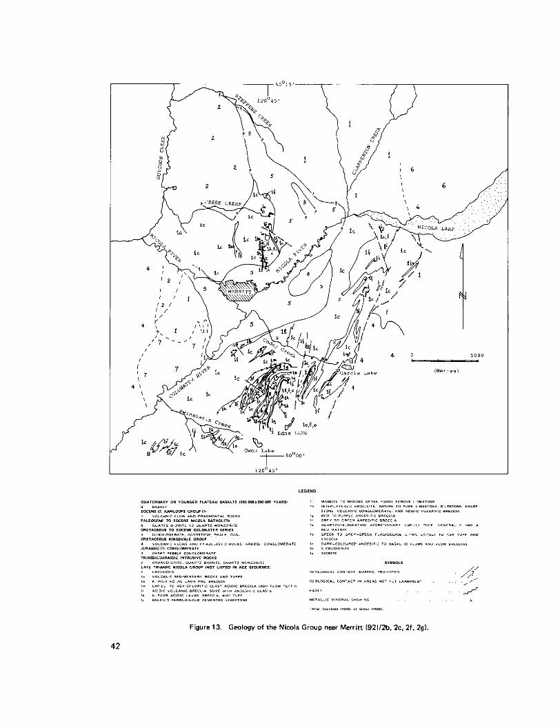
NICOLA PROJECT - MERRITT AREA
(921/2)
By W. J. McMillan
Mapping at scale 1:15 840 was continued in rocks of the Nicola Group both south and north of the town of Merritt.
South of town, on Iron Mountain, considerable time was spent unravelling the tectonic a d stratigraphic picture (Fig. 13). An excellent section is exposed which is roughly 5 000 metres thick. Way up’or ‘tops’ were well defined by crossbedding. scouring, and graded beds. Because outcrops are relatively abundant, it was possible to document lateral facies variations which otherwise would undoubtedly have teen attributed to faulting. The following description concentrates on the section exposed on Iron Mountain, other areas studied will be described in notes accompany preliminary maps which are in preparation.
As can be seen on the section (Fig. 14). the basal unit exposed is microdiorite of unknown thickness which is overlain by a unit roughly 1 500 metres thick comprised predominantly of basaltic andesite. The andesitic unit contains zones dominated by flow breccia and mappable zones of andesitic volcanic breccia. Uncommon interlayers of dacitic tuff and welded tuff occur. Near the top of the unit andesitic breccias become widespread and in many areas give way upward to andesitic breccias carrying some acid volcanic clasts. These ‘rhyolite’ andesite breccias are overlain by, and interfingered vu::h. rhyolitic breccias, dark-coloured relatively potassium-rich rhyolitic lavas, and lesser amounts of distinctive chloritic fragment acid breccias (ash flow tuffs ?I and andesitic breccia. Further south andesitic flows give way up-section ta K-rhyolites with no intervening breccias. Generally, K-rhyolitic flows overlie the mixed Ibreccias or are separated from them by thin to thick chloritic fragment acid breccias. Preliminary chemical analyse!; indicate compositions ranging from rhyolite to dacite for rocks mapped as K-rhyolite in the field.
The acid lava and acid breccia zone is overlain and wedges out southward into basaltic ande!,ite flows. Thai:
interfingering with it. Within the basic flows periods of quiescence were marked by deposition o i is, the acidic zone comprises a CompOsite domal body which has basic flow rocks both above ancl
argillaceous limestone and periods of explosive activity by felsic tuffs and breccias. To the northeast the basic flows pinch out and the rhyolitic zone is overlain by a sequence of sandy to pebbly volcano-sedimentary rocks with areas of limestone breccia which in turn is overlain by a thin but persisteni: impure limestone. Further northeast, both the rhyolitic succession and overlying sedimentary rocks abut against an andesitic lapilli to bomb breccia unit which forms a large, irregularly lensoid body in andesitic to basaltic country rock. Overlying the breccia is the same thin persistent limestone that overlies the adjoining rocks. Volcanic breccias with predominantly acid clasts overlie the limestone. These vckanic breccia:; appear to be of both pyroclastic and reworked pyroclastic origin,
An excellent marker unit consists of variably feldspathic, often quartz-bearing, red accretionary lapilli tuff. It has been reworked locally but persists along a strike length of a t least 8 kilometres. To the south i t overlies basic volcanic rocks and is overlain by limestone bodies; to the north it is overlain by mixed andesitic to acidic volcano-sedimentary rocks and breccias containing fossiliferous, locally crossbedded,
41
ldegroot
1978
42

43

limestone layers. In the northeast the top of this sedimentary unit is a distinctive golden brown-weathering argillite-shale-sandstone succession, ranging in thickness from a few to about 10 metres. Abundant halobid pelecypod and a few poorly preserved ammonite impressions were collected in the silty shale beds.
Above the sedimentary unit to the northeast and within the limestones to the south are lensoid bodies of green to dark grey, potassium-poor, siliceous volcanic rocks. A single chemical analysis indicates that the rock is dacite but more analyses are needed to define i ts range in composition, East of Iron Mountain peak, the dacite interfingers with dark green, massive to bedded to fragmental plagioclase-bearing crystal lithic tuffs and flows (?). Relationships between the dacite and the feldspathic volcanic rocks are obscured by faulting but they appear to be interlayered. The feldspathic volcanic rocks appear to be largely of pyroclastic origin but, because they contain lenses of limestone, they were evidently deposited in a submarine environment. The rock type variations resemble those of subaerial cinder cones; perhaps this unit formed a shallow marine cinder cone. Many porphyritic dykes cut the underlying rocks, fewer cut rocks of the ‘cinder cone.’
Red sandstones which give way to red to purple volcanic breccias overlie the dacitelfeldspathic volcanic zone. Bombs and broken bombs are recognizable in the red to purple andesitic breccias. These give way up section to a calcareous reefoid unit in which calcareous organic remains lie in a dark hematite red matrix. Fossils comprise corals, bryozoa, crinoid columnals. brachiopods, and pelecypods. Thickness of the reefoid unit varies considerably but it i s laterally persistent along a strike length of about 4 kilometres. The rocks
tuffs, acid tuffs, some dacitic rocks as well as an area of dark green feldspathic volcanic rocks like those in up section are a mixed assemblage of acidic breccias, grey to purple andesitic breccias, andesitic flows and
the supposed cinder cone. Outcrop is poor above the reefoid unit but in some outcrops there are interlayers of the acid and basic members on a scale of several metres.
Rocks to the south on the north flank of Selish Mountain are in structural discontinuity with those of Iron Mountain. Drift cover a t lower elevations masks the inferred fault zone and correlation of rock types on either side is uncertain, therefore the sense of movement on the fault could not be determined. Rocks east of Iron Mountain are also structurally discordant. For the same reasons, the sense of movement on the fault or faults is not known.
Rocks on the north flank of Selish Mountain near Kwinshatin Creek are gently folded and strikesvary from northeast to southeast. Beds generally have relatively low southward dips. It appears that the average strike is northeastward. Assuming this strike and assuming that the section is upright, the basal unit, west of the south fork of Kwinshatin Creek, consists of basaltic andesites, grey andesitic breccias, and red to purple andesitic breccias. South of the map border this succession is cut by dioritic intrusions. The andesitic unit is overlain by dacitic breccias with interlayers of andesitic breccia, limestone, and sandstone. A thin limestone separates the ’dacitic’ member from overlying grey to green basaltic andesite. The andesites are overlain by more dacitic rocks then green plagioclase porphyritic andesite then a volcano-sedimentary unit. The volcano-sedimentary rocks comprise pyritic acid ash tuff, lime-cemented acidic to feldspathic volcanic sandstone and conglomerate, dacitic tuffs, and limestone pods. This unit is overlain by red andesitic breccia which gives way ‘up’ section to andesitic volcanic rocks southwest of Gwen Lake.
Rocks east of Iron Mountain are predominantly andesitic and basaltic andesite flows and breccias. Sporadic episodes of acidic volcanic activity occurred and during periods of quiescence limestone or silty to
44

conglomeratic sediments were deposited. Northwest of Garcia Lake many of the basic lavas are pyritic, consequently bleached and rusty weathering zones are widespread.
Triassic rocks north of Merritt are separated from those to the south by the Cretaceous ( ? I Merritt coal basin, Outcrops in the coal basin are uncommon and it will not be discussed here. Above devation 1 OOCI metres along the north wall of Niwla River valley. rock exposures are moderately abundant, elsewhere they are sparse. Strikes of beds are approximately northlsouth and dips are steep. Opportunitiss to make top determinations were rare and not definitive but the rocks appear to become younger eastward. Livingstone (personal communication, 1978) also found poor evidence that tops are eastward. The section is not as well exposed as on Iron Mountain but again commenced with a thick outpouring of relatively basic lava with local episodes of acidic and pyroclastic activity. After a period of andesitic pyroclastic activity and emplace- ment of a distinctive microdiorite either as a flow or a sill there was a period of quiescence during which, feldspathic volcanosedimentary rocks, limy siltstones, and limestone were deposited. Above the limy zonc are volcanic breccias with a marked acidic component followed by a thick series of green, dacitic flows. flow breccias, pyroclastic breccias, and lesser basic lava flows. Plagioclase porphyritic dykes are locally abundant throughout the section and small dioritic intrusions occur locally.
Nicola rocks north of Merritt are cut off by the composite Jesse Creek intrusions on the north and arc unconformably overlain by, or in fault contact with, a tongue-shaped body of Coldwater (?) conglomeratic: sedimentary rocks and Jurassic chert pebble conglomerates on the east. Nicola stratigraphy east of the younger rocks is not yet resolved.
METALLIC MINERAL SHOWINGS
Copper, copper-iron, iron, and lead-zincicopper showings occur in Nicola Group rocks near Merritt. Most of the copper and iron-rich types are in limy host rocks associated with dioritic intrusions or porphyry dykes and would be classified as skarns. Most mineralization seen north of Merritt (Fig. '13) was of thi:; type. South of Merrin, deposits are more varied in character. Skarns occur but also other types including: magnetite-pyrite veins in acidic fragmental volcanic host rocks with which they have both conformable ancl crosscutting relationships; specularitetchalcopyrite veins cut rhyolitic and acid volcanic breccia country rock on Iron Mountain; quartz-chalcopyrite veins cut volcanic country rock adjacent to plagioclase!
occur on Iron Mountain and are of two types. An inclined shaft sunk on a showing of the first type is now porphyry dykes; and there are galena-sphalerite-pyrite-barite-calcite showings. The lead-zinc-barite showings
inaccessible but the character of the mineralization can be inferred from material in the dump. It comprise!; banded veins and possibly bedded mineralization in a flow-banded, K-rich acidic lava (rhyolite) country rock. The other type of showing consists of rotated blocks of bedded, impure barite carrying small amount!; of sphalerite, galena, and minor amounts of grey copper (tetrahedrite?). Bedding in the blocks i!i discontinuous and contorted. The country rock consists of disrupted cherty argillite, siltstone, and arl unusual limestone breccia. The limestone breccia has many rounded limestone clasts but also carries quartz clasts which appear to be fragments of quartz veins. Veinlets of barite carrying small amounts of sulphide!; are associated with these showings. Both types of zinc-lead-barite showings were apparently formed contemporaneously. The first type formed in association with acid volcanism in rhyolitic 'domes.' The second type are interpreted to have been transported into sedimentary basins flanking the 'domes.'
45

REFERENCES
Cockfield. W. E. (1948): Geology and Mineral Deposits of Nicola Map-Area, British Columbia, Geo/. Surv., Canada, Mem. 249, 164 pp.
Frebold, Hans and Tipper, H. W. (1970): Status of the Jurassic in the Canadian Cordillera of British Columbia, Alberta, and Southern Yukon, Cdn. Jour. Earth Sci., Vol. 7, pp. 1-21.
McMillan. W. J. (1977): Nicola Project, B.C. Ministry of Mines & Pet Res., Geological Fieldwork, 1977, pp. 26-30;
Preto, V. A. (1975): Geology of the Central Part of the Nicola Group, British Columbia, B.C. Ministry of Mines & Pet. Res., Preliminary Map 18.
Preto, V. A., Osatenko. M. J., and McMillan, W. J. (1979): Recent Radiometric Dates and Strontium Isotopic Ratios Related to Plutonism and Volcanism in South-Central British Columbia, Cdn. Jour.
Schau, M. P. (1968): Geology of the Upper Triassic Nicola Group in South-Central British Columbia, Earth Sci., in press.
unpubl. Ph.D. thesis, University of British Columbia, 21 1 pp.
46
NORTHWEST BRITISH COLUMBIA
LOGTUNG
11040/13E, 105B/4E)
By P. A. Christopher
The Logtung tungsten-molybdenum property straddles the British Columbia-Yukon border about 66 kilometres southeast of Teslin. Yukon Territory. The British Columbia zone on the prospect was discovered in 1976 by Cordilleran Engineering Limited while prospecting for the source of a tungsten geochemical anomaly in the Logjam Creek-Two Ladder Creek area. The Jam 1 to 5 claims 198 units) ancl Camp 1 claim (2 units) in the Atlin Mining Division and 138 adjacent claims in the Yukon were staked to cover the prospect. The property was optioned to Amax Potash Limited in 1977. During 1977, Amax drilled 4163 metres of NQ and 58.8 metres of BO core in four holes on the B.C. zone (Fig. 15) and about 2 365 metre:,
deposit in the Yukon, subparallel to the border, was indicated to be of better grade and tonnage potential in the main zone (Central and Yukon zones, Schroeter, 1977). The main zone, a quartz vein stockwork
1214,000,000 tons grading 0.12 per cent WO, and 0.05 per cent MoS2. George Cross Newsletter, No. 64, 19781. During 1978 Amax concentrated on defining the Yukon zone.
The centre of the Jam claim block is 8 kilometres north of the Alaska Highway a t latitude 59 degrees 5el minutes north and longitude 131 degrees 35 minutes west. Access to the camp and claims is via a
13-kilometre gravel road which leaves the Alaska Highway a t Kilometre 1213.
GENERAL SETTING
The property is situated near the northern end of the Cassiar Mountain physiographic province, a glaciatecl terrain characterized by moderately rugged topography. The property has 1040 metres of relief with elevations ranging from 1 892 metres to 852 metres in the Smart River valley. Previous studies of the regional geology are those of Gower (19521, Poole (1956). Pooleetal. 11960),and Gabrielse 11969).
Figure 15 shows the general geology and setting of the Logtung property. Carboniferous sedimentary rock!. (unit 1) of the Dorsey Group are part of the west limb of a major southeast-plunging svncline (Poole,, 1956). Sedimentary rocks have been intruded and metamorphosed by dioritic rocks (unit 2) and by quartz monzonite and alaskite sills, dykes, and stocks (units 3 and 4) resulting in hornfelsing of argillaceous rocks and skarnification of limy rocks. Aplite dykelets and quartz veinlets are abundant in the alasltitic dykes and in contact metaromatized sedimentary rocks. Northerly and northeasterly trending faults are associated! with mineralization and with some intrusive contacts.
ldegroot
1978

I

Unit 1
Sedimentary rocks consist mainly of argillite, phyllite, and limestone with contact metamorphism ancl metasomatism producing hornfels and skarn. Hornfels is light or dark grey or black with a grey-greerl variety that may reflect initially higher carbonate content. Skarn is often interbedded with hornfels in the B.C. zone but seldom exceeds 30 per cent of the rock for more than a metre. Limestone occurs on the ridge east of the main zone but lenses out into argillaceous sedimentary rocks.
Unit 2
Dioritic rocks of variable texture and composition occur as two main tabular sills or dyke-like bodies witR numerous offshoots. The variable nature may be the product of metasomatic and metamorphic effects of younger granitic intrusion. Staining indicates potassium feldspar contents between 5 and l!j per cent wittl biotite developed in K-feldspar-rich varieties. Increase of K-feldspar near fractures suggests metasomatic: addition of potassium. Epidote and quartz sulphide veinlets cut the diorite.
Unit 3
Biotite quartz monzonite that occurs as a stock a t the south boundary of the showings is considered by Poole (1956, p. 171) to be satellitic to the Seagull batholith. The stock is medium grained, even or slightly porphyritic textured with miarolitic cavities, fluorite veinlets, quartz veinlets, and smoky quartz. Aplite, porphyritic quartz monzonite, and porphyritic alaskite dykes occur as offshoots.
Scintillometer readings between 4 000 cpm and 24 000 cpm ( 2 to 12 times background) obtained over the stock suggest that radiometric surveys may help in detecting similar stocks.
Unit 4
Porphyritic alaskite dykes and hornfelsed argillaceous sedimentary rocks are cut by a stockwork of scheelite
veinlets. Outcrop patterns suggest a canoe-shape for dykes in the main zone. and molybdenite-bearing quartz veins in the main zone. The alaskite contains fluorite as disseminations and
MINERALIZATION
Scheelite and molybdenite mineralization occurs mainly in stockwork quartz veins in porphyritic alaskite, quartz monzonite, and contact hornfels and skarn. Minor disseminated mineralizatlon occurs in garnet-diopside skarns, hornfels, and intrusive rocks. The iron sulphide content of the mineralized zones is insufficient for gossan production.
Bluish green beryl was found in the B.C. zone as cavity fillings and massive vein fillings with quartz. Purple fluorite is widespread on the property. Wolframite was identified by Poole (1956. p. 179) and the
4EI

occurrence of molybdenum, tungsten, and tin mineralization with fluorite and tourmaline in a stockwork was described by Mulligan (1968).
Lead-zinc-silver mineralization occurs about 100 metres northeast of the main zone and numerous showings can be traced toward the Pure Silver [lead-zinc-silver-gold-(tin)] property. A north-30-degree-east set of steeply dipping quartz veins that carry molybdenum is persistent and widespread in the area.
REFERENCES
6.C. Ministry of Mines & Pet. Res., Assessment Report 6491. Gabrielse. H. (1969): Geology of Jennings River Map-Area, British Columbia (1040). Geol. Sum., Canada,
Paper 6855, p. 37. Gower, J. A. (1952): The Seagull Creek Batholith and i t s Metamorphic Aureole, unpubl. M.A.Sc. thesis,
University of British Columbia. Mulligan, R . (1968): Geology of Canadian Beryllium Deposits, Geo/. Surv., Canada, Econ. Geol. Rept. No.
23. Poole, W. H. 11956): Geology of the Carsiar Mountains in the Vicinity of the Yukon-British Columbia
Boundary, unpubl. Ph.D. thesis, Princeton University. Poole, W. H., Roddick. J. A,, and Green, L. H. (1960): Wolf Lake MapArea. Yukon Territory, Geol. Surv.,
Schroeter, T. (19781: Logtung l1040/13E), 6.C. Ministry of Mines & Pet. Res., Geological Fieldwork, Canada, Map 10-1960.
1977, p. 70.
50

CASSIAR MAP-AREA
(104/P)
By A. Panteleyev
INTRODUCTION
A mapping project was initiated in the Cassiar area in responre to heightened interest in molybdenum, tungsten, tin, and uranium in the general area and as a result of the discovery of the Logtung tungsten-molybdenum deposit and concentrated exploration for tin-tungsten in the vicinity of Swift River.
An area of 260 square kilometres (100 square miles) was mapped a t a scale of 1:15840. The maparea covers part of the southwest corner of McDame map sheet (NTS 104P) and includes the area between Cassiar mine on the north and Cottonwood River to the south. One hundred and sixty-five rock specimens were collected, 12 assay samples were gathered from mineralized zones, and 76 stream silt samples were taken for analvsis.
The intent of the mapping program was to delineate and describe the various intrusive units that make up this portion of the Cassiar batholith. This project will serve as a basis for further studies on the nature of the Cassiar batholith and related mineral deDosits.
Detailed mapping and sampling were done around known mineral deposits. Rock suites were collected for analysis to determine the concentration levels of various elements of interest in mineralized environments and the immediately surrounding host terrains. Six samples were taken for KlAr radiometric dating of intrusive and hydrothermal events.
A detailed silt sampling program was undertaken lone sample per 3.4 square kilometres) tu demonstrate the dispersion of ore and related elements around areas of known mineralization. This study is intended to provide an orientation suite that can be used to assist interpretation of results from the 1978 Uranium Reconnaissance Program (URP) in McDame (104P). Jennings River (10401, and Wolf Lake (1056) mapareas where a sampling density of one sample per 12.5 square kilometres was achieved.
Preliminary results are shown on Figures 16 and 17 and in the accompanying table
GEOLOGY
Intrusive Rocks
The main intrusive mass in the map-area, hereafter referred to informally as the ’Cassiar stock,’ appears to be a discrete intrusion that has k e n emplaced along the eastern margin of the Cassiar batholith. In 1972 the possibility of a separate intrusion in the Cassiar area w a s indicated by 68.3+2.7 and 71.7i.2.6 Ma dates in contrast to a mean 1 0 2 3 Ma age for the Cassiar batholith (Christopher, 1972).
51
ldegroot
1978

~ i g u r e 16. Geology of the Cassiar maparea
52

53
This mapping project has shown that the 'Cassiar stock' is separated a t least locally from the Cassiar batholith on the west by a screen of metamorphic rocks generally 1 kilometre or less in width that has been mapped from Cottonwood River near Bass Creek (Fig. 16). approximately 8 kilometres to the north and has been observed to extend a t least an additional 8 kilometres northward. The full extent of the 'Cassiar stock' to the north of the area mapped is uncertain but a dimension of 33 by 7 kilometres from the Cottonwood River northward to the Blue River is possible. The southern two-thirds of the proposed 'Cassiar stock' i s shown on Figure 16.
The 'Cassiar stock' is composed mainly of coarse-grained quartz monzonite and porphyritic quartz monzonite in which aplite dykes are wmmon and pegmatite pods are present but are rare overall. The main quartz monzonite megacrystic phase (map unit A) contains both biotite and hornblende with biotite in excess of hornblende in a coarse granular fabric of quartz and feldspar with K-feldspar phenocrysts ranging from 2 to 4 Centimetres in size.
Within map unit A are zones of finer grained porphyritic quartz monzonite and equigranular quartz monzonite. These rocks are shown as map unit B and have gradational contacts with map unit A. Rocks of map unit B (textural variants of map unit A) are present as either mantled porphyries in which oliogoclase commonly forms rims on K-feldspar phenocrysts or as medium-grained equigranular quartz monzonite. The mantled porphyritic quartz monzonite is compositionally equivalent to map unit A and is present in the areas of the two main molybdenum deposits (Storie molybdenum and Cassiar molybdenum). Equigranular medium-grained quartz monzonite contains some muscovite in addition to biotite and is present in two areas: one west of the head of Lang Creek; the other northwest of Cassiar and north of Troutline Creek. Similar equigranular quartz monzonite forms along the margin of the stock in a chilled border zone up to 300 metres in width. In some parts of the border zone gneissic inclusions are common and where these are common the quartz monzonite is usually leucocratic and contains minute spessartine garnets.
Map unit C occupies a small area relative to map units A and B but is nevertheless the most important rock unit in the map-area as the main molybdenum deposits are associated with it. Map unit C consists of quartz feldspar porphyry and quartz porphyry which have chilled contacts with equigranular to porphyritic quartz monzonite and mantled porphyry of map unit 6. A small amount of equigranular, fine-grained. grey to pink quartz monzonite that is similar to quartz monzonite of map unit B is found on the flanks of the quartz porphyry and quartz feldspar porphyry intrusions. It is included in map unit C because it shows an intrusive rather than gradational relationship to mantled quartz monzonite porphyry of map unit B.
Intrusive rocks of map unit D are similar to the finer grained and mantled quartz monzonite porphyries of map unit E but because they form a separate small stock have been designated a separate map unit.
Map unit E consists of a small body of fine to mediumgrained diorite that intrudes Sylvester rocks between Lang Creek and Highway 37. It is suggested here that this might be a Paleozoic intrusion that is synchronous with other small diorite and hornblendite dykes or sills that make up part of the Sylvester Group.
54
Bedded Rocks
Bedded rocks are readily subdivided into six lithologically distinct but structurally conformable map units. These have been described by Gabrielse 11963) as the Good Hope (now Ingenika), Atan, Kechika, Sandpile, McDame, and Sylvester Groups which range in age from Proterozoic to Devono/Mississippi,m. Except for Sylvester rocks which appear to be an allochthonous volcanic terrane (Monger, Souther, and Gabrielse. 1972). the other rocks are a shelf assemblage of fine-grained quartzite. shale, and carbonates.
Good Hope (Ingenika) rocks are mainly impure quartzite and are extensively metamorphosed to cordierite hornfels or micaceous schists. The upper part of the Good Hope map unit consists of a transitional zone of thinly interbedded siltstone and limestone which is now extensively recrystallized to a banded calc-silicate rock. This is overlain by an uppermost unit of coarsely crystalline limestone. Atan rocks irI the maparea consist of a lower unit of rusty weathering biotite and spotted hornfels and an upper unit oi: dolomite and marmorired limestone. Near the intrusive contact these rocks form skarn and banded epidote-rich tactite zones. Further from the intrusive contact needles of scapolite are common in marble. Kechika rocks are black shale and slate; Sandpile rocks are mainly sandy dolomite; and McDame rocks are platy dolomite, dolomite breccia, and limestone. In the single locality observed where McDame limestone was intruded, a tremolite-epidote tactite zone generally less than 3 metres wide was formed.
The three major carbonate units: Upper Good Hope, Upper Atan, and combined Sandpile-McDame (map units a, b, cl form unmistakable. well-exposed, persistent exposures in the map-area that are useful marker units. These bedded units can be seen on Figure 16 to trend parallel to the Cassiar stock and therefore contact metamorphic effects are wnsistently more pronounced in the Good Hope and Atan rocks. All map units dip eastward although two broad synclines al;d closely folded Atan rocks near the intrusive contact were noted. All recognized faults had normal movement; some may have considerable lateral displacement. Repetition of Kechika, Sandpile, McDame, and basal Sylvester map units in the vicinity o f Cassiar mine dictates that thrust faults are present but these were not studied.
Mineral Deposits
At least 15 mineral deposits and noteworthy occurrences of diverse types are known in Cassiar map-area,
The most important are two molybdenum deposits: Storie (New Jersey Zinc) deposit arld the Cassiar molybdenum deposit. Both have been extensively explored; Storie deposit by 7 796 metres of diamond drilling and Cassiar molybdenum deposit by an 885-metre adit and 457 metres of drilling. The deposits have similar geological settings. They are both related to small dyke-like bodies. Cassiar m,iybdenum is associated with a northeasterly trending, steeply dipping, dyke-like body up to 360 metres wide and the Storie molybdenum deposit with a series of northerly to northeasterly, gently northwesterly cipping sheets. Three intrusive phases are recognized: a coarse-grained, porphyritic quartz monzonite (in part mantled porphyry) host rock, a fine-grained equigranular to medium-grained weakly porphyritic quartz monzonite, and small bodies of quartz porphyry or quartz feldspar porphyry.
Molybdenite is concentrated near intrusive contacts in fractures, rare quartz veinlets, and is disseminated as scattered flakes and rosettes in the weakly miarolitic youngest porphyry intrusions. Locally a t Cassiar
4 55

molybdenum deposit small high-grade zones with spectacular molybdenite crystals have formed in greisen pods developed along the borders of quartz porphyry dykes. Most commonly fractures with molybdenite contain some pyrite and quartz although 'dry' fractures with molybdenite and pyrite or molybdenite alone as rosettes are present. Rarely molybdenite forms coarse flaky vein selvages in vuggy quartz veinlets that also may contain K-feldspar or yellow fluorite.
At Storie molybdenum deposit molybdenite is present as disseminations throughout the youngest fine-granular porphyry dyke as well as in fractures and some quartz veins in the coarser grained quartz monzonites. Fractures commonly contain muscovite and have K-feldspar envelopes. Where muscovite is abundant and coarse grained, purple fluorite is commonly present. A K/Ar radiometric date of 71.4*2.5 Ma has recently been obtained from sericite from one such mineralized vein. Rare vuggy quartz veins with green beryl crystals are also present locally.
Both of these molybdenum deposits lack significant breccia zones and large-scale quartz stockworks or vein systems are absent. The environment of mineralization is one in which molybdenum is intimately associated with the small dyke-like intrusions that are the more highly differentiated phases of the surrounding quartz monzonite. Molybdenum mineralization appears to have taken place in a high-temperature vapour- dominated environment with low overall water content. Therefore, the relatively small amount of hydrothermal fluid that was evolved was restricted to fractures proximal to the youngest intrusions.
The other molybdenum Occurrences shown by stars on Figure 16 are minor showings. In the intrusive rocks molybdenite occurs from south to north as rare flakes in weakly porphyritic quartz monzonite, with arsenopyrite in fractured coarsely porphyritic quartz monzonite, as flakes a t the margin of a 1-metre-wide spherical pegmatite pod in porphyritic quartz monzonite, and in a quartz vein. In the other two occurrences molybdenite is present as minute grains on fractures in banded Atan calc-silicate rock and in the northern occurrence as rosettes with pyrrhotite in a skarn in Good Hope rocks.
Scheelite is common in small amounts in many garnet-pyroxene skarns that have formed a t and near the main intrusive wntact with Good Hope (Proterozoic) and Atan (Lower Cambrian) rocks. Nine check
analyses show that concentration ranges in the range of 0.01 to 0.02 per cent WO, are widespread in these skarns. Scheelite is also present in massive pyrrhotite lenses that form replacement bodies in quartz monzonite adjacent to the intrusive contact (for example, 3 kilometres west of Cassiar mine) or form in tactite zones along the intrusive contact. The strongest scheelite concentration observed (not shown on Fig. 16) is in calc-silicate bands in Atan carbonates on Lamb Mountain approximately 8 kilometres northwest of Cassiar minesite. At Lamb Mountain one band of mineralized skarn was determined to contain 0.13 per cent WO, and 0.02 per cent copper and zinc across a width of 4.5 metres. The pyrrhotite-rich skarn band is near but separated from a small fine-grained porphyritic quartz monzonite intrusion by about 130 metres of crystalline limestone and a 10-metre-wide band of tremolite-rich barren skarn. Molybdenite is present in greisen veins a t the intrusive wntact. A number of other skarn bands further from the intrusion than the one sampled contain minor scheelite.
Another type of minor tungsten occurrence was discovered 1.5 kilometres east of Storie molybdenum deposit in which quartz veinlets in Atan hornfels contain scheelite near the intrusive contact with quartz monzonite. The quartz-veined hornfels is overlain by barren, thinly banded epidote-garnet skarn that was
56

formed a t the base of the Atan carbonate upper map unit. Along strike to the north and east the banded skarn contains lenses up to 8 metres in thickness of massive magnetite, pyrrhotite, and minor quartz, wollastonite, and tremolite. These contain generally 0.03 per cent or less W 0 3 and base metal values (Cu, Pb. Zn, Sn, Bi). A similar magnetite-rich skarn lens southwest of Needlepoint Mountain (the Lowgrade deposit, shown as 2a on Fig. 161 was found by J. J. McDougall in 1954 to contain Be in helvite. Later, danalite was identified as the major beryllium-bearing mineral (Thompson. 1957). Tin content in the nine skarn samples tested for tungsten ranges from trace to a maximum of .04 per cent.
The Lang Creek copper deposit (occurrence 3 in Fig. 16) (Annual Report of the Minister of Mines and Petroleum Resources, 1961) is a small, shallow-dipping massive sulphide lens. It is up t3 2 metres in thickness and is conformable with an argillite unit interbedded with greenstone near the base of the Sylvester assemblage. A sample across the exposed 1.0-metre sulphide layer assayed 1.7 ppm gold, 36 ppm silver, 1.84 per cent copper, 0.12 per cent lead, and 0.77 per cent zinc. Despite i ts small size this deposit is important in that it demonstrates the presence of massive sulphides in Sylvester rocks, an asemblage that might have been neglected during past exploration.
Veins are abundant in the maparea with silver-bearing lead-zinc veins being most prevalent, Quartz veins with free gold are restricted to Sylvester rocks to the east of the map-area and will be examined in detail during the 1979 field season. Silver-lead-zinc veins with manganiferous magnetite (shown as 4 on Fig. 161 are found at the Wiseman property southwest of Needlepoint Mountain, in the Marble Basin area, and in the Contact deposit west of Cassiar mine. These veins are associated with east-westerly trending faults and fracture zones in carbonate rocks of the Good Hope and Atan upper map units. Similar veins, but containing abundant pyrite instead of magnetite and having tin in the order of 0.15 per cent Sn, occur south of Cassiar. The pyrite-rich stanniferous lead-zinc-silver veins might be deeper equivalents to the magnetite-bearing veins as they occur in Atan hornfels or at the base of the Upper Atan carbonate unit.
A unique vein-type occurrence on the north bank of Lang Creek is shown as 4b. I t cons;sts of a 3 to 4-metrewide replacement zone with pyrrhotite and arsenopyrite in a fault zone that separatzs Atan rocks from Kechika black shales. A sample from this mineralized fault zone across a 3.3-metre width contains 2 ppm gold, 22 ppm silver, 0.1 1 per cent copper, 0.03 per cent lead, 0.005 per cent zinc, 10.04 per cent bismuth, and 1.5 per cent tin.
Minor mineralization (not shown on Fig. 16) consists of widespread scattered fine grains of pyrrhotite and
fine-grained pyrrhotite. One locality with traces of sphalerite is known in the road cut immediately east of t races of chalcopyrite in Good Hope and Atan hornfels. Kechika rocks contain units with allundant very
Simmons Lake. Generally sulphide minerals in Kechika rocks are so fine grained that they cmnot be seen by eye but they are accentuated where the rocks are recrystallized to hornfels.
GEOCHEMICAL DATA
Geochemical data for the 76 sample sites are shown on Figure 17 and listed on the accompanying table. Clearly the sample suite is highly anomalous in molybdenum, uranium, tungsten, lead, and zinc. However, the main source of molybdenum. uranium, tungsten (and also tin) can be identified and cormfined to the
57

Figure 17. Silt sample location (19781, Carriar maparea

ANALYTICAL DATA: CASSIAR SILTS. 1978
8
6
8
60 21 34
* 1 6
6 6
N. I\. 34 1 0
N. A.
5
3
2
16 12
45 2 7
4 6
10
2
14
2 367 4 1 7
59

Cassiar and Storie molybdenum deposits. Mean uranium content in si l ts from intrusive sources is 39 ppm compared to about 12 ppm from bedded rocks. Zinc is concentrated in black shales of the Kechika Group. Lead correlates with zinc in black shale hosts but is also derived from major vein occurrences and probably numerous small veinlets peripheral to molybdenum deposits in granitic rocks. Tin is derived from the greisen-rich zones a t Storie molybdenum deposit but i s also related to lead-zinc veins. It is noteworthy that anomalous associations of tin-lead-zinc in Granite Creek (samples 17 to 22) indicate that more veins are present in this region than have been discovered to date.
Copper is low overall and notably depleted in the intrusive terrains. All samples with copper enrichment can be related to minor chalcopyrite occurrences in Good Hope and Atan hornfels, Sylvester greenstone, or chalcocite occurrences in McDame rocks as noted by Gabrielse (19631. Some malachite and azurite in McDame carbonate rocks is probably formed from copper leached out of overlying Sylvester greenstones.
ACKNOWLEDGMENTS
The cooperation and hospitality of Cassiar Asbestos Corporation Limited, especially the Engineering Department, are appreciated. Mr. W. J. Storie provided much valuable information about the region and its history. He generously gave access to his maps and reports and was an affable guide to the many showings and areas of interest. His interest is this project and stimulating discussions are deeply appreciated.
Greg Smith ably assisted the writer in the field.
REFERENCES
Christopher, P. A., White, W. H. , and Harakal, J . E. (19721: Age of Molybdenum and Tungsten Mineralization in Northern British Columbia, Cdn. Jour. Earth Sci., Vol. 9, pp. 1727-1734.
Gabrielse. Hubert (19631: McDame MapArea, Cassiar District, British Columbia, Geol. Surv., Canada, Mem. 31 9. 138 pp.
Monger, J.W.H., Souther, J. G., and Gabrielse. H. (19721: Evolution of the Canadian Cordillera: A Plate-Tectonic Model, Amer. Jour. Sci., Vol. 272, pp. 577-602.
Mulligan, Robert (1969): Metallogeny of the Region Adjacent to the Northern Part of the Cassiar Batholith, Yukon Territory and British Columbia, Geol. Surv., Canada, Paper 68-70, p. 13.
.._..__... (19751: Geology of Canadian Tin Occurrences, Geol. Surv., Canada, Econ. Geol. Report No. 28, p. 155.
Thompson, R . M. (1957): Danalite from British Columbia, Cdn. Min., Vol. 6, pp. 68-71.
60

C O A L I N V E S T I G A T I O N S
CROWSNEST COALFIELD
By David E. Pearson and D. A. Grieve
INTRODUCTION
Systematic 1:7000 scale mapping of Crowsnest Coalfield was concluded during the 1978 field season when the 100 square kilometres remaining from the two previous field seasons was mapped. The area covered by this mapping project is indicated on Figure 18. Preliminary maps to be published during the year on this project will cover (1) Morrissey Ridge from Coal Creek to Morrissey Creek, (2) the northern Iportion of the Southern Dominion Coal Block. and (3) Flathead and McLatchie Ridges. These preliminary maps will contain both measured sections and petrographic data for each seam over 1 metre thick.
(a) Morrisrev Creek
Mapping along Morrissey Ridge was rnmpleted and the key area of Morrissey Creek was examined in detail. All coals in this creek section are of low volatile rank and possess vitrinite reflectance values greater than 1.51 per cent. The highest rank coal exposed in the whole coalfield wa!; located here (1.85 per cent Eo).
A number of large folds which affect only the lower portion of the coal measures can be traced across the south crop of the coalfield from the pipeline section on Flathead Ridge to Morrissey Creek.
Coalification is more advanced in Morrissey Creek than anywhere else in the coalfield. Because of this, the lower coal seams. which have inherently high inertinite maceral contents (Cameron. 1972; Pearson and Grieve, 1978 and in preparation) will produce very poor quality coke and they should properly be considered thermal (steam) coals. The upper seams, however, with inherently high reactive maceral contents and ranks of 1.4 to 1.5 per cent. will probably produce the finest quality metallurgical coal in the whole coalfield. The uppermost two seams on the Southern Dominion Coal Block have ranks of ~ 1 . 4 per cent with inert contents of about 25 per cent and in quality are similar to 'A' seam in the Michel Creek section.
Excellently preserved casts of a bipedal carnivorous dinosaur, probably a Coelurosaur (Currie, personal communication) were found in a sandstone overlying the upper seam on the coal block.
Figure 19 is a true scale cross-section of the north side of Morrissey Creek. It shows how the amplitude of the large folds decreases with elevation. The figure confirms the story first described from Michel Creek and Coal Creek, that the rank of mal seams increases down dip. For example, a
61
ldegroot
1978

Figure 18. Distribution of low. medium, and high-volatile bituminous coals Over Crowsnest Coalfield. Ranges in vitrinite reflectance data at specific locations represent coals
62 overlying basal sandstone and underlying the Elk conglomerate.
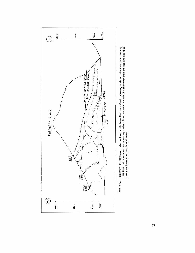
63

coal under the Elk conglomerate above Morrissey Creek has a rank of 1.38 per cent. yet the same coal in the valley has a rank of 1.65 per cent. Similarly, the Moose-rider seam, which rests directly on the basal Kootenay sandstone has a rank on the ridge of 1.69 per cent but in th’e valley this has risen to 1.85 per cent. This means that the Moose-rider seam will obtain a rank of semi-anthracite (rank go 21.92 per cent) 100 metres beneath the valley of Morrissey Creek, and the upper seams could obtain that rank with a further decrease in elevation of 300 metres.
(b) Lodgepole-Mclatchie Area
A prominent sandstone which forms the apparent base to the coal measures is exposed high upon the ridge adjacent to McLatchie Creek. At two localities along this ridge however, vitrinite-bearing mudstone (carbargillites) have been sampled beneath this sandstone yet above the obvious shales of the underlying Fernie Formation.
Mapping south of Michel Head last year revealed the presence of an important lag fault (low angle gravity fault), which juxtaposes high volatile coal-bearing sequences directly on low volatile (Ro =
1.67 per cent) coal-bearing sequences. At the time we concluded that this was the Flathead fault (Price, 1965).
Immediately west of Lodgepole Creek a normal fault is exposed, which, when traced toward the
and evidently is the southern extremity of that which we presumed to be the Flathead fault in 1977. creek, rapidly cuts obliquely down through the succession. The fault is a low angle gravity fault (lag)
Thus, the east crop of Crowsnest Coalfield is marked by the lag fault here referred to as the East Crop fault. This important structure can be followed for about 25 kilometres from Lodgepole Creek to Taylor Mountain.
The age of this structure relative to coalification is evident from Figure 18. Ranks change rapidly on either side of the structure and it is clearly post-coalification in age. Constrictional structures (folds) intimately associated with the fault suggest however that the fault moved more than once.
(c) Eagle Mountain, Elk Valley Coalfield
Upon completion of the mapping of Crowsnest Coalfield, detailed work started in the latter part of the field season on Eagle Mountain, Fording Coal’s property in Elk Valley Coalfield. This work will continue in future field seasons.
RAPID PREDICTION OF COKE STRENGTH
During laboratory studies on collected coals a rapid method of semi-quantitative prediction of coke strength was discovered (Pearson, in preparation). Figure 20 shows actual ASTM 25millimetre Tumbler stability factors for 113 British Columbia cokes as a function of free swelling index and volatile matter (d.a.f.) basis. Crosses indicate values that conform with the plotted contours; open circles are data which do
64

Figure20. Diagram showing haw the 25mm ASTM
yield (dry, ash-free barid and free swelling index. Tumbler stability is a function of volatile matter
not conform with the contours. Eighty-six per cent of the carbonized coals conform to 1:he contoured stabilitv values shown.
ACKNOWLEDGMENTS
tt i s a pleasure to record our thanks to Mickey Welder and Peter Mustard, our co-workers during the field season, Phil Currie of the Provincial Museum of Alberta is thanked for his information on the dinosaur tracks.
REFERENCES
Cameron, A. R. (1972): Petrography of Kootenay Coals in the Upper Elk River and Crowsnest Areas, British Columbia and Alberta, Proc., First Geological Conference on Western Canadian Coal, Research Councilof Alberta, Info. Series No. 60, pp. 31-45.
Pearson, D. E. (in preparation): Prediction of Coke Strength Using Volatile-Matter Yield and Free Swelling-Index of Western Canadian Coals.
Pearson. D. E. and Grieve, D. A. (1978 and in preparation): Petrographic Evaluation of Crowsnest
Price, R. A. (1965): Flathead Map-Area, British Columbia and Alberta, Geol. Surv., Canada, Mem. 336. Coalfield, CIM, Abstract, 80th Annual Meeting, Vancouver.
65

QUINSAM AREA, VANCOUVER ISLAND
(92F/13E, 14W; 92K/3W, 4El
By G.E.P. Eastwood
As part of a preliminary joint venture agreement with respect to the Quinsam property between Weldwood of Canada Limited and Luscar Ltd., Lexco Testing drilled steadily from mid-February into the summer, and by early July had drilled about 10 200 metres in 174 holes. This was principally fill-in drilling a t 75-metre centres.
The writer completed reconnaissance geological mapping of the area of Comox Formation sedimentary rocks between Campbell Lake and the Iron River, and remapped the Iron River section below Chute Creek in greater detail. Exposures along the north-flowing section of the Quinsam River are thin to thick-bedded sandstone, containing widely separated shaly and organic horizons. The lowest of these contains an aggregate of 2 metres of coal, and may be correlative with No. 3 seam south of Middle Quinsam Lake. Two
yielded an average dip downstream of 5 degrees 15 minutes. Crossbedding in the sandstone is conspicuous higher horizons contain 35 and 18 centimetres of coal respectively. Measurements on the lowest horizon
in places and is probably present to some degree through most of the section, for the sandstone beds dip 10 to 14 degrees downstream in most exposures. The result is that the thickness of Comox near the Karmutsen contact i s less than half what would be inferred from the sandstone dips, and an upturn to an on-lapping contact is possible. Farther north, a t the outlet of Lukwa Lake, pebble and cobble conglomerate, very similar to that exposed along Highway 28, is exposed close to Karmutsen outcrops. It appears unnecessary to invoke a fault along this segment of the contact.
On the south shore of Campbell Lake outcrops of Bonanza lava and Comox sandstone are separated by 150 metres of cover. The sandstone contains shells and bits of unaltered bark and wood. indicating minimum diagenesis.
On the Iron River the main coal seam pinches out a short distance upstream. It is now known to lie only 3.8 metres above the basal conglomerate and is clearly the No. 1 seam. The No. 2 seam is probably represented by coal exposed in the bed of the access road, but no further exposures were found to the south. The basal conglomerate was deposited on a rough surface and varies greatly in thickness; in the thicker sections it grades down to arkose. This basal unit disconformably overlies thin-bedded chert and striped tuff, which in turn overlie Karmutsen lava. Many dykes of felsite porphyry cut these beds, but none was found penetrating basal Camox rocks. The ages of these rocks therefore lie somewhere between Late Triassic and Late Cretaceous.
REFERENCE
Eastwood. G.E.P. (19771: Quinsam Area, Vancouver Island, B.C. Ministry of Mines and Pet. Res., Geological Fieldwork, 1977, pp. 55, 56.
66
ldegroot
1978

COAL PROPERTY EXAMINATIONS
PEACE RIVER COALFIELD
By R. H. Karst
SAXON (93111.8)
The Saxon coal property of Denison Mines Limited is situated 160 kilometres south of Dawson Creek and immediately adjacent to the Alberta-British Columbia border. The property consists of 50 coal licences comprising 13 600 hectares of mountainous terrain.
Since obtaining the licences in 1970, Denison has performed exploration work on the property including 57 diamond-drill holes, 12 adits, and considerable geological mapping. The 1978 program consisted of 9 core holes and 13 rotary holes, all drilled in the Saxon East area where the coal measures dip 45 to 50 degrees southwest and are thought to be recoverable by underground hydraulic mining methods. Detailed geological mapping was also conducted in this area. The rotary drilling was used to delineate structurs? in a zone of deep glacial overburden.
The mineable coal reserves found to date on the Saxon property are entirely within the Gates member of the Commotion Formation. Denison has numbered the more significant coal horizons from 1 to 10 with the larger numbers corresponding to a higher stratigraphic level. Approximately one-third to one-half of thew coal seams have mineable coal thicknesses a t any one location. Aggregate coal thickness for these seams is in the order of 13 metres. The coal is of metallurgical grade.
Structurally, the Saxon property is a broad synclinorium trending northwestlsoutheast with the coal-bearing Gates member exposed on the flanks. Saxon East is the northeastern flank whose rocks dip at 45 degrees with some local thrust faulting present. Saxon South, with wtential open-pit rewrves, is on the southeastern flank and the rocks there exhibit stronger structural deformation. Saxon West i!i the area west of the Narraway River and little exploration work has been done in this area.
MONKMAN PASS (931/7.8,10,15)
The Monkman Pass coal property is under licence to Canadian Superior Exploration Limited and Mclntyre Mines Limited. The property includes 119 w a l licences in 14 licence groups, in long linear bel ts trending northwestlsoutheast from Quintette Mountain in the north to Nekik Mountain in the south. The total licence area, comprising 6 BOO hectares, is situated 115 kilometressouth-southeast of Dawson Creek. Since 1976, Pacific Petroleum Ltd. has been operator of the Monkman Pass property by agreement with the above owners. Additional coal licences, adjoining the existing licences, were applied for in 1978.
The licences were granted in 1970 and exploration work was carried out in 1970, 1971, 1973. 1975, 1976, and 1977. This work included 23 core holes, geological mapping, and considerable trenching. The
67
ldegroot
1978

exploration program in 1978 was the largest to date and included 30 core holes and 20 rotary holes in addition to two adits. One of these adits provided access to two different coal seams by way of a decline to a lower seam.
There are four coal seams 181, 83, 84. and 89) of interest in the Gates member of the Commotion Formation. All Gates coal is given the prefix B and a number corresponding to i t s stratigraphic level. The Gething Formation has yielded one coal seam of economic interest to date (A2 seam). All coal is of metallurgical grade.
The most favourable potential mine area on the property is in the Duke and Duchess licence group. Cumulative thickness of the mineable Gates coal is in the order of 19 metres within 165 metres of stratigraphic section. The seams dip northeast at 18 to 20 degrees under a partial dip slope. Open-pit mining would be possible in the initial stages with later conversion to underground operations when strip ratios or hangingwall heights become too high. Coal reserves appear to be sufficient to support a mining operation with annual production in the range of 2.5 to 5 million tonnes. Most of the exploration work done to date has been in the Duke Mountain and Duchess Mountain area.
The property includes many other licences on which exploration activity has been minimal and consequently the evaluation of the coal potential i s incomplete. Some of these licence groups are: Wapiti Dip Slope, Onion Syncline, Secus Dip Slope, Nekik Dip Slope, and Saxon Extension. In most of these areas the coal measures are dipping to the southwest a t angles greater than 30 degrees. Six core holes completed in 1978 were on these licences.
DOWLING CREEK -SOUTH MOUNT GETHING (930/16)
Utah Mines Ltd. acquired the 21 coal licences belonging to Bow River Resources Ltd. and Rainier Energy Resources Inc. by an agreement made in May 1978 regarding the Dowling Creek coal property. Utah also applied for and was granted 24 new coal licences (South Mount Gething property) adjoining the western edge of the Dowling Creek licences. The property now comprises 11 750 hectares in 45 coal licences located between Gaylard and Dowling Creeks, approximately 25 kilometres west of Hudson Hope.
Dowling Creek licences were granted in 1971 and exploration was performed on the property in 1971, 1972, 1976, and 1977. During this period geological mapping and approximately 13 core holes were completed. The 1978 program drilled four core holes on the Dowling Creek portion and three core holes on the South Mount Gething portion of the licences. Geological mapping of the area was continued.
All of the coal occurs within the Gething Formation. The Gates member is of marine origin in this part of the coalfield and is therefore non-coal bearing. The type section of the Gething Formation occurs in the Peace River Canyon at the north end of the property just below the W.A.C. Bennett Dam. Over 17 different coal horizons have been recognized and named in the canyon area by various workers. Most of these coal occurrences are less than 1 metre thick and appear to be lenticular over short distances. The most promising seams are located within the top hundred metres of the formation which is regarded to be 600 metres thick
68

in the canyon area. Of these upper coals, the Trojan seam appears to be the b e s t developed with reported thicknesses of 1.2 to 2.5 metres.
The Dowling Creek-South Mount Gething property is an antidinelsyncline structure striking northlsouth with a southerly plunge. The anticlinal axis is centred over the South Mount Gething portion of ths property and exposes Gething and Cadomin rocks within i t s core. The adjacent syncline to the east (Dowling Creek) has shallow-dipping limbs and contains rocks of the Fort St. John Group in the axial zone. The coal-bearing Gething Formation is encountered a t depth except a t the north end of the property where it is exposed a t surface due to the synclinal plunge to the south. The exploration objective is to find coal of underground mineable thickness that occurs at surface and can be traced down into the syncline. This requires some deep drill testing and one of the 1978 holes exceeded 600 metres in depth. Thl? results of this season's program are being evaluated.
MOUNT SPIEKER (93P/3)
The Mount Spieker coal property of Brameda Resources Ltd. is located between Bullmoose and Perry Creeks approximately 100 kilometres southwest of Dawson Creek. This property is currently optioned to Ranger Oil Ltd. and consists of 36 coal licences (3 100 hectares) of which three licences, isswd in 1978, are in Ranger's name.
Original licences were granted in 1970, but the area received little exploration work other than reconnaissance mapping until 1975. During the field seasons of 1975, 1976, and 1977, 15 (:ore holes, coal trenching, and detailed geological mapping were carried out. The 1978 program included 18 core holes and three adits for bulk sampling purposes.
Both the Gething Formation and the Gates member of the Commotion Formation colitain coals of mineable thickness in the Mount Spieker area. The Gates member in particular has four significant coal horizons labelled A, B, C. and D respectively, with the D seam being stratigraphically the highest. Cumulative coal thickness for these seams is approximately 12 metres and occurs within 85 metres of stratigraphic section. Only the upper 150 metres of the Gates member is coal bearing. the lower 180 metres being barren, The Moosebar Formation which lies between the Gates member and the Gething Formation includes 100 metres of marine shale. The bes t developed coal within the Gething Formation is the Bird seam, which is situated just below the Moosebar contact, and is split into two discrete coal seams separated by 10 to 50 feet of rock. Aggregate coal thickness for the Bird seams is about 3 metres. The Skeeter and Chamberlain seams, located 18 metres below the Bird horizon, are not well developed. The Skeeter seam is the better of the two and achieves a mineable thickness on a very local basis only. The stratigraphically lower 'middle coals' of the Gething Formation have only been penetrated by a few drill holes and are relatively unexplored. All of the coal is of metallurgical grade.
Work to date has indicated four potential mining areas. The first is the Mount Spieker block where Gates Seams A and B have underground mining possibilities. The rocks exhibit shallow dips with an occasional gentle roll. The block is relatively free of faults except for a major westerly dipping thrust which marks the
69

eastern boundary of this mining block. The Bird block, which encompasses the saddle area of Mount Spieker, has underground mining potential for the Bird horizon. A third underground mining prospect is the syncline area on the west side of Mount Spieker. The Gates coals may be recoverable in discrete panels of undeformed rock whose limits are defined by local structures present in the area. Lastly, there is the EB1 open-pit area where the Gates A, B. C, and D seams are recoverable by surface mining methods. All of the above-mentioned potential mining blocks are adjacent to one another. There are some remaining areas within the property which are still unevaluated, namely the West Bird and South Bird areas.
Ranger Oil envisions an eventual mining operation of 1 to 2 million tonnes per year where the excellent coking but relatively high sulphur coals of the Gething Formation may be blended with the low sulphur Gates coal.
SUKUNKA (93P/3,4.51
The Sukunka coal property of B P Canada Limited is located between the Sukunka River and Bullmoose Creek, roughly 50 kilometres south of Chetwynd. The property incorporates three former properties of Brameda Resources Ltd., namely the Coalition-Sukunka, Chamberlain, and Bullmoose licence groups. B P Canada bought these licences from Brameda in early 1977. Brameda has retained certain rights to surface mineable coal in the Bullmoose portion of the property and Brascan Resources Limited still has a 12.5-per-cent interest in the Coalition-Sukunka portion. The amalgamated properties are now given the Sukunka name and include 61 coal licences comprising 16 565 hectares.
The Sukunka property was one of the first areas licensed and i t s early success helped generate interest in coal throughout northeastern British Columbia. Original licences were obtained in 1970, but exploration began a year earlier when Brameda drilled eight core holes on the coal occurrences reported by local residents. Since then a considerable amount of drilling, mapping, and adit work has been conducted on the property. Trial underground mining began in 1972 and has continued intermittently.
The 1978 program included 28 rotary holes and 8 core holes. Two of the core holes were deep tests, spudding in a t the lower Gates member and drilling down to middle Gething rocks. The rotary rig was mainly used to test the middle and lower coals of the Gething Formation. Underground exploration continued in the south chamberlain window with one continuous miner and one shuttlecar in operation.
The coal seams of prime interest all occur within the Gething Formation. The uppermost is the Bird seam occurring immediately below the Moosebar formational contact. The Bird seam achieves thicknesses of up to 3 metres on parts of the property. Approximately 40 metres below the Bird seam lies the Chamberlain coal horizon. the most important coal zone. The chamberlain seam attains a thickness of 5 metres a t some locations on the property. At other locations the zone splits into two separate seams, the uppermost called the Skeeter seam, the lower seam retaining the Chamberlain designation. Although both splits have mineable coal thicknesses a t some locations, the Chamberlain split is more continuous than the Skeeter. The interval between both seams varies from 0 to 7 metres and this proximity may complicate the underground recovery of both seams in some areas. Approximately 130 metres further down section are the
70

middle coals. These seams, as well as the lower coals further down section, are currently being evaluated. All coals of the Sukunka property are considered metallurgical grade, particularly the Chamberlain seam which is regarded as a premium coking coal.
Structurally the property is cut by a number of thrust faults which define the boundaries #of three mining plates. Most of the coal is recoverable by underground mining methods only. Current Underground work in the Chamberlain horizon has indicated specific information on roof support, seam character, and floor regularity. The results of this underground exploration will determine the mining systl?m needed for full-scale production. It will also have a direct bearing on the time frame and production rates of the eventual mining operation. Coal reserves are sufficient to support an operation in excess of 3 million tonnes per year, provided that the necessary underground mining rates can be achieved.
BURNT RIVER (93P/4.51
The Burnt River coal property of Brameda Resources Ltd. is situated 35 kilometres south of Chetwynd. The property includes 39 coal licences situated between Mink Creek and the Sukunka River. Eleven of these coal licences were issued in 1978. Total area of the property is 10 000 hectares.
Since original licences were granted in 1970, the Burnt River property received little attention other than reconnaissane mapping during the 1970-76 period. Detailed mapping in 1977 localed a flat-lyin!~ 9.8-metre coal outcrop which initiated a four-core-hole drill program. The 1978 program has continued the drilling using a Winkie portable drill and a track-mounted diamond drill using NC rods. The Winkie is used for shallow tests such as coal crop-line determinations and spotting favourable drill sites for the larger drill. Altogether 885 metres (31 core holes) of Winkie drilling and 1 815 metres (20 core holes) of NQ wer,? completed this summer. Detailed geological mapping was also performed.
The area covered by the Burnt River property exhibits very strong structural deformation. The area is also totally forested. These two factors and little surface control have impeded the understanding of the deposit. The geological interpretation resulting from this year's work is considerably different than previous interpretations. A number of high-angle thrusts have been delineated from airphoto interpretation. Thick conglomerate units within the Boulder Creek Formation and the Gates member have been recognized and differentiated from those conglomerates occurring within the Cadomin Formation. However, thl? stratigraphy within formations and the correlation of drill holes within the property is not yet fully understood.
The Gething Formation contains most of the major coals. The Gates member, although coal bearing, appears to have no coals greater than 1 metre thick. Examination of the geophysical logs (of Pacific Birch c-31-K, a natural gas exploratory hole located a t the north end of the Burnt River licences, shows the Gething Formation to be 350 metres in stratigraphic thickness. Within the Gething Formation the logs reveal six coal seams having thicknesses greater than 1.5 metres of which f ive seams occur within the top 115 metres of the formation. A 7-metre coal encountered 45 metres below the top of the Gethin!~ Formation in the gas hole probably correlates to the 9.8-metre coal seen in outcrop. It is inwresting to not,?
71

the geophysical log of the Pacific Birch hole also indicated numerous coal horizons within the Minnes Group which underlies the Cadomin Formation. A t least five of these coal horizons exceed 1.5 metres in thickness. The Minnes Group has been mapped on the Burnt River property.
Brameda’s 1978 program is designed to evaluate the open-pit coal potential of the property. The complex geological structure prevalent through the licences can be handled from a mining point of view provided the coals are thick enough and the strip ratios favourable. A coal Seam has been encountered with a 20-metre local thickness. Several other seams are also being evaluated. All the coal is of high quality thermal grade.
72

VlTRlNlTE REFLECTANCE AS A CORRELATION TOOL
IN THE CARBON CREEK COAL MEASURES
(930/10,15)
By R. H. Karst
INTRODUCTION
The core from two diamond-drill holes in storage a t the Charlie Lake core library was sampled for coal in October. The holes were selected on the basis of a correlation problem that existed in the coal measures of the Carbon Creek basin. It was hoped that a study of coal rank within the cored intervals using vitrinit'e reflectance would provide another tool useful in the determination of the correct correlation.
CARBON CREEK COAL MEASURES
The coal-bearing Gething Formation occurs in a large asymmetric syncline occupying tht? Carbon Creel< drainage basin, approximately 56 kilometres west of Hudson Hope. From 1971-1976 Utah Mines Ltd. has actively explored the basin for i t s coal potential, drilling 93 diamond-drill holes, :Li2 rctary holes, and driving six coal adits. The coal property is a multi-seam deposit with 14 separate coal horizons having production potential. Coal thicknesses are characteristically 1.5-2.0 metres with local occurrences of seams 3 to 4 metres thick.
Two of the main areas of delineated coal reserves having mining potential are the Central ,tnd North areas (Fig. 21). Drill-hole correlation within each area is readily identifiable using core descriptions, coal quality, and gamma logs as correlation tools. Also. the density of drilling within each area is sufficient for the reserves to be considered of the measured category. A problem exists, however, in the correlation of coil1 measures of the Central area with coal measures of the North area. Although the twc areas are less than 1.5 kilometres apart, the correlation methods previously mentioned have been inadequate in providing a convincing linkage.
In an effort to bridge the gap Utah Mines drilled four holes immediately south of Seven Mile Creek, the north bank being too steep for a drill set-up. Unfortunately these drill holes were very difficult to correlate with each other let alone with holes in the reserve areas. Utah finally arrived a t the correlation shown on Figure 21, based on structural projections and the 'best gamma f i t possible.' The immediata implication of this correlation was that the Gething Formation a t Carbon Creek was over 1 100 metm in thickness, almost double the accepted maximum thickness recogniud for the Gething sequence. Several outside critic:s suggested that the correlation was in error and that coals in the North area were stratigraphically equivalent to coals of the Central area, thus reducing the formation thickness to more acceptable levels. Utah's geologists were the first to admit that the correlation was speculative.
73

I ' c > & '

CURRENT STUDY
Since there is no evidence of structural disturbance on surface or in the core of the Seven Mile Creek areal the author does not believe the correlation problem to be related to geologic structure. Instead it is felt that constant facies change and bed lenticularity of sedimentary origin are responsible. A correlation tool i!; needed that is independent of bed continuity or lithologic units.
Coal rank is primarily a function of temperature during the coalification process and increase!; proportionally with increasing depth of burial because of the geothermal-gradient effcct. The paleo isotherms in a structurally undisturbed sedimentary basin should be nearly parallel to the bedding of the sedimentary sequence, a t least over relatively short distances such as 1.5 kilometres. These isotherms woulcl be independent of changes in the lithology of the sedimentary sequence. Coal rank is an accurate indicator of these isotherms.
Petrographically, coal rank can be obtained by measuring the reflectance of vitrinite. Increasing reflectancx (k ) indicates increasing coal rank. The relationship between vitrinite reflectance and volatile-matter content (the normal coal rank parameter) has been quantified by numerous coal petrology ,specialists. One advantage of vitrinite reflectance in coal-rank determination is that only a very small sample is required.
0
Carbon Creek drill holes 75-45 and 75-47 were selected for the coal-rank studies. These holes are firmly correlated to their respective areas on the basis of lithology. coal quality, and geophysical logs (Fig. 22). Each hole is presently stored a t the British Columbia Ministry of Mines and Petroleum Resources’ cor1! storage facility a t Charlie Lake. Although the coal core from the major Seams is missing lsampled by Utah staff during the drill program), numerous coals less than 0.5 metre in thickness still remain in the core boxes. These coals were sampled for vitrinite reflectance.
RESULTS
The reflectance values versus depth for the coals sampled in each drill hole are plotted on Figure 22. Since the range in coal rank represented by these samples is relatively small compared to the entire lignitelanthracite progression, the points on the graph should be linear. A noticeable amount of scatter in
examined. This occurs because coal macerals. of which vitrinite is one, do not have fixed compositional the points is evident but this phenomena is typical when coals having only subtle differences in rank are
formulae such as minerals. Vitrinites of the same rank may have minor compositional differences which will effect the reflectance to some degree. By drawing the b e s t line to f it the points (coalificiation line) ancl examining the range of the line alone, the scatter is effectively averaged out. Figure22 displays the reflectance range of each coalificiation line. This figure also indicates the stratigraphic relationship betweerl the drill holes based on coal rank; drill hole 75-47 is spudded a t a stratigraphically higher level than 75-45 but both holes share much of the same stratigraphic intervals.
The reflectance value of 1.12 per cent is regarded as the division between high-volatile and medium-volatile bituminous coal. This io value (or any other) can be used to test the validity of the correlation on Figure 22 by matching the 1.12 per cent ko value with i ts corresponding depth in each hore hole. Thc
75

Figure 22. ial vitrinite reflectance versus depth for drill hole 7 5 4 5 ; ibl vitrinite reflectance versus depth for drill hole 75-47: icl reflectance range of the coalification line for each borehole.
76
highlmedium volatile boundary occupies approximatley the same stratigraphic level in the existing correlation between bore holes, thus collaborating the correlation. It is interesting to note that each graph contains one anomalously low io point located considerably to the left of the coalificiatior line (Fig. 22). With the present correlation, these points may represent the same coal horizon.
CONCLUSIONS
The postulated correlation across Seven Mile Creek appears to be correct,
The Gething Formation is a t least 1 100 metres thick.
The possibility exists that the Gething sequence may have been even thicker than this figure because no overlying Moosebar Formation has ever been seen in drill core or in outcrop within the Carbon Creek basin.
The Peace River Canyon (Gething Formation's type section) was previously regarded as the thickest Gething occurrence (550 metres). There are two possible mechanisms which could be responsible for this tremendous formational thickening: (1) Carbon Creek is much closer to the Lower Cretac:eous sediment source area and had a more rapid rate of subsidence; (2) major formational facies changes exist in the overlying Moosebar Formation or Gates member to the west such that the Carbon Creek coal measures may encompass stratigraphic equivalents of these formations. A detailed fossil examination would be required to choose the correct mechanism.
The core storage facility a t Charlie Lake has the core on file which may answer these and many more questions about the geology of northeastern British Columbia.
ACKNOWLEDGMENTS
The author would like to thank Dr. D. E. Pearson for the original idea of this study and Mr. D. A. Grieve for his instruction on the vitrinite reflectance technique.
REFERENCES
LeNobel. D. N. and Karst, R . H. (1976): Exploration Activity in the Carbon Creek Basin, B,C. Ministry of Mines & Pet. Res., Assessment Reports P R-Carbon Creek, 76 ( 1 to 6) C and 76 (1 to E;) D.
Stott, D. F. (1973): Lower Cretaceous Bullhead Group Between Bullmoose Mountain and Tetsa River, Rocky Mountain Foothills, Northeastern British Columbia, Geol. Surv., Canada, Bull. 219.
77

L E G E N D
B R E N O T F M . - - - - K B r
C A D O M I N F M . " - K C d
G E T H I N G F M . " - K G
C O A L T R E N C H X
M A J O R F A U L T _ _ _ _
9 3 P/W N T S
B U R N T R I V E R
M A P - A R E A 1 5 0 5 10 15 > U I Y U I
S C A L E O F K I L O M E T R E S N
~ i g u r e 23. Burnt River maparea

BURNT RIVER AREA
(93PI4, 5)
By R. D. Gilchrist
INTRODUCTION
During the 1978 field season detailed mapping of coal measures and associated strata was conducted on the area bounded by Hasler Creek in the north and the Sukunka River in the south. However this discussion will be confined to the area from Brazion Creek south to the Sukunka River. All coal-bearing strata were examined. I t was discovered that not only were the quartzites of the Monach Formation present but coal-bearing rocks lying stratigraphically below the Cadomin conglomerate were also present. Hugher, (1964) had designated these beds the Brenot Formation. Coal seams were sampled and analy'sed in both the Brenot and Gething Formations.
STRATIGRAPHY
BRENOT FORMATION
All coal measures lying above the quartzites of the Monach Formation and below the conglomerate of the Cadomin Formation have been mapped as the Brenot Formation. Hughes (1964) defined the top of the Brenot a t the first appearance of coarser sediments, but as the conglomerate of the Cadomin is continuous as far north as Brazion Creek it is felt that the base of the conglomerate is a more readily mappable contact. North of the Brazion, Hughes' definition is more applicable. Just north of Mount Merrick the formation has a thickness of about 150 metres. Strata are composed of siltstone, fine-grained sandstone, (coal, and lesser amounts of claystone and mudstone. It is very similar in composition and character to the L.ower Gething.
Coals are present throughout the Brenot. but the thickest seam development is in the ul~per part. It is believed to underlie most of the relatively flat areas east of Mount Jilg. from the Sukunka River north to Brazion Creek. I t is also present in much of the high country between Mount Merrick and IVlount Jilg and immediately west of Goodrich Peak. Whether the Brenot Formation contains thick (>2 met.es) coal seams throughout these areas is not established.
CADOMIN FORMATION
McLean's (1977) working definition of the Cadomin. namely 'all conglomerate and medium- to coarse-grained sand units are included unless they are separated from the main body of the lormation by a unit of finer sediments greater than 1.5 times the thickness of the overlying unit,' has been found to be useful in the map-area although with some exceptions. The nature of the Cadomin conglomerate is such that when found in relatively gently dipping strata, the conglomerate-derived scree effectively covers all strata below the conglomerate unit itself. Hence if medium or coarse sandstones exist below the
7 9'
ldegroot
1978
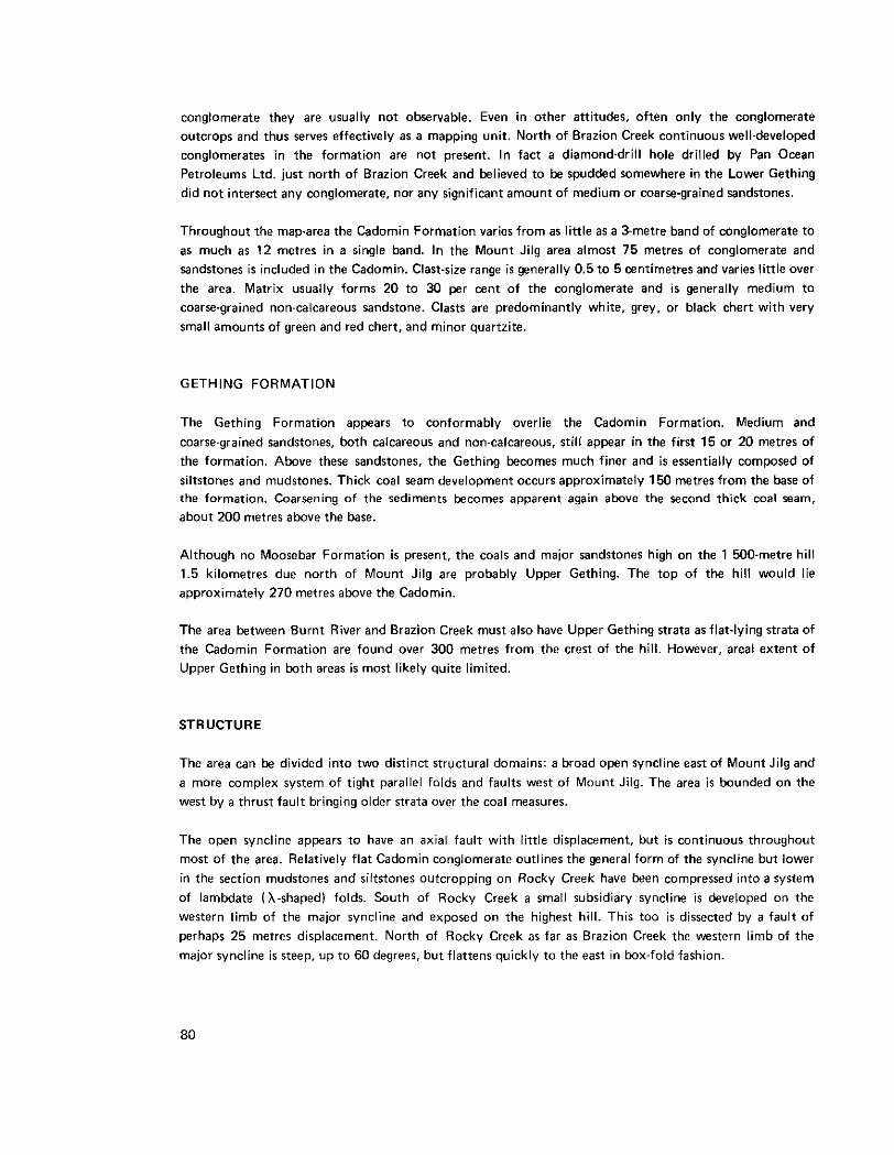
conglomerate they are usually not observable. Even in other attitudes, often only the conglomerate outcrops and thus serves effectively as a mapping unit. North of Brazion Creek continuous well-developed conglomerates in the formation are not present. In fact a diamond-drill hole drilled by Pan Ocean Petroleums Ltd. just north of Brazion Creek and believed to be spudded somewhere in the Lower Gething did not intersect any conglomerate, nor any significant amount of medium or coarsegrained sandstones.
Throughout the maparea the Cadomin Formation varies from as l i t t le as a 3-metre band of conglomerate to as much as 12 metres in a single band. In the Mount Jilg area almost 75 metres of conglomerate and sandstones is included in the Cadomin. Clast-size range is generally 0.5 to 5 Centimetres and varies little over the area. Matrix usually forms 20 to 30 per cent of the conglomerate and is generally medium to coarse-grained non-calcareous sandstone. Clasts are predominantly white, grey, or black chert with very small amounts of green and red chert, and minor quartzite.
GETHING FORMATION
The Gething Formation appears to conformably overlie the Cadomin Formation. Medium and coarse-grained sandstones, both calcareous and non-calcareous, still appear in the first 15 or 20 metres of the formation. Above these sandstones, the Gethiny becomes much finer and is essentially composed of siltstones and mudstones. Thick coal seam development occurs approximately 150 metres from the base of the formation. Coarsening of the sediments becomes apparent again above the second thick coal seam, about 200 metres above the base.
Although no Moosebar Formation is present, the coals and major sandstones high on the 1 500-metre hill 1.5 kilometres due north of Mount Jilg are probably Upper Gething. The top of the hill would lie approximately 270 metres above the Cadomin.
The area between Burnt River and Brarion Creek must also have Upper Gethiny strata as flat-lying strata of the Cadomin Formation are found over 300 metres from the crest of the hill. However, areal extent of Upper Gething in both areas is most likely quite limited.
STRUCTURE
The area can be divided into two distinct structural domains: a broad open syncline east of Mount Jilg and a more complex system of tight parallel folds and faults west of Mount Jilg. The area is bounded on the west by a thrust fault bringing older strata over the coal measures.
The open syncline appears to have an axial fault with little displacement, but is continuous throughout most of the area. Relatively flat Cadomin conglomerate outlines the general form of the syncline but lower in the section mudstones and siltstones outcropping on Rocky Creek have been compressed into a system of lambdate (X-shaped) folds. South of Rocky Creek a small subsidiary syncline is developed on the western limb of the major syncline and exposed on the highest hill. This too is dissected by a fault of perhaps 25 metres displacement. North of Rocky Creek as far as Brazion Creek the western limb of the major syncline is steep, up to 60 degrees, but flattens quickly to the east in box-fold fashion.
80

A tight faulted anticline is formed immediately to the west of the major syncline and is followed by over half a dozen parallel lambdate folds westwards to the thrust fault underneath the east scarp of Mount Merrick. Except for a single exposure just east of the thrust, the Cadomin has been eroded it1 this area, but a number of exposures of Brenot Formation (location D) as well as the lower Monach quartzites occur in this area. Strata are inclined from 30 degrees to vertical.
COAL
Coal occurs in the 8renot and Gething Formations within the map-area. Sixteen trenches wen? dug exposing relatively thick (>Z-metre) seams as well as several smaller seams in both formations. All significant seams were described and sampled. Descriptions of the major seams (with significant coal intervals designated by a letter for reference to the accompanying table) are given in the following paragraphs.
8RENOT FORMATION
Two w a l seams 0.85 metre and 0.9 metre thick and lying 9 and 18 metres respectively above the Monach-Brenot contact were exposed a t location A. The lower seam ( A - l l had a fine-grained flaggy sandstone roof and a carbonaceous mudstone roof. The upper seam (A-2) had a carbonaceous mudstone roof and a mudstone floor.
Approximately 16 kilometres to the south a t location B, a coal seam (5-11 lying 120 met~.res below the Brenot-Cadomin contact was trenched. The description is summarized as follows: floor - carbonaceous mudstone with bands of vitrain. 0.5 metre sheared bright coal with 2 centimetres mudstone bands (a), 1.4 metres mudstone with vitrain bands (bl, 1 metre bright coal (c), 4 metres mudstone with thin (1 to 3 centimetrel vitrain bands; roof -calcareous, medium-grained siltstone.
Seventy metres up section lies a 3.2-metre coal seam (8.2); however the upper metre of the seam contains several claystone bands. Approximately 1.5 kilometres southwest a t location C the same seam was trenched but here 3.2 metres (C-1) of coal with no partings were recorded. The logs of the seams are as follows: location B, floor - claystone. 2.06 metres bright banded coal (a) , 0.1 5 metre claystone. 0.38 metre bright coal (bl. 0.28 metre carbonaceous claystone. 0.10 metre bright coal (cl. 0.10 metre carbonaceous claystone. 0.10 metre bright coal; roof - siltstone (with plant rootlets); location C, floor - claystone, 0.1 metre coal (a). 0.5 metre mudstone, 1.5 metres bright coal (b), 1.7 metresdull coal (c); roof -mudstone. Strata a t locations B and C dip to the southwest a t approximately 65 degrees.
A t location D three coal seams all less than 1 metre and one seam 2.3 metres thick occur in wliat is believed to be Upper Brenot. Due to structural complexity no direct measurement to either upper or 13wer contacts can be made, but the coals are believed to occur in the upper 50 metres of the Brenot Formation. The thick seam (D- l l has a carbonaceous claystone flcor overlain by 0.7 metre dull and bright banded coal (a), 1.0 metre dull and bright blocky coal (b). 13 centimetres carbonaceous mudstone with coaly stl-eaks. and 0.5 metre bright banded coal (c). overlain by a claystone roof. The Seam dips 30 degrees to the southwest.
81

GETHING FORMATION
Coal within this formation was exposed in several trenches all lying just north of Mount Jilg (location E). Trenches were made on gently dipping strata on a steep hillside and hence measurements may be distorted by mass movement. A lower seam, lying a minimum of 150 metres above the Cadomin. w a s trenched in two locations (E-1 and E-2) approximately 300 metres apart. They were logged as follows: E-1, floor - carbonaceous claystone, 1.3 metres dull-banded, dirty coal (a). 0.4 metre claystone, 0.2 metre dull-banded mal (b), 0.4 metre carbonaceous claystone. 0.3 metre carbonaceous weathered claystone, 0.01 metre yellow-brown mudstone, 1.2 metres bright hard coal (c), overburden; E-2, floor - claystone, 0.45 metres dull and bright coal (a). 1 metre carbonaceous claystone, 0.4 metre bright, blocky coal (b), 1.35 metres claystone with vitrain bands, 0.4 metre dull-banded coal IC), 1.1 metres bright-banded coal (dl, 0.12 metre carbonaceous claystone with vitrain bands (e). 0.03 metre bright-banded coal (fl, 0.75 metre dull-banded coal (9); roof -carbonaceous claystone with occasional thin coal bands.
An upper seam (E-31. lying approximately 30 metres above the lower, was exposed in an area of minor but severe folding and faulting. The seam was estimated to be 2.3 metres thick and lies a t least 180 metres above the Cadomin Formation. It is overlain by carbonaceous mudstone and underlain by siltstone, mudstone, and fine-grained sandstone in turn.
COAL QUALITY
Results of analyses of raw coal from trench samples taken during the 1978 field season are shown in the accompanying table. Trench locations and sample intervals are referenced to the map and text respectively. Volatile matter has been shown on a dry mineral matter-free basis for ease of comparison. Analyses have been given for all coal-bearing intervals, even if they are only thin vitrain bands in mudstone. Results on the higher ash samples can be expected to be less accurate. Trench E-1 was in an area subject to mass movement and it is believed that the very high ash contents are due to the mixture of clays with the coal a t outcrop only.
Volatiles are anomalously high for coals of their stratigraphic position in this region. The samples from the Gething Formation ranged from 30 to 33.5 per cent (dmmfl. at last 6 to 8 per cent higher than Gething coals from south of the Sukunka River. The Brenot coals had even higher volatiles on the average, ranging up to 38 per Cent for low ash coal. Compositional differences in the coal could account for the difference in volatiles between the Brenot and Gething coal. There are wide variations in volatiles even within the same seam in the Brenot coals. The generally high volatiles in this area may indicate a shallower depth of burial than for adjoining areas.
Gething coals are not as clean as the Brenot coals; ash on raw coal samples is never below 12 per cent. On the other hand, the Brenot coals have ash contents below 4 per cent on some intervals.
82

RAW COAL TRENCH SAMPLE ANALYSES
f t L
I -t* E - 3
L
t
t
REFERENCES
Hughes, J. E. (1964): Jurassic and Cretaceous Strata of the Bullhead Succession in the Peace and Pine River Foothills, 6.C. Ministry of Mines & Pet. Res., Bull. 51.
.._....... (1967): Geology of the Pine Valley, Mount Wabi to Solitude Mountain, Northeastern British Columbia, B.C. Ministry of Mines & Pet. Res., Bull. 52.
McLean. J. R . (19771: The Cadomin Formation: Stratigraphy. Sedimentology. and Tectonic: Implications. Cdn. Petrol. Geologists, Bull., Vol. 25, No. 4, pp. 792-827.
Stott, D. F. (19681: Lower Cretaceous Bullhead and Fort St. John Groups, between Smoky and Peace Rivers, Rocky Mountain Foothills, Alberta and British Columbia, Geol. Surv., Canada, E:ull. 152.
.......... (19731: Lower Cretaceous Bullhead Group between Bullmoose Mountain and Tetsa River, Rocky Mountain Foothills, Northeastern British Columbia, Geol. Surv., Canada, Bull. 219.
83

GROUNDHOG COALFIELD
(lMA115; 104H/2, 3)
By R. D. Gilchrist
A joint Geological Survey of Canada - Ministry of Mines and Petroleum Resources reconnaissance mapping project was conducted in the Groundhog Coalfield for a two-week period in late July - early August. Personnel consisted of T. A. Richards and his assistant R . Stevens for the Geological Survey of Canada and the author and his assistant W. Killick for the Ministry of Mines and Petroleum Resources. The purpose of the project was to determine the broad stratigraphic and structural relationships of the central part of the basin so as to be able (1) to evaluate the feasibility of a more detailed study of the whole basin and (21 to mmment on the coal resource potential of the area. As time was limited, investigations were confined to the area bounded by the Nass River on the east, the Skeena River on the west , Didene Creek on the north, and Panorama Creek on the south.
It was concluded that the strata could be subdivided on the basis of facies units. Several workers (Malloch, Best, Jenkins, Eisbacher) have attempted this, but none of the units have been correlated throughout the basin with detailed control. Facies changes are quite rapid in some of the coarse alluvial rocks, however outcrop is excellent and should provide enough control. Much of the coal measures outcrop below timberline and hence have limited exposure, but hopefully facies changes will not be so rapid, as in the coarser clastics. In fact it will be necessary to describe the coal zones in as much detail as possible for correlation purposes across the major valleys and other areas lacking exposure.
As the southern part of the basin has received the majority of the previous work. investigation for coal potential was confined to the northern half of the area defined in the first paragraph. Not surprisingly what appears to be the fullest stratigraphic section is found on the highest peak in the area, just south of Mount Gunanoot. Here over 750 metres of conglomerates overlie the coal measures. The coal measures essentially outcrop on the perimeter of the 'central structural basin,' that is, on the steeply folded limbs of the syncline and on the northern, southward steeply plunging end of the syncline.
Coal was observed at several localities on the west limb, but only in float or thin (1 metre) seams. An analysis on a sample taken just off the crest of the ridge immediately east of Nass Lake showed a relatively high volatile matter, 26.54 per cent for a coal of 15.53 per cent ash (all analyses on raw coal and given in a dry basis). A sample taken less than 3 kilometres north on the same ridge, but somewhat lower in the section, had a very low ash content, 6.78 per cent, but a volatile matter of only 10.36 per cent.
The area east of Tahtsedle Creek lies in a structurally separate unit from the central syncline. The western portion is very flat and approximates a shallow southwest dip slope whereas the eastern part is very tightly folded. An analysis on a coal seam exposed in a locally disturbed area at the north end of the dip slope showed an ash content of 23.55 per cent and a volatile matter content of 13.3 per cent. An accurate seam thickness could not be obtained but is believed to be over 2 metres.
The rapid thickening of the coarse clastic units toward the centre of the basin may imply an independent mechanism of subsidence. If this mechanism were operating during deposition of the coal measures, it
84

would be possible to have significant thickening of the coal seams in the centre of the basin. However, they would have been and would continue to be under the maximum cover and would thereforr, be relatively inaccessible and highly coalified.
REFERENCES
Eisbacher. G. H. (1974): Deltaic Sedimentation in the Northeastern Bowser Basin. British Columbia, Geol. Surv., Canada, Paper 73-33.
Tompson, W. D., Jenkins, D. M.. and Roper. M. W. (1970): Exploration of the Groundhog Coalfield, Upper Skeena River Area, British Columbia, Repart for National Coal Corporation, Placer Development Ltd., and Quintana Minerals Corporation, B.C. Ministry of Mines & Pet. Res., Open File.
Black, J. M. and Best R. (1968): Groundhog Coal Survey, Report for Coastal Coal Co. Ltd. and Dillingham Corporation, E X . Ministry of Mines & Pet. Res., Open File.
Malloch, G. S. (1914): The Groundhog Coal Field, British Columbia, Geol, Surv., Canada, Sessional Paper No. 26, Summary Report 1912.
85

CORRELATION STUDIES PEACE RIVER COALFIELD
(93P)
By P. McL. D. Duff
Eight weeks were spent in the Province in 1978, mainly a t the Charlie Lake mre library. A vis i t was made to Edmonton from August 9th to 12th to discuss with Dr. Charles Stelck. of the University of Alberta, fossil identifications undertaken by him on material from drill cores, to have further collections identified and to discuss areas, both geographical and geological, within the coalfield, that would repay further , detailed examination.
Two visits were made to the Sukunka area (August 20-21, 24-25), one particularly to examine a prolific fossiliferous horizon in the Gates member found during the mapping. The other visit was to locate, with R. Karst, the cores from the holes drilled by the former Coal Division of the Department of Lands and Forests in the Hasler, Willow, and Noman Creek areas during the early 1950s. The core boxes were found but both they and the cores were weathered and useless, which is unfortunate as they could have proved an invaluable link in solving some of the stratigraphic problems in a particularly obscure area of the geology.
The opportunity was also taken, while in the area, to visit the B P Explorations’ Sukunka coal camp and discuss stratigraphic problems with their geologists, and also to walk a stretch of the Grizzly pipeline trench (crossing the Manalta property) with R. Karst. The exposed section yielded valuable information on the structural complexities. emphasizing the very real difficulties of mapping and drilling in that area. A potentially useful fossiliferous horizon was seen, although it is not absolutely certain it is in situ, and we hope Dr. Stelck will throw some light on the discovery.
The main objective of this year‘s work was to attempt to complete the first overall examination of a representative sample of cores from the whole length of the coalfield. To this end some 5 000 metres of core from 22 bore holes were examined. A concentrated effort was made on the detailed paleontological studies of cores a t Carbon Creek, in conjunction with examination of cores from East Mount Gething and Cinnabar Peak to help solve correlation problems. Cores from Pan Ocean’s Pine Pass property were examined as well. Time prevented extensive examination of cores from the Saxon and Quintette areas in an attempt to define the extent of the marine horizon in the middle of the Gates. Further fossil identifications will be necessary before firm conclusions can be drawn, but the broad stratigraphic picture that emerged in 1977 seems to be confirmed.
Two weeks were spent in Victoria obtaining information from the files and attempting to draw up graphic logs of, and correlate, bore holes. Preparation of a bulletin on the stratigraphic studies in the Peace River Coalfield will be Dossible after one more season’s work.
86
ldegroot
1978

S T R U C T U R A L M A T E R I A L I N V E S T I G A T I O N
GRAVEL INVENTORY IN THE LOWER MAINLAND
By 2. D. Hora
Assessment of the gravel deposits in the lower mainland was carried out during June, July, and Augusl: 1978. The study was concentrated on producing areas and the purpose of the work is to gather all necessary data to ensure the long-term availability of construction aggregate for greater Vancouver and adjacent areas.
COQUITLAM VALLEY
This major producing area consists of sediments deposited during several major glacial advances and retreats and non-glacial intervals in a glacier-carved bedrock valley. The gravels, up to 100 to 150 metres thick, are, equivalents of Quadra, Highbury, and pre-Highbury deposits and are overlain by Vashon till (.Fee table).
LANGLEY AND FORT LANGLEY AREAS
Gravel deposits here are of glaciomarine and ice-contact origin and are part of a large proglacial fan delta. The gravels are approximately up to 40 to 45 metres thick and belong to the Fort Langley Formation. Par;: of the deposits in these areas are below groundwater level.
ABBOTSFORD - MISSION AREA
Gravel accumulations of this area are glaciofluvial and ice-contact deposits of Sumas drift. North of Missiorl the gravel deposits form irregular bouldery mantle along slopes of deeply cut valleys. Near Abbotsford botkl the advance and recessional outwash of a rather gently rolling topography exist and the gravel deposit!; extend over a considerably larger area and are underlain by flat marine sediments. The thickness of gravel deposits has been found locally up to approximately 50 metres and part of the gravel is below groundwater level.
CHlLLlWACK AREA
Several small gravel pits have been opened in alluvial fan of Chilliwack River around Veddel, Crossing. The deposited gravel is approximately 5 to 10 metres thick and corresponds to Salish sediments (see table).
5 87
ldegroot
1978
STRATIGRAPHIC TABLE
I HOLOCENE I POST GLACIAL
I
LATE WISCONSIN VASHON DRIFT FRASER GLliClATlON
Q"4L)RA SI\ND <COQUITLAM DRIFT
REFERENCES
Armstrong. J. E. 11956): Surficial Geology of Vancouver Area, Geo/. Surv., Canada, Paper 55-40. .......... 11957): Surficial Geology of New Westminster Map-Area, Geol. Surv., Canada, Paper 57-5. .......... (1960): Surficial Geology of Sumas Map-Area, G w l . Surv., Canada, Paper 59-9. ......__.. (1960): Surficial Geology of Chilliwack MapArea, Geo/. Surv., Canada, Map 53-1959. .......... 119771: Quaternary Stratigraphy of the Fraser Lowland, Geo/. Assoc. Canada, Fieldtrip Guidebook,
Trip 10. Learning, S. F. 11968): Sand and Gravel in the Strait of Georgia, G w / . Surv., Canada, Paper 66-10.
88

A P P L I E D G E O L O G Y
MINERAL PROPERTY EXAMINATIONS
SOUTHEAST BRITISH COLUMBIA
By G . G . Addie
RADAR CLAIM I82E/lW)
The Radar claim is located about 15 kilometres north of Grand Forks, east of the Granby I3iver. between Toronto and Snowball Creeks. Access is by tote road up Snowball Creek. The claim is owned by Consolidated Boundary Exploration Limited and operated by Chinook Construction & Engineering Ltd.
Uranium mineralization is present as 'high-grade' lenses and disseminations in biotite garnet pegmatite which intrudes granite gneiss and amphibolite to the east and biotite gneiss to the west. The pegmatite units are in turn intruded by small fine-grained biotite quartz monzonite plugs. A fault cuts off the uraniferous mineral zone on the west (Fig. 24). A sample of the biotite from the uranium-bearing pegm3tites has been taken for age determination. Thin sections of the pegmatite and quartz monzonite indicate that a considerable amount of zircon is present in the biotite.
A preliminary statistical study indicates that the Log U (cpmIlLog K (cpm) and Log Th (cpmI/Log K (cpm) have a high correlation. The ratios indicate that the deposit may be zoned.
The pegmatites appear identical to those at China Creek which have been dated as 48.8t1.7 Ma (Middle Eocene). The significance of the quartz monzonite is not known, but it may be the source of -:he pegmatites and may be responsible for concentrating the uranium mineralization.
YOSlE 1 AND 2 (82F/lIW)
The Yosie 1 and 2 claims are located about 10 kilometres southeast of Slocan on the upper reaches of Crusader Creek, a south-flowing tributary of Lemon Creek. Access is by approximately 22 kilometres of good logging road which joins Highway 6. The property was located and staked by Crawford C. Young of Nelson.
Lead mineralization is in small shears in Nelson granodiorite. At the junction of the logging road with an unnamed creek just south of the prospect pits there is some orthoclase-quartz pegmatite as dykes and probably a small plug. The mineralization may be related to these young intrusions. A V L L E M 16 low anomaly was also found at the creek suggesting a fault control of the creek.
89
ldegroot
1978

R A D A R I
Figure 24. Radar 1 claim.
90

Galena stringers strike generally eastlwest with dips of 45 to 51 degrees north. One grab sarnple from the first pit north on the Yosie 2 claim (Fig. 25) assayed as follows: gold, 1 ppm; silver, 267 ppm,: copper, 0.03 per cent; lead, 34 per cent; zinc, 0.52 per cent; antimony, 0.015 per cent; arsenic, 0.02 per cent.
The vein shown nearest the road is 18 centimetres wide in the left pit and 20.5 centimetres wide in the right pit. The pit nearest the road should be deepened to bedrock to see if the vein length of 5 lnetres can be extended. In general the pits are 1 to 2 metres deep. The VLF-EM 16 did not respond to any of the
Figure 25. Yosi 1 and 2 claims.
91
SOUTHERN AND SOUTHEASTERN BRITISH COLUMBIA
BY T. D. Lewis
Fifteen mineral properties, funded in part by the Prospectors' Assistance Program or the Mineral Exploration Incentive Program, were investigated by the writer. Reports on three of these properties follow; the remainder are listed below and are available on open file in Victoria.
THREE JACKS BAS SPRUCE ROCKLAND KALISPELL VERNA MOLY MONEY MAKER JUNE, SKYE CUMOLY CHU CHUA E AND R
82E/1 E 82E/15E 82F/14W 82F/14W 82F/14W 82F/15W 82K/3W 92G/16W 92H/16W 92JIlW 92P/8E 93Al11 W
KASLO CLAIM (82K/3E)
The Kaslo claim is located a t Retallack. 29 kilometres west of Kaslo and 21 kilometres east of New Denver. The claim is currently leased by Peter Leontowicz.
Lead-zinc mineralization occurs in Slocan Group sedimentary rocks of Upper Triassic to Lower Jurassic age, here consisting primarily of black fissile phyllites with interbedded limestone, calcareous phyllites, and brown gritty quartzites. The rocks trend 310 degrees and generally dip southwesterly. but vary due to folding. Greenstones and ultramafic rocks of the Kaslo Group unconformably underlie the sedimentary rocks to the east. Intruding all rocks are Nelson granites, granite dykes, and late-stage lamprophyre dykes.
The dominant structures on the Kaslo claim are folds with axes trending easterly to northeasterly and plunging 15 to 20 degrees easterly. Unravelling these structures was possible due to marker horizons wnsisting of quartzite and limestone within the phyllites. Whereas the phyllites exhibited intense folding destroying primary textures, the limestones and quartzites were more competent and bedding attitudes could be recorded. Boudinage structures developed within the limestone, suggests it behaved in a plastic manner under stress. Four faults are interpreted in the vicinity of the Kaslo claim. Two nearly parallel faults striking northwesterly and dipping southerly are believed to be associated with mineralization observed on the property. Two barren faults cut the stratigraphy and offset pre-existing faults.
92
ldegroot
1978

Mineralized faults were encountered within the Hazel adit, which is 120 metres west of the northwest corner of the Kaslo claim. A fault within phyllites, 30.5 metres from the portal, was noted lo be on strike with a mineralized showing on surface. The showing on surface consisted of vuggy, galena-rich fragments in the overburden. Outcrops nearby were sheared and rusty, with disseminated galena.
A second fault, 48.8 metres from the portal, forms a fault contact between phyllite and limestone. Disseminated galena and minor chalcopyrite were noted over 2.5 metres. Projected to the surface, the fault occurs within sheared limestone with associated galena-rich fragments within overburden.
Exploration on the Kaslo claim during 1978 consisted of numerous roads and trenches along the south-facing slope. The purpose of these roads has been to allow access, expose ,outcrops and mineralization. To date, Peter Leontowicz, under the Prospectors Assistance Act, has exposed numerous showings of galena and possibly sphalerite. Mineralization appears to be associated with two faults. Further exploration is required to expose mineralization 'in place.'
REFERENCES
Cairnes, C. E. (1934): Slocan Mining Camp, British Columbia, Geol. Surv.. Canada, Mem. 173. Hedley, M. S. 11945): Geology of the Whitewater and Lucky Jim Mines Areas, Slocan D,strict, British
Columbia, B.C. Ministry of Mines& Pet. Res., Bull. 22.
GOTCHA (82M/13Wl
The Gotcha claim group is situated in the Kamloops Mining Division, approximately 27 kilornetres west of Avola. The claim is 4.8 kilometres northwest of the confluence of the Raft River and Maxwell Creek, a t an elevation of 1 220 metres. Year round access is afforded by 35 kilometres of logging road up the Raft River Road from Highway 5, then 4.8 kilometres of logging road up Maxwell Creek from the Raft River. The claims are owned by United Mineral Services Limited.
The Gotcha property is underlain by metamorphic rocks consisting of gneiss, schist, quartritc, marble, and
minor amphibolite. These rocks have been intruded by granitic stocks, dykes, and sills, believed to be of Mesozoic age with attendant localized skarnification.
Skarn mineralization developed within the marble can be divided into three zones including: (1) calcite and coarse-grained wollastonite; (2) coarse-grained garnet (crystals range from 1 to 50 millimetres in diameter) and diopside scheelite (up to 30 rnillimetres); and (3) finely banded diopside, containing !;cheelite. The skarn attains a thickness of 10 metres, and outcrop exposures coupled with diamond drillin(l indicates the zone continuous over a length of 50 metres.
Currently. United Mineral Services has developed a small open-pit operation to mine the scheelite. Scheelite is reported to grade 1 per cent, and occurs mainly within skarn zones 2 and 3, as noted above.
93

Folding and faulting have occurred within the metasedimentary rocks and the intrusive rocks. Granitic rocks typically occur alongfold hinges, suggesting a structural control of their emplacement.
NIFTY f93D/9W)
The Nifty property is located on the east side of the Noosgulch River, approximately 35 kilometres northeast of Bella Coola (Fig. 261. Access to the property is by a 15minute helicopter flight from Firvale, situated on the Bella Coola River. The property, owned by United Mineral Services Limited, is under option to Pan Ocean Oil Limited.
The Nifty deposit includes barite and sulphide horizons within a volcano-sedimentary pile of interbedded fine-grained to lapilli tuff and tuffaceous siltstones. Five diamond-drill holes on the east side of Noosgulch River failed to intersect economic sulphide occurrences.
Figure 26. Loeation map. N i f ty map-area,
94

Galena-sphalerite pods occur within felsic tuffs. In 1977, the property was mapped on a scale of 1:lOOO by J. R . Woodcock, and further exploration was warranted to explore the extent of the sulphide mineralization.
Drilling was completed during the first week of July. Information presented in this report was largely supplied by Pan Ocean geologists and on information gathered from core logged in diamond-drill hole 78-2 and outcrop examimation. The volcano-sedimentary pile which hosts the Nifty deposit is of Middle Jurassic age or older. Subsequent to deposition, the area was tilted eastward a t 55 degrees and the rocks strike 115 degrees. Intruding all rock types are late-stage porphyritic mafic dykes (Fig. 27).
Deposition of the volcanic debris occurred within a subaqueous environment. Rapid facies changes within the stratigraphic section suggests a distal, pulsating volcanic source. Textural and compositional changes within the section suggest three main stages of deposition:
Upper Unit - dominantly interbedded fine andesitic tuffs and bedded siltstones. Thickness of this 15 units is estimated a t 50 to 60 metres.
Ore-bearing Unit - dominantly felsic lapilli tuff with thin, interbedded andesite lapilli tuff and siltstone. In addition, jasper breccias and barite horizons occur in this unit. Coarser fragments and an increase in felsic fragments are characteristic of this unit. Approxi- mately thickness is estimated a t 40 to 50 metres.
Lower Unit - dominantly altered, fine tuffs in a matrix of bleached grit, with ellipsoidal chlorite and epidote spots. The thickness is unknown.
Two main types of sulphide mineralization were noted on the Nifty property. Firstly, massive pods of dominantly galena, sphalerite, and minor pyrite occur within a felsic lapilli tuff. Felsic fragments are incorporated within the pod, and stratification of the sulphides is evident. Secondly, disseminated pyrite forms part of the matrix for the felsic tuff.
95

\
I
/
Figure 27. Geological map, Nifty property.
96
NORTH-CENTRAL AND CENTRAL BRITISH COLUMBIA
By G. H. Klein
BEVELEY, CARlE 194C13E)
This lead-zinc-silver property straddles the Osilinka River 8 kilometres northesat of Uslika Lake. Access to the property is by a branch road off the Omineca Road. The property consists of a claim block 6 kilometres by 3 kilometres and is being worked by Suzie Mining Explorations Limited, formerly Susie Gold Mines Limited.
Most exploratory work was done in the northern half of the property which is underlain by Cambrian and older Tenakihi Group rocks consisting of a faulted sequence of schist, phyllite, argillite, (dolomite, and limestone.
Mineralization occurs as a replacement in a friable dolomitized section of limestone near overlying argillite. Fine-grained galena, the main sulphide, is found as disseminations and as irregular massive pods of a few kilograms. Accessory minerals are sphalerite and barite. Cerussite was noted. Mineralization has been found on surface in three separate areas.
Work done on the property to the end of September included gravity surveys, geochemistry, stripping, geological mapping, and diamond drilling of approximately 1 450 metres in 16 holes. Current work is under the guidance of K. C. Fahrni, consultant.
REFERENCES
Fahrni. K. C. (1978): Suzie Mining Exploration Property, Osilinka River near Wasi Creek, private report. Garnett, J. A. 11973): Beveley, B.C. Ministry of Mines& Pet. Res., GEM, 1973, pp, 390-395. McCammon, J. W. (1952): Osilinka River-Nina Lake Area, Minister of Mines, B.C., Ann. Rept., 1952, pp.
Roots, E. F. (1954): Geology and Mineral Deposits of Aiken Lake MapArea. British Columbia, Geol. Surv., 98- 1 09.
Canada, Mem. 274.
DOUG (93H/l lE)
The Doug copper prospect is situated 100 kilometres east of Prince George on the eastern drainage of Everett Creek. The prospect is near timberline at 1 800 metres and is covered by 55 units in six claims owned by Gordon and Bruce hied, of Kamloops.
Fossiliferoos light grey limestone of the Cambrian Mural Formation, covered partly by thin drift, underlies the property. Small-scale solution structures are noted where the limestone is exposed and ice scour has been minimal.
97
ldegroot
1978

Mineralization is found over an area of 3 kilometres by 1 kilometre in low temperature quartz veins in the limestone. Fine-grained chalcopyrite, in places almost completely altered to secondary minerals, is found in patches in the quartz up to a few centimetres in width and 10 Centimetres in length. A creamcoloured ankerite, which is easily weathered, is also present.
The showings may be the source of considerable mineralized float found in the area. Work done to date consists of prospecting and some hand trenching.
REFERENCE
Campbell, R. 6.. Mountjoy. E. W.. and Young, F. G. 11973): Geology of McBride Map-Area, Geol. Surv., Canada. Paper 72-35.
98

WEST-CENTRAL AND NORTHWEST BRITISH COLUMBIA
By T. G. Schroeter
CAPTAIN SWANNELL (93E111Wl
The Captain Swannell lead-zinc-silver prospect, owned by Clifford McNeill, is situated approximately 130 kilometres south of Smithers on the northeast slope of Swing Peak. During 1978, McNeill constructed a 7.5-kilometre caterpillar road from a landing on Tahtsa Reach to the property and constructed a camp a t an elevation of 1 300 metres in the creek valley below the showings.
At an elevation of 1 500 metres, galena, sphalerite, pyrite, and smaller amounts of chalcopyrite, arsenopyrite, and tetrahedrite occur within a 3-metre-wide, 90-metre-long shear zone replacement in Kasalka Group ( ? I intermediate to acid porphyritic volcanic rocks. The shear zone strikes 150 degrees and dips steeply to the southwest cutting the bedding planes of the country rock which have a trend of 140175 degrees northeast. In 1929 a tunnel about 120 metres in length was driven a t an elevation of 1 470 metres to test the showing.
Above the tunnel, near the top of the mountain, a 1.5-metre quartz vein with galena, !;phalerite, and abundant manganese occurs within Kaketsa Group (?) grey rhyolite.
NEW MOON (93E/13W)
The New Moon massive sulphide prospect is located EO kilometres southwest of Smithers and west of Morice Lake. In 1968 Phelps Dodge Corporation of Canada, Limited first explored the ground and during 1971-72 Agressive Mining Ltd. conducted an electromagnetic survey and completed five diamond-drill holes to test a 150-metre-long. 25-metre-wide shear zone which carried galena, sphalerite, and pyrite in a quartz gangue.
Over the past two years Charles Kowall found occurrences of sulphides in trenches and glacial moraines over a length of 3 kilometres.
A thick sequence P 9 0 0 metres) of Hazelton Group (Telkwa Formation) rocks, consisting of green and red andesitic to rhyolitic flows, breccias, and volcanic wackes and interfingering bands of limertone and limy chert, has been intruded by feldspar porphyry dykes and a quartz porphyry pluton to the east. The general attitude of the layered rocks is 120/10 degrees northeast. The volcanic rocks have undertgone extensive chloritization and epidotization and the limestone has locally been converted to skarn. Mineralization occurs in shear zones and as distinct bands and consists of chalcopyrite, bornite, sphalerite, galena, pyrite. and specular hematite.
99
ldegroot
1978

Four main areas of mineralization have been observed:
(1) Plateau Zone
Galena, sphalerite, and pyrite occur in quartz stringers in a northeasterly trending (030/60 degrees east) zone trenched over a 25-metre width and a length of 150 metres in quartz porphyry close to a contact with tuffaceous rhyolite. The results of a five-drill-hole program are not known.
(2) Cliff Breccia Zone
Chalcopyrite, pyrite, and galena occur in a silicified and brecciated andesite in an eastlwest fault zone immediately south of the Plateau Zone and is exposed over a vertical interval of 610 metres.
(3) Valley Camp Occurrence
Brecciated dark green andesite float with a chalcopyrite 'cement' occurs on the valley floor of the upper part of locally named Dogleg Creek.
(4) Glacial Moraine Occurrenee
Scattered and distinct linear zones of massive sulphide float occur on lateral and terminal moraines a t the east end of the property. Numerous boulders up to 1.5 metres in diameter with varying amounts of banded chalcopyrite.pyrite-sphalerite-galena-bornite-hematite-magnetite occur in andesite and limy chert. Local lenses of limestone crop out near the base of the succession. The origin of the mineralization is assumed to be either on the ice-covered cliffs to the south or in bedrock underlying the overburden-covered vallev floor.
During 1978 Great Plains Development Company of Canada, Ltd. conducted geological, geochemical, and geophysical (ground electromagnetic) surveys on the property.
BOB CREEK (93Li7W)
The Bob Creek prospect is located approximately 12 kilometres south of Houston. During the winter and spring of 1978 DuPont of Canada Exploraton Limited, under an option agreement with Mid Mountain Mining Limited, conducted geophysical, geochemical, and geological surveys and completed six diamond- drill holes, totalling approximately 425 metres, on this massive sulphide prospect.
Gold, zinc, silver, and copper values have been obtained from acid volcanic rocks associated with widespread pyritization. Mineralized acid volcanic tuffs and breccias crop out in a 610-metre-long gossan in a gorge in Bob Creek and in trenches to the west of Bob Creek. Intermediate volcanic rocks of andesitic composition crop out on the west side of the property.
100

A small gabbroic stock has intruded the andesitic rocks near the southern boundary of the claim group. The rhyolitic rocks are overlain to the east and north by postmineral Tertiary andesites and basalts.
The principal metallic minerals in order of abundance are pyrite. sphalerite, chalcopyrite, galena, silver in unknown form, and gold, both as free gold and in a sulphide matrix. The sulphides occur a s tiny fracture fillings, in small lenses, and as coarse disseminations within the rhyolite and rhyolite breccias.
Pyrite is ubiquitous within the acid volcanic rocks and occurs as disseminations, with quartz in small veins, as coatings on fracture surfaces, and in fillings in breccias. Sphalerite in amounts of up to 3 per cent occasionally fills the voids in the breccia and occurs in quartz-pyrite veinlets.
Kaolinization and sericitization are extensive in the rhyolites and breccias.
TELKWA COAL (93L/ l lE l
Buikley Valley Collieries Limited's Telkwa coal mine i s located approximately 10 kilometres south of Telkwa, straddling Goathorn Creek. Under an option agreement with Lloyd Gething, Cyprus Anvil Mining Corporation diamond drilled six holes, three of which were stopped in overburden a t depth of more than 150 metres. The other three holes encountered Skeena Group sedimentary rocks, with or without coal seams, overlying Hazelton Group maroon volcanic rocks. In general, the area appears to be very complexly block faulted over short distances making reconstruction and correlation of rock units very difficult.
On the east side of Goathorn Creek, above the No. 1 and No. 3 mines, there may be some potential for open-pit mining methods.
During 1978, Lloyd Gething and a partner mined a 4.2-metre coal seam (Betty seam, No. 4 mine extension) by a horizontal tunnel. The advance was approximately 60 metres and with the use of an old shaker 30 tonnes of coal per hour was produced. This thermal coal has an average Btu content of 13 000, an ash content of 7 per cent, and a sulphur content of 0.6 per cent.
CRATER (93L l l lE l
The Crater A1 to H8 claims, owned and operated by Mecca Minerals Limited, are located approximately 30 kilometres south of Smithers on the north end of the ridge between Webster and Loring Creeks in the Telkwa Range.
A thick sequence (greater than 300 metres) of Hazelton Group (Telkwa Formation) volcanic rocks has been broken by faults and intruded by granodiorite and felsic dykes. The axis of a north/!;outh-trending anticline, plunging to the north, runs through the middle of Crater Lake. The volcanic rocks consist of alternating beds of red andlor green agglomeratic fragmental rocks, brick red tuffs, and massive green andesitic flows. with minor purple andesitic tuffs and clastic sedimentary rocks.
101

Malachite, bornite, chalcopyrite, chalcocite, tetrahedrite, specular hematite, and magnetite occur in epidote-quartz-calcitehearing shear zones in predominantly green fragmental andesitic volcanic rocks. Where mineralized. the andesitic rocks have been altered to a fine-matted mixture of sericite (25 per cent). chlorite (25 per cent), carbonate (20 per cent), kaolin (15 per cent). epidote 18 per cent), leucoxene (3 per cent), hematite (2 per cent), magnetite (1 to 2 per cent), chalcopyrite andlor pyrite (less than 1 per cent). Massive green andesitic flows up to 15 metres thick contain up to 5 per cent fine-grained disseminated magnetite.
During 1978 Mecca Minerals conducted a small diamond-drill program to test for disseminated-type sulphide mineralization within individual flow rocks.
MAX (93M/3E)
The Max claim, owned and operated by Rebel Developments Limited, is located approximately 25 kilometres east of Hazelton. In December 1977, bulldozer trenching exposed the Main showing and the Creek showing. During January 1978, a 2 000-metre winter access road was constructed from Harold Price Creek to the base camp a t an elevation of 800 metres and six diamond-drill holes, totalling 303.5 metres, were completed. All six holes intersected diorite. Small veinlets (up to 6 centimetres in width), containing
observed in minor quantities. The fresh diorite is quartz-poor and contains abundant magnetite. Plagioclase sphalerite, galena. pyrite with minor pyrrhotite and boulangerite in a quartz-carbonate gangue were
has been moderately altered to sericite and hornblende is altered to biotite. Adjacent to mineralized veins, the diorite contains more quartz and the plagioclase has been completely sericitized. Biotite hornfels is well developed adjacent to the diorite which is intrusive into volcanic rocks.
Mineralization in both showings consists of massive sphalerite, galena, pyrite, and boulangerite in a quartz-carbonate gangue. A sample taken over a 12-centimetre width on the Creek showing assayed 2 ppm gold, 4 140 ppm silver, 0.60 per cent copper. 1.9 per cent lead, and 4.37 per cent zinc.
During the summer of 1978, geological and geochemical surveys were performed and a t least one packsack drill hole was put down on the Creek showing.
VICTORIA MINE (93M/4W)
The Victoria mine is located approximately 10 kilometres south of Hazelton in the Rocher Debouk Range. This former gold-cobalt-nickel-uranium-molybdenum producer closed in 1950. Four veins exist on the property with three of them paralleling each other within a granodiorite (Rocher Deboule stock) while the fourth occurs in the contact zone between granodiorite and hornfelsed sedimentary rocks to the south.
Mineralization consists of cobalt-nickel sulpharsenides (mainly arsenopyrite), molybdenite, and uraninite in a predominantly hornblende gangue which has filled replacement zones within the granodiorite.
102

During 1978, J. Hutter, Jr. (lessee) completed cnnstruction of an access road to the camp a t t!levation 1 266 metres and re-opened and retimbered the No. 2 adit (elevation 1 580 metres) and No. 00 adit (elevation 1 760 metres). Mr. Hutter plans to reconstruct part of the 60-year-old aerial tramline to tran!iport ore dowri the mountain.
The writer sampled four locations within the No. 00 adit. Mineralization consisted of massive arsenopyrite with erythrite (cobalt bloom) within hornblende in a granodiorite host. The No. 00 tunnel is approximately 80 metres in length.
SHAS (94E/2W, 3E)
The Shas gold-silver prospect is located approximately 320 kilometres north of Smithers in the Toodoggone River area, north and east of the Black Lake airstrip.
During 1978 Asarco, under an option agreement with International Shasta Resources Limiied, conducted geological and geophysical surveys over the property.
The property is underlain by Toodoggone volcanic rocks, here consisting of porphyritic flows. pyroclastic rocks, and minor sedimentary rocks.
Significant quartz veining trending southeasterly in a zone over 30 metres wide on surface and associated quartz stockworks occur within an altered crystal and lapilli tuff unit in the vuicanic sequence. On weathered surface the tuffs are light brown-orange in colour with resistant quartz crystals and lapilli-sized fragments. Typically the rocks are composed of crystals, up to 3 millimetres in diameter, of bright orange feldspar (50 to 60 per Cent, with abundant fine-grained hematite) and round quartz grains (2(1 per cent) in a fine-grained greyish to brownish feldspar-rich matrix. Pyrite occurs as a fine dusting throughout the altered tuff unit and is also present in most of the quartz veins and stockworks. An unidentified silver-grey mineral (argentite ?) occurs within the quartz stockwork zone and gold-silver assay values are ajsociated with quartz-rich rocks having a grey hue due to a fine-grained sulphide mixture.
This showing is similar to the Lawyers gold-silver prospect located approximately 15 kilometres to the north, although no quartz amethyst veins were seen.
HECATE GOLD (103G/8)
The Hecate Gold prospect is located 113 kilometres south of Prince Rupert, approximately 3 kilometres inland from Survey Bay on the west coast of Banks Island.
Numerous gold-bearing zones have been recognized on the property held under option by Hecate Gold Corporation from Falconbridge Nickel Mines Limited. The zone of interest during 1977-78 was the Bob
103

zone. on which underground drifting and sampling were conducted. A 15-per-cent decline was advanced approximately 434 metres.
Mineralization consists of pyrite, arsenopyrite. chalcopyrite, sphalerite, and galena occurring in a predominantly quartz plus minor calcite gangue, within a shear zone in a foliated granodiorite. The sulphides are for the most part coarse grained and locally are banded. Minor amounts of graphite were noted.
The attitude of the main shear (vein) structure is 090/85 degrees north. Several associated quartz veins have similar strikes with shallower dips (for example, 60 degrees north).
The narrow quartz+pyrite veins exhibit wallrock bleaching (sericite), especially within the first 30.5 metres from the portal.
Clay and chlorite gouge is common in zones wider than 15 centimetres.
The host granodiorite is massive to strongly foliated. A typical mode is: feldspar, 60 per cent; quartz, 20 to 25 per cent; green amphibole, 10 to 20 per cent; brown biotite (after amphibole), 5 p e r cent; accessories, 1 to 2 per cent. Plagioclase is only weakly to moderately sericitized. Mafic minerals have been weakly chloritized and partially replaced by opaque minerals.
Bands and pods of marble occur within the granodiorite, and a t their contact, a red-brown diopside-garnet skarn zone is developed. The skarn is composed mainly of granular garnet with intergrown diopside and minor fillings of quartz and calcite. A typical mode is: garnet, 70 per cent; diopside, 20 per cent; biotite, 2 per cent; calcite, 5 per cent; quartz, 2 per cent; and pyrite, 1 per cent. Banding in the marble is cut by the sulphide mineralization. Assay values up to 168 ppm gold and 305 ppm silver were obtained from underground samples.
It is apparent that the precious metals are contained within pyrite, chalcopyrite, and arsenopyrite.
During the month of May the operation was closed and all equipment was moved from the property
SILBAK PREMIER MINE (104B/1)
The Silbak Premier mine is situated approximately 15 kilometres north of Stewart. During the spring and summer of 1978, four local men under a lease agreement 'high-graded' and shipped approximately 135 tonnes of hand-sorted high-grade silver-gold ore from the floor of the old Glory Hole (No. 1 level). The lessees believe that they were actually mining a large block of loose rock that had spalled off the wall of the Glory Hole years ago. Mineralization consists of massive pyrite, galena, and sphalerite with tetrahedrite, native silver, and electrum in a quartz gangue within 'Premier porphyry.' The operators estimate that the ore will assay greater than 70 ppm gold and 5 145 ppm silver.
104

BIG MISSOURI -UNICORN (1048/1)
The Big Missouri-Unicorn gold-silver property, operated by Tournigan Mining Explorations Ltd., is located approximately 25 kilometres north of Stewart. During 1978, a 30-man camp wasestablished. Surface and underground diamond drilling, sampling and mapping, and portal rehabilitation were carried out.
Eight diamond-drill holes, totalling 610 metres, were drilled in the area of the Dag0 shaft which has been rehabilitated, mapped, and panel sampled.
The Province zone, located 650 metres west of the shaft area, was examined in 50 trenches and by hand blasting over a mineralized area 1 800 metres by 1 200 metres.
An attempt was made to open up the caved portal on the No. 3 tunnel of the Unity claim.
The Groundhog, Show Em, Snow, and Mann portals were rehabilitated.
MOLY, TAKU (NAN) (104K/6W)
The Moly-Taku molybdenum prospect, owned by Frank Onucki and operated by Omni Resources Inc., i!; located approximately 25 kilometres southeast of Tulsequah on the British Columbia-Alaska border t i t
Mount Ogden. Several tonnes of molybdenite-bearing quartz monzonite porphyry occur on terminal and medial moraines on the surface of an active glacier.
A number of mining companies examined the area in the 1960's and in 1967 a small dialnond drill was skidded onto an accessible site and still remains there. One drill hole was collared in a tongue of quartz: monzonite.
Country rock on the property consists of a sequence of PermoITriassic metasedimentary and metavolcanic rocks. These include tactite, a diabase sill, and a thin to thick-bedded sequence of shales and carbonates. Two types of tact i te are present: (a) a white calc-silicate rock containing calcite, dolomitEs, wollastonite, and tremolite, and (bl a fine-grained, green diopside-epidote-garnet unit with or withoilt fine-grained disseminated pyrite, magnetite, or locally sphalerite. These rocks strike northwesterly and dip steeply to the northeast.
An irregular body of light-coloured CretaceousRertiary quartz monzonite porphyry intrude!; the sequence. The rock varies from warse to fine grained in texture with 40 per cent by volume consisting #of phenocrysts of quartz and feldspar set in a fine-grained cream-coloured groundmass. Mafic minerals are Lisually lacking.
Molybdenite occurs in quartz veinlets ranging in thickness up to 0.25 centimetre associated with irregular clots of quartz, and as fine disseminations in the quariz monzonite porphyry. Molybdenite ,md pyrite also occur in quartz veinlets within silicified dark green tactite.
105

At the drill site southeast of the drill hole, the tactite has been contorted and silicified a t the contact with quartz monzonite. Molybdenum-bearing quartz monzonite float observed on the active glaciers appears to be coming from near the drill site area (Lower Moly zone) and the steep rugged headwall to the southeast (Upper Moly zone1 which was not visited.
MIR (104NllOW)
The MIR 1 to 6 claims, being explored by the MUG Syndicate (Malabar Mines, Union Oil, and Getty) are located southwest of Trout Lake, 50 kilometres east of Atlin.
The property is underlain by alaskitic quartz monzonite of the Surprise Lake batholith. In places it is banded by layers of aplite and pegmatite.
The MIR claims lie on the western flank of the Trout Lake graben which is a northlsouth-trending feature bisecting the Surprise Lake batholith.
Galena, sphalerite, chalcopyrite, pyrite, magnetite, and hematite accompanied by secondary uranium mineralk) [for example, kasolite - Pb(U0,1Si04.H,01 occur as polymetallic veins or in quartz stockworks. Magnetite is usually significant and secondary manganese is commonly associated with the base metal sulphides which may be either massive or disseminated.
Uranium anomalies occur in radon springs and in silts and are particularly high in areas of bog. The presence of major structural lineaments appears to be favourable for uranium migration. Aplitic phases of the alaskitic quartz monzonite host are commonly more radioactive.
A small amount of trenching by Union Oil, the operator. has exposed some occurrences of wlymetallic veining associated with quartz. Three diamond-drill holes totalling approximately 450 metres were also wmpleted to test uranium geochemical anomalies.
On the MIR property and also in other areas within the Surprise Lake batholith, a dull yellowish green waxy looking mineral occurring as a thin coating along fractures has been identified by X-ray techniques as a clay mineral with a diffractogram closely resembling that of tosudite. an aluminium silicate hydrate with minor iron, magnesium, calcium, sodium, and potassium. A small amount of kaolinite is also present.
CY, ENG (104Nl l lE)
The CY, ENG claim group, owned and operated by Mattagami Lake Mines Limited, is located in the Mount Weir area approximately 40 kilometres east of Atlin, within the Surprise Lake batholith. Three main textural varieties of alaskite have been noted: very coarse grained. uniform medium grained, and fine grained porphyritic. The average modal composition consists of quartz (20 to 40 per cent). orthoclase (20
106

to 50 per cent), plagioclase (10 to 40 per cent). and minor biotite (less than 2 per cent). and in general the rocks are only weakly altered (local kaolinization of feldspars and minor chloritization and epidotizationl,
In the south part of the claim group the alaskitic quartz monzonite is in contact with chert, argillite, chert pebble conglomerate, and chert breccia of the Cache Creek Group.
Zeunerite ~Cu(U02)2(AS04)2.1016Hz01, molybdenite, gaiena, spahlerite, pyrite, fluoritc!, beryl, wolfra- mite, magnetite, and hematite have been noted in various rock types on the property. In addition, a zone of supergene alteration including kasolite [Pb(UO,)SiO,.H,OI, wulfenite (PbMoO,), and minor vandendries;. scheite [PbU,0,2.12H,0] exist on the south flank of Mount Weir. Mineralization is assumed to be associated with local fractures or faults.
On top of Mount Weir, tension fractures filled with smoky quartz veins and carrying galena and sphalerite occur in marse-grained alaskite. Quartz veins are up to 20 centimetres in width and are exposed over ,a length of 40 centimetres. Euhedral quartz crystals up to 3 centimetres long occur in vuggy veins. A uranium anomaly coexists with the base metal mineralization here.
Elsewhere near the summit of Mount Weir near massive magnetitekhematite veins, 1 to 2 metres across, intrude alaskite with a general trend of 050165 degrees northwest. The quartz-rich zones have a general trend of 160175 degrees west.
On the CY 6 claim a yellow-orange-coloured supergene zone exposed over an area of 1 0 metres by 40 metres contains kasolite, wulfenite, and vandendriesscheite. Shallow test pits showed the bedrock to be very intensely weathered and anomalous in uranium. Not far from this occurrence, a mafic-rich dyke carrying disseminated sphalerite was noted.
On the west side of Caribou Creek, on the CY 8 claim, several mafic dykes up tu 4 metres wide and trending 050160 degrees northwest intrude the alaskite. Up to 20 per cent disseminated sphalerite occur!; within the dykes. Purple fluorite and beryl are also minor constituents.
On the northeast flank of Mount Weir mafic-rich dykes with sphalerite, galena, magnetite, hematite, quartz, and danalite [(Fe,Mn.Zn),8e3~SiO,),S1 intrude alaskite.
YKR (104N/llW)
The YKR property, owned by A. Matson and explored by Yukon Revenue Mines Limited, is located on the west side of Boulder Creek, approximately 20 kilometres east of Atlin. During 1978 Yukon Revenue carried out magnetic surveys, mapping, and trenching over a 300-squaremetre area.
The claim group is underlain by Cache Creek Group greenstone interbedded with small sections of limestone and quartzite. On the west side of the claim group there are three small stocks of peridotite and metadiorite. The Surprise Lake batholith, consisting of alaskite, underlies the northeastern part of the claim group.
107

Pyrrhotite and pyrite with minor amounts of chalcopyrite. tetrahedrite, galena, sphalerite, fluorite, cassiterite, and scheelite occur as disseminations and irregular massive lenses in altered talcose basic volcanic rocks and peridotite. Traces of molybdenite also exist. Galenobismutite IPbBi, Sq) with a minor amount of tetradymite (?) (BizTezS) has also been identified by X-ray techniques.
AP (1040/7E)
The AP claims, owned by DuPont of Canada Exploration Limited, are located approximately 80 kilometres south-southeast of Swift River, just north of Ash Mountain in the Jennings River area. Tungsten mineralization occurs in garnet-diopside skarn zones (in quartz veinlets and as disseminations) in contact with host argillaceous quartzite and metachert of the Oblique Creek Formation and granitic rocks, similar in appearance to the Surprise Lake and Seagull batholiths (that is, with smoky grey quartz eyes). Faulting on the property is complex.
DuPont has carried out geochemical surveys and preliminary geological mapping.
ATAN (104P/lE)
The ATAN lead-zinc prospect, being explored by Amoco Canada Petroleum Company Ltd., is located approximately 20 kilometres east of Deadwood Lake, 110 kilometres south of Watson Lake. Thirty-four units comprise the Atan 1, 2, 3, and 4 claims. Sphalerite and galena occur as pods, disseminations, and veinlets in massive to thin-bedded Atan Group limestone (up to 150 metres thick) of Early Cambrian age. Resistant 'ribs' of sphalerite (light brown) and galena (grey) give the limestone a ribbon appearance. The Atan limestone is pan of a block-faulted anticlinal structure that is flanked to the west by phyllites of the Kechika Group and to the east by thick alluvium. Pyrite is generally less than 5 per cent by volume and does not necessarily correlate with zones of lead-zinc mineralization. Secondary hydrozincite is common in mineralized lead-zinc outcrops. Gypsum-carbonate veining is less abundant.
Amoco diamond drilled three holes on the prospect during 1978.
108

GENERAL REVIEW
BY E. W. Grove
DISTRICT GEOLOGISTS
In 1978. the number of district offices was expanded to six, with headquarters maintained ,at Victoria. The office locations and the outline of the respective districts are shown on Figure 28.
The addition of District Geologists a t Charlie Lake and Fernie now provides increased access by industry and the public to Ministry information files, technical assistance, and training. The District Geologists in these two offices will primarily be responsible for monitoring and inventorying the coal resources of th': northeast and southeast coalfields, as well as specialized coal-related studies.
District Geologists in the Nelson, Kamloops, Prince George, and Smithers offices maintained their established roles in monitoring and providing assistance to various facets of the metals industry.
PROSPECTORS ASSISTANCE
The Prospectors' Assistance Program was expanded in 1978 through the Accelerated Mineral Development Program, funded by Bill 5, Revenue Surplus of 1976/77 Appropriation Act, 1978. The number of grant; made to prospectors was increased to 211, and a complementary increase in technical assistance wa!; provided by hiring field geologist, T. D. Lewis, and student assistant, A. D. Rivard. An overall increase in the number and depth of the basic geologylprospecting courses given during the fall of 1978 has also beer1 made through the expanded program.
MINERAL EXPLORATION INCENTIVE PROGRAM
The Mineral Exploration Incentive Program was instituted in 1978 and funded through the Accelerated Mineral Development Program. The program provides grants, limited to one-third of the cost of exploration, up to a maximum of $50 000, on any one property in one year.
The intention is to provide a level of funding, previously unavailable t o prospectors and developers, to stimulate industrv a t this level.
An experienced mine and exploration geologist, J. F. Bristow, P. Eng., was hired to administer the program, with assistance from T. D. Lewis and A. D. Rivard. Short term office clerical help was also provided.
Of 190 requests and applications received prior to September 1, 1978, 72 were examined irl detail and 38 contracts were awarded. Al l approved projects were visited in the field and, where necessary. some geological mapping ensued or technical assistance provided.
109
ldegroot
1978

Figure 28. Locations and areas. District Geologists; central coal core storage facility 11978).
110

O T H E R I N V E S T I G A T I O N S
GEOLOGY AND GEOCHEMISTRY OF POSSIBLE URANIUM SOURCE ROCKS
IN THE EAST OKANAGAN URANIUM AREA
(82 E, L) .
By T. K. Sills
Graduate Student
Department of Geology, University of Calgary
This project was sponsored by the British Columbia Ministry of Mines and Petroleum Resobrces and carried out as partial fulfillment of the requirements for a Master of Science degree a t the University of Calgary. The project consisted of mapping portions of the thesis area (Fig. 291 a t scales of 1:31 6WOand 1:15 840 and concurrent sampling of basement rocks both in outcrop and in diamond-drill holes. Previous geological mapping (Christopher, 19761 was expanded to include a larger area around and between known uranium occurrences (Christopher, 1977, 1978). The scope of the project was to examine in detail the relationship between Tertiary basal-type uranium occurrences and the underlying basement rocks and to determine the source(s) of the uranium mineralization.
Of the 196 samples collected during the 1977 and 1978field seasons (Fig. 29) 180 samples were collected from the East Okanagan uranium area while 16 samples were for comparison. The samples are being analysed for a variety of major, minor, and trace elements to determine if selected elements or elemerlt ratios will indicate source rocks for uranium in the basal-type occurrences.
Preliminary data (radiometric and geochemical) indicate that Valhalla quartz monzonites and the Coryell syenites contain high background amounts of uranium (10 to 15 ppml. Minor intrllsive phases c'f muscovite-biotite granite also have high background concentrations of uranium.
The variation of uranium with volatiles (Li, Be, F, CII and immobile elements (Ea, K, Th) may indicate rocks with initially high uranium concentration (Alder, 19771 which have subsequently been leached. I f these variations in element content prove valid, similar lithologies in other areas could be evaluated rapidl,r to determine their potential source rocks for sedimentary or hydrothermal uranium deposits.
REFERENCES
Adler, H. H. (19771: Geochemical Fractors Contributing to Uranium Concentration in ,4lkalic Igneous Rocks, in Recognition and Evaluation of Uraniferous Areas, International Atomic Energy Agency, Vienna, 1977, Panel Proceedings Series 450, pp. 35-45.
111
ldegroot
1978

Christopher, P. A. (1976): Uranium Mineralization in the Hydraulic Lake Area, B.C. Minisfry of Mines & Pet. Res., Geological Fieldwork, 1976, pp. 11-13,
.......... (1977): Basal-Type Uranium Deposits, South-Central British Columbia, B.C. Minisfry of Mines & Pet. Res., Geological Fieldwork, 1977, pp. 12, 13.
_......... (1978): East Okanagan Uranium Area (Kelowna to Beaverdell), South-Central British Columbia, B.C. Minisrry of Mines & Per. Res., Preliminary Map 29.
Sca le : 1:1,000.000
f L E b E N D :
S a m p l e LocPtion
Figure 29. Sample location map. Southeast Okanagan
112

GEOLOGY OF THE PURCELL SUPERGROUP
BETWEEN WILDHORSE RIVER AND SAND CREEK
(82G/6,111
By Margaret E. McMechan
Graduate Student
Department of Geological Sciences, Queen’s University
INTRODUCTION
This study of the stratigraphy, sedimentaion, and deformation of the rocks of the Midclle Proterozoic: Purcell Supergroup was initiated in 1977 with the mapping of an area of approximatrly 120 square kilometres north of the Bull River. Mapping, a t a scale of 1:25000, was completed in 1978 and some stratigraphic sections were studied in detail. The area has been mapped on a reconnaissance basis by Leech (1958. 1960) and Thompson (1962al. The area immediately to the north is presently beiny studied by T. Hoy of the British Columbia Ministry of Mines and Petroleum Resources.
The Bull Canyon fault, a southwest-dipping fault on the southern flank of the Steeples that abruptly steepens to a vertical, northeast-trending fault east of the Bull River (Fig. 30). was recognized by Thompsor (1962a. b) and Leech (1962, unpublished field maps). Data collected in this study suggest the Bull Canyor fault is a thrust fault which separates two distinct stratigraphic sequences of Purcell rocks. The mair features of the geology in the area to the north of this fault have been described (McMechan, 19771 and will not be repeated here. An account of the stratigraphic, sedimentologic, and structural relations within the entire map-area, and their regional implications, will be presented as a British Columbia Milistry of Miner. and Petroleum Resources 1:50 000 preliminary geological map with accompanying notes. A discussion oi
the results of the 1978 field study, in terms of stratigraphy, structure, and economic geology follows.
STRATIGRAPHY
The oldest rocks exposed in the area to the south of the Bull Canyon fault belong to the Aldridge Formation. They comprise three distinct map units. The lowest (unit A l ) includes a t least 850 metres of slabby to flaggy. very rusty weathering, homogeneous, medium grey argillaceous silt i te interlayered with very thin parallel-laminated, light to medium grey, graded silt i te couplets or with very thin parallel laminae of dark grey siltite. Rare thin-bedded quartzites occur in this silt i te sequence. The base of unit A1 is not exposed within the map-area.
The middle unit (unit A2) comprises approximately 650 metres of thin to thick-bedded, fine-grained, light grey argillaceous quartzite interbedded with rusty weathering, crossbedded or laminated, light and medium grey, graded silt i te and dark grey argillite. Quartzite beds grade to dark grey silt i te in the top few centimetres. They commonly contain rip-up clasts of black argillite and frequently have flute or asymmetric. load casts along the base. Thus, they resemble the A unit of the 8ouma sequence. Convolute layering, in beds up to 10 metres thick, occurs locally in the Bull River area.
1 1 3
ldegroot
1978


The upper unit (unit 3A) consists mainly of rusty weathering, pyritic, thin parallel-laminatt!d, graded grey siltite. dark argillaceous siltite with sparse laminae of light grey siltite, and slabby to blocky, faintly colour laminated, dark and medium grey, fine siltite. Thin irregular 'mudcracks' and small-scalt! scour-and-fill structures occur locally in siltites of the transitional contact zone between the Aldridge and Creston Formations (see discussion following) but are generally lacking elsewhere. Thin to thick-bedded quartzites form a subunit of A3 that is traceable across the map-area and also occur as isolated lenses in the vicinity of Bull River. The quartzites commonly exhibit convolute bedding, dolomite-cemented layers, and ripple crosslamination. In the Sand Creek area, the traceable quartzite unit is a t least 5 metres thick and occurs approximately 375 metres above the base of unit A3.
Rocks of the Aldridge Formation grade into those of the Creston Formation over a few hundred metres of section. Two sequences of interlaminated dolomitic siltite and green nowdolomitic siltite containing abundant ripple and channel crosslaminations, mudcracks, r ipup debris beds, and disrupted bedding, the latter apparently formed by dewatering, are found in the transition zone throughout maparea south of Bull Canyon fault. The dolomitic intervals are interlayered on the centimetre and metre scale with thin parallel-laminated, dark and light grey siltite. They appear to be conformable with the underlying and overlying strata. Siltite with discontinuous, medium to fine-grained, graded laminae, abundant mudcracks, and scour-and-fill structures (features characteristic of the Lower Creston Formation) normally occur below the dolomitic interval, whereas siltite with characteristics of the Upper Aldridge Formation (unit A3) occur above it. The AldridgelCreston contact has been designated a t the top of the thick sequence of siltite. characterized by continuous parallel laminations and a general lack of 'mudcracks,' that lies immediately above the dolomitic horizons. Unit A3 is approximately 700 metres thick in the Sand Creek area. The dolomite intervals are interpreted as upper intertidal flat deposits. The upper part of unil: A3 therefore represents a shallowing upward sequence from 'turbidite fan' (quartzite subunit) to subtidal and intertidal environments, followed by a return to subtidal conditions.
South of the Bull Canyon fault, the Creston Formation is between 920 and 990 metres thic:k. Three main subdivisions of the formation were recognized. The lower part of the Creston Formation consists of thin, planar-bedded, limonite-spotted, green-grey, coarse-grained siltite, separated by very thin 'mudcracked' black argillite partings, and interlayered with continuous to discontinuously laminated, light and dark grey, graded 'mudcracked' siltite. Rippled surfaces, load casts, and rip-up debris beds are locally associated with the coarse siltite. Rare, very thin white quartzite lenses occur near the top of the lower part 'of the Creston Formation.
The middle unit of the Creston Formation consists primarily of discontinuously laminated, medium to finegrained, dark to light green, graded siltite. Scour-and-fill structures, mudcracks, and r ipuo debris layers are locally abundant. Thin-bedded, coarse-grained, green silt i te and rare lenses of white quartzite are interbedded in this sequence. A dolomitic silt i te horizon with sedimentary structures, similar to the non.dolomitic green siltite, occurs in the middle unit of the Creston Formation, in the vicinity of Little Sand Creek. An interval of faintly laminated, fine-grained, purple and green silt i te usually occurs near the top of the middle unit.
Medium to very coarse-grained, white quartzites are abundant in the upper unit of the Creston Formation. They are characteristically very thin to thin bedded and well sorted. Crossbedding. siltite rip-up clasts,
115

mudcrack in-filling, and dolomite cementation are common features. The quartzites form tabular lenses interbedded in silt i tes similar to those of the middle unit of the Creston Formation. Near the top of the formation some of the siltites are dolomitic. Mudcracks and ripple marks are common throughout the upper unit and interference ripple patterns are particularly abundant in the Little Sand Creek area.
Strata of the Kitchener-Siyeh Formation transitionally overlie those of the Creston Formation. The change from non-dolomitic silt i te (with interbedded thick quartzite lenses) to interlaminated dolomitic and non-dolomitic silt i te occurs over a few tens of metres of section. The top of the Creston Formation has been placed a t the top of the last sequence of non-dolomitic siltite with thickness in excess of 5 metres. At least 800 metres of the lower or dolomitic part of the Kitchener-Siyeh Formation is exposed in the Iron Mountain area. A total thickness cannot be estimated because of faulting. Comparison with the Kitchener-Siyeh Formation exposed immediately to the southeast across the Upper Sand Creek fault suggests the upper or non-dolomitic part of the formation may have been removed by sub-Devonian erosion.
Brown-weathering, discontinuously interlaminated, light grey dolomitic and green non-dolomitic siltite, interbedded with rare dolomitic sandstone, comprise the basal 250 metres of the Kitchener-Siyeh Formation in the Iron Mountain area. Climbing ripples, ripple crosslamination, cut-and-fill structure, and rare mudcracks occur in this unit. The remaining exposed strata consist of orange-brown weathering,
strata are interbedded with very thin-bedded, medium to fine-grained. light to dark grey, graded silt i te and thin-bedded silty dolomite that contains irregular black argillite partings or molar-tooth structures. These
occasional stromatolite, oolite, or dolomitic rip-up debris beds. Load casts and flame structures are common in the silt i te intervals.
Strata of the formations described above have been faulted against siltite. dolomitic siltite, and dolomite of the Gateway and Kitchener-Siyeh Formations on the east, against Paleozoic carbonate rocks and quartzite on the south, and Paleozoic carbonate rocks on the west. Details of the distribution of these units and lithologic descriptions are given by Leech 11958).
Intrusive rocks are rare in the region south of the Bull Canyon fault. One laterally persistent sill occurs near the top of the Creston Formation and two parallel northwest-trending dykes of variable width intrude Aldridge sediments in the immediate vicinity of Bull River.
STRUCTURE
The area south of the Bull Canyon fault is dominated by a large open recumbent anticline that forms the Lizard segment of the Hosmer nappe. The upright limb and hinge zone of this anticline underlie the study area. Bedding in the upright limb is generally east dipping while that in the overturned limb is west dipping. Strata of the upright limb have overridden those of the overturned limb on a steep, northwest-trending thrust fault that cuts through the overturned limb of the structure (Leech, 1958). Near the Rocky Mountain Trench the upright limb of the anticline is offset by a major west-dipping normal fault, the Murray Lake fault, which puts Devonian and Mississippian rocks against rocks low in the Precambrian sequence (Aldridge and Creston Formations). Two northwest-trending, steep west-dipping normal faults
116
occur in the southeast portion of the study area. Their trends, and that of the Murray ILake fault, are affected by a southeast-dipping, northeast-trending fault located south of Little Sand Creek. A north-dipping fault with variable stratigraphic displacement is inferred in the area immediately north of Sand Creek. A penetrative cleavage has developed in argillaceous rocks in all the formations but is best
developed in the Aldridge Formation.
ECONOMIC GEOLOGY
One important copper4lver-gold deposit and numerous smaller copper or lead-silver showings occur within the maparea south of the Bull Canyon fault. Smaller showings usually occur as chalcopyrite, pyrite or pyrrhotite, or galena associated with quartz or siderite-quartz veins.
The Bull River deposit consists of several siderite-quartz veins that contain chalcopyrite as massive pods, blebs, and fracture fillings. The mineralized veins occur in argillites, siltites, and quartzites of the Aldridge Formation (unit A2). and a t or near diorite dyke contacts. Chalcopyrite also occurs in fractures in the host sediments. Total production a t the Bull River mine during i t s operating life from 1972-1974 was 471 906 tonnes of ore grading: copper, 1.54 per cent; silver, 13.37 grams per tonne; gold, 0.274 grams per tonne.
ACKNOWLEDGMENTS
I would like to thank Tory Fenton, Peter Fry, and Wendy Comfort for their able assistance in the field. Discussion with Dr. G. B. Leech of the Geological Survey of Canada concerning the geology of Purcell strata exposed in the southernmost portion of, and immediately east of, the map-area, is greatly appreciated.
This project has been funded by the British Columbia Ministry of Mines and Petroleum Resources and the Natural Sciences and Engineering Research Council of Canada.
REFERENCES
Hoy. T. (1978): Geology of the Estella-Kootenay King Area, Southeastern British Columbia, B.C. Ministry of Mines & Pet. Res., Preliminary Map 28.
Leech, G. B. (19581: Fernie Map-Area, West Half, British Columbia, Geol, Surv., Canada, Paper 58-10. ....._._. (19601: Geology Fernie (West Half). Kootenay District, British Columbia, Gwl. Surv.. Canada, Map
.......... (1962): Structure of the Bull River Valley near Latitude 49' 35'. Alta. SOC. Pet. Geol.. Vol. 10, pp, 11-1960.
396407. McMechan, M. E. (19771: Geology of the Precambrian Purcell Supergroup, Cranbrwk-Fort Steele Area,
B.C. Ministry of Mines& Pet. Res., Geological Fieldwork, 1977, pp. 73-79. Minister of Mines, B.C., Ann. Rept.. 1972, p. 52; 1973, p. 52, 1974, p. 26. 11 8.
117

Thompson, T. L. l1962a): Stratigraphy, Tectonics, Structure, and Gravity in the Rocky MountainTrench Area, Southeastern British Columbia, Canada, unpublished Ph.D. thesis, Stanford University.
..._.__... (1962bl: Origin of the Rocky Mountain Trench in Southeastern British Columbia by Cenozoic Block Faulting, Ala. SOC. Pet, Geol., Vol. 10, pp. 408-427.
118

GEOLOGY OF THE KAMLOOPS GROUP
(92119. 10, 15, 161
By Thomas Ewing
Graduate Student
Department of Geological Sciences, University of British Columbia
INTRODUCTION
An area of approximately 250 square kilometres lying west and northwest of Kamloops has been mapped for a final scale of 1:30 000 (Fig. 31). This area extends northward from the Afton mine to include the type area of the Middle Eocene Kamloops Group.
G. M. Dawson (1896) first described the Eocene volcanic and sedimentary sequence a t Kamloops. Later mapping by Cockfield 11948) a t 1 : X O 000 redefined the Kamloops Group and outlined the main outcrop area. The internal stratigraphy of the group, apart from the informally named 'Tranquille beds,' was not considered.
This study was undertaken to work out the stratigraphy and structure of the Eocene Kamloops Group. One of the aims of the project is to aid in the search for uranium, coal. and copper in the surrounding region, bv increasing the understanding of Eocene tectonic and depmitional environments. The study has been sponsored, in part, by the British Columbia Ministry of Mines and Petroleum Resources.
STRATIGRAPHY
The Eocene volcanic and sedimentary sequence. approximately 2 000 metres thick, is intensely faulted and
Those following are products of field observation and inference; petrologic and geochemical informatior! changes lithologies over short distances. Correlations are thus tentative, especially across major fractures.
will almost certainly modify them.
The Kamloops Group can be subdivided into two extensive units, called here the 'Tranquille beds'and the! 'Dewdrop Flats' formations.* The Tranquille beds. 500 metres thick, are chiefly sedimentay and underlie the Dewdrop Flats formation, some 1 300 metres thick, which is chiefly made up of volcanic flows ancl breccias and corresponds with Dawson's 'Upper Volcanic Series.' Although the boundary bt!tween the twcl is irregular and interfingering in detail, it i s generally conformable, as seem to be most colitacts betweerl their various members.
'All formation and member name6 in this report are provilional. and are not yet proposed as formal rock-stratigraphic names under the Stratigraphic Code. No type Sections are described. and names used herein are for convenience in describing the various units.
119
6
ldegroot
1978

AFTON/TRANQUILLE AREA I
I ;-y&d;lide d i i n s I 0 -Pleistocene drift. lokebeds
DEWDROP FLATS FORMATION 1 1 - Opar breccia 10- Red Plotwu member
TRANQUILLE FORMATION 5"upper sediments
5" tuffs
c "maf ic ophonits
September.197E
__. i 0 I 2 3 k m
Figure 31. Geological map of the Karnloaps Group. Afton-Tranquille area.
120
MESOZOIC ROCKS
The older rocks in the area are Mesozoic volcanic and plutonic rocks of the Nicola Group and the Iron Mask batholith. These are andesitic flows and tuffs (Nicola Group) and their intrusive equivalrnts (Iron Mask pluton), which are altered to epidote and hematite-bearing assemblages. These rocks were not mapped in detail.
TRANQUILLE BEDS
The basal member (unit 1) consists of a poorly exposed series of fossiliferous lakekds norrh of Kamloops Lake. To the south, porphyritic trachytes (?) form the base of the succession and may be sill-like intrusive bodies. Some lakekds are also found in this section. The basal member was originally gradational to thl? lower member (unit 3), which consists of tuffaceous fine-grained sediments with low organi': contents. The lower Tranquille is inrruded by the Battle Bluff diabase sills (unit 2) (the dolerites of Dawson, 1896). which are mediumgrained, biotite-bearing diabases totalling about 120 metres in thickness. These si l ls are probably related to other diabase intrusions in the area (unit D), and may be from a sourc:e near the east end of Kamloops Lake. The total thickness of the basal and lower members of the Tranquilk beds is greater than 250 metres.
The middle member (unit 4) i s a pillow breccia of andesitic material, about 120 metres thick. South of the Thompson River, the same stratigraphic position is occupied by intermediate flows or si l ls (unit 4'1. Thi:; unit may be correlated with the volcanic rocks exposed in the Afton open pit.
The upper member (unit 5) varies in lithology. North of the Thompson River valley. the unit is dominated by altered andesitic ash-rich mudflows. South of the Thompson River, the sequence is largely tuffaceour (unit 5'1, with indistinct large-scale structure much obscured by faulting: some true lacustrirle beds are alscl included. Total thickness of this member is about 100 to 150 metres.
UPPER VOLCANIC SERIES (DEWDROP FLATS FORMATION)
The lowermost member of the Dewdrop Flats formation is the breccia of 'The Nipple' (unit 6). This is a basaltic mudflow breccia, containing large ( 5 millimetre) pyroxene and occasional olivine phenocrysts. The unit is thicker than 100 metres west of Tranquille River, but rapidly interfingers eastward aith the upper member of the Tranquille formation
The overlying Kissick breccia (unit 71 consists mainly of flow breccias and derived mudflowsof aphanitic andesite. Unbrecciated flow cores have also k e n observed. The unit is entirely subaerial a t Mara Hill and to the west, but becomes subaqueous to the north. South of the Thompson River, the correlative Mount Dufferin breccia (unit 7') shows occasional pillows in a subaqueous breccia. Primary dips indkate a volcanic centre near the present Mara Hill. Total thickness is about 160 to 190 metres.
The Mara Hill member (unit 8) is primarily red-brown trachytic to andesitic flows and breccias, with tuffaceous sediments present toward i ts base. At Mara Hill summit, this lithology interfingers with a pile of
121

andesite flow breccia similar to the Kissick, indicating an andesitic source to the southeast. Thickness of the unit is 100 t o 150 metres. South of the Thompson River, the correlative 'Chimney'flows (unit 8 ' ) are trachytic flows similar to those of the Mara Hill member.
The Wheeler breccia (unit 9) overlies the Mara Hill sequence. Cliff-forming grey andesitic flow breccias and mudflows similar to the Kissick are characteristic. Subaqueous breccias are common in some strata, as are unbrecciated flow. One source t o the southwest is indicated by primary dips west of Tranquille River; others may also have been important. The breccia is 250 metres thick in typical exposures.
The 'Ecological Reserve'breccia [incorrectly shown under the Tranquille formation (unit 4") on Fig. 311 is composed of flow breccias and mudflows of phenocrystic trachyte, similar in composition to the overlying Red Plateau member. Primary dips indicate a volcanic centre to the west and southwest. The total thickness of the complex is about 600 metres. The unit contains some tuffaceous sediments near i t s base; i ts relations to the main mass of the breccia and the Tranauille formation is not clear.
The Red Plateau member (unit 10) consists of red-brown trachytic flows, moderately to highly vesicular, interlayered with derived f lowtop breccias and mudflows. Irregular couplets of flow rock and flow-top breccia average about 15 metres thick, as seen in the Tranquille gorge. Centres for this sequence are not evident; the eruptions may have been of fissure or shield type. Thickness of this member is 300 to 400 metres.
The highest exposed unit, the Opax breccia (unit 111, consists of flow breccias and mudflowsof aphanitic andesite similar to the Kissick and Wheeler breccias. There are no indications of local volcanic centres. Thickness of this breccia is greater than 300 metres.
INTRUSIVE BODIES
Besides the Battle Bluff sills, noted previously, several varieties of hypabyssal intrusive bodies cut the Eocene succession. A set of andesite plugs with associated dykes and sills i s located north of the Thompson River, as are other dyke systems of andesitic and trachytic composition (unit A). Small areas of nondescript aphanites occur along the fault zone in the southwest part of the map-area (units B and C).
STRUCTURE
Primary volcanic structures are described above. The dominant secondary structures are normal faults, which break up the area into small blocks or panels of varying orientation. Three northwestlsoutheast faults were possibly active in the Eocene: the Cherry Creek fault to the southwest, the 'Road Creek' fault through the centre, and the Tranquille Canyon fault in the northern part of the area. The zone of complex structure presently followed by the Trans-Canada Highway (the Afton zone) may also have been active.
Present structure is complex. An eastlwest horst of Mesozoic rock extends west from Tranquille. A northwest/southeast graben is irregularly developed along Tranquille Canyon and a t Dufferin in the southeast. Significant structures also lie under the Thompson RiverlKamloops Lake trough.
122

ECONOMIC GEOLOGY
During the field season, no areas of promising mineralization were encountered. A Geiger counter survey of the area gave a few readings above background, mostly in sedimentary units; further tests will be carried out.
Veins of quartz, calcite, and various zeolites with stains of bright green celadonite. were found in many areas, especially in the Tranquille formation and along dykes. Analcite crystals were found in diabase along the tracks south of Kamloops Lake, while an unnamed blue-green mineral is fairly abundant in the Red Plateau member.
Coal is rare in the Kamloops Group. Traces of organic-rich sediment occur a t various places in the succession, but true coal has only been found on the southern fringe of the mapped area, in the Afton open pit and along Guerrin Creek in the southeast. The areas involved in both are minute; most of the Tranquille formation is very low in organic matter. The depositional basin appears to have been choked with ash and volcanic debris throughout most of i t s history.
There is much interest in identifying the depth to basement, as the Tirassic volcanic and plutonic rocks are known hosts for mineralization. It appears a t this time that in most parts of the area, the basement is more than 250 metres deep and hence inaccessible. In the southwestern part of the area, it might be reached a t
lesser depths.
TECTONIC RECONSTRUCTION
The Kamloops Group appears to represent one sedimentaryltectonic episode, beginning with lacustrine sedimentation. Ash contribution, always considerable, increased with time, and was followed by subaqueous flows and debris flows of volcanic material. Northwestlsoutheast faults and eastlwest structures may have controlled the basin geometry. following pre-existing lines of weakness. Later, lacustrine sedimentation virtually ceased, as the basin was filled by volcanic debris. Several small stratovolcanoes were built, surrounded by fissure or shield-volcano eruptions of more trachytic material. The Battle Bluff sills were probably intruded contemporaneously with this (Dewdrop Flats1 volcanism. Later faulting, probably still Eocene in age, disrupted the sequence into panels of varying dip.
ACKNOWLEDGMENTS
The help of Gordon White, District Geologist in Kamloops, along with the staff of the Kamloops office of the British Columbia Ministry of Mines and Petroleum Resources, was essential in carrying out this fieldwork. Thanks also go to Alan Reed of Afton Mines Ltd. for maps and access to the Afton open pit, and to John Harrop, field assistant, for the summer.
REFERENCES
Cockfield, W. E. (1948): Geology and Mineral Depositsof Nicola MapArea, British Columbia, Geol. Surv., Canada, Mem. 249,164 pp.
Dawson, G. M. (18961: Report on the Area of the Kamloops Map Sheet, Geol. Surv., Canada, Ann. Rept., New Series Vol. VII, Pt. B.
123

1 24

GEOLOGY OF AN AREA INCLUDING
NORTHAIR MINES LTD.'S CALLAGHAN CREEK PROPERTY (9UI3W)
By J.H.L. Miller and A. J. Sinclair
Department of Geological Sciences, University of British Columbia
INTRODUCTION
Northair Mines Ltd.'s Callaghan Creek property is about 85 kilometres north of Vancouver Ion the western side of Mount Sproat, 8 kilometres north by gravel road from Highway 99. General geology 'of the area has been outlined most recently by Miller and Sinclair (1978). During the 1978 field season a more detailed study was undertaken of some aspects of the geology in the immediate vicinity of the mineral deposits. This was done as a continuation of a project initiated a t the University of British Columbia through the British Columbia Ministry of Mines and Petroleum Resources and continued with the support of Northair Mines Ltd. and the National Research Council of Canada. We particularly thank Mr. M. P. Dickson, mine manager, and Mr. Wayne Ash, mine engineer. for their interest and encouragement. Dr. N. C. Carter's interest and enthusiasm for the study has been an important factor in i ts success.
GENERAL GEOLOGY
A detailed geological map of a small area including Northair mine is given on Figure 32. Principal rock units are numbered after Miller and Sinclair (1978) and have been subdivided further where possible. All Mesozoic pyroclastic units strike northerly or northwesterly and are near vertical with tops facing easterly wherever such determinations could be made, mainly outside the area of Figure 32. A number of samples were crushed, ground, and fused to produce glass beads for refractive index measurements. These measurements can be correlated roughly with compositions (for example, Mathews. 1951; Church, 1975) and results, shown graphically on Figure 33. indicate the predominance of rhyodacitic to andesitic compositionsfor the pyroclastic units (units 3 to 5 inclusive). The Coast Plutonic Complex is represented in the map-area by a diorite (unit 6b). Descriptions of these units follow.
Lithologic Descriptions
Unit 3 - Andesitic crystal tuff has an aphanitic, dark grey matrix surrounding clasts of zoned, subhedral plagioclase and lesser hornblende. Clasts make up about 20 per cent of the rock, and some are up to 1 centimetre in length. The clasts are broken crystals that commonly show a crude alignment (bedding). Andesitic crystal tuff fragments up to 6 centimetres in diameter are present in small amoun1:s in the lower part of this unit. These fragments are generally spherical and subrounded, with clasts of broken phenocrysts of plagioclase and hornblende making up 40 per cent of the fragment.
125
ldegroot
1978

6
t5 f 4
Unit 3
El Unit 5 3
2
I
0 152 1 5 3 1 5 4 155 156 157 158 159 1.6
DACITE I ANDESITE 7 BASALT R.I. OF GLASS
Figure 33. Histogram of refractive index measurements for fused glass beads obtained from crushed Powders of hand specimens of units 3 ,4 . and 5.
Figure34. Generalized plan of underground haulage levels showing relative locations of three principal ore zones. A-A’ io location of the cross-section of Figure 35 (modified from Dickson and McLeod, 19751.

Unit 4 - Dacitic agglomerate (matrix supported) has a fine-grained, medium grey-green, tuffaceous matrix which contains three fragment types including dacite. rhyodacite. and andesite in decrrasing order of abundance. Fragments are subangular and elongate and range up to 30 centimetres in diwneter with an average of about 6 centimetres. Matrix varies from 20 to 70 per cent but averages about 50 per cent. Graded bedding and crossbedding were observed in the basal part of the unit and indicate t.3ps facing east. Siliceous siltstone (unit 4al is dark grey with a very fine-grained, uniform texture and contains trace amounts of finely disseminated pyrite. Dacitic agglomerate (fragment supported, unit 4b) is similar to the general description of unit 4 except that the matrix is consistently about 10 per cent and 4b is fragmen!: supported. Tuffaceous sandstones and siltstones (unit 4c) are dark grey, siliceous siltstonm to pale grey. tuffaceous sandstones interbedded on varying scales, from 1 centimetre to 50 metres, and together comprise a layer about 35 metres thick.
Unit 5 - Andesitic agglomerate has a fine-grained, dark green tuffaceous matrix which surrounds s ix different fragment types. These are, in order of decreasing abundance: andesite, andesitic tuff, dacite. tuffaceous sandstones, dacitic tuff, and jasper. Fragments range from well rounded i:o sub-angular. commonly are ovoid in general shape, and are up to 70 centimetres in diameter (average about 4 centimetres). Matrix varies from 20 to 95 per cent with an average of about 40 per cent. Epiclastic volcanic breccia (unit 5a) has a very fine-grained, black matrix surrounding four different coarse fragment types, which are in decreasing order of abundance: andesite equigranular tuff, dacite. and siliceous siltstone. Ths fragments are angular to subangular and elongate in shape with an average diameter of 3 centimetres but range up to 30 centimetres. Matrix varies from 90 to 5 per cent and averages about 15 per cent. Tuffaceous sandstones and siltstones (unit 5b) vary between pale to medium grey siltstones and coarse-grainecl sandstones. Graded bedding and crossbedding were observed throughout this unit. Andesitic crystal tuff (unit 5c) has an aphanitic, dark grey matrix surrounding broken phenocrysts of zoned, subhedral plagioclase. The plagioclase laths are up to 1 centimetre in length.
Unit 6b - Diorite is fine to medium grained and pale to medium grey-green with an equigranular texture Mineral composition is about 45 per cent plagioclase, 25 per cent chlorite, 14 per cent epidote, 8 per ceni quartz. and the remainder accessory minerals.
MINERAL DEPOSITS
Three ore zones are known on the Callaghan Creek property of Northair Mines which are, from north to south, the Discovery, Warman, and Manifold zones (Fig. 34). All zones are tabular in form, strike about north 40 degrees west and have near vertical dips. Average thicknesses are about 1.8. 2.4, and 5.1 metres, respectively from south to north. Ore grades differ progressively from zone to zone. In gener,%l the southern (Manifold) zone is high in precious metals and low in base metals. The converse is true for the Discovery zone and the Warman zone is intermediate in character. Similarly, the form of mineralization varies from south to north. In the south (Manifold) zone sulphides are disseminated or thickly layered in a siliceous carbonate layer and in the north (Discovery) zone sulphides are layered and locally massive in form. Again the Warman zone is intermediate in character.
127

. . . . . . . .
. . . e
Figure 35. 1850 cross-section perpendicular to Warman zone snowing parallelism of
correct scale. lithologic contacts and the Warman zone whose thickness is shown to
A RE\IATION
FEET)
3600'
3500'
3400'
3300'
3200'
3100
3OOo'
2900'
2 8 0 0 '
2700'
128

The three zones appear to represent faulted segments of a single mineral-rich sheet. Such ar' interpretatiorl is apparent underground between the ends of the Warman and Manifold zones where small faulted segment!; of the ore have been identified. A more complex fault zone exists between the Warman and Discovery zones. This 'single sheet' hypothesis is supported by the gradational characteristics of the ore if all threr zones are remnstructed to a single body. Characteristics of both the Discovery and Manifold zones extencl to the respective adjacent parts of the Warman zone.
Origin of the Northair mineral deposits recently has been the subject of controversy with ihe two genera'l extreme points of view being (1) a vein hypothesis and (2 ) a volcanic exhalative origin followed by partial mobilization accompanying plutonism. We will not consider all the arguments for genesis in this discussion but some results of the 1978 fieldwork have a direct bearing on the problem. One of the main points usetl in the past as indicative of an epigenetic nature to the ore zones has been the apparently diverse orientations of bedding and the tabular ore zones. The northwesterly trend of the ore zones has been contrasted with the northerly regional trend of bedding measured hundreds of metres to the west and south' of the ore zones. Extrapolation of these bedding orientations into the area of ore deposits has led to the suggestion of transgressive geometry for the ore shoots and therefore an epigenetic origin.
Detailed examination of core from 12 exploratory drill holes to the southwest of the Warman zone has. established a local detailed stratigraphy that extends the length of, and parallels, the Warman ore zone. An example is shown in cross-section A-A' (Fig. 35). the location of which is indicated on Figure 32 and 34. The immediate footwall of the Warman zone is a 113-metre-thick layer of andesitic aggbmerate which consists of a fine-grained tuffaceous matrix containing 70 per cent large fragments as in the general description of unit 5. About 34 metres below the Warman zone is a 0.3 to 4.6-metre. fine-grained tuffaceous marker layer that locally is disrupted into fragments. Below the andesitic agglomerate layer is a pale grey to green tuffaceous sandstone unit that contains rare subrounded fragments up to 3 centimetres in diameter. The contact between the tuffaceous sandstone and the andesitic agglomerate is gl-adational over about 1.5 metres. A similar andesitic agglomerate containing a thin tuff marker has beer observed in a single diamond-drill hole on the southwest side of the Discovery zone, but the marker callnot be traced because of lack of both outcrop and other appropriately located drill holes. Nevertheless, this occurrence indicates that the stratigraphy immediately southwest of and parallel to the Warman zone extends over a total distance of a t least 500 metres. As yet we have not been able to check the presence o f a comparable stratigraphy to the southwest of the Manifold zone because of the deteriorated condition o f boxes of drill core from eXploration holes drilled several ~ e a r r ago. However. we note the parallelism of so-called alteration zones mapped in one cross-section of the Manifold zone by Little (1974) and suggest the possibility that in reality these zones which parallel bedding defined above, represent original compositional differences rather than superimposed alteration zones.
In addition to recognition of a parallelism between ore zones and bedding on a scale of hundreds of metres, it is common in underground workings to see sulphide layers from a few millimetres to a few centimetres thick that parallel alternating layers of carbonate, quartz. and, locally, silicates, over distance of centimetres to metres. These layered sulphides are part of a highly deformed (folded and fracture4 interlayered sequence that is cut by veins of coarse-grained calcite with or without quartz andlor sulphides. In places these form a myriad of sulphide-bearing veinlets of post-deformation age, superposed in places on layered sulphides that appear to represent vestiges of a pre-deformational mineralizing event. It was this obvious
129

finely layered aspect, apparent underground locally in all ore zones, that originally led us to suggest an early ‘volcanogenic’ stage in the development of the ore zones (Miller and Sinclair, 1977; Miller,eta/., 1978).
In idealized form the model that we propose is a distal volcanogenic or exhalative model in which a local marine basin formed during a hiatus in explosive rhyodacitic to andesitic volcanism. Ore fluids were fed to the water-sediment interface from a pipe zone, not now known, to mntribute base and precious metals to the basin of chemical sedimentation. Further explosive volcanism followed. The deposit was deformed and metamorphosed to greenschist facies during subsequent emplacement of Coast plutonic rocks and it was late in this interval that post-deformational, sulphide-bearing carbonate and/or quartz veinlets formed by mobilization of originally syngenetic material. Similar veinlets removed from known mineral zones are free of sulphides. The deposit was later disrupted by northerly trending faults, many with significant strike-slip components. One of there faults truncates the Discovery zone on the west.
CONCLUSIONS
Detailed mapping in the vicinity of the Northair ore deposits has led to the establishment of a fairly detailed stratigraphy within the pyroclastic sequence that contains the ores. Bedding has been shown to be parallel to the Warman zone and probably to the Discovery zone as well. Re-examication of the Manifold zone is required.
The weight of available evidence indicates a complex origin for the Northair deposits. Their close association with a thick pyroclastic sequence or rhyodacitic to andesitic composition is well established as is the layered nature of the ores and the parallelism of this layering with bedding in the enclosing pyroclastic rocks. These features as well as the more detailed association with common exhalite products such as layered chert and carbonate would appear to necessitate some genetic relationship of ore to volcanism. However, superimposed on this ‘volcanogenic’ exhalite are the obviously later effects, the veinlets that crosscut deformed layered sulphides. It seems unreasonable to require that metals in these veinlets be derived elsewhere, particuarly because similar veinlets elsewhere in the pendant do not contain sulphides. Consequently, we attribute these sulphide-bearing veinlets to local remobilization during metamorphism that accompanied intrusion of the adjacent Coast Plutonic Complex.
The model proposed here has important implications regarding exploration of other roof pendants and septae in the Coast Plutonic Complex. Sulphide-bearing veinlets appear to require a metal-rich source, that in some cases could be a bedded volcanogenic concentration. This possibility is in accord with the general principle enunciated by Sinclair. et a/. (1978). regarding the importance of metal occurrences as an important factor in mineral exploration and resource evaluation.
REFERENCES
Dickson, M. P. and McLeod, D. A. (1975): Northair Mines: Grassroots to Senior Financing, Cdo. Min. Jour., April, pp. 79-82.
130

Church, B. N. (1975): Quantitative Classification and Chemical Comparison of Common Volcanic Rocks, Geo/. Sac. Amer., Bull., Vol. 86, pp. 257-263.
Little, L. M. (1974): The Geology and Mineralogy of the Brandywine Property Lead-Zinc-Gold-Silvt?r Deposit, Southwestern British Columbia, unpubl. BSc. thesis., University of British ICo/umbia, Dept. of Geological Sciences, Vancouver.
Igneous Rocks, Am. Miner., Vol. 36, pp. 92-101.
Ministry of Mines & Pet. Rea, Geological Fieldwork, 1977, pp. 96-102.
Mathews. W. H. (1951): A Useful Method for Determining Approximate Composition of Fine-grained
Miller, J.H.L. and Sinclair. A. J. (1977): Geology of Part of the Callaghan Creek Roof Pendant, 8.17.
Miller, J.H.L.. Sinclair, A. J., Manifold, A. H., and Wetherell, D. G. (1978): Mineral Deposits in the Callaghan Creek Area, Southwestern British Columbia, preprint and oral presentation. CIM, Ann. Gen. Mtg., April 23-27, Vancouver.
Miller, J.H.L., Sinclair, A. J.. Wetherell. D. G., and Manifold, A. H. (1978): Mineral Deposits in the Callaghan Creek Area, Southwestern British Columbia (Abstract), CIM, Bull., March, 11. 129.
Sinclair, A. J., Wynne-Edwards, H. R., and Sutherland Brown. A. 119781: An Analysis of Distribution of Mineral Occurrences in British Columbia. B.C. Ministry of Mines& Pet. Res., Bull. 68.
131

Figure 36. Map of area including the Sam Goosly Cu-Ag deposit, showing structure contours on the tops of four marker beds in the ore-bearing pyrociastic unit. The reference grid used by Equity Mining Corp. is shown, as are vertical projections of dril l hole intersections with the various marker beds. Patterned areas are approximate outlines of ore zones on the 4400-foot level: the Main zone on the north and the Southern Tail zone on the south.
I32

PRELIMINARY REPORT ON THE SAM GOOSLY COPPER-SILVER DEPOSIT
(93Ll1 E)
By D. G. Wetherell and A. J. Sinclair
Department of Geological Sciences, University of British Columbia
and
T. G. Schroeter
District Geologist, British Columbia Ministry of Mines and Petroleum Resources
INTRODUCTION
Sam Goosly copper-silver deposit, 56 kilometres by road southeast of Houston, contains 39.5 million tonnes of ore grading 86.5 ppm silver, 0.81 ppm gold, and 0.33 per cent copper (George, 1977). The ores occur within an inlier of steeply dipping Mesozoic pyroclastic and volcaniclastic sedimentary rocks. Tbis inlier i s flanked by flat-lying to shallow-dipping Tertiary andesites and basalts. Previous workers (Wojdak, 1974; Schroeter, 1976) have described two ore zones. the Main zone and the Southern Tail zone. During the summer of 1978, a detailed examination of about 4 875 metres of selected drill cores was carried out in an effort to better define the local volcanic stratigraphy and the relationship between the Main arld Southern Tail zones.
ACKNOWLEDGMENTS
This study is supported financially by the British Columbia Ministry of Mines and Petroleum Resources. Field support and the enthusiastic cooperation of Equity Mining Corporation through Mr. E. S. Holt, chief geologist, are appreciated. Comments of Dr. C. I. Godwin have improved the text.
VOLCANIC STRATIGRAPHY
Mesozoic strata a t Sam Goosly are thought to be right-side-up (Church, 1969; Ney, et a/., 1972, and Wojdak, 1974) describe three major units which, from bottom to top are:
(I1 A clastic sequence composed primarily of chert pebble and volcanic conglomerates, quartzites, plus minor tuffs and tuffaceous sediments.
( 1 1 ) A pyroclastic sequence containing lapilli, ash, and dust tuffs, plus local lenr.es of volcanic conglomerates and sandstones.
( 1 1 1 1 A sedimentarylvolcanic sequence composed of volcanic conglomerates and sandstones, tuffs, and tuffaceous sediments, all generally well bedded.
133
ldegroot
1978

Five subdivisions of the pyroclastic sequence (unit II) were defined. These are:
(I la) Pyroclastic flow or flow breccia unit with minor ash tuffs and local volcaniclastic lenses. This unit was observed only in drill holes 3,7, and 29.
(I lb) Dust tuff which is the main host for ore in the Southern Tail zone. This unit has rare bedding and is intensely fractured and/or brecciated where mineralized. Dust tuffs are developed best in the Southern Tail, but a tongue of dust tuff and dust tuff breccia can be traced into the Main zone and locally overlies Ila.
(IIc) Dark grey to green lapilli and ash tuff unit with local lenses of dust tuff. This unit is well developed within the Main zone and overlies I l b or I la if the dust tuff unit is absent.
(I ld) Volcaniclastic unit composed dominantly of conglomerates containing chloritic clasts within a silicic matrix. This unit forms lenses of locally reworked material within I la and IIc.
( I le) Pale-coloured lapilli, ash, and dust tuff unit. The presence of local layers of welded tuff and beds of light-coloured volcanic conglomerate with a tuffaceous matrix makes this unit distinct from IIc.
These five subdivisions, dacitic in composition (Church, 1969),are those described by Wojdak (1974). with the exception of unit Ilb. Wojdak concluded that the breccia which contains much of the Main zone ore was a brecciated dacite and distinct from the dust tuffs of the Southern Tail zone. Examination of drill core which was not available to Wojdak indicates that breccia and dust tuff are stratigraphically continuous and therefore equivalent.
In addition to these general subdivisions, four stratigraphic marker beds have been identified (Fig. 36). These thin ash tuff markers define a sequence with strikes of 013 degrees to 01 8 degrees and dips of about 40 degrees to 45 degrees west throughout both the Main and Southern Tail zones. The most extensive marker has been traced more than 400 metres along strike, a t least 150 metres down dip, and is known in 17 drill holes. All four markers are locally distinctive ash tuff beds from 1.5 to 6.1 metres thick.
The Mesozoic strata are flanked and unconformably overlain by gently dipping (<35 degrees) andesitic flows of the Ootsa Group and basaltic lavas of the Endako Group (Church, 1969).
INTRUSIVE ROCKS
Stocks
Two stock-like intrusions crosscut Mesozoic stratigraphy.
A quartz monzonite stock with sparse copper-molybdenum mineralization cuts Mesozoic strata (300 to 600 metres) west of the ore zones. Ney, etal. (1972) report tetrahedrite veins within the south end of this stock and a lens of silver-bearing sulphide in a shear zone along the axis of the stock. This stock has been dated by K/Ar methods at 56.253 Ma* (Church. 19691 and 61.1 Ma with no error limitsgiven (Ney,eta/., 19721.
'Recalculated model ages using presently accepted decay constants are: quartz monzonite. 55.852.3 Ma; gabbro monzonite, 48.4 f l .9 Ma.
134
A gabbro-monzonite complex intrudes Mesozoic strata just east of the Main zone. This stock is thought to
48.8f3 MaX (Church, 1969) and 52.5 Ma with no error limitsgiven (Ney,eta/., 1972) have been reported. be post-mineral and contains magnetite and traces of disseminated pyrite (Wojdak. 19741. KIAr ages of
Dykes
Dykes of several different compositions, both pre and post-mineral in age, have been identified a t Sani Goosly. Pre-mineral diorite, andesite, and quartz latite dykes have been noted during the present study. For example, a pre-mineral diorite dyke (diamond-drill hole 19 a t 59 to 63 metres) is cut by pyrite veins with quartz-sericite envelopes and by gypsum veins. Some andesite dykes. in both the Main ancl Southern Tail zones, are weakly veined with quartz. pyrite, and specular hematite. Some quartz latite dykes, found in the Southern Tail, contain veins of quartz, pyrite, specular hematite, and tetrahedrite; chalcopyrite, sphalerite, and galena have been identified in polished sections.
Post-mineral trachyandesite. andesite, and quartz latite dykes have been described by VJojdak (1974). Varieties intermediate in texture to trachyandesite and andesite have been noted and it is thought that these dykes are related to one another and to the gabbro-monzonite complex to the east (Church, 1969). and may be feeders to trachyandesitic flows of Goosly Lake volcanic rocks of the Ootsa Group.
MINERAL DEPOSITS
Ore minerals a t Sam Goosly occur predominantly as veins and dissemination>, with massive sulphide!; present as local patches within the Main zone. Main zone ores are fine grained, generally occurring a!; disseminations with a lesser abundance of veins. Southern Tail ores, on the other hand, are coarse grainecl and occur predominantly as veins with only local disseminated sulphides. The primary ore controls appear to be structural; sulphides are developed best in zones of intense fracturing and brecciation. The ores are generally restricted to a tabular fracture zone which roughly parallels stratigraphy. However, copper-silver sulphides occur throughout the stratigraphic column and sulphide veins up to 5 metres in length cross. bedding in outcrop and up to 3 metres along drill core.
The most abundant sulphide is pyrite. Other major sulphides include chalcopyrite, tetrahedrite, pyrrhotite (observed macroscopically only in the Main zone), arsenopyrite, and sphalerite. Magnetite and specular hematite are also common. On the basis of macroscopic vein relations and limited mineralographic study. a consistent vein paragenesis has been observed in both the Main and Southern Tail zones, which from oldest (1 ) to youngest (6) i s : t
1. Chlorite veins; quartz veins 2. Chlorite veins and quartz veins, each with pyrite andlor magnetite
‘Recalculated model ages wing presently accepted decay constants are: quartz monzonite, 55.8t2.3 Ma: gabbro monzonite, 48.42 1.9 Ma.
tArrenopyrite. identified in both zones. fits between stages 2 and 4 in the paragenetic sequence but its relationship to stage 3 is uncertain.

3. Chlorite veins with pyrite andlor specular hematite (f chalcopyrite); quartz-pyrite veins with tourmaline or specular hematite (f chalcopyrite); calcite-pyrite veins
4. Copper sulphides f tourmaline (a) Tetrahedrite (? later chalcopyrite), or (b) Chalcopyrite (+ later tetrahedrite) f pyrrhotite
5. Galena-bearing and sphalerite-bearing veins 6. Gypsum veins; calcite veins
This consistency of paragenesis suggests that the two ore zones are related genetically. Examination of drill core shows that sulphides occur continuously between the Main and Southern Tail zones.
An epigenetic origin for the Sam Goosly ores is indicated by: local sulphide rim textures in coarse fragments suggesting a replacement origin; abundant sulphide veins that cut both clasts and rock matrix; the consistency of macroscopic vein paragenesis; and the presence of mineralized dykes within the ore zones.
ALTERATION
No new field data have been identified that would change Wojdak's (1974) description of corundum, andalusite, and scorzalite alteration zones about the Main zone ores. However, examination of drill core not available to Wojdak has provided additional data on the Southern Tail assemblages.
Quartz-sericite alteration is developed bes t in the south-central portion of the Southern Tail zone (at 9100N. 12700E company grid, Fig. 36). In drill holes north, south, and east of this area, quartz-sericite alteration feathers out, forming thin irregular layers interspersed with zones of chloritic alteration. Insufficient data exist to the west to place limits on extent of alteration in this direction. Generally, the zone of most abundant quartz-sericite alteration appears to coincide with an area of very coarsegained tetrahedrite and pyrite veining which occurs in intensely brecciated dust tuffs. This central zone is flanked by less intensely fractured rocks that seem to be roughly coincident with a zone of andalusite-pyrophyllite- chlorite alteration described by Wojdak (1974). A whole rock KlAr ageof 57.1?2 Ma for the mineralizing event has been obtained on a sample of intense sericite-tourmaline alteration from diamond-drill hole 54 a t 250 metres, representative of a large alteration zone about 600 metres northwest of the Main zone. The analysis was performed by the geochronology laboratory a t the University of British Columbia.
DISCUSSION AND CONCLUSIONS
After deposition and lithification of the Mesozoic rocks that contain the Goosly orebodies, the strata were tilted into a west-facing homocline with an approximate attitude of 015 degrees dipping 45 degrees west. These rocks were subsequently intruded by the quartz monzonite stock to the west. The limited K/Ar data available suggest that mineralization was nearly contemporaneous with emplacement of the quartz monzonite. Features such as tetrahedrite veining and silver mineralization in shear zones within the quartz monzonite stock suggest that the Sam Goosly copper-silver ores are younger than or cogenetic with the quartz monzonite.
136

Prior to mineralization, an extensive fracture system developed subparallel to the strike and dip of the host rocks. The coarse-grained, vein-like nature of the ores in the Southern Tail zone and the lateral feathering out of associated quartz-sericite alteration indicate the existence of an illdefined centre of mineralizatior'. As ore-bearing fluids moved along the fracture system away from the centre, the sulphides became finer grained and the alteration intensity decreased, resulting in an andalusitepyrophyllite halo. Andalusite alteration in the Main zone may be related to this halo or to another principal centre of minwalization.
A post.ore gabbro-monzonite complex intruded the Mesozoic rocks on the eastern side of the property. Contact metamorphism resulted in the formation of a biotite hornfels and local pyrite porphyroblasts (Wojdak, 1974). Pyrrhotite may also have formed during contact metamorphism (Ney, et a/., 19721. Another possible contact metamorphic effect is the dewatering and conversion of some pyrophyllite to andalusite plus quartz. This could account for the relative abundance of andalusite and lack of pyrophyllite within the Main zone described by Wojdak (19741. Pyrophyllite might be expected to the west of the Main zone beyond the effects of contact metamorphism as has been documented by Nielson (196!31.
Slightly after or simultaneous with the gabbro-monzonite intrusion, the entire region was covered by a series of andesitic flows which are cogenetic with the gabbro-monzonite stock according to Church (1969).
REFERENCES
Church, B. N. (1969): Sam Goosly, B.C. Ministryof Mines& Pet. Res., GEM, 1969, pp. 142-148. George, J . G. (19771: Silver, Cdn. Min. Jour., Feb., 1977, pp, 75-83. Ney, C. S., Anderson, J. M.. and Panteleyev, A. (19721: Discovery, Geologic Setting, and Style of
Mineralization. Sam Goosly Deposit, British Columbia, CIM, Bull. 65, No. 723, p?. 53.64. Nielson, R . L. (19691: Mineralogic Studies of Drill Core from the Sam Goosly Prospect. British Columbia,
private report, Kennecott Exploration lnc., Exploration Services, Schroeter. T. G. (1976): Mineral property Examinations, B.C Ministry of Mines & Pet, tles., Geological
Fieldwork, 1976, p. 55. Wojdak, P. J. (19741: Alteration at the Sam Goosly Copper-Silver Deposit, British Columbia, unpubl. M.Sc:.
thesis, University of British Columbia.
137
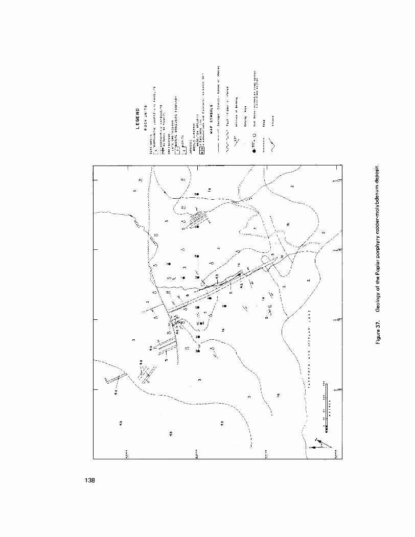
138

GEOLOGY OF THE POPLAR PORPHYRY COPPER-MOLYBDENUM DEPOSIT
(93L/3E; 93E115W)
By P. M. Mesard and C. 1. Godwin
Department of Geological Sciences, University of British Columbia
and
N. C. Carter
Senior Geologist, British Columbia Ministry of Mines and Petroleum Resources
INTRODUCTION
The Poplar copper-molybdenum porphyry deposit, 50 kilometres south-southwest of Houston, is centred near 54 degrees 01 minute north and 126 degrees 50 minutes west. The property is accessible from Houston via 80 kilometres of forest access roads along the Morice River, Owen Lake, Tahtsa Reach, and Poplar Lake. The deposit is situated on the northeast shore of Tagetochlain (Poplar) Lake in an area of moderately rolling topography which ranges in elevation from 840 metres a t lake level to 1 110 metres a t the western edge of the study area (Fig. 37). Two small streams, Canyon Creek and East Creek, traverse the area. Grassy, open meadows alternate with local stands of aspen, fir, and pine. Meadows in the area are used t ~ y local ranchers for cattle grazing.
The property has been optioned since 1974 by Utah Mines Ltd. Development work to 1977 has included geological and topographic mapping, soil geochemistry, magnetometer, induced polarization, and legal land surveys, and 40 diamond-drill holes (ranging from 119 to 300 metres in length) totalllng 8 281 metres.
This paper is a preliminary report on fieldwork undertaken during the summer of 1978 on the Poplar property. which will form the basis for an M.A.Sc. thesis project by the senior author. Work is continuing on details of petrology, mineralization. and alteration, and the spatial distribution of these features. Geochronometric studies are also in progress.
Field studies consisted of mapping the geology of the area surrounding the deposit a t a scale of 1:2500. and logging the majority of the drill core. Special emphasis was placed on detailed logging of drill holes along an east-west cross-section (eight holes), and a 035 azimuth section (four holes), through the tieposit (Fig. 37, filled circles). Other holes (Fig. 37, open circles), logged in less detail, facilitated extrapolation from there cross-sections. A computer compatible data base system w a s used to log the core in detail (Blanchet and Godwin, 1972; Godwin, et a/., 1976; and Wilton. 19781. Data collected are amenable to computer processing for studies involving a large number of variables. Such studies can define statistical correlatiorls between separate geologic features and their spatial distribution (compare Cargill, 1975; Wilton, 1978).
This study is supported jointly by the British Columbia of Mines and Petroleum Resources and by a National Research Council of Canada grant to Godwin. Discussions with T. G. Schroeter of the Ministry csf Mines and Petroleum Resources, Dr. A. J. Sinclair of the University of British Columbia, and Dr. T. A.
Richards of the Geological Survey of Canada during visits in the field were helpful. Utah Mines Ltd. have generously given permission for this project and have proyided a large amount of backgrourld data. Intere:;t shown by B. Bowen and A. J. Schmidt is gratefully acknowledged.
139
ldegroot
1978

GEOLOGY
Figure 37 shows the generalized geology of the Poplar porphyry deposit based on surface geology and information from drill holes. Mineralization appears to be genetically related to a Late Cretaceous porphyritic stock which intruded and locally metamorphosed volcaniclastic and epiclastic country rocks. Several post-mineral dykes intrude both the stock and the surrounding sedimentary rocks, and may be equivalent in age and composition to Tertiary (?) volcanic rocks in the western and central part of the study area.
Field descriptions. as follows, are provided in order of decreasing age as determined from crosscutting relationships.
Hazelton Group (?) (Units l a and lb)
Potassiurnlargon age analyses (see table) from the biotite monzonite porphyry indicate that the sedimentary rocks surrounding the deposit are of pre-Late Cretaceous age. Lithologies of these sedimentary rocks are similar to those described by Tipper and Richards (1976. p. 27) for the upper portion of the Early to Middle Jurassic Hazelton Group. Hazelton (?) rocks consist of two distinct units: a volcaniclastic and epiclasticvolcanic member (unit tal and an epiclastic member (unit lb). Contacts delineating the upper and lower units were not observed.
Unit l a is composed of dark grey to pale tan dust and lapilli tuff, argillaceous tuff, and siltstone. Local lenses of medium to fine-grained sandstone, up to 1 metre thick, are interbedded with these tuffaceous rocks. Bedding attitudes are 050 to 075 degrees with dips of 50 to 80 degrees southeasterly. Unit l b is a moderately sorted, polylithic conglomerate and sandstone. The conglomerate consists of up to 85 per cent rounded to subangular clasts of quartz, banded chert, and tuff, less than 2 centimetres in diameter. The matrix consists of fine-grained tuff and quartz. and is locally chloritic. Sandstone of this unit, which underlies and locally is interbedded with the conglomerate, consists of well-rounded to angular, medium to fine-grained quartz. plagioclase, and chert.
POTASSIUM-ARGON ANALYTICAL DATA= FROM THE POPLAR PORPHYRY DEPOSIT. BRITISH COLUMBIA
SAMPLE NO. APPARENT- 4 0 W d 4oAr.d MINERAL ROCK UNIT; LOCATION^ OR NAME DATED ROCK NAME^ LAT. IN]: LONG. IW)
%K+SC 40Ar TOTAL AGE IMal 110.5cm3STPlgi
TIME'
G76TR22 Late , 171.9r2.5 2.088 0.878 1.14x1.07 biotite 3: bintile 54" 01' 125' 5 0 monlonite Porphyry
CrefaCeO".
POPLAR LAKE Late 75.1+2.3 2.139 0.915 l.W+O.C4 biotlle 3: biotite 5 4 " O i ' 1 2 5 ' 5 0 monzonite oorPhYrY
CWtaCeOU
140

Diorite (Unit 2)
Diorite is observed in outcrops which form local ridges on the southern and southeastern portions of Figure 00. This diorite, generally porphyritic. contains up to 20 per cent coarse-grained, euhedral hornblende in a fine-grained to aphanitic groundmass. Medium-grained phenocrysts of plagioclase are abundant, and medium-grained biotite phenocrysts are minor. Although potassium feldspar phenocrysts were not observed, the groundmass is locally pinkish grey indicating that is may contain apprer:iable potassium feldspar. Magnetite is common in the groundmass. This unit is locally mineralized with minor disseminations of pyrite andlor traces of chalcopyrite. The diorite was observed in chillecl contact against the Hazelton (? ) conglomerate (unit 1 b).
Biotite Monzonite Porphyry (Unit 3)
Biotite monzonite porphyry has distinctive medium-grained euhedral phenocrysts of plagioclase and biotite in a pink to dark grey aphanitic groundmass. Minor mediumgrained hornblende and rare potassium feldspar phenocrysts (most pink feldspars are hematitized plagioclase) are observed locally. Textural variations are common. Contacts between this unit and the Hazelton I?) sedimentary rocks are typically highly fractured, sheared, and steep. Hydrothermal alteration within the biotite monzonite porphyry is extensive and variable. Sulphide minerals are most abundant in this unit, but are absent in younger rock (units. Therefore, the biotite monzonite porphyry is very closely related to the formation of the Poplar deposit.
Two samples of biotite monzonite porphyry have yielded K/Ar model ages of 71.9t2.5 Ma and 75.1-2.3 Ma (see table). This Late Cretaceous age suggests that the biotite monzonite porphyry is synchronous with granitic stocks associated with the Bulkley intrusions defined by Carter (1974, 1576; cormpare Maclntyre. 1976) which are host to other copper and molybdenum deposits in the area including Huckleberry and Ox Lake.
Porphyritic Rhyodacite Dykes and Flows (?) (Units 4a and 46)
Porphyritic rhyodacite (Fig. 37. unit 4a) intrudes the biotite monzonite porphyry and Hazelton ( ? I sedimentary rocks. These dykes have fine to medium-grained plagioclase phenocrysts set in a maroon aphanitic groundmass. Quartz eyes, up to 5 millimetres in diameter and medium-grained biotite occur locally. Oriented phenocrysts define a trachvtoid texture, emphasized by elongated amygdules.
Volcanic flow (? ) rocks (Fig. 37, unit 4b) are found in Canyon Creek and capping (?) a hill in the western portion of Figure 00. These rocks are porphyritic and composed of up to 50 per cent fine to
medium-grained phenocvsts of plagioclase, biotite, hornblende, and potassium feldspar. The aphanitic groundmass is reddish brown to pink in colour. Locally the unit is trachytoid.
These flows ( ? I are typically fresh and unmineralized, yet occur adjacent to highly altered biotite porphyrv. These volcanic rocks therefore were not present a t the time of intrusion, alteration, and mineralization of the deposit. Megascopically these flows (?) resemble the dykes in mineralogy and texture, and are
141

tentatively considered to be comagmatic; the dykes. thus, were 'feeders' for the volcanic rocks and locally intrude them. Faulting has placed unit 4b against highly altered argillites of the Hazelton (? ) Group in Canyon Creek, but the nature of the contact in the western part of Figure 37, between volcanic rocks and the altered intrusion is unknown.
Porphyritic Quartz Eye Rhyolite Dykes (Unit 5 )
Porphyritic quartz eye rhyolite is distinctively white to tan in colour. The unit is composed of abundant well-rounded quartz eyes, up to 6 millimetres in diameter, with medium-grained euhedral plagioclase and biotite phenocrysts in an aphanitic groundmass. Porphyritic quartz eye porphyry is the most abundant dyke rock and is observed intruding all other units, except the volcanic flow (?) rocks (unit 4b).
ALTERATION AND MINERALIZATION
All significant hydrothermal alteration and sulphide concentrations are restricted to the Hazelton ( ? I Group layered rocks, the diorite, and the biotite monzonite porphyry. Alteration assemblages, whose localizations are strongly controlled by structure, are complex and variable in intensiw and distribution. Pervasive
especially a t rock unit contacts. On the basis of field studies the major alteration assemblages are: alteration is volumetrically most abundant, but veins and associated envelopes are also commonly observed,
(1) POTASSIC: potassium feldspar + secondary biotite + magnetite + gypsum f quartz f
( 2 ) PHYLLIC: quartz + sericite + pyrite f gypsum f clay kcarbonate f hematite (3) ARGILLIC: clay f sericite f carbonate f quartz (4) PROPYLITIC: chlorite +carbonate i epidote ?albite (?)
hematite
These assemblages are commonly superimposed on one another (for example, potassium feldspar veins cut pervasively Zricitized rocks). The most widespread alteration is phyllic, followed by potassic and propylitic. Argillic alteration is minor.
Sulphide minerals, in order of decreasing abundance, include: pyrite, chalcopyrite, and molybdenite. Traces of sphalerite, galena, tetrahedrite, covellite, and chalcocite occur in veins. Chalcopyrite, commonly as disseminations, is closely associated with sericitized biotite. Molybdenite occurs mainly in veins associated with gypsum and quartz.
STRUCTURE
This study is centred in a region characterized by extensive block faulting (Maclntyre, 1976; Woodsworth, personal communication, 19781. Structures on Figure 37 are interpreted from scant outcrop, drill-hole information, and from aerial photographs. The dominant structural feature is the north-northwest-trending shear zone parallel to the porphyritic quartz eye rhyolite dyke in Canyon Creek. Outcrop in the creek is
142
well jointed, sheared, and quartz veined. A dominant set of joints trends 010 to 025 degrees azimuth and dips 75 to 90 degrees to the northwest. Numerous dykes and shear zones on Figure 37 parallel this trend, but are truncated in the northern part of Figure 37 by an easterly trending fault. Displacement along faults could not be determined.
REFERENCES
Blanchet, P. H. and Godwin, C. I. (1972): ‘Geolog System’ for Computer and Manual Anal,ysis of Geologic Data from Other Deposits, Econ. Geol., Vol. 67. pp. 796-813.
Cargill. D. G. (1975): Geology of the ’Island Copper’ Mine, Port Hardy, British Columbia, unpubl. Ph.D. thesis, University of British Columbia, 21 1 pp.
Carter, N. C. (1974): Geology and Geochronology of Porphyry Copper and Molybdenilm Deposits in
....,_.... (1976): Regional Setting of Porphyry Deposits in West-Central British Columbia, in Porphyry
Godwin. C. I., Hindson, R. E., and Blanchet, P. H. (1977): ‘Geolog,‘ A Computer-based Scheme for Detailed Analysis of Stratigraphy, Especially as Applied to Data from Drill Holes in Coal Exploration or Development; ClM, Bull., Vol. 70, No. 783. pp, 123.132.
West-Central British Columbia, unpubl. Ph.D. thesis, University of British Columbia.
Deposits of the Canadian Cordillera, A. Sutherland Brown, ed., ClM, Special Val. 15, pp. 227-238.
Maclntyre. D. G. 11976): Evolution of Upper Cretaceous Volcanic and Plutonic Centres and Associated Porphyry Copper Occurrences, Tahtsa Lake Area, British Columbia, unpubl. Ph.D. thesis, University of Western Ontario, p. 148.
Obradovich. J. D. and Cobban. W. A. (1975): A Time-Scale for the Late Cretaceous of the Western Interior of North America, Geol. Assoc. Canada, Special Paper No. 13, pp. 31-54.
Tipper, H. W. and Richards, T. A. (1976): Jurassic Stratigraphy and History of North-Central British Columbia, Geol. Surv., Canada, Bull. 270, p. 73.
Wilton, D. C. 11978): A Genetic Model for the Sustut Copper Deposit, North-Central British Columbia, unpubl. MSc. thesis, University of British Columbia, p. 213.
143

144

RECONNAISSANCE GEOCHEMICAL SURVEYS
(103 I, P; 104 0, P)
By N. C. Carter, T. E. Kalnins, and G. D. Nordin
The Ministry of Mines and Petroleum Resources was involved in two reconnaissance geochemical surveys in 1978.
1978 was the third and final year for the Uranium Reconnaissance Program managed and funded jointly by the Ministry and the Department of Energy, Mines and Resources. To date, approximately 114 000 square kilometres in British Columbia have been sampled a t an average density of one sample site per 12.5 square kilometres. Analytical results have been released for NTS map-areas 82 E, F. K, L, M and 104 N (Fig. 38).
Field sampling in 1978 was carried out in the Jennings River and McDame map-areas (NTS 104 0 and P) by a six-person crew provided by Bema Industries Ltd. of Vancouver. The crew was supwvised by S . El. Ballantyne. Geological Survey of Canada, and G. D. Nordin, who represented the Ministry. A total of 1 730 stream sediment and water and 70 lake sediment samples were collected from the two map-areas. The planned sample site density w a s achieved in the Jennings River maparea but not in hlcDame due t 3
extensive areas of swamp and thick brush cover in the northern part of the map-area.
Sample preparation and analysis were contracted out to separate commercial firms. Df!termination of uranium in stream sediments will be done by the Atomic Energy of Canada Laboratory ir Ottawa. Water samples will be analysed for uranium, fluorine, and pH while stream sediments will be anglysed for zinc:. copper, lead, nickel, cobalt, silver, manganese, iron, molybdenum, tungsten, and mercury. in addition to uranium. Analytical results are expected to be released in June of 1979.
The 1978 Accelerated Geochemical Survey. patterned after the Uranium Reconnaissanct! Program, was made possible through the Accelerated Mineral Development Program funded by Bill 5, Revenue Surplus of 1976177 Appropriation Act, 1978. The area selected for sampling (Fig. 38) included the Prince RupertlTerrace (103 I and J) and Nass River (103P and 0) mapareas.
A sample s i te density of one site per 6 square kilometres was almost achieved. Stream water!; and sediments were collected from 4 111 sites during this mainly helicopter-supported survey. The sampling crew wa:; provided by Stokes Exploration Management Company and was under the supervision of T. E. Kalnins. Ministry representative.
Stream sediments and waters will be analysed for the same elements as those samples collected for the Uranium Reconnaissance Program, except that the sediments to he done by Chemex Labs L.td. will also h! analysed for arsenic. Uranium analysis of stream sediments will be carried out using the new facilities o i Novatrack Analysts Ltd. in Vancouver. Water analyses have been done by Bondar-Clegg and Co. Ltd. ancl sample preparation was carried out by Min-En Laboratories Ltd.
Release of analytical results from this survey is planned for April of 1979 by way of two sample location maps and computer print-outs of analytical data.
146
ldegroot
1978

1500--179-0122