GEOLOGICAL 3D MODELING OF LARGE PLAINS IN ITALY · GEOLOGICAL 3D MODELING OF LARGE PLAINS IN ITALY:...
27
GEOLOGICAL 3D MODELING OF LARGE PLAINS IN ITALY: basin analysis, active faults, and characterization of uncertainties Chiara D’Ambrogi & F.E. Maesano Servizio Geologico d'Italia – ISPRA [email protected]
Transcript of GEOLOGICAL 3D MODELING OF LARGE PLAINS IN ITALY · GEOLOGICAL 3D MODELING OF LARGE PLAINS IN ITALY:...

GEOLOGICAL 3D MODELING OF LARGE PLAINS IN ITALY: basin analysis, active faults, and characterization of uncertainties
Chiara D’Ambrogi & F.E. MaesanoServizio Geologico d'Italia – ISPRA

Imag
e:
NA
SA
Geological 3D modeling of large plains: geology, economy, society
Workflow
- 3D modeling
- basin analysis
- fault characterization
- uncertainties
Communication of the results
OUTLINE
The geological challenge in large plains…
beneath our feet?What’s
Subsurface geological sheet
STATIC PRODUCTS DYNAMICALLY UPDATABLE PRODUCTS
3D model 3D model-derived maps
knowledge
mapping modeling & mapping
Large plains: geology - economy - society ■ ■ ■ ■ ■ Workflow: 3D modeling - analysis - uncertainties ■ ■ ■ ■ ■ ■ ■ ■ ■ ■ ■ ■ ■ ■ ■ Communication & conclusions ■ ■ ■
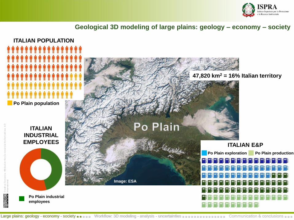
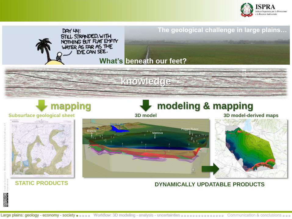
Image: ESA
Po Plain population
ITALIAN POPULATION
0Po Plain exploration Po Plain production
ITALIAN E&P
Po Plain industrial
employees
ITALIAN
INDUSTRIAL
EMPLOYEES
47,820 km2 = 16% Italian territory
Geological 3D modeling of large plains: geology – economy – society
Large plains: geology - economy - society ■ ■ ■ ■ ■ Workflow: 3D modeling - analysis - uncertainties ■ ■ ■ ■ ■ ■ ■ ■ ■ ■ ■ ■ ■ ■ ■ Communication & conclusions ■ ■ ■
Plain, but not tectonically stable Geology – economy – society
Large plains: geology - economy - society ■ ■ ■ ■ ■ Workflow: 3D modeling - analysis - uncertainties ■ ■ ■ ■ ■ ■ ■ ■ ■ ■ ■ ■ ■ ■ ■ Communication & conclusions ■ ■ ■
May-June 2012 Emilia seismic sequence - Mw max 6.1
Milano
Bologna
Torino
Venezia
Magnitude
Instrumental seismicity 1990 -2015 (http://iside.rm.ingv.it)Research Permits
O&G Production
Gas storage
Blind thrust
Cavone gas field
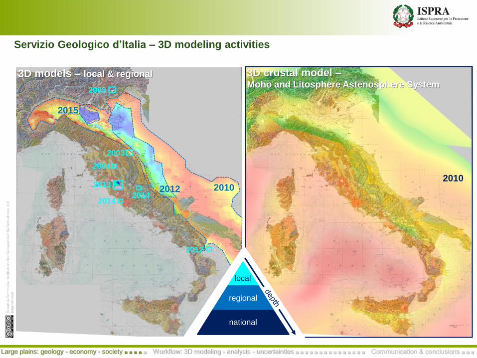
3D models – local & regional 3D crustal model –Moho and Litosphere Astenosphere System
local
regional
national
local
2010
2003
2004
2013
20142014
2012
2010
2008
2012
2015
Servizio Geologico d’Italia – 3D modeling activities
Large plains: geology - economy - society ■ ■ ■ ■ ■ Workflow: 3D modeling - analysis - uncertainties ■ ■ ■ ■ ■ ■ ■ ■ ■ ■ ■ ■ ■ ■ ■ Communication & conclusions ■ ■ ■
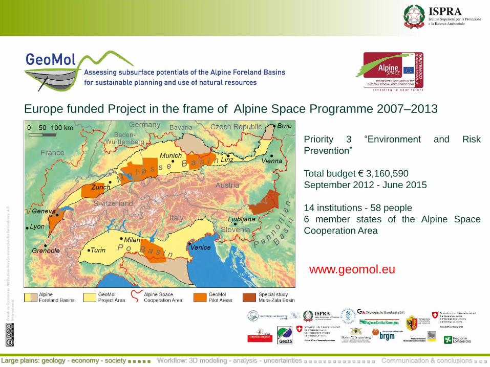
Priority 3 “Environment and Risk
Prevention”
Total budget € 3,160,590
September 2012 - June 2015
14 institutions - 58 people
6 member states of the Alpine Space
Cooperation Area
Europe funded Project in the frame of Alpine Space Programme 2007–2013
www.geomol.eu
Large plains: geology - economy - society ■ ■ ■ ■ ■ Workflow: 3D modeling - analysis - uncertainties ■ ■ ■ ■ ■ ■ ■ ■ ■ ■ ■ ■ ■ ■ ■ Communication & conclusions ■ ■ ■
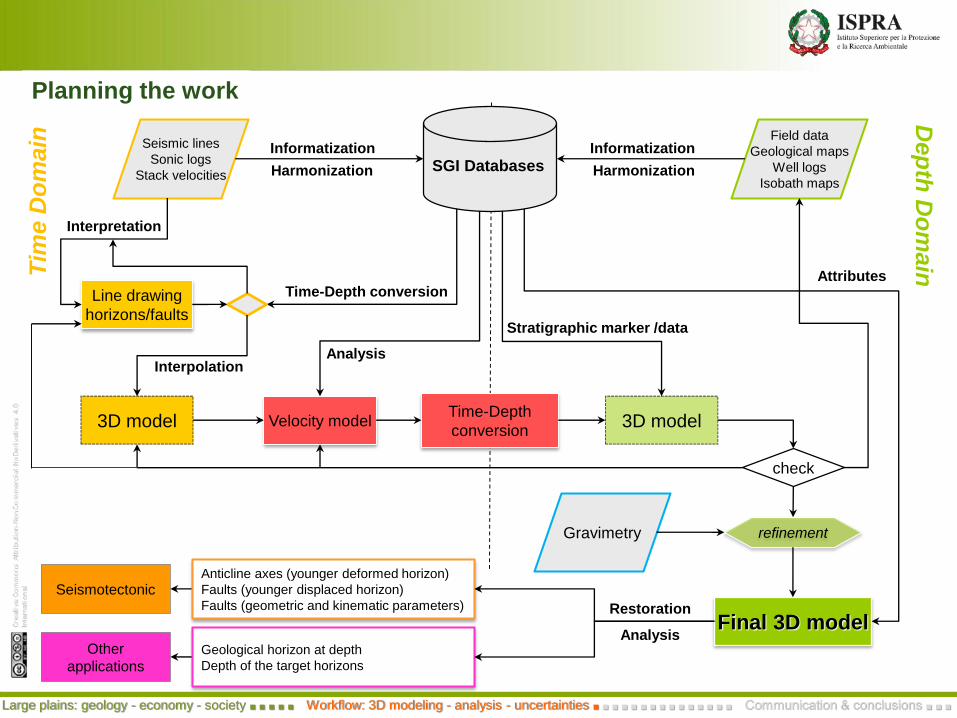
Tim
eD
om
ain
Dep
thD
om
ain
3D model Velocity model
Seismic lines
Sonic logs
Stack velocities
Field data
Geological maps
Well logs
Isobath maps
Interpretation
Informatization
AnalysisInterpolation
Time-Depth
conversion3D model
Stratigraphic marker /data
Attributes
Informatization
check
SGI Databases HarmonizationHarmonization
Line drawing
horizons/faults
refinementGravimetry
Seismotectonic
Other
applications
Final 3D model
Anticline axes (younger deformed horizon)
Faults (younger displaced horizon)
Faults (geometric and kinematic parameters)
Geological horizon at depth
Depth of the target horizons
Restoration
Analysis
Time-Depth conversion
Planning the work
Large plains: geology - economy - society ■ ■ ■ ■ ■ Workflow: 3D modeling - analysis - uncertainties ■ ■ ■ ■ ■ ■ ■ ■ ■ ■ ■ ■ ■ ■ ■ Communication & conclusions ■ ■ ■
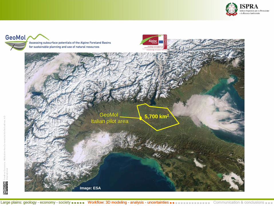
Image: ESA
GeoMol
Italian pilot area5,700 km2
Large plains: geology - economy - society ■ ■ ■ ■ ■ Workflow: 3D modeling - analysis - uncertainties ■ ■ ■ ■ ■ ■ ■ ■ ■ ■ ■ ■ ■ ■ ■ Communication & conclusions ■ ■ ■
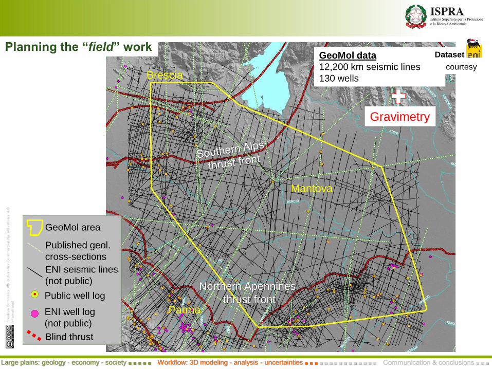
Brescia
Mantova
Parma
GeoMol data
12,200 km seismic lines
130 wells
Gravimetry
Planning the “field” workDataset
courtesy
GeoMol area
Published geol.
cross-sections
ENI seismic lines
(not public)
Blind thrust
Public well log
ENI well log
(not public)
Northern Apennines
thrust front
Large plains: geology - economy - society ■ ■ ■ ■ ■ Workflow: 3D modeling - analysis - uncertainties ■ ■ ■ ■ ■ ■ ■ ■ ■ ■ ■ ■ ■ ■ ■ Communication & conclusions ■ ■ ■
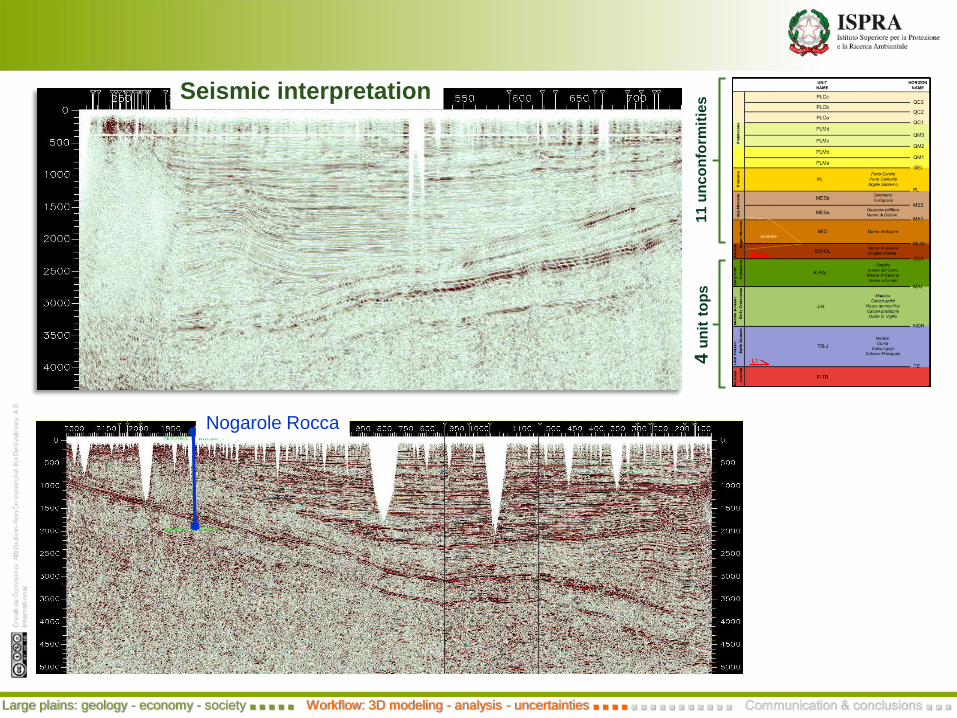
Nogarole Rocca
Seismic interpretation
11 u
nc
on
form
itie
s4 u
nit
top
sLarge plains: geology - economy - society ■ ■ ■ ■ ■ Workflow: 3D modeling - analysis - uncertainties ■ ■ ■ ■ ■ ■ ■ ■ ■ ■ ■ ■ ■ ■ ■ Communication & conclusions ■ ■ ■

NOR
MLW
ME2ME3
SCAMAI
PL
ME1
TE
QM1
QM1QM2
QM3
QC1QC2
PL
Nogarole Rocca
Seismic interpretation
11 u
nc
on
form
itie
s4 u
nit
top
sLarge plains: geology - economy - society ■ ■ ■ ■ ■ Workflow: 3D modeling - analysis - uncertainties ■ ■ ■ ■ ■ ■ ■ ■ ■ ■ ■ ■ ■ ■ ■ Communication & conclusions ■ ■ ■

4-layer cake model - interpolated V0 and k
The velocity model and Time-Depth conversion
More on uncertainties characterization…
Interpolate velocity
Interpolate gradient
Spatial overlay of v0 and k values on the [x,y,twt] ascii
(horizon/fault surface)
Depth conversion using instantaneous velocity
Analysis of well velocitiesto obtain V0 and k
Extract velocity data for each stratigraphic interval
Wells database
3D model (time domain)
3D model (depth domain)
Layer 4Layer 3Layer 2Layer 1
Large plains: geology - economy - society ■ ■ ■ ■ ■ Workflow: 3D modeling - analysis - uncertainties ■ ■ ■ ■ ■ ■ ■ ■ ■ ■ ■ ■ ■ ■ ■ Communication & conclusions ■ ■ ■
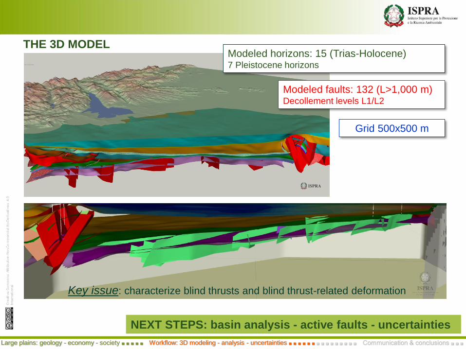
THE 3D MODELModeled horizons: 15 (Trias-Holocene)7 Pleistocene horizons
Modeled faults: 132 (L>1,000 m)Decollement levels L1/L2
Grid 500x500 m
NEXT STEPS: basin analysis - active faults - uncertainties
Large plains: geology - economy - society ■ ■ ■ ■ ■ Workflow: 3D modeling - analysis - uncertainties ■ ■ ■ ■ ■ ■ ■ ■ ■ ■ ■ ■ ■ ■ ■ Communication & conclusions ■ ■ ■
Key issue: characterize blind thrusts and blind thrust-related deformation
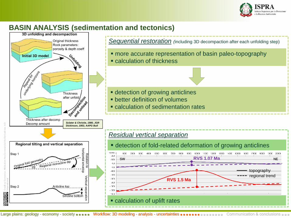
Sclater & Christie, 1980, JGR
Dickinson, 1953, AAPG Bull
more accurate representation of basin paleo-topography
calculation of thickness
Sequential restoration (including 3D decompaction after each unfolding step)
detection of growing anticlines
better definition of volumes
calculation of sedimentation rates
BASIN ANALYSIS (sedimentation and tectonics)
detection of fold-related deformation of growing anticlines
Residual vertical separation
SW NE
RVS 1.5 Ma
RVS 1.07 Ma
topography
regional trend
calculation of uplift rates
Large plains: geology - economy - society ■ ■ ■ ■ ■ Workflow: 3D modeling - analysis - uncertainties ■ ■ ■ ■ ■ ■ ■ ■ ■ ■ ■ ■ ■ ■ ■ Communication & conclusions ■ ■ ■
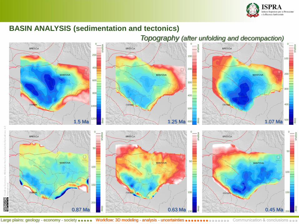
200
400
800
1000
0
sh
allo
wd
ee
p
600
1200
1.5 Ma
100
200
400
500
0
sh
allo
wd
ee
p
300
6001.25 Ma
100
200
400
500
0
sh
allo
wd
ee
p
300
1.07 Ma
50
100
150
200
0
sh
allo
wd
ee
p
0.87 Ma
50
100
130
0
sh
allo
wd
ee
p
0.63 Ma
50
100
150
200
0
sh
allo
wd
ee
p
0.45 Ma
Topography (after unfolding and decompaction)
BASIN ANALYSIS (sedimentation and tectonics)
Large plains: geology - economy - society ■ ■ ■ ■ ■ Workflow: 3D modeling - analysis - uncertainties ■ ■ ■ ■ ■ ■ ■ ■ ■ ■ ■ ■ ■ ■ ■ Communication & conclusions ■ ■ ■
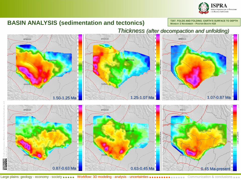
1.25-1.07 Ma
0.63-0.45 Ma0.87-0.63 Ma
1.07-0.87 Ma1.50-1.25 Ma
Thickness (after decompaction and unfolding)
0.45 Ma-present
T207. FOLDS AND FOLDING: EARTH’S SURFACE TO DEPTH
MONDAY 2 NOVEMBER – POSTER BOOTH 418BASIN ANALYSIS (sedimentation and tectonics)
Large plains: geology - economy - society ■ ■ ■ ■ ■ Workflow: 3D modeling - analysis - uncertainties ■ ■ ■ ■ ■ ■ ■ ■ ■ ■ ■ ■ ■ ■ ■ Communication & conclusions ■ ■ ■

BASIN ANALYSIS & ACTIVE FAULTS
Uplift rate calculation
T207. FOLDS AND FOLDING: EARTH’S SURFACE TO DEPTH
MONDAY 2 NOVEMBER – POSTER BOOTH 418
Large plains: geology - economy - society ■ ■ ■ ■ ■ Workflow: 3D modeling - analysis - uncertainties ■ ■ ■ ■ ■ ■ ■ ■ ■ ■ ■ ■ ■ ■ ■ Communication & conclusions ■ ■ ■
200
400
800
1000
0
600
1200
sh
allo
wd
ee
p
A
B
1.50 Ma
Sedimentation & Uplift rates
Base Gelasian
1.50 Ma
1.25 Ma
1.07 Ma
Base Pliocene
Well
Vertical separation - Lateral variation
A
B
Maesano & D’Ambrogi, 2015, Italian Journal of Geosciences
1.50
1.25
1.07
0.45
0.63
0.87Ma
after
identification and characterization of growing anticlines (after 3D model restoration)
we need
accuracy in positioning the fault tip (younger deformed/displaced horizon)
age constraints (deformed/displaced horizon younger than 1.6 Ma)

ACTIVE FAULTS
Inherited normal faults
possible reactivation in the
present stress field
Depth 5 + 0.5 km Depth 10 + 0.5 km
Fault upper tip/Axis
(younger displaced
or deformed horizon)
NS – N10E: Maximum horizontal stress axis orientation
(data from WSM 2008; Heidbach et al., 2008)
interpolation from
SHINE
http://shine.rm.ingv.it/
Shmax orientation
Favorably oriented planes
from structural analysis (3D model-derived) to seismotectonic characterization
New or modified
Seism Sources
Seismogenic
Sources
DISS http://diss.rm.ingv.it/diss/
Active fault/fold
related to
Seism Sources
Active fault/fold
related to potential
Seism Sources
Active fault/fold
Large plains: geology - economy - society ■ ■ ■ ■ ■ Workflow: 3D modeling - analysis - uncertainties ■ ■ ■ ■ ■ ■ ■ ■ ■ ■ ■ ■ ■ ■ ■ Communication & conclusions ■ ■ ■
collaboration with INGV
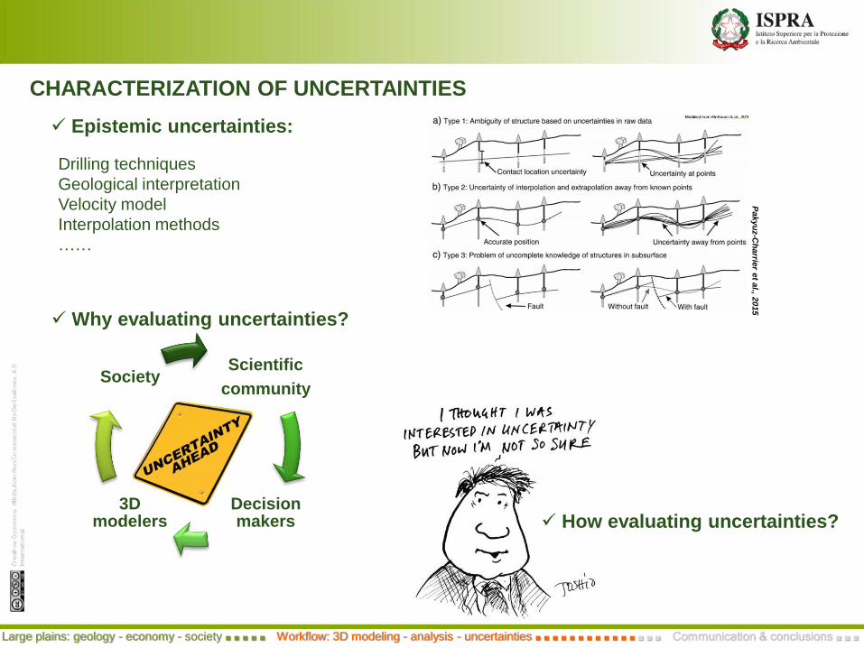
Why evaluating uncertainties?
CHARACTERIZATION OF UNCERTAINTIES
Scientific
community
Decision makers
3D modelers
Society
Drilling techniques
Geological interpretation
Velocity model
Interpolation methods
……
Pakyu
z-C
harrie
ret a
l., 2015
Epistemic uncertainties:
How evaluating uncertainties?
Large plains: geology - economy - society ■ ■ ■ ■ ■ Workflow: 3D modeling - analysis - uncertainties ■ ■ ■ ■ ■ ■ ■ ■ ■ ■ ■ ■ ■ ■ ■ Communication & conclusions ■ ■ ■
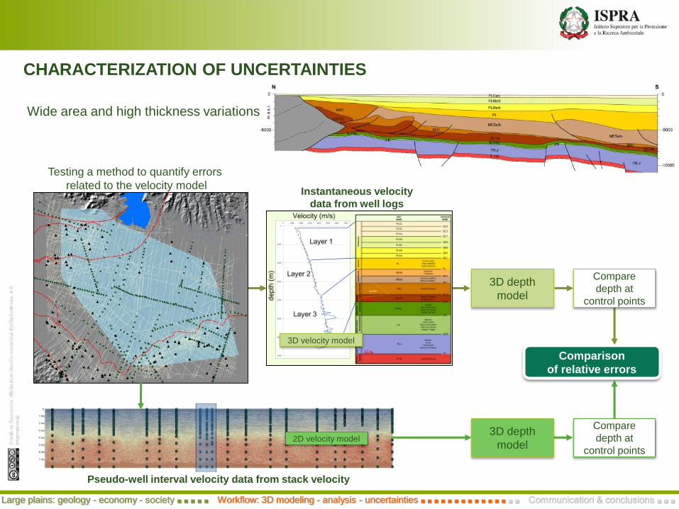
CHARACTERIZATION OF UNCERTAINTIES
Wide area and high thickness variations
Pseudo-well interval velocity data from stack velocity
Testing a method to quantify errors
related to the velocity modelInstantaneous velocity
data from well logs
3D depth
model
3D depth
model
Compare
depth at
control points
Compare
depth at
control points
Comparison
of relative errors
3D velocity model
2D velocity model
Large plains: geology - economy - society ■ ■ ■ ■ ■ Workflow: 3D modeling - analysis - uncertainties ■ ■ ■ ■ ■ ■ ■ ■ ■ ■ ■ ■ ■ ■ ■ Communication & conclusions ■ ■ ■
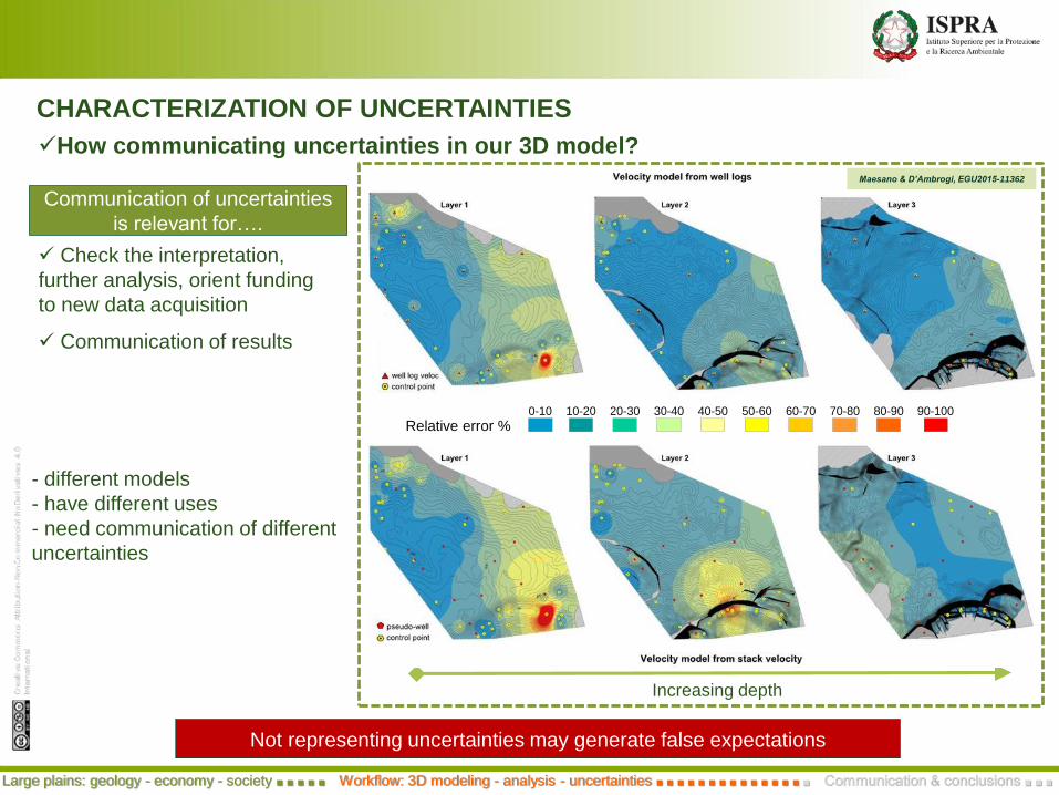
CHARACTERIZATION OF UNCERTAINTIES
How communicating uncertainties in our 3D model?
Not representing uncertainties may generate false expectations
Communication of results
Check the interpretation,
further analysis, orient funding
to new data acquisition
- different models
- have different uses
- need communication of different
uncertainties
Increasing depth
Maesano & D’Ambrogi, EGU2015-11362
0-10 10-20 20-30 30-40 40-50 50-60 60-70 70-80 80-90 90-100
Relative error %
Communication of uncertainties
is relevant for….
Large plains: geology - economy - society ■ ■ ■ ■ ■ Workflow: 3D modeling - analysis - uncertainties ■ ■ ■ ■ ■ ■ ■ ■ ■ ■ ■ ■ ■ ■ ■ Communication & conclusions ■ ■ ■
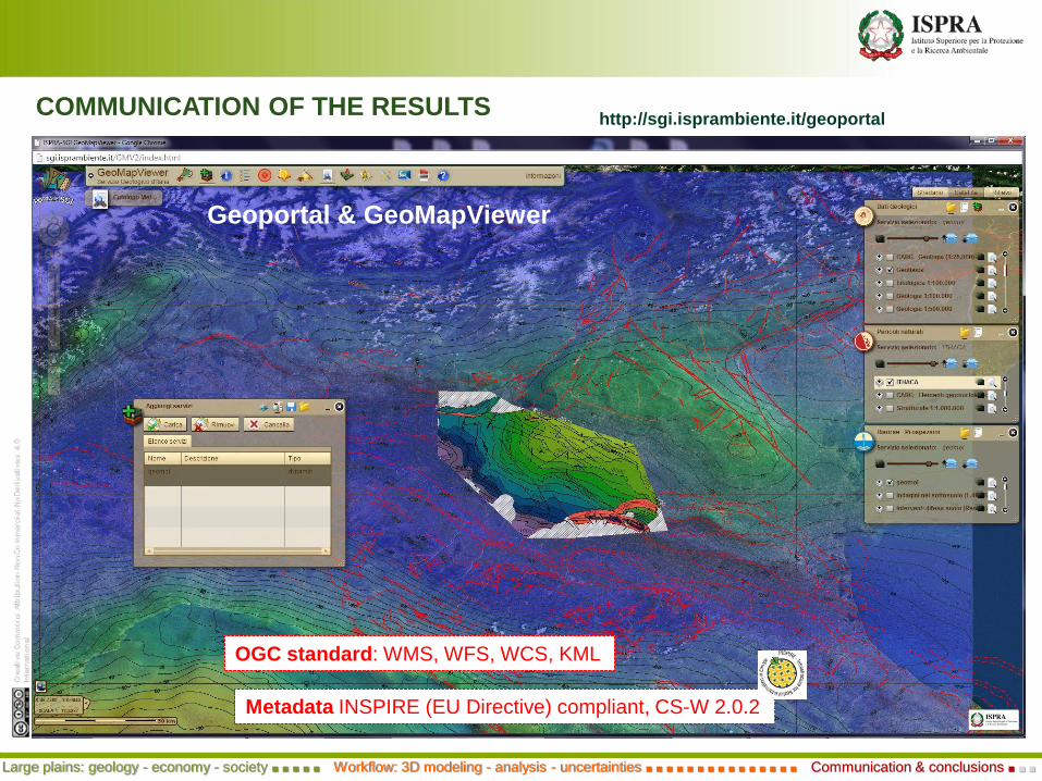
Geoportal & GeoMapViewer
Metadata INSPIRE (EU Directive) compliant, CS-W 2.0.2
OGC standard: WMS, WFS, WCS, KML
COMMUNICATION OF THE RESULTShttp://sgi.isprambiente.it/geoportal
Large plains: geology - economy - society ■ ■ ■ ■ ■ Workflow: 3D modeling - analysis - uncertainties ■ ■ ■ ■ ■ ■ ■ ■ ■ ■ ■ ■ ■ ■ ■ Communication & conclusions ■ ■ ■
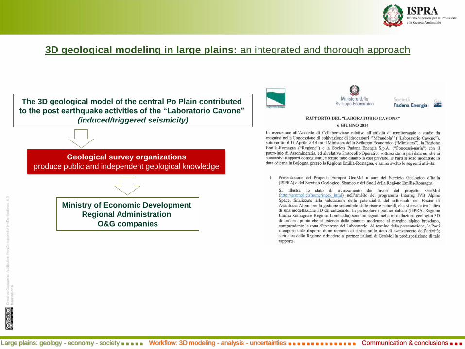
3D geological modeling in large plains: an integrated and thorough approach
The 3D geological model of the central Po Plain contributed
to the post earthquake activities of the “Laboratorio Cavone”
(induced/triggered seismicity)
Ministry of Economic Development
Regional Administration
O&G companies
Geological survey organizations
produce public and independent geological knowledge
Large plains: geology - economy - society ■ ■ ■ ■ ■ Workflow: 3D modeling - analysis - uncertainties ■ ■ ■ ■ ■ ■ ■ ■ ■ ■ ■ ■ ■ ■ ■ Communication & conclusions ■ ■ ■
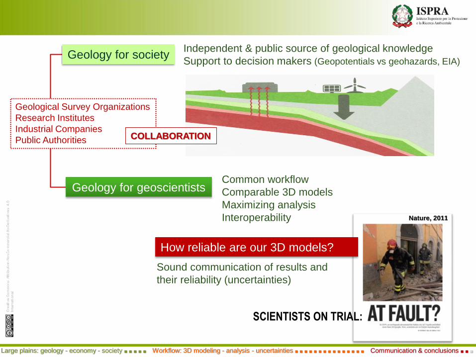
Independent & public source of geological knowledge
Support to decision makers (Geopotentials vs geohazards, EIA)
Geological Survey Organizations
Research Institutes
Industrial Companies
Public Authorities COLLABORATION
Common workflow
Comparable 3D models
Maximizing analysis
Interoperability
Geology for geoscientists
Geology for society
Large plains: geology - economy - society ■ ■ ■ ■ ■ Workflow: 3D modeling - analysis - uncertainties ■ ■ ■ ■ ■ ■ ■ ■ ■ ■ ■ ■ ■ ■ ■ Communication & conclusions ■ ■ ■
SCIENTISTS ON TRIAL:
Sound communication of results and
their reliability (uncertainties)
How reliable are our 3D models?
Nature, 2011

(44,663 stations,1 km grid, density 2.67 g/cm3)
Bouguer
anomaly map
High-pass filter
Gravimetry
Residual Bouguer
anomaly map
Structural element
thrust
normal fault
Gravimetry
discontinuity
primary
secondary
Large plains: geology - economy - society ■ ■ ■ ■ ■ Workflow: 3D modeling - analysis - uncertainties ■ ■ ■ ■ ■ ■ ■ ■ ■ ■ ■ ■ ■ ■ ■ Communication & conclusions ■ ■ ■
contribution from F. Ferri


![[PPT]The Unification of Italy and Germany - White Plains · Web viewNationalism is the belief that each ethnic group ... Arial Default Design The Unification of Italy and Germany Slide](https://static.fdocuments.in/doc/165x107/5aa274b17f8b9ab4208d119e/pptthe-unification-of-italy-and-germany-white-plains-viewnationalism-is.jpg)