Geologic Nomenclature and Description - ngmdb.usgs.gov · [DRAFT document for inclusion in “USGS...
37
Draft—Subject to revision Geologic Nomenclature and Description [DRAFT document for inclusion in “USGS Suggestions to Authors of the Reports of the United States Geological Survey, Eighth Edition” (STA8)] Version 1.0, March 14, 2018 This document was prepared for the U.S. Geological Survey by a working group comprised of members of the Science Publishing Network and the U.S. Geologic Names Committee. Working group members are (listed alphabetically): Julie A. Herrick, Katherine D. Jacques, Claire M. Landowski, David A. Shields, and Nancy R. Stamm (Geologic Names Committee Secretary). This document will be included in STA8, which is planned for publication in 2018. For reference, the seventh edition of STA is available at https://www.nwrc.usgs.gov/lib/lib_sta.htm. For questions or comments about this document, contact: Nancy Stamm and Claire Landowski ([email protected]). Because a final copyedit will be done prior to STA8 publication, we request that you limit your editorial comments to identifying missing or incorrect content, and to issues of general comprehension. [Document accessed at https://ngmdb.usgs.gov/info/docs/USGS-STA8_GeolNomenChapterDRAFT.pdf .]
-
Upload
nguyennhan -
Category
Documents
-
view
213 -
download
0
Transcript of Geologic Nomenclature and Description - ngmdb.usgs.gov · [DRAFT document for inclusion in “USGS...

Draft—Subject to revision
Geologic Nomenclature and Description
[DRAFT document for inclusion in “USGS Suggestions to Authors of the Reports of the United States Geological Survey, Eighth Edition” (STA8)]
Version 1.0, March 14, 2018
This document was prepared for the U.S. Geological Survey by a working group comprised of members of the Science Publishing Network and the U.S. Geologic Names Committee. Working group members are (listed alphabetically): Julie A. Herrick, Katherine D. Jacques, Claire M. Landowski, David A. Shields, and Nancy R. Stamm (Geologic Names Committee Secretary).
This document will be included in STA8, which is planned for publication in 2018. For reference, the seventh edition of STA is available at https://www.nwrc.usgs.gov/lib/lib_sta.htm. For questions or comments about this document, contact: Nancy Stamm and Claire Landowski ([email protected]). Because a final copyedit will be done prior to STA8 publication, we request that you limit your editorial comments to identifying missing or incorrect content, and to issues of general comprehension. [Document accessed at https://ngmdb.usgs.gov/info/docs/USGS-STA8_GeolNomenChapterDRAFT.pdf .]

Draft—Subject to revision
ii
Contents Geologic Names Committee and Technical Reviews ........................................................................................ 1Temporal Units..................................................................................................................................................... 2
Chronostratigraphic Units (arts. 66—79 of the Code) .................................................................................... 2Geochronologic Units (arts. 80–82 of the Code) ............................................................................................ 3Lower, Middle, Upper Versus Early, Middle, Late .......................................................................................... 3
Position ........................................................................................................................................................ 3Age ............................................................................................................................................................... 4
Numerical Ages ................................................................................................................................................ 4Provincial Terms............................................................................................................................................... 4
Material Units ....................................................................................................................................................... 7Formal Names .................................................................................................................................................. 7
Capitalization ............................................................................................................................................... 7Diacritical Marks .......................................................................................................................................... 7Accepted Usage of Names ......................................................................................................................... 7Classification Schemes of Other Agencies ................................................................................................ 8Foreign Names ............................................................................................................................................ 8Names Not Accepted by the USGS ............................................................................................................ 8Names of Varied or Controversial Use ....................................................................................................... 9Abandoned or Obsolete Names ................................................................................................................. 9Quotation Marks .......................................................................................................................................... 9Changes to Geologic Nomenclature ........................................................................................................... 9
Revised Names (art. 19 of the Code) ..................................................................................................... 9Boundary Change (arts. 19a and 23 of the Code) ............................................................................. 9Rank Change (art. 19b—g of the Code) .......................................................................................... 10Assignment to Another Unit of Higher Rank .................................................................................... 10Subdivision of a Unit ......................................................................................................................... 10
Names Adopted by the USGS ............................................................................................................... 10Principal and Ancillary Reference Sections, Localities, or Areas (art. 8 of the Code) ........................ 10Abandoned Names (art. 20 of the Code) .............................................................................................. 11Reinstatement of an Abandoned Name (art. 20e of the Code) ........................................................... 11Areal Extent (art. 12 of the Code) ......................................................................................................... 11Names Having Lithologic Designations (arts. 17a—18 of the Code) .................................................. 11Age Assignment (see also “Temporal Units” section) .......................................................................... 12
Proposing New Names (arts. 3—16, 22—47, and 55—60 of the Code) ................................................ 12Publication Requirements (art. 4 of the Code) ............................................................................................. 13Informal Names .............................................................................................................................................. 13
Use of Informal Names in Publications .................................................................................................... 14New Informal Names ................................................................................................................................. 14
Use of Geographic Names and Other Proper Nouns in Informal Nomenclature ................................ 14Use of Formal Rank Terms in Informal Nomenclature .................................................................... 14
Economic Terms ........................................................................................................................................ 15Aquifer Nomenclature and Classification .............................................................................................. 15
Informal Classifications of Surficial Deposits ........................................................................................... 15Pedologic Soil Nomenclature and Classification .................................................................................. 15
Informal Classifications of Geologic Events ............................................................................................. 16
Draft—Subject to revision
iii
Bodies of Intrusive Rocks.......................................................................................................................... 16Summary of Formal Versus Informal Usage ................................................................................................. 16
Geologic Descriptions........................................................................................................................................ 16Text Matter ..................................................................................................................................................... 16
Discussion of the Geologic Setting ........................................................................................................... 16Internal Consistency of Terms (see also “Accepted Usage of Names” section) .................................... 17Undesirable Expressions .......................................................................................................................... 17
Geologic Maps ............................................................................................................................................... 17Map Units, Labels, Colors, and Patterns .................................................................................................. 18
Labels for Map Units .............................................................................................................................. 18Formats for Map Unit Labels ............................................................................................................ 18Use of Map Unit Labels in Text Matter ............................................................................................. 19
Colors and Patterns for Map Units ........................................................................................................ 19Description of Map Units (DMU) ............................................................................................................... 20Correlation of Map Units (CMU) ............................................................................................................... 22Cross Sections........................................................................................................................................... 24
Expressing Uncertainty .................................................................................................................................. 24Citations Clarifying the Use of Geologic Names ........................................................................................... 25Illustrations, Charts, and Tables .................................................................................................................... 25
Measured Sections and Graphic Stratigraphic Columns ......................................................................... 25Correlation Charts and Stratigraphic Tables ............................................................................................ 29Abbreviations ............................................................................................................................................. 30
Acknowledgments.............................................................................................................................................. 31References ......................................................................................................................................................... 31About This Chapter ............................................................................................................................................ 34
Figures 1.Upper Jurassic to lower Tertiary provincial series and stages of the Gulf Coastal Plain of the United
States .......................................................................................................................................................... 62.Part of a simple cross section (from Berry and others, 2015) showing the relation between geologic
units having alphanumeric designations.. ..................................................................................................... 193.Example of part of a Correlation of Map Units (CMU; top) and a Description of Map Units (DMU;
bottom) from Minor and Brandt (2015), showing stratigraphic order, including queried ages, and hierarchy within a DMU .................................................................................................................................. 22
4.Example of a Correlation of Map Units diagram (from Walsh and others, 2010), showing the complex relations of rocks of the Connecticut Valley-Gaspé synclinorium area, north-central Vermont ................. 23
5.Schematic cross section of the rocks and sediments in the Kaibab area, Arizona (from Billingsley and others, 2004) .................................................................................................................................................. 24
6.Example of a measured section in tabular format (A) and accompanying graphic stratigraphic column (B), excerpted and slightly reformatted from Malmon and others (2011, p. 59, 94–95) ............................. 26
7.Chronostratigraphic column for the Colville basin, northern Alaska (from Mull and others, 2006) ............ 288.Correlation chart (from Finn, 2014) of Cretaceous rocks of the Bighorn and Powder River basins,
Wyoming and Montana. ................................................................................................................................. 299.A stratigraphic table by Turner and others (2011) that compares their stratigraphic classification of
the Eocene to Oligocene Chisos Formation with that of previous workers in the Big Bend National Park area, Texas. ........................................................................................................................................... 30

Draft—Subject to revision
Geologic Nomenclature and Description The U.S. Geological Survey (USGS) has the responsibility of publishing geologic maps
and reports that inform and benefit the general public, private industry, government officials, and scientists. Our publications must be accessible to everyone, whether geologist or not, and therefore the nomenclature and classifications used in USGS maps and reports must be clear and consistent.
Since the late 19th century, the Geologic Names Committee (GNC) has been responsible for defining protocols that promote uniform geologic nomenclature and classifications amongst USGS authors, whose studies cover vastly diverse topics and geologic areas. The rules and guidelines presented here are based upon the North American Stratigraphic Code (North American Commission on Stratigraphic Nomenclature, NACSN, 2005, available online at http://www.nacstrat.org/; herein referred to as the Code).
This chapter outlines the accepted expressions and styles of nomenclatural terms to use with rock and sediment descriptions, and the requirements for proposing and modifying formal geologic nomenclature. Emphasis is placed on the most commonly used categories of material units (lithostratigraphic and lithodemic) and temporal units (chronostratigraphic and geochronologic). USGS authors should be familiar with, and adhere to, the requirements of all categories defined in the Code.
A geologic unit is a three-dimensional body of earth material, recognized by its lithologic content (consolidated rock or unconsolidated sediment) and its boundaries at the surface and (or) subsurface. It is mappable at 1:24,000 scale, and is referred to by a formal or informal geologic name. In order to emphasize that geologic nomenclature connotes both the names and the three-dimensional bodies of material they represent, and to improve readability, the term “geologic name” is used interchangeably with “geologic unit” in this chapter.
History has shown us that by clearly categorizing a name, properly defining and describing a name, and fully explaining the revision of a previously introduced name avoids confusion and misinterpretation by others.
Geologic Names Committee and Technical Reviews The Geologic Names Committee (GNC), first organized by the Director of the USGS in
1899, is responsible for defining rules governing accepted usage of geologic nomenclature and classification in all USGS-authored reports and maps, whether they are to be published by the USGS or an outside organization, and whether they result in whole or in part from the official work of the USGS. The protocols used by the USGS, and outlined here, are based on the North American Stratigraphic Code (North American Commission on Stratigraphic Nomenclature, NACSN, 2005, available online at http://www.nacstrat.org/; herein referred to as the Code).
The GNC and geologic names technical reviewers evaluate formal geologic names for conformance with the rules of geologic nomenclature and decide if the names are permissible in USGS-authored publications. Emphasis is placed on maintaining uniformity of USGS nomenclature and limiting the number of geologic names employed through correlation of rocks and sediments from one study area to another. The GNC maintains records of formal geologic names, as well as informal names of economic and regional significance, for the United States,
Draft—Subject to revision
2
its possessions, and territories; these records are available through the online lexicon, Geolex, at https://ngmdb.usgs.gov/Geolex.
Every report and map originating in the USGS that contains geologic names must be reviewed for conformance to the Code and USGS protocols before its publication is authorized by the Bureau Approving Official. All parts of a report and map are subject to a geologic names technical review, including body text and illustrations, charts, tables, captions, appendixes, or other supplementary files. Geologic names reviewers consult Geolex and associated records (https://ngmdb.usgs.gov/Geolex/stratres), the Code, and USGS protocols. Ideally, these technical reviews would be conducted as part of a thorough peer review.
Accuracy and clarity are the main objectives in all publications of geologic data. A close observance of these protocols and guidelines provided herein will greatly expedite the work of reviewers and editors, and accelerate publication. Questions of conformance with the Code or USGS protocols that arise during the publication process may be addressed to the geologic names technical reviewer or the GNC and must be resolved before Bureau approval.
Temporal Units The Geologic Names Committee periodically publishes a geologic time scale that serves
as the standard for USGS publications. The current version is available online at https://ngmdb.usgs.gov/Geolex/stratres/timescales. Authors may use other published time scales, for example, those of the Geological Society of America or the International Commission of Stratigraphy (ICS), provided that they are clearly specified and referenced. Most of the USGS geologic time divisions are recognized internationally and ratified by the ICS. The geologic time scale serves a dual purpose by enabling authors to distinguish geologic units by position (chronostratigraphic) and age (geochronologic), as outlined below.
Names of the geologic time divisions may be used as modifiers of geologic units, for example, Ordovician Bighorn Dolomite. Punctuation marks are not used; for example, late Pleistocene Roxana Silt, not late-Pleistocene, or Permian Murdock Mountain Formation, not Permian, Murdock Mountain Formation.
A geologic unit can be assigned to more than one chronostratigraphic or geochronologic unit. The term “to” is used to indicate relatively continuous deposition or time, for example, Ordovician to Devonian includes the Silurian. The term “and” is used to indicate a significant amount of missing strata or time, for example, Ordovician and Devonian excludes the Silurian.
Chronostratigraphic Units (arts. 66—79 of the Code) Chronostratigraphic units of a standard geologic time scale designate the position of a
material unit relative to the sequence of rocks or sediments of a standard section (global boundary stratotype section and points, GSSPs)1. Examples of chronostratigraphic terms (in order of decreasing rank) are Phanerozoic Eonothem, Mesozoic Erathem, Cretaceous System, Upper Cretaceous Series, and Maastrichtian Stage.
Chronostratigraphic units should be used to express (1) the relative stratigraphic position of a material unit that generally conforms to the Law of Superposition, for example, a
1At the time of writing this chapter, the Precambrian divisions (with the exception of the Ediacaran and Cryogenian Systems) are represented by geochronometric global standard stratigraphic ages (GSSAs).
Draft—Subject to revision
3
lithostratigraphic unit, and (2) stratigraphic relations, for example, “in this area, the Upper Jurassic Morrison Formation is unconformably overlain by the Lower Cretaceous Kootenai Formation,” or “this unit is correlative with the lower Oligocene Vicksburg Group.”
Geochronologic Units (arts. 80–82 of the Code) Geochronologic units of a standard geologic time scale designate the age of a material
unit relative to the time interval represented by a standard section (GSSPs)2. Examples of geochronologic terms (in order of decreasing rank) are Phanerozoic Eon, Mesozoic Era, Cretaceous Period, Late Cretaceous Epoch, and Maastrichtian Age.
Geochronologic units should be used to express the age of: (1) a lithodemic unit that generally does not conform to the Law of Superposition, for example, a granite having an emplacement age of 1,100 Ma should be referred to as “late Mesoproterozoic” rather than “upper Mesoproterozoic;” (2) some surficial deposits, for example, the oldest Pleistocene glacial deposit may be highest on the mountain, thus the designation “oldest till” is preferable to “upper till;” and (3) fossils, for example, “samples collected from the base of the formation yielded ostracodes of early Eocene age.”
Lower, Middle, Upper Versus Early, Middle, Late Authors must be careful to differentiate the position (chronostratigraphic) from the age
(geochronologic) of a geologic unit.
Position Most of the systems of the Paleozoic and Mesozoic are subdivided into series that are
formally designated with the terms “Lower,” “Middle,” and “Upper,” for example, Lower Ordovician, Middle Mississippian, and Upper Jurassic. The informal, lowercase terms “lower,” “middle,” and “upper” are applied to (1) indefinite subdivisions of chronostratigraphic units of a standard time scale, for example, upper Paleozoic or lower Tertiary, and (2) subdivisions of stages and series, for example, upper Thanetian (upper Paleocene) or lower Ypresian (lower Eocene). Authors may also use “lower,” “middle,” or “upper” instead of a named series, for example, upper Permian instead of Lopingian. Examples expressing stratigraphic range and relations of material units are given below.
Stratigraphic range of a lithostratigraphic unit.—Upper Cretaceous Lewis Shale; upper Miocene to lower Pliocene Conant Creek Tuff; lower Calabrian Guaje Pumice Bed; upper Wisconsin Tiskilwa Formation.
Stratigraphic range of a lithodemic unit.—Not applicable; age terms rather than position terms are used for lithodemic units (art. 13d of the Code).
Stratigraphic relations.—“In this area, upper Paleozoic rocks are unconformably overlain by lower Tertiary sediments.” “Here, the Middle-Upper Pennsylvanian boundary is placed at the top of the informal Mason coal bed.” “The 500-foot-thick sequence of unnamed dolomites is equivalent to the Lower and Middle Devonian Sevy Dolomite exposed to the west.”
2At the time of writing this chapter, the Precambrian divisions (with the exception of the Ediacaran and Cryogenian Systems) are represented by geochronometric global standard stratigraphic ages (GSSAs).

Draft—Subject to revision
4
Age Most of the periods of the Paleozoic and Mesozoic are subdivided into epochs that are
formally designated with the terms “Early,” “Middle,” and “Late,” for example, Early Ordovician, Middle Mississippian, and Late Jurassic. The informal, lowercase terms “early,” “middle,” and “late” are applied to (1) indefinite subdivisions of geochronologic units of a standard time scale, for example, late Paleozoic or early Tertiary, and (2) subdivisions of ages and epochs, for example, late Thanetian (late Paleocene) or early Ypresian (early Eocene). Authors may also use “early,” “middle,” or “late” instead of a named epoch, for example, late Permian instead of Lopingian. Examples expressing the age of material units and geologic events are given below.
Age range of a lithostratigraphic unit.—Late Cretaceous Lewis Shale; late Miocene to early Pliocene Conant Creek Tuff ; early Calabrian Guaje Pumice Bed; late Wisconsinan Tiskilwa Formation.
Age range of a lithodemic unit.—The early Mesoproterozoic Silver Plume Granite; Early Cretaceous quartz syenite of the Barber Hill stock; early Pliocene andesite porphyry.
Geologic events.—“The lower Tertiary sediments were deposited during the early Tertiary.” “Volcanic eruption occurred before the late Chattian (late Oligocene).” “The Menominee Group was intruded by granitic rocks of the Mellen Intrusive Complex in the late Mesoproterozoic.”
Numerical Ages The USGS follows the conventions recommended by the North American Commission
on Stratigraphic Nomenclature (art. 13 of the Code) for reporting numerical ages. Ages are specified in ka (kilo-annum), Ma (Mega-annum), and Ga (Giga-annum), which are the SI (International System of Units) abbreviations. Numerical ages expressing durations of time, without specific reference to the present, are informally conveyed in years (yr), thousand years (k.y.), million years (m.y.), and billion years (b.y.). For example, “sediments were deposited at 85 Ma” (sediments were deposited 85 million years before present), and “deposition continued for the next 2 m.y.” (deposition continued for the next 2 million years).
Authors reporting numerical ages of geologic units should state what the ages represent, for example, cooling, exhumation, intrusion, metamorphism, or exposure. Authors should also include analytical techniques, calibration methods and uncertainty estimates; see also “Age Assignment” section. For example, “crystallization ages range from 1,183±11 to 1,028±9 Ma,” “the terminal moraine formed at 27.5±2.2 ka (10Be, n=8, average, 1 standard deviation),” “samples from the basal lake clay yielded a radiocarbon age of 22.89±0.72 14C ka B.P. (27.07±0.67 cal. ka B.P.),” “more than 90 percent of the flood basalt volume erupted in about 1.1 m.y., from about 16.7 to 15.6 Ma.”
Unlike chronostratigraphic and geochronologic units, numerical ages should not be used as modifiers, for example, “~100 Ma rocks” should instead be stated as “rocks of ~100 Ma” or “rocks (~100 Ma).”
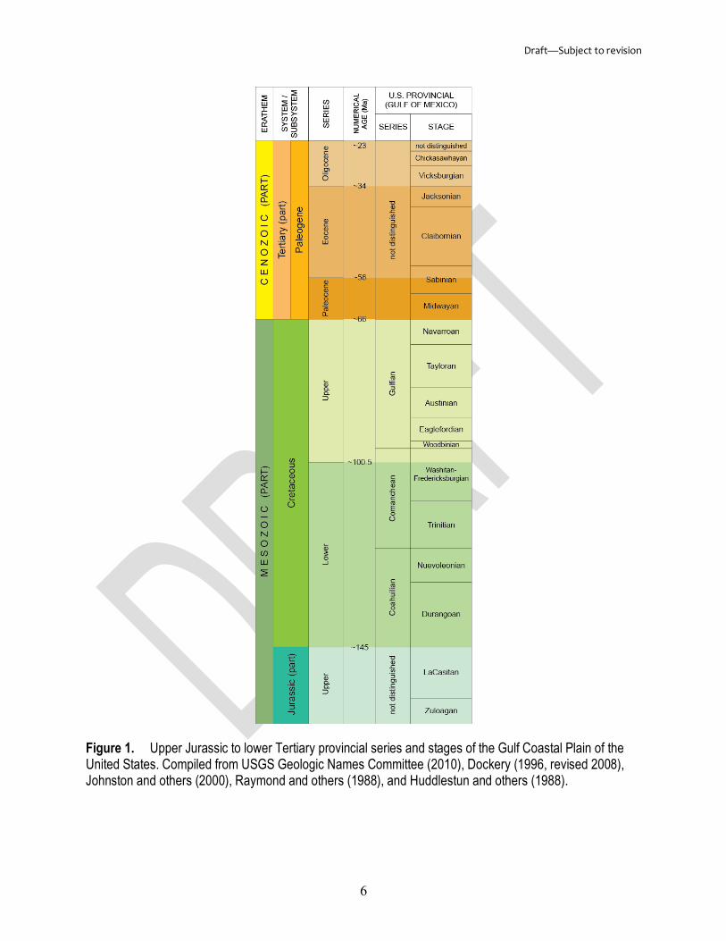
Provincial Terms The use of a provincial geologic time scale in a publication may be preferable to the
USGS or International time scale, especially if it is commonly used by the intended audience. For example, a report on energy resources of Cretaceous and lower Tertiary rocks and sediments

Draft—Subject to revision
5
in the Gulf Coastal Plain might be best conveyed using provincial series and stages rather than the global terms (fig. 1). Provincial terms adopted by the USGS are available online at https://ngmdb.usgs.gov/Geolex/stratres/timescales. Most provincial terms are restricted to certain regions of the United States and should not be applied to rocks and sediments beyond those regions, for example, authors should not refer to late Pleistocene sediments of Florida as Wisconsinan age.
A provincial term may be formal or informal and, depending on the area or author, its definition may vary. Thus, authors must clearly distinguish formal and informal provincial terms, and should include citations to published reports, or definitions of the terms in the proposed report, to clarify their use of the terms. Authors are reminded that, since the 1961 Code, the practice of converting a material unit term to a temporal unit term simply by appending “-ian” or “-an” is not permitted. Authors planning to propose a new formal provincial term are referred to the requirements of chronostratigraphic units (arts. 66—68, 73—78 of the Code).
Draft—Subject to revision
6
Figure 1. Upper Jurassic to lower Tertiary provincial series and stages of the Gulf Coastal Plain of the United States. Compiled from USGS Geologic Names Committee (2010), Dockery (1996, revised 2008), Johnston and others (2000), Raymond and others (1988), and Huddlestun and others (1988).
Draft—Subject to revision
7
Material Units Units defined on the basis of geologic material or physical boundaries are separated into
lithostratigraphic, lithodemic, magnetopolarity, biostratigraphic, pedostratigraphic, and allostratigraphic categories (see table 2 of the Code). This discussion focuses on the more commonly studied lithostratigraphic and lithodemic units, and, except where noted, the rules and guidelines summarized here apply to all categories. References to all articles are those of the 2005 Code.
As used herein, a geologic unit is a three-dimensional body of earth material, recognized by its lithologic content (consolidated rock or unconsolidated sediment) and its boundaries at the surface and (or) subsurface. It is mappable at 1:24,000 scale, and is referred to by a formal or informal geologic name. In order to emphasize that geologic nomenclature connotes both the names and the three-dimensional bodies of material they represent, and to improve readability, the term “geologic name” is used interchangeably with “geologic unit.”
Formal Names Most formal geologic names are binomial; with the exception of biostratigraphic units
(arts. 48—54 of the Code), they consist of a geographic name followed by a rank term or lithologic term, for example, Decorah Formation or Akmalik Chert. See also “Names Having Lithologic Designations” section. The geographic name—a river, town, or other permanent geographic feature—is at or near the place where the distinguishing characteristics of the geologic unit are best observed.
Capitalization
Since the 1961 Code, the initial letters of formal geologic names have been capitalized. Geologic names from sources written before that time should also be capitalized, for example, Bear Creek Shale of Chadwick (1918), unless included in material quoted directly from the source, for example, “...on p. 343, Chadwick (1918) states ‘If distinct from the Martville [sandstone], the Bear Creek shale will lie above rather than below it.’...”
Diacritical Marks
In some areas of the United States whose local language is not English, the U.S. Board on Geographic Names (https://geonames.usgs.gov/domestic/index.html) includes diacritical marks in the names of the geographic features. Geologic units named from these features should also include diacritical marks.
Accepted Usage of Names
A geologic name may have several usages, for example, depending on the area, the Oriskany can be referred to as the Oriskany Sandstone, Oriskany Formation, or Oriskany Group. Authors must apply the accepted usage of a name for a given area consistently throughout their publication (see “Internal Consistency of Terms” section).
The GNC maintains records of formal geologic names of the United States, its possessions and territories; these records are available through the online lexicon, Geolex, at https://ngmdb.usgs.gov/Geolex. To aid authors and reviewers, usages and definitions published by members of the USGS, and (or) those that have been adopted by the USGS for use in regional

Draft—Subject to revision
8
studies such as 1:100,000-scale geologic mapping, are indicated in Geolex with an asterisk (*); other usages are of the State geological surveys, or, in some cases, of individuals.
Authors employing a definition and (or) usage of a geologic name other than the prevailing or current one should provide a citation to clarify its use. For example, the Slim Sam Formation of Klepper and others (1957) may be more suitable to a regional study in Montana than the current, stratigraphically and geographically restricted definition of Tysdal (2000). Conversely, the Zia Sand of Manley (1978) may be more suitable to a local study in New Mexico than the current Zia Formation of Williams and Cole (2007).
New and revised names are continually appended to Geolex, but not at equal pace with the large volume of published works on the rocks and sediments of the United States each year. Therefore, authors planning to use a more recent definition and (or) usage of a geologic name than what is given in Geolex should contact the GNC secretary with pertinent reference(s). Upon approval by the GNC, authors should include in their publication a citation to clarify use of the name, such as “the St. Peter Sandstone of Doe (Year),” and a brief summary of Doe’s description of the unit (see also “Names Adopted by the USGS” section).
Classification Schemes of Other Agencies
The classification and nomenclature of geologic units in publications resulting from cooperative investigations with other agencies, for example, state geological surveys, may follow the scheme of the cooperators. Authors should include a brief statement in the introduction, and in pertinent illustrations, charts, tables, and captions, such as, “In this report we use the stratigraphic classification of the Illinois State Geological Survey (Kolata, 2005).” Any classification scheme used must have been described in a published report or the description must be included in the proposed report. Examples of classification schemes are available online at https://ngmdb.usgs.gov/Geolex/stratres/charts.
Foreign Names
Authors conducting studies in a foreign country should use the classification and nomenclature approved by that country; the spelling of geographic names should conform to the usage of the country (art. 7e of the Code).
The geological surveys of Canada and Mexico maintain geologic names lexicons that are available online; access to these are provided from Geolex. Authors conducting studies along the international borders with Canada or Mexico may extend geologic names from those countries into the United States, such as the Waterton Formation of Alberta and Montana. Authors planning to extend geologic names from the United States into Canada or Mexico, or propose formal changes to existing nomenclature in Canada or Mexico, should first discuss them with members of the Canada or Mexico geological surveys who are knowledgeable about the area.
Names Not Accepted by the USGS
Names that are not defined in accordance with nomenclatural guidelines (in place at the time of publication) are not adopted in the formal USGS classification. In Geolex, these names are indicated with a slash (/) and may include a brief explanation of the conflict in brackets ([ ]). Use of these names in reports and maps is not encouraged, but if used, should include citations, for example, the Animas Quartz Monzonite of Zeller and Alper (1965), the Four Corners
Draft—Subject to revision
9
Formation of the Breathitt Group (Chesnut, 1992), the Derby-Doerun Dolomite (usage of the Missouri Geological Survey, 1979).
Names of Varied or Controversial Use
The definitions of some geologic names have changed many times and some definitions are a “bone of contention.” Authors should include citations that clarify their use of such names; for example, “In this report, we use the Cloverly Formation of Lee (1927, p. 58, 63) which, in the upper part, includes the informal ‘rusty beds’ of some geologists.” or “In this report, we use the Thermopolis Shale of Hewett and Lupton (1917, p. 19–20) which, near its base, includes the informal ‘rusty beds’ of Washburne (1908, p. 350).”
Abandoned or Obsolete Names
When referring to abandoned or obsolete names, authors should include citations, for example, “this unit was previously mapped as the Beattyville Shale Member of the Lee Formation (Stager, 1962).” To reinstate an abandoned name, see “Reinstatement of an Abandoned Name” section. Obsolete names are those that have fallen into disuse, but have not been formally abandoned, such as the Glendale Granite of Crawford (1909).
Quotation Marks
Authors sometimes use quotation marks to imply misnomer or misapplication of a name or to indicate a name has been abandoned. Because of the varied use and implications attached to the meaning of quotation marks, their usage in a geologic context should be explained.
Changes to Geologic Nomenclature As the USGS conducts new geologic studies across the country, and as scientific
knowledge and techniques advance, it may become necessary to make changes to the existing geologic nomenclature. Requirements for the most common types of modifications to previously defined geologic units are outlined here. Most of these modifications require formal publication (see “Publication Requirements” section). Before proposing formal changes to existing nomenclature, authors should discuss them with other geologists knowledgeable about the area.
Revised Names (art. 19 of the Code) A geologic unit is revised when (1) a boundary is changed, (2) the rank is changed, (3)
the unit is placed in another unit of higher rank, or (4) the unit is subdivided into units of lesser rank. These modifications require formal publication.
Boundary Change (arts. 19a and 23 of the Code) This type of modification involves a minor change to one or more boundaries of a
geologic unit; the geographic part of its name is unaltered, and its original type section, locality, or area is retained. Authors should provide (1) reasons for the change; (2) historical background and explanation of changes from previous definitions; (3) lithologic description of the revised unit; and (4) reference sections, localities, or areas. Requires formal publication.
A geologic unit requiring a major change to one or more of its boundaries probably should be abandoned or not used (see “Abandoned Names” section).

Draft—Subject to revision
10
Rank Change (art. 19b—g of the Code) Laterally, a formation may become a member of another formation, and a formation may
become a group or vice versa. A change in rank of a geologic unit can occur from one study area to another, or within a single area; its boundaries and the geographic part of its name are unaltered, and its original type section, locality, or area, is retained. Authors should provide (1) reasons for the change; (2) historical background and explanation of changes from previous definitions; (3) the areal extent of the rank change; and (4) reference sections, localities, or areas. Requires formal publication.
Assignment to Another Unit of Higher Rank Laterally, a named member may extend from one formation into another, especially in
areas of intertonguing. The component formations of a group may also change regionally. The boundaries and geographic part of the name are unaltered, and the original type section, locality, or area, is retained. Authors should provide (1) reasons for the change; (2) historical background and explanation of changes from previous definitions; (3) the areal extent of the change; and (4) reference sections, localities, or areas. Requires formal publication.
Subdivision of a Unit Where subdividing a geologic unit, the boundaries and geographic part of the name are
unaltered, and the original type section, locality, or area, is retained. Authors should provide (1) reasons for the change; (2) historical background and explanation of changes from previous definitions; (3) the areal extent of the change; and (4) reference sections, localities, or areas. Requires formal publication.
The author is reminded that an identical geographic name may not be applied to any subdivisions of a geologic unit, for example, the Picuris Formation should not contain a Picuris Shale Member or a Picuris Bed.
Names Adopted by the USGS
Authors may request that a geologic unit be adopted by the USGS by notifying the GNC secretary and including pertinent information such as the original reference. Upon approval by the GNC, authors should include in their publication a statement of intent, such as "This unit, named by Doe in [Year], is here adopted" or “here used,” and if the original definition is adequate, include a brief summary of Doe's description of the unit. Does not require a separate formal publication.
If the original definition is inadequate and a re-definition is necessary, such as designating a principal reference section for the unit, authors must make certain the re-definition meets the minimum requirements for new names (see “Proposing New Names” section) and include a historical summary of use of the name. Requires formal publication.
Principal and Ancillary Reference Sections, Localities, or Areas (art. 8 of the Code) Principal reference sections, localities, or areas may be designated for previously defined
geologic units for which a type locality was never chosen, and for those units whose type sections or localities have been destroyed, covered, or otherwise made inaccessible.

Draft—Subject to revision
11
Reference sections, localities, or areas should be designated for revised names. Authors should also consider designating supplementary reference sections to illustrate the variability or characteristic features of a unit, especially if not evident at its type section or locality.
Authors should provide the locality information (USGS topographic quadrangle, county, latitude/longitude coordinates), and where possible, total thickness, detailed lithologic description and measurements, and description of upper and lower contacts. Requires formal publication.
Abandoned Names (art. 20 of the Code) To abandon the name of a geologic unit, an author must provide (1) reasons for
abandonment, and (2) a replacement name(s), which can be formal or (and) informal. Requires formal publication.
An abandoned name is understood to be abandoned everywhere, including its type section, locality, or area; thus, an author may be more prudent to not use a term rather than abandon it. By stating the reasons for not using a term, the author will allow time to determine if subsequent workers agree that the name is invalid (art. 5a of the Code). Authors who do not use a name at its type section, locality, or area, should not apply the name elsewhere.
Reinstatement of an Abandoned Name (art. 20e of the Code) An abandoned name rarely needs to be reinstated, but the procedure is acceptable if (1)
the reinstatement will not cause confusion, (2) the original definition of the name is still valid, and (3) the geographic name has not been applied to another geologic unit. Requires formal publication.
Areal Extent (art. 12 of the Code) Some geologic units can be recognized and mapped over broad areas, such as several
States; others are limited to small areas. A geologic unit should be extended away from the type section, locality, or area only as far as the significant lithologic features of the unit can be recognized. The author is reminded that a formal geologic unit must be mappable at 1:24,000 scale. This modification does not require formal publication.
Names Having Lithologic Designations (arts. 17a—18 of the Code) Lithologic designations are single, ordinary compositional terms, such as limestone or
granite, denoting the dominant lithology of a geologic unit (see arts. 30b and 40a of the Code). Lithologic designations may be used with subunit rank terms (below the rank of the fundamental unit; see table 2 of the Code for list of terms); for example, Anna Shale Member or Deicke Bentonite Bed. They may be used in place of a fundamental unit rank term (formation), for example, Niobrara Chalk or Rowe Schist. Lithologic designations are not used with, or in place of, higher rank terms such as “group” or “suite.”
Owing to geologic processes, the dominant lithology of a geologic unit may significantly change over great distances. In such cases, authors may find it necessary to change the lithologic designation of a unit for use in their study area; for example, if a formation is predominantly sandstone in the study area, it should be called a sandstone (Dakota Sandstone). However, if it is a heterogeneous mixture of lithologies such as sandstone and shale, the term “formation” should be used (Dakota Formation).
Draft—Subject to revision
12
Authors should explain the lithologic changes in the “Description of Map Units” of a geologic map or in the geologic description section of a report. This type of modification is intended for regional variations of a geologic unit and does not require formal publication.
Age Assignment (see also “Temporal Units” section) Authors modifying the age of a geologic unit (1) must include evidence for the change;
and (2) should explain the reasons for divergence from ages reported by previous workers. Does not require formal publication.
Authors including new or previously unpublished age determinations based on recognition of index fossils or biozonal assignments should include localities and lithologic descriptions of samples, and faunal and (or) floral lists. Numerical age determinations should include (1) interpretive statements about what the numerical age represents, for example, cooling, exhumation, intrusive, metamorphic, or exposure; (2) analytical techniques, calibration methods and uncertainty estimates; and (3) localities and lithologic descriptions of samples, and mineral phases analyzed. Individuals responsible for the age determinations should be credited. The author is reminded that the definition of a geologic unit is “independent of time concepts” (art. 22d—e of the Code).
Proposing New Names (arts. 3—16, 22—47, and 55—60 of the Code) It is the author’s responsibility to avoid duplication of names. Authors planning to
propose a new formal geologic unit should (1) check Geolex and associated GNC records (https://ngmdb.usgs.gov/Geolex/stratres) to determine that a geographic name has not been used for another previously named geologic unit in the United States; and (2) reserve the name with the GNC secretary.
The geographic name, taken from a geographic feature at or near the place where the distinguishing characteristics of the geologic unit are best observed, must be officially recognized by the U.S. Board on Geographic Names (BGN) (https://geonames.usgs.gov/domestic/index.html). The use of proper nouns such as the name of a person, borehole, quarry, or mine is acceptable for informal, local, economic units; it is not permitted in formal USGS nomenclature.
If a geologic unit is to be named in an area without named geographic features, a new geographic name must be proposed through the BGN. Instructions and application forms for proposing new geographic names are available, and these forms should be completed by the author at an early stage in the preparation of a report or map.
The minimum requirements for defining a new geologic unit are: 1. Statement of intent to introduce a name, “this unit is here named…” 2. Designation of category (for example, lithodemic, allostratigraphic), geographic feature
from which the name is taken, and rank 3. Specification of type section, locality, or area (include USGS topographic quadrangle,
county, and latitude/longitude coordinates) 4. Lithologic description and thickness (if thickness is estimated or unknown, authors
should so indicate) 5. Description of the upper and lower contacts (if arbitrarily chosen or unknown, authors
should so indicate) 6. Geologic age (if unknown, authors should so indicate)

Draft—Subject to revision
13
Where applicable, authors should also include: (1) historical background; (2) dimensions, shape, and other regional aspects; (3) correlations; and (4) genesis.
Proposing a new geologic name (geologic unit) requires formal publication. Authors should include in their report (1) a geologic map having a USGS topographic base3, and (or) a cross section, illustrating the proposed geologic unit and its relations to surrounding units, and (2) an index map having a topographic base4 showing the location of the type section, locality, or area. If the proposed geologic unit partially or wholly replaces an existing unit (see also “Revised Names” and “Abandoned Names” sections), authors should also include a brief historical summary of previous studies.
The description of the proposed geologic unit should highlight the characteristics that distinguish it from other units, such as dominant and subordinate lithology, color (fresh and weathered), induration, grain size, mineralogy, and bedding characteristics, as well as the thickness of the unit and nature of the upper and lower contacts at the type section, locality, or area. Where possible, authors should include maximum, minimum, or average thickness of the unit, and indicate its areal extent.
Authors should indicate the geologic age of the proposed geologic unit and include evidence such as biostratigraphic and numerical age determinations (see also “Age Assignment” section). Where possible, indicate correlations with other units of known age.
Publication Requirements (art. 4 of the Code) Proposals for new nomenclature and most changes to existing nomenclature require
formal publication. An acceptable publication must be (1) in conformance with the USGS publication standards of adequate peer review and geologic names technical review, (2) issued for the purpose of permanent record in a scientific venue that ensures wide distribution, and (3) if possible, in a format that assures availability for many years into the future. Guidebooks, open-file reports and maps, university theses and dissertations, abstracts, fact sheets, news releases, and webpages are not acceptable publications.
During the planning process, authors should carefully consider the publication venue best suited to the subject matter and audience, for example, a New Mexico Museum of Natural History Bulletin might not be the best publication for revisions to geologic units of Virginia. Authors should also carefully consider the limitations of various publication venues. For example, because of constraints on allowable text, new or revised geologic nomenclature introduced on formal map publications must be fully explained in an accompanying pamphlet or as lengthy notes in the “Description of Map Units.”
Informal Names An informal geologic unit does not adhere to the standards of formal nomenclature; there
might not be a type section, locality, or area, and a published definition is not required for its use. It may be casually mentioned in a report or fully described and delineated on a geologic map or cross section. Informal geologic units generally are of local extent and considered unique to each publication; an informal unit of one author may be different from that of another author, for example, the Havallah sequence of Silberling and Roberts (1962) or the Havallah sequence of Ketner (2008). 3USGS topographic quadrangles are available online at https://nationalmap.gov/. 4USGS topographic quadrangles are available online at https://nationalmap.gov/..
Draft—Subject to revision
14
Use of Informal Names in Publications In reports, proper reference to an informal name is given in headings and at first use of
the name in a paragraph or section, as well as in illustrations, charts, tables, and captions. It should be clearly distinguished from formal names and, if applicable, include a citation to clarify its use, for example, “the informal basalt of Hembre Ridge of Wells and others (1994).” All of the terms comprising an informal name are lowercase (except for the geographic name or other proper noun). If the name is used several times in a paragraph or section, the subsequent reference might be to the Hembre Ridge or, if there is no possibility of confusion with another geologic unit, the Hembre Ridge basalt. If not already indicated by its name, the age of the unit should be given where it is used for the first time in the body text of the report. An age range is given from oldest to youngest, for example, “the early and early middle Eocene informal basalt of Hembre Ridge (Wells and others, 1994);” see also “Discussion of the Geologic Setting” section.
Proper reference to an informal unit shown on a geologic map and (or) cross section is given in the unit’s name/age in the Description of Map Units, for example, “Basalt of Hembre Ridge of Wells and others (1994) (lower middle and lower Eocene).” The stratigraphic range (or age) is stated highest to lowest (or youngest to oldest) in parentheses following the name and citation. Note the term “informal” is not required.
New Informal Names As with formal nomenclature, most informal names are binomial. An informal unit may
be named for: (1) color (mahogany bed, purple and green unit); (2) position or relative age (lower member, older terrace gravel); (3) lithology (shale member, limestone bed); (4) genesis or type of deposit (Idaho batholith, alluvium, glacial Lake Budd deposits); (5) letter (J sandstone, member A); (6) number (unit 2); or (7) geographic name or other proper noun (Lassen Lodge unit, granite of Lonesomehurst). All of the terms comprising an informal name are lowercase (except for the geographic name or other proper noun).
Use of Geographic Names and Other Proper Nouns in Informal Nomenclature Informal geologic names, notably local lithodemic units, generally are comprised of a
geographic name (or other proper noun) and a lithologic term. The standard convention is to treat the lithologic term as the subject nominative, for example, granite of Black Mountain, tuff of Stony Point, or sandstone of Snow Creek. The use of a geographic name (or other proper noun) in conjunction with a formal rank term is not permitted; see “Use of Formal Rank Terms in Informal Nomenclature” section.
The use of proper nouns such as the name of a person, borehole, quarry, or mine is acceptable for informal, local, economic units; for example, Big Mary coal bed, Hurry-Up oil sand, or Burke ore body. However, these types of names are not permitted in formal USGS nomenclature.
Use of Formal Rank Terms in Informal Nomenclature Formal terms below the rank of the fundamental unit (see table 2 of the Code for list of
terms) may be used in conjunction with descriptive terms such as color, position, lithology, etc., for example, gray lens, middle tongue, or sandstone member. However, the use of a formal rank term in conjunction with a geographic name (or other proper noun) is not permitted; terms such
Draft—Subject to revision
15
as “unit,” “deposits,” or “body,” may be used; for example, the Agate Beach unit, or Rose Creek ultramafic body.
Economic Terms
The local names by which informal economic units are known, such as oil sands, coal beds, and quarry stone, may be used in publications by USGS authors with a statement in the text indicating the originators of the names, and that the names are of local usage; for example, “local drillers’ term for the basal sand of the Bakken Formation,” or “miners’ terms applied locally in the Carlin district.” Where an economic term has been replaced by a formal geologic name, the formal name shall preferably be used, but the economic term may be used in parentheses without quotation marks, for example, Greenbrier Limestone (Big lime), or Arvonia Formation (Buckingham slate).
The State geological surveys maintain records of economic units in their states and are available online; State websites may be accessed from the Association of American State Geologists website (http://www.stategeologists.org/). The USGS Energy Program maintains records of coal beds and coal zones of the United States; these are available online at https://energy.usgs.gov/Coal/AssessmentsandData/CoalDatabases.aspx.
Aquifer Nomenclature and Classification Aquifer nomenclature is informal, for example, Floridan aquifer system or High Plains
aquifer. Authors conducting studies related to groundwater aquifers should adhere to the USGS Office of Groundwater guidelines, available online at https://pubs.usgs.gov/of/1986/0534/report.pdf. The USGS standard groundwater aquifer nomenclature and classification of the United States are available online at https://water.usgs.gov/ogw/NatlAqCode-reflist.html.
Informal Classifications of Surficial Deposits
Classifications of surficial deposits may be dependent on the geologic setting (glacial, desert, coastal, volcanic), geomorphic and landform features (eskers, dunes, beaches, craters), and depositional, erosional, atmospheric, and tectonic processes, thus authors should ensure their methods of classifying these sediments are clearly conveyed to the readers.
Many of the surficial geologic units described and mapped in the United States are of local extent and time-transgressive; the oldest sediments may be at the highest elevation. These are referred to by their age, usually relative to similarly described and mapped deposits, for example, “young talus slope deposits,” and “very old talus slope deposits.” Authors planning to propose a formal name for this type of unit are referred to the requirements of allostratigraphic units (arts. 58—60 of the Code); see also “Proposing New Names” section.
Pedologic Soil Nomenclature and Classification Pedologic soil nomenclature is informal, for example, Houghton mucky peat or Montello
silt loam. The standard classification and taxonomy of pedologic soils are maintained by the U.S. Department of Agriculture Natural Resources Conservation Service, available online at https://websoilsurvey.sc.egov.usda.gov/App/HomePage.htm. Authors planning to propose a formal name for this type of unit are referred to the requirements of pedostratigraphic units (arts. 55—57 of the Code); see also “Proposing New Names” section.
Draft—Subject to revision
16
Informal Classifications of Geologic Events
Classifications of cratonic marine transgressions such as the Sauk, Tippecanoe, Kaskaskia, Absaroka, Zuni, and Tejas sequences, are informal. Classifications of mountain building events, for example, the Taconic orogeny or Laramide orogeny, and accreted, fault-bounded packages of rocks, for example, Tugaloo terrane, are also informal.
The Quaternary geologic climate classification of the 1961 Code is informal, for example, Wisconsin glaciation, Olympia interglaciation. “Neoglaciation” is used to designate a readvance of ice following the Hypsithermal (Thermal Maximum) interval. The term may be used only in reference to mountain areas where cirques and glaciers formed following the Hypsithermal.
Bodies of Intrusive Rocks
Structural form terms, such as dike, sill, stock, pluton, batholith, and laccolith, are not part of the formal classification of the USGS; these terms imply genesis and are interpretive. In the descriptive material of map explanations and texts, the lithologic unit should be emphasized rather than the structural form, for example, granodiorite of the Idaho batholith, or quartz syenite of the Monadnock Mountain pluton.
Summary of Formal Versus Informal Usage The distinction between formal and informal nomenclature must be kept clear throughout
maps and reports, notably in the abstract, introduction, geologic description, and conclusion of the text, and in accompanying illustrations, charts, tables, and captions. Authors should provide descriptions and styles of usage early in the report, and maintain a consistency of usage throughout.
Formal nomenclature consists of a geographic name followed by a rank or lithologic term; all of the terms are uppercase. Terms comprising an informal name are lowercase (except for the geographic name or other proper noun). The use of a proper noun such as the name of a person, borehole, quarry, or mine as a formal geologic name is not permitted, but is acceptable for an informal name. For informal nomenclature, geographic names (or other proper nouns) are not used in conjunction with rank terms (see table 2 of the Code for list of terms); a geographic name (or other proper noun) may be combined with a lithologic term, but the lithologic term is the subject nominative, for example, the granite of Azalea Canyon, or the sandstone of Beans Point.
Geologic Descriptions
Text Matter
Discussion of the Geologic Setting In the body text of a report or map, the geology of an area is usually discussed
chronologically—the oldest unit first, and the youngest last. This order may not apply to some local areas where geologic information is based largely on subsurface records, such as groundwater aquifers, oil fields, and areas where rocks are poorly exposed; in such areas the author may find it advantageous to discuss the stratigraphy from youngest to oldest.

Draft—Subject to revision
17
Where a geologic name is used for the first time in the body text of a report, its age should be given, if not already indicated by its name—age ranges are given from oldest to youngest; for example, the Highlandcroft Plutonic Suite of Middle Ordovician to Llandovery age, or the early to middle Eocene Tallahatta Formation (see also “Geochronologic Units” section).
Internal Consistency of Terms (see also “Accepted Usage of Names” section) To minimize confusion on the part of the readers, usage of geologic names should be
consistent, and the accepted name for a given area must be used throughout the text in reference to that area. Proper reference to the formal name, for example, Excello Shale Member of the Carbondale Formation, is given in headings and first use of the name in a paragraph or section, as well as accompanying illustrations, charts, tables, and captions. If the name is used several times in a paragraph or section, the subsequent reference might be to the Excello, the Excello Member of the Carbondale, but not the Excello Shale.
When two or more geologic units of equal rank are included as a sequence in one sentence, an author may prefer listing them with the general rank term, rather than the specific terms. For example, Twin Creek Limestone, Morrison Formation, Dakota Sandstone, and Mancos Shale, though correct, could be listed simply as Twin Creek, Morrison, Dakota, and Mancos Formations. Note that “Formations” is capitalized.
If there are no designated subunits, formal or informal, but it is desired to refer to a particular lithologic facies, authors should indicate that the facies is part of the formation, as in sandstone of the Calico Bluff Formation, and not Calico Bluff sandstone.
Undesirable Expressions Examples of shortened or abbreviated terms that should be avoided:
• Penn-Perm, for Pennsylvanian and Permian • Permo-Carboniferous, for Permian and Carboniferous • Cambro-Ordovician, for Cambrian and Ordovician • Mid-Cretaceous, for middle Cretaceous • Westwater Member, for Westwater Canyon Member • Bennett Shale, for Bennett Shale Member • Belle Fourche-type rocks, for rocks similar to those of the Belle Fourche Shale • The upper Trinity Group, for the upper part of the Trinity Group.
Geologic map unit labels should not be used in the body text of a report as an abbreviated method of referring to geologic units (see “Use of Map Unit Labels in Text Matter” section). Use of acronyms for geologic units, and structural and other geologic features is not encouraged. Saving space is insufficient justification for a loss of clarity.
Geologic Maps “…the maps are designed not so much for the specialist as for the people, who justly look to the official geologist for a classification, nomenclature, and system of convention so simple and expressive as to render his work immediately [understandable]…”
USGS Director John Wesley Powell 3rd International Geological Congress, Berlin, Germany, 1885

Draft—Subject to revision
18
The Federal Geographic Data Committee (FGDC) and USGS cartographic standard for geologic maps (USGS, 2006), is available online at https://ngmdb.usgs.gov/fgdc_gds/ and https://pubs.usgs.gov/tm/2006/11A02/. The proposed FGDC and USGS standard GIS database design for geologic maps is available online at https://ngmdb.usgs.gov/Info/standards/. These standards were developed under a strict review process and are in use by private industry and State and Federal agencies.
Map Units, Labels, Colors, and Patterns A map unit (1) can include one to many formal and (or) informal geologic units; (2) is
recognized by its lithologic content and its contacts, at the surface and (or) in the subsurface; (3) is assigned a geologic age; and (4) is assigned a unique label, and color and (or) pattern.
Labels for Map Units Map unit labels are short, two- to four-letter codes denoting the geologic ages and names
of the geologic units; they are defined by the authors and are considered unique to each geologic map. Although adjacent maps might not use the same label for the same unit, the format of the map unit label is standardized for all USGS maps.
Formats for Map Unit Labels
The first letters (uppercase) of the map unit label signify the geologic age of the unit; these are the standard FGDC and USGS age-symbol fonts5 for eras and periods (erathems and systems), available online at https://pubs.usgs.gov/tm/2006/11A02/ and https://ngmdb.usgs.gov/fgdc_gds/geolsymstd/download.php. Subsequent letters (lowercase) of the map unit label are selected by the author and are the initial letter(s) of the geographic name of a unit, for example, Early Ordovician Gasconade Dolomite (Og) or Tertiary sandstone of Pine Creek (Tpc). Where a geographic name is not associated with a unit, the initial letter(s) of the lithologic term is used, for example, Quaternary alluvium (Qal).
If a map unit spans more than one period (system).—Age symbols are listed youngest first, oldest second; for example, Silurian and Devonian sedimentary rocks (DSs), or Cretaceous, Tertiary, and Quaternary sediments (QKs).
If all map units belong to a single period (system).—If a mapped area consists entirely of rocks and (or) sediments of the same period (system), the age symbols may be omitted from the map unit label, for example, Early Jurassic limestone (l) and Middle Jurassic Moab Tongue of the Entrada Sandstone (em).
Undivided units.—Where the subdivisions of a geologic unit (such as a group, which is an assemblage of formations [art. 28 of the Code]), are not separately mapped, the geologic unit is said to be undivided. A “u” should be appended to the end of the map unit label, for example, Silurian to Devonian Helderberg Group, undivided (DShu).
Undifferentiated units.—A map unit that consists of two or more geologic units of equal rank, or a mixture of ranks and (or) categories, are said to be undifferentiated. The map unit label may include initial letter(s) (lowercase) of each unit, ordered youngest to oldest; for example, the 5The standard age-symbol font, GeoAge, was prepared by the USGS Geologic Names Committee (GNC) for the Federal Geographic Data Committee (FGDC) cartographic standard. For documentation and download, see FGDC document number FGDC-STD-013-2006 (USGS, 2006), available online at https://pubs.usgs.gov/tm/2006/11A02/.

Draft—Subject to revision
19
Early Cretaceous Gannett Group and Middle and Late Jurassic Stump Formation, undifferentiated (KJgs). Alternatively, the label could be shortened to indicate the general lithology of the map unit; for example, the metamorphosed rocks of the Late Ordovician Oliverian Plutonic Suite and Ordovician Partridge Formation, undifferentiated (Om).
Subunits.—For separately mapped subunits, such as members of formations, the hierarchy is indicated by initial letter(s) of the parent unit followed by initial letter(s) of the subunit, for example, the late Tertiary Sentinel Bluffs Member (Tgsb) and Winter Water Member (Tgww) of the Grande Ronde Basalt. It is the author’s choice whether to apply this format to mapped subdivisions of larger units, such as groups.
Alphanumeric.—Numbers are used in some map unit labels, especially for Tertiary and Quaternary deposits. The youngest or the lowest deposit is assigned number 1. The older or the higher deposits are assigned numbers 2, 3, and so forth. See, for example, figure 2, which shows a sequence of alluvial deposits that range from the youngest, late Holocene unit 1 (Qa1) to the oldest, latest Pleistocene(?) and Holocene unit 3 (Qa3).
Figure 2. Part of a simple cross section (from Berry and others, 2015) showing the relation between geologic units having alphanumeric designations. Note that Qa1 overlies Qa2, which overlies Qa3; the youngest unit receives the lowest number designation.
Use of Map Unit Labels in Text Matter Map unit labels should not be used in the body text of a report as an abbreviated method
of referring to geologic units; for example, Je should not be used in the text as a substitute for the Jurassic Entrada Sandstone. Inclusion of map unit labels in the text, in parentheses after the unit name, is useful when several similarly labeled mapped units are being compared; for example, “within this outcrop exposure of alluvial-fan deposits, unit 4 of early Pleistocene age (Qa4) lies 25 meters below unit 7 of late Pleistocene age (Qa7)” or “Paleoproterozoic metasedimentary rocks (units Xd, Xsc, Xcg, and Xsi).”
Colors and Patterns for Map Units
Authors should use the colors and patterns of the Federal Geographic Data Committee (FGDC) and USGS cartographic standard (USGS, 2006), which is available online at

Draft—Subject to revision
20
https://pubs.usgs.gov/tm/2006/11A02/ and https://ngmdb.usgs.gov/fgdc_gds/geolsymstd/download.php. Guidelines for use of colors and patterns are explained in the introductory text (p. 24–27), available online at https://pubs.usgs.gov/tm/2006/11A02/FGDCgeostdTM11A2_introtext.pdf. This standard was developed under a strict review process and is in use by private industry and State and Federal agencies.
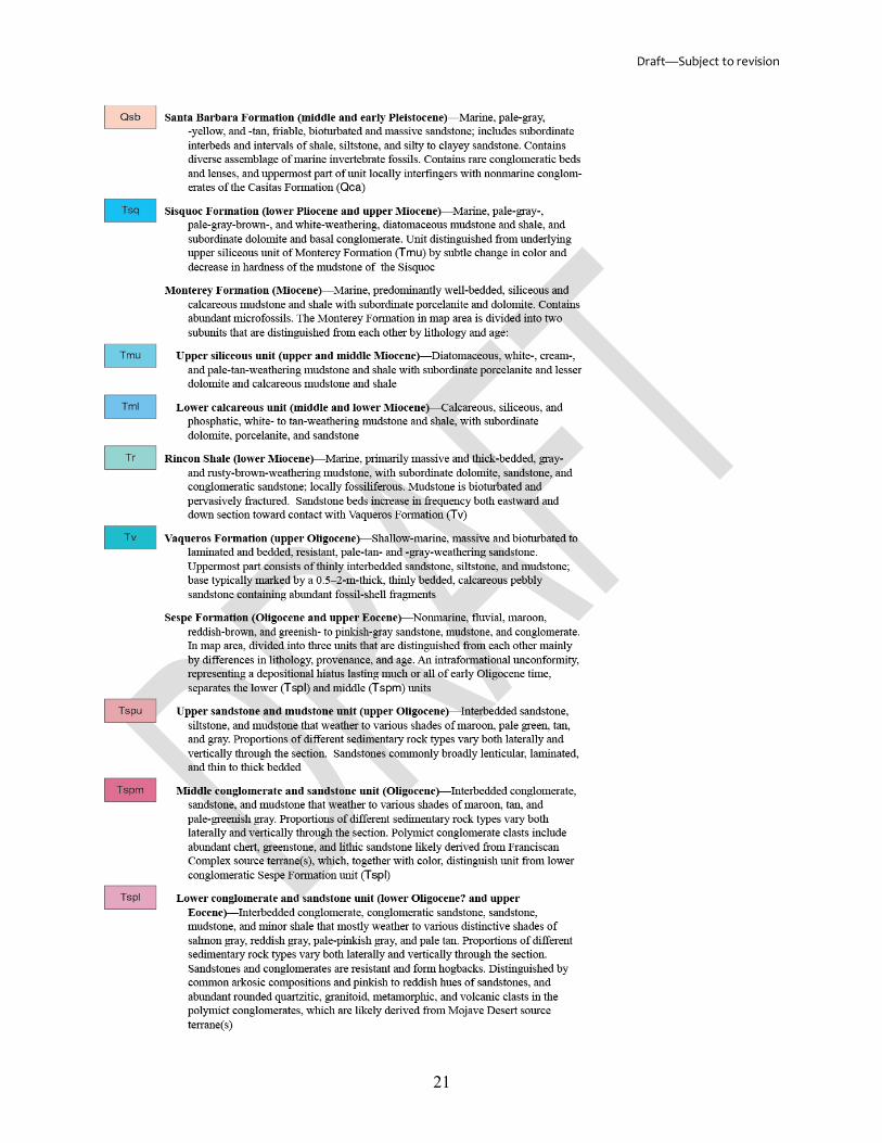
Description of Map Units (DMU) The Description of Map Units (DMU) is an abbreviated account of the characteristics of
the rocks or sediments in each map unit (fig. 3). The map units are listed youngest or highest first; oldest or lowest last. For each map unit, authors should include (1) the names and age ranges (or stratigraphic ranges) of the constituent geologic units, and (2) a brief description highlighting the characteristics of the map unit and how it is distinguished in the field from nearby units. Descriptions should be limited to observations from within the map area, although brief statements of correlations with units in adjacent areas may be appropriate.
Draft—Subject to revision
21

Draft—Subject to revision
22
Figure 3. Example of part of a Correlation of Map Units (CMU; top) and a Description of Map Units (DMU; bottom) from Minor and Brandt (2015), showing stratigraphic order, including queried ages, and hierarchy within a DMU. Note that, in the CMU, surficial deposits are grouped by type of unit (for example, alluvial, marine-shore), rather than by geographic location--either organization is acceptable.
Each map unit may be composed of one or many geologic units. The names and age ranges (or stratigraphic ranges) of the constituent geologic units are ordered youngest to oldest (highest to lowest), for example, “Fitch Formation (Lower Devonian and Upper Silurian) and Sawyer Mountain Formation (Devonian and Silurian), undifferentiated.” Subunits are indented under the parent unit.
Characteristics of the rocks or sediments described for each map unit may include lithology (dominant and subordinate), color (fresh and weathered), induration, grain size, mineralogy, bedding characteristics, interpreted facies, unit thickness, nature of contacts, correlation with other units, fossils, numerical ages, magnetic polarity chrons, and data sources. The order in which characteristics are listed may differ from map to map, but it should be consistent within a given Description of Map Units.
Descriptions should use telegraphic style; nonessential articles (“a,” “an,” “the”) may be deleted; complete sentences are unnecessary. To separate concepts or content, periods or semicolons may be better than conjunctions. The description may be paragraphed. Periods are omitted at the end of each map unit entry. Let brevity and good judgment decide. An example DMU entry follows:
Price River Formation (Upper Cretaceous)—Gray to light-gray, thin- to thick-bedded, locally massive, commonly well cemented conglomerate, conglomeratic sandstone, and sandstone with minor shale. Coarse conglomerate beds contain well-rounded clasts of light-brown and purple quartzite, light-gray quartz, light-gray and black chert, and sparse dark-blue limestone. Sandstone is fine to coarse grained. Of fluvial origin. Forms steep slopes and low cliffs. Includes Castlegate Sandstone (Kc) in cross sections. Ranges in thickness from 0 to about 365 m (0-1,200 ft)
If an entry is long and has a string of descriptive terms, an alternative format is an inverted sentence structure of rock or sediment type followed by its descriptors, for example:
Curtis Formation (Jurassic)—Interbedded sandstone, shale, and limestone. Sandstone, light-gray, fine- to coarse-grained, poorly sorted, and thick-bedded. Shale, pale-green, * * *. Limestone, * * *
The format of map unit descriptions may differ from map to map, but must be consistent within a given Description of Map Units.
Correlation of Map Units (CMU) The Correlation of Map Units diagram, on the geologic map sheet or in an accompanying
pamphlet, serves as an important visual aid for authors to portray the general interrelations of the map units described in the Description of Map Units (fig. 3).
The vertical axis of the diagram is geologic age; map units are ordered youngest to oldest (highest to lowest). The horizontal axis may be geography, geologic setting, or another scheme chosen by the author.
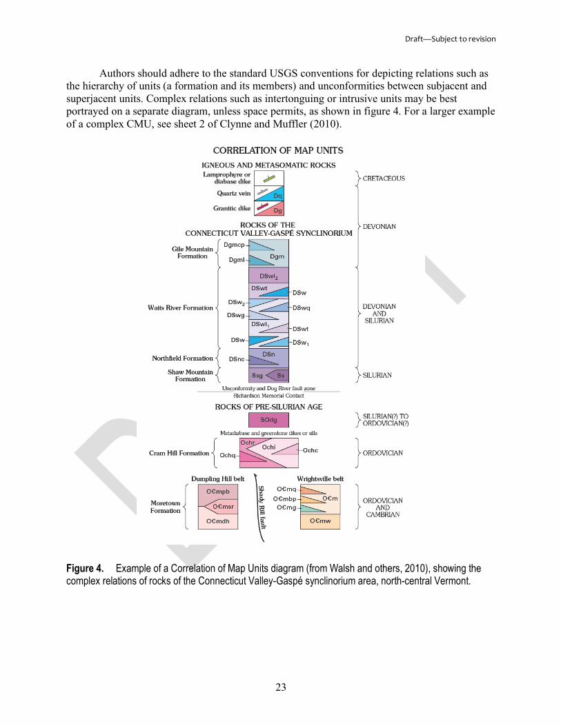
Draft—Subject to revision
23
Authors should adhere to the standard USGS conventions for depicting relations such as the hierarchy of units (a formation and its members) and unconformities between subjacent and superjacent units. Complex relations such as intertonguing or intrusive units may be best portrayed on a separate diagram, unless space permits, as shown in figure 4. For a larger example of a complex CMU, see sheet 2 of Clynne and Muffler (2010).
Figure 4. Example of a Correlation of Map Units diagram (from Walsh and others, 2010), showing the complex relations of rocks of the Connecticut Valley-Gaspé synclinorium area, north-central Vermont.
Draft—Subject to revision
24
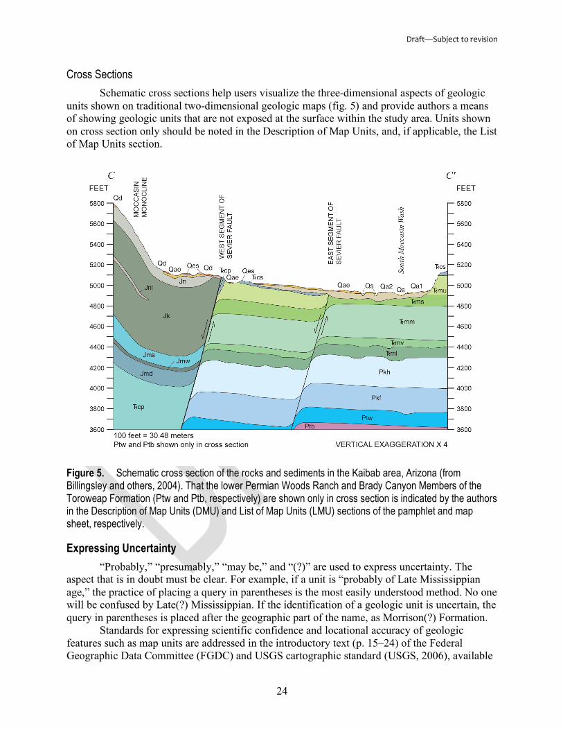
Cross Sections Schematic cross sections help users visualize the three-dimensional aspects of geologic
units shown on traditional two-dimensional geologic maps (fig. 5) and provide authors a means of showing geologic units that are not exposed at the surface within the study area. Units shown on cross section only should be noted in the Description of Map Units, and, if applicable, the List of Map Units section.
Figure 5. Schematic cross section of the rocks and sediments in the Kaibab area, Arizona (from Billingsley and others, 2004). That the lower Permian Woods Ranch and Brady Canyon Members of the Toroweap Formation (Ptw and Ptb, respectively) are shown only in cross section is indicated by the authors in the Description of Map Units (DMU) and List of Map Units (LMU) sections of the pamphlet and map sheet, respectively.
Expressing Uncertainty “Probably,” “presumably,” “may be,” and “(?)” are used to express uncertainty. The
aspect that is in doubt must be clear. For example, if a unit is “probably of Late Mississippian age,” the practice of placing a query in parentheses is the most easily understood method. No one will be confused by Late(?) Mississippian. If the identification of a geologic unit is uncertain, the query in parentheses is placed after the geographic part of the name, as Morrison(?) Formation.
Standards for expressing scientific confidence and locational accuracy of geologic features such as map units are addressed in the introductory text (p. 15–24) of the Federal Geographic Data Committee (FGDC) and USGS cartographic standard (USGS, 2006), available
Draft—Subject to revision
25
online at https://pubs.usgs.gov/tm/2006/11A02/FGDCgeostdTM11A2_introtext.pdf. The proposed FGDC and USGS standard GIS database design for geologic maps, available online at https://ngmdb.usgs.gov/Info/standards/, includes scientific confidence and locational accuracy fields for each element shown on a map. These standards were developed under a strict review process and are in use by private industry and State and Federal agencies.
Citations Clarifying the Use of Geologic Names Authors should use “of Doe (Year)” if employing Doe’s usage and definition of a
geologic name, and “modified from Doe (Year)” if the usage and (or) definition is changed in any way. Use of “after Doe (Year)” is not encouraged; it carries a nebulous connotation.
Databases compiled from several sources, such as Geolex, should not be cited as an authoritative reference; the reference from which the information was compiled should be cited as the authoritative reference.
Illustrations, Charts, and Tables
Measured Sections and Graphic Stratigraphic Columns Measured stratigraphic sections are detailed descriptions of the beds comprising geologic
units, notably at the type and reference section(s). These descriptions may be from outcrop exposures or boreholes. For each measured section, authors should provide: (1) a title indicating general location; (2) whether the section is single, composite, or generalized; (3) method of measurement, names of mappers, and dates of the survey; (4) an index map having a topographic base6 showing the location of the section; (5) a graphic stratigraphic column; and (6) photographs of the outcrop exposures or cores described.
Measured sections may also be in tabular format (fig. 6). The youngest unit is listed first and its subdivisions are indented under it, in descending order. The intervals are numbered if needed for reference in other parts of the publication, starting with 1 at the base of the measured section. Thicknesses for each interval, as well as cumulative thicknesses or depths, may be given in SI (International System of Units) metric and (or) U.S. units of measurement.
6USGS topographic quadrangles are available online at https://nationalmap.gov/.

Draft—Subject to revision
26
Figure 6. Example of a measured section in tabular format (A) and accompanying graphic stratigraphic column (B), excerpted and slightly reformatted from Malmon and others (2011, p. 59, 94–95). Shown are detailed lithologic descriptions of a reference section of the Pleistocene Chemehuevi Formation, exposed near Katherine Landing, Lake Mead Recreational Area, Arizona. Unit intervals are numbered and

Draft—Subject to revision
27
cumulative thickness are given, starting from the base of the section. Alphabetic intervals delineated in the accompanying graphic stratigraphic column are keyed to the measured section.
Lithologic descriptions are given in telegraphic style, similar to that of geologic unit descriptions (see also “Description of Map Units” section). The rock or sediment type is listed first, followed by the descriptive terms, for example, “Quartzite, medium-dark-gray (N4), fine- to medium-grained;” or, for intervals consisting of heterogeneous rock or sediment types, “Siltstone and quartzite. Dark-gray (N3) shaly siltstone interbedded with fine-grained quartzite.” Use of color terms should be as specific as possible. Exact color images are most effectively transferred from author to reader by reference to a color chart such as that of Goddard and others (1948) or the Munsell Color Company (2009).
Graphic stratigraphic columns serve as important visual aids for authors to portray the lithologic content and stratigraphic relations of geologic units described in a measured section (fig. 6). Stratigraphic columns are also useful for depicting complex relationships, such as intertonguing or intrusive units, that are not easily conveyed on a conventional geologic map (fig. 7). Authors should use lithologic and color patterns from the Federal Geographic Data Committee (FGDC) and USGS cartographic standard (USGS, 2006), available online at https://pubs.usgs.gov/tm/2006/11A02/ and https://ngmdb.usgs.gov/fgdc_gds/geolsymstd/download.php. This standard was developed under a strict review process and is in use by private industry and State and Federal agencies.

Draft—Subject to revision
28
Figure 7. Chronostratigraphic column for the Colville basin, northern Alaska (from Mull and others, 2006). Red box outlines the geologic units mapped within the study area. Abbreviations and symbols are as
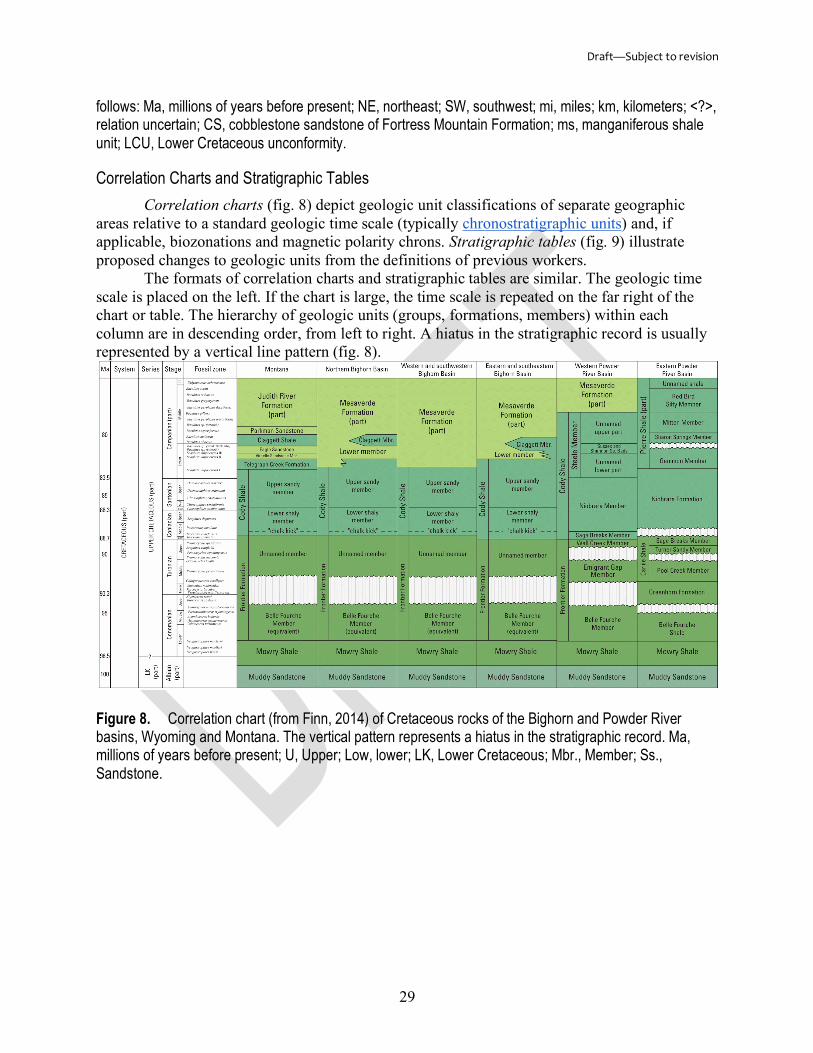
Draft—Subject to revision
29
follows: Ma, millions of years before present; NE, northeast; SW, southwest; mi, miles; km, kilometers; <?>, relation uncertain; CS, cobblestone sandstone of Fortress Mountain Formation; ms, manganiferous shale unit; LCU, Lower Cretaceous unconformity.
Correlation Charts and Stratigraphic Tables Correlation charts (fig. 8) depict geologic unit classifications of separate geographic
areas relative to a standard geologic time scale (typically chronostratigraphic units) and, if applicable, biozonations and magnetic polarity chrons. Stratigraphic tables (fig. 9) illustrate proposed changes to geologic units from the definitions of previous workers.
The formats of correlation charts and stratigraphic tables are similar. The geologic time scale is placed on the left. If the chart is large, the time scale is repeated on the far right of the chart or table. The hierarchy of geologic units (groups, formations, members) within each column are in descending order, from left to right. A hiatus in the stratigraphic record is usually represented by a vertical line pattern (fig. 8).
Figure 8. Correlation chart (from Finn, 2014) of Cretaceous rocks of the Bighorn and Powder River basins, Wyoming and Montana. The vertical pattern represents a hiatus in the stratigraphic record. Ma, millions of years before present; U, Upper; Low, lower; LK, Lower Cretaceous; Mbr., Member; Ss., Sandstone.
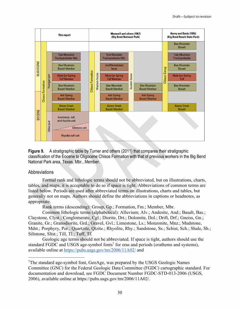
Draft—Subject to revision
30
Figure 9. A stratigraphic table by Turner and others (2011) that compares their stratigraphic classification of the Eocene to Oligocene Chisos Formation with that of previous workers in the Big Bend National Park area, Texas. Mbr., Member.
Abbreviations Formal rank and lithologic terms should not be abbreviated, but on illustrations, charts,
tables, and maps, it is acceptable to do so if space is tight. Abbreviations of common terms are listed below. Periods are used after abbreviated terms on illustrations, charts and tables, but generally not on maps. Authors should define the abbreviations in captions or headnotes, as appropriate.
Rank terms (descending): Group, Gp.; Formation, Fm.; Member, Mbr. Common lithologic terms (alphabetical): Alluvium; Alv.; Andesite, And.; Basalt, Bas.;
Claystone, Clyst.; Conglomerate, Cgl.; Diorite, Drt.; Dolomite, Dol.; Drift, Drf.; Gneiss, Gn.; Granite, Gr.; Granodiorite, Grd.; Gravel, Gvl.; Limestone, Ls.; Monzonite, Mnz.; Mudstone, Mdst.; Porphyry, Por.; Quartzite, Qtzite.; Rhyolite, Rhy.; Sandstone, Ss.; Schist, Sch.; Shale, Sh.; Siltstone, Sltst.; Till, Tl.; Tuff, Tf.
Geologic age terms should not be abbreviated. If space is tight, authors should use the standard FGDC and USGS age-symbol fonts7 for eras and periods (erathems and systems), available online at https://pubs.usgs.gov/tm/2006/11A02/ and 7The standard age-symbol font, GeoAge, was prepared by the USGS Geologic Names Committee (GNC) for the Federal Geologic Data Committee (FGDC) cartographic standard. For documentation and download, see FGDC Document Number FGDC-STD-013-2006 (USGS, 2006), available online at https://pubs.usgs.gov/tm/2006/11A02/.

Draft—Subject to revision
31
https://ngmdb.usgs.gov/fgdc_gds/geolsymstd/download.php. Use of acronyms for geologic units and structural and other geologic features is not encouraged.
Acknowledgments We are extremely grateful to the geologists of the USGS who freely shared their
knowledge and expertise and provided assistance to us while writing this chapter. In alphabetical order, they are Carolyn A. Donlin, Lucy E. Edwards, Ralph A. Haugerud, Jonathan C. Matti, Randall C. Orndorff, John E. Repetski, Leslie F. (Jingle) Ruppert, Katharine S. Schindler, Janet L. Slate, David R. Soller, Scott W. Starratt, Ray E. Wells, and Jan L. Zigler.
References American Commission on Stratigraphic Nomenclature [ACSN], 1961, Code of stratigraphic
nomenclature: American Association of Petroleum Geologists Bulletin, v. 45, no. 5, p. 645–665, accessed March 14, 2017, at http://archives.datapages.com/data/bulletns/1961-64/data/pg/0045/0005/0600/0645.htm.
Berry, M.E., Slate, J.L., Hanson, P.R., and Brandt, T.R., 2015, Geologic map of the Orchard 7.5' quadrangle, Morgan County, Colorado: U.S. Geological Survey Scientific Investigations Map 3331, 1 sheet, scale 1:24,000, accessed June 2017 at https://doi.org/10.3133/sim3331.
Billingsley, G.H., Priest, S.S., and Felger, T.J., 2004, Geologic map of the Pipe Spring National Monument and the western Kaibab-Paiute Indian Reservation, Mohave County, Arizona: U.S. Geological Survey Scientific Investigations Map 2863, 21 p., 1 sheet, scale 1:31,680, accessed March 2017 at https://pubs.usgs.gov/sim/2004/2863/.
Bishop, E.E., Eckel, E.B., and others, 1978, Suggestions to authors of the reports of the United States Geological Survey, 6th ed.: Washington, D.C., U.S. Geological Survey, 273 p. [Also available online at https://pubs.er.usgs.gov/publication/70058738.]
Chadwick, G.H., 1918, Stratigraphy of the New York Clinton: Geological Society of America Bulletin, v. 29, no. 1, p. 327–368, accessed March 13, 2018, at https://doi.org/10.1130/GSAB-29-327.
Chesnut, D.R., Jr., 1992, Stratigraphic and structural framework of the Carboniferous rocks of the central Appalachian basin in Kentucky: Kentucky Geological Survey Bulletin, 11th series, no. 3, 42 p., accessed May 2017 at https://ngmdb.usgs.gov/Prodesc/proddesc_90236.htm.
Clynne, M.A., and Muffler, L.J.P., 2010, Geologic map of Lassen Volcanic National Park and vicinity, California: U.S. Geological Survey Scientific Investigations Map 2899, 110 p., 3 sheets, scale 1:50,000, accessed April 2017 at https://pubs.usgs.gov/sim/2899/.
Crawford, R.D., 1909, Geology and petrography of the Sugarloaf district, Boulder County, Colorado: University of Colorado Studies, v. 6, no. 2, p. 97-131, accessed February 2017 at https://hdl.handle.net/2027/uiug.30112111537442.
Dockery, D.T., III, 1996 (revised 2008), Toward revision of the generalized stratigraphic column of Mississippi: Mississippi Geology, v. 17, no. 1, p. 1-8, accessed May 2017 at https://ngmdb.usgs.gov/Prodesc/proddesc_101823.htm.
Finn, T.M., 2014, Lower Cody Shale (Niobrara equivalent) in the Bighorn basin, Wyoming and Montana—Thickness, distribution, and source rock potential: U.S. Geological Survey Scientific Investigations Report 2013–5138, 32 p., accessed April 2017 at https://doi.org/10.3133/sir20135138
Goddard, E.N., chairman, 1948, Rock-color chart: National Research Council, 6 p.
Draft—Subject to revision
32
Hansen, W.R., ed., 1991, Suggestions to authors of the reports of the United States Geological Survey, 7th ed.: Washington, D.C., U.S. Geological Survey, 289 p. [Also available online at https://pubs.er.usgs.gov/publication/7000088.]
Hewett, D.F., and Lupton, C.T., 1917, Anticlines in the southern part of the Big Horn basin, Wyoming; a preliminary report on the occurrence of oil: U.S. Geological Survey Bulletin 656, 192 p., accessed April 2017 at https://pubs.er.usgs.gov/publication/b656/.
Huddlestun, Paul, Braunstein, Jules, and Biel, Ralph, coordinators, 1988, Gulf Coast region correlation chart: American Association of Petroleum Geologists, Correlation of Stratigraphic Units in North America (COSUNA), 1 sheet.
Johnston, J.E., III, Heinrich, P.V., Lovelace, J.K., McCulloh, R.P., and Zimmerman, R.K., 2000, Stratigraphic charts of Louisiana: Louisiana Geological Survey Folio 8, 6 p., accessed May 2017 at https://ngmdb.usgs.gov/Prodesc/proddesc_98070.htm.
Ketner, K.B., 2008, The Inskip Formation, the Harmony Formation, and the Havallah sequence of northwestern Nevada—An interrelated Paleozoic assemblage in the home of the Sonoma orogeny: U.S. Geological Survey Professional Paper 1757, 21 p., accessed March 2017 at https://pubs.usgs.gov/pp/1757/.
Klepper, M.R., Weeks, R.A., and Ruppel, E.T., 1957, Geology of the southern Elkhorn Mountains, Jefferson and Broadwater Counties, Montana: U.S. Geological Survey Professional Paper 292, 82 p., scale 1:31,250, accessed March 2017 at https://pubs.er.usgs.gov/publication/pp292/.
Kolata, D.R., compiler, 2005, Bedrock geology of Illinois: Illinois State Geological Survey, Illinois Map 14, 1 sheet, scale 1:500,000, accessed January 2017 at https://ngmdb.usgs.gov/Prodesc/proddesc_87181.htm.
Lee, W.T., 1927, Correlation of geologic formations between east-central Colorado, central Wyoming, and southern Montana: U.S. Geological Survey Professional Paper 149, 80 p., 1 pl., accessed April 2017 at https://ngmdb.usgs.gov/Prodesc/proddesc_93444.htm.
Malmon, D.V., Howard, K.A., House, P.K., Lundstrom, S.C., Pearthree, P.A., Sarna-Wojcicki, A.M., Wan, Elmira, and Wahl, D.B., 2011, Stratigraphy and depositional environments of the upper Pleistocene Chemehuevi Formation along the lower Colorado River: U.S. Geological Survey Professional Paper 1786, 95 p., accessed June 2017 at https://pubs.usgs.gov/pp/1786/.
Manley, K.A., 1978, Geologic map of Bernalillo NW quadrangle, Sandoval County, New Mexico: U.S. Geological Survey Geologic Quadrangle Map GQ-1446, 1 sheet, scale 1:24,000, accessed June 2017 at https://ngmdb.usgs.gov/Prodesc/proddesc_10980.htm.
Minor, S.A., and Brandt, T.R., 2015, Geologic map of the southern White Ledge Peak and Matilija quadrangles, Santa Barbara and Ventura Counties, California: U.S. Geological Survey Scientific Investigations Map 3321, 34 p., 1 sheet, 1:24,000, accessed June 2017 at https://dx.doi.org/10.3133/sim3321/.
Missouri Geological Survey [Anderson, K.H., coordinator], 1979, Geologic map of Missouri: Missouri Division of Geology and Land Survey, 1 sheet, scale 1:500,000, accessed June 2017 at http://laurel.lso.missouri.edu/record=b4225833~S5.
Mull, C.G., Houseknecht, D.W., Pessel, G.H., and Garrity, C.P., 2006, Geologic map of the Utukok River quadrangle, Alaska: U.S. Geological Survey Scientific Investigations Map 2817-D, 1 sheet, scale 1:250,000, accessed June 2017 at https://pubs.usgs.gov/sim/2006/2817d/.
Munsell Color Company, 2009 (rev. ed.), Munsell soil color charts: Grand Rapids, Michigan, Munsell Color Co. [leaves, unnumbered].

Draft—Subject to revision
33
North American Commission on Stratigraphic Nomenclature [NACSN], 1983, North American stratigraphic code: American Association of Petroleum Geologists, v. 67, no. 5, p. 841–875, accessed January 2017 at http://archives.datapages.com/data/bulletns/1982-83/data/pg/0067/0005/0800/0841.htm.
North American Commission on Stratigraphic Nomenclature [NACSN], 2005, North American stratigraphic code: American Association of Petroleum Geologists, v. 89, no. 11, p. 1547–1591, accessed January 2017 at https://doi.org/10.1306/07050504129.
Raymond, D.E., Osborne, W.E., Copeland, C.W., and Neathery, T.L., 1988, Alabama stratigraphy: Geological Survey of Alabama Circular 140, 97 p., accessed May 2017 at https://ngmdb.usgs.gov/Prodesc/proddesc_87793.htm.
Silberling, N.J., and Roberts, R.J., 1962, Pre-Tertiary stratigraphy and structure of northwestern Nevada, Geological Society of America Special Paper 72, 58 p. accessed June 2017 at https://dx.doi.org/10.1130/SPE72-p1.
Smith, W.S.T., 1903, Hartville, Wyoming: U.S. Geological Survey Geologic Atlas of the United States Folio 91, 6 p., 3 pls., scale 1:125,000, accessed June 2017 at https://ngmdb.usgs.gov/Prodesc/proddesc_2499.htm.
Stager, H.K., 1962, Geology of the Ano quadrangle, Kentucky: U.S. Geological Survey Geologic Quadrangle Map GQ-171, 1 sheet, scale 1:24,000, accessed May 2017 at https://ngmdb.usgs.gov/Prodesc/proddesc_619.htm.
Turner, K.J., Berry, M.E., Page, W.R., Lehman, T.M., Bohannon, R.G., Scott, R.B., Miggins, D.P., Budahn, J.R., Cooper, R.W., Drenth, B.J., Anderson, E.D., and Williams, V.S., 2011, Geologic map of Big Bend National Park, Texas: U.S. Geological Survey Scientific Investigations Map 3142, 84 p., 1 sheet, scale 1:75,000, accessed June 12, 2017, at https://pubs.usgs.gov/sim/3142/.
Tysdal, R.G., 2000, Revision of Cretaceous Slim Sam Formation, Elkhorn Mountains area, Montana: U.S. Geological Survey Professional Paper 1601-B, p. B1–B8, accessed May 2017 at https://pubs.usgs.gov/pp/p1601/.
U.S. Geological Survey, 1958, Suggestions to authors of the reports of the United States Geological Survey, 5th ed.: Washington, D.C., 255 p. [Also available at https://pubs.er.usgs.gov/publication/70058737.]
U.S. Geological Survey, 2006, FGDC digital cartographic standard for geologic map symbolization [Federal Geologic Data Committee Document Number FGDC-STD-013-2006] (PostScript implementation): U.S. Geological Survey Techniques and Methods 11-A2, 290 p., 2 pl., accessed March 12, 2018 at http://pubs.usgs.gov/tm/2006/11A02/.
U.S. Geological Survey Geologic Names Committee [Cohee, G.V., chair], 1953, Stratigraphic nomenclature in reports of the U.S. Geological Survey: U.S. Geological Survey, 54 p.
U.S. Geological Survey Geologic Names Committee [Cohee, G.V., chair], 1962, Stratigraphic nomenclature in reports of the U.S. Geological Survey: U.S. Geological Survey, 35 p.
U.S. Geological Survey Geologic Names Committee [Cohee, G.V., chair], 1974, Stratigraphic nomenclature in reports of the U.S. Geological Survey: U.S. Geological Survey, 45 p.
U.S. Geological Survey Geologic Names Committee [Orndorff, R.C., chair], 2010, Divisions of time—major chronostratigraphic and geochronologic units: U.S. Geological Survey Fact Sheet 2010–3059, 2 p., accessed March 13, 2018, at https://pubs.usgs.gov/fs/2010/3059/.
Walsh, G.J., Kim, Jonathan, Gale, M.H., and King, S.M., 2010, Bedrock geologic map of the Montpelier and Barre West quadrangles, Washington and Orange Counties, Vermont: U.S.
Draft—Subject to revision
34
Geological Survey Scientific Investigations Map 3111, 36 p., 1 sheet, scale 1:24,000, accessed May 9, 2017, at https://pubs.usgs.gov/sim/3111/.
Washburne, C.W., 1908, Gas fields of the Bighorn basin, Wyoming, in Contributions to economic geology, 1907; Part I, Metals and nonmetals, except fuels: U.S. Geological Survey Bulletin 340, p. 348–363.
Wells, R.E., Snavely, P.D., MacLeod, N.S., Kelly, M.M., and Parker, M.J., 1994, Geologic map of the Tillamook Highlands, northwest Oregon Coast Range (Tillamook, Nehalem, Enright, Timber, Fairdale, and Blaine 15-minute quadrangles): U.S. Geological Survey Open-File Report 95–670, 24 p., 2 sheets, scale 1:62,500, accessed June 2017 at https://pubs.usgs.gov//of/1994/of94-021/.
Williams, P.L., and Cole, J.C., 2007, Geologic map of the Albuquerque 30’ x 60’ quadrangle, north-central New Mexico: U.S. Geological Survey Scientific Investigations Map 2946, 31 p., 1 sheet, scale 1:100,000, accessed June 2017 at https://pubs.usgs.gov/sim/2007/2946/.
Zeller, R.A., Jr., and Alper, A.M., 1965, Geology of the Walnut Wells quadrangle, Hidalgo County, New Mexico: New Mexico Bureau of Mines and Mineral Resources Bulletin 84, 105 p., 1 pl., scale 1:48,000, accessed May 2017 at https://ngmdb.usgs.gov/Prodesc/proddesc_73001.htm.
About This Chapter Much of the information provided here is updated from previous editions of “Suggestions
to Authors” (USGS, 1958, 1978, 1991), “Stratigraphic Nomenclature in Reports of the USGS” (GNC, 1953, 1962, 1974), and unpublished Geologic Names Committee documents, ca. 1900—present (available for viewing in the USGS National Center in Reston, Virginia). Although this chapter is written with the practicing field geologist in mind, we hope these guidelines benefit all who find themselves preparing geology-related reports and maps.
The authors of the chapter on Geologic Nomenclature for STA 8 are Claire M. Landowski (lead), Julie A. Herrick, Katherine D. Jacques, David A. Shields, and Nancy R. Stamm.