GEOLOGIC MAP OF THE PLAINS 30’x 60’ …GEOLOGIC MAP OF THE PLAINS 30’x 60’ QUADRANGLE,...
44
GEOLOGIC MAP OF THE PLAINS 30’x 60’ QUADRANGLE, WESTERN MONTANA Jeffrey D. Lonn, Larry N. Smith, and Robin B. McCulloch Montana Bureau of Mines and Geology Open-File Report 554 2007 This report has had preliminary reviews for conformity with Montana Bureau of Mines and Geology’s technical and editorial standards. Partial support has been provided by the STATEMAP component of the National Cooperative Geologic mapping Program of the U.S. Geological Survey under contract number 06HQAG0029.
Transcript of GEOLOGIC MAP OF THE PLAINS 30’x 60’ …GEOLOGIC MAP OF THE PLAINS 30’x 60’ QUADRANGLE,...

GEOLOGIC MAP OF THE PLAINS 30’x 60’ QUADRANGLE,
WESTERN MONTANA
Jeffrey D. Lonn, Larry N. Smith, and Robin B. McCulloch
Montana Bureau of Mines and Geology Open-File Report 554
2007
This report has had preliminary reviews for conformity with Montana Bureau of Mines and Geology’s technical and editorial standards. Partial support has been provided by the STATEMAP component of the National Cooperative Geologic mapping Program of the U.S. Geological Survey under contract number 06HQAG0029.
1
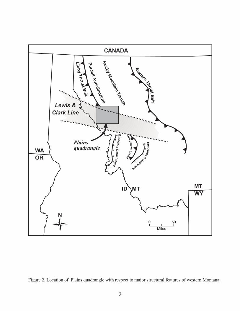
INTRODUCTION Montana Bureau of Mines and Geology (MBMG) staff selected the Plains 30’x 60’ quadrangle in western Montana for 1:100,000-scale mapping in order to fill the gap between the already completed Wallace (Lonn and McFaddan, 1999) and Missoula West (Lewis, 1998a) 30’x 60’ quadrangles (fig. 1). Bedrock of the map area is comprised mostly of low-grade metasedimentary rocks of the middle Proterozoic Belt Supergroup. The extraordinary thickness (>13 kilometers) of the Belt Supergroup and its complex deformation in western Montana have contributed to substantial stratigraphic and structural complexity in this region, and a geologically sound regional interpretation for this part of western Montana has been a goal of MBMG’s mapping program for the past decade. Harrison and others (1986) provided the foundation for mapping in this area with the publication of the Wallace 1O x 2O quadrangle, a 1:250,000-scale compilation that includes the Plains 30’ x 60’ quadrangle. The southwestern third of the Plains quadrangle contains structures of the Lewis and Clark Line, a poorly understood zone of west-northwest-trending faults and folds that transects the more northerly structural grain of western Montana (fig. 2). Recent mapping along the line in the adjacent Wallace (Lonn and McFaddan, 1999; Lewis and others, 1999) and Missoula West (Lewis, 1998a) 30’ x 60’ quadrangles revealed structural and stratigraphic interpretations that conflicted with Harrison and others’ (1986) regional map. Therefore, MBMG’s new mapping on the Plains quadrangle concentrated on the area of the Lewis and Clark Line. Northeast of this area, Sears and others (1991) compiled a 1:100,000-scale bedrock geologic map that covers the remainder of the Plains quadrangle, and this map is incorporated into the Plains quadrangle with very few changes. MBMG’s Ground-Water Assessment Program contributed new maps of the Cenozoic valley deposits.
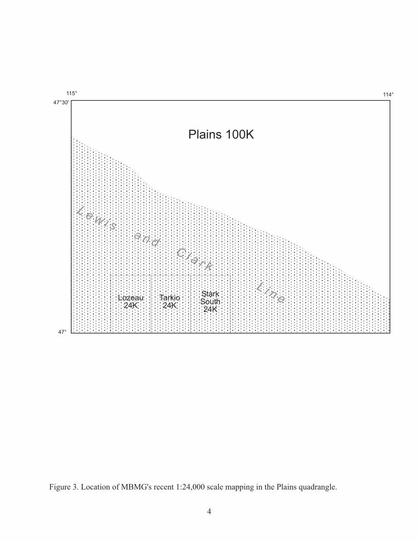
Because of the structural complexity within the Plains quadrangle, MBMG’s strategy was to first map some key 7.5’ quadrangles, beginning in 2004 with 1:24,000-scale mapping of the Tarkio and Lozeau quadrangles (Lonn and Smith, 2005) followed by the Stark South quadrangle (Lonn and Smith, 2006) (fig. 3). Field work was then completed at the 1:100,000 scale for the rest of the Lewis and Clark Line during the summer of 2006.
STRATIGRAPHY
The Correlation Chart and the Description of Map Units provide a detailed description of stratigraphy on the Plains quadrangle. Most of the area is underlain by low-grade metasedimentary rocks of the Middle Proterozoic Belt Supergroup. The Plains quadrangle includes the entire Belt section, from the Prichard Formation through the Pilcher Formation, which has a total estimated thickness of 13,800 meters. Unusual lithologies in the middle Proterozoic Snowslip Formation have produced a great deal of confusion in mapping this region. A 150-meter-thick quartzite interval at the top of the Snowslip was misidentified by Campbell (1960) and Harrison and others (1986) in

���������� ���������������������������������������������������
� � � ������
��� � ��� ���
�������
� � � � � � � �
� � � � �
� � � � �
� �
��
��
��
���
��
���
���
� �
!����
"����
#$���
%����
���&�
'����
'���(
!���
�)����
"�����
��*���
������
������
+����*
+�����
' )��
'�����,��(��
-������
.�$����
!�/�����
-� �����
� "�����
0���&���
��������
'�1�����
2�������
!��������
���� )����
���������(����������)
'1����3�� )
��&����������
'����4�������
5
�� ���
���
�� ���
���
��������������
���������������� ����
���
� ��
��������
���
�� ���
�� ���
�� ���
���
�������������
����������������
�
�
�������� ���� � � ���������������������������� ��� ������������������� ��������� ������
��
��
�
��
�
�
��
��
��
�
��
�
����
����
����
��
����
��
����
������
����
���� ���
�����
���� ���
����
����
�������
�������������
��������� �����
������� �
���� ���� ���!�
��� ��
��� ��������
������
�
� ��� "�
����� �
#���$��%
����
�����
� ��
�
��������
�����
���
�� �������
���������
���� ����
�������������
���������� ������������������ �������������� ���������������� ��!������"��#������
� � � � �� �
� � �
� � � �
�

5
several localities. And a carbonate-rich zone beneath the Snowslip quartzite appears on Harrison and others’ (1986) map as lower Wallace Formation. Assignment of these rocks to a normal stratigraphic sequence significantly simplifies the structural complexity depicted on earlier maps. Paleozoic and Mesozoic sedimentary rocks that were presumably deposited in the area have mostly been eroded. Approximately 215 meters of the Cambrian section is preserved in the Clark Fork Canyon between Huson and Superior. Dikes and sills of gabbroic to granodioritic composition that range in age from middle Proterozoic to early Tertiary have intruded the Belt rocks. Early Tertiary volcanic rocks are present in the lower part of the Ninemile Valley. Unconsolidated Tertiary sedimentary deposits cover the bedrock in some areas; they commonly underlie benches in the Ninemile, Jocko, and Mission Valleys. Bouldery Tertiary deposits are also preserved in some of the mountainous areas, particularly between the traces of the Boyd Mountain and Tarkio faults above the Clark Fork Canyon.
Quaternary history and deposits The Plains quadrangle lies in the central portion of the Glacial Lake Missoula lake basin, a glacially dammed lake that filled and drained multiple times during the Pleistocene. Glacial Lake Missoula inundated the Clark Fork River Valley and much of the Flathead River Valley up to altitudes of about 1,307 meters above sea level. A glacier near the current Montana-Idaho border impounded the lake along the Clark Fork and Flathead Rivers (Pardee, 1910; Levish, 1997; Alt, 2001) (fig. 4). Quaternary units present on the Plains quadrangle are mostly along the Clark Fork River and Flathead River canyons and form the floor of the Mission Valley (fig. 5). Pleistocene deposits include gravelly alluvium (glacial flood deposits), glacial-lake deposits, and glacial till. The glacial-lake deposits are mostly laminated glaciolacustrine silt and clay. However, silty gravel interbedded with laminated silt occurs in the extensive deposits of the Mission Valley (Levish, 1997). Till occurs mostly in the eastern portion of the map where valley glaciers of the Mission Range and Rattlesnake Mountains built moraines on the Mission and Jocko Valley floors (fig. 5). Holocene deposits include minor alluvial fans, eolian deposits, and sand and gravel on terraces and modern floodplains. Most of the Quaternary units in the Plains quadrangle were deposited during Pleistocene glacial times by sedimentation in, and drainage of, Glacial Lake Missoula. The glacial flood deposit unit is gravelly alluvium that occurs along the Clark Fork and Flathead River Valleys, mostly in the canyon reaches downstream of the towns of Dixon and Huson (fig. 5); unit thickness in well logs averages 11 meters, but values range from 0 to more than 92 meters. The gravelly alluvium contains imbricated boulder-sized clasts and planar cross-stratified gravel with set heights of 2 to greater than 30 meters. Paleocurrent directions are down the Clark Fork River Valley and up the tributaries. The unit is most extensive along the Clark Fork River. Large-scale bedforms composed of this

�
��������������� ��
��������������� ������������
��������������
������ ��
��������� �
����� ���������
�������� ���� � ����������������������������� ����������������

�
���������
���������
� �� ������� �� ������
�����
� ���������
� �� ����
� �� ����
����� ������������� �����������
����� ������ �
����������
��������
����������
���� ����� � ��� ��� ����!���"����# �� �!��������$ �������%�������� �
���!������� �
���!�������
���
�����
��
��
�����
��
��
��
��
���
��� ���
��
���
��
��
��
��
��
���
��
��
� ����� � ��� ��� ����!����
&�� �������������'������$'����!��������� "���'����� ������ �� ��
�� ��! � ����!��(��) ��������!���
* ������ �� �������!)�
* ����((�� !�������� ���!)����
��
��
����� ���� ��� ��� ���� ���
����� ����
���

8
flood deposit unit formed in a number of areas along the Clark Fork River, especially where the valley widens downstream of constrictions (fig. 5). Along the Flathead River, the unit partially fills some side valleys, where it was termed “gulch fill” by Pardee (1910, 1942). The gravel also occurs above bedrock and below glaciolacustrine silt and clay in the Flathead River Valley near Dixon and in the northern end of the Jocko Valley. Thinly bedded silt and clay diagnostic of glacial-lake deposition occur in many areas in the Missoula Valley, along the Clark Fork River canyon, and across the Mission Valley. Silt-dominated, laminated, glacial-lake deposits along the valley floors may represent one or more lake stands. The silt and clay unit occurs on incised uplands in the canyon reaches of the Clark Fork and Flathead Rivers, between 3 and 30 meters above modern river level. These bench-forming sequences of laminated silt, clay, and minor sand have been widely recognized as deposits of Glacial Lake Missoula (Pardee, 1910, 1942), and were informally called the Lake Missoula beds by Langton (1935). A few sections of the Lake Missoula beds have been described in varying degrees of detail by Chambers (1971, 1984), Waitt (1980), Fritz and Smith (1993), and Levish (1997). Glaciers developed in the higher elevations of some mountains in the area, and deposited till, a mixture of silt, clay, sand, and gravel that commonly is compacted. Valley glaciers flowed from some of the larger drainages in the Bitterroot and Mission Ranges into the Jocko and Mission Valleys, forming a few lateral and terminal moraines (fig. 5). The giant bedforms and large-scale cross-stratification in bouldery deposits show that high-energy draining of Glacial Lake Missoula transported and deposited much of the gravelly alluvium in the area. Areas of scablands—irregular, internally drained erosion surfaces characteristic of high velocity fluid flows—occur on bedrock surfaces along the canyons and serve as additional evidence of catastrophic drainage events. Low-energy lake deposits of laminated silt that overlie the high-energy alluvium indicate that the lake was re-established after the one or more earlier catastrophic drainages. Significant erosion and gravel transport during draining of the last lake was more restricted within the stream valleys than during the earlier draining events. Scabland erosion related to this draining is restricted to the inner valley of the Clark Fork River. For a more detailed interpretation of the deposits see Smith (2006). Dissection of the till and glacial-lake sediments by the Clark Fork River and its tributaries occurred during and after deglaciation. Stream levels in Glacial Lake Missoula basin dropped rapidly after the last drainage event. The Clark Fork River in Mineral and Missoula Counties cut a canyon between 18 and 95 meters deep as the lake drained. This erosion has created an inner canyon cut into bedrock and basin-fill sediments. Holocene erosion and sedimentation were restricted mostly to near-stream channels. The floodplain widened and strath terraces formed locally along the Clark Fork in small areas where the river is not incised into Belt Supergroup bedrock. Extensive terraces along the Flathead River formed where erodible glacial-lake deposits were removed by stream action. The incorporation of the 11,400 14C yr BP Glacier Peak tephra in terrace deposits about 12 meters above river level near the Sloan Bridge shows that most downcutting occurred by the early Holocene, and most likely as the last Glacial Lake Missoula drained (Levish, 1997; Timmerman, 2005). Minor deposition of alluvial fan sediments occurred
9
where steep drainages end in broad valleys.
STRUCTURE The Plains quadrangle can be divided into two distinct structural domains roughly separated by the west-northwest-striking Ninemile Fault (fig. 6). The southwestern third of the quadrangle is characterized by northwest- to west-northwest-trending folds, faults, and cleavage. These are the structures that define the west-northwest-trending Lewis and Clark Line discussed in the Introduction. Northeast of the Ninemile Fault, the rocks have been deformed into a series of large, open, north-trending, east-verging folds. These folds are superimposed on a broad structural high known as the Purcell Anticlinorium (Price, 1981) (fig 2). The cores of anticlines in this area expose rocks of the lower Prichard Formation that are the stratigraphically lowest known rocks of the Belt Supergroup. Folds associated with the north-striking Libby thrust belt (Harrison and Cressman, 1993) extend into the northwestern corner of the Plains quadrangle. This northern domain of north-trending structures, the Purcell Anticlinorium, is only sparsely cut by faults; the most significant are the north- to northwest-trending, basin-bounding, normal faults.
The Purcell Anticlinorium The Purcell Anticlinorium is the name given to the broad structural high that extends north from the Plains quadrangle into Canada between the Rocky Mountain Trench and the Libby thrust belt (fig. 2). It comprises the northern structural domain of the Plains quadrangle. Price (1981) postulated that it represents a major Cretaceous thrust ramp anticline located at the eastern margin of the Proterozoic Belt basin, while Harrison and Cressman (1993) suggested a Precambrian age for the broad, regional-scale folds. Superimposed on the broad anticlinorium are the anticline-syncline pairs visible on the Plains quadrangle (fig. 7 and pl. 1). These folds are upright to overturned, trend north to north-northwest and verge east, and have steeply west-dipping axial planes (Buckley and Sears, 1993). A north- to north-northwest-striking, steeply west-dipping spaced cleavage (S1) is present (pl. 1) and is thought to be axial planar to the folds. Several of the reverse faults of the Libby thrust belt (Harrison and Cressman, 1993), located just northwest of the Plains quadrangle, die into these folds (Sears and others, 1991), indicating that these folds are kinematically linked to the thrust belt, and are therefore the result of east-west-directed, Late Cretaceous compression (deformation event D1). Based on intrusive relationships, Harrison and Cressman (1993) proposed a minimum age of 100 Ma for the Libby thrust belt, and so the prominent folds of the Purcell Anticlinorium must be of approximately the same age. In Price’s (1981) interpretation, these folds were carried piggyback on the eastern thrust slab (Sears, 1988; Sears and others, 1989) by the underlying Lewis/Hoadley/Eldorado thrust system as late as the Paleocene (Mudge and others, 1982). A ramp in this thrust is postulated to be responsible for creating the broad structural high. In contrast, Harrison and Cressman (1993) thought that the smaller Cretaceous folds modified the pre-existing broad anticlinorium formed in the Late Proterozoic.

� � � � � � �� � � � � � � � �
� � � � � � �
� �� �
� � � � �
� � �
� � � �
� ���� � � �
� � �
������������ ���� ��� ���������������� ����������������������������������������� ���������������� ����������� ��������������������
�

������������
������������ ������������������������� ��������������������
������������
������
�����������
���
���
����
�����
���������
���������
���������
���
�����������
����
�����
�����
���
�����
��������
������
����� ��
�
��
���
������ �����
!���"�
��
�������
��
�����
���# ������
$�%���
�&���
��������
���
���
���
���
���
�����
��
������� ���
��

12
Two other types of faults cut the folds of the Purcell Anticlinorium on the Plains quadrangle. The earliest are west-northwest- to west-striking reverse faults; they are interpreted to be related to compressive tectonism along the Lewis and Clark Line (deformation event D2) and will be discussed below. Later north-northeast to northwest normal faults developed in response to Cenozoic crustal extension (deformation event D3), and some of these exhibit Holocene movement (Witkind, 1975; Ostenaa and others, 1990, 1995; Stickney and others, 2000; Hoffmann and others, 2006). A few of these faults also display dextral offset (Witkind, 1975; Ostenaa and others, 1995).
The Lewis and Clark Line The west-northwest-trending structures of the southern structural domain are part of the Lewis and Clark Line. Although Billingsley and Locke’s (1941) original definition of the line was based on a physiography controlled by Cenozoic strike-slip and normal faults, most subsequent workers have recognized that Late Cretaceous compressional structures are an important component of the Lewis and Clark Line. These west-northwest-oriented compressive features have been attributed to: 1) sinistral transpression (Smith, 1965; Lorenz, 1984; Hyndman and others, 1988; Reid and others, 1993; Sears and Clements, 2000); 2) dextral transpression (Wallace and others, 1990); 3) rotation of originally north-trending folds through left-lateral (Reid and others, 1993; Burmester and Lewis, 2003) or right-lateral (Hobbs and others, 1965) shear; or 4) northeast-directed compression that did not involve lateral movement (White, 1993; Yin and others, 1993; Yin and Oertel, 1995). Subsequent Cenozoic extension and/or right-lateral shear (Hobbs and others, 1965; Reynolds, 1979; Harrison and others, 1974, 1986; Bennett and Venkatakrishnan, 1982; Sheriff and others, 1984; Winston, 1986a; Doughty and Sheriff, 1992; Yin and others, 1993; White, 1993; Yin and Oertel, 1995; Lonn and McFaddan, 1999) superimposed high-angle normal and dextral faults that roughly parallel and obscure the compressional features. This series of tectonic events has created an extremely complex structural geometry along the Lewis and Clark Line. In fact, White (1993, 2000) identified five structural elements formed by discrete tectonic events along the Lewis and Clark Line in the Coeur d’Alene mining district west of the Plains quadrangle. We have combined these events into two long-lasting periods of tectonism: 1) Late Cretaceous sinistral transpression (D2), and 2) Cenozoic dextral transtension (D3). Clearly, the Lewis and Clark Line is a complex and controversial feature, and even its boundaries cannot be agreed upon. As Winston (2000) suggests, much of the confusion may stem from workers combining diverse structures of different origins into one feature when it is really a combination of several structures. Geologic mapping along much of the Lewis and Clark Line has been available only at the 1:250,000-scale; it is hoped that more detailed mapping such as this will resolve some of the conflict. The larger question of “what localized the Lewis and Clark Line?” also remains unanswered. Although Precambrian structure has been proposed to explain the zone’s existence (Hobbs and others, 1965; Harrison and others, 1974; Reynolds, 1979; Leach and others, 1988; Winston, 1986a; Sears, 1988), the recognized structures that define the
13
zone are all Cretaceous or younger.
Relationship of the Lewis and Clark Line to the Purcell Anticlinorium As the north-south folds of the Purcell Anticlinorium approach the Ninemile Fault that is the northern boundary of the Lewis and Clark Line in this area, their north to north-northwest axial traces curve southeastward (pl. 1). This is most convincingly displayed by the west flank of the Plains anticline and the axial trace of the Moise Valley anticline (fig. 7 and pl. 1). We suggest that the folds have been bent eastward by left lateral shear along the Lewis and Clark Line. Also, two west-striking faults, the Perma and Burgess faults (Sears and others, 1991) displace the Plains anticline in a reverse sense (pl. 1 and fig. 7). The rotated fold axes and the offset of folds along the Perma and Burgess faults 1) confirm a sinistral transpressive (D2) origin for the early compressional features of the Lewis and Clark Line, and 2) show that the west-northwest-trending compressive features postdate the folds and reverse faults of the Purcell Anticlinorium (D1). Further evidence for the younger age of the Lewis and Clark Line is provided by relationships about the Lothrop fault near Alberton (pl. 1 and fig. 7; also Lonn and Smith, 2006). North of the Lothrop fault are north-trending folds and the Stark Mountain reverse fault that we interpret to be related to D1; south of the west-northwest Lothrop fault are tight west-northwest-trending folds and reverse faults related to the compressive phase of the Lewis and Clark Line (D2). Nowhere do the north-trending folds (F1) refold either the Lothrop fault or the west-northwest folds (F2). In fact, it appears that the Lothrop reverse fault simply overrode the north-trending structures. The north-trending fold set is also disrupted in the upper Ninemile Valley by bands of intense, west-northwest cleavage (shear foliation) and tight west-northwest folds that deform the apparently pre-existing north-striking beds (pl. 1 and fig. 8). Therefore, the Lewis and Clark Line does appear to be a younger feature separate from the Libby thrust belt and the north-south folds of the Purcell Anticlinorium. Other evidence for this age relationship was presented by Burmester and Lewis (2003), who used paleomagnetic evidence to show that a large west-northwest fold south of the Coeur d’Alene mining district is a north-south fold rotated in a counter-clockwise direction by sinistral shear along the Lewis and Clark Line. Hobbs and others (1965) had also proposed that some of the west-northwest folds of the Lewis and Clark Line are rotated north-south folds, but had rotated clockwise as a result of dextral shear. Note that White (1993, 2000) disagrees with a rotational origin for the west-northwest folds, instead proposing that the west-northwest-trending folds formed first and were then refolded along through-going north-trending axes. Sears (1988) and Sears and others (1989) inferred a maximum age of 82 Ma for the westerly-striking compressional features of the Lewis and Clark Line, considerably younger than the 100 Ma age proposed for the Libby thrust belt (Harrison and Cressman, 1993) and therefore younger than the folds of the Purcell Anticlinorium.

��������������
��
��
���
��
���
���
������������� ���������������������������������������� ������ �������� ��������������� ����� ��� ������������������� ��������� ��� ���������������� ������������������� ����������������������������������� ����� ������ �������������� ��
� ��� ��
�
��� �������� ��������� ���
��� �������� �������������������� ����
��� �������� ��������� ���� ����!�� ������"!���#����!�������!������#��� ���!���� ���� #����!
$�
%��� #������� ��
��� �������� �����#��������� �������� ��� !���!�� ! �����
��� �������� �����! ������� �� ��&��� � ������� �������� ! ���$�
$�
��
��� �������� �����! ������� �� ������������! �� ������������������ �������!!�# ����!����# ���� ���� ��
!
15
Transpressive structures of the Lewis and Clark Line Sinistral transpression (D2), dominated by north-northeast-directed shortening, generated the earliest west-northwest fabrics that define the Lewis and Clark Line. The D2 structures are: 1) the rotated F1 folds, discussed previously, that now have a northwest orientation; 2) tight, upright to overturned, northwest- to west-northwest-trending folds (F2); 3) metamorphic shear foliation (S2) that, where intensely developed, defines wide shear zones; and 4) anastomosing reverse and normal faults that formed simultaneously in a compressive setting (Wavra and others, 1994; Reid and others, 1995). The tight folds formed early, possibly contemporaneously with the rotation of the F1 folds. Most of the tight folds have steeply south-dipping axial planes and verge north-northeast, but a few are overturned to the south-southwest. Sears and Clements (2000) and Geraghty and Portner (2003) proposed that these compressional features of opposing vergence are part of a positive flower structure that developed in response to sinistral transpression, while White (1993, 2000) ascribes the south-southwest directed structures to later deformation of the original north-northeast-verging structures. A metamorphic shear foliation (S2) transects the folds at an acute angle (Reid and others, 1993, 1995; Wavra and others, 1994). Like the axial planes of the F2 folds, the foliation mostly dips steeply south (average attitude N60oW 62oSW; fig. 9a), but some foliation dips north, and the same explanations described above for the opposing F2 folds apply. This foliation formed under lower greenschist metamorphic conditions at deep levels of the upper crust (Leach and others, 1988; Reid and others, 1995; Sears and others, 1989). It has a phyllitic to schistose texture and commonly contains steeply dipping stretching lineations and some mylonitic microfabric. Lineation plunge averages 60o S52oW (fig. 9b), raking 0-20o west of the dip line, and kinematic indicators show mostly oblique reverse movement (south side up and slightly east). However, some show normal movement (Reid and others, 1995; Yin and others, 1993; Yin and Oertel, 1995); this normal shear occurred under the same greenschist metamorphic conditions as the reverse shear, and therefore at approximately the same time. Where the foliation is intensely developed, it has completely transposed bedding and comprises broad ductile shear zones (fig. 10). Some of these zones of ductile deformation can be traced southeastward into brittle reverse faults that developed synchronously at higher structural levels. The best example is the Terror shear zone, a ductile shear zone described in the Coeur d’Alene mining district (Reid and others, 1993) that extends eastward into the Plains quadrangle north of Superior (fig. 10). As the zone is traced southeastward to higher structural and stratigraphic levels, ductile shear is replaced by brittle deformation, and the Terror shear zone becomes the Lothrop fault system. Like the shear foliation and the ductile shear zones, the Lothrop fault postdates some of the folds (Lonn and Smith, 2006), but we interpret the folds, ductile shear zones, and faults to be kinematically linked. It appears that the rocks first folded in response to north-northeast-directed shortening, then sheared or broke with continued compression. Whether the rocks behaved in a more ductile or brittle manner depended on the temperature and pressure conditions that in turn were

��
��
���������� ��������������������������� ������������������������������������� ���������� ����������������� ����� !������������������������ �"# ��$����� ������%%��������� ���� ����� ��"� �
�&

������������
������������ ������������������������ ��������������� ��������������������� ������ �� ��������������� �������� ��� ���� ��� ����������
������������
���
������
�����������
������
���
���
������� � � ������ � � ����

18
determined by structural level (Sears, 1988; Sears and others, 1989; Sears and Clements, 2000). Deformation became more brittle with time as well, and faults formed that overprint the ductile shear zones (Reid and others, 1995). In the Coeur d’Alene mining district and the Wallace 30’ x 60’ quadrangle, these faults are represented by an anastomosing pattern of merging reverse and normal faults (Hobbs and others, 1965; Lonn and McFaddan, 1999) that Wavra and others (1994) and Reid and others (1995) proposed to have formed contemporaneously in a tectonic setting of constrictional strain. The steep, anastomosing faults bound steeply dipping rod- or lozenge-shaped bodies that moved along the dip lines with respect to one another when compressed by north-northeast-directed shortening (fig. 11). Explained simply, an individual lozenge or rod is bounded by a reverse fault on one side and a normal fault on the other, and movement of the fault-bounded body was through a process similar to squeezing a bar of soap or a watermelon seed. On the Plains quadrangle, a number of fault systems, including the Lothrop, Tarkio, and Sunrise Creek faults, are comprised of subparallel and anastomosing reverse and normal faults. This geometry has previously been attributed to reactivation of the thrusts by Cenozoic extension (Lewis, 1998a, 1998b; Lonn, 2001; Lonn and Smith, 2005, 2006) that undoubtedly occurred, but a constrictional strain process could have formed some of these fault zones. Such faults, where a lozenge or wedge of rock is extracted or extruded between two faults with opposite shear senses (fig. 11), may be more common than previously described (Froitzheim and others, 2006). The world-class silver veins in the Coeur d’Alene district along the Lewis and Clark Line to the west of the Plains quadrangle developed along these types of faults (White, 1993, 2000; Reid and others, 1993, 1995; Wavra and others, 1994). Mineralization in the Superior mining district (Campbell, 1960) that lies along the Terror shear zone also appears to have been localized in a similar structural setting.
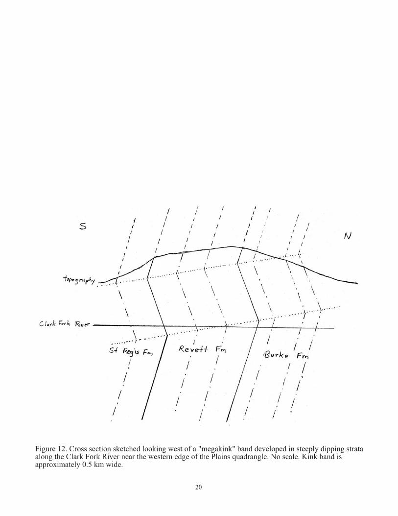
Transtensional structures of the Lewis and Clark Line Cenozoic extensional and dextral shear affected the Lewis and Clark Line following the sinsistral transpressive event. Relative timing of the extensional and dextral tectonism cannot be determined, and therefore we have grouped both into a long-lived dextral transtensional event (D3). Structures reflective of the D3 deformation include kink folds or bands with near horizontal axes, detachment (low-angle normal) faults, high-angle, listric(?) normal faults, and right lateral strike-slip faults. The oldest extensional features are probably the gently dipping kink folds or bands that are obvious in areas where the strata and/or foliation are steeply dipping (fig. 12). These kink bands range in width from less than 0.5 cm to more than 1 km, and are attributed to horizontal extension (Wallace and Hosterman, 1956; Campbell, 1960; Hobbs and others, 1965; White, 1993). A well-exposed example of a “megakink” (White, 1993) is along the Clark Fork River near the west edge of the map (stop 1 of White and others, 2000). Here the steeply south-dipping strata have been tilted so that they dip north and are overturned to the south (fig. 12), creating potential problems with the tectonic interpretation. Lonn and McFaddan (1999) interpreted such north-dipping shear foliation and overturned strata

���������� ������������� ������ �������� � ���������������� ���������������������������������� ���� �������� ������������ ��������� ����������� ���������
����������� ����
��� ����
��� ������ ���� ����������
��� ������������ ������������� ���� !"
�
����������� �������� ������������ ���������� ������������������������� ������������������������������� �������������� ������������������������������� ������ ������!�����������" ��������#��������������� $��������%�&���������
%
21
as representing Cretaceous, south-directed folds and faults of opposing vergence to the normally north-directed features. Geraghty and Portner (2003) used this as evidence to support the flower structure hypothesis (Sears and Clements, 2000). It may be that the south-directed structures are just the result of a Cenozoic kink fold overprint. The Pi diagram of shear foliation (fig. 9a) shows a large amount of scatter without a well-defined girdle; this distribution is also attributed to the tilting of the foliations in kink bands. A few low-angle normal faults (detachment faults) were mapped in the southwestern part of the Plains quadrangle, and several major detachment faults were mapped on the south-adjacent Missoula West quadrangle (Lewis, 1998a). We propose that continued extension along the kink bands (fig. 12) would create flat-dipping normal faults, and we therefore suggest that the kink folds and detachment faults formed at the same time. As exhumation by erosion and extension continued, high-angle normal faults, such as the Ninemile, Osburn, and Boyd Mountain Faults, developed (fig. 10). These faults appear to have been localized by pre-existing zones of intensely developed compressive shear: the Ninemile Fault was localized by a zone of intensely developed shear foliation and tightly folded strata (Yin and others, 2000; Yin and Oertel, 1995); the Osburn Fault was controlled by the Terror shear zone/Lothrop reverse fault, and the Boyd Mountain is located along the south side of the Terror shear zone (cross section AA’). The Boyd Mountain fault coincides with the bounding thrust of Sears’ (1988) and Sears and others’ (1989) western slab. So, a number of west-northwest-trending shear zones and reverse faults were indeed reactivated as normal faults as previously proposed (Lewis, 1998a, 1998b; Lonn, 2001; Lonn and Smith, 2005, 2006). Two normal faults, the Boyd Mountain and Ninemile Faults, contain Tertiary sediments in their hanging walls that have been tilted into the fault, indicative of a listric geometry. Major basin-bounding normal faults, such as the Mission and Jocko Faults, also formed in the Purcell Anticlinorium, probably beginning during the same extensional event, with movement on some continuing until modern times (Witkind, 1975; Ostenaa and others, 1990, 1995; Stickney and others, 2000; Hofmann and others, 2006). Although right-lateral tectonism has historically been emphasized for the Lewis and Clark Line, it appears to be overshadowed by the reverse, left-lateral, and normal displacements. Evidence for right-lateral movement comes mostly from outside the Plains quadrangle. West of the quadrangle, two west-northwest faults, the Osburn and Butler Gulch (a splay of the Osburn) faults have documented right-lateral movement (Hobbs and others, 1965; Lonn and McFaddan, 1999). Focal mechanism solutions for some small earthquakes along the Lewis and Clark Line both east and west of the Plains quadrangle show dextral offset along west-northwest-striking fault planes (Sprenke and others, 1991; Mike Stickney, verbal communication, 2007). Within the Plains quadrangle itself, however, there is no good evidence for dextral strike-slip movement along the Lewis and Clark Line. A few enigmatic east-northeast- to northeast-striking, high-angle faults appear to cut some of the northwest-trending faults of the Lewis and Clark Line. The most prominent
22
of these are the Trout Creek and Quartz Creek faults (pl. 1 and fig. 7). The Quartz Creek fault is intruded by granodiorite that appears to be responsible for the gold mineralization that was extensively worked by placer operations along the creek. Dip direction and sense of movement are unknown for these faults, and it is not known if these faults were part of the main extensional event (D3) or if they formed later.
Summary of structural history 1. East-west shortening (deformation event D1) produced the north-trending folds (F1) of
the Purcell Anticlinorium and Libby thrust belt at about 100 Ma. 2. Sinistral transpression (deformation event D2) along the Lewis and Clark Line
produced west-northwest-trending folds (F2), shear foliation (S2), shear zones, and faults at approximately 82 Ma.
3. Horizontal extension (deformation event D3) caused flat-dipping kink bands and low-angle normal faults along the Lewis and Clark Line in the early Tertiary.
4. Continued Cenozoic extension (deformation event D3) formed the prominent normal faults in both the Purcell Anticlinorium domain and along the Lewis and Clark Line. Many faults appear to reactivate pre-existing reverse faults and shear zones. Quaternary movement has been documented for several faults.
5. Relatively minor right lateral movement, possibly contemporaneous with extension and so placed within the D3 deformation event, occurs along some faults. It may also continue into the Quaternary.
MINERAL DEPOSITS IN THE NINEMILE VALLEY
During the mapping of the Plains quadrangle, investigation of the occurrence of mineral deposits in the Ninemile Creek drainage was also undertaken. Both placer and lode deposits are known in the Ninemile Valley that lies within the structurally complex Lewis and Clark Line (figs. 3 and 7).
The northwest-trending Ninemile Fault zone bounds the northeast side of the Ninemile Valley. Gold placer deposits are located near the head of the Ninemile Valley and in many side drainages on its northeast flank. Most of the placer deposits do not appear to be associated with modern stream deposits. Lode deposits also occur in many of the drainages, but few appear to have any connection to the placer deposits.
Gold Placer Deposits
Gold placer deposits within the Ninemile Creek drainage occur as two distinct deposits (fig. 13). The Upper Ninemile Placer is confined to Eustache, St. Louis, Beecher, and upper Ninemile Creeks near the head of the Ninemile Valley. The Middle Ninemile Placer, located 10 km southeast, occurs along several tributaries northeast of the Ninemile Creek near the trace of the Ninemile Fault (fig. 13).

����������� �������������� � �������
�������
��� ����
���
������
���
���
�����
�������
�����
���
���
����
��������������
�����
����
���
���
���
������
������
����
�������
���������
����
���������
���
���
���
���
���
�����
�����
����
������
���
����
��!����
����������"#$�%����&'�%���(
)!���
���
���
�������������� ����
�������������� ����
��
�
�
��� � � � � �
�
� �
�
������� �����
�
��� � ��� �����
������������

24
Upper Ninemile Placer Deposits
The Upper Ninemile Placer, located near the head of Ninemile Creek, can be divided into three separate deposits: 1. In Eustache and upper St. Louis creeks, gold has been mined in localized, small volume placers containing angular to subangular gravels buried beneath 1-2 m of overburden. 2. Along upper Ninemile Creek, the placer deposits are contained within rounded quartzite cobble in a red-brown, silty clay matrix. Pay streaks near the mouth of Beecher Creek appear to be cut by the west-northwest-trending fault mapped in the valley bottom and offset in a left-lateral sense. 3. West of Beecher Creek, placer gold occurs up to 100 m above modern streams within unconsolidated gravel mapped as Tertiary in age.
The lack of gold in the modern alluvium, the offset pay streaks, and the association of placer deposits with Tertiary sediments suggest a Tertiary age for the placer deposits. In addition, the predominance of clasts derived from the Wallace Formation within the deposits implies that the carbonate-rich Wallace Formation hosted the source mineralization. The lack of schistose clasts in the placers may indicate that the lode gold was not associated with the Cretaceous ductile shear zones, although it is also possible that the schistose rocks are less resistant to weathering than undeformed rocks and did not survive transport.
Middle Ninemile Placer Deposits The Middle Ninemile Placer is located along tributary streams on the northeast side of the central part of the Ninemile Valley (fig.13). These placers appear to originate from lode deposits controlled by northwest-trending faults that cut the Prichard Formation. Near the confluence of McCormick and Little McCormick Creeks, an acidic rock seep is visible where the concealed Ninemile Fault crosses the drainage, suggesting mineralization along the Ninemile Fault. A parallel fault 0.5 km north is probably the source of the Favorite Gulch and Kennedy Creek placers. However, neither mineralization nor alteration is consistent along the lengths of the faults, and we propose that northeast-striking cross faults extend up the tributary drainages, and that the gold mineralization formed where the two fault systems intersect.
The Middle Ninemile placers are adjacent to but 2-18 m above the modern alluvium, so like the Upper Ninemile Placer deposits, these are older than Holocene.
Lode Deposits
Upper Ninemile Lode Deposits
25
A silver-lead mine is located along a fault striking west-northwest across St. Louis Creek. The fault juxtaposes rocks of the Wallace and St. Regis Formations. The mine is postulated to be a Coeur d’Alene-type deposit related to Cretaceous ductile shear. The Waylett copper mine is located along St. Louis Creek adjacent to the Ninemile fault zone. Isolated occurrences of copper are found along the fault for kilometers in both directions. This may also be a Coeur d’Alene-type deposit. Between Beecher and Soldier creeks, the placer miners (Bob and Clay Lewis, personal communication, 2006) noted northeast-trending gold-rich red zones that may represent northeast-striking faults that may have been a lode source for the placers. Mines and drilling projects on the southwest side of the Ninemile Valley, between Twin and Sawpit Creeks, have identified lode gold resources in quartz-sulfide veins hosted by the St. Regis Formation. Two vein systems exist: one trends northeast, and the other north-south; dips range from 0° to 50o. However, no associated placers exist in these drainages.
Middle Ninemile Lode Deposits In the Middle Ninemile area, the lode deposits coincide with the placer deposits. Bedrock is hydrothermally altered, phyllitic argillite of the Prichard Formation. Abundant fractures and vugs are filled with quartz, and contain chalcopyrite, sphalerite, galena, and pyrite. Assays of the bedrock range from 0.042 to 0.134 ounces per ton gold. Nearby placers contain pyrite cubes, galena nuggets, and flat pieces of gold suggesting that the gold is locally derived. As suggested earlier, the gold mineralization was probably controlled by intersecting northwest- and northeast-trending faults.

��
���� ���� ����
���
����
��
�
��
���
��
���
����
����
��
���
�����
���
���
���
�����
�����
�����
���
���
���
���
���
���
���
����
���
���
���
����������
����������
����������
���
���
���
���
���
���
��� ��
���
��� ���
���
��
��������
���������
�� �� �
� �������
���� ��
������ ��� ����
������� ��� ����
������������ �������� ���
��

27
DESCRIPTION OF MAP UNITS
Descriptions use the sediment type terminology of Winston (1986b) for describing bed thickness and sedimentary structures.
af ARTIFICIAL FILL Qal ALLUVIUM OF MODERN CHANNELS AND FLOODPLAINS (HOLOCENE)
Well- to moderately sorted gravel, sand, and minor silt along active stream channels and on modern floodplains. Unit includes minor colluvium at the bases of hill slopes. Thickness ranges from 0 to about 12 m.
Qaf ALLUVIAL FAN DEPOSITS (HOLOCENE)
Gravel, sand, and silt in distinctly fan-shaped landforms at the mouths of small drainages.
Qc ALLUVIUM AND COLLUVIUM (HOLOCENE) Thin, unconsolidated slope wash and talus deposits and alluvial deposits along
small drainages; gravel, sand, and silt 2-8 m thick. Qat ALLUVIUM OF STREAM TERRACES (HOLOCENE AND PLEISTOCENE)
Gravel and sand underlying flat benches perched above present river level; typically 1-9 m thick.
Qe EOLIAN DEPOSITS (HOLOCENE AND PLEISTOCENE)
Light gray, medium-, fine-, and very fine-grained massive-bedded sand in parabolic dune-shaped deposits mantling older sediments. Partially vegetated, locally has active blow-out areas. Thickness 0-5 m.
Qls LANDSLIDE DEPOSITS (HOLOCENE AND LATE PLEISTOCENE) Unsorted mixtures of mud and angular boulders of locally derived bedrock
transported by mass movement down slopes; characterized by irregular topography.
Qao OLDER ALLUVIUM (HOLOCENE AND LATE PLEISTOCENE)
Mostly well-rounded gravel and sand deposited by streams and slope wash on surfaces 2-185 m above modern streams; may include stream terraces and glacial flood deposits, however exposures are poor and geomorphic forms are indistinct; mostly less than 12 m thick
Qgl GLACIAL LAKE DEPOSITS (PLEISTOCENE)
Grayish-brown, light- to dark-yellowish-brown, gravelly silt, light-pink silt and sand, very fine-grained sand in cyclic beds, and silty and clayey gravel. Deposit caps many benches in the canyon reaches of the Clark Fork and Flathead rivers, where it is typically 10-13 m thick. The unit is coarser grained in the Mission

28
Valley than in the western and southern parts of the quadrangle. The silty and clayey gravel in the Mission Valley has a bimodal grain-size, is matrix-supported, and occurs in thick beds (1-10 m thick) separated by laminated silt and clay units that are continuous for hundreds of feet to miles in outcrop along the Flathead River; the silty and clayey gravel was interpreted to be deposited by sediment gravity flows in Glacial Lake Missoula (Levish, 1997).
Qgf GLACIAL FLOOD DEPOSITS (PLEISTOCENE)
Stratified, granule through boulder gravel, minor sands, and local 12-50-cm-thick interbeds of laminated silty clay and very fine-grained sand. Gravels may contain silt and very fine-grained sand in pore spaces. Clasts commonly subangular to subrounded; clast lithologies mostly Belt Supergroup quartzites and argillites, with lesser amounts of diorite, granite, and poorly indurated mudstones and siltstones. Cross bedding is typically large-scale, ranging from one meter to tens of meters in height. Imbricated boulder-sized clasts and planar cross-stratified gravel with set heights of 1-30 m display paleocurrents oriented down the Clark Fork River and up tributaries to the Clark Fork, suggesting a high-energy, high-volume alluvial environment. Thicknesses typically about 12 m, but reach more than 92 m in paleochannels along the Clark Fork River and in eddy bars in tributary valleys along the Flathead River.
Qgt GLACIAL TILL (LATE PLEISTOCENE) Unsorted large boulders, gravel, sand, and silt in compact deposits. Till makes up lateral and terminal moraines with irregular topography and internally drained basins.
QTg GRAVEL (PLEISTOCENE OR TERTIARY) Poorly exposed rounded gravel and sand on hillslopes; stratification and age of
deposits are unclear. Ts SEDIMENTARY ROCKS (TERTIARY)
Claystone, shale, siltstone, sandstone, locally thick conglomerate, and minor coal. Some poorly exposed deposits of well-rounded boulders in a silt and sand matrix cap slopes up to 1,600 m in elevation in the Ninemile Valley and along the Boyd Mountain, Osburn, and Tarkio faults. Poor exposures and the rarity of known fossils make correlation between outcrops difficult. Clasts are mostly quartzite, but also include rare volcanic and granitic rocks. Strata range from unconsolidated to strongly consolidated in outcrop; most units can be characterized as weakly consolidated.
Tv VOLCANIC ROCKS (TERTIARY)
Porphyritic, welded, gray to black tuff containing phenocrysts of quartz, sanidine, plagioclase, and biotite. Also contains fragments of country rock and pumice (after Wells, 1974).
TKgd GRANODIORITE AND QUARTZ DIORITE (TERTIARY OR CRETACEOUS)
29
Dikes and sills of dark-colored, altered, equigranular, fine- to medium-grained quartz diorite to granodiorite. Tertiary or Late Cretaceous age is inferred from their occurrence along Tertiary or Cretaceous fault zones.
TKgb GABBRO AND DIORITE (TERTIARY OR CRETACEOUS) Dikes and sills of dark-colored, altered, equigranular, fine- to medium-grained gabbro, diabase, and diorite. Tertiary or Late Cretaceous age is inferred from their occurrence along Tertiary or Late Cretaceous fault zones.
TKYgb GABBRO AND DIORITE (LATE PROTEROZOIC, CRETACEOUS, OR
TERTIARY) Dark-colored gabbro and diorite sills and dikes of uncertain age. Although Harrison and others (1986) assigned a late Precambrian age to all mafic igneous rocks in the region based on K-Ar isochronology of a sill near Alberton (Obradovich and Peterman, 1968), similar rocks commonly occur along Tertiary or Cretaceous faults, suggesting that some may be as young as early Tertiary.
Єrl RED LION FORMATION (UPPER CAMBRIAN)
Thin-bedded gray and red mottled dolomite. Top not exposed; about 25 m thick where exposed (Wells, 1974).
Єhs HASMARK AND SILVER HILL FORMATIONS, UNDIVIDED (UPPER
CAMBRIAN) Єh HASMARK FORMATION (UPPER CAMBRIAN)
Light-gray to white, massive to mottled dolomite. Thickness 125 m (Wells, 1974). Єsh SILVER HILL FORMATION (UPPER OR MIDDLE CAMBRIAN)
Consists of a lower shale member 25-30 m thick, and an upper limestone member 54 m thick that contains wavy, irregular stringer of brown silty limestone (Wells, 1974).
ЄYq QUARTZITE, UNDIVIDED (MIDDLE CAMBRIAN AND MIDDLE
PROTEROZOIC) Includes the Cambrian Flathead and Middle Proterozoic Pilcher formations; the disconformable contact between these formations is difficult to locate in the field. The Pilcher consists of medium- to coarse-grained, vitreous to feldspathic quartzite with distinctive alternating purple and light-gray, trough cross-laminae. Flathead sandstone is medium- to coarse-grained, white to red, massive to cross-bedded, vitreous quartzite. Thickness of this unit is 30-300 m.
ZYgb GABBRO AND DIORITE (MIDDLE AND LATE PROTEROZOIC)
Dark-colored gabbroic sills and dikes. This lithologic unit is assigned to intrusions for which there exists evidence that they are Precambrian in age. One sill near Alberton was dated by K-Ar isochronology at 760 Ma (Obradovich and Peterman, 1968).

30
Ygr GARNET RANGE FORMATION (MIDDLE PROTEROZOIC)
Rusty-brown to yellow weathering, greenish-gray, micaceous, hummocky cross-stratified, fine-grained quartzite with olive-green to black argillite interbeds. Distinguished by rusty yellow weathered surfaces and abundant detrital mica. Thickness ranges from 277 m (Lonn and Smith, 2005) to over 2,500 m (Wells 1974).
Ym MCNAMARA FORMATION (MIDDLE PROTEROZOIC)
Dense, interbedded, green and red siltite and argillite in microlaminae and couplets. Mudcracks and chips are common. Contains diagnostic thin chert beds and chert rip-up clasts. Dominated by mudcracked even couplet and mudcracked lenticular couplet sediment types. From 700 to 1,230 m thick.
Ybo BONNER FORMATION (MIDDLE PROTEROZOIC)
Pink, medium- to coarse-grained feldspathic, cross-bedded quartzite. Contains some granule-sized grains, and locally includes micaceous, maroon-colored argillite interbeds. Mostly comprised of the cross-bedded sand sediment type. Thickness 550 m.
Yms3 MOUNT SHIELDS FORMATION, INFORMAL MEMBER 3 (MIDDLE
PROTEROZOIC) Red quartzite to argillite couples and couplets with abundant mudcracks, mudchips, and salt casts. Includes green interbeds, and also some red microlaminae. Approximately 800 m thick.
Yms2 MOUNT SHIELDS FORMATION, MEMBER 2, INFORMAL (MIDDLE PROTEROZOIC) Pink to gray, flat-laminated to cross-bedded, fine- to medium-grained quartzite. Contains some tan-weathering dolomitic blebs. Cross-bedded intervals are difficult to distinguish from the Bonner Formation. Thickness 1,000 to 1,170 m.
Ysh SHEPARD FORMATION (MIDDLE PROTEROZOIC)
Dolomitic and non-dolomitic, dark-green siltite and light-green argillite in microlaminae and couplets, and lenticular couplets of white quartzite and green siltite. Poorly exposed, but weathers into thin plates. Dolomitic beds have a characteristic orange-brown weathering rind. Ripples and load casts are common, and mudcracks are rare. Difficult to distinguish from carbonate-rich intervals in the Snowslip Formation (Ysn). Thickness approximately 250 to 300 m.
Ysn SNOWSLIP FORMATION (MIDDLE PROTEROZOIC)
There are substantial lateral variations in the lithology of this unit across the quadrangle. In the east, the upper 30 m consists of quartzite to red argillite couples and couplets. The middle 750 m is mostly dark-green siltite and light-green argillite in couplets and microlaminae with abundant dessication cracks and mud rip-up clasts. Some interbedded intervals of quartzite to red argillite in mudcracked couplets are present. The lower 150 m is comprised of dolomitic and
31
non-dolomitic dark-green siltite and light-green argillite in cracked and uncracked even couplets and microlaminae that are difficult to distinguish from the Shepard Formation. In the west, the upper 150 m consists of gray to pink, fine-grained, flat laminated quartzite containing some tan weathering dolomitic blebs and beds. This quartzite is difficult to distinguish from the Mount Shields Formation member 2, and has been misidentified as such on many previous maps in the region (Hall, 1968; Campbell, 1960; Harrison and others, 1986). The middle 500 m is comprised of dolomitic and non-dolomitic dark-green siltite and light-green argillite in cracked and uncracked even couplets and microlaminae. Also includes some lenticular couplets of white quartzite and green siltite. The carbonate-rich middle part is difficult to distinguish from the Shepard Formation, and has also been confused with the Helena Formation (Harrison and others, 1986). The lower 500 m is comprised mainly of dark-green siltite and purple to dark-gray argillite in undulating, uncracked couplets. The lower part of the Snowslip resembles the correlative upper member of the Wallace Formation of northwestern Montana and northern Idaho (Harrison and others, 1986, 1992). Thickness 830 to 1,150 m.
Ypn PIEGAN GROUP, UNDIVIDED (MIDDLE PROTEROZOIC). Includes the Wallace and Helena formations. Previously known as the informal middle Belt carbonate, this group has been formalized by Winston (in press), who revised the stratigraphy and nomenclature.
Yw WALLACE FORMATION (MIDDLE PROTEROZOIC)
Previously known as the Wallace Formation, informal middle member. Mapped only in the southern part of the quadrangle. Upper part is the dinstinctive “black and tan” lithology comprised of tan weathering dolomitic quartzite and siltite capped by black argillite in pinch-and-swell couples and couplets. The quartzite/siltite beds commonly have scoured bases or bases with load casts. The lower part exposed in the map area is white, fine-grained quartzite that grades upward to tan, dolomitic siltite and argillite in uncracked undulating and even couplets. Contains the sedimentary breccia common to the Wallace Formation that is comprised of angular white quartzite clasts in a matrix of punky, orange-weathering silty dolomite. The breccia weathers into spires and hoodoos. Molar-tooth structure and non-polygonal crinkle cracks are common throughout the section. Severe internal deformation makes thickness estimates problematic, but a thickness of more than 1,500 m is probable.
Yh HELENA FORMATION (MIDDLE PROTER0ZOIC)
Previously known as the Wallace Formation, informal lower member. Only mapped in southern part of the quadrangle. Includes beds assigned to the Empire Formation in the northern part of the Plains quadrangle. Consists of cycles, from 1 to 10 m thick and usually incomplete, of: basal white quartzite or intraclast unit, overlain by uncracked (non-mudcracked) even and lenticular couplets of green siltite and argillite, and capped by dolomitic beds. However, these cycles are difficult to recognize in the typical small outcrop. The unit is more easily recognized by wavy but parallel, silver-green couplets of darker green siltite and

32
lighter green argillite, by white quartzite, by beds of tan or brown weathering dolomite from 0.5 to 1 m thick, and by weathered-out pods of carbonate in the green siltite. Some couplets are mudcracked. About 150 m above the base of this unit is an interval of abundant thick black argillite beds and some pinch and swell couplets capped by black argillite like those of the Wallace Formation. Carbonate mud and uncracked (non-mudcracked) even couplets are the principal sediment types in this interval. The severity of deformation within the lower Wallace makes thickness unknown, but it is probably about 1,200 m.
Ysr SAINT REGIS FORMATION (MIDDLE PROTEROZOIC)
Identified by gray-purple or, more commonly, bright green mudcracked silt to clay couplets with abundant mud chips. Dolomitic silt beds in the upper part weather to a siderite-colored brown, darker than the carbonate in the Wallace Formation. Toward the base, gray-purple, flat-laminated quartzite beds 10-30 cm thick become common. Down section in the Revett Formation, the thickness of these quartzite beds increases to 0.5 to 1 m and mud cracks and chips become less common. Comprised mainly of mudcracked even couplet, mudcracked lenticular couplet, and even couple sediment types. Thickness is estimated to be 800 m; in the area of the Terror shear zone, the formation appears to be tectonically thinned.
Yr REVETT FORMATION, UNDIVIDED (MIDDLE PROTEROZOIC) Yr3 REVETT FORMATION, MEMBER 3, INFORMAL (MIDDLE
PROTEROZOIC) White to purple or lavender, banded medium-grained quartzite in 1-2-m-thick beds. Quartzite beds are capped by green argillite, 5-10 cm thick, that is not obvious in outcrop. Very thin mud skins and associated mud chips are common. Quartzite beds are flat-laminated to cross-bedded. Some cross-beds are overprinted and intersected by purple liesegang bands. About 300 m thick.
Yr2 REVETT FORMATION, MEMBER 2, INFORMAL (MIDDLE PROTEROZOIC) Mostly gray-green siltite and argillite in indistinct wispy beds 5-20 cm thick. Load, pillow, and fluid-escape structures are common. Some mud cracks and chips are present. This member is mostly of the discontinuous layer sediment type. About 300 m thick.
Yr1 REVETT FORMATION, MEMBER 1, INFORMAL (MIDDLE PROTEROZOIC) Banded quartzite very similar to member 3. The contact with the Burke Formation is gradational and somewhat arbitrary, and placed where the quartzite beds thin to less than 1 m. About 300 m thick.
Yb BURKE FORMATION (MIDDLE PROTEROZOIC) The uppermost part is purple-gray to white, flat-laminated and cross-bedded sericitic quartzite in beds 0.3-1 m thick interbedded with green siltite. Flat-

33
laminated sand and even couples characterize the sediment types. The middle and lowermost parts contain purple, or alternating green and purple, mudcracked siltite-argillite couplets with abundant mud chips. In the siltite, abundant euhedral magnetite grains may be diagnostic. The middle and lowermost parts are mainly mudcracked even couplet and mudcracked lenticular couplet sediment types. Approximately 1,100 m thick.
Ypt PRICHARD FORMATION, TRANSITION MEMBER, INFORMAL (MIDDLE PROTEROZOIC) Where mapped, includes the lowermost Burke Formation and the uppermost part of the Prichard Formation, unit h. Intervals of pyritic, black and gray, evenly laminated argillite and siltite couplets and couples alternating with intervals of green siltite and argillite in mudcracked and uncracked couplets. Thickness approximately 600 m. (after Harrison and others, 1986).
Ypgh PRICHARD FORMATION, UNIT H AND UNIT G, INFORMAL, UNDIVIDED
(MIDDLE PROTEROZOIC) Yph PRICHARD FORMATION, UNIT H, INFORMAL (MIDDLE PROTEROZOIC)
Pyritic, black and gray, evenly laminated argillite and siltite couplets. Weathers a rusty brown from the abundant pyrite and pyrrhotite. Thickness 700 m. (after Cressman, 1985; Harrison and others, 1986).
Ypg PRICHARD FORMATION, UNIT G, INFORMAL (MIDDLE PROTEROZOIC)
Planar-laminated gray fine-grained micaceous quartzite interbedded with olive-gray siltite and gray argillite. Thickness 300 to 500 m (after Harrison and others, 1986; Cressman, 1985).
Ypf PRICHARD FORMATION, UNIT F, INFORMAL (MIDDLE PROTEROZOIC) Thinly laminated dark-gray fine-grained siltite and gray argillite. Pyrite or pyrrhotite laminae locally present. Thickness 1,000 to 1,200 m. (after Harrison and others, 1986; Cressman, 1985).
Ypbx PRICHARD FORMATION, BRECCIA UNIT, INFORMAL (MIDDLE PROTEROZOIC) Sulfide-rich mud-breccia dikes emplaced at a low angle to bedding in units B through E of the Prichard Formation. They contain angular chips of light-gray siltite up to 3 cm across in a matrix of massive, dark-gray mudstone. Their origin is postulated to be associated with the emplacement of the mafic sills (Ygb). The sills may have loaded the unconsolidated sediments, creating fluid overpressures that forced the fluids upward along low angle growth faults. As much as 100 m thick. (after Buckley and Sears, 1993).
Ygb GABBRO AND DIORITE (MIDDLE PROTEROZOIC)
Sills of mostly coarse-grained amphibole-plagioclase diorite. Some contain fine- to medium-grained biotite granophyre. One sill is a fine-grained diabase. They are

34
postulated to have intruded unconsolidated, wet, Prichard Formation sediments. Sills range from 180 to 300 m thick. (after Buckley and Sears, 1993).
Ype PRICHARD FORMATION, UNIT E, INFORMAL (MIDDLE PROTEROZOIC)
Laminated gray siltite and argillite, interbedded with some quartzite. Ripple marks, mud cracks, and mud chips common. Thickness 900 m. (after Harrison and others, 1986; Cressman, 1985).
Ypd PRICHARD FORMATION, UNIT D, INFORMAL (MIDDLE PROTEROZOIC) Gray, rusty weathering, silty argillite containing abundant chlorite porphyroblasts and sparse garnet. Thickness 500-800 m (after Harrison and others, 1986; Cressman, 1985).
Ypc PRICHARD FORMATION, UNIT C, INFORMAL (MIDDLE PROTEROZOIC) Gray, fine-grained quartzite in beds 0.3 to 0.6 m thick. Contains some cross beds. Thickness 0 to 100 m. (after Harrison and others, 1986; Cressman, 1985).
Ypb PRICHARD FORMATION, UNIT B, INFORMAL (MIDDLE PROTEROZOIC) Dark-gray siltite and light-gray argillite in graded couplets and microlaminae. Contains felted masses of tourmaline. Slump folds common. Rusty weathering. Thickness 500 to 1,000 m. (after Harrison and others, 1986; Cressman, 1985).
Ypa PRICHARD FORMATION, UNIT A, INFORMAL (MIDDLE PROTEROZOIC) Dark-gray siltite and light-gray argillite in graded couplets and microlaminae. Contains felted masses of tourmaline. Rusty weathering. Similar to unit b, but lacks slump folds. Base not exposed, but 600 m exposed. (after Harrison and others, 1986; Cressman, 1985).
���������
��� �������� ��������� ����
��� �������� �������������������� ����
��� �������� ��������� ��������� �� !�����"� ���#���� ������� ������#��� �! ���� ����� #����
$�
%�� &����'����� ��
(��� #�'����� ��
��� �������� �����#'����������������� ��� ��' ��� �'��)
*��!�'����'�+��������������#��#��'��,�����������''��������������� ��
-��'�+� ���� ����� #�����#�����������"�.�/�0,��� ���������������1 !���'"'�#����,��������������#��#��'��
��
-��'�+��������� �� �����!���!���,��� ���������������1 !���'"�'�#����,�������������#��#��'��
2����#�+��� ���������������1 !���'"�'�#����
3���� ��������� �����'�+��������������������'�#�,��������������#��#��'��43�� ���''"5�'���� ��!��� ������� �����'� �#������ ��������������#� ������� ���!�'����'� ��"� �� �6������1��� ��4
��7���'�����!�'����'�+� "!��' ��������������� ��
��� ��7 ' �����'�� ��� �����'�� ���!���!���
��� �������� ����� �������' �� ��,��� � ��'����� �������� �'�$)
$)
�)
��� �������� ����� �������' �� ������������� ��� ����'������������� ������ �# ����� ����#� ���' ���� ��
8����� �� ������ ''
��
�"�#' ��+� ��� ������#������1 �'��'���������'������ ��#� ��������������
��� #' ��+� ��� ������#������1 �'��'���������'������ ��#� ��������������
������������� #' ��+� ��� ������#������1 �'��'��������� ��� ��#� ���������� ��
���������� "�#' ��+� ��� ������#������1 �'��'��������� ��� ��#� ���������� ��

���������� ��������������������� ��� ��������� �������� ����� �������� �������� �����
� ����������� ����������������������������������
� ��������� ��������
� ������������
� ����������
� �!"#��������
� $���������������$������
� $����!�� �����
� $����!�� �����
� $���%�&���������'���������()��(*�����+��,
�� $�-��������'%�������������()��(*�����+��,
�
�
�
�
�
�
��
�
����.��(
���.
��.��(���.
��.��(
���. ���.��.��(
��
37
REFERENCES
Alt, D.D., 2001, Glacial Lake Missoula and its Humongous Floods: Mountain Press, Missoula, Montana, 199 p.
Bennett, E.H., and Venkatakrishnan, R., 1982, A palinspastic reconstruction of the Coeur
d’Alene mining district based on ore deposits and structual data: Economic Geology, v. 77, p. 1851-1866.
Billingsley, P., and Locke, A., 1941, Structure and ore deposits in the continental
framework: American Institute of Mining and Metallurgical Engineers Transactions, v. 144, p. 9-59.
Boleneus, D.E., 2001, Raster images of geologic maps of Middle Proterozoic Belt strata
in parts of Benewah, Bonner, Kootenai and Shoshone counties, Idaho, and Lincoln, Mineral, and Sanders counties, Montana: U.S. Geological Survey Open-File Report 01-438, scale 1:50,000 and 1:12,000.
Buckley, S.N., and Sears, J.W., 1993, Shallow emplacement of sills into Belt Supergroup
sediment at Perma, western Montana, in Berg, R.B., ed., Belt Symposium III: Montana Bureau of Mines and Geology Special Publication 112, p. 32-43.
Burmester, R.F., and Lewis, R.S., 2003, Counterclockwise rotation of the Packsaddle
syncline is consistent with regional sinistral transpression across north-central Idaho: Northwest Geology, v. 32, p. 147-159.
Campbell, A.B., 1960, Geology and mineral deposits of the St. Regis-Superior area,
Mineral County, Montana: U.S. Geological Survey Bulletin 1082-I, p. A1-A33, map scale 1:62,500.
Chambers, R.L., 1971, Sedimentation in Glacial Lake Missoula: [unpubl. M.S. thesis]
University of Montana, Missoula, 100 p. Chambers, R.L., 1984, Sedimentary evidence for multiple Glacial Lakes Missoula, in
McBane, J.D., and Garrison, P.B., eds., Northwest Montana and Adjacent Canada: Montana Geological Society, Billings, p. 189–199.
Cressman, E.R., 1985, The Prichard Formation of the lower part of the Belt Supergroup
(Middle Proterozoic) near Plains, Sanders County, Montana: U.S. Geological Survey Bulletin 5553, 64 p.
Doughty, P.T., and Sheriff, S.D., 1992, Paleomagnetic evidence for en echelon crustal
extension and crustal rotations in western Montana and Idaho: Tectonics, v. 11, p. 663-671.
Fritz, W.J., and Smith, G.A., 1993, Revisiting the Ninemile section: Problems with
relating glacial Lake Missoula stratigraphy to the Scabland-floods stratigraphy:

38
EOS Transactions-American Geophysical Union 74, 43 (supplement), p. 302.
Froitzheim, N., Pleuger, J., and Nagel, T.J., 2006, Extraction faults: Journal of Structural Geology, v. 28, p. 1388-1395.
Geraghty, Emily, and Portner, Ryan, 2003, Strain analysis and kinematic history of the
Lewis and Clark Line, St. Regis, Montana: Northwest Geology, v. 23, p. 196-198. Hall, F.W., 1968, Bedrock geology, north half of Missoula 30' quadrangle, Montana:
Missoula, University of Montana, Ph.D. dissertation, 253 p., map scale 1:48,000. Harrison, J.E., Griggs, A.B., and Wells, J.D., 1974, Tectonic features of the Precambrian
Belt Basin and their influence on post-Belt structures: U.S. Geological Survey Professional Paper 86, 15 p.
Harrison, J.E., Griggs, A.B., and Wells, J.D., 1986, Geologic and structure maps of the
Wallace 1O x 2O quadrangle, Montana and Idaho: U.S. Geological Survey Miscellaneous Investigations Map I-1509-A, scale 1:250,000.
Harrison, J.E., and Cressman, E.R., 1993, Geology of the Libby thrust belt of
northwestern Montana and its implications to regional tectonics: U.S. Geological Survey Professional Paper 1524, 42 p., map scale 1:125,000.
Hobbs, S.W., Griggs, A.B., Wallace, R.E., and Campbell, A.B., 1965, Geology of the Coeur d’Alene district, Shoshone County, Idaho: U.S. Geological Survey Professional Paper 478, 139 p., map scale 1:24,000.
Hofmann, M.H., Hendrix, M.S., Sperazza, M., and Moore, J.N., 2006, Neotectonic
evolution and fault geometry change along a major extensional fault system in the Mission and Flathead valleys, northwest Montana: Journal of Structural Geology, v. 28, p. 1244-1260.
Hyndman, D.W., Alt, David, and Sears, J.W., 1988, Post-Archean metamorphic and
tectonic evolution of western Montana and northern Idaho, in Ernst, W.G., ed., Metamorphism and Crustal Evolution in the Western Conterminous U.S. (Rubey Volume VII): Englewood Cliffs, New Jersey, Prentice-Hall, p. 332-361.
Langton, C.M., 1935, Geology of the northeastern part of the Idaho Batholith and
adjacent region in Montana: Journal of Geology, v. 43, no. 1, p. 27-60, map scale 1:400,000.
Leach, D.L., Landis, G.P., and Hofstra, A.H., 1988, Metamorphic origin of the Coeur
d’Alene base and precious metal veins in the Belt Basin, Idaho and Montana: Geology, v. 16, p. 122-125.
Levish, D.R., 1997, Late Pleistocene sedimentation in Glacial Lake Missoula and revised
39
glacial history of the Flathead Lobe of the Cordilleran Ice Sheet, Mission Valley, Montana: University of Colorado, PhD dissertation, Boulder, 191 p.
Lewis, R.S., 1998a, Geologic map of the Montana part of the Missoula West 30' x 60'
quadrangle: Montana Bureau of Mines and Geology Open File Report MBMG 373, scale 1:100,000.
Lewis, R.S., 1998b, Stratigraphy and structure of the lower Missoula Group in the Butte
1O x 2O quadrangle and Missoula West 30’ x 60’ quadrangle: Northwest Geology, v. 28, p. 1-14.
Lewis, R.S., Burmester, R.F., McFaddan, M.D., Derkey, P.D., and Oblad, J.R., 1999,
Digital geologic map of the Wallace quadrangle, Idaho: U.S. Geological Survey Open-File Report 99-390, scale 1:100,000.
Lonn, J., 1984, Structural geology of the Tarkio area, Mineral County, Montana:
Missoula, University of Montana, M.S. thesis, 51 p. Lonn, J., 2001, Floater’s guide to the Belt rocks of Alberton Gorge, western Montana:
Northwest Geology, v. 31, p. 1-17, map scale 1:100,000. Lonn, J.D., and McFaddan, M.D., 1999, Geologic map of the Montana part of the
Wallace 30' x 60' quadrangle: Montana Bureau of Mines and Geology Open File Report MBMG 388, 16 p., scale 1:100,000.
Lonn, J.D., and Smith, L.N., 2005, Geologic map of the Tarkio and Lozeau 7.5’
quadrangles, western Montana: Montana Bureau of Mines and Geology Open File Report MBMG 516, 17 p., scale 1:24,000.
Lonn, J.D., and Smith, L.N., 2006, Geologic map of the Stark South 7.5’ quadrangles,
western Montana: Montana Bureau of Mines and Geology Open File Report 531, 16 p., scale 1:24,000.
Lorenz, J.C., 1984, Function of the Lewis and Clark fault system during the Laramide
orogeny, in Montana Geological Society 1984 Field Conference Guidebook, Northwest Montana and Adjacent Canada: Montana Geological Society, p. 221-230.
Mudge, M.R., Earhart, R.L., Whipple, J.W., and Harrison, J.E., 1982, Geologic and
structure map of the Choteau 1O x 2O quadrangle, western Montana: U.S. Geological Survey Miscellaneous Investigations Map I-1300, scale 1:250,000.
Obradovich, J.D., and Peterman, Z.E., 1968, Geochronology of the Belt Series, Montana:
Canadian Journal of Earth Science, v. 5, p. 737-747. Ostenaa, D.A., Manley, W., Gilbert, J., LaForge, R., Wood, C., and Wiesenberg, C.W.,
40
1990, Flathead Reservation regional seismotectonic study: an evaluation for dam safety: U.S. Bureau of Reclamation Seismotectonic Report 90-8, 223 p.
Ostenaa, D.A., Levish, D.R., and Klinger, R.E., 1995, Mission fault study: U.S. Bureau
of Reclamation Seismotectonic Report 94-8. Pardee, J.T., 1910, The Glacial Lake Missoula, Montana: Journal of Geology v. 18, p.
376–386. Pardee, J.T., 1942, Unusual currents in Glacial Lake Missoula, Montana: Geological
Society of America Bulletin 53, p. 1569–1599. Price, R.A., 1981, The Cordilleran thrust and fold belt in the southern Canadian Rocky
Mountains, in McClay, K.R., and Price, H.J. eds., Thrust and Nappe Tectonics: Geological Society of London Special Publication 9, p. 427-448.
Reid, R.R., Hayden, T.J., Wavra, C.S., and Bond, W.D., 1993, Structural analysis and ore
controls in the Coeur d’Alene mining district, Idaho: U.S. Geological Survey Open-File report 93-235, 66 p.
Reid, R.R., Wavra, C.S., and Bond, W.D., 1995, Constriction fracture flow: A
mechanism for fault and vein formation in the Coeur d’Alene district, Idaho: Economic Geology, v. 90, p. 81-87.
Reynolds, M.W., 1979, Character and extent of basin-range faulting, western Montana
and east-central Idaho, in Newman, G.W., and Goode, H.D., eds., Basin and Range Symposium: Denver, Colorado, Rocky Mountain Association of Geologists, p. 185-193.
Sears, J.W., 1988, Two major thrust slabs in the west-central Montana cordillera, in
Schmidt, C., and Perry, W.J., eds., Interactions of the Rocky Mountain Foreland and the Cordilleran Thrust Belt: Geological Society of America Memoir 171, p. 165-170.
Sears, J.W., and Clements, P.S., 2000, Geometry and kinematics of the Blackfoot thrust
fault and Lewis and Clark Line, Bonner, Montana, in Roberts, Sheila, and Winston, Don, eds., Geologic Field Trips, Western Montana and Adjacent Areas: Rocky Mountain Section, Geological Society of America, p. 123-130.
Sears, J.W., Weiss, C.P, Reynolds, P.H., and Griffin, J.H., 1989, A structural section
through a 25-km-thick thrust plate in west-central Montana: A field trip from Paradise to Garrison, in Chamberlain, V.E., Breckenridge, R.M., and Bonnichsen, B., eds., Guidebook to the geology of northern and western Idaho and surrounding areas: Idaho Geological Survey Bulletin 28, p. 87-102.
Sears, J.W., Buckley, S.N., Jacob, P., and Ryan, P.C., 1991, Geologic map of the

41
Flathead Indian Reservation and environs: unpublished compilation, scale 1:100,000.
Sheriff, S.D., Sears, J.W., and Moore, J.N., 1984, Montana’s Lewis and Clark fault zone:
an intracratonic transform fault system: Geological Society of America Abstracts with Programs, v. 16, no. 6, p. 653-654.
Smith, J.G., 1965, Fundamental transcurrent faulting in the northern Rocky Mountains:
American Association of Petroleum Geologists Bulletin, v. 49, p. 1398-1409. Smith, L.N., 2006, Stratigraphic evidence for multiple drainings of Glacial Lake
Missoula along the Clark Fork River, Montana, USA: Quaternary Research 66, p. 311–322.
Sprenke, K.F., Stickney, M.C., Dodge, D.A. and Hammond, W.R., 1991, Seismicity and
tectonic stress in the Coeur d'Alene mining district: Bulletin of the Seismological Society of America, v. 81, p. 1145-1156.
Stickney, M.C., Haller, K.M., and Machette, M.N., 2000, Quaternary faults and
seismicity in western Montana: Montana Bureau of Mines and Geology Special Publication 114, map scale 1:750,000..
Timmerman, G.K., 2005, Constraining temporal relationships among the draining of
Glacial Lake Missoula, the retreat of the Flathead ice lobe, and the development of the lower Flathead River Valley: M.S. thesis, University of Montana, Missoula, Montana, 87 p.
Waitt, R.B., 1980, About forty last-glacial Lake Missoula jökulhlaups through southern
Washington: Journal of Geology 88, p. 653–679. Wallace, C.A., Lidke, D.J., and Schmidt, R.G., 1990, Faults of the central part of the
Lewis and Clark line and fragmentation of the Late Cretaceous foreland basin in west-central Montana: Geological Society of America Bulletin, v. 102, p. 1021-1037.
Wavra, C.S., Bond, W.D., and Reid, R.R., 1994, Evidence from the Sunshine mine for
dip-slip movement during Coeur d’Alene district mineralization: Economic Geology, v. 89, 515-527.
Wells, J.D., 1974, Geologic map of the Alberton quadrangle, Missoula, Sanders, and
Mineral counties, Montana: U.S. Geological Survey Geologic Quadrangle Map GQ-1157, scale 1:62,500.
White, B.G., 1993, Diverse tectonism in the Coeur D’Alene mining district, Idaho, in
Berg, R.B., ed., Belt Symposium III: Montana Bureau of Mines and Geology Special Publication 112, p. 245-265.

42
White, B.G., 2000, Coeur d’Alene mining district: Product of preconcentrated source deposits and tectonism within the Lewis and Clark Line, in Roberts, S.M., ed., Belt Supergroup: A guide to Proterozoic rocks of western Montana and adjacent areas: Montana Bureau of Mines and Geology Special Publication 94, p. 95-101.
White, B.G., Winston, Don, and Lange, Ian, 2000, The Lewis and Clark Line and the
Coeur d’Alene mining district, in Roberts, S.M.,ed., Belt Supergroup: A guide to Proterozoic rocks of western Montana and adjacent areas: Montana Bureau of Mines and Geology Special Publication 94, p. 103-121.
Winston, Don, 1986a, Sedimentation and tectonics of the Middle Proterozoic Belt Basin,
and their influence on Phanerozoic compression and extension in western Montana and northern Idaho, in Peterson, J.A., ed., Paleotectonics and Sedimentation in the Rocky Mountain Region, United States: American Association of Petroleum Geologists Memoir 41, p. 87-118.
Winston, Don, 1986b, Sedimentology of the Ravalli Group, middle Belt carbonate, and
Missoula Group, Middle Proterozoic Belt Supergroup, tectonics of the Belt Basin, Montana, Idaho, and Washington, in Roberts, S.M., ed., Belt Supergroup: A guide to Proterozoic rocks of western Montana and adjacent areas: Montana Bureau of Mines and Geology Special Publication 94, p. 85-124.
Winston, Don, 1986c, Middle Proterozoic tectonics of the Belt Basin, western Montana
and northern Idaho, in Roberts, S.M., ed., Belt Supergroup: A guide to Proterozoic rocks of western Montana and adjacent areas: Montana Bureau of Mines and Geology Special Publication 94, p. 237-234.
Winston, Don, 2000, Belt stratigraphy, sedimentology, and structure in the vicinity of the
Coeur d’Alene mining district, in Roberts, Sheila, and Winston, Don, eds., Geologic field trips, western Montana and adjacent areas: Rocky Mountain Section, Geological Society of America, p. 85-94.
Winston, Don, in press, Revised stratigraphy and depositional history of the Helena and
Wallace formations, Middle Proterozoic Piegan Group, Belt Supergroup of Montana and Idaho, USA, in Link, P.K., and Lewis, R.S., eds., Proterozoic Geology of North America and Siberia: SEPM Special Publication 86.
Winston, Don, and Lonn, Jeff, 1988, Road log No. 1: Structural geology and Belt
stratigraphy of the Tarkio area, Montana, in Weidman, R.M., ed., Guidebook of the greater Missoula area: Tobacco Root Geological Society 13th Annual Field Conference, Missoula, Montana, p. 1-34.
Witkind, I.J., 1975, Preliminary map showing known and suspected active faults in
western Montana: U.S. Geological Survey Open-File Report 75-285, p. 1-36. Yin, A., and Oertel, G., 1995, Strain analysis of the Ninemile fault zone, western

43
Montana: Insights into mutiply deformed regions: Tectonophysics, v. 247, p. 133-143.
Yin, A., Fillipone, J.A., Harrison, M., Sample, J.A., and Gehrels, G.E., 1993, Fault
kinematics of the western Lewis and Clark Line in northern Idaho and northwestern Montana: Implications for possible mechanisms of Mesozoic arc separation, in Berg, R.B., ed., Belt Symposium III: Montana Bureau of Mines and Geology Special Publication 112, p. 244-253.