Geoinformatics based LULUCF inputs for CDM Project of ITC - PSPD, Bhadrachalam CDM Barrier removal...
15
Geoinformatics based LULUCF inputs for CDM Project of ITC - PSPD, Bhadrachalam CDM Barrier removal – Meet III Forestry and Ecology Division National Remote Sensing Agency Dept. of Space Pujar GS, Sudhakar, S & Murthy MSR
-
date post
21-Dec-2015 -
Category
Documents
-
view
216 -
download
0
Transcript of Geoinformatics based LULUCF inputs for CDM Project of ITC - PSPD, Bhadrachalam CDM Barrier removal...

Geoinformatics based LULUCF inputs for CDM Project of ITC - PSPD, Bhadrachalam
CDM Barrier removal – Meet III
Forestry and Ecology DivisionNational Remote Sensing Agency
Dept. of Space
Pujar GS, Sudhakar, S & Murthy MSR
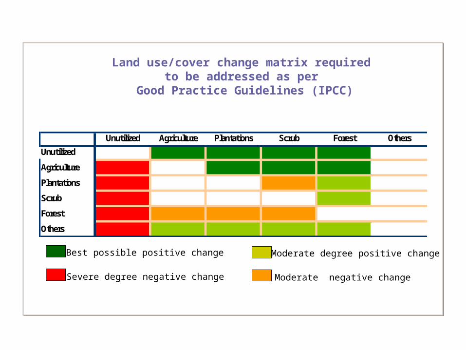
Unutilized Agriculture Plantations Scrub Forest Others
Unutilized
Agriculture
Plantations
Scrub
Forest
Others
Land use/cover change matrix required to be addressed as per
Good Practice Guidelines (IPCC)
Severe degree negative change
Best possible positive change
Moderate negative change
Moderate degree positive change

Snapshot of landscape at the start of the project
Spatial explicitness of boundaries
Amenability for spatial modeling to prove additionality
Potential to collate multisource information for barrier reduction

0% 20% 40% 60% 80% 100%
Leakage
Additionality
Biomass Pattern
Land cover
change
Sink boundaries
RS GIS GPS
*
* SCALE DEPENDENTRS med res & h-res
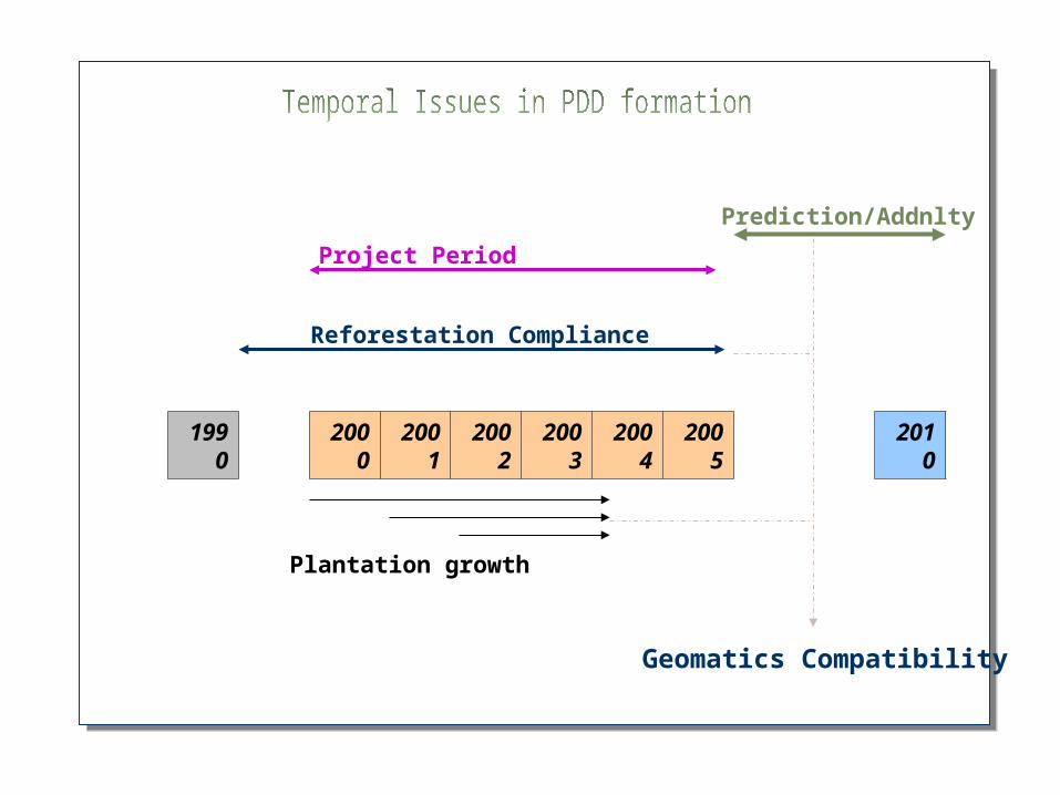
1990
2000
2001
2002
2003
2004
2005
2010
Reforestation Compliance
Project Period
Prediction/Addnlty
Plantation growth
Geomatics Compatibility

Afforestation – Requires assessment data using 50 year old data
Satellite data not available for the period
Compilation of such data if exists in to spatial form needs separate
effort, 1955 2005? LISS
III/IV
Reforestation – Requires assessment data using data since 31st Dec 1989
Assessment of non forest lands possible using available IRS data
during 19901990
2005LISS I/II/ TM
LISS III/IV
forest
agril
Nonforest

Appraisal of technology potential to PDD facilitator
Selection of satellite datasets suiting the requirement
Image analysis for land cover delineation and plantation mapping
Plantation mapping aided by ground based ownership Information
Generation of sink boundaries and erstwhile land cover content
Prediction of plantation position and spread
Sink boundary and position for validation
Information fine tuning for final submission
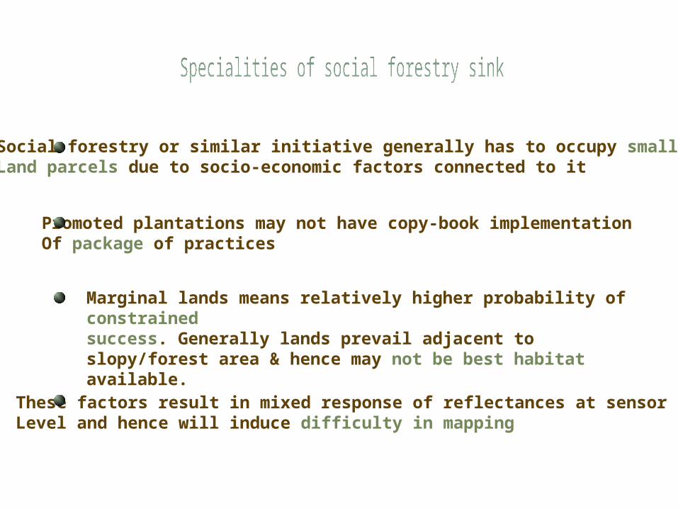
Social forestry or similar initiative generally has to occupy smaller Land parcels due to socio-economic factors connected to it
Marginal lands means relatively higher probability of constrainedsuccess. Generally lands prevail adjacent to slopy/forest area & hence may not be best habitat available.
These factors result in mixed response of reflectances at sensorLevel and hence will induce difficulty in mapping
Promoted plantations may not have copy-book implementationOf package of practices

IRS P6 LISS III data
MAR 2005
IRS P6 LISS III data
MAR 2005
Image enhancements
Pre-fieldinterpretation
IRS 1D LISS III data
APR 2004
Field Check
Discussion Interpretation
Social Foresty Plantation mapping
Land cover classification for SF windows
LandsatTM/ETM data
OCT 1990
Reforestation inputs for CER’s
GPS based inventory
GPS based inventory
supportive
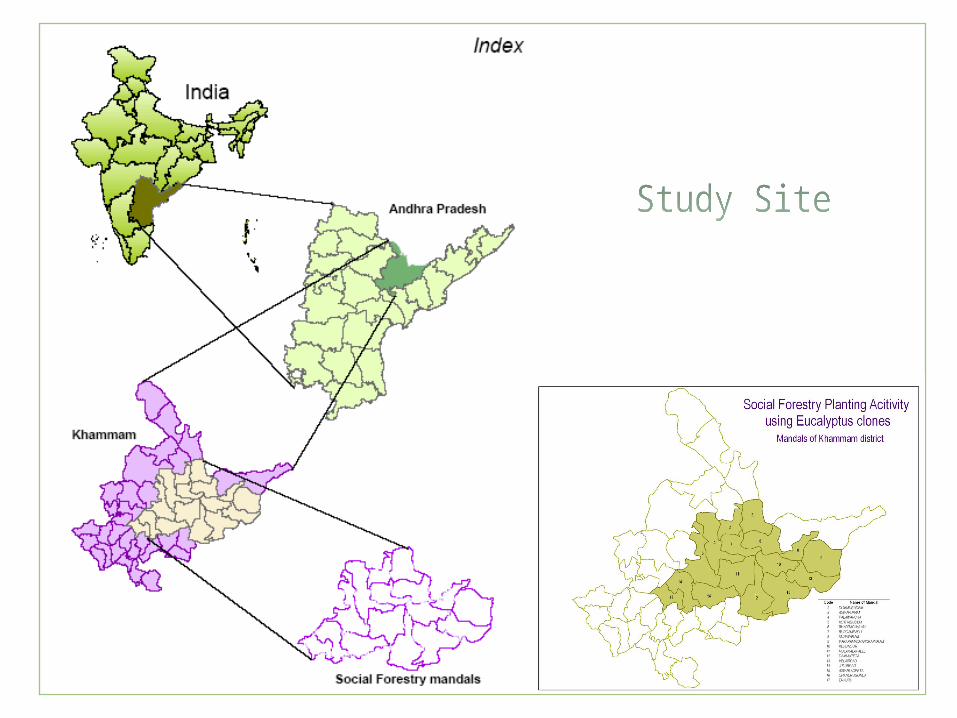
NOV 2000 SF windowsSocial forestry
PlantationWindows in the
Study site
IRS P6 LISS III data
MAR 2005
IRS P6 LISS III data
MAR 2005
Image enhancements
Pre-fieldinterpretation
IRS 1D LISS III data
APR 2004
Field Check
Discussion Interpretation
Social Foresty Plantation mapping
Land cover classification for SF windows
LandsatTM/ETM data
OCT 1990
Reforestation inputs for CER’s
GPS based inventory
GPS based inventory
GPS based inventory
GPS based inventory
supportive
NOV 2000 SF windowsSocial forestry
PlantationWindows in the
Study site
Methodology for land cover change in Social Forestry Mandals
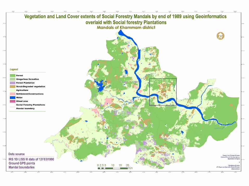

Vegetation and Land cover 1990
Vegetation and Land cover 2005
Land coverChanges
Plantationincrease
Rate of increaseIn 5 km pixels
Categorization of Rates
Stratified random Allocation of sites
Suitability Surface
Scrub and adjacency
Amenable slopes inAmenable elevations
Forest area exclusion
Size based buffers
Site delineation
Probability of sitesElimination of smallpatches
PlantationSite predictions
Predictingof plantationOccurrence
Approach


Thank you