Geography & Climate - Department of Zoology, UBCjankowsk/BIO413_3_011014.pdf · Geography & Climate...
33
Geography & Climate 1 All species have limits to their distributions across the globe To understand species ranges, we need to understand the physical template and climate This is fundamental to biogeography
Transcript of Geography & Climate - Department of Zoology, UBCjankowsk/BIO413_3_011014.pdf · Geography & Climate...

Geography & Climate
1
All species have limits to their distributions across the globe To understand species ranges, we need to understand the physical template and climate This is fundamental to biogeography
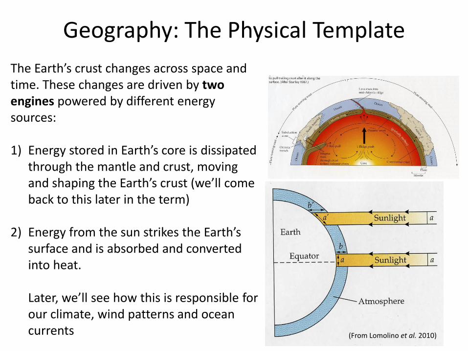
Geography: The Physical Template
2
The Earth’s crust changes across space and time. These changes are driven by two engines powered by different energy sources: 1) Energy stored in Earth’s core is dissipated
through the mantle and crust, moving and shaping the Earth’s crust (we’ll come back to this later in the term)
2) Energy from the sun strikes the Earth’s surface and is absorbed and converted into heat. Later, we’ll see how this is responsible for our climate, wind patterns and ocean currents (From Lomolino et al. 2010)
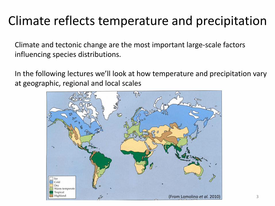
Climate reflects temperature and precipitation
3
Climate and tectonic change are the most important large-scale factors influencing species distributions. In the following lectures we’ll look at how temperature and precipitation vary at geographic, regional and local scales
(From Lomolino et al. 2010)

Temperature and thermal energy
4
Spherical shape of earth causes latitudinal gradient in thermal radiation
(From Lomolino et al. 2010)
The angle of incoming radiant energy affects the amount of heat absorbed Most intense heating occurs where the incoming sunlight is perpendicular to the Earth’s surface for two reasons: 1) The greatest amount of energy is
delivered to the smallest surface area (a vs. a’)
2) Less radiation is absorbed or reflected back into space because the distance traveled through the atmosphere is minimized (b vs. b’)

Temperature and thermal energy
5
The angle of inclination of the earth’s axis causes seasonality.
What is the angle and how does this relate to the Tropic of Cancer and Capricorn?
(From Lomolino et al. 2010)
Looking at the figure on the right, what day of the year is it?
6
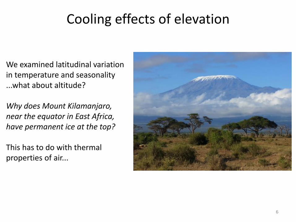
Cooling effects of elevation
We examined latitudinal variation in temperature and seasonality ...what about altitude? Why does Mount Kilamanjaro, near the equator in East Africa, have permanent ice at the top? This has to do with thermal properties of air...

As a climber goes up a mountainside, the length (and pressure) of the column of air above the climber decreases
The pressure and density of air decreases with increasing altitude
With reduced pressure, air expands and undergoes adiabatic cooling
Gases lose heat as molecules move farther apart (fewer collisions)
7
column of air into
atmosphere
Lower pressure
Higher pressure
Cooling effects of elevation
http://www.cslctx.org/2012/02/17/the-view-from-the-top/

Winds and Currents
8
Differential heating with latitude drives the major atmospheric air circulation, resulting in global wind patterns. Here is how this works:
(From Lomolino et al. 2010)
1) Equator is heated most intensively. Air at the equator expands as it is heated, becomes less dense than surrounding air and rises
2) Rising air reduces atmospheric pressure over the equator and surface air north and south of equator flows into area of reduced pressure
3) Rising heated air undergoes adiabatic cooling, is pushed away from the equator, and descends at ~30 degrees N and S latitude

Winds and Currents
9
4) Circulating air masses produce surface winds blowing toward the equator between 0 and 30 degrees and toward the poles between 30 and 60 degrees
5) Surface winds do not blow due N or S because of the rotation of the Earth
Differential heating with latitude drives the major atmospheric air circulation, resulting in global wind patterns. Here is how this works:
(From Lomolino et al. 2010)

Winds and Currents
10
6) Every point on the Earth’s surface makes one rotation every 24 hours. Because the circumference of the earth is ~40,000 km, a point at the equator moves from W to E at ~1700 km/h
7) Points at higher latitudes travel a shorter distance with every 24-hour rotation, moving at a slower rate than points at the equator
8) This induces the Coriolis effect, where surface winds are deflected toward the right in the NH and to the left in the SH
Differential heating with latitude drives the major atmospheric air circulation, resulting in global wind patterns. Here is how this works:
(From Lomolino et al. 2010)

Winds and Currents
11 (From Lomolino et al. 2010)
Coriolis Effect: the tendency for moving objects (e.g., wind and currents) to veer clockwise in the NH and counterclockwise in the SH. We see this effect easily between 0 and 30 degrees North and South latitude

Winds and Currents
12
Surface winds initiate the major ocean currents: (1) Trade winds push ocean currents westward at the equator and (2) westerlies produce eastward currents at high latitudes (N and S). The net results are circular ocean currents, clockwise in the NH and counter-clockwise in the SH.
(From Lomolino et al. 2010)

Geographic precipitation patterns
13
Global temperature, winds, and currents interact to influence global precipitation
(From Lomolino et al. 2010)
Part of this has to do with cloud formation and adiabatic cooling... As air warms, it can absorb more water vapor evaporated from land and water When air contains moisture and cools, there is a point at which the air is saturated with water vapor (dew point) Further cooling results in condensation and cloud formation. When water and ice particles are too heavy to remain airborne, they will fall as rain and snow.

Geographic precipitation patterns
14
(From Lomolino et al. 2010)
Tropical rains are heaviest when the sun is directly overhead and the rate of heating is most intense (the spring and fall equinoxes).
Horse Latitudes: warm, dry surface winds "dry-out" the land and create most of our great deserts near 30o N and S latitude (e.g., Mojave, Sonoran, Sahara, Gobi, and Great Sandy deserts).

Horse Latitudes and adjacent zones
15
Two belts of relatively dry climates encircle the globe Over land, these belts are the world’s deserts and Mediterranean climates (mild rainy winters and hot dry summers) Over oceans, these belts have hot air and little wind The term may come from the days when Spanish ships transported horses to the West Indies http://www.rossway.net/horselat.htm
Ships would slow in mid-ocean in this latitude, prolonging the voyage...water shortages would force crews to throw their horses overboard or eat them

Horse Latitudes and adjacent zones
16
Deserts and Mediterranean climates are usually on the Western side of continents In winter, land is cooler than ocean water, westerly winds bring moisture-laden air that results in rainfall when air cools over land
Horse latitudes
Horse latitudes
Horse Latitudes and adjacent zones
17
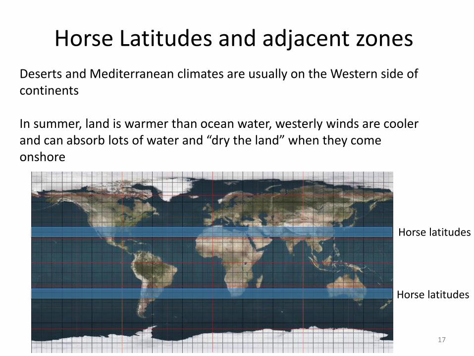
Deserts and Mediterranean climates are usually on the Western side of continents In summer, land is warmer than ocean water, westerly winds are cooler and can absorb lots of water and “dry the land” when they come onshore
Horse latitudes
Horse latitudes

18
(From Lomolino et al. 2010)
Horse Latitudes and adjacent zones
The world’s driest deserts occur where westerlies bring cold currents and surface winds. In the winter, there is little or no rainfall and summers are hot and dry. Atacama Desert (left): 1 mm/year Namib Desert (right): 2-20 mm/year

Regional precipitation patterns
19
Regional topography also has important effects on precipitation
Monthly mean temperature and precipitation
Vancouver (49° 15’ N) Montreal (45° 30’ N)

Regional precipitation
20 (From Lomolino et al. 2010)
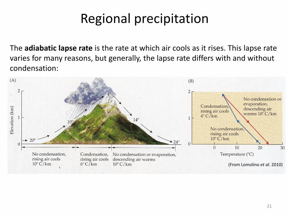
Mountains, in particular, have complex effects on regional precipitation Because we’ll talk about mountains quite a bit, we’ll explore some details here
Regional precipitation
21
(From Lomolino et al. 2010)
The adiabatic lapse rate is the rate at which air cools as it rises. This lapse rate varies for many reasons, but generally, the lapse rate differs with and without condensation:
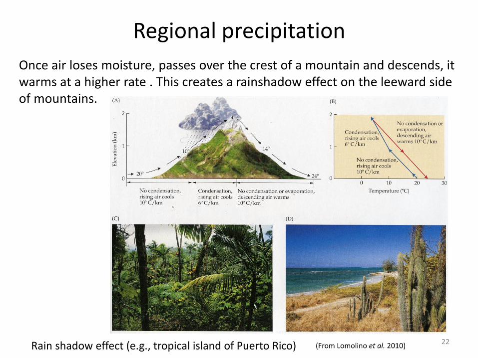
Regional precipitation
22
Once air loses moisture, passes over the crest of a mountain and descends, it warms at a higher rate . This creates a rainshadow effect on the leeward side of mountains.
(From Lomolino et al. 2010) Rain shadow effect (e.g., tropical island of Puerto Rico)

But it’s complicated...
Mountains differ in temperature and precipitation regimes for many reasons: latitude, height and age, to name a few Let’s make a comparison and look at these effects:
23
Whistler, Pacific Ranges, British Columbia, Canada
Great Smoky Mountain, Appalachian Range, Tennessee-North Carolina, USA

Whistler vs. Great Smoky Mountains
24
Latitude: 51 degrees N Highest peak: 4019 m (13186 ft)
Age: 60 million years
Latitude: 40 degrees N Highest peak: 2037 m (6684 ft)
Age: 480 million years
Whistler, Pacific Ranges, British Columbia, Canada
Great Smoky Mountain, Appalachian Range, Tennessee-North Carolina, USA

25
Whistler, Pacific Ranges, British Columbia, Canada
Great Smoky Mountain, Appalachian Range, Tennessee-North Carolina, USA
Whistler vs. Great Smoky Mountains
These mountains have different effects on regional precipitation and climate: older mountains tend to be smaller with smaller rainshadow effects.

Revisit climate with a better understanding of temperature and precipitation
26 (From Lomolino et al. 2010)
By now, you should understand why we see the major climates exhibited here, but also why this map is a gross oversimplification of our Earth’s climate
Climate variation
27
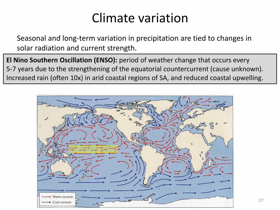
El Nino Southern Oscillation (ENSO): period of weather change that occurs every 5-7 years due to the strengthening of the equatorial countercurrent (cause unknown). Increased rain (often 10x) in arid coastal regions of SA, and reduced coastal upwelling.
Seasonal and long-term variation in precipitation are tied to changes in solar radiation and current strength.

Climate variation
28
Atacama Desert
Seasonal and long-term variation in precipitation are tied to changes in solar radiation and current strength.
El Nino Southern Oscillation (ENSO): period of weather change that occurs every 5-7 years due to the strengthening of the equatorial countercurrent (cause unknown). Increased rain (often 10x) in arid coastal regions of SA, and reduced coastal upwelling.

Climate variation
29
Galapagos Islands
Seasonal and long-term variation in precipitation are tied to changes in solar radiation and current strength.
El Nino Southern Oscillation (ENSO): period of weather change that occurs every 5-7 years due to the strengthening of the equatorial countercurrent (cause unknown). Increased rain (often 10x) in arid coastal regions of SA, and reduced coastal upwelling.

Climate variation
30 (From Grant and Grant 2002)
Seasonal and long-term variation in precipitation are tied to changes in solar radiation and current strength.
El Nino Southern Oscillation (ENSO): period of weather change that occurs every 5-7 years due to the strengthening of the equatorial countercurrent (cause unknown). Increased rain (often 10x) in arid coastal regions of SA, and reduced coastal upwelling.

Climate change
31
Global climate has changed frequently.
Climate has clearly changed with cycles of glaciation (more on this later).
(From Gates 1993)
Change since last glacial max. has not exceeded about 1 oC per 1000 yrs.
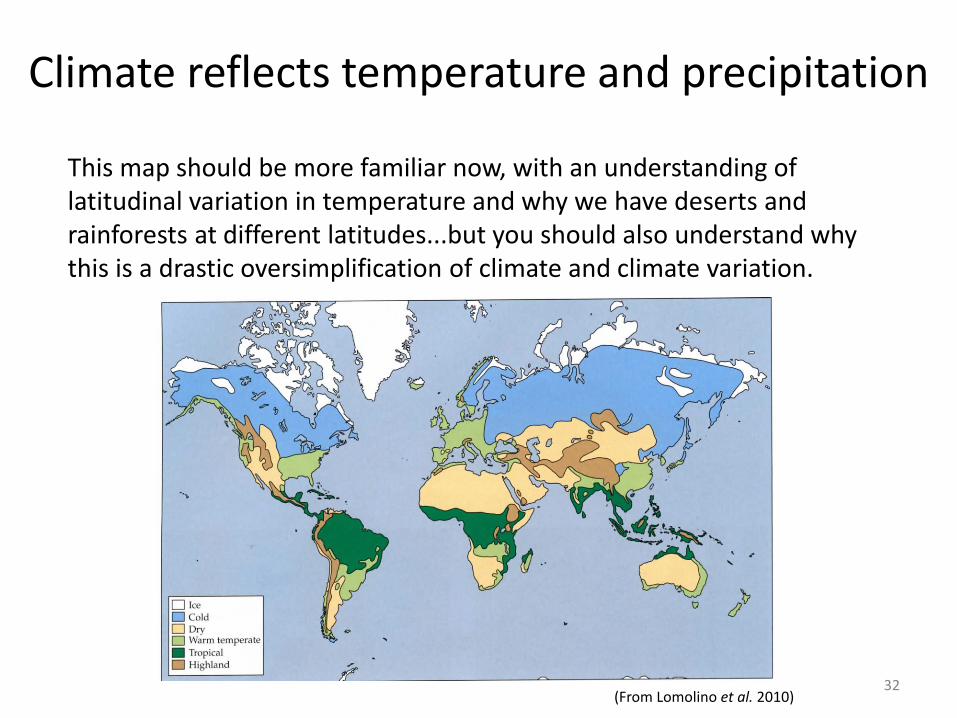
32 (From Lomolino et al. 2010)
Climate reflects temperature and precipitation
This map should be more familiar now, with an understanding of latitudinal variation in temperature and why we have deserts and rainforests at different latitudes...but you should also understand why this is a drastic oversimplification of climate and climate variation.
Climate and Climate Change
References for this section:
Gates, D.M. 1993. Climate Change and its Biological Consequences. Sunderland, MA: Sinauer Assoc. Grant, P.R., and B.R. Grant. 2002. Unpredictable evolution in a 30-year study of Darwin’s finches. Science 296: 707-711. Lomolino, M.V., B.R. Riddle, R.J. Whittaker, & J.A. Brown. 2010. Biogeography (4th ed., Chapter 2). Sinauer Associates, Inc., Sunderland, Mass.
33