Geographic information technology usage in developing ...
16
Full Terms & Conditions of access and use can be found at http://www.tandfonline.com/action/journalInformation?journalCode=tgsi20 Geo-spatial Information Science ISSN: 1009-5020 (Print) 1993-5153 (Online) Journal homepage: http://www.tandfonline.com/loi/tgsi20 Geographic information technology usage in developing countries – A case study in Mozambique Nelson Amade, Marco Painho & Tiago Oliveira To cite this article: Nelson Amade, Marco Painho & Tiago Oliveira (2018) Geographic information technology usage in developing countries – A case study in Mozambique, Geo-spatial Information Science, 21:4, 331-345, DOI: 10.1080/10095020.2018.1523995 To link to this article: https://doi.org/10.1080/10095020.2018.1523995 © 2018 Wuhan University. Published by Informa UK Limited, trading as Taylor & Francis Group. Published online: 19 Oct 2018. Submit your article to this journal Article views: 142 View Crossmark data
Transcript of Geographic information technology usage in developing ...

Full Terms & Conditions of access and use can be found athttp://www.tandfonline.com/action/journalInformation?journalCode=tgsi20
Geo-spatial Information Science
ISSN: 1009-5020 (Print) 1993-5153 (Online) Journal homepage: http://www.tandfonline.com/loi/tgsi20
Geographic information technology usagein developing countries – A case study inMozambique
Nelson Amade, Marco Painho & Tiago Oliveira
To cite this article: Nelson Amade, Marco Painho & Tiago Oliveira (2018) Geographic informationtechnology usage in developing countries – A case study in Mozambique, Geo-spatial InformationScience, 21:4, 331-345, DOI: 10.1080/10095020.2018.1523995
To link to this article: https://doi.org/10.1080/10095020.2018.1523995
© 2018 Wuhan University. Published byInforma UK Limited, trading as Taylor &Francis Group.
Published online: 19 Oct 2018.
Submit your article to this journal
Article views: 142
View Crossmark data

Geographic information technology usage in developing countries – A casestudy in MozambiqueNelson Amadea, Marco Painhob and Tiago Oliveira b
aUniversidade Catolica de Mocambique, Beira, Mozambique; bNova Information Management School, Universidade Nova de Lisboa,Lisboa, Portugal
ABSTRACTGeographic information technologies (GIT) have matured, have become pervasive through-out many types of organizations over recent decades and gained a wide range of attention indiverse sectors of society. The goal of this paper is to identify the main drivers and uses of GITin organizations and to give an overview of GIT uses in developing countries with a focus on acase study developed for Mozambique by analyzing the results of a survey of 123Mozambican organizations that are current GIT users. The results show that the main driversbehind are compatibility, complexity, competitive pressure, donor pressure, governmentpolicy, intention to adopt, innovation, relative advantage, security, and technology compe-tence. Organizations of the public and private sectors use GIT for customer/resource/riskmanagement, decision support, education, research, monitoring, prediction, simulation, suit-ability analysis, sustainability, use and access.
ARTICLE HISTORYReceived 11 January 2018Accepted 2 April 2018
KEYWORDSGeographic informationtechnologies; organizations;remote sensing; GPS;geographic informationsystems; Mozambique
1. Introduction
Technology has come to pervade many types of orga-nizations in recent decades as they take advantage ofthe opportunities offered by technology for improv-ing efficiency, flexibility, and growth possibilities.Geographic information technologies (GIT), devel-oped during the 1960s and 70s, have matured in thelast three decades and have gained attention acrossmany sectors of society. The ability of these technol-ogies to support decision making is taken as one ofthe main reasons for organizations to select this typeof technology (Harrison et al. 2007). GIT include alltypes of computer systems (hardware and software)and tools used in processing georeferenced informa-tion. This set of systems and tools include remotesensing (RS) systems (Horler and Barber 1981), GPS(Kaplan and Hegarty 2005), Geographic informationsystems (GIS) (Chrisman 2002), and all systems andsub-systems that deal with geographic informationprocessing (Jankowski and Nyerges 2001; Harrisonet al. 2007). These technologies have been studied inseveral ways, including their use as decision supportsystems and as integrating backbones for the organi-zational information systems (Hendriks 2000).
Development of infrastructure of natural resourcemanagement, and other social and economic devel-opment activities, can benefit from the use of GIT asthey contain a major spatial component. We illustratethe importance of GIT for organizations in the devel-oping world by using Mozambique as a case study.
As in other countries, the introduction andnumerous applications of GIT and information andcommunication technologies (ICT) (Dong-Ju 2013)in Mozambique, has increased in the recent years.However, there is no efforts mentioned in the litera-ture, and no clear understanding of how GIT use hasevolved exactly, how it is being used and in whichsectors. This paper, therefore, seeks to understand thefactors behind GIT adoption and use in Mozambique.
The goal of the work presented here is to understandthe main drivers and uses of GIT in organizations, andto give an overview of the GIT situation inMozambiqueby analyzing the results of a survey responded to by 123Mozambican organizations that are current GIT users.The research focus on three main sectors: (1) agricul-ture and natural resources; (2) public services; (3) otherservices and manufacturing.
The paper is organized into four sections: Section2 describes the methodology; Section 3 analyses GITuses in organizations and society, and their driversthrough a literature review; Section 4 discusses thepreliminary results of GIT uses in the Mozambicancontext; and the last section presents the conclusionsand future research.
2. Methodology
To the best of our knowledge, literature that supportsthe process of GIT adoption in organizations is rare orunpublished, and information regarding GIT adoptionin Mozambique is non-existent. Less literature about
CONTACT Marco Painho [email protected]
GEO-SPATIAL INFORMATION SCIENCE2018, VOL. 21, NO. 4, 331–345https://doi.org/10.1080/10095020.2018.1523995
© 2018 Wuhan University. Published by Informa UK Limited, trading as Taylor & Francis Group.This is an Open Access article distributed under the terms of the Creative Commons Attribution License (http://creativecommons.org/licenses/by/4.0/), which permitsunrestricted use, distribution, and reproduction in any medium, provided the original work is properly cited.

GIT does not mean few applications. GIT has beenused in many countries for different purposes, andintegrated with many applications. The research com-bines what exists in the literature with the results of asurvey, and targets a real case study (Mozambicancontext).
The review approach includes articles identified inpeer-reviewed journals or conference proceedingsfrom 1990 to 2017, using the Web of Science,Google Scholar, Science Direct, information systemjournals, and etc. as information sources. The reviewwas compiled based on the following list of keywords:GIT/GPS adoption/use, GPS/GIS adoption/use, GISdiffusion, GIS implementation, GIT/GIS integration,RS adoption, and use of RS in organizations. Theliterature review systematically isolated domain appli-cation areas, drivers, uses, and countries where thetechnology has been used through a qualitativeassessment of its content analysis for each source.Domain application areas, uses and countries weredirectly extracted from the text by the authors. Weused the drivers normally used in the technologyadoption literature (Cooper and Zmud 1990; Mooreand Benbasat 1991; Rogers 2003; Zhu and Kraemer2005; Zhu, Kraemer, and Xu 2006; Ghobakhloo,Arias-Aranda, and Benitez-Amado 2011; Low, Chen,and Wu 2011; Oliveira and Martins 2011; Nkhomaand Dang 2013; Zhu, Chang, and Luo 2016).
In order to get an insight of GIT use in developingcountries, we developed a case study for the case ofMozambique. Mozambique has a favored and strate-gic geographic location in Southern Africa. With anarea of approximately 800,000 km2, its economy hasgrown at an average of 7.7% annually between 1996and 2011 (Foster and Dominguez 2011) and above7% between 2011 and 2014 (World Bank 2016). Inthe late 2000s, the country spent an annual average of664 million USD (equivalent to 10% of its GDP) oninfrastructure, including ICT (Foster and Dominguez2011). In its master plan, the Mozambican govern-ment establishes the use of technology and regulatesthe availability of ways that enable organizations tointroduce new technology approaches (Moçambique,Republica de 2010).
A survey on GIT adoption was conducted duringmid-2014, and targeted at governmental, private, andnon-profit organizations. There is no known orga-nized database or list of organizations using GIT inMozambique. As a result, we tried to contact allgovernment levels, private sector and non-profitorganizations, and specialists in the field of GIT,and to gather as many contacts as possible. The partof the survey used in this paper includes eight ques-tions that involve a characterization of the organiza-tion pertaining to the use of GIT: sector, organizationsize (number of employees), type of GIT used, andmaturity. The complete survey is composed of 33
questions. The remaining questions are related toadoption constructs and will be used in developingthe adoption model. See Annex 1 for a list of thequestions used in this article. The questionnaire wasconducted online using the Survey Monkey engine,and the link was addressed to and shared with orga-nizations through emails.
The data collected provides a good overview onhow organizations are using GIT in Mozambique. Italso enables the development of a conceptual adop-tion model in the future. 2043 surveys were sent, 123were returned and validated (of which, 61 from gov-ernmental organizations and 62 from the private andnon-profit sectors). Considering that 2043 individualswho received the survey were distributed by approxi-mately 380 organizations, the return rate, at the orga-nizational level, was 32%. The study only considersorganizations that are using GIT.
The resultant data is analyzed in terms of the mainsectors (also found in the literature), as well as glob-ally in terms of the country as whole.
3. Overview of GIT applications and reasonsfor use
In the 21st century, there are many sensitive issues(including biodiversity, natural hazards, sustainableagriculture, transportation, crime, climate change,migration and urbanization, health care, etc.), all ofthese share a common trait: they exhibit a geographi-cal component, and thus can benefit from the useof GIT.
This section reviews GIT applications with a focuswhenever on developing countries, covering past27 years (1990−2017), and a wide range of applicationdomains and sectors. There seemed to be very few (ifany) articles having core objective that was to studythe factors behind adoption of GIT, and the reasonsfor taking up GIT in organizations are deduced fromthe qualitative assessments in the text. Tables 1 to 3summarize the most frequently mentioned domains,drivers, and uses that explain the reasons why, in thearticles reviewed, organizations are using GIT as aworking tool, as well as the authors and countrywhere the application took place. These tables arefurther summarized and analyzed in Figures 1 and 2in Section 3.4. We assume that the applicationsdescribed in the reviewed articles take place withinan organization. Based on the results of the text ana-lysis, we infer the type of organization, the applicationdomain and the main drivers and uses for each case.
Cases of reported GIT use are very diverse andnumerous, and it is difficult to construct a completeoverview of all the possible uses and motivations. Thereview below offers relevant examples found in thescholarly literature to illustrate the importance andwidespread use of GIT in society.
332 N. AMADE ET AL.
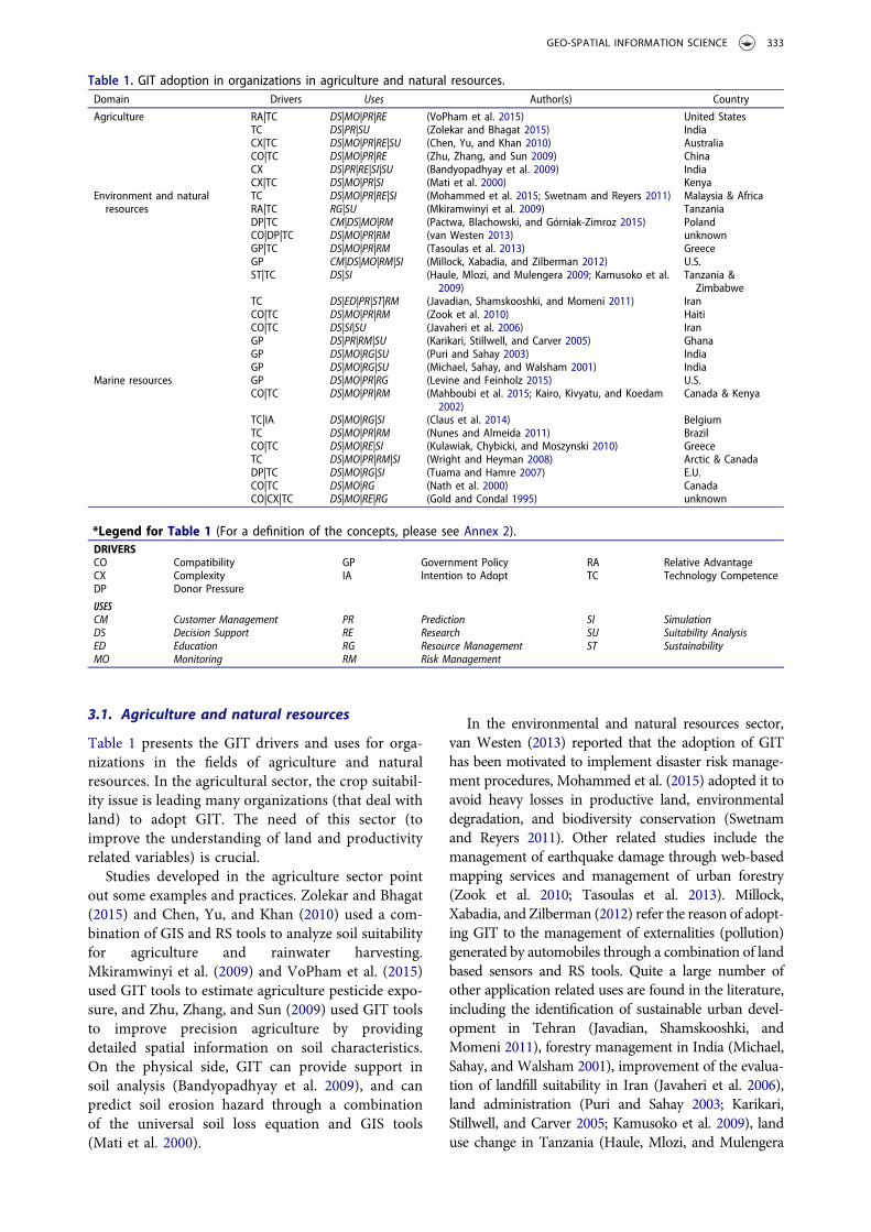
3.1. Agriculture and natural resources
Table 1 presents the GIT drivers and uses for orga-nizations in the fields of agriculture and naturalresources. In the agricultural sector, the crop suitabil-ity issue is leading many organizations (that deal withland) to adopt GIT. The need of this sector (toimprove the understanding of land and productivityrelated variables) is crucial.
Studies developed in the agriculture sector pointout some examples and practices. Zolekar and Bhagat(2015) and Chen, Yu, and Khan (2010) used a com-bination of GIS and RS tools to analyze soil suitabilityfor agriculture and rainwater harvesting.Mkiramwinyi et al. (2009) and VoPham et al. (2015)used GIT tools to estimate agriculture pesticide expo-sure, and Zhu, Zhang, and Sun (2009) used GIT toolsto improve precision agriculture by providingdetailed spatial information on soil characteristics.On the physical side, GIT can provide support insoil analysis (Bandyopadhyay et al. 2009), and canpredict soil erosion hazard through a combinationof the universal soil loss equation and GIS tools(Mati et al. 2000).
In the environmental and natural resources sector,van Westen (2013) reported that the adoption of GIThas been motivated to implement disaster risk manage-ment procedures, Mohammed et al. (2015) adopted it toavoid heavy losses in productive land, environmentaldegradation, and biodiversity conservation (Swetnamand Reyers 2011). Other related studies include themanagement of earthquake damage through web-basedmapping services and management of urban forestry(Zook et al. 2010; Tasoulas et al. 2013). Millock,Xabadia, and Zilberman (2012) refer the reason of adopt-ing GIT to the management of externalities (pollution)generated by automobiles through a combination of landbased sensors and RS tools. Quite a large number ofother application related uses are found in the literature,including the identification of sustainable urban devel-opment in Tehran (Javadian, Shamskooshki, andMomeni 2011), forestry management in India (Michael,Sahay, and Walsham 2001), improvement of the evalua-tion of landfill suitability in Iran (Javaheri et al. 2006),land administration (Puri and Sahay 2003; Karikari,Stillwell, and Carver 2005; Kamusoko et al. 2009), landuse change in Tanzania (Haule, Mlozi, and Mulengera
Table 1. GIT adoption in organizations in agriculture and natural resources.Domain Drivers Uses Author(s) Country
Agriculture RA|TC DS|MO|PR|RE (VoPham et al. 2015) United StatesTC DS|PR|SU (Zolekar and Bhagat 2015) IndiaCX|TC DS|MO|PR|RE|SU (Chen, Yu, and Khan 2010) AustraliaCO|TC DS|MO|PR|RE (Zhu, Zhang, and Sun 2009) ChinaCX DS|PR|RE|SI|SU (Bandyopadhyay et al. 2009) IndiaCX|TC DS|MO|PR|SI (Mati et al. 2000) Kenya
Environment and naturalresources
TC DS|MO|PR|RE|SI (Mohammed et al. 2015; Swetnam and Reyers 2011) Malaysia & AfricaRA|TC RG|SU (Mkiramwinyi et al. 2009) TanzaniaDP|TC CM|DS|MO|RM (Pactwa, Blachowski, and Górniak-Zimroz 2015) PolandCO|DP|TC DS|MO|PR|RM (van Westen 2013) unknownGP|TC DS|MO|PR|RM (Tasoulas et al. 2013) GreeceGP CM|DS|MO|RM|SI (Millock, Xabadia, and Zilberman 2012) U.S.ST|TC DS|SI (Haule, Mlozi, and Mulengera 2009; Kamusoko et al.
2009)Tanzania &Zimbabwe
TC DS|ED|PR|ST|RM (Javadian, Shamskooshki, and Momeni 2011) IranCO|TC DS|MO|PR|RM (Zook et al. 2010) HaitiCO|TC DS|SI|SU (Javaheri et al. 2006) IranGP DS|PR|RM|SU (Karikari, Stillwell, and Carver 2005) GhanaGP DS|MO|RG|SU (Puri and Sahay 2003) IndiaGP DS|MO|RG|SU (Michael, Sahay, and Walsham 2001) India
Marine resources GP DS|MO|PR|RG (Levine and Feinholz 2015) U.S.CO|TC DS|MO|PR|RM (Mahboubi et al. 2015; Kairo, Kivyatu, and Koedam
2002)Canada & Kenya
TC|IA DS|MO|RG|SI (Claus et al. 2014) BelgiumTC DS|MO|PR|RM (Nunes and Almeida 2011) BrazilCO|TC DS|MO|RE|SI (Kulawiak, Chybicki, and Moszynski 2010) GreeceTC DS|MO|PR|RM|SI (Wright and Heyman 2008) Arctic & CanadaDP|TC DS|MO|RG|SI (Tuama and Hamre 2007) E.U.CO|TC DS|MO|RG (Nath et al. 2000) CanadaCO|CX|TC DS|MO|RE|RG (Gold and Condal 1995) unknown
*Legend for Table 1 (For a definition of the concepts, please see Annex 2).DRIVERSCO Compatibility GP Government Policy RA Relative AdvantageCX Complexity IA Intention to Adopt TC Technology CompetenceDP Donor Pressure
USESCM Customer Management PR Prediction SI SimulationDS Decision Support RE Research SU Suitability AnalysisED Education RG Resource Management ST SustainabilityMO Monitoring RM Risk Management
GEO-SPATIAL INFORMATION SCIENCE 333

2009), and mineral resource management (Pactwa,Blachowski, and Górniak-Zimroz 2015).
In the marine resources sector, the adoption of GIThas been motivated to address a lack of efficient methods
Table 2. GIT adoption in organizations in public service.Domain Drivers Uses Author (s) Country
Government TC DS|MO|PR|RE|SI (Nourani, Saenz, and Castreghini 2011) BrazilCO|GP|IV MO|RE (Ramadhan, Sensuse, and Arymurthy 2011) IndonesianGP|IV CM|DS|MO|PR (Liu and Wei 2010) unknownCP|GP|TC CM|DS|MO|PR|RM (Abdulaal 2009) Saudi ArabiaCO|GP|TC CM|MO|RE (Moody 2007) NetherlandsTC CM|MO|RE (Rambaldi et al. 2006; Musakwa and van Niekerk 2015) Developing countriesTC DS|ED|MO|PR|RG (Abbott 2003) South AfricaCP|IV|RA|TC DS|MO|PR (Nasirin and Birks 2003) U.K.DP|GP DS|MO|RG (Yomralioglu 2002) Turkey
Education CO|IV|RA|TC DS|ED|RG|SI (Hong 2014) U.S.IV|RA|TC CM|DS|ED|SI (Demirci, Karaburun, and Ünlü 2013) TurkeyCO|TC ED|RE|SI (Hwang 2013) U.S.TC ED|PR|SI (Korucu 2012; Zietsman 2002) Turkey & South AfricaCO|RA|TC ED|SI (Amade and Painho 2011) MozambiqueCO|IV|TC DS|ED|SI (Yin 2010) U.S.GP|TC DS|ED|RM (Lateh and Muniandy 2010) MalaysiaCO|TC DS|ED|MO|RG (Balram and Dragićević 2008) CanadaTC ED (Alibrandi and Palmer-Moloney 2001; Musakwa 2017) U.S. & Southern AfricaCO|TC ED|SI (Lloyd 2001) U.S.
Health care system CO|IV|TC DS|MO|RG|SI (Mahmoud et al. 2015) Saudi ArabiaCO|IV|TC DS|RG (Abubakar et al. 2014) TanzaniaIV|TC MO|RE|SI (Patel and Waters 2012) unknownGP DS|MO|RE|SI (Joyce 2009) U.K.TC DS|MO|RG|SI (Cowper et al. 2004) U.S.TC MO|RE|RG|UA (McLafferty 2003) U.S.CO|TC MO|RE|RG|SI (Kistemann, Dangendorf, and Schweikart 2002) unknown
* Legend for Table 2.DRIVERSCO Compatibility GP Government Policy RA Relative AdvantageDP Donor Pressure IV Innovation TC Technology CompetenceCP Competitive Pressure
USESCM Customer Management PR Prediction RM Risk ManagementDS Decision Support RE Research SI SimulationED Education RG Resource Management UA Use and accessMO Monitoring
Table 3. GIT adoption in organizations in other services and manufacturing.Domain Drivers Uses Author (s) Country
Banks and insurance CO|CX|SE|TC CM|DS|MO|PR|RM (Ajah and Inyiama 2011) NigeriaIV|TC DS|MO|RE|RM (Ngai et al. 2011) U.S.TC DS|MO|RG|SI (Gabriela, Laurenţiu, and Simona 2010) RomaniaCO|CP|IV|SE|TC CM|DS|MO (Jafrullah and Uppuluri 2003) unknownCP|GP|TC DS|PR|RG (MacDonald 2001) Canada
Manufacturing CP|IV|TC DS|MO|RE (Chong and Chan 2012) MalaysiaCO|IV|TC MO|RE (Drummond and French 2008) U.S.TC DS|RG (Bansal 2007) unknownCO|CP|SE|TC DS|MO (Freire 2004) Brazil
Transport and communication TC DS|MO|PR|RG|SI (Kawamura et al. 2014; Dorosh et al. 2012) Japan & AfricaSE|TC DS|MO|PR|RG (Chen, Wu, and Tri 2012) VietnamGP|IV|TC DS (Mahesh, Zellner, and Zielinski 2011) IndiaTC DS|MO|RE|SI (Ma et al. 2009) U.S.TC DS|MO|PR|RG|SI (Batarlienė 2007) LithuaniaCO|TC ED|PR|RG|SI (Harvey and Chrisman 1998) unknownTC DS|MO|PR|RE (Gutiérrez, González, and Gómez 1996) E.U.
* Legend for Table 3.DRIVERSCO Compatibility GP Government Policy SE SecurityCP Competitive Pressure IV Innovation TC Technology CompetenceCX Complexity
USESCM Customer Management MO Monitoring RG Resource ManagementDS Decision Support PR Prediction RM Risk ManagementED Education RE Research SI Simulation
334 N. AMADE ET AL.

for monitoring and managing marine environment pro-cesses and resources (Kairo, Kivyatu, and Koedam 2002;Kulawiak, Chybicki, and Moszynski 2010; Mahboubiet al. 2015; Nunes and Almeida 2011), to control criticallife habitats (Wright and Heyman 2008), and to map thecoral reef marine ecosystem (Levine and Feinholz 2015).Gold and Condal (1995), Nath et al. (2000) introducedGIT to support aquaculture and manage pollution crisesin coastal and ocean regions of Europe (oil spills). Finally,Claus et al. (2014) calls for the need to standardizemarinegeographic names (seas, ocean basins, ridges, seamounts)and boundaries through the use of an open applicationthat will link names to information and maps with geo-graphic location, as well as the need to have a web-basedinformation system to improve management (Tuamaand Hamre 2007).
3.2. Public service
Table 2 shows GIT drivers and uses in public serviceorganizations. Technology policies in the governmentsector are leading to the adoption and use of GIT,especially because governments wish to promote and
encourage citizen participation, for example, in urbanplanning and re-development (Rambaldi et al. 2006;Moody 2007; Musakwa and van Niekerk 2015). Someexamples of these actions can be urban governance(Ramadhan, Sensuse, and Arymurthy 2011), and man-agement of urban violence (Abdulaal 2009) with thehelp of geo-referencing in crime events. On the imple-mentation side, Yomralioglu (2002), Abbott (2003),Nasirin and Birks (2003), Liu and Wei (2010),Nourani, Saenz, and Castreghini (2011) notice in thesetechnologies the opportunity to integrate and link exist-ing government infrastructures and platforms (e-Government) and make information more suitable fornetwork transactions.
The education sector has been one of those that haveactively adopted GIT. The capability to offer innovationand compatibility increases students’ productivity byproviding virtual environments and rapid problem sol-ving (Balram andDragićević 2008; Korucu 2012). Thereare similar views applied technologies as tools to helpstudents acquire critical thinking, spatial skills and socialskills (Alibrandi and Palmer-Moloney 2001; Lloyd 2001;Zietsman 2002; Lateh and Muniandy 2010; Kim and
Figure 1. Sharing of drivers by the main sectors (size ofdrivers, represented as shaded circles, denotes frequency ofappearance in the literature).
Figure 2. Sharing of uses by the main sector (size of uses,represented as shaded circles, denotes frequency of appear-ance in the literature).
GEO-SPATIAL INFORMATION SCIENCE 335

Bednarz 2011; Musakwa 2017). Furthermore, Yin(2010), Demirci, Karaburun, and Ünlü (2013), Hwang(2013), and Hong (2014) emphasize the potentiality ofthese technologies to create a good learning environ-ment for students and teachers. Because of their poten-tialities, GITs are capable of going beyond the classroomand being used in comparative studies as tools to testpotential new teaching methods versus old ones(Amade and Painho 2011).
The health sector also has been among those thathave actively adopted GIT, the reason lies in theinterest in simulation and ability to predict diseaseoutbreaks and spread (epidemiology). McLafferty(2003) and Joyce (2009) reported the use of GIT toimprove support in health care delivery, Mahmoudet al. (2015) mentioned that these tools could build aspatial decision-making support system for hospitalsto monitor disease. Other examples include epide-miological studies and deployment of emergency ser-vices (Kistemann, Dangendorf, and Schweikart 2002).Analysis and understanding of the relationshipbetween geography and disease are probably themain reason for GIT use in the health sector forresearch, simulation and monitoring (Patel andWaters 2012). On other hand, one of the factorsthat has been identified as a constraint for GIT usein health is its cost, and thus Abubakar et al.(2014)pointed out the need to analyze how open-sourceGIT tools can provide feasible solutions for datavisualization in the health care system and also pro-vided patient record information through atlas data-base systems built with GIT (Cowper et al. 2004).
3.3. Other services and manufacturing
The GIT drivers and uses within organizations in otherservices andmanufacturing are presented in Table 3. Thebanking sector is using GIT to improve customer man-agement, decision support, prediction, and risk manage-ment. This adoption has been motivated by currentproblems that banks are facing, namely competition(MacDonald 2001), financial fraud (Ngai et al. 2011),poor customer satisfaction and retention (Jafrullah andUppuluri 2003), loan losses and a lack of decision-makingmechanisms in distributing loans (Ajah and Inyiama2011; Gabriela, Laurenţiu, and Simona 2010).
Competitive pressure is leading the manufacturingsector to use GIT. This is the case for planners whoneed to understand and use these tools to meet theirprofessional requirements (Drummond and French2008) and for business people to whom these technol-ogies are crucial, especially if the activities are relatedto space and location management (Freire 2004). Theconstruction of these tools is imperative to solve engi-neering problems related to spatial data (complexvisualizations, integration of information, route plan-ning, cost estimation and others) (Bansal 2007).
In the transport and communication sector the useof GIT has been motivated by the lack of appropriatedecision support systems to mitigate communicationnetwork damage (Kawamura et al. 2014; Dorosh et al.2012). Chen, Wu, and Tri (2012) point to problemsrelated to communications with network coverage thathave been solved with a GIS model to predict networkcoverage systems. Ma et al. (2009) andMahesh, Zellner,and Zielinski (2011) justify GIT use with the need tomanage the highway network transportation system,which must respond to an increasing population andnumber of vehicles, and with urban sprawl; as well aswith the safe transportation of dangerous freights insafe conditions (Batarlienė 2007).
3.4. Analysis of GIT adoption in organizationsand society
The literature reviewed above indicates the pervasiveuse of GIT in society and how this technology traversesa very large range of economic sectors in the private andpublic domains. It also shows that these technologiesare used worldwide, although the scientific literature forAfrica in this area is very scarce. A closer analysis of thedifferent GIT drivers and uses leads to a summary ofGIT adoption factors that can help to explain andunderstand the reasons why organizations take on GIT.
It is clear that public and private organizations arelooking to use the spatial domain to improve produc-tivity and performance, predict unusual situations,reduce losses, increase customer satisfaction andface competition. The drivers, indirectly extractedfrom the text content analysis of the literature, moti-vating organizations from different sectors to use GITare: compatibility, competitive pressure, complexity,donor pressure, government policy, intention toadopt, innovation, relative advantage, security andtechnology competence as shown in Tables 1 to 3.
Figure 1 shows how these drivers are shared amongthe main domains. TC and CO are the most commondrivers found and are shared by the three domains. DPand RA are driving public services and agriculture andnatural resources, while GP, together with IV and CP,are shared by public services and other services andmanufacturing. Security seems to be a driver mostlyconnected to other services and manufacturing.
Most of the uses identified in the literature are sharedby the three domains (Figure 2), the most importantones (i.e. those occurring most frequently in the litera-ture review) being DS, MO, RG, and PR. ED is mostlyutilized, as expected by the public services, whichincludes the education and research field, and, to acertain extent by the other services and manufacturingdomain. Public services have an emphasis on UA andagriculture and natural resources on SU and ST.
In this section we have made an overview of thedrivers and uses that are leading organizations to
336 N. AMADE ET AL.
adopt GIT identified through a qualitative analysis ofscientific literature. The drivers and uses for GITidentified in this work provide a basis for the furtherdevelopment of a quantitative adoption study.
4. GIT use in Mozambique – state of affairs
In its master plan Mozambican government supportsthe use of technology to improve the current scenarioand move the country forward (Moçambique,Republica de 2010). The World Bank strategy forAfrican countries resides in supporting them intheir transformation through country strategies. Thestrategy lies heavily on sectors like manufacturing,agriculture, transportation, education, health, andICT. A priority of the World Bank is to focus onreforms and public investments including infrastruc-ture development (World Bank 2011).
In what follows we analyze the results of the surveyfrom Mozambican organizations. We will analyze thesame sectors as those found in the literature and useMozambique as a case study of GIT adoption indeveloping countries. GIT has been widely used byboth the public and private sectors since its 1980s.The Mozambican Government Moçambique,Republica de 2010) as well as the World Bank(World Bank 2011) have been reinforcing measuresand program to invest more in ICT as well as in theneed to develop GIT-based systems for use in fundedprojects.
4.1. Distribution of GIT by organization andactivity sector
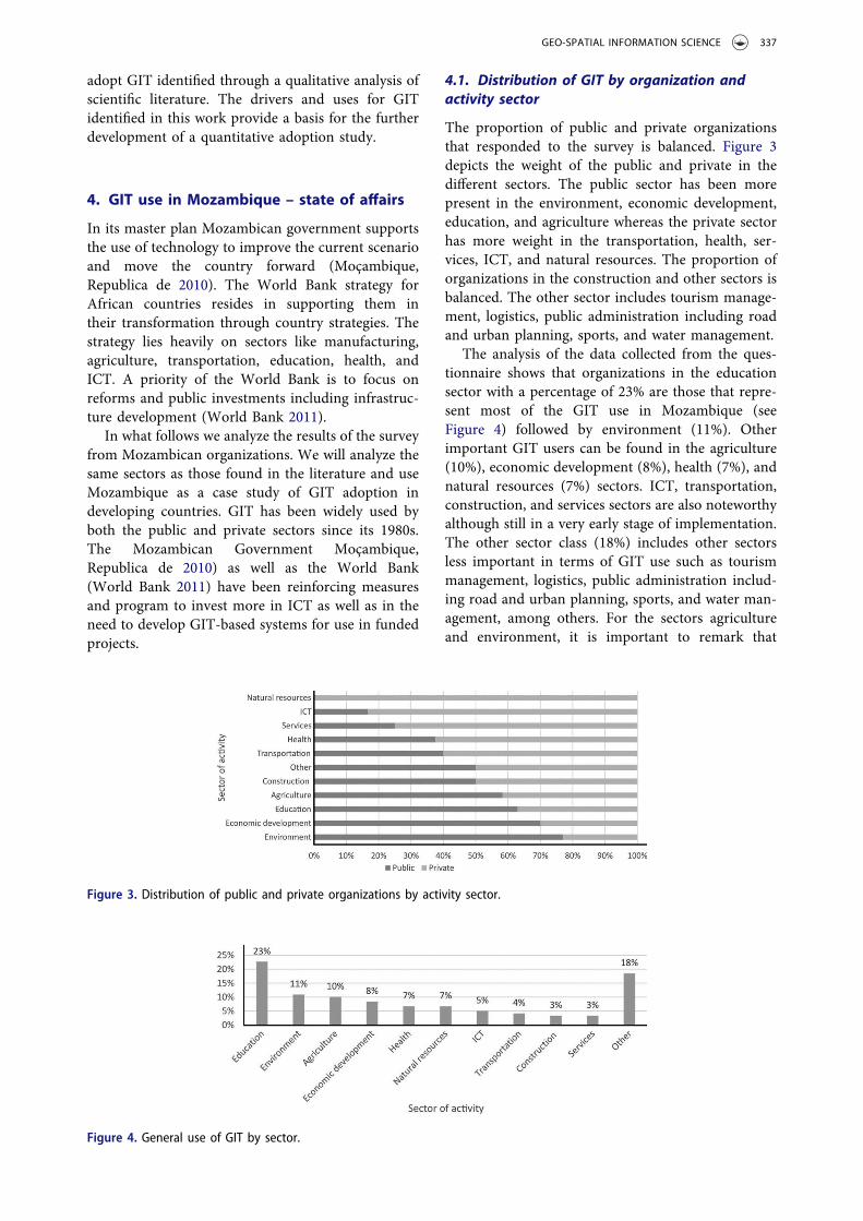
The proportion of public and private organizationsthat responded to the survey is balanced. Figure 3depicts the weight of the public and private in thedifferent sectors. The public sector has been morepresent in the environment, economic development,education, and agriculture whereas the private sectorhas more weight in the transportation, health, ser-vices, ICT, and natural resources. The proportion oforganizations in the construction and other sectors isbalanced. The other sector includes tourism manage-ment, logistics, public administration including roadand urban planning, sports, and water management.
The analysis of the data collected from the ques-tionnaire shows that organizations in the educationsector with a percentage of 23% are those that repre-sent most of the GIT use in Mozambique (seeFigure 4) followed by environment (11%). Otherimportant GIT users can be found in the agriculture(10%), economic development (8%), health (7%), andnatural resources (7%) sectors. ICT, transportation,construction, and services sectors are also noteworthyalthough still in a very early stage of implementation.The other sector class (18%) includes other sectorsless important in terms of GIT use such as tourismmanagement, logistics, public administration includ-ing road and urban planning, sports, and water man-agement, among others. For the sectors agricultureand environment, it is important to remark that
Figure 3. Distribution of public and private organizations by activity sector.
Figure 4. General use of GIT by sector.
GEO-SPATIAL INFORMATION SCIENCE 337

Mozambique public policies are emphasizing thedevelopment of these two sectors (Moçambique,Republica de 2010) given their importance both as amain means of income and food production for thepopulation. The agriculture sector absorbs 75% of thepopulation of Mozambique (UN FAO 2015).
The environment is facing many challenges suchas climate change, biodiversity conservation, amongothers, which are influencing the productivity of nat-ural and semi-natural ecosystems (Tilman 2001). It isalso noteworthy that transportation, construction,and services are the sectors with the least use ofGIT among the respondents (Figure 4).
It seems that there is no relationship betweenorganization size and GIT use. The percentage ofGIT use by organization size is depicted in Figure 5.The organizations were classified in terms of theirnumber of employees (European Commission 2015).More than 50% of the organizations using GIT haveover 50 employees. However, it is important to notethat GIT use is spread throughout all organizationalsizes.
4.2. Evolution and intensity of GIT use
It is possible to find in Figure 6 that the organizationsstarted to intensify the use of GIT from 1995: in theperiod of 2010−2014, the number of new organiza-tions using GIT reached 44; 1995−2014, the numberof organizations using GIT increases very quickly in
line with world evolution of GIT use (Henttu, Izaret,and Potere 2012). Before the year 1995, the use ofthese technologies was very rare and almost insignif-icant. It is also clear that between 1980 and 1995organizations were stagnant in terms of new technol-ogy approaches.
Crossing data between sectors of activity and typeof most used technologies is illustrated the Figure 7.All three GIT types, GIS, GPS, and RS, are led by theeducation sector. The GIS technology is, as men-tioned, topped by the education sector. A secondgroup of sectors in intensity of GIS use includes theenvironment, agriculture, natural resources, eco-nomic development, and ICT. The remaining sectorsform a group of low GIS use (five or fewer organiza-tions per sector). In the same the way, RS intensity isled by education followed by natural resources, envir-onment, and ICT, leaving all the other sectors in alarge group of low use intensity (fewer than fiveorganizations per sector). Finally GPS, the mostrecent of GIT technologies, is mostly used by theeducation and environment sectors closely followedby the agriculture, natural resources, and ICT, theremaining forming a group of lower use intensity(five or fewer organizations per sector). The otherclass sector includes organizations using complemen-tary technologies, of which Google Earth, GoogleMaps and automatic information system are exam-ples. GIS and GPS are the most frequently usedtechnologies in all sectors. Independently of the
Figure 5. Percentage of GIT use by organization size.
Figure 6. Evolution of GIT use in Mozambican organizations.
338 N. AMADE ET AL.

intensity of use all sectors share a similar pattern ofthe technology mix use.
Using a technology mix of GIT creates synergiesand efficiency in works. When looking at the technol-ogy mix (Figure 8), it is possible to find that the mostcommon technologies (GPS and GIS) used by theorganizations are also those that are used togethermore frequently. Other mixes also exist and aboutone third of the organizations use some kinds of mixincluding GIS/RS and RS/GPS or a mixture of thethree (GIS/GPS/RS). A group of organizations (46)actually use some or all of the identified GIT tech-nologies with complementary ones.
4.3. Summary of GIT use in Mozambique
Analysis of the data collected from the questionnaireshows that GIT is being used by many and diversesectors in Mozambique. The proportion of public andprivate organizations that responded to the survey isbalanced. The public sector has been more present inthe environment, economic development, education,
and agriculture, whereas the private sector has moreweight in transportation, health, services, ICT, and nat-ural resources (Figure 3). Organizations in the educa-tion sector with a percentage of 23% are those thatrepresent most of the GIT use in Mozambique(Figure 4) followed by environment (11%). More thanhalf of the organizations using GIT have more than 50employees (Figure 5). Organizations started to intensifythe use of GIT from year 1995 and in year 2014 thenumber of new organizations using GIT reached 44(Figure 6). All three GIT types, GIS, GPS, and RS areled by the education sector (Figure 7). However, it isimportant to note that GIT use is spread throughout allorganizational sizes and the technologies most used areGIS and GPS in all sectors.
5. Conclusions
This paper has analyzed the main drivers and uses ofGIT revealed in a literature review, and the currentsituation in Mozambique in terms of GIT uses. Theliterature review showed that the main drivers of GITuses in organizations are compatibility, competitivepressure, complexity, donor pressure, government pol-icy, intention to adopt, innovation, relative advantage,security, and technology competence (with compatibil-ity and technology competence being the main ones).Organizations of the public and private sectors use GITfor customermanagement, decision support, education,monitoring, prediction, research, resource manage-ment, risk management, simulation, suitability analysis,sustainability, use, and access.
The results of the questionnaire revealed that GIT isbeing used as well by many and diverse sectors inMozambique. The public sector has been more presentin the environment, economic development, education,and agriculture, whereas the private sector has moreweight in transportation, health, services, ICT, andnatural resources. Organizations in the education sectorrepresent the largest sector of GIT use in Mozambiquefollowed by the environment. GIT application startedto intensify since 1995 with 44 new organizations usingGIT in the period 2010−2014. All three GIT types (GIS,GPS, and RS) are led by the education sector. However,
Figure 7. Intensity of GIT type by sector.
Figure 8. GIT mix use.
GEO-SPATIAL INFORMATION SCIENCE 339

it is important to note that GIT use is spread through-out all organizational sizes, and the most used technol-ogies are GIS and GPS in all sectors.
This first study gave an overview of the state ofaffairs of GIT used in Mozambique, and identified anumber of drivers and uses that can form the supportto develop a conceptual model inspired on some ofthe results of the current research.
There are many models on information technologyadoption that are operating at individual and organiza-tion level, and have been studied and developed overthe years. The most important theories operating atorganization level are the diffusion of innovation(DOI) theory (Rogers 2002), technology, organizationand environment (TOE) framework (Tornatzky andFleischer 1990) and organizational theory (Powell andDimaggio 1991). The DOI theory explains how newideas spread through cultures using communicationchannels. The TOE framework seeks to explain howorganizations can reach the right equilibrium betweeninternal and external factors. Finally the organizationaltheory emphasizes the aspects related to social culture(norms, routines, and rules) and how they becomeestablished as authoritative guidelines for social beha-vior. As future research, we suggest using the remaininganswers to the questionnaire to test the existing adop-tion models at the organization level and enrichingthem with the findings of the current study to under-stand GIT adoption in Mozambique.
Funding
This research was partially funded by NUFFIC, the Dutchorganization for internationalization in education, througha doctoral grant [grant number: NICHE-MOZ-136].
Notes on contributors
Nelson Amade obtained his Bachelor’s degree from theFaculty of Tourism Management and InformationTechnology, Catholic University of Mozambique in 2008and a Master’s degree in 2011. He is currently a PhDcandidate in the field of Information Management at theNOVA Information Management School (NOVA IMS) ofthe Universidade Nova de Lisboa.
Marco Painho is a full professor at the NOVA InformationManagement School (NOVA IMS) of the UniversidadeNova de Lisboa and the coordinator of the MastersPrograms in Geospatial Technologies and GeographicInformation Systems and Science. He holds a PhD inGeography from the University of California in SantaBarbara. His research interests include GeographicalInformation Systems and Science, (Spatial) DecisionSupport Systems, Data Integration, Spatial Analysis, UserGenerated (Spatial) Content, Information Infrastructures,New Technology Implementation, GIS Education andDistance Learning (e-learning). Additional detail can befound at http://www.novaims.unl.pt/docentes-investigacao-docentes?d=3.
Tiago Oliveira is an associate professor at the NOVAInformation Management School (NOVA IMS). Hisresearch interests include technology adoption, digitaldivide and privacy. He has published papers in severalacademic journals and conferences, including theInformation & Management, Decision Support Systems,Computers in Human Behavior, Journal of BusinessResearch, Information Systems Frontiers, InternationalJournal of Information Management, Journal of GlobalInformation Management, Industrial Management & DataSystems, Computers in Industry, International Journal ofAccounting Information Systems, etc. Tiago has authoredmore than 100 scientific articles in Journals and conferenceproceedings and has more than 3000 citations (https://scholar.google.com/citations?user=RXwZPpoAAAAJ).
ORCID
Tiago Oliveira http://orcid.org/0000-0001-6523-0809
References
Abbott, J. 2003. “The Use of GIS in Informal SettlementUpgrading: Its Role and Impact on the Community andon Local Government.” Habitat International 27 (4):575–593. doi:10.1016/S0197-3975(03)00006-7.
Abdulaal, W. A. 2009. “Framework for Enterprise GIS forSaudi Municipalities.” International Journal ofGeographical Information Science 23 (6): 687–702.doi:10.1080/13658810701378838.
Abubakar, B., K. Honest, S. Bakar, and H. Sleiman. 2014.“Adoption of Free Open Source Geographic InformationSystem Solution for Health Sector in ZanzibarTanzania.” Journal of Health Informatics 8 (1): 1–11.http://jhidc.org/index.php/jhidc/article/view/110.
Ajah, I., and C. Inyiama. 2011. “Loan Fraud Detection andIT-based Combat Strategies.” Journal of Internet Bankingand Commerce 16(2): 1. Special section.
Alibrandi, M., and J. Palmer-Moloney. 2001. “Making aPlace for Technology in Teacher Education withGeographic Information Systems (GIS).” ContemporaryIssues in Technology and Teacher Education 1 (4): 483–500. http://www.editlib.org/p/10739.
Amade, N., and M. Painho. 2011. “Google Earth ComoFerramenta Didáctica - Um Estudo de Caso NumaEscola Secundária.” REID, 1–14. http://reid.ucm.ac.mz/index.php/reid/article/view/6.
Balram, S., and S. Dragićević. 2008. “Collaborative Spacesfor GIS-based Multimedia Cartography in BlendedEnvironments.” Computers and Education 50 (1): 371–385. doi:10.1016/j.compedu.2006.07.004.
Bandyopadhyay, S., R. K. Jaiswal, V. S. Hegde, and V.Jayaraman. 2009. “Assessment of Land SuitabilityPotentials for Agriculture Using a Remote Sensing andGIS Based Approach.” International Journal of RemoteSensing 30 (4): 879–895. doi:10.1080/01431160802395235.
Bansal, V. K. 2007. “Potential of GIS to Find Solutions toSpace Related Problems in Construction Industry.”Proceedings of World Academy of Science EngineeringTechnology 136119 (8): 307–310.
Batarlienė, N. 2007. “Implementation of AdvancedTechnologies and Other Means in Dangerous FreightTransportation.” Pažangių Technologijų Ir KitųPriemonių Diegimas Vežant Pavojinguosius Krovinius22 (4): 290–295. doi:10.1080/16484142.2007.9638144.
340 N. AMADE ET AL.

Chan, F. T. S., and A. Y. L. Chong. 2012. “A SEM-NeuralNetwork Approach for Understanding Determinants ofInterorganizational System Standard Adoption andPerformances.” Decision Support Systems 54 (1): 621–630. doi:10.1016/j.dss.2012.08.009.
Chen, X., H. Wu, and T. M. Tri. 2012. “Field StrengthPrediction of Mobile Communication Network Basedon GIS.” Geo-Spatial Information Science 15 (3): 199–206. doi:10.1080/10095020.2012.720457.
Chen, Y., J. Yu, and S. Khan. 2010. “Spatial SensitivityAnalysis of Multi-Criteria Weights in GIS-based LandSuitability Evaluation.” Environmental Modelling andSoftware 25 (12): 1582–1591. doi:10.1016/j.envsoft.2010.06.001.
Chong, A. Y. L., and F. T. S. Chan. 2012. “StructuralEquation Modeling for Multi-Stage Analysis on RadioFrequency Identification (RFID) Diffusion in the HealthCare Industry.” Expert Systems with Applications 39 (10):8645–8654. doi:10.1016/j.eswa.2012.01.201.
Chrisman, N. 2002. Exploring Geographic InformationSystems. New York: John Wiley and Sons.
Claus, S., N. De Hauwere, B. Vanhoorne, P. Deckers, F.Souza Dias, F. Hernandez, and J. Mees. 2014. “MarineRegions: Towards a Global Standard for GeoreferencedMarine Names and Boundaries.” Marine Geodesy 37 (2):99–125. doi:10.1080/01490419.2014.902881.
Cooper, R. B., and R. W. Zmud. 1990. “InformationTechnology Implementation Research: A TechnologicalDiffusion Approach.” Management Science 36 (2): 123–139. doi:10.1287/mnsc.36.2.123.
Cowper, D., W. Yu, M. Kuebeler, J. D. Kubal, L. M.Manheim, and B. A. Ripley. 2004. “Using GIS inGovernment: An Overview of the VHA’s HealthcareAtlas, FY-2000.” Journal of Medical Systems 28 (3):257–269. doi:10.1023/B:JOMS.0000032843.52406.2f.
Demirci, A., A. Karaburun, and M. Ünlü. 2013.“Implementation and Effectiveness of GIS-basedProjects in Secondary Schools.” Journal of Geography112 (5): 214–228. doi:10.1080/00221341.2013.770545.
Dong-Ju, C. 2013. “Whither Should ICT4D Go in Africa?”African Affairs 33 (1): 227–246.
Dorosh, P., H. G. Wang, L. You, and E. Schmidt. 2012.“Road Connectivity, Population, and Crop Productionin Sub-Saharan Africa.” Agricultural Economics 43 (1):89–103. doi:10.1111/j.1574-0862.2011.00567.x.
Drummond,W. J., and S. P. French. 2008. “The Future of GISin Planning: Converging Technologies and DivergingInterests.” Journal of the American Planning Association74 (2): 161–174. doi:10.1080/01944360801982146.
European Commission. 2015. “What Is an SME?” http://ec.europa.eu/growth/smes/business-friendly-environment/sme-definition/index_en.htm.
Foster, V., and C.Dominguez. 2011. “Zambia’s Infrastructure:A Continental Perspective.” Policy Research WorkingPapers. World Bank. doi: 10.1596/1813-9450-5599.
Freire, N. 2004. “O Geonegócio - as Geotecnologias E aEmergência de Novos Mercados Em Regiões Periféricas:O Caso de Maceió - AL.” http://hdl.handle.net/123456789/6070. (in Portuguese)
Gabriela, D., D. Laurenţiu, and M. Simona. 2010.“Geographical Information Systems - Applicability inInvestments and Banking.” Annals of the University ofCraiova, Economic Sciences Series 2 (38): 1–8.
Ghobakhloo, M., D. Arias-Aranda, and J. Benitez-Amado.2011. “Adoption of E-Commerce Applications in SMEs.”Industrial Management and Data Systems 111 (8): 1238–1269. doi:10.1108/02635571111170785.
Gold, C. M., and A. R. Condal. 1995. “A Spatial DataStructure Integrating GIS and Simulation in A MarineEnvironment.” Marine Geodesy 18 (3): 213–228.doi:10.1080/15210609509379757.
Gutiérrez, J., R. González, and G. Gómez. 1996. “TheEuropean High-Speed Train Network.” Journal ofTransport Geography 4 (4): 227–238. doi:10.1016/S0966-6923(96)00033-6.
Harrison, T., T. A. Pardo, J. R. Gil-Garcia, F. Thompson,and D. Juraga. 2007. “Geographic InformationTechnologies, Structuration Theory, and the WorldTrade Center Crisis.” Journal of the American Societyfor Information Science and Technology 58 (14): 2240–2254. doi:10.1002/asi.20695.
Harvey, F., and N. Chrisman. 1998. “Boundary Objects andthe Social Construction of GIS Technology.” Environmentand Planning A 30 (9): 1683–1694. doi:10.1068/a301683.
Haule, C., M. Mlozi, and M. Mulengera. 2009. “The Patternand Magnitude of Land Use/Cover Change in ThreeWards of Ludewa District, Tanzania and ItsImplications to Smallholder Farmers’ Livelihoods.”African Affairs 25 (1): 31–58.
Hendriks, P. H. J. 2000. “An Organizational LearningPerspective on GIS.” International Journal of GeographicalInformation Science 14 (4): 373–396. doi:10.1080/13658810050024296.
Henttu, H., J. M. Izaret, and D. Potere. 2012. “(BostonConsulting Group) Geospatial Services: A $1.6 TrillionGrowth Engine for the U.S. Economy.” https://www.bcg.com/documents/file109372.pdf.
Hong, J. E. 2014. “Promoting Teacher Adoption of GISUsing Teacher-Centered and Teacher-Friendly Design.”Journal of Geography 113 (4): 139–150. doi:10.1080/00221341.2013.872171.
Horler, D., and J. Barber. 1981. Plants and the DaylightSpectrum: Principles of Remote Sensing of Plants.London: Academic Press.
Hwang, S. 2013. “Placing GIS in Sustainability Education.”Journal of Geography in Higher Education 37 (2): 276–291. doi:10.1080/03098265.2013.769090.
Jafrullah, M., and S. Uppuluri. 2003. “An IntegratedApproach for Banking GIS.” Paper Presented at the MapIndia 2003 Conference, India, New Delhi, January 28–31.
Jankowski, P., and T. Nyerges. 2001. GIS for GroupDecision Making. Boca Raton: CRC Press.
Javadian, M., H. Shamskooshki, and M. Momeni. 2011.“Application of Sustainable Urban Development inEnvironmental Suitability Analysis of Educational LandUse by Using AHP and GIS in Tehran.” ProcediaEngineering 21: 72–80. doi:10.1016/j.proeng.2011.11.1989.
Javaheri, H., T. Nasrabadi, M. H. Jafarian, G. R. Rowshan, andH. Khoshnam. 2006. “Site Selection of Municipal SolidWaste Landfills Using Analytical Hierarchy ProcessMethod in a Geographical Information TechnologyEnvironment in Giroft.” Iranian Journal of EnvironmentalHealth, Science and Engineering 3 (3): 177–184.
Joyce, K. 2009. “‘To Me It’S Just Another Tool to HelpUnderstand the Evidence’: Public Health Decision-Makers’ Perceptions of the Value of GeographicalInformation Systems (GIS).” Health and Place 15 (3):831–840. doi:10.1016/j.healthplace.2009.01.004.
Kairo, J. G., B. Kivyatu, and N. Koedam. 2002. “Applicationof Remote Sensing and GIS in the Management ofMangrove Forests within and Adjacent to KiungaMarine Protected Area, Lamu, Kenya.” Environment,Development and Sustainability 4 (2): 153–166.doi:10.1023/A:1020890711588.
GEO-SPATIAL INFORMATION SCIENCE 341

Kamusoko, C., M. Aniya, B. Adi, and M. Manjoro. 2009.“Rural Sustainability under Threat in Zimbabwe –Simulation of Future Land Use/Cover Changes in theBindura District Based on the Markov-CellularAutomata Model.” Applied Geography 29 (3): 435–447.doi:10.1016/j.apgeog.2008.10.002.
Kaplan, E. D., and C. Hegarty. 2005. Understanding GPS:Principles and Applications. 2nd ed. Boston: Artech House.
Karikari, I., J. Stillwell, and S. Carver. 2005. “The Applicationof GIS in the Lands Sector of a Developing Country:Challenges Facing Land Administrators in Ghana.”International Journal of Geographical Information Science19 (3): 343–362. doi:10.1080/13658810412331280149.
Kawamura, Y., A. M. Dewan, B. Veenendaal, M. Hayashi,T. Shibuya, I. Kitahara, H. Nobuhara, and K. Ishii. 2014.“Using GIS to Develop a Mobile CommunicationsNetwork for Disaster-Damaged Areas.” InternationalJournal of Digital Earth 7 (4): 279–293. doi:10.1080/17538947.2013.808277.
Kim, M., and R. Bednarz. 2011. “GIS Education for Teachersin South Korea: Who Participates and Why?” KoreanGeographical Society 46 (3): 382–395. http://www.kgeography.or.kr/homepage/kgeography/www/old/publishing/journal/46/03/11.PDF.
Kistemann, T., F. Dangendorf, and J. Schweikart. 2002.“New Perspectives on the Use of GeographicalInformation Systems (GIS) in Environmental HealthSciences.” International Journal of Hygiene andEnvironmental Health 205 (3): 169–181. doi:10.1078/1438-4639-00145.
Korucu, M. G. 2012. “GIS and Types of GIS EducationPrograms.” Procedia - Social and Behavioral Sciences 46:209–215. doi:10.1016/j.sbspro.2012.05.095.
Kulawiak, M., A. Chybicki, and M. Moszynski. 2010.“Web-Based GIS as a Tool for Supporting MarineResearch.” Marine Geodesy 33 (2–3): 135–153.doi:10.1080/01490419.2010.492280.
Lateh, H., and V. Muniandy. 2010. “ICT Implementationamong Malaysian Schools: GIS, Obstacles andOpportunities.” Procedia - Social and Behavioral Sciences2 (2): 2846–2850. doi:10.1016/j.sbspro.2010.03.426.
Levine, A. S., and C. L. Feinholz. 2015. “Participatory GISto Inform Coral Reef Ecosystem Management: MappingHuman Coastal and Ocean Uses in Hawaii.” AppliedGeography 59: 60–69. doi:10.1016/j.apgeog.2014.12.004.
Liu,H. B., andY.G.Wei. 2010. “TheApplication ofWebGIS ine-Government.” Paper Presented at the IEEE InternationalConference on e-Business and e-Government, China,Guangzhou, May 7–9 doi: 10.1109/ICEE.2010.139.
Lloyd, W. J. 2001. “Integrating GIS into the UndergraduateLearning Environment.” Journal of Geography 100 (5):158–163. doi:10.1080/00221340108978443.
Low, C., Y. Chen, and M. Wu. 2011. “Understanding theDeterminants of Cloud Computing Adoption.”Industrial Management and Data Systems 111 (7):1006–1023. doi:10.1108/02635571111161262.
Ma, Y. C., Y. Zhou, M. Chowdhury, K. C. Wang, and R. Fries.2009. “A Framework for Performance Evaluation ofCommunication Alternatives for Intelligent TransportationSystems.” Journal of Intelligent Transportation Systems 13(3): 111–126. doi:10.1080/15472450903084212.
MacDonald, E. H. 2001. “GIS in Banking: Evaluation ofCanadian Bank Mergers.” Canadian Journal of RegionalScience 24 (3): 419–442.
Mahboubi, P., M. Parkes, C. Stephen, and H. M. Chan.2015. “Using Expert Informed GIS to Locate ImportantMarine Social-Ecological Hotspots.” Journal of
Environmental Management 160: 342–352. doi:10.1016/j.jenvman.2015.03.055.
Mahesh, A., M. L. Zellner, and S. Zielinski. 2011.“Emerging Private Sector Roles in Urban Transport: ACase Study of an Innovative Telecom-GIS Solution inBangalore.” Journal of Urban Technology 18 (3): 67–80.doi:10.1080/10630732.2011.615568.
Mahmoud, M. S. A., M. Ibrahim, A. Magid, S. M. A. Abdullah,and N. M. El-Tayeb. 2015. “Development of Health CareSystems in Subareas of KSA Using GIS Concept.” Journal ofInformation Sciences and Computing Technologies 1 (1): 7–53. http://www.scitecresearch.com/journals/index.php/jisct/article/download/16/7.
Mati, B.M., R. P. C.Morgan, F. N. Gichuki, J. N. Quinton, T. R.Brewer, and H. P. Liniger. 2000. “Assessment of ErosionHazard with the USLE and GIS: A Case Study of theUpper Ewaso Ng’iro North Basin of Kenya.” InternationalJournal of Applied Earth Observation and Geoinformation 2(2): 78–86. doi:10.1016/S0303-2434(00)85002-3.
McLafferty, S. L. 2003. “GIS and Health Care.” AnnualReview of Public Health 24 (1): 25–42. doi:10.1146/annurev.publhealth.24.012902.141012.
Michael, B., S. Sahay, and G. Walsham. 2001. “InformationTechnology and Social Transformation: GIS for ForestryManagement in India.” The Information Society 17 (1):5–20. doi:10.1080/019722401750067397.
Millock, K., A. Xabadia, and D. Zilberman. 2012. “Policyfor the Adoption of New Environmental MonitoringTechnologies to Manage Stock Externalities.” Journal ofEnvironmental Economics and Management 64 (1): 102–116. doi:10.1016/j.jeem.2012.02.004.
Mkiramwinyi, F. O., B. P. Mbilinyi, P. T. K. Munishi, S. D.Tumbo, and M. C. S. Lalika. 2009. “Identification ofPotential Sites for Rainwater Harvesting Using RemoteSensing and GIS in the Makanya River Catchment, SameDistrict, Northern Tanzania.” African Affairs 25 (1):169–184.
Moçambique, Republica de. 2010. “ProgramaQuinquenal Do Governo Para 2010–2014.” http://www.mpd.gov.mz/index.php/documentos/instrumentos-de-gestao/programa-quinquenal-do-governo-pqg/2015-2019.
Mohammed, K. S., Y. Elhadary, N. Samat, and N. Q. Omar.2015. “GIS and Remote Sensing Techniques forMeasuring Agriculture Land Loss in Balik PulauRegion of Penang State, Malaysia.” Asian Journal ofAgriculture and Rural Development 5 (2): 30–41.
Moody, R. 2007. “Electronic Government.” Paper Presentedat the International Conference on ElectronicGovernment, Regensburg, Germany, September 3–7.doi: 10.1007/978-3-540-74444-3.
Moore, G. C., and I. Benbasat. 1991. “Development of anInstrument to Measure the Perceptions of Adopting anInformation Technology Innovation.” Information SystemsResearch 2 (3): 192–222. doi:10.1287/isre.2.3.192.
Musakwa, W. 2017. “Perspectives on Geospatial InformationScience Education: An Example of Urban Planners inSouthern Africa.” Geo-Spatial Information Science 20 (2):201–208. doi:10.1080/10095020.2017.1339403.
Musakwa, W., and A. van Niekerk. 2015. “EarthObservation for Sustainable Urban Planning inDeveloping Countries.” Journal of Planning Literature30 (2): 149–160. doi:10.1177/0885412214557817.
Nasirin, S., and D. F. Birks. 2003. “DSS Implementation inthe UK Retail Organisations: A GIS Perspective.”Information and Management 40 (4): 325–336.doi:10.1016/S0378-7206(02)00015-0.
342 N. AMADE ET AL.

Nath, S. S., J. P. Bolte, L. G. Ross, and J. Aguilar-Manjarrez.2000. “Applications of Geographical InformationSystems (GIS) for Spatial Decision Support inAquaculture.” Aquacultural Engineering 23 (1–3): 233–278. doi:10.1016/S0144-8609(00)00051-0.
Ngai, E. W. T., Y. Hu, Y. H. Wong, Y. Chen, and X. Sun.2011. “The Application of Data Mining Techniques inFinancial Fraud Detection: A Classification Frameworkand an Academic Review of Literature.” DecisionSupport Systems 50 (3): 559–569. doi:10.1016/j.dss.2010.08.006.
Nkhoma, M. Z., and D. P. T. Dang. 2013. “ContributingFactors of Cloud Computing Adoption : A Technology -Organisation - Environment Framework Approach.”International Journal of Information Systems andEngineering 1 (1): 38–49. http://researchbank.rmit.edu.au/view/rmit:22196.
Nourani, F., M. C. Saenz, and M. I. Castreghini. 2011.“Tecnologias de Informação Geográfica No Apoio ÀTomada de Decisão Em Políticas Públicas de ControleDa Violência.” Revista Do Laboratório de Estudos DaViolência Da UNESP/Marília. (in Portuguese) http://200.145.171.5/revistas/index.php/levs/article/download/1659/1414.
Nunes, C., and O. Almeida. 2011. “A Atuação DasInstituições Governamentais Na Atividade Pesqueira EO Uso de Geotecnologias Na Amazônia.” FormaçãoOnline 1 (18): 214–237. (in Portuguese) http://revista.fct.unesp.br/index.php/formacao/article/view/875/1088
Oliveira, T., and M. Martins. 2011. “Literature Review ofInformation Technology Adoption Models at FirmLevel.” The Electronic Journal Information SystemsEvaluation 14 (1): 110–121.
Pactwa, K., J. Blachowski, and J. Górniak-Zimroz. 2015.“GIS as a Support Tool in Regional Management ofRock Mineral Resources – Experiences from SWPoland.” Procedia Earth and Planetary Science 15: 488–494. doi:10.1016/j.proeps.2015.08.054.
Patel, A., and N. Waters. 2012. Application of GeographicInformation Systems: Chapter 16: Using GeographicInformation Systems for Health Research. InTech.https://www.intechopen.com/books/application-of-geographic-information-systems/using-geographic-information-systems-for-health-research.
Powell, W. W., and P. J. Dimaggio. 1991. The NewOrganizationalism in Organizational Analysis. Chicago:University of Chicago Press.
Puri, S. K., and S. Sahay. 2003. “Participation throughCommunicative Action: A Case Study of GIS forAddressing Land/Water Development in India.”Information Technology for Development 10 (3): 179–199. doi:10.1002/itdj.1590100305.
Ramadhan, A., D. I. Sensuse, and A. M. Arymurthy. 2011.“Assessment of GIS Implementation in IndonesianE-Government System.” Paper Presented at the IEEEInternational Conference on Electrical Engineering andInformatics, Indonesia, Bandung, July 17–19. doi:10.1109/ICEEI.2011.6021515.
Rambaldi, G., P. A. K. Kyem, M. McCall, and D. Weiner.2006. “Participatory Spatial Information Management andCommunication in Developing Countries.” The ElectronicJournal of Information Systems in Developing Countries 25(1): 1–9. doi:10.1002/j.1681-4835.2006.tb00162.x.
Rogers, E. M. 2002. “Diffusion of Preventive Innovations.”Addictive Behaviors 27 (6): 989–993. doi:10.1016/S0306-4603(02)00300-3.
Rogers, E. M. 2003. Diffusion of Innovations.5th ed. NewYork: Free Press. doi:10.1007/978-94-011-1771-5_2.
Swetnam, R. D., and B. Reyers. 2011. “Meeting the Challengeof Conserving Africa’s Biodiversity: The Role of GIS, Nowand in the Future.” Landscape and Urban Planning 100 (4):411–414. doi:10.1016/j.landurbplan.2011.02.002.
Tasoulas, E., G. Varras, I. Tsirogiannis, and C. Myriounis.2013. “Development of a GIS Application for UrbanForestry Management Planning.” Procedia Technology8: 70–80. doi:10.1016/j.protcy.2013.11.011.
Tilman, D. 2001. “Forecasting Agriculturally Driven GlobalEnvironmental Change.” Science 292 (5515): 281–284.doi:10.1126/science.1057544.
Tornatzky, L., and M. Fleischer. 1990. The Process ofTechnology Innovation. Lexington, MA: LexingtonBooks.
Tuama, É. Ó., and T. Hamre. 2007. “Design andImplementation of a Distributed GIS Portal for OilSpill and Harmful Algal Bloom Monitoring in theMarine Environment.” Marine Geodesy 30 (1–2): 145–168. doi:10.1080/01490410701296671.
UN FAO. 2015. “FAO in Mozambique.” http://www.fao.org/mozambique/fao-in-mozambique/en/.
van Westen, C. J. 2013. “3.10 Remote Sensing and GIS forNatural Hazards Assessment and Disaster RiskManagement.” Treatise on Geomorphology 3: 259–298.doi:10.1016/B978-0-12-374739-6.00051-8.
VoPham, T., J. P. Wilson, D. Ruddell, T. Rashed, M. M.Brooks, J. M. Yuan, E. O. Talbott, C. C. H. Chang, and J.L. Weissfeld. 2015. “Linking Pesticides and HumanHealth: A Geographic Information System (GIS) andLandsat Remote Sensing Method to EstimateAgricultural Pesticide Exposure.” Applied Geography62: 171–181. doi:10.1016/j.apgeog.2015.04.009.
Wang, Y. M., Y. S. Wang, and Y. F. Yang. 2010.“Understanding the Determinants of RFID Adoption inthe Manufacturing Industry.” Technological Forecastingand Social Change 77 (5): 803–815. doi:10.1016/j.techfore.2010.03.006.
World Bank. 2011. “Africa’s Future and the World Bank’sSupport to It.” http://siteresources.worldbank.org/INTAFRICA/Resources/AFR_Regional_Strategy_3-2-11.pdf.
World Bank. 2016. “GDP Growth (Annual %).” http://data.worldbank.org/indicator/NY.GDP.MKTP.KD.ZG/countries/MZ?display=graph.
Wright, D. J., and W. D. Heyman. 2008. “Introduction tothe Special Issue: Marine and Coastal GIS forGeomorphology, Habitat Mapping, and MarineReserves.” Marine Geodesy 31 (4): 223–230.doi:10.1080/01490410802466306.
Yin, L. 2010. “Integrating 3DVisualization andGIS in PlanningEducation.” Journal ofGeography inHigher Education 34 (3):419–438. doi:10.1080/03098260903556030.
Yomralioglu, T. 2002. “GIS Activity in Turkey.”International Symposium on GIS, Turkey Istanbul,September 23–26. doi:10.1044/1059-0889(2002/er01)
Zhu,D.H., Y. P. Chang, and J. J. Luo. 2016. “Understanding theInfluence of C2C Communication on Purchase Decision inOnline Communities from a Perspective of InformationAdoption Model.” Telematics and Informatics 33 (1): 8–16.doi:10.1016/j.tele.2015.06.001.
Zhu, K., S. Dong, S. X. Xu, and K. L. Kraemer. 2006.“Innovation Diffusion in Global Contexts:Determinants of Post-Adoption Digital Transformationof European Companies.” European Journal Of
GEO-SPATIAL INFORMATION SCIENCE 343

Information Systems 15 (6): 601–616. doi:10.1057/pal-grave.ejis.3000650.
Zhu, K., and K. L. Kraemer. 2005. “Post-AdoptionVariations in Use and Value of e-Business byOrganizations : Cross-Country Evidence from theRetail Industry.” Information Systems Research 16 (1):61–84. doi:10.1287/Isre.1050.0045.
Zhu, K., K. L. Kraemer, and S. Xu. 2006. “The Process ofInnovation Assimilation by Firms in DifferentCountries: A Technology Diffusion Perspective one-Business.” Management Science 52 (10): 1557–1576.doi:10.1287/mnsc.1050.0487.
Zhu, Z., R. Zhang, and J. Sun. 2009. “Research on GIS-basedAgriculture Expert System.” Paper Presented at the WRI
World Congress on Software Engineering, China, Xiamen,May 19–21. doi: 10.1109/WCSE.2009.104.
Zietsman, H. L. 2002. “Geographic Information Science inSouth Africa.” South African Geographical Journal 84(1): 30–37. doi:10.1080/03736245.2002.9713753.
Zolekar, R. B., and V. S. Bhagat. 2015. “Multi-Criteria LandSuitability Analysis for Agriculture in Hilly Zone:Remote Sensing and GIS Approach.” Computers andElectronics in Agriculture 118 (C): 300–321.doi:10.1016/j.compag.2015.09.016.
Zook, M., M. Graham, T. Shelton, and S. Gorman. 2010.“Volunteered Geographic Information andCrowdsourcing Disaster Relief: A Case Study of theHaitian Earthquake.” World Medical and Health Policy2 (2): 7–33. doi:10.2202/1948-4682.1069.
344 N. AMADE ET AL.
Appendix
Annex 1. List of questions used in article (translation to English, between brackets and in italics)
Caracterização da instituição (Organizational description)1. Qual o sector de actividade da sua instituição (seleccione por favor uma das opções abaixo)?
(What is the activity sector of your organization (select one of the options below)?
● Agricultura (Agriculture) ● Produção e indústria (Porduction and industry)● Ambiente (Environment) ● Desenvolvimento económico e Social (Social and economic development)● Comércio (Trade) ● Recursos naturais (Natural resources)● Construção (Construction) ● Serviços (Services)● Educação (Education) ● Saúde (Health)● Informação e comunicação (Information and communication) ● Transportes e comunicações (Transport and comunications)
● Outro (especifique) (Other (Specify))
2. Quais as Tecnologias de Informação Geográfica (TIG) utilizadas na sua instituição? (What geographic informationtechnologies (GIT) are used in your organization?)
● Sistema de informação geográfica (Geographic information systems (GIS))● Deteção remota (Remote sensing)● Sistemas de posicionamento global (Global Positioning Systems (GPS))● Outras (especifique) (Other (Specify))● Nenhuma (None)
3. Na sua instituição utiliza as seguintes TIG: (In your organization, geographic information technologies are used)
● No computador pessoal (In a personal computer)● Na Web/Internet (On the Web/Internet)
4. Há quantos anos a sua instituição utiliza TIG? (For how many years has your organization been using GIT?)5. Qual o número de trabalhadores da instituição (aproximadamente)? (How many people, approximately work in yourorganization?)6. Aproximadamente qual o volume de negócios anual da sua instituição em Moçambique? (What the annual trade volumeof your organization?)
● Até 80.000.00 MZN (Up to. . .)● 81.000.00 MZN 400.000.00 MZN● 401.000.001 MZN 2.000.000.00 MZN● Superior a 2.000.000.000.001 MZN (Above. . .)● Não aplicável a instituições do Estado (Does not apply to governmental organizations)
7. Qual o cargo que ocupa na sua instituição? (What is your position in the organization?)8. Caso esteja interessado em receber os resultados deste estudo, indique por favor o seu e-mail: (If you are interested inreceiving the results of the study please provide your email)

Annex 2. Definition of the concepts
Compatibility (CO) Is the harmonization between the potential adopter’s, existing values, previous practices, and current needs (Rogers 2003)Competitive pressure(CP)
It refers to the pressure felt by the firm from industry competitors (Low, Chen, and Wu 2011)
Complexity (CX) It reflects the interrelationships within the organization and the degree of difficulty to use the innovation (Rogers 2003)Donor pressure (DP) A person or organization who donates something voluntary and puts pressure to a specific goal be accomplished (self-
developed)Government policy (GP) Group of polices and rules set by government to regulate a specific activity (self-developed)Intention to adopt (IA) Desire or belief to implement something (Nkhoma and Dang 2013)Innovation (IV) The process of translating an idea or invention into a good or service that creates value for a customer’s (Nkhoma and Dang
2013)Relative advantage (RA) Degree to which a new product is more advantageous to the customers than the competing brands the extent to which an
innovation is better than the previous generation (Nkhoma and Dang 2013; Wang, Wang, and Yang 2010)Security (SE) Reflects the degree of concern of one organization with data security (Chan and Chong 2012; Wang, Wang, and Yang 2010)Technologycompetence (TC)
Can be understood as the ability to improve an organizations product portfolio (Zhu et al. 2006; Zhu, Kraemer, and Xu 2006;Zhu and Kraemer 2005)
GEO-SPATIAL INFORMATION SCIENCE 345