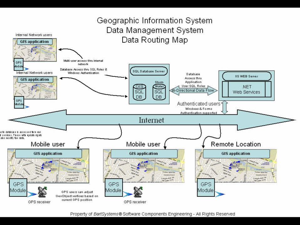
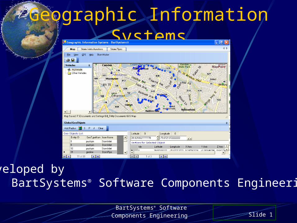
Geographic Information Systems BartSystems ® Software Components Engineering Slide 1 Developed by...
14
BartSystems ® Software Components Engineering Slide 1 Geographic Information Systems veloped by BartSystems ® Software Components Engineeri
-
Upload
kristian-maxwell -
Category
Documents
-
view
217 -
download
1
Transcript of Geographic Information Systems BartSystems ® Software Components Engineering Slide 1 Developed by...
BartSystems® Software
Components Engineering Slide 1
Geographic Information Systems
Developed byBartSystems® Software Components Engineering
BartSystems® Software
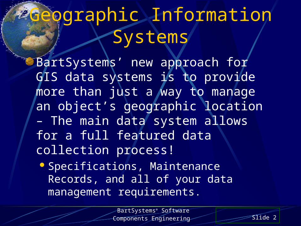
Components Engineering Slide 2
Geographic Information Systems
BartSystems’ new approach for GIS data systems is to provide more than just a way to manage an object’s geographic location – The main data system allows for a full featured data collection process!Specifications, Maintenance Records, and
all of your data management requirements.
BartSystems® Software
Components Engineering Slide 3
Geographic Information Systems
Built on GPS enabled Multi-Vehicle Tracking Subsystem Technology
Main GeoObject Engine is fully integrated with GPS subsystem
Extensible design allows new Data Systems to be plugged into Geo System
BartSystems® Software
Components Engineering Slide 4
Geographic Information Systems
Built on GPS enabled Multi-Vehicle Tracking Subsystem Technology Multi-Tracking allows vehicles to be tracked in
real-time. Vehicle tracking systems can be built supporting
multi-town, multi-node, multi-map tracking. It can be configured for multiple types of fleets
displayed in separate maps, if desired.
BartSystems® Software
Components Engineering Slide 5
Geographic Information Systems
Main GeoObject Engine is fully integrated with GPS subsystem Integration into the GPS system allows for real-
time target tracking to any GeoObject
Real-Time Distance & Bearing is shown.
BartSystems® Software
Components Engineering Slide 6
Geographic Information Systems
Extensible design allows new Data Systems to be plugged into Geo System The system is an open-ended structure that allows
n-number of data systems to be added (no limit). All Data Systems can be mixed and matched. Plots: All objects are shown on the map:
Hydrants, Inlets, Pipes, etc.
BartSystems® Software
Components Engineering Slide 7
Geographic Information Systems
Currently Available Data SystemsFire Hydrant Management System
Easy to use Hydrant Data Entry SystemStorm Water Management System
Virtual Schematic of storm water system Navigate both to upstream & downstream points.
Maintain specs on all inlets/junction & pipesHazardous Waste Containment
BartSystems® Software
Components Engineering Slide 8
Geographic Information Systems
Future Data Systems Inventory and Work Site Management
System (This is currently available)Needs to be integrated into the GIS structure.Provides a way to manage all of your work sites
throughout the city/town right on the map!Water Main Valve Exercise & Maintenance
SystemQuick shutdown of water in case of breaks.
BartSystems® Software
Components Engineering Slide 9
Geographic Information Systems
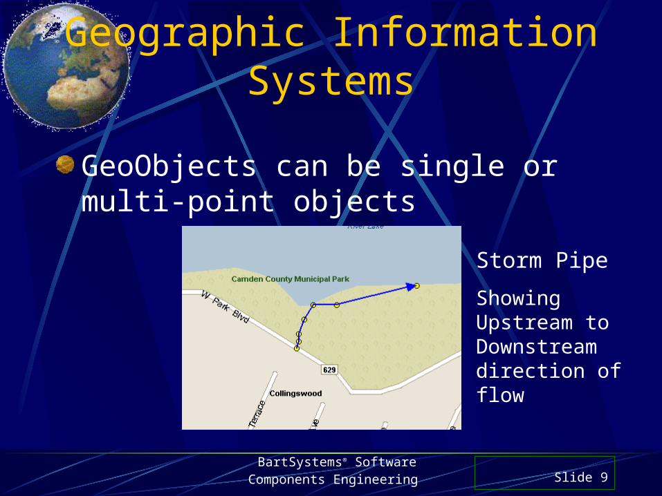
GeoObjects can be single or multi-point objects
Storm Pipe
Showing Upstream to Downstream direction of flow
BartSystems® Software
Components Engineering Slide 10
Geographic Information Systems
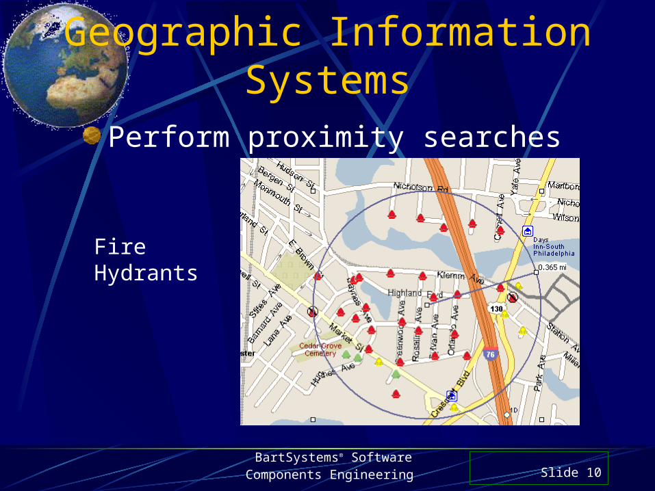
Fire Hydrants
Perform proximity searches
BartSystems® Software
Components Engineering Slide 11
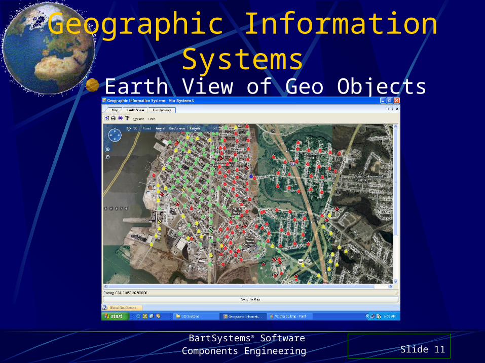
Geographic Information Systems
Earth View of Geo Objects
BartSystems® Software
Components Engineering Slide 12
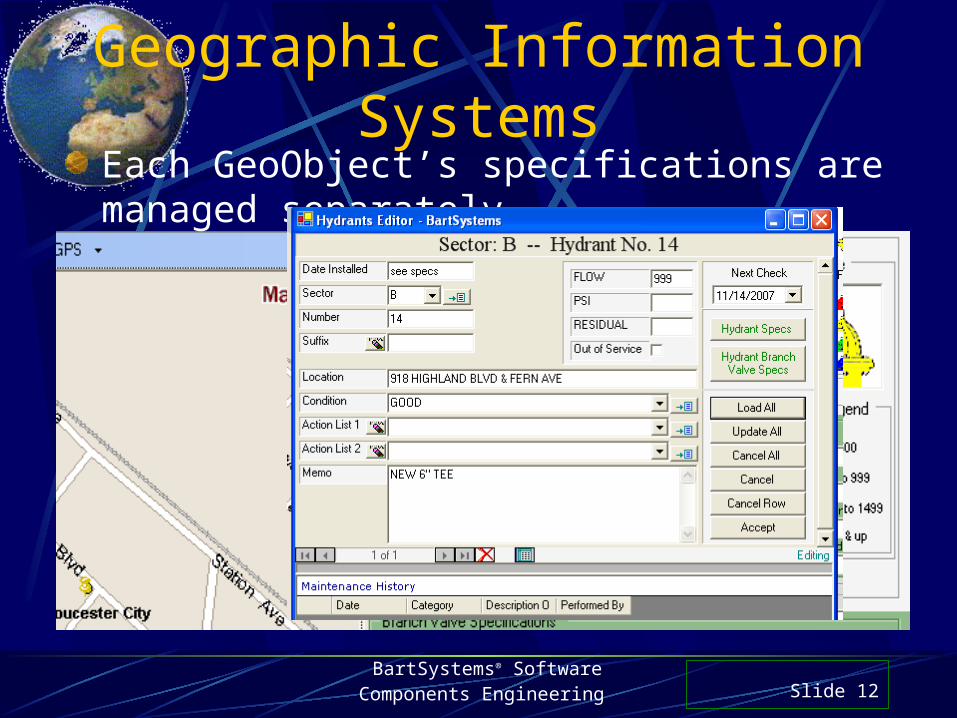
Geographic Information SystemsEach GeoObject’s specifications are managed separately
BartSystems® Software
Components Engineering Slide 13
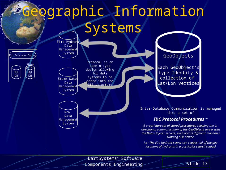
Geographic Information Systems
GeoObjects
Each GeoObject’stype Identity &collection of
Lat/Lon verticesStorm Water
DataManagement
System
Inter-Database Communication is managed thru a set of
IDC Protocol Procedures TM
A proprietary set of stored procedures allowing the bi-directional communication of the GeoObjects server with the Data Objects servers, even across different machines
running SQL server.
i.e.: The Fire Hydrant server can request all of the geo locations of hydrants in a particular search radius!
New Data
ManagementSystem
Fire HydrantData
ManagementSystem
Protocol is an open n-Type design
allowing for data systems to be added into the GIS structure
SQLDB
SQL Database Server
SQLDB
Storm Water