Geographic Information Systems - aun.edu.eg · PDF file-The use of geographic information...
36
Geographic Information Systems
Transcript of Geographic Information Systems - aun.edu.eg · PDF file-The use of geographic information...

Geographic Information Systems

What is a Geographic Information System (GIS)?
••definition of GIS definition of GIS -- An internally referenced, An internally referenced, automated, spatial information system for automated, spatial information system for data mapping, management, and analysisdata mapping, management, and analysis

CaptureData
GIS Process
RegisterMap Base
InterpretData
Convert Datato DigitalFormat
Store Datain Computer
ProcessData
DisplayResults

DATA INPUTDATA INPUTDATA INPUT
DATABASE MANAGEMENT DATABASE MANAGEMENT DATABASE MANAGEMENT
ANALYSIS & MODELLINGANALYSIS & MODELLINGANALYSIS & MODELLING
DATA OUTPUTDATA OUTPUTDATA OUTPUT
DATA FLOW IN A GISDATA FLOW IN A GIS

GIS – Infra Structure
HUMANWARE
HARDWARE
SOFTWARE
DATA (Spatial & Attribute)
CD_JEP-32005-2004

Seismic studies adoption of geographic information systems
The GIS is a newly information systems, has received a boom in many different areas of science, such as urban planning and management of networks and other applications that rely on Atablojia Topology (flag characteristics and spatial relations), and spatial analysis Spatial Analysis.

Began thinking seriously about the use of GIS in disaster management and ensuring public safety since the mid-1990s past as a result of the availability of computer equipment and increasing efficiency in addition to the proliferation of civilian use of satellite imagery.

A demonstration of the Department of hypothetical seismic disaster in the city of Homs 1999
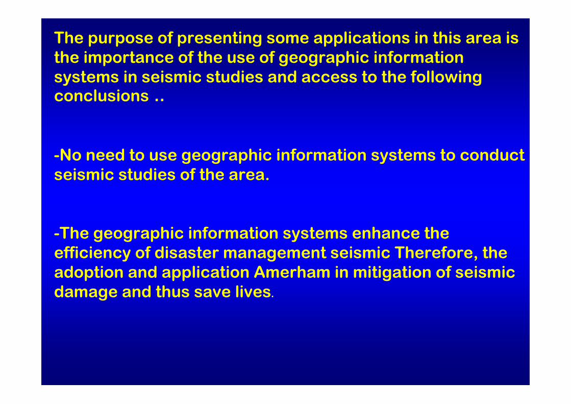
The purpose of presenting some applications in this area is the importance of the use of geographic information systems in seismic studies and access to the following conclusions ..
-No need to use geographic information systems to conduct seismic studies of the area.
-The geographic information systems enhance the efficiency of disaster management seismic Therefore, the adoption and application Amerham in mitigation of seismic damage and thus save lives.
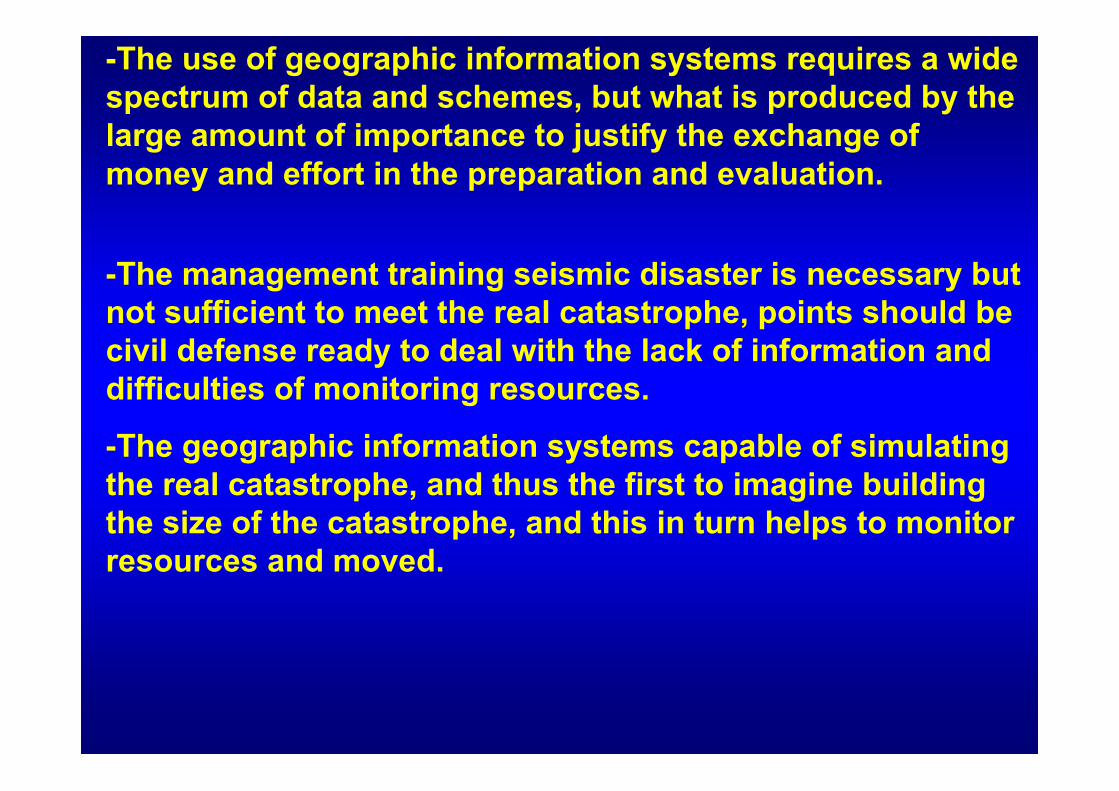
-The use of geographic information systems requires a wide spectrum of data and schemes, but what is produced by the large amount of importance to justify the exchange of money and effort in the preparation and evaluation.
-The management training seismic disaster is necessary but not sufficient to meet the real catastrophe, points should be civil defense ready to deal with the lack of information and difficulties of monitoring resources.
-The geographic information systems capable of simulating the real catastrophe, and thus the first to imagine building the size of the catastrophe, and this in turn helps to monitor resources and moved.

- The seismic modeling of cities adopting GIS has a vital role in detecting shortcomings, which are not detectable by conventional means (taking civil defense installations, areas with high likelihood of risk ...) And therefore can avoid these shortcomings before it is too late.
The study attributed to earthquakes using GISGIS الدراسة الراجعة للزالزل باستخدام
The study attributed contribute to the history of earthquakes that struck the region in determining seismic this region and thus help in the identification and mapping Altmentq seismic.
There is more than one way to chart the road Altmentqseismic, and for example, the traditional way to assess seismic risk by going back to more than one source of seismic data as a specific reference often take 50 years and seismic intensity not less than a specific value (5.5 Richter for example) where it is being analyzed earthquakes carelessly previous earthquakes, regressive and give greater weight to the earthquakes that occurred in the earliest periods, and through the study of the likelihood of repetition, with the approval of faults and fissures neighboring relations and the use of damping are probabilistic seismic mapping.
Using seismic maps at the time of the construction of the facility and determination to resist the stresses resulting from the defect due to an earthquake, is the value of design expressed in the symbol of the relationship between the code Z Syrian Arab shear strength of the grassroots (V=Z.I.K.C.S.W
The GIS systems more flexibility in linking data and generating schemes or schemes of databases, and can be used in the generation of maps and seismic as in the following scheme that has been generated from historical records that hit Japan during the five and twenty years.
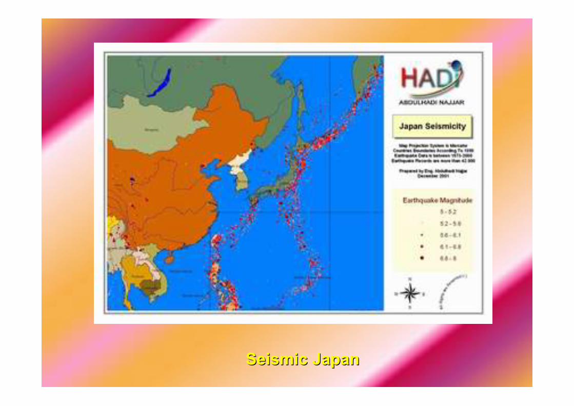
Seismic Japan Seismic Japan
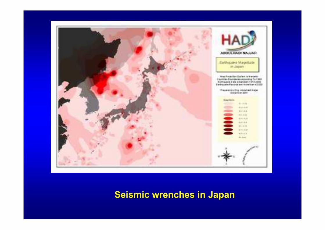
Seismic wrenches in Japan Seismic wrenches in Japan

Fee hotbeds of earthquakes using GIS
The depth of the epicenter is the depth that extends from the Earth's surface to generate the earthquake earthquakeusually described as the geographical location of its epicenter, the depth and degree of project preparation.
The depth of focus of the earthquakes of less than 60 meters classified as earthquakes and a few rear of this type of earthquakes caused by the crash of the fragile rock in the earth's crust, or because the energy of rock Altchouhehgenerate strong internal friction largest proven aspects of the opposite of faults in the earth's crust which lead the slide plate among them, and the Gulf of Aqaba earthquake earthquakes are a few rear model.

Earthquakes are a few rear usually more dangerous, since the earthquake energy decreases gradually with increasing mileage, due to friction, and the depths of earthquakes give an indication of the tectonics of the area, the second figure shows that there is a link between the form of land and the depth of earthquakes

It is known in the science of materials that resist It is known in the science of materials that resist the sharp changes in the body that lead to greater the sharp changes in the body that lead to greater distortions when these changes, and in seismic distortions when these changes, and in seismic engineering there is similar is the role of the engineering there is similar is the role of the movement in the tectonic plates generate movement in the tectonic plates generate earthquakes, most earthquakes follow the border earthquakes, most earthquakes follow the border between tectonic plates, as shown on the latest between tectonic plates, as shown on the latest figure, however we simply note that there is a lot figure, however we simply note that there is a lot of earthquakes that deviate from this ruleof earthquakes that deviate from this rule. .
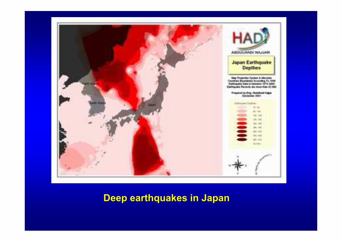
Deep earthquakes in JapanDeep earthquakes in Japan

The contour of the seismic hot for Central Japan

Seismic world and the theory of plate tectonics
Modeling cities using GIS for seismic damage expected
Despite all the research is still the subject of earthquakes is expected elusive now, in fact, all seeking global Alkodat used in the design of traditional civilian installations to prevent damage to components and construction-construction of the low-intensity tremors and reduce the vulnerability of the construction and non-construction level, which allows reform and restoration, in the middle of earthquakes, and prevent the total or partial collapse of high-intensity earthquakes in order to avoid loss of life .

Actually this should be depends on the commitment to implement design specifications demanded by Alkodat and obligation to implement the one hand and strongly earthquake occurred on the other hand, in the earthquakes, we find many important installations collapsed, although they conform to the requirements of the design code, and the reason then either permissive code in the reserves. The earthquake or simply a very strong and any business can not afford.
The collapse of facilities is not the only reason for the large number of human losses and material, for example, the earthquake in Kobe, Japan (January 17, 1995 at 4:25 strongly 6.2 on the Richter scale) were human losses resulted primarily from the spread of the fires that followed the earthquake and delayed control
That is the sign of an earthquake is very important, but very difficult, that the disaster management is well organized and contribute to the reduction of losses; this administration must be based on information on the location of the damage and distribute and access to this information and study is difficult in the first hours after the occurrence the disaster, but the adoption of geographic information systems can create a virtual model of the expected damage caused and to update this model according to the actual data contained.
This model can be built by securing data in advance of the talks, installations, where we give every facility and weight depends on the extent to achieve the safety and efficiency specifications to withstand earthquake, and turning these specifications to figures associated with the specifications established as a camel resistance, soft floor, floor weak, short columns, correspondence, etc ..

It also must be established and the location of the soil incorporation into account, such as the possibility of the occurrence of the phenomenon of volcanic soil or slide or get tons and amplify seismic energy, etc..
In addition to the lights on the impact of other factors such ashigh neighboring installations neighboring installations and the presence of the interval and the damage that might establish the damaged infrastructure, etc ..
The foregoing is part of the factors which must be taken into account when the city of seismic modeling and must transform these factors to the figures depend on the proportionality (the show is given an appropriate nature of the soil incorporation from 1 to 5 for example) or based on real comparative terms (the adoption of high construction the actual value).
These must be linked to the data model and three-dimension Muscat Repertory shows and installations are spatial relations themselves, as they appear activities and emergency requirements (duty firefighters and hospitals and roads ...).

Three-dimension model of residential buildings are reflected rises, in addition to infrastructure
The model identifies the former scenario is a principle Altozinand sequence event, this scenario is supposed to rely on the data when the earthquake occurs (coordinates, response spectrum, depth ...) Hence, road damage can be generated which are in accordance to the management of the disaster, noting updated and amended with the increasing information on the actual damages.
The foregoing is a simplified explanation required an in-depth and extensive experience in the conduct of installations dynamic addition to the experience gained from previous earthquakes, and thus manufacturing model requires gentle wealth of information and takes a long time, and in spite of this, the results can be obtained on a large degree of important.

The planning and disaster management using GISThe planning and disaster management using GIS
Geographic information systems are an effective tool in disaster management and has been used in many parts of the world in the rescue operations, firefighting and heavy floods and earthquakes and, through Dhadid Alamtheli location of the installations of Civil Defense and the Department of logistics and resource monitoring.


Such schemes theorists trilateral dimension of the patterns of the affected construction in Northeridj
One example of this was the Civil Defense Department systems upon Northeridj impact of the earthquake, California (January 17, 1994 at 4:31 strongly and 6.7 on the Richter scale), this may be the first real application of the adoption of seismic disaster management geographic information systems

used the GIS mapping of affected areas and according to the Mercali scale rate, and the areas affected shocks regressive, and in the evaluation of structural safety of buildings, also helped in the understanding of the relationship between the concentration of damaged buildings and the likelihood of a volcanic soil, and in the management of water resources and sources of drinking post the disaster, and given the privacy of the region where there are many non-English-speaking nationalities has helped GIS in monitoring human resources to help people in the affected areas
The use of geographic information systems vital role in the alleviation of the disaster and improve the speed of response and management of the optimum manner