Systems of Care: Environmental Scan of Medicaid-Funded Long-Term
Geographic Information Systems and Medicaid Modernization: Incorporating Esri® Technology and Services An Esri® White Paper August 2012
Copyright © 2012 Esri All rights reserved. Printed in the United States of America. The information contained in this document is the exclusive property of Esri. This work is protected under United States copyright law and other international copyright treaties and conventions. No part of this work may be reproduced or transmitted in any form or by any means, electronic or mechanical, including photocopying and recording, or by any information storage or retrieval system, except as expressly permitted in writing by Esri. All requests should be sent to Attention: Contracts and Legal Services Manager, Esri, 380 New York Street, Redlands, CA 92373-8100 USA. The information contained in this document is subject to change without notice. Esri, the Esri globe logo, ArcObjects, ArcGIS, ModelBuilder, ArcPad, StreetMap, EDN, ArcLogistics, Business Analyst, ArcWeb, Business Analyst Online, esri.com, and @esri.com are trademarks, service marks, or registered marks of Esri in the United States, the European Community, or certain other jurisdictions. Other companies and products or services mentioned herein may be trademarks, service marks, or registered marks of their respective mark owners.
J9781
Esri White Paper i
Geographic Information Systems and Medicaid Modernization: Incorporating Esri Technology and Services
An Esri White Paper Contents Page
Introduction and Purpose of Paper ........................................................ 1 Brief History of Medicaid IT .......................................................... 1 Structure of Paper ........................................................................... 3 Terms and Abbreviations ................................................................ 3
Medicaid and MMIS ............................................................................. 6 Medicaid Mandatory Services ........................................................ 7 Medicaid Optional Services ............................................................ 7 The Scope of MMIS........................................................................ 8
Medicaid Information Technology Architecture .................................. 8 MITA Architectures ........................................................................ 9 MITA and SOA............................................................................... 10 MITA Maturity Model .................................................................... 10 MITA Business Processes............................................................... 10
Understanding Geography as a Common Frame of Reference ............ 10 Existing GIS within Health and Human Services Agencies ........... 12 Enterprise GIS ................................................................................. 12
Geographically Enabling MMIS ........................................................... 13 MITA Business Processes and GIS ................................................ 14 MITA Technical Capabilities and GIS ........................................... 20 GIS Software Considerations .......................................................... 22 Esri GIS and Modernizing MMIS................................................... 25 Esri Interoperability and SOA ........................................................ 25
Geographic Information Systems and Medicaid Modernization: Incorporating Esri Technology and Services
J9781
Contents Page
August 2012 ii
The Future of GIS and MITA ............................................................... 27 MITA Business Maturity Levels..................................................... 27 GIS in Future MMIS Research and Development Projects ............ 27
How to Get Started................................................................................ 27 Medicaid Agencies.......................................................................... 27 Systems Integrators and Developers ............................................... 28
Appendixes
Appendix A: Esri Solutions to Modernizing MMIS ............................. 29 ArcGIS for Desktop ........................................................................ 29 ArcGIS for Server ........................................................................... 29 ArcGIS Spatial Analyst................................................................... 30 ArcGIS Network Analyst ................................................................ 30 ArcLogistics .................................................................................... 30 Esri Business Analyst and Esri Business Analyst Server ............... 31 Esri Data.......................................................................................... 31 Developer Tools .............................................................................. 31
Appendix B—Spatial Data and Geographic Locations Relevant to Medicaid ........................................................................................ 32
J9781
Esri White Paper
Geographic Information Systems and Medicaid Modernization: Incorporating Esri Technology and Services
Introduction and Purpose of Paper
Needs-based medical assistance programs around the world continue to receive attention from policy makers and the public due to escalating costs of medical services, fluctuations in enrollment and utilization, and ongoing concerns about access to care and quality of care. Information technology (IT) promises to deliver to such programs better understanding of access to care, increased efficiencies, improved services, and reductions in fraud and abuse. Geographic information system (GIS) technology is a key component to modernizing the IT of such programs. This white paper is intended to address two essential issues in the role of GIS in modernizing the IT of needs-based medical assistance programs: ■ The importance of geographically enabling information systems (with GIS) to
support the mission and work of needs-based medical assistance programs such as Medicaid
■ The choice of specific Esri® technology solutions appropriate for Medicaid
Management Information Systems (MMISs) and Medicaid Information Technology Architecture (MITA)
While this paper includes extensive references to MMIS in the United States, it is also intended as a reference for IT modernization efforts of other countries' needs-based medical assistance programs.
Brief History of Medicaid IT
In the United States, the Medicaid program was signed into law in 1965 as Title XIX of the Social Security Act.1 Medicaid is a federal/state entitlement program that pays for medical assistance for certain individuals and families with low incomes and financial resources. It is the largest source of funding for medical and health-related services for America's poorest people2 and is the dominant source of financing for long-term care.3 Medicaid provides health coverage and long-term care support to more than 44 million
1 Centers for Medicare and Medicaid Services. About CMS: History: Overview. Retrieved August 21, 2008,
from http://www.cms.hhs.gov/History/. 2 Technical Summary: Overview of Medicaid. Retrieved August 21, 2008, from
http://www.cms.hhs.gov/MedicaidGenInfo/03_TechnicalSummary.asp#TopOfPage. 3 Kaiser Family Foundation, 2007. Medicaid: A Primer. Retrieved October 15, 2008, from
http://www.kff.org/medicaid/7334-02.cfm.

Geographic Information Systems and Medicaid Modernization: Incorporating Esri Technology and Services
J9781
August 2012 2
people in low-income families and nearly 14 million elderly and disabled people.4 Medicaid primarily buys services in the private health care sector and represents a major source of financing for health care providers serving low-income and uninsured populations.5 Medicaid pays for approximately 20 percent of personal health spending in the United States.6 State agencies administer Medicaid within broad federal guidelines.7 The federal agency responsible for Medicaid is the Centers for Medicare and Medicaid Services (CMS), a division of the US Department of Health and Human Services (DHHS). Since its beginnings in 1965, the Medicaid program has gone through numerous changes, some of which have been directly related to IT. In 1972, Public Law 92-603 provided partial federal funding for design, development, installation, and operation of state mechanized claims processing and information retrieval systems approved by the Secretary of Health and Human Services. Soon after, MMISs were required as tools to track and control Medicaid expenditures and provide data for Medicaid program planning and evaluation. As MMISs evolved over the years, they largely developed as closed systems, missing opportunities for both cross-agency collaboration and patient-centric care. In response to IT industry evolution and the needs of MMIS, the Center for Medicaid and State Operations (CMSO) has articulated a vision for MITA. This initiative has emerged to foster integrated business and IT transformation across the Medicaid enterprise to improve the administration of the Medicaid program.8 MITA advocates a service-oriented architecture (SOA) approach to all Medicaid IT, further discussed in the Medicaid Information Technology Architecture section of this paper. As the second largest item in state budgets,9 Medicaid is frequently high on the federal and state health policy agenda due to its impact on state functioning, health care providers, and the public's health. The passage of the American Recovery and Reinvestment Act of 2009 will provide additional stimulus to Medicaid IT over the coming years. Given states' large investments in Medicaid IT, it is imperative for state Medicaid programs and the systems integrators (SIs) supporting Medicaid IT transformation to leverage GIS capacities into the MITA framework.
4 Kaiser Commission on Medicaid and the Uninsured, January 2008. Medicaid: Overview and Impact of New
Regulations, Kaiser Family Foundation Issue Paper No. 7739. Retrieved August 20, 2008, from http://www.kff.org/medicaid/upload/7739.pdf.
5 Kaiser Family Foundation, 2007. Medicaid: A Primer. Retrieved October 15, 2008, from http://www.kff.org/medicaid/7334-02.cfm.
6 Ibid. 7 Ibid. 8 Centers for Medicare and Medicaid Services. Overview of Medicaid Information Technology Architecture.
Retrieved August 21, 2008, from http://www.cms.hhs.gov/MedicaidInfoTechArch/. 9 Kaiser Family Foundation, 2007. Medicaid: A Primer. Retrieved October 15, 2008, from
http://www.kff.org/medicaid/7334-02.cfm.
Geographic Information Systems and Medicaid Modernization: Incorporating Esri Technology and Services
J9781
Esri White Paper 3
Structure of Paper This paper is composed of seven parts. The first part is this introduction. It describes the purpose and structure of this paper and defines terminology used throughout the paper. The second section describes the scope of Medicaid services and MMIS. The third section provides an overview of MITA. The fourth section describes the benefits of understanding geography as a common frame of reference within health and human services (HHS), including an explanation of enterprise GIS within HHS agencies. The fifth section provides an overview of geographically enabling MMIS. The sixth section discusses the future of GIS within MITA. The final section offers suggestions on how to get started, including additional specific resources available from Esri and its business partners for Medicaid agencies, systems integrators, and other software developers.
Terms and Abbreviations
■ Automation—[computing] The automatic functioning of a machine, system, or process without the need for human interaction.
[software] In COM technology, a feature that allows an object that was designed for use in one application to be accessed in another application. For example, ArcObjects™ may be accessed in Visual Basic and in other languages, tools, and applications that support automation.
■ Client—An application, computer, or device in a client/server model that makes
requests to a server. Although client/server architecture can exist on one computer, it is more relevant to network systems that distribute applications over computers to different locations.
■ Enterprise GIS—A geographic information system that is integrated through an
entire organization so that a large number of users can manage, share, and use spatial data and related information to address a variety of needs, including data creation, modification, visualization, analysis, and dissemination.
■ Feature—The representation of a geographic feature that has both a spatial
representation (referred to as a shape) and a set of attributes. Features can be represented as points, lines, polygons, or grids.
■ Geocode—A code representing the location of an object, such as an address; a
census tract; a postal code; or x,y coordinates. ■ Geocoding—A GIS operation for converting street addresses into spatial data that
can be displayed as features on a map, usually by referencing address information from a street segment data layer.
■ Geodatabase—A collection of geographic datasets for use by ArcGIS® technology.
There are many types of geographic datasets including feature classes, attribute tables, raster datasets, network datasets, and topologies.
■ Geographic information system—An integrated collection of computer software
and data used to view and manage information connected with specific locations, analyze spatial relationships, and model spatial processes.
Geographic Information Systems and Medicaid Modernization: Incorporating Esri Technology and Services
J9781
August 2012 4
■ Health Insurance Portability and Accountability Act of 1996 (HIPAA)—Public Law 104-191 resulted in new privacy standards for health information in the United States. HIPAA's goals include improving portability and continuity of health insurance coverage in the group and individual markets; combating waste, fraud, and abuse in health insurance and health care delivery; and simplifying the administration of health insurance, among other purposes.10 HIPAA has impacted how providers communicate electronically with Medicaid and other programs.
■ Health Level 7 (HL7)—One of several American National Standards Institute
(ANSI)-accredited standards developing organizations (SDOs) operating in the health care arena. HL7 produces standards (sometimes called specifications or protocols) for the particular health care domain of clinical and administrative data.11
■ Interoperability—The capability of components or systems to exchange data with
other components or systems or to perform in multiple environments. ■ Medicaid—A federal entitlement program in the United States that provides free or
low-cost health and long-term care coverage to certain categories of low-income Americans. States design their own Medicaid programs within broad federal guidelines.12
■ Medicare—A health insurance program in the United States for people aged 65 and
older, under 65 with certain disabilities, and of all ages with permanent kidney failure.13
■ Medicaid Information Technology Architecture (MITA)—A CMS IT initiative to
transform the concept of today's state-based claims processing systems into an enterprise-wide backbone architecture capable of addressing tomorrow's Medicaid needs as well as today's.14
■ Medicaid Management Information System (MMIS)—An integrated group of
procedures and computer processing operations (subsystems) developed at the general design level to meet principal objectives. The objectives of this system and its enhancements include the Title XIX program control and administrative costs; service to recipients, providers, and inquiries; operations of claims control and computer capabilities; and management reporting for planning and control.15
10 Health Insurance Portability and Accountability Act of 1996, Public Law 104-191, 104th Cong. Retrieved
December 18, 2008, from http://www.cms.hhs.gov/HIPAAGenInfo/Downloads/HIPAALaw.pdf. 11 Health Level Seven, What is HL7? Retrieved December 17, 2008, from http://www.hl7.org/. 12 Kaiser Family Foundation, 2007. Medicaid: A Primer. Retrieved October 15, 2008, from
http://www.kff.org/medicaid/7334-02.cfm. 13 Centers for Medicare and Medicaid Services. Overview of Medicare. Retrieved December 18, 2008, from
http://www.cms.hhs.gov/MedicareGenInfo/. 14 Friedman, Rick, April 18, 2006. MITA: A Vision of Evolving Medicaid Systems, presentation from
Collaborative Expedition Workshop at the National Science Foundation, Arlington, VA. Retrieved October 20, 2008, from http://colab.cim3.net/file/work/Expedition_Workshop /2006-04-18 _OpenCollaboration_NetworkingHealthIT/Friedman_CMS_and_MITA_2006_04_18.ppt.
15 Centers for Medicare and Medicaid Services. Overview of the Medicaid Management Information System. Retrieved August 21, 2008, from http://www.cms.hhs.gov/MMIS/.
Geographic Information Systems and Medicaid Modernization: Incorporating Esri Technology and Services
J9781
Esri White Paper 5
■ MITA Maturity Model (MMM)—A two-dimensional model showing how the Medicaid program will evolve and be transformed over space and time. It applies the general definition of a maturity model to the complexities of the Medicaid program as manifested in 51 jurisdictions.16
■ National Provider Identifier (NPI)—A standard 10-digit unique health identifier
for health care providers in the United States, mandated under HIPAA.17 ■ Raster—A spatial data model that defines space as an array of equally sized cells
arranged in rows and columns and composed of single or multiple bands. Each cell contains an attribute value and location coordinates. Unlike a vector structure, which stores coordinates explicitly, raster coordinates are contained in the ordering of the matrix. Groups of cells that share the same value represent the same type of geographic feature.
■ Reference Information Model (RIM)—An object model created as part of the HL7
Version 3 methodology. The RIM is a large pictorial representation of the clinical data (domains) and identifies the life cycle of events that a message or groups of related messages will carry. It is a shared model between all the domains and as such is the model from which all domains create their messages. Explicitly representing the connections that exist between the information carried in the fields of HL7 messages, the RIM is essential to HL7's ongoing mission of increasing precision and reducing implementation costs.18
■ Server—A computer that manages shared resources, such as disks, printers, and
databases, on a network or software that provides services or functionality to client software. For example, a web server is software that sends web pages to browsers.
■ Service-oriented architecture (SOA)—An architecture in which core business
capabilities are encapsulated within independent software services and these services are leveraged by various front-end applications to fulfill business requirements.19
■ Spatial modeling—Analytic procedures applied with GIS. There are three
categories of spatial modeling functions that can be applied to geographic features within a GIS: (1) geometric models such as calculating the Euclidean distance between features, generating buffers, and calculating areas and perimeters; (2) coincidence models such as topological overlay; and (3) adjacency models such as pathfinding, redistricting, and allocation. All three model categories support operations on spatial data such as points, lines, polygons, and grids.
16 Centers for Medicare and Medicaid Services. MITA Information Series: The MITA Maturity Model.
Retrieved December 17, 2008, from http://www.cms.hhs.gov/MedicaidInfoTechArch/Downloads/mitamm.pdf.
17 Centers for Medicare and Medicaid Services. Overview of the National Provider Identifier (NPI) Final Rule. Retrieved December 17, 2008, from www.cms.hhs.gov/NationalProvidentStand/downloads/NPIoverview.pdf.
18 Health Level Seven, The Reference Information Model (RIM). Retrieved December 17, 2008, from http://www.hl7.org/.
19 Kawamoto, Kensaku, and David Lobach. "Proposal for Fulfilling Strategic Objectives of the U.S. Roadmap for National Action on Decision Support through a Service-oriented Architecture Leveraging HL7 Services," Journal of the American Medical Information Association (2007): 146–155.
Geographic Information Systems and Medicaid Modernization: Incorporating Esri Technology and Services
J9781
August 2012 6
■ Systems integrator—An entity that builds solutions from diverse components. With increasing IT complexity, more organizations want complete solutions incorporating hardware, software, and networking expertise in a multivendor environment.
■ Vector—A coordinate-based data model that represents geographic features as
points, lines, and polygons. Each point feature is represented as a single coordinate pair, while line and polygon features are represented as ordered lists of vertices. Attributes are associated with each vector feature, as opposed to a raster data model, which associates attributes with grid cells.
■ Web service—A software component accessible over the web for use in other
applications. Web services are built using industry standards, such as XML and SOAP, and thus are not dependent on any particular operating system or programming language, allowing access to them through a wide range of applications.
Medicaid and MMIS Medicaid and other health care claim processing systems collect and generate large
amounts of information that require integration of both administrative and clinical data. These kinds of data, if geographically enabled, can greatly benefit MMIS when data integration, analysis, and visualization are possible through the use of GIS technology. By associating data with location, proximity to other locations, movements across a locale, and other location-based analyses, MMIS users can make better decisions regarding eligibility, reimbursement, and other health-related services. Geographically enabled MMIS coupled with appropriate GIS technology provides Medicaid management with enhanced capabilities that may be leveraged across many business processes. To accomplish this requires setting up an interoperable information technology system that involves software, hardware, methods, and labor to conduct all aspects of the Medicaid business processes. Eventually, the improved MMIS looks for solutions that leverage the massive collection of administrative, clinical, and operational information for the purpose of addressing the policy and operational issues facing the Medicaid program. Geographically enabled information then becomes a strategic component of MMIS in any administrative decision-making process. The promise of information technologies' ability to economize, improve the process of health care, and improve the public's health and social outcomes is as compelling as it is complex. Its implementation requires a multifaceted approach to improving quality of care, reducing cost, and optimizing health outcomes in all health care transactions. Esri technology provides solutions that create geographic knowledge across the entire Medicaid health delivery and payment system. To manage their functions, Medicaid services collect and maintain administrative, clinical, and operations data from the diverse programs and services outlined below. An efficient MMIS system uses a standards-based approach to bringing together Medicaid data that is complex, distributed, and context sensitive.

Geographic Information Systems and Medicaid Modernization: Incorporating Esri Technology and Services
J9781
Esri White Paper 7
Medicaid Mandatory Services
According to the Kaiser Family Foundation's Medicaid Primer,20 most Medicaid beneficiaries are entitled to receive the following services if they are determined to be medically necessary by the state Medicaid program or a managed care organization with which the state contracts: ■ Physician services ■ Hospital services (inpatient and outpatient) ■ Laboratory and X-ray services ■ Early periodic screening, diagnosis, and treatment (EPSDT) services for individuals
under 21 ■ Medical and surgical dental services ■ Rural and federally qualified health center services ■ Family planning ■ Pediatric and family nurse practitioner services ■ Nurse-midwife services ■ Nursing facility services for individuals 21 and older ■ Home health care for persons eligible for nursing facility services
Medicaid Optional Services
Optional services are those services that a state can choose to cover in order to receive federal matching funds. According to the Kaiser Family Foundation's Medicaid Primer,21 commonly offered optional services include the following: ■ Prescription drugs ■ Clinic services ■ Dental and vision services and supplies ■ Prosthetic devices ■ Physical therapy and rehabilitation services ■ Tuberculosis (TB)-related services ■ Primary care case management ■ Nursing facility services for individuals under 21 ■ Intermediate care facilities for individuals with mental retardation (ICF/MR) services ■ Home- and community-based care services
20 Kaiser Family Foundation, 2007. Medicaid: A Primer. Retrieved October 15, 2008, from
http://www.kff.org/medicaid/7334-02.cfm. 21 Kaiser Family Foundation, 2007. Medicaid: A Primer. Retrieved October 15, 2008, from
http://www.kff.org/medicaid/7334-02.cfm.
Geographic Information Systems and Medicaid Modernization: Incorporating Esri Technology and Services
J9781
August 2012 8
■ Respiratory care services for ventilator-dependent individuals ■ Personal care services ■ Hospice services
The Scope of MMIS Individual states are allowed to utilize contractual services to perform work for the design, development, installation, or enhancement of an MMIS to meet their individual claims processing and payment needs. The basic core of each MMIS component is functionally similar. A fiscal agent, usually a private contractor selected through a competitive procurement process, may operate the state's MMIS. Currently, 15 states are self-operated, and the rest use fiscal agents. See http://www.cms.hhs.gov/MMIS/Downloads/mmisfaqr.pdf for the most recent MMIS Fiscal Agent Contract Status Report available from CMS at the time of this publication.
Medicaid Information Technology
Architecture
Medicaid Information Technology Architecture is an IT initiative sponsored by CMS intended to improve the administration of the Medicaid program so that it may evolve from a state-based claims processing system into an enterprise-wide backbone architecture capable of addressing not only today's but tomorrow's Medicaid needs.22 MITA has a national framework that provides a blueprint consisting of models, guidelines, and principles to be used by states as they implement enterprise solutions.23 It includes an architecture framework, processes, and planning guidelines that allow state Medicaid enterprises to meet their Medicaid objectives within the MITA framework while supporting unique local needs. Goals of MITA include the following:24 ■ Improved health outcomes ■ A patient-centric view not constrained by organizational barriers ■ Common standards with, but not limited to, Medicare ■ Interoperability between state Medicaid organizations within and across states, as
well as with other agencies involved in health care ■ Web-based access and integration
22 Friedman, Rick, April 18, 2006. MITA: A Vision of Evolving Medicaid Systems, presentation from
Collaborative Expedition Workshop at the National Science Foundation, Arlington, VA. Retrieved October 20, 2008, from http://colab.cim3.net/file/work/Expedition_Workshop /2006-04-18 _OpenCollaboration_NetworkingHealthIT/Friedman_CMS_and_MITA_2006_04_18.ppt.
23 Centers for Medicare and Medicaid Services. Introduction to MITA Framework, CMS MITA Presentation. Retrieved December 17, 2008, from www.cms.hhs.gov/MedicaidInfoTechArch/03_MITAPresentations.asp#TopOfPage.
24 Centers for Medicare and Medicaid Services. MITA Information Series: What is MITA? An Overview. Retrieved December 17, 2008, from http://www.cms.hhs.gov/MedicaidInfoTechArch/Downloads/mitaoverview.pdf.
Geographic Information Systems and Medicaid Modernization: Incorporating Esri Technology and Services
J9781
Esri White Paper 9
■ Software reusability ■ Use of COTS software ■ Integration of public health data
MITA Architectures The MITA framework is composed of three architectures: ■ Business architecture includes the operations concept, MITA Maturity Model,
Business Process Model, Business Capability Matrix, MITA Self-Assessment, and MITA business services.25 Table 1 (page 15) relates MITA processes to GIS relevance.
■ Technical architecture includes the business services, technical services,
technology architecture, Technical Capability Matrix, application architecture, and solution sets.26 These are intended to help states determine whether a service or infrastructure already exists. Since MITA technical services are designed to ensure vendor and platform independence, this simplifies the insertion of GIS technology to support geocoding, visualization, decision support, and advanced spatial analysis. Table 2 (page 18) relates the MITA technical services to GIS technical capabilities in the context of the MMM (levels 1 through 5). The links provided in the final How to Get Started section of this paper will be helpful for developing application architectures and for determining COTS options for solution sets.
■ Information architecture includes the data management strategy, Logical Data
Model, Conceptual Data Model, and data standards.27 This architecture uses the Health Level 7 Reference Information Model as a basis for identifying the standard data elements that are used by states in the development of MITA business services.28 Locational accuracy is important for many MITA business services, as referenced elsewhere in this paper. The A_Spatial_Coordinate Common Message Element Type (CMET) was passed in HL7 balloting about two years ago. This means a more standardized spatial coordinate with a higher level of locational accuracy. Previously, the RIM only included a placeholder for latitude-longitude with no guidance regarding specificity. (See the white paper HL7 and Spatial Interoperability Standards for Public Health and Health Care Delivery for more information.) As states develop their information architecture, more robust GIS services and analyses should be possible using the location information within HL7 messages.
25 Centers for Medicare and Medicaid Services. CMS MITA Framework 2.0, Part I, Chapter 1: Business
Architecture. Retrieved December 16, 2008, from www.cms.hhs.gov/MedicaidInfoTechArch/04_MITAFramework.asp#TopOfPage.
26 Centers for Medicare and Medicaid Services. CMS MITA Framework 2.0, Part III, Chapter 1: Technical Architecture. Retrieved December 16, 2008, from www.cms.hhs.gov/MedicaidInfoTechArch/04_MITAFramework.asp#TopOfPage.
27 Centers for Medicare and Medicaid Services. MITA Information Architecture. Retrieved December 18, 2008, from www.cms.hhs.gov/MedicaidInfoTechArch/Downloads/mitainformation.pdf.
28 Centers for Medicare and Medicaid Services. CMS MITA. Retrieved December 17, 2008, from www.cms.hhs.gov/MedicaidInfoTechArch/01_Overview.asp#TopOfPage.
Geographic Information Systems and Medicaid Modernization: Incorporating Esri Technology and Services
J9781
August 2012 10
MITA and SOA MITA has introduced SOA as an approach to address three major existing challenges for MMIS:29 ■ Highly interconnected systems using point-to-point interfaces require pervasive
modifications to accommodate changes to business requirements, making them difficult to change.
■ Users must navigate through multiple functional systems to perform a single task. ■ MMIS, to a large extent, is platform dependent and does not communicate easily
across functional or technical boundaries, which makes it difficult to share information or reuse functionality.
MITA is also standardizing the use of XML message interchange between business services and across organizational boundaries.30 Esri interoperability and SOA are discussed further in the Esri Interoperability and SOA section of this paper.
MITA Maturity Model
MITA has also introduced a maturity model showing how the program will evolve and be transformed over time.31 It is understood that states are at various levels (1 through 5) of this MMM for different business processes. The MMM is referenced in several tables and figures below.
MITA Business Processes
MITA has a Business Process Model through which states are identifying all the major Medicaid business processes that are common among them. After identifying the MITA business processes, MITA business services will be developed based on the conceptual processes, when possible.32 This Business Process Model also provides a framework for assessing the relevance and applicability of GIS products and services to MITA core business processes, in light of states' varying levels on the MMM. The Business Process Model also presents opportunities for future research and development projects incorporating GIS into MMIS and MITA.
Understanding Geography as a
Common Frame of Reference
Modernizing MMISs to facilitate more efficient claims submissions, recipient eligibility, prior approval, and provider enrollment requires geographically referenced information. The science of geography recognizes that almost everything that exists can be expressed in terms of its location and, therefore, has established a standard framework of spatial coordinates to communicate and relate the placement of people, things, and events, wherever that may be. Therefore, geography provides a spatial baseline that is used for storing, analyzing, and communicating most types of data. Eventually, geography supplies structurally coherent common ground for decision support mechanisms.
29 Centers for Medicare and Medicaid Services. MITA Information Series: Service-Oriented Architecture: A
Primer. Retrieved December 17, 2008, from http://www.cms.hhs.gov/MedicaidInfoTechArch/Downloads/mitasoa.pdf.
30 Ibid. 31 Centers for Medicare and Medicaid Services. MITA Information Series: The MITA Maturity Model.
Retrieved December 17, 2008, from http://www.cms.hhs.gov/MedicaidInfoTechArch/Downloads/mitamm.pdf.
32 Centers for Medicare and Medicaid Services. MITA Information Series: The MITA Business Process Model. Retrieved December 17, 2008, from http://www.cms.hhs.gov/MedicaidInfoTechArch/Downloads/mitabpm.pdf.

Geographic Information Systems and Medicaid Modernization: Incorporating Esri Technology and Services
J9781
Esri White Paper 11
Medicaid stands to benefit profoundly from the application of the science of geography through GIS technology. Here are some examples of how GIS technology supports MITA's goals: ■ MITA advocates more patient-centric Medicaid information systems. For a system
to be patient centric, it is absolutely necessary to know where the patient lives and the patient's relative level of access to Medicaid providers and services. GIS facilitates such analyses as well as enhancing patient-centric case management (e.g., by providing tools for analyzing access to transportation) and enhancing the consumer user experience (e.g., by providing a web-based services locator and/or a web-based population health data query system).
■ MITA advocates common standards through which MMIS can interoperate with
other systems, such as Medicare. Esri products use common standards and support key data interchange formats and web services standards for ensuring relevant GIS and IT interoperability between systems over wired and/or wireless networks. Esri is also a member of HL7 and recently published a working paper regarding HL7 and locational accuracy. To read more, please see Esri's white papers referenced in the How to Get Started section of this paper.
■ MITA advocates interoperability between state Medicaid organizations within and
across states, as well as with other agencies involved in health care. Esri is the standard GIS for most health agencies and a growing number of health care organizations. A more detailed description of Esri interoperability is included in the Esri Interoperability and SOA section below.
■ MITA advocates web-based access and integration. As noted in the Esri Solutions to
Modernizing MMIS section below, ArcGIS for Server facilitates web-based access and integration.
■ MITA advocates software reusability. As noted previously, most health and human
services agencies already have large deployments of Esri software. Such software is utilized for multiple business functions within the HHS enterprise.
■ MITA advocates the use of COTS software. For more than 25 years, Esri has built
open and interoperable commercial off-the-shelf software products. ■ MITA advocates the integration of public health data. GIS provides many data
management and analysis tools for integrating Medicaid data with other public health data. As noted below, in many public health departments, Esri technology is the standard for GIS data collection, management, analysis, visualization, and reporting.
Geographic Information Systems and Medicaid Modernization: Incorporating Esri Technology and Services
J9781
August 2012 12
Existing GIS within Health and Human
Services Agencies
Public health departments around the world have embraced GIS as a tool for collecting and analyzing data, evaluating health programs, and communicating results (internally, to policy makers, and to the public). These departments use GIS on a daily basis to analyze the spread of infectious disease; promote and encourage healthy behaviors (e.g., through targeted marketing); protect the public against environmental hazards (e.g., through cancer registries, enforcing regulations, plume modeling, targeted notification); prevent injuries (e.g., by analyzing traffic injuries by location); respond to disasters and assist communities in recovery (e.g., through situational awareness, identifying vulnerable populations); and ensure the quality and accessibility of health services, as well as many other programs and services. National health authorities, as well as state and local health departments, have recognized the importance of geocoding as a foundation for GIS. In the United States, Healthy People 2010's Infrastructure Goal 23-3 is to "increase the proportion of all major national, state, and local health data systems that use geocoding to promote nationwide use of GIS at all levels." The target for 2010 is geocoding 90 percent of all health data systems.33 In the United States, all 50 state health departments and hundreds of local health departments use Esri technology extensively. In summary, the existing deployments of Esri desktop, server, and mobile GIS technologies in health and human service agencies, together with increasing geocoding capacities spurred by Healthy People 2010 and other initiatives, present many opportunities for shared business capabilities with Medicaid and MMIS under the SOA umbrella.
Enterprise GIS Over the same time frame as Medicaid's history (1965 to the present), GIS technology has emerged as a powerful tool in many sectors, including health and human services. Recognizing the growing importance of GIS, state CIOs in the United States placed GIS on their Top Ten Priority Technologies list for 2008. GIS is not just a stand-alone analytic tool used for health planning or epidemiological research. It may span the entire HHS enterprise, serving multiple divisions, programs, and people from the computer desktop to web applications to mobile phones and PDAs. GIS has also been embraced by the IT community and has become a strategic component of information technologies incorporated into the central systems of many enterprises. Figure 1 illustrates the evolution of GIS in health and human services.
33 United States Department of Health and Human Services. Healthy People 2010 Goal 23-3. Retrieved
December 18, 2008, from http://healthypeople.gov/Document/HTML/Volume2/23PHI.htm#_Toc491137862.

Geographic Information Systems and Medicaid Modernization: Incorporating Esri Technology and Services
J9781
Esri White Paper 13
Figure 1 Evolution of Health GIS
Many state health departments have developed, or are currently developing, enterprise-wide geocoding services. Such services facilitate real-time geocoding of vital events such as births and deaths. An enterprise-wide geocoding service could be leveraged by the MMIS as a shared business capability, as stated in the MITA goals. Examples of other shared business capabilities are discussed later in this paper. Health agencies and the systems integrators who have built and maintain MMISs for them should explore enterprise GIS capacities of their sister agencies, as well as what services they may offer to others. Such enterprise GIS capacities could be leveraged on the application layer or the service layer. The National States Geographic Information Council (NSGIC) (www.nsgic.org/index.cfm) is committed to efficient and effective government through the prudent adoption of geospatial information technologies. A 2007 NSGIC survey of states' GIS initiatives is available at www.gisinventory.net/summaries.
Geographically Enabling MMIS
As Medicaid agencies evolve through the five stages of MITA maturity, they must be able to integrate with new technologies including advanced spatial data and information delivery. Geographically enabling MMIS would enhance the utility of existing Medicaid data: facilitating decision making and policy development, allowing extensive use of GIS in day-to-day Medicaid operations (e.g., maps, routing, and advanced spatial analysis), and helping disseminate relevant data to the public through web-based services locators and population health data query systems. GIS also provides a framework for visualizing and analyzing Medicaid activity near borders and across jurisdictions. Figure 2 represents the evolution of MMIS and GIS, as influenced by an SOA approach to IT. The rapid evolution of GIS as an essential component of the IT enterprise for governmental agencies, including DHHS, mirrors the recent call for MITA from CMS.
Geographic Information Systems and Medicaid Modernization: Incorporating Esri Technology and Services
J9781
August 2012 14
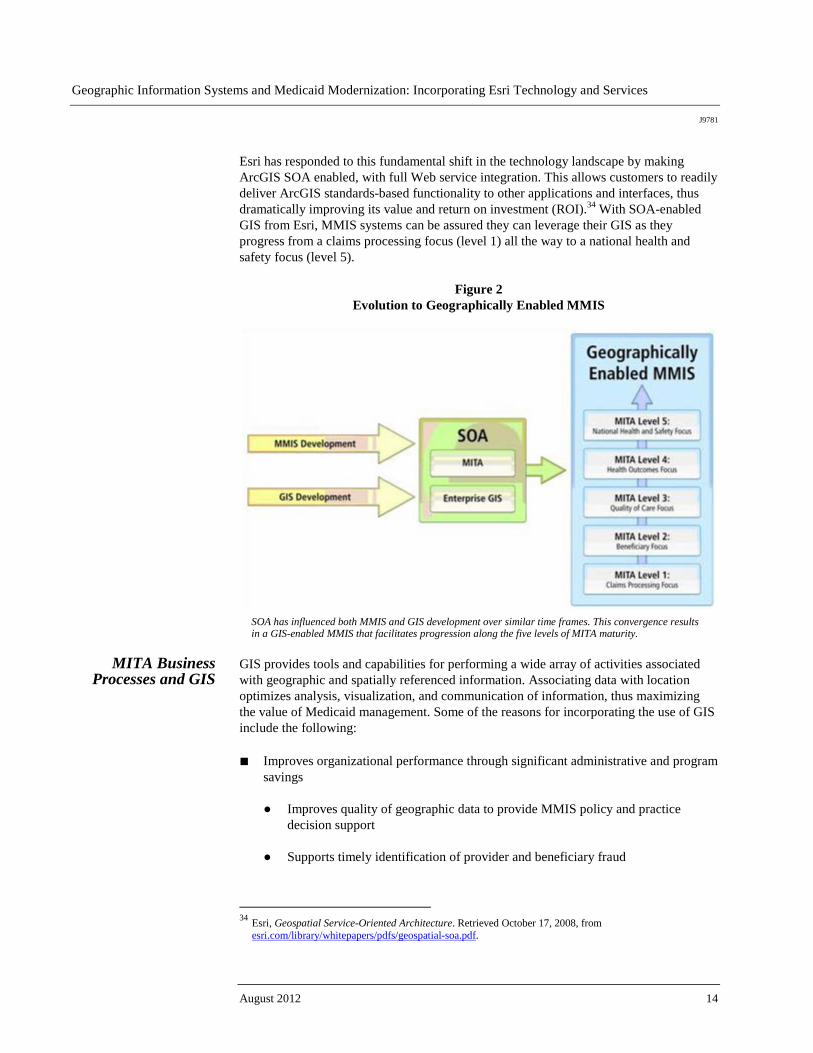
Esri has responded to this fundamental shift in the technology landscape by making ArcGIS SOA enabled, with full Web service integration. This allows customers to readily deliver ArcGIS standards-based functionality to other applications and interfaces, thus dramatically improving its value and return on investment (ROI).34 With SOA-enabled GIS from Esri, MMIS systems can be assured they can leverage their GIS as they progress from a claims processing focus (level 1) all the way to a national health and safety focus (level 5).
Figure 2 Evolution to Geographically Enabled MMIS
SOA has influenced both MMIS and GIS development over similar time frames. This convergence results in a GIS-enabled MMIS that facilitates progression along the five levels of MITA maturity.
MITA Business
Processes and GIS GIS provides tools and capabilities for performing a wide array of activities associated with geographic and spatially referenced information. Associating data with location optimizes analysis, visualization, and communication of information, thus maximizing the value of Medicaid management. Some of the reasons for incorporating the use of GIS include the following: ■ Improves organizational performance through significant administrative and program
savings
● Improves quality of geographic data to provide MMIS policy and practice decision support
● Supports timely identification of provider and beneficiary fraud
34 Esri, Geospatial Service-Oriented Architecture. Retrieved October 17, 2008, from
esri.com/library/whitepapers/pdfs/geospatial-soa.pdf.

Geographic Information Systems and Medicaid Modernization: Incorporating Esri Technology and Services
J9781
Esri White Paper 15
● Reduces undeliverable mail
● Saves time and money spent correcting wrong addresses
● Has point-of-registration address management and geocoding that vastly improves geographic accuracy and decision making
■ Improves service delivery
● Increases referral compliance for clients through discharge maps and directions
● Determines provider access for more efficient service delivery planning
● Improves call center efficiency by utilizing reverse geocoding to identify caller location
● Identifies significant community health problems
■ Data integration
● Permits integration of a variety of third-party and externally collected data from within the state government as it might be related to fraud and abuse, site location, expected service volumes, utilization management, and surveillance and tracking requirements
■ Helps Medicaid perform essential specific analyses
● Fraud and abuse detection
● Utilization and expenditures determination
● Enrollment and cancellation
● Provider profiling
● Network access (including access to care performance measures and ability to focus Medicaid recruitment efforts)
● Trend analysis and detection
Data standards and reporting specifications are also critical in day-to-day operations. Data standardization promotes the employment of commercially available techniques such as bulk mailing, consolidation of mailing, ZIP Code™ presorting, and geocoding. To geographically enable MMIS, all provider and beneficiary data must be exactly geocoded and have the capability to create fictitious addresses to analyze potentially new populations. An effective approach to delivering geographic knowledge within the Medicaid program begins by implementing a sound address management and geocoding system.

Geographic Information Systems and Medicaid Modernization: Incorporating Esri Technology and Services
J9781
August 2012 16
Perhaps the most critical function of an MMIS is its ability to process claims. A typical MMIS should have the capacity to collect and authenticate each address at the time it is collected. Implementing an address management and geocoding system ensures that valid and accurate street addresses are entered into the MMIS. Without such a program, an MMIS can expect about 20 percent of all addresses to be incorrect. This includes addresses of beneficiaries as well as providers. Managing the process by which addresses are collected, authenticated, and entered into a Medicaid system is essential for the production of accurate geographic information about providers and beneficiaries. Making sure that addresses are collected and authenticated in a uniform fashion at the point of service (e.g., intake assessment) or at the time a provider seeks program participation requires a system that provides instant access to a set of acceptable addresses. An address management and geocoding system includes a national master address file capable of reporting the likelihood that a given address is valid and sufficiently identifiable to assign a latitude and longitude (i.e., exact geocoding). In addition, the address management and geocoding system can also append additional information to an address that identifies the census tract, block group, or service area in which the address is located. The use of an address management and geocoding system integrated into an MMIS allows the required georeferenced information, mapping, and managed care network analysis to achieve the highest level of accuracy possible within an efficient and scalable technical environment. Enterprise geocoding solutions are based on modern industry software development standards and run on all major hardware platforms. Once the Medicaid data is geographically enabled, spatial and statistical analyses are possible. These analyses will be provided to MMIS for management of primary care physician (PCP) and specialist networks as related to enrollment. States are currently articulating and mapping their MMIS business processes and objectives to the MITA framework. Table 1 provides an overview of selected Medicaid business processes and GIS relevance, with an emphasis on progression through various MMM levels. It includes business areas from the MITA State Self-Assessment and the MITA Business Capability Maturity Matrix.
Geographic Information Systems and Medicaid Modernization: Incorporating Esri Technology and Services
J9781
Esri White Paper 17
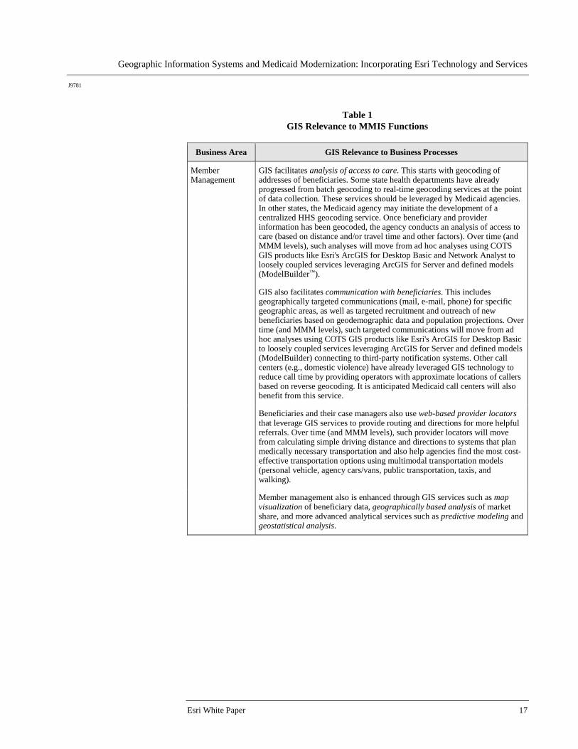
Table 1 GIS Relevance to MMIS Functions
Business Area GIS Relevance to Business Processes
Member Management
GIS facilitates analysis of access to care. This starts with geocoding of addresses of beneficiaries. Some state health departments have already progressed from batch geocoding to real-time geocoding services at the point of data collection. These services should be leveraged by Medicaid agencies. In other states, the Medicaid agency may initiate the development of a centralized HHS geocoding service. Once beneficiary and provider information has been geocoded, the agency conducts an analysis of access to care (based on distance and/or travel time and other factors). Over time (and MMM levels), such analyses will move from ad hoc analyses using COTS GIS products like Esri's ArcGIS for Desktop Basic and Network Analyst to loosely coupled services leveraging ArcGIS for Server and defined models (ModelBuilder™).
GIS also facilitates communication with beneficiaries. This includes geographically targeted communications (mail, e-mail, phone) for specific geographic areas, as well as targeted recruitment and outreach of new beneficiaries based on geodemographic data and population projections. Over time (and MMM levels), such targeted communications will move from ad hoc analyses using COTS GIS products like Esri's ArcGIS for Desktop Basic to loosely coupled services leveraging ArcGIS for Server and defined models (ModelBuilder) connecting to third-party notification systems. Other call centers (e.g., domestic violence) have already leveraged GIS technology to reduce call time by providing operators with approximate locations of callers based on reverse geocoding. It is anticipated Medicaid call centers will also benefit from this service.
Beneficiaries and their case managers also use web-based provider locators that leverage GIS services to provide routing and directions for more helpful referrals. Over time (and MMM levels), such provider locators will move from calculating simple driving distance and directions to systems that plan medically necessary transportation and also help agencies find the most cost-effective transportation options using multimodal transportation models (personal vehicle, agency cars/vans, public transportation, taxis, and walking).
Member management also is enhanced through GIS services such as map visualization of beneficiary data, geographically based analysis of market share, and more advanced analytical services such as predictive modeling and geostatistical analysis.

Geographic Information Systems and Medicaid Modernization: Incorporating Esri Technology and Services
J9781
August 2012 18
Business Area GIS Relevance to Business Processes
Provider Management
GIS facilitates provider network analysis, or understanding the goodness of fit between beneficiaries and provider types, based on location. This analysis begins with geocoding of addresses of providers and beneficiaries (see above). Initially, the analysis will define buffer or coverage zones around provider locations based on a determined range/radius. Over time (and MMM levels), provider network analyses will move from ad hoc analyses using COTS products like Esri's ArcGIS extensions (Network Analyst, Spatial Analyst) to loosely coupled services leveraging ArcGIS for Server and defined models (ModelBuilder).
GIS also facilitates communication with providers. As with member communication (referenced above), this includes geographically targeted communications for providers in specific geographic areas, as well as targeted recruitment and outreach of new providers based on geodemographic data and population projections. GIS may also improve address updates (by providers) as well as call center performance.
After identifying spatial gaps in coverage by geography/travel time, GIS also facilitates identification of most appropriate new sites for provider enrollment based on multicriteria models including location. Over time (and MMM levels), such analyses will move from ad hoc analyses using COTS GIS products like Esri's Business Analyst™ to loosely coupled services leveraging ArcGIS for Server and defined models.
Provider management also is enhanced through GIS services such as web-based services locators (getting members to the providers); map visualization of all providers versus Medicaid providers; and map visualization of other provider data (e.g., underused providers in the network relative to specific beneficiary needs). Moving along the MMM continuum, GIS also facilitates advanced analytic services such as predictive modeling and geostatistical analysis of provider data.
Contractor Management
GIS facilitates contractor management. This starts with geocoding of addresses of contractors and their service areas. Over time (and MMM levels), contractor management analyses will move from ad hoc analyses using COTS products (such as the linked charting, graphing, and mapping in ArcGIS) to integration with third-party performance management and reporting systems.
Solutions already exist through Esri business partners linking document management systems directly to ArcGIS (e.g., a Medicaid agency would bring up all relevant contracts for a particular point on a map or region).
Contractor management is also enhanced through GIS services such as map visualization of contractor responsibilities and locations/service areas and advanced analytic services such as predictive modeling and geostatistical analysis of contractor data.
Geographic Information Systems and Medicaid Modernization: Incorporating Esri Technology and Services
J9781
Esri White Paper 19
Business Area GIS Relevance to Business Processes
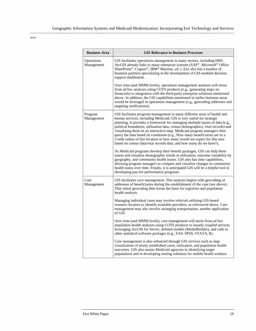
Operations Management
GIS facilitates operations management in many sectors, including HHS. ArcGIS already links to many enterprise systems (SAP®, Microsoft® Office SharePoint®, Cognos®, IBM® Maximo, etc.). Esri also has a number of business partners specializing in the development of GIS-enabled decision support dashboards.
Over time (and MMM levels), operations management analyses will move from ad hoc analyses using COTS products (e.g., generating maps on financials) to integration with the third-party enterprise solutions mentioned above. In addition, the GIS capabilities mentioned in earlier business areas would be leveraged in operations management (e.g., geocoding addresses and targeting notifications).
Program Management
GIS facilitates program management in many different areas of health and human services, including Medicaid. GIS is very useful for strategic planning. It provides a framework for managing multiple layers of data (e.g., political boundaries, utilization data, census demographics, vital records) and visualizing them on an interactive map. Medicaid program managers then query the data based on conditions (e.g., How many beneficiaries are in a 5-mile radius of this location or how many would we expect for this area based on census data/vital records data, and how many do we have?).
As Medicaid programs develop their benefit packages, GIS can help them assess and visualize demographic trends in utilization, outcome variability by geography, and community health issues. GIS also has time capabilities, allowing program managers to compare and visualize changes in community health status over time. Finally, it is anticipated GIS will be a helpful tool in developing pay-for-performance programs.
Care Management
GIS facilitates care management. This analysis begins with geocoding of addresses of beneficiaries during the establishment of the case (see above). That initial geocoding then forms the basis for registries and population health analysis.
Managing individual cases may involve referrals utilizing GIS-based resource locators to identify available providers, as referenced above. Care management may also involve arranging transportation, another application of GIS.
Over time (and MMM levels), care management will move from ad hoc population health analyses using COTS products to loosely coupled services leveraging ArcGIS for Server, defined models (ModelBuilder), and calls to other statistical software packages (e.g., SAS, SPSS, STATA, R).
Care management is also enhanced through GIS services such as map visualization of newly established cases, utilization, and population health outcomes. GIS also assists Medicaid agencies in identifying target populations and in developing routing solutions for mobile health workers.
Geographic Information Systems and Medicaid Modernization: Incorporating Esri Technology and Services
J9781
August 2012 20
Business Area GIS Relevance to Business Processes
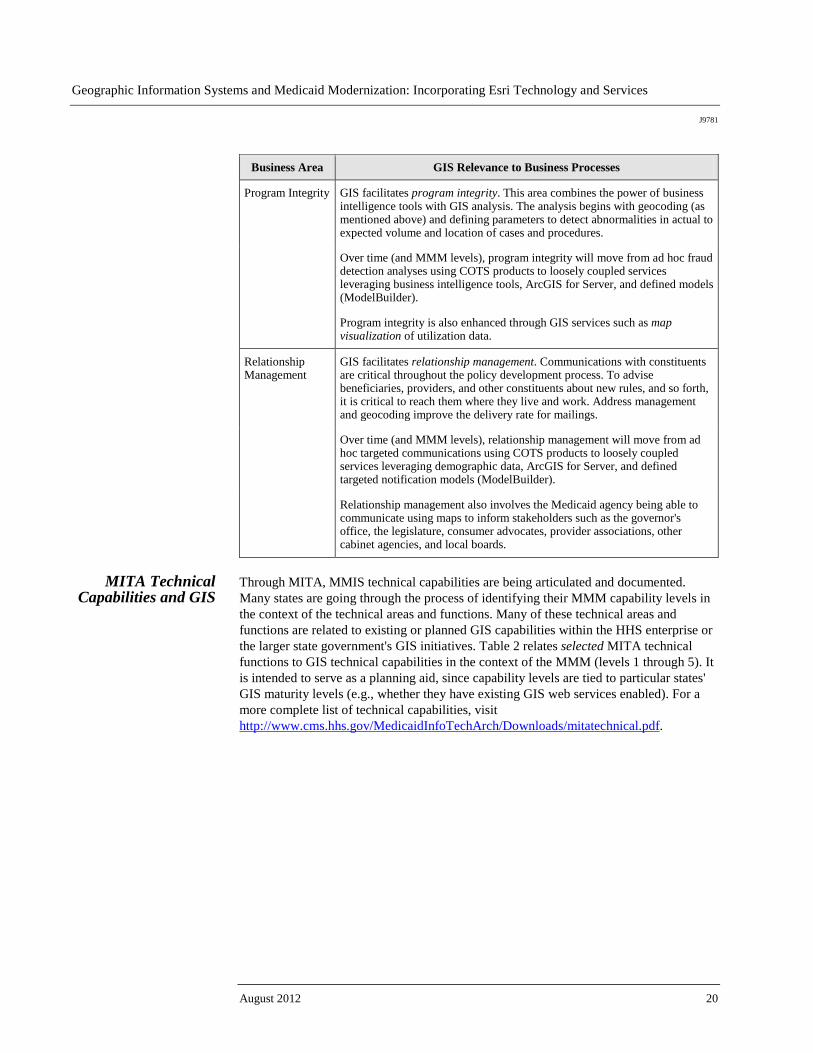
Program Integrity GIS facilitates program integrity. This area combines the power of business intelligence tools with GIS analysis. The analysis begins with geocoding (as mentioned above) and defining parameters to detect abnormalities in actual to expected volume and location of cases and procedures.
Over time (and MMM levels), program integrity will move from ad hoc fraud detection analyses using COTS products to loosely coupled services leveraging business intelligence tools, ArcGIS for Server, and defined models (ModelBuilder).
Program integrity is also enhanced through GIS services such as map visualization of utilization data.
Relationship Management
GIS facilitates relationship management. Communications with constituents are critical throughout the policy development process. To advise beneficiaries, providers, and other constituents about new rules, and so forth, it is critical to reach them where they live and work. Address management and geocoding improve the delivery rate for mailings.
Over time (and MMM levels), relationship management will move from ad hoc targeted communications using COTS products to loosely coupled services leveraging demographic data, ArcGIS for Server, and defined targeted notification models (ModelBuilder).
Relationship management also involves the Medicaid agency being able to communicate using maps to inform stakeholders such as the governor's office, the legislature, consumer advocates, provider associations, other cabinet agencies, and local boards.
MITA Technical
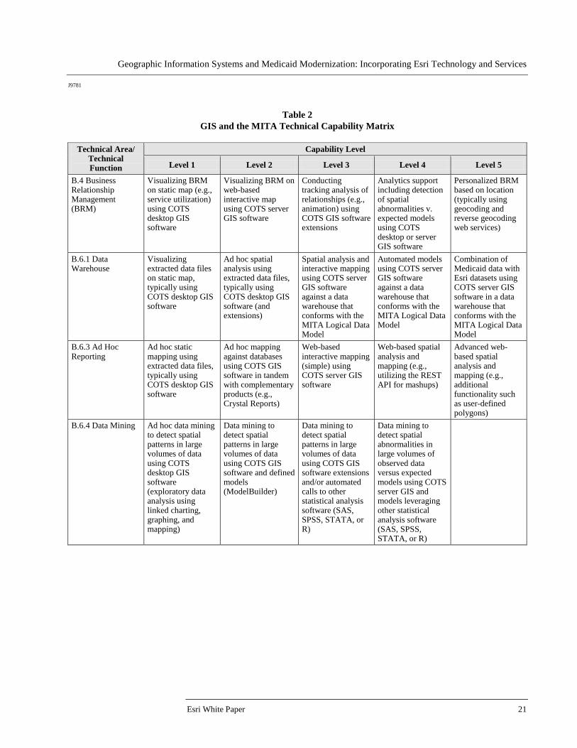
Capabilities and GIS Through MITA, MMIS technical capabilities are being articulated and documented. Many states are going through the process of identifying their MMM capability levels in the context of the technical areas and functions. Many of these technical areas and functions are related to existing or planned GIS capabilities within the HHS enterprise or the larger state government's GIS initiatives. Table 2 relates selected MITA technical functions to GIS technical capabilities in the context of the MMM (levels 1 through 5). It is intended to serve as a planning aid, since capability levels are tied to particular states' GIS maturity levels (e.g., whether they have existing GIS web services enabled). For a more complete list of technical capabilities, visit http://www.cms.hhs.gov/MedicaidInfoTechArch/Downloads/mitatechnical.pdf.
Geographic Information Systems and Medicaid Modernization: Incorporating Esri Technology and Services
J9781
Esri White Paper 21
Table 2 GIS and the MITA Technical Capability Matrix
Technical Area/
Technical Function
Capability Level
Level 1 Level 2 Level 3 Level 4 Level 5
B.4 Business Relationship Management (BRM)
Visualizing BRM on static map (e.g., service utilization) using COTS desktop GIS software
Visualizing BRM on web-based interactive map using COTS server GIS software
Conducting tracking analysis of relationships (e.g., animation) using COTS GIS software extensions
Analytics support including detection of spatial abnormalities v. expected models using COTS desktop or server GIS software
Personalized BRM based on location (typically using geocoding and reverse geocoding web services)
B.6.1 Data Warehouse
Visualizing extracted data files on static map, typically using COTS desktop GIS software
Ad hoc spatial analysis using extracted data files, typically using COTS desktop GIS software (and extensions)
Spatial analysis and interactive mapping using COTS server GIS software against a data warehouse that conforms with the MITA Logical Data Model
Automated models using COTS server GIS software against a data warehouse that conforms with the MITA Logical Data Model
Combination of Medicaid data with Esri datasets using COTS server GIS software in a data warehouse that conforms with the MITA Logical Data Model
B.6.3 Ad Hoc Reporting
Ad hoc static mapping using extracted data files, typically using COTS desktop GIS software
Ad hoc mapping against databases using COTS GIS software in tandem with complementary products (e.g., Crystal Reports)
Web-based interactive mapping (simple) using COTS server GIS software
Web-based spatial analysis and mapping (e.g., utilizing the REST API for mashups)
Advanced web-based spatial analysis and mapping (e.g., additional functionality such as user-defined polygons)
B.6.4 Data Mining Ad hoc data mining to detect spatial patterns in large volumes of data using COTS desktop GIS software (exploratory data analysis using linked charting, graphing, and mapping)
Data mining to detect spatial patterns in large volumes of data using COTS GIS software and defined models (ModelBuilder)
Data mining to detect spatial patterns in large volumes of data using COTS GIS software extensions and/or automated calls to other statistical analysis software (SAS, SPSS, STATA, or R)
Data mining to detect spatial abnormalities in large volumes of observed data versus expected models using COTS server GIS and models leveraging other statistical analysis software (SAS, SPSS, STATA, or R)

Geographic Information Systems and Medicaid Modernization: Incorporating Esri Technology and Services
J9781
August 2012 22
Technical Area/ Technical Function
Capability Level
Level 1 Level 2 Level 3 Level 4 Level 5
B.6.5 Statistical Analyses
Visualization of ad hoc statistical analyses (e.g., regression analysis) using COTS desktop GIS software
Visualization of ad hoc statistical analyses (e.g., regression analysis) using automated templates in COTS desktop GIS software
Statistical analyses of designated data (e.g., regression analysis) using spatial statistics tools in COTS desktop GIS software
Statistical analyses of designated data (e.g., regression analysis) using spatial statistics tools leveraged through COTS server GIS software
Level 4 plus automated calls to other statistical analysis software (SAS, SPSS, STATA, or R)
P.1 Performance Data Collection and Reporting
Static map visualization of performance reporting using COTS desktop GIS software
Collecting and reporting using predefined and ad hoc spatially defined performance metrics using COTS desktop GIS software (e.g., GIS for multistage sampling)
Interactive web-based mapping of performance metrics that conform to MITA-defined performance metrics (using COTS server GIS software)
Generating alerts and alarms when the value of a spatial metric falls outside limits (using COTS server GIS software and extensions)
Predictive modeling of performance expectations using COTS server GIS, extensions, and Esri data
P.2 Dashboard Generation
Static map visualization of summary-level performance information (i.e., performance dashboards) using COTS GIS software
Interactive web-based mapping of performance dashboards within a state Medicaid agency for all MITA-defined metrics using COTS server GIS software and available templates
Server GIS-enabled performance dashboards from external sources (e.g., other states and agencies) within a state Medicaid agency for all MITA-defined metrics
GIS Software
Considerations Identifying the common software needs will make specification, standardization, and implementation of GIS applications for Medicaid modernization more cost-effective and enhance the sharing of data, software, and other resources. Standard capabilities of GIS software and extensions may also be specially configured to support the needs of each state MMIS. This section provides general GIS considerations of software capability needs. The type of software utilized in Medicaid modernization must be able to do the following: ■ Data Management: Comprehensive data management and administrative reporting
systems will have the ability to examine utilization and expenditure trends. This will be done through various diagnostic and demographic parameters from both diagnostic and clinical perspectives. In addition, Medicaid data routinely collected in the process of enrolling providers and beneficiaries will be equipped with GIS data management capabilities that allow GIS analysis utilizing data from additional sources, such as demographics and environmental data. Successful uses of data management capabilities depend on adherence to the standard geographic or spatial reference system mentioned earlier. Esri technology meets this requirement fully and provides a comprehensive array of analytic tools for the identification of practice patterns as well as demographically and geographically driven metrics of the MMIS.

Geographic Information Systems and Medicaid Modernization: Incorporating Esri Technology and Services
J9781
Esri White Paper 23
■ Relational Database Management System (RDBMS): Enhanced and more accurate RDBMS-maintained data provides an MMIS decision support system with reliable, usable, and accurate data necessary to support the agency's critical business operations such as fraud analysis and detection and federal reporting. An RDBMS provides the following advantages to MMIS:
● Improved performance, scalability, and portability ● Improved data integrity ● Enhanced flexibility and maintainability ● Enhanced security features
Esri technology meets this requirement fully. The geodatabase is the common data storage and management framework for ArcGIS and can be utilized wherever it is needed—on desktops, in servers (including the web), or in mobile devices. ArcGIS implements the geodatabase either as a collection of files in a file system or as a collection of tables within an RDBMS. Table 3 describes geodatabase types, licensing levels, RDBMS technology, and differentiating characteristics.
Table 3
Geodatabases and RDBMS
Geodatabase Licensing RDBMS Technology
Differentiating Characteristics
Enterprise ArcGIS for Server Enterprise
DB2®, Informix®, Oracle®, SQL Server®, PostgreSQL
- Multiuser editing - Supports versioning - Supports spatial types
Workgroup ArcGIS for Server Workgroup
SQL Server Express
- Supports versioning - Maximum of 4 GB of data - 10 concurrent users
Desktop ArcGIS for Desktop, ArcGIS Engine
SQL Server Express
- Supports versioning - Maximum of 4 GB of data - 4 concurrent connections
File ArcGIS for Desktop Advanced, ArcGIS for Desktop Standard, ArcGIS for Desktop Basic
No RDBMS—Uses local file structure
- No versioning support - 1 TB per table size limit
(default)
Personal ArcGIS for Desktop Advanced, ArcGIS for Desktop Standard, ArcGIS for Desktop Basic
Microsoft Access® (Jet Engine)
- No versioning support - Maximum of 2 GB of data
■ Data Accuracy: To ensure that all mapped information is correctly positioned
requires verification of geographic data supplied by beneficiaries and providers. The MMIS requires stringent address management ensuring that locations of services are correctly identified and authenticated as well as ascertaining that the beneficiary's residential location is accurate. Esri technology supports geocoding in ArcGIS for Desktop, and it is also possible to build simple geocoding web applications with ArcGIS for Server. In addition, a number of Esri business partners offer services in address management and geocoding.
Geographic Information Systems and Medicaid Modernization: Incorporating Esri Technology and Services
J9781
August 2012 24
■ Geographic Analysis: GIS offers a number of geographic analyses. Of particular interest to Medicaid management will be the ability to leverage Medicaid data routinely collected in the course of enrolling providers and beneficiaries in addition to the routine adjudication and payment of claims. This is done by combining map layers of different themes to derive new information that describes the relationship between the combined layers. Geostatistical analysis capabilities will also enable Medicaid to apply science to both geography and statistics in the analysis of health issues to calculate the probable risks and success associated with different programs and initiatives. Esri's GIS solution provides a sound foundation for extensive data integration and analyses across all Medicaid databases containing geographic information.
■ Map Creation and Display: GIS will enable Medicaid staff to create and display
their results in different forms—maps, charts, graphs, and other graphics. Maps dynamically linked to charts, graphs, and other graphics (such as scatterplots) allow for greater exploratory spatial data analysis. In addition to maps produced in traditional paper formats, maps can be easily exchanged in digital format across the intranet or Internet or via other storage media. For example, Medicaid staff may create a series of maps and reports to demonstrate accessibility to services and share it internally via intranet and with policy makers as printed maps. Esri's GIS solution meets this requirement fully.
■ Web Functionality: The web has become a way of sharing and transmitting
information. The MMIS will leverage web functionality to deliver and improve services that seek to lower costs and must support multiple interfaces in an efficient manner. Esri's GIS solution meets this requirement fully.
■ Query and Display of Databases: GIS query tools are frequently used to search for
data in the database and display results in both map and tabular formats. The public may also be provided with access to data that is appropriate for public consumption. Esri's GIS solution meets this requirement fully and is the foundation for many web-based data query systems developed by HHS agencies.
■ HIPAA Compliance: HIPAA requires public and private sectors to change
processes and information systems to achieve compliance. Section 1171(5)(E) of the Social Security Act, enacted by HIPAA, identifies state Medicaid programs as health plans that are capable of receiving, processing, and sending standard transactions electronically. MMIS is therefore impacted by HIPAA standards and requirements. Since state Medicaid programs need information and capacity to process standard claims, as well as encounter, enrollment, eligibility, remittance advice, and other transactions, modernization of MMIS must comply with HIPAA standards. Esri's GIS solution provides the flexibility to meet this requirement.

Geographic Information Systems and Medicaid Modernization: Incorporating Esri Technology and Services
J9781
Esri White Paper 25
Esri GIS and Modernizing MMIS
Many state Medicaid programs are already using ArcGIS software. Many are using desktop GIS to assess beneficiaries' access to providers (the Desktop stage of figure 1) and some have already begun integrating it as part of MITA (the Server or Federated steps of figure 1). Over the next several years, it is anticipated that most MMISs will become fully federated and integrated with enterprise GIS efforts at the agency-wide or statewide level (as illustrated in the third stage of figure 1). As states issue proposals for planning services, state agencies and vendors should consider geographically enabling MMIS. Esri offers a complete range of GIS software and services including software, database design and development, customized applications programming, training, and installation. Esri GIS software packages, including ArcGIS for Desktop Basic, are now the most widely used in the world. Esri GIS solutions are being applied now in health and human services departments across the United States and the rest of the world. Many of the 350,000 successful systems that Esri has implemented are improving the work of health and human service organizations. By adhering to relevant industry standards, Esri's software packages are able to interoperate seamlessly with other software and are, therefore, ideal for MMIS. Esri's strength in the public health marketplace is legendary. All 50 state health departments use Esri GIS technology, thus all MMISs can build sound geographic knowledge about programs and operations with unparalleled confidence. Esri can demonstrate a proven track record of successful GIS technology solutions across the health and human services sector, from health care organizations to foster care. Esri has both the technology and experience to assist potential bidders to any state MMIS seeking to meet the comprehensive GIS requirements, at whatever level of MITA maturity (1 through 5). Maps and precise geographic information have become critical service delivery standards. The Esri solutions described below would allow the fiscal agent to keep pace with the rapid introduction of mapping, routing, and other functionalities already being used in many other industries. ArcGIS is a family of complementary products that work together both on the desktop and server. Detailed descriptions of selected Esri products relevant to Medicaid modernization are available in appendix A.
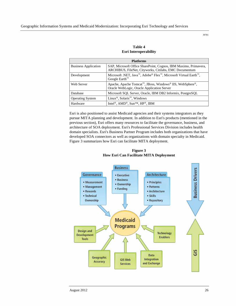
Esri Interoperability and SOA
Esri recognizes that data and software capabilities need to be available to a wide range of users in an organization, each of whom may access and use different business tools. The distributed nature of GIS has many implications for interoperability with respect to hardware environments, operating systems, data management, deployment of application logic (desktop, server, mobile, ESB), web services integration, openly documented application programming interfaces (APIs), and documented XML data schemas. Esri has addressed interoperability comprehensively by implementing a variety of standards, strategies, and techniques in ArcGIS. The chart below (table 4) briefly summarizes Esri interoperability regarding platforms such as business applications, development, web servers, databases, operating systems, and hardware.
Geographic Information Systems and Medicaid Modernization: Incorporating Esri Technology and Services
J9781
August 2012 26
Table 4 Esri Interoperability
Platforms
Business Application SAP, Microsoft Office SharePoint, Cognos, IBM Maximo, Primavera, ARCHIBUS, FileNet, Cityworks, Citilabs, EMC Documentum
Development Microsoft .NET, Java™, Adobe® Flex™, Microsoft Virtual Earth™, Google Earth™
Web Server Apache, Apache Tomcat™, JBoss, Windows® IIS, WebSphere®, Oracle WebLogic, Oracle Application Server
Database Microsoft SQL Server, Oracle, IBM DB2 Informix, PostgreSQL Operating System Linux®, Solaris™, Windows Hardware Intel®, AMD®, Sun™, HP®, IBM
Esri is also positioned to assist Medicaid agencies and their systems integrators as they pursue MITA planning and development. In addition to Esri's products (mentioned in the previous section), Esri offers many resources to facilitate the governance, business, and architecture of SOA deployment. Esri's Professional Services Division includes health domain specialists. Esri's Business Partner Program includes both organizations that have developed SOA connectors as well as organizations with domain specialty in Medicaid. Figure 3 summarizes how Esri can facilitate MITA deployment.
Figure 3 How Esri Can Facilitate MITA Deployment
Geographic Information Systems and Medicaid Modernization: Incorporating Esri Technology and Services
J9781
Esri White Paper 27
The Future of GIS and MITA
MITA Business Maturity Levels
As states use the MMM as a framework for assessing where they are and where they want to go with Medicaid business processes and IT, Esri stands ready to support them in determining how best to incorporate GIS capacities to support their work.
GIS in Future MMIS Research and
Development Projects
The complexities of the Medicaid program present many interesting opportunities for day-to-day business process improvement. The consistent stream of new data, combined with historical data, also provides a basis for continued spatial analysis research and development. Esri has an extensive user community—the Health and Human Services User Group (HUG). Many HUG members based in universities and research organizations are interested in partnering with entities such as Medicaid agencies for spatial analysis research and development projects. In addition, Esri has a history of partnering with organizations to collaborate on cutting-edge spatial analysis.
How to Get Started
Medicaid Agencies Esri's health team includes domain specialists who are prepared to have discussions with staff from Medicaid agencies regarding how GIS can support their programmatic goals. Contact an expert now. Staff of Medicaid agencies should also consider the following resources: ■ Subscribe to Esri News for Health and Human Services, a quarterly newsletter about
software news, events, and user stories affecting the health and human services GIS community.
■ Join Esri Health and Human Services User Group, an active community of more than
1,000 professionals dedicated to sharing information, ideas, and experiences about Esri technology in the health and human services industry.
■ Order GIS Tutorial for Health and other titles from Esri Press. ■ Attend the Esri Health GIS Conference or Esri International User Conference. ■ View health presentations from past Esri conferences. ■ View content from the Esri Virtual Campus. ■ Learn more about Esri Professional Services. ■ View ArcGIS for Server live user sites. ■ Download the ArcGIS for Server Functionality Matrix.
Geographic Information Systems and Medicaid Modernization: Incorporating Esri Technology and Services
J9781
August 2012 28
■ Download Esri white papers:
● ArcGIS for Server
● Geospatial Service-Oriented Architecture
● Developing and Deploying an Integrated Geoenabled SOA Business Solution: A Case Study
● Esri-Supported Open Geospatial Consortium, Inc., and ISO/TC 211 Standards
● System Design Strategies
● HL7 and Spatial Interoperability Standards for Public Health and Health Care
Delivery Another resource is the Esri Partner Network, which has more than 2,000 partners providing best-in-class GIS solutions. These Esri partners have built expertise around specific areas such as the following: ■ Web portals ■ Data warehouses ■ Fraud detection ■ Data mining ■ Integration kits with business intelligence/dashboard solutions ■ Medicaid and other HHS domain expertise
Systems Integrators and Developers
As indicated previously in this paper, Esri has an extensive array of software products and professional and technical services that can assist any prime contractor in fulfilling all GIS-related requirements of MMIS. Esri is prepared to provide all necessary documentation, including assigned staff and their resumés as well as reference sites, required by an RFP to address all GIS-related requirements and to provide specific pricing for both software and professional services. Contact Esri Professional Services for further information or assistance at esri.com. In addition to the white papers, demos, and other resources described above for staff of Medicaid agencies, systems integrators and developers should also consider the following: ■ Many people belong to the Esri Developer Network (EDNSM), a cost-effective way to
use and leverage ArcGIS products and technologies in applications and systems they design and build.
■ Many people attend the Esri Developer Summit, an opportunity for them to connect
with Esri staff and software developers from around the world to explore trends, tips, and best practices for effective GIS development.

J9781
Esri White Paper 29
Appendix A: Esri Solutions to Modernizing MMIS
ArcGIS for Desktop ArcGIS for Desktop is a powerful tool for the management, display, query, and analysis of spatial information. ArcGIS software's extensible architecture has enabled Esri to develop optional plug-in modules, dramatically extending the software's functional capabilities; for example, OLAP for ArcGIS, a free add-on, allows users of online analytical processing (OLAP) server technology to view their business data in the ArcGIS environment via read-only tables. ArcGIS links traditional data analysis tools, such as spreadsheets, databases, and business graphics, with maps for a completely integrated analysis system. By integrating an organization's data geographically with ArcGIS, new patterns can be uncovered and new insights gained. Several recent developments relevant to Medicaid include these: ■ Improved support for PDF documents (e.g., users can author a map document and
export it in PDF for wide distribution while passing along the ability for increased end-user interaction with the document beyond simple viewing)
■ A model-building tool that facilitates iterative modeling capabilities ■ Linked maps, graphs, charts, and scatterplots for the user to perform exploratory
spatial data analysis (ESDA) ■ A significant spatial statistics toolbox, featuring tools for spatial autocorrelation,
analyzing spatial patterns (i.e., clustering or dispersion), and assessing spatial distributions
ArcGIS for Server ArcGIS for Server connects people with geographic information via web applications and
services. Organizations use ArcGIS for Server to distribute maps and GIS capabilities over the web to improve internal workflows, communicate vital issues, and engage stakeholders. By providing key technologies and supporting interoperability with standards such as .NET 2.0, Enterprise JavaBeans, Web Services Interoperability Organization (WS-I)-compliant Web services, and Open Geospatial Consortium, Inc. (OGC), services out of the box, the ArcGIS for Server technology platform is ideally suited to SOA deployment in MITA. With ArcGIS for Server, Medicaid agencies can do the following: ■ Improve decisions and productivity with web mapping services and applications that
can be delivered to web, desktop, and mobile work forces ■ Leverage existing Medicaid IT architecture by integrating a GIS server and spatial
data with other enterprise systems, such as customer relationship management (CRM) or enterprise resource planning (ERP) systems

Geographic Information Systems and Medicaid Modernization: Incorporating Esri Technology and Services
J9781
August 2012 30
■ Rapidly meet specialized demand for focused Medicaid applications by mashing up geographic content with GIS functionality
■ Take control of Medicaid spatial data through centralized management of data,
applications, and services ■ Provide fast access to large volumes of imagery using image services, with the
option for dynamic mosaicking and on-the-fly processing, reducing storage costs and data processing overhead
ArcGIS Spatial
Analyst ArcGIS Spatial Analyst brings sophisticated raster and vector data analysis to the desktop. It seamlessly integrates raster-based spatial analysis with ArcGIS for Desktop software's vector-based mapping and analysis. This powerful combination brings unprecedented power for mapping, visualization, modeling, and analysis to Medicaid organizations in an affordable desktop package. ArcGIS Spatial Analyst provides the tools needed to support a broad range of spatial modeling and application requirements. With ArcGIS Spatial Analyst, a Medicaid organization can perform capability, sensitivity, predictive, and site suitability modeling; site location analysis; demographic analysis; and much more.
ArcGIS Network Analyst
This powerful extension provides network-based spatial analysis including routing, travel directions, closest facility, and service area analysis. ArcGIS Network Analyst enables users to dynamically model realistic network conditions, including turn restrictions, speed limits, height restrictions, and traffic conditions, at different times of the day. With ArcGIS Network Analyst, Medicaid agencies can conduct the following analyses: ■ Drive-time analysis ■ Point-to-point routing ■ Route directions ■ Service area definition ■ Shortest path ■ Optimum route ■ Closest facility ■ Origin-destination analysis
ArcLogistics ArcLogistics™ is a complete desktop solution for creating optimized routes and solving scheduling problems. Create dynamic routes and schedules that cut fuel costs and improve customer service using ArcLogistics. From a small fleet operation to a large multiuser environment, ArcLogistics provides a quick and significant return on investment. With ArcLogistics, Medicaid agencies can do the following: ■ Create routes and schedules in less time ■ Meet commitments and improve service ■ Save money, use less fuel, and reduce emissions
Geographic Information Systems and Medicaid Modernization: Incorporating Esri Technology and Services
J9781
Esri White Paper 31
Esri Business Analyst and Esri Business Analyst
Server
Esri Business Analyst combines Esri's leading GIS technology with extensive business, demographic, and consumer data. By combining information such as sales data, demographics, and competitor locations with census boundaries, territories, and store locations, Esri Business Analyst helps Medicaid agencies better understand their markets and their beneficiaries. Esri Business Analyst is available with US or Canadian data. With Esri Business Analyst, Medicaid agencies can do the following: ■ Choose the ideal location to offer programs and services ■ Target underserved markets ■ Perform site and trade area analysis ■ Customize and automate frequently used analyses ■ Develop and share reports with demographic, consumer, and business data or their
own Medicaid data ■ Discover cross-marketing opportunities ■ Build interactive forecast and market share models based on the Huff model For a complete enterprise solution, the desktop version of Esri Business Analyst may be combined with Esri Business Analyst Server.
Esri Data Esri's business, consumer spending, and demographic data encompasses a wide variety of datasets that helps agencies, companies, and organizations analyze markets, profile customers, evaluate competitors, and more. Esri data is available as part of Esri Business Analyst, Esri Business Analyst Server, or Esri Business Analyst OnlineSM or as individual databases. Medicaid agencies can use Esri data to do the following: ■ Analyze and describe a community or service area ■ Identify new sites for facilities or programs ■ Evaluate competitor sites ■ Profile customers and constituents ■ Forecast demand for products and services
Developer Tools Esri also offers a number of developer tools, which are described in the Systems Integrators and Developers section. For a full list of Esri products, visit esri.com/products.
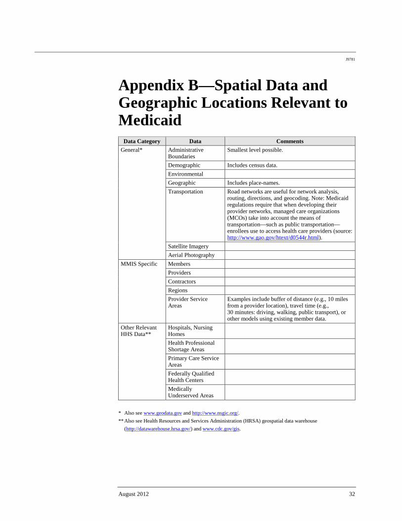
J9781
August 2012 32
Appendix B—Spatial Data and Geographic Locations Relevant to Medicaid
Data Category Data Comments General* Administrative
Boundaries Smallest level possible.
Demographic Includes census data. Environmental Geographic Includes place-names. Transportation Road networks are useful for network analysis,
routing, directions, and geocoding. Note: Medicaid regulations require that when developing their provider networks, managed care organizations (MCOs) take into account the means of transportation—such as public transportation—enrollees use to access health care providers (source: http://www.gao.gov/htext/d0544r.html).
Satellite Imagery Aerial Photography
MMIS Specific Members Providers Contractors Regions Provider Service Areas
Examples include buffer of distance (e.g., 10 miles from a provider location), travel time (e.g., 30 minutes: driving, walking, public transport), or other models using existing member data.
Other Relevant HHS Data**
Hospitals, Nursing Homes
Health Professional Shortage Areas
Primary Care Service Areas
Federally Qualified Health Centers
Medically Underserved Areas
* Also see www.geodata.gov and http://www.nsgic.org/. ** Also see Health Resources and Services Administration (HRSA) geospatial data warehouse
(http://datawarehouse.hrsa.gov/) and www.cdc.gov/gis.

Printed in USA
Contact Esri
380 New York Street Redlands, California 92373-8100 usa
1 800 447 9778 t 909 793 2853 f 909 793 5953 [email protected] esri.com
Offices worldwide esri.com/locations
Esri inspires and enables people to positively impact their future through a deeper, geographic understanding of the changing world around them.
Governments, industry leaders, academics, and nongovernmental
organizations trust us to connect them with the analytic knowledge
they need to make the critical decisions that shape the planet. For
more than 40 years, Esri has cultivated collaborative relationships
with partners who share our commitment to solving earth’s most
pressing challenges with geographic expertise and rational resolve.
Today, we believe that geography is at the heart of a more resilient
and sustainable future. Creating responsible products and solutions
drives our passion for improving quality of life everywhere.