Development of a Geographic Framework for an Integrated Flood Modeling System
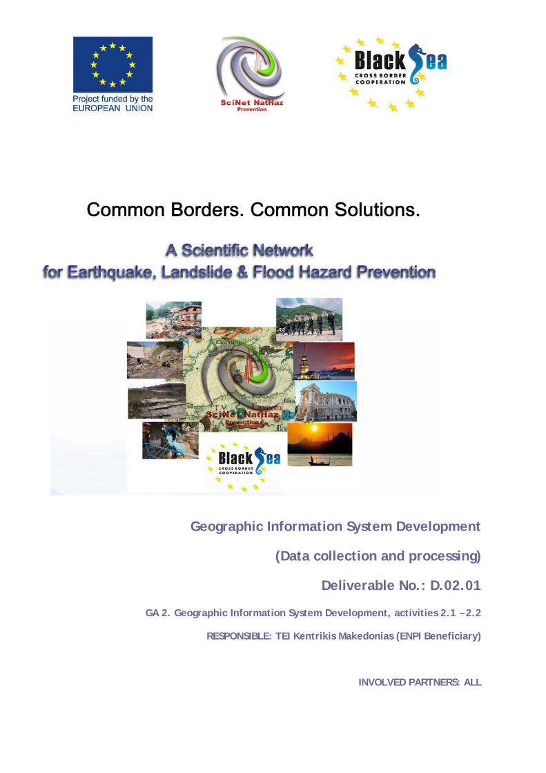
Geographic Information System Development
(Data collection and processing)
Deliverable No.: D.02.01
GA 2. Geographic Information System Development, activities 2.1 – 2.2
RESPONSIBLE: TEI Kentrikis Makedonias (ENPI Beneficiary)
INVOLVED PARTNERS: ALL
Black Sea JOP, “SCInet NatHaz” Data collection and processing
Deliverable-No. D.02.01 Final VersionIssue: I.07 Date: 31st January 2014 Page: 2 of 28
Project Details
Programme
Black Sea JOP
Priority and Measure
Priority 2 (Sharing resources and
competencies for environmental
protection and conservation), Measure
2.1. (Strengthening the joint knowledge
and information base needed to address
common challenges in the environmental
protection of river and maritime systems)
Objective
Development of a Scientific Network
Project Title
A Scientific Network for Earthquake,
Landslide and Flood Hazard Prevention
Project Acronym
SCInet NatHaz
Contract No
MIS-ETC 2614
Black Sea JOP, “SCInet NatHaz” Data collection and processing
Deliverable-No. D.02.01 Final VersionIssue: I.07 Date: 31st January 2014 Page: 3 of 28
Lead Partner TEI OF KENTRIKI MAKEDONIA, GREECE
Total Budget
700.000,00 Euro (€)
Time Frame
Start Date – End Date
01/05/2013 – 30/04/2015
Book Captain: K. PAPATHEODOROU (TEI KENTRIKIS MAKEDONIAS)
Contributing
Authors:
K. Papatheodorou, K. Ntouros, A. Tzanou, N. Klimis, S.
Skias, H. Aksoy, O. Kirca, G. Celik, B. Margaris, N.
Theodoulidis, A. Sidorenko, O. Bogdevich, K. Stepanova, O.
Rubel, N. Fedoronchuk, L. Tofan, M.J. Adler, Z. Prefac, V.
Nenov, H. Yermendjiev, A. Ansal, G. Tonuk, M. Demorcioglou
Black Sea JOP, “SCInet NatHaz” Data collection and processing
Deliverable-No. D.02.01 Final VersionIssue: I.07 Date: 31st January 2014 Page: 4 of 28
Document Release Sheet
Book captain: K. PAPATHEODOROU (TEI
KENTRIKIS MAKEDONIAS)
Sign Date
31.01.2014
Approval K. PAPATHEODOROU (TEI
KENTRIKIS MAKEDONIAS)
Sign Date
31.01.2014
Approval ATTILA ANSAL
(KOERI/BOGAZICI UNIVERSI)
Sign Date
31.01.2014
Approval N. KLIMIS (DEMOCRITUS
UNIVERSITY of THRAKI)
Sign Date
31.01.2014
Approval B. MARGARIS (EPPO/ITSAK) Sign Date
31.01.2014
Approval V. NENOV (“ASSEN ZLATAROV”
UNIVERSITY)
Sign Date
31.01.2014
Approval L. TOFAN (“OVIDIUS”
UNIVERSITY)
Sign Date
31.01.2014
Approval A. SIDORENKO (“Dr. GHITU”
INSTITUTE ACAD. of SCIENCES
Sign Date
31.01.2014
Approval K. STEPANOVA (BSB UEAS) Sign Date
31.01.2014
Endorsement: Sign Date
Distribution: ALL PARTNERS
Black Sea JOP, “SCInet NatHaz” Data collection and processing
Deliverable-No. D.02.01 Final VersionIssue: I.07 Date: 31st January 2014 Page: 5 of 28
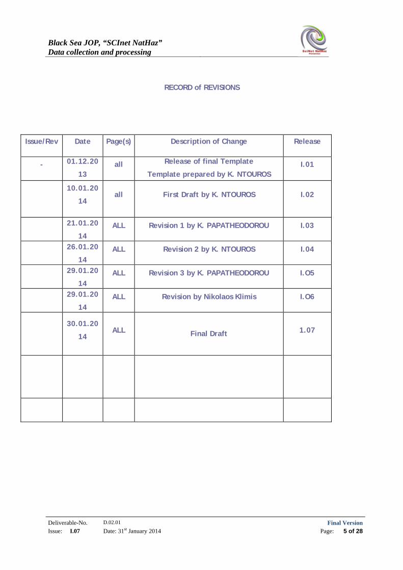
RECORD of REVISIONS
Issue/Rev Date Page(s) Description of Change Release
- 01.12.20
13 all Release of final Template
Template prepared by K. NTOUROS I.01
10.01.20
14 all First Draft by K. NTOUROS I.02
21.01.20
14 ALL Revision 1 by K. PAPATHEODOROU I.03
26.01.20
14 ALL Revision 2 by K. NTOUROS I.04
29.01.20
14 ALL Revision 3 by K. PAPATHEODOROU I.O5
29.01.20
14 ALL Revision by Nikolaos Klimis I.O6
30.01.20
14 ALL Final Draft 1.07
Black Sea JOP, “SCInet NatHaz” Data collection and processing
Deliverable-No. D.02.01 Final VersionIssue: I.07 Date: 31st January 2014 Page: 6 of 28
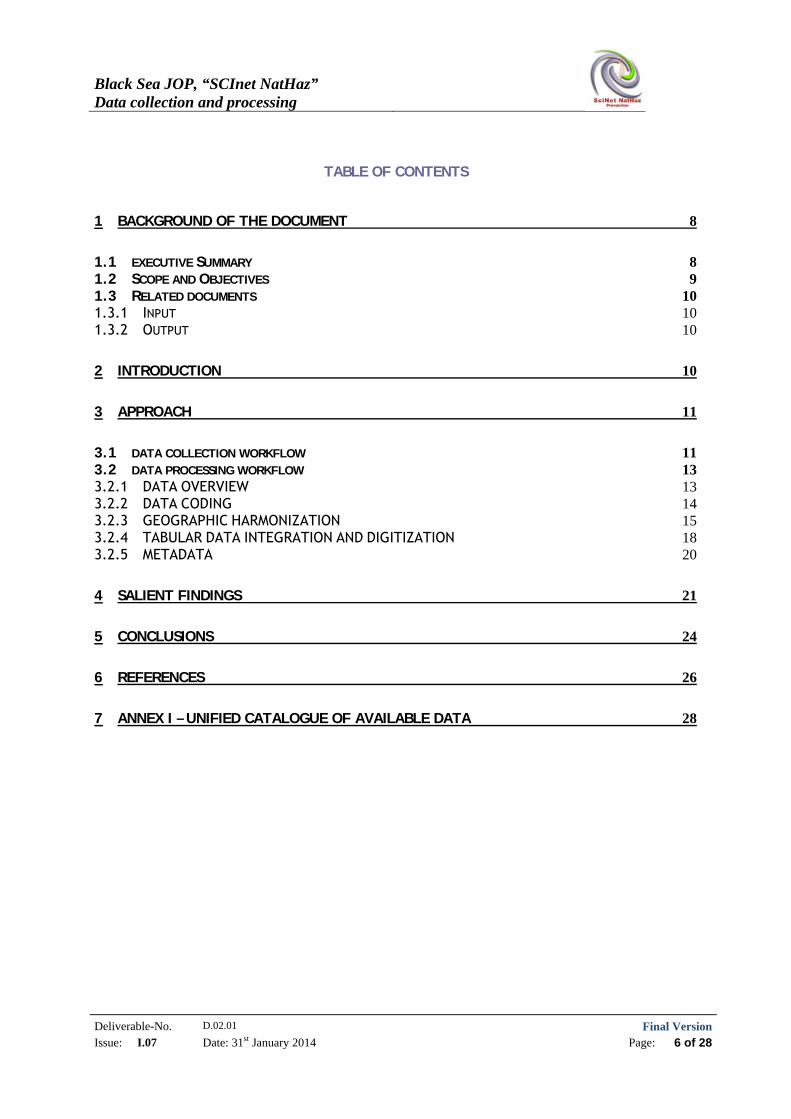
TABLE OF CONTENTS
1 BACKGROUND OF THE DOCUMENT 8
1.1 EXECUTIVE SUMMARY 8 1.2 SCOPE AND OBJECTIVES 9 1.3 RELATED DOCUMENTS 10 1.3.1 INPUT 10 1.3.2 OUTPUT 10
2 INTRODUCTION 10
3 APPROACH 11
3.1 DATA COLLECTION WORKFLOW 11 3.2 DATA PROCESSING WORKFLOW 13 3.2.1 DATA OVERVIEW 13 3.2.2 DATA CODING 14 3.2.3 GEOGRAPHIC HARMONIZATION 15 3.2.4 TABULAR DATA INTEGRATION AND DIGITIZATION 18 3.2.5 METADATA 20
4 SALIENT FINDINGS 21
5 CONCLUSIONS 24
6 REFERENCES 26
7 ANNEX I – UNIFIED CATALOGUE OF AVAILABLE DATA 28
Black Sea JOP, “SCInet NatHaz” Data collection and processing
Deliverable-No. D.02.01 Final VersionIssue: I.07 Date: 31st January 2014 Page: 7 of 28
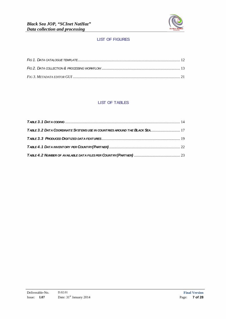
LIST OF FIGURES
FIG 1. DATA CATALOGUE TEMPLATE ........................................................................................................... 12
FIG 2. DATA COLLECTION & PROCESSING WORKFLOW .................................................................................. 13
FIG 3. METADATA EDITOR GUI ................................................................................................................ 21
LIST OF TABLES
TABLE 3.1 DATA CODING ........................................................................................................................ 14
TABLE 3.2 DATA COORDINATE SYSTEMS USE IN COUNTRIES AROUND THE BLACK SEA ............................... 17
TABLE 3.3 PRODUCED DIGITIZED DATA FEATURES .................................................................................. 19
TABLE 4.1 DATA INVENTORY PER COUNTRY(PARTNER) .......................................................................... 22
TABLE 4.2 NUMBER OF AVAILABLE DATA FILES PER COUNTRY(PARTNER) ................................................ 23
Black Sea JOP, “SCInet NatHaz” Data collection and processing
Deliverable-No. D.02.01 Final VersionIssue: I.07 Date: 31st January 2014 Page: 8 of 28
1 BACKGROUND OF THE DOCUMENT
1.1 EXECUTIVE SUMMARY
Earthquakes, Landslides and Floods (ELF) pose a serious threat to human life, property and
infrastructure and cause heavy damage each year stalling sustainable development. The
problem gets more serious with time, due to the continuous development and expansion of
land uses even in hazard prone areas [3],[5].
A large number of actions have already been taken by the EU regarding hazard mitigation
including legislation, the formation of various bodies, the establishment of organizations
and funding instruments. The current trend to ELF hazard mitigation suggests an
integrated approach where all the natural hazard mitigation stages –prevention,
preparedness, response and recovery- are considered, with focusing on the first stage:
Prevention! [2],[4],[6],[7]. Hazard Prevention as a process, requires an as accurate as
possible ELF hazard identification and that in turn requires scientifically sound
methodologies and accurate and reliable data [8],[9].
At this point, the major problem regarding Earthquake, Landslide and Flood hazards
identification in the European Union is related to information gaps [1], [8], [9]. Required
data in appropriate scales are either obsolete or inaccessible and even when they can be
found, metadata are missing so it is difficult to assess their accuracy and reliability. Having
said that, reliable information is indispensable for decision making at all levels including
planning effective preventive measures.
One of the basic targets of the SciNetNatHaz project is the collection, harmonization,
coding and free/open access of data related to ELF hazards. Data, during the project’s
implementation are going to be collected in two phases: a preliminary one; and the final
one following the selection of methodologies to be used for each of the ELF hazards
assessment in pilot implementation areas.
The ScinetNat-Haz project’s second Group of Actions (GA.2), includes activities aiming at
data collection and the necessary data processing in order to harmonize the data
collected. Data requirements are defined at large by the methodological approaches to be
used for ELF hazard assessment in pilot implementation areas in various countries so, the
data harmonization procedures foreseen, are absolutely necessary. At a later stage, the
harmonized data will populate a Geo-database built into a Geographic Information System.
At the final stage, all data and results produced will be published through a Web GIS
platform. As ownership issues may arise considering data sharing over the WebGIS platform
Black Sea JOP, “SCInet NatHaz” Data collection and processing
Deliverable-No. D.02.01 Final VersionIssue: I.07 Date: 31st January 2014 Page: 9 of 28
which is being developed, it has been decided to provide free/open access only to the
processing results as soon as they become available and not to the raw data, except from
the cases where written permissions are given by the data owners.
At this preliminary phase, basic data including topographic and geologic maps, hydrologic
and meteorological data as well as additional information regarding past earthquake,
landslide and flood events were collected from various sources from all the participating
countries. Data were classified according to their theme, processed, harmonized, coded
and prepared for further use. Metadata were also created according to the INSPIRE
provisions using the online INSPIRE template.
This document provides brief information about the procedures followed and the processes
carried out to prepare data for further use in the project.
The overview of the whole procedure followed and its outcomes reveals various aspects in
respect to i) data availability and access; ii) data required processing; iii) spatial
characteristics of data.
1.2 SCOPE AND OBJECTIVES
The project’s implementation requires the selection of methodologies to be used for each
of the natural hazards investigated. As the methodological approach is closely related to
data requirements, the data collection is a dynamic process changing over time until the
hazard assessment methodology to be applied is finally selected (fig.1).
Having said that, there is a multitude of data types always required when considering ELF
hazard assessment; no matter which the implemented methodology is going to be. These
data types describe and are related to: topography, geomorphology, geology, hydrology,
climate, history (past events), to mention a few.
In that respect, an effort has been made to collect such data in order to form a geographic
database (Geo-Database) which will provide the background of the applied research which
will follow.
Within this context, topographic, geologic, hydrologic and various types of thematic maps
were collected from each partner for his respective country, both in analogue and in
digital format. Additional data such as satellite images and ASTER DEMs were also
downloaded from the respective web sites.
Black Sea JOP, “SCInet NatHaz” Data collection and processing
Deliverable-No. D.02.01 Final VersionIssue: I.07 Date: 31st January 2014 Page: 10 of 28
Data were evaluated for their reliability in order to be used within the scopes of the
project and those who failed the evaluation were rejected. Data which had a positive
evaluation were forwarded for further processing which included all stages of the
harmonization process: geo-referencing, spatial adjustments, reference system
transformation, coding and metadata creation according to the INSPIRE provisions.
Metadata creation is an absolute necessity for data which are going to be distributed
(open/freely accessed) because they provide valuable information necessary for their
evaluation.
1.3 RELATED DOCUMENTS
1.3.1 Input
List of former deliverables acting as inputs to this document
Document ID Descriptor
D.1.01 Current status assessment / legislation and bibliography review
1.3.2 Output
List of other deliverables for which this document is an input.
Document ID Descriptor
D.2.02 Geodatabase development
D.2.03 WebGIS Development / Update and completion of geodatabase
D.3.01 Results from seismic, landslide and flood hazard assessment coming from regional implementation of adopted methodologies
D.3.02 The final report: Recapitulation of the main results from progress reports. It will also focus on results from local scale assessment of the examined hazards and the suggestion of preventive measures
2 INTRODUCTION
This document summarizes the flow and procedures used for the data mining (search and
acquisition) as well as the data processing.
Black Sea JOP, “SCInet NatHaz” Data collection and processing
Deliverable-No. D.02.01 Final VersionIssue: I.07 Date: 31st January 2014 Page: 11 of 28
As already mentioned this is the initial phase of data collection and processing, since at a
later stage, data requirements issues may arise, as methodologies to be implemented, will
be finally selected. Data updating has been foreseen in GA.2>A.2.5 during the geo-
database development (activity 2.5). According to that, basic types of data needed for any
case when assessing ELF hazards were collected. The implementation of GA.1: Activities
1.4-1.6 provided an overview of the data requirements. The Geo-Database update will be
based on upcoming activities (GA1: Activities 1.7 – 1.13) and on field data and
measurements during the pilot implementation phase.
3 APPROACH
According to the results of activities (A.1.4–A.1.6), the types of data required include:
Topographic data (maps on 1:50,000 scale)
Geologic data (maps on scale 1:50,000)
Meteorological data
Hydrological data (hydrologic networks including watersheds)
Land Use/ Land Cover data
Seismological/Earthquake Hazard related data
Landslide events (landslide inventory, including all available relative data)
Flood events (Flood event inventory, including all available relative data)
Infrastructure data (road network, urban areas, rail networks, firestations, hospitals etc.)
The procedure followed for the data collection and processing is described in the following
chapter.
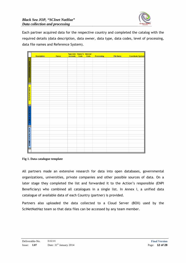
3.1 DATA COLLECTION WORKFLOW
For the data collection, a common template (Excel-file) (fig 1) was created and distributed
to all partners for consistency reasons. The catalog to be created included essential
information regarding the data mined.
Black Sea JOP, “SCInet NatHaz” Data collection and processing
Deliverable-No. D.02.01 Final VersionIssue: I.07 Date: 31st January 2014 Page: 12 of 28
Each partner acquired data for the respective country and completed the catalog with the
required details (data description, data owner, data type, data codes, level of processing,
data file names and Reference System).
Fig 1. Data catalogue template
All partners made an extensive research for data into open databases, governmental
organizations, universities, private companies and other possible sources of data. On a
later stage they completed the list and forwarded it to the Action’s responsible (ENPI
Beneficiary) who combined all catalogues in a single list. In Annex I, a unified data
catalogue of available data of each Country (partner) is provided.
Partners also uploaded the data collected to a Cloud Server (BOX) used by the
SciNetNatHaz team so that data files can be accessed by any team member.
Black Sea JOP, “SCInet NatHaz” Data collection and processing
Deliverable-No. D.02.01 Final VersionIssue: I.07 Date: 31st January 2014 Page: 13 of 28
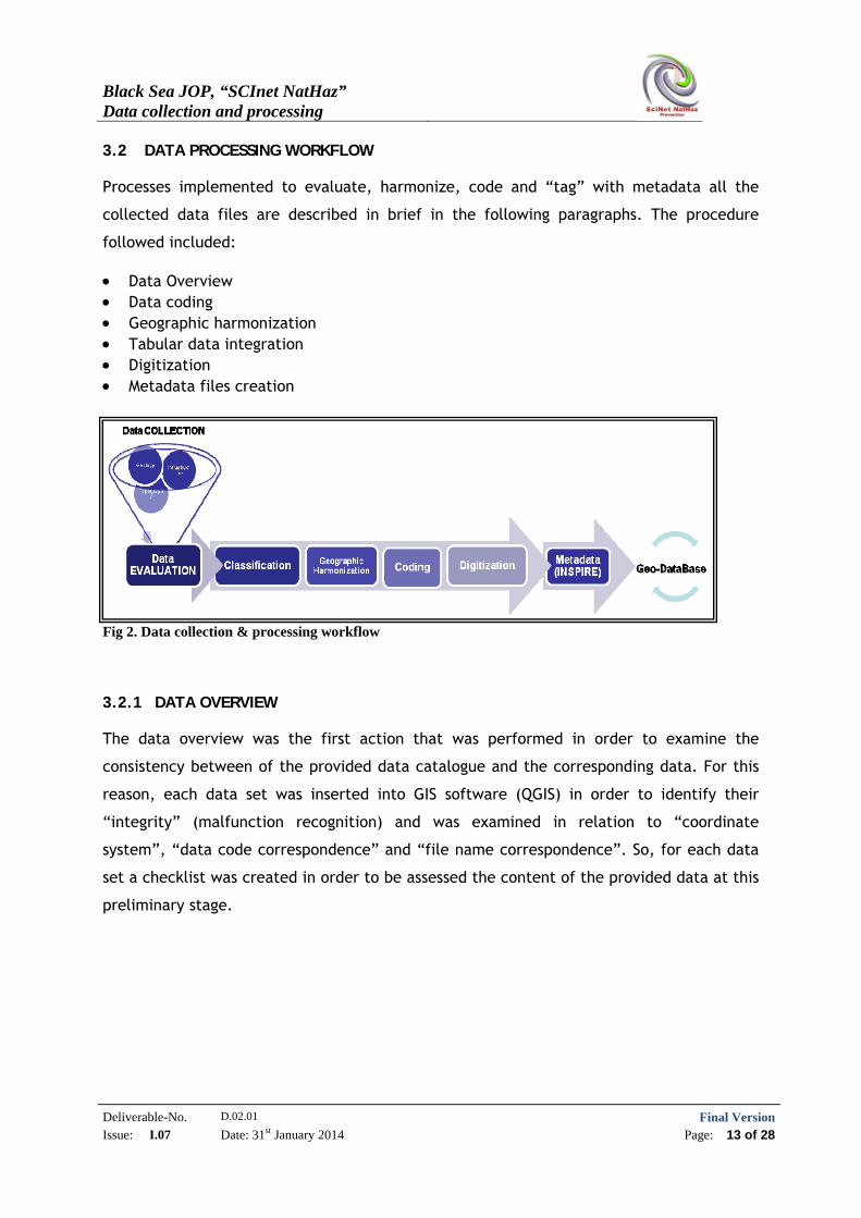
3.2 DATA PROCESSING WORKFLOW
Processes implemented to evaluate, harmonize, code and “tag” with metadata all the
collected data files are described in brief in the following paragraphs. The procedure
followed included:
Data Overview Data coding Geographic harmonization Tabular data integration Digitization Metadata files creation
Fig 2. Data collection & processing workflow
3.2.1 DATA OVERVIEW
The data overview was the first action that was performed in order to examine the
consistency between of the provided data catalogue and the corresponding data. For this
reason, each data set was inserted into GIS software (QGIS) in order to identify their
“integrity” (malfunction recognition) and was examined in relation to “coordinate
system”, “data code correspondence” and “file name correspondence”. So, for each data
set a checklist was created in order to be assessed the content of the provided data at this
preliminary stage.
Black Sea JOP, “SCInet NatHaz” Data collection and processing
Deliverable-No. D.02.01 Final VersionIssue: I.07 Date: 31st January 2014 Page: 14 of 28
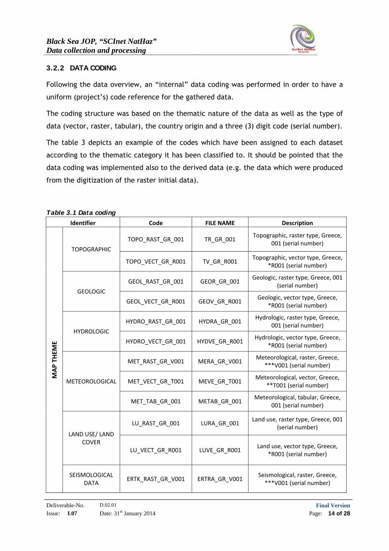
3.2.2 DATA CODING
Following the data overview, an “internal” data coding was performed in order to have a
uniform (project’s) code reference for the gathered data.
The coding structure was based on the thematic nature of the data as well as the type of
data (vector, raster, tabular), the country origin and a three (3) digit code (serial number).
The table 3 depicts an example of the codes which have been assigned to each dataset
according to the thematic category it has been classified to. It should be pointed that the
data coding was implemented also to the derived data (e.g. the data which were produced
from the digitization of the raster initial data).
Table 3.1 Data coding
Identifier Code FILE NAME Description
MAP THEM
E
TOPOGRAPHIC
TOPO_RAST_GR_001 TR_GR_001 Topographic, raster type, Greece,
001 (serial number)
TOPO_VECT_GR_R001 TV_GR_R001 Topographic, vector type, Greece,
*R001 (serial number)
GEOLOGIC
GEOL_RAST_GR_001 GEOR_GR_001 Geologic, raster type, Greece, 001
(serial number)
GEOL_VECT_GR_R001 GEOV_GR_R001 Geologic, vector type, Greece,
*R001 (serial number)
HYDROLOGIC
HYDRO_RAST_GR_001 HYDRA_GR_001 Hydrologic, raster type, Greece,
001 (serial number)
HYDRO_VECT_GR_001 HYDVE_GR_R001 Hydrologic, vector type, Greece,
*R001 (serial number)
METEOROLOGICAL
MET_RAST_GR_V001 MERA_GR_V001 Meteorological, raster, Greece,
***V001 (serial number)
MET_VECT_GR_T001 MEVE_GR_T001 Meteorological, vector, Greece,
**T001 (serial number)
MET_TAB_GR_001 METAB_GR_001 Meteorological, tabular, Greece,
001 (serial number)
LAND USE/ LAND COVER
LU_RAST_GR_001 LURA_GR_001 Land use, raster type, Greece, 001
(serial number)
LU_VECT_GR_R001 LUVE_GR_R001 Land use, vector type, Greece,
*R001 (serial number)
SEISMOLOGICAL DATA
ERTK_RAST_GR_V001 ERTRA_GR_V001 Seismological, raster, Greece, ***V001 (serial number)
Black Sea JOP, “SCInet NatHaz” Data collection and processing
Deliverable-No. D.02.01 Final VersionIssue: I.07 Date: 31st January 2014 Page: 15 of 28
ERTK_VECT_GR_T001 ERTVE_GR_T001 Seismological, vector, Greece,
**T001 (serial number)
ERTK_TAB_GR_001 ERTAB_GR_001 Seismological, tabular, Greece,
001 (serial number)
LANDSLIDES PAST EVENTS DATA
LANDS_RAST_GR_V001 LARA_GR_V001 Landslides, raster, Greece, ***V001 (serial number)
LANDS_VECT_GR_T001 LAVE_GR_T001 Landslides, vector, Greece, **T001 (serial number)
LANDS_TAB_GR_001 LATAB_GR_001 Landslides, tabular, Greece, 001
(serial number)
FLOODS PAST EVENTS DATA
FLOD_RAST_GR_V001 FLORA_GR_V001 Floods, raster, Greece, ***V001
(serial number)
FLOD_VECT_GR_T001 FLOVE_GR_T001 Floods, vector, Greece, **T001
(serial number)
FLOD_TAB_GR_001 FLOTAB_GR_001 Floods, tabular, Greece, 001
(serial number)
INFRASTRUCTURE (ROADS,
RAILWAYS, URBAN AREAS)
INFRA_RAST_GR_001 INFRA_GR_001 Infrastucture, raster type, Greece,
001 (serial number)
INFRA_VECT_GR_R001 INFVE_GR_R001 Infrastucture, vector type,
Greece, *R001 (serial number)
* R: denotes that the dataset is derived from the digitization of the Raster (001)
** T: denotes that the dataset is derived from the processing of the tabular data (001)
*** V: denotes that the dataset is derived from the processing of the vector dataset (001)
3.2.3 GEOGRAPHIC HARMONIZATION
The first step of the data harmonization process is the geographic harmonization. Purpose
of this process is to transform data collected from various sources from various countries,
having different Coordinate Reference Systems (CRS), to a single CRS in order to be
available for further evaluation, processing, fusion etc. Almost each European country
records data and produces maps following its own-different than any other-CRS. It is
therefore evident that for practical reasons, all available data should be transformed and
geo-referenced into a common coordinate system. The selected reference system is the
World Geodetic System - WGS84 (Geographic Coordinates), which provides the ability to
work on large areas with harmonized data and at the same time, when necessary, it can be
transformed to local reference systems with minimal distortion. Moreover, the specific CRS
Black Sea JOP, “SCInet NatHaz” Data collection and processing
Deliverable-No. D.02.01 Final VersionIssue: I.07 Date: 31st January 2014 Page: 16 of 28
is closely related to GPS positioning applications, so maps created using it, have an, as
accurate as possible, positioning indication when using a GPS. The WGS84 reference system
is consistent with the International Terrestrial Reference Frame (ITRF) with minimal
difference between them (around 1cm worldwide).
The WGS 84 is in fact an Earth global reference system. It includes an Earth model defined
by a set of parameters. Primary parameters define the shape of the Earth (ellipsoid) and
the secondary ones describe a detailed gravity model on the Earth’s surface.
There is an ongoing effort made by the EU to adapt to a “local”-pan-European reference
system based on WGS84, evident by the Programme EPIC (European Programme for the
Implementation of a Common geodetic reference frame) set up in 1991 and having
biannual meetings. Geo-referenced to WGS84 data, can be re-transformed to any other
CRS including the pan-European data Reference System EVRF2007 [16], [17] whenever it
will be adopted by the majority of EU countries, including most of the involved in the
project ones.
Transformation of National CRS and datums to geographic coordinates of the WGS84 is
based on mapping equations used to transform coordinate data from source projection
coordinates (x,y) of the respective National geodetic Reference System (GRS) to
geographic coordinates (φ, λ) of the WGS84. The transformation always incorporates an
error to transformed coordinates but at the scale of a respective implementation covering
very large areas, this error can be ignored.
Almost all commercial and Open source GIS software incorporates the ability to transform
data from various sources and CRS. For consistency among partners and practical reasons,
the open source software Quantum GIS was selected for the procedure
(http://www.qgis.org/en/site/about/index.html).
A brief overview of it’s abilities to transform data into various CRS is given here:
http://www.ga.gov.au/webtemp/image_cache/GA20953.pdf
As already mentioned, the data CRS transformation was implemented with the use of
“QGIS” software and the provided automated “reproject-warp” tool. The transformation
process was performed to both raster and vector data.
Black Sea JOP, “SCInet NatHaz” Data collection and processing
Deliverable-No. D.02.01 Final VersionIssue: I.07 Date: 31st January 2014 Page: 17 of 28
It must be noted that, even tabular data can be transformed by following the steps: i)
input tabular data into a Geographic Information System; ii) conversion to a shapefile
(vector file containing both the points and their attributes; iii) transformation (and/or
spatial adjustment) of the shapefile. At the end of this procedure, the coordinates in the
resulting file are transformed into the new CRS.
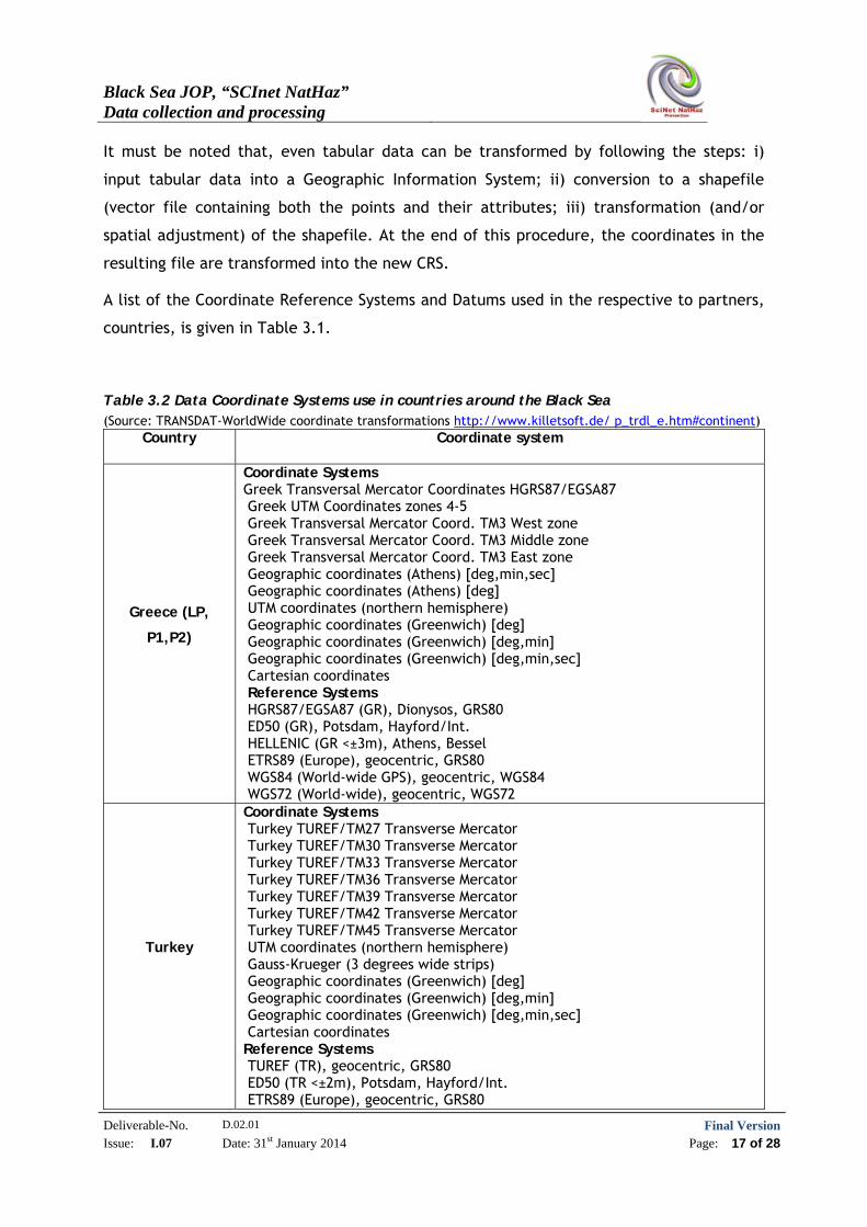
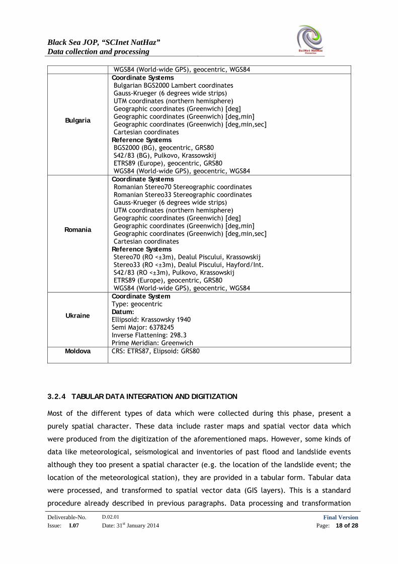
A list of the Coordinate Reference Systems and Datums used in the respective to partners,
countries, is given in Table 3.1.
Table 3.2 Data Coordinate Systems use in countries around the Black Sea (Source: TRANSDAT-WorldWide coordinate transformations http://www.killetsoft.de/ p_trdl_e.htm#continent)
Country Coordinate system
Greece (LP,
P1,P2)
Coordinate Systems Greek Transversal Mercator Coordinates HGRS87/EGSA87 Greek UTM Coordinates zones 4-5 Greek Transversal Mercator Coord. TM3 West zone Greek Transversal Mercator Coord. TM3 Middle zone Greek Transversal Mercator Coord. TM3 East zone Geographic coordinates (Athens) [deg,min,sec] Geographic coordinates (Athens) [deg] UTM coordinates (northern hemisphere) Geographic coordinates (Greenwich) [deg] Geographic coordinates (Greenwich) [deg,min] Geographic coordinates (Greenwich) [deg,min,sec] Cartesian coordinates Reference Systems HGRS87/EGSA87 (GR), Dionysos, GRS80 ED50 (GR), Potsdam, Hayford/Int. HELLENIC (GR <±3m), Athens, Bessel ETRS89 (Europe), geocentric, GRS80 WGS84 (World-wide GPS), geocentric, WGS84 WGS72 (World-wide), geocentric, WGS72
Turkey
Coordinate Systems Turkey TUREF/TM27 Transverse Mercator Turkey TUREF/TM30 Transverse Mercator Turkey TUREF/TM33 Transverse Mercator Turkey TUREF/TM36 Transverse Mercator Turkey TUREF/TM39 Transverse Mercator Turkey TUREF/TM42 Transverse Mercator Turkey TUREF/TM45 Transverse Mercator UTM coordinates (northern hemisphere) Gauss-Krueger (3 degrees wide strips) Geographic coordinates (Greenwich) [deg] Geographic coordinates (Greenwich) [deg,min] Geographic coordinates (Greenwich) [deg,min,sec] Cartesian coordinates Reference Systems TUREF (TR), geocentric, GRS80 ED50 (TR <±2m), Potsdam, Hayford/Int. ETRS89 (Europe), geocentric, GRS80
Black Sea JOP, “SCInet NatHaz” Data collection and processing
Deliverable-No. D.02.01 Final VersionIssue: I.07 Date: 31st January 2014 Page: 18 of 28
WGS84 (World-wide GPS), geocentric, WGS84
Bulgaria
Coordinate Systems Bulgarian BGS2000 Lambert coordinates Gauss-Krueger (6 degrees wide strips) UTM coordinates (northern hemisphere) Geographic coordinates (Greenwich) [deg] Geographic coordinates (Greenwich) [deg,min] Geographic coordinates (Greenwich) [deg,min,sec] Cartesian coordinates Reference Systems BGS2000 (BG), geocentric, GRS80 S42/83 (BG), Pulkovo, Krassowskij ETRS89 (Europe), geocentric, GRS80 WGS84 (World-wide GPS), geocentric, WGS84
Romania
Coordinate Systems Romanian Stereo70 Stereographic coordinates Romanian Stereo33 Stereographic coordinates Gauss-Krueger (6 degrees wide strips) UTM coordinates (northern hemisphere) Geographic coordinates (Greenwich) [deg] Geographic coordinates (Greenwich) [deg,min] Geographic coordinates (Greenwich) [deg,min,sec] Cartesian coordinates Reference Systems Stereo70 (RO <±3m), Dealul Piscului, Krassowskij Stereo33 (RO <±3m), Dealul Piscului, Hayford/Int. S42/83 (RO <±3m), Pulkovo, Krassowskij ETRS89 (Europe), geocentric, GRS80 WGS84 (World-wide GPS), geocentric, WGS84
Ukraine
Coordinate System Type: geocentric Datum: Ellipsoid: Krassowsky 1940 Semi Major: 6378245 Inverse Flattening: 298.3 Prime Meridian: Greenwich
Moldova CRS: ETRS87, Elipsoid: GRS80
3.2.4 TABULAR DATA INTEGRATION AND DIGITIZATION
Most of the different types of data which were collected during this phase, present a
purely spatial character. These data include raster maps and spatial vector data which
were produced from the digitization of the aforementioned maps. However, some kinds of
data like meteorological, seismological and inventories of past flood and landslide events
although they too present a spatial character (e.g. the location of the landslide event; the
location of the meteorological station), they are provided in a tabular form. Tabular data
were processed, and transformed to spatial vector data (GIS layers). This is a standard
procedure already described in previous paragraphs. Data processing and transformation
Black Sea JOP, “SCInet NatHaz” Data collection and processing
Deliverable-No. D.02.01 Final VersionIssue: I.07 Date: 31st January 2014 Page: 19 of 28
into spatial information layers provides the ability to combine and incorporate these
datasets into spatial databases which could be used for the development of a Geographic
Information System (GIS). Data can then be used to produce additional spatial information,
using advanced GIS procedures like interpolation methods, spatial statistics, morphometry
models etc.
The digitization process followed standard procedures where all related parameters and
especially errors incorporated during the processing stages, were assessed.
Data processing and digitization are time and effort consuming procedures so they were
limited to cover areas of “interest”; where such types of data are necessary for the
project implementation, namely the wider areas which were selected for the “pilot” case
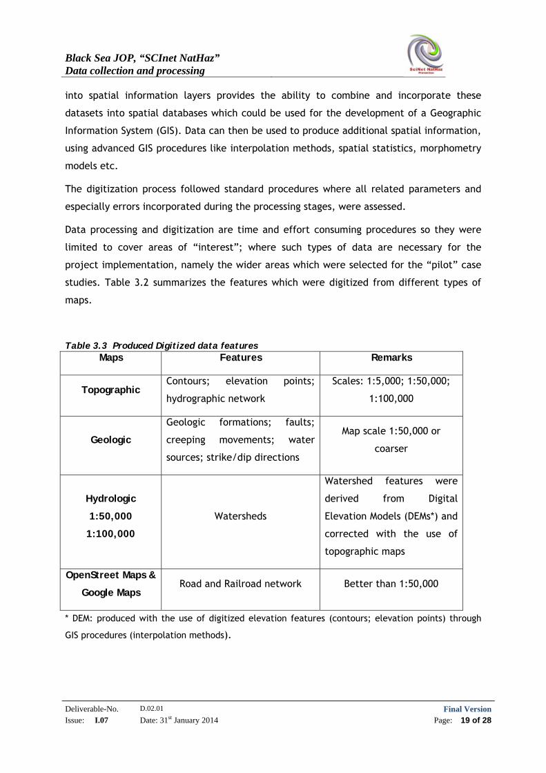
studies. Table 3.2 summarizes the features which were digitized from different types of
maps.
Table 3.3 Produced Digitized data features Maps Features Remarks
Topographic Contours; elevation points;
hydrographic network
Scales: 1:5,000; 1:50,000;
1:100,000
Geologic
Geologic formations; faults;
creeping movements; water
sources; strike/dip directions
Map scale 1:50,000 or
coarser
Hydrologic
1:50,000
1:100,000
Watersheds
Watershed features were
derived from Digital
Elevation Models (DEMs*) and
corrected with the use of
topographic maps
OpenStreet Maps &
Google Maps Road and Railroad network Better than 1:50,000
* DEM: produced with the use of digitized elevation features (contours; elevation points) through
GIS procedures (interpolation methods).
Black Sea JOP, “SCInet NatHaz” Data collection and processing
Deliverable-No. D.02.01 Final VersionIssue: I.07 Date: 31st January 2014 Page: 20 of 28
3.2.5 METADATA
Metadata records (descriptive data about the data) are files of information which describe
the fundamental characteristics of a data file, an information resource or a geospatial
service. It represents the “who”, “what”, “when”, “where”, “why” and “how” of the
resource (The Federal Geographic Data Committee - FGDC,
http://www.fgdc.gov/metadata).
The European Commission (EC) has released a Directive which came into force on 15th May
2007, the INSPIRE Directive (Infrastructure for Spatial Information in the European
Community, Directive 2007/2/EC). According to that, the European Union (EU) aims to
create a Spatial Data Infrastructure (SDI) in order to facilitate the sharing of environmental
spatial information among public sector organisations as well as the public access to
spatial information across Europe, providing that way a better policy-making across
boundaries (http://inspire.ec.europa.eu).
The INSPIRE Directive is based on the following common principles
(http://inspire.ec.europa.eu):
Data should be collected only once and kept where it can be maintained most
effectively.
It should be possible to combine seamless spatial information from different
sources across Europe and share it with many users and applications.
It should be possible for information collected at one level/scale to be shared with
all levels/scales; detailed for thorough investigations, general for strategic
purposes.
Geographic information needed for good governance at all levels, should be readily
and transparently available.
Easy to find what geographic information is available, how it can be used to meet a
particular need, and under which conditions it can be acquired and used.
For the implementation of aforementioned Directive regarding metadata, the European
Commission (EC) released the Regulation (EC) No 1205/2008 of 3 December 2008 as well as
supportive documents (INSPIRE Metadata Implementing Rules: Technical Guidelines based
on EN ISO 19115 and EN ISO 19119 - 06.11.2013, the latest version)[
http://inspire.ec.europa.eu/index.cfm/pageid/101].
Black Sea JOP, “SCInet NatHaz” Data collection and processing
Deliverable-No. D.02.01 Final VersionIssue: I.07 Date: 31st January 2014 Page: 21 of 28
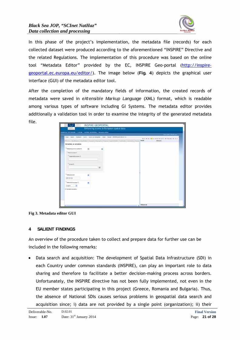
In this phase of the project’s implementation, the metadata file (records) for each
collected dataset were produced according to the aforementioned “INSPIRE” Directive and
the related Regulations. The implementation of this procedure was based on the online
tool “Metadata Editor” provided by the EC, INSPIRE Geo-portal (http://inspire-
geoportal.ec.europa.eu/editor/). The image below (Fig. 4) depicts the graphical user
interface (GUI) of the metadata editor tool.
After the completion of the mandatory fields of information, the created records of
metadata were saved in eXtensible Markup Language (XML) format, which is readable
among various types of software including GI Systems. The metadata editor provides
additionally a validation tool in order to examine the integrity of the generated metadata
file.
Fig 3. Metadata editor GUI 4 SALIENT FINDINGS
An overview of the procedure taken to collect and prepare data for further use can be
included in the following remarks:
Data search and acquisition: The development of Spatial Data Infrastructure (SDI) in
each Country under common standards (INSPIRE), can play an important role to data
sharing and therefore to facilitate a better decision-making process across borders.
Unfortunately, the INSPIRE directive has not been fully implemented, not even in the
EU member states participating in this project (Greece, Romania and Bulgaria). Thus,
the absence of National SDIs causes serious problems in geospatial data search and
acquisition since; i) data are not provided by a single point (organization); ii) their
Black Sea JOP, “SCInet NatHaz” Data collection and processing
Deliverable-No. D.02.01 Final VersionIssue: I.07 Date: 31st January 2014 Page: 22 of 28
existence or their availability is usually unknown; iii) in most of the cases, metadata
are either not available or do not exist, a fact which poses serious restrictions about
the potential uses of the data found.
Having said that, the procedure followed in this project during the search for data,
reveals several difficulties since the different types of data which have to be collected,
are maintained in various National Organizations, Services, Higher Education
Institutions etc. Some of them are:
Finding the specific Data owner/maintainer
Reluctance of the data owner/maintainer to provide the requester data
Lack of online tools for data search (data catalogues)
Lack of Metadata
Data constrains (permissions of use)
Time consuming data ordering procedures
It must be pointed out that the Lack of Metadata must be considered as the key parameter
in finding “usable” data in terms of reliability, accuracy and possibility of normalization
and harmonization so, creating metadata according to the INSPIRE directive, must be
considered as a prerequisite of paramount importance.
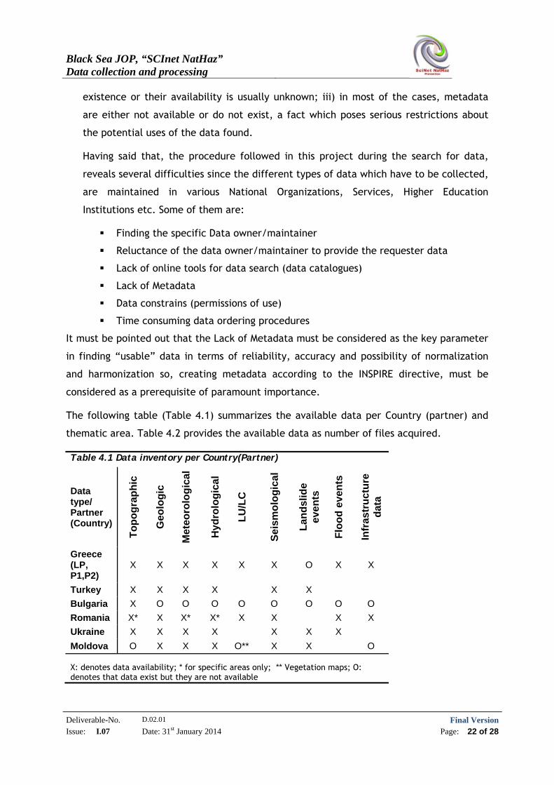
The following table (Table 4.1) summarizes the available data per Country (partner) and
thematic area. Table 4.2 provides the available data as number of files acquired.
Table 4.1 Data inventory per Country(Partner)
Data type/ Partner (Country)
To
po
gra
ph
ic
Geo
log
ic
Met
eoro
log
ical
Hyd
rolo
gic
al
LU
/LC
Sei
smo
log
ical
Lan
dsl
ide
even
ts
Flo
od
eve
nts
Infr
astr
uct
ure
d
ata
Greece (LP, P1,P2)
X X X X X X O X X
Turkey X X X X X X
Bulgaria X O O O O O O O O
Romania X* X X* X* X X X X
Ukraine X X X X X X X
Moldova O X X X O** X X O
X: denotes data availability; * for specific areas only; ** Vegetation maps; O: denotes that data exist but they are not available
Black Sea JOP, “SCInet NatHaz” Data collection and processing
Deliverable-No. D.02.01 Final VersionIssue: I.07 Date: 31st January 2014 Page: 23 of 28
Table 4.2 Number of available data files per Country(Partner)
Data type/
Partner (Country)
To
po
gra
ph
ic
Geo
log
ic
Met
eoro
log
ical
Hyd
rolo
gic
al
LU
/LC
Sei
smo
log
ical
Lan
dsl
ide
even
ts
Flo
od
eve
nts
Infr
astr
uct
ure
dat
a
Greece (LP,
P1,P2) 25 21 1 4 2 6 2 3
Turkey 3 6 2 10 7 1
Bulgaria 24
Romania 3 8 1 1 2 1 1 2
Ukraine 515 10 5 11 4 4 2
Moldova 24 1 1 1 13
Data processing: As already mentioned, lack of Spatial Data Infrastructures (SDIs) is a
twofold issue: it poses constraints in data search, and blocks trans-boundary
cooperation as regards the use of harmonized data and the implementation of common
methodologies. This is due to the creation of spatial data under different standards
(spatial reference; data models; metadata etc.). As is therefore evident, in order for
data collected to be used in projects requiring trans-boundary cooperation, a series of
data processing is required.
In this initial phase of data collection for the project needs, the main issue that arose
was the transformation of data into a common coordinate reference system (CRS). Data
coming from different countries possess a different CRS. Even more, many times even
data coming from the same country have different CRS, due to the different, for each
case, Organization which has produced them or is maintaining them. As a result of this
situation, the data provided by all of the partners had to be (and actually were)
transformed into a common CRS (WGS 84) using an open source GIS software (Quantum
GIS-QGIS). Having said that, open source software has been selected as the tool for the
implementation because it provides all of the required functionality at no cost and it
can be supported by the partnership members. “No cost” means in our case, that at a
later stage already foreseen, it can be distributed to stakeholders with the necessary
manuals, sample data and tutorials containing a step-by-step approach to the
implementation of hazard assessment methodologies.
Black Sea JOP, “SCInet NatHaz” Data collection and processing
Deliverable-No. D.02.01 Final VersionIssue: I.07 Date: 31st January 2014 Page: 24 of 28
The main problem encountered during this procedure was related to unrecognizable or
even undefined spatial reference, mainly due to the fact that the data were be having
a “local” National CRS and which was not recognizable from the GIS software or the
data had a spatial reference but it was not assigned to the data. To this end, the data
with undefined CRS were firstly assigned with their respective CRS (so they were geo-
referenced) and then transformed into the selected Reference System, WGS 84 CRS.
Moreover local/National Grids were created and incorporated into the QGIS software so
that they can be readily available to less experienced users.
As already mentioned, metadata is a key issue for data use since they provide all the
necessary information about the data. For this reason, metadata files were created for
the entire data collection except for the few cases where metadata files already
existed. In this way, it will be feasible to evaluate the reliability & accuracy and
therefore the “usability” of all collected and used for the project’s implementation
data files. Moreover, as data reliability and accuracy regulate part of the results
produced when applying methodologies for hazard assessment, the metadata files
created are necessary for defining the level of reliability and accuracy of the project’s
final results.
Another important impact due to the absence of National SDIs is the fact of multiple
digitization of the same source of data (i.e. analogue maps etc) by different
Organizations. So, even though funds have been spent for duplicate results, data,
either are not made available to the public, or, permission for their use has serious
constrains and limitations. Since digitization of analogue data is, a time and effort
consuming process, it was limited to cover areas of “interest”; where such types of
data are necessary for the project implementation, namely the wider areas which were
selected for the “pilot” case studies.
5 CONCLUSIONS
At this initial phase of the SciNetNatHaz project’s implementation, basic data including
topographic, geologic and various thematic maps, hydrologic and meteorological data, as
well as, additional information regarding past earthquake, landslide and flood events were
collected from various sources from all participating in the project countries.
A total number exceeding the 720 files was collected, reviewed, evaluated, classified into
thematic categories, processed, coded and harmonized.
Black Sea JOP, “SCInet NatHaz” Data collection and processing
Deliverable-No. D.02.01 Final VersionIssue: I.07 Date: 31st January 2014 Page: 25 of 28
The procedure followed the guidelines set by EU related legislation, the INSPIRE directive
and related documents as well as the state-of-practice [10],[11],[12],
[13],[14],[15],[18],[19].
Metadata were also created according to INSPIRE provisions using the online INSPIRE web
application.
Data were mostly collected from governmental agencies responsible for production and
maintenance of the respective maps and data.
Hazard inventories, although in existence, are not actually available for public access.
Even in the few cases where they could be acquired, the level of Bureaucracy, restrictions
and constrains, makes their acquirement extremely difficult.
Landslide inventories are no exception. Even when they exist in some cases, they are not
accessible. For instance, there is a Landslide inventory for Greece, maintained by the
Institute of Geological and Mineral Exploration (IGME) which is not accessible. There was
information though, that it will be made available at some point in the future.
A similar situation stands for the flood hazard inventories in almost the entity of the
countries involved. Data related to flooding events were gathered by investigation in
Public Services and other information resources (the press, colleagues, universities etc).
Exception to this situation is the Earthquake inventories containing systematic recordings
of earthquake events, maintained by National Organizations or Public Bodies as
EPPO/ITSAK (Greece), KOERI (Turkey), Academy of Sciences Romania and Academy of
Sciences Moldova. Earthquake data can also be retrieved from several international
Organizations activated in this field (csem-EMSC, ORFEUS, Earthquake data portal etc).
Spatial Data Infrastructure (SDI) development across Europe and the neighboring countries,
under common standards as the INSPIRE provisions, is of extremely high importance and
should be a task of an equally high priority. SDI is expected to play an important role to
data sharing, to the use of harmonized data and to the implementation of common
methodologies; addressing in this way the “information gap” which is one of the main
problems already recognized by the EU, regarding Earthquake, Landslide and Flood Hazard
mitigation [1], [8].

Black Sea JOP, “SCInet NatHaz” Data collection and processing
Deliverable-No. D.02.01 Final VersionIssue: I.07 Date: 31st January 2014 Page: 26 of 28
6 REFERENCES
1. Clark Ian (2012): Towards an EU policy on Disaster Management. European
Commission Humanitarian Aid & Civil Protection.
2. Council of the European Union (2009): Council Conclusions on a Community
framework on disaster prevention within the EU 2979th JUSTICE and HOME
AFFAIRS, Council meeting Brussels, 30 November 2009
3. Commission of the European Communities, Proposal for a Directive of the Council
(2006): On the identification and designation of European Critical Infrastructure and
assessment of the need to improve their protection. COM (20060 787 final, Brussels,
12.12.2006
4. Commission of the European Communities (2008): Communication from the Commission
to the European parliament, the Council on Reinforcing the Union’s Disaster
Response Capacity.
5. Commission of the European Communities (2009): Communication from the Commission
to the European parliament, the Council, the European Economic and Social Committee
and the Committee of the Regions. A Community approach on the prevention of
natural and man-made disasters
6. European Commission Research Directorate General (2003): Background Information for
Press Release: Floods: European research for better predictions and management
solutions, Dresden, (13 October 2003).
7. European Commission: Research and innovation: Workshop on RESEARCH: Floods!:
Managing the risks of flooding in Europe. Conference Proceedings, (2006)
8. European Commission DG Environment (2008): Member State’s approaches towards
Prevention Policy-A critical analysis, Final Report.
9. European Commission. European Research Area (2009): Principles of Multi-Risk
Assessment. Interaction amongst natural and man-induced risks.
10. European Commission Decision of June 2009: Implementing Directive 2007/2/EC of the
European Parliament and of the council as regards monitoring and reporting.
11. INSPIRE Infrastructure for Spatial Information in Europe (2007): D 2.9.1.9. INSPIRE Data
Specification on Protected Sites-Guidelines. Technical Paper.
Black Sea JOP, “SCInet NatHaz” Data collection and processing
Deliverable-No. D.02.01 Final VersionIssue: I.07 Date: 31st January 2014 Page: 27 of 28
12. INSPIRE Infrastructure for Spatial Information in Europe (2007): Guidelines for the
encoding of spatial data. Technical Paper.
13. INSPIRE Infrastructure for Spatial Information in Europe (2007): D.2.8.1.1. INSPIRE
Specification on Coordinate Reference Systems-Guidelines
14. GINIE: Network for Geographic Information in Europe (2003): Strategies for the
Geographic Information in Europe: Guidelines. European Umbrella Organization for
Geographic Information-EUROGI, GINIE D 2.7.2. Technical Report.
15. Longhorn R. (2005): Geospatial Standards, Interoperability, Metadata Semantics and
Spatial Data Infrastructure. NIEeS Workshop on Activating Metadata, 6-7 July 2005,
Cambridge, UK.
16. Dragomir P., RUS T., AVRAMIUC N., DUMITRU P. (2010): EVRF2007 as Realization of the
European Vertical Reference System in Romania.
http://geodezie.utcb.ro/files/geos/publicatii/Articol_EVRF2007_2010.pdf
17. Sacher M., Ihde J., Liebsch G., Makinen J (2009): EVRF2007 as Realization of the
European Vertical Reference System, American Geophysical Union, Spring Meeting
2009, abstract #CG71A-06
18. Tom Henry (2003): Standards for the Infrastructure for Spatial information in Europe
(INSPIRE) and Global Spatial Data Infrastructure (GSDI). 9th EC GI & GIS Workshop, ESDI
Servicing the user, A Coruna, Spain, 25-57 June 2003. Workshop proceedings.
19. Weerts A. (2004): Data handling in EU Flood Related Projects: Past, Present and
Future. WL Delft Hydraulics, Delft, the Netherlands
Black Sea JOP, “SCInet NatHaz” Data collection and processing
Deliverable-No. D.02.01 Final VersionIssue: I.07 Date: 31st January 2014 Page: 28 of 28
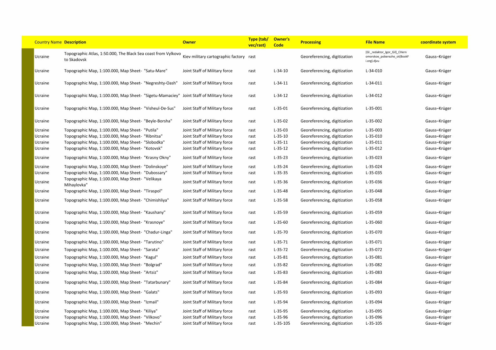
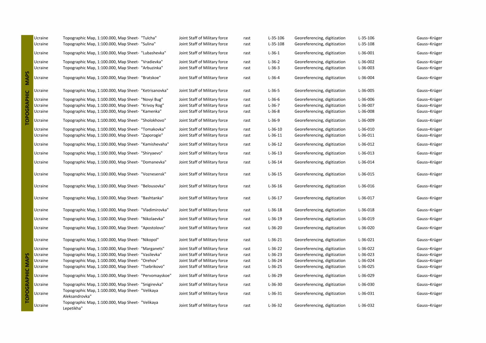
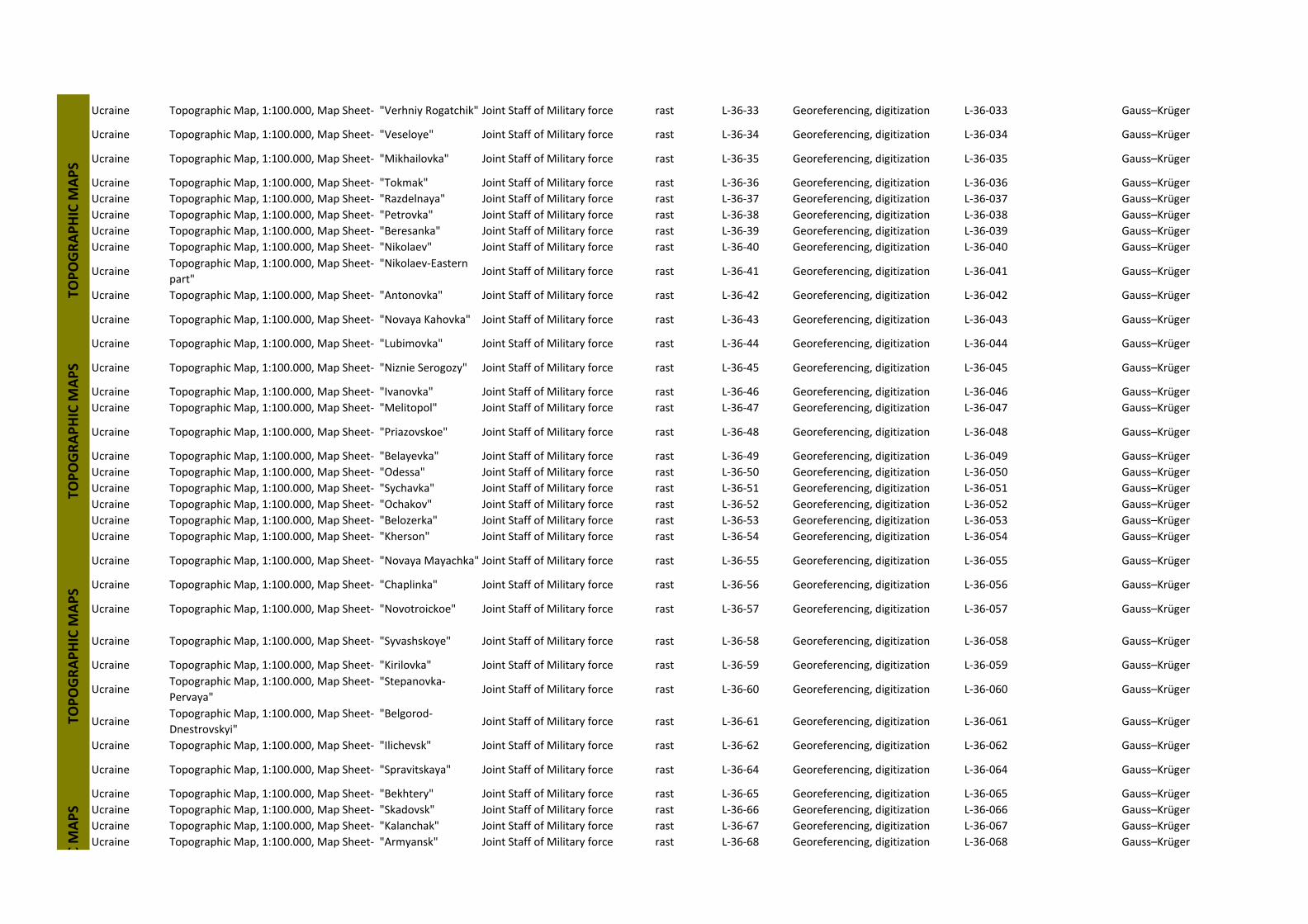
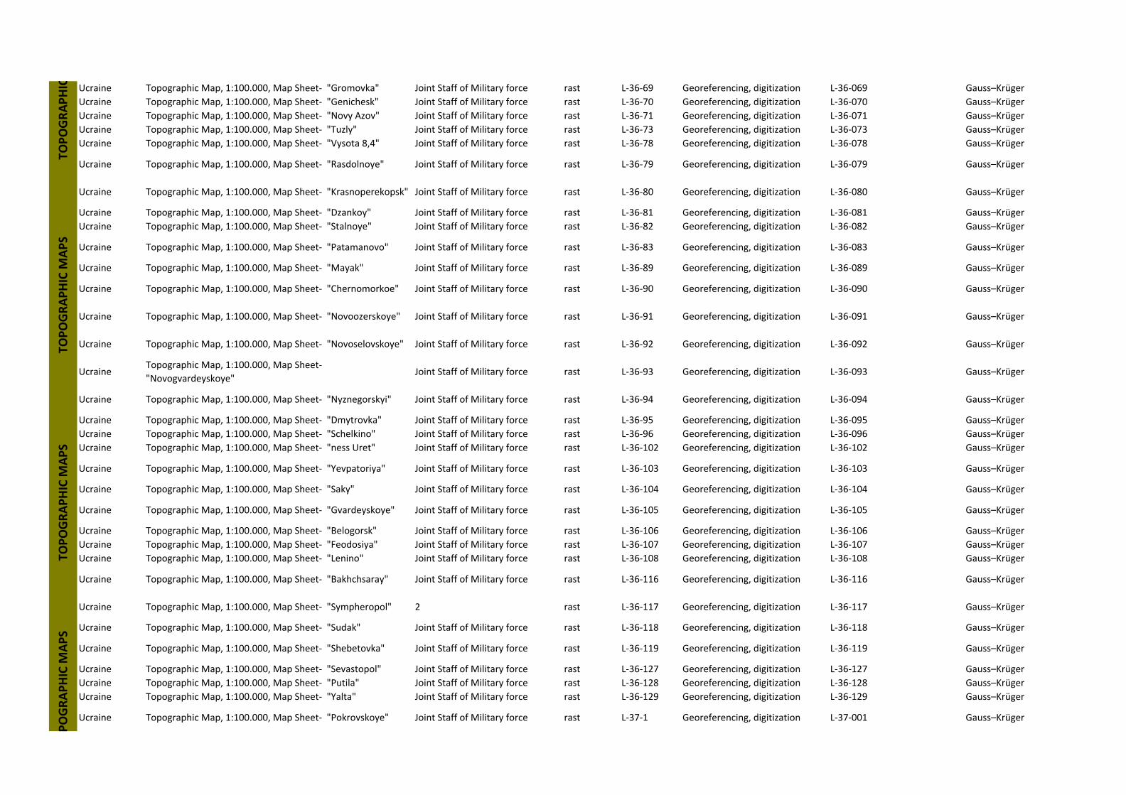
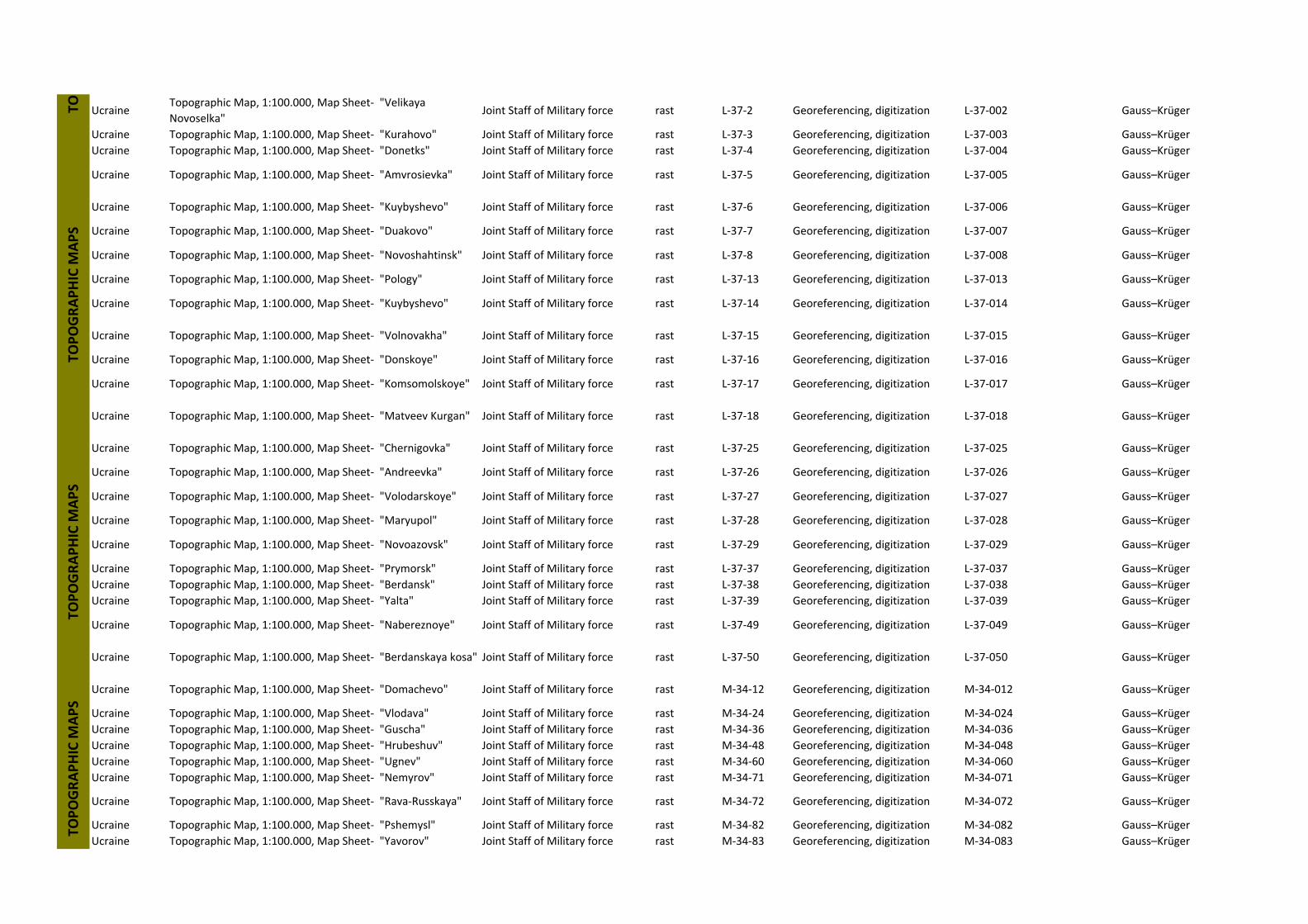
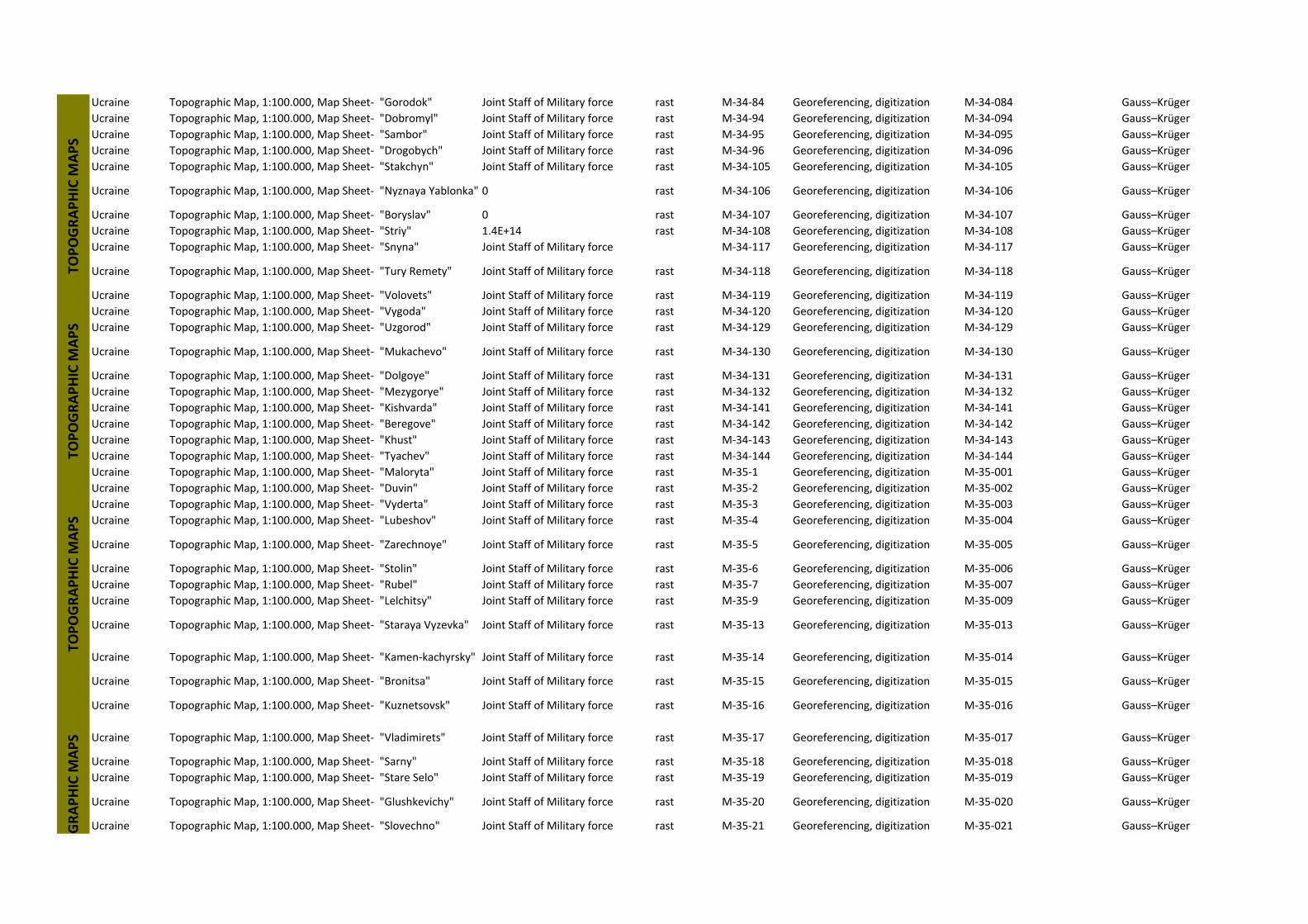
7 ANNEX I – UNIFIED CATALOGUE OF AVAILABLE DATA
Country Name Description OwnerType (tab/
vec/rast)
Owner's
CodeProcessing File Name coordinate system
UcraineTopographic Atlas, 1:50.000, The Black Sea coast from Vylkovo
to SkadovskKiev military cartographic factory rast Georeferencing, digitization
[Gl._redaktor_Igor_Gil]_CHern
omorskoe_poberezhe_ot(BookF
i.org).djvuGauss–Krüger
Ucraine Topographic Map, 1:100.000, Map Sheet‐ "Satu‐Mare" Joint Staff of Military force rast L‐34‐10 Georeferencing, digitization L‐34‐010 Gauss–Krüger
Ucraine Topographic Map, 1:100.000, Map Sheet‐ "Negreshty‐Oash" Joint Staff of Military force rast L‐34‐11 Georeferencing, digitization L‐34‐011 Gauss–Krüger
Ucraine Topographic Map, 1:100.000, Map Sheet‐ "Sigetu‐Mamaciey" Joint Staff of Military force rast L‐34‐12 Georeferencing, digitization L‐34‐012 Gauss–Krüger
Ucraine Topographic Map, 1:100.000, Map Sheet‐ "Visheul‐De‐Sus" Joint Staff of Military force rast L‐35‐01 Georeferencing, digitization L‐35‐001 Gauss–Krüger
Ucraine Topographic Map, 1:100.000, Map Sheet‐ "Beyle‐Borsha" Joint Staff of Military force rast L‐35‐02 Georeferencing, digitization L‐35‐002 Gauss–Krüger
Ucraine Topographic Map, 1:100.000, Map Sheet‐ "Putila" Joint Staff of Military force rast L‐35‐03 Georeferencing, digitization L‐35‐003 Gauss–Krüger
Ucraine Topographic Map, 1:100.000, Map Sheet‐ "Ribnitsa" Joint Staff of Military force rast L‐35‐10 Georeferencing, digitization L‐35‐010 Gauss–Krüger
Ucraine Topographic Map, 1:100.000, Map Sheet‐ "Slobodka" Joint Staff of Military force rast L‐35‐11 Georeferencing, digitization L‐35‐011 Gauss–Krüger
Ucraine Topographic Map, 1:100.000, Map Sheet‐ "Kotovsk" Joint Staff of Military force rast L‐35‐12 Georeferencing, digitization L‐35‐012 Gauss–Krüger
Ucraine Topographic Map, 1:100.000, Map Sheet‐ "Krasny Okny" Joint Staff of Military force rast L‐35‐23 Georeferencing, digitization L‐35‐023 Gauss–Krüger
Ucraine Topographic Map, 1:100.000, Map Sheet‐ "Dolinskoye" Joint Staff of Military force rast L‐35‐24 Georeferencing, digitization L‐35‐024 Gauss–Krüger
Ucraine Topographic Map, 1:100.000, Map Sheet‐ "Dubossary" Joint Staff of Military force rast L‐35‐35 Georeferencing, digitization L‐35‐035 Gauss–Krüger
UcraineTopographic Map, 1:100.000, Map Sheet‐ "Velikaya
Mihaylovka"Joint Staff of Military force rast L‐35‐36 Georeferencing, digitization L‐35‐036 Gauss–Krüger
Ucraine Topographic Map, 1:100.000, Map Sheet‐ "Tiraspol" Joint Staff of Military force rast L‐35‐48 Georeferencing, digitization L‐35‐048 Gauss–Krüger
Ucraine Topographic Map, 1:100.000, Map Sheet‐ "Chimishliya" Joint Staff of Military force rast L‐35‐58 Georeferencing, digitization L‐35‐058 Gauss–Krüger
Ucraine Topographic Map, 1:100.000, Map Sheet‐ "Kaushany" Joint Staff of Military force rast L‐35‐59 Georeferencing, digitization L‐35‐059 Gauss–Krüger
Ucraine Topographic Map, 1:100.000, Map Sheet‐ "Krasnoye" Joint Staff of Military force rast L‐35‐60 Georeferencing, digitization L‐35‐060 Gauss–Krüger
Ucraine Topographic Map, 1:100.000, Map Sheet‐ "Chadur‐Linga" Joint Staff of Military force rast L‐35‐70 Georeferencing, digitization L‐35‐070 Gauss–Krüger
Ucraine Topographic Map, 1:100.000, Map Sheet‐ "Tarutino" Joint Staff of Military force rast L‐35‐71 Georeferencing, digitization L‐35‐071 Gauss–Krüger
Ucraine Topographic Map, 1:100.000, Map Sheet‐ "Sarata" Joint Staff of Military force rast L‐35‐72 Georeferencing, digitization L‐35‐072 Gauss–Krüger
Ucraine Topographic Map, 1:100.000, Map Sheet‐ "Kagul" Joint Staff of Military force rast L‐35‐81 Georeferencing, digitization L‐35‐081 Gauss–Krüger
Ucraine Topographic Map, 1:100.000, Map Sheet‐ "Bolgrad" Joint Staff of Military force rast L‐35‐82 Georeferencing, digitization L‐35‐082 Gauss–Krüger
Ucraine Topographic Map, 1:100.000, Map Sheet‐ "Artsiz" Joint Staff of Military force rast L‐35‐83 Georeferencing, digitization L‐35‐083 Gauss–Krüger
Ucraine Topographic Map, 1:100.000, Map Sheet‐ "Tatarbunary" Joint Staff of Military force rast L‐35‐84 Georeferencing, digitization L‐35‐084 Gauss–Krüger
Ucraine Topographic Map, 1:100.000, Map Sheet‐ "Galats" Joint Staff of Military force rast L‐35‐93 Georeferencing, digitization L‐35‐093 Gauss–Krüger
Ucraine Topographic Map, 1:100.000, Map Sheet‐ "Izmail" Joint Staff of Military force rast L‐35‐94 Georeferencing, digitization L‐35‐094 Gauss–Krüger
Ucraine Topographic Map, 1:100.000, Map Sheet‐ "Kiliya" Joint Staff of Military force rast L‐35‐95 Georeferencing, digitization L‐35‐095 Gauss–Krüger
Ucraine Topographic Map, 1:100.000, Map Sheet‐ "Vilkovo" Joint Staff of Military force rast L‐35‐96 Georeferencing, digitization L‐35‐096 Gauss–Krüger
Ucraine Topographic Map, 1:100.000, Map Sheet‐ "Mechin" Joint Staff of Military force rast L‐35‐105 Georeferencing, digitization L‐35‐105 Gauss–Krüger
Ucraine Topographic Map, 1:100.000, Map Sheet‐ "Tulcha" Joint Staff of Military force rast L‐35‐106 Georeferencing, digitization L‐35‐106 Gauss–Krüger
Ucraine Topographic Map, 1:100.000, Map Sheet‐ "Sulina" Joint Staff of Military force rast L‐35‐108 Georeferencing, digitization L‐35‐108 Gauss–Krüger
Ucraine Topographic Map, 1:100.000, Map Sheet‐ "Lubashevka" Joint Staff of Military force rast L‐36‐1 Georeferencing, digitization L‐36‐001 Gauss–Krüger
Ucraine Topographic Map, 1:100.000, Map Sheet‐ "Vradievka" Joint Staff of Military force rast L‐36‐2 Georeferencing, digitization L‐36‐002 Gauss–Krüger
Ucraine Topographic Map, 1:100.000, Map Sheet‐ "Arbuzinka" Joint Staff of Military force rast L‐36‐3 Georeferencing, digitization L‐36‐003 Gauss–Krüger
Ucraine Topographic Map, 1:100.000, Map Sheet‐ "Bratskoe" Joint Staff of Military force rast L‐36‐4 Georeferencing, digitization L‐36‐004 Gauss–Krüger
Ucraine Topographic Map, 1:100.000, Map Sheet‐ "Ketrisanovka" Joint Staff of Military force rast L‐36‐5 Georeferencing, digitization L‐36‐005 Gauss–Krüger
Ucraine Topographic Map, 1:100.000, Map Sheet‐ "Novyi Bug" Joint Staff of Military force rast L‐36‐6 Georeferencing, digitization L‐36‐006 Gauss–Krüger
Ucraine Topographic Map, 1:100.000, Map Sheet‐ "Krivoy Rog" Joint Staff of Military force rast L‐36‐7 Georeferencing, digitization L‐36‐007 Gauss–Krüger
Ucraine Topographic Map, 1:100.000, Map Sheet‐ "Kamenka" Joint Staff of Military force rast L‐36‐8 Georeferencing, digitization L‐36‐008 Gauss–Krüger
Ucraine Topographic Map, 1:100.000, Map Sheet‐ "Sholokhovo" Joint Staff of Military force rast L‐36‐9 Georeferencing, digitization L‐36‐009 Gauss–Krüger
Ucraine Topographic Map, 1:100.000, Map Sheet‐ "Tomakovka" Joint Staff of Military force rast L‐36‐10 Georeferencing, digitization L‐36‐010 Gauss–Krüger
Ucraine Topographic Map, 1:100.000, Map Sheet‐ "Zaporogie" Joint Staff of Military force rast L‐36‐11 Georeferencing, digitization L‐36‐011 Gauss–Krüger
Ucraine Topographic Map, 1:100.000, Map Sheet‐ "Kamishevaha" Joint Staff of Military force rast L‐36‐12 Georeferencing, digitization L‐36‐012 Gauss–Krüger
Ucraine Topographic Map, 1:100.000, Map Sheet‐ "Shiryaevo" Joint Staff of Military force rast L‐36‐13 Georeferencing, digitization L‐36‐013 Gauss–Krüger
Ucraine Topographic Map, 1:100.000, Map Sheet‐ "Domanevka" Joint Staff of Military force rast L‐36‐14 Georeferencing, digitization L‐36‐014 Gauss–Krüger
Ucraine Topographic Map, 1:100.000, Map Sheet‐ "Voznesensk" Joint Staff of Military force rast L‐36‐15 Georeferencing, digitization L‐36‐015 Gauss–Krüger
Ucraine Topographic Map, 1:100.000, Map Sheet‐ "Belousovka" Joint Staff of Military force rast L‐36‐16 Georeferencing, digitization L‐36‐016 Gauss–Krüger
Ucraine Topographic Map, 1:100.000, Map Sheet‐ "Bashtanka" Joint Staff of Military force rast L‐36‐17 Georeferencing, digitization L‐36‐017 Gauss–Krüger
Ucraine Topographic Map, 1:100.000, Map Sheet‐ "Vladimirovka" Joint Staff of Military force rast L‐36‐18 Georeferencing, digitization L‐36‐018 Gauss–Krüger
Ucraine Topographic Map, 1:100.000, Map Sheet‐ "Nikolaevka" Joint Staff of Military force rast L‐36‐19 Georeferencing, digitization L‐36‐019 Gauss–Krüger
Ucraine Topographic Map, 1:100.000, Map Sheet‐ "Apostolovo" Joint Staff of Military force rast L‐36‐20 Georeferencing, digitization L‐36‐020 Gauss–Krüger
Ucraine Topographic Map, 1:100.000, Map Sheet‐ "Nikopol" Joint Staff of Military force rast L‐36‐21 Georeferencing, digitization L‐36‐021 Gauss–Krüger
Ucraine Topographic Map, 1:100.000, Map Sheet‐ "Marganets" Joint Staff of Military force rast L‐36‐22 Georeferencing, digitization L‐36‐022 Gauss–Krüger
Ucraine Topographic Map, 1:100.000, Map Sheet‐ "Vasilevka" Joint Staff of Military force rast L‐36‐23 Georeferencing, digitization L‐36‐023 Gauss–Krüger
Ucraine Topographic Map, 1:100.000, Map Sheet‐ "Orehov" Joint Staff of Military force rast L‐36‐24 Georeferencing, digitization L‐36‐024 Gauss–Krüger
Ucraine Topographic Map, 1:100.000, Map Sheet‐ "Tsebrikovo" Joint Staff of Military force rast L‐36‐25 Georeferencing, digitization L‐36‐025 Gauss–Krüger
Ucraine Topographic Map, 1:100.000, Map Sheet‐ "Pervomayskoe" Joint Staff of Military force rast L‐36‐29 Georeferencing, digitization L‐36‐029 Gauss–Krüger
Ucraine Topographic Map, 1:100.000, Map Sheet‐ "Snigirevka" Joint Staff of Military force rast L‐36‐30 Georeferencing, digitization L‐36‐030 Gauss–Krüger
UcraineTopographic Map, 1:100.000, Map Sheet‐ "Velikaya
Aleksandrovka"Joint Staff of Military force rast L‐36‐31 Georeferencing, digitization L‐36‐031 Gauss–Krüger
UcraineTopographic Map, 1:100.000, Map Sheet‐ "Velikaya
Lepetikha"Joint Staff of Military force rast L‐36‐32 Georeferencing, digitization L‐36‐032 Gauss–Krüger
TOPOGRAPHIC M
APS
TOPOGRAPHIC M
APS
Ucraine Topographic Map, 1:100.000, Map Sheet‐ "Verhniy Rogatchik" Joint Staff of Military force rast L‐36‐33 Georeferencing, digitization L‐36‐033 Gauss–Krüger
Ucraine Topographic Map, 1:100.000, Map Sheet‐ "Veseloye" Joint Staff of Military force rast L‐36‐34 Georeferencing, digitization L‐36‐034 Gauss–Krüger
Ucraine Topographic Map, 1:100.000, Map Sheet‐ "Mikhailovka" Joint Staff of Military force rast L‐36‐35 Georeferencing, digitization L‐36‐035 Gauss–Krüger
Ucraine Topographic Map, 1:100.000, Map Sheet‐ "Tokmak" Joint Staff of Military force rast L‐36‐36 Georeferencing, digitization L‐36‐036 Gauss–Krüger
Ucraine Topographic Map, 1:100.000, Map Sheet‐ "Razdelnaya" Joint Staff of Military force rast L‐36‐37 Georeferencing, digitization L‐36‐037 Gauss–Krüger
Ucraine Topographic Map, 1:100.000, Map Sheet‐ "Petrovka" Joint Staff of Military force rast L‐36‐38 Georeferencing, digitization L‐36‐038 Gauss–Krüger
Ucraine Topographic Map, 1:100.000, Map Sheet‐ "Beresanka" Joint Staff of Military force rast L‐36‐39 Georeferencing, digitization L‐36‐039 Gauss–Krüger
Ucraine Topographic Map, 1:100.000, Map Sheet‐ "Nikolaev" Joint Staff of Military force rast L‐36‐40 Georeferencing, digitization L‐36‐040 Gauss–Krüger
UcraineTopographic Map, 1:100.000, Map Sheet‐ "Nikolaev‐Eastern
part"Joint Staff of Military force rast L‐36‐41 Georeferencing, digitization L‐36‐041 Gauss–Krüger
Ucraine Topographic Map, 1:100.000, Map Sheet‐ "Antonovka" Joint Staff of Military force rast L‐36‐42 Georeferencing, digitization L‐36‐042 Gauss–Krüger
Ucraine Topographic Map, 1:100.000, Map Sheet‐ "Novaya Kahovka" Joint Staff of Military force rast L‐36‐43 Georeferencing, digitization L‐36‐043 Gauss–Krüger
Ucraine Topographic Map, 1:100.000, Map Sheet‐ "Lubimovka" Joint Staff of Military force rast L‐36‐44 Georeferencing, digitization L‐36‐044 Gauss–Krüger
Ucraine Topographic Map, 1:100.000, Map Sheet‐ "Niznie Serogozy" Joint Staff of Military force rast L‐36‐45 Georeferencing, digitization L‐36‐045 Gauss–Krüger
Ucraine Topographic Map, 1:100.000, Map Sheet‐ "Ivanovka" Joint Staff of Military force rast L‐36‐46 Georeferencing, digitization L‐36‐046 Gauss–Krüger
Ucraine Topographic Map, 1:100.000, Map Sheet‐ "Melitopol" Joint Staff of Military force rast L‐36‐47 Georeferencing, digitization L‐36‐047 Gauss–Krüger
Ucraine Topographic Map, 1:100.000, Map Sheet‐ "Priazovskoe" Joint Staff of Military force rast L‐36‐48 Georeferencing, digitization L‐36‐048 Gauss–Krüger
Ucraine Topographic Map, 1:100.000, Map Sheet‐ "Belayevka" Joint Staff of Military force rast L‐36‐49 Georeferencing, digitization L‐36‐049 Gauss–Krüger
Ucraine Topographic Map, 1:100.000, Map Sheet‐ "Odessa" Joint Staff of Military force rast L‐36‐50 Georeferencing, digitization L‐36‐050 Gauss–Krüger
Ucraine Topographic Map, 1:100.000, Map Sheet‐ "Sychavka" Joint Staff of Military force rast L‐36‐51 Georeferencing, digitization L‐36‐051 Gauss–Krüger
Ucraine Topographic Map, 1:100.000, Map Sheet‐ "Ochakov" Joint Staff of Military force rast L‐36‐52 Georeferencing, digitization L‐36‐052 Gauss–Krüger
Ucraine Topographic Map, 1:100.000, Map Sheet‐ "Belozerka" Joint Staff of Military force rast L‐36‐53 Georeferencing, digitization L‐36‐053 Gauss–Krüger
Ucraine Topographic Map, 1:100.000, Map Sheet‐ "Kherson" Joint Staff of Military force rast L‐36‐54 Georeferencing, digitization L‐36‐054 Gauss–Krüger
Ucraine Topographic Map, 1:100.000, Map Sheet‐ "Novaya Mayachka" Joint Staff of Military force rast L‐36‐55 Georeferencing, digitization L‐36‐055 Gauss–Krüger
Ucraine Topographic Map, 1:100.000, Map Sheet‐ "Chaplinka" Joint Staff of Military force rast L‐36‐56 Georeferencing, digitization L‐36‐056 Gauss–Krüger
Ucraine Topographic Map, 1:100.000, Map Sheet‐ "Novotroickoe" Joint Staff of Military force rast L‐36‐57 Georeferencing, digitization L‐36‐057 Gauss–Krüger
Ucraine Topographic Map, 1:100.000, Map Sheet‐ "Syvashskoye" Joint Staff of Military force rast L‐36‐58 Georeferencing, digitization L‐36‐058 Gauss–Krüger
Ucraine Topographic Map, 1:100.000, Map Sheet‐ "Kirilovka" Joint Staff of Military force rast L‐36‐59 Georeferencing, digitization L‐36‐059 Gauss–Krüger
UcraineTopographic Map, 1:100.000, Map Sheet‐ "Stepanovka‐
Pervaya"Joint Staff of Military force rast L‐36‐60 Georeferencing, digitization L‐36‐060 Gauss–Krüger
UcraineTopographic Map, 1:100.000, Map Sheet‐ "Belgorod‐
Dnestrovskyi"Joint Staff of Military force rast L‐36‐61 Georeferencing, digitization L‐36‐061 Gauss–Krüger
Ucraine Topographic Map, 1:100.000, Map Sheet‐ "Ilichevsk" Joint Staff of Military force rast L‐36‐62 Georeferencing, digitization L‐36‐062 Gauss–Krüger
Ucraine Topographic Map, 1:100.000, Map Sheet‐ "Spravitskaya" Joint Staff of Military force rast L‐36‐64 Georeferencing, digitization L‐36‐064 Gauss–Krüger
Ucraine Topographic Map, 1:100.000, Map Sheet‐ "Bekhtery" Joint Staff of Military force rast L‐36‐65 Georeferencing, digitization L‐36‐065 Gauss–Krüger
Ucraine Topographic Map, 1:100.000, Map Sheet‐ "Skadovsk" Joint Staff of Military force rast L‐36‐66 Georeferencing, digitization L‐36‐066 Gauss–Krüger
Ucraine Topographic Map, 1:100.000, Map Sheet‐ "Kalanchak" Joint Staff of Military force rast L‐36‐67 Georeferencing, digitization L‐36‐067 Gauss–Krüger
Ucraine Topographic Map, 1:100.000, Map Sheet‐ "Armyansk" Joint Staff of Military force rast L‐36‐68 Georeferencing, digitization L‐36‐068 Gauss–Krüger
C M
APS
TOPOGRAPHIC M
APS
TOPOGRAPHIC M
APS
TOPOGRAPHIC M
APS
Ucraine Topographic Map, 1:100.000, Map Sheet‐ "Gromovka" Joint Staff of Military force rast L‐36‐69 Georeferencing, digitization L‐36‐069 Gauss–Krüger
Ucraine Topographic Map, 1:100.000, Map Sheet‐ "Genichesk" Joint Staff of Military force rast L‐36‐70 Georeferencing, digitization L‐36‐070 Gauss–Krüger
Ucraine Topographic Map, 1:100.000, Map Sheet‐ "Novy Azov" Joint Staff of Military force rast L‐36‐71 Georeferencing, digitization L‐36‐071 Gauss–Krüger
Ucraine Topographic Map, 1:100.000, Map Sheet‐ "Tuzly" Joint Staff of Military force rast L‐36‐73 Georeferencing, digitization L‐36‐073 Gauss–Krüger
Ucraine Topographic Map, 1:100.000, Map Sheet‐ "Vysota 8,4" Joint Staff of Military force rast L‐36‐78 Georeferencing, digitization L‐36‐078 Gauss–Krüger
Ucraine Topographic Map, 1:100.000, Map Sheet‐ "Rasdolnoye" Joint Staff of Military force rast L‐36‐79 Georeferencing, digitization L‐36‐079 Gauss–Krüger
Ucraine Topographic Map, 1:100.000, Map Sheet‐ "Krasnoperekopsk" Joint Staff of Military force rast L‐36‐80 Georeferencing, digitization L‐36‐080 Gauss–Krüger
Ucraine Topographic Map, 1:100.000, Map Sheet‐ "Dzankoy" Joint Staff of Military force rast L‐36‐81 Georeferencing, digitization L‐36‐081 Gauss–Krüger
Ucraine Topographic Map, 1:100.000, Map Sheet‐ "Stalnoye" Joint Staff of Military force rast L‐36‐82 Georeferencing, digitization L‐36‐082 Gauss–Krüger
Ucraine Topographic Map, 1:100.000, Map Sheet‐ "Patamanovo" Joint Staff of Military force rast L‐36‐83 Georeferencing, digitization L‐36‐083 Gauss–Krüger
Ucraine Topographic Map, 1:100.000, Map Sheet‐ "Mayak" Joint Staff of Military force rast L‐36‐89 Georeferencing, digitization L‐36‐089 Gauss–Krüger
Ucraine Topographic Map, 1:100.000, Map Sheet‐ "Chernomorkoe" Joint Staff of Military force rast L‐36‐90 Georeferencing, digitization L‐36‐090 Gauss–Krüger
Ucraine Topographic Map, 1:100.000, Map Sheet‐ "Novoozerskoye" Joint Staff of Military force rast L‐36‐91 Georeferencing, digitization L‐36‐091 Gauss–Krüger
Ucraine Topographic Map, 1:100.000, Map Sheet‐ "Novoselovskoye" Joint Staff of Military force rast L‐36‐92 Georeferencing, digitization L‐36‐092 Gauss–Krüger
UcraineTopographic Map, 1:100.000, Map Sheet‐
"Novogvardeyskoye"Joint Staff of Military force rast L‐36‐93 Georeferencing, digitization L‐36‐093 Gauss–Krüger
Ucraine Topographic Map, 1:100.000, Map Sheet‐ "Nyznegorskyi" Joint Staff of Military force rast L‐36‐94 Georeferencing, digitization L‐36‐094 Gauss–Krüger
Ucraine Topographic Map, 1:100.000, Map Sheet‐ "Dmytrovka" Joint Staff of Military force rast L‐36‐95 Georeferencing, digitization L‐36‐095 Gauss–Krüger
Ucraine Topographic Map, 1:100.000, Map Sheet‐ "Schelkino" Joint Staff of Military force rast L‐36‐96 Georeferencing, digitization L‐36‐096 Gauss–Krüger
Ucraine Topographic Map, 1:100.000, Map Sheet‐ "ness Uret" Joint Staff of Military force rast L‐36‐102 Georeferencing, digitization L‐36‐102 Gauss–Krüger
Ucraine Topographic Map, 1:100.000, Map Sheet‐ "Yevpatoriya" Joint Staff of Military force rast L‐36‐103 Georeferencing, digitization L‐36‐103 Gauss–Krüger
Ucraine Topographic Map, 1:100.000, Map Sheet‐ "Saky" Joint Staff of Military force rast L‐36‐104 Georeferencing, digitization L‐36‐104 Gauss–Krüger
Ucraine Topographic Map, 1:100.000, Map Sheet‐ "Gvardeyskoye" Joint Staff of Military force rast L‐36‐105 Georeferencing, digitization L‐36‐105 Gauss–Krüger
Ucraine Topographic Map, 1:100.000, Map Sheet‐ "Belogorsk" Joint Staff of Military force rast L‐36‐106 Georeferencing, digitization L‐36‐106 Gauss–Krüger
Ucraine Topographic Map, 1:100.000, Map Sheet‐ "Feodosiya" Joint Staff of Military force rast L‐36‐107 Georeferencing, digitization L‐36‐107 Gauss–Krüger
Ucraine Topographic Map, 1:100.000, Map Sheet‐ "Lenino" Joint Staff of Military force rast L‐36‐108 Georeferencing, digitization L‐36‐108 Gauss–Krüger
Ucraine Topographic Map, 1:100.000, Map Sheet‐ "Bakhchsaray" Joint Staff of Military force rast L‐36‐116 Georeferencing, digitization L‐36‐116 Gauss–Krüger
Ucraine Topographic Map, 1:100.000, Map Sheet‐ "Sympheropol" 2 rast L‐36‐117 Georeferencing, digitization L‐36‐117 Gauss–Krüger
Ucraine Topographic Map, 1:100.000, Map Sheet‐ "Sudak" Joint Staff of Military force rast L‐36‐118 Georeferencing, digitization L‐36‐118 Gauss–Krüger
Ucraine Topographic Map, 1:100.000, Map Sheet‐ "Shebetovka" Joint Staff of Military force rast L‐36‐119 Georeferencing, digitization L‐36‐119 Gauss–Krüger
Ucraine Topographic Map, 1:100.000, Map Sheet‐ "Sevastopol" Joint Staff of Military force rast L‐36‐127 Georeferencing, digitization L‐36‐127 Gauss–Krüger
Ucraine Topographic Map, 1:100.000, Map Sheet‐ "Putila" Joint Staff of Military force rast L‐36‐128 Georeferencing, digitization L‐36‐128 Gauss–Krüger
Ucraine Topographic Map, 1:100.000, Map Sheet‐ "Yalta" Joint Staff of Military force rast L‐36‐129 Georeferencing, digitization L‐36‐129 Gauss–Krüger
Ucraine Topographic Map, 1:100.000, Map Sheet‐ "Pokrovskoye" Joint Staff of Military force rast L‐37‐1 Georeferencing, digitization L‐37‐001 Gauss–Krüger
TOPOGRAPHIC
TOPOGRAPHIC M
APS
TOPOGRAPHIC M
APS
POGRAPHIC M
APS
UcraineTopographic Map, 1:100.000, Map Sheet‐ "Velikaya
Novoselka"Joint Staff of Military force rast L‐37‐2 Georeferencing, digitization L‐37‐002 Gauss–Krüger
Ucraine Topographic Map, 1:100.000, Map Sheet‐ "Kurahovo" Joint Staff of Military force rast L‐37‐3 Georeferencing, digitization L‐37‐003 Gauss–Krüger
Ucraine Topographic Map, 1:100.000, Map Sheet‐ "Donetks" Joint Staff of Military force rast L‐37‐4 Georeferencing, digitization L‐37‐004 Gauss–Krüger
Ucraine Topographic Map, 1:100.000, Map Sheet‐ "Amvrosievka" Joint Staff of Military force rast L‐37‐5 Georeferencing, digitization L‐37‐005 Gauss–Krüger
Ucraine Topographic Map, 1:100.000, Map Sheet‐ "Kuybyshevo" Joint Staff of Military force rast L‐37‐6 Georeferencing, digitization L‐37‐006 Gauss–Krüger
Ucraine Topographic Map, 1:100.000, Map Sheet‐ "Duakovo" Joint Staff of Military force rast L‐37‐7 Georeferencing, digitization L‐37‐007 Gauss–Krüger
Ucraine Topographic Map, 1:100.000, Map Sheet‐ "Novoshahtinsk" Joint Staff of Military force rast L‐37‐8 Georeferencing, digitization L‐37‐008 Gauss–Krüger
Ucraine Topographic Map, 1:100.000, Map Sheet‐ "Pology" Joint Staff of Military force rast L‐37‐13 Georeferencing, digitization L‐37‐013 Gauss–Krüger
Ucraine Topographic Map, 1:100.000, Map Sheet‐ "Kuybyshevo" Joint Staff of Military force rast L‐37‐14 Georeferencing, digitization L‐37‐014 Gauss–Krüger
Ucraine Topographic Map, 1:100.000, Map Sheet‐ "Volnovakha" Joint Staff of Military force rast L‐37‐15 Georeferencing, digitization L‐37‐015 Gauss–Krüger
Ucraine Topographic Map, 1:100.000, Map Sheet‐ "Donskoye" Joint Staff of Military force rast L‐37‐16 Georeferencing, digitization L‐37‐016 Gauss–Krüger
Ucraine Topographic Map, 1:100.000, Map Sheet‐ "Komsomolskoye" Joint Staff of Military force rast L‐37‐17 Georeferencing, digitization L‐37‐017 Gauss–Krüger
Ucraine Topographic Map, 1:100.000, Map Sheet‐ "Matveev Kurgan" Joint Staff of Military force rast L‐37‐18 Georeferencing, digitization L‐37‐018 Gauss–Krüger
Ucraine Topographic Map, 1:100.000, Map Sheet‐ "Chernigovka" Joint Staff of Military force rast L‐37‐25 Georeferencing, digitization L‐37‐025 Gauss–Krüger
Ucraine Topographic Map, 1:100.000, Map Sheet‐ "Andreevka" Joint Staff of Military force rast L‐37‐26 Georeferencing, digitization L‐37‐026 Gauss–Krüger
Ucraine Topographic Map, 1:100.000, Map Sheet‐ "Volodarskoye" Joint Staff of Military force rast L‐37‐27 Georeferencing, digitization L‐37‐027 Gauss–Krüger
Ucraine Topographic Map, 1:100.000, Map Sheet‐ "Maryupol" Joint Staff of Military force rast L‐37‐28 Georeferencing, digitization L‐37‐028 Gauss–Krüger
Ucraine Topographic Map, 1:100.000, Map Sheet‐ "Novoazovsk" Joint Staff of Military force rast L‐37‐29 Georeferencing, digitization L‐37‐029 Gauss–Krüger
Ucraine Topographic Map, 1:100.000, Map Sheet‐ "Prymorsk" Joint Staff of Military force rast L‐37‐37 Georeferencing, digitization L‐37‐037 Gauss–Krüger
Ucraine Topographic Map, 1:100.000, Map Sheet‐ "Berdansk" Joint Staff of Military force rast L‐37‐38 Georeferencing, digitization L‐37‐038 Gauss–Krüger
Ucraine Topographic Map, 1:100.000, Map Sheet‐ "Yalta" Joint Staff of Military force rast L‐37‐39 Georeferencing, digitization L‐37‐039 Gauss–Krüger
Ucraine Topographic Map, 1:100.000, Map Sheet‐ "Nabereznoye" Joint Staff of Military force rast L‐37‐49 Georeferencing, digitization L‐37‐049 Gauss–Krüger
Ucraine Topographic Map, 1:100.000, Map Sheet‐ "Berdanskaya kosa" Joint Staff of Military force rast L‐37‐50 Georeferencing, digitization L‐37‐050 Gauss–Krüger
Ucraine Topographic Map, 1:100.000, Map Sheet‐ "Domachevo" Joint Staff of Military force rast M‐34‐12 Georeferencing, digitization M‐34‐012 Gauss–Krüger
Ucraine Topographic Map, 1:100.000, Map Sheet‐ "Vlodava" Joint Staff of Military force rast M‐34‐24 Georeferencing, digitization M‐34‐024 Gauss–Krüger
Ucraine Topographic Map, 1:100.000, Map Sheet‐ "Guscha" Joint Staff of Military force rast M‐34‐36 Georeferencing, digitization M‐34‐036 Gauss–Krüger
Ucraine Topographic Map, 1:100.000, Map Sheet‐ "Hrubeshuv" Joint Staff of Military force rast M‐34‐48 Georeferencing, digitization M‐34‐048 Gauss–Krüger
Ucraine Topographic Map, 1:100.000, Map Sheet‐ "Ugnev" Joint Staff of Military force rast M‐34‐60 Georeferencing, digitization M‐34‐060 Gauss–Krüger
Ucraine Topographic Map, 1:100.000, Map Sheet‐ "Nemyrov" Joint Staff of Military force rast M‐34‐71 Georeferencing, digitization M‐34‐071 Gauss–Krüger
Ucraine Topographic Map, 1:100.000, Map Sheet‐ "Rava‐Russkaya" Joint Staff of Military force rast M‐34‐72 Georeferencing, digitization M‐34‐072 Gauss–Krüger
Ucraine Topographic Map, 1:100.000, Map Sheet‐ "Pshemysl" Joint Staff of Military force rast M‐34‐82 Georeferencing, digitization M‐34‐082 Gauss–Krüger
Ucraine Topographic Map, 1:100.000, Map Sheet‐ "Yavorov" Joint Staff of Military force rast M‐34‐83 Georeferencing, digitization M‐34‐083 Gauss–Krüger
TOPOGRAPHIC M
APS
TOTO
POGRAPHIC M
APS
TOPOGRAPHIC M
APS
Ucraine Topographic Map, 1:100.000, Map Sheet‐ "Gorodok" Joint Staff of Military force rast M‐34‐84 Georeferencing, digitization M‐34‐084 Gauss–Krüger
Ucraine Topographic Map, 1:100.000, Map Sheet‐ "Dobromyl" Joint Staff of Military force rast M‐34‐94 Georeferencing, digitization M‐34‐094 Gauss–Krüger
Ucraine Topographic Map, 1:100.000, Map Sheet‐ "Sambor" Joint Staff of Military force rast M‐34‐95 Georeferencing, digitization M‐34‐095 Gauss–Krüger
Ucraine Topographic Map, 1:100.000, Map Sheet‐ "Drogobych" Joint Staff of Military force rast M‐34‐96 Georeferencing, digitization M‐34‐096 Gauss–Krüger
Ucraine Topographic Map, 1:100.000, Map Sheet‐ "Stakchyn" Joint Staff of Military force rast M‐34‐105 Georeferencing, digitization M‐34‐105 Gauss–Krüger
Ucraine Topographic Map, 1:100.000, Map Sheet‐ "Nyznaya Yablonka" 0 rast M‐34‐106 Georeferencing, digitization M‐34‐106 Gauss–Krüger
Ucraine Topographic Map, 1:100.000, Map Sheet‐ "Boryslav" 0 rast M‐34‐107 Georeferencing, digitization M‐34‐107 Gauss–Krüger
Ucraine Topographic Map, 1:100.000, Map Sheet‐ "Striy" 1.4E+14 rast M‐34‐108 Georeferencing, digitization M‐34‐108 Gauss–Krüger
Ucraine Topographic Map, 1:100.000, Map Sheet‐ "Snyna" Joint Staff of Military force M‐34‐117 Georeferencing, digitization M‐34‐117 Gauss–Krüger
Ucraine Topographic Map, 1:100.000, Map Sheet‐ "Tury Remety" Joint Staff of Military force rast M‐34‐118 Georeferencing, digitization M‐34‐118 Gauss–Krüger
Ucraine Topographic Map, 1:100.000, Map Sheet‐ "Volovets" Joint Staff of Military force rast M‐34‐119 Georeferencing, digitization M‐34‐119 Gauss–Krüger
Ucraine Topographic Map, 1:100.000, Map Sheet‐ "Vygoda" Joint Staff of Military force rast M‐34‐120 Georeferencing, digitization M‐34‐120 Gauss–Krüger
Ucraine Topographic Map, 1:100.000, Map Sheet‐ "Uzgorod" Joint Staff of Military force rast M‐34‐129 Georeferencing, digitization M‐34‐129 Gauss–Krüger
Ucraine Topographic Map, 1:100.000, Map Sheet‐ "Mukachevo" Joint Staff of Military force rast M‐34‐130 Georeferencing, digitization M‐34‐130 Gauss–Krüger
Ucraine Topographic Map, 1:100.000, Map Sheet‐ "Dolgoye" Joint Staff of Military force rast M‐34‐131 Georeferencing, digitization M‐34‐131 Gauss–Krüger
Ucraine Topographic Map, 1:100.000, Map Sheet‐ "Mezygorye" Joint Staff of Military force rast M‐34‐132 Georeferencing, digitization M‐34‐132 Gauss–Krüger
Ucraine Topographic Map, 1:100.000, Map Sheet‐ "Kishvarda" Joint Staff of Military force rast M‐34‐141 Georeferencing, digitization M‐34‐141 Gauss–Krüger
Ucraine Topographic Map, 1:100.000, Map Sheet‐ "Beregove" Joint Staff of Military force rast M‐34‐142 Georeferencing, digitization M‐34‐142 Gauss–Krüger
Ucraine Topographic Map, 1:100.000, Map Sheet‐ "Khust" Joint Staff of Military force rast M‐34‐143 Georeferencing, digitization M‐34‐143 Gauss–Krüger
Ucraine Topographic Map, 1:100.000, Map Sheet‐ "Tyachev" Joint Staff of Military force rast M‐34‐144 Georeferencing, digitization M‐34‐144 Gauss–Krüger
Ucraine Topographic Map, 1:100.000, Map Sheet‐ "Maloryta" Joint Staff of Military force rast M‐35‐1 Georeferencing, digitization M‐35‐001 Gauss–Krüger
Ucraine Topographic Map, 1:100.000, Map Sheet‐ "Duvin" Joint Staff of Military force rast M‐35‐2 Georeferencing, digitization M‐35‐002 Gauss–Krüger
Ucraine Topographic Map, 1:100.000, Map Sheet‐ "Vyderta" Joint Staff of Military force rast M‐35‐3 Georeferencing, digitization M‐35‐003 Gauss–Krüger
Ucraine Topographic Map, 1:100.000, Map Sheet‐ "Lubeshov" Joint Staff of Military force rast M‐35‐4 Georeferencing, digitization M‐35‐004 Gauss–Krüger
Ucraine Topographic Map, 1:100.000, Map Sheet‐ "Zarechnoye" Joint Staff of Military force rast M‐35‐5 Georeferencing, digitization M‐35‐005 Gauss–Krüger
Ucraine Topographic Map, 1:100.000, Map Sheet‐ "Stolin" Joint Staff of Military force rast M‐35‐6 Georeferencing, digitization M‐35‐006 Gauss–Krüger
Ucraine Topographic Map, 1:100.000, Map Sheet‐ "Rubel" Joint Staff of Military force rast M‐35‐7 Georeferencing, digitization M‐35‐007 Gauss–Krüger
Ucraine Topographic Map, 1:100.000, Map Sheet‐ "Lelchitsy" Joint Staff of Military force rast M‐35‐9 Georeferencing, digitization M‐35‐009 Gauss–Krüger
Ucraine Topographic Map, 1:100.000, Map Sheet‐ "Staraya Vyzevka" Joint Staff of Military force rast M‐35‐13 Georeferencing, digitization M‐35‐013 Gauss–Krüger
Ucraine Topographic Map, 1:100.000, Map Sheet‐ "Kamen‐kachyrsky" Joint Staff of Military force rast M‐35‐14 Georeferencing, digitization M‐35‐014 Gauss–Krüger
Ucraine Topographic Map, 1:100.000, Map Sheet‐ "Bronitsa" Joint Staff of Military force rast M‐35‐15 Georeferencing, digitization M‐35‐015 Gauss–Krüger
Ucraine Topographic Map, 1:100.000, Map Sheet‐ "Kuznetsovsk" Joint Staff of Military force rast M‐35‐16 Georeferencing, digitization M‐35‐016 Gauss–Krüger
Ucraine Topographic Map, 1:100.000, Map Sheet‐ "Vladimirets" Joint Staff of Military force rast M‐35‐17 Georeferencing, digitization M‐35‐017 Gauss–Krüger
Ucraine Topographic Map, 1:100.000, Map Sheet‐ "Sarny" Joint Staff of Military force rast M‐35‐18 Georeferencing, digitization M‐35‐018 Gauss–Krüger
Ucraine Topographic Map, 1:100.000, Map Sheet‐ "Stare Selo" Joint Staff of Military force rast M‐35‐19 Georeferencing, digitization M‐35‐019 Gauss–Krüger
Ucraine Topographic Map, 1:100.000, Map Sheet‐ "Glushkevichy" Joint Staff of Military force rast M‐35‐20 Georeferencing, digitization M‐35‐020 Gauss–Krüger
Ucraine Topographic Map, 1:100.000, Map Sheet‐ "Slovechno" Joint Staff of Military force rast M‐35‐21 Georeferencing, digitization M‐35‐021 Gauss–Krüger
TOPOGRAPHIC M
APS
TOPOGRAPHIC M
APS
TOPOGRAPHIC M
APS
GRAPHIC M
APS
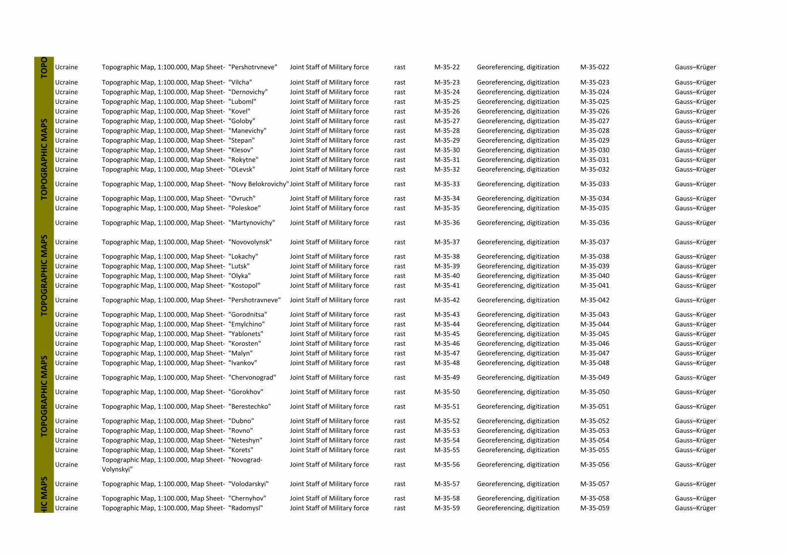
Ucraine Topographic Map, 1:100.000, Map Sheet‐ "Pershotrvneve" Joint Staff of Military force rast M‐35‐22 Georeferencing, digitization M‐35‐022 Gauss–Krüger
Ucraine Topographic Map, 1:100.000, Map Sheet‐ "Vilcha" Joint Staff of Military force rast M‐35‐23 Georeferencing, digitization M‐35‐023 Gauss–Krüger
Ucraine Topographic Map, 1:100.000, Map Sheet‐ "Dernovichy" Joint Staff of Military force rast M‐35‐24 Georeferencing, digitization M‐35‐024 Gauss–Krüger
Ucraine Topographic Map, 1:100.000, Map Sheet‐ "Luboml" Joint Staff of Military force rast M‐35‐25 Georeferencing, digitization M‐35‐025 Gauss–Krüger
Ucraine Topographic Map, 1:100.000, Map Sheet‐ "Kovel" Joint Staff of Military force rast M‐35‐26 Georeferencing, digitization M‐35‐026 Gauss–Krüger
Ucraine Topographic Map, 1:100.000, Map Sheet‐ "Goloby" Joint Staff of Military force rast M‐35‐27 Georeferencing, digitization M‐35‐027 Gauss–Krüger
Ucraine Topographic Map, 1:100.000, Map Sheet‐ "Manevichy" Joint Staff of Military force rast M‐35‐28 Georeferencing, digitization M‐35‐028 Gauss–Krüger
Ucraine Topographic Map, 1:100.000, Map Sheet‐ "Stepan" Joint Staff of Military force rast M‐35‐29 Georeferencing, digitization M‐35‐029 Gauss–Krüger
Ucraine Topographic Map, 1:100.000, Map Sheet‐ "Klesov" Joint Staff of Military force rast M‐35‐30 Georeferencing, digitization M‐35‐030 Gauss–Krüger
Ucraine Topographic Map, 1:100.000, Map Sheet‐ "Rokytne" Joint Staff of Military force rast M‐35‐31 Georeferencing, digitization M‐35‐031 Gauss–Krüger
Ucraine Topographic Map, 1:100.000, Map Sheet‐ "OLevsk" Joint Staff of Military force rast M‐35‐32 Georeferencing, digitization M‐35‐032 Gauss–Krüger
Ucraine Topographic Map, 1:100.000, Map Sheet‐ "Novy Belokrovichy" Joint Staff of Military force rast M‐35‐33 Georeferencing, digitization M‐35‐033 Gauss–Krüger
Ucraine Topographic Map, 1:100.000, Map Sheet‐ "Ovruch" Joint Staff of Military force rast M‐35‐34 Georeferencing, digitization M‐35‐034 Gauss–Krüger
Ucraine Topographic Map, 1:100.000, Map Sheet‐ "Poleskoe" Joint Staff of Military force rast M‐35‐35 Georeferencing, digitization M‐35‐035 Gauss–Krüger
Ucraine Topographic Map, 1:100.000, Map Sheet‐ "Martynovichy" Joint Staff of Military force rast M‐35‐36 Georeferencing, digitization M‐35‐036 Gauss–Krüger
Ucraine Topographic Map, 1:100.000, Map Sheet‐ "Novovolynsk" Joint Staff of Military force rast M‐35‐37 Georeferencing, digitization M‐35‐037 Gauss–Krüger
Ucraine Topographic Map, 1:100.000, Map Sheet‐ "Lokachy" Joint Staff of Military force rast M‐35‐38 Georeferencing, digitization M‐35‐038 Gauss–Krüger
Ucraine Topographic Map, 1:100.000, Map Sheet‐ "Lutsk" Joint Staff of Military force rast M‐35‐39 Georeferencing, digitization M‐35‐039 Gauss–Krüger
Ucraine Topographic Map, 1:100.000, Map Sheet‐ "Olyka" Joint Staff of Military force rast M‐35‐40 Georeferencing, digitization M‐35‐040 Gauss–Krüger
Ucraine Topographic Map, 1:100.000, Map Sheet‐ "Kostopol" Joint Staff of Military force rast M‐35‐41 Georeferencing, digitization M‐35‐041 Gauss–Krüger
Ucraine Topographic Map, 1:100.000, Map Sheet‐ "Pershotravneve" Joint Staff of Military force rast M‐35‐42 Georeferencing, digitization M‐35‐042 Gauss–Krüger
Ucraine Topographic Map, 1:100.000, Map Sheet‐ "Gorodnitsa" Joint Staff of Military force rast M‐35‐43 Georeferencing, digitization M‐35‐043 Gauss–Krüger
Ucraine Topographic Map, 1:100.000, Map Sheet‐ "Emylchino" Joint Staff of Military force rast M‐35‐44 Georeferencing, digitization M‐35‐044 Gauss–Krüger
Ucraine Topographic Map, 1:100.000, Map Sheet‐ "Yablonets" Joint Staff of Military force rast M‐35‐45 Georeferencing, digitization M‐35‐045 Gauss–Krüger
Ucraine Topographic Map, 1:100.000, Map Sheet‐ "Korosten" Joint Staff of Military force rast M‐35‐46 Georeferencing, digitization M‐35‐046 Gauss–Krüger
Ucraine Topographic Map, 1:100.000, Map Sheet‐ "Malyn" Joint Staff of Military force rast M‐35‐47 Georeferencing, digitization M‐35‐047 Gauss–Krüger
Ucraine Topographic Map, 1:100.000, Map Sheet‐ "Ivankov" Joint Staff of Military force rast M‐35‐48 Georeferencing, digitization M‐35‐048 Gauss–Krüger
Ucraine Topographic Map, 1:100.000, Map Sheet‐ "Chervonograd" Joint Staff of Military force rast M‐35‐49 Georeferencing, digitization M‐35‐049 Gauss–Krüger
Ucraine Topographic Map, 1:100.000, Map Sheet‐ "Gorokhov" Joint Staff of Military force rast M‐35‐50 Georeferencing, digitization M‐35‐050 Gauss–Krüger
Ucraine Topographic Map, 1:100.000, Map Sheet‐ "Berestechko" Joint Staff of Military force rast M‐35‐51 Georeferencing, digitization M‐35‐051 Gauss–Krüger
Ucraine Topographic Map, 1:100.000, Map Sheet‐ "Dubno" Joint Staff of Military force rast M‐35‐52 Georeferencing, digitization M‐35‐052 Gauss–Krüger
Ucraine Topographic Map, 1:100.000, Map Sheet‐ "Rovno" Joint Staff of Military force rast M‐35‐53 Georeferencing, digitization M‐35‐053 Gauss–Krüger
Ucraine Topographic Map, 1:100.000, Map Sheet‐ "Neteshyn" Joint Staff of Military force rast M‐35‐54 Georeferencing, digitization M‐35‐054 Gauss–Krüger
Ucraine Topographic Map, 1:100.000, Map Sheet‐ "Korets" Joint Staff of Military force rast M‐35‐55 Georeferencing, digitization M‐35‐055 Gauss–Krüger
UcraineTopographic Map, 1:100.000, Map Sheet‐ "Novograd‐
Volynskyi"Joint Staff of Military force rast M‐35‐56 Georeferencing, digitization M‐35‐056 Gauss–Krüger
Ucraine Topographic Map, 1:100.000, Map Sheet‐ "Volodarskyi" Joint Staff of Military force rast M‐35‐57 Georeferencing, digitization M‐35‐057 Gauss–Krüger
Ucraine Topographic Map, 1:100.000, Map Sheet‐ "Chernyhov" Joint Staff of Military force rast M‐35‐58 Georeferencing, digitization M‐35‐058 Gauss–Krüger
Ucraine Topographic Map, 1:100.000, Map Sheet‐ "Radomysl" Joint Staff of Military force rast M‐35‐59 Georeferencing, digitization M‐35‐059 Gauss–Krüger
TOPOGRAPHIC M
APS
TOPOGRAPHIC M
APS
HIC M
APS
TOPO
TOPOGRAPHIC M
APS
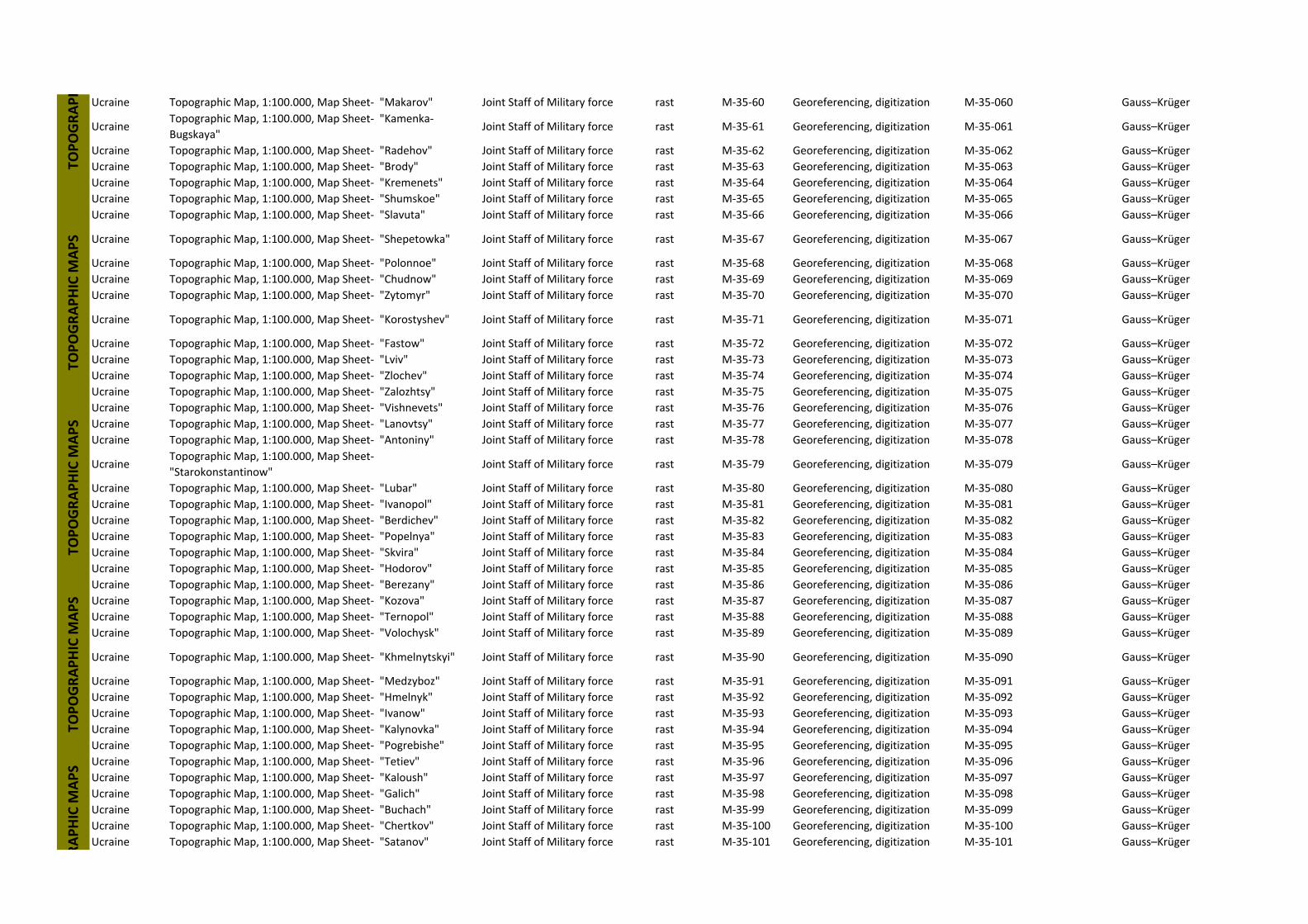
Ucraine Topographic Map, 1:100.000, Map Sheet‐ "Makarov" Joint Staff of Military force rast M‐35‐60 Georeferencing, digitization M‐35‐060 Gauss–Krüger
UcraineTopographic Map, 1:100.000, Map Sheet‐ "Kamenka‐
Bugskaya"Joint Staff of Military force rast M‐35‐61 Georeferencing, digitization M‐35‐061 Gauss–Krüger
Ucraine Topographic Map, 1:100.000, Map Sheet‐ "Radehov" Joint Staff of Military force rast M‐35‐62 Georeferencing, digitization M‐35‐062 Gauss–Krüger
Ucraine Topographic Map, 1:100.000, Map Sheet‐ "Brody" Joint Staff of Military force rast M‐35‐63 Georeferencing, digitization M‐35‐063 Gauss–Krüger
Ucraine Topographic Map, 1:100.000, Map Sheet‐ "Kremenets" Joint Staff of Military force rast M‐35‐64 Georeferencing, digitization M‐35‐064 Gauss–Krüger
Ucraine Topographic Map, 1:100.000, Map Sheet‐ "Shumskoe" Joint Staff of Military force rast M‐35‐65 Georeferencing, digitization M‐35‐065 Gauss–Krüger
Ucraine Topographic Map, 1:100.000, Map Sheet‐ "Slavuta" Joint Staff of Military force rast M‐35‐66 Georeferencing, digitization M‐35‐066 Gauss–Krüger
Ucraine Topographic Map, 1:100.000, Map Sheet‐ "Shepetowka" Joint Staff of Military force rast M‐35‐67 Georeferencing, digitization M‐35‐067 Gauss–Krüger
Ucraine Topographic Map, 1:100.000, Map Sheet‐ "Polonnoe" Joint Staff of Military force rast M‐35‐68 Georeferencing, digitization M‐35‐068 Gauss–Krüger
Ucraine Topographic Map, 1:100.000, Map Sheet‐ "Chudnow" Joint Staff of Military force rast M‐35‐69 Georeferencing, digitization M‐35‐069 Gauss–Krüger
Ucraine Topographic Map, 1:100.000, Map Sheet‐ "Zytomyr" Joint Staff of Military force rast M‐35‐70 Georeferencing, digitization M‐35‐070 Gauss–Krüger
Ucraine Topographic Map, 1:100.000, Map Sheet‐ "Korostyshev" Joint Staff of Military force rast M‐35‐71 Georeferencing, digitization M‐35‐071 Gauss–Krüger
Ucraine Topographic Map, 1:100.000, Map Sheet‐ "Fastow" Joint Staff of Military force rast M‐35‐72 Georeferencing, digitization M‐35‐072 Gauss–Krüger
Ucraine Topographic Map, 1:100.000, Map Sheet‐ "Lviv" Joint Staff of Military force rast M‐35‐73 Georeferencing, digitization M‐35‐073 Gauss–Krüger
Ucraine Topographic Map, 1:100.000, Map Sheet‐ "Zlochev" Joint Staff of Military force rast M‐35‐74 Georeferencing, digitization M‐35‐074 Gauss–Krüger
Ucraine Topographic Map, 1:100.000, Map Sheet‐ "Zalozhtsy" Joint Staff of Military force rast M‐35‐75 Georeferencing, digitization M‐35‐075 Gauss–Krüger
Ucraine Topographic Map, 1:100.000, Map Sheet‐ "Vishnevets" Joint Staff of Military force rast M‐35‐76 Georeferencing, digitization M‐35‐076 Gauss–Krüger
Ucraine Topographic Map, 1:100.000, Map Sheet‐ "Lanovtsy" Joint Staff of Military force rast M‐35‐77 Georeferencing, digitization M‐35‐077 Gauss–Krüger
Ucraine Topographic Map, 1:100.000, Map Sheet‐ "Antoniny" Joint Staff of Military force rast M‐35‐78 Georeferencing, digitization M‐35‐078 Gauss–Krüger
UcraineTopographic Map, 1:100.000, Map Sheet‐
"Starokonstantinow"Joint Staff of Military force rast M‐35‐79 Georeferencing, digitization M‐35‐079 Gauss–Krüger
Ucraine Topographic Map, 1:100.000, Map Sheet‐ "Lubar" Joint Staff of Military force rast M‐35‐80 Georeferencing, digitization M‐35‐080 Gauss–Krüger
Ucraine Topographic Map, 1:100.000, Map Sheet‐ "Ivanopol" Joint Staff of Military force rast M‐35‐81 Georeferencing, digitization M‐35‐081 Gauss–Krüger
Ucraine Topographic Map, 1:100.000, Map Sheet‐ "Berdichev" Joint Staff of Military force rast M‐35‐82 Georeferencing, digitization M‐35‐082 Gauss–Krüger
Ucraine Topographic Map, 1:100.000, Map Sheet‐ "Popelnya" Joint Staff of Military force rast M‐35‐83 Georeferencing, digitization M‐35‐083 Gauss–Krüger
Ucraine Topographic Map, 1:100.000, Map Sheet‐ "Skvira" Joint Staff of Military force rast M‐35‐84 Georeferencing, digitization M‐35‐084 Gauss–Krüger
Ucraine Topographic Map, 1:100.000, Map Sheet‐ "Hodorov" Joint Staff of Military force rast M‐35‐85 Georeferencing, digitization M‐35‐085 Gauss–Krüger
Ucraine Topographic Map, 1:100.000, Map Sheet‐ "Berezany" Joint Staff of Military force rast M‐35‐86 Georeferencing, digitization M‐35‐086 Gauss–Krüger
Ucraine Topographic Map, 1:100.000, Map Sheet‐ "Kozova" Joint Staff of Military force rast M‐35‐87 Georeferencing, digitization M‐35‐087 Gauss–Krüger
Ucraine Topographic Map, 1:100.000, Map Sheet‐ "Ternopol" Joint Staff of Military force rast M‐35‐88 Georeferencing, digitization M‐35‐088 Gauss–Krüger
Ucraine Topographic Map, 1:100.000, Map Sheet‐ "Volochysk" Joint Staff of Military force rast M‐35‐89 Georeferencing, digitization M‐35‐089 Gauss–Krüger
Ucraine Topographic Map, 1:100.000, Map Sheet‐ "Khmelnytskyi" Joint Staff of Military force rast M‐35‐90 Georeferencing, digitization M‐35‐090 Gauss–Krüger
Ucraine Topographic Map, 1:100.000, Map Sheet‐ "Medzyboz" Joint Staff of Military force rast M‐35‐91 Georeferencing, digitization M‐35‐091 Gauss–Krüger
Ucraine Topographic Map, 1:100.000, Map Sheet‐ "Hmelnyk" Joint Staff of Military force rast M‐35‐92 Georeferencing, digitization M‐35‐092 Gauss–Krüger
Ucraine Topographic Map, 1:100.000, Map Sheet‐ "Ivanow" Joint Staff of Military force rast M‐35‐93 Georeferencing, digitization M‐35‐093 Gauss–Krüger
Ucraine Topographic Map, 1:100.000, Map Sheet‐ "Kalynovka" Joint Staff of Military force rast M‐35‐94 Georeferencing, digitization M‐35‐094 Gauss–Krüger
Ucraine Topographic Map, 1:100.000, Map Sheet‐ "Pogrebishe" Joint Staff of Military force rast M‐35‐95 Georeferencing, digitization M‐35‐095 Gauss–Krüger
Ucraine Topographic Map, 1:100.000, Map Sheet‐ "Tetiev" Joint Staff of Military force rast M‐35‐96 Georeferencing, digitization M‐35‐096 Gauss–Krüger
Ucraine Topographic Map, 1:100.000, Map Sheet‐ "Kaloush" Joint Staff of Military force rast M‐35‐97 Georeferencing, digitization M‐35‐097 Gauss–Krüger
Ucraine Topographic Map, 1:100.000, Map Sheet‐ "Galich" Joint Staff of Military force rast M‐35‐98 Georeferencing, digitization M‐35‐098 Gauss–Krüger
Ucraine Topographic Map, 1:100.000, Map Sheet‐ "Buchach" Joint Staff of Military force rast M‐35‐99 Georeferencing, digitization M‐35‐099 Gauss–Krüger
Ucraine Topographic Map, 1:100.000, Map Sheet‐ "Chertkov" Joint Staff of Military force rast M‐35‐100 Georeferencing, digitization M‐35‐100 Gauss–Krüger
Ucraine Topographic Map, 1:100.000, Map Sheet‐ "Satanov" Joint Staff of Military force rast M‐35‐101 Georeferencing, digitization M‐35‐101 Gauss–Krüger
RAPHIC M
APS
TOPOGRAPH
TOPOGRAPHIC M
APS
TOPOGRAPHIC M
APS
TOPOGRAPHIC M
APS
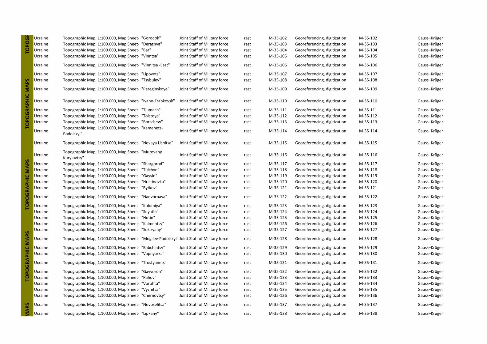
Ucraine Topographic Map, 1:100.000, Map Sheet‐ "Gorodok" Joint Staff of Military force rast M‐35‐102 Georeferencing, digitization M‐35‐102 Gauss–Krüger
Ucraine Topographic Map, 1:100.000, Map Sheet‐ "Deraznya" Joint Staff of Military force rast M‐35‐103 Georeferencing, digitization M‐35‐103 Gauss–Krüger
Ucraine Topographic Map, 1:100.000, Map Sheet‐ "Bar" Joint Staff of Military force rast M‐35‐104 Georeferencing, digitization M‐35‐104 Gauss–Krüger
Ucraine Topographic Map, 1:100.000, Map Sheet‐ "Vinntsa" Joint Staff of Military force rast M‐35‐105 Georeferencing, digitization M‐35‐105 Gauss–Krüger
Ucraine Topographic Map, 1:100.000, Map Sheet‐ "Vinnitsa ‐East" Joint Staff of Military force rast M‐35‐106 Georeferencing, digitization M‐35‐106 Gauss–Krüger
Ucraine Topographic Map, 1:100.000, Map Sheet‐ "Lipovets" Joint Staff of Military force rast M‐35‐107 Georeferencing, digitization M‐35‐107 Gauss–Krüger
Ucraine Topographic Map, 1:100.000, Map Sheet‐ "Tsybulev" Joint Staff of Military force rast M‐35‐108 Georeferencing, digitization M‐35‐108 Gauss–Krüger
Ucraine Topographic Map, 1:100.000, Map Sheet‐ "Pereginskoye" Joint Staff of Military force rast M‐35‐109 Georeferencing, digitization M‐35‐109 Gauss–Krüger
Ucraine Topographic Map, 1:100.000, Map Sheet‐ "Ivano‐Frabkovsk" Joint Staff of Military force rast M‐35‐110 Georeferencing, digitization M‐35‐110 Gauss–Krüger
Ucraine Topographic Map, 1:100.000, Map Sheet‐ "Tlumach" Joint Staff of Military force rast M‐35‐111 Georeferencing, digitization M‐35‐111 Gauss–Krüger
Ucraine Topographic Map, 1:100.000, Map Sheet‐ "Tolstoye" Joint Staff of Military force rast M‐35‐112 Georeferencing, digitization M‐35‐112 Gauss–Krüger
Ucraine Topographic Map, 1:100.000, Map Sheet‐ "Borschew" Joint Staff of Military force rast M‐35‐113 Georeferencing, digitization M‐35‐113 Gauss–Krüger
UcraineTopographic Map, 1:100.000, Map Sheet‐ "Kamenets‐
Podolskyi"Joint Staff of Military force rast M‐35‐114 Georeferencing, digitization M‐35‐114 Gauss–Krüger
Ucraine Topographic Map, 1:100.000, Map Sheet‐ "Novaya Ushitsa" Joint Staff of Military force rast M‐35‐115 Georeferencing, digitization M‐35‐115 Gauss–Krüger
UcraineTopographic Map, 1:100.000, Map Sheet‐ "Murovany
Kurylovtsy"Joint Staff of Military force rast M‐35‐116 Georeferencing, digitization M‐35‐116 Gauss–Krüger
Ucraine Topographic Map, 1:100.000, Map Sheet‐ "Shargorod" Joint Staff of Military force rast M‐35‐117 Georeferencing, digitization M‐35‐117 Gauss–Krüger
Ucraine Topographic Map, 1:100.000, Map Sheet‐ "Tulchyn" Joint Staff of Military force rast M‐35‐118 Georeferencing, digitization M‐35‐118 Gauss–Krüger
Ucraine Topographic Map, 1:100.000, Map Sheet‐ "Gaysin" Joint Staff of Military force rast M‐35‐119 Georeferencing, digitization M‐35‐119 Gauss–Krüger
Ucraine Topographic Map, 1:100.000, Map Sheet‐ "Hristinovka" Joint Staff of Military force rast M‐35‐120 Georeferencing, digitization M‐35‐120 Gauss–Krüger
Ucraine Topographic Map, 1:100.000, Map Sheet‐ "Bytkov" Joint Staff of Military force rast M‐35‐121 Georeferencing, digitization M‐35‐121 Gauss–Krüger
Ucraine Topographic Map, 1:100.000, Map Sheet‐ "Nadvornaya" Joint Staff of Military force rast M‐35‐122 Georeferencing, digitization M‐35‐122 Gauss–Krüger
Ucraine Topographic Map, 1:100.000, Map Sheet‐ "Kolomiya" Joint Staff of Military force rast M‐35‐123 Georeferencing, digitization M‐35‐123 Gauss–Krüger
Ucraine Topographic Map, 1:100.000, Map Sheet‐ "Snyatin" Joint Staff of Military force rast M‐35‐124 Georeferencing, digitization M‐35‐124 Gauss–Krüger
Ucraine Topographic Map, 1:100.000, Map Sheet‐ "Hotin" Joint Staff of Military force rast M‐35‐125 Georeferencing, digitization M‐35‐125 Gauss–Krüger
Ucraine Topographic Map, 1:100.000, Map Sheet‐ "Kalmentsy" Joint Staff of Military force rast M‐35‐126 Georeferencing, digitization M‐35‐126 Gauss–Krüger
Ucraine Topographic Map, 1:100.000, Map Sheet‐ "Sokiryany" Joint Staff of Military force rast M‐35‐127 Georeferencing, digitization M‐35‐127 Gauss–Krüger
Ucraine Topographic Map, 1:100.000, Map Sheet‐ "Mogilev‐Podolskyi" Joint Staff of Military force rast M‐35‐128 Georeferencing, digitization M‐35‐128 Gauss–Krüger
Ucraine Topographic Map, 1:100.000, Map Sheet‐ "Babchintsy" Joint Staff of Military force rast M‐35‐129 Georeferencing, digitization M‐35‐129 Gauss–Krüger
Ucraine Topographic Map, 1:100.000, Map Sheet‐ "Vapnyarka" Joint Staff of Military force rast M‐35‐130 Georeferencing, digitization M‐35‐130 Gauss–Krüger
Ucraine Topographic Map, 1:100.000, Map Sheet‐ "Trostyanets" Joint Staff of Military force rast M‐35‐131 Georeferencing, digitization M‐35‐131 Gauss–Krüger
Ucraine Topographic Map, 1:100.000, Map Sheet‐ "Gayvoron" Joint Staff of Military force rast M‐35‐132 Georeferencing, digitization M‐35‐132 Gauss–Krüger
Ucraine Topographic Map, 1:100.000, Map Sheet‐ "Rahov" Joint Staff of Military force rast M‐35‐133 Georeferencing, digitization M‐35‐133 Gauss–Krüger
Ucraine Topographic Map, 1:100.000, Map Sheet‐ "Vorohta" Joint Staff of Military force rast M‐35‐134 Georeferencing, digitization M‐35‐134 Gauss–Krüger
Ucraine Topographic Map, 1:100.000, Map Sheet‐ "Vyznitsa" Joint Staff of Military force rast M‐35‐135 Georeferencing, digitization M‐35‐135 Gauss–Krüger
Ucraine Topographic Map, 1:100.000, Map Sheet‐ "Chernovtsy" Joint Staff of Military force rast M‐35‐136 Georeferencing, digitization M‐35‐136 Gauss–Krüger
Ucraine Topographic Map, 1:100.000, Map Sheet‐ "Novoselitsa" Joint Staff of Military force rast M‐35‐137 Georeferencing, digitization M‐35‐137 Gauss–Krüger
Ucraine Topographic Map, 1:100.000, Map Sheet‐ "Lipkany" Joint Staff of Military force rast M‐35‐138 Georeferencing, digitization M‐35‐138 Gauss–Krüger
TOPOGR
TOPOGRAPHIC M
APS
TOPOGRAPHIC M
APS
TOPOGRAPHIC M
APS
MAPS
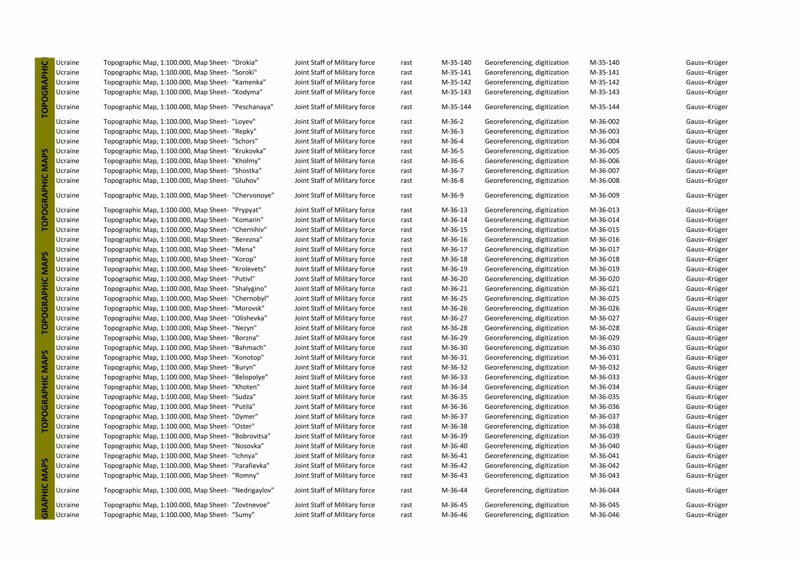
Ucraine Topographic Map, 1:100.000, Map Sheet‐ "Drokia" Joint Staff of Military force rast M‐35‐140 Georeferencing, digitization M‐35‐140 Gauss–Krüger
Ucraine Topographic Map, 1:100.000, Map Sheet‐ "Soroki" Joint Staff of Military force rast M‐35‐141 Georeferencing, digitization M‐35‐141 Gauss–Krüger
Ucraine Topographic Map, 1:100.000, Map Sheet‐ "Kamenka" Joint Staff of Military force rast M‐35‐142 Georeferencing, digitization M‐35‐142 Gauss–Krüger
Ucraine Topographic Map, 1:100.000, Map Sheet‐ "Kodyma" Joint Staff of Military force rast M‐35‐143 Georeferencing, digitization M‐35‐143 Gauss–Krüger
Ucraine Topographic Map, 1:100.000, Map Sheet‐ "Peschanaya" Joint Staff of Military force rast M‐35‐144 Georeferencing, digitization M‐35‐144 Gauss–Krüger
Ucraine Topographic Map, 1:100.000, Map Sheet‐ "Loyev" Joint Staff of Military force rast M‐36‐2 Georeferencing, digitization M‐36‐002 Gauss–Krüger
Ucraine Topographic Map, 1:100.000, Map Sheet‐ "Repky" Joint Staff of Military force rast M‐36‐3 Georeferencing, digitization M‐36‐003 Gauss–Krüger
Ucraine Topographic Map, 1:100.000, Map Sheet‐ "Schors" Joint Staff of Military force rast M‐36‐4 Georeferencing, digitization M‐36‐004 Gauss–Krüger
Ucraine Topographic Map, 1:100.000, Map Sheet‐ "Krukovka" Joint Staff of Military force rast M‐36‐5 Georeferencing, digitization M‐36‐005 Gauss–Krüger
Ucraine Topographic Map, 1:100.000, Map Sheet‐ "Kholmy" Joint Staff of Military force rast M‐36‐6 Georeferencing, digitization M‐36‐006 Gauss–Krüger
Ucraine Topographic Map, 1:100.000, Map Sheet‐ "Shostka" Joint Staff of Military force rast M‐36‐7 Georeferencing, digitization M‐36‐007 Gauss–Krüger
Ucraine Topographic Map, 1:100.000, Map Sheet‐ "Gluhov" Joint Staff of Military force rast M‐36‐8 Georeferencing, digitization M‐36‐008 Gauss–Krüger
Ucraine Topographic Map, 1:100.000, Map Sheet‐ "Chervonoye" Joint Staff of Military force rast M‐36‐9 Georeferencing, digitization M‐36‐009 Gauss–Krüger
Ucraine Topographic Map, 1:100.000, Map Sheet‐ "Prypyat" Joint Staff of Military force rast M‐36‐13 Georeferencing, digitization M‐36‐013 Gauss–Krüger
Ucraine Topographic Map, 1:100.000, Map Sheet‐ "Komarin" Joint Staff of Military force rast M‐36‐14 Georeferencing, digitization M‐36‐014 Gauss–Krüger
Ucraine Topographic Map, 1:100.000, Map Sheet‐ "Chernihiv" Joint Staff of Military force rast M‐36‐15 Georeferencing, digitization M‐36‐015 Gauss–Krüger
Ucraine Topographic Map, 1:100.000, Map Sheet‐ "Berezna" Joint Staff of Military force rast M‐36‐16 Georeferencing, digitization M‐36‐016 Gauss–Krüger
Ucraine Topographic Map, 1:100.000, Map Sheet‐ "Mena" Joint Staff of Military force rast M‐36‐17 Georeferencing, digitization M‐36‐017 Gauss–Krüger
Ucraine Topographic Map, 1:100.000, Map Sheet‐ "Korop" Joint Staff of Military force rast M‐36‐18 Georeferencing, digitization M‐36‐018 Gauss–Krüger
Ucraine Topographic Map, 1:100.000, Map Sheet‐ "Krolevets" Joint Staff of Military force rast M‐36‐19 Georeferencing, digitization M‐36‐019 Gauss–Krüger
Ucraine Topographic Map, 1:100.000, Map Sheet‐ "Putivl" Joint Staff of Military force rast M‐36‐20 Georeferencing, digitization M‐36‐020 Gauss–Krüger
Ucraine Topographic Map, 1:100.000, Map Sheet‐ "Shalygino" Joint Staff of Military force rast M‐36‐21 Georeferencing, digitization M‐36‐021 Gauss–Krüger
Ucraine Topographic Map, 1:100.000, Map Sheet‐ "Chernobyl" Joint Staff of Military force rast M‐36‐25 Georeferencing, digitization M‐36‐025 Gauss–Krüger
Ucraine Topographic Map, 1:100.000, Map Sheet‐ "Morovsk" Joint Staff of Military force rast M‐36‐26 Georeferencing, digitization M‐36‐026 Gauss–Krüger
Ucraine Topographic Map, 1:100.000, Map Sheet‐ "Olishevka" Joint Staff of Military force rast M‐36‐27 Georeferencing, digitization M‐36‐027 Gauss–Krüger
Ucraine Topographic Map, 1:100.000, Map Sheet‐ "Nezyn" Joint Staff of Military force rast M‐36‐28 Georeferencing, digitization M‐36‐028 Gauss–Krüger
Ucraine Topographic Map, 1:100.000, Map Sheet‐ "Borzna" Joint Staff of Military force rast M‐36‐29 Georeferencing, digitization M‐36‐029 Gauss–Krüger
Ucraine Topographic Map, 1:100.000, Map Sheet‐ "Bahmach" Joint Staff of Military force rast M‐36‐30 Georeferencing, digitization M‐36‐030 Gauss–Krüger
Ucraine Topographic Map, 1:100.000, Map Sheet‐ "Konotop" Joint Staff of Military force rast M‐36‐31 Georeferencing, digitization M‐36‐031 Gauss–Krüger
Ucraine Topographic Map, 1:100.000, Map Sheet‐ "Buryn" Joint Staff of Military force rast M‐36‐32 Georeferencing, digitization M‐36‐032 Gauss–Krüger
Ucraine Topographic Map, 1:100.000, Map Sheet‐ "Belopolye" Joint Staff of Military force rast M‐36‐33 Georeferencing, digitization M‐36‐033 Gauss–Krüger
Ucraine Topographic Map, 1:100.000, Map Sheet‐ "Khoten" Joint Staff of Military force rast M‐36‐34 Georeferencing, digitization M‐36‐034 Gauss–Krüger
Ucraine Topographic Map, 1:100.000, Map Sheet‐ "Sudza" Joint Staff of Military force rast M‐36‐35 Georeferencing, digitization M‐36‐035 Gauss–Krüger
Ucraine Topographic Map, 1:100.000, Map Sheet‐ "Putila" Joint Staff of Military force rast M‐36‐36 Georeferencing, digitization M‐36‐036 Gauss–Krüger
Ucraine Topographic Map, 1:100.000, Map Sheet‐ "Dymer" Joint Staff of Military force rast M‐36‐37 Georeferencing, digitization M‐36‐037 Gauss–Krüger
Ucraine Topographic Map, 1:100.000, Map Sheet‐ "Oster" Joint Staff of Military force rast M‐36‐38 Georeferencing, digitization M‐36‐038 Gauss–Krüger
Ucraine Topographic Map, 1:100.000, Map Sheet‐ "Bobrovitsa" Joint Staff of Military force rast M‐36‐39 Georeferencing, digitization M‐36‐039 Gauss–Krüger
Ucraine Topographic Map, 1:100.000, Map Sheet‐ "Nosovka" Joint Staff of Military force rast M‐36‐40 Georeferencing, digitization M‐36‐040 Gauss–Krüger
Ucraine Topographic Map, 1:100.000, Map Sheet‐ "Ichnya" Joint Staff of Military force rast M‐36‐41 Georeferencing, digitization M‐36‐041 Gauss–Krüger
Ucraine Topographic Map, 1:100.000, Map Sheet‐ "Parafievka" Joint Staff of Military force rast M‐36‐42 Georeferencing, digitization M‐36‐042 Gauss–Krüger
Ucraine Topographic Map, 1:100.000, Map Sheet‐ "Romny" Joint Staff of Military force rast M‐36‐43 Georeferencing, digitization M‐36‐043 Gauss–Krüger
Ucraine Topographic Map, 1:100.000, Map Sheet‐ "Nedrigaylov" Joint Staff of Military force rast M‐36‐44 Georeferencing, digitization M‐36‐044 Gauss–Krüger
Ucraine Topographic Map, 1:100.000, Map Sheet‐ "Zovtnevoe" Joint Staff of Military force rast M‐36‐45 Georeferencing, digitization M‐36‐045 Gauss–Krüger
Ucraine Topographic Map, 1:100.000, Map Sheet‐ "Sumy" Joint Staff of Military force rast M‐36‐46 Georeferencing, digitization M‐36‐046 Gauss–Krüger
TOPOGRAPHIC M
APS
TOPOGRAPHIC M
APS
OGRAPHIC M
APS
TOPOGRAPHIC M
TOPOGRAPHIC M
APS
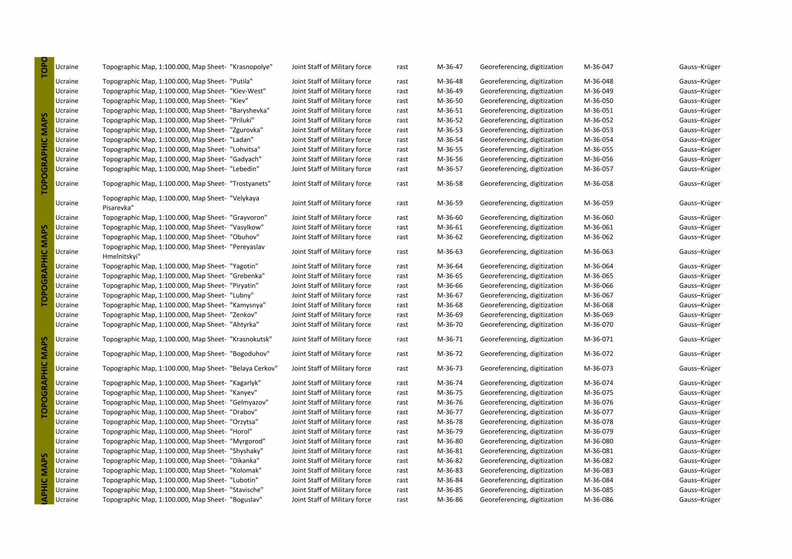
Ucraine Topographic Map, 1:100.000, Map Sheet‐ "Krasnopolye" Joint Staff of Military force rast M‐36‐47 Georeferencing, digitization M‐36‐047 Gauss–Krüger
Ucraine Topographic Map, 1:100.000, Map Sheet‐ "Putila" Joint Staff of Military force rast M‐36‐48 Georeferencing, digitization M‐36‐048 Gauss–Krüger
Ucraine Topographic Map, 1:100.000, Map Sheet‐ "Kiev‐West" Joint Staff of Military force rast M‐36‐49 Georeferencing, digitization M‐36‐049 Gauss–Krüger
Ucraine Topographic Map, 1:100.000, Map Sheet‐ "Kiev" Joint Staff of Military force rast M‐36‐50 Georeferencing, digitization M‐36‐050 Gauss–Krüger
Ucraine Topographic Map, 1:100.000, Map Sheet‐ "Baryshevka" Joint Staff of Military force rast M‐36‐51 Georeferencing, digitization M‐36‐051 Gauss–Krüger
Ucraine Topographic Map, 1:100.000, Map Sheet‐ "Priluki" Joint Staff of Military force rast M‐36‐52 Georeferencing, digitization M‐36‐052 Gauss–Krüger
Ucraine Topographic Map, 1:100.000, Map Sheet‐ "Zgurovka" Joint Staff of Military force rast M‐36‐53 Georeferencing, digitization M‐36‐053 Gauss–Krüger
Ucraine Topographic Map, 1:100.000, Map Sheet‐ "Ladan" Joint Staff of Military force rast M‐36‐54 Georeferencing, digitization M‐36‐054 Gauss–Krüger
Ucraine Topographic Map, 1:100.000, Map Sheet‐ "Lohvitsa" Joint Staff of Military force rast M‐36‐55 Georeferencing, digitization M‐36‐055 Gauss–Krüger
Ucraine Topographic Map, 1:100.000, Map Sheet‐ "Gadyach" Joint Staff of Military force rast M‐36‐56 Georeferencing, digitization M‐36‐056 Gauss–Krüger
Ucraine Topographic Map, 1:100.000, Map Sheet‐ "Lebedin" Joint Staff of Military force rast M‐36‐57 Georeferencing, digitization M‐36‐057 Gauss–Krüger
Ucraine Topographic Map, 1:100.000, Map Sheet‐ "Trostyanets" Joint Staff of Military force rast M‐36‐58 Georeferencing, digitization M‐36‐058 Gauss–Krüger
UcraineTopographic Map, 1:100.000, Map Sheet‐ "Velykaya
Pisarevka"Joint Staff of Military force rast M‐36‐59 Georeferencing, digitization M‐36‐059 Gauss–Krüger
Ucraine Topographic Map, 1:100.000, Map Sheet‐ "Grayvoron" Joint Staff of Military force rast M‐36‐60 Georeferencing, digitization M‐36‐060 Gauss–Krüger
Ucraine Topographic Map, 1:100.000, Map Sheet‐ "Vasylkow" Joint Staff of Military force rast M‐36‐61 Georeferencing, digitization M‐36‐061 Gauss–Krüger
Ucraine Topographic Map, 1:100.000, Map Sheet‐ "Obuhov" Joint Staff of Military force rast M‐36‐62 Georeferencing, digitization M‐36‐062 Gauss–Krüger
UcraineTopographic Map, 1:100.000, Map Sheet‐ "Pereyaslav
Hmelnitskyi"Joint Staff of Military force rast M‐36‐63 Georeferencing, digitization M‐36‐063 Gauss–Krüger
Ucraine Topographic Map, 1:100.000, Map Sheet‐ "Yagotin" Joint Staff of Military force rast M‐36‐64 Georeferencing, digitization M‐36‐064 Gauss–Krüger
Ucraine Topographic Map, 1:100.000, Map Sheet‐ "Grebenka" Joint Staff of Military force rast M‐36‐65 Georeferencing, digitization M‐36‐065 Gauss–Krüger
Ucraine Topographic Map, 1:100.000, Map Sheet‐ "Piryatin" Joint Staff of Military force rast M‐36‐66 Georeferencing, digitization M‐36‐066 Gauss–Krüger
Ucraine Topographic Map, 1:100.000, Map Sheet‐ "Lubny" Joint Staff of Military force rast M‐36‐67 Georeferencing, digitization M‐36‐067 Gauss–Krüger
Ucraine Topographic Map, 1:100.000, Map Sheet‐ "Kamysnya" Joint Staff of Military force rast M‐36‐68 Georeferencing, digitization M‐36‐068 Gauss–Krüger
Ucraine Topographic Map, 1:100.000, Map Sheet‐ "Zenkov" Joint Staff of Military force rast M‐36‐69 Georeferencing, digitization M‐36‐069 Gauss–Krüger
Ucraine Topographic Map, 1:100.000, Map Sheet‐ "Ahtyrka" Joint Staff of Military force rast M‐36‐70 Georeferencing, digitization M‐36‐070 Gauss–Krüger
Ucraine Topographic Map, 1:100.000, Map Sheet‐ "Krasnokutsk" Joint Staff of Military force rast M‐36‐71 Georeferencing, digitization M‐36‐071 Gauss–Krüger
Ucraine Topographic Map, 1:100.000, Map Sheet‐ "Bogoduhov" Joint Staff of Military force rast M‐36‐72 Georeferencing, digitization M‐36‐072 Gauss–Krüger
Ucraine Topographic Map, 1:100.000, Map Sheet‐ "Belaya Cerkov" Joint Staff of Military force rast M‐36‐73 Georeferencing, digitization M‐36‐073 Gauss–Krüger
Ucraine Topographic Map, 1:100.000, Map Sheet‐ "Kagarlyk" Joint Staff of Military force rast M‐36‐74 Georeferencing, digitization M‐36‐074 Gauss–Krüger
Ucraine Topographic Map, 1:100.000, Map Sheet‐ "Kanyev" Joint Staff of Military force rast M‐36‐75 Georeferencing, digitization M‐36‐075 Gauss–Krüger
Ucraine Topographic Map, 1:100.000, Map Sheet‐ "Gelmyazov" Joint Staff of Military force rast M‐36‐76 Georeferencing, digitization M‐36‐076 Gauss–Krüger
Ucraine Topographic Map, 1:100.000, Map Sheet‐ "Drabov" Joint Staff of Military force rast M‐36‐77 Georeferencing, digitization M‐36‐077 Gauss–Krüger
Ucraine Topographic Map, 1:100.000, Map Sheet‐ "Orzytsa" Joint Staff of Military force rast M‐36‐78 Georeferencing, digitization M‐36‐078 Gauss–Krüger
Ucraine Topographic Map, 1:100.000, Map Sheet‐ "Horol" Joint Staff of Military force rast M‐36‐79 Georeferencing, digitization M‐36‐079 Gauss–Krüger
Ucraine Topographic Map, 1:100.000, Map Sheet‐ "Myrgorod" Joint Staff of Military force rast M‐36‐80 Georeferencing, digitization M‐36‐080 Gauss–Krüger
Ucraine Topographic Map, 1:100.000, Map Sheet‐ "Shyshaky" Joint Staff of Military force rast M‐36‐81 Georeferencing, digitization M‐36‐081 Gauss–Krüger
Ucraine Topographic Map, 1:100.000, Map Sheet‐ "Dikanka" Joint Staff of Military force rast M‐36‐82 Georeferencing, digitization M‐36‐082 Gauss–Krüger
Ucraine Topographic Map, 1:100.000, Map Sheet‐ "Kolomak" Joint Staff of Military force rast M‐36‐83 Georeferencing, digitization M‐36‐083 Gauss–Krüger
Ucraine Topographic Map, 1:100.000, Map Sheet‐ "Lubotin" Joint Staff of Military force rast M‐36‐84 Georeferencing, digitization M‐36‐084 Gauss–Krüger
Ucraine Topographic Map, 1:100.000, Map Sheet‐ "Stavische" Joint Staff of Military force rast M‐36‐85 Georeferencing, digitization M‐36‐085 Gauss–Krüger
Ucraine Topographic Map, 1:100.000, Map Sheet‐ "Boguslav" Joint Staff of Military force rast M‐36‐86 Georeferencing, digitization M‐36‐086 Gauss–Krüger
RAPHIC M
APS
TOPO
TOPOGRAPHIC M
APS
TOPOGRAPHIC M
APS
TOPOGRAPHIC M
APS

UcraineTopographic Map, 1:100.000, Map Sheet‐ "Korsun‐
Shevchenkoskyi"Joint Staff of Military force rast M‐36‐87 Georeferencing, digitization M‐36‐087 Gauss–Krüger
UcraineTopographic Map, 1:100.000, Map Sheet‐ "Russkaya
Polayana"Joint Staff of Military force rast M‐36‐88 Georeferencing, digitization M‐36‐088 Gauss–Krüger
Ucraine Topographic Map, 1:100.000, Map Sheet‐ "Cherkassy" Joint Staff of Military force rast M‐36‐89 Georeferencing, digitization M‐36‐089 Gauss–Krüger
Ucraine Topographic Map, 1:100.000, Map Sheet‐ "Obolon" Joint Staff of Military force rast M‐36‐90 Georeferencing, digitization M‐36‐090 Gauss–Krüger
Ucraine Topographic Map, 1:100.000, Map Sheet‐ "Globino" Joint Staff of Military force rast M‐36‐91 Georeferencing, digitization M‐36‐091 Gauss–Krüger
Ucraine Topographic Map, 1:100.000, Map Sheet‐ "Ostapye" Joint Staff of Military force rast M‐36‐92 Georeferencing, digitization M‐36‐092 Gauss–Krüger
Ucraine Topographic Map, 1:100.000, Map Sheet‐ "Reshetilovka" Joint Staff of Military force rast M‐36‐93 Georeferencing, digitization M‐36‐093 Gauss–Krüger
Ucraine Topographic Map, 1:100.000, Map Sheet‐ "Krasnograd" Joint Staff of Military force rast M‐36‐95 Georeferencing, digitization M‐36‐095 Gauss–Krüger
Ucraine Topographic Map, 1:100.000, Map Sheet‐ "Chapayevo" Joint Staff of Military force rast M‐36‐96 Georeferencing, digitization M‐36‐096 Gauss–Krüger
Ucraine Topographic Map, 1:100.000, Map Sheet‐ "Zashkiv" Joint Staff of Military force rast M‐36‐97 Georeferencing, digitization M‐36‐097 Gauss–Krüger
Ucraine Topographic Map, 1:100.000, Map Sheet‐ "Zvenigorodka" Joint Staff of Military force rast M‐36‐98 Georeferencing, digitization M‐36‐098 Gauss–Krüger
Ucraine Topographic Map, 1:100.000, Map Sheet‐ "Shpola" Joint Staff of Military force rast M‐36‐99 Georeferencing, digitization M‐36‐099 Gauss–Krüger
Ucraine Topographic Map, 1:100.000, Map Sheet‐ "Smela" Joint Staff of Military force rast M‐36‐100 Georeferencing, digitization M‐36‐100 Gauss–Krüger
Ucraine Topographic Map, 1:100.000, Map Sheet‐ "Kamenka" Joint Staff of Military force rast M‐36‐101 Georeferencing, digitization M‐36‐101 Gauss–Krüger
Ucraine Topographic Map, 1:100.000, Map Sheet‐ "Chigirin" Joint Staff of Military force rast M‐36‐102 Georeferencing, digitization M‐36‐102 Gauss–Krüger
Ucraine Topographic Map, 1:100.000, Map Sheet‐ "Kremenchug" Joint Staff of Military force rast M‐36‐103 Georeferencing, digitization M‐36‐103 Gauss–Krüger
Ucraine Topographic Map, 1:100.000, Map Sheet‐ "Komsomolsk" Joint Staff of Military force rast M‐36‐104 Georeferencing, digitization M‐36‐104 Gauss–Krüger
Ucraine Topographic Map, 1:100.000, Map Sheet‐ "KObelyaky" Joint Staff of Military force rast M‐36‐105 Georeferencing, digitization M‐36‐105 Gauss–Krüger
Ucraine Topographic Map, 1:100.000, Map Sheet‐ "Nehvoroscha" Joint Staff of Military force rast M‐36‐106 Georeferencing, digitization M‐36‐106 Gauss–Krüger
Ucraine Topographic Map, 1:100.000, Map Sheet‐ "Pereschepino" Joint Staff of Military force rast M‐36‐107 Georeferencing, digitization M‐36‐107 Gauss–Krüger
Ucraine Topographic Map, 1:100.000, Map Sheet‐ "Sahnovschina" Joint Staff of Military force rast M‐36‐108 Georeferencing, digitization M‐36‐108 Gauss–Krüger
Ucraine Topographic Map, 1:100.000, Map Sheet‐ "Uman" Joint Staff of Military force rast M‐36‐109 Georeferencing, digitization M‐36‐109 Gauss–Krüger
Ucraine Topographic Map, 1:100.000, Map Sheet‐ "Talnoye" Joint Staff of Military force rast M‐36‐110 Georeferencing, digitization M‐36‐110 Gauss–Krüger
UcraineTopographic Map, 1:100.000, Map Sheet‐ "Mokraya
Kaligorka"Joint Staff of Military force rast M‐36‐111 Georeferencing, digitization M‐36‐111 Gauss–Krüger
Ucraine Topographic Map, 1:100.000, Map Sheet‐ "Novomirgorod" Joint Staff of Military force rast M‐36‐112 Georeferencing, digitization M‐36‐112 Gauss–Krüger
Ucraine Topographic Map, 1:100.000, Map Sheet‐ "Aleksandrovka" Joint Staff of Military force rast M‐36‐113 Georeferencing, digitization M‐36‐113 Gauss–Krüger
Ucraine Topographic Map, 1:100.000, Map Sheet‐ "Znamenka" Joint Staff of Military force rast M‐36‐114 Georeferencing, digitization M‐36‐114 Gauss–Krüger
Ucraine Topographic Map, 1:100.000, Map Sheet‐ "Aleksandriya" Joint Staff of Military force rast M‐36‐115 Georeferencing, digitization M‐36‐115 Gauss–Krüger
Ucraine Topographic Map, 1:100.000, Map Sheet‐ "Lihovka" Joint Staff of Military force rast M‐36‐116 Georeferencing, digitization M‐36‐116 Gauss–Krüger
Ucraine Topographic Map, 1:100.000, Map Sheet‐ "Carychanka" Joint Staff of Military force rast M‐36‐117 Georeferencing, digitization M‐36‐117 Gauss–Krüger
Ucraine Topographic Map, 1:100.000, Map Sheet‐ "Petrikovka" Joint Staff of Military force rast M‐36‐118 Georeferencing, digitization M‐36‐118 Gauss–Krüger
Ucraine Topographic Map, 1:100.000, Map Sheet‐ "Gubinikha" Joint Staff of Military force rast M‐36‐119 Georeferencing, digitization M‐36‐119 Gauss–Krüger
Ucraine Topographic Map, 1:100.000, Map Sheet‐ "Popasnoye" Joint Staff of Military force rast M‐36‐120 Georeferencing, digitization M‐36‐120 Gauss–Krüger
TOPOGR
TOPOGRAPHIC M
APS
TOPOGRAPHIC M
APS
TOPOGRAPHIC M
APS
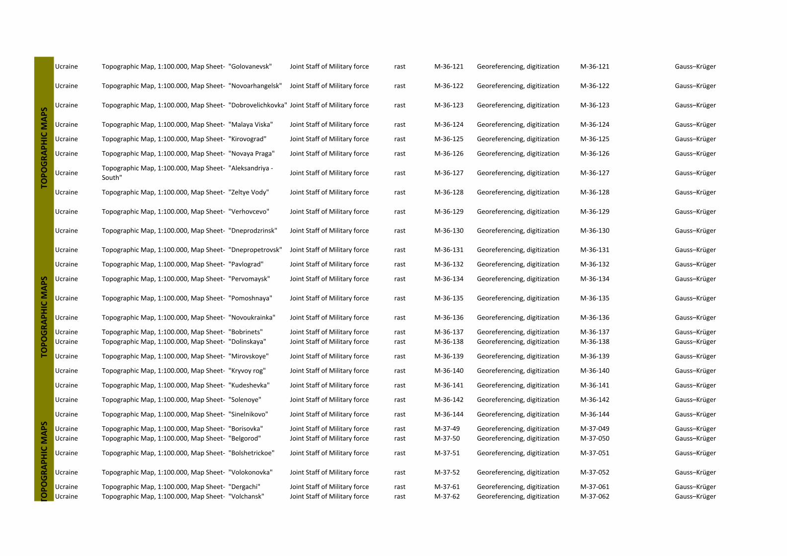
Ucraine Topographic Map, 1:100.000, Map Sheet‐ "Golovanevsk" Joint Staff of Military force rast M‐36‐121 Georeferencing, digitization M‐36‐121 Gauss–Krüger
Ucraine Topographic Map, 1:100.000, Map Sheet‐ "Novoarhangelsk" Joint Staff of Military force rast M‐36‐122 Georeferencing, digitization M‐36‐122 Gauss–Krüger
Ucraine Topographic Map, 1:100.000, Map Sheet‐ "Dobrovelichkovka" Joint Staff of Military force rast M‐36‐123 Georeferencing, digitization M‐36‐123 Gauss–Krüger
Ucraine Topographic Map, 1:100.000, Map Sheet‐ "Malaya Viska" Joint Staff of Military force rast M‐36‐124 Georeferencing, digitization M‐36‐124 Gauss–Krüger
Ucraine Topographic Map, 1:100.000, Map Sheet‐ "Kirovograd" Joint Staff of Military force rast M‐36‐125 Georeferencing, digitization M‐36‐125 Gauss–Krüger
Ucraine Topographic Map, 1:100.000, Map Sheet‐ "Novaya Praga" Joint Staff of Military force rast M‐36‐126 Georeferencing, digitization M‐36‐126 Gauss–Krüger
UcraineTopographic Map, 1:100.000, Map Sheet‐ "Aleksandriya ‐
South"Joint Staff of Military force rast M‐36‐127 Georeferencing, digitization M‐36‐127 Gauss–Krüger
Ucraine Topographic Map, 1:100.000, Map Sheet‐ "Zeltye Vody" Joint Staff of Military force rast M‐36‐128 Georeferencing, digitization M‐36‐128 Gauss–Krüger
Ucraine Topographic Map, 1:100.000, Map Sheet‐ "Verhovcevo" Joint Staff of Military force rast M‐36‐129 Georeferencing, digitization M‐36‐129 Gauss–Krüger
Ucraine Topographic Map, 1:100.000, Map Sheet‐ "Dneprodzrinsk" Joint Staff of Military force rast M‐36‐130 Georeferencing, digitization M‐36‐130 Gauss–Krüger
Ucraine Topographic Map, 1:100.000, Map Sheet‐ "Dnepropetrovsk" Joint Staff of Military force rast M‐36‐131 Georeferencing, digitization M‐36‐131 Gauss–Krüger
Ucraine Topographic Map, 1:100.000, Map Sheet‐ "Pavlograd" Joint Staff of Military force rast M‐36‐132 Georeferencing, digitization M‐36‐132 Gauss–Krüger
Ucraine Topographic Map, 1:100.000, Map Sheet‐ "Pervomaysk" Joint Staff of Military force rast M‐36‐134 Georeferencing, digitization M‐36‐134 Gauss–Krüger
Ucraine Topographic Map, 1:100.000, Map Sheet‐ "Pomoshnaya" Joint Staff of Military force rast M‐36‐135 Georeferencing, digitization M‐36‐135 Gauss–Krüger
Ucraine Topographic Map, 1:100.000, Map Sheet‐ "Novoukrainka" Joint Staff of Military force rast M‐36‐136 Georeferencing, digitization M‐36‐136 Gauss–Krüger
Ucraine Topographic Map, 1:100.000, Map Sheet‐ "Bobrinets" Joint Staff of Military force rast M‐36‐137 Georeferencing, digitization M‐36‐137 Gauss–Krüger
Ucraine Topographic Map, 1:100.000, Map Sheet‐ "Dolinskaya" Joint Staff of Military force rast M‐36‐138 Georeferencing, digitization M‐36‐138 Gauss–Krüger
Ucraine Topographic Map, 1:100.000, Map Sheet‐ "Mirovskoye" Joint Staff of Military force rast M‐36‐139 Georeferencing, digitization M‐36‐139 Gauss–Krüger
Ucraine Topographic Map, 1:100.000, Map Sheet‐ "Kryvoy rog" Joint Staff of Military force rast M‐36‐140 Georeferencing, digitization M‐36‐140 Gauss–Krüger
Ucraine Topographic Map, 1:100.000, Map Sheet‐ "Kudeshevka" Joint Staff of Military force rast M‐36‐141 Georeferencing, digitization M‐36‐141 Gauss–Krüger
Ucraine Topographic Map, 1:100.000, Map Sheet‐ "Solenoye" Joint Staff of Military force rast M‐36‐142 Georeferencing, digitization M‐36‐142 Gauss–Krüger
Ucraine Topographic Map, 1:100.000, Map Sheet‐ "Sinelnikovo" Joint Staff of Military force rast M‐36‐144 Georeferencing, digitization M‐36‐144 Gauss–Krüger
Ucraine Topographic Map, 1:100.000, Map Sheet‐ "Borisovka" Joint Staff of Military force rast M‐37‐49 Georeferencing, digitization M‐37‐049 Gauss–Krüger
Ucraine Topographic Map, 1:100.000, Map Sheet‐ "Belgorod" Joint Staff of Military force rast M‐37‐50 Georeferencing, digitization M‐37‐050 Gauss–Krüger
Ucraine Topographic Map, 1:100.000, Map Sheet‐ "Bolshetrickoe" Joint Staff of Military force rast M‐37‐51 Georeferencing, digitization M‐37‐051 Gauss–Krüger
Ucraine Topographic Map, 1:100.000, Map Sheet‐ "Volokonovka" Joint Staff of Military force rast M‐37‐52 Georeferencing, digitization M‐37‐052 Gauss–Krüger
Ucraine Topographic Map, 1:100.000, Map Sheet‐ "Dergachi" Joint Staff of Military force rast M‐37‐61 Georeferencing, digitization M‐37‐061 Gauss–Krüger
Ucraine Topographic Map, 1:100.000, Map Sheet‐ "Volchansk" Joint Staff of Military force rast M‐37‐62 Georeferencing, digitization M‐37‐062 Gauss–Krüger TOPOGRAPHIC M
APS
TOPOGRAPHIC M
APS
TOPOGRAPHIC M
APS
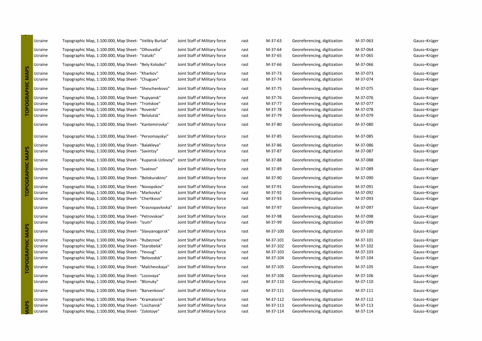
Ucraine Topographic Map, 1:100.000, Map Sheet‐ "Velikiy Burluk" Joint Staff of Military force rast M‐37‐63 Georeferencing, digitization M‐37‐063 Gauss–Krüger
Ucraine Topographic Map, 1:100.000, Map Sheet‐ "Olhovatka" Joint Staff of Military force rast M‐37‐64 Georeferencing, digitization M‐37‐064 Gauss–Krüger
Ucraine Topographic Map, 1:100.000, Map Sheet‐ "Valuiki" Joint Staff of Military force rast M‐37‐65 Georeferencing, digitization M‐37‐065 Gauss–Krüger
Ucraine Topographic Map, 1:100.000, Map Sheet‐ "Bely Kolodez" Joint Staff of Military force rast M‐37‐66 Georeferencing, digitization M‐37‐066 Gauss–Krüger
Ucraine Topographic Map, 1:100.000, Map Sheet‐ "Kharkov" Joint Staff of Military force rast M‐37‐73 Georeferencing, digitization M‐37‐073 Gauss–Krüger
Ucraine Topographic Map, 1:100.000, Map Sheet‐ "Chuguev" Joint Staff of Military force rast M‐37‐74 Georeferencing, digitization M‐37‐074 Gauss–Krüger
Ucraine Topographic Map, 1:100.000, Map Sheet‐ "Shevchenkovo" Joint Staff of Military force rast M‐37‐75 Georeferencing, digitization M‐37‐075 Gauss–Krüger
Ucraine Topographic Map, 1:100.000, Map Sheet‐ "Kupyansk" Joint Staff of Military force rast M‐37‐76 Georeferencing, digitization M‐37‐076 Gauss–Krüger
Ucraine Topographic Map, 1:100.000, Map Sheet‐ "Troitskoe" Joint Staff of Military force rast M‐37‐77 Georeferencing, digitization M‐37‐077 Gauss–Krüger
Ucraine Topographic Map, 1:100.000, Map Sheet‐ "Rovenki" Joint Staff of Military force rast M‐37‐78 Georeferencing, digitization M‐37‐078 Gauss–Krüger
Ucraine Topographic Map, 1:100.000, Map Sheet‐ "Belolutsk" Joint Staff of Military force rast M‐37‐79 Georeferencing, digitization M‐37‐079 Gauss–Krüger
Ucraine Topographic Map, 1:100.000, Map Sheet‐ "Kantemirovka" Joint Staff of Military force rast M‐37‐80 Georeferencing, digitization M‐37‐080 Gauss–Krüger
Ucraine Topographic Map, 1:100.000, Map Sheet‐ "Pervomayskyi" Joint Staff of Military force rast M‐37‐85 Georeferencing, digitization M‐37‐085 Gauss–Krüger
Ucraine Topographic Map, 1:100.000, Map Sheet‐ "Balakleya" Joint Staff of Military force rast M‐37‐86 Georeferencing, digitization M‐37‐086 Gauss–Krüger
Ucraine Topographic Map, 1:100.000, Map Sheet‐ "Savintsy" Joint Staff of Military force rast M‐37‐87 Georeferencing, digitization M‐37‐087 Gauss–Krüger
Ucraine Topographic Map, 1:100.000, Map Sheet‐ "Kupansk‐Uzlovoy" Joint Staff of Military force rast M‐37‐88 Georeferencing, digitization M‐37‐088 Gauss–Krüger
Ucraine Topographic Map, 1:100.000, Map Sheet‐ "Svatovo" Joint Staff of Military force rast M‐37‐89 Georeferencing, digitization M‐37‐089 Gauss–Krüger
Ucraine Topographic Map, 1:100.000, Map Sheet‐ "Belokurakino" Joint Staff of Military force rast M‐37‐90 Georeferencing, digitization M‐37‐090 Gauss–Krüger
Ucraine Topographic Map, 1:100.000, Map Sheet‐ "Novopskov" Joint Staff of Military force rast M‐37‐91 Georeferencing, digitization M‐37‐091 Gauss–Krüger
Ucraine Topographic Map, 1:100.000, Map Sheet‐ "Markovka" Joint Staff of Military force rast M‐37‐92 Georeferencing, digitization M‐37‐092 Gauss–Krüger
Ucraine Topographic Map, 1:100.000, Map Sheet‐ "Chertkovo" Joint Staff of Military force rast M‐37‐93 Georeferencing, digitization M‐37‐093 Gauss–Krüger
Ucraine Topographic Map, 1:100.000, Map Sheet‐ "Krasnopavlovka" Joint Staff of Military force rast M‐37‐97 Georeferencing, digitization M‐37‐097 Gauss–Krüger
Ucraine Topographic Map, 1:100.000, Map Sheet‐ "Petrovskoe" Joint Staff of Military force rast M‐37‐98 Georeferencing, digitization M‐37‐098 Gauss–Krüger
Ucraine Topographic Map, 1:100.000, Map Sheet‐ "Izum" Joint Staff of Military force rast M‐37‐99 Georeferencing, digitization M‐37‐099 Gauss–Krüger
Ucraine Topographic Map, 1:100.000, Map Sheet‐ "Slavyanogorsk" Joint Staff of Military force rast M‐37‐100 Georeferencing, digitization M‐37‐100 Gauss–Krüger
Ucraine Topographic Map, 1:100.000, Map Sheet‐ "Rubeznoe" Joint Staff of Military force rast M‐37‐101 Georeferencing, digitization M‐37‐101 Gauss–Krüger
Ucraine Topographic Map, 1:100.000, Map Sheet‐ "Starobelsk" Joint Staff of Military force rast M‐37‐102 Georeferencing, digitization M‐37‐102 Gauss–Krüger
Ucraine Topographic Map, 1:100.000, Map Sheet‐ "Yevsug" Joint Staff of Military force rast M‐37‐103 Georeferencing, digitization M‐37‐103 Gauss–Krüger
Ucraine Topographic Map, 1:100.000, Map Sheet‐ "Belovodsk" Joint Staff of Military force rast M‐37‐104 Georeferencing, digitization M‐37‐104 Gauss–Krüger
Ucraine Topographic Map, 1:100.000, Map Sheet‐ "Malchevskaya" Joint Staff of Military force rast M‐37‐105 Georeferencing, digitization M‐37‐105 Gauss–Krüger
Ucraine Topographic Map, 1:100.000, Map Sheet‐ "Lozovaya" Joint Staff of Military force rast M‐37‐106 Georeferencing, digitization M‐37‐106 Gauss–Krüger
Ucraine Topographic Map, 1:100.000, Map Sheet‐ "Bliznuky" Joint Staff of Military force rast M‐37‐110 Georeferencing, digitization M‐37‐110 Gauss–Krüger
Ucraine Topographic Map, 1:100.000, Map Sheet‐ "Barvenkovo" Joint Staff of Military force rast M‐37‐111 Georeferencing, digitization M‐37‐111 Gauss–Krüger
Ucraine Topographic Map, 1:100.000, Map Sheet‐ "Kramatorsk" Joint Staff of Military force rast M‐37‐112 Georeferencing, digitization M‐37‐112 Gauss–Krüger
Ucraine Topographic Map, 1:100.000, Map Sheet‐ "Lisichansk" Joint Staff of Military force rast M‐37‐113 Georeferencing, digitization M‐37‐113 Gauss–Krüger
Ucraine Topographic Map, 1:100.000, Map Sheet‐ "Zolotoye" Joint Staff of Military force rast M‐37‐114 Georeferencing, digitization M‐37‐114 Gauss–Krüger
TTO
POGRAPHIC M
APS
TOPOGRAPHIC M
APS
TOPOGRAPHIC M
APS
MAPS
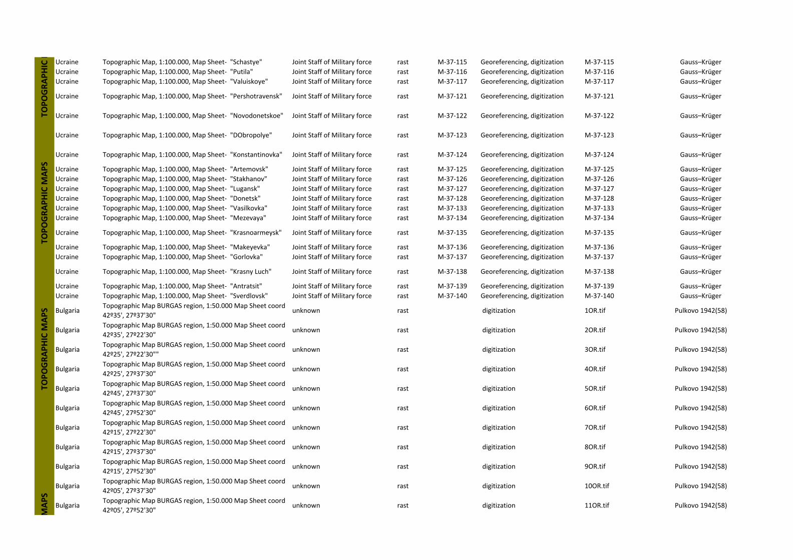
Ucraine Topographic Map, 1:100.000, Map Sheet‐ "Schastye" Joint Staff of Military force rast M‐37‐115 Georeferencing, digitization M‐37‐115 Gauss–Krüger
Ucraine Topographic Map, 1:100.000, Map Sheet‐ "Putila" Joint Staff of Military force rast M‐37‐116 Georeferencing, digitization M‐37‐116 Gauss–Krüger
Ucraine Topographic Map, 1:100.000, Map Sheet‐ "Valuiskoye" Joint Staff of Military force rast M‐37‐117 Georeferencing, digitization M‐37‐117 Gauss–Krüger
Ucraine Topographic Map, 1:100.000, Map Sheet‐ "Pershotravensk" Joint Staff of Military force rast M‐37‐121 Georeferencing, digitization M‐37‐121 Gauss–Krüger
Ucraine Topographic Map, 1:100.000, Map Sheet‐ "Novodonetskoe" Joint Staff of Military force rast M‐37‐122 Georeferencing, digitization M‐37‐122 Gauss–Krüger
Ucraine Topographic Map, 1:100.000, Map Sheet‐ "DObropolye" Joint Staff of Military force rast M‐37‐123 Georeferencing, digitization M‐37‐123 Gauss–Krüger
Ucraine Topographic Map, 1:100.000, Map Sheet‐ "Konstantinovka" Joint Staff of Military force rast M‐37‐124 Georeferencing, digitization M‐37‐124 Gauss–Krüger
Ucraine Topographic Map, 1:100.000, Map Sheet‐ "Artemovsk" Joint Staff of Military force rast M‐37‐125 Georeferencing, digitization M‐37‐125 Gauss–Krüger
Ucraine Topographic Map, 1:100.000, Map Sheet‐ "Stakhanov" Joint Staff of Military force rast M‐37‐126 Georeferencing, digitization M‐37‐126 Gauss–Krüger
Ucraine Topographic Map, 1:100.000, Map Sheet‐ "Lugansk" Joint Staff of Military force rast M‐37‐127 Georeferencing, digitization M‐37‐127 Gauss–Krüger
Ucraine Topographic Map, 1:100.000, Map Sheet‐ "Donetsk" Joint Staff of Military force rast M‐37‐128 Georeferencing, digitization M‐37‐128 Gauss–Krüger
Ucraine Topographic Map, 1:100.000, Map Sheet‐ "Vasilkovka" Joint Staff of Military force rast M‐37‐133 Georeferencing, digitization M‐37‐133 Gauss–Krüger
Ucraine Topographic Map, 1:100.000, Map Sheet‐ "Mezevaya" Joint Staff of Military force rast M‐37‐134 Georeferencing, digitization M‐37‐134 Gauss–Krüger
Ucraine Topographic Map, 1:100.000, Map Sheet‐ "Krasnoarmeysk" Joint Staff of Military force rast M‐37‐135 Georeferencing, digitization M‐37‐135 Gauss–Krüger
Ucraine Topographic Map, 1:100.000, Map Sheet‐ "Makeyevka" Joint Staff of Military force rast M‐37‐136 Georeferencing, digitization M‐37‐136 Gauss–Krüger
Ucraine Topographic Map, 1:100.000, Map Sheet‐ "Gorlovka" Joint Staff of Military force rast M‐37‐137 Georeferencing, digitization M‐37‐137 Gauss–Krüger
Ucraine Topographic Map, 1:100.000, Map Sheet‐ "Krasny Luch" Joint Staff of Military force rast M‐37‐138 Georeferencing, digitization M‐37‐138 Gauss–Krüger
Ucraine Topographic Map, 1:100.000, Map Sheet‐ "Antratsit" Joint Staff of Military force rast M‐37‐139 Georeferencing, digitization M‐37‐139 Gauss–Krüger
Ucraine Topographic Map, 1:100.000, Map Sheet‐ "Sverdlovsk" Joint Staff of Military force rast M‐37‐140 Georeferencing, digitization M‐37‐140 Gauss–Krüger
BulgariaTopographic Map BURGAS region, 1:50.000 Map Sheet coord
42º35', 27º37'30"unknown rast digitization 1OR.tif Pulkovo 1942(58)
BulgariaTopographic Map BURGAS region, 1:50.000 Map Sheet coord
42º35', 27º22'30"unknown rast digitization 2OR.tif Pulkovo 1942(58)
BulgariaTopographic Map BURGAS region, 1:50.000 Map Sheet coord
42º25', 27º22'30""unknown rast digitization 3OR.tif Pulkovo 1942(58)
BulgariaTopographic Map BURGAS region, 1:50.000 Map Sheet coord
42º25', 27º37'30"unknown rast digitization 4OR.tif Pulkovo 1942(58)
BulgariaTopographic Map BURGAS region, 1:50.000 Map Sheet coord
42º45', 27º37'30"unknown rast digitization 5OR.tif Pulkovo 1942(58)
BulgariaTopographic Map BURGAS region, 1:50.000 Map Sheet coord
42º45', 27º52'30"unknown rast digitization 6OR.tif Pulkovo 1942(58)
BulgariaTopographic Map BURGAS region, 1:50.000 Map Sheet coord
42º15', 27º22'30"unknown rast digitization 7OR.tif Pulkovo 1942(58)
BulgariaTopographic Map BURGAS region, 1:50.000 Map Sheet coord
42º15', 27º37'30"unknown rast digitization 8OR.tif Pulkovo 1942(58)
BulgariaTopographic Map BURGAS region, 1:50.000 Map Sheet coord
42º15', 27º52'30"unknown rast digitization 9OR.tif Pulkovo 1942(58)
BulgariaTopographic Map BURGAS region, 1:50.000 Map Sheet coord
42º05', 27º37'30"unknown rast digitization 10OR.tif Pulkovo 1942(58)
BulgariaTopographic Map BURGAS region, 1:50.000 Map Sheet coord
42º05', 27º52'30"unknown rast digitization 11OR.tif Pulkovo 1942(58)
TOPOGRAPHIC M
APS
MAPS
TOPOGRAPHIC M
TOPOGRAPHIC M
APS
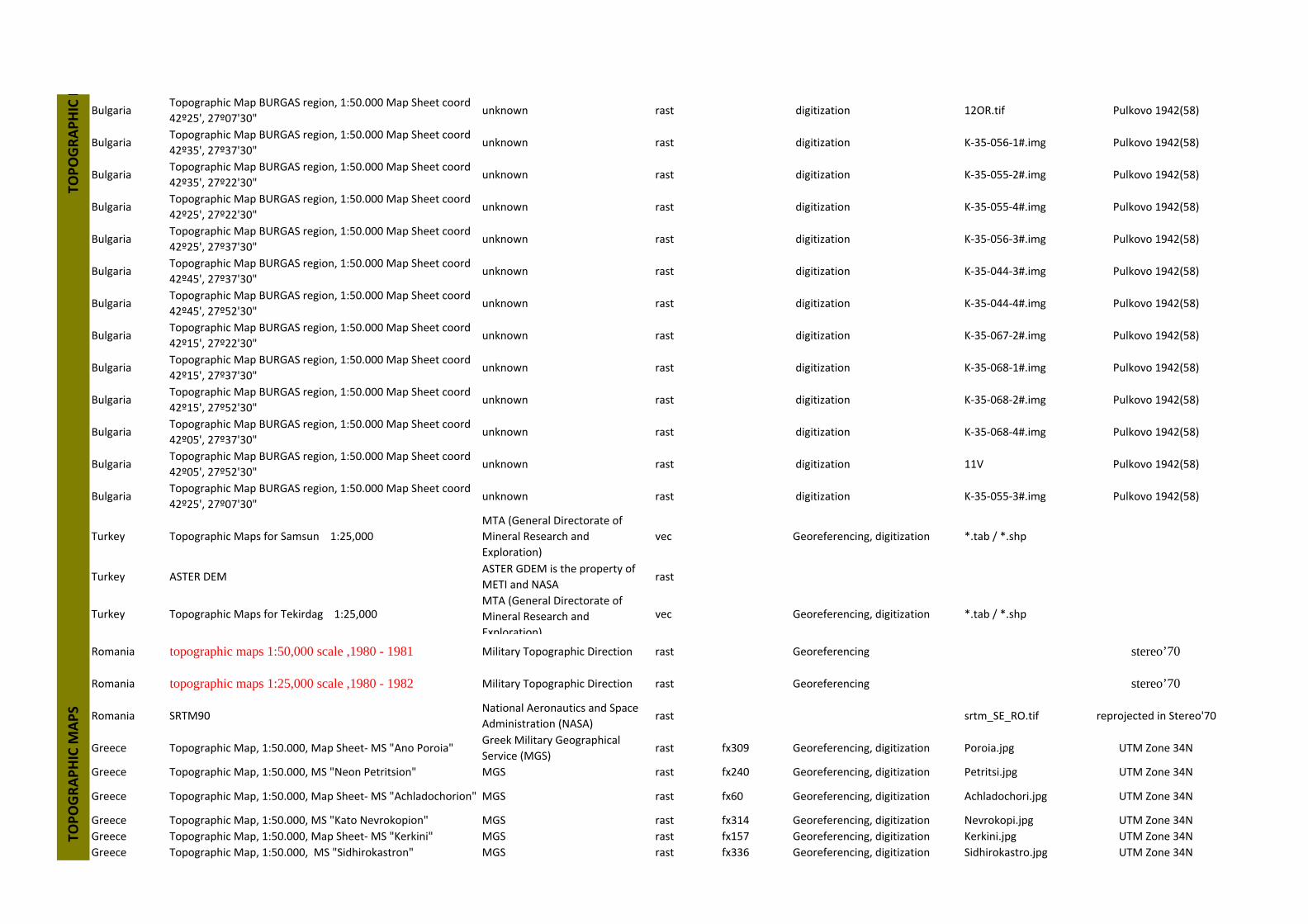
BulgariaTopographic Map BURGAS region, 1:50.000 Map Sheet coord
42º25', 27º07'30"unknown rast digitization 12OR.tif Pulkovo 1942(58)
BulgariaTopographic Map BURGAS region, 1:50.000 Map Sheet coord
42º35', 27º37'30"unknown rast digitization K‐35‐056‐1#.img Pulkovo 1942(58)
BulgariaTopographic Map BURGAS region, 1:50.000 Map Sheet coord
42º35', 27º22'30"unknown rast digitization K‐35‐055‐2#.img Pulkovo 1942(58)
BulgariaTopographic Map BURGAS region, 1:50.000 Map Sheet coord
42º25', 27º22'30"unknown rast digitization K‐35‐055‐4#.img Pulkovo 1942(58)
BulgariaTopographic Map BURGAS region, 1:50.000 Map Sheet coord
42º25', 27º37'30"unknown rast digitization K‐35‐056‐3#.img Pulkovo 1942(58)
BulgariaTopographic Map BURGAS region, 1:50.000 Map Sheet coord
42º45', 27º37'30"unknown rast digitization K‐35‐044‐3#.img Pulkovo 1942(58)
BulgariaTopographic Map BURGAS region, 1:50.000 Map Sheet coord
42º45', 27º52'30"unknown rast digitization K‐35‐044‐4#.img Pulkovo 1942(58)
BulgariaTopographic Map BURGAS region, 1:50.000 Map Sheet coord
42º15', 27º22'30"unknown rast digitization K‐35‐067‐2#.img Pulkovo 1942(58)
BulgariaTopographic Map BURGAS region, 1:50.000 Map Sheet coord
42º15', 27º37'30"unknown rast digitization K‐35‐068‐1#.img Pulkovo 1942(58)
BulgariaTopographic Map BURGAS region, 1:50.000 Map Sheet coord
42º15', 27º52'30"unknown rast digitization K‐35‐068‐2#.img Pulkovo 1942(58)
BulgariaTopographic Map BURGAS region, 1:50.000 Map Sheet coord
42º05', 27º37'30"unknown rast digitization K‐35‐068‐4#.img Pulkovo 1942(58)
BulgariaTopographic Map BURGAS region, 1:50.000 Map Sheet coord
42º05', 27º52'30"unknown rast digitization 11V Pulkovo 1942(58)
BulgariaTopographic Map BURGAS region, 1:50.000 Map Sheet coord
42º25', 27º07'30"unknown rast digitization K‐35‐055‐3#.img Pulkovo 1942(58)
Turkey Topographic Maps for Samsun 1:25,000
MTA (General Directorate of
Mineral Research and
Exploration)
vec Georeferencing, digitization *.tab / *.shp
Turkey ASTER DEMASTER GDEM is the property of
METI and NASArast
Turkey Topographic Maps for Tekirdag 1:25,000MTA (General Directorate of
Mineral Research and
Exploration)
vec Georeferencing, digitization *.tab / *.shp
Romania topographic maps 1:50,000 scale ,1980 - 1981 Military Topographic Direction rast Georeferencing stereo’70
Romania topographic maps 1:25,000 scale ,1980 - 1982 Military Topographic Direction rast Georeferencing stereo’70
Romania SRTM90National Aeronautics and Space
Administration (NASA)rast srtm_SE_RO.tif reprojected in Stereo'70
Greece Topographic Map, 1:50.000, Map Sheet‐ MS "Ano Poroia"Greek Military Geographical
Service (MGS) rast fx309 Georeferencing, digitization Poroia.jpg UTM Zone 34N
Greece Topographic Map, 1:50.000, MS "Neon Petritsion" MGS rast fx240 Georeferencing, digitization Petritsi.jpg UTM Zone 34N
Greece Topographic Map, 1:50.000, Map Sheet‐ MS "Achladochorion" MGS rast fx60 Georeferencing, digitization Achladochori.jpg UTM Zone 34N
Greece Topographic Map, 1:50.000, MS "Kato Nevrokopion" MGS rast fx314 Georeferencing, digitization Nevrokopi.jpg UTM Zone 34N
Greece Topographic Map, 1:50.000, Map Sheet‐ MS "Kerkini" MGS rast fx157 Georeferencing, digitization Kerkini.jpg UTM Zone 34N
Greece Topographic Map, 1:50.000, MS "Sidhirokastron" MGS rast fx336 Georeferencing, digitization Sidhirokastro.jpg UTM Zone 34N
TOPOGRAPHIC M
TOPOGRAPHIC M
APS
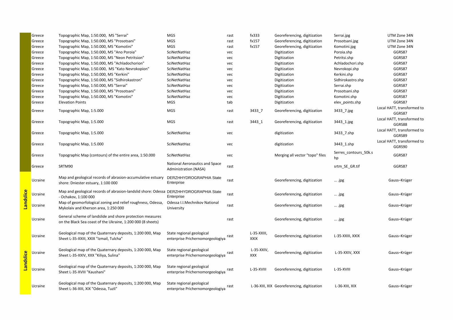
Greece Topographic Map, 1:50.000, MS "Serrai" MGS rast fx333 Georeferencing, digitization Serrai.jpg UTM Zone 34N
Greece Topographic Map, 1:50.000, MS "Prosotsani" MGS rast fx157 Georeferencing, digitization Prosotsani.jpg UTM Zone 34N
Greece Topographic Map, 1:50.000, MS "Komotini" MGS rast fx157 Georeferencing, digitization Komotini.jpg UTM Zone 34N
Greece Topographic Map, 1:50.000, MS "Ano Poroia" SciNetNatHaz vec Digitization Poroia.shp GGRS87
Greece Topographic Map, 1:50.000, MS "Neon Petritsion" SciNetNatHaz vec Digitization Petritsi.shp GGRS87
Greece Topographic Map, 1:50.000, MS "Achladochorion" SciNetNatHaz vec Digitization Achladochori.shp GGRS87
Greece Topographic Map, 1:50.000, MS "Kato Nevrokopion" SciNetNatHaz vec Digitization Nevrokopi.shp GGRS87
Greece Topographic Map, 1:50.000, MS "Kerkini" SciNetNatHaz vec Digitization Kerkini.shp GGRS87
Greece Topographic Map, 1:50.000, MS "Sidhirokastron" SciNetNatHaz vec Digitization Sidhirokastro.shp GGRS87
Greece Topographic Map, 1:50.000, MS "Serrai" SciNetNatHaz vec Digitization Serrai.shp GGRS87
Greece Topographic Map, 1:50.000, MS "Prosotsani" SciNetNatHaz vec Digitization Prosotsani.shp GGRS87
Greece Topographic Map, 1:50.000, MS "Komotini" SciNetNatHaz vec Digitization Komotini.shp GGRS87
Greece Elevation Points MGS tab Digitization elev_points.shp GGRS87
Greece Topographic Map, 1:5.000 MGS rast 3433_7 Georeferencing, digitization 3433_7.jpgLocal HATT, transformed to
GGRS87
Greece Topographic Map, 1:5.000 MGS rast 3443_1 Georeferencing, digitization 3443_1.jpgLocal HATT, transformed to
GGRS88
Greece Topographic Map, 1:5.000 SciNetNatHaz vec digitization 3433_7.shpLocal HATT, transformed to
GGRS89
Greece Topographic Map, 1:5.000 SciNetNatHaz vec digitization 3443_1.shpLocal HATT, transformed to
GGRS90
Greece Topographic Map (contours) of the entire area, 1:50.000 SciNetNatHaz vec Merging all vector "topo" filesSerres_contours_50k.s
hpGGRS87
Greece SRTM90National Aeronautics and Space
Administration (NASA)rast srtm_SE_GR.tif GGRS87
UcraineMap and geological records of abrasion‐accumulative estuary
shore: Dniester estuary, 1:100 000DERZHHYDROGRAPHIA State Enterprise
rast Georeferencing, digitization … .jpg Gauss–Krüger
UcraineMap and geological records of abrasion‐landslid shore: Odessa
‐ Ochakov, 1:100 000DERZHHYDROGRAPHIA State Enterprise
rast Georeferencing, digitization … .jpg Gauss–Krüger
UcraineMap of geomorfological zoning and relief roughness, Odessa,
Mykolaiv and Kherson area, 1:250 000
Odessa I.I.Mechnikov National
Universityrast Georeferencing, digitization … .jpg Gauss–Krüger
UcraineGeneral scheme of landslide and shore protection measures
on the Black Sea coast of the Ukraine, 1:200 000 (8 sheets)rast Georeferencing, digitization … .jpg Gauss–Krüger
UcraineGeological map of the Quaternary deposits, 1:200 000, Map
Sheet L‐35‐XXIII, XXIX "Izmail, Tulcha"
State regional geological
enterprise Prichernomorgeologiyarast
L‐35‐XXIII,
XXIXGeoreferencing, digitization L‐35‐XXIII, XXIX Gauss–Krüger
UcraineGeological map of the Quaternary deposits, 1:200 000, Map
Sheet L‐35‐XXIV, XXX "Kiliya, Sulina"
State regional geological
enterprise Prichernomorgeologiyarast
L‐35‐XXIV,
XXXGeoreferencing, digitization L‐35‐XXIV, XXX Gauss–Krüger
UcraineGeological map of the Quaternary deposits, 1:200 000, Map
Sheet L‐35‐XVIII "Kaushani"
State regional geological
enterprise Prichernomorgeologiyarast L‐35‐XVIII Georeferencing, digitization L‐35‐XVIII Gauss–Krüger
UcraineGeological map of the Quaternary deposits, 1:200 000, Map
Sheet L‐36‐XIII, XIX "Odessa, Tuzli"
State regional geological
enterprise Prichernomorgeologiyarast L‐36‐XIII, XIX Georeferencing, digitization L‐36‐XIII, XIX Gauss–Krüger
Landslice
Landslice
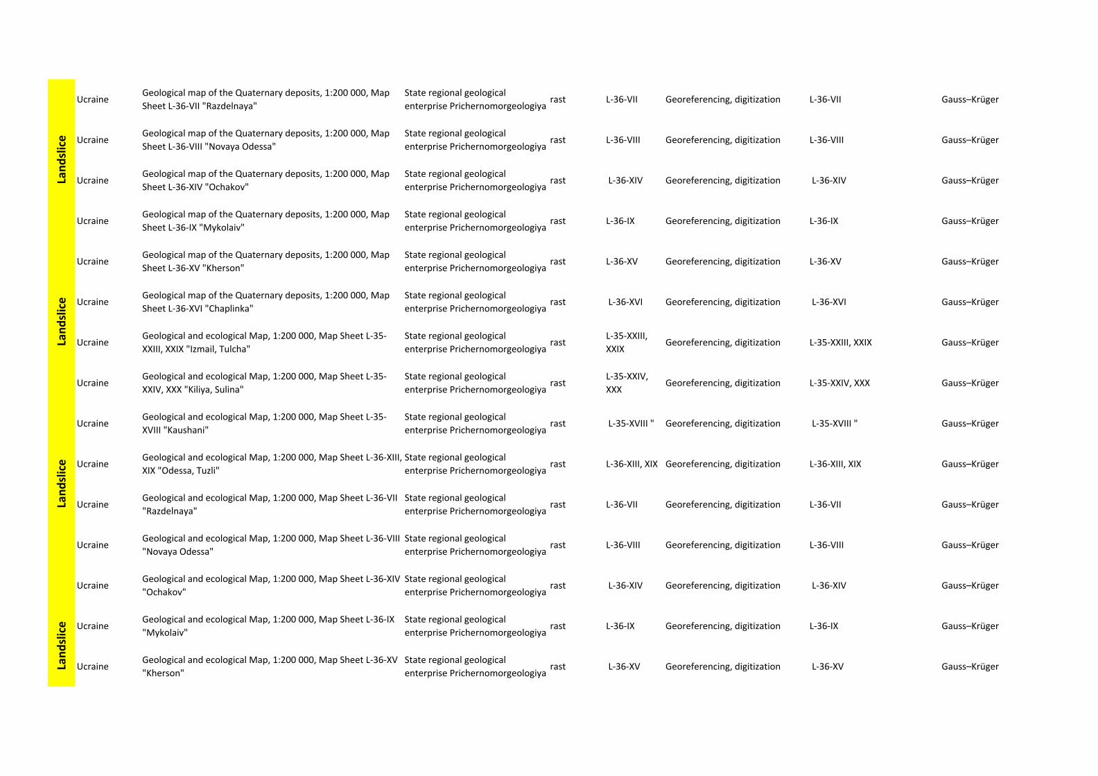
UcraineGeological map of the Quaternary deposits, 1:200 000, Map
Sheet L‐36‐VII "Razdelnaya"
State regional geological
enterprise Prichernomorgeologiyarast L‐36‐VII Georeferencing, digitization L‐36‐VII Gauss–Krüger
UcraineGeological map of the Quaternary deposits, 1:200 000, Map
Sheet L‐36‐VIII "Novaya Odessa"
State regional geological
enterprise Prichernomorgeologiyarast L‐36‐VIII Georeferencing, digitization L‐36‐VIII Gauss–Krüger
UcraineGeological map of the Quaternary deposits, 1:200 000, Map
Sheet L‐36‐XIV "Ochakov"
State regional geological
enterprise Prichernomorgeologiyarast L‐36‐XIV Georeferencing, digitization L‐36‐XIV Gauss–Krüger
UcraineGeological map of the Quaternary deposits, 1:200 000, Map
Sheet L‐36‐IX "Mykolaiv"
State regional geological
enterprise Prichernomorgeologiyarast L‐36‐IX Georeferencing, digitization L‐36‐IX Gauss–Krüger
UcraineGeological map of the Quaternary deposits, 1:200 000, Map
Sheet L‐36‐XV "Kherson"
State regional geological
enterprise Prichernomorgeologiyarast L‐36‐XV Georeferencing, digitization L‐36‐XV Gauss–Krüger
UcraineGeological map of the Quaternary deposits, 1:200 000, Map
Sheet L‐36‐XVI "Chaplinka"
State regional geological
enterprise Prichernomorgeologiyarast L‐36‐XVI Georeferencing, digitization L‐36‐XVI Gauss–Krüger
UcraineGeological and ecological Map, 1:200 000, Map Sheet L‐35‐
XXIII, XXIX "Izmail, Tulcha"
State regional geological
enterprise Prichernomorgeologiyarast
L‐35‐XXIII,
XXIXGeoreferencing, digitization L‐35‐XXIII, XXIX Gauss–Krüger
UcraineGeological and ecological Map, 1:200 000, Map Sheet L‐35‐
XXIV, XXX "Kiliya, Sulina"
State regional geological
enterprise Prichernomorgeologiyarast
L‐35‐XXIV,
XXXGeoreferencing, digitization L‐35‐XXIV, XXX Gauss–Krüger
UcraineGeological and ecological Map, 1:200 000, Map Sheet L‐35‐
XVIII "Kaushani"
State regional geological
enterprise Prichernomorgeologiyarast L‐35‐XVIII " Georeferencing, digitization L‐35‐XVIII " Gauss–Krüger
UcraineGeological and ecological Map, 1:200 000, Map Sheet L‐36‐XIII,
XIX "Odessa, Tuzli"
State regional geological
enterprise Prichernomorgeologiyarast L‐36‐XIII, XIX Georeferencing, digitization L‐36‐XIII, XIX Gauss–Krüger
UcraineGeological and ecological Map, 1:200 000, Map Sheet L‐36‐VII
"Razdelnaya"
State regional geological
enterprise Prichernomorgeologiyarast L‐36‐VII Georeferencing, digitization L‐36‐VII Gauss–Krüger
UcraineGeological and ecological Map, 1:200 000, Map Sheet L‐36‐VIII
"Novaya Odessa"
State regional geological
enterprise Prichernomorgeologiyarast L‐36‐VIII Georeferencing, digitization L‐36‐VIII Gauss–Krüger
UcraineGeological and ecological Map, 1:200 000, Map Sheet L‐36‐XIV
"Ochakov"
State regional geological
enterprise Prichernomorgeologiyarast L‐36‐XIV Georeferencing, digitization L‐36‐XIV Gauss–Krüger
UcraineGeological and ecological Map, 1:200 000, Map Sheet L‐36‐IX
"Mykolaiv"
State regional geological
enterprise Prichernomorgeologiyarast L‐36‐IX Georeferencing, digitization L‐36‐IX Gauss–Krüger
UcraineGeological and ecological Map, 1:200 000, Map Sheet L‐36‐XV
"Kherson"
State regional geological
enterprise Prichernomorgeologiyarast L‐36‐XV Georeferencing, digitization L‐36‐XV Gauss–Krüger
Landslice
Landslice
Landslice
Landslice
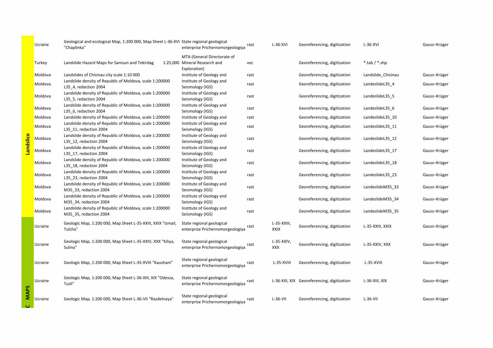
UcraineGeological and ecological Map, 1:200 000, Map Sheet L‐36‐XVI
"Chaplinka"
State regional geological
enterprise Prichernomorgeologiyarast L‐36‐XVI Georeferencing, digitization L‐36‐XVI Gauss–Krüger
Turkey Landslide Hazard Maps for Samsun and Tekirdag 1:25,000
MTA (General Directorate of
Mineral Research and
Exploration)
vec Georeferencing, digitization *.tab / *.shp
Moldova Landslides of Chisinau city scale 1:10 000 Institute of Geology and rast Georeferencing, digitization Landslide_Chisinau Gauss–Krüger
MoldovaLandslide density of Republic of Moldova, scale 1:200000
L35_4, redaction 2004
Institute of Geology and
Seismology (IGS)rast Georeferencing, digitization LandeslideL35_4 Gauss–Krüger
MoldovaLandslide density of Republic of Moldova, scale 1:200000
L35_5, redaction 2004
Institute of Geology and
Seismology (IGS)rast Georeferencing, digitization LandeslideL35_5 Gauss–Krüger
MoldovaLandslide density of Republic of Moldova, scale 1:200000
L35_6, redaction 2004
Institute of Geology and
Seismology (IGS)rast Georeferencing, digitization LandeslideL35_6 Gauss–Krüger
Moldova Landslide density of Republic of Moldova, scale 1:200000 Institute of Geology and rast Georeferencing, digitization LandeslideL35_10 Gauss–Krüger
MoldovaLandslide density of Republic of Moldova, scale 1:200000
L35_11, redaction 2004
Institute of Geology and
Seismology (IGS)rast Georeferencing, digitization LandeslideL35_11 Gauss–Krüger
MoldovaLandslide density of Republic of Moldova, scale 1:200000
L35_12, redaction 2004
Institute of Geology and
Seismology (IGS)rast Georeferencing, digitization LandeslideL35_12 Gauss–Krüger
MoldovaLandslide density of Republic of Moldova, scale 1:200000
L35_17, redaction 2004
Institute of Geology and
Seismology (IGS)rast Georeferencing, digitization LandeslideL35_17 Gauss–Krüger
MoldovaLandslide density of Republic of Moldova, scale 1:200000
L35_18, redaction 2004
Institute of Geology and
Seismology (IGS)rast Georeferencing, digitization LandeslideL35_18 Gauss–Krüger
MoldovaLandslide density of Republic of Moldova, scale 1:200000
L35_23, redaction 2004
Institute of Geology and
Seismology (IGS)rast Georeferencing, digitization LandeslideL35_23 Gauss–Krüger
MoldovaLandslide density of Republic of Moldova, scale 1:200000
M35_33, redaction 2004
Institute of Geology and
Seismology (IGS)rast Georeferencing, digitization LandeslideM35_33 Gauss–Krüger
MoldovaLandslide density of Republic of Moldova, scale 1:200000
M35_34, redaction 2004
Institute of Geology and
Seismology (IGS)rast Georeferencing, digitization LandeslideM35_34 Gauss–Krüger
MoldovaLandslide density of Republic of Moldova, scale 1:200000
M35_35, redaction 2004
Institute of Geology and
Seismology (IGS)rast Georeferencing, digitization LandeslideM35_35 Gauss–Krüger
UcraineGeologic Map, 1:200 000, Map Sheet L‐35‐XXIII, XXIX "Izmail,
Tulcha"
State regional geological
enterprise Prichernomorgeologiyarast
L‐35‐XXIII,
XXIXGeoreferencing, digitization L‐35‐XXIII, XXIX Gauss–Krüger
UcraineGeologic Map, 1:200 000, Map Sheet L‐35‐XXIV, XXX "Kiliya,
Sulina"
State regional geological
enterprise Prichernomorgeologiyarast
L‐35‐XXIV,
XXXGeoreferencing, digitization L‐35‐XXIV, XXX Gauss–Krüger
Ucraine Geologic Map, 1:200 000, Map Sheet L‐35‐XVIII "Kaushani"State regional geological
enterprise Prichernomorgeologiyarast L‐35‐XVIII Georeferencing, digitization L‐35‐XVIII Gauss–Krüger
UcraineGeologic Map, 1:200 000, Map Sheet L‐36‐XIII, XIX "Odessa,
Tuzli"
State regional geological
enterprise Prichernomorgeologiyarast L‐36‐XIII, XIX Georeferencing, digitization L‐36‐XIII, XIX Gauss–Krüger
Ucraine Geologic Map, 1:200 000, Map Sheet L‐36‐VII "Razdelnaya"State regional geological
enterprise Prichernomorgeologiyarast L‐36‐VII Georeferencing, digitization L‐36‐VII Gauss–Krüger
Landslice
C M
APS
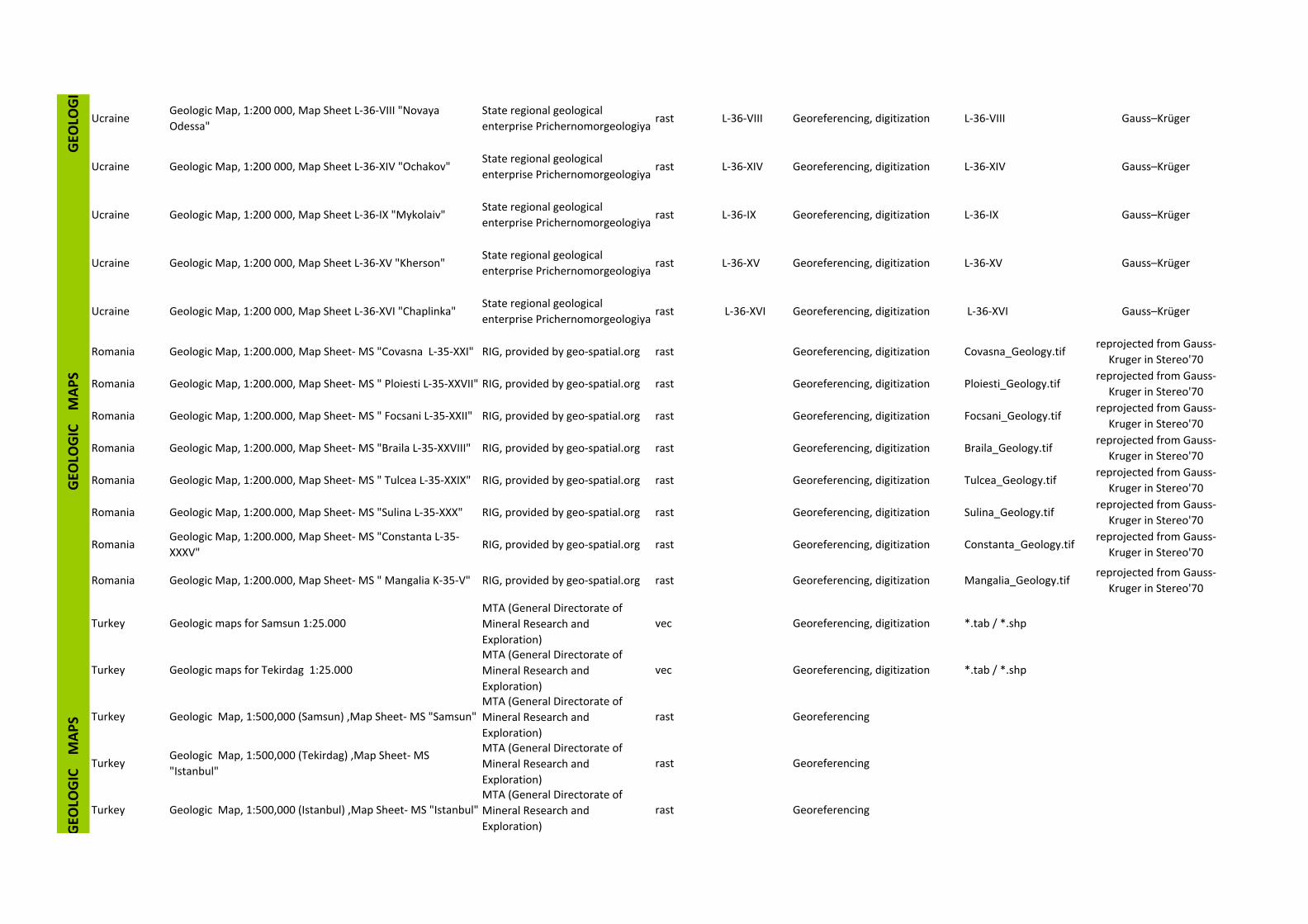
UcraineGeologic Map, 1:200 000, Map Sheet L‐36‐VIII "Novaya
Odessa"
State regional geological
enterprise Prichernomorgeologiyarast L‐36‐VIII Georeferencing, digitization L‐36‐VIII Gauss–Krüger
Ucraine Geologic Map, 1:200 000, Map Sheet L‐36‐XIV "Ochakov"State regional geological
enterprise Prichernomorgeologiyarast L‐36‐XIV Georeferencing, digitization L‐36‐XIV Gauss–Krüger
Ucraine Geologic Map, 1:200 000, Map Sheet L‐36‐IX "Mykolaiv"State regional geological
enterprise Prichernomorgeologiyarast L‐36‐IX Georeferencing, digitization L‐36‐IX Gauss–Krüger
Ucraine Geologic Map, 1:200 000, Map Sheet L‐36‐XV "Kherson"State regional geological
enterprise Prichernomorgeologiyarast L‐36‐XV Georeferencing, digitization L‐36‐XV Gauss–Krüger
Ucraine Geologic Map, 1:200 000, Map Sheet L‐36‐XVI "Chaplinka"State regional geological
enterprise Prichernomorgeologiyarast L‐36‐XVI Georeferencing, digitization L‐36‐XVI Gauss–Krüger
Romania Geologic Map, 1:200.000, Map Sheet‐ MS "Covasna L‐35‐XXI" RIG, provided by geo‐spatial.org rast Georeferencing, digitization Covasna_Geology.tifreprojected from Gauss‐
Kruger in Stereo'70
Romania Geologic Map, 1:200.000, Map Sheet‐ MS " Ploiesti L‐35‐XXVII" RIG, provided by geo‐spatial.org rast Georeferencing, digitization Ploiesti_Geology.tifreprojected from Gauss‐
Kruger in Stereo'70
Romania Geologic Map, 1:200.000, Map Sheet‐ MS " Focsani L‐35‐XXII" RIG, provided by geo‐spatial.org rast Georeferencing, digitization Focsani_Geology.tifreprojected from Gauss‐
Kruger in Stereo'70
Romania Geologic Map, 1:200.000, Map Sheet‐ MS "Braila L‐35‐XXVIII" RIG, provided by geo‐spatial.org rast Georeferencing, digitization Braila_Geology.tifreprojected from Gauss‐
Kruger in Stereo'70
Romania Geologic Map, 1:200.000, Map Sheet‐ MS " Tulcea L‐35‐XXIX" RIG, provided by geo‐spatial.org rast Georeferencing, digitization Tulcea_Geology.tifreprojected from Gauss‐
Kruger in Stereo'70
Romania Geologic Map, 1:200.000, Map Sheet‐ MS "Sulina L‐35‐XXX" RIG, provided by geo‐spatial.org rast Georeferencing, digitization Sulina_Geology.tifreprojected from Gauss‐
Kruger in Stereo'70
RomaniaGeologic Map, 1:200.000, Map Sheet‐ MS "Constanta L‐35‐
XXXV"RIG, provided by geo‐spatial.org rast Georeferencing, digitization Constanta_Geology.tif
reprojected from Gauss‐
Kruger in Stereo'70
Romania Geologic Map, 1:200.000, Map Sheet‐ MS " Mangalia K‐35‐V" RIG, provided by geo‐spatial.org rast Georeferencing, digitization Mangalia_Geology.tifreprojected from Gauss‐
Kruger in Stereo'70
Turkey Geologic maps for Samsun 1:25.000
MTA (General Directorate of
Mineral Research and
Exploration)
vec Georeferencing, digitization *.tab / *.shp
Turkey Geologic maps for Tekirdag 1:25.000
MTA (General Directorate of
Mineral Research and
Exploration)
vec Georeferencing, digitization *.tab / *.shp
Turkey Geologic Map, 1:500,000 (Samsun) ,Map Sheet‐ MS "Samsun"
MTA (General Directorate of
Mineral Research and
Exploration)
rast Georeferencing
TurkeyGeologic Map, 1:500,000 (Tekirdag) ,Map Sheet‐ MS
"Istanbul"
MTA (General Directorate of
Mineral Research and
Exploration)
rast Georeferencing
Turkey Geologic Map, 1:500,000 (Istanbul) ,Map Sheet‐ MS "Istanbul"
MTA (General Directorate of
Mineral Research and
Exploration)
rast Georeferencing
GEO
LOGIC M
APS
GEO
LOGI
GEO
LOGIC M
APS
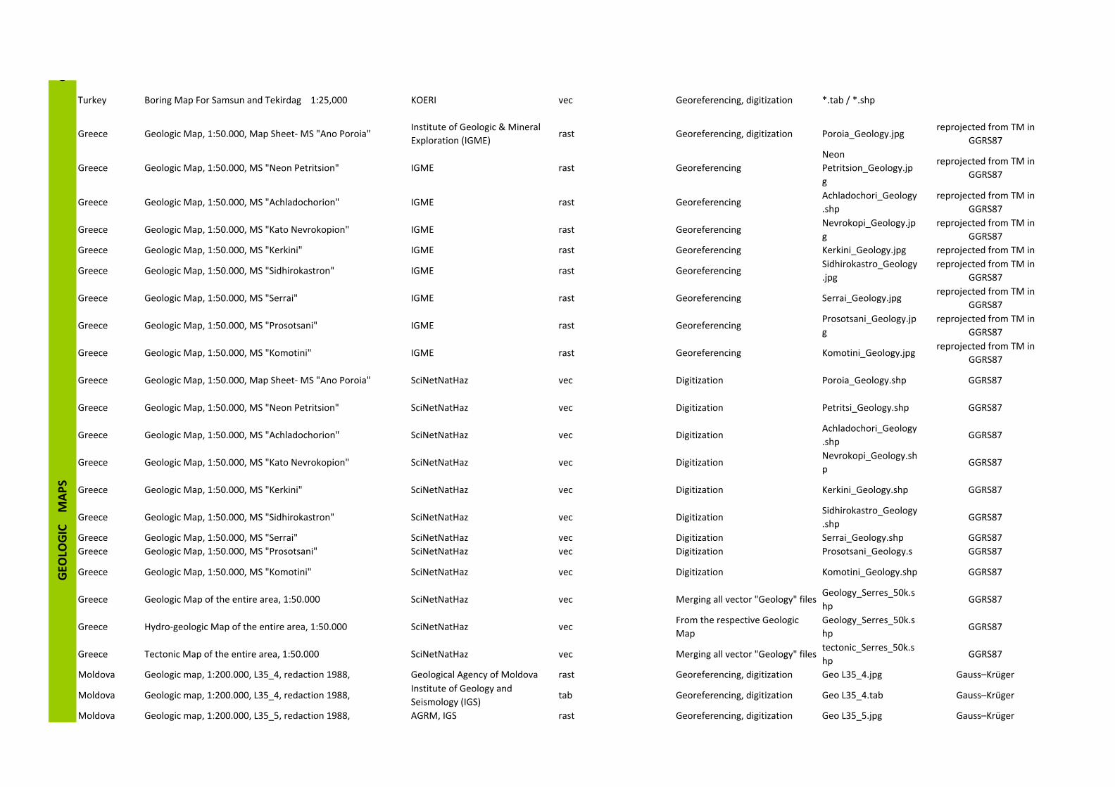
Turkey Boring Map For Samsun and Tekirdag 1:25,000 KOERI vec Georeferencing, digitization *.tab / *.shp
Greece Geologic Map, 1:50.000, Map Sheet‐ MS "Ano Poroia"Institute of Geologic & Mineral
Exploration (IGME)rast Georeferencing, digitization Poroia_Geology.jpg
reprojected from TM in
GGRS87
Greece Geologic Map, 1:50.000, MS "Neon Petritsion" IGME rast Georeferencing
Neon
Petritsion_Geology.jp
g
reprojected from TM in
GGRS87
Greece Geologic Map, 1:50.000, MS "Achladochorion" IGME rast GeoreferencingAchladochori_Geology
.shp
reprojected from TM in
GGRS87
Greece Geologic Map, 1:50.000, MS "Kato Nevrokopion" IGME rast GeoreferencingNevrokopi_Geology.jp
g
reprojected from TM in
GGRS87
Greece Geologic Map, 1:50.000, MS "Kerkini" IGME rast Georeferencing Kerkini_Geology.jpg reprojected from TM in
Greece Geologic Map, 1:50.000, MS "Sidhirokastron" IGME rast GeoreferencingSidhirokastro_Geology
.jpg
reprojected from TM in
GGRS87
Greece Geologic Map, 1:50.000, MS "Serrai" IGME rast Georeferencing Serrai_Geology.jpgreprojected from TM in
GGRS87
Greece Geologic Map, 1:50.000, MS "Prosotsani" IGME rast GeoreferencingProsotsani_Geology.jp
g
reprojected from TM in
GGRS87
Greece Geologic Map, 1:50.000, MS "Komotini" IGME rast Georeferencing Komotini_Geology.jpgreprojected from TM in
GGRS87
Greece Geologic Map, 1:50.000, Map Sheet‐ MS "Ano Poroia" SciNetNatHaz vec Digitization Poroia_Geology.shp GGRS87
Greece Geologic Map, 1:50.000, MS "Neon Petritsion" SciNetNatHaz vec Digitization Petritsi_Geology.shp GGRS87
Greece Geologic Map, 1:50.000, MS "Achladochorion" SciNetNatHaz vec DigitizationAchladochori_Geology
.shpGGRS87
Greece Geologic Map, 1:50.000, MS "Kato Nevrokopion" SciNetNatHaz vec DigitizationNevrokopi_Geology.sh
pGGRS87
Greece Geologic Map, 1:50.000, MS "Kerkini" SciNetNatHaz vec Digitization Kerkini_Geology.shp GGRS87
Greece Geologic Map, 1:50.000, MS "Sidhirokastron" SciNetNatHaz vec DigitizationSidhirokastro_Geology
.shpGGRS87
Greece Geologic Map, 1:50.000, MS "Serrai" SciNetNatHaz vec Digitization Serrai_Geology.shp GGRS87
Greece Geologic Map, 1:50.000, MS "Prosotsani" SciNetNatHaz vec Digitization Prosotsani_Geology.s GGRS87
Greece Geologic Map, 1:50.000, MS "Komotini" SciNetNatHaz vec Digitization Komotini_Geology.shp GGRS87
Greece Geologic Map of the entire area, 1:50.000 SciNetNatHaz vec Merging all vector "Geology" filesGeology_Serres_50k.s
hpGGRS87
Greece Hydro‐geologic Map of the entire area, 1:50.000 SciNetNatHaz vecFrom the respective Geologic
Map
Geology_Serres_50k.s
hpGGRS87
Greece Tectonic Map of the entire area, 1:50.000 SciNetNatHaz vec Merging all vector "Geology" filestectonic_Serres_50k.s
hpGGRS87
Moldova Geologic map, 1:200.000, L35_4, redaction 1988, Geological Agency of Moldova rast Georeferencing, digitization Geo L35_4.jpg Gauss–Krüger
Moldova Geologic map, 1:200.000, L35_4, redaction 1988,Institute of Geology and
Seismology (IGS)tab Georeferencing, digitization Geo L35_4.tab Gauss–Krüger
Moldova Geologic map, 1:200.000, L35_5, redaction 1988, AGRM, IGS rast Georeferencing, digitization Geo L35_5.jpg Gauss–Krüger
GGEO
LOGIC M
APS
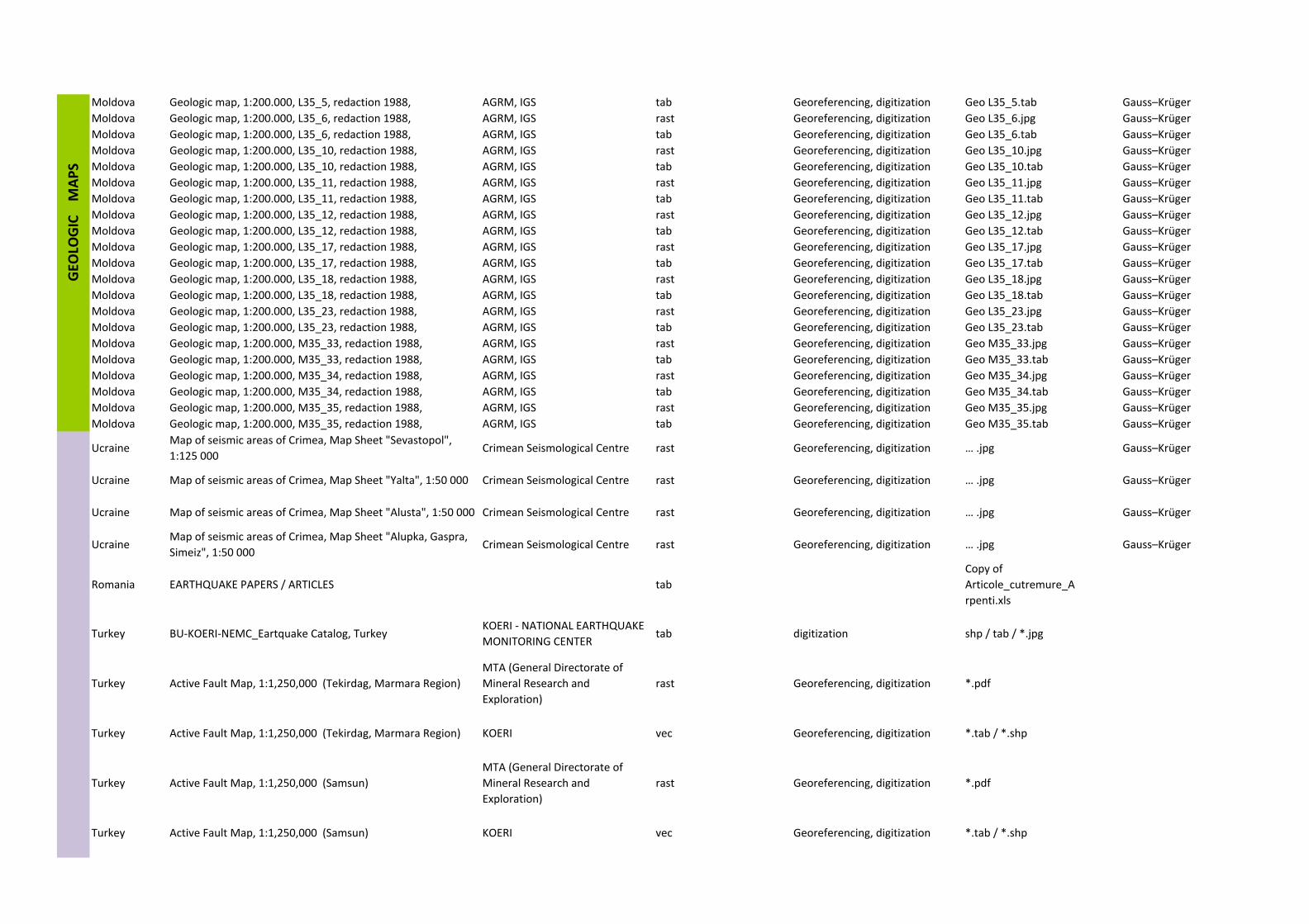
Moldova Geologic map, 1:200.000, L35_5, redaction 1988, AGRM, IGS tab Georeferencing, digitization Geo L35_5.tab Gauss–Krüger
Moldova Geologic map, 1:200.000, L35_6, redaction 1988, AGRM, IGS rast Georeferencing, digitization Geo L35_6.jpg Gauss–Krüger
Moldova Geologic map, 1:200.000, L35_6, redaction 1988, AGRM, IGS tab Georeferencing, digitization Geo L35_6.tab Gauss–Krüger
Moldova Geologic map, 1:200.000, L35_10, redaction 1988, AGRM, IGS rast Georeferencing, digitization Geo L35_10.jpg Gauss–Krüger
Moldova Geologic map, 1:200.000, L35_10, redaction 1988, AGRM, IGS tab Georeferencing, digitization Geo L35_10.tab Gauss–Krüger
Moldova Geologic map, 1:200.000, L35_11, redaction 1988, AGRM, IGS rast Georeferencing, digitization Geo L35_11.jpg Gauss–Krüger
Moldova Geologic map, 1:200.000, L35_11, redaction 1988, AGRM, IGS tab Georeferencing, digitization Geo L35_11.tab Gauss–Krüger
Moldova Geologic map, 1:200.000, L35_12, redaction 1988, AGRM, IGS rast Georeferencing, digitization Geo L35_12.jpg Gauss–Krüger
Moldova Geologic map, 1:200.000, L35_12, redaction 1988, AGRM, IGS tab Georeferencing, digitization Geo L35_12.tab Gauss–Krüger
Moldova Geologic map, 1:200.000, L35_17, redaction 1988, AGRM, IGS rast Georeferencing, digitization Geo L35_17.jpg Gauss–Krüger
Moldova Geologic map, 1:200.000, L35_17, redaction 1988, AGRM, IGS tab Georeferencing, digitization Geo L35_17.tab Gauss–Krüger
Moldova Geologic map, 1:200.000, L35_18, redaction 1988, AGRM, IGS rast Georeferencing, digitization Geo L35_18.jpg Gauss–Krüger
Moldova Geologic map, 1:200.000, L35_18, redaction 1988, AGRM, IGS tab Georeferencing, digitization Geo L35_18.tab Gauss–Krüger
Moldova Geologic map, 1:200.000, L35_23, redaction 1988, AGRM, IGS rast Georeferencing, digitization Geo L35_23.jpg Gauss–Krüger
Moldova Geologic map, 1:200.000, L35_23, redaction 1988, AGRM, IGS tab Georeferencing, digitization Geo L35_23.tab Gauss–Krüger
Moldova Geologic map, 1:200.000, M35_33, redaction 1988, AGRM, IGS rast Georeferencing, digitization Geo M35_33.jpg Gauss–Krüger
Moldova Geologic map, 1:200.000, M35_33, redaction 1988, AGRM, IGS tab Georeferencing, digitization Geo M35_33.tab Gauss–Krüger
Moldova Geologic map, 1:200.000, M35_34, redaction 1988, AGRM, IGS rast Georeferencing, digitization Geo M35_34.jpg Gauss–Krüger
Moldova Geologic map, 1:200.000, M35_34, redaction 1988, AGRM, IGS tab Georeferencing, digitization Geo M35_34.tab Gauss–Krüger
Moldova Geologic map, 1:200.000, M35_35, redaction 1988, AGRM, IGS rast Georeferencing, digitization Geo M35_35.jpg Gauss–Krüger
Moldova Geologic map, 1:200.000, M35_35, redaction 1988, AGRM, IGS tab Georeferencing, digitization Geo M35_35.tab Gauss–Krüger
UcraineMap of seismic areas of Crimea, Map Sheet "Sevastopol",
1:125 000Crimean Seismological Centre rast Georeferencing, digitization … .jpg Gauss–Krüger
Ucraine Map of seismic areas of Crimea, Map Sheet "Yalta", 1:50 000 Crimean Seismological Centre rast Georeferencing, digitization … .jpg Gauss–Krüger
Ucraine Map of seismic areas of Crimea, Map Sheet "Alusta", 1:50 000 Crimean Seismological Centre rast Georeferencing, digitization … .jpg Gauss–Krüger
UcraineMap of seismic areas of Crimea, Map Sheet "Alupka, Gaspra,
Simeiz", 1:50 000Crimean Seismological Centre rast Georeferencing, digitization … .jpg Gauss–Krüger
Romania EARTHQUAKE PAPERS / ARTICLES tab
Copy of
Articole_cutremure_A
rpenti.xls
Turkey BU‐KOERI‐NEMC_Eartquake Catalog, TurkeyKOERI ‐ NATIONAL EARTHQUAKE
MONITORING CENTERtab digitization shp / tab / *.jpg
Turkey Active Fault Map, 1:1,250,000 (Tekirdag, Marmara Region)
MTA (General Directorate of
Mineral Research and
Exploration)
rast Georeferencing, digitization *.pdf
Turkey Active Fault Map, 1:1,250,000 (Tekirdag, Marmara Region) KOERI vec Georeferencing, digitization *.tab / *.shp
Turkey Active Fault Map, 1:1,250,000 (Samsun)
MTA (General Directorate of
Mineral Research and
Exploration)
rast Georeferencing, digitization *.pdf
Turkey Active Fault Map, 1:1,250,000 (Samsun) KOERI vec Georeferencing, digitization *.tab / *.shp
GEO
LOGIC M
APS
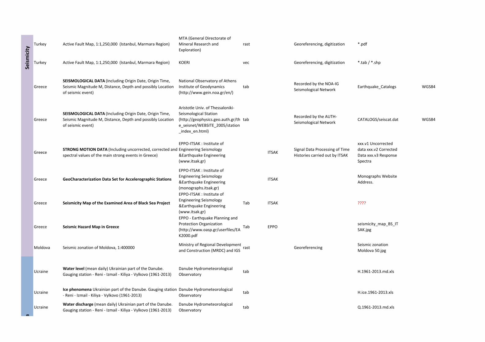
Turkey Active Fault Map, 1:1,250,000 (Istanbul, Marmara Region)
MTA (General Directorate of
Mineral Research and
Exploration)
rast Georeferencing, digitization *.pdf
Turkey Active Fault Map, 1:1,250,000 (Istanbul, Marmara Region) KOERI vec Georeferencing, digitization *.tab / *.shp
Greece
SEISMOLOGICAL DATA (Including Origin Date, Origin Time,
Seismic Magnitude M, Distance, Depth and possibly Location
of seismic event)
National Observatory of Athens
Institute of Geodynamics
(http://www.gein.noa.gr/en/)
tabRecorded by the NOA‐IG
Seismological Network Earthquake_Catalogs WGS84
Greece
SEISMOLOGICAL DATA (Including Origin Date, Origin Time,
Seismic Magnitude M, Distance, Depth and possibly Location
of seismic event)
Aristotle Univ. of Thessaloniki‐
Seismological Station
(http://geophysics.geo.auth.gr/th
e_seisnet/WEBSITE_2005/station
_index_en.html)
tabRecorded by the AUTH‐
Seismological Network CATALOGS/seiscat.dat WGS84
GreeceSTRONG MOTION DATA (Including uncorrected, corrected and
spectral values of the main strong events in Greece)
EPPO‐ITSAK : Institute of
Engineering Seismology
&Earthquake Engineering
(www.itsak.gr)
ITSAKSignal Data Processing of Time
Histories carried out by ITSAK
xxx.v1 Uncorrected
data xxx.v2 Corrected
Data xxx.v3 Response
Spectra
Greece GeoCharacterization Data Set for Accelerographic Stations
EPPO‐ITSAK : Institute of
Engineering Seismology
&Earthquake Engineering
(monographs.itsak.gr)
ITSAKMonographs Website
Address.
Greece Seismicity Map of the Examined Area of Black Sea Project
EPPO‐ITSAK : Institute of
Engineering Seismology
&Earthquake Engineering
(www.itsak.gr)
Tab ITSAK ????
Greece Seismic Hazard Map in Greece
EPPO ‐ Earthquake Planning and
Protection Organization
(http://www.oasp.gr/userfiles/EA
K2000.pdf
Tab EPPOseismicity_map_BS_IT
SAK.jpg
Moldova Seismic zonation of Moldova, 1:400000Ministry of Regional Development
and Construction (MRDC) and IGSrast Georeferencing
Seismic zonation
Moldova 50.jpg
UcraineWater level (mean daily) Ukrainian part of the Danube.
Gauging station ‐ Reni ‐ Izmail ‐ Kiliya ‐ Vylkovo (1961‐2013)
Danube Hydrometeorological
Observatorytab H.1961‐2013.md.xls
UcraineIce phenomena Ukrainian part of the Danube. Gauging station
‐ Reni ‐ Izmail ‐ Kiliya ‐ Vylkovo (1961‐2013)
Danube Hydrometeorological
Observatorytab H.ice.1961‐2013.xls
UcraineWater discharge (mean daily) Ukrainian part of the Danube.
Gauging station ‐ Reni ‐ Izmail ‐ Kiliya ‐ Vylkovo (1961‐2013)
Danube Hydrometeorological
Observatorytab Q.1961‐2013.md.xls
Seismicity
a
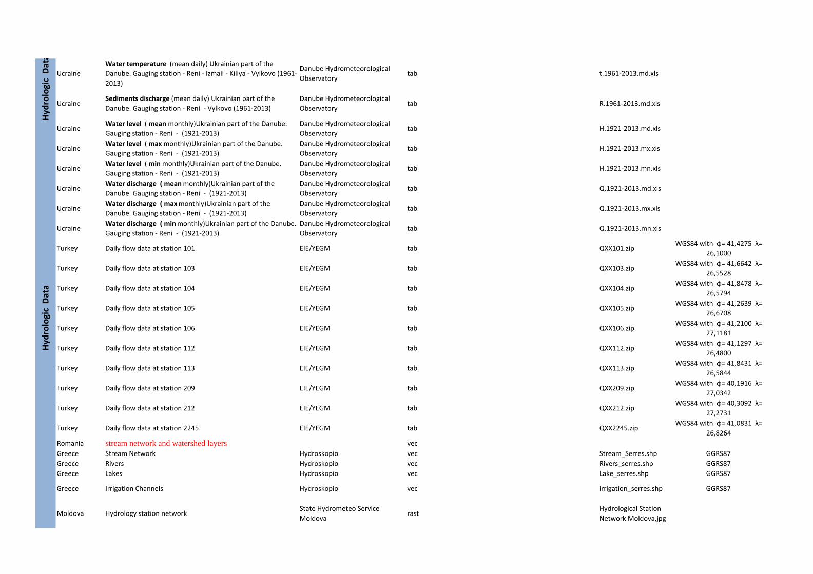
Ucraine
Water temperature (mean daily) Ukrainian part of the
Danube. Gauging station ‐ Reni ‐ Izmail ‐ Kiliya ‐ Vylkovo (1961‐
2013)
Danube Hydrometeorological
Observatorytab t.1961‐2013.md.xls
UcraineSediments discharge (mean daily) Ukrainian part of the
Danube. Gauging station ‐ Reni ‐ Vylkovo (1961‐2013)
Danube Hydrometeorological
Observatorytab R.1961‐2013.md.xls
UcraineWater level ( mean monthly)Ukrainian part of the Danube.
Gauging station ‐ Reni ‐ (1921‐2013)
Danube Hydrometeorological
Observatorytab H.1921‐2013.md.xls
UcraineWater level ( max monthly)Ukrainian part of the Danube.
Gauging station ‐ Reni ‐ (1921‐2013)
Danube Hydrometeorological
Observatorytab H.1921‐2013.mx.xls
UcraineWater level ( min monthly)Ukrainian part of the Danube.
Gauging station ‐ Reni ‐ (1921‐2013)
Danube Hydrometeorological
Observatorytab H.1921‐2013.mn.xls
UcraineWater discharge ( mean monthly)Ukrainian part of the
Danube. Gauging station ‐ Reni ‐ (1921‐2013)
Danube Hydrometeorological
Observatorytab Q.1921‐2013.md.xls
UcraineWater discharge ( max monthly)Ukrainian part of the
Danube. Gauging station ‐ Reni ‐ (1921‐2013)
Danube Hydrometeorological
Observatorytab Q.1921‐2013.mx.xls
UcraineWater discharge ( min monthly)Ukrainian part of the Danube.
Gauging station ‐ Reni ‐ (1921‐2013)
Danube Hydrometeorological
Observatorytab Q.1921‐2013.mn.xls
Turkey Daily flow data at station 101 EIE/YEGM tab QXX101.zipWGS84 with φ= 41,4275 λ=
26,1000
Turkey Daily flow data at station 103 EIE/YEGM tab QXX103.zipWGS84 with φ= 41,6642 λ=
26,5528
Turkey Daily flow data at station 104 EIE/YEGM tab QXX104.zipWGS84 with φ= 41,8478 λ=
26,5794
Turkey Daily flow data at station 105 EIE/YEGM tab QXX105.zipWGS84 with φ= 41,2639 λ=
26,6708
Turkey Daily flow data at station 106 EIE/YEGM tab QXX106.zipWGS84 with φ= 41,2100 λ=
27,1181
Turkey Daily flow data at station 112 EIE/YEGM tab QXX112.zipWGS84 with φ= 41,1297 λ=
26,4800
Turkey Daily flow data at station 113 EIE/YEGM tab QXX113.zipWGS84 with φ= 41,8431 λ=
26,5844
Turkey Daily flow data at station 209 EIE/YEGM tab QXX209.zipWGS84 with φ= 40,1916 λ=
27,0342
Turkey Daily flow data at station 212 EIE/YEGM tab QXX212.zipWGS84 with φ= 40,3092 λ=
27,2731
Turkey Daily flow data at station 2245 EIE/YEGM tab QXX2245.zipWGS84 with φ= 41,0831 λ=
26,8264
Romania stream network and watershed layers vec
Greece Stream Network Hydroskopio vec Stream_Serres.shp GGRS87
Greece Rivers Hydroskopio vec Rivers_serres.shp GGRS87
Greece Lakes Hydroskopio vec Lake_serres.shp GGRS87
Greece Irrigation Channels Hydroskopio vec irrigation_serres.shp GGRS87
Moldova Hydrology station networkState Hydrometeo Service
Moldovarast
Hydrological Station
Network Moldova,jpg
Hyd
rologic Data
Hyd
rologic Data
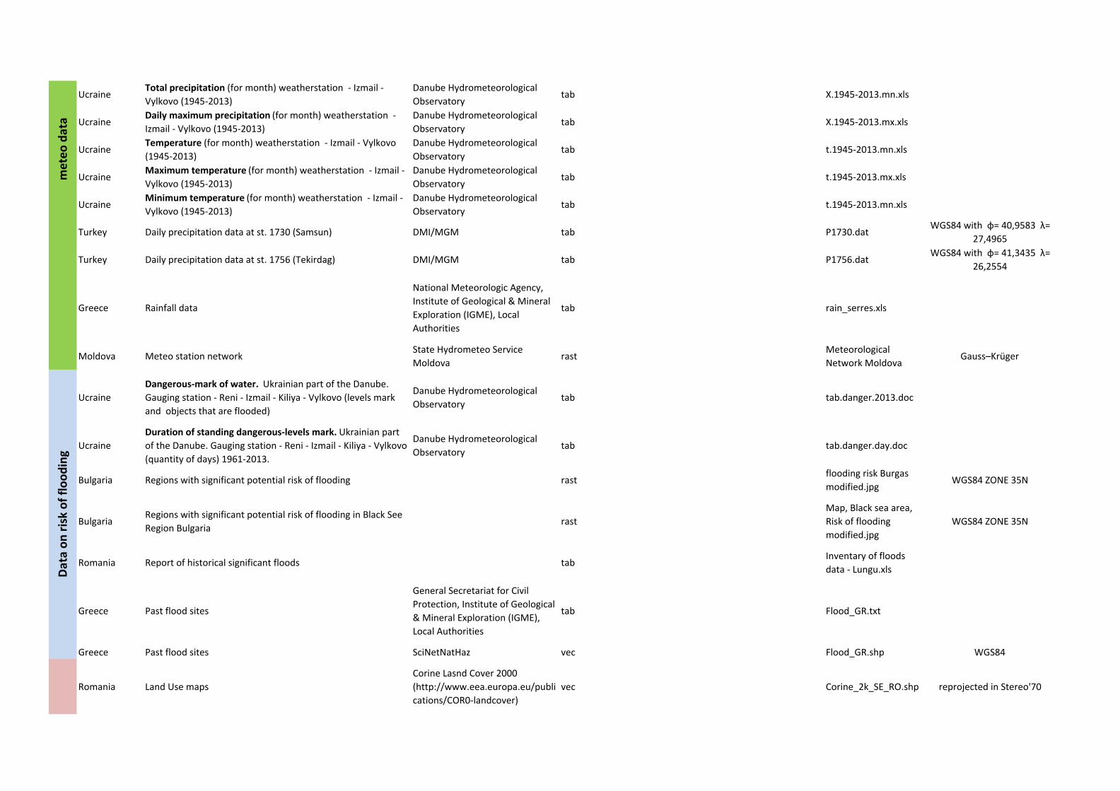
UcraineTotal precipitation (for month) weatherstation ‐ Izmail ‐
Vylkovo (1945‐2013)
Danube Hydrometeorological
Observatorytab X.1945‐2013.mn.xls
UcraineDaily maximum precipitation (for month) weatherstation ‐
Izmail ‐ Vylkovo (1945‐2013)
Danube Hydrometeorological
Observatorytab X.1945‐2013.mx.xls
UcraineTemperature (for month) weatherstation ‐ Izmail ‐ Vylkovo
(1945‐2013)
Danube Hydrometeorological
Observatorytab t.1945‐2013.mn.xls
UcraineMaximum temperature (for month) weatherstation ‐ Izmail ‐
Vylkovo (1945‐2013)
Danube Hydrometeorological
Observatorytab t.1945‐2013.mx.xls
UcraineMinimum temperature (for month) weatherstation ‐ Izmail ‐
Vylkovo (1945‐2013)
Danube Hydrometeorological
Observatorytab t.1945‐2013.mn.xls
Turkey Daily precipitation data at st. 1730 (Samsun) DMI/MGM tab P1730.datWGS84 with φ= 40,9583 λ=
27,4965
Turkey Daily precipitation data at st. 1756 (Tekirdag) DMI/MGM tab P1756.datWGS84 with φ= 41,3435 λ=
26,2554
Greece Rainfall data
National Meteorologic Agency,
Institute of Geological & Mineral
Exploration (IGME), Local
Authorities
tab rain_serres.xls
Moldova Meteo station networkState Hydrometeo Service
Moldovarast
Meteorological
Network MoldovaGauss–Krüger
Ucraine
Dangerous‐mark of water. Ukrainian part of the Danube.
Gauging station ‐ Reni ‐ Izmail ‐ Kiliya ‐ Vylkovo (levels mark
and objects that are flooded)
Danube Hydrometeorological
Observatorytab tab.danger.2013.doc
Ucraine
Duration of standing dangerous‐levels mark. Ukrainian part
of the Danube. Gauging station ‐ Reni ‐ Izmail ‐ Kiliya ‐ Vylkovo
(quantity of days) 1961‐2013.
Danube Hydrometeorological
Observatorytab tab.danger.day.doc
Bulgaria Regions with significant potential risk of flooding rastflooding risk Burgas
modified.jpgWGS84 ZONE 35N
BulgariaRegions with significant potential risk of flooding in Black See
Region Bulgariarast
Map, Black sea area,
Risk of flooding
modified.jpg
WGS84 ZONE 35N
Romania Report of historical significant floods tabInventary of floods
data ‐ Lungu.xls
Greece Past flood sites
General Secretariat for Civil
Protection, Institute of Geological
& Mineral Exploration (IGME),
Local Authorities
tab Flood_GR.txt
Greece Past flood sites SciNetNatHaz vec Flood_GR.shp WGS84
Romania Land Use maps
Corine Lasnd Cover 2000
(http://www.eea.europa.eu/publi
cations/COR0‐landcover)
vec Corine_2k_SE_RO.shp reprojected in Stereo'70
meteo data
Data on risk of flooding
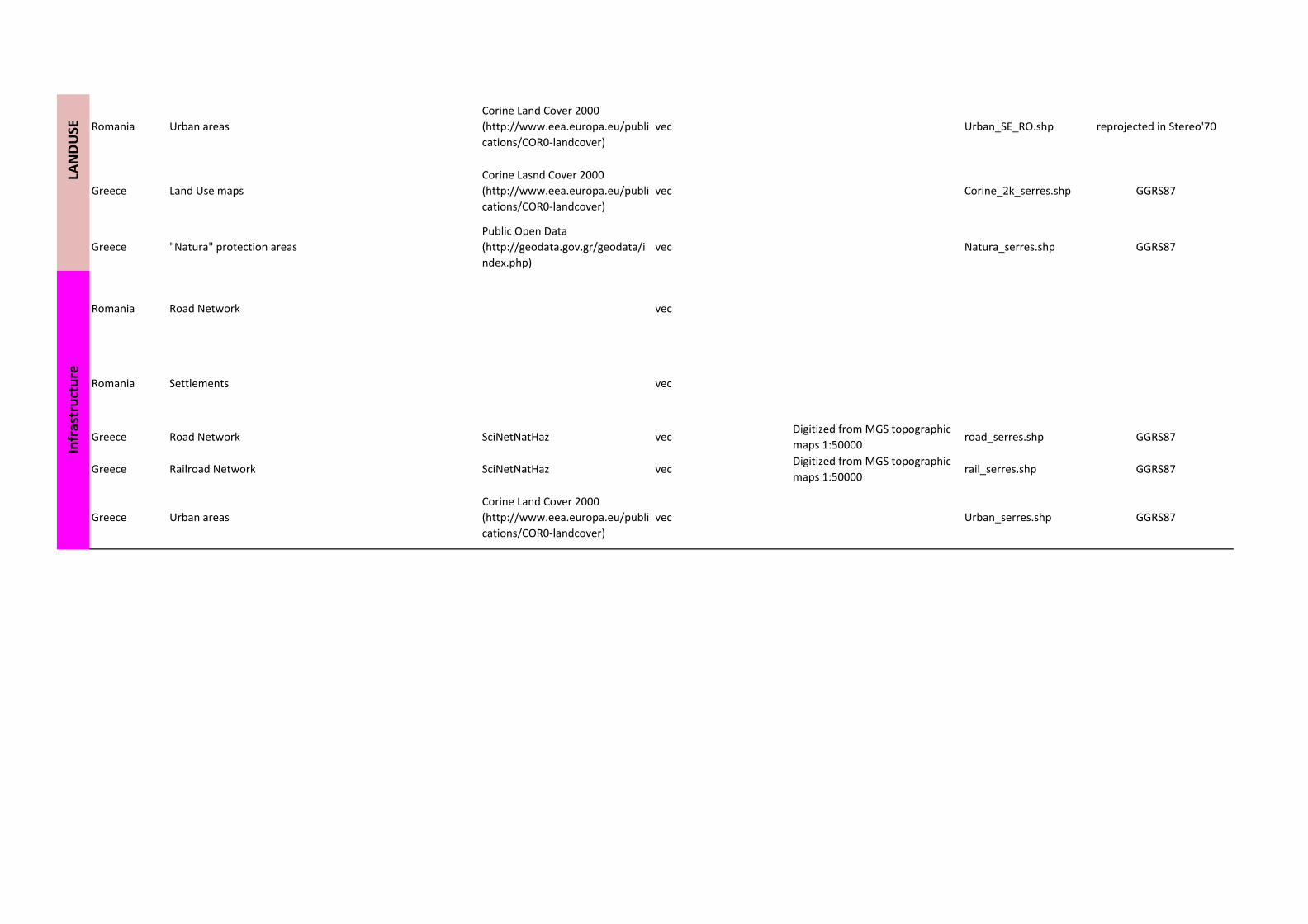
Romania Urban areas
Corine Land Cover 2000
(http://www.eea.europa.eu/publi
cations/COR0‐landcover)
vec Urban_SE_RO.shp reprojected in Stereo'70
Greece Land Use maps
Corine Lasnd Cover 2000
(http://www.eea.europa.eu/publi
cations/COR0‐landcover)
vec Corine_2k_serres.shp GGRS87
Greece "Natura" protection areas
Public Open Data
(http://geodata.gov.gr/geodata/i
ndex.php)
vec Natura_serres.shp GGRS87
Romania Road Network vec
Romania Settlements vec
Greece Road Network SciNetNatHaz vecDigitized from MGS topographic
maps 1:50000road_serres.shp GGRS87
Greece Railroad Network SciNetNatHaz vecDigitized from MGS topographic
maps 1:50000rail_serres.shp GGRS87
Greece Urban areas
Corine Land Cover 2000
(http://www.eea.europa.eu/publi
cations/COR0‐landcover)
vec Urban_serres.shp GGRS87
Infrastructure
LANDUSE