Geoffs. Int., Vol. 28-5, 1989, pp. - CaltechAUTHORS · tud 30° 30' N) mostraron varias ocurrencias...
46
J.M. Stock Geoffs. Int., Vol. 28-5, 1989, pp. 851-896 Spec. Vol.: Dynamics and Evolution of the Lithosphere, Part 2. SEQUENCE AND GEOCHRONOLOGY OF MIOCENE ROCKS ADJACENT TO THE MAIN GULF ESCARPMENT: SOUTHERN VALLE CHICO, BAJA CALIFORNIA NORTE, MEXICO RESUMEN J.M. STOCK* (Received: July 27, 1988) (Accepted: January 5, 1989) El levantamiento geol6gico y las dataciones potasio-arg6n de rocas terciarias en el noreste de Baja California (lati- tud 30° 30' N) mostraron varias ocurrencias de volcanismo y sedimentaci6n entre 20 y 6 Ma. Entre 20 y 15 Ma, basaltos, andesitas y flujos piroclasticos cubrieron localmente las rocas batollticas y prebatollticas (de edad cre- tacica y mas antigua). Encima·de ellos se deposito hasta 300 metros de flujos piroclasticos, tobas, basaltos, are- niscas y conglomerados por toda el area de! levantamiento, antes de 11 Ma. Entre 11 y 6 Ma hubo erupciones que produjeron flujos y brechas andeslticos y rioHticos. Alredcdor de 6 Ma, otras erupciones cubrieron la region hasta con 300 m mas de flujos piroclasticos, cenizas y tobas v{tricas soldadas. Estas capas coronan las mesas al- tas de la parte noroeste de la Provincia Volcanica de Pucrtecitos. Otras rocas volcanicas locales que no han sido datadas pueden ser menores de 6 Ma. El desarrollo dcl tectonismo que sc observa hoy, con fallas normales, capas inclinadas y relieve topografico debido al Main Gulf Escarpment, cmpezo cntre 11 y 6 Ma. Las variaciones de cspesor de las capas de edad pre-11 Mase debcn a la prcsencia de relieve erosional, pero las variaciones de espesor de las capas mas recientes estan relacionadas con tectonismo. El alineamiento nor-noroeste de cuatro conos vol- canicos de edad pre-6 Ma, al este del Escarpment, sugiere que las fallas de distension influycron sobrc el ascenso de los magmas durante el Mioceno Superior. *Department of Earth, Atmospheric, and Planetary Sciences, Massachusetts Institute of Technology, Cam- bridge MA 02139 USA. (Present address: Dept. of Earth and Planetary Sciences, Harvard University, Cambridge MA 02138 USA.) 851
Transcript of Geoffs. Int., Vol. 28-5, 1989, pp. - CaltechAUTHORS · tud 30° 30' N) mostraron varias ocurrencias...

J.M. Stock
Geoffs. Int., Vol. 28-5, 1989, pp. 851-896 Spec. Vol.: Dynamics and Evolution of the Lithosphere, Part 2.
SEQUENCE AND GEOCHRONOLOGY OF MIOCENE ROCKS ADJACENT TO THE MAIN GULF ESCARPMENT: SOUTHERN VALLE CHICO,
BAJA CALIFORNIA NORTE, MEXICO
RESUMEN
J.M. STOCK* (Received: July 27, 1988) (Accepted: January 5, 1989)
El levantamiento geol6gico y las dataciones potasio-arg6n de rocas terciarias en el noreste de Baja California (latitud 30° 30' N) mostraron varias ocurrencias de volcanismo y sedimentaci6n entre 20 y 6 Ma. Entre 20 y 15 Ma, basaltos, andesitas y flujos piroclasticos cubrieron localmente las rocas batollticas y prebatollticas (de edad cretacica y mas antigua). Encima·de ellos se deposito hasta 300 metros de flujos piroclasticos, tobas, basaltos, areniscas y conglomerados por toda el area de! levantamiento, antes de 11 Ma. Entre 11 y 6 Ma hubo erupciones que produjeron flujos y brechas andeslticos y rioHticos. Alredcdor de 6 Ma, otras erupciones cubrieron la region hasta con 300 m mas de flujos piroclasticos, cenizas y tobas v{tricas soldadas. Estas capas coronan las mesas altas de la parte noroeste de la Provincia Volcanica de Pucrtecitos. Otras rocas volcanicas locales que no han sido datadas pueden ser menores de 6 Ma. El desarrollo dcl tectonismo que sc observa hoy, con fallas normales, capas inclinadas y relieve topografico debido al Main Gulf Escarpment, cmpezo cntre 11 y 6 Ma. Las variaciones de cspesor de las capas de edad pre-11 Mase debcn a la prcsencia de relieve erosional, pero las variaciones de espesor de las capas mas recientes estan relacionadas con tectonismo. El alineamiento nor-noroeste de cuatro conos volcanicos de edad pre-6 Ma, al este del Escarpment, sugiere que las fallas de distension influycron sobrc el ascenso de los magmas durante el Mioceno Superior.
*Department of Earth, Atmospheric, and Planetary Sciences, Massachusetts Institute of Technology, Cambridge MA 02139 USA.
(Present address: Dept. of Earth and Planetary Sciences, Harvard University, Cambridge MA 02138 USA.)
851
852 GEOFISICA INTERNACIONAL
ABSTRACT
Geologic mapping and K/Ar dating of Tertiary rocks in NE Baja California, at latitude 30° 30' N, reveal a history of volcanism from 20 Ma to at least 6 Ma. From 20 to 15 Ma, basalt, andesite and pyroclastic flows locally covered the Cretaceous and older batholithic and prebatholithic rocks. These deposits were followed by up to 300 m of additional pyroclastic flows, reworked tuff, basalt, sandstone and conglomerate. Subsequent eruptions between 11 and 6 Ma produced andesite to rhyolite flows and breccias. Eruptions at about 6 Ma covered the region with up to an additional 300 m of pyroclastic flows, ash fall deposits and welded vitric tuff. These units cap the high plateaus of the northwestern corner of the Puertecitos volcanic province. Local undated volcanic units may be younger than 6 Ma. The tilting, faulting and topographic relief associated with the Main Gulf Escarpment began developing sometime between 11 and 6 Ma; variations in thickness of the pre- I I Ma units arc not generally fault-related, although variations in thickness of the 6 Ma deposits arc. The alignment of four prc-6 Ma volcanic vents along a NNW trend parallel to the present escarpment suggests that ascent of the magmas may have been structurally controlled by Late Miocene extensional faults.
INTRODUCTION
This report summarizes the volcanic geology of part of the western boundary of the Gulf of California extensional province in northeastern Baja California, Mexico. Detailed geologic mapping at a scale of 1: 20 000 adjacent to the Main Gulf Escarpment (between latitudes 300 35' and 30026'N and longitudes 1140 55' and 1150 lO'W, an area approximately 24 x 15 km) reveals the timing and structural development of the escarpment and of the Gulf of California extensional province. The informal stratigraphy discussed in this paper was established to provide kinematic constraints on structural observations discussed elsewhere (Stock and Hodges, 1989).
The mapped area includes parts of the Agua Caliente, Bahfa Santa Marfa, Ma tom(
and Puertecitos 1:50000 topographic quadrangles published by the Direcci6n General de Estudios del Territorio Nacional (DETENAL) de Mexico. Locations are referred to the 1-km grid of these maps: Universal Transverse Mercator zone 11 (central meridian 114° W).
GEOLOGIC SETTING
Valle de San Felipe - Valle Chico is an 100-km long, NNW-SSE trending valley on the eastern side of the Baja California peninsula in the state of Baja California, Me(ico (Fig. 1). The western side of Valle de San Felipe - Valle Chico is controlled by high-angle normal faults of the Main Gulf Escarpment, which separate the relatively unextended batholithic rocks of the Peninsular Ranges, on the west, from the lower elevation basins and ranges of the Gulf Extensional Province t~ the east. The

D OUUlltNAltT ALLUVIUM AND OU.Yll..
El 'OIT-IATHOLITHIC llDIMUITI AND VOL.CANICI
~ IUHOLITHIC ROCICI
••• 0TH£Jt INTll:UllV(I
[] Plt(IATHOLITHIC METUf.DlMENTI
10 10
ICILOUITEltl
>O
J.M. Stock 853
N
30°1 5'N -
1 1 ~·oO'w
Fig. 1. Regional geologic map of part of northeastern Baja California, after Gastil et al. (1975). Areas discussed in the text are outlined: S =Stock (this study); B =Bryant (1986); S&G= Sommer and Garcia (1970); D&M= Dokka and Merriam (1982).
principal fault of the escarpment at this latitude, the E-dipping· San Pedro Martir Fault, strikes approximately NNW for 80 km, has up to 5 km of normal separation (Gastil et al., 1975) and is believed to flatten with depth (Dokka and Merriam, 1982; Gastil et al., 1975). Two major right-lateral strike-slip faults, the Agua Blanca fault (striking WNW) and the San Miguel Fault (striking NW) extend across the west side of Baja California and die out as they approach the Main Gulf Escarpment approximately at the northern end of Valle de San Felipe - Valle Chico .
...
854 GEOFISICA INTERNACIONAL
In a simple structural model, the Valle de San Felipe - Valle Chico may be an oblique pull-apart basin formed by the transfer of right-lateral motion from these two strike-slip fault systems to oblique normal displacement along the San Pedro Martir Fault. However, the mechanism by which this displacement is accommodated at the southern end of the valley is enigmatic. The San Pedro Martir Fault is replaced to the south, by an eastward-widening zone of parallel high-angle faults extending to the coast (a distance of 37 km) at the latitude of Puertecitos. The applicability of a pull-apart model to the structures at the southern end of the valley and constraints on the timing of deformation were evaluated by Stock and Hodges ( 1989).
The basement rocks of the region are Cretaceous plutonic rocks and metasedimentary rocks of probable Paleozoic age (Fig. 1). These are overlain by Miocene to Pliocene volcanic rocks, sandstone and conglomerate; shallow marine Pliocene sedimentary rocks and post-Pliocene alluvium and sand. With the exception of the Pliocene marine deposits, all of these lithologies are present in the area of detailed mapping.
PREVIOUS WORK
Published summaries of the regional geology drew upon aerial photographs (Gastil et al., 197 5; Dokka and Merriam, 1982), space photographs (Hamilton, 1971), reconnaissance mapping and a number of unpublished master's theses by students at San Diego State University (Gastil et al., 197 5). Ages of Tertiary units in surrounding areas have been determined by K-Ar geochronology (Gastil et al., 1975, 1979; Bryant, 1986) and by paleontological studies (Anderson, 1973; Boehm, 1984 ).
Although the structural development of the Main Gulf Escarpment and the Puertecitos volcanic province was addressed by Dokka and Merriam ( 1982), no study to date has included detailed descriptions or mineral dates for the units present within or adjacent to southern Valle Chico. Although similarities between the Valle Chico units and those from adjacent regions are discussed, the following informal stratigraphy does not follow the nomenclature used in studies of nearby areas.
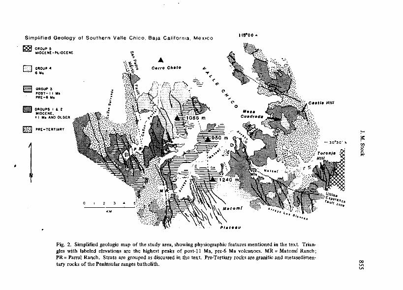
TERTIARY STRATIGRAPHY
The post-batholithic strata of southern Valle Chico are here divided into five informal units (Fig. 2). The first four of these, from oldest to youngest, are: (1) sand-
-
Simplified Geology of Southern Valle Chico. Baja California. Mexico
1188 GROUPS MIOCENE-PLIOCENE
[]] GROUP 4 6 Ma
§ GROUP 3 POST- I I Ma PRE-6 Ma
mm GROUPS I f. 2 MIOCENE, I I Ma AND OLDER
~ PRE-TERTIARY
1 0 3
KM
<P ~
~:."- ~ ...... °" ~*~
A Cerro Ch•to " ~
< .;;;:. __ < ~
C> ~· '$-
~·~ ~C> ~]~ 0
~/:a~. m @'Q _
... ~ .L~@=--
11s:oo ..
'~i\.
Fig. 2. Simplified geologic map of the study area, showing physiographic features mentioned in the text. Triangles with labeled elevations are the highest peaks of post-11 Ma, pre-6 Ma volcanoes. MR= Matomi Ranch; PR= Parral Ranch. Strata are grouped as discussed in the text. Pre-Tertiary rocks are granitic and metasedimentary rocks of the Peninsular ranges batholith.
~
?= Cll .... 0
~
00 Vt Vt

856 GEOFISICA INTERNACIONAL
T-1. KIAi -· S. v• Clllco. Baja C-_.,.., Unil - Li1hology La•- l..ongMe ....... %!<20 40AI" "°,.,. Age, .... ,. Pr-• .._(8)
*2 ...... x IDE-11 ... t2aldclw -(mol/gm)
YC-11-0H llb4 ....... I0.613•'N 11•.1171'W w.r. Ar-I U27 t 0 2.197 73.31 14.IH0.22 15.7•1• YC-11-0H llb4 blooh I0.1134'N 11•.1111•w w.r. Al-2 1.427. 0 2.tH 1•.10 14.•lt0.22 11.334
YC-17-051 Mb2 blooh 30.5114'N 114.tt33'W ., Al-I 1.101t0.001 3.135 12.11 11.Ht0.•2 10.1133
YC-17-011 Mvb - ao.•117'N 11•.t71t'W wr Ar-I l.743t0.00I 4.241 77.11 ll.12t0.21 10.111•
YC-17-05• Mb3 ....... 30.45M'N 114 ...... w wr Ar-I 2.211•0.007 1.511 77.11 17.03t0.21 13.2751
YC-11-13• Mrl rllroli1e IUll I0.52to'N lll.I071'W -l.511t0.ll 13.•3 11.10 11.lttl.OO q 1.211
YC-11-134 Mrl rllJolile luH I0.12t0'N 111.1011•w - l.Hlt0.110 1.137 71.37 11.fftO.IO I 1.2221
YC-11-1•1 Mr3 rllrolile IUll I0.1321'N 111.IOOO'W - 5.121t0.020 •.t21 7•.ta l.07t0.20 d l.OIH
YC-11-141 Mr3 rllrolile luH I0.1321'N 111.IOOO'W - l.121t0.020 3.419 .... 2 •.27t0.12 I 1.1111
YC-11-1•1 Mr3 rllJolile luft I0.1321'N 111.IOOO'W - l.121t0.020 •.HI 77.11 1.14*0.ll q,I O.N71
YC-17-010 Miii ....... ao.•711'N 114.llll'W wr Al-I 2.ltot0.013 7.107 lt.17 20.0ltO.M t.2282
YC-17-051 Miii blooh ao.•llt'N 11•.1121•w ., Ar-I l.244t0.0l I 2.737 lt.U 11.21*0.42 ··••7• YC-17-010 Miii ....... 30.4711'N 114.llll'W Wf Al-2 2.ltot0.013 7.7H lt.33 20.02t0.31 7.173'
YC-11-0•S Mr2 vitrophyr• I0.5120'N 111.0t2••w pllgioclMe O.ZOtt0.003 0.207 U.2t l.Olt1.tl q,I l.t902
YC-17-101 Me2 - 30.47'5'N lll.7723'W Wf Ar-I 1.M4t0.00I 1.2736 17.77 l.47t0.21 11.0532
YC-11-171 Me2 - ao.•72t'N 111.0ISl'W .. ,,,_, I. 711t0.00I 0.12• I.II 2.53t0.22 10 ... 15
YC-tl-171 Me2 _ ..
ao.•72t'N 115.0ISl'W wr Ar-2 l.7t•t0.001 0.5133 1.15 2.Ht0.22 1.1237
YC-tl-215 Mvo porphrrr I0.4131'N 115.07IO'W _,,,_, 7.17t0.03 11.11· 77.03 te.75t0.21 0.1112
YC-11-111 Mb5 ....... I0.47•1'N 115.0103'W •• Ar-2 I .211t0.005 2.121 11.14 12.7Dt0.24 1.5253
YC-11-225 MJI .... ,... I0.4140'N 111.0l7•'W _,,,_, 7. llt0.03 12.0I 20.01 13.17t0.52 0.7ttl
P.-clUre -: q. quonz - (T • llliO'C), I• - .... - d • - -; -· - -· 0ec:er --: ~.•-' • O.SllxlOE-10/yl'; )..~ • 4.tll2xl0E-10/yl'; ~ • t.117xtOE-4 -·
stones, andesite flows, vent breccias and basalt; (2) sandstones, basalt and tuffs, capped by an 11 Ma welded tuff; (3) andesites overlying the 11-Ma welded tuff; and ( 4) airfall and pyroclastic flow deposits overlying both (1) and (2) with slight angular unconformity, with a 6 Ma welded tuff close to the top of the section. Group 5 comprises several welded tuffs deposite~ with high initial dips against erosional topography on relatively flat-lying strata of groups 1 and 2, in the southwestern comer of the map area. Group 5 rocks are not in direct contact with rocks of either Group 3 or Group 4. Group 5 has not been dated, but is inferred to be younger than Group 4 on the basis of basal morphology and degree of structural disturbance. Limestones and older alluvial deposits are the youngest rocks present.
The batholithic rocks here have not been dated. In this report they are assumed to be Cretaceous, because Cretaceous U-Pb and K/Ar (cooling) ages are reported for them elsewhere in northern Baja California (see summary in Gastil et al., 1975).
In the absence of chemical analyses, compositional names of the volcanic units have been assigned according to textures and phenocryst assemblages observed in hand sample and thin-section. Black, olivine-bearing flows and sills are labeled "basalt". If olivine cannot be seen in hand sample, black flows are still labeled "basalt" if they are massive and highly vesicular. Black to light grey flows lacking olivine in

'
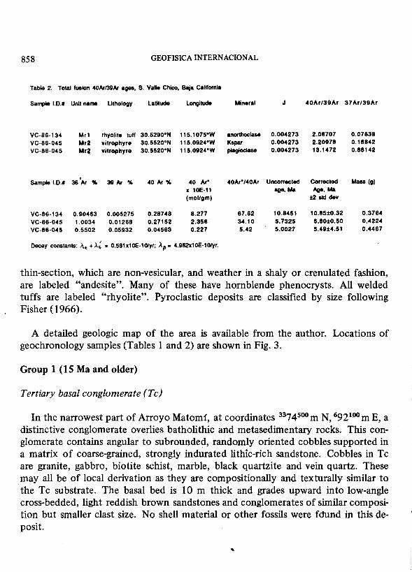
LOCATIONS OF GEOCHRONOLOGY SAMPLES, SOUTHERN VALLE CHICO
£88 GROUP 5 MIOCENE-PLIOCENE
LJ GROUP 4 6 Ma
S GROUP 3 POST- I I Ma PRE-8 Ma
!Im GROUPS I l 2 MIOCENE, I I Ma AND OLDER
~ PRE-TERTIARY --~
l 0 4
KM
I I 5°00' W I
Mb2
,-:,"' -
?.t~~;~; ~=-,~.~;.!
.,.,~··'~~~~~ "'\.c.._,,.. ... ,,,,, 88-0911 °Mb'4'.£:,.
-~"W·-.-·.·~~\f~:-. ._:(,~,;:,
'1!~~11~~'. "-~~ '""""_,,,~ - 30°30'
·~i;::~~~tWY ' ··~_t;;;~:~0 ~,~
Fig. 3. Locations of geochronology samples (Tables 1 and 2). The VC- prefix in front of each sample ID number has been omitted. The 3- or 4-character code following the sample ID number is the abbreviation Of the corresponding geologic map unit, discussed in text.
~
~ tll ... 0
~
00 Vo -.J
858 GEOFISICA INTERNACIONAL
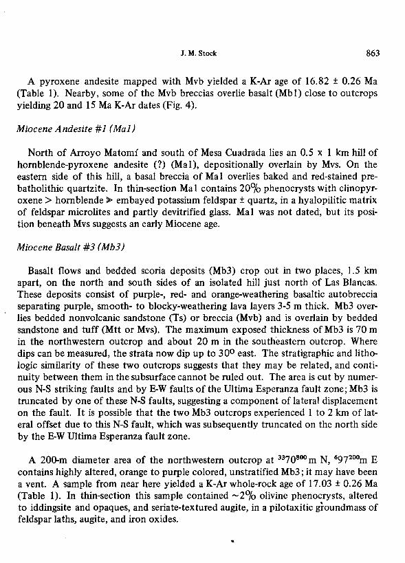
Table 2. Total fusion 40Ar/39Ar ages, S. Valle Chico, Baja CaHlornla
Sample 1.0.# Unit name Lithology latitude longitude Mineral J 40Ar/39Ar 37Ar/39Ar
VC-86-134 Mr1 rhyolite tuft 30.5290°N 115.1015•w anorthoclase 0.004273 2.08707 0.07838 VC-86-045 Mr2 vltrophyre 30.5520°N 115.0924°W Kspar 0.004273 2.20978 0.18842
VC-86-045 Mri vitrophyre 30.5520°N 115.0924°W plagioclase 0.004273 13.1472 0.88142
. Sample 1.0.# 36 Ar % 39 Ar % 40 Ar% 40 Ar" 40Ar*/40Ar Unco"ected Corrected Mass (g)
x 10E·11 age, Ma Age, Ma (mol/gm) :1:2 std dev
VC-86-134 0.90463 0.005275 0.28748 8.277 87.62 10.8451 10.85±0.32 0.3764
VC-86-045 1.0034 0.01268 0.27152 2.356 34.10 5.7325 5.80±0.50 0.4224
VC-86-045 0.5502 0.05932 0.04563 0.227 5.42 5.0027 5.49±4.51 0.4467
Decay constants: i\• + ).~ • 0.58h10E-10/yr; :Af> • 4.962x10E-10/yr.
thin-section, which are non-vesicular, and weather in a shaly or crenulated fashion, are labeled "andesite". Many of these have hornblende phenocrysts. All welded tuffs are labeled "rhyolite". Pyroclastic deposits are classified by size following Fisher ( 1966).
A detailed geologic map of the area is available from the author. Locations of geochronology samples (Tables 1 and 2) are shown in Fig. 3.
Group 1 (15 Ma and older)
Tertiary basal conglomerate (Tc)
In the narrowest part of Arroyo Matomf, at coordinates 3374500 m N, 692100 m E, a distinctive conglomerate overlies batholithic and metasedimentary rocks. This conglomerate contains angular to suhrounded, randomly oriented cobbles supported in a matrix of coarse-grained, strongly indurated lithic-rich sandstone. Cobbles in Tc are granite, gabbro, biotite schist, marble, black quartzite and vein quartz. These may all be of local derivation as they are compositionally and texturally similar to the Tc substrate. The basal bed is 10 m thick and grades upward into low-angle cross-bedded, light reddish brown sandstones and conglomerates of similar composition but smaller clast size. No shell material or other fossils were fdund in this deposit.

J.M. Stock 859
This outcrop is truncated on the west side of the canyon by a NNW-striking highangle fault, with probable down-to-the west normal and unknown strike-slip separation; no offset equivalent of Tc crops out on the west side of this fault. To the east, Tc is conformably overlain by massive sandstone (Ts) and by younger volcanic breccias and tuffs of Mvs.
Tc is almost certainly Tertiary in age and no younger than mid-Miocene. Basal conglomerates and sandstones of granitic and metasedimentary derivation, containing late Eocene volcanic clasts, occur west of San Felipe (Fig. I) in the San Felipe quadrangle (Anderson, 1973). Similar conglomerates in the Santa Rosa Basin have clasts of Permian fusilinid limestone (Gastil et al., 1973; Bryant, 1986). It is not known how these conglomerates relate to one another or to Tc; no clasts of fusilinidbearing limestone or of extrusive volcanic rocks were recognized in Tc.
Depositional Relationships, Southern Valle Chico
NORTHEAST
Mr4
Mr3
Mmt
Mrt
b4
WEST
Mmt ,,.,,., 5.49.:t.4,51 5.80•0.50
-18.08• 1.961
:;::: \! ~~~g ::
Ts
12.53•0.221 12.36•0.221
• • 10.85J:0.32-- • Mr1 11.99±0.50 /..._ _ ___,
116.69'1.001 Mva
6.47i0.28
16.75<0.28 • <:::» Mbau ~
Ta
granitic & metesedlmentery rocks
SOUTH
120.05•0.361
120.02±0.361
Fig. 4. Schematic stratigraphic columns, summarizing the depositional relationships of the units present in the northeastern, western, and sou them parts of the mapped area. Dots show stratigraphic positions of dated samples, with the corresponding K/Ar or 40Ar-39Ar total fusion ages. Suspect ages arc in parentheses (sec discussion of individual units in the text). Thicknesses are not to scale and angular discordances arc not shown.

860 GEOFISICA INTERNACIONAL
Tertiary Basal Sandstones (Ts)
Discontinuous lenses of poorly to moderately lithified sandstones (Ts) occur at the base of the Tertiary sedimentary sequence, above granitic and metasedimentary rocks or above conglomerate composed of granitic and metasedimentary rocks (Fig. 4). These sandstones are usually recessive and covered by talus of overlying resistant volcanic units. Their matrix reflects the composition of the local substrate, ranging from feldspar-rich, with minor biotite and quartz, to more biotite-rich in composition, with lithic fra$ments of granite, phyllite and schist. A volcanic component is generally absent from the basal few meters of sandstone, but often increases up section, so that volcanic lithic fragments, ash laminae and pumice may dominate upper Ts.
The sorting and rounding of the grains range from moderate to poor, and grainsizes from coarse to medium, except for ash interbeds. Bedding is usually indistinct, although local clast-rich layers indicate bedding orientation. Where bedding is welldeveloped, beds range from 3 to 30 cm thick. In several outcrops in the northeastern part of the map area, both low-angle planar crossbedding, crossbedding of up to 25° angle, and festooned crossbedding were observed. Ts is normally buff to light brown in color, and rarely brick red to orange brown, with red to purple staining within a few tens of centimeters of contacts with basalt sills (Mbsu) or overlying basalt flows. There are a few conglomerate beds which are generally less than 30 cm thick, with subangular to subrounded clasts less than 3 cm in diameter. Bedding plane orientation varies up to loo within individual structural blocks, indicating minor initial variations or low-angle crossbedding; post-depositional tectonic tilting of Ts locally reaches 520.
The 0-60 m range of thickness of Ts partly reflects erosional relief on the basement. The surface of the granitic basement, where exposed, is weathered, lacks a significant soil horizon, and has shallow joints and cracks filled by the basal sandstones. This resembles the surfaces of granitic hills exposed presently in the arid climate of this part of Baja California. The angle between this surface and the bedding in Ts, where measured, was 20° or less.
No fossils or plant remains were found in Ts. Calcite-cemented concretions and caliche veins are present locally. In one outcrop, irregular tubelike veytical and horizontal structures, 1 to 1.5 cm in diameter, and filled with finer-grained material,

J.M. Stock 861
were present within a few meters of the basal contact. These may be root casts or burrows. The lack of shell material and gypsum, as well as the poor grading and immaturity of Ts, argues against a marine origin. Ts was more likely deposited subaerially as weathering products of its substrate, with incorporation of more distantly derived volcanic detritus into upper Ts.
The various sandstone bodies included within Ts probably originated as separate deposits. They are constrained to be post-Cretaceous by their content of batholithic and pre-batholithic clasts, and to be pre-mid Miocene where they are overlain by volcanic rocks 19.56 and 16.75 Ma in age (Mb2 and Mvs). In the absence of further age constraints they are here classified as Tertiary.
Miocene Basalt 1 (Mbl)
Three adjacent basalt outcrops, 40-70 m thick, overlie granitic and prebatholithic rocks south of Arroyo Matomf. The outcrops are in very close proximity (less than 250 m), suggesting former continuity. In thin-section, typical samples contain 15-40°/o phenocrysts, of olivine and/or augite, ± sieve-textured, em bayed plagioclase, in an intergranular groundmass of plagioclase laths, clinopyroxene granules, and opaque granules.
Samples from the northern and southern outcrops yielded K-Ar ages of 20.05 ± 0.36 (2a) Ma1 and 15.21 ± 0.42 Ma (Table 1). K20 content of these samples differed, so they may represent separate flows. The 20 Ma age may be less reliable, despite a higher radiogenic yield, because of minor clay alteration in the groundmass. These early Miocene ages of Mb 1 are consistent with its stratigraphic position beneath Mvb. Because of similar substrate and stratigraphic level, this basalt may be coeval with the undated basalts of unit Mbu.
Undifferentiated Miocene Basalt (Mbu)
In the southeast corner of the map area, between Las Blancas and Arroyo Matomf, there are two hills (separated by 2-3 km) where basalt, 50-60 m thick, overlies granitic and prebatholithic rocks or Tertiary volcanic breccias (Mvb). These weather
1 Uncertainties in age dates are given as ± 2a unless noted.
...

862 GEOFISICA INTERNACIONAL
variably, ranging from resistant, blocky, light-orange slabs with iddingsitized olivines, to fine-grained recessive slopes. They are all relatively altered with no visible internal stratigraphy. No ages were obtained on these basalts, but a similar outcrop of possibly coeval basalt (Mbl), 3 km to the west, yielded early Miocene K-Ar ages (see previous paragraph).
Miocene Volcanic Breccias (Mvb)
These massive, laterally discontinuous, poorly- to non-bedded breccias and pyroclastic flows occur in the southeastern part of the map area. They are deposited on granite, prebatholithic metasedimentary rocks, basalt (Mb 1, Mb3) or basal sandstones (Ts). They are overlain by Mvs/Mtt or higher units (Mmt, Mr3, Mr4) on surfaces with relief of up to 300.
Individual breccia lenses within Mvb may be poly- or mono-lithologic, with an ash matrix and rounded to angular clasts of pumice or various porphyritic lithic compositions. The breccias are generally clast supported. Clasts may be rounded to angular. Typical lithic clasts contain even smaller lithic fragments, and 40-60°/o phenocrysts of compositions including feldspar, plagioclase + quartz, zoned plagioclase + hornblende, clinopyroxene + hornblende + plagioclase, and hornblende + biotite + plagioclase ± quartz. Hornblende and biotite are often replaced by iron oxides. Mvb weathers a variety of colors from yellow or orange to dark brown and may be locally stained green, red, orange, and purple. It is inferred to be of explosion breccia, lahar or agglutinated breccia origin, and to represent near-vent facies of andesitic or more acidic compositions. Individual lenses of monolithologic breccia may be tens of meters thick.
Unstratified pyroclastic flow units, locally found between these breccia lenses, were included in Mvb. These units weather a variety of pastel colors and contain feldspar-amphibole-biotite pumice, in a tuffaceous matrix. The matrix is incipiently welded, glassy, or devitrified, and may be of the same composition as the clasts, so that the boundary between clasts and matrix is gradational.
Near Arroyo Matomf, Mvb was intruded by dikes containing 50°/o crystals, with glomerocrystic feldspar > hornblende ~ augite > quartz. These dikes have been mapped as part of Mvb.
J.M. Stock 863
A pyroxene andesite mapped with Mvb yielded a K-Ar age of 16.82 ± 0.26 Ma (Table 1). Nearby, some of the Mvb breccias overlie basalt (Mbl) close to outcrops yielding 20 and 15 Ma K-Ar dates (Fig. 4).
Miocene Andesite #1 (Mal)
North of Arroyo Matomi and south of Mesa Cuadrada lies an 0.5 x 1 km hill of hornblende-pyroxene andesite (?) (Ma 1 ), depositionally overlain by Mvs. On the eastern side of this hill, a basal breccia of Ma 1 overlies baked and red-stained prebatholithic quartzite. In thin-section Mal contains 20°10 phenocrysts with clinopyroxene > hornblende ~ em bayed potassium feldspar ± quartz, in a hyalopilitic matrix of feldspar microlites and partly devitrified glass. Mal was not dated, but its position beneath Mvs suggests an early Miocene age.
Miocene Basalt #3 (Mb3)
Basalt flows and bedded scoria deposits (Mb3) crop out in two places, 1.5 km apart, on the north and south sides of an isolated hill just north of Las Blancas. These deposits consist of purple-, red- and orange-weathering basaltic autobreccia separating purple, smooth- to blocky-weathering lava layers 3-5 m thick. Mb3 overlies bedded nonvolcanic sandstone (Ts) or breccia (Mvb) and is overlain by bedded sandstone and tuff (Mtt or Mvs). The maximum exposed thickness of Mb3 is 70 m in the northwestern outcrop and about 20 m in the southeastern outcrop. Where dips can be measured, the strata now dip up to 300 east. The stratigraphic and lithologic similarity of these two outcrops suggests that they may be related, and continuity between them in the subsurface cannot be ruled out. The area is cut by numerous N-S striking faults and by E-W faults of the Ultima Esperanza fault zone; Mb3 is truncated by one of these N-S faults, suggesting a component of lateral displacement on the fault. It is possible that the two Mb3 outcrops experienced 1 to 2 km of lateral offset due to this N-S fault, which was subsequently truncated on the north side by the E-W Ultima Esperanza fault zone.
A 200-m diameter area of the northwestern outcrop at 3370800 m N, 697200m E contains highly altered, orange to purple colored, unstratified Mb3; it may have been a vent. A sample from near here yielded a K-Ar whole-rock age of 17.03 ± 0.26 Ma (Table 1). In thin-section this sample contained -2°10 olivine phenocrysts, altered to iddingsite and opaques, and seriate-textured augite, in a pilotaxitic groundmass of feldspar laths, augite, and iron oxides.
864 GEOFISICA INTERNACIONAL
Group 2 (17-11 Ma)
Miocene Tufts of Toronja Hill (Mtt)
This slope-forming sequence of non-welded pumice and lithic lapilli tuffs, with minor reworked intervals, crops out south of Arroyo Matomf in the southeast corner of the map area, on Toronja Hill and hills to the southwest. These tuffs rest on highrelief topographic surfaces in unstratified volcanic breccias (Mvb), and vary from 150 to 100 m in thickness when basal units are excluded. Mtt is conformably overlain by cliff-forming, . well-indurated tuff breccias and unstratified block tuffs of Mvs. On the south side of Toronja Hill, Mtt is·overlain on an erosional unconformity by a sequence of undated welded tuffs, mapped collectively as MPru.
Individual lapilli tuffs in Mtt range from 4 to 37 m in thickness (Appendix A3). Beds of distinctive colors are useful markers of separation on the N-striking highangle faults cutting them. No paleosols or major erosion surfaces were identified in Mtt, suggesting a short span of time and/or tectonic quiescence during deposition.
The Mtt tuffs are internally conformable, with initial orientations varying by up to 8° within individual structural blocks. Later tectonism has resulted in present dips of 15-30°. Mtt is also conformable with the overlying Mvs strata. However, because of the recessive nature of Mtt, its position below cliffs of Mvs, and the marker horizons it contains, Mtt is distinguished here as a separate unit. Where Mtt is not mapped as a separate unit, a thin (<20 m) equivalent to Mtt may be included at the base of overlying Mvs, or at the top of the underlying sandstones (Ts).
Miocene Volcaniclastic Sediments ( Mvs)
Stratified pyroclastic flows, bedded tuff, reworked tuff, sandstone, and conglomerate (Mvs) form the major cliffs and mesas of southern Valle Chico (Appendix A2). The base of Mvs is here defined as the base of the first massive, cliff-forming lapilli tuff or tuff breccia above either (a) a sequence consisting of sandstones and tuffaceous sandstones (Ts), (b) heterolithologic volcanic breccias lacking large- and small-scale stratification (Mvb), (c) flows of mid-Miocene olivine basalt (Mb), (d) the tuffs of Toronja Hill, or (e) batholithic and metasedimentary rocks. Except where Mtt is mapped separately, the base of Mvs has been defined principally on gross lithologic contrasts and/or morphology because the basal unit, and consequen-
I. M. Stock 865
tly the basal composition, varies. Where Mvs overlies sandstone (Ts), the basal contact may be gradational. Relief of the substrate may reach 450 and appears to control the presence or absence of the lowermost beds in Mvs; resulting unit thicknesses range from only a few meters to nearly 300 m. Variations in resistance of adjacent beds produce an outcrop pattern of alternating cliffs, slopes and benches. In the southern part of the area, these combine to produce sheer cliffs several hundred meters high, capped by 50-100 m of slope-forming tuff which weathers to produce caves.
Mvs is dominated by unwelded pumice lapilli and block tuff, poorly sorted, with a sandy to tuff aceous matrix between heterogeneous angular to rounded blocks. Common clast compositions include pumice, light gray hornblende-bearing volcanic fragments, and red- and green-weathering plagioclase-quartz-biotite porphyry, with feldspars exceeding 5 mm in diameter. In several areas. dikes of similar composition (30°/o phenocrysts, plagioclase > hornblende> biotite > quartz) intrude lowermost Mvs. Fragments of batholithic and metasedimentary rocks occur throughout Mvs but are most common near the basal depositional contact above batholithic or metasedimentary units. The numerous lithic clasts present in the thicker lapilli tuffs, and their inverse grading, indicate a pyroclastic flow or mudflow origin. The ash laminae between pyroclastic flow deposits, interpreted as ground surge deposits, are generally planar.
Minor intervals of reworked tuff, conglomerate, and poorly consolidated lithic sandstones (some with crossbedding at angles of up to 45°) suggest gaps in the timing of deposition. No soil horizons or erosional surfaces were noted within Mvs. The degree of reworking appears to increase to the north, suggesting a southern source.
Individual beds can be followed for maximum distances of 1-2 km. On a large scale, Mvs is internally conformable; persistent low-angle unconformities were not identified. Attitudes of Mvs beds vary locally by up to 15-300 within individual structural blocks, probably due to original depositional variation. Later structural disturbances have resulted in local dips as great as 450.
The uppermost bed in Mvs is often a clast-supported conglomerate of well rounded volcanic pebbles and cobbles, in a matrix of fine- to medium-grained volcanic sandstone. At 3379775m N, 686975 m E, this conglomerate is overlain by 20 cm of coarse lithic sandstone containing poorly preserved tracks, possibly footprints of a bird or
866 GEOFISICA INTERNACIONAL
lizard. In Arroyo Matomi, the top of Mvs is pyroclastic breccia.
Mvs is overlain by welded tuff (Mrl) in much of the northern part of the map area. The contact is generally conformable although in one area (3376200 m N, 694770 m E) undulations in the basal surface of Mrl, above relatively flat-lying Mvs, suggest an intervening episode of erosion. Discontinuous sills of Miocene olivine basalt (Mbsu) are commonly present near the base of Mvs. On hills northwest and east of Mesa Cuadrada (locations 3383500 m N, 690800 m E and 3378650m N, 697650m E), upper Mvs overlies flows of Miocene olivine basalt (Mb4 and Mb2).
Lower Mvs must be older than 14.5 Ma because it is intruded by 14.5 Ma olivine basalt (Mb4; Table 1 ). Some of it is no older than 16. 7 5 Ma because a plagioclasequartz-biotite porphyry cobble from lower Mvs north of Rancho Matomi yielded a biotite K-Ar age of 16.75 ± 0.28 Ma (Table 1). Upper Mvs deposits overlie an extrusive equivalent of Mb4 and hence must be younger than 14.5 Ma. The uppermost conglomeratic beds of Mvs are probably no younger than 12.7 Ma because south of Arroyo Matomi, Mvs is overlain by a 12.70 ± 0.24 Ma basalt flow (Mb5; Fig. 4 and Table 1).
Undifferentiated Miocene Basalt Sills (Mbsu)
Local sills of olivine basalt (Mbsu), up to a few meters in thickness, intrude breccias and sandstones (Mvb, Mvs and Ts) in the map area. The Mbsu sills are generally fragmented and iddingsitized, with unaltered olivine crystals rarely preserved. Mbsu weathers recessively and is associated with purple to red staining in the adjacent sandstones or breccias. The contacts of these sills are baked and irregular, crosscutting bedding in unlithified deposits but parallel to more lithified beds. Mbsu has not been dated and therefore is mapped separately from the dated Miocene basalts (Mb 1 to Mb5).
Miocene Basalt #2 (Mb2)
In the northeastern corner of the map area, iddingsitized olivine basalt (Mb2) crops out on two adjacent hills. It overlies Tertiary sandstone (Ts) or batholithic rocks, and is overlain by Miocene volcaniclastic strata (Mvs) or by welded rhyolite tuff (Mrl). Mb2 is grey to purple or red in color, and generally highly altered, weathering variably from large blocks to shaly slopes. Its maximum exposed thick-
...
J.M. Stock 867
ness is 90 m, but it may be thicker to the north where its base is unexposed. No internal stratification is visible, although the thickness of the deposit and its parallelism with underlying units suggest a single- or multiple-flow, rather than intrusive origin. High-angle and vertical foliations near the thickest part of Mb2 on the southeast side of the easternmost hill (3385000 m N, 692750 m E) may indicate a vent.
Thin section observation shows about 20°/o phenocrysts (glomerocrystic olivine~ pyroxene > plagioclase), in an intergranular groundmass of feldspar microlites and clinopyroxene granules. Olivine rims are altered to iddingsite and opaques.
Although the stratigraphic position of Mb2 resembles that of Mb4, Mb2 is thicker and more pervasively altered. A whole rock sample yielded a K-Ar age of 19.56 ± 0.42 Ma (Table 1), suggesting that Mb2 is older than Mb4.
Miocene Basalt #4 (Mb4)
East of Mesa Cuadrada, on Castle Hill, black to gray-weathering olivine basalt (Mb4) sits either directly on granitic batholithic rocks or on a thin ( < 20 m) sequence of coar.se, red-brown sandstones with metasedimentary clasts. Mb4 ranges from 20 to 60 m in thickness, and is often massive and altered. Where fresh, it is black and characterized by elongate, zeolite-filled vesicles. The base of the flow is a 20-cm thick zone of smaller, angular, more vesicular blocks of the same composition, underlain by 15 cm of finely laminated red sandstone. Individual flow boundaries within Mb4 were not visible.
In thin-section Mb4 contains 10-15°/o seriate-textured, iddingsitized olivine; 5-150/o clinopyroxene; and 25°/o opaques in an intergranular groundmass of microcrystalline feldspar.
On Castle Hill, Mb4 is overlain by unwelded pyroclastic flow deposits (Mvs) whose overall bedding parallels the base of Mb4. This is inferred to be a conformable depositional contact although it is talus-covered and nowhere exposed. Mb4 is interpreted to be a flow on Castle Hill because of the brecciated and planar character of the base. To the west, on Mesa Cuadrada, Mb4 passes laterally into a beddingparallel sill within Mvs. This sill thins westward to a point on the north side of Mesa Cuadrada where the unit consists of two subparallel 3-5 m thick sills which are separated vertically by 5-10 m of sandstone (Ts or basal Mvs). These sills are similar to
...

868 GEOFISICA INTERNACIONAL
those of Mbsu described above, with irregular, baked contacts, and red to purple staining in the adjacent sandstones.
A whole-rock sample from the lower sill gave duplicate K-Ar ages of 14.53 ± 0.22 and 14.48 ± 0.22 Ma (Table 1). If Mb4 on Castle Hill is a flow, as inferred, then the upper Mvs units deposited on it must be younger than 14.5 Ma.
Miocene Basalt #5 (Mb5)
This basalt crops out west of the narrowest part of Arroyo Matomf, stratigraphically above Mvs. MbS is found at the same stratigraphic level as Mrl, which crops out immediately along strike to the north. The contact between Mb5 and Mr 1 is not exposed, but it is not a fault because the underlying Mvs beds are continuous. The age of Mb5 relative to Mrl is uncertain.
In thin section MbS is fine-grained and almost entirely crystalline, with numerous phenocrysts of euhedral to subhedral olivine, and rare embayed and strained quartz and plagioclase with reaction rims, in a hyalopilitic groundmass of feldspar laths, opaque· and clinopyroxene granules, and devitrified glass. Mb5 is the only basalt in the field area which contains quartz.
Mb5 gave a whole-rock K-Ar age of 12.70 ± 0.24 Ma, suggesting that it is older than Mrl.
Miocene Welded Rhyolite Tuff #1 (Mrl)
A resistant, cliff-forming welded tuff (Mr 1) caps many of the mesas in the map area. This tuff was deposited on granitic rocks, prebatholithic metasedimentary rocks, Miocene volcaniclastic rocks (Mvs), or basalt (Mb2). Its planar, resistant character makes it a useful marker horizon.
The recessive base of Mr 1 is generally characterized by 15-50 cm of white pumicebearing ash. Welding increases upward, producing 30-100 cm of brown glass with flattened pumice lapilli, 20-70 cm of black vitrophyre grading upward into a spherulitic horizon, and then light pinkish grey to dark purple-red devitrified rhyolite, with some lithophysal horizons. A eutaxitic foliation and associated fdliation-parallel

J.M. Stock 869
cracking are most prominent above the spherulitic horizon and decrease up section. In rare cases, the black vitrophyre is absent. An upward transition to partially welded or non-welded tuff is not preserved, suggesting that upper Mrl was eroded prior to the deposition of overlying units.
In thin-section, densely welded Mrl contains 10°/o phenocrysts, with anhedral anorthoclase > plagioclase > orthopyroxene > hornblende, and about 5°/o fragments of acidic volcanic rock. The basal ash contains 2°/o lithic fragments and 5-1 o0/o phenocrysts, with potassium feldspar > clinopyroxene = orthopyroxene = hornblende = opaques.
The thickness of purple-red devitrified Mrl varies from 8 to 30 m. Mrl is thinnest and most discontinuous in the southeastern portion of the map area, and thickest southwest of Mesa Cuadrada. This thickness variation is attributed to preexisting topographic relief, as a source for Mr 1 has not been identified within the map area. Mrl crops out north of the map area, capping small hills on the east side of central Valle Chico, where it is tilted west 15-200. It may also crop out west of the map area on the other side of the Peninsula drainage divide.
Mrl generally overlies a calichified conglomerate (uppermost Mvs) with rounded to subrounded volcanic clasts; less frequently it overlies poorly lithified pyroclastic breccia. In at least two places Mrl overlies a low-relief erosional unconformity, and its basal contact is warped against planar-bedded Mvs units below. The basal foliation of Mrl locally dips as much as 45° within the map area. In many cases, dip variations within individual structural blocks appear to be due to irregular b;isal topography. Average dips of Mrl outcrops, based on three (or more) -point computation from the geologic map, are generally less than 150 and are approximately consistent with dips of the underlying Mvs beds. These average dips are more appropriate for structural analyses.
Anorthoclase (Ab6~100r27) from welded Mrl yielded K-Ar ages of 11.99 ± 0.50 (lower temperature, with flux) and 16.69 ± 1.00 Ma (higher temperature, without flux) and a total fusion 40Ar-39Ar age of 10.85 ± 0.32 Ma. The older of the K-Ar ages is from an extraction with low radiogenic yield, and is hence considered unreliable; the other two results disagree at the 95°/o confidence level, and the total fusion age is considered to be more reliable. Either of these two ages are consistent with . the stratigraphic position of Mrl above mid-Miocene Mvs .
...

870 GEOFISICA INTERNACIONAL
Group 3 (Pre-6, post 11 Ma)
Miocene Andesite #2 (Ma2)
Vents, domes, and flows of post-Mrl volcanics are present throughout the western half of southern Valle Chico. These vary in composition and generally lack interbedded ash. They have all been grouped as a single map unit, Ma2. Three high rounded hills, with peaks at approximately 1 085 m, 950 m, and 1 240 m elevation, are aligned along a NNW-SSE trend over a distance of 8 km (Fig. 2) and may be the major vents for these deposits.
Units within Ma2 weather variably; they may be massive and blocky or shaly and recessive, and from dark to light brown or grayish brown in color. The most common lithology is 5°/o feldspar phenocrysts and aligned hornblende crystals, largely replaced by iron oxide, in a fine-grained black matrix. Where most altered, Ma2 rocks are mottled or shiny, and may be finely fractured in outcrop, with pink weathering on cleavage surfaces, and one or two crenulation surfaces present. In thin·section, these units typically contain 7-15°/o phenocrysts, of plagioclase ±potassium feldspar ~ hornblende, in a pilotaxitic to trachytic groundmass of feldspar microlites, clinopyroxene granules, opaques and devitrified glass. In places on the 1 240 m volcano, Ma2 rocks are a light purple color, lack large phenocrysts, and contain approximately 20°/o vesicles, of diameter 0.5 mm or less, partially filled with tridymite.
Flows and breccias of Ma2 overlie welded tuff, Mrl, in several exposures. Generally, 1 to 4 m at the base of Ma2 is autobreccia with a maximum clast diameter of 1 meter. A basal ash bed may be present. In one area, breccias of Ma2 drape over an erosion surface (dipping up to 20°) in Mvs and Mrl. Ma2 is overlain along variably steep dome and cone breccia surf aces by a variety of units, including unwelded tuff (Myt and Mmt), welded tuff (Mr3 and Mr4), and rhyolite flows (Mr2) (Fig. 4).
On the flanks of the 1 240 m volcano, lenses of Ma2 cone breccia exhibit grading on a meter scale, and primary dips of 10° or more. Foliations of massive Ma2 measured on the volcanoes are variable and steep.
An Ma2 vent, 500 m in diameter, intrudes Mvs south of Matomf Ranch. To the southwest, a hill of Ma2, partially buried by younger tuffs (Mmt and Mr3) may also

J.M. Stock 871
be a vent. Cerro Chato, a volcanic hill just northwest of the mapped area (Fig. 2), may also be an Ma2 vent, along the NNW line of the other high volcanic cones. Cerro Chato was not mapped in this study, but cliffs of Myt, which crop out at the south end of Cerro Chato, were carefully investigated and found to depositionally overlie Cerro Chato rocks and to be uncut by faults. Thus, this part of Cerro Chato is pre-6 Ma in age, as are the other mapped Ma2 volcanic vents. Similar partially exposed or buried vents may be present west and south of the map area.
No ages were determined on the Ma2 flows and breccias near the largest cones. A black, massive andesite flow on the western edge of the map area, overlying Mrl, yielded a whole-rock K-Ar age of 6.47 ± 0.28 Ma (Table 1). In thin-section this rock contained about 5°/o plagioclase phenocrysts in a J:iyalopilitic matrix of feldspar microlites, opaques, and brown glass.
Another andesite sample, from the top of a ridge northeast of Rancho Matomf yielded whole-rock K-Ar ages of 2.53 ± 0.22 and 2.36 ± 0.22 Ma (Table 1). This sample contained 3°/o phenocrysts, with plagioclase > oxidized hornblende, in a trachytic groundmass of feldspar laths, opaque and augite granules, and orthopyroxene crystals. These ages may be suspect because of slight sample alteration, and because field relationships are more consistent with an older age. Most of the rocks on this ridge, including this sample, were mapped as Ma2 on the basis of structural relationships and apparent continuity of outcrop. However, because Ma2 contains multiple flows, it is possible that younger flows, restricted to this part of the map area, have been included within Ma2.
From airphoto interpretation, Gastil et al. (1975) mapped another part of this ridge as Pliocene basalt, possibly on the basis of morphology. In this work, that unit is included in Ma2.
Group 4 (6 Ma)
Miocene Yellow Tuff(Myt)
A sequence of distinctive yellow-weathering pumice and lithic lapilli tuffs (Myt) crops out in the western half of the map area. These tuffs flowed into topographic lows; they overlie relatively planar surfaces of welded tuff (Mrl) and•volcaniclastic sediments (Mvs), and are buttressed against constructional topography of Miocene andesite (Ma2) and rhyolite (Mr2) flows.
...

J.M. Stock 871
be a vent. Cerro Chato, a volcanic hill just northwest of the mapped area (Fig. 2), may also be an Ma2 vent, along the NNW line of the other high volcanic cones. Cerro Chato was not mapped in this study, but cliffs of Myt, which crop out at the south end of Cerro Chato, were carefully investigated and found to depositionally overlie Cerro Chato rocks and to be uncut by faults. Thus, this part of Cerro Cha to is pre-6 Ma in age, as are the other mapped Ma2 volcanic vents. Similar partially exposed or buried vents may be present west and south of the map area.
No ages were determined on the Ma2 flows and breccias near the largest cones. A black, massive andesite flow on the western edge of the map area, overlying Mr 1, yielded a whole-rock K-Ar age of 6.47 ± 0.28 Ma (Table 1). In thin-section this rock contained about 5°/o plagioclase phenocrysts in a hyalopilitic matrix of feldspar microlites, opaques, and brown glass.
Another andesite sample, from the top of a ridge northeast of Rancho Matomf yielded whole-rock K-Ar ages of 2.53 ± 0.22 and 2.36 ± 0.22 Ma (Table 1). This sample contained 3°/o phenocrysts, with plagioclase > oxidized hornblende, in a trachytic groundmass of feldspar laths, opaque and augite granules, and orthopyroxene crystals. These ages may be suspect because of slight sample alteration, and because field relationships are more consistent with an older age. Most of the rocks on this ridge, including this sample, were mapped as Ma2 on the basis of structural relationships and apparent continuity of outcrop. However, because Ma2 contains multiple flows, it is possible that younger flows, restricted to this part of the map area, have been included within Ma2.
From airphoto interpretation, Gastil et al. (1975) mapped another part of this ridge as Pliocene basalt, possibly on the basis of morphology. In this work, that unit is included in Ma2.
Group 4 (6 Ma)
Miocene Yellow Tuff(Myt)
A sequence of distinctive yellow-weathering pumice and lithic lapilli tuffs (Myt) crops out in the western half of the map area. These tuffs flowed into topographic lows; they overlie relatively planar surf aces of welded tuff (Mr 1) and volcaniclastic sediments (Mvs), and are buttressed against constructional topography of Miocene andesite (Ma2) and rhyolite (Mr2) flows.
...

J.M. Stock 873
Miocene Rhyolite #2 (Mr2)
Mr2 comprises two rhyolite obsidian flows: one of approximately 3 km lateral extent, in the northwest comer of the map area, and one less than 1 km in extent, in the south-central part of the map area. They are lithologically similar although not necessarily coeval.
The more extensive flow exhibits classic stratigraphy. A basal white tuff contains clasts of dark gray vitrophyre which increase irr frequency upward, grading into a 20 m thick layer of blue-gray to black massive vitrophyre and then into 20 to 200 m of massive, resistant, red to black or yellow and white banded, largely devitrified rhyolite with numerous empty or chalcedony-filled vugs, and spherulitic growths up to 10 cm in diameter. The flow weathers variably into cliffs, steep, bumpy slopes, and rounded boulders. Much of the upper part of the unit is brown or gray weathering, glassy, feldspar porphyry characterized by vertical jointing on steep faces.
In thin-section, the basal vitrophyre contains 5-10°/o phenocrysts, with potassium .feldspar> plagioclase > quartz > oxidized biotite, in a clear, perlitic glass with minor disseminated opaques.
Foliation, defined by variations in devitrification, varies locally from shallowly inclined to vertical. These foliations, and rare small scale folds, may be flow or degassing_ stf\l~tEr:es, and their steep attitudes do not reflect structural disturbance. The outcrop pattern of the basal vitrophyre suggests an average dip of go or less which may be due to structural rotation from the horizontal.
This flow may have issued from the 1 085-m Ma2 volcano southeast of Cerro Chato. The southern edge of Mr2 on this hill is banked against a steep surface in underlying Ma2. Here, Mr2 is overlain by thin tuffs (possibly Mmt correlatives) and nonwelded to welded tuffs (Mr3 and Mr4).
The basal vitrophyre.yielded ages of 8.08 ± 1.96 Ma {K-Ar plagioclase), 5.80 ± 0.50 Ma (40Ar-39Ar total fusion of potassium feldspar) and 5.49 ± 4.51 Ma (total fusion of plagioclase) (Tables 1 and 2). The total fusion age on potassium feldspar should be most reliable (see discussion in Appendix B), and is consistent with the 6.07 ± 0.20 and 6.14 ± 0.16 Ma ages obtained from the overlying unwelded tuff, Mr3. Hence, the more extensive outcrop of Mr2 is assumed to be lat~st Miocene in age.

874 GEOFISICA INTERNACIONAL
The smaller rhyolite flow included in Mr2 is of similar lithology, with a less welldeveloped basal vitrophyre, overlying Mvs. This flow underlies a well-bedded sandstone and pebble conglomerate of reworked Mr2 and angular schist and biotite clasts, grading up into a volcanic breccia with angular blocks greater than 20 cm in diameter, and then into Mmt. This flow was not dated and is only constrained to be postMvs (12.70 Ma) and pre-Mmt (6 Ma) in age.
Miocene Tuffs of Matomf (Mmt)
The Tuffs of Matomf are a package of unwelded, white, light brown and orange, pumice lapilli tuffs. They crop out on the Matomf Plateau in the southern part of the map area (south of Arroyo Matomf); on top of Mesa Cuadrada, and east of the San Pedro Martir fault, on either side of Cafi6n Parral, north and northeast of Rancho Parral. They are generally recessive and form cliffs or talus-covered slopes beneath more resistant welded tuffs (Mr3 and Mr4).
The thickness of Mmt varies according to the constructional topography of underlying units (Ma2 and Mr2). It pinches out completely against the south side of the 1 240 m Ma2 volcano. The thickness of Mmt is 180 m near Cafi6n Parral, 180 m on the Matomf Plateau, 20-60 m on Mesa Cuadrada, and 50-130 m between Arroyo Las Blancas and Arroyo Matomf. Mmt contains unwelded pumice and lithic lapilli tuffs of pyroclastic flow origin, with at least eight individual units ranging from 2.5 to 37 m thick; ash fall tuff; and minor reworked tuff, tuffaceous sandstone, and conglomerate (Appendix Al). All of these strata are generally conformable, and no paleosols or erosional horizons were recognized within the sequence. These strata dip up to 150 due to tectonic tilting along high-angle faults.
Most of the lapilli in Mmt are white pumice, with subordinate rhyolite glass, welded tuff, and obsidian. Granitic and metasedimentary clasts are rare in exposures of Mmt near the Matomf Plateau but are more common in basal Mmt west of Cafi6n Parral, where degree of reworking and percentage of sandstone units are greater. Where Mmt overlies Mr2, it contains a basal conglomerate of Mr2 clasts.
Mmt is conformably overlain by a moderately resistant welded tuff, Mr3, which yielded K-Ar ages of 6.14 and 6.07 Ma. Mr2, which underlies Mmt, yielded a potassium feldspar 40Ar-39Ar total fusion age of 5.80 ± 0.50 Ma. These ages indicate that Mmt is also about 6 Ma in age.
...

J.M. Stock 875
Miocene Rhyolite #3 ( Mr3)
A non-welded to partially welded pyroclastic flow (Mr3) conformably overlies Mmt. Mr3 weathers pinkish brown to light grayish purple, with a cliff-forming, moderately welded devitrified center, and less resistant upper and lower surfaces forming rounded blocks with large equant cavities where pumice lapilli have weathered out. The basal 1 meter is non-welded, gray-weathering tuff, with white pumice and red volcanic lithic lapilli. Approximate lithologic proportions are 5-10°/o lithic fragments and 10°/o crystals in a fine-grained ash matrix. The crystal fraction contains anorthoclase ~ augite > quartz > opaques > biotite.
Anorthoclase (Ab65An30r32) from Mr3 yielded K-Ar dates of 6.07 ± 0.20, 6.14 ± 0.16 Ma, and 4.27 ± 0.12 Ma (Table 1). The first two extractions were made at higher temperature and are considered more reliable (see discussion in Appendix B).
The approximate symmetry of the cooling zonation in Mr3 suggests that the overlying welded tuff, Mr4, was deposited without major intervening erosion. The variations in thickness of Mr3 (54 m on the Matomf Plateau, 60-80 m on the hill east of Cafi6n Parral, and less than 20 m on Mesa Cuadrada) parallel changes in thickness of underlying Mmt, and the conformity of the two units suggests that they may be part of the same eruptive sequence. Mr3 and Mr4 were mapped separately in this study becau·se their contact is a useful marker horizon.
Miocene Rhyolite #4 (Mr4)
This densely welded vitric tuff crops out on the Matomf Plateau, Mesa Cuadrada, and the 1 085 m Ma2 volcano. Its base is usually orange ash, grading upward into brown glass with flattened pumice and obsidian fragments and then into smooth, light purple brown, porcelainous devitrified tuff, usually within 1 m of the base. Internal lithophysal zones, mottled blue and pink, and lithophysae 1-2 cm in diameter, occur within the densely welded interior. Mr4 contains< 3°/o phenocrysts {potassium feldspar, biotite and clinopyroxene), and 10-15°/o pumice fragments, in a matrix of welded glass shards.
Mr4 is at least 8-10 m thick on the Matomf Plateau. The base, if uqexposed, can be located by the concentration of fragments of brown frothy glass or brownish-

876 GEOFISICA INTERNACIONAL
black obsidian in the float, and constitutes a useful marker horizon. Eutaxitic foliation at the base of Mr4 dips variably, generally 1 o0 or less. Orientations determined by three-point computation are preferred for structural analysis. Preservation of symmetrical cooling zonation in the subjacent 6 Ma Mr3 tuff, and lack of an erosional unconformity between Mr3 and Mr4, suggests that Mr4 and Mr3 are close in age. However, Mr4 was not dated. In this report it is considered to be latest Miocene in age, although a Pliocene age cannot be ruled out.
Units of uncertain age (Group S)
Undifferentiated Miocene-Pliocene Rhyolites (MPru)
This series of densely welded vitric tuffs is present in the southeasternmost corner of the map area. The total vertical thickness of MPru exceeds 200 m; it has not been subdivided in this report.
In their southernmost mapped exposure, the MPru units overlie basalt (MPbu) (Figs. 4 and 5). Elsewhere MPru overlies a relatively flat-lying sequence of Mrl, Mvs, Mtt and Mvb on a southeast-facing topographic slope of at least 200. The base of the lowermost MPru tuff conforms to this topographic surface. The base of a higher MPru tuff, deposited at a shallower angle, truncates the entire thickness of the subjacent tuff. Thus, the dips and the unconformities seen within MPru reflect post-Mrl erosional relief. Some N-striking high-angle faults in Mtt and Mrl do not cut overlying MPru, indicating that faulting, as well as significant erosion, occurred in the period between Mr 1 and MPru deposition. Other north-striking high-angle faults cut both MPru and Mrl.
Both crystal-rich and crystal-poor, lithic-rich lithologies are present in MPru. Observed proportions include potassium feldspar > opaques > clinopyroxene, potassium feldspar = plagioclase > lithic fragments > hornblende = clinopyroxene = opaques, clinopyroxene = plagioclase = potassium feldspar, and plagioclase > clinopyroxene > biotite.
MPru is never in direct contact with Mr3, or Mr4, and because no chemistry or ages were obtained from the MPru tuffs, the stratigraphic relation of these two tuff packages remains uncertain. In the field, MPru does not appear to correlate with any of the other units. MPru was deposited on a much steeper erosional sur-

SANTA ROSA BASIN
G•atll et el. 1979 Bry•nt 1986
30 km N of thl• atudy
Ape f$foJ
1100
l 0
1:1.e~z.• 12.3•1.I wr ---1.9•1.Z ,,leg
HS.l-'l,3 wr
. , 0 . 0
J.M. Stock
SOUTIIERN VALLE OllCO
Thl1 1tudy
"'·~ ... ,~ ........ ..,,., . -·
....
Mvo 15.75•0.ZI tJIOf/fo
....
Mb1 ... , Mb2 Mb3
To
'5.Zr•0.42 wt 10.05•0.3111 wr rt.51•0.•2 wr 20.az,,0.31 •r 11.03•0.22 .,
~ milll
• ~ D 0 . 0 mm m
IESA EL TABANO (PIJERTECITOSI
Sommer • G•d• 1970 0.•111 et ... 1971
15 km E of 11110 a1udy
EXPLANATION
conglomor•I•
••ld•d tuft
bH•ll
ondoolto
••Molone
gnnfUc rocti:s
Hdded luff•
rttyollte flow
volconlc lltrocclH
877
Fig. 5. Comparison of summary stratigraphic sections from southern Valle Chico and adjacent areas. Isotopic ages are from sources listed, and are K/Ar ages unless "tf" (total fusion 40Ar-39Ar) is noted. The thickness of units at Mesa El T:ibano is approximate. Units mapped in this study are abbreviated. Note that the uncertainties in ages are given as ±2a for this study; those of other studies are given as ±la following their conventions.
face than were Mr3 and Mr4. The MPru tuffs are collectively much thicker than the adjacent exposures of Mr3, which appear to pinch out towards the MPru location. The MPru tuffs differ significantly from the Mr welded tuffs in their appearance in outcrop. We favor the interpretation that MPru is a separate sequence from Mr3, and Mr4, most likely younger in age.
The MPru tuffs continue eastward from the map area, as a 100-20€> m thick section exposed on low hills south of Arroyo Matomf. It seems likely that MPru form
...

878 GEOFISICA INTERNACIONAL
part of a major lithologic package exposed east of the map area for at least 8 km on both sides of Arroyo Matomf.
Undifferentiated Miocene-Pliocene Basalt (MPbu)
At least 100 m of fresh, vesicular black basalt crops out beneath MPru in the southeastern corner of the map area. In thin section, MPbu contains phenocrysts of clinopyroxene and plagioclase in a pilotaxitic groundmass of feldspar microlites and disseminated opaques. The stratigraphic position of MPbu, above Mrl and below MPru, is consistent with either a Miocene or Pliocene age.
Post-6 Ma units
Limestones ( PQJ)
Deposits of caliche or limestone are common on mesas capped by Mrl and Mr4. Thin deposits (<l m thick) may occur anywhere, but thick deposits (up to 10 min thickness) are restricted to fault-angle depressions on the Matomf Plateau. These limestones (PQ 1) are generally thinly-bedded to laminated, with rare angular lithic clasts of caliche or of volcanic rock. Thin-section observation of several samples indicates that they are composed of elastic debris and chemical precipitates, with no biological component (e.g., pollen) visible. These limestones must be younger than the underlying Mr3 and Mr4. Since Mr3 at least is 6 Ma in age, in this report a PlioQuaternary age is assigned to these limestones.
Older Alluvium ( Qoal)
Arroyo Matomf drains eastward from the Peninsular drainage divide to the coast of the Gulf of California, descending 400 m in 20 km across the mapped area (from Rancho Matomf to the Llanos de San Fermfn). Along the margins of Arroyo Matomf, flat-lying fluvial deposits of coarse sand, gravel, and unconsolidated cobble conglomerate occur in banks up to 20 m high. Clasts are granitic and metasedimentary rocks as well as Miocene volcanic rocks. This alluvium was deposited unconformably against ·topographic surfaces of significant relief. No faults were observed in the wellexposed cliffs of Qoal anywhere along the main Matomf drainage in t4e mapped area. Talus may conceal faults in some areas.

J.M. Stock 879
Qoal underlies many of the present alluvial and desert pavement surfaces of southern Valle Chico, and may be as thick as 80 min places. Qoal probably was deposited when all of southern Valle Chico drained northward into an internal drainage basin at the center of the Valle de San Felipe. (The gentle drainages in Valle de San Felipe still drain internally, to a final elevation of 390 m.) The divide between the Arroyo Matomf drainages and gentler northward drainages of Valle Chico is 30-50 m higher than, and 200-400 m distant from, Arroyo Matomf. The proximity of this drainage divide to Arroyo Matomf suggests that the drainage capture from the south, which initiated erosion of Qoal, occurred fairly recently, and almost certainly within Quaternary time.
CORRELATIONS WITH VOLCANIC ROCKS FROM ADJACENT AREAS
Puertecitos Region
Late Miocene and Pliocene K-Ar ages have been reported from tuffs collected in the El Canelo drainage, 15 km east of the southeast edge of the mapped area (Fig. 1 ). The reported ages range from 9 .4 to 3 .1 Ma (Sommer and Garcia, 1970; Gastil et al., 1975, 1979). The volcanic rocks here at Mesa El Tabano comprise two distinct packages: a steeply tilted sequence of several flows of acidic volcanic rock averaging 8.8 Ma in age, and a relatively flat, overlying sequence of conformable siliceous pyroclastic rocks, which yielded ages of 5.9 ± 0.2 Ma (la) (base) and 3.1 ± 0.5 (la) Ma (top) (Fig. 5). The base of the 8.8 Ma units is not exposed.
The appearance in outcrop of the lower sequence of Mesa El Tabano rocks differs substantially from the appearance of MPru, Mr3, and Mr4 in southern Valle Chico.
However, this might be due to lateral facies changes between the two areas. Chemical analyses of these units, and detailed mapping in the region separating the two areas will be required for evaluation of the possible equivalence of these tuffs. The Tuffs of Matomf (Mmt) and Mr3 could be coeval with the 5.9 Ma tuff from Mesa El Tabano; Mr4 could be coeval with either the 5.9 Ma tuff or the 3.1 Ma tuff. If Mr4 is close to Mr3 in age, as suggested by the conformity of these units in southern Valle Chico, then the 3.1 Ma unit reported from the El Canelo drainage has no correlative in the dated sequences of southern Valle Chico. It may correlate with the MPru tuffs. This would imply that toward the east, younger units are•present at the top of the sequence forming the Puertecitos volcanic province.

880 GEOFISICA INTERNACIONAL
Santa Rosa Basin
This area lies 30 km north of the northeast corner of the map area, east of the Sierra San Felipe (Fig. 1). Volcanic rocks interbedded with sediments yielded K-Ar ages ranging from 16 to 9 Ma (Gastil et al., 1975, 1979; Bryant, 1986). From bottom to top, the sequence consists of basal conglomerate, olivine basalt, welded tuff, andesite, alluvial fan deposits, tuff, olivine basalt, and welded tuff (Fig. 5). The lowest welded tuff thins to the south, and the other units pinch out within the Santa Rosa Basin (Bryant, 1986). The basal vitrophyre of the lowest tuff yielded a whole-rock K-Ar age of 14.2 ± 0.9 (la) Ma (Gastil et al., 1979), older than Mrl in southern Valle Chico. The 15.0 Ma age of the lower olivine basalt in the Santa Rosa basin (Gastil et al., 1979) is close to the 14.5 Ma age of olivine basalt Mb4 in sou them Valle Chico, indicating coeval basaltic volcanism in both areas in middle Miocene time (Fig. 5). The ages of the higher rhyolite tuffs in the Santa Rosa Basin are not very well constrained, despite new dates reported by Bryant ( 1986). They may be coeval with Mrl in southern Valle Chico.
CONCLUSIONS
Southern Valle Chico and the northwestern part of the Puertecitos volcanic province, adjacent to the Main Gulf Escarpment, contain four major post-batholithic rock sequences. From oldest to youngest these are: local andesitic breccias and basalt; conglomerate, sandstone and tuff, capped by welded tuff; andesite to rhyolite flows and domes; rhyolite glass flows, bedded tuff and pyroclastic flows, capped by a second welded tuff. A fifth sequence of tuffs occurs only in the southeastern corner of the map area and is younger than most of Group 2 but of uncertain relationship to Groups 3 and 4.
Because Group 2 and Group 4 are stratified, internally conformable, and capped by resistant welded tuffs, they are useful marker sequences. Group 2 is up to 300 m thick and 16.75 to 10.85 Ma in age; Group 4 is up to 200 m thick and all about 6 Ma in age. Group 2 was deposited with an equal range of thickness on both sides of the present escarpment faults, and the relief of its basal contact with batholithic rocks does not appear to be fault-controlled. This suggests that the development of major topographic relief along normal faults in the map area, and the development of Valle Chico as a structural basin, did not begin until after Group 2 was deposited (i.e., after 11 Ma). Strata of Group 4, however, pinch out against the escarpment, sug-
J.M. Stock 881
gesting that fault-controlled topographic relief had developed by 6 Ma. Structural disturbances related to the development of the Main Gulf Escarpment are additionally indicated by an angular unconformity between Groups 2 and 4, and by the alignment of vents of Ma2 in a zone parallel to, and east of, the present escarpment.
A comparison with the results from adjacent areas shows that the details of the Miocene volcanic history, and of the timing and extent of structural disturbances, vary significantly over distances of tens of kilometers within this part of the Gulf Extensional Province. Nevertheless, there are some similarities with adjacent regions. Rhyolite tuffs and olivine basalts (Group 2) were deposited in southern Valle Chico from about 16-11 Ma, contemporaneously with similar deposits 30 km to the north in the Santa Rosa Basin and the Sierra San Felipe. The post-11 Ma andesites, Ma2 (Group 3) in southern Valle Chico have no known correlative close by: however, 9 Ma andesite occurs in the Sierra Pintas, approximately 120 km to the north (McEldowney, 1971; James, 1973). The 6 Ma rhyolites (Group 4) are coeval with, and may be correlative with, rhyolite 15 km to the east in the Puertecitos volcanic province. 8.1 Ma rhyolites in the Puertecitos volcanic province have no correlative in most of southern Valle Chico but might correlate with an undated rhyolite tuff sequenc~ (Group 5) present only in the southeastern corner of the map area.
Dokka and Merriam ( 1982) previously estimated that faulting along the Main Gulf Escarpment in this area began sometime between 17 and 9 Ma. This estimate was based on volcanic stratigraphy known from regions to the south and east; in particular, on the dated units from Mesa El Tabano, closer to Puertecitos (Sommer and Garcia, 1970; Gastil et al., 1975, 1979), and on a 17-Ma date on an andesite 48 km to the south. Detailed volcanic stratigraphy and K-Ar geochronology show that most of the Miocene volcanic rocks of southern Valle Chico are not equivalent to the dated units near Puertecitos. These new age constraints, in conjunction with detailed structural observations, indicate that extensional faulting began here after 11 Ma and prior to 6 Ma. This timing for the initiation of extension is consistent with the 8.9 Ma age of onset of extensional faulting in the Santa Rosa Basin and the 12-8 Ma initiation of circum-Gulf extensional faulting on both sides of the Gulf of California (Gastil et al., 1979).
ACKNOWLEDGEMENTS
Francisco Suarez Vidal, head of the Geologic Division of the Centro de lnvestigaci6n
...
882 GEOFISICA INTERNACIONAL
Cientffica y Educaci6n Superior de Ensenada (CICESE), provided valuable assistance with logistical aspects of the field work. Robert Fleck provided access to the argon geochronology laboratory at the U. S. Geological Survey in Menlo Park, and Malcolm Pringle, James Saburomaru, and Jerry von Essen provided patient teaching and assistance there. Kurt Stemlof performed argon spectrometry for the 87-1 experiments. R. Gordon Gastil and Clarence Allen lent aerial photos of parts of the map area. Holly Ryan, Lee Clark, Kelly McCloskey, and Kate Whidden assisted in the field. Acknowledgement is made to the Petroleum Research Fund, administered by the American Chemical Society, for the partial support of this research. Additional support was obtained from the Society of Sigma Xi and from the Geological Society of America. J. M. Stock's graduate studies at M. I. T. were supported by a Fannie and John Hertz Foundation fellowship. Comments by T. Byrne, K. Hodges, T. Grove, and an anonymous referee are gratefully acknowledged.
APPENDIX Al
Measured section of units Mr3, Mmt, and Myt
Composite stratigraphic section on the edge of the Matomf Plateau, southern Valle Chico, Baja California Norte, Mexico. Measured by J. M. Stock and K. Whidden, using tape, compass, clinometer, and eye-level sighting, on March 20-2 l, 1987. Located in the Matomf [HI 1B76] 1:50 000 topographic quadrangle, published by DETENAL, Mexico.
TOP OF SECTION: UTM coordinates 3370220m N, 687380m E, at elevation I 090 m. Overlain by welded rhyolite tuff, Mr4.
Mr3 (welded rhyolite tuff)
54.0 m Pyroclastic flow, moderately welded to non-welded. Crystals: quartz, anorthoclase, biotite (altered), lots of lithic fragments. Matrix color: light grayish purple, where welded. Welded center is more resistant and tends to form cliffs.
Basal 1 m: nonwelded grey lapilli tuff, maximum lapilli size 2 cm. Lapilli are white pumice and red volcanic lithic fragments.
Total thickness of Mr3: 54.0 m

J.M. Stock 883
Mmt (Tuffs of Matomi)
13.5 m Lapilli tuff, brown. Upper 50 cm stained orange. Maximum lapilli size 10 cm. Lapilli are 50°/o pumice, 40°/o purple rhyolitic lithic fragments, 10°/o black perlite; all are angular to subangular, with no sorting or grading.
0.5 m Light gray lapilli tuff, moderately well graded, reworked or ground surge deposit. Maximum lapilli size 2 cm. Lapilli are 60°/o pumice, 40°/o volcanic lithic fragments.
0.1 m Fine volcanic sand. Laminated on a scale of 1 - 20 mm.
23.6 m White pumice lapilli tuff, unwelded, unsorted. Pumice flow deposit. Maximum lapilli size 10 cm. Concentration of large lapilli (maximum lapilli size 5 cm) 1 m below top of unit. Upper 1 m is lapilli-free (ash only). Lapilli are mostly white pumice, 30°/o rhyolitic rock or obsidian, 2°/o granodiorite. Lapilli angular to subrounded.
· 11.3 m White lapilli tuff (pumice flow deposit), unwelded, maximum clast size 1 cm. 30°/o lithic fragments, 70°/o pumice, unsorted, ungraded. Top 30 cm are stained brown.
0.2 m Finely laminated ash. Ground surge?
0. 7 m Lapillistone. Lapilli are 0.5 - 2 cm in diameter, mostly pumice, 1 o0/0
other rhyolite compositions, < 1°/o granitic. Normal to inversely graded. Biotite rich.
9.9 m White pumice lapilli tuff, locally lapillistone. Maximum lapilli size 6 cm. Up to 30°/o of the lapilli may be rhyolitic glass. Top 50 cm are stained brown.
13.4 m White to light orange lapilli tuff, maximum lapilli size 3 cm; 70°/o pumice, 30°/o rhyolite glass, welded tuff, and obsidian. Pumice flow origin.
...

884 GEOFISICA INTERNACIONAL
0.05 m finely laminated ash. Ground surge?
2.0 m White lapillistone.
29.0 m White pumice lapilli tuff and lapillistone. Pumice flow deposit. Unwelded, cliff-forming, weathers with large holes or caves. Top is stained orange. Lapilli are 95°/o angular to subangular white pumice; <5°/o gray glass, rhyolite, and other lithologies. Some lenses have higher concentrations of lapilli. Maximum lapilli size = 10 cm. No grading, minor sorting. Pumice is biotite-bearing.
0.4 m Ground surge deposit; beds :s;;; 1 cm thick, sorted, graded. Maximum clast size 5 cm.
2.5 m White ash and lapilli tuff. Concentration of obsidian fragments (<5 mm diameter) at base.
37.2 m Peach to light orange colored pumice lapillistone and lapilli tuff. Weathers in small benches, about 1 m high, with caves; does not form cliffs. Maximum pumice lapilli size 7 cm, most <3 cm diameter. Matrix: orange ash, contains biotite (altered to copper color), sanidine,. no quartz. Mostly unwelded, poorly indurated ash. Rare small fragments of gray glass or fine-grained volcanic rock. Fresh color: grayish orange pink. No alignment or flattening of pumice clasts.
Total thickness of Mmt: 144.4 m
(Base of Mmt: 3370550m N, 687100 m E. Section moved laterally along the base of Mmt to 3370550 m N, 687°20 m E, at about 890 m elevation, to avoid a small fault.)
Myt (Yellow tuff)
16.0 m Yellow lapilli tuff (pyroclastic flow deposit), non-welded, benchforming. Maximum lapilli size 6 - 8 cm. Lapilli composition: light gray glass with hexagonal quartz crystals, partly devitrified with mafic phases weathered out. Lapilli are angular .
...
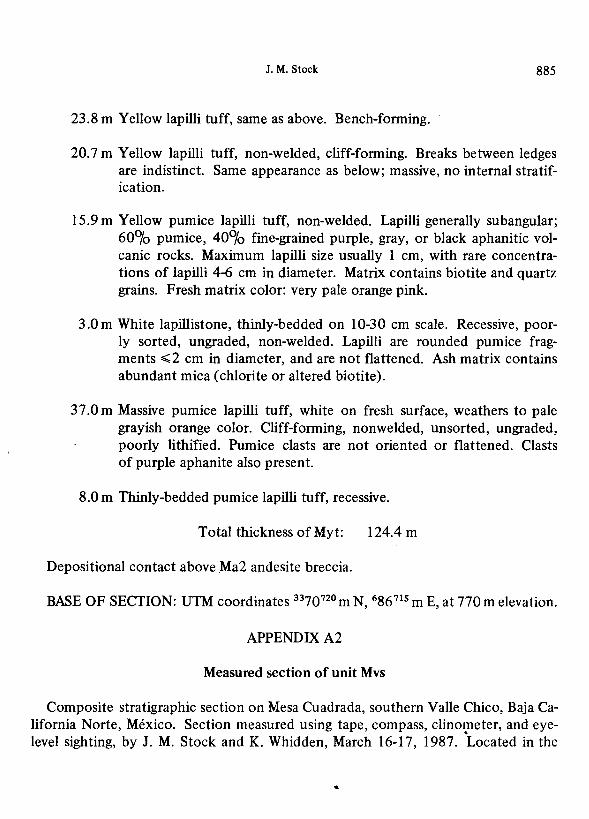
J.M. Stock 885
23.8 m Yellow lapilli tuff, same as above. Bench-forming.
20. 7 m Yell ow lapilli tu ff, non-welded, cliff-forming. Breaks between ledges are indistinct. Same appearance as below; massive, no internal stratification.
15.9 m Yellow pumice lapilli tuff, non-welded. Lapilli generally subangular; 60°/o pumice, 40°/o fine-grained purple, gray, or black aphanitic volcanic rocks. Maximum lapilli size usually 1 cm, with rare concentrations of lapilli 4-6 cm in diameter. Matrix contains biotite and quartz grains. Fresh matrix color: very pale orange pink.
3 .0 m White lapillistone, thinly-bedded on 10-30 cm scale. Recessive, poorly sorted, ungraded, non-welded. Lapilli are rounded pumice fragments ..;;2 cm in diameter, and are not flattened. Ash matrix contains abundant mica (chlorite or altered biotite).
37.0m Massive pumice lapilli tuff, white on fresh surface, weathers to pale grayish orange color. Cliff-forming, nonwelded, unsorted, ungraded, poorly lithified. Pumice clasts are not oriented or flattened. Clasts of purple aphanite also present.
8.0 m Thinly-bedded pumice lapilli tuff, recessive.
Total thickness of Myt: 124.4 m
Depositional contact above Ma2 andesite breccia.
BASE OF SECTION: UTM coordinates 3370720 m N, 686 715 m E, at 770 m elevation.
APPENDIX A2
Measured section of unit Mvs
Composite stratigraphic section on Mesa Cuadrada, southern Valle Chico, Baja California Norte, Mexico. Section measured using tape, compass, clinometer, and eyelevel sighting, by J.M. Stock and K. Whidden, March 16-17, 1987. Located in the
...

886 GEOFISICA INTERNACIONAL
Bahia Santa Maria [HI 1B67] 1:50 000 topographic quadrangle published by DETENAL, Mexico.
TOP OF SECTION: UTM coordinates 3377320 m N, 695410 m E, at 1 000 m elevation.
Overlain by white basal ash of Mrl(welded rhyolite tuff).
Mvs (volcaniclastic sediments)
6.6 m Poorly sorted conglomerate and reworked ash. Comprises two lenses with poor normal grading, max clast size = 1 m. Top 10 cm is orange stained from contact with welded tuff above. Clasts are heavily coated with caliche, subangular to subrounded, unsorted. Matrix is ash. Clast composition is similar to that of lower units.
13.2 m Tuff, light gray weathering. Clast poor, mostly ash matrix. Clasts are angular to su brounded. Largest clasts are 1 m in diameter; most are 1-10 cm in diameter. Clast composition is similar to that oflower units.
~42 m Lithic lapilli tuff, unwelded, clast-rich (but all matrix-supported). Clast diameter averages 1-3 cm; maximum diameter 10 cm in most parts. Clasts are poorly sorted and poorly graded on a scale of 1-10 m. Lithic lapilli in basal 10 m have accretionary rinds of ash. Recessive weathering, often with caves. Matrix color: pale brownish pink. Coarse,friable, with rounded feldspar grains, ash-cemented. Clast composition similar to lower units: grey glass and other feldspar porphyries.
3.5 m Lithic lapilli tuff, brown matrix, with angular to subangular clasts of varied volcanic compositions including grey amphibole + feldspar + biotite porphyry (glassy), unsorted, ungraded; maximum clast size 40 cm. Light brown weathering.
5.2 m Reworked volcanic conglomerate or pyroclastic breccia. Clast supported, clasts angular to subangular. Most common clast composition: gray porphyritic glass with feldspar+ amphibole + biotite, some with flow banding. Clast diameter ~60 cm, most 2-10 cm. Matrix: light gray, unwelded ash. Poorly sorted. Basal ash is inversely graded. Top

15.0m
2.6 m
(Pinches out
laterally)
10.0m (up to 32.5
m elsewhere)
J.M. Stock 887
of this unit has a few reworked beds 5-10 cm thick, grading upwards from ash to clast-supported conglomerate, clasts ,;;;;3 cm in diameter.
Lapilli tuff, nonwelded, unsorted, ungraded. In most of unit, clasts are angular to subangular, 50°/o white pumice, maximum clast size 50 cm, most 10 cm or less. No obvious internal stratification. Light gray weathering. Clasts are the same composition as lower units, and weather orange. Top 2 m of unit shows poor inverse grading with highest concentration of large clasts. Ash lens occurs about 4 m above base. Base is a ~ 50 cm thick layer of lapilli tu ff with white pumice clasts, .;;;;6 cm diameter, in gray ash.
Reworked tuff, clast-supported and/or matrix-supported conglomerate. Maximum bed thickness 40 cm, some beds 1-3 cm; bedding poor to fair. Normal to reverse grading in conglomerates, none in sands. Clasts subangular, not imbricated, maximum diameter 20 cm, mostly <3 cm. One reworked ash bed at the base of this unit is inversely graded. Clasts are angular to subangular, crystal-rich (or hypabyssal texture). varicolored feldspar + biotite + amphibole porphyries. All silicic - no mafic volcanics or metasediments.
Lapilli tuff with some zones of small blocks. Poorly sorted, non-graded within larger tuff breccia-lapilli tuff intervals; poorly to non-bedded. Fresh matrix: pinkish grey, unwelded ash with very fine-grained, disseminated mafic crystals, including biotite, feldspar, amphibole. Pumice clasts concentrated at base; pumice is otherwise absent.
(Base of this unit: UTM coordinates 3377 130 111 N, 695 230 m E, at approx. 910 m elevation. Line of section moved laterally to UTM coordinates 3377440 m N, 694860 m E, at 920 m elevation, to avoid a cliff. The exact overlap of the sections is uncertain but is estimated to be no more than I 0 m.)
19 .4 m Lapilli tuff; base consists of thin bedded ash (2-6 cm) grading upwards to tuff breccia. Clasts are angular to subangular, mostly grey porphyry and hypabyssal; .;;;SO cm diameter; some show flow banding. Tuff is matrix supported, nonwelded, and poorly sorted, with inverse to nor-mal grading. •
....

888 GEOFISICA INTERNACIONAL
4.0 m Tuff breccia, poorly sorted, inversely graded. Angular clasts are varicolored volcanic porphyries (feldspar + pyroxene ± quartz), some with hypabyssal texture; some white pumice clasts. Clast diameter ..;;;60 cm. Matrix is light pink, non-welded, devitrified. Some local metasedimentary clasts near metasedimentary outcrops. Contact with underlying unit is gradational.
7.5 m, Lapilli tuff, poorly sorted, inversely graded, percent of clasts increases toward top; maximum clast size 50 cm at center of lenses. Clast compositions: 70°/o white pumice, 30°/o feldspar+ pyroxene ± quartz porphyries; clasts are subangular. Non-welded matrix is grayish orange pink, and weathers orange. Unit contains interbeds of reworked tuff, poorly bedded on 30-10 cm scale, with poorly-sorted clasts <4 cm in diameter, mostly volcanic compositions; also, rare boulders ( 1 m diameter) of locally underlying metasedimentary units. Larger volcanic blocks ( < 1 m diameter) are confined to the upper half of the unit.
1.0 m Lapilli tuff and tuff breccia.
5.2 m Lapilli tuff and tuff breccia, as below, with concentrations of larger blocks (> 50 cm diameter) in center.
6.4 m Lapilli tuff and tuff breccia, orange weathering. Clasts .,.;;45 cm, usually <IO cm, and angular to subrounded. 35°/o of clasts are pumice with accretionary rinds; the remainder are other rhyolitic and hypabyssal compositions. No metasedimentary clasts are present. Two zones of larger clasts form resistant ledges. Matrix is pale orange to light gray in color. Pumice is 10°/o mafic crystals, 15°/o feldspar crystals, 75°/o ash. The top of this unit is orange in color.
3.0 m Reworke·d pumice lapilli tuff. Conglomerate beds 6-40 cm thick, some clast-supported, with both normal and reverse grading, are separated by 1-5 cm thick interbeds of fine reworked ash. Cobbles are subangular to subrounded, .,.;;9 cm diameter, with rare 30-cm diameter clasts, all of volcanic compositions. Pumice fragments are present at base .
. 8.0 m Pumice lapilli tuff, non welded, with pumice concentrations at base
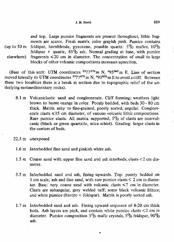
J.M. Stock 889
and top. Large pumice fragments are present throughout, lithic fragments are scarce. Fresh matrix color grayish pink. Pumice contains
(up to 50 m feldspar, hornblende, pyroxene, possible quartz: 5°/o mafics, 10°/o feldspar + quartz, 85°/o ash. Normal grading at base, with pumice
elsewhere) fragments ~20 cm in diameter. The concentration of small to large blocks of other volcanic compositions increases upsection.
(Base of this unit: UTM coordinates 3377370 m N, 695°60 m E. Line of section moved laterally to UTM coordinates 3377470 m N, 693830 m E to avoid a cliff. Between these two localities there is a break in section due to topographic relief of the underlying metasedimentary rocks).
8.1 m Volcaniclastic sand and conglomerate. Cliff forming; weathers light brown to burnt orange in color. Poorly bedded, with beds 30 - 80 cm thick. Matrix ashy to fine-grained, poorly sorted, angular. Conglomerate clasts ~ 15 cm diameter, of various volcanic lithic compositions. Rare pumice clasts. All matrix supported, 5°/o of clasts are non-volcanic (black or green quartzite, mica schist). Grading: larger clasts in the centers of beds.
22.3 m unexposed
1.6 m Interbedded fine sand and pinkish white ash.
1.5 m Coarse sand with upper fine sand and ash interbeds; clasts <2 cm diameter.
3.5 m Interbedded sand and ash, fining upwards. Top: poorly bedded on 1 cm scale, ash and fine sand, with rare pumice clasts < 2 cm in diameter. Base: very coarse sand with volcanic clasts ~7 cm in diameter. Clasts are subangular, grey welded tuff; some black volcanic lithics; and white pumice (biotite + feldspar). Matrix is poorly sorted ash.
1.7 m Interbedded sand and ash. Fining upward sequence of 8-20 cm thick beds. Ash layers are pink, and contain white pumice clasts <2 cm in diameter. Pumice composition 5°/o mafic crystals, 5°/o feldspar, 90~o ash.
890 GEOFISICA INTERNACIONAL
>0.2 m Medium to coarse sand, poorly to non-bedded. Grains are well rounded, well sorted, 1 o0/o volcanic grains, 1 o0/o mafic grains, 80°/o quartz ~ feldspar.
Total thickness of Mvs: 253.2 m
Base unexposed. Elsewhere nearby this unit overlies granitic and metasedimentary rocks.
BASE OF SECTION: UTM coordinates 3377370 m N, 693800 m E, at 655 m elevation.
APPENDIXA3
Measured section of unit Mtt
Continuous stratigraphic section on Toronja Hill, south of Arroyo Matomi, Baja California Norte, Mexico. Measured by J. M. Stock and K. Whidden, on April 4, 1987, using compass, tape, clinometer, and eye-level sighting. Located in the Puertecitos [Hl 1B77] 1:50000 topographic quadrangle published by DETENAL, Mexico.
TOP OF SECTION: UTM coordinates 3372670 m N, 700°70 m E, at 590 m elevation. Overlain by cliff-forming lapilli tuff and tuff breccia of Mvs.
Mtt (Tuffs of Toronja Hill)
7.9 m Lapilli tuff, grey matrix, gray on fresh surface, orange-weathering. Unwelded, unsorted, ungraded. Maximum lapilli size 10 cm. Lapilli are 50°/o pumice, 30°/o bluish grey aphanite, 20°/o other volcanic clasts; most are <2 cm diameter. No clasts of porphyry with large feldspars.
11.8 m Lapilli tuff. Top 1 m: clasts ~ lm in diameter, clast-supported conglomerate with light brown tuffaceous matrix, clasts largely bluish gray pumice with large feldspar + mafics (hornblende?) + biotite, granular texture. Elsewhere in unit, maximum clast size 4 cm, average 1-2 cm. Lapilli are blue, white, gray, and tan pumice, with some red and brown volcanic clasts. •
J.M. Stock 891
3.4 m Conglomerate (reworked tuff and lapilli tuft). Clasts are subangular to subrounded, of various volcanic compositions. Maximum clast size 12 cm. Beds are 4 - 30 m thick, with inverse to normal grading, and local pumice-rich layers with orange and ochre pumice clasts.
7.8 m Reworked lapilli tu ff and lapillistone; non-welded to moderately welded, resistant, orange-weathering, poorly graded in both normal and reverse senses. Maximum clast size 10 crh diameter. Lapilli are aphanitic. Basal lapillistone is 1 m thick with maximum lapilli diameter of 2 cm.
36.7 m Lapilli tuff, gray to light grayish blue. Lumpy weathering, unwelded to moderately welded, unsorted, with angular to subangular clasts. Clasts have distinctive hypabyssal texture with large feldspar phenocrysts and are light brown to light grey weathering. Maximum lapilli size is 15 cm. Some pumice lapilli have weathered out. Uppermost part of unit has symmetric, reverse to normal grading. Top 3 111 are reworked beds, 0.5 to 1.0 m thick.
7 .0 m Lapilli tuff, slope-forming. Irregular zones of red staining adjacent to reddish volcanic breccias and brecciated lenses of coarse feldspar porphyry fragments. Rare andesite blocks and lithic lapilli with finergrained feldspar. Numerous small pumice lapilli.
12.4 m Lapilli and block tuff, characterized by large blocks of feldspar porphyry, with feldspar crystals ~ 1 cm long. Orange weathering. Gray on fresh surface, maximum block size 80 cm, angular to subangular. No grading or sorting. Matrix is incipiently welded and contains biotite. Pumice clasts weather out.
6.3 m Obscured by talus
11.4 m Lapilli tuff. Lapilli are pumice and grey volcanics; matrix is purple and non-welded to poorly welded. No internal bedding, grading, or sorting. Lapilli are bluish gray aphanite, angular to subangular, with minor red and purple aphanite, and pumice fragments. A few clasts reach 10 cm in size; most are ~ 1 cm. Rare lapillistone beds have clasts ~ 1 m in diameter, of varied volcanic lithologies .
....
892 GEOFISICA INTERNACIONAL
16.8 m Pumice and lithic lapilli tuff. Tan to light brown weathering. Reworked. Well-bedded, beds 0.1 to 1 m thick, some conglomerate lenses. Clasts are angular to subangular, of various volcanic lithologies including pumice and basalt, and rare mica schist. Grading is normal at base (debris flow texture), matrix supported. Maximum clast size is 1 m but most are smaller. Higher units are inversely graded and weather orange.
4 m Pumice lapilli tuff, grayish brown, maximum clast size 8 cm. Some bedding 3 0-40 cm thick.
1.8 m Reworked ash and lapilli tuff, recessive, thin-bedded (10-40 cm scale). Light gray weathering, no grading, rare crossbeds. Maximum clast size 2 cm.
1.0 m Debris flow, sands at base, reverse to normal grading upwards, maximum clast size 25 cm, most< 10 cm, clasts subangular to rounded, of various volcanic lithologies and rare metasedimentacy lithologies. Biotjte-rich, light gray, partially welded pumice common. Laterally variable.
1.0 m Tuffaceous sands. Laminated; beds 10 - 15 cm thick; up to 50°/o pumice dasts. Inversely graded. Maximum size of pumice clasts is 15 mm.
>6.3 m Tuffaceous sandstone, poorly sorted, ungraded, non-bedded, wellindurated. Weathers into rounded, exfoliating surfaces. Maximum grain size 1 mm for crystals, lithic fragments; 2 mm for pumice. Lithic fragments are subrounded to subangular, and largely volcanic in composition, although some fragments of metamorphic rock, up to 1 cm in diameter occur. Grain compositions: lithic fragments 40-60°/o; pumice 30°/o; crystals 10-30<}0.
Total thickness of unit Mtt: 135.6 m
Depositional contact on underlying unstratified volcanic breccias (unit Mvb). BASE OF SECTION: UTM coordinates 3372490 m N, 699920 m E, at 460 m elevation.

J.M. Stock 893
APPENDIX B
K-AR AND 40 AR-39 AR GEOCHRONOLOGY
Conventional potassium-argon ages were obtained on potassium feldspar, plagioclase, biotite, or whole rocks from fourteen samples within the map area (Table 1). Total fusion 40Ar-39Ar ages were also obtained on some of the feldspars (Table 2). Final sample preparation, argon extractions, and argon analyses were performed at the U. S. Geological Survey geochronology laboratory in Menlo Park, California. K20 analyses were performed by the U.S.G.S. Analytical Chemistry division, using a lithium metaborate flux fusion-flame photometry method, with the lithium as an internal standard (lngamells, 1970). Argon extractions were made using standard isotope-dilution procedures (e.g., Dalrymple and Lanphere, 1969). Argon analyses were made using a 60° sector, 15.2 cm radius, Neir-type mass spectrometer, and a 23 cm radius, 90° sector multi-collector mass spectrometer (Stacey et al., 1981 ).
An additional check on these ages could have been obtained by dating coexisting hornblende or biotite; however, the content of these minerals in the samples was very low, they were largely oxidized, and not enough of these phases could be extracted from the amount of sample collected.
Feldspars
Potassium feldspar and plagioclase crystals were separated by standard mineral separation techniques and hand picking. Clean separates were rinsed in 6°/o HF for 10-15 minutes to remove minor remaining glass and surface impurities.
Conventional K-Ar ages of high-temperature potassium feldspars may be slightly too low, due to incomplete escape of argon from theviscousmelt(McDowell, 1983). Final recovery of argon, yielding K/ Ar ages in good agreement with 40Ar-39Ar ages, has been obtained from extractions at 1 600°C for 40 minutes (McDougall, 1985); however, McDowell ( 1983) encountered measurable differences between K-Ar and 40Ar-39Ar ages even with these extraction temperatures, and recommended the use of basalt flux, as well as T > 1 670°C. Therefore, in many of the feldspar extractions listed in Table 1, a pure quartz glass, water-cooled vacuum bottle was used in order to fuse the crystals at temperatures of up to 1 650°C (by optical pyrometer reading with estimated uncertainty of ± 50°C). Flux of previously-fused basalt glass was

894 GEOFISICA INTERNACIONAL
added to some of the samples in an effort to improve argon release by lowering the viscosity of the melt. The samples were kept at fusion temperature for up to sixty minutes. One sample was fused twice, yielding 4°/o more radiogenic argon during the second fusion. The 40Ar-39Ar total fusion ages (Table 2) were intended to check for incomplete release or incomplete collection of argon gas during extraction from feldspars. Unfortunately, not all of these techniques could be tried on all of the samples, and consistent differences between techniques were not always observed. In interpretation of t)le differences between the results, conventional extractions at higher temperature are assumed to be more reliable than those at lower temperature (see discussion on previous page); extractions from potassium feldspar more reliable than those from plagioclase; total fusion 40Ar-39Ar more reliable than conventional K/Ar; and extractions with higher radiogenic yield more reliable than those with lower radiogenic yield.
Biotites
Biotites were separated by standard mineral separation techniques. In both samples, the biotites were highly magnetic due to iron oxide alteration of the rims. Efforts to· remove the magnetic material by use of the ball mill and mica table were largely successful, but the final biotite separate still contained minor iron oxide contamination, which should not affect the final result.
Whole Rocks
Whole rock samples were crushed and sieved to -20+40 mesh size, and rinsed in an ultrasonic bath of 2.4 N HCl for 20 minutes to dissolve calcite. Samples were dried at room temperature, under a heat lamp, or in a sample oven at< 140°C prior to the argon extraction.
BIBLIOGRAPHY
ANDERSON, R. L., 1973. Geology of the Playa San Felipe Quadrangle, Baja California, Mexico, MS Thesis, Calif. State Univ. San Diego, San Diego, California, USA.
BOEHM, M., 1984. An overview of the lithostratigraphy, biostratigraplty, and paleoenvironments of the late Neogene San Felipe marine sequence, Baja California,
J.M. Stock 895
Mexico, in V. A. Frizzell, Jr. (ed.), Geology of the Baja California Peninsula, Pacific Section, Society of Economic Paleontologists and Mineralogists, Los Angeles. 253-266.
BRYANT, B. A., 1986. Geology of the Sierra Santa Rosa Basin, Baja California, Mexico, M. S. Thesis, San Diego State University, San Diego, California, USA.
DALRYMPLE, G. B. and M. LANPHERE, 1969. Potassium-Argon Dating, San Francisco: W. H. Freeman and Co., 258 pp.
DOKKA, R. K. and R. H. MERRIAM, 1982. Late Cenozoic extension of northeastern Baja California, Mexico. Geo!. Soc. Am. Bull., 93, 371-378.
FISHER, R. V., 1966. Rocks composed of volcanic fragments. Earth Sci. Rev., 1, 287-298.
GASTIL, R. G., D. KRUMMENACHER and J. MINCH, 1979. The record of Cenozoic volcanism around the Gulf of California. Geo!. Soc. Am. Bull., 90, 839-857.
GASTIL, R. G., D. V. LeMONE and W. J. STEWART, 1973. Permian fusilinids from near San Felipe, Baja California. Amer. Assoc. Petrol. Geo!. Bull., 57, 746-747.
GASTIL, R. G., R. P. PHILLIPS and E. C. ALLISON, 1975. Reconnaissance Geology of the State of Baja California. Geol. Soc. Am., Memoir 140.
HAMILTON, W., 1971. Recognition on space photographs of structural elements of Baja California. U.S. Geological Survey Professional Paper 718, 26 pp.
INGAMELLS, C. 0., 1970. Lithium metaborate flux in silicate analysis. Analytica Chimica Acta, 52, 323-334.
JAMES, A. H., 1973. Structure and stratigraphy of the southern Sierra de Pintas, Baja California, Mexico. M. S. Thesis, San Diego State University, San Diego, California, USA.
McDOUGALL, I., 1985. K-Ar and 40Ar/39Ar dating of the hominid-bearing Pliocene-Pleistocene sequence at Koobi Fora, Lake Turkana, Northern Kenya. Geo!. Soc. Am. Bull., 96, 159-175.
McDOWELL, F. W., 1983. K-Ar dating: incomplete extraction of radiogenic argon from alkali feldspar. Isotope Geoscience, 1, 119-126.
McELDOWNEY, R. C., 1971. Geology of the northern Sierra Pinta, Baja California, Mexico, M. S. Thesis, San Diego State College.
SOMMER, M. A. and J. GARCIA, 1970. Potassium-argon dates for Pliocene rhyolite sequences east of Puertecitos, Baja California. Geo!. Soc. Am. Abstracts with Programs, 2, 146.
STACEY, J. S., N. D. SHERRILL, G. B. DALRYMPLE, M.A. LANPHERE and N. V. CARPENTER, 1981. A five-collector system for the simultaneous measure-
...

896 GEOFISICA INTERNACIONAL
ment of argon isotope ratios in a static mass spectrometer. International J. Mass Spectrometry and Ion Phys., 39, 167-180.
STOCK, J.M. and K. V. HODGES, 1989. Miocene to recent structural development of an extensional accommodation zone, NE Baja California, Mexico. (In press, J. Struct. Geo!., 1989).
....