Geodesign with Little Time and Small Data: Post-tsunami...
13
2 Geodesign with Little Time and Small Data: Post-tsunami Restoration in Soma City, Fukushima Prefecture, Japan Carl STEINITZ Graduate School of Design, Harvard University, Cambridge, MA, USA · [email protected] 1 Introduction It is clear that for serious societal and environmental issues, designing for change cannot be a solitary activity. Rather, it is inevitably a collaborative endeavor (figure 1), with partici- pants from various design professions and geographic sciences, linked by technology from several locations for rapid communication and feedback, and reliant on transparent com- munication with the people of the place who are also direct participants. Fig. 1: Geodesign is a collaborative endeavour “Geodesign applies systems thinking to the creation of proposals for change and impact simulations in their geographic contexts, usually supported by digital technology.” (TESS CANFIELD & CARL STEINITZ after MICHAEL FLAXMAN and STEPHEN ERVIN) “Geodesign changes geography by design.” “Geodesign” is an invented word, and a very useful term to describe a collaborative activity that is not the exclusive territory of any design profession, geographic science or information technology. Each participant must know and be able to contribute something that the others cannot or do not. …….yet during the process, no one need lose his or her professional, scientific or personal identity.” (CARL STEINITZ) Wissen Hayek, U., Fricker, P. & Buhmann, E. (Eds.) (2014): Peer Reviewed Proceedings of Digital Landscape Architecture 2014 at ETH Zurich. © Herbert Wichmann Verlag, VDE VERLAG GMBH, Berlin/Offenbach. ISBN 978-3-87907-530-0.
Transcript of Geodesign with Little Time and Small Data: Post-tsunami...
2
Geodesign with Little Time and Small Data: Post-tsunami Restoration in Soma City,
Fukushima Prefecture, Japan
Carl STEINITZ
Graduate School of Design, Harvard University, Cambridge, MA, USA · [email protected]
1 Introduction
It is clear that for serious societal and environmental issues, designing for change cannot be a solitary activity. Rather, it is inevitably a collaborative endeavor (figure 1), with partici-pants from various design professions and geographic sciences, linked by technology from several locations for rapid communication and feedback, and reliant on transparent com-munication with the people of the place who are also direct participants.
Fig. 1: Geodesign is a collaborative endeavour
“Geodesign applies systems thinking to the creation of proposals for change and impact simulations in their geographic contexts, usually supported by digital technology.” (TESS CANFIELD & CARL STEINITZ after MICHAEL FLAXMAN and STEPHEN ERVIN)
“Geodesign changes geography by design.” “Geodesign” is an invented word, and a very useful term to describe a collaborative activity that is not the exclusive territory of any design profession, geographic science or information technology. Each participant must know and be able to contribute something that the others cannot or do not. …….yet during the process, no one need lose his or her professional, scientific or personal identity.” (CARL STEINITZ)
Wissen Hayek, U., Fricker, P. & Buhmann, E. (Eds.) (2014): Peer Reviewed Proceedings of Digital LandscapeArchitecture 2014 at ETH Zurich. © Herbert Wichmann Verlag, VDE VERLAG GMBH, Berlin/Offenbach. ISBN 978-3-87907-530-0.

Geodesign with Little Time and Small Data
3
I have organized many collaborative, multidisciplinary studies of important landscape regions undergoing significant change. The framework within which I organize most of my work and teaching strategies has been published in my recent book A Framework for Geodesign, Esri Press, 2012 (figure 2). In this paper I will present an example application of my framework under conditions of little time and small data.
Fig. 2: The framework for geodesign
“Everyone designs who devises courses of action aimed at changing existing situations into preferred ones.” (HERBERT SIMON, The Sciences of the Artificial, 1969)
The basic problem of geodesign can be stated as, “How do we get from the present state of this geographical study area to the best possible future?” In the framework we answer the question: "How might the landscape be altered?" with change models, the ways of design-ing and achieving the products of the geodesign study. Change models are a particularly important element within the geodesign framework.

C. Steinitz
4
Fig. 3: Aspects of size and scale, and the need for collaboration
There are multiple ways of designing, but all change models combine decisions related to allocation, organization, and expression, and all require visualization and communication (figure 3). Allocation refers to where changes are located, such as the placement of new housing in the landscape, the conversion of forest to agriculture, or the protection of a rare animal’s habitat, and so on. Organization refers to the interrelationships among the elements of the design, such as how the school, the shopping area, the park, the bus system, and both low- and high-density housing all fit together in the design of the new community. Expression refers to the way in which the design is perceived. For example, is it seen as a residential community, or as a friendly place, a beautiful or an expensive one, etc. The three characteristics of allocation, organization, and expression are rarely applied with equal emphasis. As a general rule, the larger the size of the design study, the more emphasis is placed on allocation. In contrast, the smaller the project, the more emphasis can be placed on expression. This change of emphasis is characteristic of the differences between landscape planning and garden design, or regional planning and architectural design.
I think that the extremes of size and scale shown in figure 2 are relatively well served. Design professionals such as architects, landscape architects, urban planners and civil engineers are generally capable at serving client needs at the scales which are symbolized in figure 3 by the house and the urban design. They increasingly work with the people of the place, and on rare occasion with geographic scientists. Similarly, geographically oriented scientists are generally capable of understanding the needs of the environment at the scales symbolized from the globe to the large region. They increasingly work with information technologies, and on rare occasion with design professionals. I believe that geodesign can be most significant and effective where the needs for collaboration overlap, between the large project and the large region. This mid-range of geodesign "problems" is

Geodesign with Little Time and Small Data
5
where the decisions are (or should be) made that can really shape the world's environments (plural) for the better.
2 Why Apply Geodesign in a Workshop Format?
When using geodesign and there is little time and small data, When working through a framework in order to understand it, When starting fast in order to identify central issues, options and choices, When it takes a design to know what the questions really are, and When it takes a design to know what is really wanted.
This workshop featured systems thinking in geodesign. All work was digital except Change Version 1. The participants were faculty and advanced students from four Japanese Univer-sities, mainly geographers and geo-scientists, engineers and landscape architects. The focus was a real site and a real problem posed by the responsible government official. The aim was to study six alternative scenarios for the future but to recommend one strategy. The work of the workshop took 24 hours over three consecutive days.
3 Post-tsunami Restoration in Soma City, Fukushima Prefecture, Japan
The 2011 earthquake off the Pacific coast of Japan, also known as the 2011 Tohoku earth-quake and the Great East Japan Earthquake, was a magnitude 9.0 undersea earthquake off the coast of Japan that occurred at 14:46 Japan Standard Time on Friday, 11 March 2011. It was the most powerful known earthquake to have hit Japan, and one of the five most powerful earthquakes in the world overall since modern record-keeping began in 1900. It was so powerful that the island of Honshu was moved 8 feet eastward. In Tohoku the land dropped almost 1 meter. The earthquake triggered extremely destructive tsunami onshore waves of 9 meters, and even up to 40 meters high (133 feet) in parts of Miyako, Iwate and Tohoku. In some cases, these traveling up to 10 km (6 miles) inland. Approximately 18,000 people died. In addition to the enormous loss of life and destruction of infrastructure, the tsunami caused the number of nuclear accidents, primarily the ongoing level VII meltdowns at three reactors in the Fukushima 1 nuclear power plant complex. The associated evacua-tion zones affected hundreds of thousands of residents (figure 4).
The city of Soma, in Fukushima province, is located directly north of the Fukushima nu-clear power plant. Approximately 1000 of its then 38,000 residents died in the tsunami, and the radiation from the nuclear disaster caused the majority of its residents to be evacuated. The environmental disaster and its consequent loss of population is of great concern. There has been rebuilding of temporary tsunami barriers, some replacement of saline and nuclear contaminated soil, the restoration of electricity and other services and while some of the surviving residents have returned, many, especially younger persons, have not.

C. Steinitz
6
Fig. 4: Earthquake, tsunami and nuclear radiation damage in Soma City
The Mayor of Soma City requested that faculty colleagues at Tohoku University organize a workshop directed at providing advice on how the city might develop policies and plans to restore the city to its prior condition and/or how it might transform itself in the near future. It was decided to organize a workshop among faculty and advanced students in diverse but relevant fields from four universities, and to invite me to conduct the workshop within my framework for geodesign. I have taught workshops with the key collaborating colleagues from these universities more than 10 times over the past 15 years and I know that they are familiar with a range of methods from which we could choose the set to apply to the issues facing Soma. The Soma workshop was conducted during 27 February through 1 March 2013. All participants had previously visited the city, in most cases on the days immediately preceding the three day workshop.
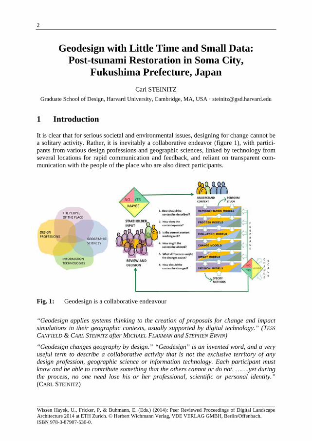
Day one began with an overview review of the framework for geodesign and how it might be applied to Soma city. The participants were asked to identify the major issues which would influence decisions regarding the future of the city. Ten were identified (figure 5).
Geodesign with Little Time and Small Data
7
Fig. 5: Ten evaluation models and the process models on which they are based.
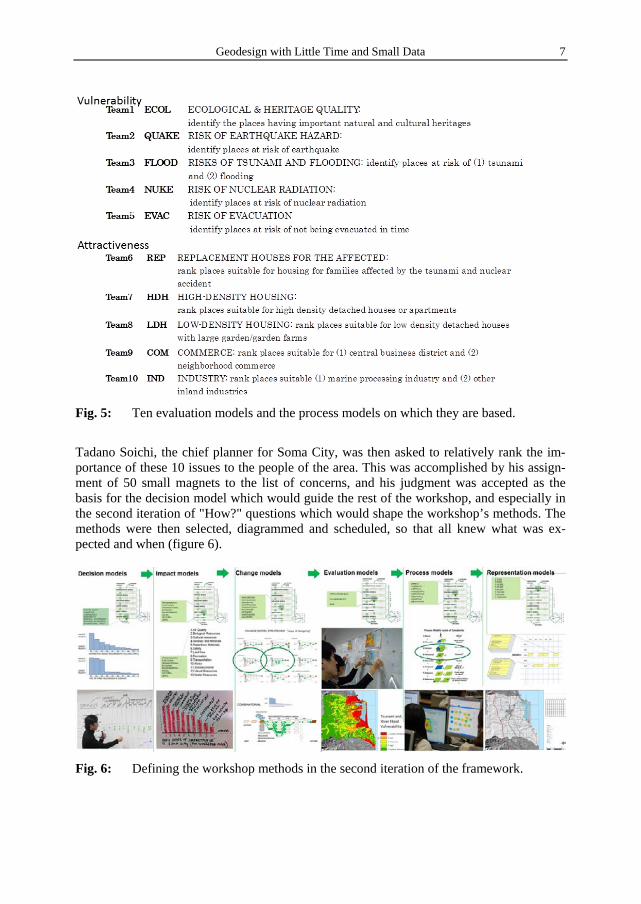
Tadano Soichi, the chief planner for Soma City, was then asked to relatively rank the im-portance of these 10 issues to the people of the area. This was accomplished by his assign-ment of 50 small magnets to the list of concerns, and his judgment was accepted as the basis for the decision model which would guide the rest of the workshop, and especially in the second iteration of "How?" questions which would shape the workshop’s methods. The methods were then selected, diagrammed and scheduled, so that all knew what was ex-pected and when (figure 6).
Fig. 6: Defining the workshop methods in the second iteration of the framework.
C. Steinitz
8
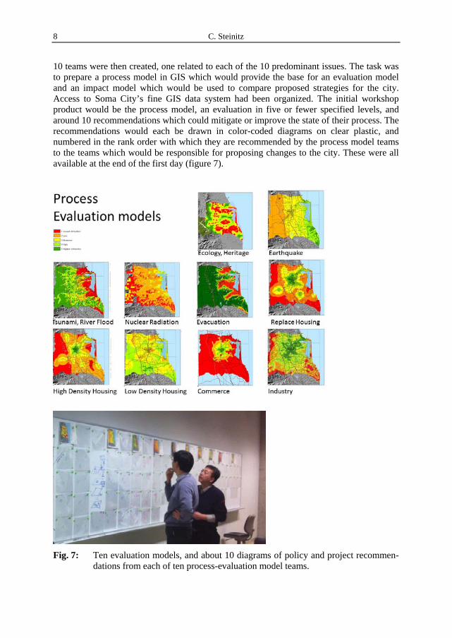
10 teams were then created, one related to each of the 10 predominant issues. The task was to prepare a process model in GIS which would provide the base for an evaluation model and an impact model which would be used to compare proposed strategies for the city. Access to Soma City’s fine GIS data system had been organized. The initial workshop product would be the process model, an evaluation in five or fewer specified levels, and around 10 recommendations which could mitigate or improve the state of their process. The recommendations would each be drawn in color-coded diagrams on clear plastic, and numbered in the rank order with which they are recommended by the process model teams to the teams which would be responsible for proposing changes to the city. These were all available at the end of the first day (figure 7).
Fig. 7: Ten evaluation models, and about 10 diagrams of policy and project recommen-dations from each of ten process-evaluation model teams.
Geodesign with Little Time and Small Data
9
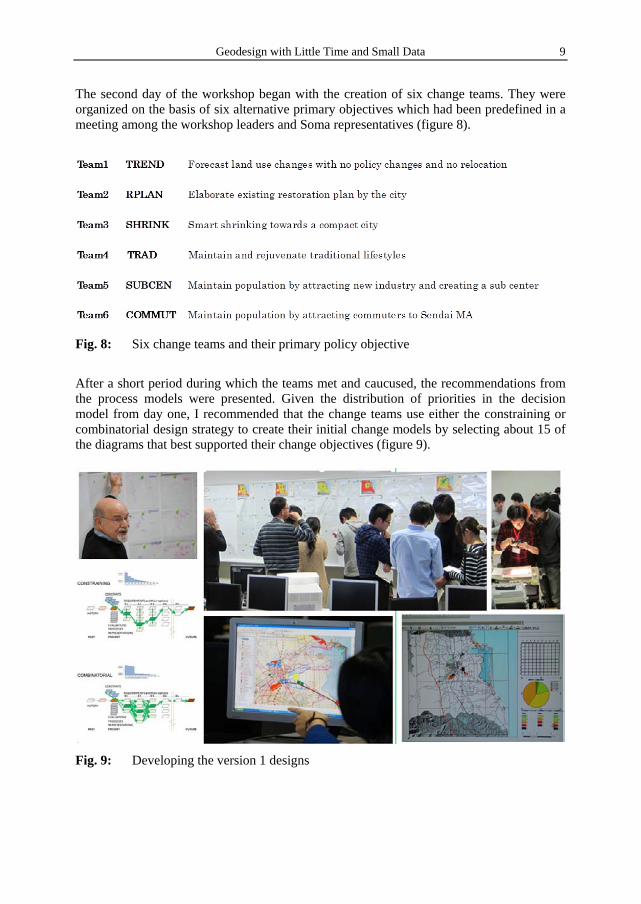
The second day of the workshop began with the creation of six change teams. They were organized on the basis of six alternative primary objectives which had been predefined in a meeting among the workshop leaders and Soma representatives (figure 8).
Fig. 8: Six change teams and their primary policy objective
After a short period during which the teams met and caucused, the recommendations from the process models were presented. Given the distribution of priorities in the decision model from day one, I recommended that the change teams use either the constraining or combinatorial design strategy to create their initial change models by selecting about 15 of the diagrams that best supported their change objectives (figure 9).
Fig. 9: Developing the version 1 designs
C. Steinitz
10
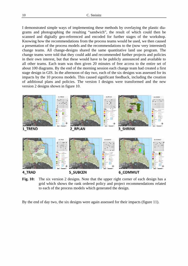
I demonstrated simple ways of implementing these methods by overlaying the plastic dia-grams and photographing the resulting “sandwich”, the result of which could then be scanned and digitally geo-referenced and encoded for further stages of the workshop. Knowing how the recommendations from the process teams would be used, we then caused a presentation of the process models and the recommendations to the (now very interested) change teams. All change-designs shared the same quantitative land use program. The change teams were told that they could add and recommended further projects and policies in their own interest, but that these would have to be publicly announced and available to all other teams. Each team was then given 20 minutes of free access to the entire set of about 100 diagrams. By the end of the morning session each change team had created a first stage design in GIS. In the afternoon of day two, each of the six designs was assessed for its impacts by the 10 process models. This caused significant feedback, including the creation of additional plans and policies. The version I designs were transformed and the new version 2 designs shown in figure 10.
Fig. 10: The six version 2 designs. Note that the upper right corner of each design has a
grid which shows the rank ordered policy and project recommendations related to each of the process models which generated the design.
By the end of day two, the six designs were again assessed for their impacts (figure 11).

Geodesign with Little Time and Small Data
11
Fig. 11: Comparing six change designs across ten impact models.
The workshop participants knew that day three would include a complete presentation of the workshop’s activities and products, and toward the end of the second day responsibili-ties were divided for the different preparatory tasks which would be involved. One of these was the 3-dimensional animation of the proposed designs, and this was organized by Eric Wittner of Esri/CityEngine (figure 12).
Fig. 12: From 2-dimensional GIS to 4-dimentional animation. Note that this design proposes to protect from future tsunamis by placing two manmade and forested barrier beaches surrounding a water park, and new agriculture and a raised by-pass road between the new compact development and the ocean.

C. Steinitz
12
The morning of day three was devoted to organizing and preparing the presentations of the 10 process models, and the six change strategies and their comparative impacts. The pres-entation was held in the afternoon to a large audience of faculty, students, the workshop participants and representatives of Soma city. At the end of the presentations, and after a series of questions to the change teams, four experts from diverse fields who had personal knowledge of Soma city and the situation offered their views on the advantages, disadvan-tages, and implementation prospects of the six designs. I made the summary comments (figure 13).
Fig. 13: Summary conclusions
The preferred strategies were initially to continue with the construction of emergency housing and try very hard to retain existing industry, while at the same time recognizing that some parts of the city would not be rebuilt as they previously were. Soma will be a less populous city for several years. The favored longer-term strategy was to attract younger families by offering less costly land and housing opportunity while assuming that many of these new residents would commute to work in Sendai and other nearby cities.
The results of the workshop and its conclusions were enthusiastically accepted by the attending representatives of Soma, and subsequently by the Mayor of Soma City.
I cannot know what will eventually happen in Soma City. I do know that the Soma work-shop received an important achievement award at the annual Esri User Conference held in San Diego and a Japanese planning prize in 2013.

Geodesign with Little Time and Small Data
13
Participants

C. Steinitz
14
Acknowledgements
I thank Professor Yuzuru Isoda and Kazumasa Hanaoka of Tohoku University and Soichi Tadano for their excellent preparations for the Soma City workshop. Professors Isoda of Tohoku University, Keiji Yano and Tomoki Nakaya of Ritsumeikan University, Akinobu Murakami of Tsukuba University, Eric Wittner of Esri/CityEngine and Tess Canfield for their contributions and support during the Soma City workshop. Tess Canfield made significant editorial contributions to this paper.
Author
Carl Steinitz is the Alexander and Victoria Wiley Professor of Landscape Architecture and Planning, Emeritus, at the Graduate School of Design, Harvard University. In 1967, Steinitz received his PhD degree in City and Regional Planning, with a major in urban design, from the Massachusetts Institute of Technology (MIT). He also holds the Master of Architecture degree from MIT and a Bachelor of Architecture degree from Cornell University. In 1965 he began his affiliation with the Harvard Graduate School of Design as a research associate in the Laboratory for Computer Graphics and Spatial Analysis. He has been Professor of Landscape Architecture and Planning at the Graduate School of Design since 1973.
Professor Steinitz has devoted much of his academic and professional career to improving methods to make design decisions about conservation and development. His teaching and applied research focus on highly valued landscapes that are undergoing substantial pres-sures for change. In 1984, the Council of Educators in Landscape Architecture (CELA) presented Professor Steinitz with the Outstanding Educator Award for his “extraordinary contribution to environmental design education” and for his “pioneering exploration in the use of computer technology in landscape planning, especially in the areas of resource man-agement and visual impact assessment.” In 1996 he received the annual “Outstanding Practitioner Award” from the International Society of Landscape Ecology (USA). In 2002, he was honored as one of Harvard University’s outstanding teachers.
Professor Steinitz has lectured and given workshops at more than 140 universities, and he has received several honorary degrees. He is currently Honorary Visiting Professor at the Centre for Advanced Spatial Analysis at University College London, and at Sheffield University. He is principal author of Alternative Futures for Changing Landscapes (ISLAND PRESS 2003) and author of A Framework for Geodesign, (ESRI PRESS 2012).