Geocachinggg Merit Badge PART ONE - Troop 1028 files/Geocaching Cutright Part 1 Oct...Geocachinggg...
33
Geocaching Merit Badge PART ONE Eric Cutright, Troop 1028, October 2014 (adapted from original presentation by Melissa Portz, ASM Delano Troop 273) 1
Transcript of Geocachinggg Merit Badge PART ONE - Troop 1028 files/Geocaching Cutright Part 1 Oct...Geocachinggg...

Geocaching Merit Badgeg gPART ONEEric Cutright, Troop 1028, October 2014
(adapted from original presentation by Melissa Portz, ASM Delano Troop 273)
1

The Plan for TodayP t O I t d tiPart One - Introduction
Troop 1028 Merit Badge Counselorsp gEric Cutright, Jeff Monroe, and Susan Saliba
What is Geocaching?History of GeocachingThe Global Positioning System (GPS)How to Find (and Hide) a GeocacheHow to Find (and Hide) a GeocacheGeocaching Lingo and RulesCool Geocache ExamplesCool Geocache ExamplesGeocaching Game – Patrol Competition
2

What is Geocaching?What is Geocaching?
“Geocaching is a sport where you use a multi-billion dollar satellite system to locate
rubbermaid containers in the middle of the woods ”rubbermaid containers in the middle of the woods.”
~~ Anonymous Anonymous
3

What is Geocaching?What is Geocaching?
• Nature meets Technologygy– GPS (Global Positioning System)– Latitude/Longitude
Map and compass– Map and compass– Hidden containers– Cool treasures, trinkets, and trackables– Friends and family time in great outdoors– Cool tracking on geocaching.com– Adventures and challengesg
4

History of GeocachingHistory of Geocaching
• GPS was developed by the US Dept of Defensep y p• May 1st, 2000 the Government made these GPS
signals available to the public– Removing “Selective Availability”
• On May 3rd, Dave Ulmer hid a 5 gallon pail out in woods in Oregonwoods in Oregon– Called “The Great American Stash Hunt”
• The first finder, Jeremy Irish, created hi t d t hgeocaching.com to document geocaches
• Today over 1 Million are hidden around the world
5

Global Positioning System (GPS)Global Positioning System (GPS)
• What does a GPS Do?– Tells you where to go– Tracks where you have been
Stores maps: topographical trails street– Stores maps: topographical, trails, street– Stores coordinates (waypoints, points of interest)– Communicates with satellites out in space– Can be linked to geocaching.com to
find nearest caches
6

How does it work?How does it work?
• Three Segmentsg– Space
• 24-30 satellites orbit around the earth at an altitude of about 12,550 miles
• Transmits position, orbit and location, and altitude– Control
• Satellites are tracked by US Air Force Monitoring Stations scatteredSatellites are tracked by US Air Force Monitoring Stations scattered throughout the US.
• Ground stations will send navigation updates to the satellites– UserUser
• GPS• Uses data from satellites to calculate user’s position, altitude and
other data
7

How does it work?How does it work?
• To sum it all up:p– The GPS uses the time it receives the signal from the satellites
to determine location and altitude– The GPS only needs to receive data from 4 satellites toThe GPS only needs to receive data from 4 satellites to
determine location. The more received, the better the accuracy
8

How to Determine CoordinatesHow to Determine Coordinates
• The globe is comprised of horizontal and vertical g plines called: Latitude and Longitude
• Latitude (horizontal - parallels) – Horizontal lines around the globe– Gives North to South position between the poles– North Pole is 90 degrees north– 0 degrees = equator– South Pole is 90 degrees south
• Longitude (vertical meridians)• Longitude (vertical - meridians)– Vertical lines around the globe– Gives East to West position from Prime Meridian– 0 degrees = Prime Meridian through Greenwich, England.
9

Latitude and LongitudeLatitude and Longitude
MooseMoose38o N, 78o Wor +38o, -78o
10

Interference and AccuracyInterference and Accuracy
• Interference: Factors that prevent GPS from preceiving information from satellites– Weather– Buildingsg– Trees– Canyons
• Takes longer for GPS to receive satellite signalTakes longer for GPS to receive satellite signal• No GPS is 100% Accurate• Most GPS units will get you within 20 feet of a
G hGeocache
– Use “Geosense” when hunting for a cache
11

How to use a GPSHow to use a GPS
• Get to know your GPS before you head outy y– Where is the Enter button, move up or down, zoom in or out, find
the menu, turn on backlight
• How to switch between the map and the compass• How to switch between the map and the compass• Check battery levels• “Mark” a waypoint (location)Mark a waypoint (location)
– A waypoint is a location entered in your GPS
• “Find” a waypoint (location) or point of interest• Edit/Change coordinates• The Compass
The arrow will not move until you begin to move– The arrow will not move until you begin to move
12

A Typical GPSA Typical GPS
• Garmin Oregon 650g
13
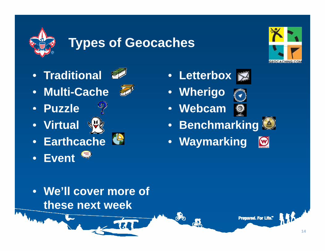
Types of GeocachesTypes of Geocaches
• Traditional • LetterboxTraditional• Multi-Cache• Puzzle
Letterbox• Wherigo• WebcamPuzzle
• Virtual• Earthcache
Webcam• Benchmarking • Waymarking• Earthcache
• Event• Waymarking
• We’ll cover more of these next weekthese next week
14

Geocache SizesGeocache Sizes
• Micro– Nano, film containers, magnetic key holder, “evil” pennies / rocks– Typically only a logbook, usually tightly rolled with special tool
S ll• Small– Sandwich size lock-n-lock, decon containers, small peanut butter
container– Can fit logbook, pencil and small trade items
• Regular– Ammo can large lock-n-lock think “shoebox size”– Ammo can, large lock-n-lock, think shoebox size
• Large– 5 gallon bucket, big wooden box
15

What should be in a Geocache?What should be in a Geocache?
16
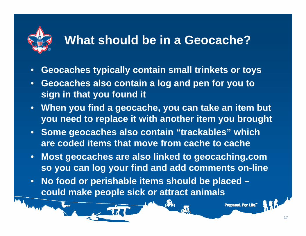
What should be in a Geocache?What should be in a Geocache?
• Geocaches typically contain small trinkets or toysyp y y• Geocaches also contain a log and pen for you to
sign in that you found it • When you find a geocache, you can take an item but
you need to replace it with another item you brought• Some geocaches also contain “trackables” which• Some geocaches also contain trackables which
are coded items that move from cache to cache• Most geocaches are also linked to geocaching.com
so you can log your find and add comments on-line• No food or perishable items should be placed –
could make people sick or attract animalscould make people sick or attract animals
17

Cool Geocaching ExamplesExamples
18

Cool Geocache Example 1Cool Geocache Example 1
19

Cool Geocache Example 2Cool Geocache Example 2
20

Cool Geocache Example 3Cool Geocache Example 3
21
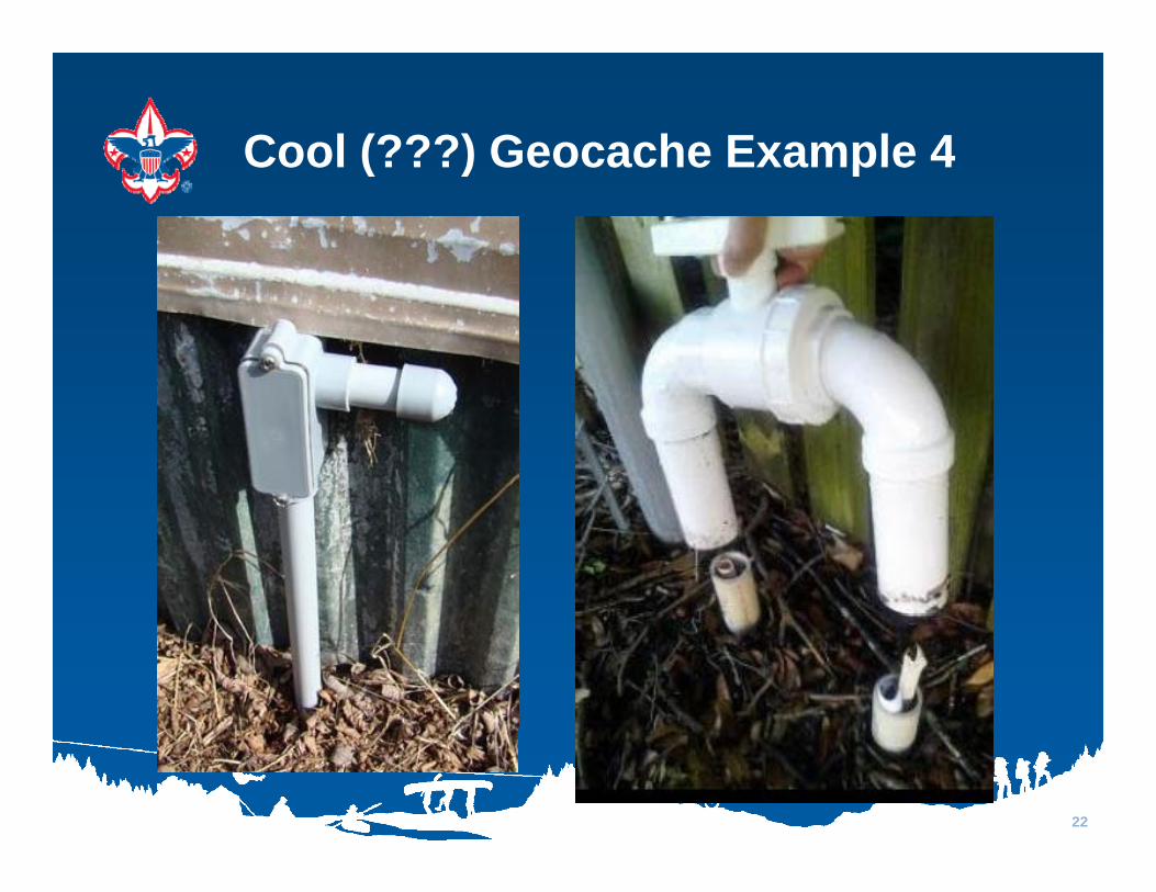
Cool (???) Geocache Example 4Cool (???) Geocache Example 4
22

Cool Geocache Example 5Cool Geocache Example 5
23

Cool Geocache Example 6Cool Geocache Example 6
24

Cool Geocache Example 7Cool Geocache Example 7
25
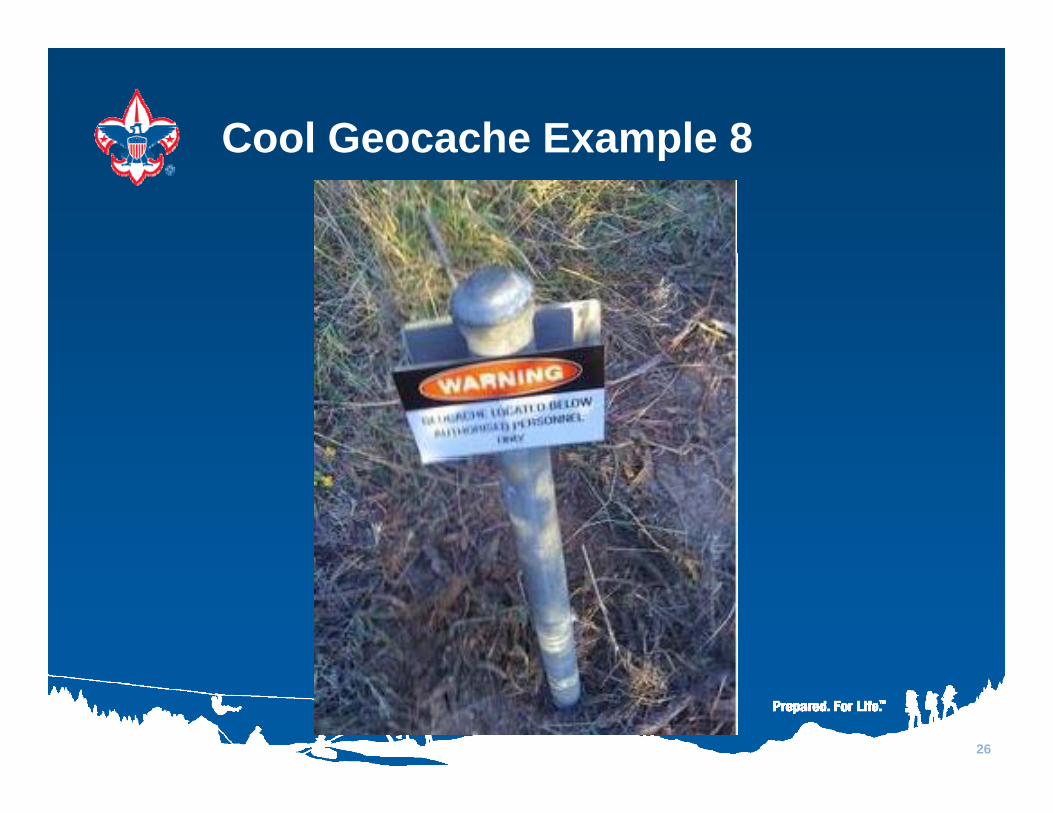
Cool Geocache Example 8Cool Geocache Example 8
26

Cool Geocache Example 9Cool Geocache Example 9
27
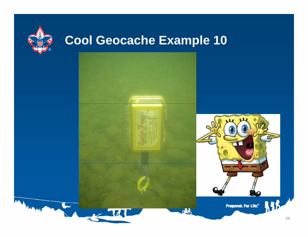
Cool Geocache Example 10Cool Geocache Example 10
28

G hiGeocaching Patrol Competition p
Game!!
29

Geocache Game – Week 1Geocache Game Week 1
• Each patrol will psearch for three mysterious geocaches aroundgeocaches around the Moose Lodge
• Limit: 1 GPS unit• Next week each patrol
will hide geocaches for the other patrolsfor the other patrols
• EVERYONE MUST FOLLOW RULES !!
30

Game Rules: Where Geocaches C t B HiddCannot Be Hidden
• Outside the “OK ZONE” shown on previous pagep p g• On pavement• Inside or under any buildings (including shelter)• Within 6 feet of any vehicles• Behind the Moose back fence or Troop 1028 shed
f• More than 6 feet into the tree line• Within 6 feet of plumbing, gas, or electrical
connectionsconnections• In any potentially unreachable or unsafe location
31

Game Rules: Keep It FunGame Rules: Keep It Fun
• Three patrols : Wolverines, Cobras, Mountaineersp , ,– Moose Patrol can split up to help
• Find only your assigned geocaches - if you find the t it b k b f th t lwrong one, put it back before another patrol sees
• Let everyone try the GPS unit• Once you reach the coordinates spread out to• Once you reach the coordinates, spread out to
search carefully as a team• Remember there WILL be nasty microcaches like
evil pennies, evil rocks, evil bolts, etc.• Bring back everything you find (treasures, etc.)
32

Get your assignmentsassignmentsand start !!
Nobody goes outside until all patrols have their first
waypoint entered
Meet back here with all three geocaches –three geocaches
if you can
33