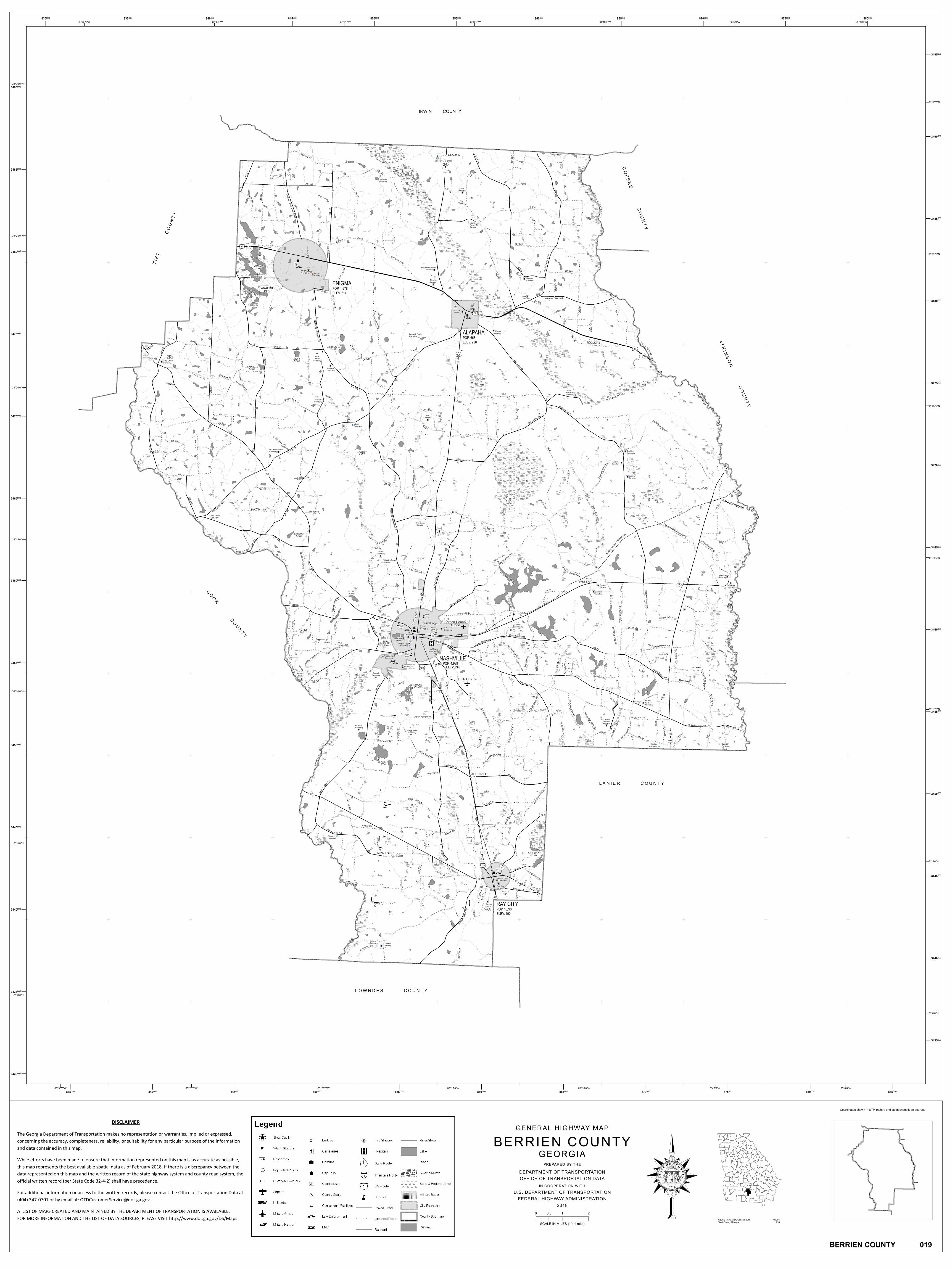
GENERAL HIGHWAY MAP BERRIEN COUNTY - … a r b er S h op R d Ray City R d F i r e t o w e r R d...
1
NEW LOIS ALLENVILLE COTTLE WEBER BANNOCKBURN GLORY GLADYS McMillian-Fletcher Cemetery Baker Cemetery Fletcher Cemetery Nashville Cemetery Baskins Cemetery Gaskins Cemetery Ramah Cemetery Pleasant Cemetery Guthrie Cemetery Avera Cemetery Hendley Cemetery White Pond Cemetery Bennett Cemetery Mount Pleasant Cemetery Poplar Springs Cemetery Pleasant Grove Cemetery Connell Cemetery Eastview Cemetery Sandy Bluff Cemetery Griffin Cemetery Gaskins Cemetery Gaskins Cemetery Riverside Cemetery Gaskins Cemetery Wheeler-Griner Cemetery Griner Cemetery Pine Grove Cemetery Flat Creek Cemetery McClellan-Rowe Cemetery Gaskins Cemetery Gaskins Cemetery Gaskins Cemetery Liberty Cemetery Ray Cemetery Vickers Cemetery Rowetown Cemetery Oaky Grove Cemetery McMillan Cemetery Pine Ridge Cemetery Kendrick-Paulk Cemetery Murray Cemetery Glory Cemetery Enigma Cemetery Enigma Cemetery Brogdon Cemetery Mount Paron Cemetery Luke Cemetery Jernigan Cemetery Purvis Cemetery Ray City Cemetery Beaver Dam Cemetery Peeples-Tygart Cemetery Westview Cemetery City Cemetery Saint James Cemetery City Cemetery Saint Luke Cemetery A L A P A H A R I V E R A L A P A H A R I V E R A L A P A H A R I V E R A L A P A H A R I V E R LAKE PFA LAKE LAKE LAKE A L A P A H A R I V E R W I T H L A C O O C H E E R I V E R W I T H L A C O O C H E E R I V E R N E W R I V E R N E W R I V E R N E W R I V E R F I V E M I L E C R E E K POND POND F I V E M I L E C R E E K F I V E M I L E C R E E K T E N M I L E C R E E K T E N M I L E C R E E K T E N M I L E C R E E K T E N M I L E C R E E K W I L L A C O O C H E E R I V E R W I L L A C O O C H E E R I V E R POND POND POND Airport C A T C R E E K C A T C R E E K C A T C R E E K H O G C R E E K H O G C R E E K W O L F B R A N C H W O L F B R A N C H D I S T R I C T B R A N C H G U M C R E E K C R O S S C R E E K R E E D Y C R E E K F L A T C R E E K N E W R I V E R G I N B R A N C H R E E D Y B R A N C H S I M O N B R A N C H R E E D Y B R A N C H F U T C H B R A N C H N o r f o l k S o u t h e r n C o r p o r a t i o n ALAPAHA POP. 668 ELEV. 290 ENIGMA POP. 1,278 ELEV. 314 NASHVILLE POP. 4,939 ELEV. 240 RAY CITY POP. 1,090 ELEV. 190 RAYS MILL BENNETT SLASH MORRIS DISTRICT LINDSEY LAKE GASKINS LAKE HAND MCMILLIAN LAKE SAPPS MCMILLIAN MARTIN LAKE RUSSEL, HORSESHOE A LAKE PATRICK, LAKE BOBBEN, LAKE PARADISE F r a n c i s P a u l k R d B a r b e r S h o p R d R a y C i t y R d F i r e t o w e r R d R a d i o S t a t i o n R d A b e G u t h r i e T o J o e G a s R o b e r t B r o g d o n R d C l e o S t C o t t l e R d O l d A d e l R d R a d i o S t a t i o n R d W e a v e r R d G r i n e r R d M a r k S u t t o n M c n a b b R d Park St A l b e r t G a s k i n s R d C e c i l R d E b e n e z e r R d A l l e n v i l l e R d Barber Rd K e e n D r Pineland Pl South One Ten Berrien County A b e G u t h r i e T o J o e G a s Berrien Academy Performance Learning Center Berrien Primary School Berrien Elementary School Berrien Middle School Berrien High School CR 9 0 CR 292 C R 23 2 C R 2 6 9 CR 2 33 County Road 235 CR 9 8 Park St Fox Run Rd W McP hearson A ve C R 1 6 1 M a rie Mcgill R d H ighl a n d C ir c l e C R 5 9 C R 3 52 A l be r tG as k ins R d CR 4 C R 4 7 H ill cre st Dri v e Williams Luke Rd C R 295 F u tc hR d C R 2 9 4 B ra dford Rd C R1 01 M c Ph ear son A ve De e r v i e w N ew R i v e r R o a d Garde n Ci ty Rd CR 3 5 3 Patten W atson Rd V int on St C R 8 0 A ver a M ill Rd C R 2 8 5 S h i l o h R d CR 1 36 Bill Dominy Rd C R 1 2 4 M u d d Creek Rd C R 2 5 9 R ice Ln C R 2 36 C R 1 4 1 CR 2 5 C R 23 8 CR 35 5 N o rth S t J B F e n d e r R d B a ke r R d CR 2 2 1 CR 2 27 C R 9 2 B a s k i n R d CR 2 72 C R 107 CR 109 CR 6 C R 1 5 CR 24 3 CR 71 B r o g d o n R d G l o r y R d C R9 3 Poplar Spring Rd N o r t h s o u t h R d C R 88 C R 1 9 4 C R 9 5 C a m p T y g a rt Rd C R 8 4 C R 3 0 7 C R 310 CR 26 8 L aun i e Sw a in Rd E d g ar Gri n e r Rd CR 106 H o w a r d B ra d fo rd R d Ra mb l in w ood R d C R 7 9 CR 1 18 C R 1 6 7 C R 1 3 7 CR 2 3 9 C R 240 C R 3 05 Glady sH wy O ld W illa c o o ch e e R d C R 2 8 C R 2 5 5 St Luke s Church Rd C R 1 5 4 C R 1 2 P o s s u m C re e k R d B a r k er Rd In dia n C a m p R d C R 2 00 C R 1 11 CR 2 26 Ske e t R a n g e R d Co n n e l l R d Wh i te Pond Rd C R 2 0 8 W y c l i f f R o b e rt s R d B r o o k s R d L ee Wilson R d CR 2 0 4 C R 2 0 9 C R 2 6 5 E Ri c h a r d s o n R d CR 3 54 C R 1 35 C R 11 C R 175 C o r nel i usR d C R3 4 3 CR 2 7 C R 94 M i l l t o w n R d R alph R o w an Rd C R 1 3 9 CR 301 R ad io St ation R d C R 1 9 1 C R 2 2 CR 1 25 G i dde ns R d O l d C o f f ee Rd C R 1 2 0 C R 5 3 T e t e r v ille R d L a n g F o r d R d C R 10 B ar b e rS h o p R d R i c hards on Rd C R 228 C R 3 1 2 C R2 51 C R 2 3 7 Old Len o x Hwy W. D. N as hR d N O l d C o ff e e R d W illie M c c l e ll anR d C R 23 0 P l ea s a n t D r R d C R 1 4 4 C R 5 C R 14 5 CR1 1 0 O l d M i l l to w nR oa d C R 2 53 W eave r D r E n i g m a T u rn e r Ch u r ch R d M u d d C r e ek R d W . K . G a s k i n s R d C R 8 A ll e n vill e R d C R 1 2 3 CR 116 C R 1 9 7 CR 105 Be r tha Ro b e rtso n Rd B r u nswic kS t Old Lenox Hwy CR 1 9 3 C R 1 0 8 L u k e R d C R 2 13 CR 86 Johnson S t C R 3 6 9 C R 36 5 C R 2 10 P a t r i c i a L n M a i n S t O l d L o i sRd C R 1 30 M al l a r d C i r C R 1 9 6 C R 2 8 7 O a k R i d g e D r C R 3 6 8 C R 2 6 5 M t P le as a n t C h u r c h Rd C R 3 0 6 C R 24 9 G r i f f i n - W h i t l e y R d N a s h v il le - E n i g m aR d G la d y sR d A m o s S i n g l e t a r y R d C R 3 3 8 P o p u la r S pring s R d C h e r o k e e Ros e R d C R 3 6 3 C R 2 2 0 C R 9 9 A ul ie G a s k i n s R d J H e n r y G as k i n s Rd CR 284 C R 3 2 5 R a y C i t y R d CR 112 C R 1 0 3 N a s h v i l l e- E n i g m a R d A ve r a C eme t ery R d J un e H e ndl ey Rd S ou t h Co ff ee Rd Firetower Rd Ga r ri s o n R d C R 3 6 2 C R 23 7 G l a d y s R d La k eland Wil lac ooc hee Rd J une H end l e yR d H e r b e r t W a t s o n R d 11 129 82 82 76 64 168 135 76 135 64 64 37 11 520 520 125 125 129 11 125 125 129 76 520 11 82 64 125 129 37 37 76 129 11 129 11 125 125 168 BERRIEN COUNTY 019 Coordinates shown in UTM meters and latitude/longitude degrees 1 77 6 M O D E R A TI O N J U S T I C E W I S D M O C O N S T I T U T I O N S T A T E O F G E O R G I A County Population, Census 2010 19,286 Total County Mileage 755 GENERAL HIGHWAY MAP BERRIEN COUNTY GEORGIA PREPARED BY THE DEPARTMENT OF TRANSPORTATION OFFICE OF TRANSPORTATION DATA IN COOPERATION WITH U.S. DEPARTMENT OF TRANSPORTATION FEDERAL HIGHWAY ADMINISTRATION 2018 0 1 2 0.5 SCALE IN MILES (1": 1 mile) 83°0'0"W 83°0'0"W 83°5'0"W 83°5'0"W 83°10'0"W 83°10'0"W 83°15'0"W 83°15'0"W 83°20'0"W 83°20'0"W 83°25'0"W 83°25'0"W 83°30'0"W 83°30'0"W 31°30'0"N 31°30'0"N 31°25'0"N 31°25'0"N 31°20'0"N 31°20'0"N 31°15'0"N 31°15'0"N 31°10'0"N 31°10'0"N 31°5'0"N 31°5'0"N 31°0'0"N 31°0'0"N 830 000 835 000 835 000 840 000 840 000 845 000 845 000 850 000 850 000 855 000 855 000 860 000 860 000 865 000 865 000 870 000 870 000 875 000 875 000 880 000 880 000 885 000 3430 000 3435 000 3435 000 3440 000 3440 000 3445 000 3445 000 3450 000 3450 000 3455 000 3455 000 3460 000 3460 000 3465 000 3465 000 3470 000 3470 000 3475 000 3475 000 3480 000 3480 000 3485 000 3485 000 3490 000 3490 000 3495 000 DISCLAIMER The Georgia Department of Transportation makes no representation or warranties, implied or expressed, concerning the accuracy, completeness, reliability, or suitability for any particular purpose of the information and data contained in this map. While efforts have been made to ensure that information represented on this map is as accurate as possible, this map represents the best available spatial data as of February 2018. If there is a discrepancy between the data represented on this map and the written record of the state highway system and county road system, the official written record (per State Code 32-4-2) shall have precedence. For additional information or access to the written records, please contact the Office of Transportation Data at (404) 347-0701 or by email at: [email protected]. A LIST OF MAPS CREATED AND MAINTAINED BY THE DEPARTMENT OF TRANSPORTATION IS AVAILABLE. FOR MORE INFORMATION AND THE LIST OF DATA SOURCES, PLEASE VISIT http://www.dot.ga.gov/DS/Maps LOWNDES COUNTY LANIER COUNTY COOK COUNTY TIFT COUNTY IRWIN COUNTY COFFEE COUNTY ATKINSON COUNTY
Transcript of GENERAL HIGHWAY MAP BERRIEN COUNTY - … a r b er S h op R d Ray City R d F i r e t o w e r R d...
NEW LOIS
ALLENVILLE
COTTLE
WEBER
BANNOCKBURN
GLORY
GLADYS
McMillian-FletcherCemetery
BakerCemetery
FletcherCemetery
NashvilleCemetery
BaskinsCemetery Gaskins
Cemetery
RamahCemetery
PleasantCemetery
GuthrieCemetery
AveraCemetery
HendleyCemetery
White PondCemetery
BennettCemetery
MountPleasant
Cemetery
PoplarSpringsCemetery
PleasantGrove
Cemetery
ConnellCemetery
EastviewCemetery
SandyBluffCemetery
GriffinCemetery
GaskinsCemetery
GaskinsCemetery
RiversideCemetery
GaskinsCemetery
Wheeler-GrinerCemetery
GrinerCemetery
Pine GroveCemetery
Flat CreekCemetery
McClellan-RoweCemetery
GaskinsCemetery
GaskinsCemetery
GaskinsCemetery
LibertyCemetery
RayCemetery
VickersCemetery
RowetownCemetery
Oaky GroveCemetery
McMillanCemetery
PineRidge
Cemetery
Kendrick-PaulkCemetery
MurrayCemetery
GloryCemetery
EnigmaCemetery
EnigmaCemetery
BrogdonCemetery
MountParonCemetery
Luke Cemetery
JerniganCemetery
PurvisCemetery
Ray City Cemetery
Beaver Dam Cemetery
Peeples-Tygart Cemetery
Westview Cemetery
City Cemetery
Saint James Cemetery
City Cemetery
Saint Luke Cemetery
AL
APA HA RIV ERALAPAH A RIVE R
ALAP
AHA RIVER
AL
APA HA RI
VER
LAKE
PFA
LAKELAKE
LAKE
ALA
PAHA RI
VER
WITH
LACOOC
HEE R
I VER
WITH
LACO
OCH
EE RIV
ER
NEW RIVER
N EW RIVER
NEW RIVER
FIVEMILE CREEK
POND
POND
FIVEMILE CREEK
FIVE
MILE
CREE
K
TENMIL
E CR
EEK
TENMILE CREEK
TENMILE CREEK
TE NMILE CREEK
WILLAC
OOCHEE RIVER
W ILLACOOCHEE RI V ER
POND
POND
POND
Airport
CAT CREEK
CAT C
REEK
C AT C
REEK
H OG C REEK
HOG C
REEK
WOLF BRA NCH
WOLF
BRAN
CHDI
STRICT BRANCH
GUM C
REEK
CROS
S CRE
EK
REED
Y CRE
EK
FLAT CREEK
NEW
RIVE
R
GIN
BRAN
CH
RE E D Y BRANCH
SIMON BRAN CH
REEDY BRANC HFUTCH BRANC H
Norfolk S
outher
n Corp
oration
ALAPAHAPOP. 668ELEV. 290
ENIGMAPOP. 1,278ELEV. 314
NASHVILLEPOP. 4,939
ELEV. 240
RAY CITYPOP. 1,090ELEV. 190
RAYS MILL
BENNETT
SLASH
MORRIS
DISTRICT
LINDSEYLAKE
GASKINSLAKE
HAND
MCMILLIANLAKE
SAPPS
MCMILLIAN
MARTINLAKE
RUSSEL,
HORSESHOEA LAKE
PATRICK,LAKE
BOBBEN,LAKE
PARADISE
Francis Paulk Rd
Barber Shop Rd
Ray City Rd
Firet o
w er R
d
Radio Station Rd
Abe Guthrie To Joe Gas
Robert Brogdon RdCleo St
Cottle Rd
Old Adel Rd
Radio Station Rd
Weaver Rd
Grine
r Rd
Mark
Sutto
n
Mcna
bb Rd
Park
St
Al bert Gaskins Rd
Cecil
RdEbeneze r Rd
Allenville Rd
Barber Rd
Keen
Dr
Pinela
nd Pl
South One Ten
Berrien County
Abe Guthrie To Joe Gas
Berrien AcademyPerformanceLearning Center
BerrienPrimarySchool
BerrienElementarySchool
BerrienMiddleSchool
BerrienHighSchool
CR90
CR 292
CR 232
CR26 9
CR 233
County Road 235
CR 98
Park St
Fox R
un Rd
W McPhearson Ave
CR161
Marie Mcgill Rd
Highla
ndCi
rcle
CR59
CR 352
Albert
Gaski
nsRd
CR 4
CR4 7
Hillcrest Drive
Williams Luke Rd
CR 295
FutchRd
CR 294
Bradford Rd
CR 101
McPhearson Ave
Deer v
i e w
N ew
Rive
r Roa
d
Garden City Rd
CR 353
Patten Watson Rd
Vinton St
CR80
Avera Mill Rd
CR28
5
Shilo
h Rd
CR 136
Bill Dominy Rd
CR 124
Mudd Creek Rd
CR25
9
Rice Ln
CR 236
CR141
CR 25
CR 238
CR35
5
North
St
J B Fend e r Rd
Baker R d
CR 221 CR 227
CR9 2
Bask
inRd
CR 272
CR10
7
CR 109
CR 6
CR15
CR 243
CR 71
BrogdonR
d
G lor y
Rd
CR93
Popla
r Spri
ng R
d
N orth
south
Rd
CR88
CR 1 94
CR95
C
amp Tygart Rd
CR84
CR 307
C R 310
CR 268
Launie Swa in Rd
Edgar Griner Rd
CR 106
Howard Bradford Rd
Ramblinwood Rd
CR79
CR 118
CR 167
CR 137
CR 2 39
CR 240
CR 305
Gladys Hwy
Old Willacoochee RdCR
28
CR 255
St Lukes Church Rd
CR 154
CR 12
Possu
mCr
eek R
d
B a rker Rd
Indian Camp Rd
CR 200
C R 111
CR 226
Skee
t Ran
geRd
Conne l l Rd
White Pond Rd
CR20
8
Wyclif
f Rob
ertsR
d
Bro o
ks
Rd
Lee Wilson Rd
CR 204
CR 209
CR 265 E
Richa
r dson
Rd
CR 354
CR135
CR 11
CR 175
C ornelius Rd
CR34
3
CR 27
CR94
Mill town Rd
Ralph Rowan Rd
CR 139
CR 301
Radio Station Rd
CR19
1
CR 22
CR 125
Giddens Rd
Old Coffee Rd
CR120
CR 53
Teterville Rd
Lan gFord
Rd
CR 10
Barbe r Shop Rd
Richardson Rd
CR 228
CR31
2
CR 251
CR23
7
Old LenoxHwy
W.D. Nash Rd
NOld
Coffe
e Rd
Willie Mcclellan Rd
CR 230
Pleasant Dr Rd
C R 144
CR5
CR 145
CR110
Old Milltown Road
CR 253
Weaver Dr
Enigma Turner Church Rd
MuddCre
ekRd W. K. Gaskins Rd
CR 8
Allenville Rd
CR12
3
CR 11
6
CR19 7
CR 105
BerthaRobertson Rd
Brunswick StOld Leno
x Hwy
CR 193
CR 108
Luke
Rd
CR 213
CR 86
Johnson St
CR36
9
CR 365
CR 210
Patrici
a Ln
Main S t
OldLo is Rd
CR
130
Mallard Cir
CR1 9
6
CR28
7
Oak R
id ge D
r
C R36
8
C R26
5
MtPle
asant
Churc
hRd
CR 306
C R 249
Griffi
n-Whit
leyRd
Nashville - Enigma Rd
Gladys Rd
A mos
Single
taryR
d
C R33
8
Popula
r Spring
s Rd
Cheroke
e RoseRd
CR363
CR22 0
CR99
Aulie
Gaskin s
Rd
J Hen ry Gaskins Rd
CR 284
CR 325
Ray CityRd
CR 112
CR103
Nashvi lle - Enigma Rd
Avera Cemetery Rd
June Hendley Rd
South
Coffee Rd
Firetower Rd
Garr ison Rd
CR362
CR 237
GladysRd
Lakeland Willacoochee Rd
June
Hend
leyRd
Herbert Wat sonR d
11
129
82
82
76
64168
135
76
135
64
64
37
11
520
520125
125
129
11
125
125
129
76
520
11
82
64
125
129
3737
76
129
11
129
11
125
125
168
BERRIEN COUNTY 019
Coordinates shown in UTM meters and latitude/longitude degrees
1 77 6
MODER
ATION
J U S T I CEW I S
D MO
CONSTITUTION
STA T
E O F G E O RGIA
County Population, Census 2010 19,286Total County Mileage 755
GENERAL HIGHWAY MAP
BERRIEN COUNTYGEORGIA
PREPARED BY THEDEPARTMENT OF TRANSPORTATIONOFFICE OF TRANSPORTATION DATA
IN COOPERATION WITHU.S. DEPARTMENT OF TRANSPORTATION
FEDERAL HIGHWAY ADMINISTRATION2018
0 1 20.5
SCALE IN MILES (1": 1 mile)
83°0'0"W
83°0'0"W
83°5'0"W
83°5'0"W
83°10'0"W
83°10'0"W
83°15'0"W
83°15'0"W
83°20'0"W
83°20'0"W
83°25'0"W
83°25'0"W
83°30'0"W
83°30'0"W
31°30'0"N
31°30'0"N
31°25'0"N
31°25'0"N
31°20'0"N
31°20'0"N
31°15'0"N
31°15'0"N
31°10'0"N
31°10'0"N
31°5'0"N
31°5'0"N
31°0'0"N
31°0'0"N
830000 835000
835000
840000
840000
845000
845000
850000
850000
855000
855000
860000
860000
865000
865000
870000
870000
875000
875000
880000
880000 885000
3430000
3435000
3435000
3440000
3440000
3445000
3445000
3450000
3450000
3455000
3455000
3460000
3460000
3465000
3465000
3470000
3470000
3475000
3475000
3480000
3480000
3485000
3485000
3490000
3490000
3495000
DISCLAIMER The Georgia Department of Transportation makes no representation or warranties, implied or expressed, concerning the accuracy, completeness, reliability, or suitability for any particular purpose of the information and data contained in this map. While efforts have been made to ensure that information represented on this map is as accurate as possible, this map represents the best available spatial data as of February 2018. If there is a discrepancy between the data represented on this map and the written record of the state highway system and county road system, the official written record (per State Code 32-4-2) shall have precedence. For additional information or access to the written records, please contact the Office of Transportation Data at (404) 347-0701 or by email at: [email protected]. A LIST OF MAPS CREATED AND MAINTAINED BY THE DEPARTMENT OF TRANSPORTATION IS AVAILABLE. FOR MORE INFORMATION AND THE LIST OF DATA SOURCES, PLEASE VISIT http://www.dot.ga.gov/DS/Maps
L O W N D E S C O U N T Y
L A N I E R C O U N T Y
C OO K C O U N T Y
T IF T
C O
U NT Y
IRWIN COUNTY
COF F E E C O U N T Y
AT K I N S O N C O U N T Y


![^^D , >d, WZKs/ Z >/^d/E' r &/E E / > ^^/^d E D ] o ' } µ Z …...^^D , >d, WZKs/ Z >/^d/E' r &/E E / > ^^/^d E](https://static.fdocuments.in/doc/165x107/5eae9b3147042534de5dc81c/d-d-wzks-z-de-r-e-e-d-e-d-o-z-d.jpg)