GEF-IWCAM AND IABIN INDICATORS MECHANISM WORKSHOP 10 - 12 March 2008 Ocho Rios, Jamaica TNC’s...
24
GEF-IWCAM AND IABIN INDICATORS MECHANISM WORKSHOP 10 - 12 March 2008 Ocho Rios, Jamaica TNC’s Marine Protected Area Wor in the Caribbean
-
Upload
christina-parrish -
Category
Documents
-
view
216 -
download
1
Transcript of GEF-IWCAM AND IABIN INDICATORS MECHANISM WORKSHOP 10 - 12 March 2008 Ocho Rios, Jamaica TNC’s...

GEF-IWCAM AND IABIN INDICATORS MECHANISM WORKSHOP10 - 12 March 2008
Ocho Rios, Jamaica
TNC’s Marine Protected Area Workin the Caribbean
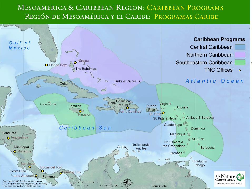
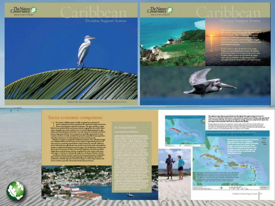
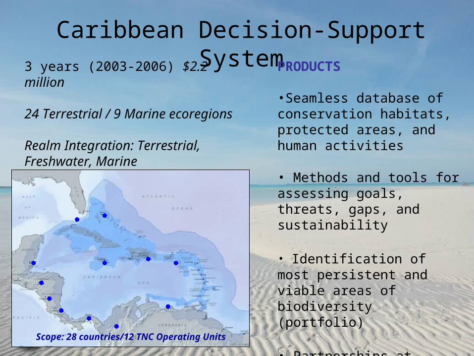
Caribbean Decision-Support System3 years (2003-2006) $2.2 million
24 Terrestrial / 9 Marine ecoregions
Realm Integration: Terrestrial, Freshwater, Marine
Scope: 28 countries/12 TNC Operating Units
PRODUCTS
•Seamless database of conservation habitats, protected areas, and human activities
• Methods and tools for assessing goals, threats, gaps, and sustainability
• Identification of most persistent and viable areas of biodiversity (portfolio)
• Partnerships at regional and local levels

BASIN-WIDE ECOREGIONAL
NATIONAL SITE-LOCAL
Multi-Scale Analysis

Caribbean Decision-Support SystemBathymetry
ClimateFreshwater featuresGeologyImageryInfrastructureLand coverMarine FeaturesModelsPoliticalProtected AreasSocioeconomicSoilsTargets (Terrestrial, Freshwater, Marine)Terrestrial FeaturesTopographyTopo Maps
Geodatabases(with FGDC metadata)
• Caribbean Region• Lesser Antilles
• Puerto Rico• Dominican Republic• Bahamas• Jamaica• St. Vincent & the Grenadines• Grenada• Haiti

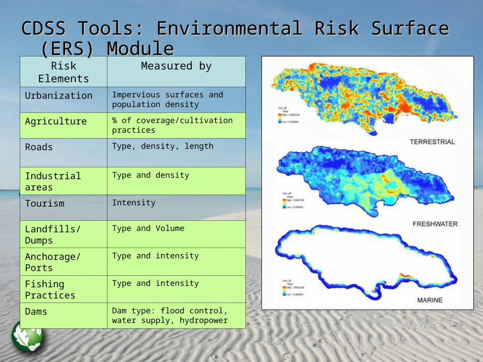
Risk Elements Measured by
Urbanization Impervious surfaces and population density
Agriculture % of coverage/cultivation practices
Roads Type, density, length
Industrial areas Type and density
Tourism Intensity
Landfills/Dumps Type and Volume
Anchorage/Ports
Type and intensity
Fishing Practices
Type and intensity
Dams Dam type: flood control, water supply, hydropower
CDSS Tools: Environmental Risk Surface (ERS) CDSS Tools: Environmental Risk Surface (ERS) ModuleModule


Caribbean Marine Action Sites
• Bahamas
• Jamaica
• Lesser Antilles: BVI, USVI, Grenada and SVG
• Dominican Republic

TNC Marine Work: Bahamas
TNC Northern Caribbean Programme has been working with partners to accomplish the following:
• Expand the current west side of Andros Island marine protected area (MPA).
• Establish a network of no-take marine reserves in Abaco, South Eleuthera, Exuma, Bimini and the Berry Islands.

West side of Andros MPA
Activities completed include:
• Conservation Area Assessment,
• Rapid Ecological Assessment (REA) and,
• Stakeholder’s AssessmentNB: Outlined in green are the proposed areas to be included in the west side protected area system
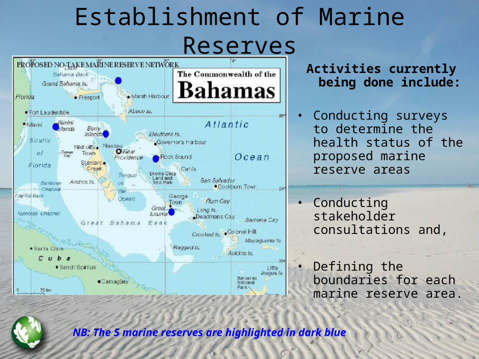
Establishment of Marine ReservesActivities currently being
done include:
• Conducting surveys to determine the health status of the proposed marine reserve areas
• Conducting stakeholder consultations and,
• Defining the boundaries for each marine reserve area.
NB: The 5 marine reserves are highlighted in dark blue

TNC Marine Work: Jamaica• Marine ERA and national gap analysis
identifying major gaps for marine biodiversity conservation
• Demonstration site– Pedro Bank, Jamaica’s largest fishing ground and important offshore area for marine biodiversity
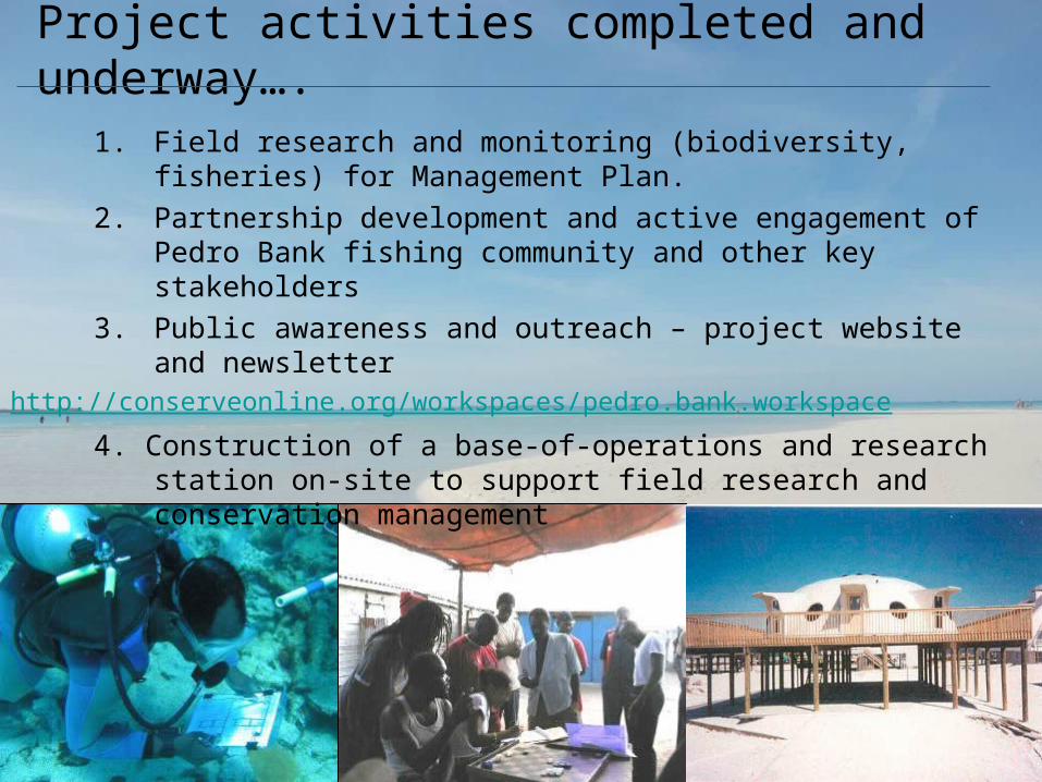
Project activities completed and underway….
1. Field research and monitoring (biodiversity, fisheries) for Management Plan.
2. Partnership development and active engagement of Pedro Bank fishing community and other key stakeholders
3. Public awareness and outreach – project website and newsletterhttp://conserveonline.org/workspaces/pedro.bank.workspace
4. Construction of a base-of-operations and research station on-site to support field research and conservation management

Designing for the Future
Ambitious Goals – The BVI Approach to Networks
The British Virgin Islands

30% Goal
To protect 30% of 6 important nearshore biological habitats in no take areas across the
BVI.
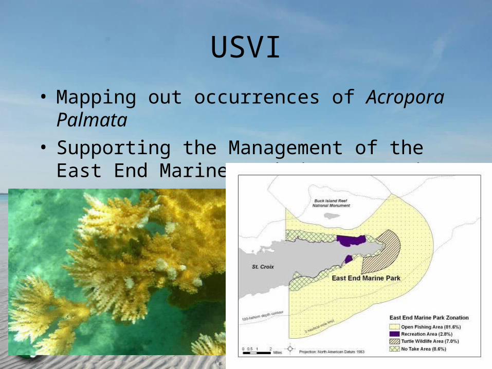
USVI
• Mapping out occurrences of Acropora Palmata
• Supporting the Management of the East End Marine Park in St. Croix


TNC Marine Work: Dominican Republic

BiodiversityStatus
ThreatsStatus
MngmtStatus
Mitigate ThreatsImplement Mngmt Plan
Improve BiodiversityMitigate Threats
Improve BiodiversityImplement Mngmt Plan
Improve Biodiversity
Mitigate ThreatsImplement Mngmt Plan
Assessing Effective Conservation in MPAs

Future Work and Collaboration Points
• On-going verification of coarse-filter habitat maps and collection of fine-filter species data
• Improve threat models based on scientific review (fishing models, tourism footprint, climate change, etc)
• Expansion of regional delivery and stewardship of CDSS data and tools (database needs updating, fill gaps, revisions)
• Build staff and partner capacity through training and dissemination of knowledge
• Questions? Email [email protected]