
Processes of Allochthonous Terrane Evolution, Mindoro Island

GEF-6 PIF Template-December2014
1
PART I: PROJECT INFORMATION
Project Title: Integrated Approach in the Management of Major Biodiversity Corridors in the Philippines (IA-Biological Corridors)
Country(ies): Philippines GEF Project ID: 9584 GEF Agency(ies): UNDP GEF Agency Project ID: 5886 Other Executing Partner(s):
Biodiversity Management Bureau and Forestry Management Bureau of the Department of Environment and Natural Resources (DENR)
Submission Date: Re-submission:
July 25, 2016 Oct 25, 2016 Dec 8, 2016 Feb 02 2017
GEF Focal Area(s): Multi-focal area Project Duration (Months) 72 Integrated Approach Pilot
IAP-Cities IAP-Commodities IAP-Food Security
Corporate Program: SGP
Name of parent program:
N/A Agency Fee ($) 1,103,422
A. INDICATIVE FOCAL AREA STRATEGY FRAMEWORK AND OTHER PROGRAM STRATEGIES
Objectives/Programs (Focal Areas, Integrated Approach Pilot, Corporate Programs)
Trust Fund
(in $) GEF Project
Financing Co-financing
BD-1 Program 2 GEFTF 5,000,370 16,900,000 BD-4 Program 9 GEFTF 5,113,370 15,450,000 LD-3 Program 4 GEFTF 859,950 4,627,180 SFM-1 GEFTF 643,275 15,546,473 SFM-2 GEFTF 643,276 14,976,667
Total Project Cost 12,260,241 67,500,320
B. INDICATIVE PROJECT DESCRIPTION SUMMARY Project Objective: Operationalise integrated management of biological corridors to generate multiple benefits including effective conservation of globally significant biodiversity, reduced deforestation and degradation and enhanced livelihoods
Project Components
Financ-ing Type Project Outcomes Project Outputs Trust
Fund
(in $) GEF Project
Financing Co-financing
1: Effective coordination and governance framework for integrated ecosystem management in the Philippines BD corridors system
TA • An effective policy and coordination framework in place for planning, managing, compliance monitoring and enforcement for integrated ecosystem (sustainable land and forest) management tested and tried in two pilot biological corridors covering 2.4 million hectares, and with a catalytic effect on the rest of the 17 BD corridors covering 11 million hectares through a replication strategy with secured funding (indicated by: reduced threats to biodiversity,
1.1 IEM framework and plans for two corridors developed and approved including, (i) at least 3 regional development, investment plans1; (ii) 9 provincial physical framework plans2; and 107 municipal LGU comprehensive land use plans (CLUPs)3 within the biological corridor. These plans incorporate integrated management of natural resources and will, inter alia: (a) identify high biodiversity areas to receive higher protection status under the National Integrated Protected Areas System (NIPAS) Act;
GEF TF
3,568,989
BD:3,000,000 LD: 250,000
SFM: 318,989
16,774,484
1 Region IV-B for Mindoro BD Corridor; and Region 11 and CARAGA for Eastern Mindanao BD Corridor 2 Oriental Mindoro and Occidental Mindoro (Mindoro BD Corridor) and the provinces of Dinagat, Surigao del Norte, Surigao del Sur, Agusan Del Norte and Agusan del Sur in CARAGA; and Davao Oriental and Compostela Valley in Region XI (Eastern Mindanao BD Corridor) 3 88 municipalities in Eastern Mindanao BD Corridor and 19 in Mindoro BD Corridor
GEF-6 PROJECT IDENTIFICATION FORM (PIF) PROJECT TYPE: FULL-SIZED PROJECT TYPE OF TRUST FUND: GEF TRUST FUND

GEF-6 PIF Template-December2014
2
improved ecological connectivity, and sustainable management of forest and land including in agricultural landscape (leading to no net loss of forest cover) in two pilot BD corridors; agreed replication strategy adopted and funding commitments secured) .
• Improved institutional and staff capacities for cross-sectoral planning, management, compliance monitoring and enforcement and decision making for integrated sustainable land and forest management (indicated by at least 20% increase in Capacity Scorecard (baseline to be established during PPG))
(b) identify gaps and measures to enhance management effectiveness of PAs; (c) prescribe appropriate land uses and forest management measures in production landscapes thus avoiding, reducing and mitigating the impacts to BD4 1.2 Policies and programs of key sectors such as forestry, agriculture and mining (e.g. consolidating issue of tenure, management of forest within and outside PA system, integrating BD into mining – permitting and rehabilitatation; integrating biodiversity into forest management plans, recommendations for local agriculture plans) in BD corridors assessed and made consistent with IEM goals and objectives 1.3 Dedicated cross sectoral landscape/ biological corridor coordination platform established, clearly defining roles and responsibilities of key agencies and sectors (such as BMB, FMB, MGB in DENR, BSWM and BFAR in DA, DoT, DTI, NEDA, DILG and HLURB) for BD corridor management nationwide 1.4 A compliance monitoring and enforcement strategy developed and adopted comprising elements such as patrolling and mobility, assisting compliance through education and information, arrest and apprehension of law-breakers, and prosecution. 1.5 Training programs established and institutionalized for national government agencies and field offices, LGUs, community and IP organizations, and private sector on IEM, SFM/SLM on planning, management, monitoring and enforcement in BD Corridors. 1.6 Replication strategy developed and approved and backed by a financial sustainability strategy to
4 Spatial and land use planning can influence land use allocations and management regimes. So can influencing policies of forestry and agriculture agencies.
GEF-6 PIF Template-December2014
3
enable the lessons and successful approaches arising from the two pilot BD corridors to be upscaled and applied to the BD Corridor system in the Philippines 1.7 Sustainable mechanisms established for lessons sharing and dissemination for the communication of results and outcomes to enable replication to other BD corridors
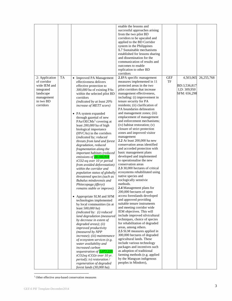
2: Application of corridor wide IEM and integrated landscape management in two BD corridors
TA • Improved PA Management effectiveness delivers effective protection to 300,000 ha of existing PAs within the selected pilot BD corridors (indicated by at least 20% increase of METT score)
• PA system expanded through gazettal of new PAs/OECMs5 covering at least 200,000 ha of high biological importance (HVCAs) in the corridors (indicated by; reduced threats from land and forest degradation, reduced fragmentation along the important habitats (reduced emissions of 10,166,918 tCO2-eq over 10 yr period from avoided deforestation) within the corridor and population status of globally threatened species (such as Bubalus mindorensis and Phitecopaga jifferyi) remains stable or improve).
• Appropriate SLM and SFM technologies implemented by local communities (in at least 500,000 ha) (indicated by: (i) reduced land degradation (measured by decrease in extent of degraded areas); (ii) improved productivity (measured by NPP increase); (iii) maintenance of ecosystem services (e.g. water availability and increased carbon sequestration of 1,072,225 tCO2eq tCO2e over 10 yr. period); iv) restoration / regeneration of degraded forest lands (30,000 ha).
2.1PA specific management measures implemented in 11 protected areas in the two pilot corridors that increase management effectiveness, including: (i) improvement in tenure security for PA residents; (ii) clarification of PA boundaries delineation and management zones; (iii) emplacement of management and enforcement mechanisms; (iv) habitat restoration; (v) closure of strict protection zones and improved visitor management 2.2 At least 200,000 ha new conservation areas identified and accorded protection with basic management plans developed and implemented to operationalise the new conservation areas 2.3 30,000 hectares of critical ecosystems rehabilitated using native species and eoclogically senstivie methods. 2.4 Management plans for 200,000 hectares of open access forestlands developed and approved providing suitable tenure instruments and meeting corridor wide IEM objectives. This will include improved silvicultural techniques, choice of species for rehabilitation of degraded areas, among others. 2.5 SLM measures applied in 300,000 hectares of degraded agricultural lands. These include various technology packages and incentives such as adoption of traditional farming methods (e.g. applied by the Mangyan indigenous peoples in Mindoro),
GEF TF
4,503,065
BD:3,536,817 LD: 309,950
SFM: 656,298
26,255,768
5 Other effective area-based conservation measures
GEF-6 PIF Template-December2014
4
terracing methods, and support to organic farming.
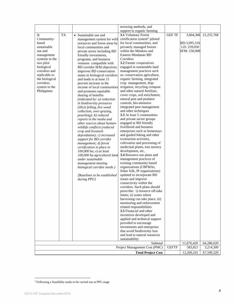
3: Community-based sustainable use and management systems in the two pilot biological corridors and replicable to the biological corridors system in the Philippines
TA • Sustainable use and management system for wild resources and forest areas by local communities and private sector including BD friendly investments, programs, and business ventures compatible with BD corridor IEM objectives improves BD conservation status in biological corridors and leads to at least 15 percent increase in the income of local communities and promotes equitable sharing of benefits (indicated by: a) reduction in biodiversity pressures (illicit felling, fire wood collection, over-grazing, poaching); b) reduced reports in the media and other sources about human-wildlife conflicts (reduced crop and livestock depredation); c) increased support for BD corridor management; d) forest certification in place in 100,000 ha; e) at least 100,000 ha agricultural land under sustainable management meeting biological corridor needs )
[Baselines to be established during PPG]
3.1 Voluntary Forest certification system6 piloted for local communities, and privately managed forests within the Mindoro and Eastern Mindanao BD Corridors 3.2 Farmer cooperatives engaged in sustainable land management practices such as: conservation agriculture, organic farming, integrated crop management, drip-irrigation, recycling compost and other natural fertilizer, cover crops, soil enrichment, natural pest and predator controls, bio-intensive integrated pest management and other techniques 3.3 At least 5 communities and private sector groups engaged in BD friendly livelihood and business enterprises such as homestays and guided hiking and other ecotourism activities, cultivation and processing of medicinal plants, tree nursery development, etc, 3.4 Resource use plans and management practices of existing community based organizations (CBFMAs, fisher folk, IP organizations) updated to incorporate BD issues and improve connectivity within the corridors. Such plans should prescribe: i) resource off-take limits; ii) zones where harvesting can take place; iii) monitoring and enforcement related responsibilities 3.5 Financial and other incentives developed and applied and technical support provided to encourage investments and enterprises that avoid biodiversity loss and lead to natural resources sustainability
GEF TF 3,604,366
BD:3,095,316 LD: 259,050
SFM: 250,000
21,255,768
Subtotal 11,676,420 64,286,020 Project Management Cost (PMC) GEFTF 583,821 3,214,300
Total Project Cost 12,260,241 67,500,320
6 Following a feasibility study to be carried out at PPG stage

GEF-6 PIF Template-December2014
5
C. INDICATIVE SOURCES OF CO-FINANCING FOR THE PROJECT BY NAME AND TYPE, IF AVAILABLE
Sources of Co-financing
Name of Co-financier Type of Co-financing
Amount ($)
Recipient Government Department of Environment and Natural Resources (DENR)
Grants 45,625,000 In-kind 2,797,380
Recipient Government Department of Agriculture (DA) Grants 7,500,000 In-kind 518,940
GEF Agency UNDP Grants 1,000,000 Bilateral Agency BMU-GIZ Grants 6,000,000 International and local NGOs
Conservation International-Philippines, Mindoro Island Biodiversity Conservation Foundation, Inc. (MIBCFI), RARE
Grants 877,500 In-kind 877,500
Private Sector Holders of industrial forest management agreements, mining companies, etc.
Grants 750,000 In-Kind 750,000
Local Government LGUs, IP and local communities In-kind 804,000 Total Co-financing 67,500,320
D. INDICATIVE TRUST FUND RESOURCES REQUESTED BY AGENCY, COUNTRY AND THE PROGRAMMING OF FUNDS a)
GEF Agency Trust Fund
Country
Focal Area Programming of Funds
(in $) GEF Project
Financing (a) Agency Fee
(b)b) Total
(c)=a+b UNDP GEFTF Philippines Biodiversity 10,113,740 910,237 11,023,977 UNDP GEFTF Philippines Land Degradation 859,950 77,395 937,345 UNDP GEFTF Philippines SFM 1,286,551 115,790 1,402,341
Total GEF Resources 12,260,241 1,103,422 13,363,663 E. PROJECT PREPARATION GRANT (PPG) IS PROJECT PREPARATION GRANT REQUESTED? YES X PPG AMOUNT REQUESTED BY AGENCY, TRUST FUND, COUNTRY AND THE PROGRAMMING OF FUNDS
Project Preparation Grant amount requested: $273,000 PPG Agency Fee: $24,570
GEF Agency
Trust Fund
Country/ Regional/Global Focal Area Programming
of Funds
(in $)
PPG Agency Fee
Total
UNDP GEFTF Philippines Biodiversity 169,830 15,285 185,115 UNDP GEFTF Philippines Land Degradation 13,575 1,222 14,797 UNDP GEFTF Philippines SFM 89,595 8,063 97,658 Total PPG Amount 273,000 24,570 297,570
F. PROJECT’S TARGET CONTRIBUTIONS TO GLOBAL ENVIRONMENTAL BENEFITS
Corporate Results Replenishment Targets Project Targets 1. Maintain globally significant biodiversity and the
ecosystem goods and services that it provides to society
Improved management of landscapes and seascapes covering 300 million hectares
2.4 million hectares
2. Sustainable land management in production systems (agriculture, rangelands, and forest landscapes)
120 million hectares under sustainable land management
400,0007 hectares
3. 4. Support to transformational shifts towards a low-emission and resilient development path
750 million tons of CO2e mitigated (include both direct and indirect)
Over a 10-year period, 11,241,143 tCO2eq from avoided emissions and sequestration (see Annex 3)
7 300,000 hectares under Output 2.5, plus 100,000 hectares based on indicator (e) under Outcome 3.

GEF-6 PIF Template-December2014
6
PART II: PROJECT JUSTIFICATION.
1. Project Description
Global Environmental Problems, Root Causes and Barriers that Need to be Addressed A country level integrated analysis of drivers of environmental degradation in preparation for the GEF 6 National Portfolio Formulation Document (NPFD) identified the major threats to Philippines globally significant biodiversity resources:8 Threats to Biodiversity Loss and degradation of natural habitat stem from deforestation due to conversion of forest areas to agriculture, poor agricultural practices, incoherent agricultural and natural resources policies, informal settlements, (illegal) logging, irresponsible mining, forest fire, and infrastructure development (roads, residential and commercial establishment). In the coastal and marine ecosystems, this is due to conversion of mangroves to fishponds and other coastal developments, damages to coral reefs and seagrasses, pollution from industrial sources, agricultural run off, and siltation. Weak management of protected areas and other natural habitats are also contributory factors to loss of biologically important habitats of globally threatened species and unique ecosystems. The Philippines Biodiversity Strategy and Action Plan (PBSAP) reported that between 1934 and 1990, the country lost 10.9 million ha of forest cover or an average annual loss of 194,000 ha. Of this area, 10.37 million ha or 95 percent were converted to other uses while 0.52 million ha were damaged by logging. Over the last 100 years, the deforestation rates have fluctuated with an average of about 150,000 ha per year.9 This rate has slowed down in the last decade, with massive efforts at regreening. However, forest cover loss still continued, with reforestation efforts aimed primarily at expanding areas with forest cover, and not the original ecosystem that was disturbed. These have brought permanent transformations of original habitats thereby contributing to irreversible loss of valuable species. Between 2003 and 2010, the area of closed forests diminished by 626,840 hectares while the area of open forests increased by 564,566 hectares. Overall, total forest cover loss between the two time periods was estimated at 328,683 hectares10. Expansion of settlements follows after clearing and conversion of degraded forests into open permanent settlements and agriculture. Underlying drivers are poverty in the rural areas, landlessness, and weak tenure security which discourage sustainable upland farming practices. Once agriculture has set in, intensive use of fertilizers and unsustainable land management practices further erode the soil of essential nutrients thus resulting in diminishing harvests, which leads to further expansion of agriculture in forest areas to meet socio economic needs. Deteriorating productivity of upland farms has forced many indigenous communities to shorten their fallow periods in between forest clearings thus limiting the time for open forest areas to recover naturally. Despite the high number of population in the forestlands, only less than a million people have long term tenure arrangements with government through the community based forest management agreements (CBFMAs), covering 1.615 million hectares. IP communities on the other hand, claim an estimated 7.7 million hectares of land (mainly within classified forestlands); but only 4.39 million hectares have been issued certificates of ancestral domain titles (CADTs), as of 2014.11 Illcit logging activities still persist despite the ban on logging in old growth forests. Based on 2010 satellite imagery, the total forest cover of the Philippines is estimated at 6.840 million ha, of which open forests account for 4.595 million hectares, or about 67% of the total forest cover in the Philippines.12 Based on the analysis in the PBSAP, “mining claims and rights overlap with defined areas for PAs, ancestral lands including those planned for conservation areas that threaten ecological sustainability. The Philippines is a significant producer of gold, copper, nickel and chromite and is also abundant in non-metallic and industrial minerals such as marble, limestone, clay, feldspar and aggregates. Since the Supreme Court upheld key provisions of the Mining Code in 2004,
8 DENR, September 2015. GEF National Program Formulation Document. 9 Biodiversity Management Bureau – DENR. Draft Philippine Biodiversity Strategy and Action Plan, September, 2015. 10 Ibid. 11 NCIP Report on Status of Delineation and Titling of Ancestral Domain and Lands; presented during the Second National ICCA Conference, October 2014, Crowne Plaza, Quezon City. 12 Forest Management Bureau, DENR. 2013 Philippine Forestry Statistics.

GEF-6 PIF Template-December2014
7
there has been a heavy influx of mining activity and investment. As of 2013, about 339 Mineral Production Sharing Agreements within 602,012 ha had been issued (DENR-MGB 2013). Since most of the country’s priority conservation areas sit on top of huge mineral reserves, many significant biodiversity areas are in conflict with prescribed land uses and management objectives”. Although mining is not allowed in existing NIPAS declared PAs, there is high likelihood that the remaining biodiversity rich KBAs which are not yet established as PAs will be allocated to mining in the absence of a national or corridor level land use allocation framework. Weak enforcement and management capacities, and limited funding, have resulted in PAs where boundaries have been encroached upon by settlers and converted into agriculture and settlements. In some cases, fragmentation of habitats have occurred, thereby failing to provide the essential protection for key highly vulnerable species within protected areas. In many cases, the lack of synergy between the DENR’s National Greening Program and protected area management have resulted in mismatch in habitat restoration efforts, thereby further contributing to irreversible transformation of original habitats to other ecosystem types. In the coastal areas, threats to coastal and marine biodiversity include industrial development, sand and gravel quarrying, development of coastal infrastructure, destructive fishing behavior, illegal fishing, and siltation due to mining, deforestation, and land degradation from the agricultural areas. Unsustainable practices which lead to over exploitation of natural resources include: overfishing and destructive fishing practices ( E.g. dulong fishery, live fish trading, use of fine mesh nets, illegal, unregulated, unreported fishing [IUUF]); inappropriate aquaculture practices (such as overstocking of fishpens); and illegal harvesting and collection of non timber forest products (NTFPs), wildlife & other resources. In terrestrial ecosystems, over exploitation comes in the form of massive fuelwood gathering for both domestic and commercial use. While this activity can be considered small scale, the aggregate impact on deforestation and degradation is huge when multiplied by the number of households involved and the frequency of occurrence. Unsustainable production and consumption of medicinal and ornamental plants and wild animals for trade and domestic use is also widely practiced. These contribute to habitat degradation and in certain cases, reduction in species populations. The most sought after and highly valued ornamental plants include the jade vine (Strongylodon macrobotrys), giant staghorn fern (Platycerium grande), waling waling (Euanthe sanderiana) and many tree fern species. Because of high demand for pet trade, a significant number of animals, such as the Palawan peacock pheasant (Polyplectron emphanum), Philippine cockatoo (Cacatua haematuropygia), talking mynah (Gracula religiosa), blue napped parrot (Tanygnathus lucionensis), and Asian small-clawed otter (Amblonyx cinereus), are also overharvested. The exploitation of some by-products of wildlife species also endangers their survival, such as the nests produced by the edible-nest swiftlets (Collocalia fuciphaga). In extrem as easy targets of illegal harvesting and wildlife trade. The harvesting of black corals, the massive smuggling of pangolins, and the recent discovery of thousands of forest turtles smuggled in Palawan are just a few examples of how the lucrative wildlife trade works. Pollution leads to collapse of ecosystems, compromising their ability to provide ecological services. One of the major causes is agricultural run off, mining, navigation, illegal reclamation of lakeshores and shoreland areas and encroachment on easements along rivers and waterways, sometimes endangering human lives. This is most particularly acute in freshwater ecosystems, where the over application of fertilizers and pesticides, and improper land management practices result in siltation, and deterioration of habitats of aquatic species. In the terrestrial areas, soil contamination due to excessive use of fertilizers and pesticides have rendered other agricultural areas unproductive. Invasive alien species (IAS) pose one of the greatest threats to aquatic biodiversity. IAS can hasten the extinction of threatened species and reduce the diversity of indigenous and endemic species through predation, competition, parasitism, diseases, hybridization, and species displacement caused by environmental and habitat change. Some of the well documented IAS that have had damaging effects on wetland biodiversity include: janitor fish (Pterygoplichthys spp.), knifefish, (Chitala sp.), giant catfish and black bass; toads and frogs, including the marine toad (Bufo marinus), the American bullfrog (Rana catesbeiana) and leopard frog (Rana tigrina); and aquatic plants like the water hyacinth and water fern. Another IAS that poses destruction to the natural habitat is Buyo-buyo (Piper aduncum), a highly aggressive

GEF-6 PIF Template-December2014
8
shrub that invades agricultural areas and natural forests13. A total of 70 invasive alien species under 40 families were classified in a profiling done in 16 protected areas in the Philippines. Introduction of exotic species in critical ecosystems, use of inappropriate species for restoration and heavy reliance on “fast growing”, “high yielding” agricultural and terrestrial crops and aquatic species had the unintended effects of invasion of ecosystems. The uncontrolled spread of IAS is due in part to lack of awareness of IAS and their impacts on the ecosystem to which they are introduced, poor understanding of their ecology, life cycle growth; lack of assessment of the environmental impacts of newly introduced species; and lack of regulation. Contributing to these is the disjunct between policies and programs that promote agricultural productivity and biodiversity conservation objectives, thereby failing to consider the holistic view and recognize the long term net effects of IAS introduction on farm income, natural resilience of agriculture, and quality and quantity of food production. It is clear that the above threats can trace their root causes to rural poverty in the Philippines, owing to landlessness amidst a rapidly growing population. These are exacerbated by weak enforcement and lack of capacities to sustainably manage natural resources and proper allocation of land among competing uses. The de facto “open access” condition of forestlands, critical coastal areas and watersheds have encouraged settlements of forest lands and conversion to agriculture, unsustainable harvests and improper resource management practices. The absence of secure property and resource use rights by most local communities and indigenous peoples occupying large portions of forest lands have not provided the necessary incentives to properly internalize the costs and benefits of natural resources management, thereby creating a cyclical pattern of degradation, biodiversity loss and poverty. Pilot Biological Corridors: The interplay of these factors can best be demonstrated in the case of the proposed focus areas of the Project, chosen mainly because of their critical importance as centers of endemism and biodiversity hotspot, economic significance, and yet lacking in support relative to the other corridors. Other criteria include poverty incidence, vulnerability, presence of extractive industries and/or extent of land use conversion and infrastructure development, and inclusion in the priority list of land degradation hotspot. The selection was made following a listing of all provinces meeting these criteria, and comparing these with the location of the country’s BD corridors. A series of technical discussions were also held during the PIF preparation, which confirmed the two priority candidate corridors to be included in the Project. During project preparation, more in depth assessment will be undertaken, including manageability considering the vast expanse of areas covered; as well as the funding levels available under the Project. The two corridors selected below represent distinct biodiversity characteristics and forest formations, located in different biogeographic zones. Each site offer different sets of challenges for integrated ecosystem management, due to the nature and degree of threats they are exposed to. These are discussed in more detail below. A total of 16 KBAs are located in the two BD Corridors, wih a total area of 1.026 Million hectares (Annex 1). In all, the two corridors host 185,046 hectares of old growth forests or about 10% of all terrestrial corridors in the Philippines; and 657,214 hectares of open forests or 18% of the total in all terrestrial corridors. Annex 1 presents the application of KBA criteria to the target corridors.
Table 2: Characteristics of target pilot corridors
Central Mindoro Biodiversity Corridor Eastern Mindanao Biodiversity Corridor Area
498,109 hectares 2 Million Hectares
Population
1.238 million 2.042 million
Forest Formations present
Tropical lowland evergreen rainforest, plus other forest types (still to be classified)
All 12 forest formations present (tropical lowland evergreen rainforest, tropical lower montane rainforest, tropical upper montane rainforest, tropical sub alpine forest, forests over limestone, forest over ultramafic rocks, beach forest, mangrove forest, peat swamp forest, freshwater swamp forest, tropical semi evergreen rainforest, and tropical moist decicuous forest14
Forest Cover 156,443 hectares (7,269 hectares old growth;
696,667 hectares
13 Biodiversity Management Bureau – DENR. Draft Philippine Biodiversity Strategy and Action Plan, September, 2015.
14 Fernando, et.al. 2008. Forest Formations of the Philippines. ASEAN-Korea Environmental Cooperation, Seoul, Korea.

GEF-6 PIF Template-December2014
9
149,125 hectares open forests; 10 hectares mangrove forests)
(177,777 hectares old growth; 508,089 hectares old growth forests; and 10,800 hectares mangrove forests)
Globally significant biodiversity Most significant threats
Tamaraw, Philippine warty pig, Philippine deer, Illin hairy-tailed cloud rat, Mindoro shrew, golden-crowned fruit bat Conversion of forest lands to agriculture and other uses; illegal hunting of wildlife; excessive fuelwood gathering
Philippine Eagle, Philippine Cockatoo, Philippine Crocodiles, Golden-crowned flying fox Rapid population growth and increasing settlements in the uplands; illegal logging (the region is classified as a hotspot); forest conversion to agriculture; land use conversion and crop shifting; wildlife hunting and collection for food and trade; and irresponsible mining.
Cropland area (annual and perennial)
58,435 hectares 681,273 hectares
Central Mindoro Biodiversity Corridor Mindoro is the seventh-largest island in the Philippines, with an area of 10.571 sq. km; and a population of 1.238 million. It is located between the large islands of Luzon and the Sunda-affiliated Palawan, and it shares faunal attributes of both islands. However, Mindoro was isolated from Luzon and Palawan throughout the Pleistocene and retains its own unique character, including the iconic tamaraw (Bubalus mindorensis). Because of these, the island of Mindoro is considered an ecoregion – together with the Semirara islands15. The Philippines Biodiversity Conservation Priority Project (PBCPP) identified seven priority areas within what is called the Central Mindoro Biodiversity Corridor, encompassing a total area of 252,260 hectares. These include: Puerto Galera (KBA); Mt. Halcon (KBA); Sablayan (KBA); Iglit and Baco Mountains (KBA, PA, ICCA); Malpalon (KBA); Bogbog, Bongabong and Mt. Hitding (KBA); and Mt. Hinunduang (KBA). The island is connected to the world famous Apo Reef National Park and the Verde Island Passage, considered the world’s center of the center of marine shorefish diversity (Figures 1 and 2). Vegetation types on Mindoro include lowland evergreen rain forest to approximately 400 m or higher, open forest from about 650 to 1,000 m, and mossy forest above. Only small patches remain of the lowland evergreen dipterocarp rain forest that would have dominated the lowland eastern portions of the island. Semideciduous forest would have predominated on the western half of the island. Limited stands of Mindoro pine (Pinus merkusii) are found at elevations of 600 m or less in the northern portions of the island. Because of its geological history, the island has evolved as a unique center of biodiversity, with very high endemism. Recent assessments have documented 94 species of hepterofauna; 10 restricted range bird species, of which five are concurrently globally threatened and endemic; at least 70 endemic species of flora unique to Mindoro island; at least 17 endemic species and taxa out of a total 50 species/sub species of butterflies; at least 10 endemic species of mammals, of which six are threatened while four await formal description; more than 300 species of birds, one quarter of which are endemic to the Philippines. In addition to these, the Mindoro Biodiversity Conservation Foundation, Inc. (MBCFI) reported that in 2011 and 2013, there were 18 newly recorded faunal species in Mindoro16. Among the other important mammals found in Mindoro include the Philippine warty pig (Sus philippensis), which is considered by IUCN as rare and declining. Also found are endemic subspecies of the Philippine deer (Cervus mariannus barandanus) found only in Mindoro; the critically endangered Illin hairy-tailed cloud rat (Crateromys Paulus), the endangered Mindoro shrew (Crocidura mindorus) and the more Philippine widespread but endangered golden-crowned fruit bat (Acerodon jubatus).17 The island is composed of a mosaic of landscapes and ecosystems – grasslands, disturbed lowland forests, agricultural areas, high elevation pine forests, freshwater lake, extensive river systems and watersheds – all supporting the socio economic and cultural development of the island. Unfortunately, Mindoro is one of the most severely deforested islands in the country (Heaney and Mittermeir 1997, as cited in WWF). Only the most rugged portions of the island's central spine has been spared from commercial logging, and the forest is still under pressure. In 2010, only 30% of the island’s forest lands have forest cover; of which only 4% is closed forest. Some 180,000 hectares are open, highly fragmented; while the rest of the forest lands have been converted to agriculture and other uses (Figure 3). The rapid decline in population of Mindoro hornbill (Penelopides mindorensis) for example, has been attributed to
15 Philippines: Island of Mindoro | Ecoregions | WWF (http://www.worldwildlife.org/ecoregions/im0130)
16 www.mibcfi.org.ph 17 Philippines: Island of Mindoro | Ecoregions | WWF (http://www.worldwildlife.org/ecoregions/im0130)

GEF-6 PIF Template-December2014
10
forest loss, fragmentation, and degradation of lowland forests; compounded by hunting pressure18. Over the years, the indigenous peoples of Mangyan, Buhid and Tau Buhid, among others; have seen shortened fallow periods in between slash and burn farming due to pressures on land from migrants occupying the fringes of their domains. Fuelwood gathering is also on the rise, the key factor behind forest degradation.
Eastern Mindanao Biodiversity Corridor The Eastern Mindanao Biodiversity Corridor (EMBC) is a long stretch of lowland and mid - to high elevation forests along the east coast of Mindanao. Dinagat Island marks its northernmost boundary while Mt. Hamiguitan Range is at its southern tip. Region 11 and Region 13 (Caraga), in seven provinces, four cities and 88 municipalities. The corridor hosts a large proportion of the country's unique plants and animals. At least 370 species of forest vertebrates (i.e. birds, mammals, amphibians and reptiles) are currently known. Out of these, nearly half (181 species) are found only in the country. The corridor's plant diversity is also very high, with more than 2,300 species known there (31% of the total species known for the Philippines). Among vertebrates, the EMBC has at least 196 species of birds and 91 (or 46 %) of them are endemic, which is more than half (51 %) of the country's total endemic birds. For mammals, at least 66 species (27 non-flying mammals and 39 bats) are known, and almost half of these (31 species) are endemic. The figure includes two new species of rodents, a new species of fruit bat, and a probable new species of insect-eating bat. The corridor also houses at least 31 amphibians (frogs and caecilians), 16 of which are endemic. There are also at least 77 species of reptiles (snakes, turtles, and lizards) and more than half of these (43 species) are endemic.19 The eastern portion of Mindanao, where the corridor is located, holds one of the largest remaining blocks of dipterocarp forest in the country. In fact, this region is called the timber corridor, because of the favorable climatic condition which enables the growing of forest tree plantations highly profitable. Both regions have a very active timber industry, which host 33 industrial forest management agreements (IFMAs) covering almost 400,000 hectares. These regions supply most of the country’s wood requirements, with active sawmills having combined annual log requirement comprising almost
23. Birlife International - (Mindoro Hornbill (Penelopides mindorensis) -...http://www.birdlife.org/datazone/speciesfactsheet.php?id=958) 19 Ibanez, Jayson and Dennis Salvador (eds). Philippine Eagle Foundation, Conservation International-Philippines, Department of Environment and Natural Resources. 2008. Eastern Mindanao Biodiversity Corridor Conservation Framework. Davao City, Philippines (http://www.researchgate.net/publication/280721421, accessed 01 October 2015.

GEF-6 PIF Template-December2014
11
60% of the country’s total. There are 182 community based forest management agreements (CBFMAs) – long term tenure instruments given to organized forest communities, covering 306,366 hectares, involving approximately 150,000 households. Private land owners are also engaged in timber production, as well as growing of long term and other high value crops. There is an active corporate sector involved in large plantations such as oil palm, rubber, and other high value crops.
Based on the EMBC Conservation Framework which was prepared in 2008, the major threats to the corridor’s biodiversity include: rapid population growth in the uplands; illegal logging (the region is classified as a hotspot); forest conversion to agriculture; land use conversion and crop shifting; wildlife hunting and collection for food and trade; and irresponsible mining. Population growth rate in the region is 2.5% per year, slightly higher than the national average of 2.3%, based on the EMBC Framework document. Based on the assessment made in the EMBC framework, the entire corridor supports at least 2,041,980 people, most of them are in 2,055 rural barangays near or within the KBAs. Each of the KBAs is completely surrounded by upland farming communities. For many of the over 1.6 million indigenous peoples living close to or inside the forests, “slash-and-burn” is the common farming method. As an illegal logging hotspot, attention is focused on the corridor in law enforcement, which resulted in continued drop in confiscated forest products. In the CARAGA region alone, confiscations dropped from 2.102 million board feet in 2011 to 1.575 board feet in 2014. Given the extensive network of illegal loggers and their allies, there is undoubtedly more illegally cut logs that were unreported or unknown to authorities. Putting a stop to illegal logging is difficult. The government has recently focused attention to this issue, by beefing up its support to the anti-illegal logging campaign. Major land degradation issues include forest conversion to agriculture, land use conversion and crop shifting. For example, the number of farms in the Caraga Region increased by 10.9 % in a span of 10 years, from 189,600 ha in 1991 to 210,200 ha in 2002. These farms grow either vegetables for the local market, or export crops like Cavendish bananas and palm oil. As forests, marshes and wetlands get converted to farms, more and more wildlife are losing breeding places, foraging grounds, and shelter. Coastal zones or mangrove forests have been converted into fish ponds and reclamation areas for agriculture, aquaculture, and urban expansion. Mangrove destruction is also taking place in the Dinagat and Siargao KBAs. Specifically, mangrove forests give way to beach resorts, piers, and docks to accommodate tourism and
GEF-6 PIF Template-December2014
12
trade. Wildlife hunting is an issue in the corridor. The EMBC Framework documented that several large, long-lived, late maturing threatened species are still being shot or trapped, deliberately or accidentally. For example, there are still cases of Philippine eagles gunned down or trapped in local snares. Large birds such as the endemic Philippine hawk eagles and Hornbills are hunted as well either for food or sheer fun. Wildlife is also extracted from the EMBC forest for the pet trade. Large- to medium-sized birds such as hornbills, eagles, forest pigeons, doves, and parrots are collected and sold to pet shops illegally. Philippine deer and wild pigs are also hunted for bush meat using both traditional snares and rifles. Bonsai plants, rare orchids, and other wild ornamental plants are collected illegally and sold to unsuspecting customers in trade fairs or plant stalls. In addition, non-native species of plants and animals are slowly finding their way into natural areas and out-competing their native counterparts. For example, janitor fishes (Pterygoplichthys disjunctivus) have invaded the Agusan Marsh, and their numbers are ballooning. Decline in native fishes were noted and people are catching less of edible fishes that are important protein source in their diet. The fast-growing, exotic tree species Gmelina has taken over gaps in the forest outgrowing native pioneer trees that normally takes more time to grow and mature. Wildlife suffers as their habitats are replaced by exotic plants that they are not equipped to use. While mining has been more fully regulated in the recent years, there have been cases of violations and complaints made by local governments and indigenous peoples on the performance of mining companies. It is common for mining companies granted exploration permits to extend their activities into actual operations. With 59 approved mineral production sharing agreements (MPSAs) in Region 13 alone, the task of monitoring remains a continuing challenge. Region 13 hosts the most number and covers almost half the area under MPSAs in Mindanao. In Dinagat islands for example, which is a KBA, there are 19 MPSAs, mostly located in identified mining reservation. Both Surigao del Sur and Surigao del Norte have twelve approved MPSAs each. This is consistent with the findings that the eastern seaboard is particularly rich in mineral resources. Baseline project, the long term solution and barriers Baseline projects: There have been a number of initiatives to upscale the level of BD planning, management and monitoring; as well as mainstream BD considerations into the broader production landscape. A proposal has been put forward to DENR to adopt the integrated ecosystems management approach – that is, to consider the wide array of tenure instruments and public land managers (de facto and formally recognized) and ensure every inch of land within the major watershed or landscape is allocated to a manager – whether it be an individual, family, organization, community, or government institution such as LGU or agency. It also provides for a process that brings sectors and stakeholders together to “jointly plan, design, and manage their landscapes and institutional resources for improved agricultural production, biodiversity and ecosystem conservation, and sustainable livelihoods.” (Adopted from Winterbottom et al. 2013, DENR/ENRMP 2013; Senge, et. al., 2007).20 This proposal is still under review, and could form the basis for an expanded definition of the IEM approach in BD corridors, or other well defined landscapes, such as river basins, island ecosystems, or watersheds. The BMB is pursuing the preparation of the PA System Master Plan that seeks to rationalize the Philippines PA system, ensure greater cohesion and ecological representativeness, and strengthen its links with the surrounding landscape. One key feature of the plan under formulation is to focus on at least three corridors for greater impact. A number of donors are also active in the sector. The USAID, through its Project – Biodversity and Watersheds Improved for Stronger Economy and Ecosystem Resilience (BWISER), is operating in Lake Naujan in Mindoro, to improve the management effectiveness of this PA. Two other projects – the ADB supported Integrated Natural Resources Environment Project (INREMP), as well as the JICA assisted Forestland Management Project, are implemented using the ridge to reef and ecosystem based approach, covering seven river basins. The BMU-GIZ is designing a program covering two major river basins that will adopt the integrated ecosystems management approach. The baseline project consists mainly of DENR’s programs as described below. Expansion and diversification of PA system. The Philippine legislature is supporting moves to strengthen legislation of formally gazette Pas in the country, to strengthen the legal protection of protected areas covered with Presidential
20 As cited by Guiang, E.S. 2015. Integrated Approach in Managing Major Biodiversity Corridors in the Philippines: Some Ideas for Discussion. Presentation made at the Technical Discussion on Draft PIF of BD Corridor Project. November 11, 2015. Ninoy Aquino Visitors Center, Quezon City.
GEF-6 PIF Template-December2014
13
Proclamations. Through the National PA System Master Planning exercise that is currently ongoing, the government is trying to rationalize the expansion of the existing PA system to improve coherence and complementarity, representativeness, and connection with the broader landscape. Following the experience and lessons from a recently concluded UNDP-GEF NewCAPP project, the PA System master Planning will include recognition of other area based conservation measures (OECMs) such as indigenous community conserved areas (ICCAs) and local conservation areas (LCAs) managed by local government units (LGUs). Adoption of Area based management approach. The new government, which took office in July 2016; is currently designing a program that would strengthen integration of resource management programs in critical landscapes. Called the area based management approach, the intention is to achieve coherence in implementation of ENR programs through integrated resource assessments, planning, budgeting and implementation among DENR programs, and between DENR and other agencies. This Project can provide the compelling case to adopt the BD Corridor as one of the ways by which such approach can be operationalized to provide multiple local, national, and global benefits. Moratorium on cutting and harvesting naturally growing trees in the natural and residual forests. This is made possible by Executive Order (EO) 23 dated February 2011. Through this EO, the DENR was able to reduce illegal logging hotspot areas from 197 municipalities in 2010 to 13, or a reduction by 93%. To strengthen the program, there is a National Forest Protection Program wherein a total of US $ 106.8 Million were invested over the period 2011-2016 to ptotect the remaining natural forests. This allows the natural forest to regenerate thus contributing to biodiversity enhanement in the process. To reinforce implementation of this policy, the DENR, through the new sets of officials have called upon the law enforcement agencies to intensify their drive in combatting illegal logging. Likewise, there are moves to strengthen the Multisectoral Forest Protection Committees, improve capacities of tenure holders in forest lands and enhance cooperation with local government units to address timber poaching. National Greening Program. This involves the planting of 1.5 million hectares with 1.5 billion trees from 2011-2016 with a budget of US $ 706.36 Million. As of 2015, a total of 1.35 million hectares of open, denuded, and degraded forestlands, includin protected areas and mangroves, have been planted under the program. Through Executive Order 193, the program has been expanded to 2016-2028 to support implementation of the Updated Philippine Forestry Master Plan. People Oriented Forestry Program. Per Executive Order 318, the Community Based Forest Management Program was institutionalized which supports the provision of tenure security, and long term agreements based on resource use plans to organized forest communities. Plans are in train, with support from the ASEAN Forest Cooperation Agreement, to update the community plans using remote sensing technology. A draft Memorandum Circular has also been prepared to provide for a well defined policy, to update the engagement of private sector investments in community forest management. Corporate Forestry Program. This involves engagement of corporations for forestlands development through the Industrial Forest Management Agreements (IFMA) and Socialized Industrial Forest Management Agreements (SIFMA). Most of the legal sources of plantation species that sustain the raw material requirements of the wood industry come from these areas. There are moves to use the forest criteria and indicators system to review the program. Management of Critical Watersheds. There are 143 such watersheds that support irrigation and power facilities, many of which were identified as initial components of the National Integrated Protected Areas System (NIPAS). Management plans, including vulnerability assessment, have been prepared for 106 watersheds. Forest Land Use Planning (FLUP). Because traditional comprehensive land use planning (CLUPs) do not provide details about forest land allocation, the DENR is developing capacities of local governments in FLUPs to set priorities for protecction and production. This way, planning for forest lands will be integral to the LGUs’ planning processes. The recent guidebooks issued by the Housing and Land Use Regulatory Board (HLURB) has captured the FLUP processes, and will become standard for all LGUs. A total of 442 municipalities have completed their FLUPs, with plans to finish the remaining 982 municipalities by 2018. In addition two other projects – the ADB supported Integrated Natural Resources Environment Project (INREMP), as well as the JICA assisted Forestland Management Project covers seven river basins. Mining audits. More recently, the new government has taken bold steps to undertake mining audits to determine
GEF-6 PIF Template-December2014
14
compliance to environmental laws. To date, the DENR has issued suspension orders to five mining companies operating in Mindanao. This campaign is foreseen to intensify in the near future as mining audits continue; with stated priority given to biodiversity conservation and environmental protection over unsustainable mining operations. While there are several initiatives across different sectors that address biodiversity conservation and resource management, in particular forest and land management, these are not currently adequately coordinated to reduce pressures on biological diversity nor are they sufficiently targeting effective management of a network of PAs and biodiversity corridors. Long term solution: The long-term solution the project will seek is establishment and operationalisation of a comprehensive planning and management framework that ensure that existing protected areas and high conservation value forests are managed to support viable populations of globally threatened species and linked through a network that allows movement of wildlife, pollination and reproduction, and other processes that help recovery and improve natural resiliency to external shocks. Such a framework should inter alia: (i) take into account the interconnectivity of various ecosystems in the landscapes, and their impacts on biodiversity, ecological processes and functions; (b) ensure that relevant agencies and actors have adequate capacities to implement the integrated approach and tackle the threats to biodiversity and effective natural resources management; (c) advocate science based approaches and use of indigenous knowedge systems and practices to restore degraded areas while also promoting sustainable agricultural and forest management practices are promoted. Thus the long-term solution will establish the enabling policy and institutional framework while building the know-how for integrated ecosystem management across the landscape that secures Protected Areas and critical vital corridors. However there are currently three key interrelated barriers that prevent the achievement of the long term solution. Barrier 1: Policies, regulations, and approaches that breed disjointed goverance, planning, management, and financing of activities within the landscape/corridor: Currently relevant agencies in PA management and those that have remit over lands identified as biodiversity corridors are guided by their respective mandates and deliver on stated outcomes. The interplay of various policies and programs in the same landscape oftentimes result in unintended results due to the absence of a commonly agreed planning and management framework for all sectors to follow. For example, the Department of Agriculture (DA) promotes agricultural production and intensification without taking into consideration biodiversity or ecosystem issues even when farms are located in forested lands or within or adjacent to KBAs or PAs. Similarly the National Greening Program (NGP) - a massive effort to reforest 1.5 million hectares of land including protected areas, mangroves, ancestral domains, degraded and barren forest lands; has used mainly exotic, fast growing and plantation trees including high value fruit tree species. Furthermore, between FMB and BMB, there is a need to reconcile definitions and approach to “forest protection”. While FMB refers protection forests as those located at altitiudes 1,000 meters above sea level and old growth forests; the BMB, protection forests is defined based on their conservation value. Other policies and programs in the landscape, particularly those which support production forestry and community based forest management, require review to determine their compliance with sustainable forest management principles. All this is compounded by the absence of long term spatial planning framework at the regional level that considers sustainable development objectives – thus, creating an environment where there is competition for “locking” of important lands for specific purposes without regard for their potential long term impacts on biodiversity, ecosystem services, agricultural productivity, and community livelihoods. Related to the above barrier is the limited capacity to integrate BD considerations in landscape level planning and management and to enforce what legal measures have been adopted – four out of five identified threats arise from the lack of (or weak and ineffective) compliance monitoring and enforcement of plans, policies, strategies, laws and other measures. Barrier 2: Fragmented implementation of key programs that fails to effectively address threats to BD corridor connectivity and natural resources decline: The absence of an integrated planning framework within the landscape that takes into account connectivity within the corridor is manifested by programs being implemented with no focus on addressing threats to habitat loss, maintaining ecosystem flows, fragmentation, conversion of high conservation value forests to agriculture. Thus, existing corridors remain a mosaic of disjointed land management units with incompatible objectives. The corridors consist of a number of KBAs and PAs, including other areas of high conservation value. However, management plans for these areas are prepared independently, without regard to connectivity of habitats. In the Cordillera corridor for example, which is a center of mammalian endemism in Luzon, there are 14 PAs and six KBAs but no integrated approach exist to link these together to ensure connectivity. Additionally critical ecosystems such as marshlands and coral reefs. Further, there is an obvious governance gap pertaining to forestlands. Often referred to as open access areas, these are areas in between forests managed by DENR and local governments and those under community based forest management or other regimes, and are left without effective management or governance. Similarly, agricultural areas such as plantations, private farms, and areas previously forests but converted to agriculture

GEF-6 PIF Template-December2014
15
continue to be exposed to various degrees and types of degradation in the absence of access to technologies and best practices in sustainable land management. Moreover, indigenous agricultural practices, such as those employed by the Mangyan indigenous communities in their swidden farms, have helped in sustaining agricultural practices for generations, but have not been widely shared and documented. Barrier 3: Weak community level mechanisms to incentivize conservation of biodiversity, promote sustainable natural resource utilization, and monitor compliance: The BD corridors consist of areas that are managed under various tenure regimes including communally and privately owned lands. A system of incentives is essential to encourage private or land tenure holders in critical spaces within the landscape to contribute to providing stepping stones, or expand the pathways of target species while ensuring improvement in ecosystem services and resilience. Within private lands and other tenured areas, transforming land management practices through such mechanisms as conservation agreements need to be tested while certification systems can promote improved practices. In areas managed for agriculture, the promotion of organic farming and agroecosystem technologies are important. While a number of these mechanisms exist, they have not been applied at the landscape level in a way that will result in changes in at a corridor or network level. In addition, review and approval of management plans of tenure holders (CBFMAs, IFMAs) should recognize the role of these management units in habitat connectivity, as stepping stones and/or in linking the network of protected areas and conservation areas within the corridor.
Proposed alternative scenario In order to remove aforementioned barriers, the objective of the project is to Operationalise integrated management of biological corridors to generate multiple benefits including effective conservation of globally significant biodiversity, reduced deforestation and degradation and enhanced livelihoods. The vision is to maximize the opportunity presented by the presencce of identified corridors to ensure a holistic approach to their management and generate multiple benefits. This shall be achieved through the three inter-related components as described below.
Component 1 – Effective coordination and governance framework for integrated ecosystem management in the Philippines BD corridors system : This component will set up an enabling environment for the effective coordination and governance of integrated ecosystem management in the Biodiversity Corridors System in the Philippines. As such, it provides the foundation and context for the replication of the results which will be achieved under Components 2 and 3 through the implementation of various activities at a pilot scale. It will develop the IEM framework and plans initially for the two corridors, and these will include regional development and investment plans, provincial physical framework plans and municipal LGU comprehensive land use plans (CLUPs) within the biological corridors. Regional development investment plans are prepared by the National Economic Development Authority (NEDA) to document the pathways and drivers of inclusive sustainable development in an administrative region. The Project will reinforce this process by integrating the BD corridor framework in its spatial development strategy; assessment of key sectors that will promote economic growth, without comproising the globally significant BD resources therein. These plans will, inter alia: (a) identify high biodiversity areas to receive higher protection status under the National Integrated Protected Areas System (NIPAS) Act; (b) identify gaps and measures to enhance management effectiveness of PAs; (c) prescribe appropriate land uses and forest management measures in production landscapes thus avoiding, reducing and mitigating the impacts to BD. In parallel, policies and programs of key sectors such as forestry, agriculture and mining in BD corridors will be assessed and made consistent with IEM goals and objectives. A cross sectoral landscape/ biological corridor coordination platform will be established, clearly defining roles and responsibilities of key agencies and sectors for BD corridor management nationwide. A compliance monitoring and enforcement strategy will be developed and adopted comprising various elements such as patrolling and mobility, assisting compliance through education and information, arrest and apprehension of law-breakers, and prosecution. The Project will help strengthen the existing forest protection program of FMB, and will develop BD Corridor specific strategies based on comprehensive assessment of sources, magnitude of the problem, destination of products, and tracking of supply chain. The project may support review of the EIA system and permitting procedures to ensure that environmental, social safeguards and other industry standards including the mitigation hierarchy are incorporated. On logging, the project will promote the SFM certification system to ensure adherence to SFM standards, and meet the demands of the international market. On mining, the Project will assist in application of Extractive Industries Transparency Initiative (EITI) standards. The Project will also endeavor to institutionalize the conduct of regular social and technical audit of both logging and mining and this could fall under Output 1.4 on enforcement and monitoring. The project will also work on strengthening monitoring mechanisms for both logging and mining (eg. Multisectoral Forest Protection Committees, Multipartitie Monitoring Committee). Training programs will be established and institutionalized for national government agencies and field offices, LGUs, community and IP organizations, and the private sector on IEM, SFM/SLM on planning, management, monitoring and

GEF-6 PIF Template-December2014
16
enforcement in BD Corridors. A Replication Strategy will be developed and approved and backed by a financial sustainability strategy to enable the lessons and successful approaches arising from the two pilot BD corridors (after appropriate evaluation) to be upscaled and applied to the BD Corridor system in the Philippines.
Component 2 – Application of corridor wide IEM and integrated landscape management in two BD corridors: This component aims to reduce anthropogenic pressures and threats over 500,000 ha of important habitats while also ensuring effective management of existing and new Protected Areas. The project will ensure the implementation of PA specific measures in 11 protected areas covering an estimated 300,000 hectares in the two corrodors. This will enhance management effectiveness of these PAs (as measured by the METT tool) and ensure sustianability and connectivity of the corridor. Following a network design, the relative importance and role of each of 11 PAs in the ecological functioning of the corridor will be defined, which will guide the configuration of the existing PAs. Management measures that will be implemented include: delineation of PA boundaries and management zones; improvement of facilities of the Protected Area Superintendent (PASU) and offices; development of trails and facilities for ecotourism and patrols; training and equipping PA Wardens and Rangers; census of PA occupants and issuance of tenure instruments called the protected area community based management agreements (PACBRMA) and development and financing of resource management plans; restoration activities; closure of strict protection zones; and visitor regulations. In addition the project will conduct detailed assessments of existing KBAs, high value conservation forests and other areas of high conservation value. Based on this it will secure at least 200,000 hectares of new conservation areas that will be incorporated in the conservation area network within the two BD corridors. An ecosystem restoration/rehabilitation strategy will be developed which will determine the sites, area estimates and approaches essential to achieve conservation and development objectives within the corridor. This will ensure that at least 30,000 hectares21 of critical ecosystems are rehabilitated (coral reefs, seagrass beds, mangroves, marshlands). The project will engage with private land owners, tenure holders, local governments, other agencies, indigenous peoples, and other stakeholders to build consensus on the overall restoration and rehabilitation strategy for the corridor and specific areas identified. In the corridor, the project will support strategies to bring under effective forms of management regimes all such forms of forest areas. To do so, the project will employ various tenure arrangements – certifcates of stewarship contracts, community based forest management agreements, and also where appropriate collaborative forest management agreements including co-management with LGUs and partnership arrangements. These may include community based monitoring, compliance with environmental laws, adherence to standards, internal community procedures for ensuring members’ adherence and performance of obligations for sustainable natural resources management, and sharing in the benefits from stewardship. In this way the project will bring at least 200,00022 hectares of open access forestlands placed under effective management through suitable tenurial instruments and management plans prepared to meet corridor wide IEM objectives. A rehabilitation plan for degraded agricultural lands shall be developed such that existing technologies for bringing back soil productivity such as soil testing kits, rotation cropping, and other farming methodologies, and other indigenous practices (e.g. of the indigenous peoples of Mangyan group in Mindoro BD corridor) will be promoted. Technology promotion will be supported by appropriate extension services. Thus the project will bring at least 300,00023 hectares of degraded agricultural lands rehabilitated through application of technology packages and incentives.
Component 3 – Community based sustainable use and management systems in the two pilot biological corridors and replicable to the biological corridors system in the Philippines: The project will achieve a Voluntary forest certification system for around 100,00024 hectares of community, indigenous peoples and privately managed forests within Mindoro and Eastern Mindanao BD Corridors. Discussions with community groups are already underway. The voluntary forest certification system will be evolved based on locally appropriate and acceptable management measures in consultation with key community groups. In addition the project will influence practices of farmer groups and corporate agriculture operators to shift towards sustainable forms of land management. The project will support measures such as conservation agriculture, organic farming, integrated crop management, drip-irrigation, recycling compost and other natural fertilizer, cover crops, soil enrichment, natural pest and predator controls, bio-intensive integrated pest management, organic certification systems, linkages with markets and promotion of sloping agricultural technologies and in this way will ensure at least 100,00025 hectares of sustainably managed agricultural lands. The project will support at least 5 community managed biodiversity friendly enterprises such as homestays and guided hiking and other
21 To be validated during project preparation phase. 22 To be validated during project preparation phase 23 To be validated during project preparation phase 24 Ibid 25 To be validated during project preparation phase

GEF-6 PIF Template-December2014
17
community based ecotourism activities, cultivation and processing of medicinal plants, tree nursery development, and non timber forest product based enterprises. To do so the project will partner with various agencies such as the Department of Trade and Industry (DTI), Department of Tourism (DOT), Fiber Industres Development Authority (FIDA), Coffee Alliance, Department of Science and Technology (DOST), the corporate social responsibility arm of the University of Asia and the Pacific, and other government and private sector organizations. To ensure that these enterprises remain viable, the project will strengthen technical, financial, administrative and marketing capacities. In addition, to ensure that businesses with negative impacts on biodiversity are not promoted inadvertently, the project will put in place safeguards for financial, and business management support. The project will also engage with local governments and community institutions to build their capacities to enter into co-management agreements.. To address the immediate and near term threats, the project plans to explore provision of targeted financial support to IPs and local communities that are linked to changes in practices and behaviour so that such support acts as an incentive to change. While specific activities are to be confirmed through a participatory approach, some examples of such targeted support mechanisms include socialized micro-credit, crop insurance, access to investment funds, etc. In order to make sure these mechanisms are sustainable and viable in the long run, the project will seek collaboration and align with existing initiatives under relevant agencies including the Philippine Crop Insurance Corporation (PCIC), Land Bank of the Philippines, Agricultural Credit Policy Council, Development Bank of the Philippines. Further, other measures will include: support in granting and strengthening of land tenure rights to forest communities, and in securing certificates of ancestral domain titles (CADTs), for indigenous peoples, developing local community forest management plans, and ADSDPPs, which incorporate conservation actions, and recognition of ICCAs. There are linked to the project strategy to promote BD friendly enterprises, ensuring local government revenues from extractive industries are allocated to poverty reduction programmes, certification systems for communities engaged in SFM and sustainable agriculture etc. Further, the project will support development of protocols to protect community rights over biodiversity resources. Sustainable development and protection plans will be prepared and will serve as excellent entry points for integrating biodiversity considerations. The project will also establish at least 2 conservation agreements that will reward novel and effective conservation actions carried out with groups such as communities, indigenous peoples and farmer groups. Finally it will train community leaders, agencies, and LGUs to undertake proper screening of programs and business propositions to determine alignment with the IEM framework. The table below summarises the expected global benefits26 and the proposed alternative and the current baseline.
CURRENT BASELINE PROPOSED ALTERNATIVE GLOBAL BENEFITS
Lack of landscape-level approach that provides for effective conservation globally significant biodiversity and ecosystems, resulting in fragmentation, soil erosion, increasing threats and degradation of land, forest and other natural resources on which communities rely. Without fully operational corridors, current PA network alone is not adequate to conserve viable populations of globally significant biodiversity, connectivity being primarily an issue. Retrogressive elements of climate change are expected to make this even worse. No rationalsation of current PA network in terms of relative importance and role in ecological functioning has been made; while individual PA management is not optimal. A proposal to adopt the integrated ecosystems management approach and ensure every inch of land within a major watershed or landscape is allocated to a manager is being reviewed but this is currently not operationalised. Structures and processes required to translate this to action are currently not emplaced.
An effective coordination and governance of integrated ecosystem management emplaced in the Biodiversity Corridors System including a cross-sectoral landscape coordination platform. IEM framework and plans developed for two pilot corridors (these will be replicated to other corridors later). These frameworks will guide regional development and investment plans, land use plans within the biological corridors. Areas of high biodiversity will be identified and protected and measures to enhance management effectiveness of PAs implemented. Relative importance and role of each of 11 PAs in the ecological functioning of the corridor will be assessed that will guide the configuration of the existing PAs. A suite of management measures implemented such as delineation of PA boundaries and management zones; improvement of facilities of the Protected Area Superintendent (PASU) and offices; development of trails and facilities for ecotourism and patrols; training and equipping PA Wardens and Rangers; census of PA occupants
• PA system expanded to include additional 200,000 hectares of KBAs
• Improved management effectiveness of 11 PAs covering 300,000 hectares
• Around 600,000 hectares of landscapes placed under improved management, thereby maintaining globally significant biodiversity and the ecosystem services provided to society.
• Of the above, around 40,000 hectares are agricultural lands. These will be placed under sustainable land management.
• High conservation value forests areas increased leading to carbon sequestration of 11,241,143 tCO2eq tCO2e over 20 yr.
26 The global environmental benefits will be further quantified during PPG

GEF-6 PIF Template-December2014
18
Communities living in and surrounding PAs and in particular within and adjacent to corridors and buffer zones lack capacity to implement SLM and SFM technologies and define sustainable resource use, resulting in degradation and over-exploitation of natural resources. PA Management plans, including vulnerability assessment, have been prepared for 106 watersheds. However several of these are disjointed and do not address fully biological connectivity and PA effectiveness issues. An impressive National Greening Program involves the planting of 1.5 million hectares with 1.5 billion trees from 2011-2016 with a budget of USD706.36 million. This provides tremendous opportunity to align the objectives of this national program and incorporate biodiversity conservation issues. Nascent efforts in enhancing the role of communities in forest management such as through Executive Order 193, have been made while the Corporate Forestry Program involves engagement of corporations for forestlands development. However additional efforts to secure tenure and promote sustainable practices is required. Besides there are opportunities for greater involvement of local communities in conservation solutions.
and issuance of tenure instruments called the protected area community based management agreements (PACBRMA) and development and financing of resource management plans; restoration activities; closure of strict protection zones; and visitor regulations. Sustainable land and forest forest management measures promoted in production while policies of key sectors such as forestry, agriculture and mining in BD corridors will be assessed and made consistent with IEM goals and objectives. Local communities and key government staff will have capacities for planning, management, monitoring and enforcement of sustainable land and forest management in BD Corridors. Community-based forest management and other tenure arrangements (e.g. certification of stewardship contracts, community based forest management agreements, and also where appropriate collaborative forest management agreements including co-management with LGUs and partnership arrangements) will be promoted to secure broad community support for conservation solutions. Community capacity to develop and management biodiversity friendly enterprises (e.g. homestays and guided hiking and other community based ecotourism activities, cultivation and processing of medicinal plants, tree nursery development, and non timber forest product based enterprises) will be increased and promoted.
period (see Annex 3 for details);
Innovation, sustainability and potential for scaling up Innovation: The integrated approach, targeting the interrelationships between biodiversity conservation, and sustainable land and forest management to deliver multiple environmental, economic and socio cultural benefits is the first of its kind in the country. Balancing these needs through the landscape approach is an innovative strategy that is highly relevant to the rest of the BD corridors in the Philippines. Upscaling of this approach in the management of BD Corridors in the Philippines shall be ensured through the Project’s replication strategy to be developed under Outcome 1. Through national level partnerships that will be strengthened in the two pilot sites, it is expected that the Project will be able to influence policies and procedures of other sectors; and develop model institutional arrangements to successfully work out similar arrangements in the rest of the corridors. Another innovation will be the setting up of a national interpretation of the HCV approach in the country, to complement existing forest management categories. The project will also innovate at the institutional level. It will evolve mechanisms at the corridor level such as a mechanism for harmonization of program implementation based on the Corridor Management Framework while establishment of a sub-system of PA networks at the corridor level is an innovative approach to upscaling conservation actions at the level beyond individual PAs, towards the broader landscape. This approach will help bridge the approach to PA management between individual PAs and national system by utilizing the corridors as subsystems of the National PA System; thereby helping to establish a hierarchy of PA systems in the Philippines. In this way the project will enhance connectivity across the PA system in order to protect biodiversity and at the same time contribute to sustainable natural resources management in a way that minimizes fragmentation on critical spaces within the corridor. Finally the project will develop a locally appropriate incentive system including development of alternative sources of income to reduce the level of destructive and unsustainable resource extraction activities especially at the community level. In this regard the project will review the effectiveness and sufficiency of current incentives to transform current practices in support of landscape level management objectives. These may include granting of reforestation contracts to forest occupants, as well as provision of community tenure instruments. A forest certification system for those engaged in plantation development and timber trade is also planned while certification systems for sustainable agricultural practices and organic farming will target farming communities.

GEF-6 PIF Template-December2014
19
Sustainability and scale up: The project incorporates institutional, social and financial sustainability into its design. It will work with government agencies to mainstream IEM in their current approaches to program implementation in the corridors while effecting changes in practices by communities, indigenous peoples and corporate forest managers through a system of incentives and economically rewarding and yet BD friendly options for securing livelihoods. The project will also partner with local academic and research institutions to perform long term research and monitoring changes in the corridors, while capacities within BMB, partner agencies and organizations will be enhanced for IEM, and integration of this approach in the PA System Master Plan of the Philippines. Likewise the project will focus on developing capacities of other sectors (IP communities, local communities, farmers and fisherfolks, private sector, local governments) for IEM planning and management, and integration of BD considerations in resource management. For the production sector, the project will engage with corporate and community forest managers (such as the CBFMA holders and holders of industrial forest management agreements, agroforestry lease agreements) to incorporate sustainable forest management principles in their operations. For the tourism industry, the Project will forge partnerships with operators to harness the eco tourism potentials within the corridors in accordance with established standards of good practice. For the mining industry, the Project will foster partnerships to designate conservation areas, rehabilitate degraded landscapes, and adhere to industry standards. Finally the project allocates resources towards formulation of a replication and sustainability strategy including securing sustainable financing towards the end of the project to ensure that project gains and approaches are supported and well resourced beyond the life of the project. There are 19 terrestrial and nine marine BD corridors in the Philippines, suggesting the huge potential for upscaling of project results.
2. Stakeholders
Stakeholder Roles and Responsibilities Involvement in the Project Preparation Biodiversity Management Bureau (BMB)
The central agency responsible for biodiversity conservation and other key biodiversity areas. It is also in charge of coordinating the implementation of the NIPAS, establishment and management of PAs and conservation areas, and the formulation and coordination of PBSAP implementation.
BMB will be the implementing agency and will be mainly responsible for managing the Project. It will therefore be a key agency in the preparation phase and it will enter into MOAs with various government agencies, selected NGOs, and organizations in implementing major components and activities in the corridors.
Forest Management Bureau (FMB)
The central agency responsible for forest management and implementation of the National Greening Program. It also issues tenurial instruments in forest lands.
FMB will be mainly responsible for implementing the parallel program on forest restoration, in accordance with the conservation framework to be developed in the corridor using the IEM approach. FMB and the project preparation team will ensure that such synergy is achieved.
Department of Agriculture – Bureau of Soils and Water Management (BSWM)
The central agency which develops and implements policies and programs for agricultural development. It also serves as the country focal point for land degradation.
DA-BSWM will be mainly responsible for developing approaches for promoting sustainable land management practices in the corridors and coordinating their implementation. It will work with the project preparation team to ensure that these aspects are well planned
Other agencies (NCIP, NEDA, DoT, DTI, DOST, DENR-MGB, DA, DILG)
Agencies involved in planning and implementation of programs in the corridors
Their participation would be crucial in the formulation of the IEM framework, and in ensuring that their programs are aligned.
National and local NGOs such as (Conservation International (CI), Haribon Foundation, Flora and Fauna International (FFI), Philippine Biodiversity Conservation Foundation Incorporated (PBCFI); RARE Philippines; Philippine Eagle Foundation; Mindoro
These NGOs have ongoing activities in the project sites, and have active partnership with BMB in advocacy, national PA system planning, monitoring and management. They undertake technical studies to provide scientific basis for establishment and better management of PAs and conservation areas; and in engagement with local stakeholders in addressing threats to BD loss
These NGOs will work with the preparation team to ensure the best partnership arrangements of communities in their areas with the project. Eventually, they will also provide co financing for the Project. The BMB will execute MOAs with these groups to assume responsibilities for the implementation of defined activities in each site. A representative of national NGOs will be selected to be a member of the Project Board.

GEF-6 PIF Template-December2014
20
Stakeholder Roles and Responsibilities Involvement in the Project Preparation Island Biodiversity Conservation Foundation, Inc.; and others. Other NGOs such as Philippine Tropical Forest Conservation Foundation, Inc. (PTFCFI); and Foundation for Philippine Environment (FPE)
They support initiatives of local communities in sustainable management of natural resources in KBAs within the corridors.
They will enter into agreements with the project preparation team to provide co financing to support activities of local communities and local NGOs in implementation of identified priority actions to address threats to biodiversity, and encourage communities to engage in sustainable natural resources management, consistent with the IEM framework
Indigenous peoples and local communities (farmers engaged in agriculture, upland forestry, and other economic activities in the corridor)
They are the direct and primary stakeholders in the Project. They stand to benefit from the Project, and suffer the consequences of environmental degradation in the corridor. IP communities have strong historical and cultural ties to their domains, which coincide with existing PAs and potential conservation areas. Their indigenous practices and knowledge systems are mainly consistent with conservation objectives. Some communities will be engaged in unsustainable practices, while some are already engaged in conservation activities in their farms. Some would have secure tenure while others may have no secure tenure yet.
IP communities will be supported in the identification and mapping of ICCAs, and preparation of ADSDPPs that are consistent with the IEM framework. These will all the planned during the project preparation phase. Together with IP communities, local communities will be the Project’s target in terms of incentives, information and extension campaigns, and promotion of sustainable agriculture practices to ensure their actions do not contribute to further fragmentation of critical habitats within the corridor. The Project will also enter into partnerships with organized communities to influence their farm planning and management practices to ensure consistency with the IEM framework.
Women and youth They are generally a neglected group in the management structures and decision making at the community level. However, they have a lot of potential to contribute to changing practices and attitudes particularly from those which lead to excessive utilization.
They will be provided with ample opportunity to take part in the formulation of the project. They will provide their special perspective to the preparation team so that their potential can be harnessed during implementation. Furthermore, their concerns will be fully considered in management planning
Academic and Research Institutions
They undertake research and other advocacy activities in the regions/provinces where the corridors are located
They will be involved in project preparation by advising on the necessary research and other studies, and in sharing of scientific information on the sites. The Project will enter into MOAs with these organizations to carry out long term research and monitoring of changes and impacts on the corridor.
Private sector (holders of industrial forest management agreements, investors in ecotourism, mining operators, etc.)
Most companies have policies on corporate social responsibility which can potentially support directly conservation efforts. Their actions directly impact on use of biodiversity resources
The Project will engage actively with the private sector, right from the preparation phase to explore potential investment opportunities to support BD friendly enterprises, and review their management plans to be consistent with the corridor IEM framework.
Development partners (ADB, World Bank, GIZ, etc.)
They have ongoing and planned initiatives in the sector. They engage in active dialogue with BMB and DENR in assessing overall sector performance, and in defining areas of future support
The project preparation team will ensure that there is synergy with other Projects, and that all initiatives are consistent with the overall strategic directions and policy framework.
In order to improve multisectoral coordination in planning and implementation, the Project will establish corridor level bodies to support the existing Regional Development Councils (RDCs), composed of representatives from national agencies (DENR, DA, Department of Trade and Industry, Department of Tourism, among others); industry representatives (mining, forest industries); NGOs and Peoples Organizations. RDCs are Chaired by the provincial Governor, with NEDA serving as its technical Secretariat. The RDC, through its relevant Committees, shall be given technical assistance and support to integrate BD Corridor framework management into the regional development
GEF-6 PIF Template-December2014
21
investment plans. The BMB and FMB will play lead roles in the provision of such technical support.
3. Gender equality and women’s empowerment. Women are directly engaged in agriculture and natural resources management, particularly among local communities in the corridors. As mentioned above, they are expected to significantly influence current practices, and can be effective community advocates of sustainable natural resources management strategies. Among IP communities, there are clear roles for women as leaders, resource managers, Trainers of the youth, and peacemakers. Among farming and fishing communities, women make important decisions regarding production, and have vital roles in marketing of the produce, allocation of domestic resources and harvests. As nurturers of families, women are most directly affected by resource degradation or drastic changes in natural resources productivity. A pre-screening of the UNDP social and environmental screening (SESP)at PIF stage revealed a potential risk related to gender: “Project potentially may limit women’s ability to use, develop and protect natural resources, taking into account different roles and positions of women and men in accessing environmental goods and services while also facing potential of have adverse impacts on gender equality and/or the situation of women and girls”. This risk needs to be considered through the project. During project preparation, a full gender analysis will be undertaken to determine the differentiated roles of women and men in biodiversity conservation and natural resources management, the impacts of biodiversity loss and resource degradation on women, and their potential role in reversing these trends. The results will be used to develop more responsive gender development program under the Project, including the project gender mainstreaming plan and gender disaggregated indicators, that will become the basis for monitoring and evaluation of the Project’s impact on promoting gender equity and empowerment of women and youth including through the application of the UNDP gender maker – that assesses project’s potential contribution to mainstreaming gender. In addition this gender assessment will also identify areas where negative impacts can be reduced and positive ones enhanced. Both during design and implementation period, the project will ensure equal opportunities for women and men to participate in decision making. Steps will be taken to ensure that women’s needs are taken into account in management arrangements set up by the community, including encouraging women to actively participate in community meetings and platforms that discuss project activities.
4. Risks.
Risk Rate Mitigation Strategy 1. Agencies will fail to agree on the IEM framework as basis for integrated planning, management and implementation of programs in the corridor. The inherent conflicts in policies and orientation of mandates and programs will make it difficult for agency representatives to be flexible in their interpretation, thus hindering them to agree to a re orientation of their planning and management frameworks. In relation to the above, it will take too much time for the appropriate institutional arrangements and coordination mechanisms to be established to make any meaningful impact on the way the programs of various sectors can be aligned to achieve results. The way the bureaucracy is structured is such that each agency is too focused on implementation of their own programs, such that it should take an intervention or triggers to set up convergence mechanisms to address common issues
L The Project will undertake studies to demonstrate the interrelationships and cross sectoral impacts of various programs on the ability of the corridor to sustainably deliver ecosystem goods and services. The study will involve the active participation of agency staff at the central and field levels in each of the corridors to engender ownership and joint analyses of results. The Project will use this information to make the case for a multisectoral approach to deliver sustainable benefits. There have been examples of interagency cooperation towards common objectives. These mechanisms shall be explored to achieve convergence of agency programs based on mutually agreed strategies. The Project will progressively work towards this institutional set up, and will find existing mechanisms as venues for corridor level coordination of efforts. Such arrangements will be a product of the processes to be undertaken under the Project rather than as a pre condition to implementation. Efforts will be made by the Project to make the case for greater cooperation by demonstrating the added benefits of doing so, rather than the traditional independent approach to natural resources management and BD conservation.
2. There will be resistance to shift from unsustainable practices or overexploitation of resources to more BD friendly enterprises within the corridor. These are expected to stem from natural tendencies to resist change, particularly to adopt new approaches that have not been proven in their communities.
M The Project will apply a combination of approaches to ensure there is adequate uptake by target communities, corporate managers and farmers of practices meant to bring resource use and extraction to sustainable levels within the corridors. This will include: technical assistance, incentives and pilot approaches to demonstrate the benefits of proposed alternatives. The Project will employ a phased approach in influencing change in practices, starting with farmers and fisherfolks who are willing to engage as pilot teams, so the benefits can be better demonstrated. Once results are available, an exchange program shall be drawn up, and participating partners trained on effective development communications strategies, to impart learnings.
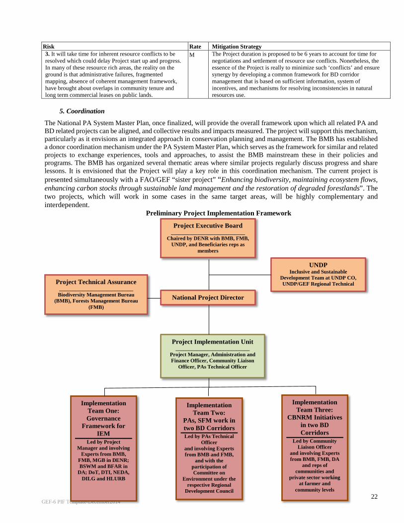
GEF-6 PIF Template-December2014
22
Risk Rate Mitigation Strategy 3. It will take time for inherent resource conflicts to be resolved which could delay Project start up and progress. In many of these resource rich areas, the reality on the ground is that administrative failures, fragmented mapping, absence of coherent management framework, have brought about overlaps in community tenure and long term commercial leases on public lands.
M The Project duration is proposed to be 6 years to account for time for negotiations and settlement of resource use conflicts. Nonetheless, the essence of the Project is really to minimize such ‘conflicts’ and ensure synergy by developing a common framework for BD corridor management that is based on sufficient information, system of incentives, and mechanisms for resolving inconsistencies in natural resources use.
5. Coordination
The National PA System Master Plan, once finalized, will provide the overall framework upon which all related PA and BD related projects can be aligned, and collective results and impacts measured. The project will support this mechanism, particularly as it envisions an integrated approach in conservation planning and management. The BMB has established a donor coordination mechanism under the PA System Master Plan, which serves as the framework for similar and related projects to exchange experiences, tools and approaches, to assist the BMB mainstream these in their policies and programs. The BMB has organized several thematic areas where similar projects regularly discuss progress and share lessons. It is envisioned that the Project will play a key role in this coordination mechanism. The current project is presented simultaneously with a FAO/GEF “sister project” “Enhancing biodiversity, maintaining ecosystem flows, enhancing carbon stocks through sustainable land management and the restoration of degraded forestlands”. The two projects, which will work in some cases in the same target areas, will be highly complementary and interdependent.
Preliminary Project Implementation Framework
Project Executive Board ____________________________
Chaired by DENR with BMB, FMB, UNDP, and Beneficiaries reps as
members
Implementation Team One: Governance
Framework for IEM
Led by Project Manager and involving
Experts from BMB, FMB, MGB in DENR; BSWM and BFAR in
DA; DoT, DTI, NEDA, DILG and HLURB
Project Implementation Unit ____________________________
Project Manager, Administration and Finance Officer, Community Liaison
Officer, PAs Technical Officer
Project Technical Assurance ____________________________ Biodiversity Management Bureau
(BMB), Forests Management Bureau (FMB)
Implementation Team Two:
PAs, SFM work in two BD Corridors Led by PAs Technical
Officer and involving Experts from BMB and FMB,
and with the participation of Committee on
Environment under the respective Regional
Development Council
Implementation Team Three:
CBNRM Initiatives in two BD Corridors
Led by Community Liaison Officer
and involving Experts from BMB, FMB, DA
and reps of communities and
private sector working at farmer and
community levels
National Project Director
UNDP Inclusive and Sustainable
Development Team at UNDP CO, UNDP/GEF Regional Technical
A i

GEF-6 PIF Template-December2014
23
For example the UNDP managed project will address barriers related to land use planning, enhancing biodiversity conservation and promoting sustainable land and forest management in the biological corridors, the FAO managed project executed by the Forest Management Bureau (FMB) of the Department of Environment and Natural Resources (DENR) will tackle barriers related to forest ecosystem restoration. More importantly, the tools and approaches that the GEF/FAO/FMB project will develop will have impacts on the overall strategy of the NGP and are therefore expected to apply more widely to ecosystem oriented management of other corridors in the Philippines. Proactive efforts will be made between the FAO and UNDP projects to ensure complementarities and synergies. These will start with a joint PPG Inception Workshop to bring together the project preparation teams of both projects. As illustrated in the following preliminary implementation framework, there will be a joint PSC/PB chaired by the Under Secretary of DENR with the participation of both BMB and FMB (as well as of UNDP and the beneficiaries representatives). It is also planned to have joint coordination committees in the two corridor landscapes. Furthermore, in an effort to ensure operational synergy, the two projects will hold joint annual review and planning meetings. Other UNDP/GEF projects from which significant lessons can be derived include the Biodiversity Partnership Programme which is supporting Mt. Siburan KBA in Mindoro island, and Lake Mainit in Eastern Mindanao to demonstrate the mainstreaming of biodiversity in the agricultural production landscape. In addition, in the Mt. Hilong hilong in Eastern Mindanao, in Cordillera region, and in Iglit Baco National Park in Mindoro, the UNDP/GEF NewCAPP has supported indigenous communities to document and recognize ICCAs. The project will coordinate with and build on lessons from the NewCAPP project including assessment of feasibility of expanding protected areas through other effective area based conservation measures (OECMs) by working with local governments to establish local conservation areas (LCAs). In addition a number of ongoing and planned projects are relevant: • The UNDP/GEF SGP experiences in working with communities, from where useful models of community based
sustainable NRM and BD conservation approaches can be learned to inform the strategy for engagement with forest communities and indigenous peoples groups;
• UNDP/GEF project on Sustainable Land Management from which useful lessons and strategies can be adopted to promote landscape level sustainable agriculture practices;
• The experiences of the USAID B+WISER Project, which works in both corridors of this proposed Project can be reviewed and its strategies for strengthening selected PAs within the corridor can be aligned with the IEM framework under the project;
• The upcoming BMU-GIZ project focusing on IEM will be reviewed, and coordination established during project preparation to avoid duplication and strengthen complementation;
• The proposed PA Financing project under UNDP/GEF where efforts shall be made to complement in the implementation of innovative financing mechanisms; and
Coordination shall also be established with other NGOs active in the sector and have operations in the sites, to maximize collective impacts.
6. Consistency with National Priorities
The project is consistent with the priorities defined in the Philippine Development Plan (2011 to 2016). The Plan clearly specified that the integrated and community based ecosystem approach to ENR management shall be adopted to address environmental degradation. Natural resources management shall be directed at enhancing the state of diferent ecosystems and the natural resources within them to provide resource dependent communities ith livelihoods. Under the biodiversity conservation and protected area management targets, the Plan aims to strengthen management of existing PAs and additional PAs in priority KBAs. More specifically, the proposed updating of the Plan for 2016-2021 proposes the strengthening the network of protected areas within three priority biodiversity corridors. The project will contribute to the framework espoused in the upcoming National PA System Master Plan by demonstrating how the network approach to PA system management can be demonstrated at the corridor level. It will also contribute to the goals and targets of the PBSAP through the strengthening of existing PAs and expansion of the PA system, expanding and improving the knowledge on the extent, characteristics, uses and values of biodiversity, and by adopting the integrated ecosystems approach in the BD corridors to address fragmentation, thereby enhancing connectivity, and contribute to greater conservation outcomes. More importantly, the corridor level conservation framework is seen as the lower tier level translation of the PBSAP. The project will also contribute to the testing of its M&E system, and provide corridor level data and information for monitoring progress in PBSAP implementation and documenting impacts. The Aligned Philippine National Action Plan to combat desertification, land degradation and drought (PNAP-DLDD) 2015-2025 examines the natural factors and existing framework relevant to sustainable land management (SLM). Its geographical
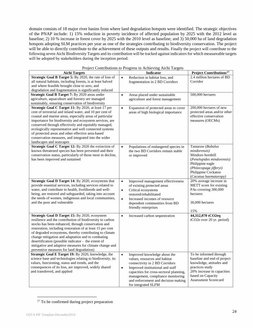
GEF-6 PIF Template-December2014
24
domain consists of 18 major river basins from where land degradation hotspots were identified. The strategic objectives of the PNAP include: 1) 15% reduction in poverty incidence of affected population by 2025 with the 2012 level as baseline; 2) 10 % increase in forest cover by 2025 with the 2010 level as baseline; and 3) 50,000 ha of land degradation hotspots adopting SLM practices per year as one of the strategies contributing to biodiversity conservation. The project will be able to directly contribute to the achievement of these outputs and results. Finally the project will contribute to the following seven Aichi Biodiversity Targets and its contribution will be tracked against indicators for which measureable targets will be adopted by stakeholders during the inception period.
Project Contributions to Progress in Achieving Aichi Targets Aichi Targets Indicator Project Contributions27
Strategic Goal B Target 5: By 2020, the rate of loss of all natural habitats, including forests, is at least halved and where feasible brought close to zero, and degradation and fragmentation is significantly reduced
• Reduction in habitat loss, and fragmentation in 2 BD Corridors
2.4 million hectares of BD Corridor
Strategic Goal B Target 7: By 2020 areas under agriculture, aquaculture and forestry are managed sustainably, ensuring conservation of biodiversity
• Areas placed under sustainable agriculture and forest management
500,000 hectares
Strategic Goal C Target 11: By 2020, at least 17 per cent of terrestrial and inland water, and 10 per cent of coastal and marine areas, especially areas of particular importance for biodiversity and ecosystem services, are conserved through effectively and equitably managed, ecologically representative and well connected systems of protected areas and other effective area-based conservation measures, and integrated into the wider landscapes and seascapes
• Expansion of protected areas to cover areas of high biological importance
200,000 hectares of new protected areas and/or other effective conservation measures (OECMs)
Strategic Goal C Target 12: By 2020 the extinction of known threatened species has been prevented and their conservation status, particularly of those most in decline, has been improved and sustained
• Populations of endangered species in the two BD Corridors remain stable or improved
Tamaraw (Bubalus mindorensis) Mindoro hornbill (Penelopides mindorensis) Philippine eagle (Phitecopaga jifferyi) Philippine Cockatoo (Cacatua haematuropy)
Strategic Goal D Target 14: By 2020, ecosystems that provide essential services, including services related to water, and contribute to health, livelihoods and well-being, are restored and safeguarded, taking into account the needs of women, indigenous and local communities, and the poor and vulnerable
• Improved management effectiveness of existing protected areas
• Critical ecosystems restored/rehabilitated
• Increased incomes of resource dependent communities from BD friendly enterprises
20% average increase in METT score for existing PAs covering 300,000 hectares 30,000 hectares 15%
Strategic Goal D Target 15: By 2020, ecosystem resilience and the contribution of biodiversity to carbon stocks has been enhanced, through conservation and restoration, including restoration of at least 15 per cent of degraded ecosystems, thereby contributing to climate change mitigation and adaptation and to combating desertification (possible indicator - the extent of mitigative and adaptive measures for climate change and preventive measures for land degradation)
• Increased carbon sequestration 44,312,070 tCO2eq tCO2e over 20 yr. period)
Strategic Goal E Target 19: By 2020, knowledge, the science base and technologies relating to biodiversity, its values, functioning, status and trends, and the consequences of its loss, are improved, widely shared and transferred, and applied
• Improved knowledge about the values, resources and habitat connectivity in 2 BD Corridors
• Improved institutional and staff capacities for cross-sectoral planning, management, compliance monitoring and enforcement and decision making for integrated SLFM
To be informed through baseline and end of project knowledge, attitudes and practices study 20% increase in capacities based on Capacity Assessment Scorecard
27 To be confirmed during project preparation
GEF-6 PIF Template-December2014
25
The Project will contribute to the attainment of SDG Target 15: Life on Land (Sustainably manage forests, combat desertification, halt and reverse land degradation, halt biodiversity loss). In the Philippines, forests are home to about 20 million people, including about 7 – 8 million indigenous people. Sustainable management of forests will help ensure equal access to resources, and bring about improved living conditions for these communities. More importantly, the Project will directly address the threats to sustainable forest management and help in delivering ecosystem benefits to affected population. A large portion of corridors are also devoted to agriculture, and subjected to all forms of degradation and unsustainable land management practices. The Project will work with selected communities to influence their practices to reverse the current conditions. The net effect is the transformation of degraded lands into sustainably managed farms to support increased yields and higher farmer incomes. Finally, arresting the threats to biodiversity loss would be a direct outcome of the Project, through its work in tackling the institutional and policy constraints that impact on fragmentation and degradation of habitats; as well as practices that encourage unsustainable use of biodiversity resources. Ultimately, the impact of the Project would be felt by communities and resource managers within and around the BD corridors, thus contributing to the attainment of SDG 1: End poverty in all its forms everywhere.
7. Knowledge management
The lessons and experiences of this initiative will form part of the overall implementation strategy for a donor coordination mechanism to be established under the BMB. This will ensure coherence of all projects with development assistance support with the PBSAP, and the agency’s medium term and long term program. The project will support distilling lessons and documentation of experiences, in particular the tools, guidelines and methods. Sufficient resources will be dedicated to ensure that important outputs are documented and disseminated. It will benchmark its knowledge management strategy with international best practices, including the use of effective social media and web enabled tools for dissemination, and interactive platform for reaching out to its desired audiences. Targeted communication and advocacy activities shall be organized to send the project’s key messages, including participation in legislative dialogues, providing technical inputs to broader policy debates, channeling information through the academe and involving the youth in research and vital campaigns, and sharing its experiences globally. More detailed strategies shall be developed during project preparation, and a communication and knowledge management plan shall be developed at the commencement of implementation, following audit of requirements and needs.
PART III: APPROVAL/ENDORSEMENT BY GEF OPERATIONAL FOCAL POINT AND GEF AGENCY A. RECORD OF ENDORSEMENT OF GEF OPERATIONAL FOCAL POINT (S) ON BEHALF OF THE GOVERNMENT: (Please attach the Operational Focal Point endorsement letter with this template.
NAME POSITION MINISTRY DATE (MM/dd/yyyy) Analiza Rebuelta-Teh Undersecretary / OFP Department of Environment and
Natural Resources (DENR) 8 June 2016
B. GEF AGENCY(IES) CERTIFICATION
This request has been prepared in accordance with GEF policies and procedures and meets the GEF criteria for project identification and preparation under GEF-6. Agency Coordinator, Agency name
Signature Date
(MM/dd/yyyy) Project Contact
Person Telephone Email
Adriana Dinu, UNDP-GEF Executive Coordinator and Director
07/25/2016 Doley Tshering Regional Technical Advisor – EBD, UNDP
+66-87-1030505

GEF-6 PIF Template-December2014
26
ANNEX 1: DETAILED INFORMATION OF THE PILOT CORRIDORS Mindoro Island Biodiversity Corridor: Mindoro is the seventh-largest island in the Philippines, with an area of 436,470 hectares; and a population of 1.238 million. It is located between the large islands of Luzon and the Sunda-affiliated Palawan, and it shares faunal attributes of both islands. However, Mindoro was isolated from Luzon and Palawan throughout the Pleistocene and retains its own unique character, including the iconic tamaraw (Bubalus mindorensis). Because of these, the island of Mindoro is considered an ecoregion – together with the Semirara islands28. The Philippines Biodiversity Conservation Priority Project (PBCPP) identified seven priority areas within what is called the Central Mindoro Biodiversity Corridor, encompassing a total area of 252,260 hectares. These include: Purto Galera (KBA); Mt. Halcon (KBA); Sablayan (KBA); Iglit and Baco Mountains (KBA, PA, ICCA); Malpalon (KBA); Bogbog, Bongabong and Mt. Hitding (KBA); and Mt. Hinunduang (KBA). The island is connected to the world famous Apo Reef National Park and the Verde Island Passage, considered the world’s center of the center of marine shorefish diversity. Vegetation types on Mindoro include lowland evergreen rain forest to approximately 400 m or higher, open forest from about 650 to 1,000 m, and mossy forest above. Only small patches remain of the lowland evergreen dipterocarp rain forest that would have dominated the lowland eastern portions of the island. Semideciduous forest would have predominated on the western half of the island. Limited stands of Mindoro pine (Pinus merkusii) are found at elevations of 600 m or less in the northern portions of the island. Because of its geological history, the island has evolved as a unique center of biodiversity, with very high endemism. Recent assessments have documented 94 species of hepterofauna; 10 restricted range bird species, of which five are concurrently globally threatened and endemic; at least 70 endemic species of flora unique to Mindoro island; at least 17 endemic species and taxa out of a total 50 species/sub species of butterflies; at least 10 endemic species of mammals, of which six are threatened while four await formal description; more than 300 species of birds, one quarter of which are endemic to the Philippines. In addition to these, the Mindoro Biodiversity Conservation Foundation, Inc. (MBCFI) reported that in 2011 and 2013, there were 18 newly recorded faunal species in Mindoro29. Among the other important mammals found in Mindoro include the Philippine warty pig (Sus philippensis), which is considered by IUCN as rare and declining. Also found are endemic subspecies of the Philippine deer (Cervus mariannus barandanus) found only in Mindoro; the critically endangered Illin hairy-tailed cloud rat (Crateromys Paulus), the endangered Mindoro shrew (Crocidura mindorus) and the more Philippine widespread but endangered golden-crowned fruit bat (Acerodon jubatus).30 The island of Mindoro is composed of a mosaic of landscapes and ecosystems – grasslands, disturbed lowland forests, agricultural areas, high elevation pine forests, freshwater lake, extensive river systems and watersheds – all supporting the socio economic and cultural development of the island. Unfortunately, Mindoro is one of the most severely deforested islands in the country (Heaney and Mittermeir 1997, as cited in WWF). Only the most rugged portions of the island's central spine has been spared from commercial logging, and the forest is still under pressure. In 2010, only 30% of the island’s forest lands have forest cover; of which only 4% is closed forest. Some 180,000 hectares are open, highly fragmented; while the rest of the forest lands have been converted to agriculture and other uses. The rapid decline in population of Mindoro hornbill (Penelopides mindorensis) for example, has been attributed to forest loss, fragmentation, and degradation of lowland forests; compounded by hunting pressure31. Over the years, the indigenous peoples of Mangyan, Buhid and Tau Buhid, among others; have seen shortened fallow periods in between slash and burn farming due to pressures on land from migrants occupying the fringes of their domains. Fuelwood gathering is also on the rise, the key factor behind forest degradation. A number of initiatives are taking place in various parts of the island. The USAID is supporting improved management of Lake Naujan; the UNDP-GEF Biodversity Partnerships Project (BPP) is mainstreaming BD conservation in the broader agricultural production landscape in Mt. Siburan KBA. The recently completed UNDP-GEF NewCAPP supported the Buhid Mangyan group in Mt. Iglit Baco National Park to document and recognize their ICCA; while the MBCFI has an on going effort to study the different conservation areas in the corridor. The
28 Philippines: Island of Mindoro | Ecoregions | WWF (http://www.worldwildlife.org/ecoregions/im0130) 29 www.mibcfi.org.ph 30 Philippines: Island of Mindoro | Ecoregions | WWF (http://www.worldwildlife.org/ecoregions/im0130) 23. Birlife International - (Mindoro Hornbill (Penelopides mindorensis) -...http://www.birdlife.org/datazone/speciesfactsheet.php?id=958)
GEF-6 PIF Template-December2014
27
local government on the other hand, has issued a policy imposing a 25-year mining moratorium in the province of Oriental Mindoro. What is lacking is a more integrated approach that strengthens the network of important conservation areas, and links these interventions with the broader landscape, restore degraded patches to improve connectivity and provide stepping stones for threatened species. Eastern Mindanao Biodiversity Corridor: The Eastern Mindanao Biodiversity Corridor (EMBC) is a long stretch of lowland and mid - to high elevation forests along the east coast of Mindanao. Dinagat Island marks its northernmost boundary while Mt. Hamiguitan Range is at its southern tip. Region 11 and Region 13 (Caraga), in seven provinces, four cities and 88 municipalities. The corridor hosts a large proportion of the country's unique plants and animals. At least 370 species of forest vertebrates (i.e. birds, mammals, amphibians and reptiles) are currently known. Out of these, nearly half (181 species) are found only in the country. The corridor's plant diversity is also very high, with more than 2,300 species known there (31% of the total species known for the Philippines). Among vertebrates, the EMBC has at least 196 species of birds and 91 (or 46 %) of them are endemic, which is more than half (51 %) of the country's total endemic birds. For mammals, at least 66 species (27 non-flying mammals and 39 bats) are known, and almost half of these (31 species) are endemic. The figure includes two new species of rodents, a new species of fruit bat, and a probable new species of insect-eating bat. The corridor also houses at least 31 amphibians (frogs and caecilians), 16 of which are endemic. There are also at least 77 species of reptiles (snakes, turtles, and lizards) and more than half of these (43 species) are endemic.32 The eastern portion of Mindanao, where the corridor is located, holds one of the largest remaining blocks of dipterocarp forest in the country. In fact, this region is called the timber corridor, because of the favorable climatic condition which enables the growing of forest tree plantations highly profitable. Both regions have a very active timber industry, which host 33 industrial forest management agreements (IFMAs) covering almost 400,000 hectares. These regions supply most of the country’s wood requirements, with active sawmills having combined annual log requirement comprising almost 60% of the country’s total. There are 182 community based forest management agreements (CBFMAs) – long term tenure instruments given to organized forest communities, covering 306,366 hectares, involving approximately 150,000 households. Private land owners are also engaged in timber production, as well as growing of long term and other high value crops. There is an active corporate sector involved in large plantations such as oil palm, rubber, and other high value crops. Based on the EMBC Conservation Framework which was prepared in 2008, the major threats to the corridor’s biodiversity include: rapid population growth in the uplands; illegal logging (the region is classified as a hotspot); forest conversion to agriculture; land use conversion and crop shifting; wildlife hunting and collection for food and trade; and irresponsible mining. Population growth rate in the region is 2.5% per year, slightly higher than the national average of 2.3%, based on the EMBC Framework document. Based on the assessment made in the EMBC framework, the entire corridor supports at least 2,041,980 people, most of them are in 2,055 rural barangays near or within the KBAs. Each of the KBAs is completely surrounded by upland farming communities. For many of the over 1.6 million indigenous peoples living close to or inside the forests, “slash-and-burn” is the common farming method. As an illegal logging hotspot, attention is focused on the corridor in law enforcement, which resulted in continued drop in confiscated forest products. In the CARAGA region alone, confiscations dropped from 2.102 million board feet in 2011 to 1.575 board feet in 2014. Given the extensive network of illegal loggers and their allies, there is undoubtedly more illegally cut logs that were unreported or unknown to authorities. Putting a stop to illegal logging is difficult. The government has recently focused attention to this issue, by beefing up its support to the anti illegal logging campaign.
Forest conversion to agriculture, land use conversion and crop shifting has continued. For example, the number of farms in the Caraga Region increased by 10.9 % in a span of 10 years, from 189,600 ha in 1991 to 210,200 ha in 2002. These farms grow either vegetables for the local market, or export crops like Cavendish bananas and palm oil. As forests, marshes and wetlands get converted to farms, more and more wildlife are losing breeding places, foraging grounds, and shelter. Coastal zones or mangrove forests have been converted into fish ponds and reclamation areas for agriculture, aquaculture, and urban expansion. Mangrove destruction is also taking place in 32 Ibanez, Jayson and Dennis Salvador (eds). Philippine Eagle Foundation, Conservation International-Philippines, Department of Environment and Natural Resources. 2008. Eastern Mindanao Biodiversity Corridor Conservation Framework. Davao City, Philippines (http://www.researchgate.net/publication/280721421, accessed 01 October 2015.

GEF-6 PIF Template-December2014
28
the Dinagat and Siargao KBAs. Specifically, mangrove forests give way to beach resorts, piers, and docks to accommodate tourism and trade. Wildlife hunting is an issue in the corridor. The EMBC Framework documented that several large, long-lived, late maturing threatened species are still being shot or trapped, deliberately or accidentally. For example, there are still cases of Philippine eagles gunned down or trapped in local snares. Large birds such as the endemic Philippine hawk eagles and Hornbills are hunted as well either for food or sheer fun. Wildlife is also extracted from the EMBC forest for the pet trade. Large- to medium-sized birds such as hornbills, eagles, forest pigeons, doves, and parrots are collected and sold to pet shops illegally. Philippine deer and wild pigs are also hunted for bush meat using both traditional snares and rifles . Bonsai plants, rare orchids, and other wild ornamental plants are collected illegally and sold to unsuspecting customers in trade fairs or plant stalls.
In addition, non-native species of plants and animals are slowly finding their way into natural areas and out-competing their native counterparts. For example, janitor fishes (Pterygoplichthys disjunctivus) have invaded the Agusan Marsh, and their numbers are ballooning. Decline in native fishes were noted and people are catching less of edible fishes that are important protein source in their diet. The fast-growing, exotic tree species Gmelina has taken over gaps in the forest outgrowing native pioneer trees that normally takes more time to grow and mature. Wildlife suffers as their habitats are replaced by exotic plants that they are not equipped to use. While mining has been more fully regulated in the recent years, there have been cases of violations and complaints made by local governments and indigenous peoples on the performance of mining companies. It is common for mining companies granted exploration permits to extend their activities into actual operations. With 59 approved mineral production sharing agreements (MPSAs) in Region 13 alone, the task of monitoring remains a continuing challenge. Region 13 hosts the most number and covers almost half the area under MPSAs in Mindanao. In Dinagat islands for example, which is a KBA, there are 19 MPSAs, mostly located in identified mining reservation. Both Surigao del Sur and Surigao del Norte have twelve approved MPSAs each. This is consistent with the findings that the eastern seaboard is particularly rich in mineral resources. The Framework was the product of extensive consultation and advocacy, which produced a draft Executive Order creating the institutional arrangements for coordinated implementation of economic and conservation activities in the corridor. These initial work can serve as stepping stone to update the analyses and prepare an integrated plan for the corridor.
Annex A – List of PAs in the Selected BD Corridors
Biodiversity Corridor Protected Area Area within BDCor
(Hectares in GIS) TOTAL AREA (PA
per Corridor)
Central Mindoro
1
Calavite & F.B. Harrison Game Refuge and Bird Sanctuary
67,186 173,842 2 Mts. Iglit-Baco National Park 106,655
Eastern Mindanao
1 Agusan Marsh Wildlife Sanctuary 40,257
138,429
2
Alamio, Buayan, Carac-an, Panikian River and Sipangpang Falls Watershed Forest Reserve
43,345 3 Aliwagwag Protected Landscape 11,448 4 Andanan Watershed Forest Reserve 17,185 5 Cabadbaran Watershed 15,180 6 Mainit Hotspring Protected Landscape 1,855 7 Mati Protected Landscape 1,067 8 Mt. Hamiguitan Range Wildlife Sanctuary 7,137 9 Surigao Watershed Forest Reserve 951
TOTAL 312,271 312,271

GEF-6 PIF Template-December2014
29
Annex B – List of KBAs within Selected BD Corridors. In selecting the pilot sites, the project applies the KBA33 approach to identifying globally important areas for biodiversity conservation. The criteria for identifying KBAs include: (i) presence of threatened species and or encompassing threatened ecosystems; (ii) holding geographically restricted biodiversity; (iii) contributing to ecological integrity; (iv) contributing to biological processes including ecological refugia; (v) and as deemed providing for biodiversity through quantitative analysis.
Biodiversity Corridor Key Biodiversity Area Area within BDCor
(Hectares in GIS)
TOTAL AREA (KBA per Corridor)
Eastern Mindanao 1 Hinatuan Bay 892 2 Carrascal Bay 148
3 Agusan Marsh Wildlife Sanctuary 53,766 4 Mt. Atuuganon and Mt. Pasian 85,500 5 Mt. Kampalili-Puting Bato 169,908 830,254 6 Mt. Hilong-hilong 240,239
7 Mt. Hamiguitan Range Wildlife Sanctuary 31,878
8 Mt. Diwata Range 93,798
9 Bislig 154,121 Central Mindoro 1 Iglit-Baco Mountains 56,299
2 Malpalon 14,093 3 Mt. Hitding 17,768 4 Mt. Hinunduang 8,222 196,209 5 Mt. Halcon 50,950 6 Puerto Galera 37,306
7 Siburan 11,569
TOTAL 1,026,463 1,026,463
33 IUCN (2014). Consultation Document on an IUCN Standard for Identification of Key Biodiversity Areas (Draft 1 October 2014)

GEF-6 PIF Template-December2014
30
Annex 3 Screen shot of the FAO Ex-Ante Carbon-balance Tool (EX-ACT) Results page
A 10-year period is taken as the minimum duration of these benefits although in effect they could go on for longer. The period takes into account that it might take some time from project start for the HCVF to be classified and areas delineated and for deforestation to stop. It also recognizes that not all of the rehabilitation of degraded forest will happen at the start of the project. The FAO Ex-Ante Carbon-balance Toll (EX-ACT) Tier ONE Edition was used and the forest type selected for the calculations is Tropical Moist Forests. GHG emissions avoided: Establishment of HVCF will change the regime from economic use to protection and this will reduce or halt deforestation in these areas. Using the PI annual deforestation rate of 2%, 4,000 ha of deforestation will be prevented annually. Assuming that direct contribution of the project take effect after 5 years when majority of project activities complete, this translates to 20,000 ha of deforestation prevented. While commercial logging and other felling operations will largely be halted some forest loss may take place due to illicit felling other associated threats. Thus total deforestation prevented is reduced by a factor of 15% to 17,000 ha. The GHG emissions reductions from this prevented deforestation is 11,303,651 tCO2eq over a 10 year period. However, after clearing, the land would have converted to either annual crops of perennial/tree crop. In the calculation, perennial tree crops was used and the carbon sequestrated by the trees was calculated as 1,136,733 tCO2eq over a 10 year period. The avoided GHG emission due to the project is therefore 10,166,918 tCO2-eq. CO2 sequestered 30,000 ha of slightly degraded forest will be rehabilitated with enrichment planting by the project. This will result in a total carbon benefit of 2,148,487 tCO2eq over a 10 year period or 214,845 tCO2eq per year. Assuming that the actual carbon sequestration will significantly come into effect after year 5 when the majority of rehabilitation efforts are completed, the total actual sequestration accrued by the project in the next 5 years is 1,074,225 tCO2eq. The total carbon benefit over a 10 year period by the project is 11,241,143 tCO2eq


![l>lf·· E ·B; -I,:,C-·-1·1V · cat. no.i bd lj.657 bd lj.6]5 bd 4630 bd 4·627 bd 4628 bd 4886 bd 4546 bd 4·545 bd 4544 bd 4542 bd lj,588 bd lj.593 bd 0102 bd 4636 bd 4632 bd](https://static.fdocuments.in/doc/165x107/5f7c69bb7d840d18665ab1e6/llf-e-b-ic-11v-cat-noi-bd-lj657-bd-lj65-bd-4630-bd-4627-bd-4628-bd.jpg)


