GCSE GEOGARPHY OCR B – REVISION GUIDE Rivers and Coasts
26
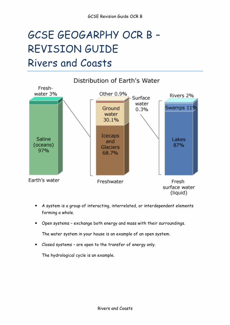
GCSE Revision Guide OCR B Rivers and Coasts GCSE GEOGARPHY OCR B – REVISION GUIDE Rivers and Coasts A system is a group of interacting, interrelated, or interdependent elements forming a whole. Open systems – exchange both energy and mass with their surroundings. The water system in your house is an example of an open system. Closed systems – are open to the transfer of energy only. The hydrological cycle is an example.
Transcript of GCSE GEOGARPHY OCR B – REVISION GUIDE Rivers and Coasts
GCSE Revision Guide OCR B
Rivers and Coasts
GCSE GEOGARPHY OCR B –
REVISION GUIDE
Rivers and Coasts
A system is a group of interacting, interrelated, or interdependent elements
forming a whole.
Open systems – exchange both energy and mass with their surroundings.
The water system in your house is an example of an open system.
Closed systems – are open to the transfer of energy only.
The hydrological cycle is an example.
GCSE Revision Guide OCR B
Rivers and Coasts
Evaporation Water turning into water vapour
Transpiration The loss of water from the leaves of plants
Precipitation The deposition of water from the atmosphere in liquid
(rain) or solid (snow) form
Surface Runoff All water flowing on the earth’s surface
Evapotranspiration The sum of evaporation from the earth’s surface
together with
the transpiration from plants
Infiltration Seeping of water into the soil
Sustainable Capable of existing in the long-term
Through-flow Movement of water through the soil
Groundwater flow The movement of water underground through rocks
Interception Collection of water by vegetation
Water table The upper level of underground water
GCSE Revision Guide OCR B
Rivers and Coasts
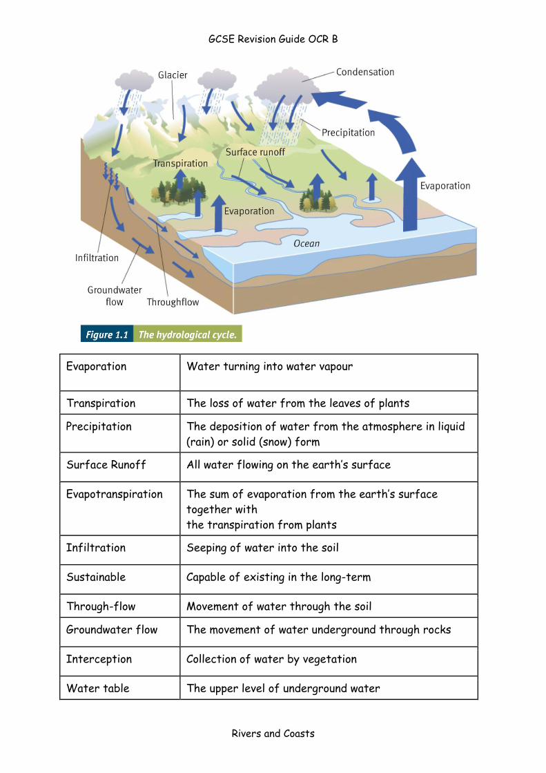
Revision Task idea: Print off the table and cut it up – try to match the terms with the
definitions
The River system/Drainage Basin System (OPEN)
Revision Tip – draw the
flow diagram opposite
from memory and try
and colour code store,
inputs, outputs and
transfers.
GCSE Revision Guide OCR B
Rivers and Coasts
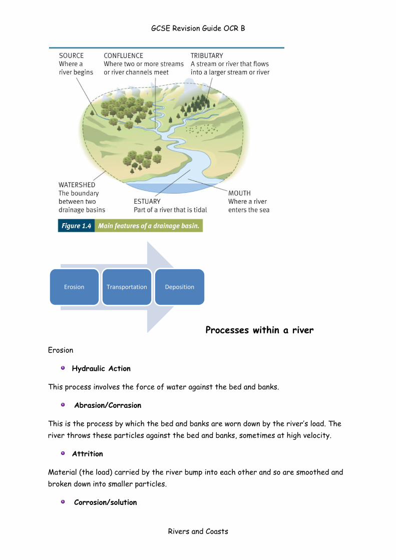
Processes within a river
Erosion
Hydraulic Action
This process involves the force of water against the bed and banks.
Abrasion/Corrasion
This is the process by which the bed and banks are worn down by the river’s load. The
river throws these particles against the bed and banks, sometimes at high velocity.
Attrition
Material (the load) carried by the river bump into each other and so are smoothed and
broken down into smaller particles.
Corrosion/solution
Erosion Transportation Deposition
GCSE Revision Guide OCR B
Rivers and Coasts
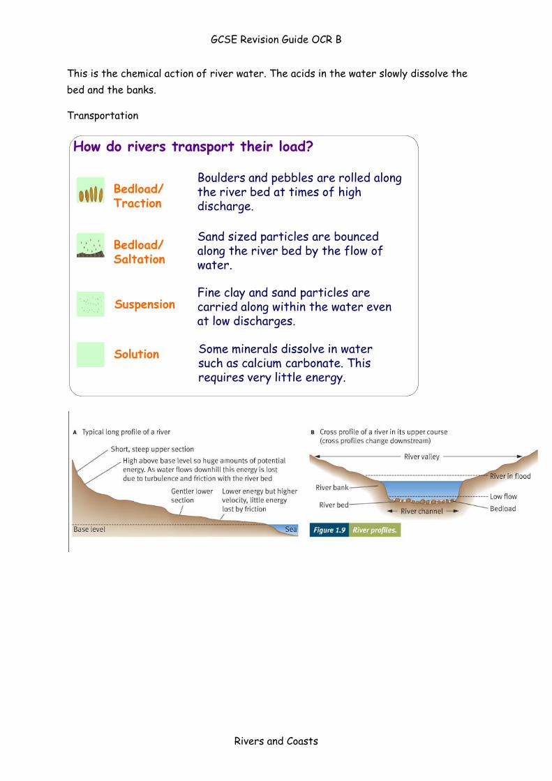
This is the chemical action of river water. The acids in the water slowly dissolve the
bed and the banks.
Transportation
How do rivers transport their load?
Bedload/Saltation
Solution
Bedload/Traction
Suspension
Boulders and pebbles are rolled along the river bed at times of high discharge.
Sand sized particles are bounced along the river bed by the flow of water.
Fine clay and sand particles are carried along within the water even at low discharges.
Some minerals dissolve in water such as calcium carbonate. This requires very little energy.
GCSE Revision Guide OCR B
Rivers and Coasts
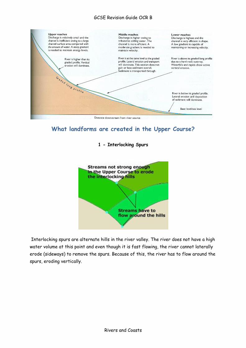
What landforms are created in the Upper Course?
1 - Interlocking Spurs
Interlocking spurs are alternate hills in the river valley. The river does not have a high
water volume at this point and even though it is fast flowing, the river cannot laterally
erode (sideways) to remove the spurs. Because of this, the river has to flow around the
spurs, eroding vertically.
GCSE Revision Guide OCR B
Rivers and Coasts
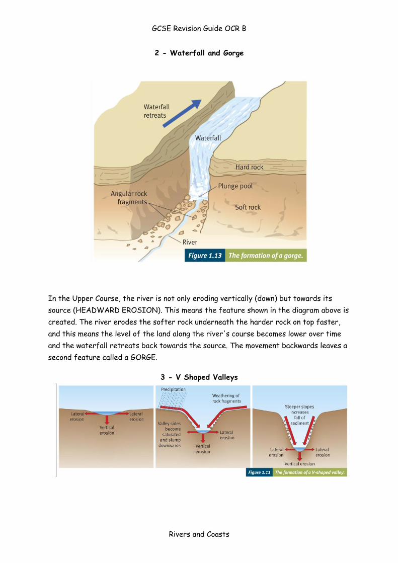
2 - Waterfall and Gorge
In the Upper Course, the river is not only eroding vertically (down) but towards its
source (HEADWARD EROSION). This means the feature shown in the diagram above is
created. The river erodes the softer rock underneath the harder rock on top faster,
and this means the level of the land along the river's course becomes lower over time
and the waterfall retreats back towards the source. The movement backwards leaves a
second feature called a GORGE.
3 - V Shaped Valleys
GCSE Revision Guide OCR B
Rivers and Coasts
What landforms are created in the middle course?
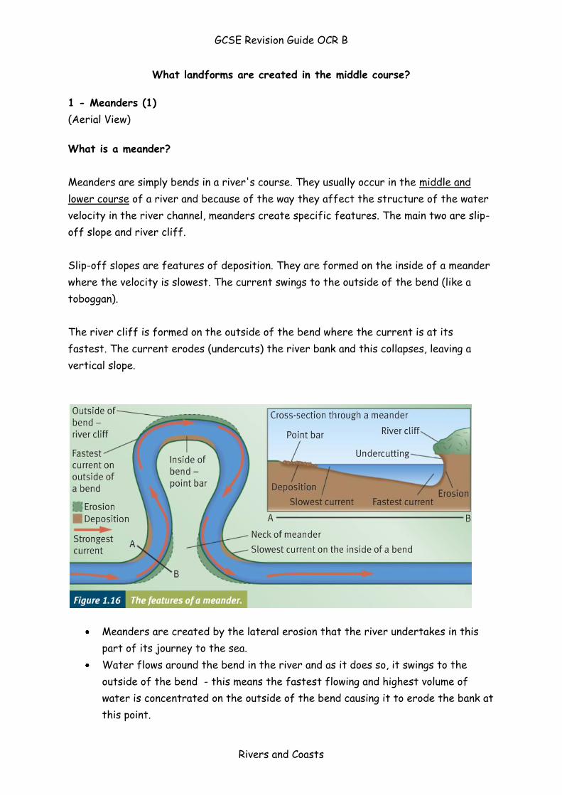
1 - Meanders (1)
(Aerial View)
What is a meander?
Meanders are simply bends in a river's course. They usually occur in the middle and
lower course of a river and because of the way they affect the structure of the water
velocity in the river channel, meanders create specific features. The main two are slip-
off slope and river cliff.
Slip-off slopes are features of deposition. They are formed on the inside of a meander
where the velocity is slowest. The current swings to the outside of the bend (like a
toboggan).
The river cliff is formed on the outside of the bend where the current is at its
fastest. The current erodes (undercuts) the river bank and this collapses, leaving a
vertical slope.
Meanders are created by the lateral erosion that the river undertakes in this
part of its journey to the sea.
Water flows around the bend in the river and as it does so, it swings to the
outside of the bend - this means the fastest flowing and highest volume of
water is concentrated on the outside of the bend causing it to erode the bank at
this point.
GCSE Revision Guide OCR B
Rivers and Coasts
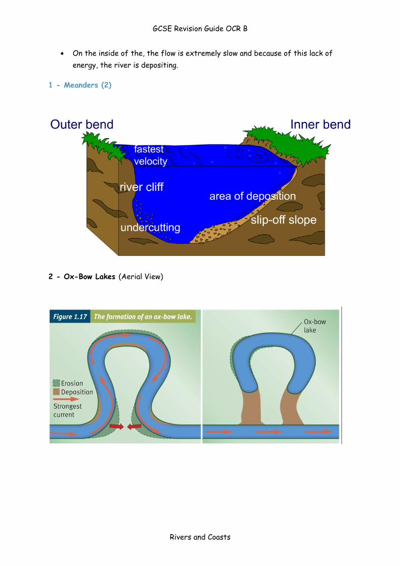
On the inside of the, the flow is extremely slow and because of this lack of
energy, the river is depositing.
1 - Meanders (2)
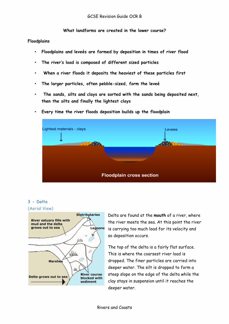
2 - Ox-Bow Lakes (Aerial View)
GCSE Revision Guide OCR B
Rivers and Coasts
What landforms are created in the lower course?
Floodplains
• Floodplains and leveés are formed by deposition in times of river flood
• The river’s load is composed of different sized particles
• When a river floods it deposits the heaviest of these particles first
• The larger particles, often pebble-sized, form the leveé
• The sands, silts and clays are sorted with the sands being deposited next,
then the silts and finally the lightest clays
• Every time the river floods deposition builds up the floodplain
3 - Delta
(Aerial View)
Delta are found at the mouth of a river, where
the river meets the sea. At this point the river
is carrying too much load for its velocity and
so deposition occurs.
The top of the delta is a fairly flat surface.
This is where the coarsest river load is
dropped. The finer particles are carried into
deeper water. The silt is dropped to form a
steep slope on the edge of the delta while the
clay stays in suspension until it reaches the
deeper water.
GCSE Revision Guide OCR B
Rivers and Coasts
Deltas are formed when the river meets the sea. The sea does not flow, so the
river suddenly stops upon meeting the sea and loses its energy to carry load.
The load is then deposited on the sea bed and over time, this builds up to form a
new piece of land in the river mouth. The river then has to divert its flow into
smaller 'distributaries' to reach the sea again. When it does so, more load is
deposited and this builds the new delta out into the sea.
For a delta to survive, the river must bring a constant supply of material to
deposit on the delta or it will be eroded away by the sea. Many human-made
dams on rivers stop silt getting to deltas in this way.
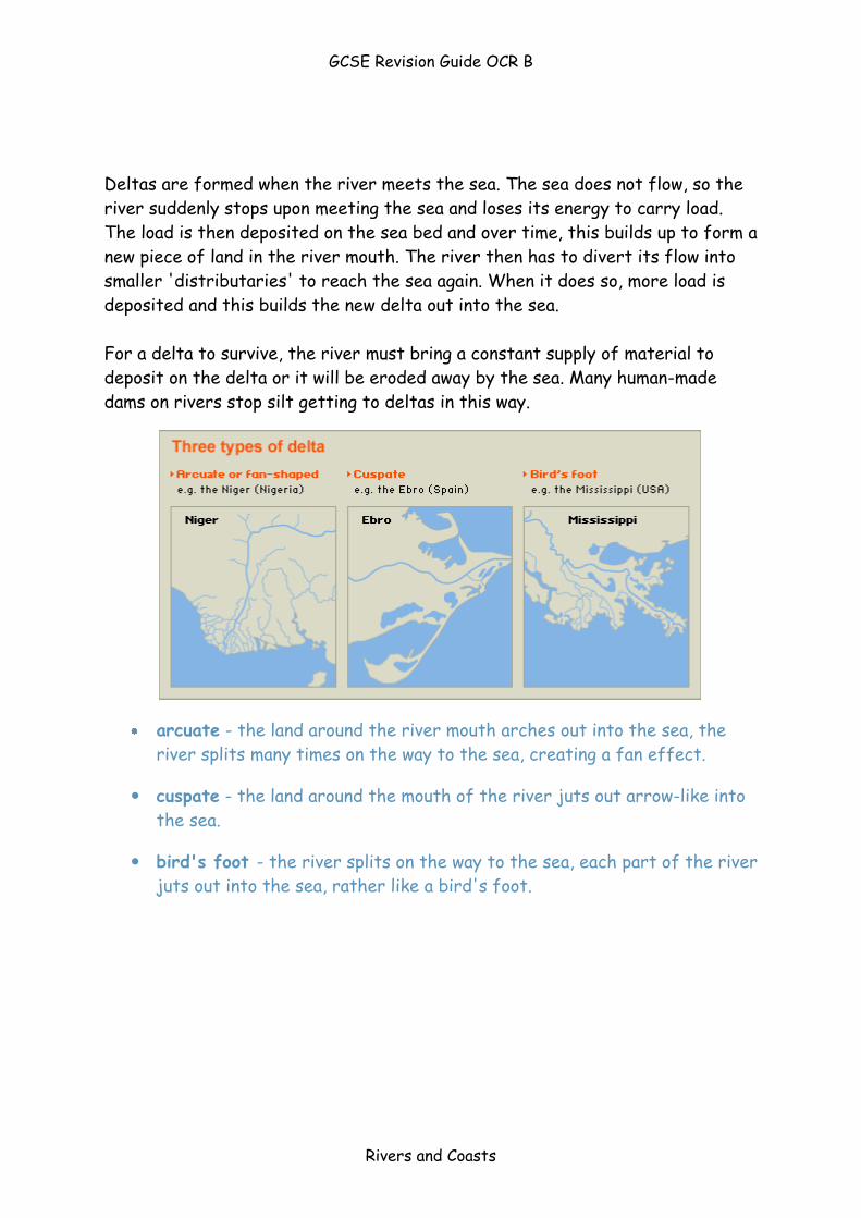
arcuate - the land around the river mouth arches out into the sea, the
river splits many times on the way to the sea, creating a fan effect.
cuspate - the land around the mouth of the river juts out arrow-like into
the sea.
bird's foot - the river splits on the way to the sea, each part of the river
juts out into the sea, rather like a bird's foot.
GCSE Revision Guide OCR B
Rivers and Coasts
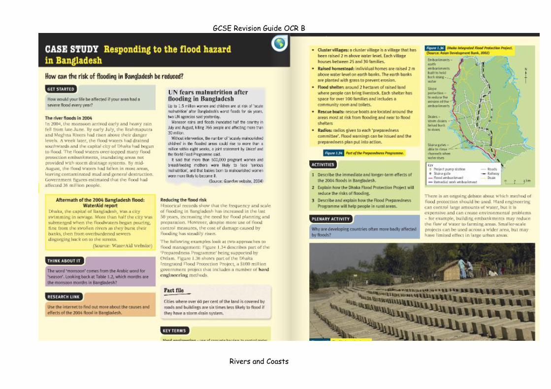
Flooding
The reasons why some rivers flood
Rivers flood for many reasons. The main reasons are:
Precipitation:
Frequent cause of flooding = heavy rainfall over days
Ground becomes saturated and water runs over surface
Most serious flooding usually after short intense storms.
Flash floods usually occur after hot summer when ground dry so water can’t
infiltrate the surface.
Water held as snow also can cause floods when melts as temp’ rises
Soil/underlying rock:
Rocks that let water through – Permeable
Rocks that don’t let water through – Impermeable
Surface run-off and flood risk greater when river basin has impermeable soil
and underlying rock.
Land use:
River basins with little vegetation cover = high flood risk
Forested basins = low flood risk
Human activity:
Deforestation (cutting down trees) and urban growth increasing flood risk
Bangladesh = increased flood risk due to deforestation in Himalayas
Impermeable tarmac surfaces and concrete surfaces are replacing fields and
woodland – surface run-off increased
GCSE Revision Guide OCR B
Rivers and Coasts
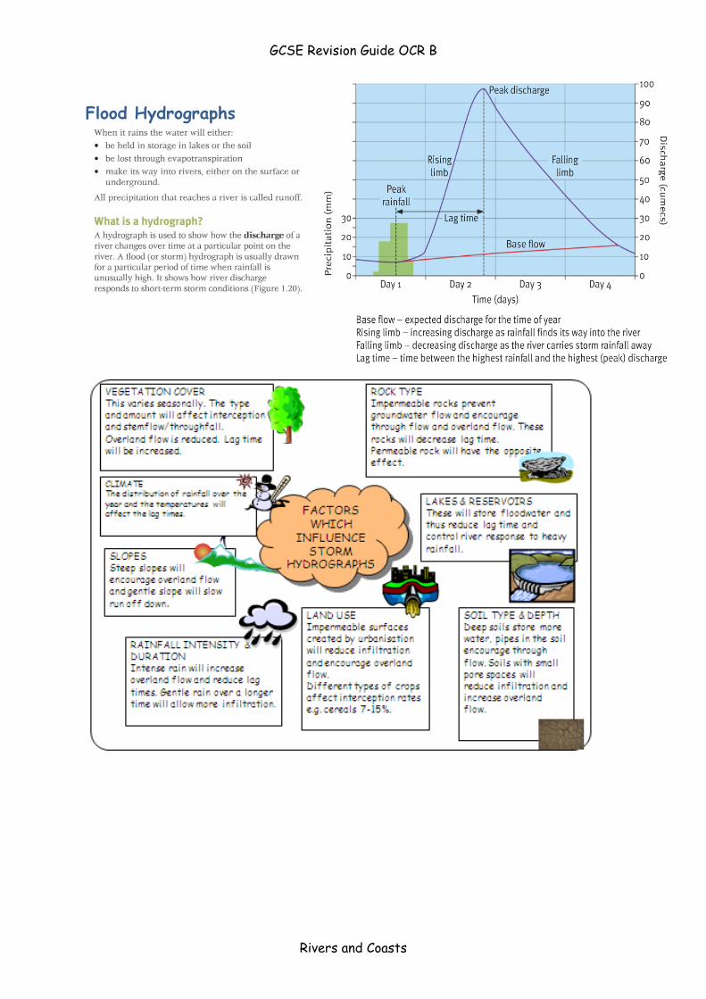
Flood Hydrographs
GCSE Revision Guide OCR B
Rivers and Coasts
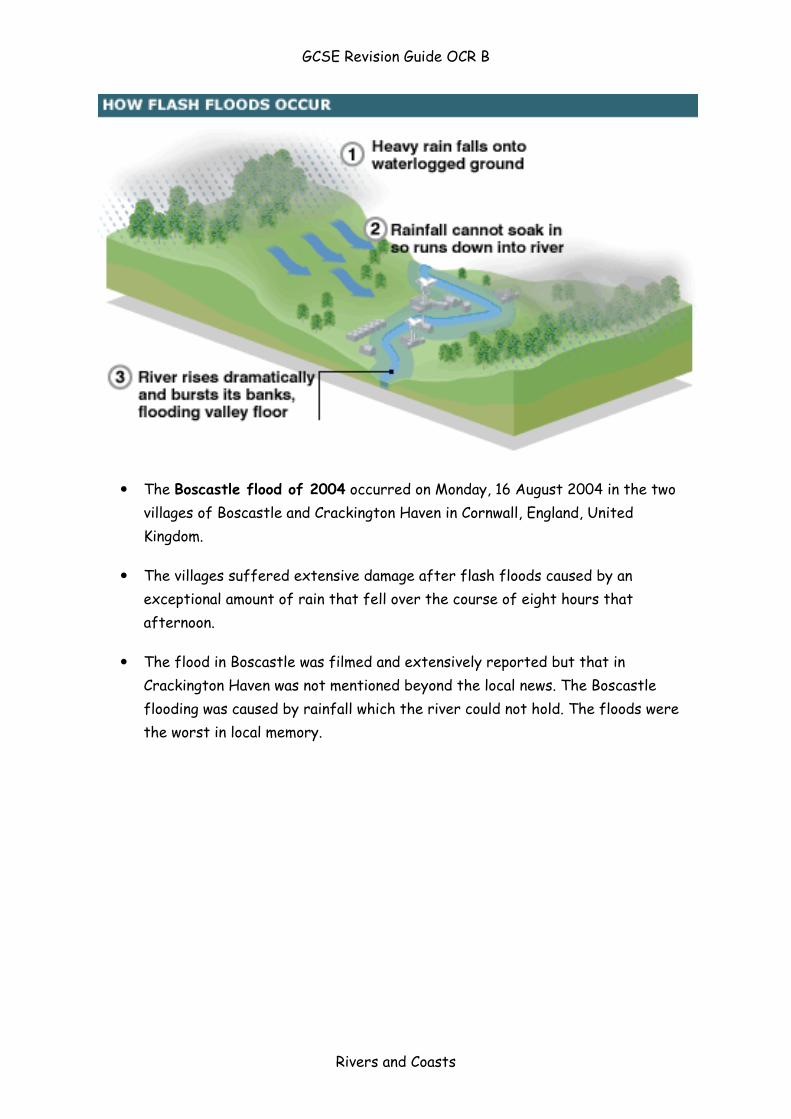
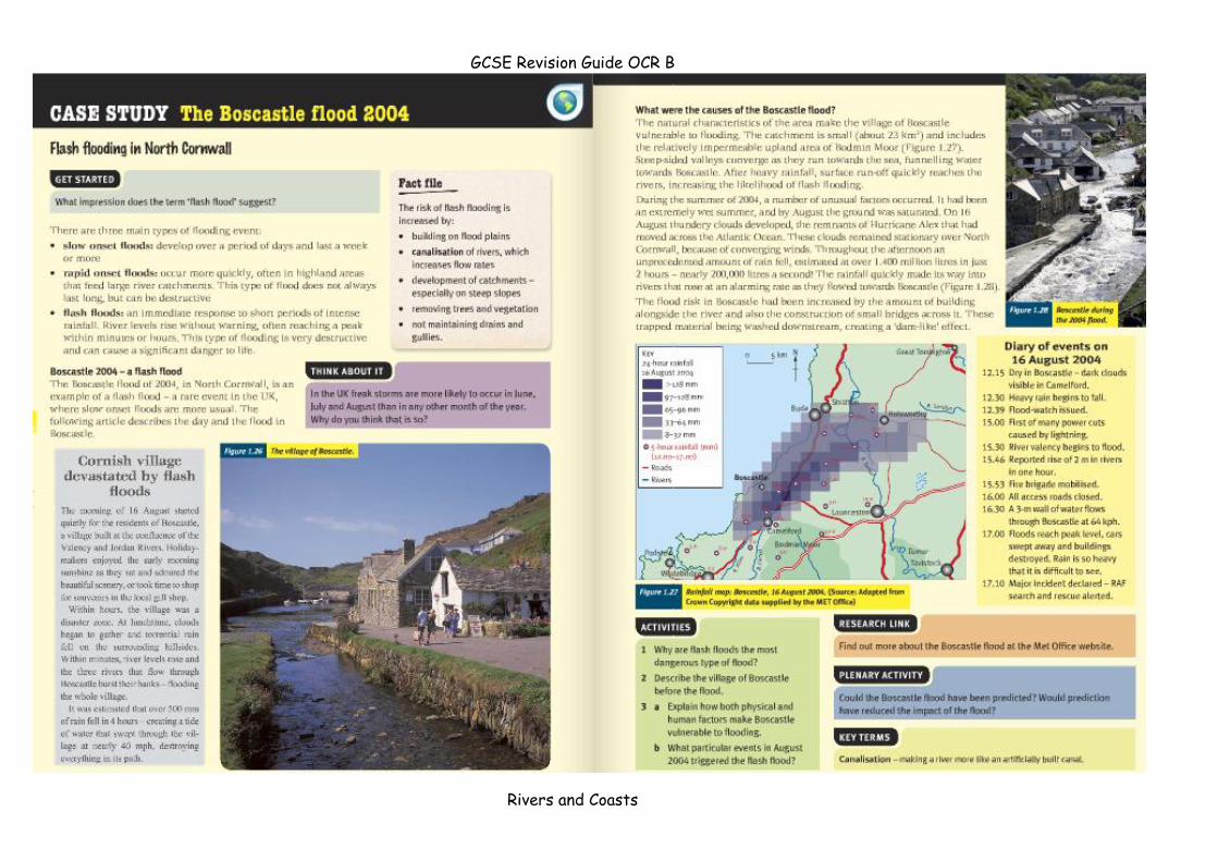
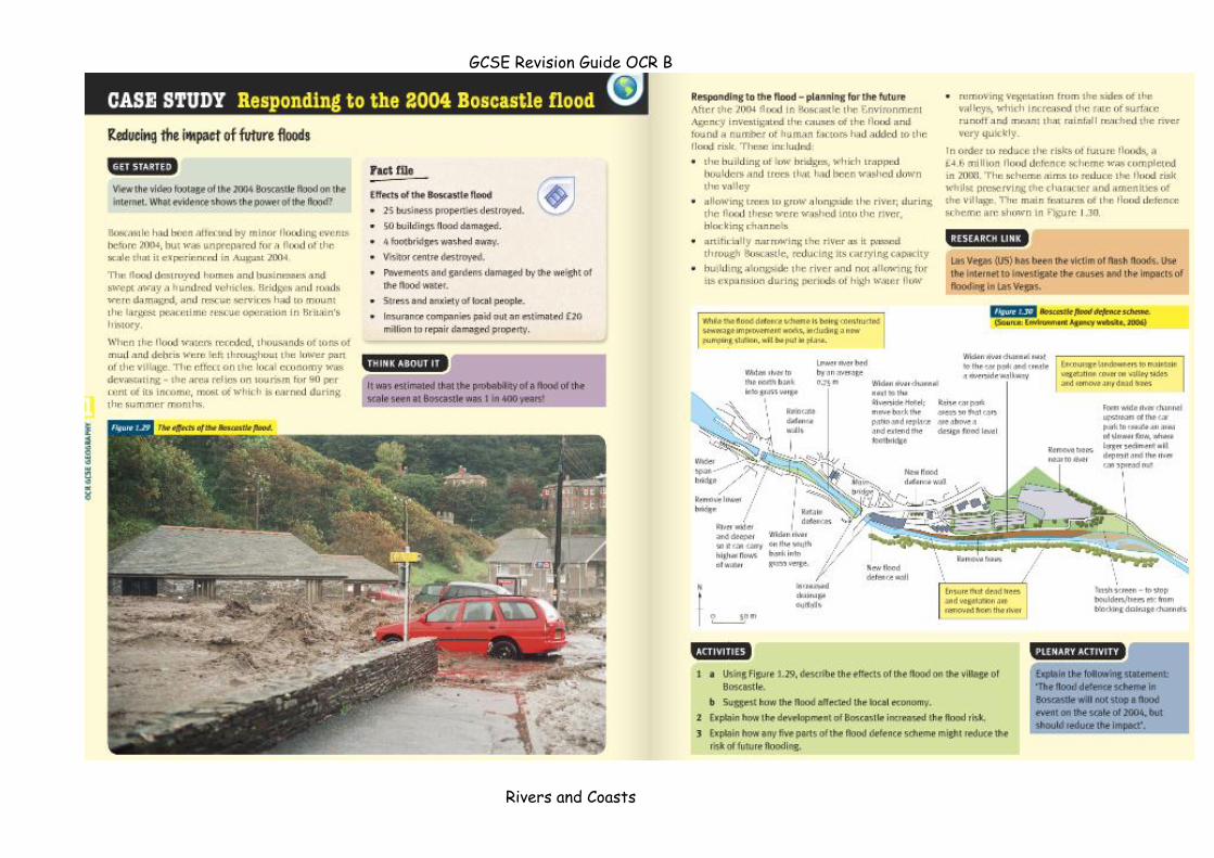
The Boscastle flood of 2004 occurred on Monday, 16 August 2004 in the two
villages of Boscastle and Crackington Haven in Cornwall, England, United
Kingdom.
The villages suffered extensive damage after flash floods caused by an
exceptional amount of rain that fell over the course of eight hours that
afternoon.
The flood in Boscastle was filmed and extensively reported but that in
Crackington Haven was not mentioned beyond the local news. The Boscastle
flooding was caused by rainfall which the river could not hold. The floods were
the worst in local memory.

GCSE Revision Guide OCR B
Rivers and Coasts
GCSE Revision Guide OCR B
Rivers and Coasts
GCSE Revision Guide OCR B
Rivers and Coasts

GCSE Revision Guide OCR B
Rivers and Coasts
GCSE Revision Guide OCR B
Rivers and Coasts
GCSE Revision Guide OCR B
Rivers and Coasts
River Management
Steps can be taken to manage flooding. Often these steps involve trying to lengthen the amount of
time it takes for water to reach the river channel, thereby increasing the lag time. Flood management
techniques can be divided into hard and soft engineering options.
'Hard' options tend to be more expensive and have a greater impact on the river and the surrounding
landscape.
'Soft' options are more ecologically sensitive. The tables summarise the main flood management
techniques.
Hard engineering options
Dam construction
Dams are often built along the course of a river in order to control the amount of discharge. Water is held back by the dam and released in a controlled way. This controls flooding.
Water is usually stored in a reservoir behind the dam. This water can then be used to generate hydroelectric power or for recreation purposes.
Building a dam can be very expensive.
Sediment is often trapped behind the wall of the dam, leading to erosion further downstream.
Settlements and agricultural land may be lost when the river valley is flooded to form a reservoir.
River engineering
The river channel may be widened or deepened allowing it to carry more water. A river channel may be straightened so that water can travel faster along the course. The channel course of the river can also be altered, diverting floodwaters away from settlements.
Altering the river channel may lead to a greater risk of flooding downstream, as the water is carried there faster.
Bitesize Home
Subjects o Art & Design
o Business Studies
o Design & Technology
o DiDA
o Drama
o English
o English Literature
o French
o Geography
o German
o History
o ICT
o Irish
o Maths
o Music
o Physical Education
o Religious Studies
o Science
o Spanish
o Welsh 2nd Language
Audio
Games
Message Boards

GCSE Revision Guide OCR B
Rivers and Coasts
Find us on Facebook
KS3 Bitesize More Bitesize BBC Teachers
Home
> Geography
> River landscapes and processes
> River flooding and management issues
Geography
River flooding and management issues
Page:
1. 1
2. 2
3. 3
4. 4
5. 5
1. Back
2. Next
River management
Hoover Dam from the air
GCSE Revision Guide OCR B
Rivers and Coasts
Steps can be taken to manage flooding. Often these steps involve trying to lengthen the amount of time it takes
for water to reach the river channel, thereby increasing the lag time. Flood management techniques can be
divided into hard and soft engineering options.
'Hard' options tend to be more expensive and have a greater impact on the river and the surrounding landscape.
'Soft' options are more ecologically sensitive. The tables summarise the main flood management techniques.
Hard engineering options
Dam
construction
Dams are often built along the course of a river in order to control the amount of discharge.
Water is held back by the dam and released in a controlled way. This controls flooding.
Water is usually stored in a reservoir behind the dam. This water can then be used to
generate hydroelectric power or for recreation purposes.
Building a dam can be very expensive.
Sediment is often trapped behind the wall of the dam, leading to erosion further downstream.
Settlements and agricultural land may be lost when the river valley is flooded to form a
reservoir.
River
engineering
The river channel may be widened or deepened allowing it to carry more water. A river channel
may be straightened so that water can travel faster along the course. The channel course of
the river can also be altered, diverting floodwaters away from settlements.
Altering the river channel may lead to a greater risk of flooding downstream, as the water is
carried there faster.
Soft engineering options
Afforestation Trees are planted near to the river. This means greater interception of rainwater
and lower river discharge. This is a relatively low cost option, which enhances the
environmental quality of the drainage basin.
Managed flooding (also
called ecological flooding)
The river is allowed to flood naturally in places, to prevent flooding in other areas
- for example, near settlements.
Planning Local authorities and the national government introduce policies to control urban
development close to or on the floodplain. This reduces the chance of flooding
and the risk of damage to property.
There can be resistance to development restrictions in areas where there is a
shortage of housing. Enforcing planning regulations and controls may be harder in
LEDCs.
Different interest groups have different views about flood management techniques:
Governments and developers often favour large hard engineering options, such as dam building. Building a
dam and a reservoir can generate income. Profits can be made from generating electric or leisure revenue.
Environmental groups and local residents often prefer softer options, such as planting trees. Soft options
cause little damage to the environment and do not involve the resettlement of communities.
GCSE Revision Guide OCR B
Rivers and Coasts
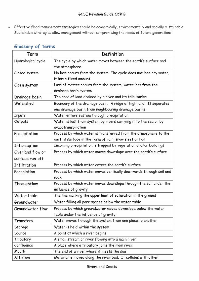
Effective flood management strategies should be economically, environmentally and socially sustainable.
Sustainable strategies allow management without compromising the needs of future generations.
Glossary of terms
TTeerrmm DDeeffiinniittiioonn
Hydrological cycle The cycle by which water moves between the earth’s surface and
the atmosphere
Closed system
No loss occurs from the system. The cycle does not lose any water,
it has a fixed amount
Open system Loss of matter occurs from the system, water lost from the
drainage basin system
Drainage basin The area of land drained by a river and its tributaries
Watershed
Boundary of the drainage basin. A ridge of high land. It separates
one drainage basin from neighbouring drainage basins
Inputs Water enters system through precipitation
Outputs Water is lost from system by rivers carrying it to the sea or by
evapotranspiration
Precipitation Process by which water is transferred from the atmosphere to the
earth’s surface in the form of rain, snow sleet or hail
Interception Incoming precipitation is trapped by vegetation and/or buildings
Overland flow or
surface run-off
Process by which water moves downslope over the earth’s surface
Infiltration Process by which water enters the earth’s surface
Percolation Process by which water moves vertically downwards through soil and
rock
Throughflow Process by which water moves downslope through the soil under the
influence of gravity
Water table The line marking the upper limit of saturation in the ground
Groundwater Water filling all pore spaces below the water table
Groundwater flow Process by which groundwater moves downslope below the water
table under the influence of gravity
Transfers Water moves through the system from one place to another
Storage Water is held within the system
Source A point at which a river begins
Tributary A small stream or river flowing into a main river
Confluence A place where a tributary joins the main river
Mouth The end of a river where it meets the sea
Attrition Material is moved along the river bed. It collides with other
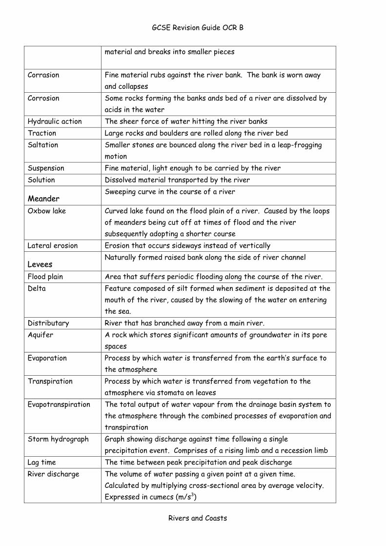
GCSE Revision Guide OCR B
Rivers and Coasts
material and breaks into smaller pieces
Corrasion Fine material rubs against the river bank. The bank is worn away
and collapses
Corrosion
Some rocks forming the banks ands bed of a river are dissolved by
acids in the water
Hydraulic action The sheer force of water hitting the river banks
Traction Large rocks and boulders are rolled along the river bed
Saltation
Smaller stones are bounced along the river bed in a leap-frogging
motion
Suspension Fine material, light enough to be carried by the river
Solution Dissolved material transported by the river
MMeeaannddeerr Sweeping curve in the course of a river
Oxbow lake Curved lake found on the flood plain of a river. Caused by the loops
of meanders being cut off at times of flood and the river
subsequently adopting a shorter course
Lateral erosion Erosion that occurs sideways instead of vertically
LLeevveeeess Naturally formed raised bank along the side of river channel
Flood plain Area that suffers periodic flooding along the course of the river.
Delta Feature composed of silt formed when sediment is deposited at the
mouth of the river, caused by the slowing of the water on entering
the sea.
Distributary River that has branched away from a main river.
Aquifer A rock which stores significant amounts of groundwater in its pore
spaces
Evaporation Process by which water is transferred from the earth’s surface to
the atmosphere
Transpiration Process by which water is transferred from vegetation to the
atmosphere via stomata on leaves
Evapotranspiration The total output of water vapour from the drainage basin system to
the atmosphere through the combined processes of evaporation and
transpiration
Storm hydrograph Graph showing discharge against time following a single
precipitation event. Comprises of a rising limb and a recession limb
Lag time The time between peak precipitation and peak discharge
River discharge The volume of water passing a given point at a given time.
Calculated by multiplying cross-sectional area by average velocity.
Expressed in cumecs (m/s3)

GCSE Revision Guide OCR B
Rivers and Coasts
Suspended load Solid particles carried within the current, but not touching the bed
Bedload The coarser material carried along the bed of a stream by the
force of the water.

GCSE Revision Guide OCR B
Rivers and Coasts