
GAS MAIN REPLACEMENT GLOUCESTER...
17
GAS MAIN REPLACEMENT GLOUCESTER GLOUCESTERSHIRE ARCHAEOLOGICAL WATCHING BRIEF For MORRISON UTILITY SERVICES CA PROJECT: 2838 CA REPORT: 09112 SEPTEMBER 2009
Transcript of GAS MAIN REPLACEMENT GLOUCESTER...

GAS MAIN REPLACEMENT GLOUCESTER
GLOUCESTERSHIRE
ARCHAEOLOGICAL WATCHING BRIEF
For
MORRISON UTILITY SERVICES
CA PROJECT: 2838 CA REPORT: 09112
SEPTEMBER 2009

GAS MAIN REPLACEMENT
GLOUCESTER GLOUCESTERSHIRE
ARCHAEOLOGICAL WATCHING BRIEF
CA PROJECT: 2838 CA REPORT: 09112
prepared by Philippa Mitcheson, Project Supervisor
date 18 September 2009
checked by Richard Young, Project Manager
date 21 September 2009
approved by Simon Cox, Head of Fieldwork
signed
date 23 September 2009
issue 01
This report is confidential to the client. Cotswold Archaeology accepts no responsibility or liability to any third party to whom this report, or any part of it, is made known. Any such party relies upon this report entirely
at their own risk. No part of this report may be reproduced by any means without permission.
© Cotswold Archaeology Building 11, Kemble Enterprise Park, Kemble, Cirencester, Gloucestershire, GL7 6BQ
Tel. 01285 771022 Fax. 01285 771033 E-mail: [email protected]

© Cotswold Archaeology
Gas Main Replacement, Gloucester, Gloucestershire: Archaeological Watching Brief
CONTENTS
SUMMARY........................................................................................................................ 4
1. INTRODUCTION ................................................................................................. 5
2. RESULTS ............................................................................................................ 7
3. DISCUSSION....................................................................................................... 7
4. CA PROJECT TEAM ........................................................................................... 7
5. REFERENCES .................................................................................................... 7
APPENDIX A: CONTEXT DESCRIPTIONS ..................................................................... 9
APPENDIX B: OASIS REPORT FORM............................................................................ 15
LIST OF ILLUSTRATIONS
Fig. 1 Site location plan (1:25,000)
Fig. 2 Trench location plan (1:1000)
3

© Cotswold Archaeology
Gas Main Replacement, Gloucester, Gloucestershire: Archaeological Watching Brief
SUMMARY
Project Name: Gas Main Replacement
Location: Gloucester, Gloucestershire
NGR: SO 8292 1838
Type: Watching Brief
Date: 27 March - 5 May 2009
Location of Archive: To be deposited with Gloucester City Museum
Site Code: GGM 09
An archaeological watching brief was undertaken by Cotswold Archaeology during
groundworks associated the replacement of a gas main along Ladybellegate Street,
Commercial Road and Kimbrose in Gloucester, Gloucestershire.
The in situ foundations of numbers 13 and 15 Ladybellegate Street were observed in two
access pits. No undisturbed deposits or features were observed during the remaining
groundworks as the works were restricted to the line of the existing service trench.
4

© Cotswold Archaeology
Gas Main Replacement, Gloucester, Gloucestershire: Archaeological Watching Brief
1. INTRODUCTION
1.1 Between March and May 2009 Cotswold Archaeology (CA) carried out an
archaeological watching brief for Morrison Utility Services along Ladybellegate
Street, Commercial Road and Kimbrose in Gloucester, Gloucestershire (centred on
NGR: SO 8292 1838; Fig. 1). The watching brief was undertaken at the request of
the Historic Environment Team, Gloucester City Council (GCC) and English
Heritage (EH) during the ‘permitted development’ of a gas main replacement.
1.2 The watching brief was carried out in accordance with a detailed Written Scheme of
Investigation (WSI) produced by CA (2009) and approved by Mr Jonathan Smith,
Historic Environment Manager, GCC. The fieldwork also followed the Standard and
Guidance for an Archaeological Watching Brief issued by the IfA (2008), the
Statement of Standards and Practices Appropriate for Archaeological Fieldwork in
Gloucestershire issued by Gloucestershire County Council Archaeology Section
(1995) and the Management of Research Projects in the Historic Environment
(MORPHE) (EH 2006). The works were monitored by Mr Phil Greatorex, Historic
Environment Record Officer, GCC, including a site visit on 20 April 2009.
The site
1.3 The site covers an area of 2ha and comprises the line of an existing gas main in the
western part of Gloucester. Archaeological interest in the site arises from its location
within the south-western corner of the Roman Colonia of Glevum and also its
proximity to the medieval monastic house of Blackfriars (Fig. 2).
1.4 The underlying solid geology of the area is mapped as Lower Lias clays of the
Lower Jurassic era with overlying alluvial drift (BGS 1975). The undisturbed
substrate was not reached during groundworks.
Archaeological Background
1.5 Known archaeological sites within this part of Gloucester include a number of
Scheduled Ancient Monuments (SAMs). These include a portion of Glevum Roman
Colonia (SAM no. GC 330) at the former Gloscat Brunswick Road campus,
comprising a small portion of the stone wall of the Roman Colonia and a number of
inhumations and pottery kilns. An archaeological evaluation conducted on the site by
CA in 2006 identified deposits associated with the defensive circuit of the Roman,
5

© Cotswold Archaeology
Gas Main Replacement, Gloucester, Gloucestershire: Archaeological Watching Brief
medieval and post-medieval town, including in situ rampart deposits and the
surrounding defensive ditch. Evidence of Roman occupation within the town,
including in situ tessellated floors was also recorded. Roman activity outside the
town was represented by a number of ditches and pits.
1.6 The route of the existing pipe lies adjacent to, and indeed crosses, the suggested
alignment of the Roman town wall. Hurst’s excavations in Ladybellegate Street in
1972 located, at the junction of Ladybellegate Street and Commercial Road, a ditch
backfilled with clays and silt which was interpreted as a Roman rampart or a robbed
out section of the wall. Recent excavations by the Gloucester County Unit at
Kimbrose along the suggested alignment of the wall did not encounter it, which
suggests that it may also have been robbed out here (thisisgloucestershire.co.uk
2009)
1.7 An archaeological excavation by CA in 2001 (Holbrook and Bateman 2008) at
nearby Parliament Street, which lies outside the South Gate of the Roman town
identified part of a cemetery that is presumed to be associated with antiquarian
records of stone cists and cremations of possible Roman date found during
construction of parts of the Dock basin (Lysons 1860, 68).
1.8 Blackfriars (SAM no. GC 116) was founded c. 1239 as a Dominican friary. After its
dissolution in 1539 it was purchased by Thomas Bell and remodelled as domestic
property. Although undoubtedly modified throughout the post-medieval period, the
principal periods of alterations were in the third quarter of the 19th century and again
in the mid 20th century during construction of the Mineral Water Works and
Westgate Motor House respectively. An extensive historical appraisal has previously
been undertaken for the site (Root 1994) and Rodwell (2009) summarises the
archaeological and historical background in her report.
Methodology
1.9 The fieldwork followed the methodology set out within the WSI (CA 2009). An
archaeologist was present during intrusive groundworks comprising the excavation
of trenches and access pits along the route of the existing gas main to replace the
pipe (Fig. 2).
1.10 Written, graphic and photographic records were compiled in accordance with CA
Technical Manual 1: Fieldwork Recording Manual (2007).
6

© Cotswold Archaeology
Gas Main Replacement, Gloucester, Gloucestershire: Archaeological Watching Brief
1.11 The archive from the evaluation is currently held by CA at their offices in Kemble
and will be deposited with Gloucester City Museum. A summary of information from
this project, set out within Appendix B, will be entered onto the OASIS online
database of archaeological projects in Britain.
2. RESULTS
2.1 The in situ limestone foundations of numbers 13 and 15 Ladybellegate Street were
observed in trenches 13 and 14 respectively. No archaeological features or deposits
were observed during the remaining groundworks. A broadly similar stratigraphy
was observed in all trenches comprising the gravel and sand backfill of the existing
service trench sealed by a layer of hardcore make-up and the tarmac road surface
or pavement surface. Undisturbed natural substrate was not encountered in any of
the trenches and no artefacts were recovered.
3. DISCUSSION
3.1 With the exception of the foundations of numbers 13 and 15 Ladybellegate Street no
archaeological deposits or features were observed during groundworks. This is due
to the fact that groundworks were entirely restricted to the existing service trench
and as a result no undisturbed deposits were encountered.
4. CA PROJECT TEAM
Fieldwork was undertaken by Sian Reynish and Philippa Mitcheson. The report was
written by Philippa Mitcheson who also compiled the archive which was prepared for
deposition by Victoria Taylor. The illustrations were prepared by Rachel Kershaw
and the project was managed for CA by Richard Young.
5. REFERENCES
BGS (British Geological Survey) 1975 Geological survey of Great Britain, Solid and Drift
Edition, Gloucester, Sheet 234 Scale 1:50,000
7

© Cotswold Archaeology
Gas Main Replacement, Gloucester, Gloucestershire: Archaeological Watching Brief
Cotswold Archaeology (CA) 2006 Gloscat, Gloucester: Archaeological Evaluation, CA
Typescript Report No. 06022
Holbrook, N. and Bateman, C. 2008 ‘The South Gate Cemetery of Roman Gloucester:
excavations at Parliament Street, 2001’, Trans. Bristol Gloucestershire Archaeol. Soc.
126, 91-106.
Hurst, H. 1984 ‘Gloucester Castle’, Trans. Bristol Gloucestershire Archaeol. Soc. 102 73-128
Lysons, S., 1860. Romans in Gloucestershire (London).
Rodwell, K. A. 2009 The Blackfriars, Gloucester: An archaeological appraisal of proposals for
structural alterations.
Root, J. 2004 Blackfriars, Gloucester: Draft Historical Appraisal Unpublished typescript
report on behalf of SWRDA
thisisgloucestershire.co.uk 2009 ‘Roman wall escapes Archaeologists’ trowels’,
http://www.thisisgloucestershire.co.uk/forest/sport/Roman-wall-escapes-
archaeologists-trowels/article-844739-detail/article.html (accessed 23 July 2009)
8

© Cotswold Archaeology
Gas Main Replacement, Gloucester, Gloucestershire: Archaeological Watching Brief
APPENDIX A: CONTEXT DESCRIPTIONS
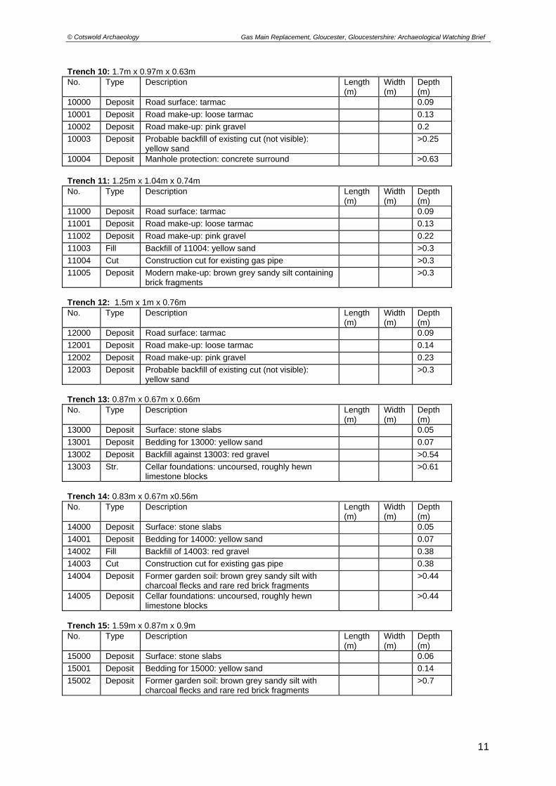
Trench measurements shown as length x width x depth
Trench 1: 4.6m x 0.8m x 0.96m No. Type Description Length
(m) Width (m)
Depth (m)
1000 Deposit Road surface: tarmac 0.1
1001 Deposit Road make-up: loose tarmac 0.1
1002 Fill Backfill of 1004: red gravel 0.57
1003 Fill Backfill of 1004: yellow sand 0.19
1004 Cut Construction cut for existing gas pipe 0.76
1005 Deposit Modern make-up: Large pieces of reinforced concrete
0.76
1006 Deposit Modern make-up: brown grey sandy silt containing brick fragments
>0.2
Trench 2: 1.4m x 1.22m x 0.9m No. Type Description Length
(m) Width (m)
Depth (m)
2000 Deposit Road surface: tarmac 0.1
2001 Deposit Road make-up: loose tarmac 0.25
2002 Cut Construction cut for existing gas pipe 0.55
2003 Fill Backfill of 2002: yellow sand 0.55
2004 Deposit Modern make-up: brown grey sandy silt containing brick fragments
>0.55
Trench 3: 1.26m x 1.7m x 0.9m No. Type Description Length
(m) Width (m)
Depth (m)
3000 Deposit Road surface: tarmac 0.1
3001 Deposit Road make-up: loose tarmac 0.25
3002 Deposit Modern make-up: brown grey sandy silt containing brick fragments
>0.55
3003 Cut Construction cut for existing gas pipe 0.82
3004 Fill Backfill of 3003: yellow sand 0.25
3005 Fill Backfill of 3003: concrete rubble 0.57
3006 Fill Fill of 3003: existing gas pipe
Trench 4: 1.26m x 1m x 0.95m No. Type Description Length
(m) Width (m)
Depth (m)
4000 Deposit Road surface: tarmac 0.1
4001 Deposit Road make-up: loose tarmac 0.25
4002 Deposit Modern make-up: brown grey sandy silt containing brick fragments
>0.55
4003 Cut Construction cut for existing gas pipe >0.85
4004 Fill Backfill of 4003: red gravel >0.85
4005 Fill Backfill of 4003: yellow sand 0.29
4006 Fill Backfill of 4003: concrete rubble 0.56
4007 Fill Fill of 4003: existing gas pipe
9

© Cotswold Archaeology
Gas Main Replacement, Gloucester, Gloucestershire: Archaeological Watching Brief
Trench 5: 3.76m x 0.46m x 1.1m No. Type Description Length
(m) Width (m)
Depth (m)
5000 Deposit Road surface: tarmac 0.1
5001 Deposit Road make-up: loose tarmac 0.26
5002 Deposit Modern make-up: brown grey sandy silt containing brick fragments
>0.74
Trench 6: 4.9m x 0.86m x 0.93m No. Type Description Length
(m) Width (m)
Depth (m)
6000 Deposit Road surface: tarmac 0.1
6001 Deposit Road make-up: loose tarmac 0.26
6002 Deposit Modern make-up: brown grey sandy silt containing brick fragments
>0.57
6003 Cut Construction cut for existing gas pipe 0.57
6004 Fill Backfill of 6003: yellow sand 0.57
Trench 7: 1.03m x 0.85m x 0.85m No. Type Description Length
(m) Width (m)
Depth (m)
7000 Deposit Road surface: tarmac 0.09
7001 Deposit Road make-up: loose tarmac 0.12
7002 Deposit Road make-up: pink gravel 0.45
7003 Deposit Probable backfill of existing cut (not visible): yellow sand
0.19
7004 Deposit Concrete drainage layer beneath 7005 >0.01
7005 Deposit Existing gas pipe >0.01
Trench 8: 10m x 0.53m x 0.97m No. Type Description Length
(m) Width (m)
Depth (m)
8000 Deposit Road surface: tarmac 0.09
8001 Deposit Road make-up: loose tarmac 0.15
8002 Deposit Road make-up: pink gravel 0.36
8003 Deposit Probable backfill of existing cut (not visible): yellow sand
>0.22
8004 Deposit Modern make-up: brown grey sandy silt containing brick fragments
>0.15
Trench 9: 4m x 1m x 0.7m No. Type Description Length
(m) Width (m)
Depth (m)
9000 Deposit Road surface: tarmac 0.09
9001 Deposit Road make-up: loose tarmac 0.15
9002 Deposit Road make-up: pink gravel 0.26
9003 Fill Backfill of 9004: yellow sand >0.17
9004 Cut Construction cut for existing gas pipe >0.17
9005 Deposit Modern make-up: brown grey sandy silt containing brick fragments
>0.17
10
© Cotswold Archaeology
Gas Main Replacement, Gloucester, Gloucestershire: Archaeological Watching Brief
Trench 10: 1.7m x 0.97m x 0.63m No. Type Description Length
(m) Width (m)
Depth (m)
10000 Deposit Road surface: tarmac 0.09
10001 Deposit Road make-up: loose tarmac 0.13
10002 Deposit Road make-up: pink gravel 0.2
10003 Deposit Probable backfill of existing cut (not visible): yellow sand
>0.25
10004 Deposit Manhole protection: concrete surround >0.63
Trench 11: 1.25m x 1.04m x 0.74m No. Type Description Length
(m) Width (m)
Depth (m)
11000 Deposit Road surface: tarmac 0.09
11001 Deposit Road make-up: loose tarmac 0.13
11002 Deposit Road make-up: pink gravel 0.22
11003 Fill Backfill of 11004: yellow sand >0.3
11004 Cut Construction cut for existing gas pipe >0.3
11005 Deposit Modern make-up: brown grey sandy silt containing brick fragments
>0.3
Trench 12: 1.5m x 1m x 0.76m No. Type Description Length
(m) Width (m)
Depth (m)
12000 Deposit Road surface: tarmac 0.09
12001 Deposit Road make-up: loose tarmac 0.14
12002 Deposit Road make-up: pink gravel 0.23
12003 Deposit Probable backfill of existing cut (not visible): yellow sand
>0.3
Trench 13: 0.87m x 0.67m x 0.66m No. Type Description Length
(m) Width (m)
Depth (m)
13000 Deposit Surface: stone slabs 0.05
13001 Deposit Bedding for 13000: yellow sand 0.07
13002 Deposit Backfill against 13003: red gravel >0.54
13003 Str. Cellar foundations: uncoursed, roughly hewn limestone blocks
>0.61
Trench 14: 0.83m x 0.67m x0.56m No. Type Description Length
(m) Width (m)
Depth (m)
14000 Deposit Surface: stone slabs 0.05
14001 Deposit Bedding for 14000: yellow sand 0.07
14002 Fill Backfill of 14003: red gravel 0.38
14003 Cut Construction cut for existing gas pipe 0.38
14004 Deposit Former garden soil: brown grey sandy silt with charcoal flecks and rare red brick fragments
>0.44
14005 Deposit Cellar foundations: uncoursed, roughly hewn limestone blocks
>0.44
Trench 15: 1.59m x 0.87m x 0.9m No. Type Description Length
(m) Width (m)
Depth (m)
15000 Deposit Surface: stone slabs 0.06
15001 Deposit Bedding for 15000: yellow sand 0.14
15002 Deposit Former garden soil: brown grey sandy silt with charcoal flecks and rare red brick fragments
>0.7
11

© Cotswold Archaeology
Gas Main Replacement, Gloucester, Gloucestershire: Archaeological Watching Brief
Trench 16: 1.49m x 0.68m x 1.39m No. Type Description Length
(m) Width (m)
Depth (m)
16000 Deposit Surface: stone slabs 0.06
16001 Deposit Bedding for 15000: yellow sand 0.15
16002 Deposit Former garden soil: brown grey sandy silt with charcoal flecks and rare red brick fragments
>1.18
Trench 17: 5.15m x 0.7m x 1.79m No. Type Description Length
(m) Width (m)
Depth (m)
17000 Deposit Surface: stone slabs 0.06
17001 Deposit Bedding for 17000: yellow sand 0.14
17002 Deposit Levelling for 17000: pink gravel 0.17
17003 Deposit Former garden soil: brown grey sandy silt with charcoal flecks and rare red brick fragments
>1.52
17004 Deposit Possible cellar backfill: brown grey sandy silt containing brick fragments
>1.52
17005 Str. Cellar wall?: Modern red brick bonded by yellow cement, 24 courses
>1.52
17006 Str. Arched modern brick culvert >1
Trench 18: 1.05m x 0.74m x 1.04m No. Type Description Length
(m) Width (m)
Depth (m)
18000 Deposit Surface: stone slabs 0.06
18001 Deposit Bedding for 16000: yellow sand 0.15
18002 Deposit Modern make-up: brown grey sandy silt containing brick fragments
>0.83
Trench 19: 1.14m x 0.6m x 1.25m No. Type Description Length
(m) Width (m)
Depth (m)
19000 Deposit Surface: red bricks 0.06
19001 Deposit Bedding for 19000: yellow sand 0.1
19002 Deposit Modern make-up: brown grey sandy silt containing brick fragments
>1.18
Trench 20: 10m x 0.6m x 0.96m No. Type Description Length
(m) Width (m)
Depth (m)
20000 Deposit Surface: red bricks 0.06
20001 Deposit Bedding for 20000: yellow sand 0.1
20002 Deposit Levelling for 20000: pink gravel 0.22
20003 Deposit Modern make-up: brown grey sandy silt containing brick fragments
>0.58
20004 Cut Construction cut for existing gas pipe >0.58
20005 Fill Backfill of 20004: pink gravel and grey sandy silt with common red brick fragments
>0.58
12

© Cotswold Archaeology
Gas Main Replacement, Gloucester, Gloucestershire: Archaeological Watching Brief
Trench 21: 15m x 0.6m x 1.3m No. Type Description Length
(m) Width (m)
Depth (m)
21000 Deposit Surface: red bricks 0.06
21001 Deposit Bedding for 21000: yellow sand 0.1
21002 Deposit Levelling for 21000: pink gravel 0.22
21003 Deposit Modern make-up: brown grey sandy silt containing brick fragments
>0.28
21004 Cut Construction cut for existing gas pipe >0.28
21005 Fill Backfill of 20004: pink gravel and grey sandy silt with common red brick fragments
>0.28
Trench 22: 27.3m x 0.5m x 1.12m No. Type Description Length
(m) Width (m)
Depth (m)
22000 Deposit Road surface: tarmac 0.1
22001 Deposit Road surface levelling layer: compacted hardcore 0.09
22002 Deposit Road surface bedding layer: concrete 0.12
22003 Deposit Modern make-up: crushed rubble 0.31
22004 Deposit Probable backfill of existing cut (not visible): yellow sand
>0.5
22005 Str. Remains of heavily disturbed red brick culvert >0.5
22006 Str. Modern concrete butting against 22005 >0.5
Trench 23: 50.8m x 0.5m x 1m No. Type Description Length
(m) Width (m)
Depth (m)
23000 Deposit Road surface: tarmac 0.1
23001 Deposit Road surface levelling layer: compacted hardcore 0.09
23002 Deposit Road surface bedding layer: concrete 0.12
23003 Deposit Probable backfill of existing cut (not visible): yellow sand
>0.5
23004 Deposit Modern make-up: rubble, red brick and limestone blocks
>0.5
23005 Deposit Modern make-up: limestone rubble and silt >0.7
Trench 24: 22m x 0.7m x 1.23m No. Type Description Length
(m) Width (m)
Depth (m)
24000 Deposit Road surface: tarmac 0.1
24001 Deposit Road surface levelling layer: compacted hardcore 0.12
24002 Deposit Road surface bedding layer: concrete 0.14
24003 Deposit Modern make-up: brown grey sandy silt containing brick fragments
>0.87
24004 Cut Construction cut for existing gas pipe 0.73
24005 Fill Backfill of 24005: yellow sand 0.35
24006 Fill Backfill of 24005: pink gravel 0.38
24007 Cut Construction cut for existing services >0.57
24008 Fill Backfill of 24007: pink gravel and blue water pipe >0.57
24009 Str. Culvert: red brick bonded with yellow cement. Partially collapsed.
>0.2
13

© Cotswold Archaeology
Gas Main Replacement, Gloucester, Gloucestershire: Archaeological Watching Brief
Trench 25: 1.52m x 1.35m x 1.05m No. Type Description Length
(m) Width (m)
Depth (m)
25000 Deposit Road surface: tarmac 0.1
25001 Deposit Road surface levelling layer: compacted hardcore 0.18
25002 Fill Backfill of 25003: yellow sand >0.77
25003 Cut Construction cut for existing gas pipe >0.77
25004 Cut Construction cut for green service >0.77
25005 Fill Backfill of 25005: pink gravel >0.77
25006 Deposit Modern make-up: brown grey sandy silt containing brick fragments
>0.77
Trench 26: 21.4m x 0.5m x 1.05m No. Type Description Length
(m) Width (m)
Depth (m)
26000 Deposit Road surface: tarmac 0.09
26001 Deposit Road surface levelling layer: compacted hardcore 0.18
26002 Deposit Probable backfill of construction cut (not visible): yellow sand
0.5
26003 Deposit Modern make-up: rubble, red brick and limestone blocks
>0.5
26004 Deposit Modern make-up: brown grey sandy silt containing brick fragments
>0.7
14

© Cotswold Archaeology
15
Gas Main Replacement, Gloucester, Gloucestershire: Archaeological Watching Brief
APPENDIX B: OASIS REPORT FORM
PROJECT DETAILS Project Name Gas Main Replacement, Gloucester,
Gloucestershire Short description
An archaeological watching brief was undertaken by Cotswold Archaeology during groundworks associated the replacement of a gas main along Ladybellegate Street, Commercial Road and Kimbrose in Gloucester, Gloucestershire. The in situ foundations of numbers 13 and 15 Ladybellegate Street were observed in two access pits. No undisturbed deposits or features were observed during the remaining groundworks as the works were restricted to the line of the existing service trench.
Project dates 27 March-5 May 2009 Project type Watching Brief Previous work None
Future work Unknown PROJECT LOCATION Site Location Gloucester, Gloucestershire Study area (M2/ha) 2ha Site co-ordinates (8 Fig Grid Reference) SO 8292 1838
PROJECT CREATORS Name of organisation Cotswold Archaeology Project Brief originator Gloucester City Council and English Heritage Project Design (WSI) originator Cotswold Archaeology Project Manager Richard Young Project Supervisor Sian Reynish and Philippa Mitcheson PROJECT ARCHIVES Intended final location of
archive Content
Physical N/A N/A Paper Gloucester City Museum WSI, pro forma registers
black and white negatives and colour slides
Digital Gloucester City Museum Digital photographs BIBLIOGRAPHY
CA (Cotswold Archaeology) 2009 Gas Main Replacement, Gloucester, Gloucestershire: Archaeological Watching Brief. CA typescript report No. 09112

Gloucestershire
PROJECT TITLE
FIGURE TITLE
N
PROJECT TITLE
SCALEDRAWN BY PROJECT NO. FIGURE NO.
COTSWOLD ARCHAEOLOGY
0 2.5km
Reproduced from the 1998 Ordnance Survey Explorer map with the permissionof Ordnance Survey on behalf of The Controller of Her Majesty's Stationery Office Crown copyright Cotswold Archaeological Trust 100002109 c
Gas Main Replacement, GloucesterGloucestershire
Site location plan
1:25,000@A4 2838RK 1
route of pipeline

Barbic
an R
oad
Commercial Road
Lady
belle
gate
Stre
et
Longsmith Street
South
gate
Stre
et
Vic
toria
Doc
k
T8T8
T7T7
T11T11
T10T10
T9T9T12T12
T13T13T14T14
T25T25
T6T6T5T5T4T4T3T3T2T2T1T1
T17T17
T21T21
T19T19
T16T16
T20T20
T15T15
T18T18
T22T22
T23T23
T24T24
T26T26
T8
T7
T11
T10
T9T12
T13T14
T25
T6T5T4T3T2T1
T17
T21
T19
T16
T20
T15
T18
T22
T23
T24
T26
184184
185185
828828
829829
830830
184
185
828
829
830
SOSO
PROJECT TITLE
FIGURE TITLE
N
COTSWOLD ARCHAEOLOGY
SCALEDRAWN BY PROJECT NO. FIGURE NO.
0 100m
Gas Main Replacement, GloucesterGloucestershire
Trench location plan
Reproduced from the 2002 Ordnance Survey Superplan map with the permissionof Ordnance Survey on behalf of The Controller of Her Majesty's Stationery Office Crown copyright Cotswold Archaeological Trust 100002109 c
1:1000@A3 2838RK 2
route of pipeline
observed trench
Blackfriars
line of Roman town wall


![CITY OF WESTMINSTER PLANNING Classification … 02 … · 13/10780/LBC – Internal works to all floors [of 59 Gloucester Terrace] including replacement of damaged plaster, plasterboard](https://static.fdocuments.in/doc/165x107/5fc151e646aa4d16e827bfd1/city-of-westminster-planning-classification-02-1310780lbc-a-internal-works.jpg)