GARFIELD COUNTY GREATER SAGE-GROUSE CONSERVATION …
51
GARFIELD COUNTY GREATER SAGE-GROUSE CONSERVATION PLAN Adopted: March 18, 2013 (via Resolution 2013-23) Garfield County Board of County Commissioners John Martin, Chairman Mike Samson Tom Jankovsky
Transcript of GARFIELD COUNTY GREATER SAGE-GROUSE CONSERVATION …

GARFIELD COUNTY
GREATER SAGE-GROUSE CONSERVATION PLAN
Adopted: March 18, 2013 (via Resolution 2013-23)
Garfield County Board of County Commissioners John Martin, Chairman
Mike Samson Tom Jankovsky
Garfield County Greater Sage-Grouse Conservation Plan Page 2
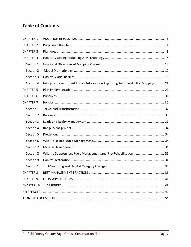
Table of Contents
CHAPTER 1 ADOPTION RESOLUTION ....................................................................................................... 3
CHAPTER 2 Purpose of the Plan ............................................................................................................... 8
CHAPTER 3 Plan Area ............................................................................................................................... 9
CHAPTER 4 Habitat Mapping, Modeling & Methodology ...................................................................... 14
Section 1 Goals and Objectives of Mapping Process .......................................................................... 14
Section 2 Model Methodology .......................................................................................................... 17
Section 3 Habitat Model Results ......................................................................................................... 19
Section 4 Interpretations and Additional Information Regarding Suitable Habitat Mapping ............ 26
CHAPTER 5 Plan Implementation........................................................................................................... 27
CHAPTER 6 Principles ............................................................................................................................. 30
CHAPTER 7 Policies ................................................................................................................................ 32
Section 1 Travel and Transportation................................................................................................... 32
Section 2 Recreation ........................................................................................................................... 33
Section 3 Lands and Realty Management .......................................................................................... 33
Section 4 Range Management ............................................................................................................ 34
Section 5 Predation ............................................................................................................................. 34
Section 6 Wild Horse and Burro Management ................................................................................... 34
Section 7 Mineral Development ......................................................................................................... 35
Section 8 Wildfire Suppression, Fuels Management and Fire Rehabilitation .................................... 35
Section 9 Habitat Restoration ............................................................................................................. 36
Section 10 Monitoring and Habitat Category Changes ................................................................... 37
CHAPTER 8 BEST MANAGEMENT PRACTICES ........................................................................................ 38
CHAPTER 9 GLOSSARY OF TERMS .......................................................................................................... 40
CHAPTER 10 APPENDIX ........................................................................................................................ 46
REFERENCES ................................................................................................................................................ 47
ACKNOWLEDGEMENTS ............................................................................................................................... 51

Garfield County Greater Sage-Grouse Conservation Plan Page 3
CHAPTER 1 ADOPTION RESOLUTION

Garfield County Greater Sage-Grouse Conservation Plan Page 4
Garfield County Greater Sage-Grouse Conservation Plan Page 5

Garfield County Greater Sage-Grouse Conservation Plan Page 6

Garfield County Greater Sage-Grouse Conservation Plan Page 7

Garfield County Greater Sage-Grouse Conservation Plan Page 8
CHAPTER 2 Purpose of the Plan
The purpose of the Garfield County Sage-Grouse Conservation Plan (the Plan) is to provide private and public land owners with land management principles, policies, incentives, and best management practices based on the best available science that are tailored to fit Garfield County’s unique landscape and habitat characteristics for the betterment of the species.
Because of the County’s unique landform, elevation, topography and vegetative cover that differ drastically from the rest of the national range, the Board of County Commissioners (the Board) commissioned an in-depth analysis, based on best available science, to determine what suitable habitat exists in the County at a refined level never before completed to obtain a very realistic and accurate picture of what suitable habitat exists.
The land located within the Plan Area is primarily held in private ownership with the Bureau of Land Management (BLM) representing the only public land. Coincidentally, most of the public lands and private property in this area contain significant oil and gas resources that are actively being developed or are intended for future development. By design, this Plan will continuously adapt as science expands for the species and habitat as well as acknowledging advances in energy exploration technology that continue to reduce the disturbance footprint. Ultimately, this will result in adaptive land management policies intended for the survival and success of the species.
As implemented, this Plan shall require these policies and principles be applied on public lands as ‘regulatory assurances’ through Coordination and they will be applied on private lands as ‘incentive-based assurances.’ In this way, this Plan serves as a planning tool for private land owners by informing and improving their conservation efforts on a voluntary basis with the added opportunity to amend this Plan as a result of their stewardship successes.
Finally, because of the scientifically sound habitat modeling conducted to identify the suitable habitat in Garfield County which is the basis of this Plan, the County intends that this Plan may serve as a model for other counties located within the national range. Furthermore, this Plan explicitly relies on the Coordination process that requires federal and state agencies with sage-grouse management responsibilities in Garfield County to ensure that their plans are consistent with this Plan. Ultimately, the Coordination process will be the vehicle that brings disparate parties together with the same intent on making sound land management decisions that benefit the sage-grouse and its habitat recognizing that there are multiple uses being managed at the same time.

Garfield County Greater Sage-Grouse Conservation Plan Page 9
CHAPTER 3 Plan Area
The Plan Area includes the area where the suitable habitats are located within Garfield County and are primarily limited to the western region of the county in occupied habitats on the Roan Plateau (see Figure 1, below). Approximately 85% of the land within the Plan Area does not support habitat characteristics necessary to support the sage-grouse, but within this area there are small but important patches of suitable habitat. In order to ensure that habitat containing, or has the potential to contain, sage-grouse is properly managed; this Plan and the associated maps identify distinct habitat categories in the Plan Area including Suitable Habitat, Temporarily Disturbed, Unoccupied Suitable Habitat, and Lek No Surface Occupancy (NSO) Habitat.

Garfield County Greater Sage-Grouse Conservation Plan Page 10
Figure 1: Plan Area

Garfield County Greater Sage-Grouse Conservation Plan Page 11
Habitat Categories Sage-grouse require somewhat different seasonal habitats distributed across sagebrush-dominated communities to complete their life cycle. All of these habitats consist of, are associated with, or are immediately adjacent to, sagebrush. The Plan utilizes the following habitat categories to define habitats in the Plan area, utilizing recent and pertinent research from the Plan area.
1. Suitable Habitat
Suitable Habitat includes all seasonal habitats (including lekking, nesting, brood rearing/summer and winter habitats) within the Plan area. Specifically, Suitable Habitat includes:
Sagebrush cover is from 10 to 50% Cover of Mixed Mountain Shrubs is not more than 10% Distance to nearest Forest is over 100 meters Distance to Shrubby Woodlands is over 50 meters Grass/forb dominated habitats (with <10% sagebrush cover) within 30 meters of
sagebrush habitat Contiguous habitats >3 acres in size, or part of a block of Suitable Habitats in close
proximity
Sagebrush- includes all species and sub-species of the genus Artemisia except the mat-forming sub-shrub species frigida.
Mixed Mountain Shrubs- are shrublands dominated by Utah serviceberry (Amelanchier utahensis), Saskatoon serviceberry (A. alnifolia), mountain mahogany (Cercocarpus montanus), oakbrush (Quercus gambelii), bitterbrush (Purshia tridentata), and may have a sagebrush component. Mapped Mixed Mountain Shrublands have greater than 10% cover of these non-sagebrush shrub species, as this is the threshold at which sage-grouse show a strong avoidance of this community type.
Shrubby Woodlands- are vegetation communities dominated by oakbrush or pinyon (Pinus edulis) and Rocky Mountain juniper (Sabina scopulorum) or Utah juniper (S. osteosperma) types. Mapped Shrubby Woodlands have greater than 10% cover of pinyon-juniper, as this is the threshold at which sage-grouse show a strong avoidance of this community type.
Forests- in the Plan area include contiguous stands larger than 1/2 acre of aspen (Populus tremuloides), Douglas-fir (Pseudotsuga menziesii), mixed conifers (including, but not limited to Douglas-fir, Engelmann spruce [Picea engelmannii], subalpine fir [Abies bifolia] and ponderosa pine [Pinus ponderosa]), pinyon-juniper woodlands, and oakbrush.
2. Seasonal Habitats
While sage-grouse generally change their use of micro-scale habitats throughout the year, sage-grouse may be found within Suitable Habitat at any time of the year. The following definitions are used for seasonal habitats, and were utilized in the development of the Seasonal Habitats Maps.

Garfield County Greater Sage-Grouse Conservation Plan Page 12
Nesting- Nesting habitat is generally moderately sized patches of denser and taller sagebrush, further away from roads and other activity areas. Specifically:
Sagebrush cover is from 20 to 50% Cover of Mixed Mountain Shrubs is not more than 10% Distance to nearest Forest is over 100 meters Distance to Shrubby Woodlands is over 50 meters
Brood Rearing- Brood rearing habitats are utilized after chicks have hatched, and are generally more mesic (moist) areas with a higher percentage of forbs and grasses which help provide higher densities of insects, plant material, and seeds for chicks, hens, as well as males during the summer and early fall months. Specifically:
Sagebrush cover is from 10 to 30% Cover of Mixed Mountain Shrubs is not more than 10% Distance to nearest Forest is over 100 meters Distance to Shrubby Woodlands is over 50 meters
Winter Habitat- Winter habitat is generally utilized by sage-grouse from November through early April. It is primarily determined by the depth and persistence of snow cover. During more severe winters, snow can limit winter habitat to wind-swept ridges and patches of the tallest sage-brush. During the winter sage-grouse food is strictly limited to sage-brush. However, sage-grouse can do quite well on winter diets. Specifically:
Sagebrush cover is >25% Cover of Mixed Mountain Shrubs is not more than 10% Distance to nearest Forest is over 100 meters Distance to Shrubby Woodlands is over 50 meters Specific areas where sage-grouse congregate should be mapped as information
becomes available
3. Temporarily Disturbed
Temporarily disturbed areas have seen recent vegetation disturbance activities (such as pipeline corridors and wildfire events) and may not support sagebrush cover at a density or height suitable for sage-grouse use. If these areas occur within a block of Suitable Habitat, they will be considered Temporarily Disturbed, and still would be considered as long-term as Suitable Habitat. Temporarily Disturbed habitat will need to be tracked spatially within the Plan area.
4. Unoccupied Suitable Habitat
CPW, the BLM, and energy companies within the Plan area have conducted multiple research and investigation efforts to determine areas where sage-grouse currently occupy habitats and these areas are relatively well-known. There are also areas that support Suitable Habitat, but for which sage-grouse currently do not occupy these areas or the status of occupancy are unknown. These areas, for whatever reason, are deemed less-than-optimal by sage-grouse (e.g., due to predation

Garfield County Greater Sage-Grouse Conservation Plan Page 13
pressures, non-lethal disturbances, an ineffectively small area of suitable habitat, etc.) and thus sage-grouse prefer to utilize other areas. These areas may also be degraded with regards to habitat, and do not meet life-history requirements for sage-grouse, or (as an example) may have low levels of invasion by pinyon-juniper trees, and is therefore ineffective habitat.
5. Lek No Surface Occupancy Habitat
Lek No Surface Occupancy (NSO) Habitats are areas where an Active Lek has been cited (determined by the County to exist), which is not located in Temporarily Disturbed or Unoccupied Suitable Habitat.

Garfield County Greater Sage-Grouse Conservation Plan Page 14
CHAPTER 4 Habitat Mapping, Modeling & Methodology
This Chapter details the process by which Suitable Habitats for Greater Sage-Grouse were developed within the Plan Area.
Section 1 Goals and Objectives of Mapping Process The habitat mapping provided by State and Federal agencies in 2012 for Greater Sage-Grouse in the Plan Area previously occurred at a landscape level that did not accurately address the unique topography of the Roan Plateau, or provide planning information at resolution accurate enough for County to use in the Plan, and for relevant land-use planning activities potentially occurring within the Plan area. Because of the significant implications on land use and ongoing land management, the most accurate delineation of habitat was deemed necessary by the County. This habitat mapping process followed the latest and most relevant peer-reviewed habitat mapping process available for mapping large and diverse areas.
The project objective was to locate and quantify the availability of suitable sage-grouse habitat on the Roan Plateau within Garfield County, independent of analyses already performed by State and Federal agencies, as well as independent of other habitat mapping efforts produced by energy companies, but still incorporating peer-reviewed and accepted habitat parameters for sage-grouse produced by the scientific community.
The process incorporated the following:
• Phase 1: Conducted a literature search and determined relevant criteria for identifying suitable habitat for the greater sage-grouse within northern Colorado. Built multi-criteria suitability spatial models incorporating all relevant criteria to model areas for general habitat suitability.
• Phase 2: Perform field verifications to validate accuracy of spatial data to on-the-ground habitat conditions (planned for spring 2013)
• Phase 3: Build multi-criteria suitability spatial models to delineate specific greater sage-grouse habitat types, including summer and winter habitats (e.g., Nesting, Brood Rearing, and Winter Habitat areas). Understanding the spatial locations of specific habitat types will help identify areas occupied by greater sage-grouse populations across the course of a typical year (planned for spring 2013)
The 220,969-acre Plan Area occurs on the Roan Plateau within Garfield County as shown in Figure 1. The spatial extent of the Plan Area represents all areas within the County currently indicated as Preliminary Priority Habitat (PPH) as mapped by CPW and adopted by the BLM. Of the

Garfield County Greater Sage-Grouse Conservation Plan Page 15
220,969-acre PPH analysis area, 61,338 acres (28%) are BLM Lands, while the remaining 159,631 acres (72%) are private and state lands.

Garfield County Greater Sage-Grouse Conservation Plan Page 16
Table 1: Literature References and Habitat Parameters Employed
Author General Habitat
Lek/ Breeding Nesting Brood Rearing
Summer Summer-Fall Winter
Apa 20101 Sagebrush - - 37% 30% - -
Total Shrub - - 68% 34% - - Walker 2010
Sage dominance - 57-96% (100m) - 50-92% (100m) - - Sage+grass+MMS - 90-98% (350m) - 88-91% (350m) - -
Forest - 0.5-6.5% (350m)
- 4.5-11.5% (740m)
- -
MMS2 - 0-1.2% (740m) - 0-1.3% (740m) - - CO Sage-Grouse Consv. Plan 2008
Sagebrush cover - 20-30% around leks
15-38% avg. 27%
10-15% 20-25% for
escape >15% >25%
NTT Report3 Sagebrush cover - - - 10-25% - -
Connelly et al. 2000 Sagebrush cover - 15-25% - 10-25% - 10-30% Grass/forb cover - >25% - >15% - NA
Area with suitable habitat - >80% - >40% - >80%
Connelly et al. 2011 Sagebrush cover 12-48% Follow Connelly et al. 2000 Grass/forb cover - Follow Connelly et al. 2000
Garfield County Habitat Map
Sagebrush cover 10-50%
Not limiting, not mapped
20-50% 10-30% >25% MMS cover <10% <10% <10% <10%
Slopes <20% <20% <20% <20% Dist. To Forest >100m >100m >100m >100m
Dist. To Shrubby Woodlands >50m >50m >50m >100m

Garfield County Greater Sage-Grouse Conservation Plan Page 17
Section 2 Model Methodology To model general greater sage-grouse habitats in the Roan Plateau PPH area in Garfield County, a multi-criteria suitability model was employed in a Geographic Information System (GIS) utilizing all relevant criteria. The relevant criteria are input in the suitability model in the form of individual spatial datasets that are weighted by importance in determining suitable habitat relative to all other criteria datasets. Furthermore, the values of each criteria dataset are ranked by a scale of 0 – 10, with higher values indicating increased habitat suitability for all criteria datasets.
While numerous criteria exist in determining seasonal habitat types (e.g., brood rearing, summer and winter ranges) for the greater sage-grouse, the Phase 1 General Habitat model attempts to capture the aggregate of all specific habitat types (i.e., overall habitat). As such, the Phase 1 Suitable Habitat model employs only those criteria common to all habitats.
Publicly available datasets depicting vegetation cover types across the project area were initially employed in the spatial models; the datasets include LANDFIRE vegetation cover, obtained from the USGS, and the Colorado Vegetation Classification Project (CVCP), obtained from CPW. However, review of the data revealed widespread inaccuracies in correctly identifying and classifying the vegetative cover types when compared to high-resolution aerial photography. In addition, the cell resolution of both the LANDFIRE and CVCP datasets, measured at 30-meters and 25-meters, respectively, and is too coarse to accurately delineate broader vegetation communities at the local scale. As a result, the spatial coarseness combined with the mistyped vegetative covers inherent to both datasets led to the conclusion that the datasets were inadequate in appropriately identifying suitable vegetative cover types at the local scale.
In an effort to increase the accuracy of the spatial data depicting existing vegetative cover types within the Plan Area, an unsupervised image classification process involving color-infrared aerial photography was performed to better represent vegetation communities. Image classification is achieved by first combining multiple bands from the same image to detect reflectance values, and subsequently clustering the reflectance values into separate classes based on a similar range in spectral values.
Color-infrared photography provides four bands that detect specific wavelength ranges of reflected solar radiation; three bands within the visible light spectrum (i.e., Red, Green and Blue), and a fourth near infrared band that measures reflected radiation beyond the visible light spectrum. The band combinations can yield a variety of properties and characteristics of the objects and vegetation interpreted in the aerial photography. For example, using the near infrared, red and green spectral bands to produce a ‘false color’ image (e.g., mapping the near infrared, red and green bands to RGB) provides high contrast between heavily vegetated areas (e.g., aspen, mixed conifer, mixed mountain shrubs), less vegetated areas (grasslands, shrublands, etc.) and barren areas. Furthermore, within forested areas, image combinations

Garfield County Greater Sage-Grouse Conservation Plan Page 18
utilizing the near infrared band help to distinguish between deciduous and coniferous tree species. Deciduous trees contain more chlorophyll and therefore reflect an intense bright red, while coniferous trees contain less chlorophyll and reflect lighter tones of red, magenta or pink. Within grassland and shrub communities, delineations were detected in a similar manner; the higher presence of chlorophyll present in grasses and forbs caused these communities to reflect much brighter as compared to adjacent sage communities.
The image classification for this project was performed on four-band, 1-meter resolution photography acquired in 2011 from the USDA as part of the National Agriculture Imagery Program (NAIP).
Table 2: Habitat Model Components CRITERIA Weight Rank Slope 25% 0% – 10% 10 10% - 20% 9 35%+ 0 Distance to Forest 25%
>350 Meters 10 275 – 350 Meters 9 100 – 275 Meters 8 0 – 100 Meters 3 In Forest 0 Canopy Cover 10% Tree Cover > 10% & < 20%, Shrub & Herb Cover > 20% & < 40% 10 Herb Cover > 50% & < 60% 9 Shrub & Herb Cover > 10% & < 20% 8 Tree Cover > 20% & < 30%, Shrub Cover > 40% & < 50% 7 Tree Cover > 30% & < 40%, Shrub Cover > 50% & < 60% 5 Shrub Cover > 60% & < 70% 4 Agricultural, Shrub Cover > 70% & < 80% 3 Shrub Cover > 80% & < 90% 2 Barren 1 All Other 0 Vegetation 40% Sagebrush-Dominated 10 Sage-Dominated/Grass Mix 9 Grass-Dominated/Sage Mix 7 Sage-Dominated/Mixed Mtn Shrubs 6 Grasses & Barren areas w/in 20 Meters of Sage Community 5 Grass-Dominated/Mixed Mtn Shrubs w/in 20 Meters of Sage Community 3 Grasses & Barren areas over 20 Meters from Sage Community 0 Aspen, Mixed Conifer, Mixed Mtn Shrubs, Water 0
The Suitable Habitat model utilized the above-listed criteria, employing the data weights and ranks listed. A value of 0 would be completely unsuitable for sage-grouse, while a value of 10

Garfield County Greater Sage-Grouse Conservation Plan Page 19
would be the most valuable habitat for sage-grouse. In order to produce a meaningful model, we eliminated all vegetation polygons having areas less than one (1) hectare and buffered the resulting forested areas to delineate four distinct zones around forest perimeters; 0 – 100 meter, 100 – 275 meters, 275 – 350 meters, and more than 350 meters from forested vegetation.
Section 3 Habitat Model Results The results of the multi-criteria suitability model are produced as a GRID dataset, containing cells with values ranging from 0 – 10, with higher values indicating higher levels of habitat suitability. The Suitable Habitat model results considered all cells with values of 9 or 10 as suitable habitat for sage-grouse.
The initial unmodified Suitable Habitat model results produced 13,945 polygons totaling 21,155 acres (~10% of the analysis area) of Suitable Habitat. The initial results were subsequently filtered to remove areas not meeting a defined area threshold (areas less than 1 hectare), as well as those areas depicted as long, linear features with minimal width that generally occur in deeply incised swales and valley bottoms where greater sage-grouse would generally not occur (i.e., areas with ineffective habitat due to the dominance of the area by unsuitable habitats and edge effects). As a result, the filtered results produced 1,140 polygons totaling 17,891 acres (~8% of the analysis area) of suitable habitat. Furthermore, of the 17,891 acres of filtered suitable habitat, 5,325 acres (~30% of modeled suitable habitat) occur on BLM Lands, while the remaining 12,566 acres (~70% of modeled suitable habitat) occurred on private lands.
The following Figures depict the data utilized in the model and the results of the initial habitat model.

Garfield County Greater Sage-Grouse Conservation Plan Page 20
Figure 2: Vegetation Community Types

Garfield County Greater Sage-Grouse Conservation Plan Page 21
Figure 3: Forested Vegetation Community Types

Garfield County Greater Sage-Grouse Conservation Plan Page 22
Figure 4: Sagebrush-Dominated Habitats

Garfield County Greater Sage-Grouse Conservation Plan Page 23
Figure 5: Steep Slope Areas

Garfield County Greater Sage-Grouse Conservation Plan Page 24
Figure 6: Resultant Suitable Habitat in Plan Area

Tabular Data on Suitable Habitat Model
The following table quantifies the results of vegetation mapping and applying restrictions to potential sagebrush community types.
Table 3: Suitable Habitat Vegetation
Remapped Vegetation Sage Cover (irrespective of size and slope)
Value Type Count Acres % of SA 10 Pure Sage 6,328.0 39,318.0 18%
9 Sage-Dominated/Grass Mix 5,206.0 11,057.4 5% 7 Grass-Dominated/Sage Mix 6,715.0 13,969.9 6% 6 Sage/Mixed Mtn Shrub 7,481.0 17,227.1 8% Total 25,730.0 81,572.4 37%
Sage Cover on < 20% Slopes (irrespective of size) Value Type Count Acres % of SA
10 Pure Sage 5,257.0 16,695.9 8% 9 Sage-Dominated/Grass Mix 4,339.0 4,485.4 2% 7 Grass-Dominated/Sage Mix 5,330.0 4,626.3 2% 6 Sage/Mixed Mtn Shrub 5,602.0 4,523.9 2%
Total 20,528.0 30,331.5 14% Sage Cover > 3 Ac. on < 20% Slopes
Value Type Count Acres % of SA 10 Pure Sage 2,674.0 14,200.8 6%
9 Sage-Dominated/Grass Mix 2,593.0 3,726.5 2% 7 Grass-Dominated/Sage Mix 2,485.0 3,188.7 1% 6 Sage/Mixed Mtn Shrub 2,855.0 3,237.6 1%
Total 10,607.0 24,353.6 11%
The sagebrush cover types are a summary of all the cover types that have a sagebrush component, and therefore would likely be considered Suitable Habitat. This presents a good summary of vegetation conditions in the Plan Area potentially suitable for grouse use. To summarize, there are approximately 81k acres of sagebrush (or 37% of the Plan Area), but of that 30k acres are on slopes <20%, and of that, there are approximately 24k acres of sagebrush areas that are in polygons >3 acres.
The model builds in the additional criteria of canopy cover of sagebrush and the distance to Forests and Woody Shrublands. With the inclusion of buffering Forests and canopy cover, the final results are that approximately 15,525 acres or 7% of the PPR area is mapped as suitable habitat (pending additional QA/QC procedures).
Garfield County Greater Sage-Grouse Conservation Plan Page 26
Section 4 Interpretations and Additional Information Regarding Suitable Habitat Mapping Subsequent to data refinement, additional models specific to each seasonal habitat will be developed, incorporating criteria that uniquely identifies the distinct characteristics of each habitat. The seasonal habitat model results should predict suitable habitats available to greater sage-grouse populations across an annual timeframe. Lastly, a least-cost-path model will employ the locations of the resulting habitat zones, as well as a full list of criteria depicting friction to movement across the landscape, to determine linkage corridors to disconnected habitat zones and probable movements of the greater sage-grouse between seasonal habitats.

Garfield County Greater Sage-Grouse Conservation Plan Page 27
CHAPTER 5 Plan Implementation
The Garfield County Board of County Commissioners (the BOCC) shall be responsible for managing and implementing the Plan. The principles and policies contained within the Plan shall be used to address functional surface disturbance for the four sage-grouse habitat categories (see Chapter 3) in the Plan Area within the political boundaries of Garfield County (the County) as depicted on Figure 1.
A. Implementation on Public Lands
The principles and policies contained within this Plan shall be required for the management of sage-grouse and its habitat on public lands that contain suitable habitat as depicted in Figure 6.
B. Implementation on Private Lands
For private lands in the Plan Area, the principles and policies contained within this Plan are considered voluntary and are encouraged to be implemented through Best Management Practices (BMPs) and conservation measures for the management of sage-grouse and its habitat as defined as suitable habitat and depicted on Figure 6.
C. Implementation Process
This policy shall serve as the primary conservation policy for the sage-grouse in Garfield County. The BOCC has the unique authority to require federal and state agencies to coordinate their plans and policies with the County, therefore ensuring that all entities with responsibilities for the species and habitat are working together efficiently and effectively and not pursuing counter-productive measures. This Plan is designed to serve as the comprehensive planning document for the sage-grouse in Garfield County.
While recognizing that each agency has its own planning processes, federal agencies are required to not only consider the County’s policies, but work to resolve conflicts and make federal plans consistent with the county’s policies (43 USC 1712). Federal statues require that the County’s policies are integrated into the federal conservation strategy for the sage-grouse on federal lands within the County’s borders. The State of Colorado has given Garfield County planning authority over lands within the County’s borders, ensuring the coordination of the County’s sage-grouse policy with state agencies as well.
Implementation of this plan will be conducted through a formal coordination process with all agencies that have jurisdiction and/or responsibility for the sage-grouse and/or its habitat. The plan will serve as the unifying and primary planning document.

Garfield County Greater Sage-Grouse Conservation Plan Page 28
Specifically, the BOCC shall utilize this Plan as a tool to evaluate and provide comment regarding land management decisions on both public and private lands for which it has land management jurisdiction. More specifically, the BOCC shall utilize this Plan in evaluating land use / development applications submitted under the County’s development regulations as well as ensuring that any federal or state land management action remains consistent with this Plan.
D. Plan Update / Amendment Process
This Plan is managed under adaptive management principles where it is understood that the scientific understanding of the species and its habitat in will be continually expanding. This requires that the policies, principles, and best management practices of this Plan be frequently evaluated and modified as warranted by the best available science appropriate for the unique Plan Area in Garfield County.
1. Annual Review
The BOCC will conduct an annual Coordination review, commencing one year from the date of enactment of this Plan with the federal and state agencies that have habitat or species responsibilities within the Plan Area. This review process will evaluate the availability and condition of habitats, direct and indirect impacts, conservation measures, policies and best management practices being implemented by each agency for their effectiveness and applicability to the Plan Area.
Also incorporated in this review is any new science and, if warranted, modifications to the best management practices, policies, and conservation incentives within the Plan. The Coordination review shall take place in government-to-government meetings between the different agencies and the BOCC.
The BOCC will also initiate meetings with entities that have private property interests in the Plan Area for the purpose of analyzing their conservation efforts and effectiveness, as well as any new science they may be able to contribute to the process to ensure Plan updates are also based on the best available science.
The consideration of changes to the Plan shall be discussed in these coordination meetings, followed up with a draft Plan update to be shared with all agencies through the Coordination process and private entities with private property interests for input. The input shall be considered and incorporated where appropriate into a formal written Plan update to be reviewed approved by the BOCC within 120 days of the submittal date of the requested change.

Garfield County Greater Sage-Grouse Conservation Plan Page 29
2. New Scientific Information
If at any time between the annual review period where federal or state agencies, or private entities with property interests in the Plan Area become aware of or acquire new science regarding the species or its habitat in the Plan Area within Garfield County that may warrant changes to the best management practices, conservation measures, or policies within this Plan, then they shall submit a written report to the County, including the scientific review and supporting data, for the County’s consideration. If the BOCC finds changes to the Plan are warranted then it can initiate a formal review of the Plan in coordination with all entities.
3. Additional Coordination Meetings
Additional Coordination meetings are encouraged beyond the required annual review and new scientific information review for the purpose of keeping apprised of and working to resolve all issues impacting the sage-grouse.

Garfield County Greater Sage-Grouse Conservation Plan Page 30
CHAPTER 6 Principles
The Plan Principles are designed to inform and guide all decision making, regardless of specific issue or impact, as they relate to the well-being of the sage-grouse in Garfield County.
1. The sage-grouse habitat in Garfield County is naturally fragmented, as a result of topography and the patchy nature of sagebrush, non-sagebrush shrubs, meadows, aspen, and conifers in the Plan area. Expanses of contiguous sage-brush, necessary to support a large stable population (as described by the Service in their March 2010 candidate determination notice), do not exist in Garfield County. Additionally, the sage-grouse population inhabiting Garfield County is a peripheral population located on the far southeastern edge of the species range. As a result, the stewardship of the population requires detailed knowledge of local conditions, including the mapping of Suitable Habitat (as determined by Garfield County Geographic Information Systems (GIS) mapping and analysis).
2. Human disturbances to Suitable Habitat are minimal, generally temporary in nature, and can be avoided or successfully mitigated in most cases.
3. Sage-grouse management decisions shall be made based on the best available scientific information that is applicable to sage-grouse habitat in Garfield County. The scientific information used will be consistent with standards of the Information Quality Act (see definitions of Quality, Objectivity, Utility and Integrity), as determined by the County.
4. Land management plans of all government agencies that have ownership or management responsibilities for the lands or species within Garfield County shall be consistent with the policies set forth in this plan subject to valid existing rights.
5. For private lands, the polices set forth in this Plan are incentive-based to be encouraged through conservation incentives and best management practices that do not encumber private property rights of the landowners but do address long-term habitat needs of sage-grouse.
6. No policies shall infringe on the private property rights of any landowner within Garfield County. All species and land coverage information gathered on private property shall be treated as the property of the landowner and shall not be used by any private or government entity for any purpose unless express, written permission has been obtained by the landowner.
7. All sage-grouse habitat and species management programs that impact the County, administered by federal and state government agencies, shall be coordinated with Garfield County, and the data collected by state and federal agencies will be shared with the County in a
Garfield County Greater Sage-Grouse Conservation Plan Page 31
timely manner or be provided to the County regardless of completeness at the formal request of the County.
8. All Federal lands within the Plan Area containing suitable habitat for sage-grouse shall be managed to continue the multiple-uses of the lands as required by 43 U.S.C 1701(a)(7). No policies shall be implemented that prescribe the management of the land for a single purpose, but all functions of the land, including providing habitat for wildlife and supporting the productive uses of its resources, shall be considered with the objective of balancing and continuing all uses of the land. Unlike government owned land where there are many property interest holders and the multiple uses must be maintained, private land owners have more discretion to manage their property for the primary purpose of conserving sage-grouse, if so desired.
9. The ability of wildlife, including sage-grouse, to habituate to inanimate manmade structures and changes to the landscape shall be acknowledged.
10. All sage-grouse conservation measures enacted on federal land or through a federal nexus shall be for the purpose of directly benefiting the species and its verified habitats. These measures shall be scientifically defensible. All data and information used to produce conservation measures shall be made available to the public and the County and shall be coordinated with the County. Additionally, the balance of impacts to other species and to human welfare must be weighed prior to approval and implementation. All planning efforts shall be governed through adaptive management principles to ensure use of the latest scientific research on sage-grouse and their habitat, best management practices, technological advances, and incorporation of impact avoidance, minimization, and mitigation opportunities are vetted and utilized.

Garfield County Greater Sage-Grouse Conservation Plan Page 32
CHAPTER 7 Policies
The policies set forth in this chapter are for the purpose of providing specific conservation measures that are to be implemented in the Plan Area in order to eliminate or limit impacts that may affect the suitable, temporarily disturbed and unoccupied habitat of the sage-grouse.
Section 1 Travel and Transportation Because the majority of roads in the Plan Area containing Suitable Habitat are private roads with controlled access that are used on a limited /seasonal basis, they do not measurably contribute to bird collisions. These roads do not produce barriers to movement for sage-grouse. These same roads provide necessary access to the area to ensure proper management of resources, infrastructure and assets, and accessibility in the event of emergencies. Very few roads support through traffic. Because of the nature of the terrain, company policies, road surfaces, and driving conditions, vehicles maintain low speeds and the risk of collision with the sage-grouse is minimal.
Policy
A. Limit motorized travel to existing roads, primitive roads, and trails, as verified by Garfield County, at a minimum in Suitable Habitats and in Lek NSO areas.
B. County roads, as determined by Garfield County and identified on County Maps (see Habitat Maps Chapter of the Plan), shall only be closed or restricted by Garfield County.
C. Allow no upgrading of existing routes, as verified by Garfield County, in Suitable Habitat or Lek NSO areas that would change route category (road, primitive road, or trail) or capacity unless the upgrading would have minimal impact on sage-grouse habitat, is necessary for motorist safety, or eliminates the need to construct a new road.
D. When reclaiming roads and trails, use locally native seed mixes as prescribed by a professional biologist and use transplanted or seeded sagebrush unless unfeasible.

Garfield County Greater Sage-Grouse Conservation Plan Page 33
Section 2 Recreation Recreational use within the Plan Area is extremely limited because the majority of the land is privately held and access is strictly controlled. This significantly reduces potential direct or indirect impacts to sage-grouse or their habitats by the general public. Any plan for creating new or additional recreational opportunities on federal lands in Suitable Habitats must provide Garfield County a sage-grouse impact analysis for review.
Policy
A. Limit motorized recreational use to existing roads, primitive roads, and trails (as verified by Garfield County), in Suitable Habitat and Lek NSO areas.
B. Avoid all Suitable Habitat and Lek NSO areas as identified on Garfield County Habitat Maps.
Section 3 Lands and Realty Management Habitats within the Plan Area are naturally fragmented and patchy; therefore, there are opportunities for new roads and energy development infrastructure to be placed outside Suitable Habitats. Further, any land acquisition shall be by mutual agreement between public and private entities.
Policy
A. Placement of new above-ground power lines in Suitable Habitat and Lek NSO areas is prohibited.
B. Bury new powerlines within Suitable Habitats and follow existing corridors unless there is a technical infeasibility, subject to valid existing rights. Anti-perch devices may be used where powerline burial is technically infeasible.
C. Private land ownership of sage-grouse Habitat areas should be continued and encouraged as private land conservation efforts have been the most effective methods to preserve diverse and healthy habitats for many species.

Garfield County Greater Sage-Grouse Conservation Plan Page 34
Section 4 Range Management Garfield County continues to enjoy a long history of livestock grazing on both private and public lands. When properly managed, livestock can coexist with sage-grouse as well as help improve suitable habitat and decrease fire hazards.
Policy
A. Maintain sustainable grazing consistent with historic land use and ranching practices that are sustainable for both agricultural operations as well as sage-grouse habitats, as recommended by the U.S. Department of Agriculture, Natural Resources Conservation Service throughout the Plan Area.
B. Livestock grazing can be utilized as a tool to properly manage sage-grouse habitat, and should not be removed from the Plan Area.
C. Any grazing restrictions or conservation measures that are put in place through a grazing permit shall be based solely on the conditions and activities specific to that permitted grazing allotment.
Section 5 Predation Predation of sage-grouse eggs, juveniles, and adults occurs naturally, but can increase in association with human development, unless precautions are undertaken.
Policy
Encourage use of anti-perch devices, burying of powerlines, closed rubbish bins, removal of road kill and dead livestock, and other methods to discourage predators on sage-grouse and limit excess predation. If predation on sage-grouse is documented to have a deleterious effect on the Roan Plateau sage-grouse population, then allow for appropriate mitigation of predation under USDA guidance.
Section 6 Wild Horse and Burro Management Wild Horses and Burro’s are not known to occur within the Plan Area and therefore do not presently impact sage grouse habitat.
Policy
Collaborate with appropriate agencies to discourage establishment of (feral) wild horse populations that could be detrimental to sage-grouse habitat.

Garfield County Greater Sage-Grouse Conservation Plan Page 35
Section 7 Mineral Development The extraction of fluid minerals in Garfield County is accomplished using increasingly advanced technologies, more efficient operations, avoidance of critical habitats, impact minimization, mitigation, and habitat restoration than in the past. As a result, surface disturbances can be minimal and temporary. The fast pace of these technological developments has meant that the primary literature on the impacts of mineral extraction on sage-grouse in Wyoming, that is cited in government publications, is inconsistent with current practices used in Garfield County. It is anticipated that the advanced technologies currently in use, as well as future ones under development, will continue to allow the efficient extraction of resources while avoiding or minimizing impacts to sage-grouse and other species.
Policy
A. Close suitable habitat as determined by the County's GIS mapping to future mineral leasing surface disturbance unless the fluid resource cannot be extracted without minimal surface disturbance. In this case, the Best Management Practices will be followed and if necessary mitigation utilized to ensure a no net loss to sage grouse habitat and no deleterious demographic effect on the population.
B. All active Leks identified outside of suitable habitat shall have a 0.6 mile NSO for all non-functional surface disturbance as defined in the Colorado State Plan. Exceptions for allowing functional disturbance within the 0.6 mile NSO may be allowed for exceptional or unique topography or other non-contributing habitat aspects or circumstances that will not adversely impact sage-grouse. If the resources cannot be accessed without disturbing the active Lek NSO habitat, then Best Management Practices will be followed and necessary mitigation utilized to ensure a no net loss to sage grouse potential habitat and no deleterious demographic effect on the population.
C. No federal land mineral withdrawals shall be made in Suitable Habitat areas if the resources can be accessed and extracted without surface disturbance.
Section 8 Wildfire Suppression, Fuels Management and Fire Rehabilitation A. Fuels Management Policy
1) Provide technical (GIS) support that can be used by landowners for voluntary fuels management that is consistent with sage-grouse habitat protection and enhancement.
2) Work with landowners to design fuels management projects in Suitable Habitat to strategically and effectively reduce wildfire threats.

Garfield County Greater Sage-Grouse Conservation Plan Page 36
3) During fuels management project design, consider the utility of using livestock to
strategically reduce fine fuels (Diamond at al. 2009), and implement grazing management that will accomplish this objective (Davies et al. 2011 and Launchbaugh et al 2007). Consult with ecologists to minimize impacts to native perennial grasses consistent with the objectives and conservation measures of the range management policy.
B. Emergency Stabilization and Rehabilitation Policy
1) Follow the County’s habitat restoration policy in developing an emergency rehabilitation plan for temporarily disturbed areas within suitable habitat.
2) Coordinate with appropriate agencies in developing and implementing rehabilitation plans.
3) Collaborate with private landowners and leaseholders to integrate their
expertise and knowledge of local conditions into rehabilitation plans.
Section 9 Habitat Restoration The naturally patchy habitat in the Plan Area requires that habitat restoration projects be planned accordingly and that creating large contiguous landscapes of sagebrush is not consistent with the plant communities in the Plan Area.
Policy
A. Encourage habitat restoration projects on private land. Request that private landowners report annually on the progress of restoration efforts (providing spatial data associated with an API number, date, and status of restoration), so the County may track disturbed vs. restored acreages in and near Suitable Habitat.
B. Recognizing that local conditions in the Plan Area differ from those range-wide for sage-grouse, the County's mapped Suitable Habitat will be used for quantifying habitat conservation objectives of no net loss of Suitable Habitat (excluding that resulting from wildfire and temporary disturbances, as permitted).
C. Require the use of native plant species for restoration based on availability, and probability of successful establishment.
Garfield County Greater Sage-Grouse Conservation Plan Page 37
D. Encourage local private landowners to share information among themselves and the County on restoration design and strategies to obtain favorable outcomes.
E. In former sagebrush habitat or in habitat to be converted to sagebrush: make re-establishment of sagebrush and desirable understory plant cover (relative to ecological site potential) the highest priority for restoration efforts.
Section 10 Monitoring and Habitat Category Changes The primary objective of this plan is to ensure the long-term health and continued existence of Sage-grouse in Garfield County. Regular monitoring of the species and its habitat in Garfield County is essential to ensuring the policies and best management practices are updated and implemented within the Plan Area.
Policy
A. All federal and state agencies with management responsibilities in the plan area for the species and/or its habitat shall provide the County with an annual update of the monitoring programs they have in place, data collected and specifics about their collection protocols. These agencies will inform the County of proposed research projects and allow for the County's input and collaboration prior to implementation.
B. All data shall be collected and studies prepared using protocols that will ensure the quality, utility, objectivity and integrity of the information as required under the Information Quality Act.
C. All data that is gathered in the Plan Area shall be shared with the County in a timely manner, and supplied to the County regardless of its state of completion at the formal request of the County.
D. Private landowners are also encouraged to monitor and share data collected on private property with the County.
E. All data that is shared with the County that is not public information will be treated as confidential and used by the County only to help inform its policies and best management practices.

Garfield County Greater Sage-Grouse Conservation Plan Page 38
CHAPTER 8 BEST MANAGEMENT PRACTICES
1) West Nile Virus
Recommend pond designs based upon current recommendations of the CPW. “Require treatment of waste water pits and any associated pit containing water that provides a medium for breeding mosquitoes with Bti (Bacillus thuringiensis v. israelensis) or take other effective action to control mosquito larvae.” These actions will reduce the distribution and abundance of mosquitoes that vector West Nile virus and reduce the risk of West Nile virus transmission to sage grouse and other wildlife (Walker, B. 2008, , before the Oil and Gas Commission of the State of Colorado on Draft Rule 1204, DOCKET NO. 0803-RM-02.
http://cogcc.state.co.us/rulemaking/StaffPreHearState/Exhibits/FINAL DOW TESTIMONY/B.Walker Testimony-041808 FINAL.pdf)
2) Fluid Mineral Development within Suitable Habitat A. Establish speed limits on county roads near suitable sage grouse habitat that are
appropriate to safety and reducing vehicle/wildlife collisions.
B. Encourage clustering / centralization of disturbances, operations (fracture stimulation, liquids gathering, etc.), and facilities.
C. Encourage use of directional and horizontal drilling to reduce surface disturbance, and adoption of new technologies.
D. Encourage placement of infrastructure in already disturbed locations where the habitat has not been restored.
E. Encourage use of oak (or other material) mats for drilling activities to reduce vegetation disturbance and for roads between closely spaced wells to reduce soil compaction and maintain soil structure to increase likelihood of vegetation reestablishment following drilling.
F. Encourage a phased development approach with concurrent reclamation.
G. Encourage placement liquid gathering facilities outside of priority areas. Have no tanks at well locations within priority areas (minimizes perching and nesting opportunities for

Garfield County Greater Sage-Grouse Conservation Plan Page 39
ravens and raptors and truck traffic). Pipelines must be under or immediately adjacent to the road (Bui et al. 2010).
H. Restrict the construction of tall facilities and fences to the minimum number and amount needed. To discourage avian predators, require installation of anti-perch devices on new fences and facilities within 4 miles of occupied suitable habitat where avian predation has been identified as a cause of mortality. Additionally, encourage retrofitting of existing fences and structures with anti-perch devices that are also located within 4 miles of occupied suitable habitat where avian predation has been identified as a cause of mortality.
I. Site and/or minimize linear ROWs to reduce disturbance to sagebrush habitats.

Garfield County Greater Sage-Grouse Conservation Plan Page 40
CHAPTER 9 GLOSSARY OF TERMS
Active Lek. Active leks are defined as locations where two or males have been observed and documented as actively courting females in the last two years the lek was surveyed (Doherty et al. 2011).
Adaptive Management. A scientific approach to adaptive management of wildlife populations requires that threats and management actions be treated as potentially falsifiable hypotheses, rather than certain knowledge. If the presumed threats to a population are ranked in order of importance (based on plausible cause and effect mechanisms), then even hypothetical threats can be prioritized and subsequently investigated in a scientific manner.
Best Management Practices (BMPs). A suite of techniques that guide or may be applied to management actions to aide in achieving desired outcomes. BMPs are often developed in conjunction with land use plans, but they are not considered a planning decision unless the plans specify that they are mandatory.
Brood Rearing Habitat. Brood rearing habitats are utilized after chicks have hatched, and are generally more mesic (moist) areas with a higher percentage of forbs and grasses which help provide higher densities of insects, plant material, and seeds for chicks, hens, as well as males during the summer and early fall months. Specifically:
Sagebrush cover is from 10 to 30% Cover of Mixed Mountain Shrubs is not more than 10% Distance to nearest Forest is over 100 meters Distance to Shrubby Woodlands is over 50 meters
Consistent: possessing firmness or coherence; marked by harmony, regularity, or steady continuity: free from variation or contradiction. (Webster Revised Dictionary)
Coordinate. Equal in rank or order; not subordinate. (Webster’s Revised Unabridged Dictionary)
Coordination. The act of coordinating; the act of putting in the same order, class, rank, dignity, etc.; as, the coordination of the executive, the legislative, and the judicial authority in forming a government; the act of regulating and combining so as to produce harmonious results; harmonious adjustment as, a coordination of functions. (Webster’s Revised Unabridged Dictionary)

Garfield County Greater Sage-Grouse Conservation Plan Page 41
Coordination Process. A process mandated by federal law that requires federal agencies to coordinate their plans, programs and management activities with local governments. The minimum parameters of this process were defined by Congress at 43 USC 1712(c)(9) and prescribe that the agencies (1) keep apprised of State, local, and tribal land use plans; (2) assure that consideration is given to those State, local, and tribal plans that are germane in the development of land use plans for public lands; (3) assist in resolving, to the extent practical, inconsistencies between Federal and non-Federal Government plans; (4) provide for meaningful public involvement of State and local government officials, both elected and appointed, in the development of land use programs, land use regulations, and land use decisions for public lands, including early public notice of proposed decisions which may have a significant impact on non-Federal lands; and (5) make land use plans consistent with State and local plans to the maximum extent the Secretary finds consistent with Federal law. (Federal Land Policy and Management Act, 43 USC 1701)
Coordination Meeting. A government-to-government meeting between a government agency or agencies and the BOCC. These meetings are public meetings, publicly noticed with agenda provided in advance. While public comment is not received during the meeting, the public is encouraged to attend and provide comments during later regular BOCC meetings as the intent is for the coordination process to be open and transparent to the public. The discussion is between the agency and the BOCC and is for the purpose of fulfilling the coordination duty, informing the agencies and BOCC of relevant projects, plans, studies and management activities. It is also the forum for discussion towards the resolution of unresolved conflicts between the counties policies and plans and the agencies programs.
Cooperation. The act of cooperating, or operating together to one end; joint operation; concurrent effort or labor. (Webster’s Revised Unabridged Dictionary)
Collaborate. To work together with another toward a common goal, especially in an intellectual endeavor; as, four chemists collaborated on the synthesis of the compound; three authors collaborated in writing the book. (Webster’s Revised Unabridged Dictionary)
Conserve. To cause no degradation or loss of sage-grouse habitat. Conserve can also refer to maintaining intact sagebrush steppe by fine tuning livestock use, watching for and treating new invasive species and maintaining existing range improvements that benefit sage -grouse etc.
Development. Active drilling and production of natural gas and oil wells.
Development Area. Areas primarily leased with active drilling and wells capable of production in payable quantities.

Garfield County Greater Sage-Grouse Conservation Plan Page 42
Enhance. The improvement of habitat by increasing missing or modifying unsatisfactory components and/or attributes of the plant community to meet sage-grouse objectives. Examples include modifying livestock grazing systems to improve the quantity and vigor of desirable forbs, improving water flow in riparian areas by modifying existing spring developments to return more water to the riparian area below the development, or marking fences to minimize sage-grouse hits and mortality.
Exploration. Active drilling and geophysical operations to 1) determine the presence of the mineral resource; or 2) determine the extent of the reservoir.
Forests. Forests in the Plan area include contiguous stands larger than 1/2 acre of aspen (Populus tremuloides), Douglas-fir (Pseudotsuga menziesii), mixed conifers (including, but not limited to Douglas-fir, Engelmann spruce [Picea engelmannii], subalpine fir [Abies bifolia] and ponderosa pine [Pinus ponderosa]), pinyon-juniper woodlands, and oakbrush.
Inactive Lek. Any lek where sufficient data suggests that there was no strutting activity throughout a strutting season. Absence of strutting grouse during a single visit is insufficient documentation to establish that a lek is inactive. This designation requires documentation of either: 1) an absence of sage-grouses on the lek during at least 2 ground surveys separated by at least seven days. These surveys must be conducted under ideal conditions (April 1-May 7 (or other appropriate date based on local conditions), no precipitation, light or no wind, half-hour before sunrise to one hour after sunrise) or 2) a ground check of the exact known lek site late in the strutting season (after April 15) that fails to find any sign (tracks, droppings, feathers) of strutting activity. Data collected by aerial surveys should not be used to designate inactive status as the aerial survey may actually disrupt activities.
Late Brood Rearing Area. Habitat includes mesic sagebrush and mixed shrub communities, wet meadows, and riparian habitats as well as some agricultural lands (e.g. alfalfa fields, etc).
Lek Complex. A lek or group of leks within 2.5 km (1.5 mi) of each other between which male sage-grouse may interchange from one day to the next. Fidelity to leks has been well documented. Visits to multiple leks are most common among yearlings and less frequent for adult males, suggesting an age-related period of establishment (Connelly et al. 2004).
Lek. A traditional courtship display area attended by male sage-grouse in or adjacent to sagebrush dominated habitat. A lek is designated based on observations of two or more male sage-grouse engaged in courtship displays. Sub-dominant males may display on itinerant strutting areas during population peaks. Such areas usually fail to become established leks. Therefore, a site where less than five males are observed strutting should be confirmed active for two years before meeting the definition of a lek (Connelly et al 2000, Connelly et al. 2003, 2004).

Garfield County Greater Sage-Grouse Conservation Plan Page 43
Mitigation. Compensating for resource impacts by replacing or providing substitute resources or habitat.
Mixed Mountain Shrubs. Shrublands dominated by Utah serviceberry (Amelanchier utahensis), Saskatoon serviceberry (A. alnifolia), mountain mahogany (Cercocarpus montanus), oakbrush (Quercus gambelii), bitterbrush (Purshia tridentata), and may have a sagebrush component. Mapped Mixed Mountain Shrublands have greater than 10% cover of these non-sagebrush shrub species, as this is the threshold at which sage-grouse show a strong avoidance of this community type.
Multiple Use: The management of the public lands and their various resource values so that they are utilized in the combination that will best meet the present and future needs of the American people; making the most judicious use of the land for some or all of these resources or related services over areas large enough to provide sufficient latitude for periodic adjustments in use to conform to changing needs and conditions; the use of some land for less than all of the resources; a combination of balanced and diverse resource uses that takes into account the long-term needs of future generations for renewable and nonrenewable resources, including, but not limited to, recreation, range, timber, minerals, watershed, wildlife and fish, and natural scenic, scientific and historical values; and harmonious and coordinated management of the various resources without permanent impairment of the productivity of the land and the quality of the environment with consideration being given to the relative values of the resources and not necessarily to the combination of uses that will give the greatest economic return or the greatest unit output. (Federal Land Policy and Management Act, 43 USC 1702(c)).
Nesting Habitat. Nesting habitat is generally moderately sized patches of denser and taller sagebrush, further away from roads and other activity areas. Specifically:
Sagebrush cover is from 20 to 50% Cover of Mixed Mountain Shrubs is not more than 10% Distance to nearest Forest is over 100 meters Distance to Shrubby Woodlands is over 50 meters
Occupied Lek: A lek that has been active during at least one strutting season within the prior 10 years.
Offsite Mitigation. Compensating for resource impacts by replacing or providing substitute resources or habitat at a different location than the project area.
Range Improvement. Any activity, structure or program on or relating to rangelands which is designed to improve production of forage; change vegetative composition; control patterns of

Garfield County Greater Sage-Grouse Conservation Plan Page 44
use; provide water; stabilize soil and water conditions; and provide habitat for livestock and wildlife. The term includes, but is not limited to, structures, treatment projects, and use of mechanical means to accomplish the desired results.
Reclamation. Rehabilitation of a disturbed area to make it acceptable for designated uses. This normally involves re-contouring, replacement of topsoil, re-vegetation, and other work necessary to ensure eventual restoration of the site.
Restoration. Implementation of a set of actions that promotes plant community diversity and structure that allows plant communities to be more resilient to disturbance and invasive species over the long term. The long-term goal is to create functional, high quality habitat that is occupied by sage-grouse. Short-term goal may be to restore the landform, soils and hydrology and increase the percentage of preferred vegetation, seeding of desired species, or treatment of undesired species.
Sagebrush. Includes all species and sub-species of the genus Artemisia except the mat-forming sub-shrub species A. frigida.
Shrubby Woodlands. Vegetation communities dominated by oakbrush or pinyon (Pinus edulis) and Rocky Mountain juniper (Sabina scopulorum) or Utah juniper (S. osteosperma) types. Mapped Shrubby Woodlands have greater than 10% cover of pinyon-juniper, as this is the threshold at which sage-grouse show a strong avoidance of this community type.
Suitable Habitat. Suitable Habitat includes all seasonal habitats (including lekking, nesting, brood rearing/summer and winter habitats) within the Plan area. Specifically, Suitable Habitat includes:
Sagebrush cover is from 10 to 50% Cover of Mixed Mountain Shrubs is not more than 20% Distance to nearest Forest is over 100 meters Distance to Shrubby Woodlands is over 50 meters Grass/forb dominated habitats (with >10% sagebrush cover) within 20 meters of
sagebrush habitat Contiguous habitats >3 acres in size, or part of a block of Suitable Habitats in close
proximity
Temporarily Disturbed Areas. Areas that have seen recent vegetation disturbance activities (such as pipeline corridors and wildfire events) may not support sagebrush cover at a density or height suitable for sage-grouse use. If these areas occur within a block of Suitable Habitat, they will be considered Temporarily Disturbed, and still would be considered as long-term as

Garfield County Greater Sage-Grouse Conservation Plan Page 45
Suitable Habitat. Temporarily Disturbed habitat will need to be tracked spatially within the Plan area.
Unoccupied Lek. A lek that has either been “destroyed” or “abandoned.”
Unoccupied Suitable Habitat. Areas that support Suitable Habitat, but for which sage-grouse currently do not occupy these areas or the status of occupancy are unknown. These areas, for whatever reason, are deemed less-than-optimal by sage-grouse (e.g., due to predation pressures, non-lethal disturbances, too small an area of suitable habitat, etc.) and thus sage-grouse prefer to utilize other areas.
Winter Habitat. Winter habitat is generally utilized by sage-grouse from November through early April. It is primarily determined by the depth and persistence of snow cover. During more severe winters, snow can limit winter habitat to wind-swept ridges and patches of the tallest sage-brush. During the winter sage-grouse food is strictly limited to sage-brush. However, sage-grouse can do quite well on winter diets. Specifically:
Sagebrush cover is >25% Cover of Mixed Mountain Shrubs is not more than 10% Distance to nearest Forest is over 100 meters Distance to Shrubby Woodlands is over 50 meters

Garfield County Greater Sage-Grouse Conservation Plan Page 46
CHAPTER 10 APPENDIX
Garfield County Greater Sage-Grouse Conservation Plan Page 47
REFERENCES
Adler, J.H. 2008. Money or nothing: the adverse environmental consequences of uncompensated land use controls. Boston College Law Review 49:301-366.
Adler, J.H. 2011. The Leaky Ark. The American. October 5, 2011. Available at http://www.american.com/archive/2011/october/the-leaky-ark/
Apa, A.D. 2010. Seasonal Habitat Use, Movements, Genetics, and Vital Rates in the Parachute/Piceance/Roan Population of Greater Sage-Grouse. Colorado Division of Wildlife – Avian Research Program Progress Report (August 20, 2010).
Baur, D.C., M.J. Bean, and W.R Irvin. 2009. A Recovery Plan for the Endangered Species Act. Environmental Law Reporter 39:10006-10011
Bean, M.J. 2002. Overcoming Unintended Consequences of Endangered Species Regulation Idaho L. Rev. 38:409-414.
Bean, M.J. 1999. Testimony before the House Resources Committee on Implementation of the Endangered Species Act. May 26, 1999.
Bush, K. 2009. Genetic diversity and paternity analysis of endangered Canadian Greater Sage-Grouse (Centrocercus urophasianus). Ph.D. dissertation, University of Alberta, Edmonton, Alberta, Canada.
Bush, K.L., C.L. Aldridge, and J.E. Carpenter, et al. 2010. Birds of a feather do not always lek together: genetic diversity and kinship structure of greater sage-grouse (Centrocercus urophasianus) in Alberta. The Auk 127(2):343−353.
Bush, K.L., C.K. Dyte, B.J. Moynahan, C.L. Aldridge, H.S. Sauls, A.M. Battazzo, B.L. , Walker, K.E. Doherty, J. Tack, J. Carlson, D. Eslinger, J. Nicholson, M.S. Boyce, D.E. , Naugle, C.A. Paszkowski, and D.W. Coltman. 2011. Population structure and genetic diversity of greater sage-grouse (Centrocercus urophasianus) in fragmented landscapes at the northern edge of their range. Conservation Genetics 12:527–542.
Coates, P.S. and D.J. Delehanty. 2010. Nest predation of greater sage-grouse in relation to microhabitat factors and predators. Journal of Wildlife Management 74(2):240-48.
Colorado Greater Sage-Grouse Steering Committee. 2008. Colorado greater sage-grouse conservation plan. Colorado Division of Wildlife, Denver, CO.
Connelly, J.W., M.A. Schroeder, A.R. Sands, and C.E. Braun. 2000. Guidelines to manage sage-grouse populations and their habitats. Wildlife Society Bulletin 28:967-985.

Garfield County Greater Sage-Grouse Conservation Plan Page 48
Connelly, J.W., E.T. Rinkes, and C.E. Braun. 2011. Characteristics of greater sage-grouse habitats: a landscape species at micro and macro scales. Pages 69–84 in S. T. Knick and J. W. Connelly, editors. Greater sage-grouse: ecology and conservation of a landscape species and its habitats. Studies in Avian Biology, Vol. 38. University of California Press, Berkeley, USA.
Davies, K.W., C.S. Boyde, J.L. Beck, J.D. Bates, T.J. Svejcar, and J.G. Gregg. 2011. Saving the sagebrush sea: an ecosystem conservation plan for big sagebrush. Biological Conservation 144:2573-2584.
Diamond, J.M., C.A. Call, and N. Devoe. 2009. Effects of targeted cattle grazing on fire behavior of cheat grass dominated rangeland in the northern Great Basin, USA. International Journal of Wildland Fire 18:944–950.
Department of Interior. 2002. U.S. Department Of The Interior, Information Quality Guidelines Pursuant To Section 515 Of The Treasury And General Government Appropriations Act For Fiscal Year 2001. Available at http://www.doi.gov/ocio/iq.html
Holdren, J.P. 2010. Scientific Integrity Memorandum for the Heads of Executive Departments and Agencies. Office of Science Technology and Policy. December 17, 2010.
Doherty, K.E., D.E. Naugle, H.E. Copeland, A. Pocewicz, and J.M. Kiesecker. 2011. Energy development and conservation tradeoffs: systematic planning for Greater Sage-Grouse in their eastern range. Pp. 505–516 in S.T. Knick and J.W. Connelly (editors). Greater Sage-Grouse: ecology and conservation of a landscape species and its habitats. Studies in Avian Biology (vol. 38), University of California Press, Berkeley, CA.
Federici, B.A. 2010. Recombinant bacterial larvicides for control of important mosquito vectors of disease, in Vector Biology, Ecology and Control, ed. P.W. Atkinson (Dordrecht, The Netherlands: Springer, pp. 163–76.
Ferraro, P.J., C. McIntosh, and M. Ospina. 2007. The effectiveness of the US endangered species act: An econometric analysis using matching methods. Journal of Environmental Economics and Management 54:245–261.
Ferrier, S. and B.A. Wintle. 2009. Quantitative approaches to spatial conservation prioritization: matching the solution to the need. Pp. 1-15, in A. Moilanen, K.A. Wilson, and H. Possingham eds., Spatial Conservation Prioritization Quantitative Methods and Computational Tools. Oxford University Press.
Harju, S.M., M.R. Dzialak, R.C. Taylor, L.D. Hayden-Wing, and J.B. Winstead. 2010. Thresholds and time lags in effects of energy development on greater sage-grouse populations. Journal of Wildlife Management 74:437-448.

Garfield County Greater Sage-Grouse Conservation Plan Page 49
Holdren, J.P. 2011. Next Steps to Ensuring Scientific Integrity. Office of Science Technology and Policy. Posted by John P. Holdren on October 31, 2011 at 02:15 PM EST, available at http://www.whitehouse.gov/blog/2011/10/31/next-steps-ensuring-scientific-integrity.
Keystone Center. 2006. The Keystone Working Group on Endangered Species Act Habitat Issues, Final Report. available at http://www.keystone.org/spp/documents/ESA Report FINAL 4 25 06 (2).pdf.
Launchbaugh, K., B. Brammer, M.L. Brooks, S. Bunting, P. Clark, J. Davison, M. Fleming, R. Kay, M. Pellant, D.A. Pyke, and B. Wylie. 2007. Interactions among livestock grazing, vegetation type, and fire behavior in the Murphy Wildland Fire Complex in Idaho and Nevada, July 2007. U.S. Geological Survey OpenFile Report 2008–1214. (http://pubs.usgs.gov/ofr/2008/1214).
MacCoun, R.J. 1998. Biases in the interpretation and use of research results. Annual Review of Psychology 49:259-287.
Moilanen, A., B.J. Anderson, F. Eigenbrod, A. Heinemeyer, D.B. Roy, S. Gillings, P.R. Armsworth, K.J. Gaston, and C.D. Thomas. 2011. Balancing alternative land uses in conservation prioritization. Ecological Applications 21(5):1419–1426.
Obama, B.H. 2009. Scientific Integrity Memorandum for the Heads of Executive Departments and Agencies. Presidential Documents. Federal Register 74 (46):10671-10672.
Paulich, N . 2010. Increasing private conservation through incentive mechanisms. Stanford Journal of Animal Law & Policy 3:106-158.
Pielke, Roger A. Jr. 2004. When scientists politicize science: making sense of controversy over The Skeptical Environmentalist. Environmental Science & Policy 7:405–417.
Platt, J.R., 1964. Strong inference. Science 146:347-353
Ramey, R.R., L.M. Brown, and F. Blackgoat (2011) Oil and gas development and greater sage grouse (Centrocercus urophasianus): a review of threats and mitigation measures. The Journal of Energy and Development 35(1):49-78.
Rehme, S.E., L.A. Powell, and C.R. Allen. 2011. Multimodel inference and adaptive management. Journal of Environmental Management 92:1360-1364.
Rice, M.B., A.D. Apa, M.L. Phillips, J.H. Gammonley, B.B. Petch, and K. Eichhoff. in press. Analysis of regional species distribution models based on radio-telemetry datasets from multiple small-scale studies. The Journal of Wildlife Management.
Ruhl, J.B. 2012. The Endangered Species act’s fall from grace in the Supreme Court. Harvard Environmental Law Review. 36:487-532.

Garfield County Greater Sage-Grouse Conservation Plan Page 50
Sage-grouse National Technical Team. 2011. Report on National Greater Sage-Grouse Conservation Measures. Available at http://www.blm.gov/pgdata/etc/medialib/blm/co/programs/wildlife. Par.73607.File.dat/GrSG%20Tech%20Team%20Report.pdf
Taylor, R.C., B. Russell, B.P. Taylor. in prep. Greater sage-grouse populations and energy development in Wyoming.
Thompson, T.R. 2012. Dispersal ecology of greater sage-grouse in northwestern Colorado: evidence from demographic and genetic methods. Doctoral dissertation, University of Idaho.
Walker, B.L. 2010. Greater Sage-Grouse Research in the Parachute-Piceance-Roan Region of Western Colorado Part II: Multi-scale Habitat Selection and Seasonal Habitat Mapping. Interim Progress Report. Colorado Division of Wildlife.
Western Association of Fish and Wildlife Agencies (WAFWA). 2008. Greater sage grouse population trends: an analysis of lek count databases 1965-2007. Unpublished report by the Sage- and Columbian Sharp-tailed Grouse Technical Committee, Western Association of Fish and Wildlife Agencies, Cheyenne, WY.
Wyoming Wildlife Consultants. 2009. Greater Sage-grouse Winter Habitat Selection Relative to Natural Gas Field Infrastructure in Northern Portions of the Pinedale Anticline Project Area Sublette County, Wyoming. Annual Report, December 2009. Pinedale, Wyoming.

Garfield County Greater Sage-Grouse Conservation Plan Page 51
ACKNOWLEDGEMENTS
This Plan was produced at the direction of the Garfield County Board of County Commissioners with the assistance from Dr. Rob Roy Ramey (Wildlife Science International, Inc.), Margaret Byfield (American Stewards of Liberty), Eric Petterson (Rocky Mountain Ecological Services), Zach Perdue (Pendo Solutions) and Fred A. Jarman (Garfield County Community Development Department).