Gabriel Mikhail/ Image House Draft April 2012
37
WADI EL GEMAL NATIONAL PARK Integrated Development Plan Gabriel Mikhail/ Image House Draft April 2012
Transcript of Gabriel Mikhail/ Image House Draft April 2012
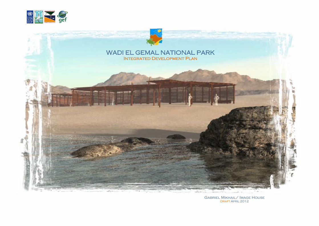
WADI EL GEMAL NATIONAL PARK
Integrated Development Plan
Gabriel Mikhail/ Image House Draft April 2012
2
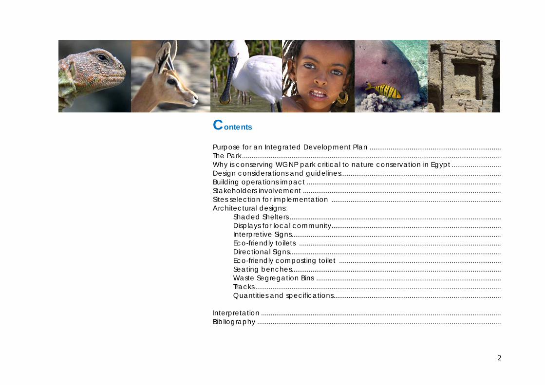
Contents
Purpose for an Integrated Development Plan ..................................................................... The Park ........................................................................................................................................ Why is conserving WGNP park critical to nature conservation in Egypt .......................... Design considerations and guidelines .................................................................................... Building operations impact ...................................................................................................... Stakeholders involvement ........................................................................................................ Sites selection for implementation ......................................................................................... Architectural designs:
Shaded Shelters ............................................................................................................... Displays for local community ......................................................................................... Interpretive Signs .............................................................................................................. Eco-friendly toilets .......................................................................................................... Directional Signs ............................................................................................................... Eco-friendly composting toilet ..................................................................................... Seating benches .............................................................................................................. Waste Segregation Bins ................................................................................................. Tracks ................................................................................................................................. Quantities and specifications ........................................................................................
Interpretation .............................................................................................................................. Bibliography ................................................................................................................................
3
Purpose of the Integrated Development Plan (IDP) Strengthening Protected Area Financing and Management Systems Project (EPASP) which has commissioned this intervention aims at maintaining sustainable Egyptian PA systems having the financial means and management capacities needed for effective management. Thus, an integrated development plan along with its implementation at chosen sites within the park is an initial yet notable step that is needed for realizing the project's objectives. The plan will integrate eco-tourism development with the conservation of the unique and sensitive natural and cultural resources of the park, notably on the coast. It would further delineate the built heritage of this park and lead by example, providing a design benchmark for future interventions to observe. Among the relevant EPASP project's objectives are: The establishment of a sustainable protected area financing system in Wadi El Gemal National Park. Provide tools and practices for revenue generation Ensure the effective use of generated revenues for priority biodiversity conservation Business planning and other tools for cost-effective management This intervention is to Design and implement an ''Integrated Development Plan" for attraction sites in the park to realize the following outcomes: Generate revenue for the park and justify revenue generation. Provide alternative livelihoods for the local Ababda community. Provide services to park visitors and the tourism sector. Help promote the park as an attractive eco-tourism destination. Conserve parts of the park through sustainable development. This IDP and its implementation is designed for specific chosen sites and is based on the park management and project's team recommendations, stakeholder involvement and the numerous planning studies and reports that target the coast. This intervention will implement the design and construction of visitor facilities at three beaches including directional and behavioral signage, marked tracks, shaded areas, environmentally friendly toilets, seating, garbage separation bins and local community handicraft sales outlets. Four interpretation kiosks at key attractions will also be designed and constructed as a part this intervention.
4
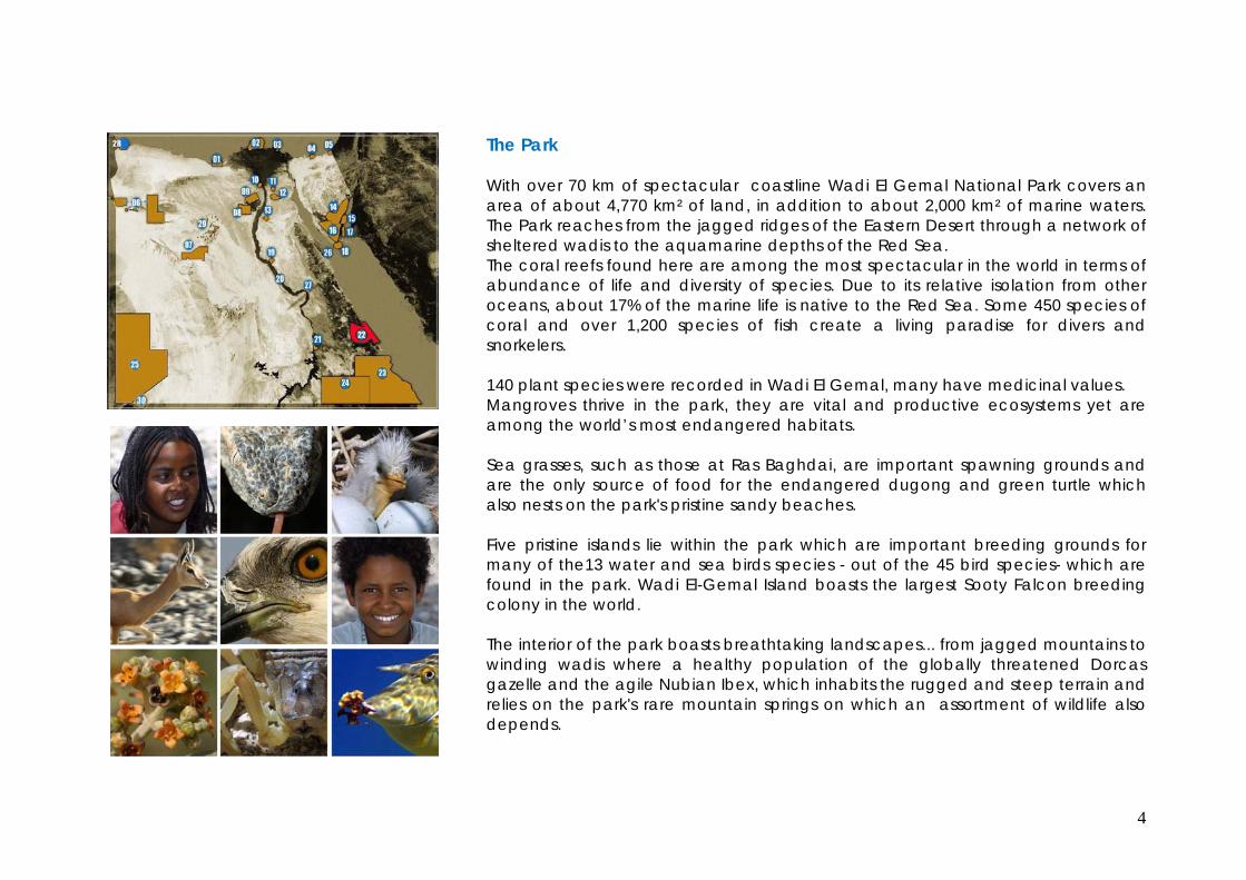
The Park With over 70 km of spectacular coastline Wadi El Gemal National Park covers an area of about 4,770 km² of land, in addition to about 2,000 km² of marine waters. The Park reaches from the jagged ridges of the Eastern Desert through a network of sheltered wadis to the aquamarine depths of the Red Sea. The coral reefs found here are among the most spectacular in the world in terms of abundance of life and diversity of species. Due to its relative isolation from other oceans, about 17% of the marine life is native to the Red Sea. Some 450 species of coral and over 1,200 species of fish create a living paradise for divers and snorkelers. 140 plant species were recorded in Wadi El Gemal, many have medicinal values. Mangroves thrive in the park, they are vital and productive ecosystems yet are among the world’s most endangered habitats. Sea grasses, such as those at Ras Baghdai, are important spawning grounds and are the only source of food for the endangered dugong and green turtle which also nests on the park's pristine sandy beaches. Five pristine islands lie within the park which are important breeding grounds for many of the13 water and sea birds species - out of the 45 bird species- which are found in the park. Wadi El-Gemal Island boasts the largest Sooty Falcon breeding colony in the world. The interior of the park boasts breathtaking landscapes... from jagged mountains to winding wadis where a healthy population of the globally threatened Dorcas gazelle and the agile Nubian Ibex, which inhabits the rugged and steep terrain and relies on the park's rare mountain springs on which an assortment of wildlife also depends.

5
Reptiles are the most numerous terrestrial vertebrate fauna and lizards are most abundant. There are at least 25 terrestrial reptiles inhabiting the Wadi el Gemal/Hamata area.
The Ababda are the main indigenous inhabitants of the park. They are a proud people with a rich and unique culture who have a great affinity with nature which sustains their livelihoods. Livestock is their major source of livelihood while some enage in small scale fishing such as at Qalaan vilaage, perhaps the only remaining authentic fishing Ababda indigenous community on the Egyptian Red Sea coast. Nowadays, some of the Ababda work in the tourism industry. Prehistoric rock art testifies to the region's prehistoric past. Ptolemaic and Roman vestiges abound, Mons Smaragdus (emerald mountain) is composed of around nine small mining communities dating back to Pharaonic times.
Tourists to WGNP are mainly attracted to the coast for its pristine beaches to sunbath, snorkel, swim and dive its reefs. Other exquisite natural and cultural values of the Park are relatively less known and need to gain more attention and interest.
Why is conserving WGNP park critical to nature conservation in Egypt Extensive tourism-associated coastal developments have been carried out in the last few decades with many more planned for the future. Almost the entire Red Sea coast of Egypt along the Eastern Desert from Ain Sokhna to Shalateen has been allocated by the government to hotel developers, pressures continue to mount to develop the park's pristine beaches for mass tourism . WGNP is the last remaining piece of largely intact nature along this coast which was largely spared from destruction and one of the few places that tourists and locals can enjoy unspoiled coastal landscapes. It is home to many globally endangered species and habitats found nowhere else in the country, losing it to mass tourism would be a devastating blow to nature conservation in Egypt. Implementing sustainable development initiatives in the park would also save it from destruction.
6
Design considerations and guidelines
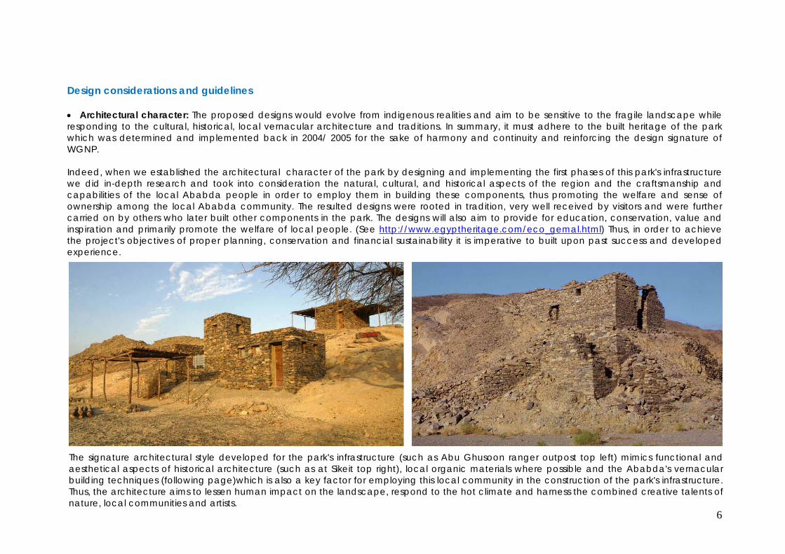
Architectural character: The proposed designs would evolve from indigenous realities and aim to be sensitive to the fragile landscape while responding to the cultural, historical, local vernacular architecture and traditions. In summary, it must adhere to the built heritage of the park which was determined and implemented back in 2004/ 2005 for the sake of harmony and continuity and reinforcing the design signature of WGNP. Indeed, when we established the architectural character of the park by designing and implementing the first phases of this park's infrastructure we did in-depth research and took into consideration the natural, cultural, and historical aspects of the region and the craftsmanship and capabilities of the local Ababda people in order to employ them in building these components, thus promoting the welfare and sense of ownership among the local Ababda community. The resulted designs were rooted in tradition, very well received by visitors and were further carried on by others who later built other components in the park. The designs will also aim to provide for education, conservation, value and inspiration and primarily promote the welfare of local people. (See http://www.egyptheritage.com/eco_gemal.html) Thus, in order to achieve the project's objectives of proper planning, conservation and financial sustainability it is imperative to built upon past success and developed experience. The signature architectural style developed for the park's infrastructure (such as Abu Ghusoon ranger outpost top left) mimics functional and aesthetical aspects of historical architecture (such as at Sikeit top right), local organic materials where possible and the Ababda's vernacular building techniques (following page)which is also a key factor for employing this local community in the construction of the park's infrastructure. Thus, the architecture aims to lessen human impact on the landscape, respond to the hot climate and harness the combined creative talents of nature, local communities and artists.
7
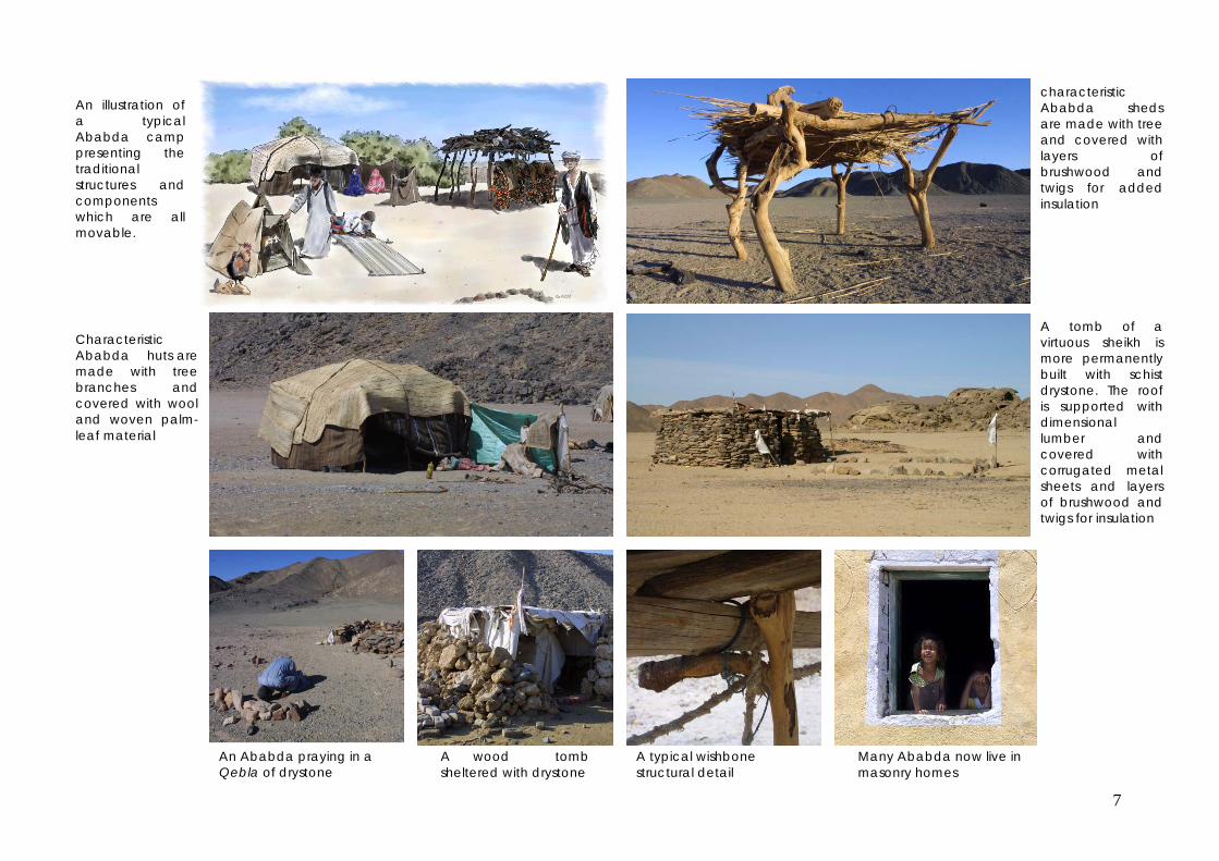
Characteristic Ababda huts are made with tree branches and covered with wool and woven palm-leaf material
An illustration of a typical Ababda camp presenting the traditional structures and components which are all movable.
An Ababda praying in a Qebla of drystone
A wood tomb sheltered with drystone
A typical wishbone structural detail
A tomb of a virtuous sheikh is more permanently built with schist drystone. The roof is supported with dimensional lumber and covered with corrugated metal sheets and layers of brushwood and twigs for insulation
Many Ababda now live in masonry homes
characteristic Ababda sheds are made with tree and covered with layers of brushwood and twigs for added insulation

8
Photo far left shows one of the existing park infrastructure component with typical signage and woodwork designs. Photo at left shows local Ababda community workers constructing wood shades. Photo at bottom left shows another completed shade. These gazwareena designs also withstood the harsh elements for almost 10 years and are still functional with minimal maintenance required. These designs are relevant to this intervention and would be integrated and developed to suite the intended use of the newly proposed shelters. The park's established theme directional signage would be observed, utilized and developed within the newly proposed signage
installations.

9
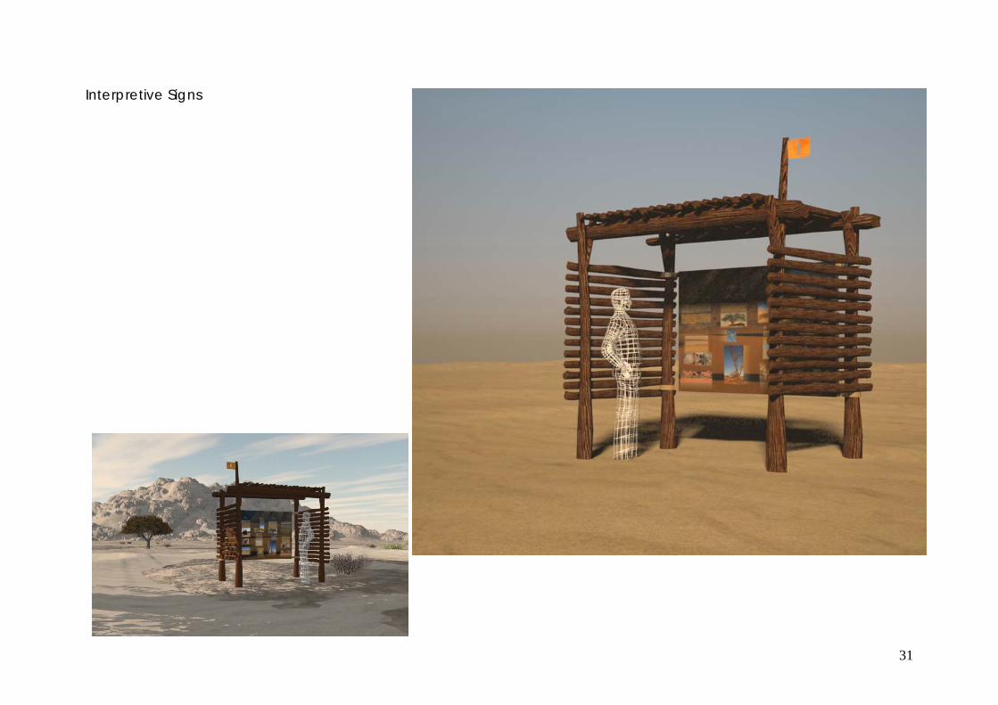
Interpretive signage: The interpretation facilities which we executed in the visitor outlook (photos below) were designed with graphics also influenced by the Roman style (much like the architecture style performed in the park) inspired by the park's historical context and its relation to the Roman Empire and the many antiquities it left behind. This style will be utilized and developed for the new interpretation facilities.
Many other details (above) for utility screening and site furniture have already been developed within the previously implemented design scheme and would be observed in the new scheme.

10
Building operations impact In order to minimize impacts to the park, the actual building sites and its sensitive surroundings the following guidelines will be followed: Restrict access and transportation of labor and building materials to established tracks. Using Ababda workers and craftsmen wherever possible. Using sustainable building materials such as Casuarina (Australian pine) for constructing open shaded areas instead of acacia branches, while
mimicking the local Ababda Casuarina is a commercially grown renewable resource. Control garbage and site cleanliness during operations. Strict instructions will be given to workers, and monitored for compliance on a regular basis, to avoid any disturbance to plants or wildlife.
Casuarina is a commercially renewable recourse, grown in several locations as above in Sadat Forest Plantation irrigated with treated sewage water.
Stakeholders involvement
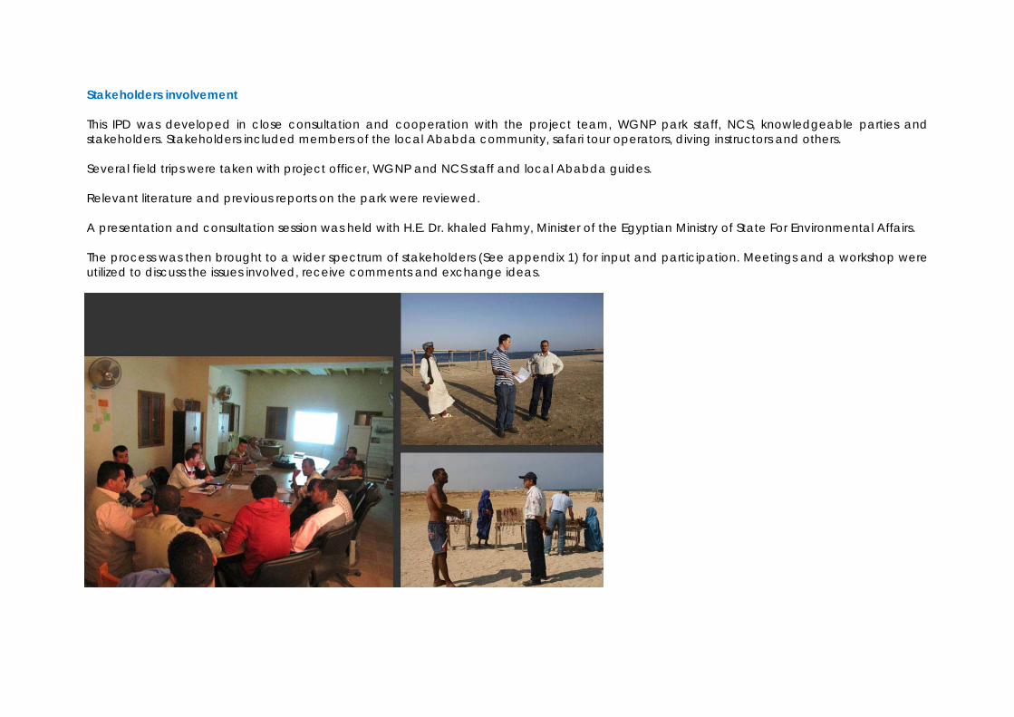
This IPD was developed in close consultation and cooperation with the project team, WGNP park staff, NCS, knowledgeable parties and stakeholders. Stakeholders included members of the local Ababda community, safari tour operators, diving instructors and others. Several field trips were taken with project officer, WGNP and NCS staff and local Ababda guides. Relevant literature and previous reports on the park were reviewed. A presentation and consultation session was held with H.E. Dr. khaled Fahmy, Minister of the Egyptian Ministry of State For Environmental Affairs. The process was then brought to a wider spectrum of stakeholders (See appendix 1) for input and participation. Meetings and a workshop were utilized to discuss the issues involved, receive comments and exchange ideas.

12
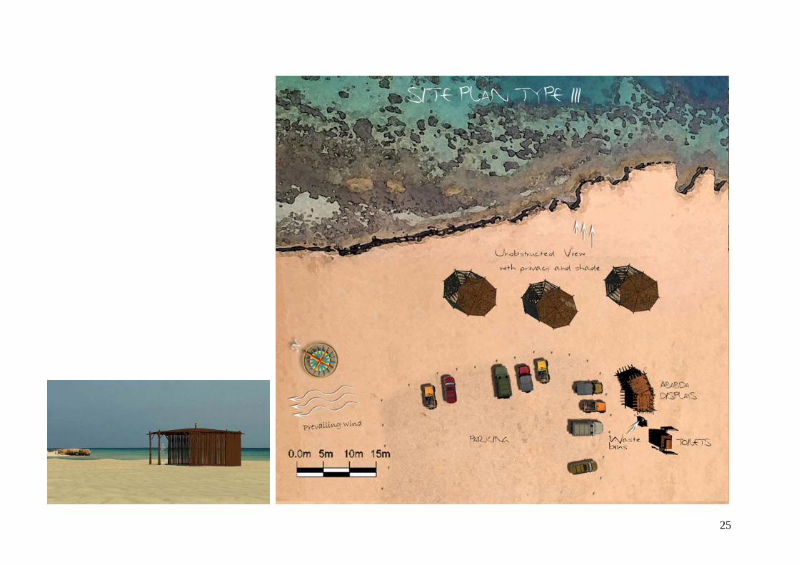
Sites selection for implementation WGNP has over 70 km of coast and a significant number of natural and cultural points of interest. A number of localities (below) where evaluated for the implementation of beaches and or interpretation facilities.
Beaches considered for implementation Sites considered for interpretation
1. Sharm el Fakere 1. Ras Baghdadi
2. Tourfet el Masheikh beach 2. Sharm El Louly
3. Sharm el Louli 3. Qulaan village
4. Ras Honkorab 4. Hamata mangrovess
5. Umm Al Abbas 5. Acacia, balanites aegyptiaca and Salvadora persica concentrations at Wadi El Gemal
6. Abu Ghosoun (shore area & dive wreck) 6. Wadi El Gemal springs
7. Qulan beach 7. WGNP islands (5 islands)
8. Saltoot springs
9. Gebel Hamata
10. Sikeit Archeological site
11. Nogross Archeological site
12. Gebel Zabara Archeological site
13. Town of Shiekh Shazley Based on field experience, stakeholder preferences (see previous section), previous studies and reports on the subject 3 beaches, 4 interpretive kiosks and 4 directional signage where chosen for implantation at this phase (see map following page) to exhibit key natural, cultural and historical points of interest within the park. The location and description of these sites are detailed in the pages to follow.

13

14
1. Selected Beaches
Site: Ras Hankorab Beach Ecotourism activities
Sandy beach, calm sea, scenic landscape / relaxation , swimming, snorkeling, beach strolling , sunbathing.
Visitor capacity 50 – 100 persons at one time or fewer
Visitor facilities
Shaded area, seating, toilets, garbage segregation bins
Local community facilities
Shaded area for sale of handicrafts
Access
Delineated 1500 m. track ad parking lot
Signage Behavioral sign Monitoring
Monitor turtle nesting sites for any signs of disturbance, enforce visitor capacity limit and beach closure by sunset, cleanliness & garbage disposal, toilet and light structure maintenance.

15
Site: Abu Ghusoon Beach Ecotourism activities
Diving, sandy beach, relaxation , swimming, snorkeling, beach strolling , sunbathing.
Visitor capacity Up to 200 persons at one time or fewer
Visitor facilities
Shaded area, seating, toilets, garbage segregation bins
Local community facilities
Shaded area for sale of handicrafts
Access
Delineated 500 m. track and parking lot
Signage Behavioral & interpretive signs Monitoring
Enforce visitor capacity limit and beach closure by sunset, cleanliness & garbage disposal, toilet and light structure maintenance.

16
Site: Fogari Beach Ecotourism activities
Diving, sandy beach, relaxation , swimming, snorkeling, beach strolling , sunbathing.
Visitor capacity Up to 200 persons at one time or fewer
Visitor facilities
Shaded area, seating, toilets, garbage segregation bins
Local community facilities
Shaded area for sale of handicrafts
Access
Delineated 300 m. track ad parking lot
Signage Behavioral & interpretive signs Monitoring
Enforce visitor capacity limit and beach closure by sunset, cleanliness & garbage disposal, toilet and light structure maintenance.

17
2. Selected interpretation sites
Site: Ras Baghdadi Ecotourism activities
Nature trekking through scenic vegetated coast with, bird watching and photography,
Visitor accessibility
Guided and unguided.
Interpretation topics
Exhibits the delta which was formed from alluvial sediments brought down through Wadi El Gemal. The mountain watershed meets the seawater cre-ating a salty marsh. Overview of sea grass and wadi habitats.
Access
Easy access form paved highway. Existing easy and winding trails.
Monitoring
Enforce closure by sunset and site cleanliness.
Panoramic view of Ras Baghdadi
Fresh underground water seeps from the ground forming a pond by the sea, creating a distinctive habitat
18
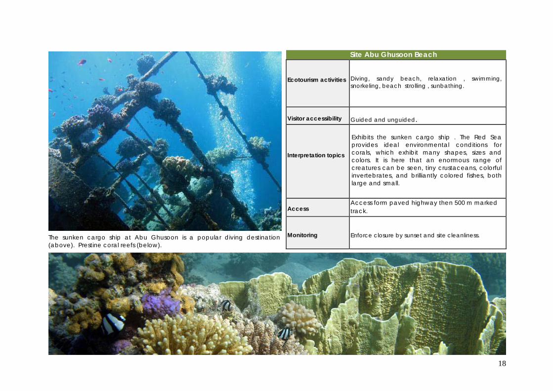
Site Abu Ghusoon Beach Ecotourism activities
Diving, sandy beach, relaxation , swimming, snorkeling, beach strolling , sunbathing.
Visitor accessibility
Guided and unguided.
Interpretation topics
Exhibits the sunken cargo ship . The Red Sea provides ideal environmental conditions for corals, which exhibit many shapes, sizes and colors. It is here that an enormous range of creatures can be seen, tiny crustaceans, colorful invertebrates, and brilliantly colored fishes, both large and small.
Access
Access form paved highway then 500 m marked track.
Monitoring
Enforce closure by sunset and site cleanliness. The sunken cargo ship at Abu Ghusoon is a popular diving destination
(above). Prestine coral reefs (below).
19
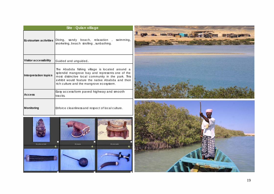
Site : Qulan village Ecotourism activities
Diving, sandy beach, relaxation , swimming, snorkeling, beach strolling , sunbathing.
Visitor accessibility
Guided and unguided.
Interpretation topics
The Ababda fishing village is located around a splendid mangrove bay and represents one of the most distinctive local community in the park. This exhibit would feature the native Ababda and their rich culture and the mangrove ecosystem.
Access
Easy access form paved highway and smooth tracks.
Monitoring
Enforce cleanliness and respect of local culture.
20
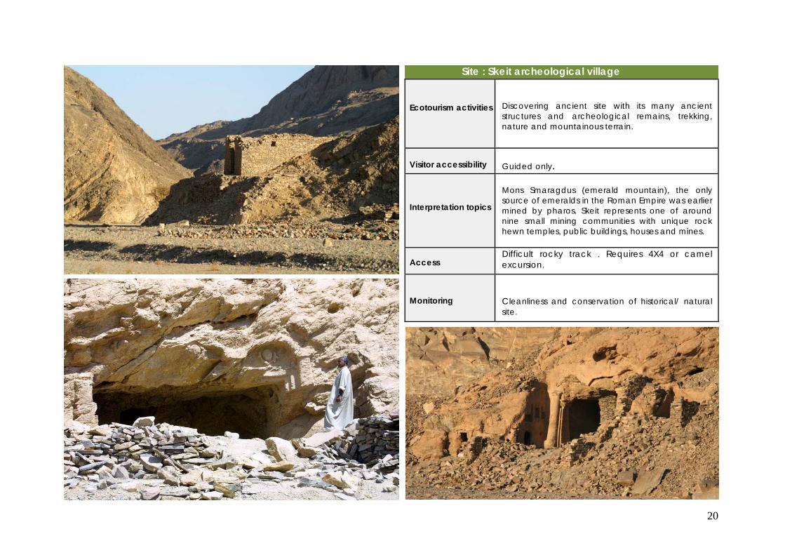
Site : Skeit archeological village Ecotourism activities
Discovering ancient site with its many ancient structures and archeological remains, trekking, nature and mountainous terrain.
Visitor accessibility
Guided only.
Interpretation topics
Mons Smaragdus (emerald mountain), the only source of emeralds in the Roman Empire was earlier mined by pharos. Skeit represents one of around nine small mining communities with unique rock hewn temples, public buildings, houses and mines.
Access
Difficult rocky track . Requires 4X4 or camel excursion.
Monitoring
Cleanliness and conservation of historical/ natural site.

21
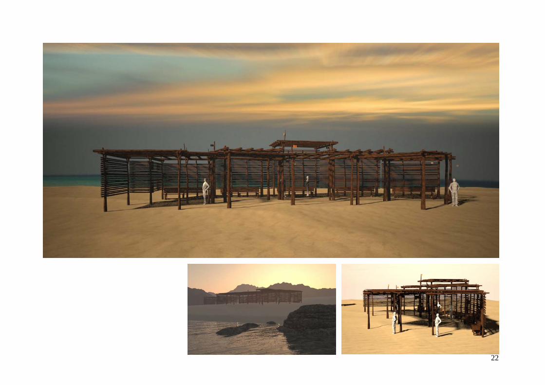
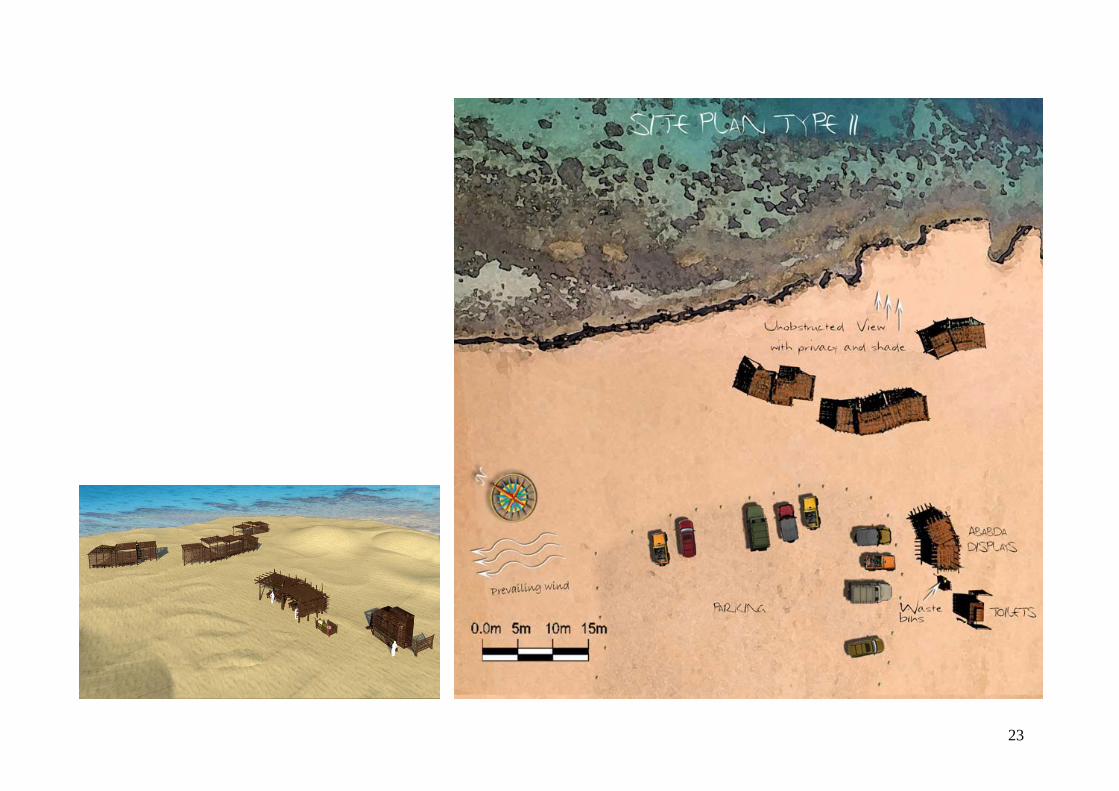
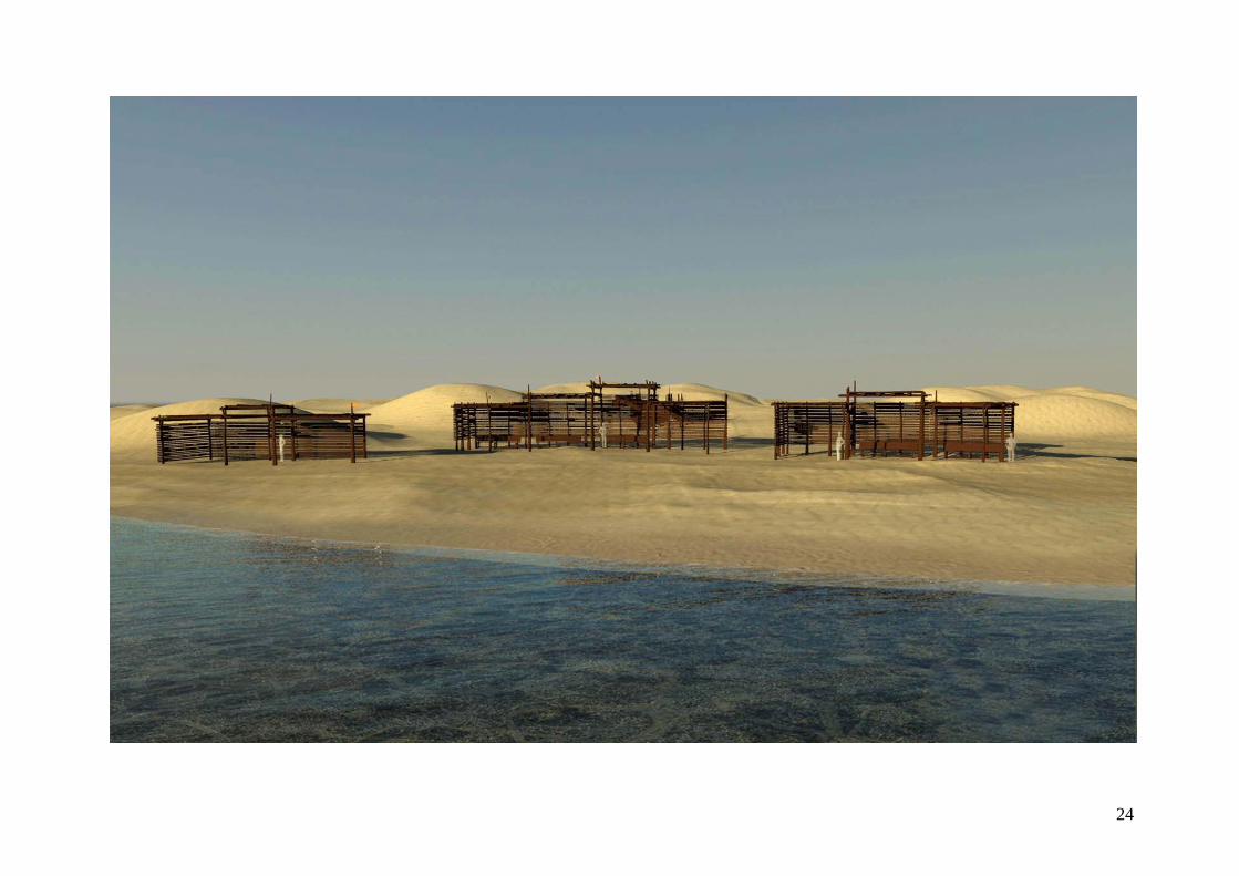
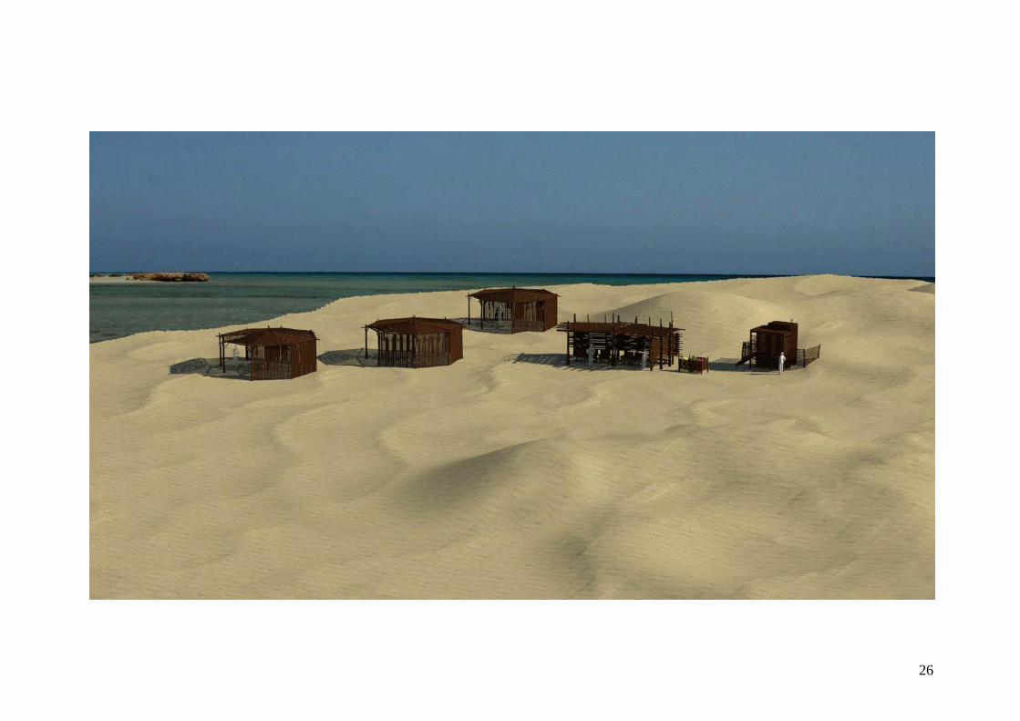
Architectural designs Shaded Shelters
22
23
24
25
26

27
Displays for local community


29
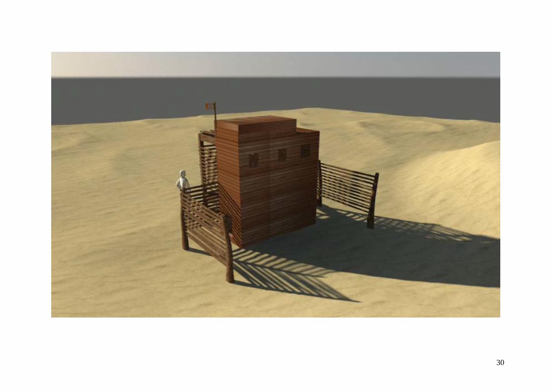
Eco-friendly toilets
30
31
Interpretive Signs
32
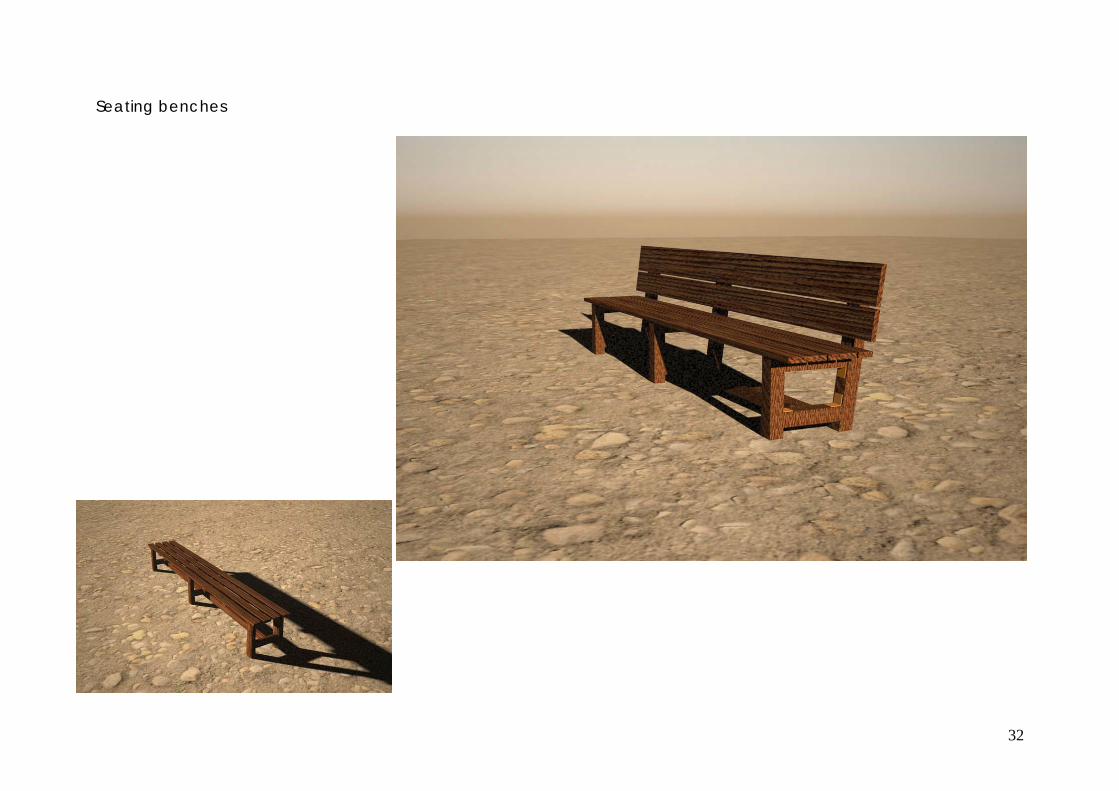
Seating benches

33
Waste Segregation Bins

34
Directional signage
35
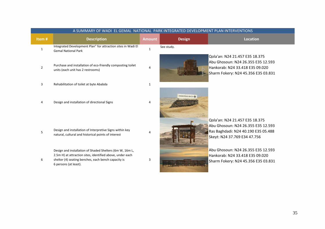
Item # Description Amount Design Location
1Integrated Development Plan" for attraction sites in Wadi El Gemal National Park 1
See study.
2Purchase and installation of eco‐friendly composting toilet units (each unit has 2 restrooms)
4
Qola'an: N24 21.457 E35 18.375Abu Ghosoun: N24 26.355 E35 12.593Hankorab: N24 33.418 E35 09.020Sharm Fokery: N24 45.356 E35 03.831
3 Rehabilitation of toilet at byte Ababda 1
4 Design and installation of directional Signs 4
5Design and installation of Interpretive Signs within key natural, cultural and historical points of interest
4
Qola'an: N24 21.457 E35 18.375Abu Ghosoun: N24 26.355 E35 12.593Ras Baghdadi: N24 40.190 E35 05.488Skeyt: N24 37.769 E34 47.756
6
Design and installation of Shaded Shelters (6m W, 16m L, 2.5m H) at attraction sites, identified above, under each shelter (4) seating benches, each bench capacity is6 persons (at least).
3
Abu Ghosoun: N24 26.355 E35 12.593Hankorab: N24 33.418 E35 09.020Sharm Fokery: N24 45.356 E35 03.831
A SUMMARY OF WADI EL GEMAL NATIONAL PARK INTEGRATED DEVELOPMENT PLAN INTERVENTIONS

36
Item # Description Amount Design Location
7Fabrication and installation of seating benches, each bench capacity is 6 persons
9
8Design and installation of displays for local community handicraft products sales. The display dimension should be (5m W, Sm L, 2.25m H)
2
Abu Ghosoun: N24 26.355 E35 12.593Hankorab: N24 33.418 E35 09.020
9 Establishment of track from the main road to Hankorab 500 m
10 Establishment of track from the main road to Qulaan. 2500 m
11Installation of(4) units Waste Segregation Bins (one/each site)
Qola'an: N24 21.457 E35 18.375Abu Ghosoun: N24 26.355 E35 12.593Hankorab: N24 33.418 E35 09.020Sharm Fokery: N24 45.356 E35 03.831
12Progress reports as follows: (I) after the initial field visit (2). Draft plan; (3). After the finalization of the plan.
3
A SUMMARY OF WADI EL GEMAL NATIONAL PARK INTEGRATED DEVELOPMENT PLAN INTERVENTIONS
37
BIBLIOGRAPHY
Baha El Din, S. M., 1999. Common Birds of Egypt. The American University in Cairo Press, Cairo. Baha El Din, S. M., 2003. Wadi El Gimal Management Plan. The Egyptian Environmental Affairs Agency, Cairo Shaw, I., J. Bunbury and R. Jameson, 1999. Emerald mining in Roman and Byzantine Egypt. Journal of Roman Archaeology. Mikhail, G. T., 2001. The Natural Wonders of the Eastern Desert and Red Sea, CD-ROM, Image House, Cairo. Mikhail, G. T., 2003. Egypt’s Wilderness and the Quest for Conservation. Image House, Cairo. Mikhail, G. T., 2003. Mangroves of Egypt, CD-ROM , Food and Agricultural Organization of the United Nations Mikhail, G. T., 2004. Wadi Degla, Gateway to the Eastern Desert, Image House, Cairo Sidebotham, S. E., H. M. Nouwens, A. M. Hense and J. A. Harrell, 2004. Archaeological Fieldwork at Sikait & Environs 02 03, Sahara 15/2004 Klemm, D. D., R. Klemm and A. Murr, 2002. Egypt and Nubia: gifts of the desert, the British Museum Press LIFE Red Sea Project/ USAID, 2008. Interpretive Master Plan for Wadi El Gamel National Park LIFE Red Sea Project/ USAID, 2008.Wadi El Gemal National Park Management Action Plan US Forest Service, 2012. Wadi El Gemal National Park Coastal Tourism And Conservation Strategy USAID. Wadi El Gemal-Hamata Protected Area Business Plan