FY2021 ASSESSMENT VALID SALES RATIO
521
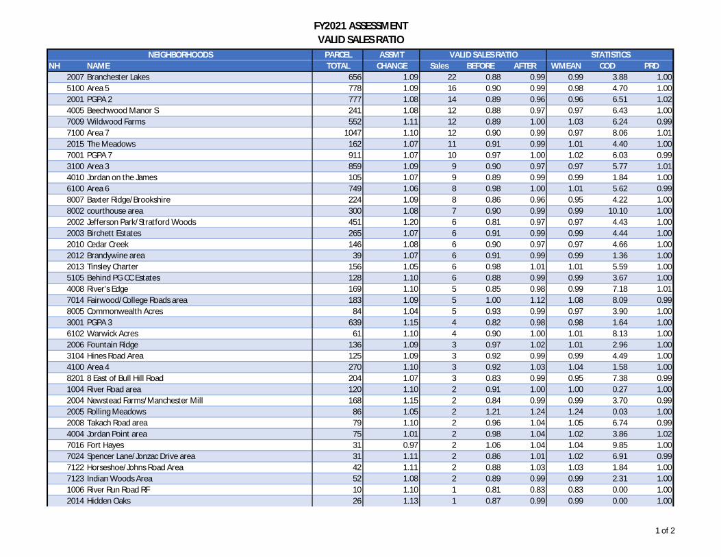
FY2021 ASSESSMENT VALID SALES RATIO PARCEL ASSMT NH NAME TOTAL CHANGE Sales BEFORE AFTER WMEAN COD PRD 2007 Branchester Lakes 656 1.09 22 0.88 0.99 0.99 3.88 1.00 5100 Area 5 778 1.09 16 0.90 0.99 0.98 4.70 1.00 2001 PGPA 2 777 1.08 14 0.89 0.96 0.96 6.51 1.02 4005 Beechwood Manor S 241 1.08 12 0.88 0.97 0.97 6.43 1.00 7009 Wildwood Farms 552 1.11 12 0.89 1.00 1.03 6.24 0.99 7100 Area 7 1047 1.10 12 0.90 0.99 0.97 8.06 1.01 2015 The Meadows 162 1.07 11 0.91 0.99 1.01 4.40 1.00 7001 PGPA 7 911 1.07 10 0.97 1.00 1.02 6.03 0.99 3100 Area 3 859 1.09 9 0.90 0.97 0.97 5.77 1.01 4010 Jordan on the James 105 1.07 9 0.89 0.99 0.99 1.84 1.00 6100 Area 6 749 1.06 8 0.98 1.00 1.01 5.62 0.99 8007 Baxter Ridge/Brookshire 224 1.09 8 0.86 0.96 0.95 4.22 1.00 8002 courthouse area 300 1.08 7 0.90 0.99 0.99 10.10 1.00 2002 Jefferson Park/Stratford Woods 451 1.20 6 0.81 0.97 0.97 4.43 1.00 2003 Birchett Estates 265 1.07 6 0.91 0.99 0.99 4.44 1.00 2010 Cedar Creek 146 1.08 6 0.90 0.97 0.97 4.66 1.00 2012 Brandywine area 39 1.07 6 0.91 0.99 0.99 1.36 1.00 2013 Tinsley Charter 156 1.05 6 0.98 1.01 1.01 5.59 1.00 5105 Behind PG CC Estates 128 1.10 6 0.88 0.99 0.99 3.67 1.00 4008 River's Edge 169 1.10 5 0.85 0.98 0.99 7.18 1.01 7014 Fairwood/College Roads area 183 1.09 5 1.00 1.12 1.08 8.09 0.99 8005 Commonwealth Acres 84 1.04 5 0.93 0.99 0.97 3.90 1.00 3001 PGPA 3 639 1.15 4 0.82 0.98 0.98 1.64 1.00 6102 Warwick Acres 61 1.10 4 0.90 1.00 1.01 8.13 1.00 2006 Fountain Ridge 136 1.09 3 0.97 1.02 1.01 2.96 1.00 3104 Hines Road Area 125 1.09 3 0.92 0.99 0.99 4.49 1.00 4100 Area 4 270 1.10 3 0.92 1.03 1.04 1.58 1.00 8201 8 East of Bull Hill Road 204 1.07 3 0.83 0.99 0.95 7.38 0.99 1004 River Road area 120 1.10 2 0.91 1.00 1.00 0.27 1.00 2004 Newstead Farms/Manchester Mill 168 1.15 2 0.84 0.99 0.99 3.70 0.99 2005 Rolling Meadows 86 1.05 2 1.21 1.24 1.24 0.03 1.00 2008 Takach Road area 79 1.10 2 0.96 1.04 1.05 6.74 0.99 4004 Jordan Point area 75 1.01 2 0.98 1.04 1.02 3.86 1.02 7016 Fort Hayes 31 0.97 2 1.06 1.04 1.04 9.85 1.00 7024 Spencer Lane/Jonzac Drive area 31 1.11 2 0.86 1.01 1.02 6.91 0.99 7122 Horseshoe/Johns Road Area 42 1.11 2 0.88 1.03 1.03 1.84 1.00 7123 Indian Woods Area 52 1.08 2 0.89 0.99 0.99 2.31 1.00 1006 River Run Road RF 10 1.10 1 0.81 0.83 0.83 0.00 1.00 2014 Hidden Oaks 26 1.13 1 0.87 0.99 0.99 0.00 1.00 NEIGHBORHOODS VALID SALES RATIO STATISTICS 1 of 2
Transcript of FY2021 ASSESSMENT VALID SALES RATIO
FY2021 ASSESSMENTVALID SALES RATIO
PARCEL ASSMTNH NAME TOTAL CHANGE Sales BEFORE AFTER WMEAN COD PRD
2007 Branchester Lakes 656 1.09 22 0.88 0.99 0.99 3.88 1.005100 Area 5 778 1.09 16 0.90 0.99 0.98 4.70 1.002001 PGPA 2 777 1.08 14 0.89 0.96 0.96 6.51 1.024005 Beechwood Manor S 241 1.08 12 0.88 0.97 0.97 6.43 1.007009 Wildwood Farms 552 1.11 12 0.89 1.00 1.03 6.24 0.997100 Area 7 1047 1.10 12 0.90 0.99 0.97 8.06 1.012015 The Meadows 162 1.07 11 0.91 0.99 1.01 4.40 1.007001 PGPA 7 911 1.07 10 0.97 1.00 1.02 6.03 0.993100 Area 3 859 1.09 9 0.90 0.97 0.97 5.77 1.014010 Jordan on the James 105 1.07 9 0.89 0.99 0.99 1.84 1.006100 Area 6 749 1.06 8 0.98 1.00 1.01 5.62 0.998007 Baxter Ridge/Brookshire 224 1.09 8 0.86 0.96 0.95 4.22 1.008002 courthouse area 300 1.08 7 0.90 0.99 0.99 10.10 1.002002 Jefferson Park/Stratford Woods 451 1.20 6 0.81 0.97 0.97 4.43 1.002003 Birchett Estates 265 1.07 6 0.91 0.99 0.99 4.44 1.002010 Cedar Creek 146 1.08 6 0.90 0.97 0.97 4.66 1.002012 Brandywine area 39 1.07 6 0.91 0.99 0.99 1.36 1.002013 Tinsley Charter 156 1.05 6 0.98 1.01 1.01 5.59 1.005105 Behind PG CC Estates 128 1.10 6 0.88 0.99 0.99 3.67 1.004008 River's Edge 169 1.10 5 0.85 0.98 0.99 7.18 1.017014 Fairwood/College Roads area 183 1.09 5 1.00 1.12 1.08 8.09 0.998005 Commonwealth Acres 84 1.04 5 0.93 0.99 0.97 3.90 1.003001 PGPA 3 639 1.15 4 0.82 0.98 0.98 1.64 1.006102 Warwick Acres 61 1.10 4 0.90 1.00 1.01 8.13 1.002006 Fountain Ridge 136 1.09 3 0.97 1.02 1.01 2.96 1.003104 Hines Road Area 125 1.09 3 0.92 0.99 0.99 4.49 1.004100 Area 4 270 1.10 3 0.92 1.03 1.04 1.58 1.008201 8 East of Bull Hill Road 204 1.07 3 0.83 0.99 0.95 7.38 0.991004 River Road area 120 1.10 2 0.91 1.00 1.00 0.27 1.002004 Newstead Farms/Manchester Mill 168 1.15 2 0.84 0.99 0.99 3.70 0.992005 Rolling Meadows 86 1.05 2 1.21 1.24 1.24 0.03 1.002008 Takach Road area 79 1.10 2 0.96 1.04 1.05 6.74 0.994004 Jordan Point area 75 1.01 2 0.98 1.04 1.02 3.86 1.027016 Fort Hayes 31 0.97 2 1.06 1.04 1.04 9.85 1.007024 Spencer Lane/Jonzac Drive area 31 1.11 2 0.86 1.01 1.02 6.91 0.997122 Horseshoe/Johns Road Area 42 1.11 2 0.88 1.03 1.03 1.84 1.007123 Indian Woods Area 52 1.08 2 0.89 0.99 0.99 2.31 1.001006 River Run Road RF 10 1.10 1 0.81 0.83 0.83 0.00 1.002014 Hidden Oaks 26 1.13 1 0.87 0.99 0.99 0.00 1.00
NEIGHBORHOODS VALID SALES RATIO STATISTICS
1 of 2
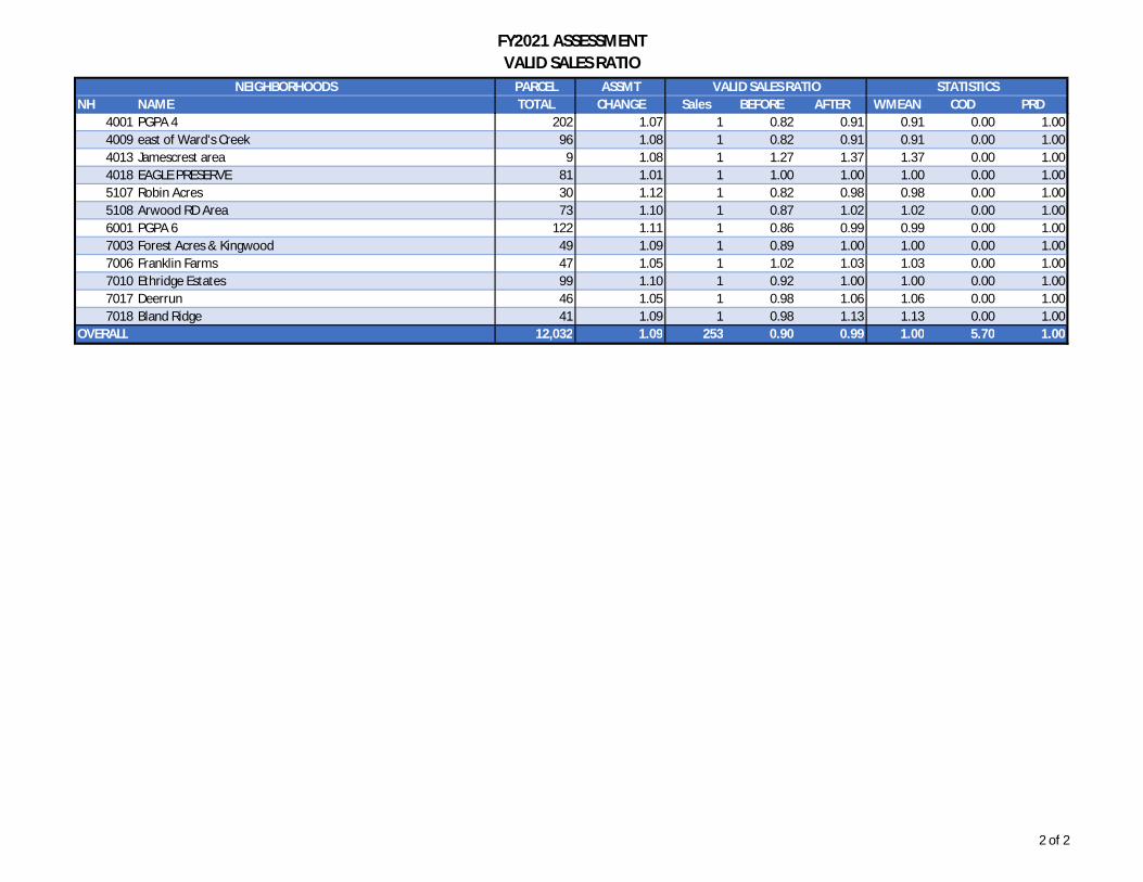
FY2021 ASSESSMENTVALID SALES RATIO
PARCEL ASSMTNH NAME TOTAL CHANGE Sales BEFORE AFTER WMEAN COD PRD
NEIGHBORHOODS VALID SALES RATIO STATISTICS
4001 PGPA 4 202 1.07 1 0.82 0.91 0.91 0.00 1.004009 east of Ward's Creek 96 1.08 1 0.82 0.91 0.91 0.00 1.004013 Jamescrest area 9 1.08 1 1.27 1.37 1.37 0.00 1.004018 EAGLE PRESERVE 81 1.01 1 1.00 1.00 1.00 0.00 1.005107 Robin Acres 30 1.12 1 0.82 0.98 0.98 0.00 1.005108 Arwood RD Area 73 1.10 1 0.87 1.02 1.02 0.00 1.006001 PGPA 6 122 1.11 1 0.86 0.99 0.99 0.00 1.007003 Forest Acres & Kingwood 49 1.09 1 0.89 1.00 1.00 0.00 1.007006 Franklin Farms 47 1.05 1 1.02 1.03 1.03 0.00 1.007010 Ethridge Estates 99 1.10 1 0.92 1.00 1.00 0.00 1.007017 Deerrun 46 1.05 1 0.98 1.06 1.06 0.00 1.007018 Bland Ridge 41 1.09 1 0.98 1.13 1.13 0.00 1.00
OVERALL 12,032 1.09 253 0.90 0.99 1.00 5.70 1.00
2 of 2
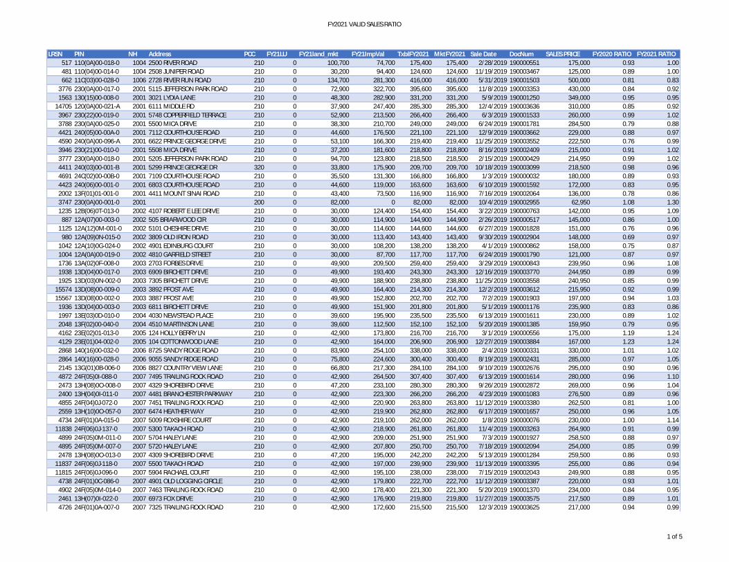
FY2021 VALID SALES RATIO
LRSN PIN NH Address PCC FY21LU FY21land_mkt FY21ImpVal TxblFY2021 MktFY2021 Sale Date DocNum SALES PRICE FY2020 RATIO FY2021 RATIO517 110(0A)00-018-0 1004 2500 RIVER ROAD 210 0 100,700 74,700 175,400 175,400 2/28/2019 190000551 175,000 0.93 1.00481 110(04)00-014-0 1004 2508 JUNIPER ROAD 210 0 30,200 94,400 124,600 124,600 11/19/2019 190003467 125,000 0.89 1.00662 11C(03)00-028-0 1006 2728 RIVER RUN ROAD 210 0 134,700 281,300 416,000 416,000 5/31/2019 190001503 500,000 0.81 0.83
3776 230(0A)00-017-0 2001 5115 JEFFERSON PARK ROAD 210 0 72,900 322,700 395,600 395,600 11/8/2019 190003353 430,000 0.84 0.921563 130(15)00-008-0 2001 3021 LYDIA LANE 210 0 48,300 282,900 331,200 331,200 5/9/2019 190001250 349,000 0.95 0.95
14705 120(0A)00-021-A 2001 6111 MIDDLE RD 210 0 37,900 247,400 285,300 285,300 12/4/2019 190003636 310,000 0.85 0.923967 230(22)00-019-0 2001 5748 COPPERFIELD TERRACE 210 0 52,900 213,500 266,400 266,400 6/3/2019 190001533 260,000 0.99 1.023788 230(0A)00-025-0 2001 5500 MICA DRIVE 210 0 38,300 210,700 249,000 249,000 6/24/2019 190001781 284,500 0.79 0.884421 240(05)00-00A-0 2001 7112 COURTHOUSE ROAD 210 0 44,600 176,500 221,100 221,100 12/9/2019 190003662 229,000 0.88 0.974590 240(0A)00-096-A 2001 6622 PRINCE GEORGE DRIVE 210 0 53,100 166,300 219,400 219,400 11/25/2019 190003552 222,500 0.76 0.993946 230(21)00-010-0 2001 5508 MICA DRIVE 210 0 37,200 181,600 218,800 218,800 8/16/2019 190002409 215,000 0.91 1.023777 230(0A)00-018-0 2001 5205 JEFFERSON PARK ROAD 210 0 94,700 123,800 218,500 218,500 2/15/2019 190000429 214,950 0.99 1.024411 240(03)00-001-B 2001 5299 PRINCE GEORGE DR 320 0 33,800 175,900 209,700 209,700 10/18/2019 190003099 218,500 0.98 0.964691 24C(02)00-00B-0 2001 7109 COURTHOUSE ROAD 210 0 35,500 131,300 166,800 166,800 1/3/2019 190000032 180,000 0.89 0.934423 240(06)00-001-0 2001 6803 COURTHOUSE ROAD 210 0 44,600 119,000 163,600 163,600 6/10/2019 190001592 172,000 0.83 0.952002 13F(01)01-001-0 2001 4411 MOUNT SINAI ROAD 210 0 43,400 73,500 116,900 116,900 7/16/2019 190002064 136,000 0.78 0.863747 230(0A)00-001-0 2001 200 0 82,000 0 82,000 82,000 10/4/2019 190002955 62,950 1.08 1.301235 12B(06)0T-013-0 2002 4107 ROBERT E LEE DRIVE 210 0 30,000 124,400 154,400 154,400 3/22/2019 190000763 142,000 0.95 1.09
887 12A(07)00-003-0 2002 505 BRIARWOOD CIR 210 0 30,000 114,900 144,900 144,900 2/26/2019 190000517 145,000 0.86 1.001125 12A(12)0M-001-0 2002 5101 CHESHIRE DRIVE 210 0 30,000 114,600 144,600 144,600 6/27/2019 190001828 151,000 0.76 0.96
980 12A(09)0N-015-0 2002 3809 OLD IRON ROAD 210 0 30,000 113,400 143,400 143,400 9/30/2019 190002904 148,000 0.69 0.971042 12A(10)0G-024-0 2002 4901 EDINBURG COURT 210 0 30,000 108,200 138,200 138,200 4/1/2019 190000862 158,000 0.75 0.871004 12A(0A)00-019-0 2002 4810 GARFIELD STREET 210 0 30,000 87,700 117,700 117,700 6/24/2019 190001790 121,000 0.87 0.971736 13A(02)0F-008-0 2003 2703 FORBES DRIVE 210 0 49,900 209,500 259,400 259,400 3/29/2019 190000843 239,950 0.96 1.081938 13D(04)00-017-0 2003 6909 BIRCHETT DRIVE 210 0 49,900 193,400 243,300 243,300 12/16/2019 190003770 244,950 0.89 0.991925 13D(03)0N-002-0 2003 7305 BIRCHETT DRIVE 210 0 49,900 188,900 238,800 238,800 11/25/2019 190003558 240,950 0.85 0.99
15574 13D(08)00-009-0 2003 3892 PFOST AVE 210 0 49,900 164,400 214,300 214,300 12/2/2019 190003612 215,950 0.92 0.9915567 13D(08)00-002-0 2003 3887 PFOST AVE 210 0 49,900 152,800 202,700 202,700 7/2/2019 190001903 197,000 0.94 1.03
1936 13D(04)00-003-0 2003 6811 BIRCHETT DRIVE 210 0 49,900 151,900 201,800 201,800 5/1/2019 190001176 235,900 0.83 0.861997 13E(03)0D-010-0 2004 4030 NEWSTEAD PLACE 210 0 39,600 195,900 235,500 235,500 6/13/2019 190001611 230,000 0.89 1.022048 13F(02)00-040-0 2004 4510 MARTINSON LANE 210 0 39,600 112,500 152,100 152,100 5/20/2019 190001385 159,950 0.79 0.954162 23E(02)01-013-0 2005 124 HOLLY BERRY LN 210 0 42,900 173,800 216,700 216,700 3/1/2019 190000556 175,000 1.19 1.244129 23E(01)04-002-0 2005 104 COTTONWOOD LANE 210 0 42,900 164,000 206,900 206,900 12/27/2019 190003884 167,000 1.23 1.242868 140(16)00-032-0 2006 8725 SANDY RIDGE ROAD 210 0 83,900 254,100 338,000 338,000 2/4/2019 190000331 330,000 1.01 1.022864 140(16)00-028-0 2006 9055 SANDY RIDGE ROAD 210 0 75,800 224,600 300,400 300,400 8/19/2019 190002431 285,000 0.97 1.052145 13G(01)0B-006-0 2006 8827 COUNTRY VIEW LANE 210 0 66,800 217,300 284,100 284,100 9/10/2019 190002676 295,000 0.90 0.964872 24F(05)0I-088-0 2007 7495 TRAILING ROCK ROAD 210 0 42,900 264,500 307,400 307,400 6/13/2019 190001614 280,000 0.96 1.102473 13H(08)0O-008-0 2007 4329 SHOREBIRD DRIVE 210 0 47,200 233,100 280,300 280,300 9/26/2019 190002872 269,000 0.96 1.042400 13H(04)0I-011-0 2007 4481 BRANCHESTER PARKWAY 210 0 42,900 223,300 266,200 266,200 4/23/2019 190001083 276,500 0.89 0.964855 24F(04)0J-072-0 2007 7451 TRAILING ROCK ROAD 210 0 42,900 220,900 263,800 263,800 11/12/2019 190003380 262,500 0.81 1.002559 13H(10)0O-057-0 2007 6474 HEATHER WAY 210 0 42,900 219,900 262,800 262,800 6/17/2019 190001657 250,000 0.96 1.054734 24F(01)0A-015-0 2007 5009 ROXSHIRE COURT 210 0 42,900 219,100 262,000 262,000 1/8/2019 190000076 230,000 1.00 1.14
11838 24F(06)0J-137-0 2007 5300 TAKACH ROAD 210 0 42,900 218,900 261,800 261,800 11/4/2019 190003263 264,900 0.91 0.994899 24F(05)0M-011-0 2007 5704 HALEY LANE 210 0 42,900 209,000 251,900 251,900 7/3/2019 190001927 258,500 0.88 0.974895 24F(05)0M-007-0 2007 5720 HALEY LANE 210 0 42,900 207,800 250,700 250,700 7/18/2019 190002094 254,000 0.85 0.992478 13H(08)0O-013-0 2007 4309 SHOREBIRD DRIVE 210 0 47,200 195,000 242,200 242,200 5/13/2019 190001284 259,500 0.86 0.93
11837 24F(06)0J-118-0 2007 5500 TAKACH ROAD 210 0 42,900 197,000 239,900 239,900 11/13/2019 190003395 255,000 0.86 0.9411815 24F(06)0J-096-0 2007 5904 RACHAEL COURT 210 0 42,900 195,100 238,000 238,000 7/15/2019 190002043 249,900 0.88 0.95
4738 24F(01)0C-086-0 2007 4901 OLD LOGGING CIRCLE 210 0 42,900 179,800 222,700 222,700 11/12/2019 190003387 220,000 0.93 1.014902 24F(05)0M-014-0 2007 7463 TRAILING ROCK ROAD 210 0 42,900 178,400 221,300 221,300 5/20/2019 190001370 234,000 0.84 0.952461 13H(07)0I-022-0 2007 6973 FOX DRIVE 210 0 42,900 176,900 219,800 219,800 11/27/2019 190003575 217,500 0.89 1.014726 24F(01)0A-007-0 2007 7325 TRAILING ROCK ROAD 210 0 42,900 172,600 215,500 215,500 12/3/2019 190003625 217,000 0.94 0.99
1 of 5

FY2021 VALID SALES RATIO
LRSN PIN NH Address PCC FY21LU FY21land_mkt FY21ImpVal TxblFY2021 MktFY2021 Sale Date DocNum SALES PRICE FY2020 RATIO FY2021 RATIO2349 13H(02)0G-028-0 2007 7009 MAPLE LEAF LANE 210 0 42,900 161,700 204,600 204,600 10/15/2019 190003049 205,000 0.84 1.002316 13H(02)0C-053-0 2007 6920 HEARTHSIDE DRIVE 210 0 42,900 155,000 197,900 197,900 4/11/2019 190000973 214,950 0.82 0.92
13445 24F(09)0J-044-0 2007 4820 LACE WING LANE 210 0 42,900 150,400 193,300 193,300 1/2/2019 190000021 199,000 0.87 0.972386 13H(03)0I-003-0 2007 4417 BRANCHESTER PARKWAY 210 0 42,900 142,200 185,100 185,100 5/23/2019 190001431 199,900 0.85 0.932502 13H(08)0P-012-0 2007 6800 SWALLOW COURT 210 0 42,900 136,100 179,000 179,000 8/28/2019 190002538 179,999 0.90 0.992291 13H(01)0E-017-0 2007 4356 BRANCHESTER PARKWAY 210 0 42,900 129,000 171,900 171,900 4/29/2019 190001145 171,000 0.99 1.013706 230(01)00-002-0 2008 5940 THOMPSON WAY 210 0 73,000 315,400 388,400 388,400 10/11/2019 190002023 350,000 1.03 1.113708 230(01)00-004-0 2008 4550 TAKACH ROAD 210 0 72,100 195,400 267,500 267,500 6/17/2019 190001648 275,900 0.90 0.97
11658 12C(02)00-005-0 2010 4492 CYPRESS CREEK DRIVE 210 0 52,800 319,500 372,300 372,300 1/14/2019 190000137 389,950 0.81 0.9511713 12C(02)00-060-0 2010 4493 CYPRESS CREEK DRIVE 210 0 50,200 307,400 357,600 357,600 4/2/2019 190000883 342,500 0.93 1.04
1295 12C(01)0A-050-0 2010 4204 CEDAR CREEK LANE 210 0 52,800 266,800 319,600 319,600 7/1/2019 190001884 321,950 0.92 0.991316 12C(01)0B-020-0 2010 4149 RUNNING CREEK LANE 210 0 50,200 226,000 276,200 276,200 9/19/2019 190002789 274,900 0.89 1.001255 12C(01)0A-010-0 2010 4237 CEDAR CREEK LANE 210 0 52,800 221,600 274,400 274,400 11/8/2019 190003335 288,150 0.93 0.951269 12C(01)0A-024-0 2010 4293 CEDAR CREEK LANE 210 0 52,800 196,800 249,600 249,600 6/28/2019 190001833 289,500 0.79 0.86
11801 12A(14)00-014-0 2012 5524 MULBERRY DRIVE 210 0 41,600 155,200 196,800 196,800 8/15/2019 190002393 203,000 0.89 0.9712618 12A(15)00-002-0 2012 4704 GARFIELD STREET 210 0 39,600 156,600 196,200 196,200 6/24/2019 190001770 195,950 0.94 1.0011788 12A(14)00-007-0 2012 5424 MULBERRY DRIVE 210 0 39,600 155,200 194,800 194,800 5/6/2019 190001207 200,000 0.90 0.9711805 12A(14)00-018-0 2012 5517 MULBERRY DRIVE 210 0 39,600 132,300 171,900 171,900 6/5/2019 190001564 172,900 0.90 0.9911784 12A(14)00-003-0 2012 5408 MULBERRY DRIVE 210 0 39,600 123,300 162,900 162,900 5/8/2019 190001238 166,500 0.92 0.9811808 12A(14)00-021-0 2012 5505 MULBERRY DRIVE 210 0 39,600 111,300 150,900 150,900 2/15/2019 190000441 149,900 0.94 1.0114828 24G(04)00-036-0 2013 1582 TINSLEY BLVD 290 0 45,100 243,300 288,400 288,400 8/30/2019 190002576 275,000 1.08 1.0512736 24G(02)00-007-0 2013 3127 TINSLEY TERRACE 295 0 60,100 210,500 270,600 270,600 5/31/2019 190001518 283,500 0.97 0.9515231 24G(05)00-012-0 2013 6972 ST PETERS CT 295 0 60,100 206,700 266,800 266,800 6/26/2019 190001810 245,000 0.99 1.0912739 24G(02)00-010-0 2013 3126 TINSLEY TERRACE 295 0 60,100 192,000 252,100 252,100 5/29/2019 190001485 257,000 0.91 0.9812737 24G(02)00-008-0 2013 3131 TINSLEY TERRACE 295 0 60,100 191,800 251,900 251,900 4/1/2019 190000877 235,000 1.00 1.0712046 24G(01)00-021-0 2013 1637 TINSLEY BOULEVARD 290 0 45,100 164,100 209,200 209,200 12/3/2019 190003620 224,000 0.89 0.9312252 23E(03)00-013-0 2014 611 HIDDEN OAKS PLACE 210 0 50,400 190,300 240,700 240,700 8/14/2019 190002374 243,000 0.87 0.9915407 13J(02)00-045-0 2015 7548 ROLLING HILL RD 210 0 53,500 281,300 334,800 334,800 3/26/2019 190000784 288,000 1.08 1.1615431 13J(02)00-041-0 2015 7522 ROLLING HILL RD 210 0 49,800 266,600 316,400 316,400 8/26/2019 190002515 322,900 0.91 0.9815758 13J(04)00-001-0 2015 7699 LYNN CREEK DR 210 0 53,500 253,000 306,500 306,500 10/23/2019 190003137 281,000 0.91 1.0915779 13J(04)00-022-0 2015 7760 LYNN CREEK DR 210 0 53,500 224,900 278,400 278,400 10/4/2019 190002956 279,900 0.87 0.9914974 13J(01)00-040-0 2015 7808 WIND ROCK LN 210 0 53,500 210,700 264,200 264,200 6/17/2019 160001659 266,000 0.94 0.9914944 13J(01)00-010-0 2015 7755 ROLLING HILL RD 210 0 53,500 204,200 257,700 257,700 1/25/2019 190000231 250,000 0.97 1.0314968 13J(01)00-034-0 2015 7813 WIND ROCK LN 210 0 53,500 202,100 255,600 255,600 1/29/2019 190000251 251,769 0.95 1.0214983 13J(01)00-049-0 2015 7630 SUGAR RUN RD 210 0 53,500 200,100 253,600 253,600 7/1/2019 190001865 259,500 0.92 0.9814979 13J(01)00-045-0 2015 2913 MEADOW VIEW BLVD 210 0 53,500 198,000 251,500 251,500 8/6/2019 190002312 263,000 0.91 0.9615379 13J(02)00-002-0 2015 7591 ROLLING HILL RD 210 0 53,500 187,700 241,200 241,200 3/4/2019 190000577 255,000 0.88 0.9514940 13J(01)00-006-0 2015 7731 ROLLING HILL RD 210 0 53,500 167,500 221,000 221,000 9/17/2019 190002761 231,750 0.90 0.9514711 140(02)00-00A-2 3001 4311 RUFFIN RD 210 0 30,000 267,500 297,500 297,500 9/17/2019 190002759 299,288 0.82 0.9912024 240(0A)00-111-B 3001 5401 RUFFIN ROAD 210 0 41,200 210,500 251,700 251,700 6/17/2019 190001655 255,000 0.83 0.99
2629 140(09)00-005-0 3001 3800 DEERWOOD LN 210 0 42,800 153,000 195,800 195,800 5/17/2019 190001366 206,000 0.71 0.954568 240(0A)00-086-0 3001 5905 PRINCE GEORGE DRIVE 210 0 29,500 124,200 153,700 153,700 10/3/2019 190002952 159,000 0.92 0.975318 260(0A)00-001-B 3100 11196 COUNTRYSIDE LN 210 0 66,700 330,800 397,500 397,500 8/16/2019 190002404 425,000 0.92 0.947072 390(0A)00-004-0 3100 16550 POLE RUN ROAD 510 0 124,600 247,100 371,700 371,700 6/4/2019 190001549 369,000 0.93 1.015443 260(13)00-002-0 3100 11875 QUAIL RUN LN 210 0 85,000 219,000 304,000 304,000 3/26/2019 190000786 329,950 0.90 0.926938 380(09)00-002-0 3100 8163 HINES ROAD 210 0 64,000 164,900 228,900 228,900 7/3/2019 190001919 260,000 0.76 0.885368 260(0A)00-042-0 3100 5400 HERITAGE ROAD 210 0 39,300 188,900 228,200 228,200 5/8/2019 190001242 235,000 0.87 0.97
12757 250(19)00-002-0 3100 11022 LAWYERS ROAD 210 0 65,300 139,300 204,600 204,600 7/8/2019 190001941 206,500 0.90 0.995553 270(08)00-002-0 3100 15825 JAMES RIVER DRIVE 210 0 56,800 142,000 198,800 198,800 4/29/2019 190001147 180,000 1.00 1.105411 260(0A)00-072-A 3100 13201 BROCKWELL ROAD 210 0 63,700 132,300 196,000 196,000 3/13/2019 190000693 205,000 0.83 0.965603 270(0A)00-031-0 3100 6509 HINES ROAD 210 0 41,700 149,900 191,600 191,600 5/1/2019 190001160 175,000 1.01 1.097051 380(11)00-003-0 3104 8773 HINES ROAD 210 0 89,800 324,300 414,100 414,100 9/23/2019 190002818 389,900 0.98 1.06
2 of 5

FY2021 VALID SALES RATIO
LRSN PIN NH Address PCC FY21LU FY21land_mkt FY21ImpVal TxblFY2021 MktFY2021 Sale Date DocNum SALES PRICE FY2020 RATIO FY2021 RATIO14574 380(18)00-019-0 3104 15001 PLEASANT GROVE DRIVE 210 0 61,700 328,100 389,800 389,800 3/29/2019 190000841 420,000 0.86 0.9314598 380(18)00-043-0 3104 14936 PLEASANT GROVE DRIVE 210 0 73,500 303,200 376,700 376,700 9/20/2019 190002814 379,000 0.92 0.99
3260 150(20)00-001-0 4001 12920 MOODY ROAD 210 0 63,100 187,400 250,500 250,500 3/4/2019 190000589 275,950 0.82 0.9114699 040(02)00-001-B 4004 811 JORDAN POINT ROAD 210 0 53,800 346,200 400,000 400,000 12/19/2019 190003808 402,000 0.99 1.00
2612 140(06)00-00A-0 4004 10709 BEAVER CASTLE ROAD 210 0 50,700 113,400 164,100 164,100 7/22/2019 190002134 152,650 0.97 1.08204 05A(01)02-001-0 4005 1312 MARL BANK DRIVE 210 0 40,700 205,100 245,800 245,800 5/14/2019 190001287 229,000 1.05 1.07299 05A(06)09-010-0 4005 1604 BUTTERNUT DRIVE 210 0 40,700 180,500 221,200 221,200 9/16/2019 190002750 223,000 0.82 0.99252 05A(03)06-011-0 4005 1501 PEACHTREE DRIVE 210 0 40,700 163,200 203,900 203,900 3/28/2019 190000809 222,000 0.74 0.92440 05A(08)18-003-0 4005 11008 JENNY CREEK DRIVE 210 0 40,700 140,000 180,700 180,700 4/16/2019 190001015 179,900 0.92 1.00308 05A(06)10-005-0 4005 10916 BEAVER CASTLE ROAD 210 0 40,700 130,600 171,300 171,300 12/17/2019 190003776 187,500 0.89 0.91409 05A(08)15-007-0 4005 1018 COLLINGWOOD DRIVE 210 0 40,700 124,500 165,200 165,200 11/1/2019 190003242 168,000 0.92 0.98420 05A(08)16-010-0 4005 1001 BUTTERNUT DRIVE 210 0 40,700 123,800 164,500 164,500 11/1/2019 190003244 147,000 1.02 1.12213 05A(02)03-003-0 4005 1317 LEMONWOOD DRIVE 210 0 40,700 123,600 164,300 164,300 4/10/2019 190000957 162,000 0.96 1.01364 05A(07)11-020-0 4005 1400 BUTTERNUT DRIVE 210 0 40,700 118,300 159,000 159,000 5/21/2019 190001396 179,000 0.80 0.89349 05A(07)11-005-0 4005 11017 SASSAFRAS DRIVE 210 0 40,700 113,300 154,000 154,000 7/18/2019 190002096 177,448 0.80 0.87355 05A(07)11-011-0 4005 11005 SASSAFRAS DRIVE 210 0 40,700 112,100 152,800 152,800 8/16/2019 190002412 160,000 0.88 0.96403 05A(08)15-001-0 4005 1124 COLLINGWOOD DRIVE 210 0 40,700 111,500 152,200 152,200 4/12/2019 190000979 170,000 0.82 0.90
3330 15B(01)05-005-0 4008 11516 YORKDALE DRIVE 210 0 45,100 159,800 204,900 204,900 5/31/2019 190001501 215,000 0.84 0.953439 15B(04)00-006-0 4008 2600 KAY STREET 210 0 45,100 148,900 194,000 194,000 10/18/2019 190003102 183,000 0.88 1.063321 15B(01)04-010-0 4008 11517 YORKDALE DRIVE 210 0 45,100 137,200 182,300 182,300 5/28/2019 190001478 204,500 0.85 0.893297 15B(01)02-006-0 4008 11417 YORKDALE DRIVE 210 0 45,100 118,700 163,800 163,800 1/16/2019 190000160 167,350 0.85 0.983312 15B(01)04-001-0 4008 11500 TAR BAY ROAD 210 0 45,100 103,700 148,800 148,800 11/8/2019 190003356 131,000 1.00 1.145808 290(09)00-004-0 4009 6754 WILLOW HILL ROAD 210 0 64,400 189,100 253,500 253,500 2/19/2019 190000461 279,000 0.82 0.91
97 04A(02)00-018-0 4010 716 SOUTH BACONS CHASE 210 0 89,100 304,900 394,000 394,000 6/28/2019 190001850 390,000 0.96 1.0184 04A(02)00-005-0 4010 10516 JORDAN PARKWAY 210 0 89,100 291,900 381,000 381,000 5/13/2019 190001262 380,000 0.89 1.0095 04A(02)00-016-0 4010 700 SOUTH BACONS CHASE 210 0 89,100 289,500 378,600 378,600 10/16/2019 190003072 379,500 0.89 1.0043 04A(01)00-005-0 4010 10421 JORDAN PARKWAY 210 0 81,000 257,300 338,300 338,300 9/5/2019 190002612 344,000 0.89 0.98
163 04A(04)00-083-0 4010 208 LIGHTHOUSE POINTE 210 0 81,000 230,900 311,900 311,900 10/21/2019 190003116 309,000 0.90 1.01158 04A(04)00-078-0 4010 225 LIGHTHOUSE POINTE 210 0 81,000 226,300 307,300 307,300 9/18/2019 190002777 310,000 0.92 0.99169 04A(04)00-089-0 4010 10546 JORDAN PARKWAY 210 0 81,000 213,600 294,600 294,600 9/26/2019 190002878 316,000 0.87 0.93137 04A(03)00-058-0 4010 400 FARRAR LANDING 210 0 81,000 203,500 284,500 284,500 8/1/2019 190002247 300,000 0.89 0.95145 04A(03)00-066-0 4010 300 LIGHTHOUSE POINTE 210 0 81,000 201,600 282,600 282,600 6/28/2019 190001837 284,500 0.93 0.99
13 040(03)00-005-0 4013 9771 JAMESCREST DRIVE 210 0 110,400 674,800 785,200 785,200 5/15/2019 190001325 575,000 1.27 1.3715728 04C(01)00-004-0 4018 1365 EAGLE PL 210 0 70,400 255,000 325,400 325,400 12/11/2019 190003694 326,900 1.00 1.00
5729 280(0A)00-008-B 4100 16600 JAMES RIVER DRIVE 210 0 37,000 191,100 228,100 228,100 8/27/2019 190002536 214,000 0.94 1.075671 27A(01)0B-002-0 4100 15206 CHIEFTAIN ROAD 210 0 36,600 172,100 208,700 208,700 8/9/2019 190002332 203,000 0.90 1.035743 280(0A)00-019-0 4100 17214 JAMES RIVER DRIVE 210 0 51,200 102,400 153,600 153,600 4/22/2019 190001072 151,000 0.92 1.02
14553 390(04)00-005-0 5100 17626 LEBANON RD 210 0 73,700 357,300 431,000 431,000 3/4/2019 190000575 486,000 0.91 0.8910728 550(0A)00-001-0 5100 10810 WEBB ROAD 600 0 350,400 4,700 355,100 355,100 9/3/2019 190002603 340,000 0.96 1.0412362 360(07)00-002-0 5100 9401 HOLLYWOOD DRIVE 210 0 65,300 284,300 349,600 349,600 5/9/2019 190001254 337,000 1.03 1.0410726 550(02)00-035-0 5100 12077 WEBB RD 210 0 68,000 247,900 315,900 315,900 7/1/2019 190001909 307,950 0.84 1.03
6637 360(05)00-001-0 5100 10910 CENTENNIAL ROAD 210 0 67,900 239,400 307,300 307,300 5/20/2019 190001387 299,500 0.95 1.0310694 550(02)00-003-0 5100 11220 COUNTY DRIVE 210 0 62,100 229,900 292,000 292,000 10/24/2019 190003152 292,000 1.08 1.0012878 540(0A)00-077-A 5100 13840 SHAVER COURT 210 0 52,500 217,700 270,200 270,200 9/9/2019 190002649 290,000 0.75 0.9312784 380(17)00-001-0 5100 13950 LEBANON RD 210 0 60,700 196,500 257,200 257,200 12/9/2019 190003672 259,000 0.87 0.9912394 380(15)00-027-A 5100 15260 LEBANON ROAD 210 0 49,600 187,000 236,600 236,600 10/10/2019 190003008 265,000 0.79 0.89
9121 460(0A)00-010-0 5100 11621 EAST QUAKER ROAD 210 0 46,300 180,700 227,000 227,000 12/27/2019 190003890 230,000 0.68 0.9910719 550(02)00-028-0 5100 11550 FIRESIDE DRIVE 210 0 62,000 156,600 218,600 218,600 3/29/2019 190000850 225,000 0.89 0.9711912 380(14)00-018-0 5100 9825 CEDAR LANE 210 0 51,600 146,200 197,800 197,800 1/31/2019 190000278 210,000 0.84 0.94
9208 460(0A)00-092-A 5100 10920 HITCHCOCK ROAD 210 0 35,600 131,700 167,300 167,300 10/9/2019 190002998 159,000 1.02 1.059159 460(0A)00-056-0 5100 12600 EAST QUAKER ROAD 210 0 21,300 113,800 135,100 135,100 7/8/2019 190001962 149,950 0.91 0.90
14628 550(0A)00-020-E 5100 12125 WEBB RD 210 0 65,300 2,300 67,600 67,600 12/18/2019 190003801 66,000 0.94 1.02
3 of 5

FY2021 VALID SALES RATIO
LRSN PIN NH Address PCC FY21LU FY21land_mkt FY21ImpVal TxblFY2021 MktFY2021 Sale Date DocNum SALES PRICE FY2020 RATIO FY2021 RATIO7142 400(0A)00-006-0 5100 500 0 64,300 0 64,300 64,300 11/25/2019 190003548 68,000 0.71 0.958897 450(07)02-001-0 5105 8200 KING DRIVE 210 0 61,300 252,400 313,700 313,700 6/20/2019 190001729 329,900 0.80 0.958924 450(07)03-009-0 5105 13301 CRYSTAL DR 210 0 91,400 160,600 252,000 252,000 5/29/2019 190001481 244,900 0.93 1.039070 45A(01)E1-018-0 5105 8205 POWELL LANE 210 0 46,600 193,200 239,800 239,800 9/6/2019 190002633 225,000 0.93 1.078946 450(07)06-001-B 5105 13411 CRYSTAL DRIVE 210 0 53,200 172,800 226,000 226,000 11/27/2019 190003573 232,500 0.83 0.979060 45A(01)E1-006-0 5105 8206 POWELL LANE 210 0 46,600 177,400 224,000 224,000 6/21/2019 190001742 224,000 0.89 1.008938 450(07)05-002-0 5105 13405 TAYLOR DRIVE 210 0 56,200 153,800 210,000 210,000 11/4/2019 190003292 220,000 0.87 0.95
14854 540(11)00-017-0 5107 9455 ROBIN RD 210 0 60,000 155,500 215,500 215,500 8/29/2019 190002554 221,000 0.82 0.9810679 54A(02)0B-004-0 5108 14204 ARWOOD ROAD 320 0 33,300 97,400 130,700 130,700 1/2/2019 190000007 128,000 0.87 1.0210302 530(06)00-001-0 6001 13732 PUMPHOUSE RD 210 0 50,400 223,200 273,600 273,600 3/29/2019 190000834 275,000 0.86 0.9911053 580(0A)00-024-B 6100 3050 COURTLAND ROAD 610 151,200 274,400 408,000 559,200 682,400 6/12/2019 190001606 659,727 0.95 0.8511223 590(0A)00-009-D 6100 17301 TEMPLETON ROAD 210 0 64,600 354,300 418,900 418,900 8/28/2019 190002547 351,000 1.16 1.1915070 610(02)00-009-0 6100 8880 FIRST CT 510 0 108,700 250,900 359,600 359,600 5/24/2019 190001452 355,000 1.05 1.0112130 590(07)00-005-0 6100 17170 TEMPLETON ROAD 210 0 65,300 292,300 357,600 357,600 7/15/2019 190002039 355,000 1.05 1.0114904 520(09)00-013-0 6100 3599 WILLOW CREEK DR 210 0 61,200 227,900 289,100 289,100 7/2/2019 190001894 320,000 0.94 0.9011295 600(05)00-009-0 6100 6025 LINDEN LANE 210 0 57,400 205,400 262,800 262,800 2/1/2019 190000316 265,000 1.00 0.9911174 590(04)00-002-0 6100 4880 TATUM ROAD 210 0 64,600 184,100 248,700 248,700 11/4/2019 190003280 273,000 0.84 0.91
9972 510(13)00-021-0 6100 15501 PRINCE GEORGE DRIVE 210 0 65,400 177,800 243,200 243,200 3/29/2019 190000847 245,000 0.92 0.9910460 530(13)00-008-0 6102 15410 GRAHAM LANE 210 0 55,900 330,000 385,900 385,900 8/13/2019 190002357 339,000 1.07 1.1414740 540(10)00-010-0 6102 15708 SPRINGFIELD DR 210 0 56,900 283,900 340,800 340,800 8/2/2019 190002259 373,000 0.87 0.9114738 540(10)00-008-0 6102 15822 SPRINGFIELD DR 210 0 65,300 259,600 324,900 324,900 7/25/2019 190002159 341,000 0.86 0.9512493 540(08)00-008-0 6102 9790 HOLDSWORTH ROAD 210 0 66,700 228,600 295,300 295,300 2/4/2019 190000329 280,000 0.92 1.05
8507 440(0A)00-061-C 7001 4699 RED GATE DRIVE 210 0 68,200 348,500 416,700 416,700 5/1/2019 190001178 400,000 0.99 1.0412424 420(0A)00-042-D 7001 12357 JOHNSON ROAD 210 0 53,400 350,600 404,000 404,000 4/1/2019 190000865 358,000 1.03 1.13
9912 510(0A)00-075-0 7001 2795 DEER RUN PL 510 0 113,300 238,500 351,800 351,800 2/1/2019 190000291 328,500 0.97 1.0712088 430(0A)00-113-B 7001 3221 TAVERN ROAD 210 0 37,700 216,300 254,000 254,000 11/15/2019 190003426 257,950 0.90 0.98
7323 420(0A)00-043-0 7001 12309 JOHNSON ROAD 210 0 58,700 189,400 248,100 248,100 5/29/2019 190001487 247,300 1.00 1.009779 510(08)00-001-0 7001 14923 SOUTH CRATER ROAD 210 0 43,900 196,200 240,100 240,100 9/19/2019 190002796 259,900 0.84 0.929992 510(15)00-009-0 7001 14400 SUNNYBROOK ROAD 210 0 40,700 137,300 178,000 178,000 9/11/2019 190002678 180,000 0.98 0.999884 510(0A)00-063-0 7001 14716 SOUTH CRATER ROAD 210 0 48,200 115,500 163,700 163,700 9/20/2019 190002804 149,900 1.03 1.098867 44D(01)00-037-0 7001 4026 UNION BRANCH ROAD 210 0 37,700 117,300 155,000 155,000 7/11/2019 190001989 155,000 0.89 1.008434 440(0A)00-014-F 7001 4303 TAVERN ROAD 210 0 37,700 96,700 134,400 134,400 9/13/2019 190002713 161,000 0.74 0.837843 43B(01)0B-010-0 7003 2812 EAGLE ROCK ROAD 210 0 47,300 133,800 181,100 181,100 7/30/2019 190002220 182,000 0.89 1.008068 43D(01)0D-006-0 7006 2004 CLARY RD 210 0 47,300 178,200 225,500 225,500 1/31/2019 190000276 219,000 1.02 1.038783 44B(04)00-003-0 7009 4312 RED CEDAR COURT 210 0 49,500 254,800 304,300 304,300 6/17/2019 190001665 239,000 1.12 1.278039 43C(06)0B-022-0 7009 11601 MORING DRIVE 210 0 97,200 206,600 303,800 303,800 3/14/2019 190000695 306,000 0.86 0.99
14879 43C(07)00-001-0 7009 11412 MORING DR 210 0 49,500 142,700 192,200 192,200 1/31/2019 190000287 177,950 0.97 1.088565 44A(01)0B-006-0 7009 11009 WALTON LAKE ROAD 210 0 49,500 136,100 185,600 185,600 3/7/2019 190000643 195,000 0.82 0.958621 44B(01)0A-009-0 7009 4400 WOODSTOCK ROAD 210 0 49,500 133,000 182,500 182,500 4/5/2019 190000924 192,500 0.85 0.958314 43G(02)0D-023-0 7009 11383 CEDAR RUN ROAD 210 0 49,500 130,200 179,700 179,700 8/6/2019 190002310 175,000 0.91 1.038766 44B(03)0D-012-0 7009 11413 WILLOW LANE 210 0 49,500 108,000 157,500 157,500 4/19/2019 190001053 148,000 0.99 1.068214 43G(01)0A-008-0 7009 11328 CEDAR RUN ROAD 210 0 49,500 102,300 151,800 151,800 10/28/2019 190003180 145,000 0.97 1.058699 44B(01)0G-020-0 7009 11204 LANCASTER DRIVE 210 0 49,500 101,300 150,800 150,800 3/26/2019 190000790 149,550 0.90 1.018778 44B(03)0E-022-0 7009 11410 WILLOW LANE 210 0 49,500 98,200 147,700 147,700 8/21/2019 190002463 155,000 0.88 0.958745 44B(02)0L-004-0 7009 4019 UNION BRANCH ROAD 210 0 49,500 95,600 145,100 145,100 5/31/2019 190001515 149,950 0.87 0.978747 44B(02)0L-006-0 7009 4031 UNION BRANCH ROAD 210 0 49,500 89,200 138,700 138,700 7/2/2019 190001891 148,000 0.83 0.948172 43E(01)0K-003-0 7010 2404 BURGAGE LANE 210 0 50,600 149,400 200,000 200,000 7/15/2019 190002037 200,000 0.92 1.009561 500(09)00-003-0 7014 1002 DRAYTON ROAD 210 0 69,000 450,200 519,200 519,200 8/2/2019 190002275 429,900 1.11 1.219554 500(08)00-007-0 7014 431 SANDHURST DRIVE 210 0 58,000 344,600 402,600 402,600 11/12/2019 190003389 400,000 0.88 1.017348 420(13)00-011-0 7014 418 OLDE KESWICK LANE 210 0 73,600 297,000 370,600 370,600 1/7/2020 200000067 330,000 1.00 1.129500 500(01)00-00B-0 7014 14207 FAIRWOOD ROAD 510 47,500 116,700 240,200 287,700 356,900 9/25/2019 190002857 315,100 1.01 0.919588 500(0A)00-008-0 7014 13900 FAIRWOOD ROAD 210 0 47,200 172,700 219,900 219,900 8/23/2019 190002487 249,950 0.83 0.88
4 of 5
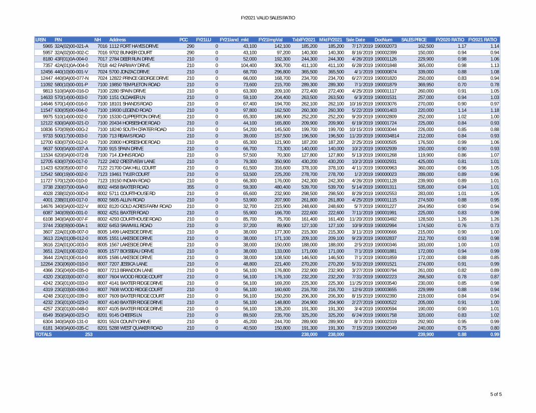
FY2021 VALID SALES RATIO
LRSN PIN NH Address PCC FY21LU FY21land_mkt FY21ImpVal TxblFY2021 MktFY2021 Sale Date DocNum SALES PRICE FY2020 RATIO FY2021 RATIO5965 32A(02)00-021-A 7016 1112 FORT HAYES DRIVE 290 0 43,100 142,100 185,200 185,200 7/17/2019 190002073 162,500 1.17 1.145957 32A(02)00-002-C 7016 9702 BUNKER COURT 290 0 43,100 97,200 140,300 140,300 8/16/2019 190002399 150,000 0.94 0.948180 43F(01)0A-004-0 7017 2784 DEER RUN DRIVE 210 0 52,000 192,300 244,300 244,300 4/26/2019 190001126 229,900 0.98 1.067357 42A(01)0A-004-0 7018 442 FAIRWAY DRIVE 210 0 104,400 306,700 411,100 411,100 6/28/2019 190001848 365,000 0.98 1.13
12456 440(10)00-001-V 7024 5700 JONZAC DRIVE 210 0 68,700 296,800 365,500 365,500 4/1/2019 190000874 339,000 0.88 1.0812447 440(0A)00-077-N 7024 12822 PRINCE GEORGE DRIVE 210 0 66,000 168,700 234,700 234,700 6/27/2019 190001820 250,000 0.83 0.9411092 580(10)00-001-P 7100 19850 TEMPLETON ROAD 210 0 73,600 215,700 289,300 289,300 7/1/2019 190001879 369,950 0.70 0.78
9813 510(0A)00-016-D 7100 2280 SPAIN DRIVE 210 0 63,300 209,100 272,400 272,400 4/25/2019 190001117 260,000 0.91 1.0514633 570(14)00-003-0 7100 1151 OLDAKER LN 210 0 59,100 204,400 263,500 263,500 6/3/2019 190001531 257,000 0.94 1.0314646 570(14)00-016-0 7100 18101 SHANDS ROAD 210 0 67,400 194,700 262,100 262,100 10/16/2019 190003076 270,000 0.90 0.9711547 630(05)00-004-0 7100 19930 LEGEND ROAD 210 0 97,800 162,500 260,300 260,300 5/22/2019 190001403 220,000 1.14 1.18
9975 510(14)00-002-0 7100 15330 CLIPPERTON DRIVE 210 0 65,300 186,900 252,200 252,200 9/20/2019 190002809 252,000 1.02 1.0012122 630(0A)00-021-D 7100 20434 HORSESHOE ROAD 210 0 44,100 165,800 209,900 209,900 6/19/2019 190001724 225,000 0.84 0.9310836 570(09)00-00G-2 7100 18240 SOUTH CRATER ROAD 210 0 54,200 145,500 199,700 199,700 10/15/2019 190003044 226,000 0.85 0.88
9733 500(17)00-003-0 7100 713 REAMS ROAD 210 0 39,000 157,500 196,500 196,500 11/20/2019 1900034814 212,000 0.84 0.9312700 630(07)00-012-0 7100 20800 HORSESHOE ROAD 210 0 65,300 121,900 187,200 187,200 2/25/2019 190000505 176,500 0.99 1.06
9637 500(0A)00-037-A 7100 915 SPAIN DRIVE 210 0 66,700 73,300 140,000 140,000 10/2/2019 190002939 150,000 0.90 0.9311534 620(0A)00-072-B 7100 714 JOHNS ROAD 210 0 57,500 70,300 127,800 127,800 5/13/2019 190001268 119,900 0.86 1.0712705 630(07)00-017-0 7122 2402 CRESTVIEW LANE 210 0 79,300 350,900 430,200 430,200 10/2/2019 190002931 425,000 0.81 1.0111423 620(05)00-007-0 7122 21700 OAK HILL COURT 210 0 61,500 316,600 378,100 378,100 4/11/2019 190000963 360,000 0.96 1.0512542 580(19)00-002-0 7123 19461 TYLER COURT 210 0 53,500 225,200 278,700 278,700 1/2/2019 190000023 289,000 0.89 0.9611727 570(12)00-010-0 7123 19150 INDIAN ROAD 210 0 66,300 176,000 242,300 242,300 4/26/2019 190001128 239,900 0.89 1.01
3738 230(07)00-00A-0 8002 4458 BAXTER ROAD 355 0 59,300 480,400 539,700 539,700 5/14/2019 190001311 535,000 0.94 1.014028 23B(02)00-00D-0 8002 5711 COURTHOUSE RD 210 0 65,600 232,900 298,500 298,500 8/29/2019 190002553 283,000 1.01 1.054001 23B(01)00-017-0 8002 5605 ALLIN ROAD 210 0 53,900 207,900 261,800 261,800 4/25/2019 190001115 274,500 0.88 0.95
14676 340(0A)00-022-V 8002 8120 GOLD ACRES FARM ROAD 210 0 32,700 215,900 248,600 248,600 5/7/2019 190001227 264,950 0.90 0.946087 340(09)00-001-0 8002 4251 BAXTER ROAD 210 0 55,900 166,700 222,600 222,600 7/11/2019 190001991 225,000 0.83 0.996108 340(0A)00-007-F 8002 4293 COURTHOUSE ROAD 210 0 85,700 75,700 161,400 161,400 11/20/2019 190003492 128,500 1.26 1.263744 230(09)00-00A-1 8002 6453 SAWMILL ROAD 210 0 37,200 89,900 127,100 127,100 10/9/2019 190002994 174,500 0.76 0.733607 22A(01)0B-007-0 8005 1499 LAKESIDE DRIVE 210 0 38,000 177,300 215,300 215,300 3/11/2019 190000666 215,000 0.90 1.003613 22A(01)0B-012-0 8005 1551 LAKESIDE DRIVE 210 0 38,000 171,100 209,100 209,100 9/23/2019 190002837 212,700 0.93 0.983616 22A(01)0C-003-0 8005 1567 LAKESIDE DRIVE 210 0 38,000 150,000 188,000 188,000 2/5/2019 190000346 183,000 1.00 1.033651 22A(01)0E-022-0 8005 1577 BOISSEAU DRIVE 210 0 38,000 133,000 171,000 171,000 7/1/2019 190001881 172,000 0.94 0.993644 22A(01)0E-014-0 8005 1586 LAKESIDE DRIVE 210 0 38,000 108,500 146,500 146,500 7/1/2019 190001859 172,000 0.88 0.85
12264 23G(06)00-010-0 8007 7207 JESSICA LANE 210 0 48,800 221,400 270,200 270,200 5/31/2019 190001521 274,000 0.91 0.994366 23G(04)00-035-0 8007 7213 BRANDON LANE 210 0 56,100 176,800 232,900 232,900 3/27/2019 190000794 261,000 0.82 0.894320 23G(03)00-007-0 8007 7604 WOOD RIDGE COURT 210 0 56,100 176,100 232,200 232,200 7/31/2019 190002223 266,500 0.78 0.874242 23G(01)00-033-0 8007 4141 BAXTER RIDGE DRIVE 210 0 56,100 169,200 225,300 225,300 11/25/2019 190003540 230,000 0.85 0.984319 23G(03)00-006-0 8007 7608 WOOD RIDGE COURT 210 0 56,100 160,600 216,700 216,700 12/6/2019 190003655 229,999 0.88 0.944248 23G(01)00-039-0 8007 7609 BAXTER RIDGE COURT 210 0 56,100 150,200 206,300 206,300 8/15/2019 190002390 219,000 0.84 0.944232 23G(01)00-023-0 8007 4140 BAXTER RIDGE DRIVE 210 0 56,100 148,800 204,900 204,900 2/27/2019 190000522 205,000 0.91 1.004257 23G(01)00-048-0 8007 4105 BAXTER RIDGE DRIVE 210 0 56,100 135,200 191,300 191,300 3/4/2019 190000594 190,000 0.90 1.016549 350(0A)00-023-O 8201 9145 CHEERS LN 210 0 89,500 235,700 325,200 325,200 6/24/2019 190001758 320,000 0.83 1.026304 340(0A)00-131-0 8201 5524 COUNTY DRIVE 210 0 45,200 244,700 289,900 289,900 8/7/2019 190002319 292,900 0.95 0.996181 340(0A)00-035-C 8201 5288 WEST QUAKER ROAD 210 0 40,500 150,800 191,300 191,300 7/15/2019 190002049 240,000 0.75 0.80
TOTALS 253 238,000 238,000 239,900 0.88 0.99
5 of 5
Transfer of Ownership
Valuation RecordAssessment Year
Reason for Change
Market Value
Taxable Value
LITLIT
Land SizeRating,Soil ID Acreage Square Feet- or - - or - - or -
Actual Effective EffectiveLand Type Frontage Frontage Depth Influence Factor
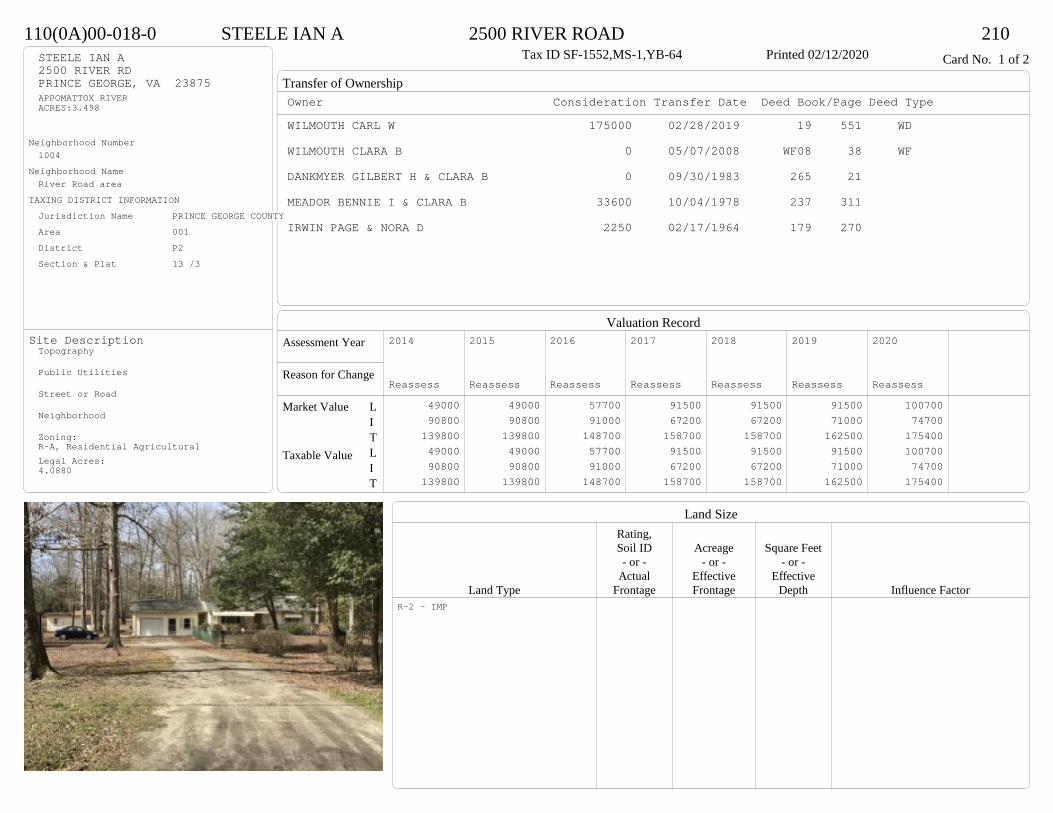
110(0A)00-018-0 STEELE IAN A 2500 RIVER ROAD 210Tax ID SF-1552,MS-1,YB-64 Printed 02/12/2020 Card No. 1 of 2STEELE IAN A
2500 RIVER RDPRINCE GEORGE, VA 23875APPOMATTOX RIVERACRES:3.498
Neighborhood Number1004
Neighborhood NameRiver Road area
TAXING DISTRICT INFORMATIONJurisdiction Name PRINCE GEORGE COUNTYArea 001 District P2 Section & Plat 13 /3
Site DescriptionTopography
Public Utilities
Street or Road
Neighborhood
Zoning:R-A, Residential AgriculturalLegal Acres:4.0880
Owner Consideration Transfer Date Deed Book/Page Deed TypeWILMOUTH CARL W 175000 02/28/2019 19 551 WD
WILMOUTH CLARA B 0 05/07/2008 WF08 38 WF
DANKMYER GILBERT H & CLARA B 0 09/30/1983 265 21
MEADOR BENNIE I & CLARA B 33600 10/04/1978 237 311
IRWIN PAGE & NORA D 2250 02/17/1964 179 270
2014
Reassess 49000 90800 139800 49000 90800 139800
2015
Reassess 49000 90800 139800 49000 90800 139800
2016
Reassess 57700 91000 148700 57700 91000 148700
2017
Reassess 91500 67200 158700 91500 67200 158700
2018
Reassess 91500 67200 158700 91500 67200 158700
2019
Reassess 91500 71000 162500 91500 71000 162500
2020
Reassess 100700 74700 175400 100700 74700 175400
R-2 - IMP
Physical Characteristics
Special Features
Description
Summary of ImprovementsStory Const Year Eff Size or
ID USE Height Type Grade Cons Year Cond Area
110(0A)00-018-0 STEELE IAN A 2500 RIVER ROAD 210Tax ID SF-1552,MS-1,YB-64 Printed 02/12/2020
28
40.5
12.5
4
15.5
44.5
1 s Mas C
1196
22.44OMP 90
OMP
16
16
8 Conc 1286.3
4
M Stp257
11
1 s Mas (UF) Slab
106
13.2
17
9.74
13
1 s Mas Slab 210
12.5
24Mas G
300
01Style: 90 MASONRYOccupancy: Single family
Story Height: 1.0Finished Area: 1406 Attic: NoneBasement: None
ROOFINGMaterial: Comp sh to 235#Type: GableFraming: Std for class
FLOORINGSub and joists 1.0Base Allowance 1.0
EXTERIOR COVERStucco 1.0
INTERIOR FINISHDrywall 1.0
ACCOMMODATIONFinished Rooms 5Bedrooms 2HEATING AND AIR CONDITIONINGPrimary Heat: Hot water Lower Full Part /Bsmt 1 Upper UpperAir Cond 0 1406 0 0PLUMBING # TF3 Fixt. Baths 1 32 Fixt. Baths 1 2Kit Sink 1 1Water Heat 1 1 TOTAL 7
REMODELING AND MODERNIZATION Amount Date
D DWELL 0.00 35 1964 1964 2 1512G01 ATTGAR 0.00 7 30001 SHEDGP 1.00 4 35 1965 1965 1 442
D : Fireplace
Transfer of Ownership
Valuation RecordAssessment Year
Reason for Change
Market Value
Taxable Value
LITLIT
Land SizeRating,Soil ID Acreage Square Feet- or - - or - - or -
Actual Effective EffectiveLand Type Frontage Frontage Depth Influence Factor
110(0A)00-018-0 STEELE IAN A 2500 RIVER ROAD 210Tax ID SF-1552,MS-1,YB-64 Printed 02/12/2020 Card No. 2 of 2

Physical Characteristics
Special Features
Description
Summary of ImprovementsStory Const Year Eff Size or
ID USE Height Type Grade Cons Year Cond Area
110(0A)00-018-0 STEELE IAN A 2500 RIVER ROAD 210Tax ID SF-1552,MS-1,YB-64 Printed 02/12/2020
17.3
29.4
1 s Mas Slab 509
5
6
M Stp30
9
9
OMP81
Style: 12 1 STORY 1960-69Occupancy: Single family
Story Height: 1.0Finished Area: 509 Attic: NoneBasement: None
ROOFINGMaterial: Comp sh to 235#Type: GableFraming: Std for class
FLOORINGSlab 1.0Base Allowance 1.0
EXTERIOR COVERBlock 1.0
INTERIOR FINISHDrywall 1.0
ACCOMMODATIONFinished Rooms 3Bedrooms 1Family Rooms 1HEATING AND AIR CONDITIONINGPrimary Heat: Space heater Lower Full Part /Bsmt 1 Upper UpperPLUMBING # TF3 Fixt. Baths 1 3Kit Sink 1 1Water Heat 1 1 TOTAL 5
REMODELING AND MODERNIZATION Amount Date
D DWELL 0.00 35 1967 1967 2 509D : Wood/pellet stove
Transfer of Ownership
Valuation RecordAssessment Year
Reason for Change
Market Value
Taxable Value
LITLIT
Land SizeRating,Soil ID Acreage Square Feet- or - - or - - or -
Actual Effective EffectiveLand Type Frontage Frontage Depth Influence Factor
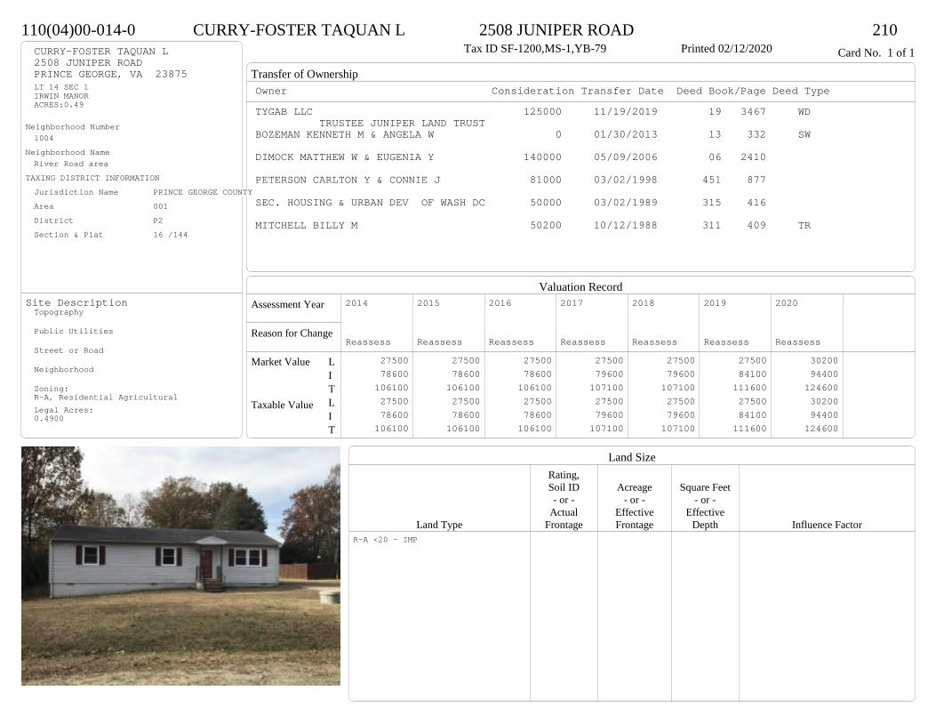
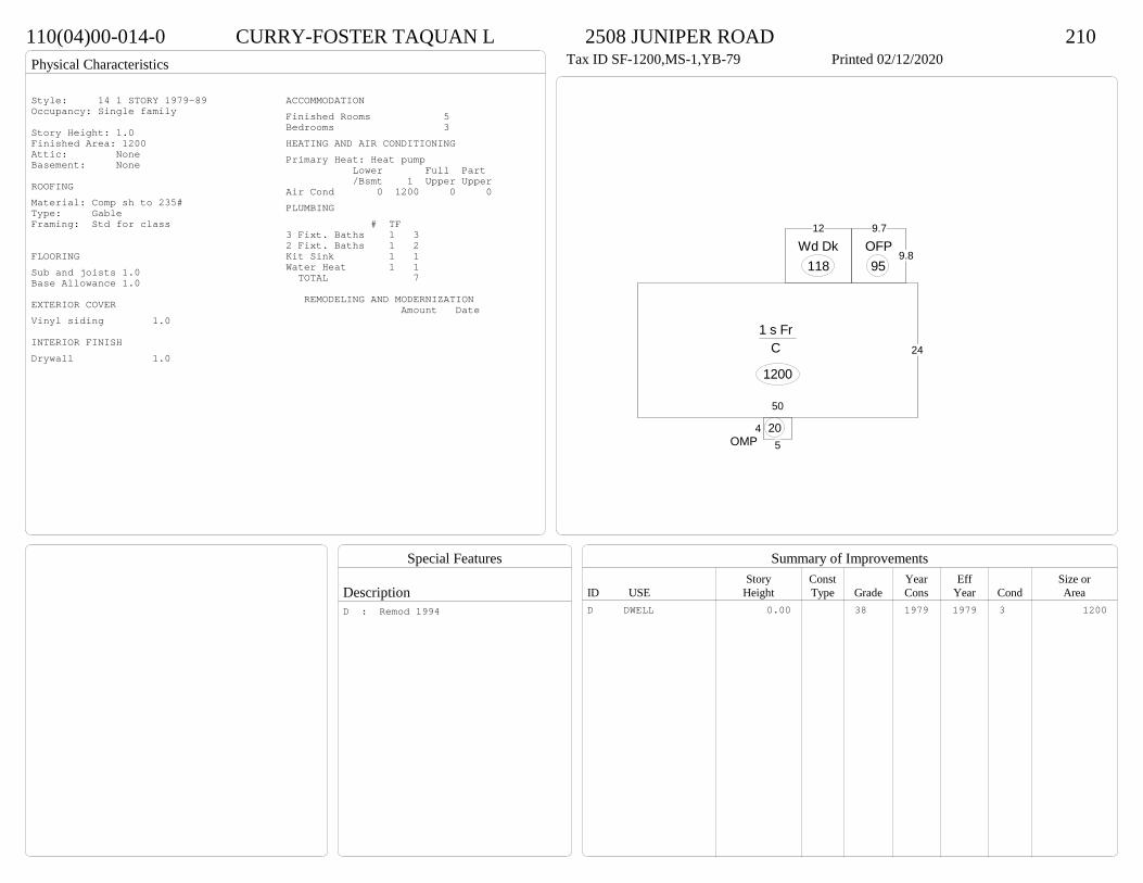
110(04)00-014-0 CURRY-FOSTER TAQUAN L 2508 JUNIPER ROAD 210Tax ID SF-1200,MS-1,YB-79 Printed 02/12/2020 Card No. 1 of 1CURRY-FOSTER TAQUAN L
2508 JUNIPER ROADPRINCE GEORGE, VA 23875LT 14 SEC 1IRWIN MANORACRES:0.49
Neighborhood Number1004
Neighborhood NameRiver Road area
TAXING DISTRICT INFORMATIONJurisdiction Name PRINCE GEORGE COUNTYArea 001 District P2 Section & Plat 16 /144
Site DescriptionTopography
Public Utilities
Street or Road
Neighborhood
Zoning:R-A, Residential AgriculturalLegal Acres:0.4900
Owner Consideration Transfer Date Deed Book/Page Deed TypeTYGAB LLC 125000 11/19/2019 19 3467 WD
TRUSTEE JUNIPER LAND TRUSTBOZEMAN KENNETH M & ANGELA W 0 01/30/2013 13 332 SW
DIMOCK MATTHEW W & EUGENIA Y 140000 05/09/2006 06 2410
PETERSON CARLTON Y & CONNIE J 81000 03/02/1998 451 877
SEC. HOUSING & URBAN DEV OF WASH DC 50000 03/02/1989 315 416
MITCHELL BILLY M 50200 10/12/1988 311 409 TR
2014
Reassess 27500 78600 106100 27500 78600 106100
2015
Reassess 27500 78600 106100 27500 78600 106100
2016
Reassess 27500 78600 106100 27500 78600 106100
2017
Reassess 27500 79600 107100 27500 79600 107100
2018
Reassess 27500 79600 107100 27500 79600 107100
2019
Reassess 27500 84100 111600 27500 84100 111600
2020
Reassess 30200 94400 124600 30200 94400 124600
R-A <20 - IMP
Physical Characteristics
Special Features
Description
Summary of ImprovementsStory Const Year Eff Size or
ID USE Height Type Grade Cons Year Cond Area
110(04)00-014-0 CURRY-FOSTER TAQUAN L 2508 JUNIPER ROAD 210Tax ID SF-1200,MS-1,YB-79 Printed 02/12/2020
24
50
1 s Fr C
1200
9.8
9.7
OFP95
12
Wd Dk118
45OMP
20
Style: 14 1 STORY 1979-89Occupancy: Single family
Story Height: 1.0Finished Area: 1200 Attic: NoneBasement: None
ROOFINGMaterial: Comp sh to 235#Type: GableFraming: Std for class
FLOORINGSub and joists 1.0Base Allowance 1.0
EXTERIOR COVERVinyl siding 1.0
INTERIOR FINISHDrywall 1.0
ACCOMMODATIONFinished Rooms 5Bedrooms 3HEATING AND AIR CONDITIONINGPrimary Heat: Heat pump Lower Full Part /Bsmt 1 Upper UpperAir Cond 0 1200 0 0PLUMBING # TF3 Fixt. Baths 1 32 Fixt. Baths 1 2Kit Sink 1 1Water Heat 1 1 TOTAL 7
REMODELING AND MODERNIZATION Amount Date
D DWELL 0.00 38 1979 1979 3 1200D : Remod 1994
Transfer of Ownership
Valuation RecordAssessment Year
Reason for Change
Market Value
Taxable Value
LITLIT
Land SizeRating,Soil ID Acreage Square Feet- or - - or - - or -
Actual Effective EffectiveLand Type Frontage Frontage Depth Influence Factor
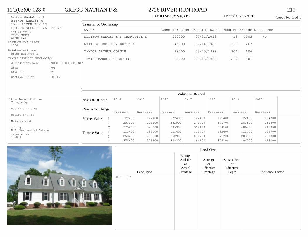
11C(03)00-028-0 GREGG NATHAN P & 2728 RIVER RUN ROAD 210Tax ID SF-0,MS-0,YB- Printed 02/12/2020 Card No. 1 of 1GREGG NATHAN P &
BISHOP ASHLEY M2728 RIVER RUN RDPRINCE GEORGE, VA 23875LOT 28 SEC 3IRWIN MANORACRES:1.2
Neighborhood Number1006
Neighborhood NameRiver Run Road RF
TAXING DISTRICT INFORMATIONJurisdiction Name PRINCE GEORGE COUNTYArea 001 District P2 Section & Plat 18 /67
Site DescriptionTopography
Public Utilities
Street or Road
Neighborhood
Zoning:R-E, Residential EstateLegal Acres:1.2000
Owner Consideration Transfer Date Deed Book/Page Deed TypeELLISON SAMUEL E & CHARLOTTE D 500000 05/31/2019 19 1503 WD
WHITLEY JOEL D & BETTY W 45000 07/14/1989 319 467
TAYLOR ARTHUR CORWIN 38000 03/25/1988 304 506
IRWIN MANOR PROPERTIES 15000 05/15/1984 269 481
2014
Reassess 122400 253200 375600 122400 253200 375600
2015
Reassess 122400 253200 375600 122400 253200 375600
2016
Reassess 122400 262900 385300 122400 262900 385300
2017
Reassess 122400 271700 394100 122400 271700 394100
2018
Reassess 122400 271700 394100 122400 271700 394100
2019
Reassess 122400 283800 406200 122400 283800 406200
2020
Reassess 134700 281300 416000 134700 281300 416000
R-E - IMP
Physical Characteristics
Special Features
Description
Summary of ImprovementsStory Const Year Eff Size or
ID USE Height Type Grade Cons Year Cond Area
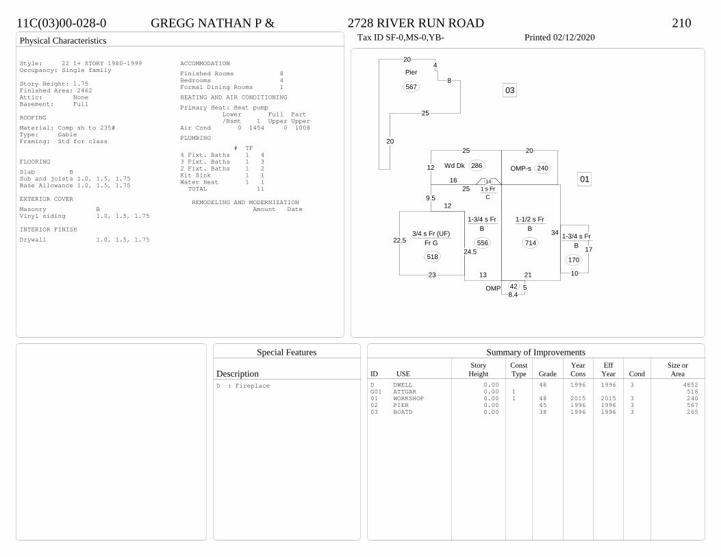
11C(03)00-028-0 GREGG NATHAN P & 2728 RIVER RUN ROAD 210Tax ID SF-0,MS-0,YB- Printed 02/12/2020
34
21
1-1/2 s Fr B
714
10
17
1-3/4 s Fr B
170
58.4
OMP 42
13
24.5
129.5
25
1-3/4 s Fr B
556
1 s Fr C
1416
12
25
Wd Dk 286
20
OMP-s 240
22.5
23
3/4 s Fr (UF) Fr G
518
01
204
8
25
20
Pier
567 03
Style: 22 1+ STORY 1980-1999Occupancy: Single family
Story Height: 1.75Finished Area: 2462 Attic: NoneBasement: Full
ROOFINGMaterial: Comp sh to 235#Type: GableFraming: Std for class
FLOORINGSlab BSub and joists 1.0, 1.5, 1.75Base Allowance 1.0, 1.5, 1.75
EXTERIOR COVERMasonry BVinyl siding 1.0, 1.5, 1.75
INTERIOR FINISHDrywall 1.0, 1.5, 1.75
ACCOMMODATIONFinished Rooms 8Bedrooms 4Formal Dining Rooms 1HEATING AND AIR CONDITIONINGPrimary Heat: Heat pump Lower Full Part /Bsmt 1 Upper UpperAir Cond 0 1454 0 1008PLUMBING # TF4 Fixt. Baths 1 43 Fixt. Baths 1 32 Fixt. Baths 1 2Kit Sink 1 1Water Heat 1 1 TOTAL 11
REMODELING AND MODERNIZATION Amount Date
D DWELL 0.00 48 1996 1996 3 4852G01 ATTGAR 0.00 1 51801 WORKSHOP 0.00 1 48 2015 2015 3 24002 PIER 0.00 45 1996 1996 3 56703 BOATD 0.00 38 1996 1996 3 265
D : Fireplace

Transfer of Ownership
Valuation RecordAssessment Year
Reason for Change
Market Value
Taxable Value
LITLIT
Land SizeRating,Soil ID Acreage Square Feet- or - - or - - or -
Actual Effective EffectiveLand Type Frontage Frontage Depth Influence Factor
230(0A)00-017-0 ELLIS CATIE H & SEAN W 5115 JEFFERSON PARK ROAD 210Tax ID SF-831,MS-1,YB-? Printed 02/12/2020 Card No. 1 of 1ELLIS CATIE H & SEAN W
5115 JEFFERSON PARK RDPRINCE GEORGE, VA 23875BAILYS CREEKACRES:4.546
Neighborhood Number2001
Neighborhood NamePGPA 2
TAXING DISTRICT INFORMATIONJurisdiction Name PRINCE GEORGE COUNTYArea 001 District P2 Section & Plat 20 /47
Site DescriptionTopography
Public Utilities
Street or Road
Neighborhood
Zoning:R-A, Residential AgriculturalR-2, General ResidentialLegal Acres:4.5460
Owner Consideration Transfer Date Deed Book/Page Deed TypeMEADOWS JOSEPH A III & DONNA A 430000 11/08/2019 19 3353 WD
2014
Reassess 66300 266500 332800 66300 266500 332800
2015
Reassess 66300 266500 332800 66300 266500 332800
2016
Reassess 66300 266500 332800 66300 266500 332800
2017
Reassess 66300 269400 335700 66300 269400 335700
2018
Reassess 66300 282900 349200 66300 282900 349200
2019
Reassess 66300 296500 362800 66300 296500 362800
2020
Reassess 72900 322700 395600 72900 322700 395600
R-A <20 - IMP Z 10%

Physical Characteristics
Special Features
Description
Summary of ImprovementsStory Const Year Eff Size or
ID USE Height Type Grade Cons Year Cond Area
230(0A)00-017-0 ELLIS CATIE H & SEAN W 5115 JEFFERSON PARK ROAD 210Tax ID SF-831,MS-1,YB-? Printed 02/12/2020
41.5
32.14
11.7
25.2
28.7
35.3
612.8
11.2
17.4
16.5
14.7
1 s Br C
2562
27
12 M Stp 277
5.9 OMP103
30.3
14.3
Wd Dk
433
6
M Stp21
27.6
24
1/2 s Br (Fin) Br G
662
Style: 15 1 STORY 1990-1999Occupancy: Single family
Story Height: 1.0Finished Area: 2894 Attic: NoneBasement: None
ROOFINGMaterial: Comp sh to 235#Type: GableFraming: Std for class
FLOORINGSub and joists 1.0, 1.5Base Allowance 1.0, 1.5
EXTERIOR COVERBrick 1.0, 1.5Vinyl siding 1.5
INTERIOR FINISH
ACCOMMODATIONFinished Rooms 7Bedrooms 3Family Rooms 1HEATING AND AIR CONDITIONINGPrimary Heat: Heat pump Lower Full Part /Bsmt 1 Upper UpperAir Cond 0 2562 0 332PLUMBING # TF5 Fixt. Baths 1 54 Fixt. Baths 1 42 Fixt. Baths 1 2Kit Sink 1 1Water Heat 1 1 TOTAL 13
REMODELING AND MODERNIZATION Amount Date
D DWELL 0.00 55 1997 1997 3 3224G01 ATTGAR 0.00 7 662
D : Fireplace
Transfer of Ownership
Valuation RecordAssessment Year
Reason for Change
Market Value
Taxable Value
LITLIT
Land SizeRating,Soil ID Acreage Square Feet- or - - or - - or -
Actual Effective EffectiveLand Type Frontage Frontage Depth Influence Factor
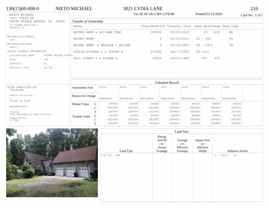
130(15)00-008-0 NIETO MICHAEL 3021 LYDIA LANE 210Tax ID SF-2412,MS-2,YB-89 Printed 02/12/2020 Card No. 1 of 1NIETO MICHAEL
3021 LYDIA LNNORTH PRINCE GEORGE, VA 23860PT JOSEPH SULC ALS PACRES:2.75
Neighborhood Number2001
Neighborhood NamePGPA 2
TAXING DISTRICT INFORMATIONJurisdiction Name PRINCE GEORGE COUNTYArea 001 District P2 Section & Plat 18 /91
Site DescriptionTopography
Public Utilities
Street or Road
Neighborhood
Zoning:R-A, Residential AgriculturalLegal Acres:2.7500
Owner Consideration Transfer Date Deed Book/Page Deed TypeHAINES RENE & LOU ANN TYER 349000 05/09/2019 19 1250 WD
HAINES RENE' 0 01/23/2001 01 - 253 DG
HAINES RENE' & HEATHER L MILLER 0 08/28/2000 00 - 3471 DG
CATLIN RICHARD L & TERESA R 215000 04/17/2000 00-1541
SULC JOSEPH J & ESTHER R 19250 06/23/1988 307 637
2014
Reassess 44500 281000 325500 44500 281000 325500
2015
Reassess 44500 281000 325500 44500 281000 325500
2016
Reassess 44500 281000 325500 44500 281000 325500
2017
Reassess 44500 280400 324900 44500 280400 324900
2018
Reassess 44500 280400 324900 44500 280400 324900
2019
Reassess 44000 286400 330400 44000 286400 330400
2020
Reassess 48300 282900 331200 48300 282900 331200
R-A <20 - IMP A -10% R -1%
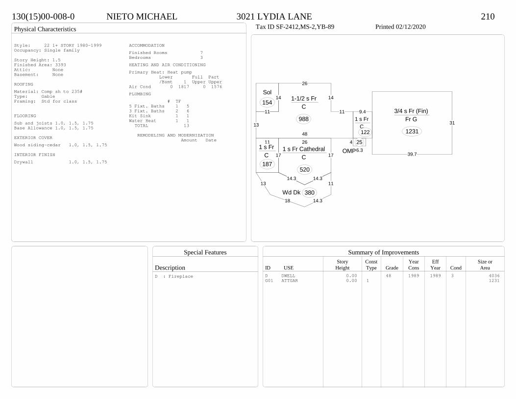
Physical Characteristics
Special Features
Description
Summary of ImprovementsStory Const Year Eff Size or
ID USE Height Type Grade Cons Year Cond Area
130(15)00-008-0 NIETO MICHAEL 3021 LYDIA LANE 210Tax ID SF-2412,MS-2,YB-89 Printed 02/12/2020
14
11
13
48
11
14
26
1-1/2 s Fr C
988
13
18 14.3
11
Wd Dk 380
26
17
14.3 14.3
171 s Fr Cathedral
C
520
9.41 s Fr
C 122
46.3OMP25
Sol154
111 s Fr
C 187
31
39.7
3/4 s Fr (Fin) Fr G
1231
Style: 22 1+ STORY 1980-1999Occupancy: Single family
Story Height: 1.5Finished Area: 3393 Attic: NoneBasement: None
ROOFINGMaterial: Comp sh to 235#Type: GableFraming: Std for class
FLOORINGSub and joists 1.0, 1.5, 1.75Base Allowance 1.0, 1.5, 1.75
EXTERIOR COVERWood siding-cedar 1.0, 1.5, 1.75
INTERIOR FINISHDrywall 1.0, 1.5, 1.75
ACCOMMODATIONFinished Rooms 7Bedrooms 3HEATING AND AIR CONDITIONINGPrimary Heat: Heat pump Lower Full Part /Bsmt 1 Upper UpperAir Cond 0 1817 0 1576PLUMBING # TF5 Fixt. Baths 1 53 Fixt. Baths 2 6Kit Sink 1 1Water Heat 1 1 TOTAL 13
REMODELING AND MODERNIZATION Amount Date
D DWELL 0.00 48 1989 1989 3 4036G01 ATTGAR 0.00 1 1231
D : Fireplace
Transfer of Ownership
Valuation RecordAssessment Year
Reason for Change
Market Value
Taxable Value
LITLIT
Land SizeRating,Soil ID Acreage Square Feet- or - - or - - or -
Actual Effective EffectiveLand Type Frontage Frontage Depth Influence Factor
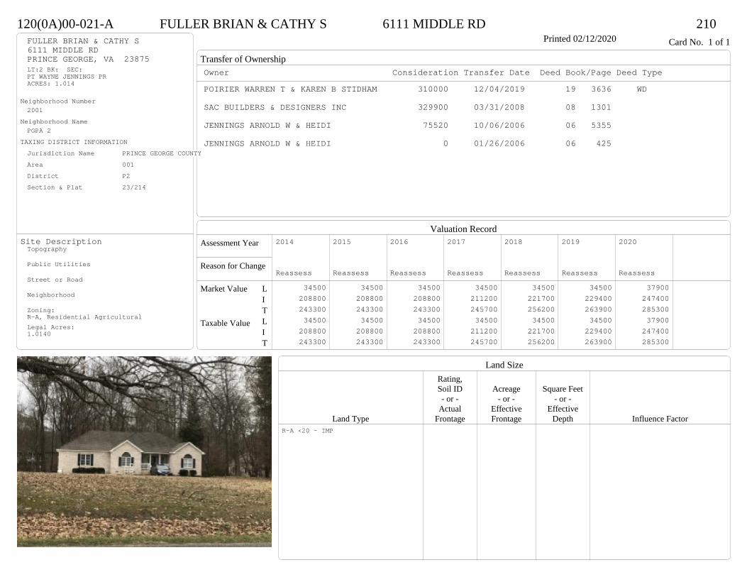
120(0A)00-021-A FULLER BRIAN & CATHY S 6111 MIDDLE RD 210Printed 02/12/2020 Card No. 1 of 1FULLER BRIAN & CATHY S
6111 MIDDLE RDPRINCE GEORGE, VA 23875LT:2 BK: SEC:PT WAYNE JENNINGS PRACRES: 1.014
Neighborhood Number2001
Neighborhood NamePGPA 2
TAXING DISTRICT INFORMATIONJurisdiction Name PRINCE GEORGE COUNTYArea 001 District P2 Section & Plat 23/214
Site DescriptionTopography
Public Utilities
Street or Road
Neighborhood
Zoning:R-A, Residential AgriculturalLegal Acres:1.0140
Owner Consideration Transfer Date Deed Book/Page Deed TypePOIRIER WARREN T & KAREN B STIDHAM 310000 12/04/2019 19 3636 WD
SAC BUILDERS & DESIGNERS INC 329900 03/31/2008 08 1301
JENNINGS ARNOLD W & HEIDI 75520 10/06/2006 06 5355
JENNINGS ARNOLD W & HEIDI 0 01/26/2006 06 425
2014
Reassess 34500 208800 243300 34500 208800 243300
2015
Reassess 34500 208800 243300 34500 208800 243300
2016
Reassess 34500 208800 243300 34500 208800 243300
2017
Reassess 34500 211200 245700 34500 211200 245700
2018
Reassess 34500 221700 256200 34500 221700 256200
2019
Reassess 34500 229400 263900 34500 229400 263900
2020
Reassess 37900 247400 285300 37900 247400 285300
R-A <20 - IMP
Physical Characteristics
Special Features
Description
Summary of ImprovementsStory Const Year Eff Size or
ID USE Height Type Grade Cons Year Cond Area
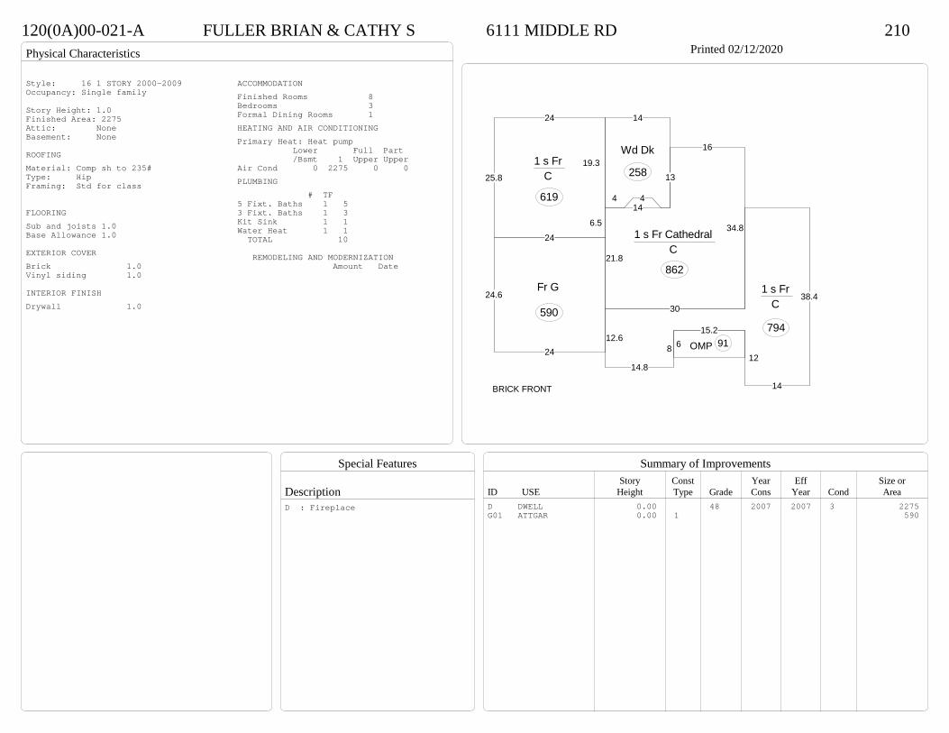
120(0A)00-021-A FULLER BRIAN & CATHY S 6111 MIDDLE RD 210Printed 02/12/2020
14.8
8
15.2
12
14
38.430
12.6
1 s Fr C
794
19.3
24
25.8
246.5
1 s Fr C
619
34.8
21.8
14
13
16
1 s Fr Cathedral C
862
14
44
Wd Dk
258
6 OMP 91
24.6
24
Fr G
590
BRICK FRONT
Style: 16 1 STORY 2000-2009Occupancy: Single family
Story Height: 1.0Finished Area: 2275 Attic: NoneBasement: None
ROOFINGMaterial: Comp sh to 235#Type: HipFraming: Std for class
FLOORINGSub and joists 1.0Base Allowance 1.0
EXTERIOR COVERBrick 1.0Vinyl siding 1.0
INTERIOR FINISHDrywall 1.0
ACCOMMODATIONFinished Rooms 8Bedrooms 3Formal Dining Rooms 1HEATING AND AIR CONDITIONINGPrimary Heat: Heat pump Lower Full Part /Bsmt 1 Upper UpperAir Cond 0 2275 0 0PLUMBING # TF5 Fixt. Baths 1 53 Fixt. Baths 1 3Kit Sink 1 1Water Heat 1 1 TOTAL 10
REMODELING AND MODERNIZATION Amount Date
D DWELL 0.00 48 2007 2007 3 2275G01 ATTGAR 0.00 1 590
D : Fireplace
Transfer of Ownership
Valuation RecordAssessment Year
Reason for Change
Market Value
Taxable Value
LITLIT
Land SizeRating,Soil ID Acreage Square Feet- or - - or - - or -
Actual Effective EffectiveLand Type Frontage Frontage Depth Influence Factor
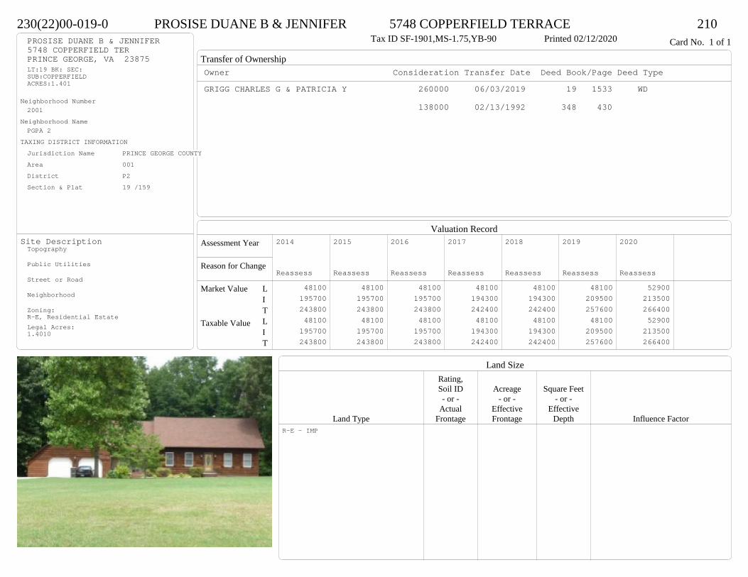
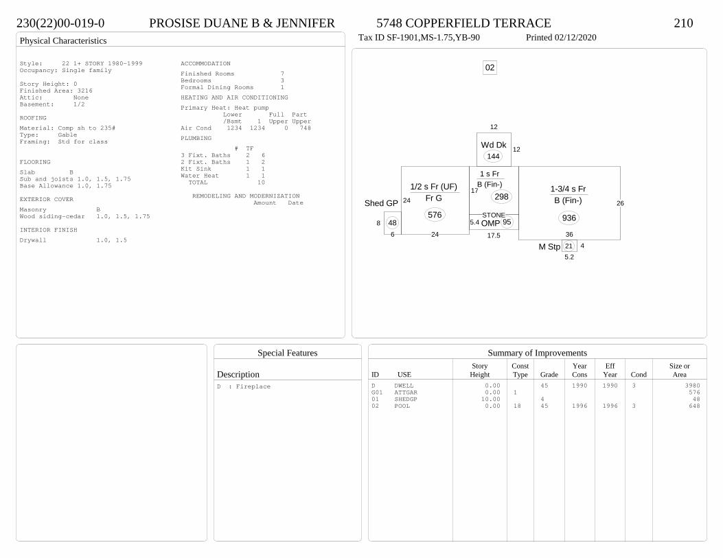
230(22)00-019-0 PROSISE DUANE B & JENNIFER 5748 COPPERFIELD TERRACE 210Tax ID SF-1901,MS-1.75,YB-90 Printed 02/12/2020 Card No. 1 of 1PROSISE DUANE B & JENNIFER
5748 COPPERFIELD TERPRINCE GEORGE, VA 23875LT:19 BK: SEC:SUB:COPPERFIELDACRES:1.401
Neighborhood Number2001
Neighborhood NamePGPA 2
TAXING DISTRICT INFORMATIONJurisdiction Name PRINCE GEORGE COUNTYArea 001 District P2 Section & Plat 19 /159
Site DescriptionTopography
Public Utilities
Street or Road
Neighborhood
Zoning:R-E, Residential EstateLegal Acres:1.4010
Owner Consideration Transfer Date Deed Book/Page Deed TypeGRIGG CHARLES G & PATRICIA Y 260000 06/03/2019 19 1533 WD
138000 02/13/1992 348 430
2014
Reassess 48100 195700 243800 48100 195700 243800
2015
Reassess 48100 195700 243800 48100 195700 243800
2016
Reassess 48100 195700 243800 48100 195700 243800
2017
Reassess 48100 194300 242400 48100 194300 242400
2018
Reassess 48100 194300 242400 48100 194300 242400
2019
Reassess 48100 209500 257600 48100 209500 257600
2020
Reassess 52900 213500 266400 52900 213500 266400
R-E - IMP
Physical Characteristics
Special Features
Description
Summary of ImprovementsStory Const Year Eff Size or
ID USE Height Type Grade Cons Year Cond Area
230(22)00-019-0 PROSISE DUANE B & JENNIFER 5748 COPPERFIELD TERRACE 210Tax ID SF-1901,MS-1.75,YB-90 Printed 02/12/2020
36
26
1-3/4 s Fr B (Fin-)
936
17
1 s Fr B (Fin-)
298
5.4
17.5
OMP 95
12
12
Wd Dk144
45.2
M Stp 21
24
24
1/2 s Fr (UF) Fr G
576
68
Shed GP
48
02
STONE
Style: 22 1+ STORY 1980-1999Occupancy: Single family
Story Height: 0Finished Area: 3216 Attic: NoneBasement: 1/2
ROOFINGMaterial: Comp sh to 235#Type: GableFraming: Std for class
FLOORINGSlab BSub and joists 1.0, 1.5, 1.75Base Allowance 1.0, 1.75
EXTERIOR COVERMasonry BWood siding-cedar 1.0, 1.5, 1.75
INTERIOR FINISHDrywall 1.0, 1.5
ACCOMMODATIONFinished Rooms 7Bedrooms 3Formal Dining Rooms 1HEATING AND AIR CONDITIONINGPrimary Heat: Heat pump Lower Full Part /Bsmt 1 Upper UpperAir Cond 1234 1234 0 748PLUMBING # TF3 Fixt. Baths 2 62 Fixt. Baths 1 2Kit Sink 1 1Water Heat 1 1 TOTAL 10
REMODELING AND MODERNIZATION Amount Date
D DWELL 0.00 45 1990 1990 3 3980G01 ATTGAR 0.00 1 57601 SHEDGP 10.00 4 4802 POOL 0.00 18 45 1996 1996 3 648
D : Fireplace

Transfer of Ownership
Valuation RecordAssessment Year
Reason for Change
Market Value
Taxable Value
LITLIT
Land SizeRating,Soil ID Acreage Square Feet- or - - or - - or -
Actual Effective EffectiveLand Type Frontage Frontage Depth Influence Factor
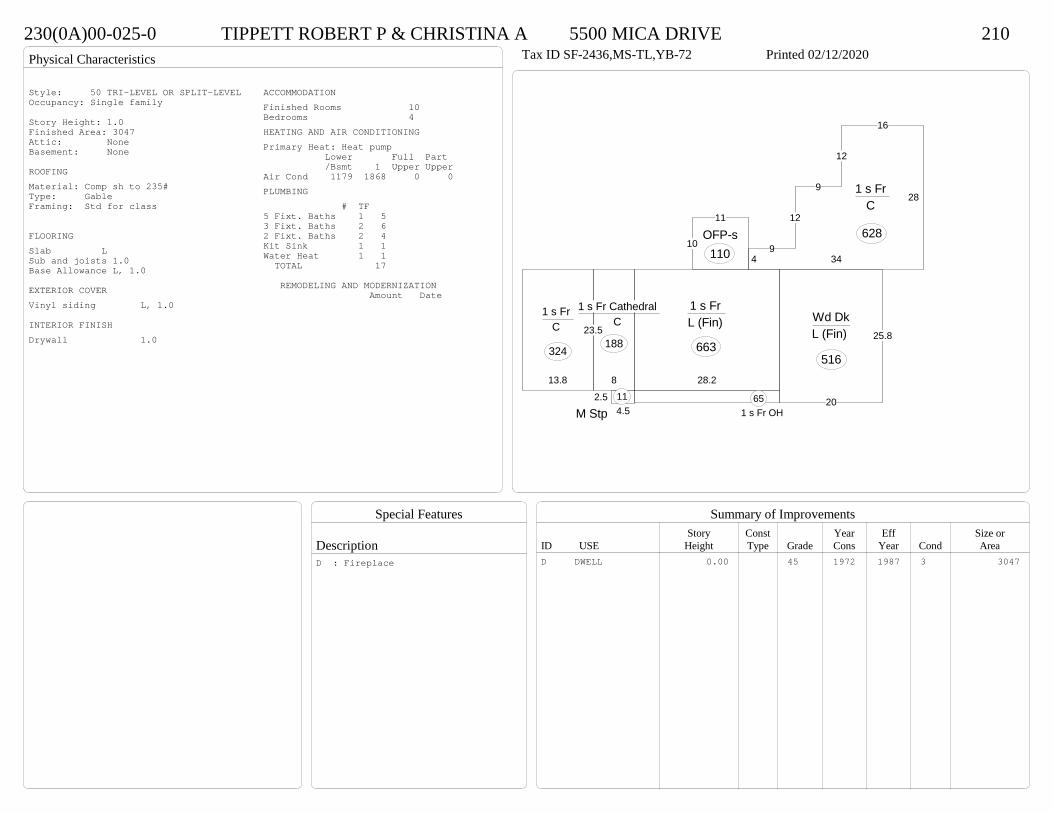
230(0A)00-025-0 TIPPETT ROBERT P & CHRISTINA A 5500 MICA DRIVE 210Tax ID SF-2436,MS-TL,YB-72 Printed 02/12/2020 Card No. 1 of 1TIPPETT ROBERT P & CHRISTINA A
5500 MICA DRPRINCE GEORGE, VA 23875SOUTHERLY RUNACRES:1.046
Neighborhood Number2001
Neighborhood NamePGPA 2
TAXING DISTRICT INFORMATIONJurisdiction Name PRINCE GEORGE COUNTYArea 001 District P2 Section & Plat 13 /190
Site DescriptionTopography
Public Utilities
Street or Road
Neighborhood
Zoning:R-A, Residential AgriculturalLegal Acres:1.0460
Owner Consideration Transfer Date Deed Book/Page Deed TypeSQUIRE ELLIS C & ANITA M 284500 06/24/2019 19 1781 WD
97000 08/17/1992 356 465
2014
Reassess 34800 170800 205600 34800 170800 205600
2015
Reassess 34800 170800 205600 34800 170800 205600
2016
Reassess 34800 170800 205600 34800 170800 205600
2017
Reassess 34800 174800 209600 34800 174800 209600
2018
Reassess 34800 178300 213100 34800 178300 213100
2019
Reassess 34800 190300 225100 34800 190300 225100
2020
Reassess 38300 210700 249000 38300 210700 249000
R-A <20 - IMP
Physical Characteristics
Special Features
Description
Summary of ImprovementsStory Const Year Eff Size or
ID USE Height Type Grade Cons Year Cond Area
230(0A)00-025-0 TIPPETT ROBERT P & CHRISTINA A 5500 MICA DRIVE 210Tax ID SF-2436,MS-TL,YB-72 Printed 02/12/2020
25.8
20
Wd DkL (Fin)
51628.2
1 s Fr L (Fin)
663
8
23.5
1 s Fr Cathedral C
188
13.8
1 s Fr C
324
1 s Fr OH 65
4.52.5
M Stp11
28
16
12
9
12
94 34
1 s Fr C
62810
11
OFP-s110
Style: 50 TRI-LEVEL OR SPLIT-LEVELOccupancy: Single family
Story Height: 1.0Finished Area: 3047 Attic: NoneBasement: None
ROOFINGMaterial: Comp sh to 235#Type: GableFraming: Std for class
FLOORINGSlab LSub and joists 1.0Base Allowance L, 1.0
EXTERIOR COVERVinyl siding L, 1.0
INTERIOR FINISHDrywall 1.0
ACCOMMODATIONFinished Rooms 10Bedrooms 4HEATING AND AIR CONDITIONINGPrimary Heat: Heat pump Lower Full Part /Bsmt 1 Upper UpperAir Cond 1179 1868 0 0PLUMBING # TF5 Fixt. Baths 1 53 Fixt. Baths 2 62 Fixt. Baths 2 4Kit Sink 1 1Water Heat 1 1 TOTAL 17
REMODELING AND MODERNIZATION Amount Date
D DWELL 0.00 45 1972 1987 3 3047D : Fireplace
Transfer of Ownership
Valuation RecordAssessment Year
Reason for Change
Market Value
Taxable Value
LITLIT
Land SizeRating,Soil ID Acreage Square Feet- or - - or - - or -
Actual Effective EffectiveLand Type Frontage Frontage Depth Influence Factor
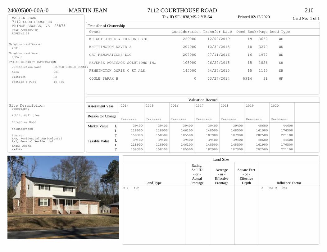
240(05)00-00A-0 MARTIN JEAN 7112 COURTHOUSE ROAD 210Tax ID SF-1838,MS-2,YB-64 Printed 02/12/2020 Card No. 1 of 1MARTIN JEAN
7112 COURTHOUSE RDPRINCE GEORGE, VA 23875NEAR COURTHOUSEACRES:2.34
Neighborhood Number2001
Neighborhood NamePGPA 2
TAXING DISTRICT INFORMATIONJurisdiction Name PRINCE GEORGE COUNTYArea 001 District P2 Section & Plat 10 /96
Site DescriptionTopography
Public Utilities
Street or Road
Neighborhood
Zoning:R-A, Residential AgriculturalR-2, General ResidentialLegal Acres:2.3400
Owner Consideration Transfer Date Deed Book/Page Deed TypeWRIGHT JIM E & TRISHA BETH 229000 12/09/2019 19 3662 WD
WHITTINGTON DAVID A 207000 10/30/2018 18 3270 WD
CRT RENOVATIONS LLC 207000 07/11/2016 16 1977 WD
REVERSE MORTGAGE SOLUTIONS INC 105000 06/29/2015 15 1826 SW
PENNINGTON DORIS C ET ALS 145000 04/27/2015 15 1145 SW
COGLE SARAH B 0 03/27/2014 WF14 31 WF
2014
Reassess 39400 118900 158300 39400 118900 158300
2015
Reassess 39400 118900 158300 39400 118900 158300
2016
Reassess 39400 146100 185500 39400 146100 185500
2017
Reassess 39400 148500 187900 39400 148500 187900
2018
Reassess 39400 148500 187900 39400 148500 187900
2019
Reassess 40600 161900 202500 40600 161900 202500
2020
Reassess 44600 176500 221100 44600 176500 221100
R-2 - IMP S -15% Z -25%

Physical Characteristics
Special Features
Description
Summary of ImprovementsStory Const Year Eff Size or
ID USE Height Type Grade Cons Year Cond Area
240(05)00-00A-0 MARTIN JEAN 7112 COURTHOUSE ROAD 210Tax ID SF-1838,MS-2,YB-64 Printed 02/12/2020
24.3
33.3
2 s Fr C
809
6.6
33.31 s Fr
C 220
5.418.6
OMP 100
10
12
Wd Dk120
20
28.1
Fr G
566
Style: 31 2/2+ Story<1979Occupancy: Single family
Story Height: 2.0Finished Area: 1838 Attic: NoneBasement: None
ROOFINGMaterial: Comp sh to 235#Type: GableFraming: Std for class
FLOORINGSub and joists 1.0, 2.0Base Allowance 1.0, 2.0
EXTERIOR COVERBrick 1.0Vinyl siding 2.0
INTERIOR FINISHDrywall 1.0, 2.0
ACCOMMODATIONFinished Rooms 8Bedrooms 3HEATING AND AIR CONDITIONINGPrimary Heat: Heat pump Lower Full Part /Bsmt 1 Upper UpperAir Cond 0 1029 809 0PLUMBING # TF4 Fixt. Baths 1 43 Fixt. Baths 1 32 Fixt. Baths 1 2Kit Sink 1 1Water Heat 1 1 TOTAL 11
REMODELING AND MODERNIZATION Amount Date
D DWELL 0.00 45 1964 1992 3 1838G01 ATTGAR 0.00 1 566
D : Remod 2015 Fireplace
Transfer of Ownership
Valuation RecordAssessment Year
Reason for Change
Market Value
Taxable Value
LITLIT
Land SizeRating,Soil ID Acreage Square Feet- or - - or - - or -
Actual Effective EffectiveLand Type Frontage Frontage Depth Influence Factor
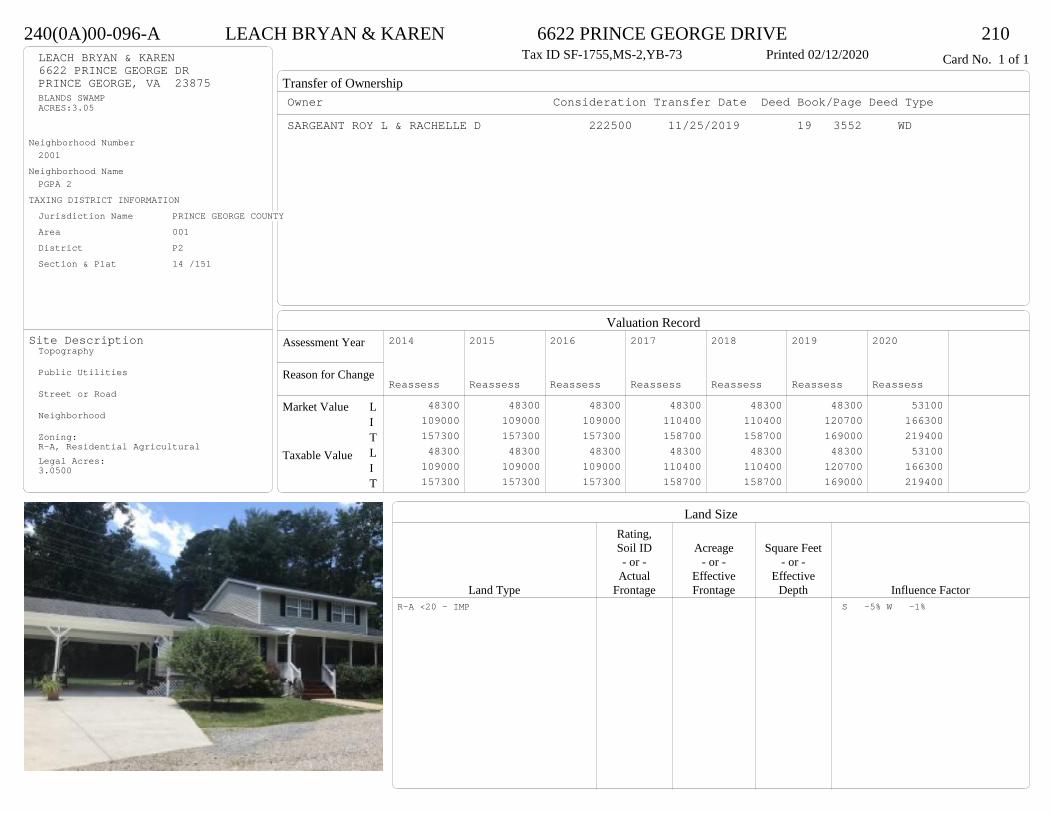
240(0A)00-096-A LEACH BRYAN & KAREN 6622 PRINCE GEORGE DRIVE 210Tax ID SF-1755,MS-2,YB-73 Printed 02/12/2020 Card No. 1 of 1LEACH BRYAN & KAREN
6622 PRINCE GEORGE DRPRINCE GEORGE, VA 23875BLANDS SWAMPACRES:3.05
Neighborhood Number2001
Neighborhood NamePGPA 2
TAXING DISTRICT INFORMATIONJurisdiction Name PRINCE GEORGE COUNTYArea 001 District P2 Section & Plat 14 /151
Site DescriptionTopography
Public Utilities
Street or Road
Neighborhood
Zoning:R-A, Residential AgriculturalLegal Acres:3.0500
Owner Consideration Transfer Date Deed Book/Page Deed TypeSARGEANT ROY L & RACHELLE D 222500 11/25/2019 19 3552 WD
2014
Reassess 48300 109000 157300 48300 109000 157300
2015
Reassess 48300 109000 157300 48300 109000 157300
2016
Reassess 48300 109000 157300 48300 109000 157300
2017
Reassess 48300 110400 158700 48300 110400 158700
2018
Reassess 48300 110400 158700 48300 110400 158700
2019
Reassess 48300 120700 169000 48300 120700 169000
2020
Reassess 53100 166300 219400 53100 166300 219400
R-A <20 - IMP S -5% W -1%
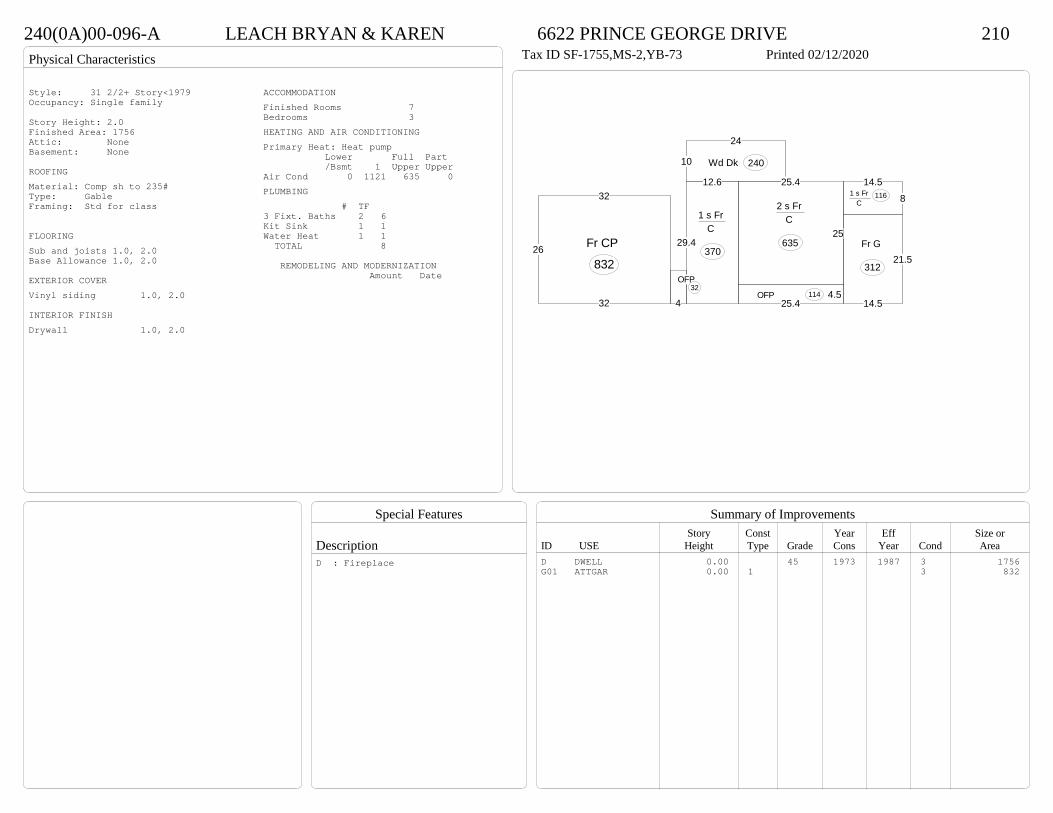
Physical Characteristics
Special Features
Description
Summary of ImprovementsStory Const Year Eff Size or
ID USE Height Type Grade Cons Year Cond Area
240(0A)00-096-A LEACH BRYAN & KAREN 6622 PRINCE GEORGE DRIVE 210Tax ID SF-1755,MS-2,YB-73 Printed 02/12/2020
32
26
32
Fr CP
832
29.4
12.6
1 s Fr C
370
25.4
25
2 s Fr C
635
4.525.4
OFP 114
14.581 s Fr
C 116
10
24
Wd Dk 240
4
OFP32
14.5
21.5Fr G
312
Style: 31 2/2+ Story<1979Occupancy: Single family
Story Height: 2.0Finished Area: 1756 Attic: NoneBasement: None
ROOFINGMaterial: Comp sh to 235#Type: GableFraming: Std for class
FLOORINGSub and joists 1.0, 2.0Base Allowance 1.0, 2.0
EXTERIOR COVERVinyl siding 1.0, 2.0
INTERIOR FINISHDrywall 1.0, 2.0
ACCOMMODATIONFinished Rooms 7Bedrooms 3HEATING AND AIR CONDITIONINGPrimary Heat: Heat pump Lower Full Part /Bsmt 1 Upper UpperAir Cond 0 1121 635 0PLUMBING # TF3 Fixt. Baths 2 6Kit Sink 1 1Water Heat 1 1 TOTAL 8
REMODELING AND MODERNIZATION Amount Date
D DWELL 0.00 45 1973 1987 3 1756G01 ATTGAR 0.00 1 3 832
D : Fireplace
Transfer of Ownership
Valuation RecordAssessment Year
Reason for Change
Market Value
Taxable Value
LITLIT
Land SizeRating,Soil ID Acreage Square Feet- or - - or - - or -
Actual Effective EffectiveLand Type Frontage Frontage Depth Influence Factor
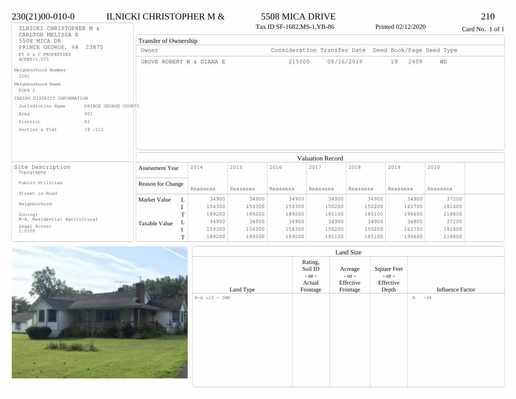
230(21)00-010-0 ILNICKI CHRISTOPHER M & 5508 MICA DRIVE 210Tax ID SF-1682,MS-1,YB-86 Printed 02/12/2020 Card No. 1 of 1ILNICKI CHRISTOPHER M &
CARLTON MELISSA E5508 MICA DRPRINCE GEORGE, VA 23875PT D & C PROPERTIESACRES:1.055
Neighborhood Number2001
Neighborhood NamePGPA 2
TAXING DISTRICT INFORMATIONJurisdiction Name PRINCE GEORGE COUNTYArea 001 District P2 Section & Plat 18 /112
Site DescriptionTopography
Public Utilities
Street or Road
Neighborhood
Zoning:R-A, Residential AgriculturalLegal Acres:1.0550
Owner Consideration Transfer Date Deed Book/Page Deed TypeGROVE ROBERT W & DIANA E 215000 08/16/2019 19 2409 WD
2014
Reassess 34900 154300 189200 34900 154300 189200
2015
Reassess 34900 154300 189200 34900 154300 189200
2016
Reassess 34900 154300 189200 34900 154300 189200
2017
Reassess 34900 150200 185100 34900 150200 185100
2018
Reassess 34900 150200 185100 34900 150200 185100
2019
Reassess 34900 161700 196600 34900 161700 196600
2020
Reassess 37200 181600 218800 37200 181600 218800
R-A <20 - IMP R -3%
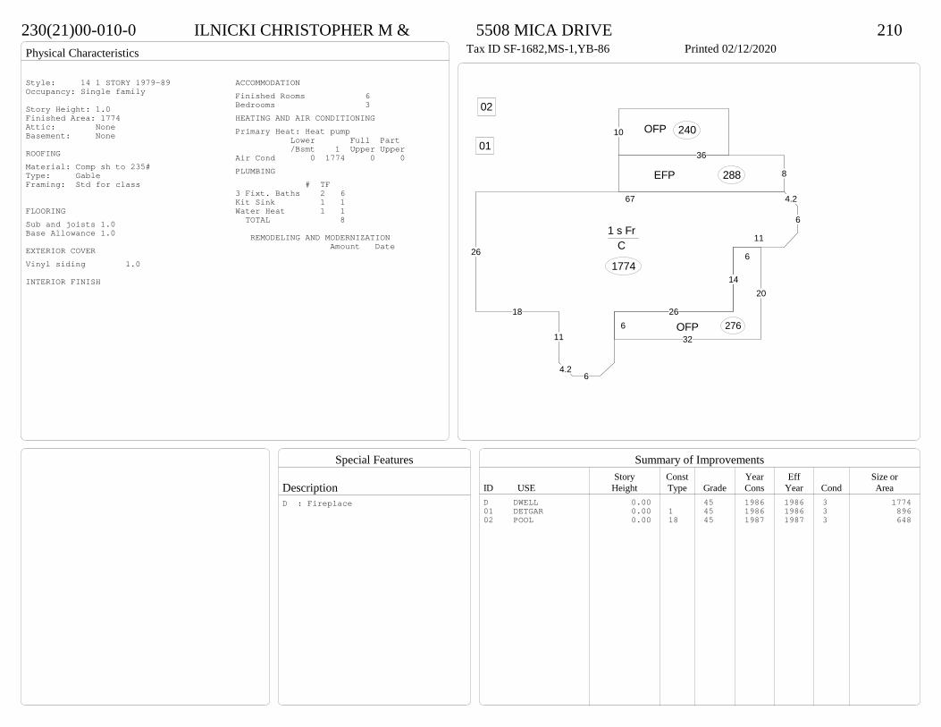
Physical Characteristics
Special Features
Description
Summary of ImprovementsStory Const Year Eff Size or
ID USE Height Type Grade Cons Year Cond Area
230(21)00-010-0 ILNICKI CHRISTOPHER M & 5508 MICA DRIVE 210Tax ID SF-1682,MS-1,YB-86 Printed 02/12/2020
26
67 4.2
6
11
14
64.2
11
18
1 s Fr C
1774
32
20
6
266 OFP 276
8
36
EFP 288
10 OFP 24001
02
Style: 14 1 STORY 1979-89Occupancy: Single family
Story Height: 1.0Finished Area: 1774 Attic: NoneBasement: None
ROOFINGMaterial: Comp sh to 235#Type: GableFraming: Std for class
FLOORINGSub and joists 1.0Base Allowance 1.0
EXTERIOR COVERVinyl siding 1.0
INTERIOR FINISH
ACCOMMODATIONFinished Rooms 6Bedrooms 3HEATING AND AIR CONDITIONINGPrimary Heat: Heat pump Lower Full Part /Bsmt 1 Upper UpperAir Cond 0 1774 0 0PLUMBING # TF3 Fixt. Baths 2 6Kit Sink 1 1Water Heat 1 1 TOTAL 8
REMODELING AND MODERNIZATION Amount Date
D DWELL 0.00 45 1986 1986 3 177401 DETGAR 0.00 1 45 1986 1986 3 89602 POOL 0.00 18 45 1987 1987 3 648
D : Fireplace

Transfer of Ownership
Valuation RecordAssessment Year
Reason for Change
Market Value
Taxable Value
LITLIT
Land SizeRating,Soil ID Acreage Square Feet- or - - or - - or -
Actual Effective EffectiveLand Type Frontage Frontage Depth Influence Factor
230(0A)00-018-0 PARHAM CHARLES G III & 5205 JEFFERSON PARK ROAD 210Tax ID SF-1523,MS-1,YB-61 Printed 02/12/2020 Card No. 1 of 1PARHAM CHARLES G III &
PARHAM KARON A5205 JEFFERSON PARK RDPRINCE GEORGE, VA 23875BAILEYS CREEKACRES:8.4515
Neighborhood Number2001
Neighborhood NamePGPA 2
TAXING DISTRICT INFORMATIONJurisdiction Name PRINCE GEORGE COUNTYArea 001 District P2 Section & Plat 312/455
Site DescriptionTopography
Public Utilities
Street or Road
Neighborhood
Zoning:R-A, Residential AgriculturalR-2, General ResidentialLegal Acres:8.4515
Owner Consideration Transfer Date Deed Book/Page Deed TypeDICKENS KATHERINE K 214950 02/15/2019 19 429 WD
DICKENS KATHERINE K 58000 11/05/2004 04 5765
2014
Reassess 86000 109200 195200 86000 109200 195200
2015
Reassess 86000 109200 195200 86000 109200 195200
2016
Reassess 86000 109200 195200 86000 109200 195200
2017
Reassess 86000 109500 195500 86000 109500 195500
2018
Reassess 86000 109500 195500 86000 109500 195500
2019
Reassess 86000 126000 212000 86000 126000 212000
2020
Reassess 94700 123800 218500 94700 123800 218500
R-A <20 - IMP Z 10%

Physical Characteristics
Special Features
Description
Summary of ImprovementsStory Const Year Eff Size or
ID USE Height Type Grade Cons Year Cond Area
230(0A)00-018-0 PARHAM CHARLES G III & 5205 JEFFERSON PARK ROAD 210Tax ID SF-1523,MS-1,YB-61 Printed 02/12/2020
26.2
20.1
16.4
32.7
10.6
11
15.6
1 s Br Slab
1469
25.3
OMP-s 202
OMP-s
172
4.25.5
M Stp 23
6.4
8.1Shed GP
52
02
Style: 12 1 STORY 1960-69Occupancy: Single family
Story Height: 1.0Finished Area: 1469 Attic: NoneBasement: None
ROOFINGMaterial: Comp sh to 235#Type: GableFraming: Std for class
FLOORINGSub and joists 1.0Base Allowance 1.0
EXTERIOR COVERBrick 1.0
INTERIOR FINISHDrywall 1.0
ACCOMMODATIONFinished Rooms 5Bedrooms 3HEATING AND AIR CONDITIONINGPrimary Heat: Forced hot air Lower Full Part /Bsmt 1 Upper UpperAir Cond 0 1469 0 0PLUMBING # TF3 Fixt. Baths 1 3Kit Sink 1 1Water Heat 1 1 TOTAL 5
REMODELING AND MODERNIZATION Amount Date
D DWELL 0.00 45 1961 1978 3 146901 SHEDGP 10.00 5202 DETGAR 0.00 1 38 1985 1985 2 580
D : Fireplace

Transfer of Ownership
Valuation RecordAssessment Year
Reason for Change
Market Value
Taxable Value
LITLIT
Land SizeRating,Soil ID Acreage Square Feet- or - - or - - or -
Actual Effective EffectiveLand Type Frontage Frontage Depth Influence Factor
240(03)00-001-B WISTERIA LANE LLC 5299 PRINCE GEORGE DR 320Tax ID SF-0,MS-0,YB- Printed 02/12/2020 Card No. 1 of 1WISTERIA LANE LLC
P O BOX 2943CHESTERFIELD, VA 23832E SIDE OF 156ACRES:1.043
Neighborhood Number2001
Neighborhood NamePGPA 2
TAXING DISTRICT INFORMATIONJurisdiction Name PRINCE GEORGE COUNTYArea 001 District P2 Section & Plat 13 /30
Site DescriptionTopography
Public Utilities
Street or Road
Neighborhood
Zoning:R-2, General ResidentialLegal Acres:1.0430
Owner Consideration Transfer Date Deed Book/Page Deed TypeRENTALS BY STIRLING LLC 218500 10/18/2019 19 3099 WD
2014
Reassess 45200 157000 202200 45200 157000 202200
2015
Reassess 45200 157000 202200 45200 157000 202200
2016
Reassess 45200 157000 202200 45200 157000 202200
2017
Reassess 45200 157000 202200 45200 157000 202200
2018
Reassess 45200 155600 200800 45200 155600 200800
2019
Reassess 45200 169100 214300 45200 169100 214300
2020
Reassess 33800 175900 209700 33800 175900 209700
R-2 - IMP W -2% Z -25% e -5%

Physical Characteristics
Special Features
Description
Summary of ImprovementsStory Const Year Eff Size or
ID USE Height Type Grade Cons Year Cond Area
240(03)00-001-B WISTERIA LANE LLC 5299 PRINCE GEORGE DR 320Tax ID SF-0,MS-0,YB- Printed 02/12/2020
77.5
105
16
67.5
165
10
1 s Fr C
1855
OFP 80
OFP 80
3.64
Wd Dk
14
3.6Wd Dk14
Style: 112 DuplexOccupancy: Duplex
Story Height: 1.0Finished Area: 1855 Attic: NoneBasement: None
ROOFINGMaterial: Comp sh to 235#Type: GableFraming: Std for class
FLOORINGSub and joists 1.0Base Allowance 1.0
EXTERIOR COVERVinyl siding 1.0
INTERIOR FINISHDrywall 1.0
ACCOMMODATIONFinished Rooms 10Bedrooms 6HEATING AND AIR CONDITIONINGPrimary Heat: Heat pump Lower Full Part /Bsmt 1 Upper UpperAir Cond 0 1855 0 0PLUMBING # TF3 Fixt. Baths 2 62 Fixt. Baths 2 4Kit Sink 2 2Water Heat 2 2 TOTAL 14
REMODELING AND MODERNIZATION Amount Date
D DWELL 0.00 45 2004 2004 3 1855D : Kitchen - additional

Transfer of Ownership
Valuation RecordAssessment Year
Reason for Change
Market Value
Taxable Value
LITLIT
Land SizeRating,Soil ID Acreage Square Feet- or - - or - - or -
Actual Effective EffectiveLand Type Frontage Frontage Depth Influence Factor
24C(02)00-00B-0 SCOTT WINSTON C III & CHRISTLE G 7109 COURTHOUSE ROAD 210Tax ID SF-1624,MS-1,YB-63 Printed 02/12/2020 Card No. 1 of 1SCOTT WINSTON C III & CHRISTLE G
7109 COURTHOUSE RDPRINCE GEORGE, VA 23875PARCEL BNEAR COURTHOUSEACRES:0.938
Neighborhood Number2001
Neighborhood NamePGPA 2
TAXING DISTRICT INFORMATIONJurisdiction Name PRINCE GEORGE COUNTYArea 001 District P2 Section & Plat 12 /29
Site DescriptionTopography
Public Utilities
Street or Road
Neighborhood
Zoning:R-A, Residential AgriculturalR-2, General ResidentialLegal Acres:0.9380
Owner Consideration Transfer Date Deed Book/Page Deed TypeMITCHELL CHRISTOPHER W 180000 01/03/2019 19 32 WD
MITCHELL CHRISTOPHER W & JENNIFER L 0 01/31/2011 11 285 WD
FITZWATER ANDY D 185000 05/10/2010 10 1377 WD
MCCORMICK BETTY H 171950 03/31/2006 06 1677 FITZWATER ANDY D
2014
Reassess 33600 126400 160000 33600 126400 160000
2015
Reassess 33600 126400 160000 33600 126400 160000
2016
Reassess 33600 126400 160000 33600 126400 160000
2017
Reassess 33600 126500 160100 33600 126500 160100
2018
Reassess 33600 126500 160100 33600 126500 160100
2019
Reassess 32300 128500 160800 32300 128500 160800
2020
Reassess 35500 131300 166800 35500 131300 166800
R-2 - IMP Z -25%

Physical Characteristics
Special Features
Description
Summary of ImprovementsStory Const Year Eff Size or
ID USE Height Type Grade Cons Year Cond Area
24C(02)00-00B-0 SCOTT WINSTON C III & CHRISTLE G 7109 COURTHOUSE ROAD 210Tax ID SF-1624,MS-1,YB-63 Printed 02/12/2020
32.6
49
22.9
10.8
6.8
154.3
4.8
1 s Br C
1429
11.6
19.7
1 s Fr C
229
3.7
OMP16
8.6
10
13.7
18.9
11.2
15.3
11.6
Wd Dk335
Style: 12 1 STORY 1960-69Occupancy: Single family
Story Height: 1.0Finished Area: 1658 Attic: NoneBasement: None
ROOFINGMaterial: Comp sh to 235#Type: GableFraming: Std for class
FLOORINGSub and joists 1.0Base Allowance 1.0
EXTERIOR COVERBrick 1.0Vinyl siding 1.0
INTERIOR FINISHDrywall 1.0
ACCOMMODATIONFinished Rooms 8Bedrooms 3HEATING AND AIR CONDITIONINGPrimary Heat: Heat pump Lower Full Part /Bsmt 1 Upper UpperAir Cond 0 1658 0 0PLUMBING # TF3 Fixt. Baths 2 6Kit Sink 1 1Water Heat 1 1 TOTAL 8
REMODELING AND MODERNIZATION Amount Date
D DWELL 0.00 45 1963 1986 3 1658D : Remod 2009 Fireplace

Transfer of Ownership
Valuation RecordAssessment Year
Reason for Change
Market Value
Taxable Value
LITLIT
Land SizeRating,Soil ID Acreage Square Feet- or - - or - - or -
Actual Effective EffectiveLand Type Frontage Frontage Depth Influence Factor
240(06)00-001-0 GILBERT JUSTIN T 6803 COURTHOUSE ROAD 210Tax ID SF-0,MS-0,YB- Printed 02/12/2020 Card No. 1 of 1GILBERT JUSTIN T
6803 COURTHOUSE RDPRINCE GEORGE, VA 23875NEAR COURTHOUSE LT 1ACRES:1.232
Neighborhood Number2001
Neighborhood NamePGPA 2
TAXING DISTRICT INFORMATIONJurisdiction Name PRINCE GEORGE COUNTYArea 001 District P2 Section & Plat 417/459
Site DescriptionTopography
Public Utilities
Street or Road
Neighborhood
Zoning:R-A, Residential AgriculturalR-2, General ResidentialLegal Acres:1.2320
Owner Consideration Transfer Date Deed Book/Page Deed TypeHANCOCK MICHAEL & NICOLE ATWOOD 172000 06/10/2019 19 1592 WD
PERSINGER MICHAEL G 170000 10/19/2006 06 5574
2014
Reassess 36800 95900 132700 36800 95900 132700
2015
Reassess 36800 95900 132700 36800 95900 132700
2016
Reassess 36800 95900 132700 36800 95900 132700
2017
Reassess 36800 97200 134000 36800 97200 134000
2018
Reassess 36800 102000 138800 36800 102000 138800
2019
Reassess 36800 106200 143000 36800 106200 143000
2020
Reassess 44600 119000 163600 44600 119000 163600
R-A <20 - IMP Z 10%
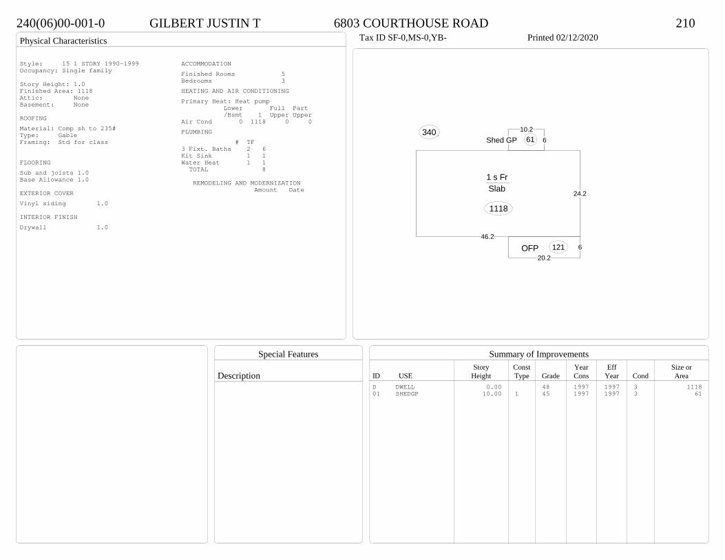
Physical Characteristics
Special Features
Description
Summary of ImprovementsStory Const Year Eff Size or
ID USE Height Type Grade Cons Year Cond Area
240(06)00-001-0 GILBERT JUSTIN T 6803 COURTHOUSE ROAD 210Tax ID SF-0,MS-0,YB- Printed 02/12/2020
46.2
24.2
1 s Fr Slab
1118
620.2
OFP 121
Conc3406
10.2Shed GP 61
Style: 15 1 STORY 1990-1999Occupancy: Single family
Story Height: 1.0Finished Area: 1118 Attic: NoneBasement: None
ROOFINGMaterial: Comp sh to 235#Type: GableFraming: Std for class
FLOORINGSub and joists 1.0Base Allowance 1.0
EXTERIOR COVERVinyl siding 1.0
INTERIOR FINISHDrywall 1.0
ACCOMMODATIONFinished Rooms 5Bedrooms 3HEATING AND AIR CONDITIONINGPrimary Heat: Heat pump Lower Full Part /Bsmt 1 Upper UpperAir Cond 0 1118 0 0PLUMBING # TF3 Fixt. Baths 2 6Kit Sink 1 1Water Heat 1 1 TOTAL 8
REMODELING AND MODERNIZATION Amount Date
D DWELL 0.00 48 1997 1997 3 111801 SHEDGP 10.00 1 45 1997 1997 3 61
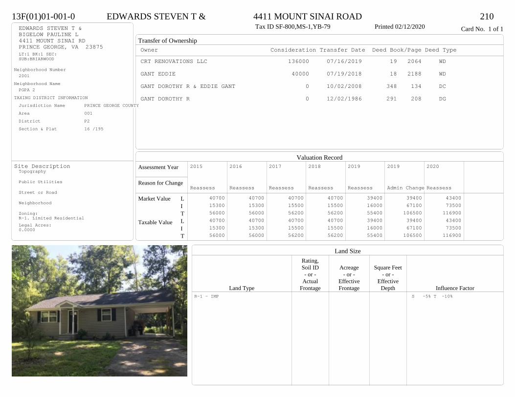
Transfer of Ownership
Valuation RecordAssessment Year
Reason for Change
Market Value
Taxable Value
LITLIT
Land SizeRating,Soil ID Acreage Square Feet- or - - or - - or -
Actual Effective EffectiveLand Type Frontage Frontage Depth Influence Factor
13F(01)01-001-0 EDWARDS STEVEN T & 4411 MOUNT SINAI ROAD 210Tax ID SF-800,MS-1,YB-79 Printed 02/12/2020 Card No. 1 of 1EDWARDS STEVEN T &
BIGELOW PAULINE L4411 MOUNT SINAI RDPRINCE GEORGE, VA 23875LT:1 BK:1 SEC:SUB:BRIARWOOD
Neighborhood Number2001
Neighborhood NamePGPA 2
TAXING DISTRICT INFORMATIONJurisdiction Name PRINCE GEORGE COUNTYArea 001 District P2 Section & Plat 16 /195
Site DescriptionTopography
Public Utilities
Street or Road
Neighborhood
Zoning:R-1. Limited ResidentialLegal Acres:0.0000
Owner Consideration Transfer Date Deed Book/Page Deed TypeCRT RENOVATIONS LLC 136000 07/16/2019 19 2064 WD
GANT EDDIE 40000 07/19/2018 18 2188 WD
GANT DOROTHY R & EDDIE GANT 0 10/02/2008 348 134 DC
GANT DOROTHY R 0 12/02/1986 291 208 DG
2015
Reassess 40700 15300 56000 40700 15300 56000
2016
Reassess 40700 15300 56000 40700 15300 56000
2017
Reassess 40700 15500 56200 40700 15500 56200
2018
Reassess 40700 15500 56200 40700 15500 56200
2019
Reassess 39400 16000 55400 39400 16000 55400
2019
Admin Change 39400 67100 106500 39400 67100 106500
2020
Reassess 43400 73500 116900 43400 73500 116900
R-1 - IMP S -5% T -10%

Physical Characteristics
Special Features
Description
Summary of ImprovementsStory Const Year Eff Size or
ID USE Height Type Grade Cons Year Cond Area
13F(01)01-001-0 EDWARDS STEVEN T & 4411 MOUNT SINAI ROAD 210Tax ID SF-800,MS-1,YB-79 Printed 02/12/2020
32
25
1 s Fr C
800
3.8
4
M Stp 15
10
12
10Wd Dk
120
12
24Fr CP
288
Style: 14 1 STORY 1979-89Occupancy: Single family
Story Height: 1.0Finished Area: 800 Attic: NoneBasement: None
ROOFINGMaterial: Comp sh to 235#Type: GableFraming: Std for class
FLOORINGSub and joists 1.0Base Allowance 1.0
EXTERIOR COVERVinyl siding 1.0
INTERIOR FINISHDrywall 1.0
ACCOMMODATIONFinished Rooms 4Bedrooms 2HEATING AND AIR CONDITIONINGPrimary Heat: Heat pump Lower Full Part /Bsmt 1 Upper UpperAir Cond 0 800 0 0PLUMBING # TF3 Fixt. Baths 1 3Kit Sink 1 1Water Heat 1 1 TOTAL 5
REMODELING AND MODERNIZATION Amount Date
D DWELL 0.00 38 1979 1997 3 800G01 ICP 0.00 1 3 288
D : Remod 2019
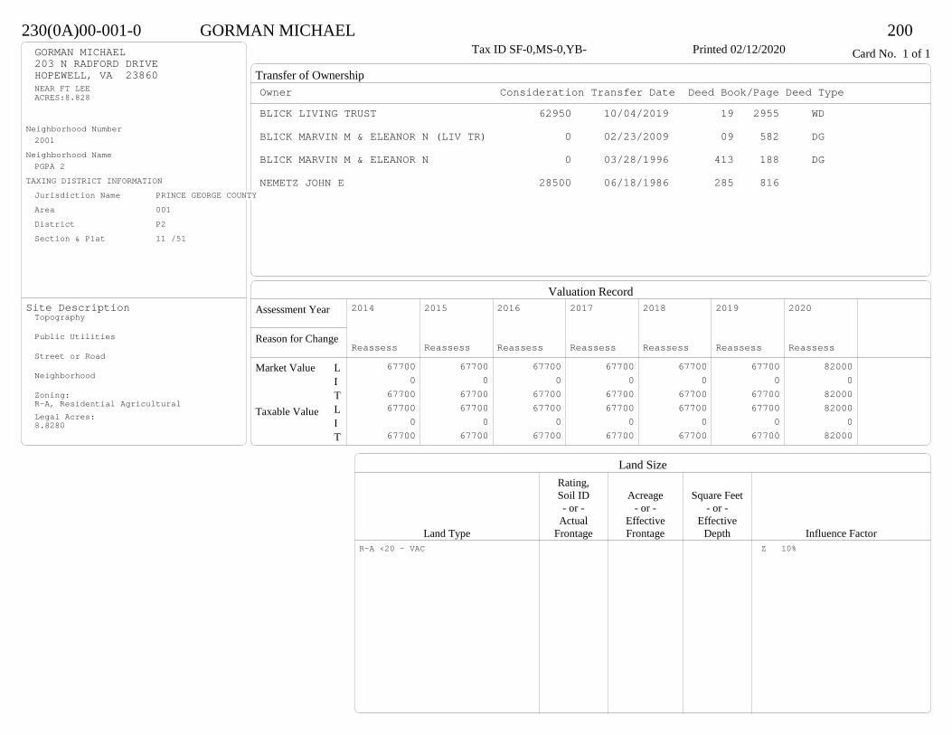
Transfer of Ownership
Valuation RecordAssessment Year
Reason for Change
Market Value
Taxable Value
LITLIT
Land SizeRating,Soil ID Acreage Square Feet- or - - or - - or -
Actual Effective EffectiveLand Type Frontage Frontage Depth Influence Factor
230(0A)00-001-0 GORMAN MICHAEL 200Tax ID SF-0,MS-0,YB- Printed 02/12/2020 Card No. 1 of 1GORMAN MICHAEL
203 N RADFORD DRIVEHOPEWELL, VA 23860NEAR FT LEEACRES:8.828
Neighborhood Number2001
Neighborhood NamePGPA 2
TAXING DISTRICT INFORMATIONJurisdiction Name PRINCE GEORGE COUNTYArea 001 District P2 Section & Plat 11 /51
Site DescriptionTopography
Public Utilities
Street or Road
Neighborhood
Zoning:R-A, Residential AgriculturalLegal Acres:8.8280
Owner Consideration Transfer Date Deed Book/Page Deed TypeBLICK LIVING TRUST 62950 10/04/2019 19 2955 WD
BLICK MARVIN M & ELEANOR N (LIV TR) 0 02/23/2009 09 582 DG
BLICK MARVIN M & ELEANOR N 0 03/28/1996 413 188 DG
NEMETZ JOHN E 28500 06/18/1986 285 816
2014
Reassess 67700 0 67700 67700 0 67700
2015
Reassess 67700 0 67700 67700 0 67700
2016
Reassess 67700 0 67700 67700 0 67700
2017
Reassess 67700 0 67700 67700 0 67700
2018
Reassess 67700 0 67700 67700 0 67700
2019
Reassess 67700 0 67700 67700 0 67700
2020
Reassess 82000 0 82000 82000 0 82000
R-A <20 - VAC Z 10%

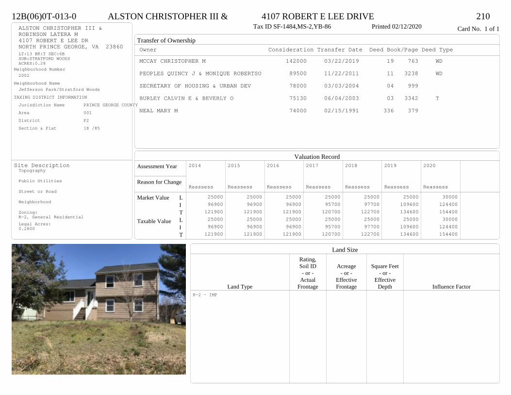
Transfer of Ownership
Valuation RecordAssessment Year
Reason for Change
Market Value
Taxable Value
LITLIT
Land SizeRating,Soil ID Acreage Square Feet- or - - or - - or -
Actual Effective EffectiveLand Type Frontage Frontage Depth Influence Factor
12B(06)0T-013-0 ALSTON CHRISTOPHER III & 4107 ROBERT E LEE DRIVE 210Tax ID SF-1484,MS-2,YB-86 Printed 02/12/2020 Card No. 1 of 1ALSTON CHRISTOPHER III &
ROBINSON LATERA M4107 ROBERT E LEE DRNORTH PRINCE GEORGE, VA 23860LT:13 BK:T SEC:6BSUB:STRATFORD WOODSACRES:0.28
Neighborhood Number2002
Neighborhood NameJefferson Park/Stratford Woods
TAXING DISTRICT INFORMATIONJurisdiction Name PRINCE GEORGE COUNTYArea 001 District P2 Section & Plat 18 /85
Site DescriptionTopography
Public Utilities
Street or Road
Neighborhood
Zoning:R-2, General ResidentialLegal Acres:0.2800
Owner Consideration Transfer Date Deed Book/Page Deed TypeMCCAY CHRISTOPHER M 142000 03/22/2019 19 763 WD
PEOPLES QUINCY J & MONIQUE ROBERTSO 89500 11/22/2011 11 3238 WD
SECRETARY OF HOUSING & URBAN DEV 78000 03/03/2004 04 999
BURLEY CALVIN E & BEVERLY O 75130 06/04/2003 03 3342 T
NEAL MARY M 74000 02/15/1991 336 379
2014
Reassess 25000 96900 121900 25000 96900 121900
2015
Reassess 25000 96900 121900 25000 96900 121900
2016
Reassess 25000 96900 121900 25000 96900 121900
2017
Reassess 25000 95700 120700 25000 95700 120700
2018
Reassess 25000 97700 122700 25000 97700 122700
2019
Reassess 25000 109600 134600 25000 109600 134600
2020
Reassess 30000 124400 154400 30000 124400 154400
R-2 - IMP

Physical Characteristics
Special Features
Description
Summary of ImprovementsStory Const Year Eff Size or
ID USE Height Type Grade Cons Year Cond Area
12B(06)0T-013-0 ALSTON CHRISTOPHER III & 4107 ROBERT E LEE DRIVE 210Tax ID SF-1484,MS-2,YB-86 Printed 02/12/2020
22
24
1 s Fr L (Fin)
528
22
1 s Fr C
528
4
5.5
M Stp 22
46
12
22
16Wd Dk
328
1 s Fr OH 22
1 s Fr OH 22
Style: 50 TRI-LEVEL OR SPLIT-LEVELOccupancy: Single family
Story Height: Tri-levelFinished Area: 1628 Attic: NoneBasement: None
ROOFINGMaterial: Comp sh to 235#Type: GableFraming: Std for class
FLOORINGSlab LSub and joists 1.0Base Allowance L, 1.0
EXTERIOR COVERHardboard L, 1.0
INTERIOR FINISHDrywall 1.0
ACCOMMODATIONFinished Rooms 6Bedrooms 4HEATING AND AIR CONDITIONINGPrimary Heat: Heat pump Lower Full Part /Bsmt 1 Upper UpperAir Cond 528 1100 0 0PLUMBING # TF3 Fixt. Baths 2 6Kit Sink 1 1Water Heat 1 1 TOTAL 8
REMODELING AND MODERNIZATION Amount Date
D DWELL 0.00 38 1986 1986 3 1628
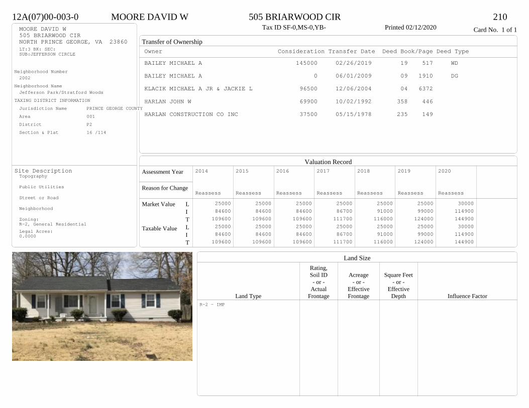
Transfer of Ownership
Valuation RecordAssessment Year
Reason for Change
Market Value
Taxable Value
LITLIT
Land SizeRating,Soil ID Acreage Square Feet- or - - or - - or -
Actual Effective EffectiveLand Type Frontage Frontage Depth Influence Factor
12A(07)00-003-0 MOORE DAVID W 505 BRIARWOOD CIR 210Tax ID SF-0,MS-0,YB- Printed 02/12/2020 Card No. 1 of 1MOORE DAVID W
505 BRIARWOOD CIRNORTH PRINCE GEORGE, VA 23860LT:3 BK: SEC:SUB:JEFFERSON CIRCLE
Neighborhood Number2002
Neighborhood NameJefferson Park/Stratford Woods
TAXING DISTRICT INFORMATIONJurisdiction Name PRINCE GEORGE COUNTYArea 001 District P2 Section & Plat 16 /114
Site DescriptionTopography
Public Utilities
Street or Road
Neighborhood
Zoning:R-2, General ResidentialLegal Acres:0.0000
Owner Consideration Transfer Date Deed Book/Page Deed TypeBAILEY MICHAEL A 145000 02/26/2019 19 517 WD
BAILEY MICHAEL A 0 06/01/2009 09 1910 DG
KLACIK MICHAEL A JR & JACKIE L 96500 12/06/2004 04 6372
HARLAN JOHN W 69900 10/02/1992 358 446
HARLAN CONSTRUCTION CO INC 37500 05/15/1978 235 149
2014
Reassess 25000 84600 109600 25000 84600 109600
2015
Reassess 25000 84600 109600 25000 84600 109600
2016
Reassess 25000 84600 109600 25000 84600 109600
2017
Reassess 25000 86700 111700 25000 86700 111700
2018
Reassess 25000 91000 116000 25000 91000 116000
2019
Reassess 25000 99000 124000 25000 99000 124000
2020
Reassess 30000 114900 144900 30000 114900 144900
R-2 - IMP
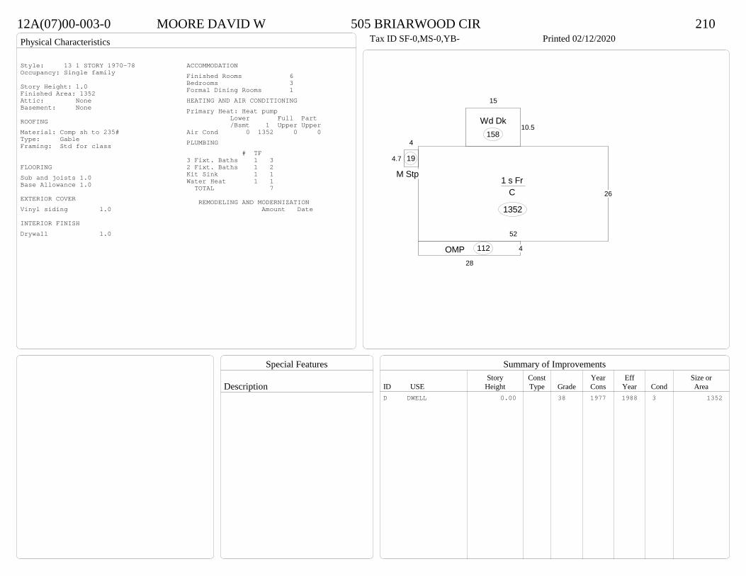
Physical Characteristics
Special Features
Description
Summary of ImprovementsStory Const Year Eff Size or
ID USE Height Type Grade Cons Year Cond Area
12A(07)00-003-0 MOORE DAVID W 505 BRIARWOOD CIR 210Tax ID SF-0,MS-0,YB- Printed 02/12/2020
52
26
1 s Fr C
1352
28
4OMP 112
4
4.7
M Stp
19
10.5
15
Wd Dk158
Style: 13 1 STORY 1970-78Occupancy: Single family
Story Height: 1.0Finished Area: 1352 Attic: NoneBasement: None
ROOFINGMaterial: Comp sh to 235#Type: GableFraming: Std for class
FLOORINGSub and joists 1.0Base Allowance 1.0
EXTERIOR COVERVinyl siding 1.0
INTERIOR FINISHDrywall 1.0
ACCOMMODATIONFinished Rooms 6Bedrooms 3Formal Dining Rooms 1HEATING AND AIR CONDITIONINGPrimary Heat: Heat pump Lower Full Part /Bsmt 1 Upper UpperAir Cond 0 1352 0 0PLUMBING # TF3 Fixt. Baths 1 32 Fixt. Baths 1 2Kit Sink 1 1Water Heat 1 1 TOTAL 7
REMODELING AND MODERNIZATION Amount Date
D DWELL 0.00 38 1977 1988 3 1352

Transfer of Ownership
Valuation RecordAssessment Year
Reason for Change
Market Value
Taxable Value
LITLIT
Land SizeRating,Soil ID Acreage Square Feet- or - - or - - or -
Actual Effective EffectiveLand Type Frontage Frontage Depth Influence Factor
12A(12)0M-001-0 SSB-2019 LLC 5101 CHESHIRE DRIVE 210Tax ID SF-1113,MS-1,YB-81 Printed 02/12/2020 Card No. 1 of 1SSB-2019 LLC
106 HOLLYBERRY LNPRINCE GEORGE, VA 23875LT:1 BK:M SEC:5ASUB:STRATFORD WOODSACRES:0.32
Neighborhood Number2002
Neighborhood NameJefferson Park/Stratford Woods
TAXING DISTRICT INFORMATIONJurisdiction Name PRINCE GEORGE COUNTYArea 001 District P2 Section & Plat 17 /115
Site DescriptionTopography
Public Utilities
Street or Road
Neighborhood
Zoning:R-2, General ResidentialLegal Acres:0.3200
Owner Consideration Transfer Date Deed Book/Page Deed TypeHUDSON MARCIA 151000 06/27/2019 19 1828 WD
5101 CHESHIRE DRIVE LAND TRUST 117500 12/05/2013 13 7185 WD
MAILE RODGER D & TAMMY P 68000 09/18/2007 07 4774
BOGESE INC 40500 08/24/1981 254 7
2014
Reassess 25000 78100 103100 25000 78100 103100
2015
Reassess 25000 78100 103100 25000 78100 103100
2016
Reassess 25000 73700 98700 25000 73700 98700
2017
Reassess 25000 78200 103200 25000 78200 103200
2018
Reassess 25000 82100 107100 25000 82100 107100
2019
Reassess 25000 89300 114300 25000 89300 114300
2020
Reassess 30000 114600 144600 30000 114600 144600
R-2 - IMP

Physical Characteristics
Special Features
Description
Summary of ImprovementsStory Const Year Eff Size or
ID USE Height Type Grade Cons Year Cond Area
12A(12)0M-001-0 SSB-2019 LLC 5101 CHESHIRE DRIVE 210Tax ID SF-1113,MS-1,YB-81 Printed 02/12/2020
46
24
1 s Fr C
1104
3.8
20
OMP 76
16
12Wd Dk
192
01Style: 14 1 STORY 1979-89Occupancy: Single family
Story Height: 1.0Finished Area: 1104 Attic: NoneBasement: None
ROOFINGMaterial: Comp sh to 235#Type: GableFraming: Std for class
FLOORINGSub and joists 1.0Base Allowance 1.0
EXTERIOR COVERVinyl siding 1.0
INTERIOR FINISHDrywall 1.0
ACCOMMODATIONFinished Rooms 5Bedrooms 3HEATING AND AIR CONDITIONINGPrimary Heat: Heat pump Lower Full Part /Bsmt 1 Upper UpperAir Cond 0 1104 0 0PLUMBING # TF3 Fixt. Baths 1 32 Fixt. Baths 1 2Kit Sink 1 1Water Heat 1 1 TOTAL 7
REMODELING AND MODERNIZATION Amount Date
D DWELL 0.00 38 1981 1981 4 110401 SHEDGP 1.00 1 38 1990 1990 3 188

Transfer of Ownership
Valuation RecordAssessment Year
Reason for Change
Market Value
Taxable Value
LITLIT
Land SizeRating,Soil ID Acreage Square Feet- or - - or - - or -
Actual Effective EffectiveLand Type Frontage Frontage Depth Influence Factor
12A(09)0N-015-0 BROWN SONJA 3809 OLD IRON ROAD 210Tax ID SF-1160,MS-1,YB-80 Printed 02/12/2020 Card No. 1 of 1BROWN SONJA
3809 OLD IRON RDNORTH PRINCE GEORGE, VA 23860LT:15 BK:N SEC:2SUB:STRATFORD WOODS
Neighborhood Number2002
Neighborhood NameJefferson Park/Stratford Woods
TAXING DISTRICT INFORMATIONJurisdiction Name PRINCE GEORGE COUNTYArea 001 District P2 Section & Plat 17 /2
Site DescriptionTopography
Public Utilities
Street or Road
Neighborhood
Zoning:R-2, General ResidentialLegal Acres:0.0000
Owner Consideration Transfer Date Deed Book/Page Deed TypeMONTERROSO CARLOS 148000 09/30/2019 19 2904 WD
CHAPPELL CHARLES M & KELLY S 80000 06/13/2019 19 1613 WD
KEPHART STEPHEN M & SUSAN P 130000 04/06/2007 07 1774
COOPER HERMAN S & KATHRYN S 53000 11/15/2002 02 6046
JOHNSON FRANCES R 48677 03/13/1989 315 701
2014
Reassess 25000 66500 91500 25000 66500 91500
2015
Reassess 25000 66500 91500 25000 66500 91500
2016
Reassess 25000 66500 91500 25000 66500 91500
2017
Reassess 25000 66600 91600 25000 66600 91600
2018
Reassess 25000 69900 94900 25000 69900 94900
2019
Reassess 25000 76500 101500 25000 76500 101500
2020
Reassess 30000 113400 143400 30000 113400 143400
R-2 - IMP

Physical Characteristics
Special Features
Description
Summary of ImprovementsStory Const Year Eff Size or
ID USE Height Type Grade Cons Year Cond Area
12A(09)0N-015-0 BROWN SONJA 3809 OLD IRON ROAD 210Tax ID SF-1160,MS-1,YB-80 Printed 02/12/2020
46
24
1 s Fr C
1104
4
5.5
OMP 22
10
20
Wd Dk 200
Style: 14 1 STORY 1979-89Occupancy: Single family
Story Height: 1.0Finished Area: 1104 Attic: NoneBasement: None
ROOFINGMaterial: Comp sh to 235#Type: GableFraming: Std for class
FLOORINGSub and joists 1.0Base Allowance 1.0
EXTERIOR COVERVinyl siding 1.0
INTERIOR FINISHDrywall 1.0
ACCOMMODATIONFinished Rooms 6Bedrooms 3Formal Dining Rooms 1HEATING AND AIR CONDITIONINGPrimary Heat: Heat pump Lower Full Part /Bsmt 1 Upper UpperAir Cond 0 1104 0 0PLUMBING # TF3 Fixt. Baths 1 32 Fixt. Baths 1 2Kit Sink 1 1Water Heat 1 1 TOTAL 7
REMODELING AND MODERNIZATION Amount Date
D DWELL 0.00 38 1980 1980 4 1104D : Remod 2019
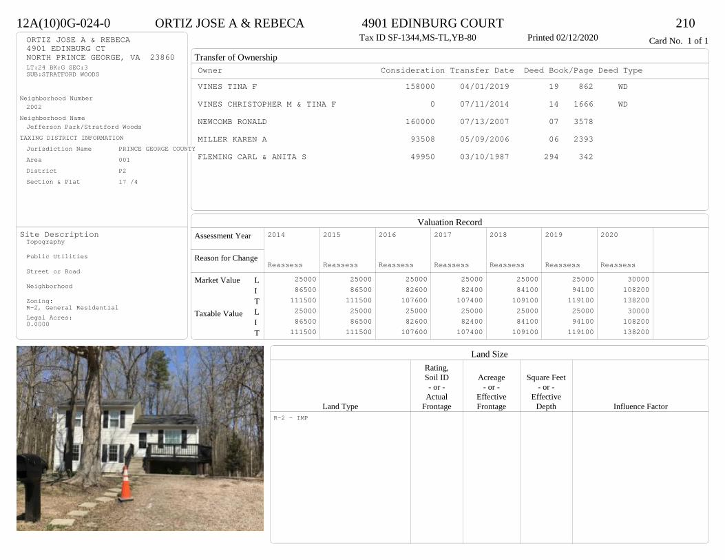
Transfer of Ownership
Valuation RecordAssessment Year
Reason for Change
Market Value
Taxable Value
LITLIT
Land SizeRating,Soil ID Acreage Square Feet- or - - or - - or -
Actual Effective EffectiveLand Type Frontage Frontage Depth Influence Factor
12A(10)0G-024-0 ORTIZ JOSE A & REBECA 4901 EDINBURG COURT 210Tax ID SF-1344,MS-TL,YB-80 Printed 02/12/2020 Card No. 1 of 1ORTIZ JOSE A & REBECA
4901 EDINBURG CTNORTH PRINCE GEORGE, VA 23860LT:24 BK:G SEC:3SUB:STRATFORD WOODS
Neighborhood Number2002
Neighborhood NameJefferson Park/Stratford Woods
TAXING DISTRICT INFORMATIONJurisdiction Name PRINCE GEORGE COUNTYArea 001 District P2 Section & Plat 17 /4
Site DescriptionTopography
Public Utilities
Street or Road
Neighborhood
Zoning:R-2, General ResidentialLegal Acres:0.0000
Owner Consideration Transfer Date Deed Book/Page Deed TypeVINES TINA F 158000 04/01/2019 19 862 WD
VINES CHRISTOPHER M & TINA F 0 07/11/2014 14 1666 WD
NEWCOMB RONALD 160000 07/13/2007 07 3578
MILLER KAREN A 93508 05/09/2006 06 2393
FLEMING CARL & ANITA S 49950 03/10/1987 294 342
2014
Reassess 25000 86500 111500 25000 86500 111500
2015
Reassess 25000 86500 111500 25000 86500 111500
2016
Reassess 25000 82600 107600 25000 82600 107600
2017
Reassess 25000 82400 107400 25000 82400 107400
2018
Reassess 25000 84100 109100 25000 84100 109100
2019
Reassess 25000 94100 119100 25000 94100 119100
2020
Reassess 30000 108200 138200 30000 108200 138200
R-2 - IMP

Physical Characteristics
Special Features
Description
Summary of ImprovementsStory Const Year Eff Size or
ID USE Height Type Grade Cons Year Cond Area
12A(10)0G-024-0 ORTIZ JOSE A & REBECA 4901 EDINBURG COURT 210Tax ID SF-1344,MS-TL,YB-80 Printed 02/12/2020
20
24
1 s Fr L (Fin)
480
16
1 s Fr C
384
5.5
4
M Stp22
8
11.7
Wd Dk90
4.4
40.2
16
15.9
12.9
Wd Dk
335
Style: 50 TRI-LEVEL OR SPLIT-LEVELOccupancy: Single family
Story Height: Tri-levelFinished Area: 1344 Attic: NoneBasement: None
ROOFINGMaterial: Comp sh to 235#Type: GableFraming: Std for class
FLOORINGSlab LSub and joists 1.0Base Allowance L, 1.0
EXTERIOR COVERVinyl siding L, 1.0
INTERIOR FINISHDrywall 1.0
ACCOMMODATIONFinished Rooms 8Bedrooms 5Formal Dining Rooms 1HEATING AND AIR CONDITIONINGPrimary Heat: Heat pump Lower Full Part /Bsmt 1 Upper UpperAir Cond 480 864 0 0PLUMBING # TF3 Fixt. Baths 1 32 Fixt. Baths 1 2Kit Sink 1 1Water Heat 1 1 TOTAL 7
REMODELING AND MODERNIZATION Amount Date
D DWELL 0.00 38 1980 1989 3 1344

Transfer of Ownership
Valuation RecordAssessment Year
Reason for Change
Market Value
Taxable Value
LITLIT
Land SizeRating,Soil ID Acreage Square Feet- or - - or - - or -
Actual Effective EffectiveLand Type Frontage Frontage Depth Influence Factor
12A(0A)00-019-0 BENNETT MELODY C & 4810 GARFIELD STREET 210Tax ID SF-943,MS-1,YB-55 Printed 02/12/2020 Card No. 1 of 1BENNETT MELODY C &
ATKINS SPRING CLARY4225 PFOST AVEPRINCE GEORGE, VA 23875CITY POINT RDACRES:.403
Neighborhood Number2002
Neighborhood NameJefferson Park/Stratford Woods
TAXING DISTRICT INFORMATIONJurisdiction Name PRINCE GEORGE COUNTYArea 001 District P2 Section & Plat 304/700
Site DescriptionTopography
Public Utilities
Street or Road
Neighborhood
Zoning:R-2, General ResidentialLegal Acres:0.4030
Owner Consideration Transfer Date Deed Book/Page Deed TypeDICKEY JORDAN R 121000 06/24/2019 19 1790 WD
VERLANDERS CONSTRUCTION CO INC 98000 05/14/2013 13 1636 WD
HENDRICK LEWIS A JR 35070 09/03/2010 10 2653 WD
HENDRICK LEWIS A 0 02/01/2010 WF10 9 WF
HENDRICK LEWIS & LEWIS A JR 0 06/08/1992 353 628 DG
HENDRICK LEWIS & LOVETTA 0 03/03/1988 304 696 DG
2014
Reassess 25000 70600 95600 25000 70600 95600
2015
Reassess 25000 70600 95600 25000 70600 95600
2016
Reassess 25000 70600 95600 25000 70600 95600
2017
Reassess 25000 70700 95700 25000 70700 95700
2018
Reassess 25000 74200 99200 25000 74200 99200
2019
Reassess 25000 80700 105700 25000 80700 105700
2020
Reassess 30000 87700 117700 30000 87700 117700
R-2 - IMP
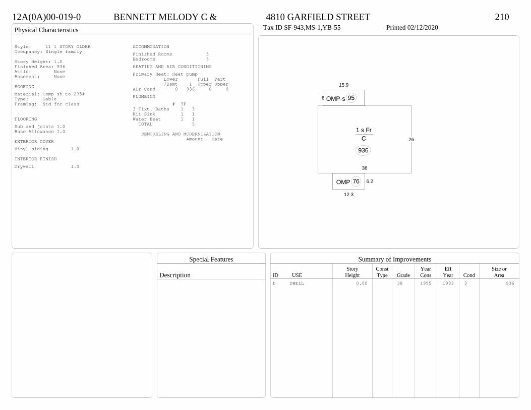
Physical Characteristics
Special Features
Description
Summary of ImprovementsStory Const Year Eff Size or
ID USE Height Type Grade Cons Year Cond Area
12A(0A)00-019-0 BENNETT MELODY C & 4810 GARFIELD STREET 210Tax ID SF-943,MS-1,YB-55 Printed 02/12/2020
26
36
1 s Fr C
936
6.2
12.3
OMP 76
6
15.9
OMP-s 95
Style: 11 1 STORY OLDEROccupancy: Single family
Story Height: 1.0Finished Area: 936 Attic: NoneBasement: None
ROOFINGMaterial: Comp sh to 235#Type: GableFraming: Std for class
FLOORINGSub and joists 1.0Base Allowance 1.0
EXTERIOR COVERVinyl siding 1.0
INTERIOR FINISHDrywall 1.0
ACCOMMODATIONFinished Rooms 5Bedrooms 3HEATING AND AIR CONDITIONINGPrimary Heat: Heat pump Lower Full Part /Bsmt 1 Upper UpperAir Cond 0 936 0 0PLUMBING # TF3 Fixt. Baths 1 3Kit Sink 1 1Water Heat 1 1 TOTAL 5
REMODELING AND MODERNIZATION Amount Date
D DWELL 0.00 38 1955 1993 3 936
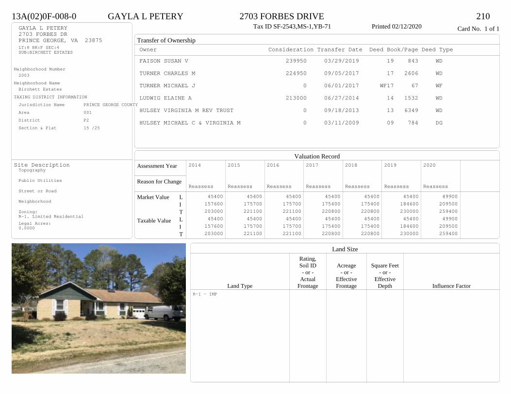
Transfer of Ownership
Valuation RecordAssessment Year
Reason for Change
Market Value
Taxable Value
LITLIT
Land SizeRating,Soil ID Acreage Square Feet- or - - or - - or -
Actual Effective EffectiveLand Type Frontage Frontage Depth Influence Factor
13A(02)0F-008-0 GAYLA L PETERY 2703 FORBES DRIVE 210Tax ID SF-2543,MS-1,YB-71 Printed 02/12/2020 Card No. 1 of 1GAYLA L PETERY
2703 FORBES DRPRINCE GEORGE, VA 23875LT:8 BK:F SEC:4SUB:BIRCHETT ESTATES
Neighborhood Number2003
Neighborhood NameBirchett Estates
TAXING DISTRICT INFORMATIONJurisdiction Name PRINCE GEORGE COUNTYArea 001 District P2 Section & Plat 15 /25
Site DescriptionTopography
Public Utilities
Street or Road
Neighborhood
Zoning:R-1. Limited ResidentialLegal Acres:0.0000
Owner Consideration Transfer Date Deed Book/Page Deed TypeFAISON SUSAN V 239950 03/29/2019 19 843 WD
TURNER CHARLES M 224950 09/05/2017 17 2606 WD
TURNER MICHAEL J 0 06/01/2017 WF17 67 WF
LUDWIG ELAINE A 213000 06/27/2014 14 1532 WD
HULSEY VIRGINIA M REV TRUST 0 09/18/2013 13 6349 WD
HULSEY MICHAEL C & VIRGINIA M 0 03/11/2009 09 784 DG
2014
Reassess 45400 157600 203000 45400 157600 203000
2015
Reassess 45400 175700 221100 45400 175700 221100
2016
Reassess 45400 175700 221100 45400 175700 221100
2017
Reassess 45400 175400 220800 45400 175400 220800
2018
Reassess 45400 175400 220800 45400 175400 220800
2019
Reassess 45400 184600 230000 45400 184600 230000
2020
Reassess 49900 209500 259400 49900 209500 259400
R-1 - IMP
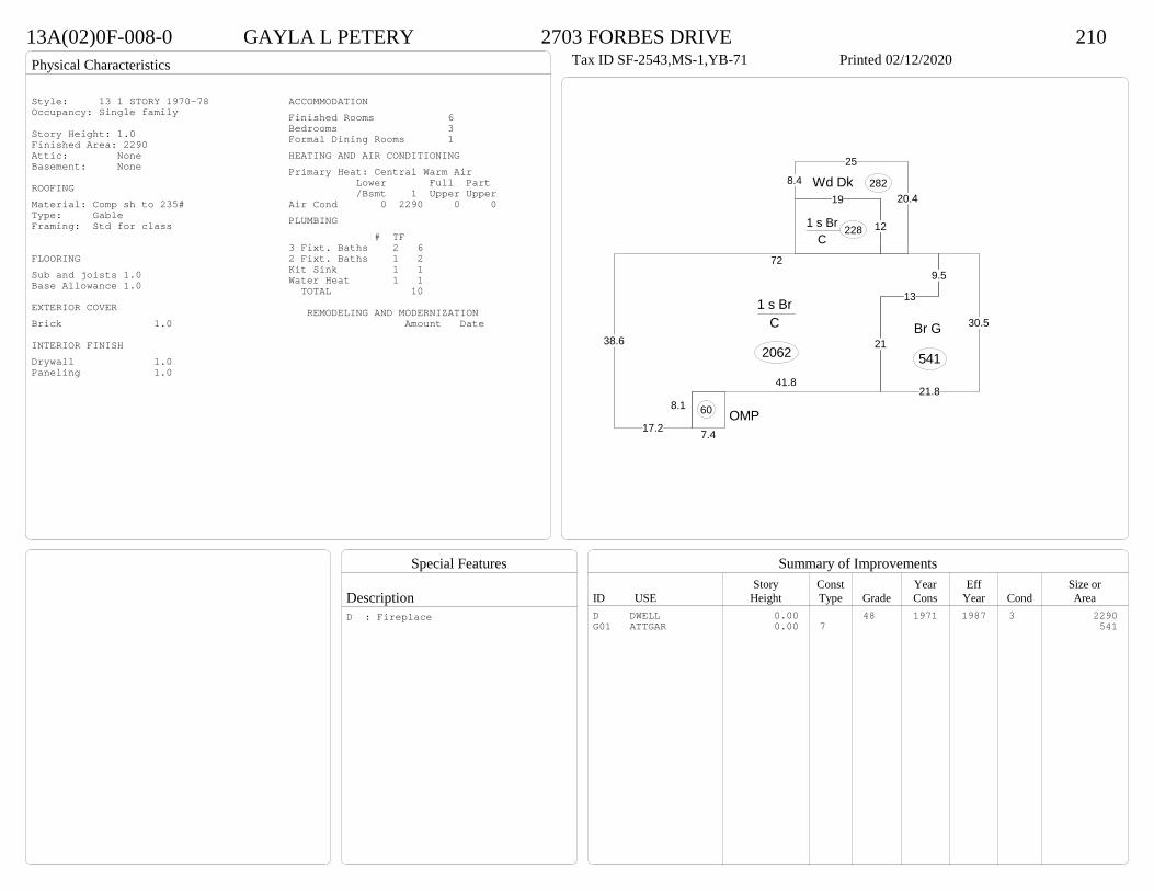
Physical Characteristics
Special Features
Description
Summary of ImprovementsStory Const Year Eff Size or
ID USE Height Type Grade Cons Year Cond Area
13A(02)0F-008-0 GAYLA L PETERY 2703 FORBES DRIVE 210Tax ID SF-2543,MS-1,YB-71 Printed 02/12/2020
17.2
38.6
729.5
13
21
41.8
8.1
1 s Br C
2062
12
19
1 s Br C
228
8.4
25
20.4Wd Dk 282
7.4OMP60
21.8
30.5Br G
541
Style: 13 1 STORY 1970-78Occupancy: Single family
Story Height: 1.0Finished Area: 2290 Attic: NoneBasement: None
ROOFINGMaterial: Comp sh to 235#Type: GableFraming: Std for class
FLOORINGSub and joists 1.0Base Allowance 1.0
EXTERIOR COVERBrick 1.0
INTERIOR FINISHDrywall 1.0Paneling 1.0
ACCOMMODATIONFinished Rooms 6Bedrooms 3Formal Dining Rooms 1HEATING AND AIR CONDITIONINGPrimary Heat: Central Warm Air Lower Full Part /Bsmt 1 Upper UpperAir Cond 0 2290 0 0PLUMBING # TF3 Fixt. Baths 2 62 Fixt. Baths 1 2Kit Sink 1 1Water Heat 1 1 TOTAL 10
REMODELING AND MODERNIZATION Amount Date
D DWELL 0.00 48 1971 1987 3 2290G01 ATTGAR 0.00 7 541
D : Fireplace
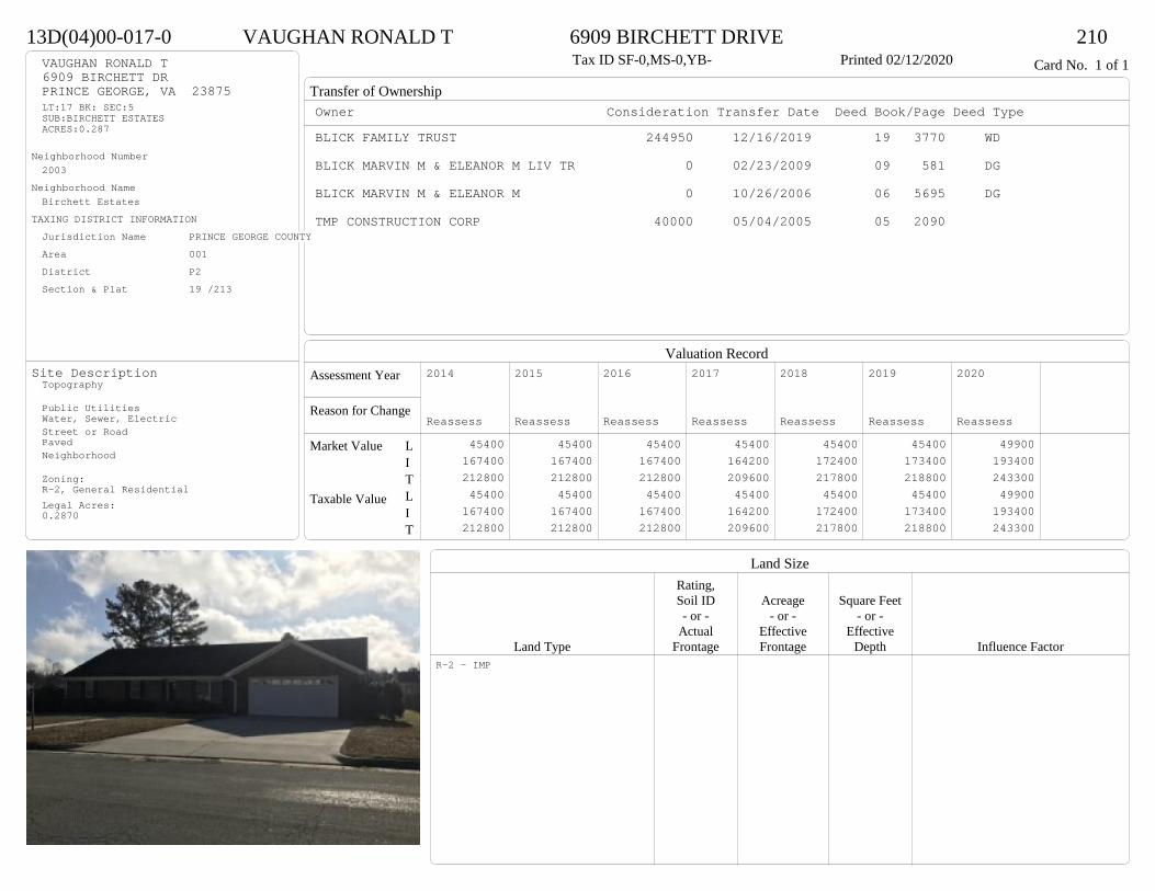
Transfer of Ownership
Valuation RecordAssessment Year
Reason for Change
Market Value
Taxable Value
LITLIT
Land SizeRating,Soil ID Acreage Square Feet- or - - or - - or -
Actual Effective EffectiveLand Type Frontage Frontage Depth Influence Factor
13D(04)00-017-0 VAUGHAN RONALD T 6909 BIRCHETT DRIVE 210Tax ID SF-0,MS-0,YB- Printed 02/12/2020 Card No. 1 of 1VAUGHAN RONALD T
6909 BIRCHETT DRPRINCE GEORGE, VA 23875LT:17 BK: SEC:5SUB:BIRCHETT ESTATESACRES:0.287
Neighborhood Number2003
Neighborhood NameBirchett Estates
TAXING DISTRICT INFORMATIONJurisdiction Name PRINCE GEORGE COUNTYArea 001 District P2 Section & Plat 19 /213
Site DescriptionTopography
Public UtilitiesWater, Sewer, ElectricStreet or RoadPavedNeighborhood
Zoning:R-2, General ResidentialLegal Acres:0.2870
Owner Consideration Transfer Date Deed Book/Page Deed TypeBLICK FAMILY TRUST 244950 12/16/2019 19 3770 WD
BLICK MARVIN M & ELEANOR M LIV TR 0 02/23/2009 09 581 DG
BLICK MARVIN M & ELEANOR M 0 10/26/2006 06 5695 DG
TMP CONSTRUCTION CORP 40000 05/04/2005 05 2090
2014
Reassess 45400 167400 212800 45400 167400 212800
2015
Reassess 45400 167400 212800 45400 167400 212800
2016
Reassess 45400 167400 212800 45400 167400 212800
2017
Reassess 45400 164200 209600 45400 164200 209600
2018
Reassess 45400 172400 217800 45400 172400 217800
2019
Reassess 45400 173400 218800 45400 173400 218800
2020
Reassess 49900 193400 243300 49900 193400 243300
R-2 - IMP
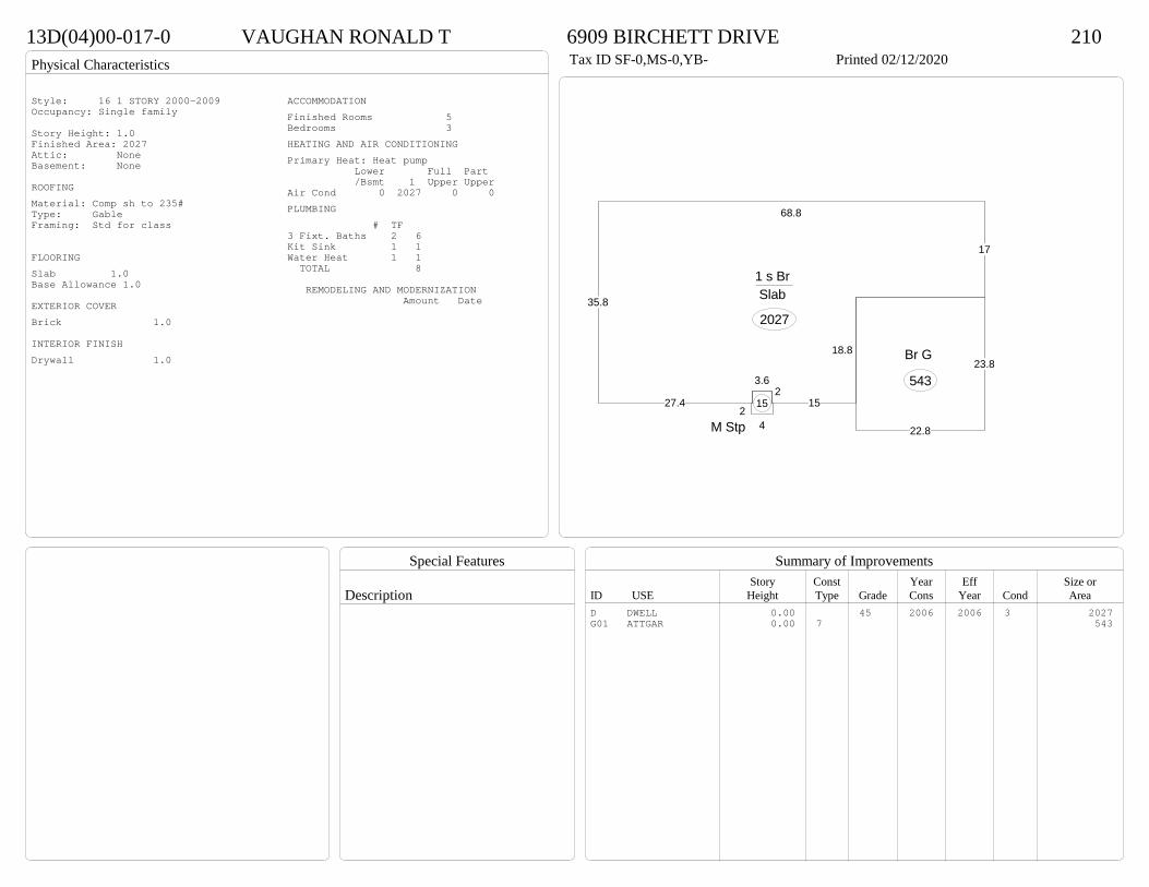
Physical Characteristics
Special Features
Description
Summary of ImprovementsStory Const Year Eff Size or
ID USE Height Type Grade Cons Year Cond Area
13D(04)00-017-0 VAUGHAN RONALD T 6909 BIRCHETT DRIVE 210Tax ID SF-0,MS-0,YB- Printed 02/12/2020
35.8
68.8
17
18.8
152
3.6
27.4
1 s Br Slab
2027
24M Stp
15
23.8
22.8
Br G
543
Style: 16 1 STORY 2000-2009Occupancy: Single family
Story Height: 1.0Finished Area: 2027 Attic: NoneBasement: None
ROOFINGMaterial: Comp sh to 235#Type: GableFraming: Std for class
FLOORINGSlab 1.0Base Allowance 1.0
EXTERIOR COVERBrick 1.0
INTERIOR FINISHDrywall 1.0
ACCOMMODATIONFinished Rooms 5Bedrooms 3HEATING AND AIR CONDITIONINGPrimary Heat: Heat pump Lower Full Part /Bsmt 1 Upper UpperAir Cond 0 2027 0 0PLUMBING # TF3 Fixt. Baths 2 6Kit Sink 1 1Water Heat 1 1 TOTAL 8
REMODELING AND MODERNIZATION Amount Date
D DWELL 0.00 45 2006 2006 3 2027G01 ATTGAR 0.00 7 543
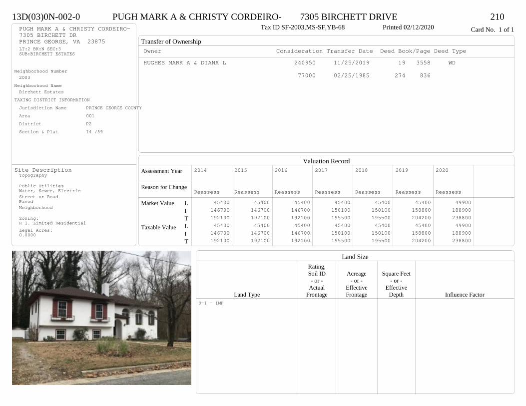
Transfer of Ownership
Valuation RecordAssessment Year
Reason for Change
Market Value
Taxable Value
LITLIT
Land SizeRating,Soil ID Acreage Square Feet- or - - or - - or -
Actual Effective EffectiveLand Type Frontage Frontage Depth Influence Factor
13D(03)0N-002-0 PUGH MARK A & CHRISTY CORDEIRO- 7305 BIRCHETT DRIVE 210Tax ID SF-2003,MS-SF,YB-68 Printed 02/12/2020 Card No. 1 of 1PUGH MARK A & CHRISTY CORDEIRO-
7305 BIRCHETT DRPRINCE GEORGE, VA 23875LT:2 BK:N SEC:3SUB:BIRCHETT ESTATES
Neighborhood Number2003
Neighborhood NameBirchett Estates
TAXING DISTRICT INFORMATIONJurisdiction Name PRINCE GEORGE COUNTYArea 001 District P2 Section & Plat 14 /59
Site DescriptionTopography
Public UtilitiesWater, Sewer, ElectricStreet or RoadPavedNeighborhood
Zoning:R-1. Limited ResidentialLegal Acres:0.0000
Owner Consideration Transfer Date Deed Book/Page Deed TypeHUGHES MARK A & DIANA L 240950 11/25/2019 19 3558 WD
77000 02/25/1985 274 836
2014
Reassess 45400 146700 192100 45400 146700 192100
2015
Reassess 45400 146700 192100 45400 146700 192100
2016
Reassess 45400 146700 192100 45400 146700 192100
2017
Reassess 45400 150100 195500 45400 150100 195500
2018
Reassess 45400 150100 195500 45400 150100 195500
2019
Reassess 45400 158800 204200 45400 158800 204200
2020
Reassess 49900 188900 238800 49900 188900 238800
R-1 - IMP
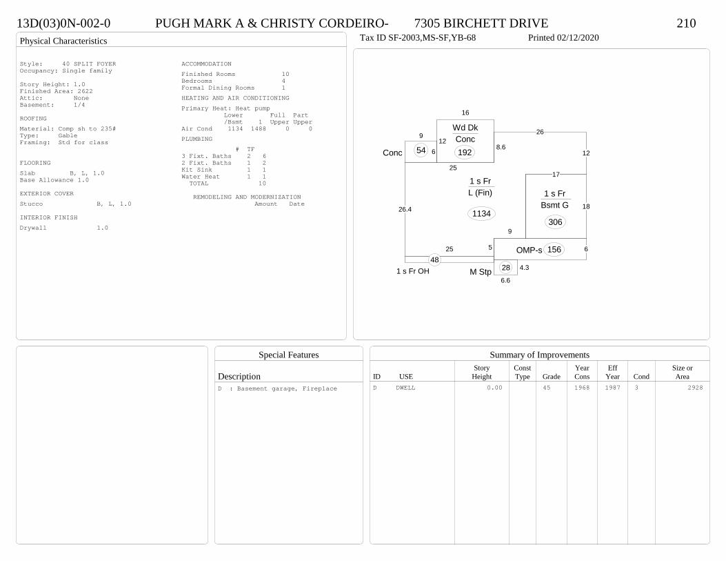
Physical Characteristics
Special Features
Description
Summary of ImprovementsStory Const Year Eff Size or
ID USE Height Type Grade Cons Year Cond Area
13D(03)0N-002-0 PUGH MARK A & CHRISTY CORDEIRO- 7305 BIRCHETT DRIVE 210Tax ID SF-2003,MS-SF,YB-68 Printed 02/12/2020
4.3
6.6M Stp 281 s Fr OH
486OMP-s 156
16
12
Wd DkConc192
18
17
1 s Fr Bsmt G
30626.4
25
8.6
26
12
9
525
1 s Fr L (Fin)
1134
6
9
Conc 54
Style: 40 SPLIT FOYEROccupancy: Single family
Story Height: 1.0Finished Area: 2622 Attic: NoneBasement: 1/4
ROOFINGMaterial: Comp sh to 235#Type: GableFraming: Std for class
FLOORINGSlab B, L, 1.0Base Allowance 1.0
EXTERIOR COVERStucco B, L, 1.0
INTERIOR FINISHDrywall 1.0
ACCOMMODATIONFinished Rooms 10Bedrooms 4Formal Dining Rooms 1HEATING AND AIR CONDITIONINGPrimary Heat: Heat pump Lower Full Part /Bsmt 1 Upper UpperAir Cond 1134 1488 0 0PLUMBING # TF3 Fixt. Baths 2 62 Fixt. Baths 1 2Kit Sink 1 1Water Heat 1 1 TOTAL 10
REMODELING AND MODERNIZATION Amount Date
D DWELL 0.00 45 1968 1987 3 2928D : Basement garage, Fireplace

Transfer of Ownership
Valuation RecordAssessment Year
Reason for Change
Market Value
Taxable Value
LITLIT
Land SizeRating,Soil ID Acreage Square Feet- or - - or - - or -
Actual Effective EffectiveLand Type Frontage Frontage Depth Influence Factor
13D(08)00-009-0 COX CRYSTAL S 3892 PFOST AVE 210Printed 02/12/2020 Card No. 1 of 1COX CRYSTAL S
3892 PFOST AVEPRINCE GEORGE, VA 23875LT:9 BK: SEC:2SUB:MONCOL SUBDIVISIONACRES:.229
Neighborhood Number2003
Neighborhood NameBirchett Estates
TAXING DISTRICT INFORMATIONJurisdiction Name PRINCE GEORGE COUNTYArea 001 District P2 Section & Plat 25/63
Site DescriptionTopography
Public Utilities
Street or Road
Neighborhood
Zoning:R-A, Residential AgriculturalR-E, Residential EstateR-3, Medium Density ResidentiaLegal Acres:0.2290
Owner Consideration Transfer Date Deed Book/Page Deed TypeMCGILL LARRY 215950 12/02/2019 19 3612 WD
SULLIVAN JERRY W SR & DIANNA L 189900 09/06/2016 16 2616 WD
SULLIVAN J W CONSTRUCTION INC 199000 11/01/2013 13 6836 WD
2014
Reassess 45400 143800 189200 45400 143800 189200
2015
Reassess 45400 143800 189200 45400 143800 189200
2016
Reassess 45400 143800 189200 45400 143800 189200
2017
Reassess 45400 145600 191000 45400 145600 191000
2018
Reassess 45400 145600 191000 45400 145600 191000
2019
Reassess 45400 154200 199600 45400 154200 199600
2020
Reassess 49900 164400 214300 49900 164400 214300
R-3 - IMP
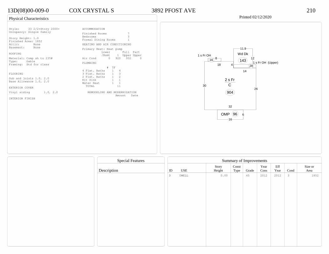
Physical Characteristics
Special Features
Description
Summary of ImprovementsStory Const Year Eff Size or
ID USE Height Type Grade Cons Year Cond Area
13D(08)00-009-0 COX CRYSTAL S 3892 PFOST AVE 210Printed 02/12/2020
30
32
26
14
418
2 s Fr C
904
616
OMP 96
81 s Fr OH
16 12
11.9
Wd Dk
143 1 s Fr OH (Upper)28
Style: 33 2/2+Story 2000+Occupancy: Single family
Story Height: 1.0Finished Area: 1852 Attic: NoneBasement: None
ROOFINGMaterial: Comp sh to 235#Type: GableFraming: Std for class
FLOORINGSub and joists 1.0, 2.0Base Allowance 1.0, 2.0
EXTERIOR COVERVinyl siding 1.0, 2.0
INTERIOR FINISH
ACCOMMODATIONFinished Rooms 7Bedrooms 3Formal Dining Rooms 1HEATING AND AIR CONDITIONINGPrimary Heat: Heat pump Lower Full Part /Bsmt 1 Upper UpperAir Cond 0 920 932 0PLUMBING # TF4 Fixt. Baths 1 43 Fixt. Baths 1 32 Fixt. Baths 1 2Kit Sink 1 1Water Heat 1 1 TOTAL 11
REMODELING AND MODERNIZATION Amount Date
D DWELL 0.00 45 2012 2012 3 1852

Transfer of Ownership
Valuation RecordAssessment Year
Reason for Change
Market Value
Taxable Value
LITLIT
Land SizeRating,Soil ID Acreage Square Feet- or - - or - - or -
Actual Effective EffectiveLand Type Frontage Frontage Depth Influence Factor
13D(08)00-002-0 HARRIS LEAH 3887 PFOST AVE 210Printed 02/12/2020 Card No. 1 of 1HARRIS LEAH
3887 PFOST AVEPRINCE GEORGE, VA 23875LT:2 BK: SEC:2SUB:MONCOL SUBDIVISIONACRES:.722
Neighborhood Number2003
Neighborhood NameBirchett Estates
TAXING DISTRICT INFORMATIONJurisdiction Name PRINCE GEORGE COUNTYArea 001 District P2 Section & Plat 25/63
Site DescriptionTopography
Public Utilities
Street or Road
Neighborhood
Zoning:R-A, Residential AgriculturalR-E, Residential EstateR-3, Medium Density ResidentiaLegal Acres:0.7220
Owner Consideration Transfer Date Deed Book/Page Deed TypeBRADSHAW RYAN G & LAURA A 197000 07/02/2019 19 1903 WD
SULLIVAN J W CONSTRUCTION INC 181900 08/22/2014 14 3080 WD
2014
Sup 1 45400 129600 175000 45400 129600 175000
2015
Reassess 45400 129600 175000 45400 129600 175000
2016
Reassess 45400 129600 175000 45400 129600 175000
2017
Reassess 45400 131200 176600 45400 131200 176600
2018
Reassess 45400 143000 188400 45400 143000 188400
2019
Reassess 45400 139000 184400 45400 139000 184400
2020
Reassess 49900 152800 202700 49900 152800 202700
R-3 - IMP

Physical Characteristics
Special Features
Description
Summary of ImprovementsStory Const Year Eff Size or
ID USE Height Type Grade Cons Year Cond Area
13D(08)00-002-0 HARRIS LEAH 3887 PFOST AVE 210Printed 02/12/2020
25.25.5
20.8
30.5
202
1412
36
1 s Fr C
1570
OMP 114
10
12
Wd Dk120
Style: 17 1 STORY 2010-2019Occupancy: Single family
Story Height: 1.0Finished Area: 1570 Attic: NoneBasement: None
ROOFINGMaterial: Comp sh to 235#Type: GableFraming: Std for class
FLOORINGSub and joists 1.0Base Allowance 1.0
EXTERIOR COVERVinyl siding 1.0
INTERIOR FINISHDrywall 1.0
ACCOMMODATIONFinished Rooms 7Bedrooms 4HEATING AND AIR CONDITIONINGPrimary Heat: Heat pump Lower Full Part /Bsmt 1 Upper UpperAir Cond 0 1570 0 0PLUMBING # TF4 Fixt. Baths 2 8Kit Sink 1 1Water Heat 1 1 TOTAL 10
REMODELING AND MODERNIZATION Amount Date
D DWELL 0.00 45 2014 2014 3 1570
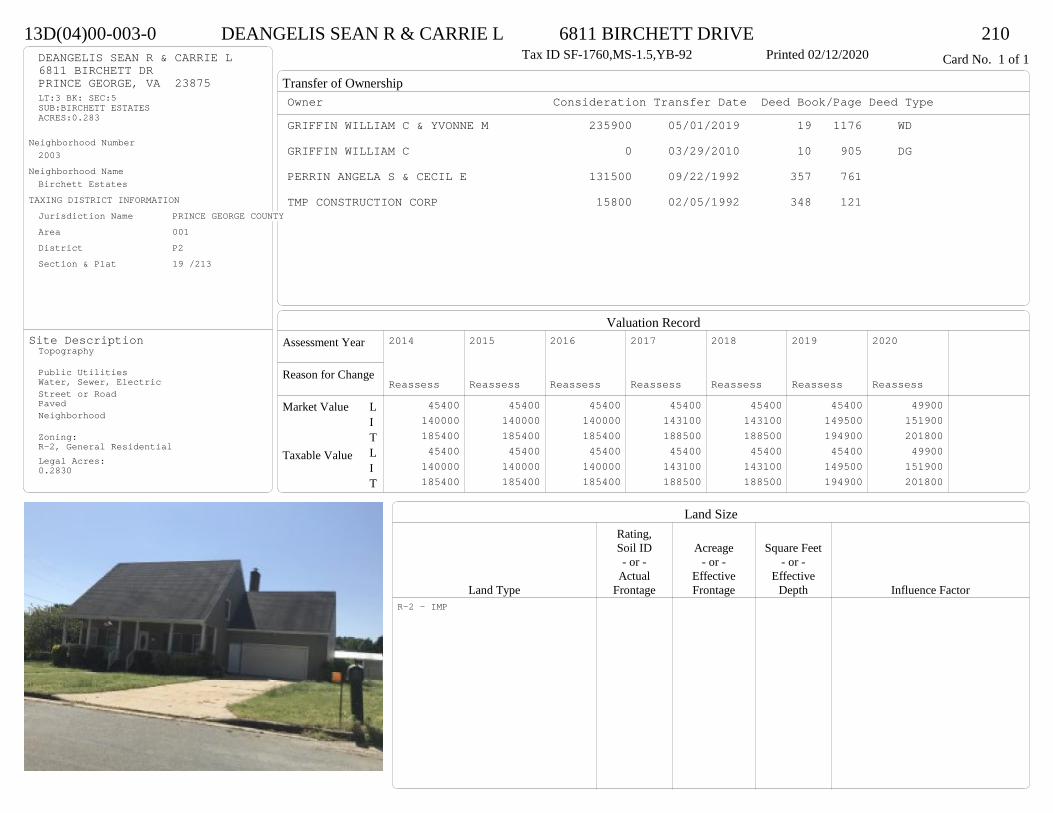
Transfer of Ownership
Valuation RecordAssessment Year
Reason for Change
Market Value
Taxable Value
LITLIT
Land SizeRating,Soil ID Acreage Square Feet- or - - or - - or -
Actual Effective EffectiveLand Type Frontage Frontage Depth Influence Factor
13D(04)00-003-0 DEANGELIS SEAN R & CARRIE L 6811 BIRCHETT DRIVE 210Tax ID SF-1760,MS-1.5,YB-92 Printed 02/12/2020 Card No. 1 of 1DEANGELIS SEAN R & CARRIE L
6811 BIRCHETT DRPRINCE GEORGE, VA 23875LT:3 BK: SEC:5SUB:BIRCHETT ESTATESACRES:0.283
Neighborhood Number2003
Neighborhood NameBirchett Estates
TAXING DISTRICT INFORMATIONJurisdiction Name PRINCE GEORGE COUNTYArea 001 District P2 Section & Plat 19 /213
Site DescriptionTopography
Public UtilitiesWater, Sewer, ElectricStreet or RoadPavedNeighborhood
Zoning:R-2, General ResidentialLegal Acres:0.2830
Owner Consideration Transfer Date Deed Book/Page Deed TypeGRIFFIN WILLIAM C & YVONNE M 235900 05/01/2019 19 1176 WD
GRIFFIN WILLIAM C 0 03/29/2010 10 905 DG
PERRIN ANGELA S & CECIL E 131500 09/22/1992 357 761
TMP CONSTRUCTION CORP 15800 02/05/1992 348 121
2014
Reassess 45400 140000 185400 45400 140000 185400
2015
Reassess 45400 140000 185400 45400 140000 185400
2016
Reassess 45400 140000 185400 45400 140000 185400
2017
Reassess 45400 143100 188500 45400 143100 188500
2018
Reassess 45400 143100 188500 45400 143100 188500
2019
Reassess 45400 149500 194900 45400 149500 194900
2020
Reassess 49900 151900 201800 49900 151900 201800
R-2 - IMP
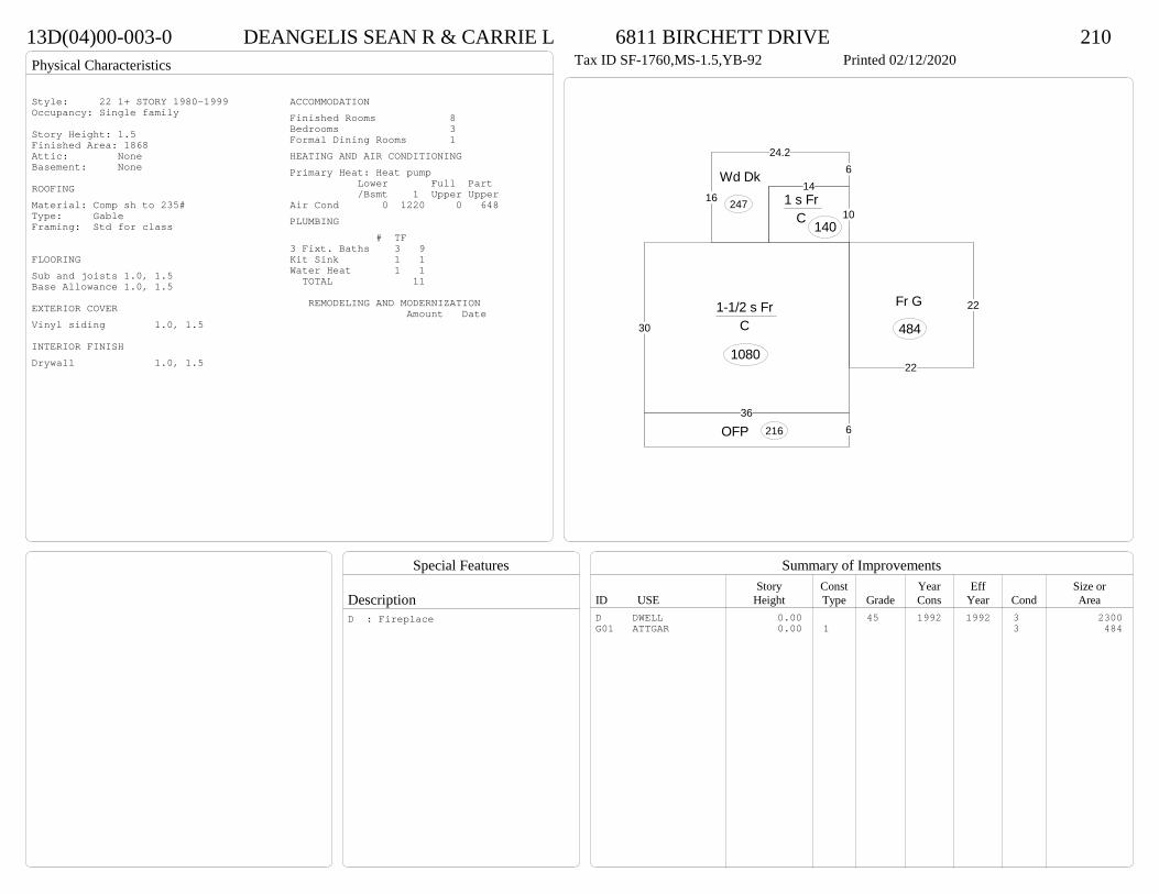
Physical Characteristics
Special Features
Description
Summary of ImprovementsStory Const Year Eff Size or
ID USE Height Type Grade Cons Year Cond Area
13D(04)00-003-0 DEANGELIS SEAN R & CARRIE L 6811 BIRCHETT DRIVE 210Tax ID SF-1760,MS-1.5,YB-92 Printed 02/12/2020
36
30
1-1/2 s Fr C
1080
10
141 s Fr
C 140
624.2
16
Wd Dk
247
6OFP 216
22
22Fr G
484
Style: 22 1+ STORY 1980-1999Occupancy: Single family
Story Height: 1.5Finished Area: 1868 Attic: NoneBasement: None
ROOFINGMaterial: Comp sh to 235#Type: GableFraming: Std for class
FLOORINGSub and joists 1.0, 1.5Base Allowance 1.0, 1.5
EXTERIOR COVERVinyl siding 1.0, 1.5
INTERIOR FINISHDrywall 1.0, 1.5
ACCOMMODATIONFinished Rooms 8Bedrooms 3Formal Dining Rooms 1HEATING AND AIR CONDITIONINGPrimary Heat: Heat pump Lower Full Part /Bsmt 1 Upper UpperAir Cond 0 1220 0 648PLUMBING # TF3 Fixt. Baths 3 9Kit Sink 1 1Water Heat 1 1 TOTAL 11
REMODELING AND MODERNIZATION Amount Date
D DWELL 0.00 45 1992 1992 3 2300G01 ATTGAR 0.00 1 3 484
D : Fireplace

Transfer of Ownership
Valuation RecordAssessment Year
Reason for Change
Market Value
Taxable Value
LITLIT
Land SizeRating,Soil ID Acreage Square Feet- or - - or - - or -
Actual Effective EffectiveLand Type Frontage Frontage Depth Influence Factor
13E(03)0D-010-0 FRANCO JACOB P & SHANNON R 4030 NEWSTEAD PLACE 210Tax ID SF-2187,MS-SF,YB-93 Printed 02/12/2020 Card No. 1 of 1FRANCO JACOB P & SHANNON R
4030 NEWSTEAD PLPRINCE GEORGE, VA 23875LT:10 BK:D SEC:3SUB:NEWSTEAD FARMSACRES:0.576
Neighborhood Number2004
Neighborhood NameNewstead Farms/Manchester Mill
TAXING DISTRICT INFORMATIONJurisdiction Name PRINCE GEORGE COUNTYArea 001 District P2 Section & Plat 17 /121
Site DescriptionTopography
Public UtilitiesWater, ElectricStreet or RoadPavedNeighborhood
Zoning:R-1. Limited ResidentialR-2, General ResidentialLegal Acres:0.5760
Owner Consideration Transfer Date Deed Book/Page Deed TypeMONTES CARLOS & 230000 06/13/2019 19 1611 WD
MENDEZ ISABEL ROSADO-BEAUFORD JOHN D JR & SHEREE A 181500 02/05/2016 16 324 WD
KOVALASKE ROBERT E JR 164200 12/22/2003 03 7844
115000 03/22/1994 452 824
2014
Reassess 36000 156000 192000 36000 156000 192000
2015
Reassess 36000 156000 192000 36000 156000 192000
2016
Reassess 36000 168700 204700 36000 168700 204700
2017
Reassess 36000 170300 206300 36000 170300 206300
2018
Reassess 36000 170300 206300 36000 170300 206300
2019
Reassess 36000 169700 205700 36000 169700 205700
2020
Reassess 39600 195900 235500 39600 195900 235500
R-1 - IMP

Physical Characteristics
Special Features
Description
Summary of ImprovementsStory Const Year Eff Size or
ID USE Height Type Grade Cons Year Cond Area
13E(03)0D-010-0 FRANCO JACOB P & SHANNON R 4030 NEWSTEAD PLACE 210Tax ID SF-2187,MS-SF,YB-93 Printed 02/12/2020
38
28.3
2 s Fr C
1075
88
Wd Dk 64
10
14
Wd Dk140
24
16
1 s Fr Slab
384
Style: 32 2/2+Story 1980-1999Occupancy: Single family
Story Height: 2.0Finished Area: 2534 Attic: NoneBasement: None
ROOFINGMaterial: Comp sh to 235#Type: GambrelFraming: Std for class
FLOORINGSub and joists 1.0, 2.0Base Allowance 1.0, 2.0
EXTERIOR COVERBrick 1.0Vinyl siding 1.0, 2.0
INTERIOR FINISHDrywall 1.0, 2.0
ACCOMMODATIONFinished Rooms 8Bedrooms 4Formal Dining Rooms 1HEATING AND AIR CONDITIONINGPrimary Heat: Heat pump Lower Full Part /Bsmt 1 Upper UpperAir Cond 0 1459 1075 0PLUMBING # TF3 Fixt. Baths 2 62 Fixt. Baths 1 2Kit Sink 1 1Water Heat 1 1 TOTAL 10
REMODELING AND MODERNIZATION Amount Date
D DWELL 0.00 45 1993 1993 3 2534
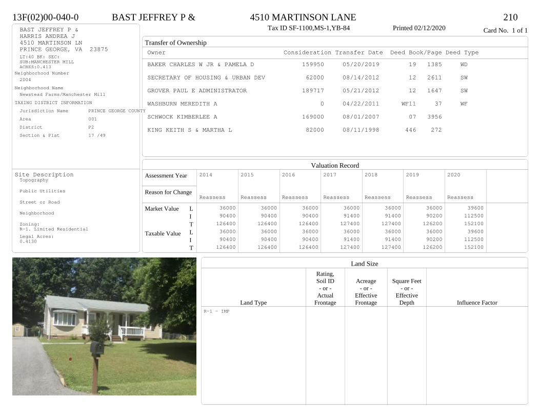
Transfer of Ownership
Valuation RecordAssessment Year
Reason for Change
Market Value
Taxable Value
LITLIT
Land SizeRating,Soil ID Acreage Square Feet- or - - or - - or -
Actual Effective EffectiveLand Type Frontage Frontage Depth Influence Factor
13F(02)00-040-0 BAST JEFFREY P & 4510 MARTINSON LANE 210Tax ID SF-1100,MS-1,YB-84 Printed 02/12/2020 Card No. 1 of 1BAST JEFFREY P &
HARRIS ANDREA J4510 MARTINSON LNPRINCE GEORGE, VA 23875LT:40 BK: SEC:SUB:MANCHESTER MILLACRES:0.413
Neighborhood Number2004
Neighborhood NameNewstead Farms/Manchester Mill
TAXING DISTRICT INFORMATIONJurisdiction Name PRINCE GEORGE COUNTYArea 001 District P2 Section & Plat 17 /49
Site DescriptionTopography
Public Utilities
Street or Road
Neighborhood
Zoning:R-1. Limited ResidentialLegal Acres:0.4130
Owner Consideration Transfer Date Deed Book/Page Deed TypeBAKER CHARLES W JR & PAMELA D 159950 05/20/2019 19 1385 WD
SECRETARY OF HOUSING & URBAN DEV 62000 08/14/2012 12 2611 SW
GROVER PAUL E ADMINISTRATOR 189717 05/21/2012 12 1647 SW
WASHBURN MEREDITH A 0 04/22/2011 WF11 37 WF
SCHWOCK KIMBERLEE A 169000 08/01/2007 07 3956
KING KEITH S & MARTHA L 82000 08/11/1998 446 272
2014
Reassess 36000 90400 126400 36000 90400 126400
2015
Reassess 36000 90400 126400 36000 90400 126400
2016
Reassess 36000 90400 126400 36000 90400 126400
2017
Reassess 36000 91400 127400 36000 91400 127400
2018
Reassess 36000 91400 127400 36000 91400 127400
2019
Reassess 36000 90200 126200 36000 90200 126200
2020
Reassess 39600 112500 152100 39600 112500 152100
R-1 - IMP

Physical Characteristics
Special Features
Description
Summary of ImprovementsStory Const Year Eff Size or
ID USE Height Type Grade Cons Year Cond Area
13F(02)00-040-0 BAST JEFFREY P & 4510 MARTINSON LANE 210Tax ID SF-1100,MS-1,YB-84 Printed 02/12/2020
42
24
1 s Fr C
1008
620
OFP 120
15.49Sol 1393.5
12.3
8.2
16.1
11.5Wd Dk
221 4.7
19.8
17
16.6
Wd P333
Style: 14 1 STORY 1979-89Occupancy: Single family
Story Height: 1.0Finished Area: 1008 Attic: NoneBasement: None
ROOFINGMaterial: Comp sh to 235#Type: GableFraming: Std for class
FLOORINGSub and joists 1.0Base Allowance 1.0
EXTERIOR COVERVinyl siding 1.0
INTERIOR FINISHDrywall 1.0
ACCOMMODATIONFinished Rooms 7Bedrooms 3Formal Dining Rooms 1HEATING AND AIR CONDITIONINGPrimary Heat: Heat pump Lower Full Part /Bsmt 1 Upper UpperAir Cond 0 1008 0 0PLUMBING # TF3 Fixt. Baths 2 6Kit Sink 1 1Water Heat 1 1 TOTAL 8
REMODELING AND MODERNIZATION Amount Date
D DWELL 0.00 45 1984 1990 3 1008D : Fireplace, Fireplace

Transfer of Ownership
Valuation RecordAssessment Year
Reason for Change
Market Value
Taxable Value
LITLIT
Land SizeRating,Soil ID Acreage Square Feet- or - - or - - or -
Actual Effective EffectiveLand Type Frontage Frontage Depth Influence Factor
23E(02)01-013-0 SULLIVAN JEFFREY L & 124 HOLLY BERRY LN 210Tax ID SF-1881,MS-T/L,YB-81 Printed 02/12/2020 Card No. 1 of 1SULLIVAN JEFFREY L &
EAGAN KERRY A124 HOLLY BERRY LNPRINCE GEORGE, VA 23875LT:13 BK:1 SEC:2SUB:ROLLING MEADOW
Neighborhood Number2005
Neighborhood NameRolling Meadows
TAXING DISTRICT INFORMATIONJurisdiction Name PRINCE GEORGE COUNTYArea 001 District P2 Section & Plat 17 /103
Site DescriptionTopographyLevelPublic UtilitiesWater, Sewer, ElectricStreet or RoadPavedNeighborhoodImprovingZoning:R-1. Limited ResidentialLegal Acres:0.0000
Owner Consideration Transfer Date Deed Book/Page Deed TypeGLASSCOCK NICHOLAS A & WENDY L 175000 03/01/2019 19 556 WD
TYLER JACQUELINE J & CHRISTINA M POT 133000 11/30/2000 00-4682
93500 05/05/1987 428 394
2014
Reassess 46300 152700 199000 46300 152700 199000
2015
Reassess 46300 152700 199000 46300 152700 199000
2016
Reassess 46300 152700 199000 46300 152700 199000
2017
Reassess 46300 152300 198600 46300 152300 198600
2018
Reassess 46300 155200 201500 46300 155200 201500
2019
Reassess 46300 161200 207500 46300 161200 207500
2020
Reassess 42900 173800 216700 42900 173800 216700
R-1 - IMP
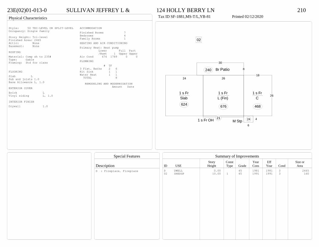
Physical Characteristics
Special Features
Description
Summary of ImprovementsStory Const Year Eff Size or
ID USE Height Type Grade Cons Year Cond Area
23E(02)01-013-0 SULLIVAN JEFFREY L & 124 HOLLY BERRY LN 210Tax ID SF-1881,MS-T/L,YB-81 Printed 02/12/2020
26
1 s Fr L (Fin)
676
18
261 s Fr
C
468
1 s Fr OH 21
24
1 s Fr Slab 624
8
30
Br P240
6
4M Stp 24
02
Patio
Style: 50 TRI-LEVEL OR SPLIT-LEVELOccupancy: Single family
Story Height: Tri-levelFinished Area: 2465 Attic: NoneBasement: None
ROOFINGMaterial: Comp sh to 235#Type: GableFraming: Std for class
FLOORINGSlab LSub and joists 1.0Base Allowance L, 1.0
EXTERIOR COVERBrick LVinyl siding L, 1.0
INTERIOR FINISHDrywall 1.0
ACCOMMODATIONFinished Rooms 7Bedrooms 4Family Rooms 1HEATING AND AIR CONDITIONINGPrimary Heat: Heat pump Lower Full Part /Bsmt 1 Upper UpperAir Cond 676 1789 0 0PLUMBING # TF3 Fixt. Baths 2 6Kit Sink 1 1Water Heat 1 1 TOTAL 8
REMODELING AND MODERNIZATION Amount Date
D DWELL 0.00 45 1981 1981 3 246502 SHEDGP 10.00 1 45 1991 1991 3 160
D : Fireplace, Fireplace

Transfer of Ownership
Valuation RecordAssessment Year
Reason for Change
Market Value
Taxable Value
LITLIT
Land SizeRating,Soil ID Acreage Square Feet- or - - or - - or -
Actual Effective EffectiveLand Type Frontage Frontage Depth Influence Factor
23E(01)04-002-0 ZISKE JOAN & PETER 104 COTTONWOOD LANE 210Tax ID SF-2025,MS-T/L,YB-81 Printed 02/12/2020 Card No. 1 of 1ZISKE JOAN & PETER
P O BOX 150WEST CHAZY, NY 12992LT:2 BK:4 SEC:1SUB:ROLLING MEADOW
Neighborhood Number2005
Neighborhood NameRolling Meadows
TAXING DISTRICT INFORMATIONJurisdiction Name PRINCE GEORGE COUNTYArea 001 District P2 Section & Plat 16 /186
Site DescriptionTopography
Public UtilitiesWater, Sewer, ElectricStreet or RoadPavedNeighborhoodStaticZoning:R-1. Limited ResidentialLegal Acres:0.0000
Owner Consideration Transfer Date Deed Book/Page Deed TypeVARGOVICH ERIKA 167000 12/27/2019 19 3884 WD
VARGOVICH DONALD GENE & ERIKA 0 05/26/2017 CD
2014
Reassess 46300 143300 189600 46300 143300 189600
2015
Reassess 46300 143300 189600 46300 143300 189600
2016
Reassess 46300 143300 189600 46300 143300 189600
2017
Reassess 46300 143000 189300 46300 143000 189300
2018
Reassess 46300 145800 192100 46300 145800 192100
2019
Reassess 46300 159800 206100 46300 159800 206100
2020
Reassess 42900 164000 206900 42900 164000 206900
R-1 - IMP

Physical Characteristics
Special Features
Description
Summary of ImprovementsStory Const Year Eff Size or
ID USE Height Type Grade Cons Year Cond Area
23E(01)04-002-0 ZISKE JOAN & PETER 104 COTTONWOOD LANE 210Tax ID SF-2025,MS-T/L,YB-81 Printed 02/12/2020
248
CnpyConc 192
23
1 s Fr L (Fin)
570
24.8
35
1 s Br C
868
1 s Fr OH 23
6
4M Stp
24
46M Stp
2410
20
OMP-s 200
24
24.8Br G
595
LOWER LEVEL BRICK
Style: 50 TRI-LEVEL OR SPLIT-LEVELOccupancy: Single family
Story Height: Bi-levelFinished Area: 2031 Attic: NoneBasement: None
ROOFINGMaterial: Comp sh to 235#Type: GableFraming: Std for class
FLOORINGSlab LSub and joists 1.0Base Allowance L, 1.0
EXTERIOR COVERBrick LVinyl siding 1.0
INTERIOR FINISHDrywall L, 1.0
ACCOMMODATIONFinished Rooms 8Bedrooms 3Formal Dining Rooms 1HEATING AND AIR CONDITIONINGPrimary Heat: Heat pump Lower Full Part /Bsmt 1 Upper UpperAir Cond 570 1461 0 0PLUMBING # TF3 Fixt. Baths 1 32 Fixt. Baths 1 2Kit Sink 1 1Water Heat 1 1 TOTAL 7
REMODELING AND MODERNIZATION Amount Date
D DWELL 0.00 45 1981 1981 3 2031G01 ATTGAR 0.00 7 595
D : Fireplace
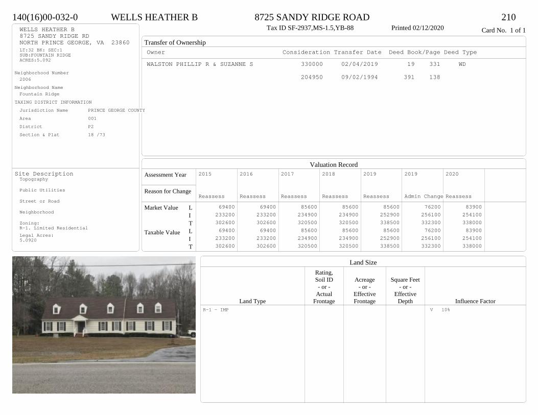
Transfer of Ownership
Valuation RecordAssessment Year
Reason for Change
Market Value
Taxable Value
LITLIT
Land SizeRating,Soil ID Acreage Square Feet- or - - or - - or -
Actual Effective EffectiveLand Type Frontage Frontage Depth Influence Factor
140(16)00-032-0 WELLS HEATHER B 8725 SANDY RIDGE ROAD 210Tax ID SF-2937,MS-1.5,YB-88 Printed 02/12/2020 Card No. 1 of 1WELLS HEATHER B
8725 SANDY RIDGE RDNORTH PRINCE GEORGE, VA 23860LT:32 BK: SEC:1SUB:FOUNTAIN RIDGEACRES:5.092
Neighborhood Number2006
Neighborhood NameFountain Ridge
TAXING DISTRICT INFORMATIONJurisdiction Name PRINCE GEORGE COUNTYArea 001 District P2 Section & Plat 18 /73
Site DescriptionTopography
Public Utilities
Street or Road
Neighborhood
Zoning:R-1. Limited ResidentialLegal Acres:5.0920
Owner Consideration Transfer Date Deed Book/Page Deed TypeWALSTON PHILLIP R & SUZANNE S 330000 02/04/2019 19 331 WD
204950 09/02/1994 391 138
2015
Reassess 69400 233200 302600 69400 233200 302600
2016
Reassess 69400 233200 302600 69400 233200 302600
2017
Reassess 85600 234900 320500 85600 234900 320500
2018
Reassess 85600 234900 320500 85600 234900 320500
2019
Reassess 85600 252900 338500 85600 252900 338500
2019
Admin Change 76200 256100 332300 76200 256100 332300
2020
Reassess 83900 254100 338000 83900 254100 338000
R-1 - IMP V 10%

Physical Characteristics
Special Features
Description
Summary of ImprovementsStory Const Year Eff Size or
ID USE Height Type Grade Cons Year Cond Area
140(16)00-032-0 WELLS HEATHER B 8725 SANDY RIDGE ROAD 210Tax ID SF-2937,MS-1.5,YB-88 Printed 02/12/2020
52
28
60
84
1-1/2 s Fr C
1648
5.8
7.7
OMP 45
101 s Fr
C 175 3.35 M Stp17
1 s Fr OH 14
16
17.5
OFP-s280 Conc 640
24
24
1/2 s Fr (Fin) Fr G
576
0102
5
5
Pier121
04
Style: 22 1+ STORY 1980-1999Occupancy: Single family
Story Height: 1.0Finished Area: 3006 Attic: NoneBasement: None
ROOFINGMaterial: Comp sh to 235#Type: GableFraming: Std for class
FLOORINGSlab 1.0Sub and joists 1.5Base Allowance 1.0, 1.5
EXTERIOR COVERVinyl siding 1.0, 1.5
INTERIOR FINISHDrywall 1.0, 1.5
ACCOMMODATIONFinished Rooms 9Bedrooms 5Formal Dining Rooms 1HEATING AND AIR CONDITIONINGPrimary Heat: Geothermal Lower Full Part /Bsmt 1 Upper UpperAir Cond 0 1837 0 1169PLUMBING # TF5 Fixt. Baths 1 53 Fixt. Baths 1 32 Fixt. Baths 1 2Kit Sink 1 1Water Heat 1 1 TOTAL 12
REMODELING AND MODERNIZATION Amount Date
D DWELL 0.00 48 1988 1988 3 4061G01 ATTGAR 0.00 1 57601 SHEDGP 1.00 1 45 1990 1990 3 27902 LEANTO 10.00 0 45 1990 1990 3 18803 PIER 0.00 45 1990 1990 3 12104 PIER 0.00 45 1990 1990 3 296
D : Fireplace02 : Three sides open

Transfer of Ownership
Valuation RecordAssessment Year
Reason for Change
Market Value
Taxable Value
LITLIT
Land SizeRating,Soil ID Acreage Square Feet- or - - or - - or -
Actual Effective EffectiveLand Type Frontage Frontage Depth Influence Factor
140(16)00-028-0 SNOWDEN HAROLD E & 9055 SANDY RIDGE ROAD 210Tax ID SF-1991,MS-1,YB-87 Printed 02/12/2020 Card No. 1 of 1SNOWDEN HAROLD E &
BRYSON SYLVIA A9055 SANDY RIDGE RDNORTH PRINCE GEORGE, VA 23860LT:28 BK: SEC:1SUB:FOUNTAIN RIDGEACRES:5.024
Neighborhood Number2006
Neighborhood NameFountain Ridge
TAXING DISTRICT INFORMATIONJurisdiction Name PRINCE GEORGE COUNTYArea 001 District P2 Section & Plat 18 /73
Site DescriptionTopography
Public Utilities
Street or Road
Neighborhood
Zoning:R-1. Limited ResidentialLegal Acres:5.0240
Owner Consideration Transfer Date Deed Book/Page Deed TypeSMITH WILMA G ET ALS 285000 08/19/2019 19 2431 WD
C/O JAY C PAUL EXECUTORGILES THEODORE H & CORA P 0 07/30/2018 WF18 93 WF
101367 03/10/1987 294 38
2015
Reassess 69100 189300 258400 69100 189300 258400
2016
Reassess 69100 189300 258400 69100 189300 258400
2017
Reassess 102800 191700 294500 102800 191700 294500
2018
Reassess 102800 191700 294500 102800 191700 294500
2019
Reassess 85000 208800 293800 85000 208800 293800
2019
Admin Change 68900 208800 277700 68900 208800 277700
2020
Reassess 75800 224600 300400 75800 224600 300400
R-1 - IMP

Physical Characteristics
Special Features
Description
Summary of ImprovementsStory Const Year Eff Size or
ID USE Height Type Grade Cons Year Cond Area
140(16)00-028-0 SNOWDEN HAROLD E & 9055 SANDY RIDGE ROAD 210Tax ID SF-1991,MS-1,YB-87 Printed 02/12/2020
224
925
8
6
17
35
17
9
64 25 3
9
22
1 s Fr C
2144
OMP
24
12.3
251 s Fr Cathedral
C 308Wd Dk
138 22Fr G
484
Style: 14 1 STORY 1979-89Occupancy: Single family
Story Height: 1.0Finished Area: 2452 Attic: NoneBasement: None
ROOFINGMaterial: Comp sh to 235#Type: GableFraming: Std for class
FLOORINGSub and joists 1.0Base Allowance 1.0
EXTERIOR COVERVinyl siding 1.0
INTERIOR FINISHDrywall 1.0
ACCOMMODATIONFinished Rooms 9Bedrooms 4Formal Dining Rooms 1HEATING AND AIR CONDITIONINGPrimary Heat: Heat pump Lower Full Part /Bsmt 1 Upper UpperAir Cond 0 2452 0 0PLUMBING # TF3 Fixt. Baths 2 6Kit Sink 1 1Water Heat 1 1 TOTAL 8
REMODELING AND MODERNIZATION Amount Date
D DWELL 0.00 48 1987 1987 3 2452G01 ATTGAR 0.00 1 484
D : Fireplace
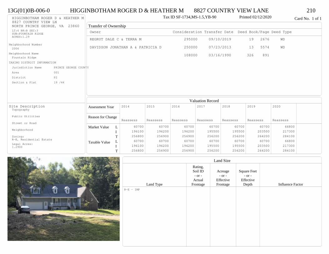
Transfer of Ownership
Valuation RecordAssessment Year
Reason for Change
Market Value
Taxable Value
LITLIT
Land SizeRating,Soil ID Acreage Square Feet- or - - or - - or -
Actual Effective EffectiveLand Type Frontage Frontage Depth Influence Factor
13G(01)0B-006-0 HIGGINBOTHAM ROGER D & HEATHER M 8827 COUNTRY VIEW LANE 210Tax ID SF-1734,MS-1.5,YB-90 Printed 02/12/2020 Card No. 1 of 1HIGGINBOTHAM ROGER D & HEATHER M
8827 COUNTRY VIEW LNNORTH PRINCE GEORGE, VA 23860LT:6 BK:B SEC:3SUB:FOUNTAIN RIDGEACRES:1.29
Neighborhood Number2006
Neighborhood NameFountain Ridge
TAXING DISTRICT INFORMATIONJurisdiction Name PRINCE GEORGE COUNTYArea 001 District P2 Section & Plat 19 /44
Site DescriptionTopography
Public Utilities
Street or Road
Neighborhood
Zoning:R-E, Residential EstateLegal Acres:1.2900
Owner Consideration Transfer Date Deed Book/Page Deed TypeREGRUT DALE C & TERRA M 295000 09/10/2019 19 2676 WD
DAVIDSON JONATHAN A & PATRICIA D 250000 07/23/2013 13 5574 WD
108000 03/16/1990 326 891
2014
Reassess 60700 196100 256800 60700 196100 256800
2015
Reassess 60700 196200 256900 60700 196200 256900
2016
Reassess 60700 196200 256900 60700 196200 256900
2017
Reassess 60700 195500 256200 60700 195500 256200
2018
Reassess 60700 195500 256200 60700 195500 256200
2019
Reassess 60700 203500 264200 60700 203500 264200
2020
Reassess 66800 217300 284100 66800 217300 284100
R-E - IMP
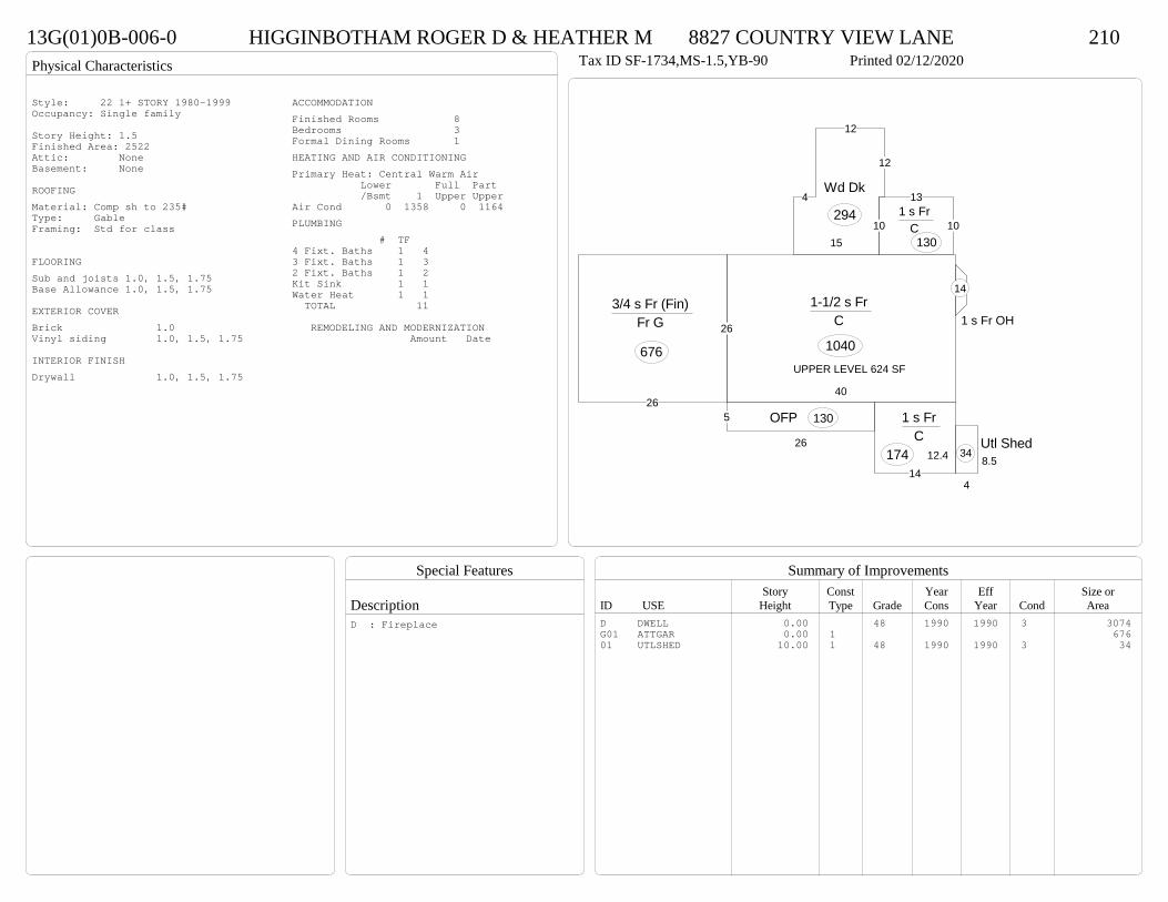
Physical Characteristics
Special Features
Description
Summary of ImprovementsStory Const Year Eff Size or
ID USE Height Type Grade Cons Year Cond Area
13G(01)0B-006-0 HIGGINBOTHAM ROGER D & HEATHER M 8827 COUNTRY VIEW LANE 210Tax ID SF-1734,MS-1.5,YB-90 Printed 02/12/2020
40
26
1-1/2 s Fr C
1040
10
12
12
4
15
Wd Dk
294
12.414
1 s Fr C
174
5
26
OFP 130
10
131 s Fr
C 130
1 s Fr OH
14
26
3/4 s Fr (Fin) Fr G
676
4
8.5Utl Shed
34
UPPER LEVEL 624 SF
Style: 22 1+ STORY 1980-1999Occupancy: Single family
Story Height: 1.5Finished Area: 2522 Attic: NoneBasement: None
ROOFINGMaterial: Comp sh to 235#Type: GableFraming: Std for class
FLOORINGSub and joists 1.0, 1.5, 1.75Base Allowance 1.0, 1.5, 1.75
EXTERIOR COVERBrick 1.0Vinyl siding 1.0, 1.5, 1.75
INTERIOR FINISHDrywall 1.0, 1.5, 1.75
ACCOMMODATIONFinished Rooms 8Bedrooms 3Formal Dining Rooms 1HEATING AND AIR CONDITIONINGPrimary Heat: Central Warm Air Lower Full Part /Bsmt 1 Upper UpperAir Cond 0 1358 0 1164PLUMBING # TF4 Fixt. Baths 1 43 Fixt. Baths 1 32 Fixt. Baths 1 2Kit Sink 1 1Water Heat 1 1 TOTAL 11
REMODELING AND MODERNIZATION Amount Date
D DWELL 0.00 48 1990 1990 3 3074G01 ATTGAR 0.00 1 67601 UTLSHED 10.00 1 48 1990 1990 3 34
D : Fireplace

Transfer of Ownership
Valuation RecordAssessment Year
Reason for Change
Market Value
Taxable Value
LITLIT
Land SizeRating,Soil ID Acreage Square Feet- or - - or - - or -
Actual Effective EffectiveLand Type Frontage Frontage Depth Influence Factor
24F(05)0I-088-0 SULLIVAN FRANK & 7495 TRAILING ROCK ROAD 210Tax ID SF-0,MS-0,YB- Printed 02/12/2020 Card No. 1 of 1SULLIVAN FRANK &
FARSACI NANCYOTA7495 TRAILING ROCK RDPRINCE GEORGE, VA 23875LT:88 BK:I SEC:9SUB:BRANCHESTER LAKES
Neighborhood Number2007
Neighborhood NameBranchester Lakes
TAXING DISTRICT INFORMATIONJurisdiction Name PRINCE GEORGE COUNTYArea 001 District P2 Section & Plat 20 /220
Site DescriptionTopography
Public Utilities
Street or Road
Neighborhood
Zoning:R-1. Limited ResidentialLegal Acres:0.5021
Owner Consideration Transfer Date Deed Book/Page Deed TypeCUSTIS RONNIE H & LORRAINE 280000 06/13/2019 19 1614 WD
2014
Reassess 39000 205900 244900 39000 205900 244900
2015
Reassess 39000 205900 244900 39000 205900 244900
2016
Reassess 39000 205900 244900 39000 205900 244900
2017
Reassess 39000 202800 241800 39000 202800 241800
2018
Reassess 39000 212200 251200 39000 212200 251200
2019
Reassess 39000 230900 269900 39000 230900 269900
2020
Reassess 42900 264500 307400 42900 264500 307400
R-1 - IMP

Physical Characteristics
Special Features
Description
Summary of ImprovementsStory Const Year Eff Size or
ID USE Height Type Grade Cons Year Cond Area
24F(05)0I-088-0 SULLIVAN FRANK & 7495 TRAILING ROCK ROAD 210Tax ID SF-0,MS-0,YB- Printed 02/12/2020
37
24
2 s Fr C
888
22
24
1-1/2 s Fr C
528
9.9
11.8
Wd Dk117
6OFP 222
61 s Fr
C 6016
18OMP-s
288
18
12Conc216
01Style: 32 2/2+Story 1980-1999Occupancy: Single family
Story Height: 2.0Finished Area: 2680 Attic: NoneBasement: None
ROOFINGMaterial: Comp sh to 235#Type: GableFraming: Std for class
FLOORINGSub and joists 1.0, 1.5, 2.0Base Allowance 1.0, 1.5, 2.0
EXTERIOR COVERVinyl siding 1.0, 1.5, 2.0
INTERIOR FINISHDrywall 1.0, 1.5, 2.0
ACCOMMODATIONFinished Rooms 9Bedrooms 4Formal Dining Rooms 1HEATING AND AIR CONDITIONINGPrimary Heat: Heat pump Lower Full Part /Bsmt 1 Upper UpperAir Cond 0 1476 888 316PLUMBING # TF4 Fixt. Baths 1 43 Fixt. Baths 1 32 Fixt. Baths 1 2Kit Sink 1 1Water Heat 1 1 TOTAL 11
REMODELING AND MODERNIZATION Amount Date
D DWELL 0.00 45 1995 2000 3 289201 DETGAR 0.00 1 45 2008 2008 3 624
D : Remod 2019 Fireplace
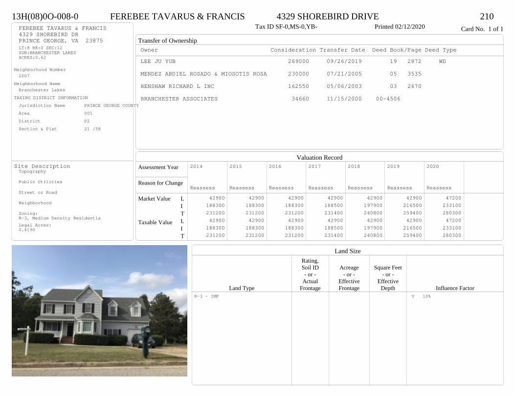
Transfer of Ownership
Valuation RecordAssessment Year
Reason for Change
Market Value
Taxable Value
LITLIT
Land SizeRating,Soil ID Acreage Square Feet- or - - or - - or -
Actual Effective EffectiveLand Type Frontage Frontage Depth Influence Factor
13H(08)0O-008-0 FEREBEE TAVARUS & FRANCIS 4329 SHOREBIRD DRIVE 210Tax ID SF-0,MS-0,YB- Printed 02/12/2020 Card No. 1 of 1FEREBEE TAVARUS & FRANCIS
4329 SHOREBIRD DRPRINCE GEORGE, VA 23875LT:8 BK:O SEC:12SUB:BRANCHESTER LAKESACRES:0.62
Neighborhood Number2007
Neighborhood NameBranchester Lakes
TAXING DISTRICT INFORMATIONJurisdiction Name PRINCE GEORGE COUNTYArea 001 District P2 Section & Plat 21 /58
Site DescriptionTopography
Public Utilities
Street or Road
Neighborhood
Zoning:R-3, Medium Density ResidentiaLegal Acres:0.6190
Owner Consideration Transfer Date Deed Book/Page Deed TypeLEE JU YUB 269000 09/26/2019 19 2872 WD
MENDEZ ABDIEL ROSADO & MIOSOTIS ROSA 230000 07/21/2005 05 3535
HENSHAW RICHARD L INC 162550 05/06/2003 03 2670
BRANCHESTER ASSOCIATES 34660 11/15/2000 00-4506
2014
Reassess 42900 188300 231200 42900 188300 231200
2015
Reassess 42900 188300 231200 42900 188300 231200
2016
Reassess 42900 188300 231200 42900 188300 231200
2017
Reassess 42900 188500 231400 42900 188500 231400
2018
Reassess 42900 197900 240800 42900 197900 240800
2019
Reassess 42900 216500 259400 42900 216500 259400
2020
Reassess 47200 233100 280300 47200 233100 280300
R-3 - IMP V 10%

Physical Characteristics
Special Features
Description
Summary of ImprovementsStory Const Year Eff Size or
ID USE Height Type Grade Cons Year Cond Area
13H(08)0O-008-0 FEREBEE TAVARUS & FRANCIS 4329 SHOREBIRD DRIVE 210Tax ID SF-0,MS-0,YB- Printed 02/12/2020
30
18
12
35
30
2 s Fr C
960
1 s Fr OH 14
12
1-1/2 s Fr Slab
288
10
12
Wd Dk
120
5 OFP 90
12
24
1/2 s Fr (Fin) Fr G
288
UPPER AREA 336 SF
Style: 33 2/2+Story 2000+Occupancy: Single family
Story Height: 2.0Finished Area: 2558 Attic: NoneBasement: None
ROOFINGMaterial: Comp sh to 235#Type: GableFraming: Std for class
FLOORINGSub and joists 1.0, 1.5, 2.0Base Allowance 1.0, 1.5, 2.0
EXTERIOR COVERVinyl siding 1.0, 1.5, 2.0
INTERIOR FINISHDrywall 1.0, 1.5, 2.0
ACCOMMODATIONFinished Rooms 8Bedrooms 4Formal Dining Rooms 1HEATING AND AIR CONDITIONINGPrimary Heat: Heat pump Lower Full Part /Bsmt 1 Upper UpperAir Cond 0 1262 960 336PLUMBING # TF3 Fixt. Baths 3 9Kit Sink 1 1Water Heat 1 1 TOTAL 11
REMODELING AND MODERNIZATION Amount Date
D DWELL 0.00 45 2003 2003 3 2798G01 ATTGAR 0.00 1 288
D : Fireplace

Transfer of Ownership
Valuation RecordAssessment Year
Reason for Change
Market Value
Taxable Value
LITLIT
Land SizeRating,Soil ID Acreage Square Feet- or - - or - - or -
Actual Effective EffectiveLand Type Frontage Frontage Depth Influence Factor
13H(04)0I-011-0 RUFFIN JASON M & AMELIA M 4481 BRANCHESTER PARKWAY 210Tax ID SF-2160,MS-2,YB-93 Printed 02/12/2020 Card No. 1 of 1RUFFIN JASON M & AMELIA M
4481 BRANCHESTER PKWYPRINCE GEORGE, VA 23875LT:11 BK:I SEC:5SUB:BRANCHESTER LAKESACRES:.368
Neighborhood Number2007
Neighborhood NameBranchester Lakes
TAXING DISTRICT INFORMATIONJurisdiction Name PRINCE GEORGE COUNTYArea 001 District P2 Section & Plat 20 /77
Site DescriptionTopography
Public Utilities
Street or Road
Neighborhood
Zoning:R-1. Limited ResidentialLegal Acres:0.3680
Owner Consideration Transfer Date Deed Book/Page Deed TypeSTAPLES LIVING TRUST 276500 04/23/2019 19 1083 WD
STAPLES DAVID P & CATHLEEN L 0 08/19/2013 13 5949 WD
127800 04/30/1996 414 543
2014
Reassess 39000 181800 220800 39000 181800 220800
2015
Reassess 39000 181800 220800 39000 181800 220800
2016
Reassess 39000 181800 220800 39000 181800 220800
2017
Reassess 39000 181300 220300 39000 181300 220300
2018
Reassess 39000 190000 229000 39000 190000 229000
2019
Reassess 39000 206800 245800 39000 206800 245800
2020
Reassess 42900 223300 266200 42900 223300 266200
R-1 - IMP
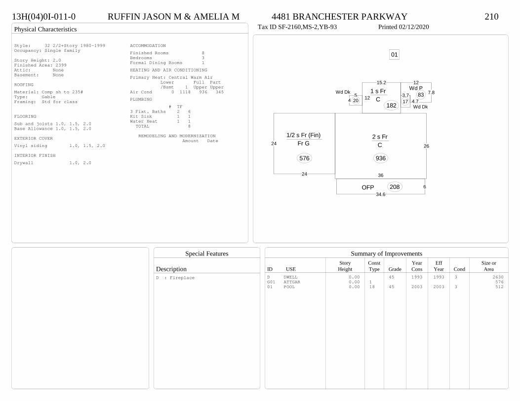
Physical Characteristics
Special Features
Description
Summary of ImprovementsStory Const Year Eff Size or
ID USE Height Type Grade Cons Year Cond Area
13H(04)0I-011-0 RUFFIN JASON M & AMELIA M 4481 BRANCHESTER PARKWAY 210Tax ID SF-2160,MS-2,YB-93 Printed 02/12/2020
36
26
2 s Fr C
936
634.6
OFP 208
12
7.8Wd P
83
15.2
121 s Fr
C 182
3.74.7Wd Dk
175
4
Wd Dk
20
24
241/2 s Fr (Fin)
Fr G
576
01Style: 32 2/2+Story 1980-1999Occupancy: Single family
Story Height: 2.0Finished Area: 2399 Attic: NoneBasement: None
ROOFINGMaterial: Comp sh to 235#Type: GableFraming: Std for class
FLOORINGSub and joists 1.0, 1.5, 2.0Base Allowance 1.0, 1.5, 2.0
EXTERIOR COVERVinyl siding 1.0, 1.5, 2.0
INTERIOR FINISHDrywall 1.0, 2.0
ACCOMMODATIONFinished Rooms 8Bedrooms 3Formal Dining Rooms 1HEATING AND AIR CONDITIONINGPrimary Heat: Central Warm Air Lower Full Part /Bsmt 1 Upper UpperAir Cond 0 1118 936 345PLUMBING # TF3 Fixt. Baths 2 6Kit Sink 1 1Water Heat 1 1 TOTAL 8
REMODELING AND MODERNIZATION Amount Date
D DWELL 0.00 45 1993 1993 3 2630G01 ATTGAR 0.00 1 57601 POOL 0.00 18 45 2003 2003 3 512
D : Fireplace
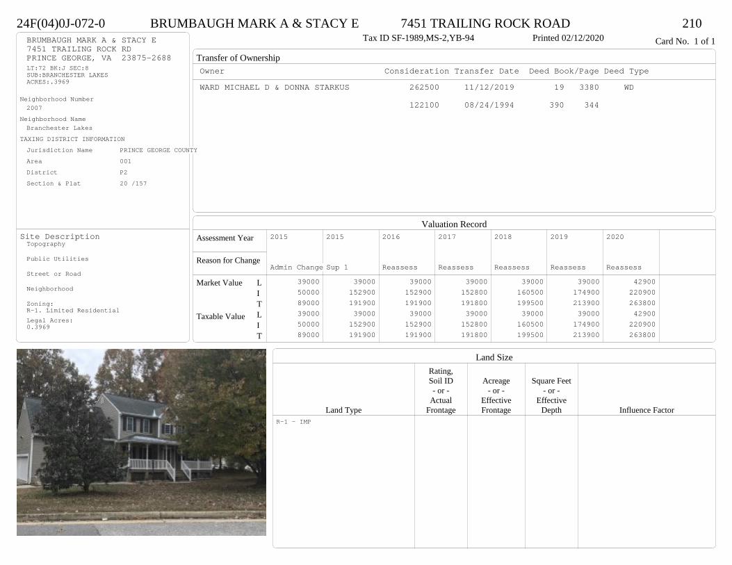
Transfer of Ownership
Valuation RecordAssessment Year
Reason for Change
Market Value
Taxable Value
LITLIT
Land SizeRating,Soil ID Acreage Square Feet- or - - or - - or -
Actual Effective EffectiveLand Type Frontage Frontage Depth Influence Factor
24F(04)0J-072-0 BRUMBAUGH MARK A & STACY E 7451 TRAILING ROCK ROAD 210Tax ID SF-1989,MS-2,YB-94 Printed 02/12/2020 Card No. 1 of 1BRUMBAUGH MARK A & STACY E
7451 TRAILING ROCK RDPRINCE GEORGE, VA 23875-2688LT:72 BK:J SEC:8SUB:BRANCHESTER LAKESACRES:.3969
Neighborhood Number2007
Neighborhood NameBranchester Lakes
TAXING DISTRICT INFORMATIONJurisdiction Name PRINCE GEORGE COUNTYArea 001 District P2 Section & Plat 20 /157
Site DescriptionTopography
Public Utilities
Street or Road
Neighborhood
Zoning:R-1. Limited ResidentialLegal Acres:0.3969
Owner Consideration Transfer Date Deed Book/Page Deed TypeWARD MICHAEL D & DONNA STARKUS 262500 11/12/2019 19 3380 WD
122100 08/24/1994 390 344
2015
Admin Change 39000 50000 89000 39000 50000 89000
2015
Sup 1 39000 152900 191900 39000 152900 191900
2016
Reassess 39000 152900 191900 39000 152900 191900
2017
Reassess 39000 152800 191800 39000 152800 191800
2018
Reassess 39000 160500 199500 39000 160500 199500
2019
Reassess 39000 174900 213900 39000 174900 213900
2020
Reassess 42900 220900 263800 42900 220900 263800
R-1 - IMP
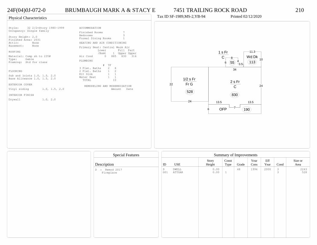
Physical Characteristics
Special Features
Description
Summary of ImprovementsStory Const Year Eff Size or
ID USE Height Type Grade Cons Year Cond Area
24F(04)0J-072-0 BRUMBAUGH MARK A & STACY E 7451 TRAILING ROCK ROAD 210Tax ID SF-1989,MS-2,YB-94 Printed 02/12/2020
13.5
7
13.5
34
242 s Fr
C
830
6 OFP 190
3.54
86
1 s Fr C
5510
11.3
Wd Dk113
24
221/2 s Fr
Fr G
528
Style: 32 2/2+Story 1980-1999Occupancy: Single family
Story Height: 2.0Finished Area: 2031 Attic: NoneBasement: None
ROOFINGMaterial: Comp sh to 235#Type: GableFraming: Std for class
FLOORINGSub and joists 1.0, 1.5, 2.0Base Allowance 1.0, 1.5, 2.0
EXTERIOR COVERVinyl siding 1.0, 1.5, 2.0
INTERIOR FINISHDrywall 1.0, 2.0
ACCOMMODATIONFinished Rooms 7Bedrooms 3Formal Dining Rooms 1HEATING AND AIR CONDITIONINGPrimary Heat: Central Warm Air Lower Full Part /Bsmt 1 Upper UpperAir Cond 0 885 830 316PLUMBING # TF3 Fixt. Baths 2 62 Fixt. Baths 1 2Kit Sink 1 1Water Heat 1 1 TOTAL 10
REMODELING AND MODERNIZATION Amount Date
D DWELL 0.00 48 1994 2000 3 2243G01 ATTGAR 0.00 1 3 528
D : Remod 2017 Fireplace

Transfer of Ownership
Valuation RecordAssessment Year
Reason for Change
Market Value
Taxable Value
LITLIT
Land SizeRating,Soil ID Acreage Square Feet- or - - or - - or -
Actual Effective EffectiveLand Type Frontage Frontage Depth Influence Factor
13H(10)0O-057-0 DOUGHERTY CHRISTOPHER 6474 HEATHER WAY 210Tax ID SF-0,MS-0,YB- Printed 02/12/2020 Card No. 1 of 1DOUGHERTY CHRISTOPHER
6474 HEATHER WAYPRINCE GEORGE, VA 23875LT:57 BK:O SEC:13SUB:BRANCHESTER LAKESACRES:0.3
Neighborhood Number2007
Neighborhood NameBranchester Lakes
TAXING DISTRICT INFORMATIONJurisdiction Name PRINCE GEORGE COUNTYArea 001 District P2 Section & Plat 21 /249
Site DescriptionTopography
Public Utilities
Street or Road
Neighborhood
Zoning:R-3, Medium Density ResidentiaLegal Acres:0.3100
Owner Consideration Transfer Date Deed Book/Page Deed TypeROMAN CARLOS & YOLANDA 250000 06/17/2019 19 1657 WD
STIRLING CONSTRUCTION INC 138000 06/15/2000 00-2421
BRANCHESTER ASSOCIATES 25000 06/21/1999 476 685
2014
Reassess 39000 176400 215400 39000 176400 215400
2015
Reassess 39000 176400 215400 39000 176400 215400
2016
Reassess 39000 176400 215400 39000 176400 215400
2017
Reassess 39000 174800 213800 39000 174800 213800
2018
Reassess 39000 183500 222500 39000 183500 222500
2019
Reassess 39000 201300 240300 39000 201300 240300
2020
Reassess 42900 219900 262800 42900 219900 262800
R-3 - IMP

Physical Characteristics
Special Features
Description
Summary of ImprovementsStory Const Year Eff Size or
ID USE Height Type Grade Cons Year Cond Area
13H(10)0O-057-0 DOUGHERTY CHRISTOPHER 6474 HEATHER WAY 210Tax ID SF-0,MS-0,YB- Printed 02/12/2020
13.33
13.3
24
34
2 s Fr C
794
7.4
5
1 s Fr Cathedral C
376
32
OFP 177
4
9.31 s Fr
C 37
1 s Fr OH (Upper)27
12.1
12.3
Wd Dk
1491 s Fr OH (Upper)23
22
22
1-1/2 s Fr Slab
484
Style: 33 2/2+Story 2000+Occupancy: Single family
Story Height: 2.0Finished Area: 2486 Attic: NoneBasement: None
ROOFINGMaterial: Comp sh to 235#Type: GableFraming: Std for class
FLOORINGSub and joists 1.0, 1.5, 2.0Base Allowance 1.5, 2.0
EXTERIOR COVERVinyl siding 1.0, 1.5, 2.0
INTERIOR FINISHDrywall 2.0
ACCOMMODATIONFinished Rooms 8Bedrooms 4Formal Dining Rooms 1HEATING AND AIR CONDITIONINGPrimary Heat: Central Warm Air Lower Full Part /Bsmt 1 Upper UpperAir Cond 0 1352 844 290PLUMBING # TF3 Fixt. Baths 2 62 Fixt. Baths 1 2Kit Sink 1 1Water Heat 1 1 TOTAL 10
REMODELING AND MODERNIZATION Amount Date
D DWELL 0.00 45 2000 2000 3 2680D : Fireplace

Transfer of Ownership
Valuation RecordAssessment Year
Reason for Change
Market Value
Taxable Value
LITLIT
Land SizeRating,Soil ID Acreage Square Feet- or - - or - - or -
Actual Effective EffectiveLand Type Frontage Frontage Depth Influence Factor
24F(01)0A-015-0 MCCOMAS KWAN J & SHIRLEY A 5009 ROXSHIRE COURT 210Tax ID SF-1981,MS-2,YB-93 Printed 02/12/2020 Card No. 1 of 1MCCOMAS KWAN J & SHIRLEY A
5009 FOXSHIRE CTPRINCE GEORGE, VA 23875LT:15 BK:A SEC:1SUB:BRANCHESTER LAKESACRES:.4843
Neighborhood Number2007
Neighborhood NameBranchester Lakes
TAXING DISTRICT INFORMATIONJurisdiction Name PRINCE GEORGE COUNTYArea 001 District P2 Section & Plat 20 /103
Site DescriptionTopography
Public Utilities
Street or Road
Neighborhood
Zoning:R-2, General ResidentialLegal Acres:0.4843
Owner Consideration Transfer Date Deed Book/Page Deed TypeFELTON ERVIN B 230000 01/08/2019 19 76 WD
FELTON ERVIN B 0 02/12/2007 07 740
FELTON ERVIN B & YOLANDRA Y 0 07/19/2005 05 3481 G
CURTIN JAMES D & LIEU T 139950 03/16/2000 00-1004
ROACH, JAMES J SR & CYNTHIA L 125000 02/01/1996 411 382
2014
Reassess 39000 168000 207000 39000 168000 207000
2015
Reassess 39000 168000 207000 39000 168000 207000
2016
Reassess 39000 168000 207000 39000 168000 207000
2017
Reassess 39000 167700 206700 39000 167700 206700
2018
Reassess 39000 176000 215000 39000 176000 215000
2019
Reassess 39000 191800 230800 39000 191800 230800
2020
Reassess 42900 219100 262000 42900 219100 262000
R-2 - IMP
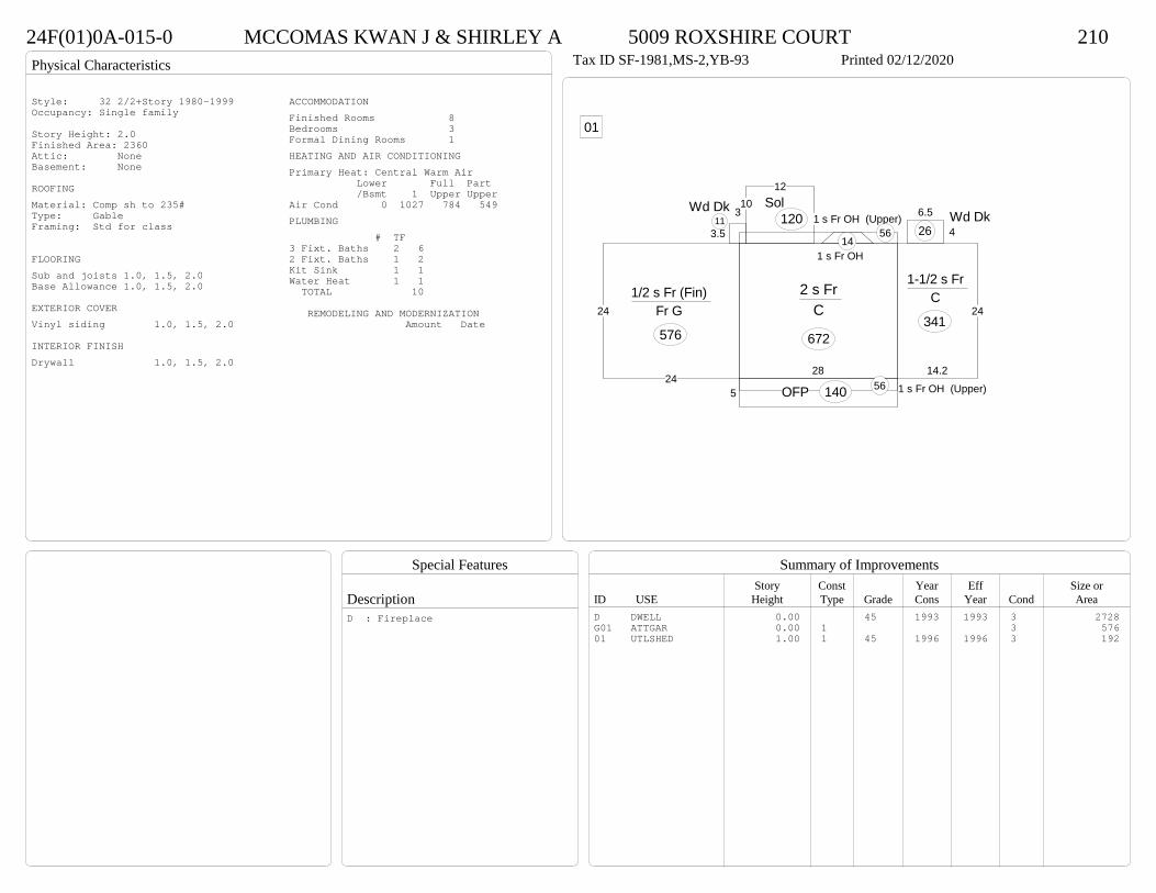
Physical Characteristics
Special Features
Description
Summary of ImprovementsStory Const Year Eff Size or
ID USE Height Type Grade Cons Year Cond Area
24F(01)0A-015-0 MCCOMAS KWAN J & SHIRLEY A 5009 ROXSHIRE COURT 210Tax ID SF-1981,MS-2,YB-93 Printed 02/12/2020
28
2 s Fr C
672
1 s Fr OH (Upper)565 OFP 140
14.2
24
1-1/2 s Fr C
341
1 s Fr OH (Upper)56
1012
Sol120
1 s Fr OH 14
4
6.5 Wd Dk263.5
3Wd Dk11
24
241/2 s Fr (Fin)
Fr G
576
01
Style: 32 2/2+Story 1980-1999Occupancy: Single family
Story Height: 2.0Finished Area: 2360 Attic: NoneBasement: None
ROOFINGMaterial: Comp sh to 235#Type: GableFraming: Std for class
FLOORINGSub and joists 1.0, 1.5, 2.0Base Allowance 1.0, 1.5, 2.0
EXTERIOR COVERVinyl siding 1.0, 1.5, 2.0
INTERIOR FINISHDrywall 1.0, 1.5, 2.0
ACCOMMODATIONFinished Rooms 8Bedrooms 3Formal Dining Rooms 1HEATING AND AIR CONDITIONINGPrimary Heat: Central Warm Air Lower Full Part /Bsmt 1 Upper UpperAir Cond 0 1027 784 549PLUMBING # TF3 Fixt. Baths 2 62 Fixt. Baths 1 2Kit Sink 1 1Water Heat 1 1 TOTAL 10
REMODELING AND MODERNIZATION Amount Date
D DWELL 0.00 45 1993 1993 3 2728G01 ATTGAR 0.00 1 3 57601 UTLSHED 1.00 1 45 1996 1996 3 192
D : Fireplace

Transfer of Ownership
Valuation RecordAssessment Year
Reason for Change
Market Value
Taxable Value
LITLIT
Land SizeRating,Soil ID Acreage Square Feet- or - - or - - or -
Actual Effective EffectiveLand Type Frontage Frontage Depth Influence Factor
24F(06)0J-137-0 HOLOYE PAUL R & SAMIRA L 5300 TAKACH ROAD 210Printed 02/12/2020 Card No. 1 of 1HOLOYE PAUL R & SAMIRA L
5300 TAKACH RDPRINCE GEORGE, VA 23875LT:137 BK:J SEC:14SUB:BRANCHESTER LAKESACRES:0.52
Neighborhood Number2007
Neighborhood NameBranchester Lakes
TAXING DISTRICT INFORMATIONJurisdiction Name PRINCE GEORGE COUNTYArea 001 District P2 Section & Plat 22/51
Site DescriptionTopography
Public Utilities
Street or Road
Neighborhood
Zoning:R-1. Limited ResidentialLegal Acres:0.5183
Owner Consideration Transfer Date Deed Book/Page Deed TypeSMITH ANDREA S 264900 11/04/2019 19 3263 WD
2014
Reassess 39000 177200 216200 39000 177200 216200
2015
Reassess 39000 177200 216200 39000 177200 216200
2016
Reassess 39000 177200 216200 39000 177200 216200
2017
Reassess 39000 176900 215900 39000 176900 215900
2018
Reassess 39000 185500 224500 39000 185500 224500
2019
Reassess 39000 201900 240900 39000 201900 240900
2020
Reassess 42900 218900 261800 42900 218900 261800
R-1 - IMP
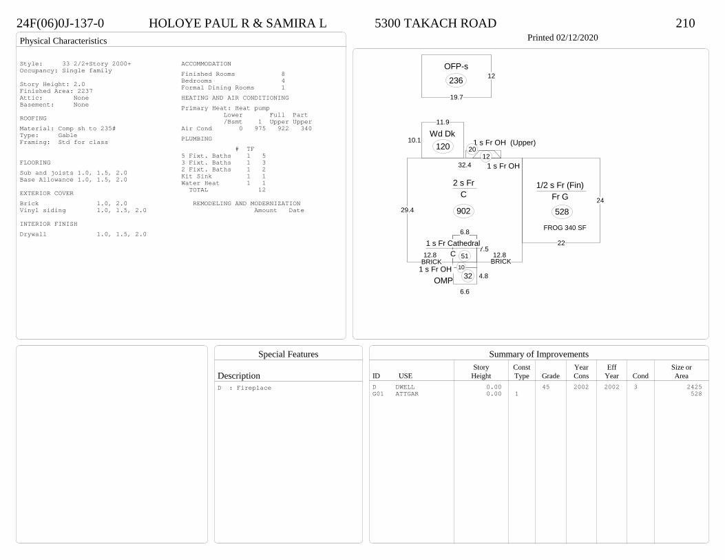
Physical Characteristics
Special Features
Description
Summary of ImprovementsStory Const Year Eff Size or
ID USE Height Type Grade Cons Year Cond Area
24F(06)0J-137-0 HOLOYE PAUL R & SAMIRA L 5300 TAKACH ROAD 210Printed 02/12/2020
19.7
12OFP-s
236
12.87.5
12.8
29.4
32.4
2 s Fr C
902
6.8
1 s Fr Cathedral C 51
1 s Fr OH 104.8
6.6OMP 32
1 s Fr OH 12
1 s Fr OH (Upper)20
11.9
10.1Wd Dk
120
22
24
1/2 s Fr (Fin) Fr G
528
FROG 340 SF
BRICKBRICK
Style: 33 2/2+Story 2000+Occupancy: Single family
Story Height: 2.0Finished Area: 2237 Attic: NoneBasement: None
ROOFINGMaterial: Comp sh to 235#Type: GableFraming: Std for class
FLOORINGSub and joists 1.0, 1.5, 2.0Base Allowance 1.0, 1.5, 2.0
EXTERIOR COVERBrick 1.0, 2.0Vinyl siding 1.0, 1.5, 2.0
INTERIOR FINISHDrywall 1.0, 1.5, 2.0
ACCOMMODATIONFinished Rooms 8Bedrooms 4Formal Dining Rooms 1HEATING AND AIR CONDITIONINGPrimary Heat: Heat pump Lower Full Part /Bsmt 1 Upper UpperAir Cond 0 975 922 340PLUMBING # TF5 Fixt. Baths 1 53 Fixt. Baths 1 32 Fixt. Baths 1 2Kit Sink 1 1Water Heat 1 1 TOTAL 12
REMODELING AND MODERNIZATION Amount Date
D DWELL 0.00 45 2002 2002 3 2425G01 ATTGAR 0.00 1 528
D : Fireplace
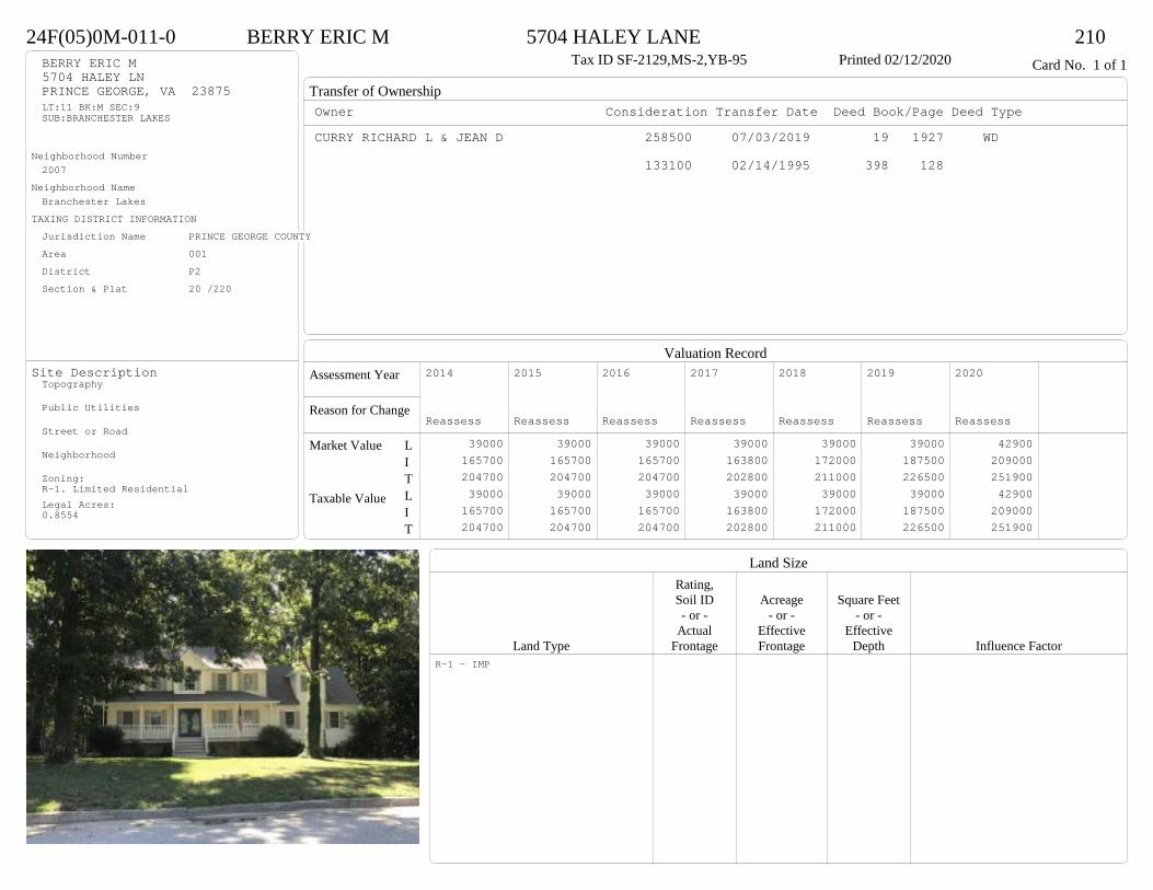
Transfer of Ownership
Valuation RecordAssessment Year
Reason for Change
Market Value
Taxable Value
LITLIT
Land SizeRating,Soil ID Acreage Square Feet- or - - or - - or -
Actual Effective EffectiveLand Type Frontage Frontage Depth Influence Factor
24F(05)0M-011-0 BERRY ERIC M 5704 HALEY LANE 210Tax ID SF-2129,MS-2,YB-95 Printed 02/12/2020 Card No. 1 of 1BERRY ERIC M
5704 HALEY LNPRINCE GEORGE, VA 23875LT:11 BK:M SEC:9SUB:BRANCHESTER LAKES
Neighborhood Number2007
Neighborhood NameBranchester Lakes
TAXING DISTRICT INFORMATIONJurisdiction Name PRINCE GEORGE COUNTYArea 001 District P2 Section & Plat 20 /220
Site DescriptionTopography
Public Utilities
Street or Road
Neighborhood
Zoning:R-1. Limited ResidentialLegal Acres:0.8554
Owner Consideration Transfer Date Deed Book/Page Deed TypeCURRY RICHARD L & JEAN D 258500 07/03/2019 19 1927 WD
133100 02/14/1995 398 128
2014
Reassess 39000 165700 204700 39000 165700 204700
2015
Reassess 39000 165700 204700 39000 165700 204700
2016
Reassess 39000 165700 204700 39000 165700 204700
2017
Reassess 39000 163800 202800 39000 163800 202800
2018
Reassess 39000 172000 211000 39000 172000 211000
2019
Reassess 39000 187500 226500 39000 187500 226500
2020
Reassess 42900 209000 251900 42900 209000 251900
R-1 - IMP

Physical Characteristics
Special Features
Description
Summary of ImprovementsStory Const Year Eff Size or
ID USE Height Type Grade Cons Year Cond Area
24F(05)0M-011-0 BERRY ERIC M 5704 HALEY LANE 210Tax ID SF-2129,MS-2,YB-95 Printed 02/12/2020
157
15
24
2 s Fr C
902
10
1 s Fr C
60
30
14.5
18.5
11.5
11.5
12
Wd Dk
507
6
37
OFP 208
22
24
1/2 s Fr (Fin) Fr G
528
A/G POOL
Style: 32 2/2+Story 1980-1999Occupancy: Single family
Story Height: 2.0Finished Area: 2180 Attic: NoneBasement: None
ROOFINGMaterial: Comp sh to 235#Type: GableFraming: Std for class
FLOORINGSub and joists 1.0, 1.5, 2.0Base Allowance 1.0, 1.5, 2.0
EXTERIOR COVERVinyl siding 1.0, 1.5, 2.0
INTERIOR FINISHDrywall 1.0, 1.5, 2.0
ACCOMMODATIONFinished Rooms 9Bedrooms 4Formal Dining Rooms 1HEATING AND AIR CONDITIONINGPrimary Heat: Central Warm Air Lower Full Part /Bsmt 1 Upper UpperAir Cond 0 962 902 316PLUMBING # TF4 Fixt. Baths 1 43 Fixt. Baths 1 32 Fixt. Baths 1 2Kit Sink 1 1Water Heat 1 1 TOTAL 11
REMODELING AND MODERNIZATION Amount Date
D DWELL 0.00 45 1995 1995 3 2392G01 ATTGAR 0.00 1 528
D : Fireplace
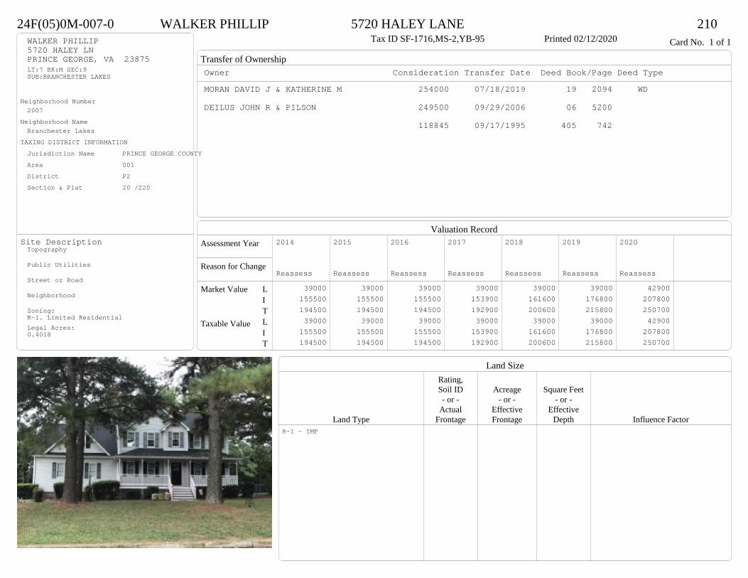
Transfer of Ownership
Valuation RecordAssessment Year
Reason for Change
Market Value
Taxable Value
LITLIT
Land SizeRating,Soil ID Acreage Square Feet- or - - or - - or -
Actual Effective EffectiveLand Type Frontage Frontage Depth Influence Factor
24F(05)0M-007-0 WALKER PHILLIP 5720 HALEY LANE 210Tax ID SF-1716,MS-2,YB-95 Printed 02/12/2020 Card No. 1 of 1WALKER PHILLIP
5720 HALEY LNPRINCE GEORGE, VA 23875LT:7 BK:M SEC:9SUB:BRANCHESTER LAKES
Neighborhood Number2007
Neighborhood NameBranchester Lakes
TAXING DISTRICT INFORMATIONJurisdiction Name PRINCE GEORGE COUNTYArea 001 District P2 Section & Plat 20 /220
Site DescriptionTopography
Public Utilities
Street or Road
Neighborhood
Zoning:R-1. Limited ResidentialLegal Acres:0.4018
Owner Consideration Transfer Date Deed Book/Page Deed TypeMORAN DAVID J & KATHERINE M 254000 07/18/2019 19 2094 WD
DEILUS JOHN R & PILSON 249500 09/29/2006 06 5200
118845 09/17/1995 405 742
2014
Reassess 39000 155500 194500 39000 155500 194500
2015
Reassess 39000 155500 194500 39000 155500 194500
2016
Reassess 39000 155500 194500 39000 155500 194500
2017
Reassess 39000 153900 192900 39000 153900 192900
2018
Reassess 39000 161600 200600 39000 161600 200600
2019
Reassess 39000 176800 215800 39000 176800 215800
2020
Reassess 42900 207800 250700 42900 207800 250700
R-1 - IMP

Physical Characteristics
Special Features
Description
Summary of ImprovementsStory Const Year Eff Size or
ID USE Height Type Grade Cons Year Cond Area
24F(05)0M-007-0 WALKER PHILLIP 5720 HALEY LANE 210Tax ID SF-1716,MS-2,YB-95 Printed 02/12/2020
13.57
13.5
34
24
2 s Fr C
830
6
34
OFP 190
922.76
23
1 s Fr C 210
10.1
22.5
Wd Dk 227
24
22
1/2 s Fr Fr G
528
Style: 32 2/2+Story 1980-1999Occupancy: Single family
Story Height: 2.0Finished Area: 2186 Attic: NoneBasement: None
ROOFINGMaterial: Comp sh to 235#Type: GableFraming: Std for class
FLOORINGSub and joists 1.0, 1.5, 2.0Base Allowance 1.0, 1.5, 2.0
EXTERIOR COVERVinyl siding 1.0, 2.0Wood siding 1.5
INTERIOR FINISHDrywall 1.0, 2.0
ACCOMMODATIONFinished Rooms 9Bedrooms 4Formal Dining Rooms 1HEATING AND AIR CONDITIONINGPrimary Heat: Central Warm Air Lower Full Part /Bsmt 1 Upper UpperAir Cond 0 1040 830 316PLUMBING # TF3 Fixt. Baths 2 62 Fixt. Baths 1 2Kit Sink 1 1Water Heat 1 1 TOTAL 10
REMODELING AND MODERNIZATION Amount Date
D DWELL 0.00 45 1995 1995 3 2398G01 ATTGAR 0.00 1 3 528
D : Fireplace
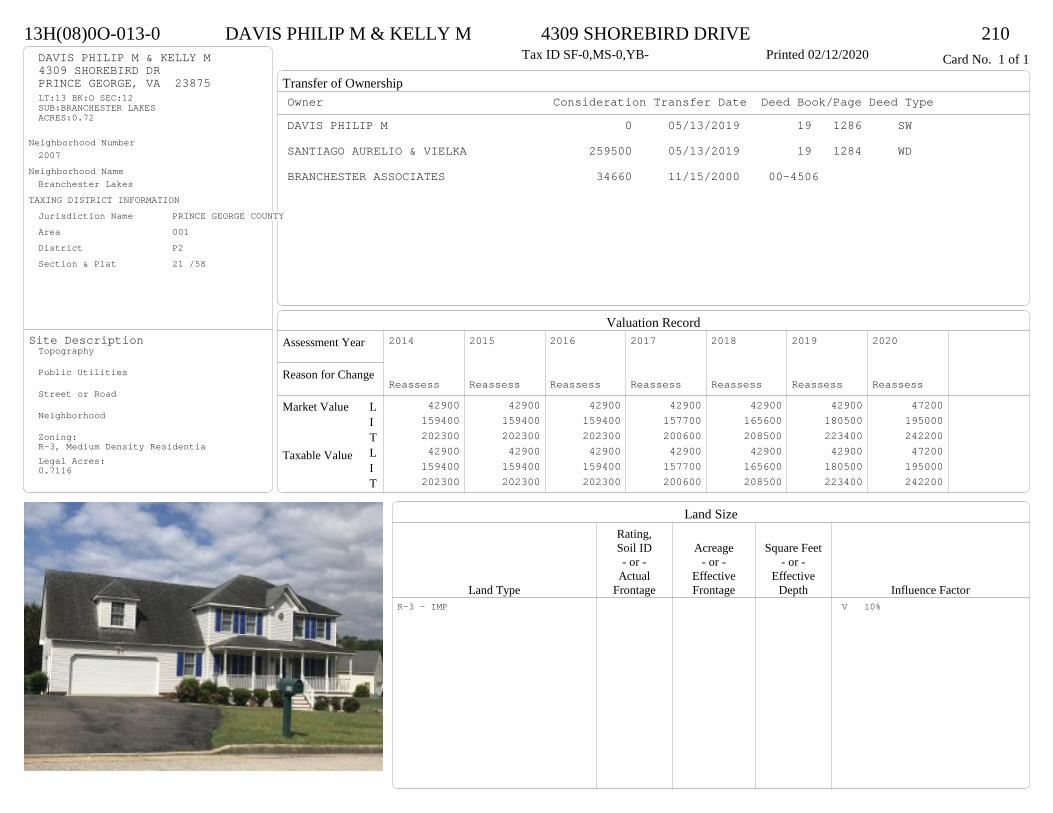
Transfer of Ownership
Valuation RecordAssessment Year
Reason for Change
Market Value
Taxable Value
LITLIT
Land SizeRating,Soil ID Acreage Square Feet- or - - or - - or -
Actual Effective EffectiveLand Type Frontage Frontage Depth Influence Factor
13H(08)0O-013-0 DAVIS PHILIP M & KELLY M 4309 SHOREBIRD DRIVE 210Tax ID SF-0,MS-0,YB- Printed 02/12/2020 Card No. 1 of 1DAVIS PHILIP M & KELLY M
4309 SHOREBIRD DRPRINCE GEORGE, VA 23875LT:13 BK:O SEC:12SUB:BRANCHESTER LAKESACRES:0.72
Neighborhood Number2007
Neighborhood NameBranchester Lakes
TAXING DISTRICT INFORMATIONJurisdiction Name PRINCE GEORGE COUNTYArea 001 District P2 Section & Plat 21 /58
Site DescriptionTopography
Public Utilities
Street or Road
Neighborhood
Zoning:R-3, Medium Density ResidentiaLegal Acres:0.7116
Owner Consideration Transfer Date Deed Book/Page Deed TypeDAVIS PHILIP M 0 05/13/2019 19 1286 SW
SANTIAGO AURELIO & VIELKA 259500 05/13/2019 19 1284 WD
BRANCHESTER ASSOCIATES 34660 11/15/2000 00-4506
2014
Reassess 42900 159400 202300 42900 159400 202300
2015
Reassess 42900 159400 202300 42900 159400 202300
2016
Reassess 42900 159400 202300 42900 159400 202300
2017
Reassess 42900 157700 200600 42900 157700 200600
2018
Reassess 42900 165600 208500 42900 165600 208500
2019
Reassess 42900 180500 223400 42900 180500 223400
2020
Reassess 47200 195000 242200 47200 195000 242200
R-3 - IMP V 10%
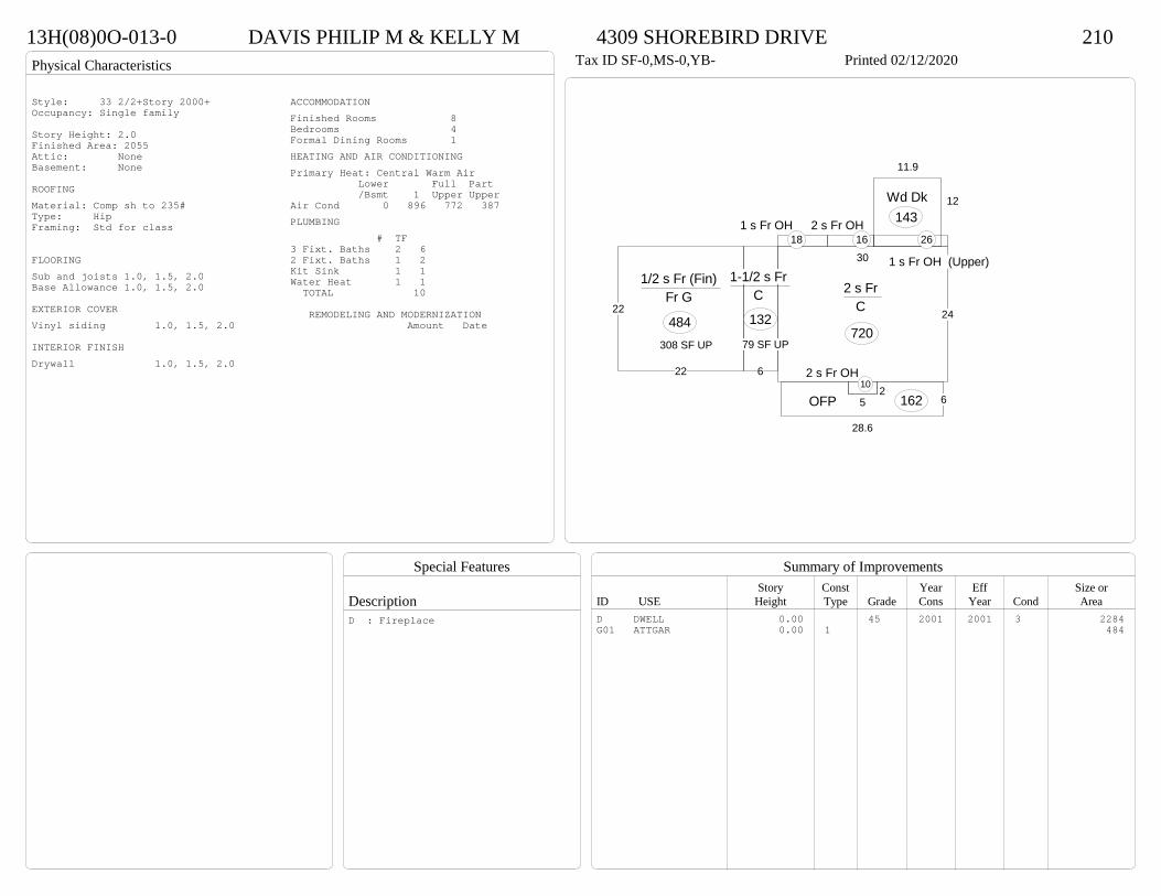
Physical Characteristics
Special Features
Description
Summary of ImprovementsStory Const Year Eff Size or
ID USE Height Type Grade Cons Year Cond Area
13H(08)0O-013-0 DAVIS PHILIP M & KELLY M 4309 SHOREBIRD DRIVE 210Tax ID SF-0,MS-0,YB- Printed 02/12/2020
24
30
2 s Fr C
720
6
1-1/2 s Fr C
132
25
2 s Fr OH 10
6
28.6
OFP 162
12
11.9
Wd Dk143
1 s Fr OH (Upper)
262 s Fr OH
161 s Fr OH
18
22
22
1/2 s Fr (Fin) Fr G
48479 SF UP308 SF UP
Style: 33 2/2+Story 2000+Occupancy: Single family
Story Height: 2.0Finished Area: 2055 Attic: NoneBasement: None
ROOFINGMaterial: Comp sh to 235#Type: HipFraming: Std for class
FLOORINGSub and joists 1.0, 1.5, 2.0Base Allowance 1.0, 1.5, 2.0
EXTERIOR COVERVinyl siding 1.0, 1.5, 2.0
INTERIOR FINISHDrywall 1.0, 1.5, 2.0
ACCOMMODATIONFinished Rooms 8Bedrooms 4Formal Dining Rooms 1HEATING AND AIR CONDITIONINGPrimary Heat: Central Warm Air Lower Full Part /Bsmt 1 Upper UpperAir Cond 0 896 772 387PLUMBING # TF3 Fixt. Baths 2 62 Fixt. Baths 1 2Kit Sink 1 1Water Heat 1 1 TOTAL 10
REMODELING AND MODERNIZATION Amount Date
D DWELL 0.00 45 2001 2001 3 2284G01 ATTGAR 0.00 1 484
D : Fireplace
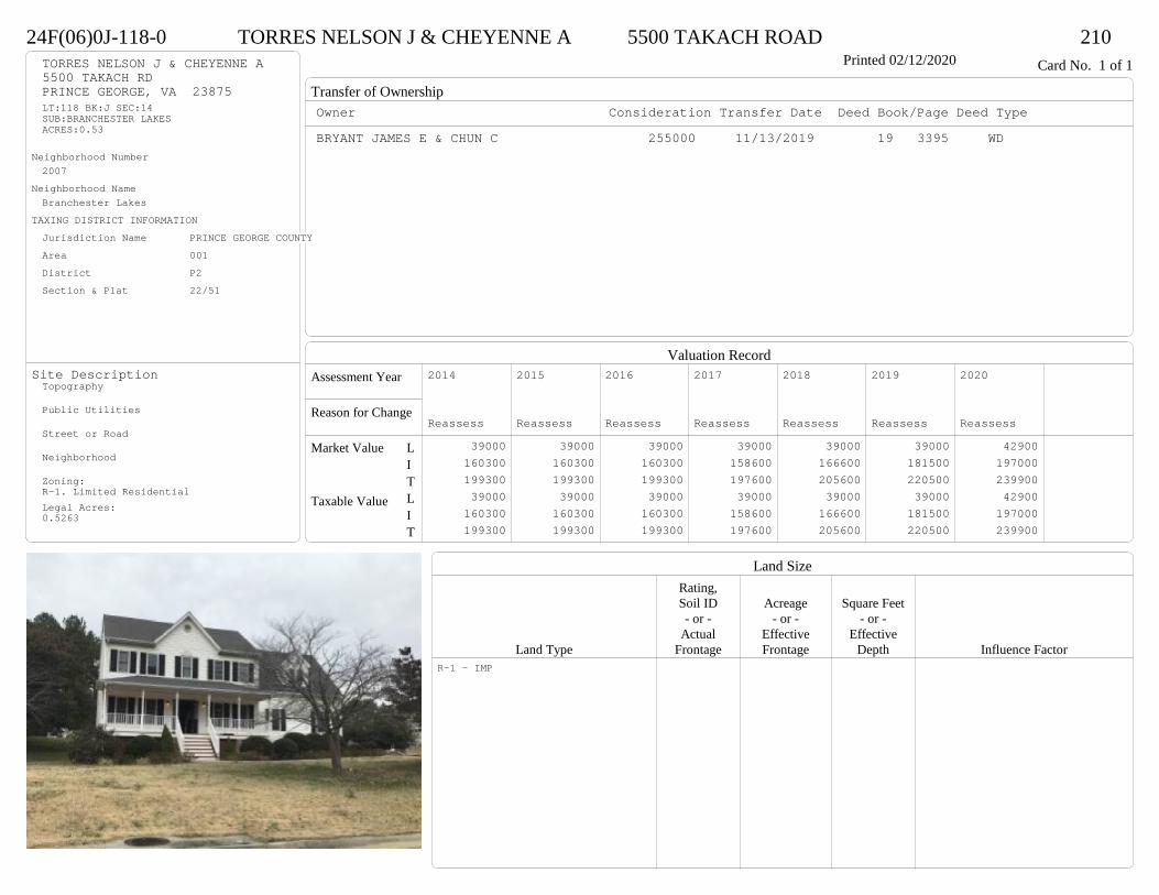
Transfer of Ownership
Valuation RecordAssessment Year
Reason for Change
Market Value
Taxable Value
LITLIT
Land SizeRating,Soil ID Acreage Square Feet- or - - or - - or -
Actual Effective EffectiveLand Type Frontage Frontage Depth Influence Factor
24F(06)0J-118-0 TORRES NELSON J & CHEYENNE A 5500 TAKACH ROAD 210Printed 02/12/2020 Card No. 1 of 1TORRES NELSON J & CHEYENNE A
5500 TAKACH RDPRINCE GEORGE, VA 23875LT:118 BK:J SEC:14SUB:BRANCHESTER LAKESACRES:0.53
Neighborhood Number2007
Neighborhood NameBranchester Lakes
TAXING DISTRICT INFORMATIONJurisdiction Name PRINCE GEORGE COUNTYArea 001 District P2 Section & Plat 22/51
Site DescriptionTopography
Public Utilities
Street or Road
Neighborhood
Zoning:R-1. Limited ResidentialLegal Acres:0.5263
Owner Consideration Transfer Date Deed Book/Page Deed TypeBRYANT JAMES E & CHUN C 255000 11/13/2019 19 3395 WD
2014
Reassess 39000 160300 199300 39000 160300 199300
2015
Reassess 39000 160300 199300 39000 160300 199300
2016
Reassess 39000 160300 199300 39000 160300 199300
2017
Reassess 39000 158600 197600 39000 158600 197600
2018
Reassess 39000 166600 205600 39000 166600 205600
2019
Reassess 39000 181500 220500 39000 181500 220500
2020
Reassess 42900 197000 239900 42900 197000 239900
R-1 - IMP
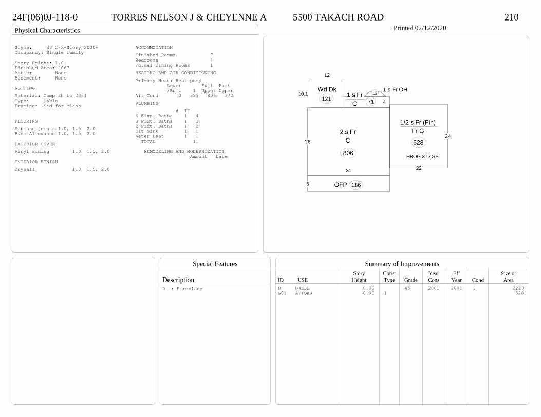
Physical Characteristics
Special Features
Description
Summary of ImprovementsStory Const Year Eff Size or
ID USE Height Type Grade Cons Year Cond Area
24F(06)0J-118-0 TORRES NELSON J & CHEYENNE A 5500 TAKACH ROAD 210Printed 02/12/2020
31
26
2 s Fr C
806
41 s Fr
C 71
1 s Fr OH 12
12
10.1Wd Dk
121
6 OFP 186
24
22
1/2 s Fr (Fin) Fr G
528
FROG 372 SF
Style: 33 2/2+Story 2000+Occupancy: Single family
Story Height: 1.0Finished Area: 2067 Attic: NoneBasement: None
ROOFINGMaterial: Comp sh to 235#Type: GableFraming: Std for class
FLOORINGSub and joists 1.0, 1.5, 2.0Base Allowance 1.0, 1.5, 2.0
EXTERIOR COVERVinyl siding 1.0, 1.5, 2.0
INTERIOR FINISHDrywall 1.0, 1.5, 2.0
ACCOMMODATIONFinished Rooms 7Bedrooms 4Formal Dining Rooms 1HEATING AND AIR CONDITIONINGPrimary Heat: Heat pump Lower Full Part /Bsmt 1 Upper UpperAir Cond 0 889 806 372PLUMBING # TF4 Fixt. Baths 1 43 Fixt. Baths 1 32 Fixt. Baths 1 2Kit Sink 1 1Water Heat 1 1 TOTAL 11
REMODELING AND MODERNIZATION Amount Date
D DWELL 0.00 45 2001 2001 3 2223G01 ATTGAR 0.00 1 528
D : Fireplace

Transfer of Ownership
Valuation RecordAssessment Year
Reason for Change
Market Value
Taxable Value
LITLIT
Land SizeRating,Soil ID Acreage Square Feet- or - - or - - or -
Actual Effective EffectiveLand Type Frontage Frontage Depth Influence Factor
24F(06)0J-096-0 TYSON JOHN F JR & SEPTEMBER E 5904 RACHAEL COURT 210Printed 02/12/2020 Card No. 1 of 1TYSON JOHN F JR & SEPTEMBER E
5904 RACHAEL CTPRINCE GEORGE, VA 23875LT:96 BK:J SEC:14SUB:BRANCHESTER LAKESACRES:0.41
Neighborhood Number2007
Neighborhood NameBranchester Lakes
TAXING DISTRICT INFORMATIONJurisdiction Name PRINCE GEORGE COUNTYArea 001 District P2 Section & Plat 22/51
Site DescriptionTopography
Public Utilities
Street or Road
Neighborhood
Zoning:R-1. Limited ResidentialLegal Acres:0.4010
Owner Consideration Transfer Date Deed Book/Page Deed TypeHALL BORIS A & YOLANDA D ADAMS 249900 07/15/2019 19 2043 WD
2014
Reassess 39000 158600 197600 39000 158600 197600
2015
Reassess 39000 158600 197600 39000 158600 197600
2016
Reassess 39000 158600 197600 39000 158600 197600
2017
Reassess 39000 158600 197600 39000 158600 197600
2018
Reassess 39000 166500 205500 39000 166500 205500
2019
Reassess 39000 181500 220500 39000 181500 220500
2020
Reassess 42900 195100 238000 42900 195100 238000
R-1 - IMP

Physical Characteristics
Special Features
Description
Summary of ImprovementsStory Const Year Eff Size or
ID USE Height Type Grade Cons Year Cond Area
24F(06)0J-096-0 TYSON JOHN F JR & SEPTEMBER E 5904 RACHAEL COURT 210Printed 02/12/2020
30.7
26
2 s Fr C
798
17.3
4
1 s Fr C 69
6OFP 184
10.1
11.8
Wd Dk119
22
24
1/2 s Fr (Fin) Fr G
528
FROG 324 SF
Style: 33 2/2+Story 2000+Occupancy: Single family
Story Height: 2.0Finished Area: 1989 Attic: NoneBasement: None
ROOFINGMaterial: Comp sh to 235#Type: GableFraming: Std for class
FLOORINGSub and joists 1.0, 1.5, 2.0Base Allowance 1.0, 1.5, 2.0
EXTERIOR COVERVinyl siding 1.0, 1.5, 2.0
INTERIOR FINISHDrywall 1.0, 1.5, 2.0
ACCOMMODATIONFinished Rooms 7Bedrooms 4Formal Dining Rooms 1HEATING AND AIR CONDITIONINGPrimary Heat: Heat pump Lower Full Part /Bsmt 1 Upper UpperAir Cond 0 867 798 324PLUMBING # TF4 Fixt. Baths 1 43 Fixt. Baths 1 32 Fixt. Baths 1 2Kit Sink 1 1Water Heat 1 1 TOTAL 11
REMODELING AND MODERNIZATION Amount Date
D DWELL 0.00 45 2002 2002 3 2193G01 ATTGAR 0.00 1 528
D : Fireplace
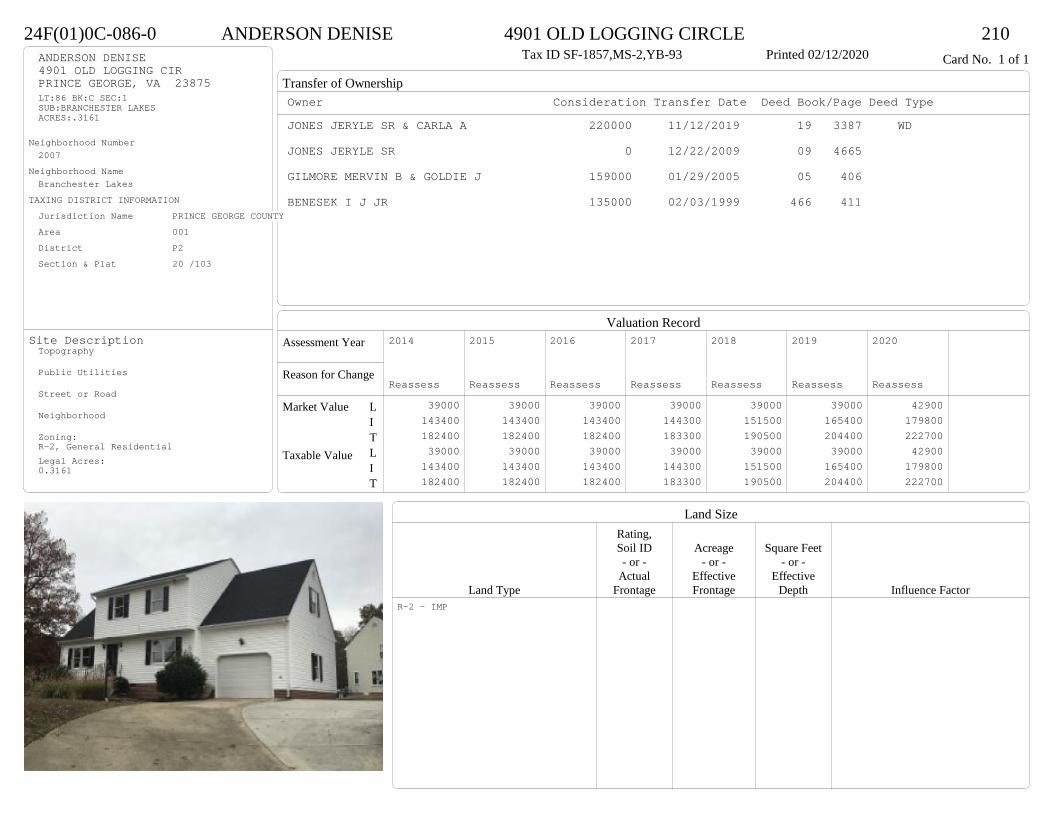
Transfer of Ownership
Valuation RecordAssessment Year
Reason for Change
Market Value
Taxable Value
LITLIT
Land SizeRating,Soil ID Acreage Square Feet- or - - or - - or -
Actual Effective EffectiveLand Type Frontage Frontage Depth Influence Factor
24F(01)0C-086-0 ANDERSON DENISE 4901 OLD LOGGING CIRCLE 210Tax ID SF-1857,MS-2,YB-93 Printed 02/12/2020 Card No. 1 of 1ANDERSON DENISE
4901 OLD LOGGING CIRPRINCE GEORGE, VA 23875LT:86 BK:C SEC:1SUB:BRANCHESTER LAKESACRES:.3161
Neighborhood Number2007
Neighborhood NameBranchester Lakes
TAXING DISTRICT INFORMATIONJurisdiction Name PRINCE GEORGE COUNTYArea 001 District P2 Section & Plat 20 /103
Site DescriptionTopography
Public Utilities
Street or Road
Neighborhood
Zoning:R-2, General ResidentialLegal Acres:0.3161
Owner Consideration Transfer Date Deed Book/Page Deed TypeJONES JERYLE SR & CARLA A 220000 11/12/2019 19 3387 WD
JONES JERYLE SR 0 12/22/2009 09 4665
GILMORE MERVIN B & GOLDIE J 159000 01/29/2005 05 406
BENESEK I J JR 135000 02/03/1999 466 411
2014
Reassess 39000 143400 182400 39000 143400 182400
2015
Reassess 39000 143400 182400 39000 143400 182400
2016
Reassess 39000 143400 182400 39000 143400 182400
2017
Reassess 39000 144300 183300 39000 144300 183300
2018
Reassess 39000 151500 190500 39000 151500 190500
2019
Reassess 39000 165400 204400 39000 165400 204400
2020
Reassess 42900 179800 222700 42900 179800 222700
R-2 - IMP

Physical Characteristics
Special Features
Description
Summary of ImprovementsStory Const Year Eff Size or
ID USE Height Type Grade Cons Year Cond Area
24F(01)0C-086-0 ANDERSON DENISE 4901 OLD LOGGING CIRCLE 210Tax ID SF-1857,MS-2,YB-93 Printed 02/12/2020
23
2 s Fr C
598
1 s Fr OH (Upper)464
6.1OMP24
13
26
1-1/2 s Fr C
338
14.3
12
9.37.1
7
Wd Dk159
Conc265
4.5
1/2 s Fr (Fin) Fr G
108
11.5
24
1/2 s Fr (UF) Fr G
276
Style: 32 2/2+Story 1980-1999Occupancy: Single family
Story Height: 2.0Finished Area: 1846 Attic: NoneBasement: None
ROOFINGMaterial: Comp sh to 235#Type: GableFraming: Std for class
FLOORINGSub and joists 1.0, 1.5, 2.0Base Allowance 1.0, 1.5, 2.0
EXTERIOR COVERVinyl siding 1.0, 1.5, 2.0
INTERIOR FINISHDrywall 1.0, 1.5, 2.0
ACCOMMODATIONFinished Rooms 8Bedrooms 4Formal Dining Rooms 1HEATING AND AIR CONDITIONINGPrimary Heat: Central Warm Air Lower Full Part /Bsmt 1 Upper UpperAir Cond 0 936 644 266PLUMBING # TF3 Fixt. Baths 2 62 Fixt. Baths 1 2Kit Sink 1 1Water Heat 1 1 TOTAL 10
REMODELING AND MODERNIZATION Amount Date
D DWELL 0.00 45 1993 1993 3 2302G01 ATTGAR 0.00 1 108G02 ATTGAR 0.00 1 276
D : Fireplace

Transfer of Ownership
Valuation RecordAssessment Year
Reason for Change
Market Value
Taxable Value
LITLIT
Land SizeRating,Soil ID Acreage Square Feet- or - - or - - or -
Actual Effective EffectiveLand Type Frontage Frontage Depth Influence Factor
24F(05)0M-014-0 CLAUDE BRIAN 7463 TRAILING ROCK ROAD 210Tax ID SF-1638,MS-2,YB-95 Printed 02/12/2020 Card No. 1 of 1CLAUDE BRIAN
7463 TRAILING ROCK RDPRINCE GEORGE, VA 23875LT:14 BK:M SEC:9SUB:BRANCHESTER LAKES
Neighborhood Number2007
Neighborhood NameBranchester Lakes
TAXING DISTRICT INFORMATIONJurisdiction Name PRINCE GEORGE COUNTYArea 001 District P2 Section & Plat 20 /220
Site DescriptionTopography
Public Utilities
Street or Road
Neighborhood
Zoning:R-1. Limited ResidentialLegal Acres:0.3714
Owner Consideration Transfer Date Deed Book/Page Deed TypeJENNINGS WILLIAM JR & ALMA J 234000 05/20/2019 19 1370 WD
LINDUFF JAMES & JANE LEONG ALS 192450 11/02/2006 06 5809
SPAULDING MICHAEL E & GLENDA D 113000 08/12/1999 480 501
H 97950 09/25/1995 406 655
2014
Admin Change 39000 140300 179300 39000 140300 179300
2015
Reassess 39000 140300 179300 39000 140300 179300
2016
Reassess 39000 140300 179300 39000 140300 179300
2017
Reassess 39000 138300 177300 39000 138300 177300
2018
Reassess 39000 144500 183500 39000 144500 183500
2019
Reassess 39000 157000 196000 39000 157000 196000
2020
Reassess 42900 178400 221300 42900 178400 221300
R-1 - IMP
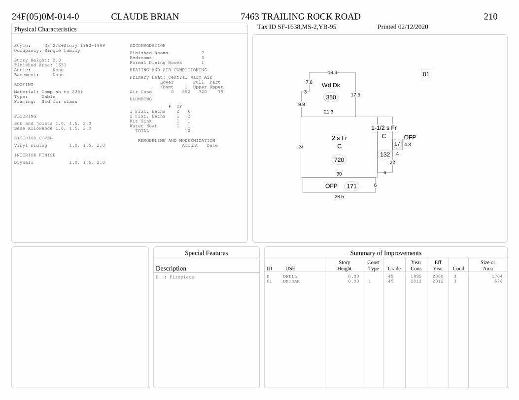
Physical Characteristics
Special Features
Description
Summary of ImprovementsStory Const Year Eff Size or
ID USE Height Type Grade Cons Year Cond Area
24F(05)0M-014-0 CLAUDE BRIAN 7463 TRAILING ROCK ROAD 210Tax ID SF-1638,MS-2,YB-95 Printed 02/12/2020
30
24
2 s Fr C
720
6
22
1-1/2 s Fr C
132 4
4.3OFP
17
6
28.5
OFP 171
17.5
18.3
7.6
3
9.921.3
Wd Dk
350
01
Style: 32 2/2+Story 1980-1999Occupancy: Single family
Story Height: 2.0Finished Area: 1651 Attic: NoneBasement: None
ROOFINGMaterial: Comp sh to 235#Type: GableFraming: Std for class
FLOORINGSub and joists 1.0, 1.5, 2.0Base Allowance 1.0, 1.5, 2.0
EXTERIOR COVERVinyl siding 1.0, 1.5, 2.0
INTERIOR FINISHDrywall 1.0, 1.5, 2.0
ACCOMMODATIONFinished Rooms 7Bedrooms 3Formal Dining Rooms 1HEATING AND AIR CONDITIONINGPrimary Heat: Central Warm Air Lower Full Part /Bsmt 1 Upper UpperAir Cond 0 852 720 79PLUMBING # TF3 Fixt. Baths 2 62 Fixt. Baths 1 2Kit Sink 1 1Water Heat 1 1 TOTAL 10
REMODELING AND MODERNIZATION Amount Date
D DWELL 0.00 45 1995 2000 3 170401 DETGAR 0.00 1 45 2012 2012 3 576
D : Fireplace
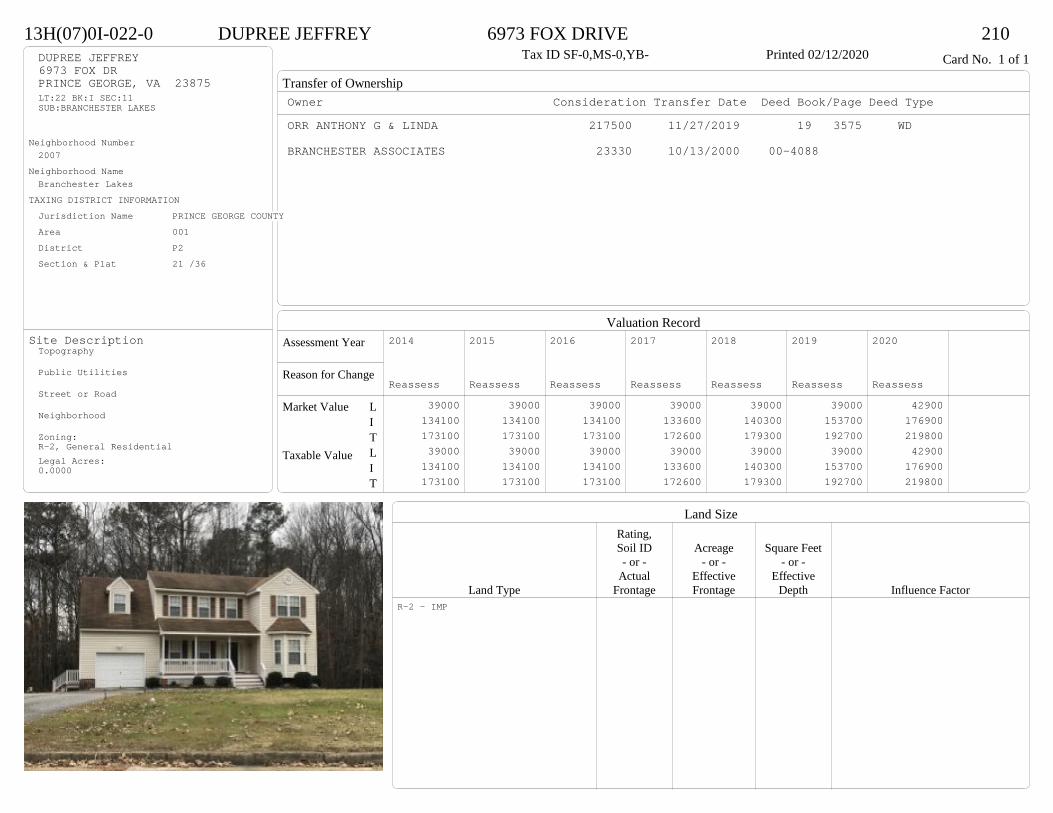
Transfer of Ownership
Valuation RecordAssessment Year
Reason for Change
Market Value
Taxable Value
LITLIT
Land SizeRating,Soil ID Acreage Square Feet- or - - or - - or -
Actual Effective EffectiveLand Type Frontage Frontage Depth Influence Factor
13H(07)0I-022-0 DUPREE JEFFREY 6973 FOX DRIVE 210Tax ID SF-0,MS-0,YB- Printed 02/12/2020 Card No. 1 of 1DUPREE JEFFREY
6973 FOX DRPRINCE GEORGE, VA 23875LT:22 BK:I SEC:11SUB:BRANCHESTER LAKES
Neighborhood Number2007
Neighborhood NameBranchester Lakes
TAXING DISTRICT INFORMATIONJurisdiction Name PRINCE GEORGE COUNTYArea 001 District P2 Section & Plat 21 /36
Site DescriptionTopography
Public Utilities
Street or Road
Neighborhood
Zoning:R-2, General ResidentialLegal Acres:0.0000
Owner Consideration Transfer Date Deed Book/Page Deed TypeORR ANTHONY G & LINDA 217500 11/27/2019 19 3575 WD
BRANCHESTER ASSOCIATES 23330 10/13/2000 00-4088
2014
Reassess 39000 134100 173100 39000 134100 173100
2015
Reassess 39000 134100 173100 39000 134100 173100
2016
Reassess 39000 134100 173100 39000 134100 173100
2017
Reassess 39000 133600 172600 39000 133600 172600
2018
Reassess 39000 140300 179300 39000 140300 179300
2019
Reassess 39000 153700 192700 39000 153700 192700
2020
Reassess 42900 176900 219800 42900 176900 219800
R-2 - IMP
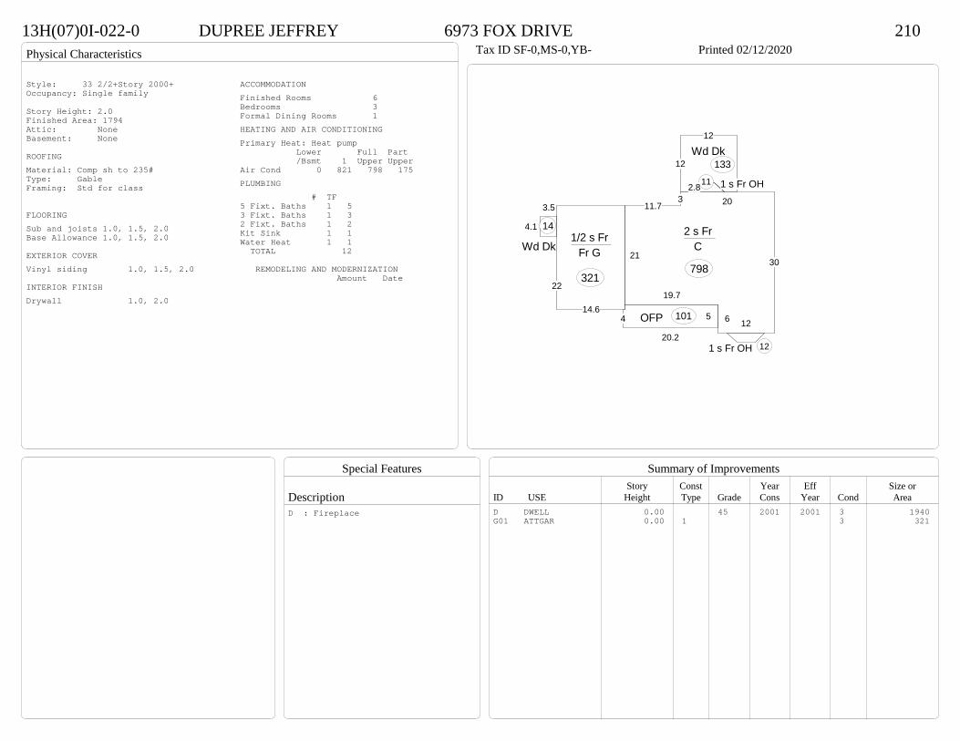
Physical Characteristics
Special Features
Description
Summary of ImprovementsStory Const Year Eff Size or
ID USE Height Type Grade Cons Year Cond Area
13H(07)0I-022-0 DUPREE JEFFREY 6973 FOX DRIVE 210Tax ID SF-0,MS-0,YB- Printed 02/12/2020
19.7
6 12
30
20311.7
21
2 s Fr C
798
54
20.2
OFP 101
1 s Fr OH 11
3.5
4.1
Wd Dk
14
1 s Fr OH 12
14.6
22
1/2 s Fr Fr G
321
12
12
2.8
Wd Dk133
Style: 33 2/2+Story 2000+Occupancy: Single family
Story Height: 2.0Finished Area: 1794 Attic: NoneBasement: None
ROOFINGMaterial: Comp sh to 235#Type: GableFraming: Std for class
FLOORINGSub and joists 1.0, 1.5, 2.0Base Allowance 1.0, 1.5, 2.0
EXTERIOR COVERVinyl siding 1.0, 1.5, 2.0
INTERIOR FINISHDrywall 1.0, 2.0
ACCOMMODATIONFinished Rooms 6Bedrooms 3Formal Dining Rooms 1HEATING AND AIR CONDITIONINGPrimary Heat: Heat pump Lower Full Part /Bsmt 1 Upper UpperAir Cond 0 821 798 175PLUMBING # TF5 Fixt. Baths 1 53 Fixt. Baths 1 32 Fixt. Baths 1 2Kit Sink 1 1Water Heat 1 1 TOTAL 12
REMODELING AND MODERNIZATION Amount Date
D DWELL 0.00 45 2001 2001 3 1940G01 ATTGAR 0.00 1 3 321
D : Fireplace

Transfer of Ownership
Valuation RecordAssessment Year
Reason for Change
Market Value
Taxable Value
LITLIT
Land SizeRating,Soil ID Acreage Square Feet- or - - or - - or -
Actual Effective EffectiveLand Type Frontage Frontage Depth Influence Factor
24F(01)0A-007-0 ABRAHAM MONICA WILLIAMS- 7325 TRAILING ROCK ROAD 210Tax ID SF-2108,MS-1.5,YB-93 Printed 02/12/2020 Card No. 1 of 1ABRAHAM MONICA WILLIAMS-
7325 TRAILING ROCK RDPRINCE GEORGE, VA 23875LT:7 BK:A SEC:1SUB:BRANCHESTER LAKESACRES:.2759
Neighborhood Number2007
Neighborhood NameBranchester Lakes
TAXING DISTRICT INFORMATIONJurisdiction Name PRINCE GEORGE COUNTYArea 001 District P2 Section & Plat 20 /103
Site DescriptionTopography
Public Utilities
Street or Road
Neighborhood
Zoning:R-2, General ResidentialLegal Acres:0.2759
Owner Consideration Transfer Date Deed Book/Page Deed TypeTOMLINSON MICHAEL D 217000 12/03/2019 19 3625 WD
JARRETT LINWOOD T 200000 09/30/2015 15 2873 WD
MERTINS KEVIN M & LEIGH S 135000 04/29/2004 04 2122
115000 09/15/1993 373 191
2014
Reassess 39000 144300 183300 39000 144300 183300
2015
Reassess 39000 144300 183300 39000 144300 183300
2016
Reassess 39000 144300 183300 39000 144300 183300
2017
Reassess 39000 144200 183200 39000 144200 183200
2018
Reassess 39000 151400 190400 39000 151400 190400
2019
Reassess 39000 165100 204100 39000 165100 204100
2020
Reassess 42900 172600 215500 42900 172600 215500
R-2 - IMP
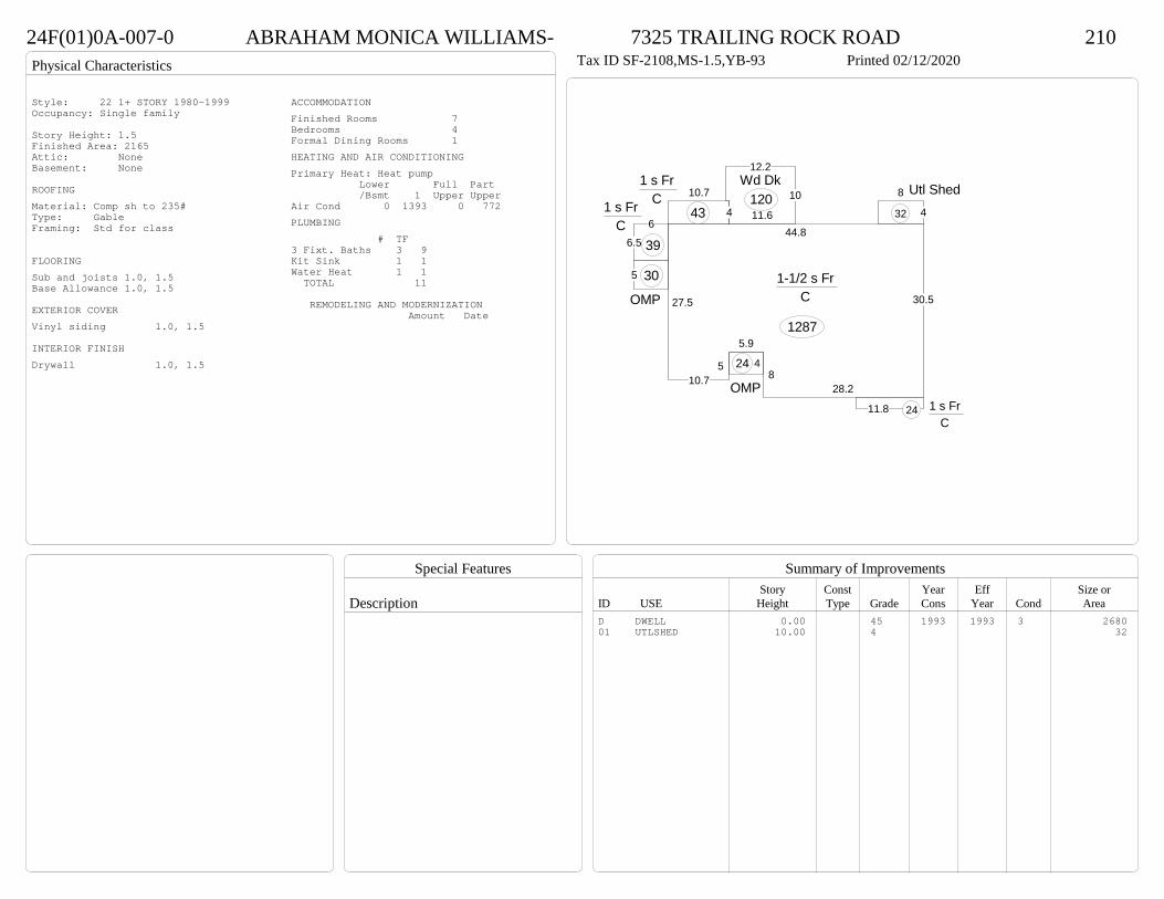
Physical Characteristics
Special Features
Description
Summary of ImprovementsStory Const Year Eff Size or
ID USE Height Type Grade Cons Year Cond Area
24F(01)0A-007-0 ABRAHAM MONICA WILLIAMS- 7325 TRAILING ROCK ROAD 210Tax ID SF-2108,MS-1.5,YB-93 Printed 02/12/2020
28.28
5.9
510.7
27.5
44.8
30.5
1-1/2 s Fr C
1287
11.8 1 s Fr C
24
10.7
4
1 s Fr C
436
6.5
1 s Fr C
39
5
OMP
30
4
OMP
24
11.6
10
12.2Wd Dk
1204
8 Utl Shed32
Style: 22 1+ STORY 1980-1999Occupancy: Single family
Story Height: 1.5Finished Area: 2165 Attic: NoneBasement: None
ROOFINGMaterial: Comp sh to 235#Type: GableFraming: Std for class
FLOORINGSub and joists 1.0, 1.5Base Allowance 1.0, 1.5
EXTERIOR COVERVinyl siding 1.0, 1.5
INTERIOR FINISHDrywall 1.0, 1.5
ACCOMMODATIONFinished Rooms 7Bedrooms 4Formal Dining Rooms 1HEATING AND AIR CONDITIONINGPrimary Heat: Heat pump Lower Full Part /Bsmt 1 Upper UpperAir Cond 0 1393 0 772PLUMBING # TF3 Fixt. Baths 3 9Kit Sink 1 1Water Heat 1 1 TOTAL 11
REMODELING AND MODERNIZATION Amount Date
D DWELL 0.00 45 1993 1993 3 268001 UTLSHED 10.00 4 32

Transfer of Ownership
Valuation RecordAssessment Year
Reason for Change
Market Value
Taxable Value
LITLIT
Land SizeRating,Soil ID Acreage Square Feet- or - - or - - or -
Actual Effective EffectiveLand Type Frontage Frontage Depth Influence Factor
13H(02)0G-028-0 ZYWICA JEFREY R & RACHEL CARTER- 7009 MAPLE LEAF LANE 210Tax ID SF-1539,MS-1,YB-91 Printed 02/12/2020 Card No. 1 of 1ZYWICA JEFREY R & RACHEL CARTER-
7009 MAPLE LEAF LNPRINCE GEORGE, VA 23875LT:28 BK:G SEC:3SUB:BRANCHESTER LAKESACRES:.3616
Neighborhood Number2007
Neighborhood NameBranchester Lakes
TAXING DISTRICT INFORMATIONJurisdiction Name PRINCE GEORGE COUNTYArea 001 District P2 Section & Plat 19 /185
Site DescriptionTopography
Public Utilities
Street or Road
Neighborhood
Zoning:R-1. Limited ResidentialLegal Acres:0.3616
Owner Consideration Transfer Date Deed Book/Page Deed TypeSHIELDS SPENCER 205000 10/15/2019 19 3049 WD
PURVIS WHITNEY D 157000 09/21/2015 15 2777 WD
FEDERAL HOME LOAN MORTGAGE CORP 148500 05/07/2010 10 1357 SWREO SALES & DISP MAIL STOP 725
LENNING GEORGE T 145000 01/12/2010 10 108 SW
99500 11/01/1991 344 862
2014
Reassess 39000 117100 156100 39000 117100 156100
2015
Reassess 39000 117100 156100 39000 117100 156100
2016
Reassess 39000 116900 155900 39000 116900 155900
2017
Reassess 39000 115700 154700 39000 115700 154700
2018
Reassess 39000 121500 160500 39000 121500 160500
2019
Reassess 39000 133400 172400 39000 133400 172400
2020
Reassess 42900 161700 204600 42900 161700 204600
R-1 - IMP

Physical Characteristics
Special Features
Description
Summary of ImprovementsStory Const Year Eff Size or
ID USE Height Type Grade Cons Year Cond Area
13H(02)0G-028-0 ZYWICA JEFREY R & RACHEL CARTER- 7009 MAPLE LEAF LANE 210Tax ID SF-1539,MS-1,YB-91 Printed 02/12/2020
57
27
1 s Fr C
1539
4
4
Wd Dk
16
8.3
5.213.8
12
17.5
Wd Dk203
621.5
OFP 129
Style: 15 1 STORY 1990-1999Occupancy: Single family
Story Height: 1.0Finished Area: 1539 Attic: NoneBasement: None
ROOFINGMaterial: Comp sh to 235#Type: GableFraming: Std for class
FLOORINGSub and joists 1.0Base Allowance 1.0Hardwood-std oak 1.0
EXTERIOR COVERVinyl siding 1.0
INTERIOR FINISHDrywall 1.0
ACCOMMODATIONFinished Rooms 7Bedrooms 3Formal Dining Rooms 1HEATING AND AIR CONDITIONINGPrimary Heat: Central Warm Air Lower Full Part /Bsmt 1 Upper UpperAir Cond 0 1539 0 0PLUMBING # TF4 Fixt. Baths 1 43 Fixt. Baths 1 3Kit Sink 1 1Water Heat 1 1 TOTAL 9
REMODELING AND MODERNIZATION Amount Date
D DWELL 0.00 45 1991 2000 3 1539D : Remod 2019 Fireplace

Transfer of Ownership
Valuation RecordAssessment Year
Reason for Change
Market Value
Taxable Value
LITLIT
Land SizeRating,Soil ID Acreage Square Feet- or - - or - - or -
Actual Effective EffectiveLand Type Frontage Frontage Depth Influence Factor
13H(02)0C-053-0 GARCIA CARLOS & CAROLINE 6920 HEARTHSIDE DRIVE 210Tax ID SF-1646,MS-2,YB-91 Printed 02/12/2020 Card No. 1 of 1GARCIA CARLOS & CAROLINE
6920 HEARTHSIDE DRPRINCE GEORGE, VA 23875LT:53 BK:C SEC:3SUB:BRANCHESTER LAKESACRES:.3444
Neighborhood Number2007
Neighborhood NameBranchester Lakes
TAXING DISTRICT INFORMATIONJurisdiction Name PRINCE GEORGE COUNTYArea 001 District P2 Section & Plat 19 /185
Site DescriptionTopography
Public Utilities
Street or Road
Neighborhood
Zoning:R-1. Limited ResidentialLegal Acres:0.3444
Owner Consideration Transfer Date Deed Book/Page Deed TypeHORNSBY BOBBY K & LAURIE B 214950 04/11/2019 19 973 WD
91000 08/02/1991 341 888
2014
Reassess 39000 121300 160300 39000 121300 160300
2015
Reassess 39000 121300 160300 39000 121300 160300
2016
Reassess 39000 121300 160300 39000 121300 160300
2017
Reassess 39000 120000 159000 39000 120000 159000
2018
Reassess 39000 126000 165000 39000 126000 165000
2019
Reassess 39000 138300 177300 39000 138300 177300
2020
Reassess 42900 155000 197900 42900 155000 197900
R-1 - IMP
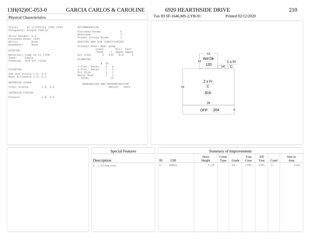
Physical Characteristics
Special Features
Description
Summary of ImprovementsStory Const Year Eff Size or
ID USE Height Type Grade Cons Year Cond Area
13H(02)0C-053-0 GARCIA CARLOS & CAROLINE 6920 HEARTHSIDE DRIVE 210Tax ID SF-1646,MS-2,YB-91 Printed 02/12/2020
34
24
2 s Fr C
816
1 s Fr C 14
10
12
Wd Dk120
6OFP 204
Style: 32 2/2+Story 1980-1999Occupancy: Single family
Story Height: 2.0Finished Area: 1646 Attic: NoneBasement: None
ROOFINGMaterial: Comp sh to 235#Type: GableFraming: Std for class
FLOORINGSub and joists 1.0, 2.0Base Allowance 1.0, 2.0
EXTERIOR COVERVinyl siding 1.0, 2.0
INTERIOR FINISHDrywall 1.0, 2.0
ACCOMMODATIONFinished Rooms 6Bedrooms 3Formal Dining Rooms 1HEATING AND AIR CONDITIONINGPrimary Heat: Heat pump Lower Full Part /Bsmt 1 Upper UpperAir Cond 0 830 816 0PLUMBING # TF3 Fixt. Baths 2 62 Fixt. Baths 1 2Kit Sink 1 1Water Heat 1 1 TOTAL 10
REMODELING AND MODERNIZATION Amount Date
D DWELL 0.00 45 1991 1991 3 1646D : Fireplace

Transfer of Ownership
Valuation RecordAssessment Year
Reason for Change
Market Value
Taxable Value
LITLIT
Land SizeRating,Soil ID Acreage Square Feet- or - - or - - or -
Actual Effective EffectiveLand Type Frontage Frontage Depth Influence Factor
24F(09)0J-044-0 SAUNDERS SHIRLON 4820 LACE WING LANE 210Printed 02/12/2020 Card No. 1 of 1SAUNDERS SHIRLON
4820 LACE WING LNPRINCE GEORGE, VA 23875LT:44 BK:J SEC:17SUB:BRANCHESTER LAKESACRES:.98
Neighborhood Number2007
Neighborhood NameBranchester Lakes
TAXING DISTRICT INFORMATIONJurisdiction Name PRINCE GEORGE COUNTYArea 001 District P2 Section & Plat 23/124
Site DescriptionTopography
Public Utilities
Street or Road
Neighborhood
Zoning:R-1. Limited ResidentialLegal Acres:0.9800
Owner Consideration Transfer Date Deed Book/Page Deed TypeHILARIO CHRISTOPHER C & MARIE J 199000 01/02/2019 19 21 WD
SULLIVAN J W CONSTRUCTION INC 160900 07/21/2005 05 3538
INGRAM RILEY E & RICHARD L HENSHAW 83500 05/03/2005 05 2073
2014
Reassess 39000 118300 157300 39000 118300 157300
2015
Reassess 39000 118300 157300 39000 118300 157300
2016
Reassess 39000 118300 157300 39000 118300 157300
2017
Reassess 39000 117000 156000 39000 117000 156000
2018
Reassess 39000 122900 161900 39000 122900 161900
2019
Reassess 39000 133700 172700 39000 133700 172700
2020
Reassess 42900 150400 193300 42900 150400 193300
R-1 - IMP

Physical Characteristics
Special Features
Description
Summary of ImprovementsStory Const Year Eff Size or
ID USE Height Type Grade Cons Year Cond Area
24F(09)0J-044-0 SAUNDERS SHIRLON 4820 LACE WING LANE 210Printed 02/12/2020
32
26
1-1/2 s Fr C
832
4 141 s Fr C
56
1011.8Wd Dk 118
1 8.7 1 s Fr OH 9
10
101 s Fr
C 100
638
22
6
16
OFP 324
Style: 23 1+ STORY 2000 +Occupancy: Single family
Story Height: 1.5Finished Area: 1496 Attic: NoneBasement: None
ROOFINGMaterial: Comp sh to 235#Type: GableFraming: Std for class
FLOORINGSub and joists 1.0, 1.5Base Allowance 1.0, 1.5
EXTERIOR COVERVinyl siding 1.0, 1.5
INTERIOR FINISHDrywall 1.0, 1.5
ACCOMMODATIONFinished Rooms 7Bedrooms 3Formal Dining Rooms 1HEATING AND AIR CONDITIONINGPrimary Heat: Heat pump Lower Full Part /Bsmt 1 Upper UpperAir Cond 0 997 0 499PLUMBING # TF4 Fixt. Baths 1 43 Fixt. Baths 1 3Kit Sink 1 1Water Heat 1 1 TOTAL 9
REMODELING AND MODERNIZATION Amount Date
D DWELL 0.00 45 2005 2005 3 1829D : Fireplace
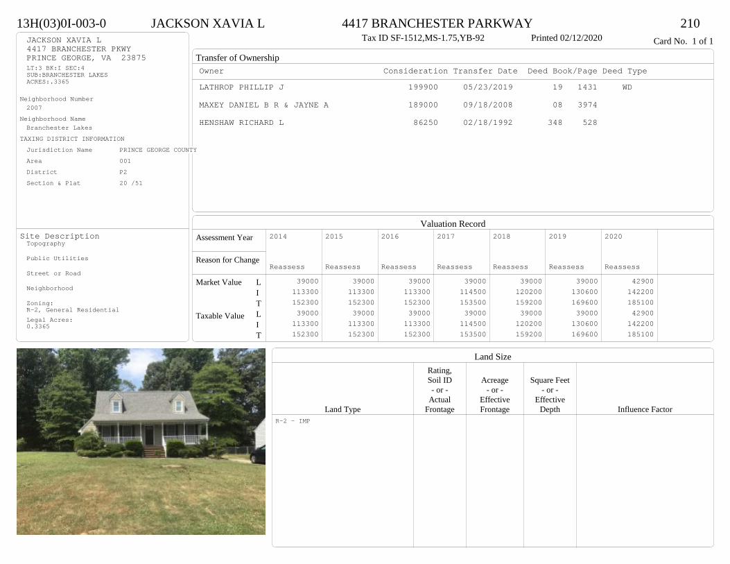
Transfer of Ownership
Valuation RecordAssessment Year
Reason for Change
Market Value
Taxable Value
LITLIT
Land SizeRating,Soil ID Acreage Square Feet- or - - or - - or -
Actual Effective EffectiveLand Type Frontage Frontage Depth Influence Factor
13H(03)0I-003-0 JACKSON XAVIA L 4417 BRANCHESTER PARKWAY 210Tax ID SF-1512,MS-1.75,YB-92 Printed 02/12/2020 Card No. 1 of 1JACKSON XAVIA L
4417 BRANCHESTER PKWYPRINCE GEORGE, VA 23875LT:3 BK:I SEC:4SUB:BRANCHESTER LAKESACRES:.3365
Neighborhood Number2007
Neighborhood NameBranchester Lakes
TAXING DISTRICT INFORMATIONJurisdiction Name PRINCE GEORGE COUNTYArea 001 District P2 Section & Plat 20 /51
Site DescriptionTopography
Public Utilities
Street or Road
Neighborhood
Zoning:R-2, General ResidentialLegal Acres:0.3365
Owner Consideration Transfer Date Deed Book/Page Deed TypeLATHROP PHILLIP J 199900 05/23/2019 19 1431 WD
MAXEY DANIEL B R & JAYNE A 189000 09/18/2008 08 3974
HENSHAW RICHARD L 86250 02/18/1992 348 528
2014
Reassess 39000 113300 152300 39000 113300 152300
2015
Reassess 39000 113300 152300 39000 113300 152300
2016
Reassess 39000 113300 152300 39000 113300 152300
2017
Reassess 39000 114500 153500 39000 114500 153500
2018
Reassess 39000 120200 159200 39000 120200 159200
2019
Reassess 39000 130600 169600 39000 130600 169600
2020
Reassess 42900 142200 185100 42900 142200 185100
R-2 - IMP
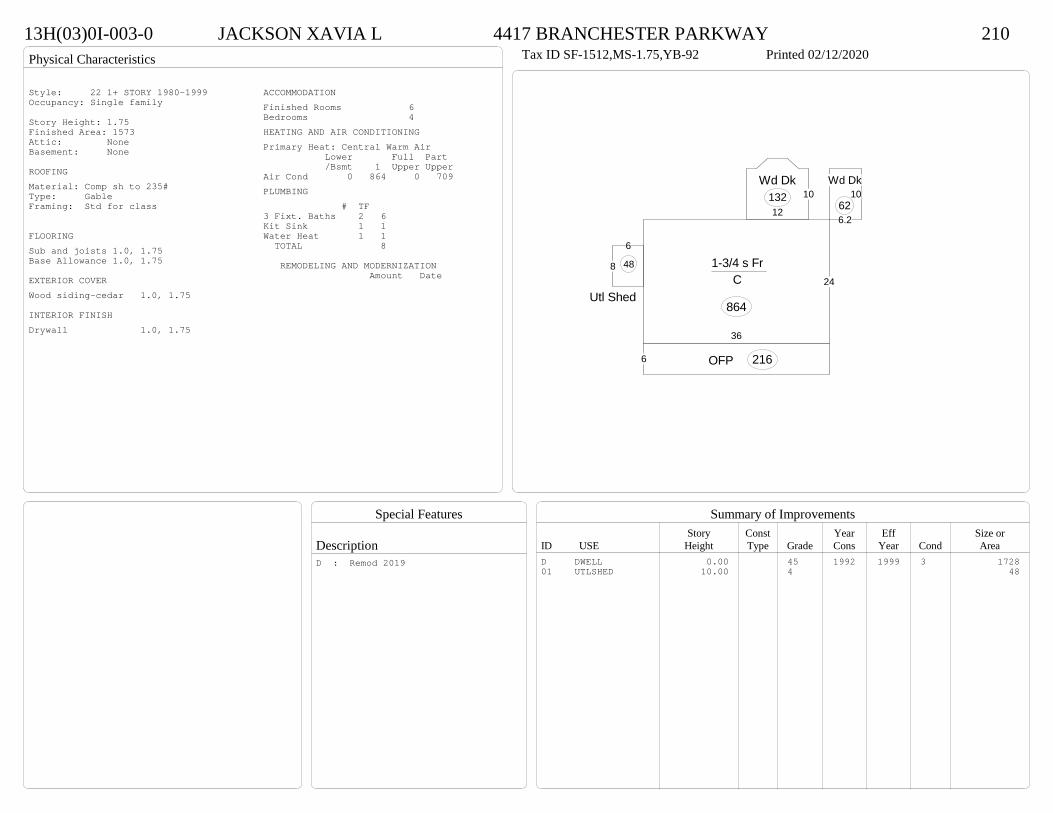
Physical Characteristics
Special Features
Description
Summary of ImprovementsStory Const Year Eff Size or
ID USE Height Type Grade Cons Year Cond Area
13H(03)0I-003-0 JACKSON XAVIA L 4417 BRANCHESTER PARKWAY 210Tax ID SF-1512,MS-1.75,YB-92 Printed 02/12/2020
36
24
1-3/4 s Fr C
864
6 OFP 216
10
12
Wd Dk132
6.2
10Wd Dk
62
6
8
Utl Shed
48
Style: 22 1+ STORY 1980-1999Occupancy: Single family
Story Height: 1.75Finished Area: 1573 Attic: NoneBasement: None
ROOFINGMaterial: Comp sh to 235#Type: GableFraming: Std for class
FLOORINGSub and joists 1.0, 1.75Base Allowance 1.0, 1.75
EXTERIOR COVERWood siding-cedar 1.0, 1.75
INTERIOR FINISHDrywall 1.0, 1.75
ACCOMMODATIONFinished Rooms 6Bedrooms 4HEATING AND AIR CONDITIONINGPrimary Heat: Central Warm Air Lower Full Part /Bsmt 1 Upper UpperAir Cond 0 864 0 709PLUMBING # TF3 Fixt. Baths 2 6Kit Sink 1 1Water Heat 1 1 TOTAL 8
REMODELING AND MODERNIZATION Amount Date
D DWELL 0.00 45 1992 1999 3 172801 UTLSHED 10.00 4 48
D : Remod 2019

Transfer of Ownership
Valuation RecordAssessment Year
Reason for Change
Market Value
Taxable Value
LITLIT
Land SizeRating,Soil ID Acreage Square Feet- or - - or - - or -
Actual Effective EffectiveLand Type Frontage Frontage Depth Influence Factor
13H(08)0P-012-0 PHILLIPS HANNELORE 6800 SWALLOW COURT 210Tax ID SF-0,MS-0,YB- Printed 02/12/2020 Card No. 1 of 1PHILLIPS HANNELORE
P O BOX 576PRINCE GEORGE, VA 23875LT:12 BK:P SEC:12SUB:BRANCHESTER LAKESACRES:0.32
Neighborhood Number2007
Neighborhood NameBranchester Lakes
TAXING DISTRICT INFORMATIONJurisdiction Name PRINCE GEORGE COUNTYArea 001 District P2 Section & Plat 21 /58
Site DescriptionTopography
Public Utilities
Street or Road
Neighborhood
Zoning:R-3, Medium Density ResidentiaLegal Acres:0.3183
Owner Consideration Transfer Date Deed Book/Page Deed TypeTONEY KEITH O 179999 08/28/2019 19 2538 WD
JONES BRIAN K & JAMIE S 187000 12/13/2007 07 6129
WILSON RICHARD A & CHRISTIE G THOMAS 109950 01/29/2001 01-323
98750 03/03/1997 426 524
2014
Reassess 39000 105600 144600 39000 105600 144600
2015
Reassess 39000 105600 144600 39000 105600 144600
2016
Reassess 39000 105600 144600 39000 105600 144600
2017
Reassess 39000 107000 146000 39000 107000 146000
2018
Reassess 39000 112300 151300 39000 112300 151300
2019
Reassess 39000 123500 162500 39000 123500 162500
2020
Reassess 42900 136100 179000 42900 136100 179000
R-3 - IMP

Physical Characteristics
Special Features
Description
Summary of ImprovementsStory Const Year Eff Size or
ID USE Height Type Grade Cons Year Cond Area
13H(08)0P-012-0 PHILLIPS HANNELORE 6800 SWALLOW COURT 210Tax ID SF-0,MS-0,YB- Printed 02/12/2020
4
16
12
10
5
4
Wd Dk156
16
38
16
1 s Fr C
608
10
24.6
7.2
11.2
1 s Fr Cathedral C
741
5OFP 80
Style: 15 1 STORY 1990-1999Occupancy: Single family
Story Height: 1.0Finished Area: 1349 Attic: NoneBasement: None
ROOFINGMaterial: Comp sh to 235#Type: GableFraming: Std for class
FLOORINGSub and joists 1.0Base Allowance 1.0
EXTERIOR COVERVinyl siding 1.0
INTERIOR FINISHDrywall 1.0
ACCOMMODATIONFinished Rooms 5Bedrooms 3HEATING AND AIR CONDITIONINGPrimary Heat: Central Warm Air Lower Full Part /Bsmt 1 Upper UpperAir Cond 0 1349 0 0PLUMBING # TF3 Fixt. Baths 2 6Kit Sink 1 1Water Heat 1 1 TOTAL 8
REMODELING AND MODERNIZATION Amount Date
D DWELL 0.00 45 1997 1997 3 1349D : Fireplace
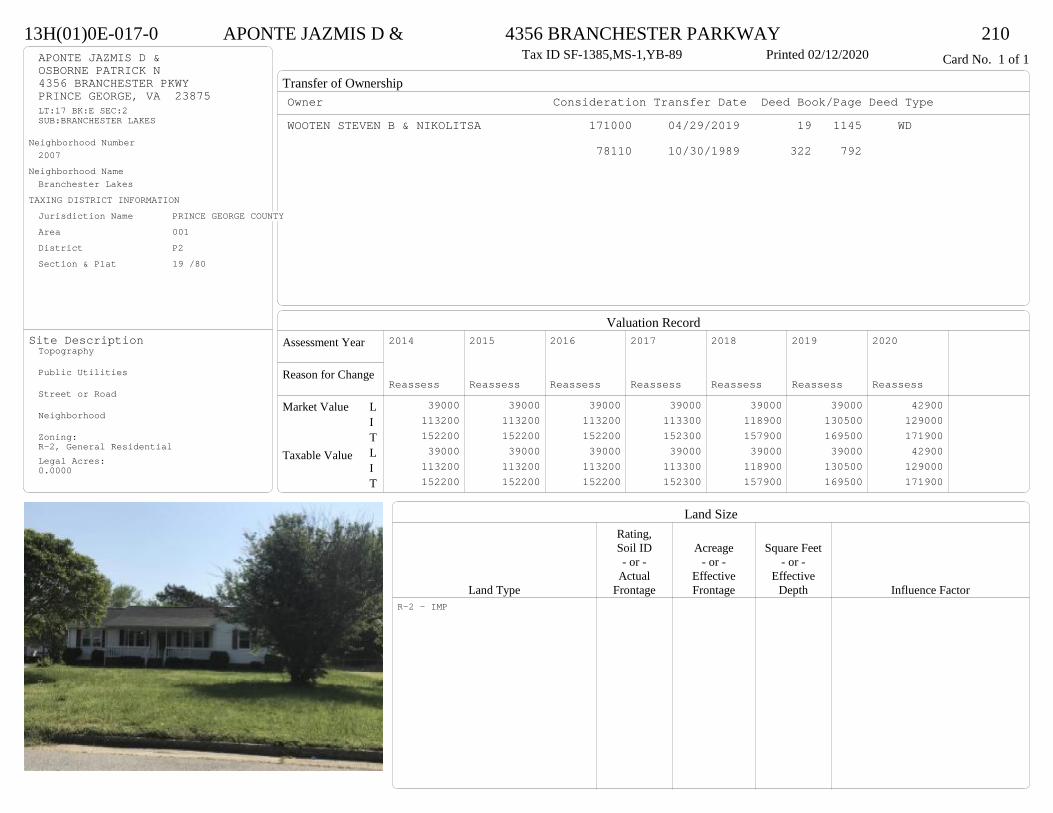
Transfer of Ownership
Valuation RecordAssessment Year
Reason for Change
Market Value
Taxable Value
LITLIT
Land SizeRating,Soil ID Acreage Square Feet- or - - or - - or -
Actual Effective EffectiveLand Type Frontage Frontage Depth Influence Factor
13H(01)0E-017-0 APONTE JAZMIS D & 4356 BRANCHESTER PARKWAY 210Tax ID SF-1385,MS-1,YB-89 Printed 02/12/2020 Card No. 1 of 1APONTE JAZMIS D &
OSBORNE PATRICK N4356 BRANCHESTER PKWYPRINCE GEORGE, VA 23875LT:17 BK:E SEC:2SUB:BRANCHESTER LAKES
Neighborhood Number2007
Neighborhood NameBranchester Lakes
TAXING DISTRICT INFORMATIONJurisdiction Name PRINCE GEORGE COUNTYArea 001 District P2 Section & Plat 19 /80
Site DescriptionTopography
Public Utilities
Street or Road
Neighborhood
Zoning:R-2, General ResidentialLegal Acres:0.0000
Owner Consideration Transfer Date Deed Book/Page Deed TypeWOOTEN STEVEN B & NIKOLITSA 171000 04/29/2019 19 1145 WD
78110 10/30/1989 322 792
2014
Reassess 39000 113200 152200 39000 113200 152200
2015
Reassess 39000 113200 152200 39000 113200 152200
2016
Reassess 39000 113200 152200 39000 113200 152200
2017
Reassess 39000 113300 152300 39000 113300 152300
2018
Reassess 39000 118900 157900 39000 118900 157900
2019
Reassess 39000 130500 169500 39000 130500 169500
2020
Reassess 42900 129000 171900 42900 129000 171900
R-2 - IMP

Physical Characteristics
Special Features
Description
Summary of ImprovementsStory Const Year Eff Size or
ID USE Height Type Grade Cons Year Cond Area
13H(01)0E-017-0 APONTE JAZMIS D & 4356 BRANCHESTER PARKWAY 210Tax ID SF-1385,MS-1,YB-89 Printed 02/12/2020
156
26.5212.5
24
54
32
1 s Fr C
1469
5.5 OMP 146
11.5
12
Wd Dk
138
Style: 14 1 STORY 1979-89Occupancy: Single family
Story Height: 1.0Finished Area: 1469 Attic: NoneBasement: None
ROOFINGMaterial: Comp sh to 235#Type: GableFraming: Std for class
FLOORINGSub and joists 1.0Base Allowance 1.0
EXTERIOR COVERVinyl siding 1.0
INTERIOR FINISHDrywall 1.0
ACCOMMODATIONFinished Rooms 6Bedrooms 3Formal Dining Rooms 1HEATING AND AIR CONDITIONINGPrimary Heat: Central Warm Air Lower Full Part /Bsmt 1 Upper UpperAir Cond 0 1469 0 0PLUMBING # TF3 Fixt. Baths 2 6Kit Sink 1 1Water Heat 1 1 TOTAL 8
REMODELING AND MODERNIZATION Amount Date
D DWELL 0.00 45 1989 1989 3 1469D : Fireplace

Transfer of Ownership
Valuation RecordAssessment Year
Reason for Change
Market Value
Taxable Value
LITLIT
Land SizeRating,Soil ID Acreage Square Feet- or - - or - - or -
Actual Effective EffectiveLand Type Frontage Frontage Depth Influence Factor
230(01)00-002-0 KOREN PAUL A 5940 THOMPSON WAY 210Tax ID SF-0,MS-0,YB- Printed 02/12/2020 Card No. 1 of 1KOREN PAUL A
5940 THOMPSON WAYPRINCE GEORGE, VA 23875LOT 2PT MIKE RUFFINS ESTACRES:9.407
Neighborhood Number2008
Neighborhood NameTakach Road area
TAXING DISTRICT INFORMATIONJurisdiction Name PRINCE GEORGE COUNTYArea 001 District P2 Section & Plat 8 /135
Site DescriptionTopography
Public Utilities
Street or Road
Neighborhood
Zoning:R-A, Residential AgriculturalLegal Acres:9.4070
Owner Consideration Transfer Date Deed Book/Page Deed TypePAGE MICHAEL A & PEGGY T 350000 10/11/2019 19 3023 WD
BARHAM LINDA S 60000 12/29/2004 04 6780
2014
Admin Change 68000 274200 342200 68000 274200 342200
2015
Reassess 68000 274200 342200 68000 274200 342200
2016
Reassess 72100 274200 346300 72100 274200 346300
2017
Reassess 72100 276700 348800 72100 276700 348800
2018
Reassess 72100 276700 348800 72100 276700 348800
2019
Reassess 72100 288600 360700 72100 288600 360700
2020
Reassess 73000 315400 388400 73000 315400 388400
R-A <20 - IMP 1 -1% A -10% W -8%

Physical Characteristics
Special Features
Description
Summary of ImprovementsStory Const Year Eff Size or
ID USE Height Type Grade Cons Year Cond Area
230(01)00-002-0 KOREN PAUL A 5940 THOMPSON WAY 210Tax ID SF-0,MS-0,YB- Printed 02/12/2020
29.76.7
5
24.5
27.7
411.7
12.8
24
23.5
19.53.8
4.5
8.4
4.7
12.3
1-1/2 s Fr C
1766
6OMP 178
15.7
10OMP-s
157
6OMP70
6.34.7
9.3
24
27.8
3/4 s Fr (Fin) Fr G
680
Style: 23 1+ STORY 2000 +Occupancy: Single family
Story Height: 1.5Finished Area: 3307 Attic: NoneBasement: None
ROOFINGMaterial: Comp sh to 235#Type: GableFraming: Std for class
FLOORINGSub and joists 1.0, 1.5, 1.75Base Allowance 1.0, 1.5, 1.75
EXTERIOR COVERVinyl siding 1.0, 1.5, 1.75
INTERIOR FINISHDrywall 1.0, 1.5, 1.75
ACCOMMODATIONFinished Rooms 9Bedrooms 3Formal Dining Rooms 1HEATING AND AIR CONDITIONINGPrimary Heat: Central Warm Air Lower Full Part /Bsmt 1 Upper UpperAir Cond 0 1766 0 1541PLUMBING # TF5 Fixt. Baths 1 53 Fixt. Baths 2 6Kit Sink 1 1Water Heat 1 1Extra Fixt 1 TOTAL 14
REMODELING AND MODERNIZATION Amount Date
D DWELL 0.00 48 2007 2007 3 4212G01 ATTGAR 0.00 1 680
D : Fireplace

Transfer of Ownership
Valuation RecordAssessment Year
Reason for Change
Market Value
Taxable Value
LITLIT
Land SizeRating,Soil ID Acreage Square Feet- or - - or - - or -
Actual Effective EffectiveLand Type Frontage Frontage Depth Influence Factor
230(01)00-004-0 SIMMONS RANDI K 4550 TAKACH ROAD 210Tax ID SF-0,MS-0,YB- Printed 02/12/2020 Card No. 1 of 1SIMMONS RANDI K
4550 TAKACH RDPRINCE GEORGE, VA 23875LOT 4PT MIKE RUFFIN ESTACRES:5.58
Neighborhood Number2008
Neighborhood NameTakach Road area
TAXING DISTRICT INFORMATIONJurisdiction Name PRINCE GEORGE COUNTYArea 001 District P2 Section & Plat 20 /223
Site DescriptionTopography
Public Utilities
Street or Road
Neighborhood
Zoning:R-A, Residential AgriculturalLegal Acres:5.5800
Owner Consideration Transfer Date Deed Book/Page Deed TypeMCKAY MELESSA A 275900 06/17/2019 19 1648 WD
BENESEK I J JR INC 278000 01/27/2006 06 440
WAYDA KENNETH M 45000 02/23/2004 04 811
2014
Reassess 65600 176300 241900 65600 176300 241900
2015
Reassess 65600 176300 241900 65600 176300 241900
2016
Reassess 65600 176300 241900 65600 176300 241900
2017
Reassess 65600 172800 238400 65600 172800 238400
2018
Reassess 65600 172800 238400 65600 172800 238400
2019
Reassess 65600 181700 247300 65600 181700 247300
2020
Reassess 72100 195400 267500 72100 195400 267500
R-A <20 - IMP
Physical Characteristics
Special Features
Description
Summary of ImprovementsStory Const Year Eff Size or
ID USE Height Type Grade Cons Year Cond Area
230(01)00-004-0 SIMMONS RANDI K 4550 TAKACH ROAD 210Tax ID SF-0,MS-0,YB- Printed 02/12/2020
28
14
1-3/4 s Fr C
392
20
2 s Fr C
560
10
121 s Fr
C 120
46
M Stp24
12
11.6
OFP139
4
OMP48
Style: 33 2/2+Story 2000+Occupancy: Single family
Story Height: 2.0Finished Area: 1954 Attic: NoneBasement: None
ROOFINGMaterial: Comp sh to 235#Type: GableFraming: Std for class
FLOORINGSub and joists 1.0, 1.75, 2.0Base Allowance 1.0, 1.75, 2.0
EXTERIOR COVERCement fiber siding 1.0, 1.75, 2.0
INTERIOR FINISHDrywall 1.0, 1.75, 2.0
ACCOMMODATIONFinished Rooms 6Bedrooms 3Formal Dining Rooms 1HEATING AND AIR CONDITIONINGPrimary Heat: Heat pump Lower Full Part /Bsmt 1 Upper UpperAir Cond 0 1072 560 322PLUMBING # TF5 Fixt. Baths 1 53 Fixt. Baths 2 6Kit Sink 1 1Water Heat 1 1 TOTAL 13
REMODELING AND MODERNIZATION Amount Date
D DWELL 0.00 48 2006 2006 3 2024D : Fireplace

Transfer of Ownership
Valuation RecordAssessment Year
Reason for Change
Market Value
Taxable Value
LITLIT
Land SizeRating,Soil ID Acreage Square Feet- or - - or - - or -
Actual Effective EffectiveLand Type Frontage Frontage Depth Influence Factor
12C(02)00-005-0 VANVALKENBURGH NICHOLAS D & 4492 CYPRESS CREEK DRIVE 210Printed 02/12/2020 Card No. 1 of 1VANVALKENBURGH NICHOLAS D &
VANVALKENBURGH YESSICA M4492 CYPRESS CREEK DRPRINCE GEORGE, VA 23875LT:5 BK: SEC:SUB:CEDAR CREEK WESTACRES:1
Neighborhood Number2010
Neighborhood NameCedar Creek
TAXING DISTRICT INFORMATIONJurisdiction Name PRINCE GEORGE COUNTYArea 001 District P2 Section & Plat 21 /45
Site DescriptionTopography
Public Utilities
Street or Road
Neighborhood
Zoning:R-E, Residential EstateLegal Acres:1.0000
Owner Consideration Transfer Date Deed Book/Page Deed TypeHARMON OLGA E & EDDIE O 389950 01/14/2019 19 137 WD
HIGGINS JAMES E & SON CONTRACTOR INC 254500 02/25/2002 02 990
JONES JAMES R BUILDER INC 31500 05/01/2001 01 2183
JONES JAMES R 0 05/19/2000 00 2048
2014
Reassess 48000 259600 307600 48000 259600 307600
2015
Reassess 45100 259600 304700 45100 259600 304700
2016
Reassess 45100 259600 304700 45100 259600 304700
2017
Reassess 45100 257200 302300 45100 257200 302300
2018
Reassess 45100 257200 302300 45100 257200 302300
2019
Reassess 45100 271500 316600 45100 271500 316600
2020
Reassess 52800 319500 372300 52800 319500 372300
R-E - IMP

Physical Characteristics
Special Features
Description
Summary of ImprovementsStory Const Year Eff Size or
ID USE Height Type Grade Cons Year Cond Area
12C(02)00-005-0 VANVALKENBURGH NICHOLAS D & 4492 CYPRESS CREEK DRIVE 210Printed 02/12/2020
32
18
6 126.4
20
31.6
20
15.5
3.5
17
2 s Fr C
1368
18
12.5
1 s Fr Cathedral C
296
4
71 s Fr OMP
28
1 s Fr C
16
1 s Fr OH 14
1 s Fr C
14
13.8
3.4 18.24
14.8
11.4
14
38.7
Wd Dk
834
23
22
1/2 s Fr (Fin) Fr G
506FROG 38 SF
UFROG 190 SF
Style: 33 2/2+Story 2000+Occupancy: Single family
Story Height: 2.0Finished Area: 3142 Attic: NoneBasement: None
ROOFINGMaterial: Comp sh to 235#Type: GableFraming: Std for class
FLOORINGSub and joists 1.0, 1.5, 2.0Base Allowance 1.0, 1.5, 2.0
EXTERIOR COVERVinyl siding 1.0, 1.5, 2.0
INTERIOR FINISHDrywall 1.0, 1.5, 2.0
ACCOMMODATIONFinished Rooms 10Bedrooms 5Formal Dining Rooms 1HEATING AND AIR CONDITIONINGPrimary Heat: Heat pump Lower Full Part /Bsmt 1 Upper UpperAir Cond 0 1708 1396 38PLUMBING # TF5 Fixt. Baths 1 54 Fixt. Baths 1 43 Fixt. Baths 1 32 Fixt. Baths 1 2Kit Sink 1 1Water Heat 1 1 TOTAL 16
REMODELING AND MODERNIZATION Amount Date
D DWELL 0.00 55 2001 2001 3 3610G01 ATTGAR 0.00 1 506
D : Fireplace
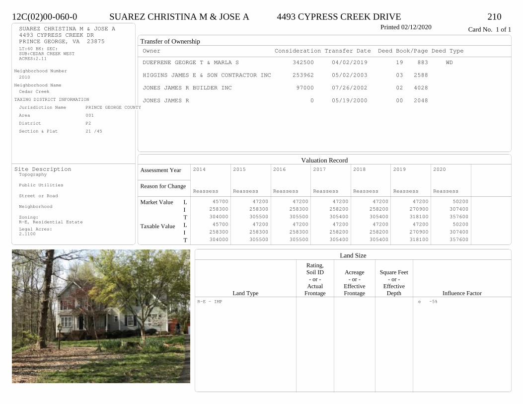
Transfer of Ownership
Valuation RecordAssessment Year
Reason for Change
Market Value
Taxable Value
LITLIT
Land SizeRating,Soil ID Acreage Square Feet- or - - or - - or -
Actual Effective EffectiveLand Type Frontage Frontage Depth Influence Factor
12C(02)00-060-0 SUAREZ CHRISTINA M & JOSE A 4493 CYPRESS CREEK DRIVE 210Printed 02/12/2020 Card No. 1 of 1SUAREZ CHRISTINA M & JOSE A
4493 CYPRESS CREEK DRPRINCE GEORGE, VA 23875LT:60 BK: SEC:SUB:CEDAR CREEK WESTACRES:2.11
Neighborhood Number2010
Neighborhood NameCedar Creek
TAXING DISTRICT INFORMATIONJurisdiction Name PRINCE GEORGE COUNTYArea 001 District P2 Section & Plat 21 /45
Site DescriptionTopography
Public Utilities
Street or Road
Neighborhood
Zoning:R-E, Residential EstateLegal Acres:2.1100
Owner Consideration Transfer Date Deed Book/Page Deed TypeDUEFRENE GEORGE T & MARLA S 342500 04/02/2019 19 883 WD
HIGGINS JAMES E & SON CONTRACTOR INC 253962 05/02/2003 03 2588
JONES JAMES R BUILDER INC 97000 07/26/2002 02 4028
JONES JAMES R 0 05/19/2000 00 2048
2014
Reassess 45700 258300 304000 45700 258300 304000
2015
Reassess 47200 258300 305500 47200 258300 305500
2016
Reassess 47200 258300 305500 47200 258300 305500
2017
Reassess 47200 258200 305400 47200 258200 305400
2018
Reassess 47200 258200 305400 47200 258200 305400
2019
Reassess 47200 270900 318100 47200 270900 318100
2020
Reassess 50200 307400 357600 50200 307400 357600
R-E - IMP e -5%
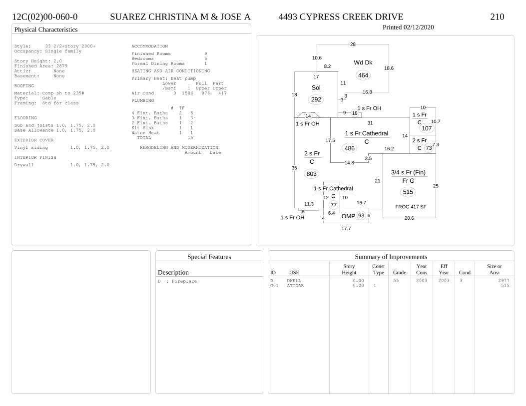
Physical Characteristics
Special Features
Description
Summary of ImprovementsStory Const Year Eff Size or
ID USE Height Type Grade Cons Year Cond Area
12C(02)00-060-0 SUAREZ CHRISTINA M & JOSE A 4493 CYPRESS CREEK DRIVE 210Printed 02/12/2020
35
11.310
16.7
21
3.52 s Fr
C
803
6.4
12
1 s Fr Cathedral C 77
1 s Fr OH 8
10
10.71 s Fr
C 107
1 s Fr OH 14
14.8
16.2
14
31
17.51 s Fr Cathedral
C 486
91 s Fr OH
18
6
17.7
4 OMP 93
7.32 s Fr
C 73
18
17
Sol
292
8.2
10.6
28
18.6
16.83
3
11
Wd Dk
464
25
20.6
3/4 s Fr (Fin) Fr G
515
FROG 417 SF
Style: 33 2/2+Story 2000+Occupancy: Single family
Story Height: 2.0Finished Area: 2879 Attic: NoneBasement: None
ROOFINGMaterial: Comp sh to 235#Type: GableFraming: Std for class
FLOORINGSub and joists 1.0, 1.75, 2.0Base Allowance 1.0, 1.75, 2.0
EXTERIOR COVERVinyl siding 1.0, 1.75, 2.0
INTERIOR FINISHDrywall 1.0, 1.75, 2.0
ACCOMMODATIONFinished Rooms 9Bedrooms 5Formal Dining Rooms 1HEATING AND AIR CONDITIONINGPrimary Heat: Heat pump Lower Full Part /Bsmt 1 Upper UpperAir Cond 0 1586 876 417PLUMBING # TF4 Fixt. Baths 2 83 Fixt. Baths 1 32 Fixt. Baths 1 2Kit Sink 1 1Water Heat 1 1 TOTAL 15
REMODELING AND MODERNIZATION Amount Date
D DWELL 0.00 55 2003 2003 3 2977G01 ATTGAR 0.00 1 515
D : Fireplace
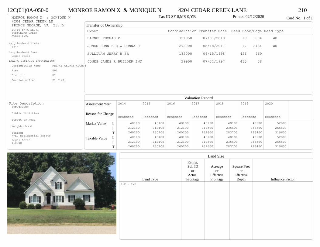
Transfer of Ownership
Valuation RecordAssessment Year
Reason for Change
Market Value
Taxable Value
LITLIT
Land SizeRating,Soil ID Acreage Square Feet- or - - or - - or -
Actual Effective EffectiveLand Type Frontage Frontage Depth Influence Factor
12C(01)0A-050-0 MONROE RAMON X & MONIQUE N 4204 CEDAR CREEK LANE 210Tax ID SF-0,MS-0,YB- Printed 02/12/2020 Card No. 1 of 1MONROE RAMON X & MONIQUE N
4204 CEDAR CREEK LNPRINCE GEORGE, VA 23875LT:50 BK:A SEC:1SUB:CEDAR CREEKACRES:1.02
Neighborhood Number2010
Neighborhood NameCedar Creek
TAXING DISTRICT INFORMATIONJurisdiction Name PRINCE GEORGE COUNTYArea 001 District P2 Section & Plat 21 /149
Site DescriptionTopography
Public Utilities
Street or Road
Neighborhood
Zoning:R-E, Residential EstateLegal Acres:1.0200
Owner Consideration Transfer Date Deed Book/Page Deed TypeBARNES THOMAS P 321950 07/01/2019 19 1884 WD
JONES RONNIE C & DONNA R 292000 08/18/2017 17 2434 WD
SULLIVAN JERRY W SR 185000 09/15/1998 456 460
JONES JAMES R BUILDER INC 29900 07/31/1997 433 38
2014
Reassess 48100 212100 260200 48100 212100 260200
2015
Reassess 48100 212100 260200 48100 212100 260200
2016
Reassess 48100 212100 260200 48100 212100 260200
2017
Reassess 48100 214500 262600 48100 214500 262600
2018
Reassess 48100 235600 283700 48100 235600 283700
2019
Reassess 48100 248300 296400 48100 248300 296400
2020
Reassess 52800 266800 319600 52800 266800 319600
R-E - IMP
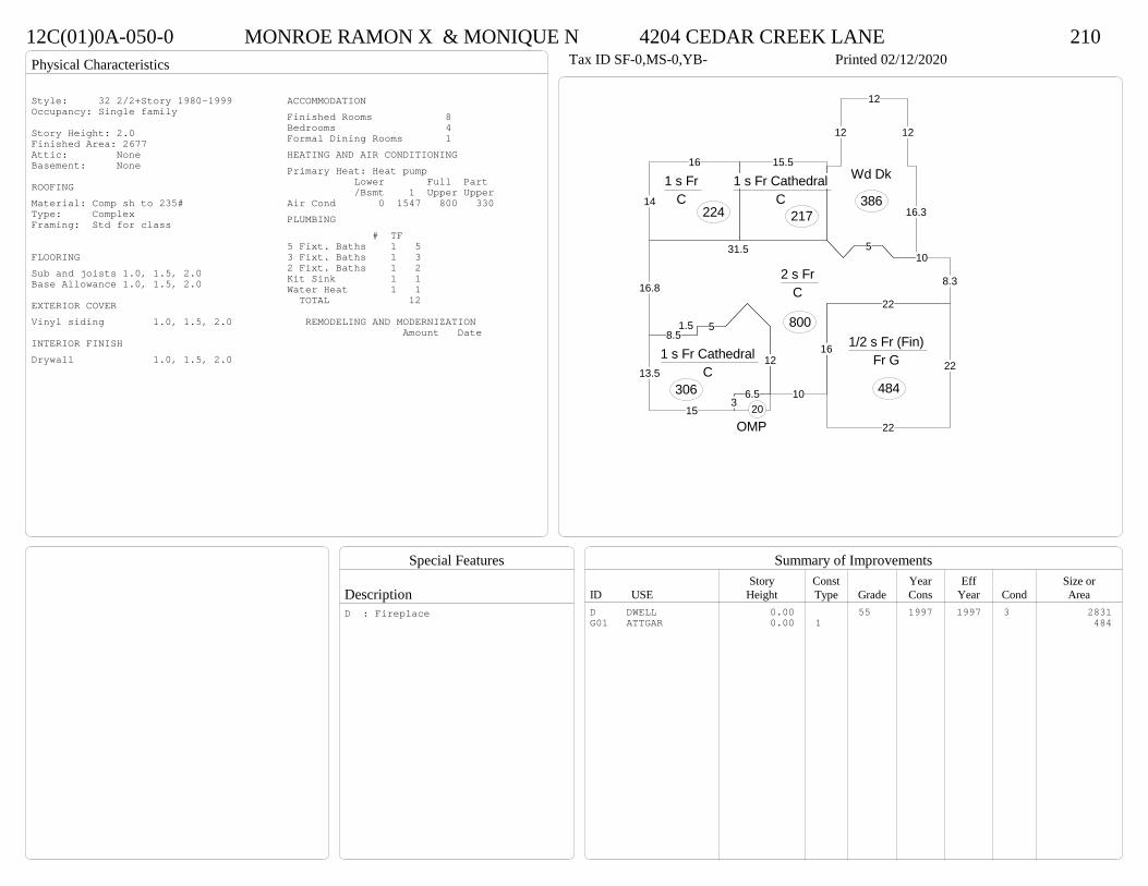
Physical Characteristics
Special Features
Description
Summary of ImprovementsStory Const Year Eff Size or
ID USE Height Type Grade Cons Year Cond Area
12C(01)0A-050-0 MONROE RAMON X & MONIQUE N 4204 CEDAR CREEK LANE 210Tax ID SF-0,MS-0,YB- Printed 02/12/2020
12
6.53
15
13.5
8.51.5 5
1 s Fr Cathedral C
306
16
10
16.8
31.5 510
8.3
22
2 s Fr C
800
14
16
1 s Fr C
224
15.5
1 s Fr Cathedral C
217 16.3
12
12
12
Wd Dk
386
OMP20
22
22
1/2 s Fr (Fin) Fr G
484
Style: 32 2/2+Story 1980-1999Occupancy: Single family
Story Height: 2.0Finished Area: 2677 Attic: NoneBasement: None
ROOFINGMaterial: Comp sh to 235#Type: ComplexFraming: Std for class
FLOORINGSub and joists 1.0, 1.5, 2.0Base Allowance 1.0, 1.5, 2.0
EXTERIOR COVERVinyl siding 1.0, 1.5, 2.0
INTERIOR FINISHDrywall 1.0, 1.5, 2.0
ACCOMMODATIONFinished Rooms 8Bedrooms 4Formal Dining Rooms 1HEATING AND AIR CONDITIONINGPrimary Heat: Heat pump Lower Full Part /Bsmt 1 Upper UpperAir Cond 0 1547 800 330PLUMBING # TF5 Fixt. Baths 1 53 Fixt. Baths 1 32 Fixt. Baths 1 2Kit Sink 1 1Water Heat 1 1 TOTAL 12
REMODELING AND MODERNIZATION Amount Date
D DWELL 0.00 55 1997 1997 3 2831G01 ATTGAR 0.00 1 484
D : Fireplace
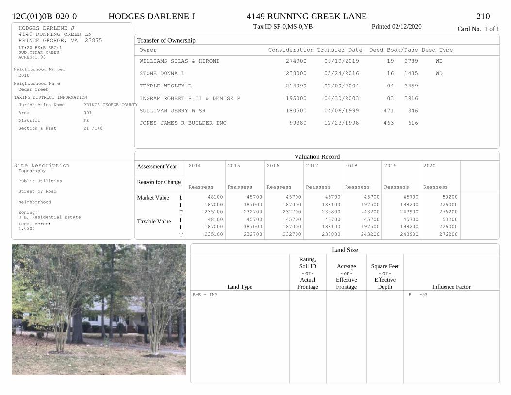
Transfer of Ownership
Valuation RecordAssessment Year
Reason for Change
Market Value
Taxable Value
LITLIT
Land SizeRating,Soil ID Acreage Square Feet- or - - or - - or -
Actual Effective EffectiveLand Type Frontage Frontage Depth Influence Factor
12C(01)0B-020-0 HODGES DARLENE J 4149 RUNNING CREEK LANE 210Tax ID SF-0,MS-0,YB- Printed 02/12/2020 Card No. 1 of 1HODGES DARLENE J
4149 RUNNING CREEK LNPRINCE GEORGE, VA 23875LT:20 BK:B SEC:1SUB:CEDAR CREEKACRES:1.03
Neighborhood Number2010
Neighborhood NameCedar Creek
TAXING DISTRICT INFORMATIONJurisdiction Name PRINCE GEORGE COUNTYArea 001 District P2 Section & Plat 21 /140
Site DescriptionTopography
Public Utilities
Street or Road
Neighborhood
Zoning:R-E, Residential EstateLegal Acres:1.0300
Owner Consideration Transfer Date Deed Book/Page Deed TypeWILLIAMS SILAS & HIROMI 274900 09/19/2019 19 2789 WD
STONE DONNA L 238000 05/24/2016 16 1435 WD
TEMPLE WESLEY D 214999 07/09/2004 04 3459
INGRAM ROBERT R II & DENISE P 195000 06/30/2003 03 3916
SULLIVAN JERRY W SR 180500 04/06/1999 471 346
JONES JAMES R BUILDER INC 99380 12/23/1998 463 616
2014
Reassess 48100 187000 235100 48100 187000 235100
2015
Reassess 45700 187000 232700 45700 187000 232700
2016
Reassess 45700 187000 232700 45700 187000 232700
2017
Reassess 45700 188100 233800 45700 188100 233800
2018
Reassess 45700 197500 243200 45700 197500 243200
2019
Reassess 45700 198200 243900 45700 198200 243900
2020
Reassess 50200 226000 276200 50200 226000 276200
R-E - IMP R -5%
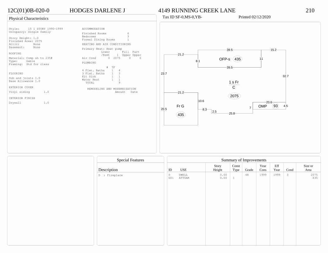
Physical Characteristics
Special Features
Description
Summary of ImprovementsStory Const Year Eff Size or
ID USE Height Type Grade Cons Year Cond Area
12C(01)0B-020-0 HODGES DARLENE J 4149 RUNNING CREEK LANE 210Tax ID SF-0,MS-0,YB- Printed 02/12/2020
8.32.5 25.8
7
20.6
32.7
15.2
11
39.5
8.1
21.2
23.7
21.2
10.6
1 s Fr C
2075
39.5
OFP-s 435
4.5OMP 9320.5
Fr G
435
Style: 15 1 STORY 1990-1999Occupancy: Single family
Story Height: 1.0Finished Area: 2075 Attic: NoneBasement: None
ROOFINGMaterial: Comp sh to 235#Type: GableFraming: Std for class
FLOORINGSub and joists 1.0Base Allowance 1.0
EXTERIOR COVERVinyl siding 1.0
INTERIOR FINISHDrywall 1.0
ACCOMMODATIONFinished Rooms 6Bedrooms 3Formal Dining Rooms 1HEATING AND AIR CONDITIONINGPrimary Heat: Heat pump Lower Full Part /Bsmt 1 Upper UpperAir Cond 0 2075 0 0PLUMBING # TF4 Fixt. Baths 1 43 Fixt. Baths 1 3Kit Sink 1 1Water Heat 1 1 TOTAL 9
REMODELING AND MODERNIZATION Amount Date
D DWELL 0.00 48 1999 1999 3 2075G01 ATTGAR 0.00 1 435
D : Fireplace

Transfer of Ownership
Valuation RecordAssessment Year
Reason for Change
Market Value
Taxable Value
LITLIT
Land SizeRating,Soil ID Acreage Square Feet- or - - or - - or -
Actual Effective EffectiveLand Type Frontage Frontage Depth Influence Factor
12C(01)0A-010-0 WILCOX BRANDON D & CHRISTINA M 4237 CEDAR CREEK LANE 210Tax ID SF-0,MS-0,YB- Printed 02/12/2020 Card No. 1 of 1WILCOX BRANDON D & CHRISTINA M
4237 CEDAR CREEK LNPRINCE GEORGE, VA 23875LT:10 BK:A SEC:1SUB:CEDAR CREEKACRES:1
Neighborhood Number2010
Neighborhood NameCedar Creek
TAXING DISTRICT INFORMATIONJurisdiction Name PRINCE GEORGE COUNTYArea 001 District P2 Section & Plat 21 /140
Site DescriptionTopography
Public Utilities
Street or Road
Neighborhood
Zoning:R-E, Residential EstateLegal Acres:1.0000
Owner Consideration Transfer Date Deed Book/Page Deed TypeARAKELIAN GARY F & DALE L 288150 11/08/2019 19 3335 WD
DAMRON DON M & ALYSON F 235000 12/13/2004 04 6522
SULLIVAN JERRY W SR 157125 07/02/1998 451 889
JONES JAMES R BUILDER INC 31140 03/26/1998 445 194
2014
Reassess 48000 207900 255900 48000 207900 255900
2015
Reassess 48000 207900 255900 48000 207900 255900
2016
Reassess 48000 207900 255900 48000 207900 255900
2017
Reassess 48000 210200 258200 48000 210200 258200
2018
Reassess 48000 210200 258200 48000 210200 258200
2019
Reassess 48000 221100 269100 48000 221100 269100
2020
Reassess 52800 221600 274400 52800 221600 274400
R-E - IMP
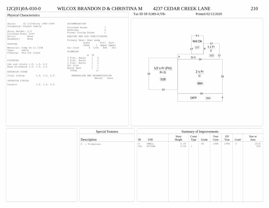
Physical Characteristics
Special Features
Description
Summary of ImprovementsStory Const Year Eff Size or
ID USE Height Type Grade Cons Year Cond Area
12C(01)0A-010-0 WILCOX BRANDON D & CHRISTINA M 4237 CEDAR CREEK LANE 210Tax ID SF-0,MS-0,YB- Printed 02/12/2020
34
26
2 s Fr C
884
634
OFP 204
4
8
12
1231.5
1 s Fr C 222
14
9.1
Wd Dk
127
22
24
1/2 s Fr (Fin) Fr G
528
Style: 32 2/2+Story 1980-1999Occupancy: Single family
Story Height: 2.0Finished Area: 2333 Attic: NoneBasement: None
ROOFINGMaterial: Comp sh to 235#Type: GableFraming: Std for class
FLOORINGSub and joists 1.0, 1.5, 2.0Base Allowance 1.0, 1.5, 2.0
EXTERIOR COVERVinyl siding 1.0, 1.5, 2.0
INTERIOR FINISHDrywall 1.0, 1.5, 2.0
ACCOMMODATIONFinished Rooms 7Bedrooms 4Formal Dining Rooms 1HEATING AND AIR CONDITIONINGPrimary Heat: Heat pump Lower Full Part /Bsmt 1 Upper UpperAir Cond 0 1106 884 343PLUMBING # TF4 Fixt. Baths 1 43 Fixt. Baths 1 32 Fixt. Baths 1 2Kit Sink 1 1Water Heat 1 1 TOTAL 11
REMODELING AND MODERNIZATION Amount Date
D DWELL 0.00 48 1998 1998 3 2518G01 ATTGAR 0.00 1 528
D : Fireplace

Transfer of Ownership
Valuation RecordAssessment Year
Reason for Change
Market Value
Taxable Value
LITLIT
Land SizeRating,Soil ID Acreage Square Feet- or - - or - - or -
Actual Effective EffectiveLand Type Frontage Frontage Depth Influence Factor
12C(01)0A-024-0 CLAYTOR ROGER W & MARY K 4293 CEDAR CREEK LANE 210Tax ID SF-0,MS-0,YB- Printed 02/12/2020 Card No. 1 of 1CLAYTOR ROGER W & MARY K
4293 CEDAR CREEK LNPRINCE GEORGE, VA 23875LT:24 BK:A SEC:1SUB:CEDAR CREEKACRES:1
Neighborhood Number2010
Neighborhood NameCedar Creek
TAXING DISTRICT INFORMATIONJurisdiction Name PRINCE GEORGE COUNTYArea 001 District P2 Section & Plat 21 /140
Site DescriptionTopography
Public Utilities
Street or Road
Neighborhood
Zoning:R-E, Residential EstateLegal Acres:1.0000
Owner Consideration Transfer Date Deed Book/Page Deed TypeGRIFFIN JAMES JR & CLARA M 289500 06/28/2019 19 1833 WD
SULLIVAN JERRY W SR 157500 07/29/1998 453 331
JONES JAMES R BUILDER INC 29760 02/19/1998 442 653
2014
Reassess 48000 166800 214800 48000 166800 214800
2015
Reassess 48000 166800 214800 48000 166800 214800
2016
Reassess 48000 170600 218600 48000 170600 218600
2017
Reassess 48000 172200 220200 48000 172200 220200
2018
Reassess 48000 172200 220200 48000 172200 220200
2019
Reassess 48000 180500 228500 48000 180500 228500
2020
Reassess 52800 196800 249600 52800 196800 249600
R-E - IMP

Physical Characteristics
Special Features
Description
Summary of ImprovementsStory Const Year Eff Size or
ID USE Height Type Grade Cons Year Cond Area
12C(01)0A-024-0 CLAYTOR ROGER W & MARY K 4293 CEDAR CREEK LANE 210Tax ID SF-0,MS-0,YB- Printed 02/12/2020
27
30.4
11.8
7.5
6.8
2 s Fr C
770
1 s Fr OH
111 s Fr OH (Upper)21
6
30.4
11.8
OFP 1721 s Fr OH 10
1 s Fr Cathedral C 51
20
2.8 16
20
Wd Dk
436 Conc 500
22
24
1/2 s Fr (Fin) Fr G
528
01
FROG 332 SF
Style: 32 2/2+Story 1980-1999Occupancy: Single family
Story Height: 2.0Finished Area: 1965 Attic: NoneBasement: None
ROOFINGMaterial: Comp sh to 235#Type: GableFraming: Std for class
FLOORINGSub and joists 1.0, 1.5, 2.0Base Allowance 1.0, 1.5, 2.0
EXTERIOR COVERVinyl siding 1.0, 1.5, 2.0
INTERIOR FINISHDrywall 1.0, 1.5, 2.0
ACCOMMODATIONFinished Rooms 7Bedrooms 3Formal Dining Rooms 1HEATING AND AIR CONDITIONINGPrimary Heat: Heat pump Lower Full Part /Bsmt 1 Upper UpperAir Cond 0 842 791 332PLUMBING # TF5 Fixt. Baths 1 53 Fixt. Baths 1 32 Fixt. Baths 1 2Kit Sink 1 1Water Heat 1 1 TOTAL 12
REMODELING AND MODERNIZATION Amount Date
D DWELL 0.00 48 1998 1998 3 2161G01 ATTGAR 0.00 1 52801 UTLSHED 10.00 1 45 2007 2007 3 200
D : Fireplace

Transfer of Ownership
Valuation RecordAssessment Year
Reason for Change
Market Value
Taxable Value
LITLIT
Land SizeRating,Soil ID Acreage Square Feet- or - - or - - or -
Actual Effective EffectiveLand Type Frontage Frontage Depth Influence Factor
12A(14)00-014-0 STEWART CODY G & BRITTANI T 5524 MULBERRY DRIVE 210Printed 02/12/2020 Card No. 1 of 1STEWART CODY G & BRITTANI T
5524 MULBERRY DRNORTH PRINCE GEORGE, VA 23860LT:14 BK: SEC:SUB:MULBERRY WOODSACRES:0.9
Neighborhood Number2012
Neighborhood NameBrandywine Area
TAXING DISTRICT INFORMATIONJurisdiction Name PRINCE GEORGE COUNTYArea 001 District P2 Section & Plat 22/72
Site DescriptionTopography
Public Utilities
Street or Road
Neighborhood
Zoning:R-2, General ResidentialLegal Acres:0.9000
Owner Consideration Transfer Date Deed Book/Page Deed TypeWESCOTT JOHN T & TAMALA J 203000 08/15/2019 19 2393 WD
HENSHAW RICHARD L INC 124000 01/31/2003 03 522 WESCOTT JOHN T & TAMALA J
PRINCE GEORGE REALTY INC 170500 03/21/2001 01 998
2014
Reassess 37800 135300 173100 37800 135300 173100
2015
Reassess 37800 135300 173100 37800 135300 173100
2016
Reassess 37800 135300 173100 37800 135300 173100
2017
Reassess 37800 135500 173300 37800 135500 173300
2018
Reassess 37800 135500 173300 37800 135500 173300
2019
Reassess 37800 143100 180900 37800 143100 180900
2020
Reassess 41600 155200 196800 41600 155200 196800
R-2 - IMP Q 5%

Physical Characteristics
Special Features
Description
Summary of ImprovementsStory Const Year Eff Size or
ID USE Height Type Grade Cons Year Cond Area
12A(14)00-014-0 STEWART CODY G & BRITTANI T 5524 MULBERRY DRIVE 210Printed 02/12/2020
30
24
2 s Fr C
720
2 s Fr OH 10
6
22
1-1/2 s Fr C
1325.1
4
OFP20
1 s Fr OH (Upper)26
2 s Fr OH 16
1 s Fr OH (Upper)18
6
28.6
OFP 162
M Stp24
Conc 296
84 SF UP
Style: 33 2/2+Story 2000+Occupancy: Single family
Story Height: 2.0Finished Area: 1752 Attic: NoneBasement: None
ROOFINGMaterial: Comp sh to 235#Type: HipFraming: Std for class
FLOORINGSub and joists 1.0, 1.5, 2.0Base Allowance 1.0, 1.5, 2.0
EXTERIOR COVERVinyl siding 1.0, 1.5, 2.0
INTERIOR FINISHDrywall 1.0, 1.5, 2.0
ACCOMMODATIONFinished Rooms 7Bedrooms 3Formal Dining Rooms 1HEATING AND AIR CONDITIONINGPrimary Heat: Heat pump Lower Full Part /Bsmt 1 Upper UpperAir Cond 0 878 790 84PLUMBING # TF3 Fixt. Baths 2 62 Fixt. Baths 1 2Kit Sink 1 1Water Heat 1 1 TOTAL 10
REMODELING AND MODERNIZATION Amount Date
D DWELL 0.00 45 2003 2003 3 1800D : Fireplace
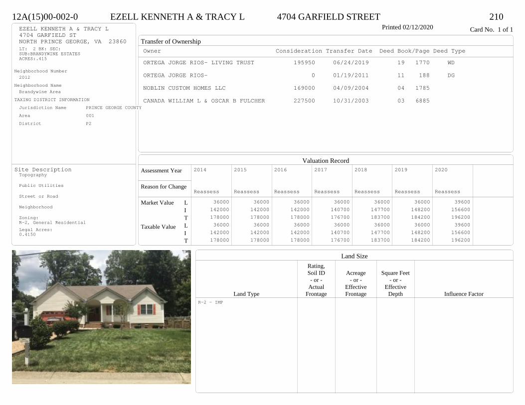
Transfer of Ownership
Valuation RecordAssessment Year
Reason for Change
Market Value
Taxable Value
LITLIT
Land SizeRating,Soil ID Acreage Square Feet- or - - or - - or -
Actual Effective EffectiveLand Type Frontage Frontage Depth Influence Factor
12A(15)00-002-0 EZELL KENNETH A & TRACY L 4704 GARFIELD STREET 210Printed 02/12/2020 Card No. 1 of 1EZELL KENNETH A & TRACY L
4704 GARFIELD STNORTH PRINCE GEORGE, VA 23860LT: 2 BK: SEC:SUB:BRANDYWINE ESTATESACRES:.415
Neighborhood Number2012
Neighborhood NameBrandywine Area
TAXING DISTRICT INFORMATIONJurisdiction Name PRINCE GEORGE COUNTYArea 001 District P2
Site DescriptionTopography
Public Utilities
Street or Road
Neighborhood
Zoning:R-2, General ResidentialLegal Acres:0.4150
Owner Consideration Transfer Date Deed Book/Page Deed TypeORTEGA JORGE RIOS- LIVING TRUST 195950 06/24/2019 19 1770 WD
ORTEGA JORGE RIOS- 0 01/19/2011 11 188 DG
NOBLIN CUSTOM HOMES LLC 169000 04/09/2004 04 1785
CANADA WILLIAM L & OSCAR B FULCHER 227500 10/31/2003 03 6885
2014
Reassess 36000 142000 178000 36000 142000 178000
2015
Reassess 36000 142000 178000 36000 142000 178000
2016
Reassess 36000 142000 178000 36000 142000 178000
2017
Reassess 36000 140700 176700 36000 140700 176700
2018
Reassess 36000 147700 183700 36000 147700 183700
2019
Reassess 36000 148200 184200 36000 148200 184200
2020
Reassess 39600 156600 196200 39600 156600 196200
R-2 - IMP
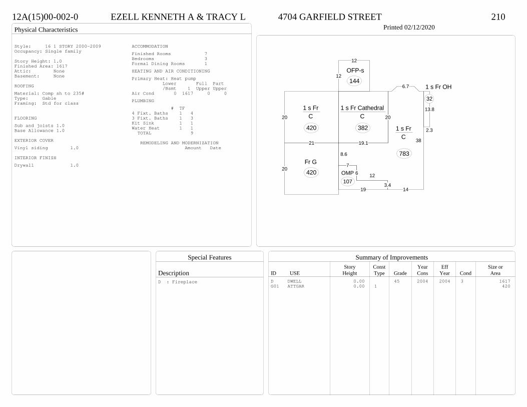
Physical Characteristics
Special Features
Description
Summary of ImprovementsStory Const Year Eff Size or
ID USE Height Type Grade Cons Year Cond Area
12A(15)00-002-0 EZELL KENNETH A & TRACY L 4704 GARFIELD STREET 210Printed 02/12/2020
20
19.1
1 s Fr Cathedral C
382
12
12
OFP-s
144
2.3
13.8
1 s Fr OH
32
20
21
1 s Fr C
420
8.6
76 12
3.414
38
6.7
1 s Fr C
783
19
OMP107
20Fr G
420
Style: 16 1 STORY 2000-2009Occupancy: Single family
Story Height: 1.0Finished Area: 1617 Attic: NoneBasement: None
ROOFINGMaterial: Comp sh to 235#Type: GableFraming: Std for class
FLOORINGSub and joists 1.0Base Allowance 1.0
EXTERIOR COVERVinyl siding 1.0
INTERIOR FINISHDrywall 1.0
ACCOMMODATIONFinished Rooms 7Bedrooms 3Formal Dining Rooms 1HEATING AND AIR CONDITIONINGPrimary Heat: Heat pump Lower Full Part /Bsmt 1 Upper UpperAir Cond 0 1617 0 0PLUMBING # TF4 Fixt. Baths 1 43 Fixt. Baths 1 3Kit Sink 1 1Water Heat 1 1 TOTAL 9
REMODELING AND MODERNIZATION Amount Date
D DWELL 0.00 45 2004 2004 3 1617G01 ATTGAR 0.00 1 420
D : Fireplace
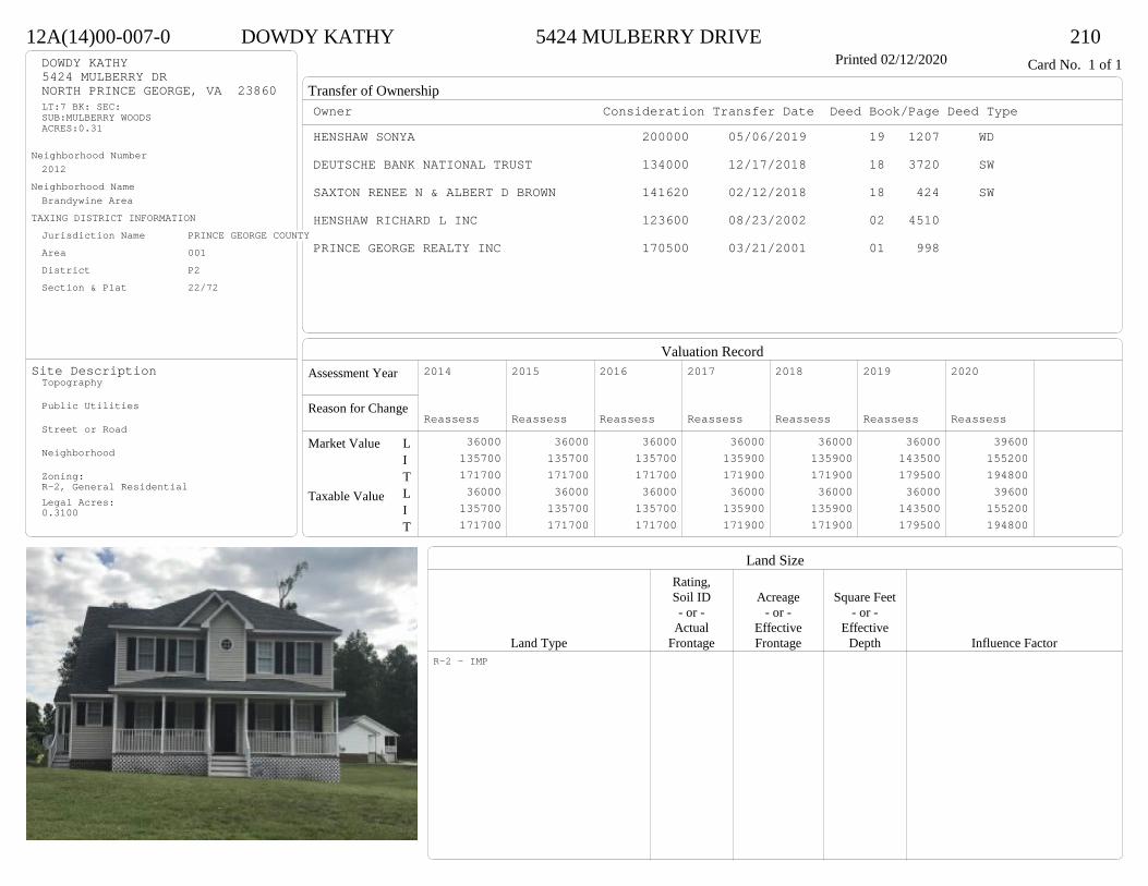
Transfer of Ownership
Valuation RecordAssessment Year
Reason for Change
Market Value
Taxable Value
LITLIT
Land SizeRating,Soil ID Acreage Square Feet- or - - or - - or -
Actual Effective EffectiveLand Type Frontage Frontage Depth Influence Factor
12A(14)00-007-0 DOWDY KATHY 5424 MULBERRY DRIVE 210Printed 02/12/2020 Card No. 1 of 1DOWDY KATHY
5424 MULBERRY DRNORTH PRINCE GEORGE, VA 23860LT:7 BK: SEC:SUB:MULBERRY WOODSACRES:0.31
Neighborhood Number2012
Neighborhood NameBrandywine Area
TAXING DISTRICT INFORMATIONJurisdiction Name PRINCE GEORGE COUNTYArea 001 District P2 Section & Plat 22/72
Site DescriptionTopography
Public Utilities
Street or Road
Neighborhood
Zoning:R-2, General ResidentialLegal Acres:0.3100
Owner Consideration Transfer Date Deed Book/Page Deed TypeHENSHAW SONYA 200000 05/06/2019 19 1207 WD
DEUTSCHE BANK NATIONAL TRUST 134000 12/17/2018 18 3720 SW
SAXTON RENEE N & ALBERT D BROWN 141620 02/12/2018 18 424 SW
HENSHAW RICHARD L INC 123600 08/23/2002 02 4510
PRINCE GEORGE REALTY INC 170500 03/21/2001 01 998
2014
Reassess 36000 135700 171700 36000 135700 171700
2015
Reassess 36000 135700 171700 36000 135700 171700
2016
Reassess 36000 135700 171700 36000 135700 171700
2017
Reassess 36000 135900 171900 36000 135900 171900
2018
Reassess 36000 135900 171900 36000 135900 171900
2019
Reassess 36000 143500 179500 36000 143500 179500
2020
Reassess 39600 155200 194800 39600 155200 194800
R-2 - IMP
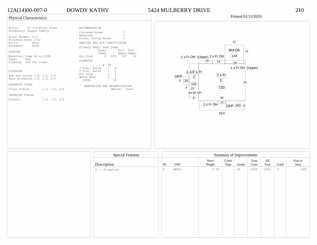
Physical Characteristics
Special Features
Description
Summary of ImprovementsStory Const Year Eff Size or
ID USE Height Type Grade Cons Year Cond Area
12A(14)00-007-0 DOWDY KATHY 5424 MULBERRY DRIVE 210Printed 02/12/2020
30
24
2 s Fr C
720
2 s Fr OH 106
28.8
OFP 163
6
22
1-1/2 s Fr C
1325
4
OFP20
12
12
Wd Dk144
1 s Fr OH (Upper)26
2 s Fr OH 16
1 s Fr OH (Upper)18
84 SF UP
Style: 33 2/2+Story 2000+Occupancy: Single family
Story Height: 2.0Finished Area: 1752 Attic: NoneBasement: None
ROOFINGMaterial: Comp sh to 235#Type: HipFraming: Std for class
FLOORINGSub and joists 1.0, 1.5, 2.0Base Allowance 1.0, 1.5, 2.0
EXTERIOR COVERVinyl siding 1.0, 1.5, 2.0
INTERIOR FINISHDrywall 1.0, 1.5, 2.0
ACCOMMODATIONFinished Rooms 7Bedrooms 3Formal Dining Rooms 1HEATING AND AIR CONDITIONINGPrimary Heat: Heat pump Lower Full Part /Bsmt 1 Upper UpperAir Cond 0 878 790 84PLUMBING # TF3 Fixt. Baths 2 62 Fixt. Baths 1 2Kit Sink 1 1Water Heat 1 1 TOTAL 10
REMODELING AND MODERNIZATION Amount Date
D DWELL 0.00 45 2002 2002 3 1800D : Fireplace
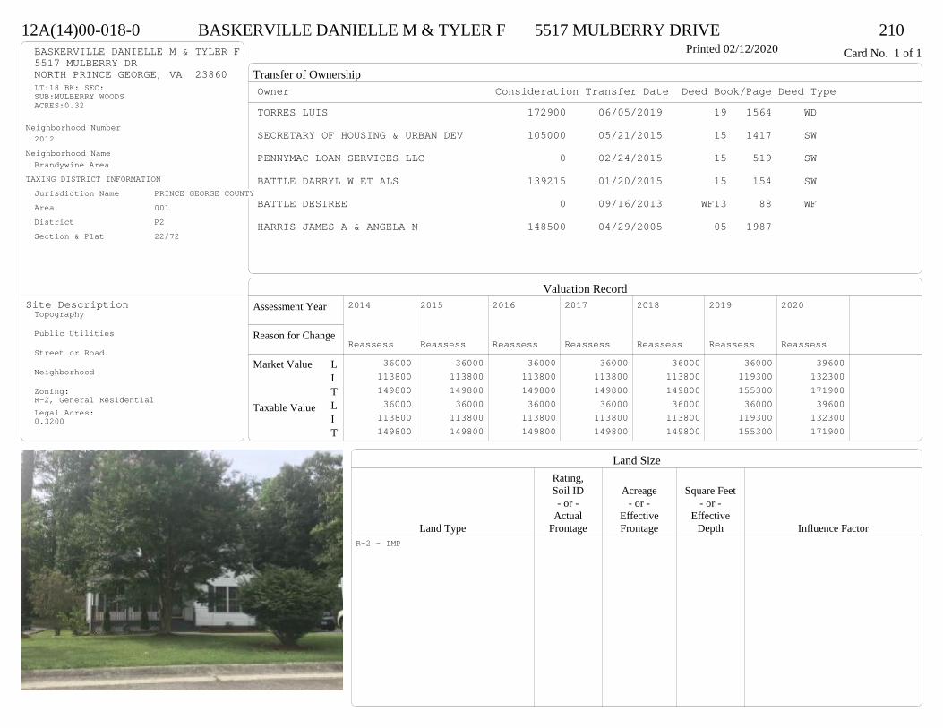
Transfer of Ownership
Valuation RecordAssessment Year
Reason for Change
Market Value
Taxable Value
LITLIT
Land SizeRating,Soil ID Acreage Square Feet- or - - or - - or -
Actual Effective EffectiveLand Type Frontage Frontage Depth Influence Factor
12A(14)00-018-0 BASKERVILLE DANIELLE M & TYLER F 5517 MULBERRY DRIVE 210Printed 02/12/2020 Card No. 1 of 1BASKERVILLE DANIELLE M & TYLER F
5517 MULBERRY DRNORTH PRINCE GEORGE, VA 23860LT:18 BK: SEC:SUB:MULBERRY WOODSACRES:0.32
Neighborhood Number2012
Neighborhood NameBrandywine Area
TAXING DISTRICT INFORMATIONJurisdiction Name PRINCE GEORGE COUNTYArea 001 District P2 Section & Plat 22/72
Site DescriptionTopography
Public Utilities
Street or Road
Neighborhood
Zoning:R-2, General ResidentialLegal Acres:0.3200
Owner Consideration Transfer Date Deed Book/Page Deed TypeTORRES LUIS 172900 06/05/2019 19 1564 WD
SECRETARY OF HOUSING & URBAN DEV 105000 05/21/2015 15 1417 SW
PENNYMAC LOAN SERVICES LLC 0 02/24/2015 15 519 SW
BATTLE DARRYL W ET ALS 139215 01/20/2015 15 154 SW
BATTLE DESIREE 0 09/16/2013 WF13 88 WF
HARRIS JAMES A & ANGELA N 148500 04/29/2005 05 1987
2014
Reassess 36000 113800 149800 36000 113800 149800
2015
Reassess 36000 113800 149800 36000 113800 149800
2016
Reassess 36000 113800 149800 36000 113800 149800
2017
Reassess 36000 113800 149800 36000 113800 149800
2018
Reassess 36000 113800 149800 36000 113800 149800
2019
Reassess 36000 119300 155300 36000 119300 155300
2020
Reassess 39600 132300 171900 39600 132300 171900
R-2 - IMP

Physical Characteristics
Special Features
Description
Summary of ImprovementsStory Const Year Eff Size or
ID USE Height Type Grade Cons Year Cond Area
12A(14)00-018-0 BASKERVILLE DANIELLE M & TYLER F 5517 MULBERRY DRIVE 210Printed 02/12/2020
144
26
34
30
1-1/2 s Fr C
940
20
4 OFP 80
12
12
Wd Dk144
Style: 23 1+ STORY 2000 +Occupancy: Single family
Story Height: 1.5Finished Area: 1538 Attic: NoneBasement: None
ROOFINGMaterial: Comp sh to 235#Type: GableFraming: Std for class
FLOORINGSub and joists 1.0, 1.5Base Allowance 1.0, 1.5
EXTERIOR COVERVinyl siding 1.0, 1.5
INTERIOR FINISHDrywall 1.0, 1.5
ACCOMMODATIONFinished Rooms 6Bedrooms 3HEATING AND AIR CONDITIONINGPrimary Heat: Heat pump Lower Full Part /Bsmt 1 Upper UpperAir Cond 0 940 0 598PLUMBING # TF3 Fixt. Baths 2 6Kit Sink 1 1Water Heat 1 1 TOTAL 8
REMODELING AND MODERNIZATION Amount Date
D DWELL 0.00 45 2002 2002 3 1880D : Fireplace
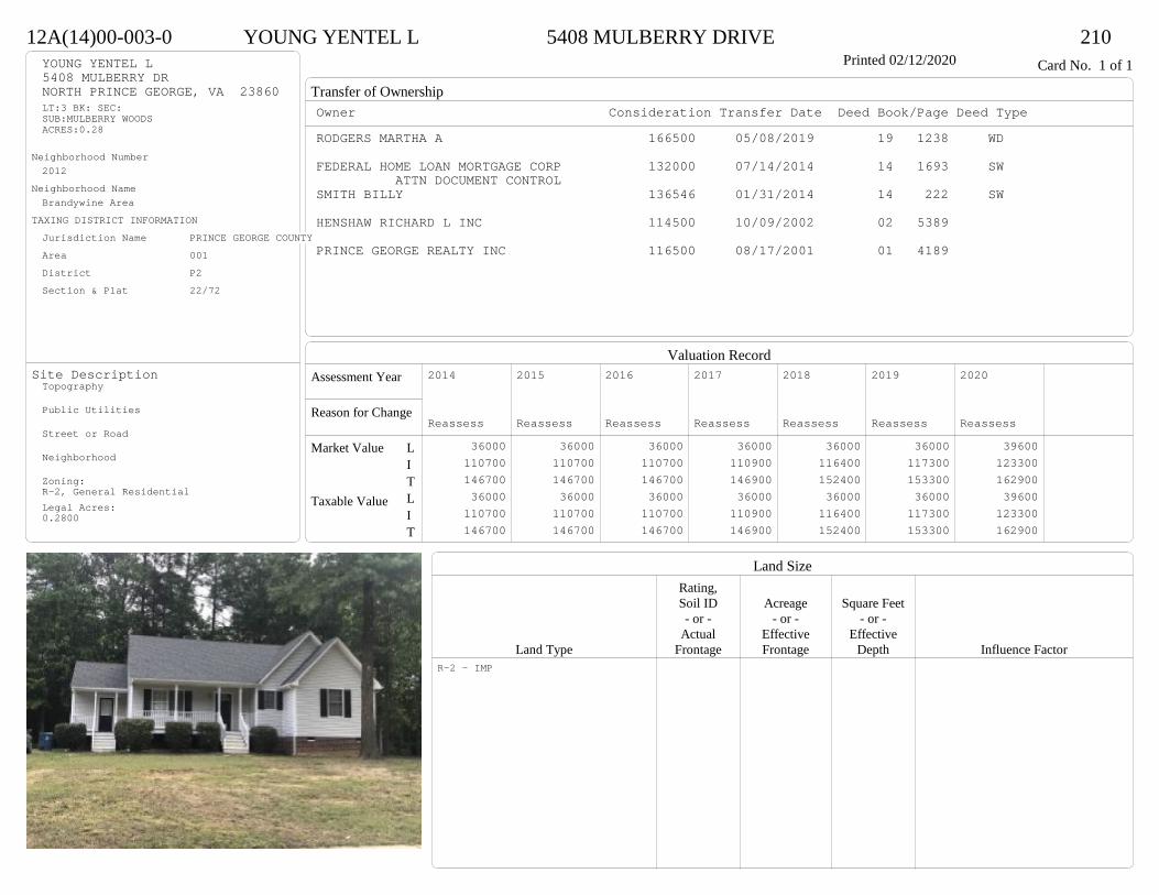
Transfer of Ownership
Valuation RecordAssessment Year
Reason for Change
Market Value
Taxable Value
LITLIT
Land SizeRating,Soil ID Acreage Square Feet- or - - or - - or -
Actual Effective EffectiveLand Type Frontage Frontage Depth Influence Factor
12A(14)00-003-0 YOUNG YENTEL L 5408 MULBERRY DRIVE 210Printed 02/12/2020 Card No. 1 of 1YOUNG YENTEL L
5408 MULBERRY DRNORTH PRINCE GEORGE, VA 23860LT:3 BK: SEC:SUB:MULBERRY WOODSACRES:0.28
Neighborhood Number2012
Neighborhood NameBrandywine Area
TAXING DISTRICT INFORMATIONJurisdiction Name PRINCE GEORGE COUNTYArea 001 District P2 Section & Plat 22/72
Site DescriptionTopography
Public Utilities
Street or Road
Neighborhood
Zoning:R-2, General ResidentialLegal Acres:0.2800
Owner Consideration Transfer Date Deed Book/Page Deed TypeRODGERS MARTHA A 166500 05/08/2019 19 1238 WD
FEDERAL HOME LOAN MORTGAGE CORP 132000 07/14/2014 14 1693 SWATTN DOCUMENT CONTROL
SMITH BILLY 136546 01/31/2014 14 222 SW
HENSHAW RICHARD L INC 114500 10/09/2002 02 5389
PRINCE GEORGE REALTY INC 116500 08/17/2001 01 4189
2014
Reassess 36000 110700 146700 36000 110700 146700
2015
Reassess 36000 110700 146700 36000 110700 146700
2016
Reassess 36000 110700 146700 36000 110700 146700
2017
Reassess 36000 110900 146900 36000 110900 146900
2018
Reassess 36000 116400 152400 36000 116400 152400
2019
Reassess 36000 117300 153300 36000 117300 153300
2020
Reassess 39600 123300 162900 39600 123300 162900
R-2 - IMP
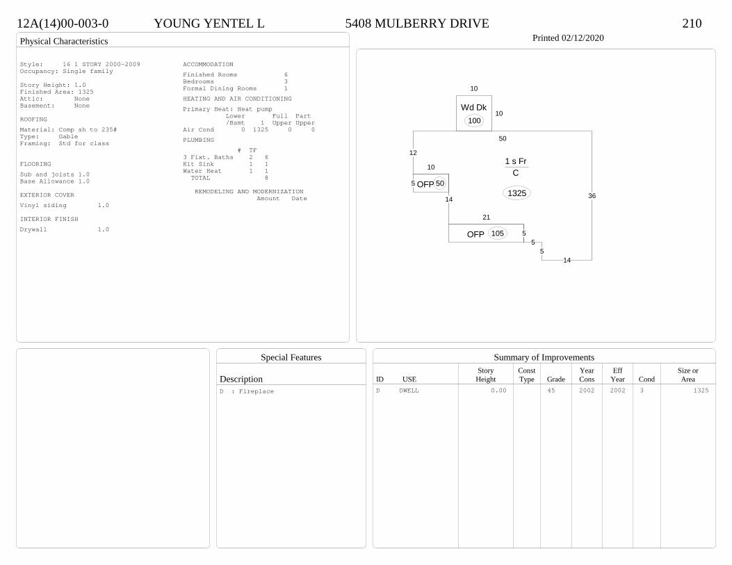
Physical Characteristics
Special Features
Description
Summary of ImprovementsStory Const Year Eff Size or
ID USE Height Type Grade Cons Year Cond Area
12A(14)00-003-0 YOUNG YENTEL L 5408 MULBERRY DRIVE 210Printed 02/12/2020
36
145
55
21
14
10
12
50
1 s Fr C
1325
OFP 105
5 OFP 50
10
10
Wd Dk100
Style: 16 1 STORY 2000-2009Occupancy: Single family
Story Height: 1.0Finished Area: 1325 Attic: NoneBasement: None
ROOFINGMaterial: Comp sh to 235#Type: GableFraming: Std for class
FLOORINGSub and joists 1.0Base Allowance 1.0
EXTERIOR COVERVinyl siding 1.0
INTERIOR FINISHDrywall 1.0
ACCOMMODATIONFinished Rooms 6Bedrooms 3Formal Dining Rooms 1HEATING AND AIR CONDITIONINGPrimary Heat: Heat pump Lower Full Part /Bsmt 1 Upper UpperAir Cond 0 1325 0 0PLUMBING # TF3 Fixt. Baths 2 6Kit Sink 1 1Water Heat 1 1 TOTAL 8
REMODELING AND MODERNIZATION Amount Date
D DWELL 0.00 45 2002 2002 3 1325D : Fireplace
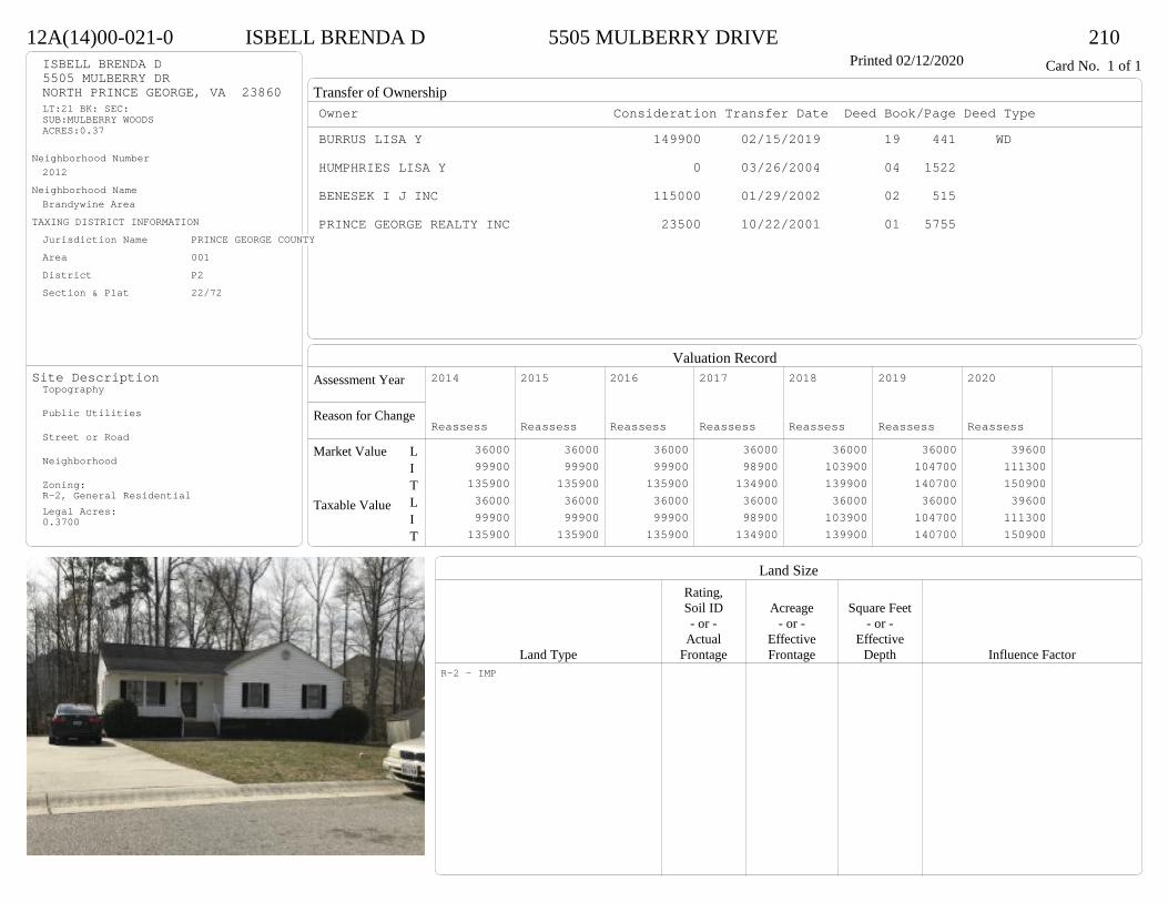
Transfer of Ownership
Valuation RecordAssessment Year
Reason for Change
Market Value
Taxable Value
LITLIT
Land SizeRating,Soil ID Acreage Square Feet- or - - or - - or -
Actual Effective EffectiveLand Type Frontage Frontage Depth Influence Factor
12A(14)00-021-0 ISBELL BRENDA D 5505 MULBERRY DRIVE 210Printed 02/12/2020 Card No. 1 of 1ISBELL BRENDA D
5505 MULBERRY DRNORTH PRINCE GEORGE, VA 23860LT:21 BK: SEC:SUB:MULBERRY WOODSACRES:0.37
Neighborhood Number2012
Neighborhood NameBrandywine Area
TAXING DISTRICT INFORMATIONJurisdiction Name PRINCE GEORGE COUNTYArea 001 District P2 Section & Plat 22/72
Site DescriptionTopography
Public Utilities
Street or Road
Neighborhood
Zoning:R-2, General ResidentialLegal Acres:0.3700
Owner Consideration Transfer Date Deed Book/Page Deed TypeBURRUS LISA Y 149900 02/15/2019 19 441 WD
HUMPHRIES LISA Y 0 03/26/2004 04 1522
BENESEK I J INC 115000 01/29/2002 02 515
PRINCE GEORGE REALTY INC 23500 10/22/2001 01 5755
2014
Reassess 36000 99900 135900 36000 99900 135900
2015
Reassess 36000 99900 135900 36000 99900 135900
2016
Reassess 36000 99900 135900 36000 99900 135900
2017
Reassess 36000 98900 134900 36000 98900 134900
2018
Reassess 36000 103900 139900 36000 103900 139900
2019
Reassess 36000 104700 140700 36000 104700 140700
2020
Reassess 39600 111300 150900 39600 111300 150900
R-2 - IMP

Physical Characteristics
Special Features
Description
Summary of ImprovementsStory Const Year Eff Size or
ID USE Height Type Grade Cons Year Cond Area
12A(14)00-021-0 ISBELL BRENDA D 5505 MULBERRY DRIVE 210Printed 02/12/2020
624
30
44
241 s Fr
C
1200
20OMP 120
12
12
OFP144
Style: 16 1 STORY 2000-2009Occupancy: Single family
Story Height: 1.0Finished Area: 1200 Attic: NoneBasement: None
ROOFINGMaterial: Comp sh to 235#Type: GableFraming: Std for class
FLOORINGSub and joists 1.0Base Allowance 1.0
EXTERIOR COVERVinyl siding 1.0
INTERIOR FINISHDrywall 1.0
ACCOMMODATIONFinished Rooms 6Bedrooms 3Formal Dining Rooms 1HEATING AND AIR CONDITIONINGPrimary Heat: Heat pump Lower Full Part /Bsmt 1 Upper UpperAir Cond 0 1200 0 0PLUMBING # TF3 Fixt. Baths 2 6Kit Sink 1 1Water Heat 1 1 TOTAL 8
REMODELING AND MODERNIZATION Amount Date
D DWELL 0.00 45 2001 2001 3 1200
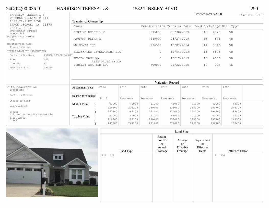
Transfer of Ownership
Valuation RecordAssessment Year
Reason for Change
Market Value
Taxable Value
LITLIT
Land SizeRating,Soil ID Acreage Square Feet- or - - or - - or -
Actual Effective EffectiveLand Type Frontage Frontage Depth Influence Factor
24G(04)00-036-0 HARRISON TERESA L & 1582 TINSLEY BLVD 290Printed 02/12/2020 Card No. 1 of 1HARRISON TERESA L &
WORRELL WILLIAM E III1582 TINSLEY BLVDPRNCE GEORGE, VA 23875LT:36 BK: SEC:4SUB:TINSLEY CHARTERACRES:.143
Neighborhood Number2013
Neighborhood NameTinsley Charter
TAXING DISTRICT INFORMATIONJurisdiction Name PRINCE GEORGE COUNTYArea 001 District P2 Section & Plat 23/246
Site DescriptionTopography
Public Utilities
Street or Road
Neighborhood
Zoning:R-3, Medium Density ResidentiaLegal Acres:0.1430
Owner Consideration Transfer Date Deed Book/Page Deed TypeSIGMUND RUSSELL W 275000 08/30/2019 19 2576 WD
KAUFMAN DEBRA A 245000 03/27/2018 18 874 WD
MW HOMES INC 236500 10/07/2014 14 3512 WD
BLACKWATER DEVELOPMENT LLC 0 11/04/2013 13 6848 WD
FULTON BANK NA 0 10/17/2013 13 6660 WDATTN DAVID SHOOP
TINSLEY CHARTER LLC 700000 01/22/2010 10 222 TS
2014
Sup 1 41000 226200 267200 41000 226200 267200
2015
Reassess 41000 226200 267200 41000 226200 267200
2016
Reassess 41000 230400 271400 41000 230400 271400
2017
Reassess 41000 233000 274000 41000 233000 274000
2018
Reassess 41000 233000 274000 41000 233000 274000
2019
Reassess 41000 255700 296700 41000 255700 296700
2020
Reassess 45100 243300 288400 45100 243300 288400
R-3 - IMP X -25%

Physical Characteristics
Special Features
Description
Summary of ImprovementsStory Const Year Eff Size or
ID USE Height Type Grade Cons Year Cond Area
24G(04)00-036-0 HARRISON TERESA L & 1582 TINSLEY BLVD 290Printed 02/12/2020
29.8
11
11.2
49.3
2.31.57.2
11
29.2
49.3
1-1/2 s Fr Slab
2039
86 OMP
48
11
11.2
OMP-s123
21.3
21.2
Fr G
452
Style: 23 1+ STORY 2000 +Occupancy: Single family
Story Height: 1.5Finished Area: 2654 Attic: NoneBasement: None
ROOFINGMaterial: Comp sh to 235#Type: GableFraming: Std for class
FLOORINGSlab 1.0Sub and joists 1.5Base Allowance 1.0, 1.5
EXTERIOR COVERVinyl siding 1.0, 1.5
INTERIOR FINISH
ACCOMMODATIONFinished Rooms 7Bedrooms 3HEATING AND AIR CONDITIONINGPrimary Heat: Heat pump Lower Full Part /Bsmt 1 Upper UpperAir Cond 0 2039 0 615PLUMBING # TF4 Fixt. Baths 1 43 Fixt. Baths 2 6Kit Sink 1 1Water Heat 1 1 TOTAL 12
REMODELING AND MODERNIZATION Amount Date
D DWELL 0.00 48 2014 2014 3 4078G01 ATTGAR 0.00 1 452
D : Fireplace

Transfer of Ownership
Valuation RecordAssessment Year
Reason for Change
Market Value
Taxable Value
LITLIT
Land SizeRating,Soil ID Acreage Square Feet- or - - or - - or -
Actual Effective EffectiveLand Type Frontage Frontage Depth Influence Factor
24G(02)00-007-0 ELLISON SAMUEL E & CHARLOTTE D 3127 TINSLEY TERRACE 295Printed 02/12/2020 Card No. 1 of 1ELLISON SAMUEL E & CHARLOTTE D
3127 TINSLEY TERPRINCE GEORGE, VA 23875LT: 7 BK: SEC: 2SUB:TINSLEY CHARTERACRES:.28
Neighborhood Number2013
Neighborhood NameTinsley Charter
TAXING DISTRICT INFORMATIONJurisdiction Name PRINCE GEORGE COUNTYArea 001 District P2 Section & Plat /
Site DescriptionTopography
Public Utilities
Street or Road
Neighborhood
Zoning:R-3, Medium Density ResidentiaLegal Acres:0.2800
Owner Consideration Transfer Date Deed Book/Page Deed TypeGARR HOMER G & SANDRA B 283500 05/31/2019 19 1518 WD
DANRICH CONSTRUCTION CO INC 256000 06/15/2005 05 2863
TINSLEY CHARTER LLC 170000 03/04/2004 04 1024
2014
Reassess 54600 205100 259700 54600 205100 259700
2015
Reassess 54600 205100 259700 54600 205100 259700
2016
Reassess 54600 205100 259700 54600 205100 259700
2017
Reassess 54600 203100 257700 54600 203100 257700
2018
Reassess 54600 203100 257700 54600 203100 257700
2019
Reassess 54600 220000 274600 54600 220000 274600
2020
Reassess 60100 210500 270600 60100 210500 270600
R-3 - IMP

Physical Characteristics
Special Features
Description
Summary of ImprovementsStory Const Year Eff Size or
ID USE Height Type Grade Cons Year Cond Area
24G(02)00-007-0 ELLISON SAMUEL E & CHARLOTTE D 3127 TINSLEY TERRACE 295Printed 02/12/2020
1 s Fr OH 24
10
12
OFP-s120
12
12Conc
144
6
OMP
5612
64.3
11.7
49.3
24
6.3
1 s Fr C
1055
33
24
1-1/2 s Fr C
792
21
22
1/2 s Fr (UF) Fr G
462brick
brick
369 SF UP
Style: 23 1+ STORY 2000 +Occupancy: Single family
Story Height: 1.5Finished Area: 2240 Attic: NoneBasement: None
ROOFINGMaterial: Comp sh to 235#Type: GableFraming: Std for class
FLOORINGSub and joists 1.0, 1.5Base Allowance 1.0, 1.5
EXTERIOR COVERBrick 1.0Vinyl siding 1.0, 1.5
INTERIOR FINISHDrywall 1.0, 1.5
ACCOMMODATIONFinished Rooms 8Bedrooms 3Family Rooms 1Formal Dining Rooms 1HEATING AND AIR CONDITIONINGPrimary Heat: Heat pump Lower Full Part /Bsmt 1 Upper UpperAir Cond 0 1871 0 369PLUMBING # TF5 Fixt. Baths 1 53 Fixt. Baths 2 6Kit Sink 1 1Water Heat 1 1 TOTAL 13
REMODELING AND MODERNIZATION Amount Date
D DWELL 0.00 48 2005 2005 3 3125G01 ATTGAR 0.00 1 462
D : Fireplace

Transfer of Ownership
Valuation RecordAssessment Year
Reason for Change
Market Value
Taxable Value
LITLIT
Land SizeRating,Soil ID Acreage Square Feet- or - - or - - or -
Actual Effective EffectiveLand Type Frontage Frontage Depth Influence Factor
24G(05)00-012-0 FALLON JOAN 6972 ST PETERS CT 295Printed 02/12/2020 Card No. 1 of 1FALLON JOAN
P O BOX 23PRINCE GEORGE, VA 23875LT:12 BK: SEC:5SUB:TINSLEY CHARTERACRES:.219
Neighborhood Number2013
Neighborhood NameTinsley Charter
TAXING DISTRICT INFORMATIONJurisdiction Name PRINCE GEORGE COUNTYArea 001 District P2 Section & Plat 24/112
Site DescriptionTopography
Public Utilities
Street or Road
Neighborhood
Zoning:R-A, Residential AgriculturalR-2, General ResidentialR-3, Medium Density ResidentiaLegal Acres:0.2190
Owner Consideration Transfer Date Deed Book/Page Deed TypeBITTENBENDER NATHAN W & 245000 06/26/2019 19 1810 WD
BITTENBENDER CAROLYN HHENSHAW RICHARD L INC 237000 08/01/2016 16 2232 WD
BLACKWATER DEVELOPMENT LLC 47500 11/08/2013 13 6904 WD
FULTON BANK NA 0 10/17/2013 13 6660 WDATTN DAVID SHOOP
TINSLEY CHARTER LLC 700000 01/22/2010 10 222 TS
2015
Reassess 54600 164600 219200 54600 164600 219200
2015
Sup 1 54600 172100 226700 54600 172100 226700
2016
Reassess 54600 172100 226700 54600 172100 226700
2017
Reassess 54600 174000 228600 54600 174000 228600
2018
Reassess 54600 189600 244200 54600 189600 244200
2019
Reassess 54600 188500 243100 54600 188500 243100
2020
Reassess 60100 206700 266800 60100 206700 266800
R-3 - IMP
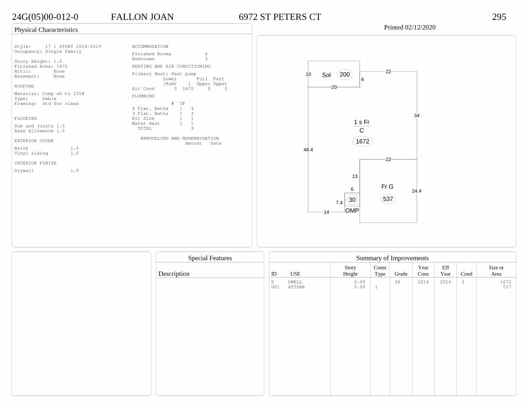
Physical Characteristics
Special Features
Description
Summary of ImprovementsStory Const Year Eff Size or
ID USE Height Type Grade Cons Year Cond Area
24G(05)00-012-0 FALLON JOAN 6972 ST PETERS CT 295Printed 02/12/2020
48.4
206
22
34
22
13
6
7.4
14
1 s Fr C
1672
OMP
30
10 Sol 200
24.4Fr G
537
Style: 17 1 STORY 2010-2019Occupancy: Single family
Story Height: 1.0Finished Area: 1672 Attic: NoneBasement: None
ROOFINGMaterial: Comp sh to 235#Type: GableFraming: Std for class
FLOORINGSub and joists 1.0Base Allowance 1.0
EXTERIOR COVERBrick 1.0Vinyl siding 1.0
INTERIOR FINISHDrywall 1.0
ACCOMMODATIONFinished Rooms 6Bedrooms 3HEATING AND AIR CONDITIONINGPrimary Heat: Heat pump Lower Full Part /Bsmt 1 Upper UpperAir Cond 0 1672 0 0PLUMBING # TF4 Fixt. Baths 1 43 Fixt. Baths 1 3Kit Sink 1 1Water Heat 1 1 TOTAL 9
REMODELING AND MODERNIZATION Amount Date
D DWELL 0.00 48 2014 2014 3 1672G01 ATTGAR 0.00 1 537
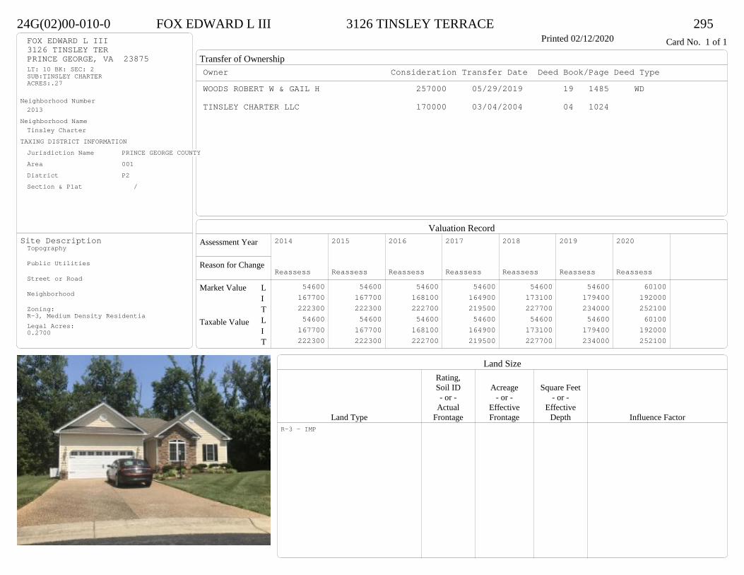
Transfer of Ownership
Valuation RecordAssessment Year
Reason for Change
Market Value
Taxable Value
LITLIT
Land SizeRating,Soil ID Acreage Square Feet- or - - or - - or -
Actual Effective EffectiveLand Type Frontage Frontage Depth Influence Factor
24G(02)00-010-0 FOX EDWARD L III 3126 TINSLEY TERRACE 295Printed 02/12/2020 Card No. 1 of 1FOX EDWARD L III
3126 TINSLEY TERPRINCE GEORGE, VA 23875LT: 10 BK: SEC: 2SUB:TINSLEY CHARTERACRES:.27
Neighborhood Number2013
Neighborhood NameTinsley Charter
TAXING DISTRICT INFORMATIONJurisdiction Name PRINCE GEORGE COUNTYArea 001 District P2 Section & Plat /
Site DescriptionTopography
Public Utilities
Street or Road
Neighborhood
Zoning:R-3, Medium Density ResidentiaLegal Acres:0.2700
Owner Consideration Transfer Date Deed Book/Page Deed TypeWOODS ROBERT W & GAIL H 257000 05/29/2019 19 1485 WD
TINSLEY CHARTER LLC 170000 03/04/2004 04 1024
2014
Reassess 54600 167700 222300 54600 167700 222300
2015
Reassess 54600 167700 222300 54600 167700 222300
2016
Reassess 54600 168100 222700 54600 168100 222700
2017
Reassess 54600 164900 219500 54600 164900 219500
2018
Reassess 54600 173100 227700 54600 173100 227700
2019
Reassess 54600 179400 234000 54600 179400 234000
2020
Reassess 60100 192000 252100 60100 192000 252100
R-3 - IMP
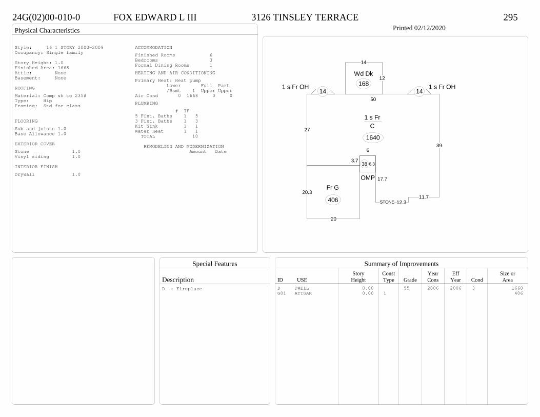
Physical Characteristics
Special Features
Description
Summary of ImprovementsStory Const Year Eff Size or
ID USE Height Type Grade Cons Year Cond Area
24G(02)00-010-0 FOX EDWARD L III 3126 TINSLEY TERRACE 295Printed 02/12/2020
3.7
6
17.7
12.311.7
39
50
27
1 s Fr C
1640
1 s Fr OH 14
12
14
Wd Dk1681 s Fr OH
14
6.3
OMP
38
20
20.3Fr G
406 STONE
Style: 16 1 STORY 2000-2009Occupancy: Single family
Story Height: 1.0Finished Area: 1668 Attic: NoneBasement: None
ROOFINGMaterial: Comp sh to 235#Type: HipFraming: Std for class
FLOORINGSub and joists 1.0Base Allowance 1.0
EXTERIOR COVERStone 1.0Vinyl siding 1.0
INTERIOR FINISHDrywall 1.0
ACCOMMODATIONFinished Rooms 6Bedrooms 3Formal Dining Rooms 1HEATING AND AIR CONDITIONINGPrimary Heat: Heat pump Lower Full Part /Bsmt 1 Upper UpperAir Cond 0 1668 0 0PLUMBING # TF5 Fixt. Baths 1 53 Fixt. Baths 1 3Kit Sink 1 1Water Heat 1 1 TOTAL 10
REMODELING AND MODERNIZATION Amount Date
D DWELL 0.00 55 2006 2006 3 1668G01 ATTGAR 0.00 1 406
D : Fireplace
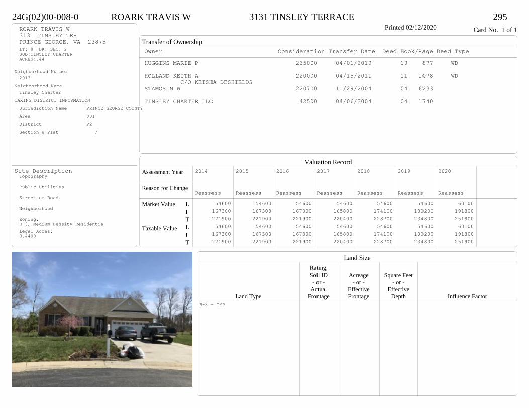
Transfer of Ownership
Valuation RecordAssessment Year
Reason for Change
Market Value
Taxable Value
LITLIT
Land SizeRating,Soil ID Acreage Square Feet- or - - or - - or -
Actual Effective EffectiveLand Type Frontage Frontage Depth Influence Factor
24G(02)00-008-0 ROARK TRAVIS W 3131 TINSLEY TERRACE 295Printed 02/12/2020 Card No. 1 of 1ROARK TRAVIS W
3131 TINSLEY TERPRINCE GEORGE, VA 23875LT: 8 BK: SEC: 2SUB:TINSLEY CHARTERACRES:.44
Neighborhood Number2013
Neighborhood NameTinsley Charter
TAXING DISTRICT INFORMATIONJurisdiction Name PRINCE GEORGE COUNTYArea 001 District P2 Section & Plat /
Site DescriptionTopography
Public Utilities
Street or Road
Neighborhood
Zoning:R-3, Medium Density ResidentiaLegal Acres:0.4400
Owner Consideration Transfer Date Deed Book/Page Deed TypeHUGGINS MARIE P 235000 04/01/2019 19 877 WD
HOLLAND KEITH A 220000 04/15/2011 11 1078 WDC/O KEISHA DESHIELDS
STAMOS N W 220700 11/29/2004 04 6233
TINSLEY CHARTER LLC 42500 04/06/2004 04 1740
2014
Reassess 54600 167300 221900 54600 167300 221900
2015
Reassess 54600 167300 221900 54600 167300 221900
2016
Reassess 54600 167300 221900 54600 167300 221900
2017
Reassess 54600 165800 220400 54600 165800 220400
2018
Reassess 54600 174100 228700 54600 174100 228700
2019
Reassess 54600 180200 234800 54600 180200 234800
2020
Reassess 60100 191800 251900 60100 191800 251900
R-3 - IMP
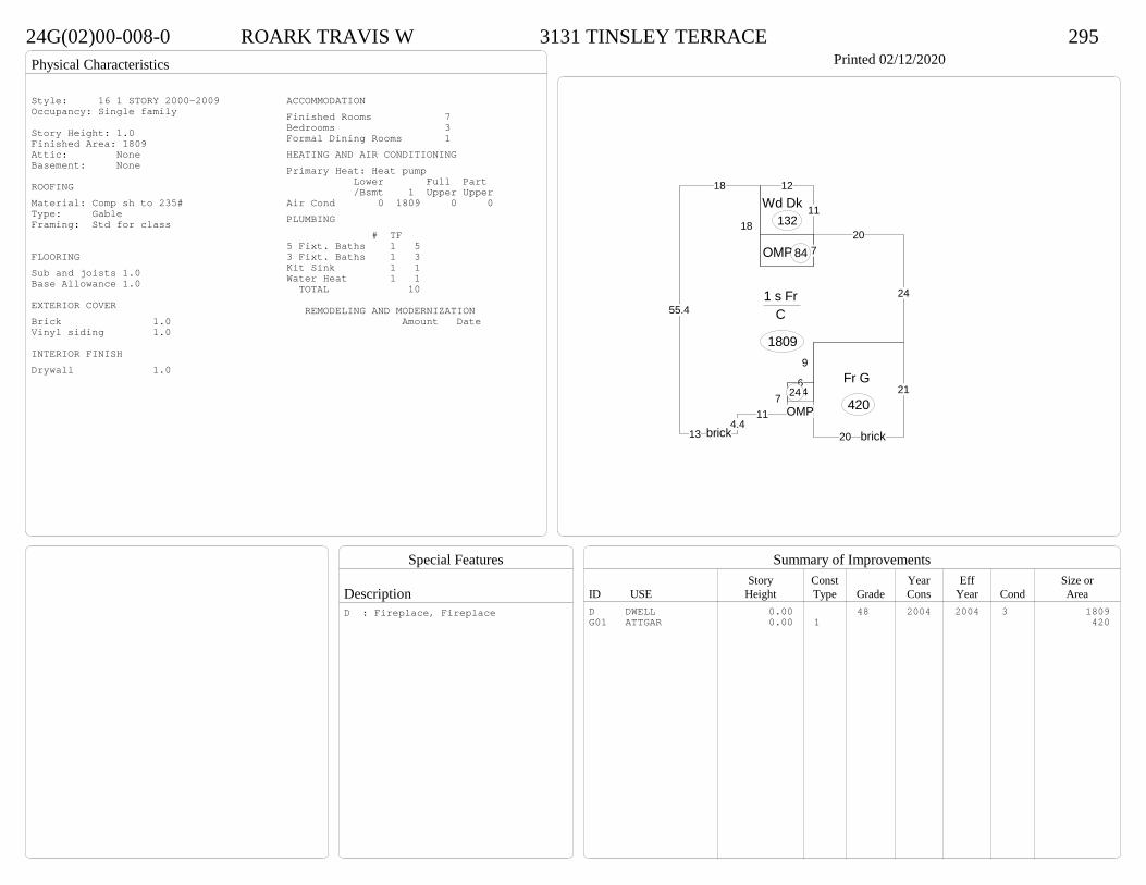
Physical Characteristics
Special Features
Description
Summary of ImprovementsStory Const Year Eff Size or
ID USE Height Type Grade Cons Year Cond Area
24G(02)00-008-0 ROARK TRAVIS W 3131 TINSLEY TERRACE 295Printed 02/12/2020
24
207
18
18
55.4
134.4
117
6
9
1 s Fr C
1809
4
OMP24
OMP84
12
11Wd Dk132
21
20
Fr G
420
brick brick
Style: 16 1 STORY 2000-2009Occupancy: Single family
Story Height: 1.0Finished Area: 1809 Attic: NoneBasement: None
ROOFINGMaterial: Comp sh to 235#Type: GableFraming: Std for class
FLOORINGSub and joists 1.0Base Allowance 1.0
EXTERIOR COVERBrick 1.0Vinyl siding 1.0
INTERIOR FINISHDrywall 1.0
ACCOMMODATIONFinished Rooms 7Bedrooms 3Formal Dining Rooms 1HEATING AND AIR CONDITIONINGPrimary Heat: Heat pump Lower Full Part /Bsmt 1 Upper UpperAir Cond 0 1809 0 0PLUMBING # TF5 Fixt. Baths 1 53 Fixt. Baths 1 3Kit Sink 1 1Water Heat 1 1 TOTAL 10
REMODELING AND MODERNIZATION Amount Date
D DWELL 0.00 48 2004 2004 3 1809G01 ATTGAR 0.00 1 420
D : Fireplace, Fireplace
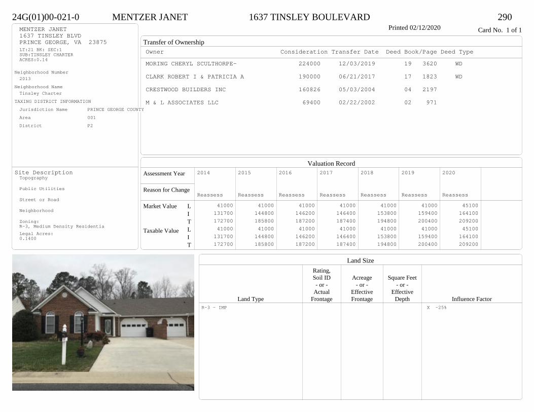
Transfer of Ownership
Valuation RecordAssessment Year
Reason for Change
Market Value
Taxable Value
LITLIT
Land SizeRating,Soil ID Acreage Square Feet- or - - or - - or -
Actual Effective EffectiveLand Type Frontage Frontage Depth Influence Factor
24G(01)00-021-0 MENTZER JANET 1637 TINSLEY BOULEVARD 290Printed 02/12/2020 Card No. 1 of 1MENTZER JANET
1637 TINSLEY BLVDPRINCE GEORGE, VA 23875LT:21 BK: SEC:1SUB:TINSLEY CHARTERACRES:0.14
Neighborhood Number2013
Neighborhood NameTinsley Charter
TAXING DISTRICT INFORMATIONJurisdiction Name PRINCE GEORGE COUNTYArea 001 District P2
Site DescriptionTopography
Public Utilities
Street or Road
Neighborhood
Zoning:R-3, Medium Density ResidentiaLegal Acres:0.1400
Owner Consideration Transfer Date Deed Book/Page Deed TypeMORING CHERYL SCULTHORPE- 224000 12/03/2019 19 3620 WD
CLARK ROBERT I & PATRICIA A 190000 06/21/2017 17 1823 WD
CRESTWOOD BUILDERS INC 160826 05/03/2004 04 2197
M & L ASSOCIATES LLC 69400 02/22/2002 02 971
2014
Reassess 41000 131700 172700 41000 131700 172700
2015
Reassess 41000 144800 185800 41000 144800 185800
2016
Reassess 41000 146200 187200 41000 146200 187200
2017
Reassess 41000 146400 187400 41000 146400 187400
2018
Reassess 41000 153800 194800 41000 153800 194800
2019
Reassess 41000 159400 200400 41000 159400 200400
2020
Reassess 45100 164100 209200 45100 164100 209200
R-3 - IMP X -25%
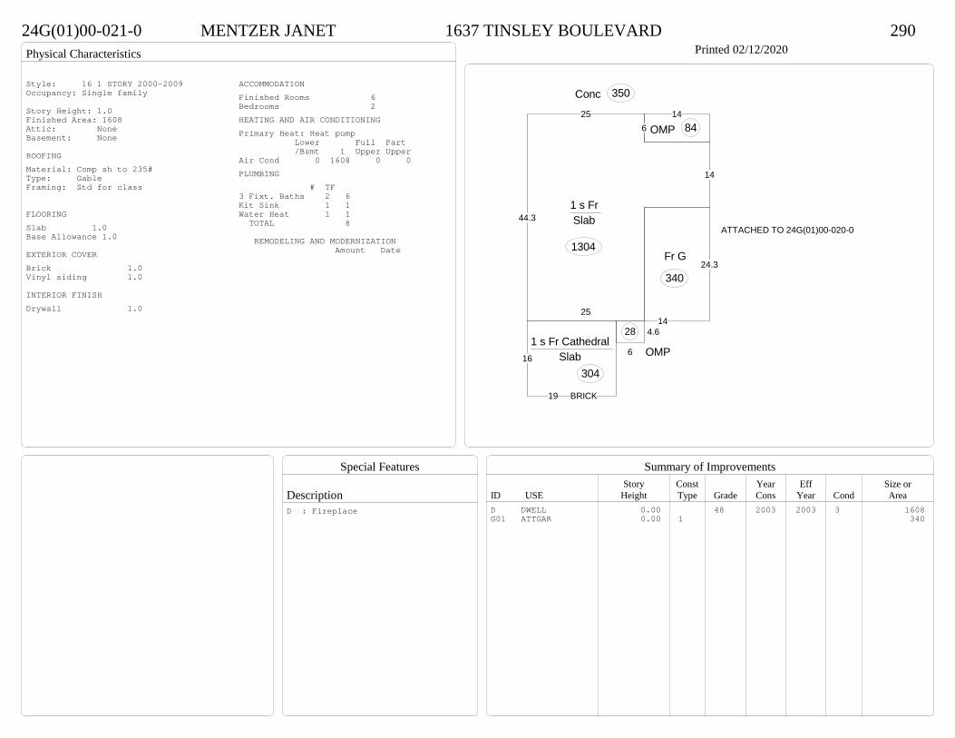
Physical Characteristics
Special Features
Description
Summary of ImprovementsStory Const Year Eff Size or
ID USE Height Type Grade Cons Year Cond Area
24G(01)00-021-0 MENTZER JANET 1637 TINSLEY BOULEVARD 290Printed 02/12/2020
16
19
1 s Fr Cathedral Slab
304
25
14
625
44.31 s Fr Slab
1304
4.6
6 OMP
28
14
OMP 84
Conc 350
24.3
14
Fr G
340
ATTACHED TO 24G(01)00-020-0
BRICK
Style: 16 1 STORY 2000-2009Occupancy: Single family
Story Height: 1.0Finished Area: 1608 Attic: NoneBasement: None
ROOFINGMaterial: Comp sh to 235#Type: GableFraming: Std for class
FLOORINGSlab 1.0Base Allowance 1.0
EXTERIOR COVERBrick 1.0Vinyl siding 1.0
INTERIOR FINISHDrywall 1.0
ACCOMMODATIONFinished Rooms 6Bedrooms 2HEATING AND AIR CONDITIONINGPrimary Heat: Heat pump Lower Full Part /Bsmt 1 Upper UpperAir Cond 0 1608 0 0PLUMBING # TF3 Fixt. Baths 2 6Kit Sink 1 1Water Heat 1 1 TOTAL 8
REMODELING AND MODERNIZATION Amount Date
D DWELL 0.00 48 2003 2003 3 1608G01 ATTGAR 0.00 1 340
D : Fireplace
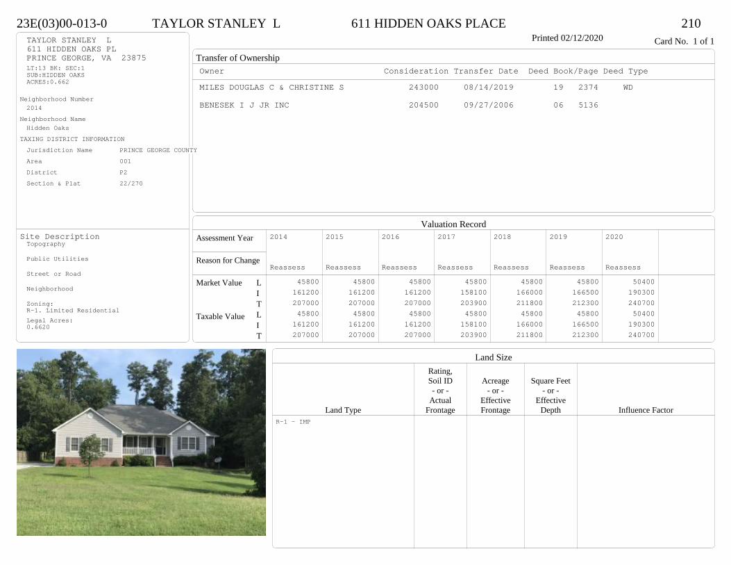
Transfer of Ownership
Valuation RecordAssessment Year
Reason for Change
Market Value
Taxable Value
LITLIT
Land SizeRating,Soil ID Acreage Square Feet- or - - or - - or -
Actual Effective EffectiveLand Type Frontage Frontage Depth Influence Factor
23E(03)00-013-0 TAYLOR STANLEY L 611 HIDDEN OAKS PLACE 210Printed 02/12/2020 Card No. 1 of 1TAYLOR STANLEY L
611 HIDDEN OAKS PLPRINCE GEORGE, VA 23875LT:13 BK: SEC:1SUB:HIDDEN OAKSACRES:0.662
Neighborhood Number2014
Neighborhood NameHidden Oaks
TAXING DISTRICT INFORMATIONJurisdiction Name PRINCE GEORGE COUNTYArea 001 District P2 Section & Plat 22/270
Site DescriptionTopography
Public Utilities
Street or Road
Neighborhood
Zoning:R-1. Limited ResidentialLegal Acres:0.6620
Owner Consideration Transfer Date Deed Book/Page Deed TypeMILES DOUGLAS C & CHRISTINE S 243000 08/14/2019 19 2374 WD
BENESEK I J JR INC 204500 09/27/2006 06 5136
2014
Reassess 45800 161200 207000 45800 161200 207000
2015
Reassess 45800 161200 207000 45800 161200 207000
2016
Reassess 45800 161200 207000 45800 161200 207000
2017
Reassess 45800 158100 203900 45800 158100 203900
2018
Reassess 45800 166000 211800 45800 166000 211800
2019
Reassess 45800 166500 212300 45800 166500 212300
2020
Reassess 50400 190300 240700 50400 190300 240700
R-1 - IMP

Physical Characteristics
Special Features
Description
Summary of ImprovementsStory Const Year Eff Size or
ID USE Height Type Grade Cons Year Cond Area
23E(03)00-013-0 TAYLOR STANLEY L 611 HIDDEN OAKS PLACE 210Printed 02/12/2020
31.3
186
12
13
10.5
15
28
18.32.3 3.7
14.8
18
7
135.7
5
1 s Fr C
1639
6 OMP 108
OMP-s 72
24
22
26.3Fr G
537
Style: 16 1 STORY 2000-2009Occupancy: Single family
Story Height: 1.0Finished Area: 1639 Attic: NoneBasement: None
ROOFINGMaterial: Comp sh to 235#Type: HipFraming: Std for class
FLOORINGSub and joists 1.0Base Allowance 1.0
EXTERIOR COVERVinyl siding 1.0
INTERIOR FINISHDrywall 1.0
ACCOMMODATIONFinished Rooms 6Bedrooms 4HEATING AND AIR CONDITIONINGPrimary Heat: Heat pump Lower Full Part /Bsmt 1 Upper UpperAir Cond 0 1639 0 0PLUMBING # TF4 Fixt. Baths 1 43 Fixt. Baths 1 3Kit Sink 1 1Water Heat 1 1Extra Fixt 1 TOTAL 10
REMODELING AND MODERNIZATION Amount Date
D DWELL 0.00 48 2006 2006 3 1639G01 ATTGAR 0.00 1 537
D : Fireplace

Transfer of Ownership
Valuation RecordAssessment Year
Reason for Change
Market Value
Taxable Value
LITLIT
Land SizeRating,Soil ID Acreage Square Feet- or - - or - - or -
Actual Effective EffectiveLand Type Frontage Frontage Depth Influence Factor
13J(02)00-045-0 MOORE DAPHNE I 7548 ROLLING HILL RD 210Printed 02/12/2020 Card No. 1 of 1MOORE DAPHNE I
7548 ROLLING HILL RDNORTH PRINCE GEORGE, VA 23860LT:45 BK: SEC:2SUB:THE MEADOWSACRES:.396
Neighborhood Number2015
Neighborhood NameThe Meadows
TAXING DISTRICT INFORMATIONJurisdiction Name PRINCE GEORGE COUNTYArea 001 District P2 Section & Plat 24/177
Site DescriptionTopography
Public Utilities
Street or Road
Neighborhood
Zoning:R-2, General ResidentialLegal Acres:0.3960
Owner Consideration Transfer Date Deed Book/Page Deed TypeHAWKINS ELLA & YOLANDA HAWKINS 288000 03/26/2019 19 784 WD
NVR INC 265120 11/25/2014 14 4036 SW
FIRST CAPITAL BANK 36500 08/20/2014 14 3064 SW
DICKENS CREEK SITEWORKS LLC 0 10/11/2013 13 6601 SW
2014
Sup 1 48600 246600 295200 48600 246600 295200
2015
Reassess 48600 246600 295200 48600 246600 295200
2016
Reassess 48600 246600 295200 48600 246600 295200
2017
Reassess 48600 249400 298000 48600 249400 298000
2018
Reassess 48600 249400 298000 48600 249400 298000
2019
Reassess 48600 263000 311600 48600 263000 311600
2020
Reassess 53500 281300 334800 53500 281300 334800
R-2 - IMP
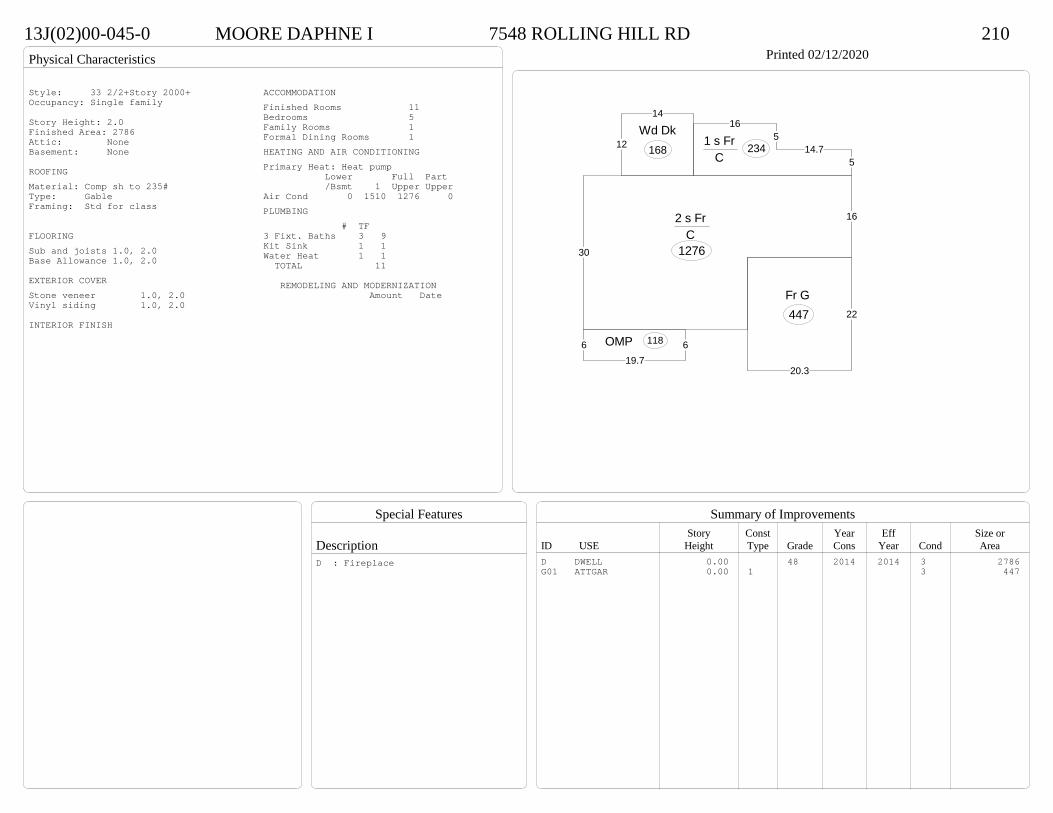
Physical Characteristics
Special Features
Description
Summary of ImprovementsStory Const Year Eff Size or
ID USE Height Type Grade Cons Year Cond Area
13J(02)00-045-0 MOORE DAPHNE I 7548 ROLLING HILL RD 210Printed 02/12/2020
30
162 s Fr C
1276
165
14.75
1 s Fr C
234
619.7
6 OMP 118
12
14
Wd Dk168
22
20.3
Fr G 447
Style: 33 2/2+Story 2000+Occupancy: Single family
Story Height: 2.0Finished Area: 2786 Attic: NoneBasement: None
ROOFINGMaterial: Comp sh to 235#Type: GableFraming: Std for class
FLOORINGSub and joists 1.0, 2.0Base Allowance 1.0, 2.0
EXTERIOR COVERStone veneer 1.0, 2.0Vinyl siding 1.0, 2.0
INTERIOR FINISH
ACCOMMODATIONFinished Rooms 11Bedrooms 5Family Rooms 1Formal Dining Rooms 1HEATING AND AIR CONDITIONINGPrimary Heat: Heat pump Lower Full Part /Bsmt 1 Upper UpperAir Cond 0 1510 1276 0PLUMBING # TF3 Fixt. Baths 3 9Kit Sink 1 1Water Heat 1 1 TOTAL 11
REMODELING AND MODERNIZATION Amount Date
D DWELL 0.00 48 2014 2014 3 2786G01 ATTGAR 0.00 1 3 447
D : Fireplace

Transfer of Ownership
Valuation RecordAssessment Year
Reason for Change
Market Value
Taxable Value
LITLIT
Land SizeRating,Soil ID Acreage Square Feet- or - - or - - or -
Actual Effective EffectiveLand Type Frontage Frontage Depth Influence Factor
13J(02)00-041-0 CROPPER CALVIN T & ERLEDINA P 7522 ROLLING HILL RD 210Printed 02/12/2020 Card No. 1 of 1CROPPER CALVIN T & ERLEDINA P
7522 ROLLING HILL RDNORTH PRINCE GEORGE, VA 23860LT:41 BK: SEC:2SUB:THE MEADOWSACRES:.999
Neighborhood Number2015
Neighborhood NameThe Meadows
TAXING DISTRICT INFORMATIONJurisdiction Name PRINCE GEORGE COUNTYArea 001 District P2 Section & Plat 24/177
Site DescriptionTopography
Public Utilities
Street or Road
Neighborhood
Zoning:R-E, Residential EstateLegal Acres:0.9990
Owner Consideration Transfer Date Deed Book/Page Deed TypeCROCKETT RICHARD L JR & ASHLEE M 322900 08/26/2019 19 2515 WD
NVR INC 285155 01/05/2015 15 12 SW
FIRST CAPITAL BANK 36500 10/08/2014 14 3537 SW
DICKENS CREEK SITEWORKS LLC 0 10/11/2013 13 6601 SW
2015
Reassess 45300 225000 270300 45300 225000 270300
2015
Admin Change 45300 232000 277300 45300 232000 277300
2016
Reassess 45300 232000 277300 45300 232000 277300
2017
Reassess 45300 234600 279900 45300 234600 279900
2018
Reassess 45300 234600 279900 45300 234600 279900
2019
Reassess 45300 247200 292500 45300 247200 292500
2020
Reassess 49800 266600 316400 49800 266600 316400
R-E - IMP
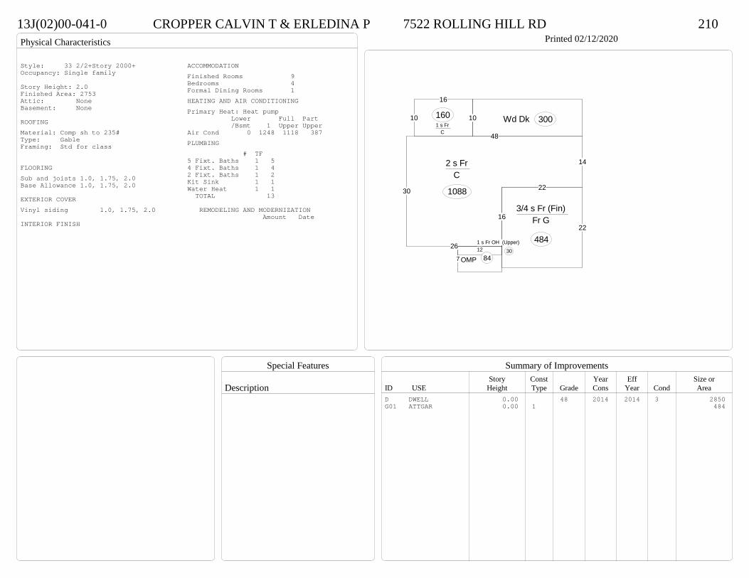
Physical Characteristics
Special Features
Description
Summary of ImprovementsStory Const Year Eff Size or
ID USE Height Type Grade Cons Year Cond Area
13J(02)00-041-0 CROPPER CALVIN T & ERLEDINA P 7522 ROLLING HILL RD 210Printed 02/12/2020
30
26
16
22
14
48
2 s Fr C
1088
10
16
1 s Fr C
160
12
7 OMP 84
1 s Fr OH (Upper)30
10 Wd Dk 300
22
3/4 s Fr (Fin) Fr G
484
Style: 33 2/2+Story 2000+Occupancy: Single family
Story Height: 2.0Finished Area: 2753 Attic: NoneBasement: None
ROOFINGMaterial: Comp sh to 235#Type: GableFraming: Std for class
FLOORINGSub and joists 1.0, 1.75, 2.0Base Allowance 1.0, 1.75, 2.0
EXTERIOR COVERVinyl siding 1.0, 1.75, 2.0
INTERIOR FINISH
ACCOMMODATIONFinished Rooms 9Bedrooms 4Formal Dining Rooms 1HEATING AND AIR CONDITIONINGPrimary Heat: Heat pump Lower Full Part /Bsmt 1 Upper UpperAir Cond 0 1248 1118 387PLUMBING # TF5 Fixt. Baths 1 54 Fixt. Baths 1 42 Fixt. Baths 1 2Kit Sink 1 1Water Heat 1 1 TOTAL 13
REMODELING AND MODERNIZATION Amount Date
D DWELL 0.00 48 2014 2014 3 2850G01 ATTGAR 0.00 1 484
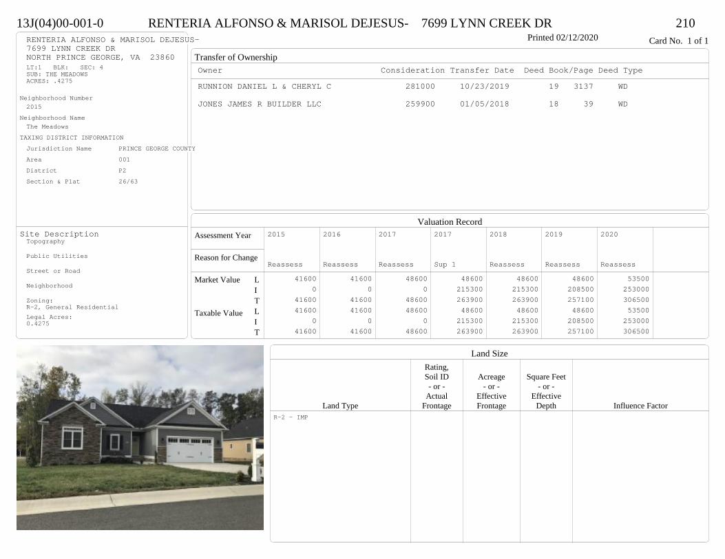
Transfer of Ownership
Valuation RecordAssessment Year
Reason for Change
Market Value
Taxable Value
LITLIT
Land SizeRating,Soil ID Acreage Square Feet- or - - or - - or -
Actual Effective EffectiveLand Type Frontage Frontage Depth Influence Factor
13J(04)00-001-0 RENTERIA ALFONSO & MARISOL DEJESUS- 7699 LYNN CREEK DR 210Printed 02/12/2020 Card No. 1 of 1RENTERIA ALFONSO & MARISOL DEJESUS-
7699 LYNN CREEK DRNORTH PRINCE GEORGE, VA 23860LT:1 BLK: SEC: 4SUB: THE MEADOWSACRES: .4275
Neighborhood Number2015
Neighborhood NameThe Meadows
TAXING DISTRICT INFORMATIONJurisdiction Name PRINCE GEORGE COUNTYArea 001 District P2 Section & Plat 26/63
Site DescriptionTopography
Public Utilities
Street or Road
Neighborhood
Zoning:R-2, General ResidentialLegal Acres:0.4275
Owner Consideration Transfer Date Deed Book/Page Deed TypeRUNNION DANIEL L & CHERYL C 281000 10/23/2019 19 3137 WD
JONES JAMES R BUILDER LLC 259900 01/05/2018 18 39 WD
2015
Reassess 41600 0 41600 41600 0 41600
2016
Reassess 41600 0 41600 41600 0 41600
2017
Reassess 48600 0 48600 48600 0 48600
2017
Sup 1 48600 215300 263900 48600 215300 263900
2018
Reassess 48600 215300 263900 48600 215300 263900
2019
Reassess 48600 208500 257100 48600 208500 257100
2020
Reassess 53500 253000 306500 53500 253000 306500
R-2 - IMP
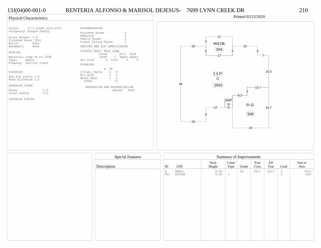
Physical Characteristics
Special Features
Description
Summary of ImprovementsStory Const Year Eff Size or
ID USE Height Type Grade Cons Year Cond Area
13J(04)00-001-0 RENTERIA ALFONSO & MARISOL DEJESUS- 7699 LYNN CREEK DR 210Printed 02/12/2020
12
9
16
48
166
176
166
7
20.3
13.75
9.3
1 s Fr C
1910
617
Wd Dk204
5
OMP28
9.35
13.7
25.7
23
Fr G
545
Style: 17 1 STORY 2010-2019Occupancy: Single family
Story Height: 1.0Finished Area: 1910 Attic: NoneBasement: None
ROOFINGMaterial: Comp sh to 235#Type: GableFraming: Std for class
FLOORINGSub and joists 1.0Base Allowance 1.0
EXTERIOR COVERStone 1.0Vinyl siding 1.0
INTERIOR FINISH
ACCOMMODATIONFinished Rooms 6Bedrooms 3Family Rooms 1Formal Dining Rooms 1HEATING AND AIR CONDITIONINGPrimary Heat: Heat pump Lower Full Part /Bsmt 1 Upper UpperAir Cond 0 1910 0 0PLUMBING # TF4 Fixt. Baths 2 8Kit Sink 1 1Water Heat 1 1 TOTAL 10
REMODELING AND MODERNIZATION Amount Date
D DWELL 0.00 55 2017 2017 3 1910G01 ATTGAR 0.00 1 3 545

Transfer of Ownership
Valuation RecordAssessment Year
Reason for Change
Market Value
Taxable Value
LITLIT
Land SizeRating,Soil ID Acreage Square Feet- or - - or - - or -
Actual Effective EffectiveLand Type Frontage Frontage Depth Influence Factor
13J(04)00-022-0 WORDLAW ELWYNE Q 7760 LYNN CREEK DR 210Printed 02/12/2020 Card No. 1 of 1WORDLAW ELWYNE Q
7760 LYNN CREEK DRNORTH PRINCE GEORGE, VA 23860LT22 BLK: SEC: 4SUB: THE MEADOWSACRES: .3099
Neighborhood Number2015
Neighborhood NameThe Meadows
TAXING DISTRICT INFORMATIONJurisdiction Name PRINCE GEORGE COUNTYArea 001 District P2 Section & Plat 26/63
Site DescriptionTopography
Public Utilities
Street or Road
Neighborhood
Zoning:R-2, General ResidentialLegal Acres:0.3099
Owner Consideration Transfer Date Deed Book/Page Deed TypeAGUILAR DANIEL A FLORES & 279900 10/04/2019 19 2956 WD
FLORES WENDY L SANTIAGO-JONES JAMES R BUILDER LLC 250900 04/27/2018 18 1262 WD
2016
Reassess 41600 0 41600 41600 0 41600
2017
Reassess 41600 0 41600 41600 0 41600
2017
Sup 1 48600 183700 232300 48600 183700 232300
2018
Reassess 48600 0 48600 48600 0 48600
2018
Admin Change 48600 183700 232300 48600 183700 232300
2019
Reassess 48600 194000 242600 48600 194000 242600
2020
Reassess 53500 224900 278400 53500 224900 278400
R-2 - IMP
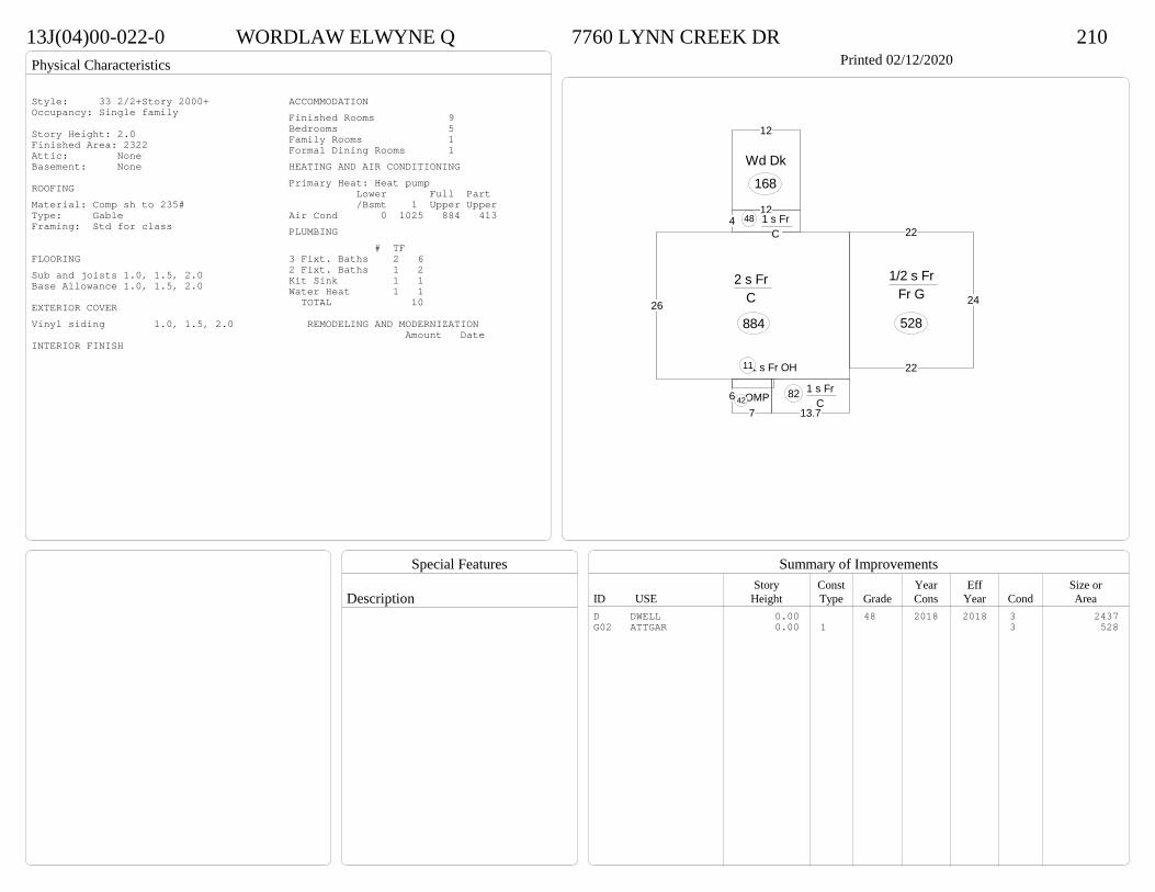
Physical Characteristics
Special Features
Description
Summary of ImprovementsStory Const Year Eff Size or
ID USE Height Type Grade Cons Year Cond Area
13J(04)00-022-0 WORDLAW ELWYNE Q 7760 LYNN CREEK DR 210Printed 02/12/2020
26
2 s Fr C
884
4121 s Fr
C 48
13.7
1 s Fr C
82
1 s Fr OH 11
67
OMP42
12
Wd Dk
168
22
24
22
1/2 s Fr Fr G
528
Style: 33 2/2+Story 2000+Occupancy: Single family
Story Height: 2.0Finished Area: 2322 Attic: NoneBasement: None
ROOFINGMaterial: Comp sh to 235#Type: GableFraming: Std for class
FLOORINGSub and joists 1.0, 1.5, 2.0Base Allowance 1.0, 1.5, 2.0
EXTERIOR COVERVinyl siding 1.0, 1.5, 2.0
INTERIOR FINISH
ACCOMMODATIONFinished Rooms 9Bedrooms 5Family Rooms 1Formal Dining Rooms 1HEATING AND AIR CONDITIONINGPrimary Heat: Heat pump Lower Full Part /Bsmt 1 Upper UpperAir Cond 0 1025 884 413PLUMBING # TF3 Fixt. Baths 2 62 Fixt. Baths 1 2Kit Sink 1 1Water Heat 1 1 TOTAL 10
REMODELING AND MODERNIZATION Amount Date
D DWELL 0.00 48 2018 2018 3 2437G02 ATTGAR 0.00 1 3 528
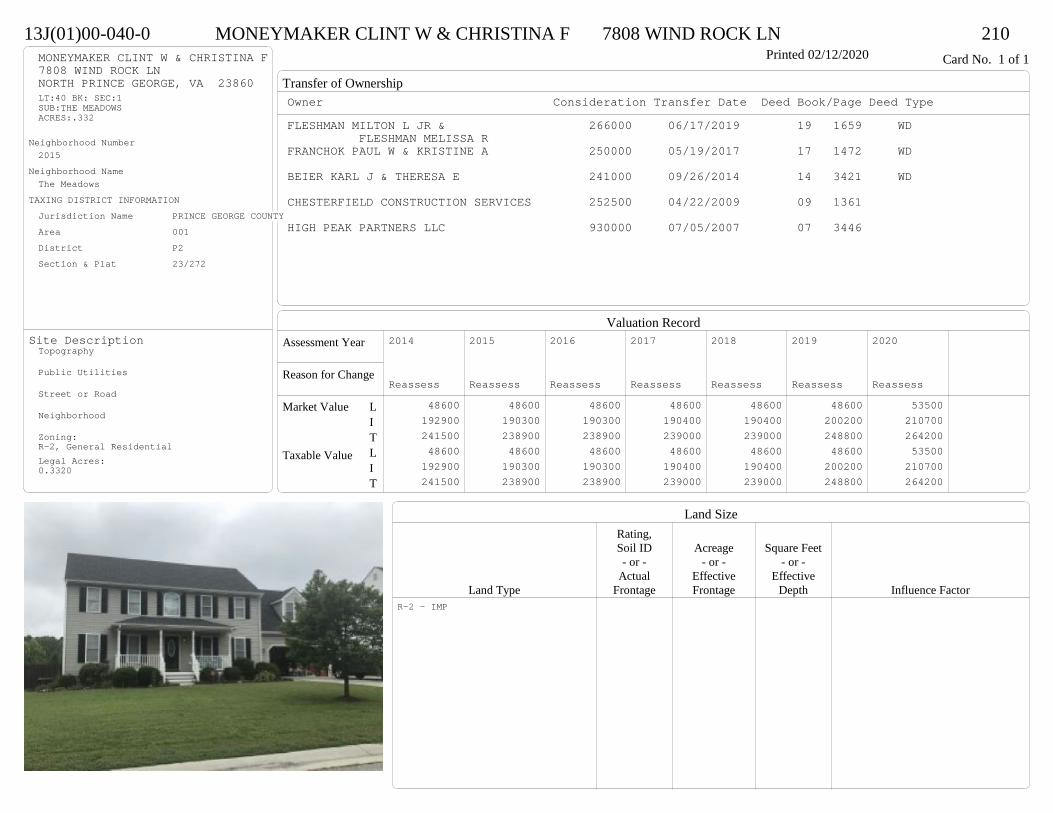
Transfer of Ownership
Valuation RecordAssessment Year
Reason for Change
Market Value
Taxable Value
LITLIT
Land SizeRating,Soil ID Acreage Square Feet- or - - or - - or -
Actual Effective EffectiveLand Type Frontage Frontage Depth Influence Factor
13J(01)00-040-0 MONEYMAKER CLINT W & CHRISTINA F 7808 WIND ROCK LN 210Printed 02/12/2020 Card No. 1 of 1MONEYMAKER CLINT W & CHRISTINA F
7808 WIND ROCK LNNORTH PRINCE GEORGE, VA 23860LT:40 BK: SEC:1SUB:THE MEADOWSACRES:.332
Neighborhood Number2015
Neighborhood NameThe Meadows
TAXING DISTRICT INFORMATIONJurisdiction Name PRINCE GEORGE COUNTYArea 001 District P2 Section & Plat 23/272
Site DescriptionTopography
Public Utilities
Street or Road
Neighborhood
Zoning:R-2, General ResidentialLegal Acres:0.3320
Owner Consideration Transfer Date Deed Book/Page Deed TypeFLESHMAN MILTON L JR & 266000 06/17/2019 19 1659 WD
FLESHMAN MELISSA RFRANCHOK PAUL W & KRISTINE A 250000 05/19/2017 17 1472 WD
BEIER KARL J & THERESA E 241000 09/26/2014 14 3421 WD
CHESTERFIELD CONSTRUCTION SERVICES 252500 04/22/2009 09 1361
HIGH PEAK PARTNERS LLC 930000 07/05/2007 07 3446
2014
Reassess 48600 192900 241500 48600 192900 241500
2015
Reassess 48600 190300 238900 48600 190300 238900
2016
Reassess 48600 190300 238900 48600 190300 238900
2017
Reassess 48600 190400 239000 48600 190400 239000
2018
Reassess 48600 190400 239000 48600 190400 239000
2019
Reassess 48600 200200 248800 48600 200200 248800
2020
Reassess 53500 210700 264200 53500 210700 264200
R-2 - IMP
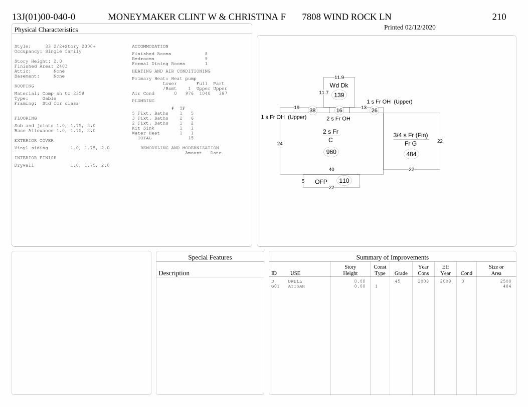
Physical Characteristics
Special Features
Description
Summary of ImprovementsStory Const Year Eff Size or
ID USE Height Type Grade Cons Year Cond Area
13J(01)00-040-0 MONEYMAKER CLINT W & CHRISTINA F 7808 WIND ROCK LN 210Printed 02/12/2020
40
24
2 s Fr C
960
19
1 s Fr OH (Upper)38
522
OFP 110
2 s Fr OH 16 13
1 s Fr OH (Upper)26
11.7
11.9
Wd Dk139
22
223/4 s Fr (Fin)
Fr G
484
Style: 33 2/2+Story 2000+Occupancy: Single family
Story Height: 2.0Finished Area: 2403 Attic: NoneBasement: None
ROOFINGMaterial: Comp sh to 235#Type: GableFraming: Std for class
FLOORINGSub and joists 1.0, 1.75, 2.0Base Allowance 1.0, 1.75, 2.0
EXTERIOR COVERVinyl siding 1.0, 1.75, 2.0
INTERIOR FINISHDrywall 1.0, 1.75, 2.0
ACCOMMODATIONFinished Rooms 8Bedrooms 5Formal Dining Rooms 1HEATING AND AIR CONDITIONINGPrimary Heat: Heat pump Lower Full Part /Bsmt 1 Upper UpperAir Cond 0 976 1040 387PLUMBING # TF5 Fixt. Baths 1 53 Fixt. Baths 2 62 Fixt. Baths 1 2Kit Sink 1 1Water Heat 1 1 TOTAL 15
REMODELING AND MODERNIZATION Amount Date
D DWELL 0.00 45 2008 2008 3 2500G01 ATTGAR 0.00 1 484

Transfer of Ownership
Valuation RecordAssessment Year
Reason for Change
Market Value
Taxable Value
LITLIT
Land SizeRating,Soil ID Acreage Square Feet- or - - or - - or -
Actual Effective EffectiveLand Type Frontage Frontage Depth Influence Factor
13J(01)00-010-0 SEMELI SIO MAFATINI JR 7755 ROLLING HILL RD 210Printed 02/12/2020 Card No. 1 of 1SEMELI SIO MAFATINI JR
7755 ROLLING HILL RDNORTH PRINCE GEORGE, VA 23860LT:10 BK: SEC:1SUB:THE MEADOWSACRES:.493
Neighborhood Number2015
Neighborhood NameThe Meadows
TAXING DISTRICT INFORMATIONJurisdiction Name PRINCE GEORGE COUNTYArea 001 District P2 Section & Plat 23/272
Site DescriptionTopography
Public Utilities
Street or Road
Neighborhood
Zoning:R-2, General ResidentialLegal Acres:0.4930
Owner Consideration Transfer Date Deed Book/Page Deed TypeMCBEE MICHAEL & JOLEEN 250000 01/25/2019 19 231 WD
VIRGINIA HOUSING DEV AUTHORITY 201000 03/04/2015 15 620 SW
JAGERS JEREMIAH P & CARRIE L 199750 02/09/2015 15 369 SW
CHESTERFIELD CONSTRUCTION SERVICES I 242560 08/22/2007 07 4330
HIGH PEAK PARTNERS LLC 300000 12/06/2006 06 6423
2015
Reassess 48600 162700 211300 48600 162700 211300
2016
Reassess 48600 168000 216600 48600 168000 216600
2017
Reassess 48600 169900 218500 48600 169900 218500
2018
Reassess 48600 169900 218500 48600 169900 218500
2019
Reassess 48600 178600 227200 48600 178600 227200
2019
Admin Change 48600 195100 243700 48600 195100 243700
2020
Reassess 53500 204200 257700 53500 204200 257700
R-2 - IMP
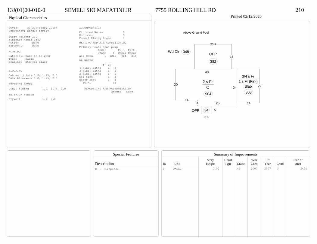
Physical Characteristics
Special Features
Description
Summary of ImprovementsStory Const Year Eff Size or
ID USE Height Type Grade Cons Year Cond Area
13J(01)00-010-0 SEMELI SIO MAFATINI JR 7755 ROLLING HILL RD 210Printed 02/12/2020
20
144 26
24
40
2 s Fr C
904
6.8
5OFP 34
16
23.9
OFP
382
Wd Dk 348
14
22
3/4 s Fr 1 s Fr (Fin-)
Slab 308
Above Ground Pool
Style: 33 2/2+Story 2000+Occupancy: Single family
Story Height: 2.0Finished Area: 2362 Attic: NoneBasement: None
ROOFINGMaterial: Comp sh to 235#Type: GableFraming: Std for class
FLOORINGSub and joists 1.0, 1.75, 2.0Base Allowance 1.0, 1.75, 2.0
EXTERIOR COVERVinyl siding 1.0, 1.75, 2.0
INTERIOR FINISHDrywall 1.0, 2.0
ACCOMMODATIONFinished Rooms 9Bedrooms 5Formal Dining Rooms 1HEATING AND AIR CONDITIONINGPrimary Heat: Heat pump Lower Full Part /Bsmt 1 Upper UpperAir Cond 0 1212 904 246PLUMBING # TF4 Fixt. Baths 1 43 Fixt. Baths 1 32 Fixt. Baths 1 2Kit Sink 1 1Water Heat 1 1 TOTAL 11
REMODELING AND MODERNIZATION Amount Date
D DWELL 0.00 45 2007 2007 3 2424D : Fireplace
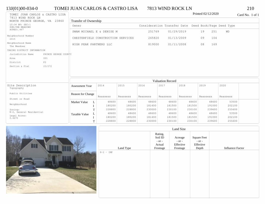
Transfer of Ownership
Valuation RecordAssessment Year
Reason for Change
Market Value
Taxable Value
LITLIT
Land SizeRating,Soil ID Acreage Square Feet- or - - or - - or -
Actual Effective EffectiveLand Type Frontage Frontage Depth Influence Factor
13J(01)00-034-0 TOMEI JUAN CARLOS & CASTRO LISA 7813 WIND ROCK LN 210Printed 02/12/2020 Card No. 1 of 1TOMEI JUAN CARLOS & CASTRO LISA
7813 WIND ROCK LNNORTH PRINCE GEORGE, VA 23860LT:34 BK: SEC:1SUB:THE MEADOWSACRES:.467
Neighborhood Number2015
Neighborhood NameThe Meadows
TAXING DISTRICT INFORMATIONJurisdiction Name PRINCE GEORGE COUNTYArea 001 District P2 Section & Plat 23/272
Site DescriptionTopography
Public Utilities
Street or Road
Neighborhood
Zoning:R-2, General ResidentialLegal Acres:0.4670
Owner Consideration Transfer Date Deed Book/Page Deed TypeSWAM MICHAEL E & DENISE M 251769 01/29/2019 19 251 WD
CHESTERFIELD CONSTRUCTION SERVICES 265820 01/13/2009 09 104
HIGH PEAK PARTNERS LLC 819000 01/11/2008 08 169
2014
Reassess 48600 180200 228800 48600 180200 228800
2015
Reassess 48600 180200 228800 48600 180200 228800
2016
Reassess 48600 181400 230000 48600 181400 230000
2017
Reassess 48600 181500 230100 48600 181500 230100
2018
Reassess 48600 181500 230100 48600 181500 230100
2019
Reassess 48600 191000 239600 48600 191000 239600
2020
Reassess 53500 202100 255600 53500 202100 255600
R-2 - IMP

Physical Characteristics
Special Features
Description
Summary of ImprovementsStory Const Year Eff Size or
ID USE Height Type Grade Cons Year Cond Area
13J(01)00-034-0 TOMEI JUAN CARLOS & CASTRO LISA 7813 WIND ROCK LN 210Printed 02/12/2020
30
23.7
17.7
12.3
44
2 s Fr C
961
1 s Fr OH (Upper)24
412
OFP48
12
14
Wd Dk168
20
16Conc
320
20.3
21.7
3/4 s Fr (Fin) Fr G
441
Style: 33 2/2+Story 2000+Occupancy: Single family
Story Height: 2.0Finished Area: 2264 Attic: NoneBasement: None
ROOFINGMaterial: Comp sh to 235#Type: GableFraming: Std for class
FLOORINGSub and joists 1.0, 1.75, 2.0Base Allowance 1.0, 1.75, 2.0
EXTERIOR COVERVinyl siding 1.0, 1.75, 2.0
INTERIOR FINISHDrywall 1.0, 1.75, 2.0
ACCOMMODATIONFinished Rooms 7Bedrooms 4Formal Dining Rooms 1HEATING AND AIR CONDITIONINGPrimary Heat: Heat pump Lower Full Part /Bsmt 1 Upper UpperAir Cond 0 961 985 318PLUMBING # TF5 Fixt. Baths 1 53 Fixt. Baths 1 32 Fixt. Baths 1 2Kit Sink 1 1Water Heat 1 1 TOTAL 12
REMODELING AND MODERNIZATION Amount Date
D DWELL 0.00 45 2008 2008 3 2387G01 ATTGAR 0.00 1 441
D : Fireplace
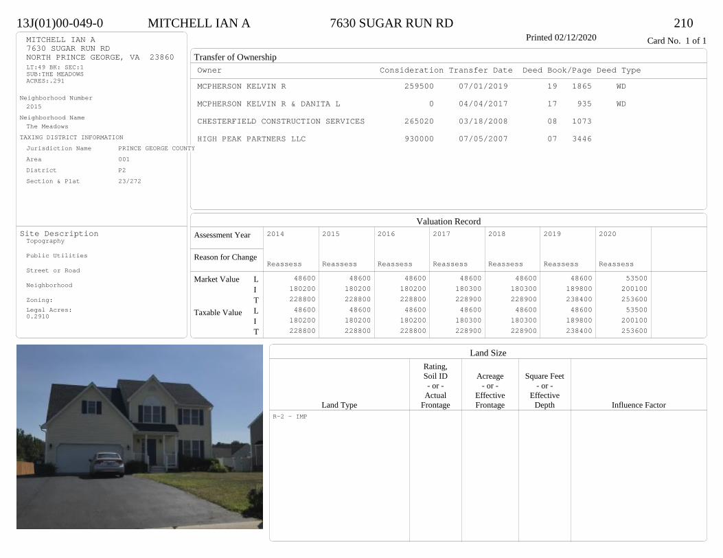
Transfer of Ownership
Valuation RecordAssessment Year
Reason for Change
Market Value
Taxable Value
LITLIT
Land SizeRating,Soil ID Acreage Square Feet- or - - or - - or -
Actual Effective EffectiveLand Type Frontage Frontage Depth Influence Factor
13J(01)00-049-0 MITCHELL IAN A 7630 SUGAR RUN RD 210Printed 02/12/2020 Card No. 1 of 1MITCHELL IAN A
7630 SUGAR RUN RDNORTH PRINCE GEORGE, VA 23860LT:49 BK: SEC:1SUB:THE MEADOWSACRES:.291
Neighborhood Number2015
Neighborhood NameThe Meadows
TAXING DISTRICT INFORMATIONJurisdiction Name PRINCE GEORGE COUNTYArea 001 District P2 Section & Plat 23/272
Site DescriptionTopography
Public Utilities
Street or Road
Neighborhood
Zoning:Legal Acres:0.2910
Owner Consideration Transfer Date Deed Book/Page Deed TypeMCPHERSON KELVIN R 259500 07/01/2019 19 1865 WD
MCPHERSON KELVIN R & DANITA L 0 04/04/2017 17 935 WD
CHESTERFIELD CONSTRUCTION SERVICES 265020 03/18/2008 08 1073
HIGH PEAK PARTNERS LLC 930000 07/05/2007 07 3446
2014
Reassess 48600 180200 228800 48600 180200 228800
2015
Reassess 48600 180200 228800 48600 180200 228800
2016
Reassess 48600 180200 228800 48600 180200 228800
2017
Reassess 48600 180300 228900 48600 180300 228900
2018
Reassess 48600 180300 228900 48600 180300 228900
2019
Reassess 48600 189800 238400 48600 189800 238400
2020
Reassess 53500 200100 253600 53500 200100 253600
R-2 - IMP

Physical Characteristics
Special Features
Description
Summary of ImprovementsStory Const Year Eff Size or
ID USE Height Type Grade Cons Year Cond Area
13J(01)00-049-0 MITCHELL IAN A 7630 SUGAR RUN RD 210Printed 02/12/2020
30
23.7
17.7
12.3
44
2 s Fr C
961
1 s Fr OH (Upper)24
412
OFP48
12
13.8
Wd Dk166
20.3
21.7
3/4 s Fr (Fin) Fr G
441
Style: 33 2/2+Story 2000+Occupancy: Single family
Story Height: 2.0Finished Area: 2264 Attic: NoneBasement: None
ROOFINGMaterial: Comp sh to 235#Type: GableFraming: Std for class
FLOORINGSub and joists 1.0, 1.75, 2.0Base Allowance 1.0, 1.75, 2.0
EXTERIOR COVERVinyl siding 1.0, 1.75, 2.0
INTERIOR FINISHDrywall 1.0, 1.75, 2.0
ACCOMMODATIONFinished Rooms 7Bedrooms 4Formal Dining Rooms 1HEATING AND AIR CONDITIONINGPrimary Heat: Heat pump Lower Full Part /Bsmt 1 Upper UpperAir Cond 0 961 985 318PLUMBING # TF4 Fixt. Baths 1 43 Fixt. Baths 1 32 Fixt. Baths 1 2Kit Sink 1 1Water Heat 1 1 TOTAL 11
REMODELING AND MODERNIZATION Amount Date
D DWELL 0.00 45 2008 2008 3 2387G01 ATTGAR 0.00 1 441
D : Fireplace
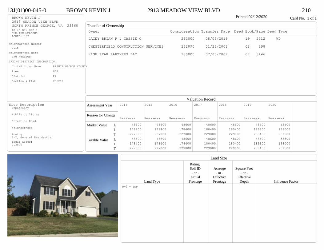
Transfer of Ownership
Valuation RecordAssessment Year
Reason for Change
Market Value
Taxable Value
LITLIT
Land SizeRating,Soil ID Acreage Square Feet- or - - or - - or -
Actual Effective EffectiveLand Type Frontage Frontage Depth Influence Factor
13J(01)00-045-0 BROWN KEVIN J 2913 MEADOW VIEW BLVD 210Printed 02/12/2020 Card No. 1 of 1BROWN KEVIN J
2913 MEADOW VIEW BLVDNORTH PRINCE GEORGE, VA 23860LT:45 BK: SEC:1SUB:THE MEADOWSACRES:.387
Neighborhood Number2015
Neighborhood NameThe Meadows
TAXING DISTRICT INFORMATIONJurisdiction Name PRINCE GEORGE COUNTYArea 001 District P2 Section & Plat 23/272
Site DescriptionTopography
Public Utilities
Street or Road
Neighborhood
Zoning:R-2, General ResidentialLegal Acres:0.3870
Owner Consideration Transfer Date Deed Book/Page Deed TypeLACEY BRIAN P & CASSIE C 263000 08/06/2019 19 2312 WD
CHESTERFIELD CONSTRUCTION SERVICES 262890 01/23/2008 08 298
HIGH PEAK PARTNERS LLC 930000 07/05/2007 07 3446
2014
Reassess 48600 178400 227000 48600 178400 227000
2015
Reassess 48600 178400 227000 48600 178400 227000
2016
Reassess 48600 178400 227000 48600 178400 227000
2017
Reassess 48600 180400 229000 48600 180400 229000
2018
Reassess 48600 180400 229000 48600 180400 229000
2019
Reassess 48600 189800 238400 48600 189800 238400
2020
Reassess 53500 198000 251500 53500 198000 251500
R-2 - IMP
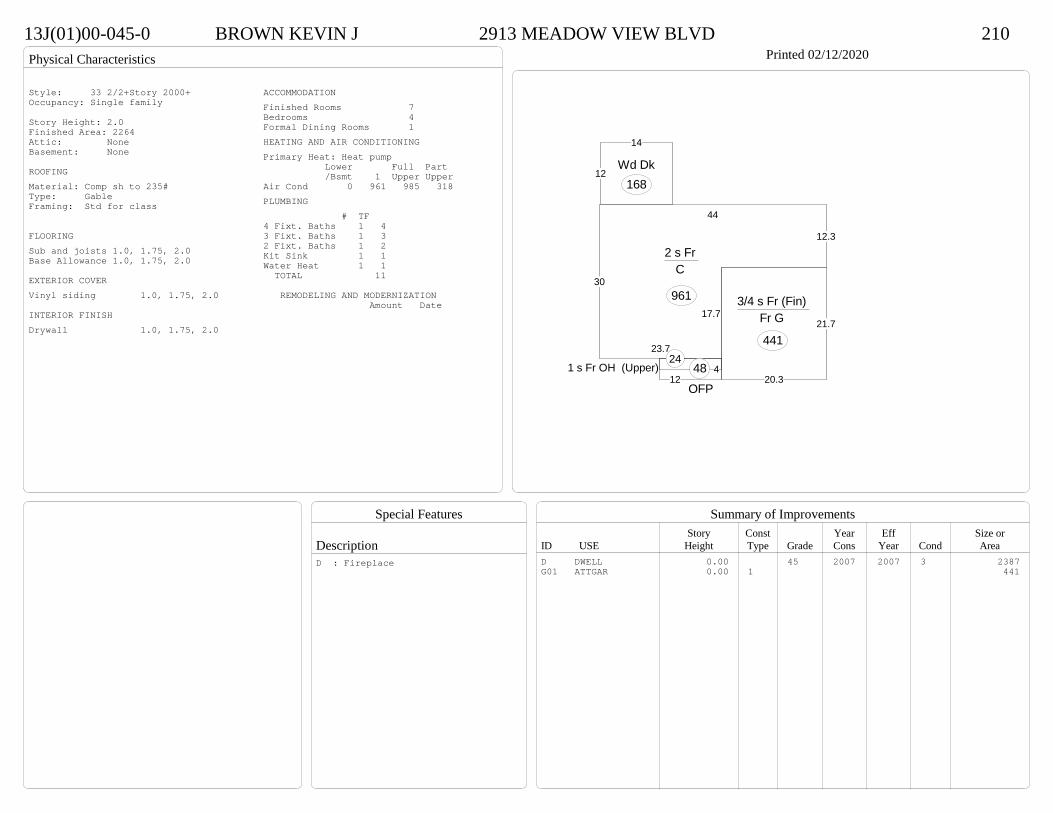
Physical Characteristics
Special Features
Description
Summary of ImprovementsStory Const Year Eff Size or
ID USE Height Type Grade Cons Year Cond Area
13J(01)00-045-0 BROWN KEVIN J 2913 MEADOW VIEW BLVD 210Printed 02/12/2020
30
23.7
17.7
12.3
44
2 s Fr C
961
1 s Fr OH (Upper)24
412
OFP48
12
14
Wd Dk168
20.3
21.7
3/4 s Fr (Fin) Fr G
441
Style: 33 2/2+Story 2000+Occupancy: Single family
Story Height: 2.0Finished Area: 2264 Attic: NoneBasement: None
ROOFINGMaterial: Comp sh to 235#Type: GableFraming: Std for class
FLOORINGSub and joists 1.0, 1.75, 2.0Base Allowance 1.0, 1.75, 2.0
EXTERIOR COVERVinyl siding 1.0, 1.75, 2.0
INTERIOR FINISHDrywall 1.0, 1.75, 2.0
ACCOMMODATIONFinished Rooms 7Bedrooms 4Formal Dining Rooms 1HEATING AND AIR CONDITIONINGPrimary Heat: Heat pump Lower Full Part /Bsmt 1 Upper UpperAir Cond 0 961 985 318PLUMBING # TF4 Fixt. Baths 1 43 Fixt. Baths 1 32 Fixt. Baths 1 2Kit Sink 1 1Water Heat 1 1 TOTAL 11
REMODELING AND MODERNIZATION Amount Date
D DWELL 0.00 45 2007 2007 3 2387G01 ATTGAR 0.00 1 441
D : Fireplace
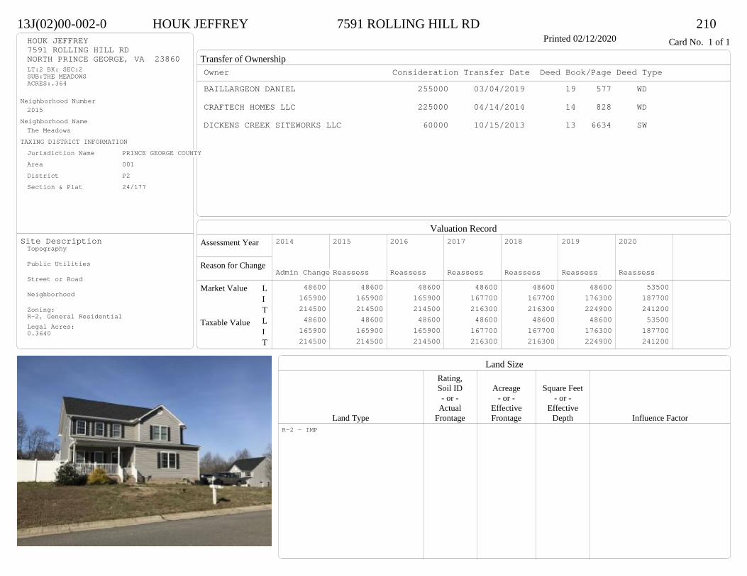
Transfer of Ownership
Valuation RecordAssessment Year
Reason for Change
Market Value
Taxable Value
LITLIT
Land SizeRating,Soil ID Acreage Square Feet- or - - or - - or -
Actual Effective EffectiveLand Type Frontage Frontage Depth Influence Factor
13J(02)00-002-0 HOUK JEFFREY 7591 ROLLING HILL RD 210Printed 02/12/2020 Card No. 1 of 1HOUK JEFFREY
7591 ROLLING HILL RDNORTH PRINCE GEORGE, VA 23860LT:2 BK: SEC:2SUB:THE MEADOWSACRES:.364
Neighborhood Number2015
Neighborhood NameThe Meadows
TAXING DISTRICT INFORMATIONJurisdiction Name PRINCE GEORGE COUNTYArea 001 District P2 Section & Plat 24/177
Site DescriptionTopography
Public Utilities
Street or Road
Neighborhood
Zoning:R-2, General ResidentialLegal Acres:0.3640
Owner Consideration Transfer Date Deed Book/Page Deed TypeBAILLARGEON DANIEL 255000 03/04/2019 19 577 WD
CRAFTECH HOMES LLC 225000 04/14/2014 14 828 WD
DICKENS CREEK SITEWORKS LLC 60000 10/15/2013 13 6634 SW
2014
Admin Change 48600 165900 214500 48600 165900 214500
2015
Reassess 48600 165900 214500 48600 165900 214500
2016
Reassess 48600 165900 214500 48600 165900 214500
2017
Reassess 48600 167700 216300 48600 167700 216300
2018
Reassess 48600 167700 216300 48600 167700 216300
2019
Reassess 48600 176300 224900 48600 176300 224900
2020
Reassess 53500 187700 241200 53500 187700 241200
R-2 - IMP

Physical Characteristics
Special Features
Description
Summary of ImprovementsStory Const Year Eff Size or
ID USE Height Type Grade Cons Year Cond Area
13J(02)00-002-0 HOUK JEFFREY 7591 ROLLING HILL RD 210Printed 02/12/2020
38
30
16.3
12.3
21.7
17.72 s Fr
C
873
21
1/2 s Fr (Fin) Fr G
4568.7 OMP 142
5 1 s Fr OH 14
11.8
12Wd Dk
142
Style: 33 2/2+Story 2000+Occupancy: Single family
Story Height: 2.0Finished Area: 2081 Attic: NoneBasement: None
ROOFINGMaterial: Comp sh to 235#Type: GableFraming: Std for class
FLOORINGSub and joists 1.0, 1.5, 2.0Base Allowance 1.0, 1.5, 2.0
EXTERIOR COVERVinyl siding 1.0, 1.5, 2.0
INTERIOR FINISHDrywall 1.0, 1.5, 2.0
ACCOMMODATIONFinished Rooms 8Bedrooms 4Formal Dining Rooms 1HEATING AND AIR CONDITIONINGPrimary Heat: Heat pump Lower Full Part /Bsmt 1 Upper UpperAir Cond 0 887 873 321PLUMBING # TF4 Fixt. Baths 1 43 Fixt. Baths 1 32 Fixt. Baths 1 2Kit Sink 1 1Water Heat 1 1 TOTAL 11
REMODELING AND MODERNIZATION Amount Date
D DWELL 0.00 45 2014 2014 3 2216G01 ATTGAR 0.00 1 456
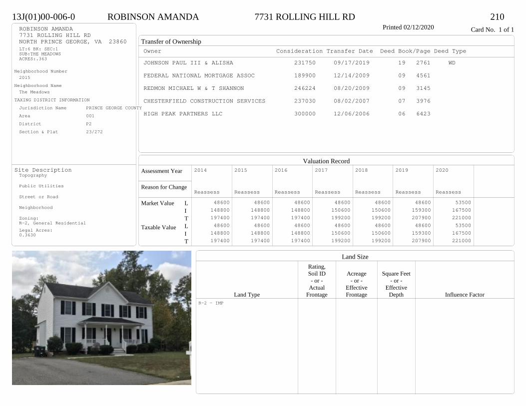
Transfer of Ownership
Valuation RecordAssessment Year
Reason for Change
Market Value
Taxable Value
LITLIT
Land SizeRating,Soil ID Acreage Square Feet- or - - or - - or -
Actual Effective EffectiveLand Type Frontage Frontage Depth Influence Factor
13J(01)00-006-0 ROBINSON AMANDA 7731 ROLLING HILL RD 210Printed 02/12/2020 Card No. 1 of 1ROBINSON AMANDA
7731 ROLLING HILL RDNORTH PRINCE GEORGE, VA 23860LT:6 BK: SEC:1SUB:THE MEADOWSACRES:.363
Neighborhood Number2015
Neighborhood NameThe Meadows
TAXING DISTRICT INFORMATIONJurisdiction Name PRINCE GEORGE COUNTYArea 001 District P2 Section & Plat 23/272
Site DescriptionTopography
Public Utilities
Street or Road
Neighborhood
Zoning:R-2, General ResidentialLegal Acres:0.3630
Owner Consideration Transfer Date Deed Book/Page Deed TypeJOHNSON PAUL III & ALISHA 231750 09/17/2019 19 2761 WD
FEDERAL NATIONAL MORTGAGE ASSOC 189900 12/14/2009 09 4561
REDMON MICHAEL W & T SHANNON 246224 08/20/2009 09 3145
CHESTERFIELD CONSTRUCTION SERVICES 237030 08/02/2007 07 3976
HIGH PEAK PARTNERS LLC 300000 12/06/2006 06 6423
2014
Reassess 48600 148800 197400 48600 148800 197400
2015
Reassess 48600 148800 197400 48600 148800 197400
2016
Reassess 48600 148800 197400 48600 148800 197400
2017
Reassess 48600 150600 199200 48600 150600 199200
2018
Reassess 48600 150600 199200 48600 150600 199200
2019
Reassess 48600 159300 207900 48600 159300 207900
2020
Reassess 53500 167500 221000 53500 167500 221000
R-2 - IMP
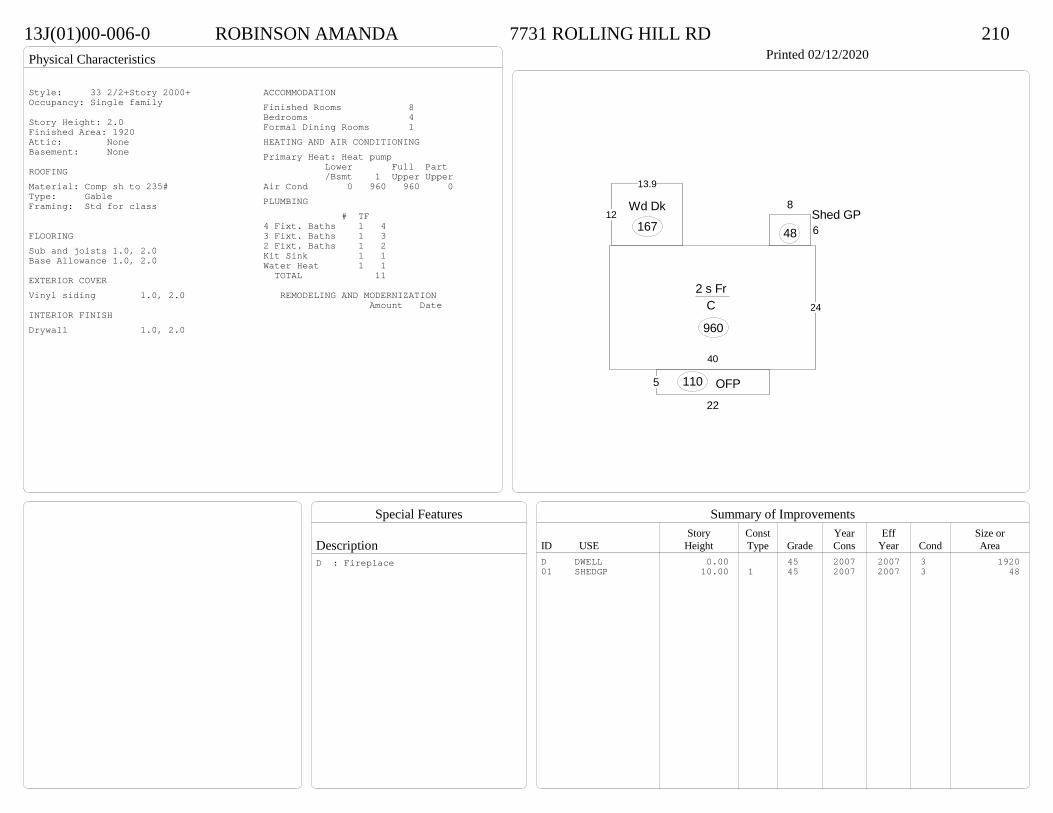
Physical Characteristics
Special Features
Description
Summary of ImprovementsStory Const Year Eff Size or
ID USE Height Type Grade Cons Year Cond Area
13J(01)00-006-0 ROBINSON AMANDA 7731 ROLLING HILL RD 210Printed 02/12/2020
40
24
2 s Fr C
960
22
5 OFP110
12
13.9
Wd Dk167 6
8Shed GP
48
Style: 33 2/2+Story 2000+Occupancy: Single family
Story Height: 2.0Finished Area: 1920 Attic: NoneBasement: None
ROOFINGMaterial: Comp sh to 235#Type: GableFraming: Std for class
FLOORINGSub and joists 1.0, 2.0Base Allowance 1.0, 2.0
EXTERIOR COVERVinyl siding 1.0, 2.0
INTERIOR FINISHDrywall 1.0, 2.0
ACCOMMODATIONFinished Rooms 8Bedrooms 4Formal Dining Rooms 1HEATING AND AIR CONDITIONINGPrimary Heat: Heat pump Lower Full Part /Bsmt 1 Upper UpperAir Cond 0 960 960 0PLUMBING # TF4 Fixt. Baths 1 43 Fixt. Baths 1 32 Fixt. Baths 1 2Kit Sink 1 1Water Heat 1 1 TOTAL 11
REMODELING AND MODERNIZATION Amount Date
D DWELL 0.00 45 2007 2007 3 192001 SHEDGP 10.00 1 45 2007 2007 3 48
D : Fireplace
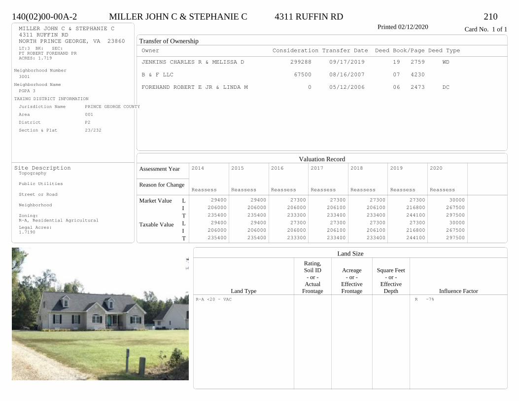
Transfer of Ownership
Valuation RecordAssessment Year
Reason for Change
Market Value
Taxable Value
LITLIT
Land SizeRating,Soil ID Acreage Square Feet- or - - or - - or -
Actual Effective EffectiveLand Type Frontage Frontage Depth Influence Factor
140(02)00-00A-2 MILLER JOHN C & STEPHANIE C 4311 RUFFIN RD 210Printed 02/12/2020 Card No. 1 of 1MILLER JOHN C & STEPHANIE C
4311 RUFFIN RDNORTH PRINCE GEORGE, VA 23860LT:3 BK: SEC:PT ROBERT FOREHAND PRACRES: 1.719
Neighborhood Number3001
Neighborhood NamePGPA 3
TAXING DISTRICT INFORMATIONJurisdiction Name PRINCE GEORGE COUNTYArea 001 District P2 Section & Plat 23/232
Site DescriptionTopography
Public Utilities
Street or Road
Neighborhood
Zoning:R-A, Residential AgriculturalLegal Acres:1.7190
Owner Consideration Transfer Date Deed Book/Page Deed TypeJENKINS CHARLES R & MELISSA D 299288 09/17/2019 19 2759 WD
B & F LLC 67500 08/16/2007 07 4230
FOREHAND ROBERT E JR & LINDA M 0 05/12/2006 06 2473 DC
2014
Reassess 29400 206000 235400 29400 206000 235400
2015
Reassess 29400 206000 235400 29400 206000 235400
2016
Reassess 27300 206000 233300 27300 206000 233300
2017
Reassess 27300 206100 233400 27300 206100 233400
2018
Reassess 27300 206100 233400 27300 206100 233400
2019
Reassess 27300 216800 244100 27300 216800 244100
2020
Reassess 30000 267500 297500 30000 267500 297500
R-A <20 - VAC R -7%
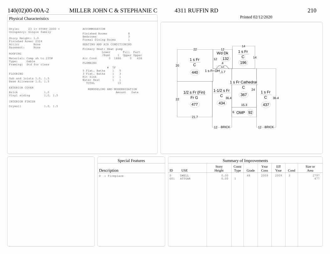
Physical Characteristics
Special Features
Description
Summary of ImprovementsStory Const Year Eff Size or
ID USE Height Type Grade Cons Year Cond Area
140(02)00-00A-2 MILLER JOHN C & STEPHANIE C 4311 RUFFIN RD 210Printed 02/12/2020
12
36.4
11.7
1-1/2 s Fr C
434 15.3
24
1 s Fr Cathedral C
367
12
36.4
1 s Fr C
437
14
14
1 s Fr C
196
6 OMP 92
4
1 s Fr OH 1220
22
1 s Fr C
440
12
12Wd Dk
132
22
21.7
1/2 s Fr (Fin) Fr G
477
BRICK BRICK
Style: 23 1+ STORY 2000 +Occupancy: Single family
Story Height: 1.0Finished Area: 2324 Attic: NoneBasement: None
ROOFINGMaterial: Comp sh to 235#Type: GableFraming: Std for class
FLOORINGSub and joists 1.0, 1.5Base Allowance 1.0, 1.5
EXTERIOR COVERBrick 1.0Vinyl siding 1.0, 1.5
INTERIOR FINISHDrywall 1.0, 1.5
ACCOMMODATIONFinished Rooms 8Bedrooms 3Formal Dining Rooms 1HEATING AND AIR CONDITIONINGPrimary Heat: Heat pump Lower Full Part /Bsmt 1 Upper UpperAir Cond 0 1886 0 438PLUMBING # TF5 Fixt. Baths 1 53 Fixt. Baths 1 3Kit Sink 1 1Water Heat 1 1 TOTAL 10
REMODELING AND MODERNIZATION Amount Date
D DWELL 0.00 48 2009 2009 3 2797G01 ATTGAR 0.00 1 477
D : Fireplace
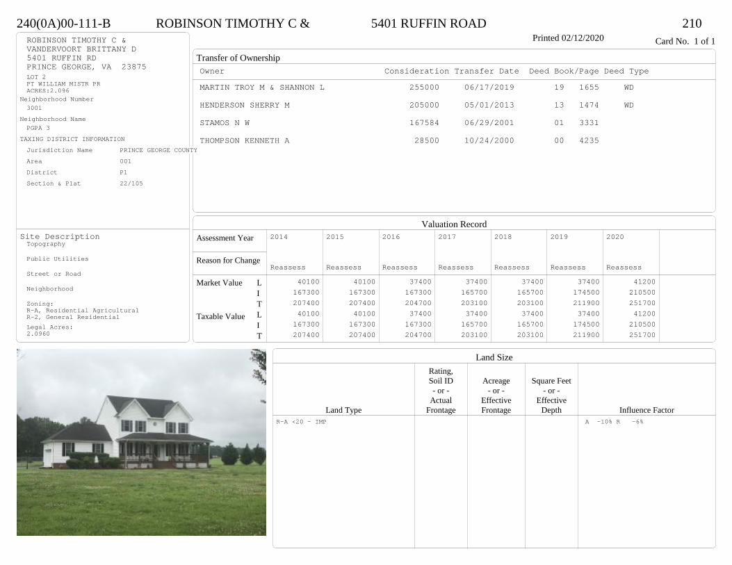
Transfer of Ownership
Valuation RecordAssessment Year
Reason for Change
Market Value
Taxable Value
LITLIT
Land SizeRating,Soil ID Acreage Square Feet- or - - or - - or -
Actual Effective EffectiveLand Type Frontage Frontage Depth Influence Factor
240(0A)00-111-B ROBINSON TIMOTHY C & 5401 RUFFIN ROAD 210Printed 02/12/2020 Card No. 1 of 1ROBINSON TIMOTHY C &
VANDERVOORT BRITTANY D5401 RUFFIN RDPRINCE GEORGE, VA 23875LOT 2PT WILLIAM MISTR PRACRES:2.096
Neighborhood Number3001
Neighborhood NamePGPA 3
TAXING DISTRICT INFORMATIONJurisdiction Name PRINCE GEORGE COUNTYArea 001 District P1 Section & Plat 22/105
Site DescriptionTopography
Public Utilities
Street or Road
Neighborhood
Zoning:R-A, Residential AgriculturalR-2, General ResidentialLegal Acres:2.0960
Owner Consideration Transfer Date Deed Book/Page Deed TypeMARTIN TROY M & SHANNON L 255000 06/17/2019 19 1655 WD
HENDERSON SHERRY M 205000 05/01/2013 13 1474 WD
STAMOS N W 167584 06/29/2001 01 3331
THOMPSON KENNETH A 28500 10/24/2000 00 4235
2014
Reassess 40100 167300 207400 40100 167300 207400
2015
Reassess 40100 167300 207400 40100 167300 207400
2016
Reassess 37400 167300 204700 37400 167300 204700
2017
Reassess 37400 165700 203100 37400 165700 203100
2018
Reassess 37400 165700 203100 37400 165700 203100
2019
Reassess 37400 174500 211900 37400 174500 211900
2020
Reassess 41200 210500 251700 41200 210500 251700
R-A <20 - IMP A -10% R -6%

Physical Characteristics
Special Features
Description
Summary of ImprovementsStory Const Year Eff Size or
ID USE Height Type Grade Cons Year Cond Area
240(0A)00-111-B ROBINSON TIMOTHY C & 5401 RUFFIN ROAD 210Printed 02/12/2020
30
12.2 1 8 12.7
18
3
6.3
35.9
2 s Fr C
1044
12
16.3
Wd Dk196
638.9
26.9
OFP 354
24
21
Fr G
504
Style: 33 2/2+Story 2000+Occupancy: Single family
Story Height: 2.0Finished Area: 2088 Attic: NoneBasement: None
ROOFINGMaterial: Comp sh to 235#Type: GableFraming: Std for class
FLOORINGSub and joists 1.0, 2.0Base Allowance 1.0, 2.0
EXTERIOR COVERVinyl siding 1.0, 2.0
INTERIOR FINISHDrywall 1.0, 2.0
ACCOMMODATIONFinished Rooms 5Bedrooms 3HEATING AND AIR CONDITIONINGPrimary Heat: Heat pump Lower Full Part /Bsmt 1 Upper UpperAir Cond 0 1044 1044 0PLUMBING # TF3 Fixt. Baths 2 62 Fixt. Baths 1 2Kit Sink 1 1Water Heat 1 1 TOTAL 10
REMODELING AND MODERNIZATION Amount Date
D DWELL 0.00 45 2001 2001 3 2088G01 ATTGAR 0.00 1 504
D : Fireplace

Transfer of Ownership
Valuation RecordAssessment Year
Reason for Change
Market Value
Taxable Value
LITLIT
Land SizeRating,Soil ID Acreage Square Feet- or - - or - - or -
Actual Effective EffectiveLand Type Frontage Frontage Depth Influence Factor
140(09)00-005-0 DRAHMS CLAYTON M & 3800 DEERWOOD LN 210Tax ID SF-0,MS-0,YB- Printed 02/12/2020 Card No. 1 of 1DRAHMS CLAYTON M &
SMILEK ALLISON D3800 DEERWOOD LNNORTH PRINCE GEORGE, VA 23860MERCHANT HOPE CHURCHTRACT 5ACRES:2.83
Neighborhood Number3001
Neighborhood NamePGPA 3
TAXING DISTRICT INFORMATIONJurisdiction Name PRINCE GEORGE COUNTYArea 001 District P2 Section & Plat 17 /71
Site DescriptionTopography
Public Utilities
Street or Road
Neighborhood
Zoning:R-A, Residential AgriculturalLegal Acres:2.8300
Owner Consideration Transfer Date Deed Book/Page Deed TypePORTER SARAH T & JUSTIN D 206000 05/17/2019 19 1366 WD
TRAYLOR SARAH E 0 03/30/2017 17 879 WD
CHAPPELL CONSTRUCTION LLC 182900 02/29/2016 16 567 WD
JAMES CARROLL DENNIS 18000 05/28/2015 15 1490 WD
2015
Reassess 22700 0 22700 22700 0 22700
2015
Sup 1 31400 107600 139000 31400 107600 139000
2016
Reassess 31400 107600 139000 31400 107600 139000
2017
Reassess 31400 109000 140400 31400 109000 140400
2018
Reassess 31400 118800 150200 31400 118800 150200
2019
Reassess 31400 115300 146700 31400 115300 146700
2020
Reassess 42800 153000 195800 42800 153000 195800
R-A <20 - IMP 1 -12% A -10%
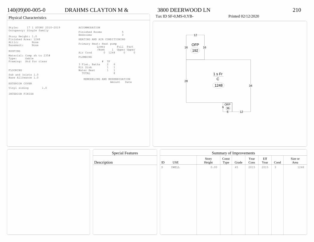
Physical Characteristics
Special Features
Description
Summary of ImprovementsStory Const Year Eff Size or
ID USE Height Type Grade Cons Year Cond Area
140(09)00-005-0 DRAHMS CLAYTON M & 3800 DEERWOOD LN 210Tax ID SF-0,MS-0,YB- Printed 02/12/2020
28
12
34
1 s Fr C
1248
66
OFP36
16
12
16OFP192
Style: 17 1 STORY 2010-2019Occupancy: Single family
Story Height: 1.0Finished Area: 1248 Attic: NoneBasement: None
ROOFINGMaterial: Comp sh to 235#Type: GableFraming: Std for class
FLOORINGSub and joists 1.0Base Allowance 1.0
EXTERIOR COVERVinyl siding 1.0
INTERIOR FINISH
ACCOMMODATIONFinished Rooms 5Bedrooms 3HEATING AND AIR CONDITIONINGPrimary Heat: Heat pump Lower Full Part /Bsmt 1 Upper UpperAir Cond 0 1248 0 0PLUMBING # TF3 Fixt. Baths 2 6Kit Sink 1 1Water Heat 1 1 TOTAL 8
REMODELING AND MODERNIZATION Amount Date
D DWELL 0.00 45 2015 2015 3 1248

Transfer of Ownership
Valuation RecordAssessment Year
Reason for Change
Market Value
Taxable Value
LITLIT
Land SizeRating,Soil ID Acreage Square Feet- or - - or - - or -
Actual Effective EffectiveLand Type Frontage Frontage Depth Influence Factor
240(0A)00-086-0 ST ONGE JOSEPH 5905 PRINCE GEORGE DRIVE 210Tax ID SF-1461,MS-1,YB-58 Printed 02/12/2020 Card No. 1 of 1ST ONGE JOSEPH
GROVE DENA5905 PRINCE GEORGE DRIVEPRINCE GEORGE, VA 23875-2563EASTERLY RUNACRES:0.447
Neighborhood Number3001
Neighborhood NamePGPA 3
TAXING DISTRICT INFORMATIONJurisdiction Name PRINCE GEORGE COUNTYArea 001 District P1 Section & Plat 11 /62
Site DescriptionTopography
Public Utilities
Street or Road
Neighborhood
Zoning:R-A, Residential AgriculturalLegal Acres:0.4470
Owner Consideration Transfer Date Deed Book/Page Deed TypeSEIBERT CHARLOTTE W 159000 10/03/2019 19 2952 WD
54000 03/02/1984 268 58
2014
Reassess 26800 111100 137900 26800 111100 137900
2015
Reassess 26800 111100 137900 26800 111100 137900
2016
Reassess 26800 111100 137900 26800 111100 137900
2017
Reassess 26800 113700 140500 26800 113700 140500
2018
Reassess 26800 113700 140500 26800 113700 140500
2019
Reassess 26800 119400 146200 26800 119400 146200
2020
Reassess 29500 124200 153700 29500 124200 153700
R-A <20 - IMP

Physical Characteristics
Special Features
Description
Summary of ImprovementsStory Const Year Eff Size or
ID USE Height Type Grade Cons Year Cond Area
240(0A)00-086-0 ST ONGE JOSEPH 5905 PRINCE GEORGE DRIVE 210Tax ID SF-1461,MS-1,YB-58 Printed 02/12/2020
24.8
60.6
22.6
19.8
1 s Br C
1459
15.2
26
EMP
395
48
M Stp 32
8.4
121 s Fr
C 10112
22.6
Br CP
271
02
64
Shed GP
24
Style: 11 1 STORY OLDEROccupancy: Single family
Story Height: 1.0Finished Area: 1560 Attic: NoneBasement: None
ROOFINGMaterial: Comp sh to 235#Type: GableFraming: Std for class
FLOORINGSub and joists 1.0Base Allowance 1.0
EXTERIOR COVERAlum siding 1.0Brick 1.0
INTERIOR FINISHDrywall 1.0
ACCOMMODATIONFinished Rooms 7Bedrooms 3HEATING AND AIR CONDITIONINGPrimary Heat: Heat pump Lower Full Part /Bsmt 1 Upper UpperAir Cond 0 1560 0 0PLUMBING # TF3 Fixt. Baths 2 6Kit Sink 1 1Water Heat 1 1 TOTAL 8
REMODELING AND MODERNIZATION Amount Date
D DWELL 0.00 45 1958 1958 3 1560G01 ICP 0.00 7 27102 DETGAR 0.00 1 45 1969 1969 3 29003 SHEDGP 1.00 1 45 1958 1958 3 24
D : Fireplace

Transfer of Ownership
Valuation RecordAssessment Year
Reason for Change
Market Value
Taxable Value
LITLIT
Land SizeRating,Soil ID Acreage Square Feet- or - - or - - or -
Actual Effective EffectiveLand Type Frontage Frontage Depth Influence Factor
260(0A)00-001-B SPIVEY ROBERT J 11196 COUNTRYSIDE LN 210Tax ID SF-0,MS-0,YB- Printed 02/12/2020 Card No. 1 of 1SPIVEY ROBERT J
11196 COUNTRYSIDE LNPRINCE GEORGE, VA 23875WARDS RUNACRES:5.974
Neighborhood Number3100
Neighborhood NameArea 3
TAXING DISTRICT INFORMATIONJurisdiction Name PRINCE GEORGE COUNTYArea 001 District P1 Section & Plat 25/141
Site DescriptionTopography
Public Utilities
Street or Road
Neighborhood
Zoning:A-1, Agricultural ConservationLegal Acres:5.9740
Owner Consideration Transfer Date Deed Book/Page Deed TypeLIEBENOW SHAUNA 425000 08/16/2019 19 2404 WD
GORMLEY MICHAEL J & REBECCA F 390900 07/22/2015 15 2102 WD
OMEARA LANA L & LINDA L MICHEL 66000 11/06/2007 07 5578 C/O LINDA L MICHEL
2014
Reassess 63800 294100 357900 63800 294100 357900
2015
Reassess 63800 294100 357900 63800 294100 357900
2016
Reassess 60600 307100 367700 60600 307100 367700
2017
Reassess 60600 306700 367300 60600 306700 367300
2018
Reassess 60600 306700 367300 60600 306700 367300
2019
Reassess 60600 329000 389600 60600 329000 389600
2020
Reassess 66700 330800 397500 66700 330800 397500
A-1 <20 - IMP A -15% V 10%
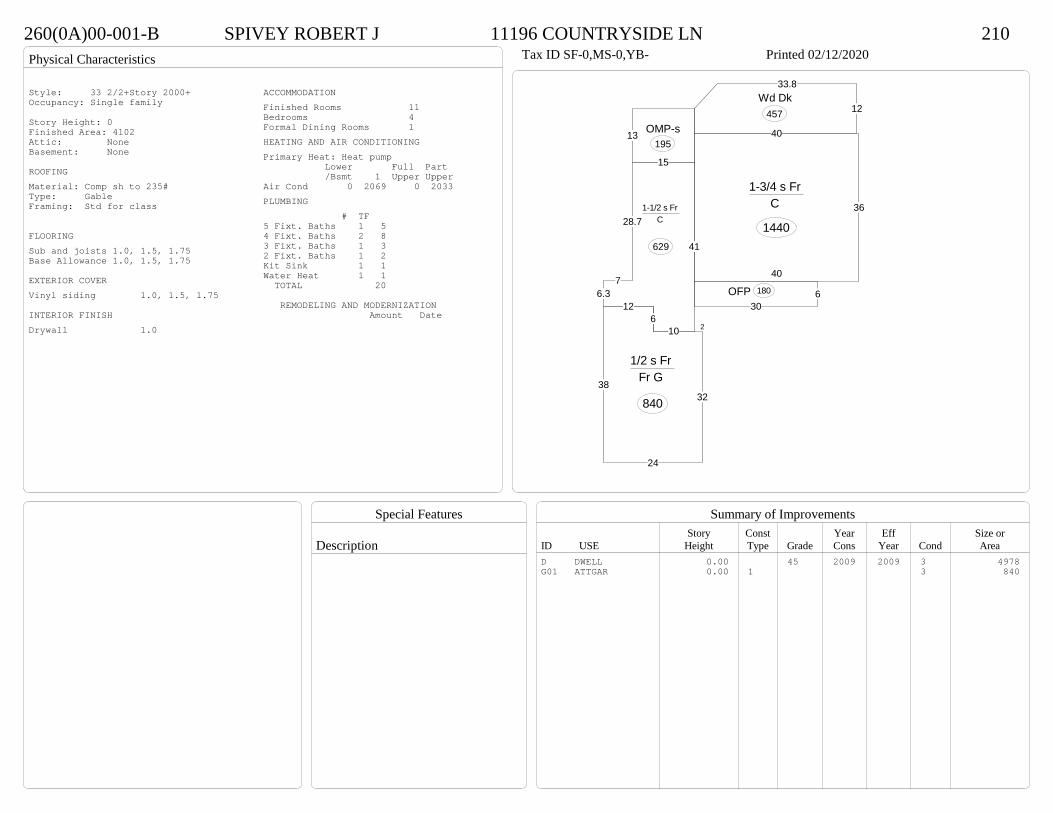
Physical Characteristics
Special Features
Description
Summary of ImprovementsStory Const Year Eff Size or
ID USE Height Type Grade Cons Year Cond Area
260(0A)00-001-B SPIVEY ROBERT J 11196 COUNTRYSIDE LN 210Tax ID SF-0,MS-0,YB- Printed 02/12/2020
630
OFP 180
13 OMP-s195
12
33.8Wd Dk
457
40
36
40
1-3/4 s Fr C
144028.7
76.3
126
10
41
15
1-1/2 s Fr C
629
2
32
24
38
1/2 s Fr Fr G
840
Style: 33 2/2+Story 2000+Occupancy: Single family
Story Height: 0Finished Area: 4102 Attic: NoneBasement: None
ROOFINGMaterial: Comp sh to 235#Type: GableFraming: Std for class
FLOORINGSub and joists 1.0, 1.5, 1.75Base Allowance 1.0, 1.5, 1.75
EXTERIOR COVERVinyl siding 1.0, 1.5, 1.75
INTERIOR FINISHDrywall 1.0
ACCOMMODATIONFinished Rooms 11Bedrooms 4Formal Dining Rooms 1HEATING AND AIR CONDITIONINGPrimary Heat: Heat pump Lower Full Part /Bsmt 1 Upper UpperAir Cond 0 2069 0 2033PLUMBING # TF5 Fixt. Baths 1 54 Fixt. Baths 2 83 Fixt. Baths 1 32 Fixt. Baths 1 2Kit Sink 1 1Water Heat 1 1 TOTAL 20
REMODELING AND MODERNIZATION Amount Date
D DWELL 0.00 45 2009 2009 3 4978G01 ATTGAR 0.00 1 3 840

Transfer of Ownership
Valuation RecordAssessment Year
Reason for Change
Market Value
Taxable Value
LITLIT
Land SizeRating,Soil ID Acreage Square Feet- or - - or - - or -
Actual Effective EffectiveLand Type Frontage Frontage Depth Influence Factor
390(0A)00-004-0 RONDINA WENDY A RISENER- 16550 POLE RUN ROAD 510Tax ID SF-0,MS-0,YB- Printed 02/12/2020 Card No. 1 of 1RONDINA WENDY A RISENER-
16550 POLE RUN RDDISPUTANTA, VA 23842POLE RUN ROADACRES:24,27
Neighborhood Number3100
Neighborhood NameArea 3
TAXING DISTRICT INFORMATIONJurisdiction Name PRINCE GEORGE COUNTYArea 001 District P3 Section & Plat 23/244
Site DescriptionTopography
Public Utilities
Street or Road
Neighborhood
Zoning:A-1, Agricultural ConservationLegal Acres:24.2800
Owner Consideration Transfer Date Deed Book/Page Deed TypeOWENS FRANK L & MARY E 369000 06/04/2019 19 1549 WD
BENESEK I J JR INC 374250 12/26/2007 07 6323
SOBER PROPERTIES INC 135000 05/16/2006 06 2557
EPPS LILLIAN H 87000 10/19/2005 05 5360
2015
Reassess 119200 190700 309900 119200 190700 309900
2016
Reassess 113200 190700 303900 113200 190700 303900
2017
Reassess 113200 191900 305100 113200 191900 305100
2018
Reassess 113300 201100 314400 113300 201100 314400
2018
Admin Change 113300 223600 336900 113300 223600 336900
2019
Reassess 113300 230600 343900 113300 230600 343900
2020
Reassess 124600 247100 371700 124600 247100 371700
A-1 20<100 - IMP W -5%

Physical Characteristics
Special Features
Description
Summary of ImprovementsStory Const Year Eff Size or
ID USE Height Type Grade Cons Year Cond Area
390(0A)00-004-0 RONDINA WENDY A RISENER- 16550 POLE RUN ROAD 510Tax ID SF-0,MS-0,YB- Printed 02/12/2020
18
7.1
135.8
5
34.3
17.7
7.542.3
28
24
12.5
1 s Fr C
2096
186.1OMP 110
12
161 s Fr
C 192
12
16
16
38.6
16Wd Dk
426
24
Fr G
576
01
Style: 16 1 STORY 2000-2009Occupancy: Single family
Story Height: 1.0Finished Area: 2288 Attic: NoneBasement: None
ROOFINGMaterial: Comp sh to 235#Type: HipFraming: Std for class
FLOORINGSub and joists 1.0Base Allowance 1.0
EXTERIOR COVERVinyl siding 1.0
INTERIOR FINISH
ACCOMMODATIONFinished Rooms 8Bedrooms 4HEATING AND AIR CONDITIONINGPrimary Heat: Heat pump Lower Full Part /Bsmt 1 Upper UpperAir Cond 0 2288 0 0PLUMBING # TF5 Fixt. Baths 1 53 Fixt. Baths 1 3Kit Sink 1 1Water Heat 1 1 TOTAL 10
REMODELING AND MODERNIZATION Amount Date
D DWELL 0.00 45 2007 2007 3 2288G01 ATTGAR 0.00 1 57601 DETGAR 10.00 1 45 2009 2009 3 1200
D : Fireplace01 : Concrete floor
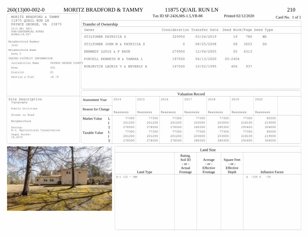
Transfer of Ownership
Valuation RecordAssessment Year
Reason for Change
Market Value
Taxable Value
LITLIT
Land SizeRating,Soil ID Acreage Square Feet- or - - or - - or -
Actual Effective EffectiveLand Type Frontage Frontage Depth Influence Factor
260(13)00-002-0 MORITZ BRADFORD & TAMMY 11875 QUAIL RUN LN 210Tax ID SF-2426,MS-1.5,YB-88 Printed 02/12/2020 Card No. 1 of 1MORITZ BRADFORD & TAMMY
11875 QUAIL RUN LNPRINCE GEORGE, VA 23875LT:2 BK: SEC:SUB:CENTENNIAL ACRESACRES:18.407
Neighborhood Number3100
Neighborhood NameArea 3
TAXING DISTRICT INFORMATIONJurisdiction Name PRINCE GEORGE COUNTYArea 001 District P1 Section & Plat 18 /9
Site DescriptionTopography
Public Utilities
Street or Road
Neighborhood
Zoning:A-1, Agricultural ConservationLegal Acres:18.4070
Owner Consideration Transfer Date Deed Book/Page Deed TypeSTILTONER PATRICIA S 329950 03/26/2019 19 786 WD
STILTONER JOHN M & PATRICIA S 0 08/25/2008 08 3653 DG
KENNEDY LOUIS & P KAYE 279950 12/06/2005 05 6313
PURCELL KENNETH M & TAMARA L 187000 06/13/2000 00-2404
KONJEVICH LAURIS V & BEVERLY A 167000 10/02/1995 406 937
2014
Reassess 77300 201200 278500 77300 201200 278500
2015
Reassess 77300 201200 278500 77300 201200 278500
2016
Reassess 77300 201200 278500 77300 201200 278500
2017
Reassess 77300 203000 280300 77300 203000 280300
2018
Reassess 77300 203000 280300 77300 203000 280300
2019
Reassess 77300 218100 295400 77300 218100 295400
2020
Reassess 85000 219000 304000 85000 219000 304000
A-1 <20 - IMP A -20% S -5%

Physical Characteristics
Special Features
Description
Summary of ImprovementsStory Const Year Eff Size or
ID USE Height Type Grade Cons Year Cond Area
260(13)00-002-0 MORITZ BRADFORD & TAMMY 11875 QUAIL RUN LN 210Tax ID SF-2426,MS-1.5,YB-88 Printed 02/12/2020
28
36
1-1/2 s Fr C
1008
10
41
1 s Fr C 410
65Wd Dk
30
12.54 OMP 50
8
34
OFP 272
28
24
3/4 s Fr (Fin) Fr G
672
01
02Style: 22 1+ STORY 1980-1999Occupancy: Single family
Story Height: 1.5Finished Area: 2559 Attic: NoneBasement: None
ROOFINGMaterial: Comp sh to 235#Type: GableFraming: Std for class
FLOORINGSub and joists 1.0, 1.5, 1.75Base Allowance 1.0, 1.5, 1.75
EXTERIOR COVERWood siding-cedar 1.0, 1.5, 1.75
INTERIOR FINISHDrywall 1.0, 1.5, 1.75
ACCOMMODATIONFinished Rooms 9Bedrooms 4HEATING AND AIR CONDITIONINGPrimary Heat: Heat pump Lower Full Part /Bsmt 1 Upper UpperAir Cond 0 1418 0 1141PLUMBING # TF3 Fixt. Baths 3 92 Fixt. Baths 1 2Kit Sink 1 1Water Heat 1 1 TOTAL 13
REMODELING AND MODERNIZATION Amount Date
D DWELL 0.00 48 1988 1988 3 3098G01 ATTGAR 0.00 1 67201 SHED 0.00 1 45 2005 2005 3 40002 LEANTO 10.00 0 45 2005 2005 3 256
D : Fireplace02 : Three sides open
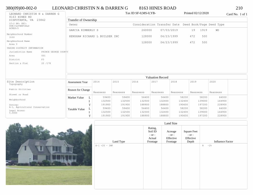
Transfer of Ownership
Valuation RecordAssessment Year
Reason for Change
Market Value
Taxable Value
LITLIT
Land SizeRating,Soil ID Acreage Square Feet- or - - or - - or -
Actual Effective EffectiveLand Type Frontage Frontage Depth Influence Factor
380(09)00-002-0 LEONARD CHRISTIN N & DARREN G 8163 HINES ROAD 210Tax ID SF-0,MS-0,YB- Printed 02/12/2020 Card No. 1 of 1LEONARD CHRISTIN N & DARREN G
8163 HINES RDDISPUTANTA, VA 23842LT:2 BK: SEC:SUB:CLOVERFIELDACRES:5
Neighborhood Number3100
Neighborhood NameArea 3
TAXING DISTRICT INFORMATIONJurisdiction Name PRINCE GEORGE COUNTYArea 001 District P3 Section & Plat 20 /178
Site DescriptionTopography
Public Utilities
Street or Road
Neighborhood
Zoning:A-1, Agricultural ConservationLegal Acres:5.0000
Owner Consideration Transfer Date Deed Book/Page Deed TypeGARCIA KIMBERLY S 260000 07/03/2019 19 1919 WD
HENSHAW RICHARD L BUILDER INC 128000 04/23/1999 472 500
128000 04/23/1999 472 500
2014
Reassess 59400 132500 191900 59400 132500 191900
2015
Reassess 59400 132500 191900 59400 132500 191900
2016
Reassess 56400 132500 188900 56400 132500 188900
2017
Reassess 56400 132400 188800 56400 132400 188800
2018
Reassess 58200 132400 190600 58200 132400 190600
2019
Reassess 58200 139000 197200 58200 139000 197200
2020
Reassess 64000 164900 228900 64000 164900 228900
A-1 <20 - IMP R -2%

Physical Characteristics
Special Features
Description
Summary of ImprovementsStory Const Year Eff Size or
ID USE Height Type Grade Cons Year Cond Area
380(09)00-002-0 LEONARD CHRISTIN N & DARREN G 8163 HINES ROAD 210Tax ID SF-0,MS-0,YB- Printed 02/12/2020
24
11.57.2
2 s Fr C
701
21 s Fr OH (Upper)
57
12
12
Wd Dk144
628.6
6OFP 157
22
221/2 s Fr (Fin)
Fr G
484
Style: 32 2/2+Story 1980-1999Occupancy: Single family
Story Height: 2.0Finished Area: 1749 Attic: NoneBasement: None
ROOFINGMaterial: Comp sh to 235#Type: GableFraming: Std for class
FLOORINGSub and joists 1.0, 1.5, 2.0Base Allowance 1.0, 1.5, 2.0
EXTERIOR COVERVinyl siding 1.0, 1.5, 2.0
INTERIOR FINISHDrywall 1.0, 2.0
ACCOMMODATIONFinished Rooms 7Bedrooms 3HEATING AND AIR CONDITIONINGPrimary Heat: Heat pump Lower Full Part /Bsmt 1 Upper UpperAir Cond 0 701 758 290PLUMBING # TF3 Fixt. Baths 2 62 Fixt. Baths 1 2Kit Sink 1 1Water Heat 1 1 TOTAL 10
REMODELING AND MODERNIZATION Amount Date
D DWELL 0.00 48 1999 1999 3 1943G01 ATTGAR 0.00 1 484
D : Fireplace
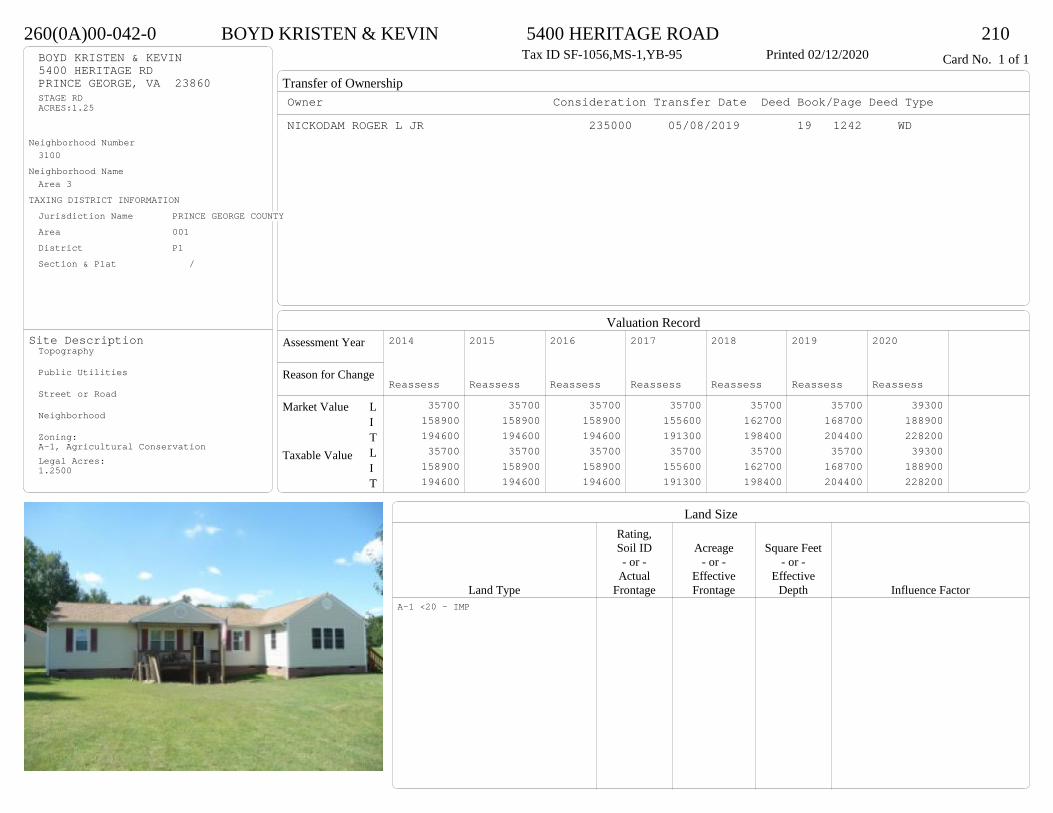
Transfer of Ownership
Valuation RecordAssessment Year
Reason for Change
Market Value
Taxable Value
LITLIT
Land SizeRating,Soil ID Acreage Square Feet- or - - or - - or -
Actual Effective EffectiveLand Type Frontage Frontage Depth Influence Factor
260(0A)00-042-0 BOYD KRISTEN & KEVIN 5400 HERITAGE ROAD 210Tax ID SF-1056,MS-1,YB-95 Printed 02/12/2020 Card No. 1 of 1BOYD KRISTEN & KEVIN
5400 HERITAGE RDPRINCE GEORGE, VA 23860STAGE RDACRES:1.25
Neighborhood Number3100
Neighborhood NameArea 3
TAXING DISTRICT INFORMATIONJurisdiction Name PRINCE GEORGE COUNTYArea 001 District P1 Section & Plat /
Site DescriptionTopography
Public Utilities
Street or Road
Neighborhood
Zoning:A-1, Agricultural ConservationLegal Acres:1.2500
Owner Consideration Transfer Date Deed Book/Page Deed TypeNICKODAM ROGER L JR 235000 05/08/2019 19 1242 WD
2014
Reassess 35700 158900 194600 35700 158900 194600
2015
Reassess 35700 158900 194600 35700 158900 194600
2016
Reassess 35700 158900 194600 35700 158900 194600
2017
Reassess 35700 155600 191300 35700 155600 191300
2018
Reassess 35700 162700 198400 35700 162700 198400
2019
Reassess 35700 168700 204400 35700 168700 204400
2020
Reassess 39300 188900 228200 39300 188900 228200
A-1 <20 - IMP
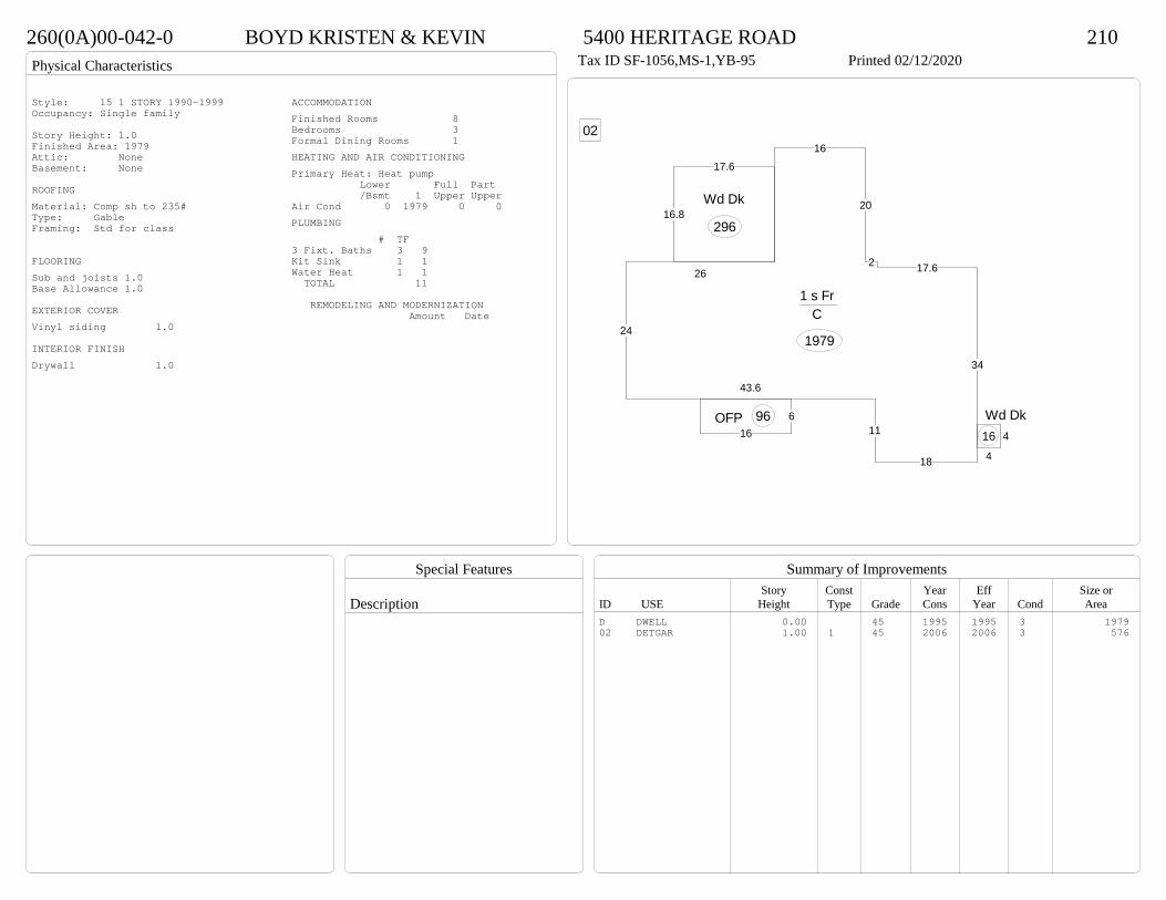
Physical Characteristics
Special Features
Description
Summary of ImprovementsStory Const Year Eff Size or
ID USE Height Type Grade Cons Year Cond Area
260(0A)00-042-0 BOYD KRISTEN & KEVIN 5400 HERITAGE ROAD 210Tax ID SF-1056,MS-1,YB-95 Printed 02/12/2020
24
43.6
11
18
34
17.62
20
16
26
1 s Fr C
1979
616
OFP 96
17.6
16.8Wd Dk
296
4
4
Wd Dk16
02
Style: 15 1 STORY 1990-1999Occupancy: Single family
Story Height: 1.0Finished Area: 1979 Attic: NoneBasement: None
ROOFINGMaterial: Comp sh to 235#Type: GableFraming: Std for class
FLOORINGSub and joists 1.0Base Allowance 1.0
EXTERIOR COVERVinyl siding 1.0
INTERIOR FINISHDrywall 1.0
ACCOMMODATIONFinished Rooms 8Bedrooms 3Formal Dining Rooms 1HEATING AND AIR CONDITIONINGPrimary Heat: Heat pump Lower Full Part /Bsmt 1 Upper UpperAir Cond 0 1979 0 0PLUMBING # TF3 Fixt. Baths 3 9Kit Sink 1 1Water Heat 1 1 TOTAL 11
REMODELING AND MODERNIZATION Amount Date
D DWELL 0.00 45 1995 1995 3 197902 DETGAR 1.00 1 45 2006 2006 3 576

Transfer of Ownership
Valuation RecordAssessment Year
Reason for Change
Market Value
Taxable Value
LITLIT
Land SizeRating,Soil ID Acreage Square Feet- or - - or - - or -
Actual Effective EffectiveLand Type Frontage Frontage Depth Influence Factor
250(19)00-002-0 HUFFMAN CHASE & 11022 LAWYERS ROAD 210Printed 02/12/2020 Card No. 1 of 1HUFFMAN CHASE &
KELLY LAUREN11022 LAWYERS RDPRINCE GEORGE, VA 23875LT: 2 BK: SEC:SUB:OAK FOREST ACRESACRES:5.00
Neighborhood Number3100
Neighborhood NameArea 3
TAXING DISTRICT INFORMATIONJurisdiction Name PRINCE GEORGE COUNTYArea 001 District P1 Section & Plat /
Site DescriptionTopography
Public Utilities
Street or Road
Neighborhood
Zoning:A-1, Agricultural ConservationLegal Acres:5.0000
Owner Consideration Transfer Date Deed Book/Page Deed TypeHAYES ADAM H & MICHELLE NOLAND 206500 07/08/2019 19 1941 WD
WILLIAMS NICHOLAS B & SARAH S 177500 09/28/2012 12 3144 WD
WILLIAM G BUILDERS INC 159292 03/14/2005 05 1160
DERESKI ROBERT D 33900 07/20/2004 04 3645
2014
Reassess 59400 118100 177500 59400 118100 177500
2015
Reassess 59400 118100 177500 59400 118100 177500
2016
Reassess 59400 118100 177500 59400 118100 177500
2017
Reassess 59400 117000 176400 59400 117000 176400
2018
Reassess 59400 122900 182300 59400 122900 182300
2019
Reassess 59400 126900 186300 59400 126900 186300
2020
Reassess 65300 139300 204600 65300 139300 204600
A-1 <20 - IMP
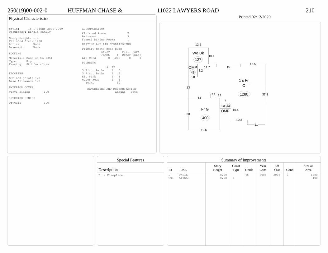
Physical Characteristics
Special Features
Description
Summary of ImprovementsStory Const Year Eff Size or
ID USE Height Type Grade Cons Year Cond Area
250(19)00-002-0 HUFFMAN CHASE & 11022 LAWYERS ROAD 210Printed 02/12/2020
113
10.3
10.4
7
2.33.414
13
8.211.7 15
15.5
37.9
1 s Fr C
1280
3.3
OMP23
5.8
OMP48
12.6
10.1Wd Dk
127
20
19.6
Fr G
400
Style: 16 1 STORY 2000-2009Occupancy: Single family
Story Height: 1.0Finished Area: 1280 Attic: NoneBasement: None
ROOFINGMaterial: Comp sh to 235#Type: HipFraming: Std for class
FLOORINGSub and joists 1.0Base Allowance 1.0
EXTERIOR COVERVinyl siding 1.0
INTERIOR FINISHDrywall 1.0
ACCOMMODATIONFinished Rooms 7Bedrooms 3Formal Dining Rooms 1HEATING AND AIR CONDITIONINGPrimary Heat: Heat pump Lower Full Part /Bsmt 1 Upper UpperAir Cond 0 1280 0 0PLUMBING # TF5 Fixt. Baths 1 53 Fixt. Baths 1 3Kit Sink 1 1Water Heat 1 1 TOTAL 10
REMODELING AND MODERNIZATION Amount Date
D DWELL 0.00 45 2005 2005 3 1280G01 ATTGAR 0.00 1 400
D : Fireplace

Transfer of Ownership
Valuation RecordAssessment Year
Reason for Change
Market Value
Taxable Value
LITLIT
Land SizeRating,Soil ID Acreage Square Feet- or - - or - - or -
Actual Effective EffectiveLand Type Frontage Frontage Depth Influence Factor
270(08)00-002-0 COMPTON MARGARET ANN 15825 JAMES RIVER DRIVE 210Tax ID SF-1328,MS-1,YB-86 Printed 02/12/2020 Card No. 1 of 1COMPTON MARGARET ANN
15825 JAMES RIVER DRDISPUTANTA, VA 23842LOT 2PT RUSSELL BRILEY PRACRES:3.49
Neighborhood Number3100
Neighborhood NameArea 3
TAXING DISTRICT INFORMATIONJurisdiction Name PRINCE GEORGE COUNTYArea 001 District P3 Section & Plat 271/695
Site DescriptionTopography
Public Utilities
Street or Road
Neighborhood
Zoning:A-1, Agricultural ConservationLegal Acres:3.4900
Owner Consideration Transfer Date Deed Book/Page Deed TypeHARTSELL LAURA H 180000 04/29/2019 19 1147 WD
BRANCH BANKING & TRUST CO 90000 06/16/2016 16 1732 SW
BEST KIMBERLY L 36435 11/03/2015 15 3256 SW
ECKSTEIN DEBORAH L HEGEN 115800 06/21/2000 00-2520
COLEMAN TERRY L & MICHELLE C 99750 07/24/1996 417 686
2014
Reassess 51600 110000 161600 51600 110000 161600
2015
Reassess 51600 110000 161600 51600 110000 161600
2016
Reassess 51600 110000 161600 51600 110000 161600
2017
Reassess 51600 101800 153400 51600 101800 153400
2018
Reassess 51600 101800 153400 51600 101800 153400
2019
Reassess 51600 127600 179200 51600 127600 179200
2020
Reassess 56800 142000 198800 56800 142000 198800
A-1 <20 - IMP

Physical Characteristics
Special Features
Description
Summary of ImprovementsStory Const Year Eff Size or
ID USE Height Type Grade Cons Year Cond Area
270(08)00-002-0 COMPTON MARGARET ANN 15825 JAMES RIVER DRIVE 210Tax ID SF-1328,MS-1,YB-86 Printed 02/12/2020
26
3610
10
10
16
1 s Fr C
1316
8
16Wd Dk
128
22
8
32
24
Wd Dk 416
01
Style: 14 1 STORY 1979-89Occupancy: Single family
Story Height: 1.0Finished Area: 1316 Attic: NoneBasement: None
ROOFINGMaterial: Comp sh to 235#Type: GableFraming: Std for class
FLOORINGSub and joists 1.0Base Allowance 1.0
EXTERIOR COVERWood siding-cedar 1.0
INTERIOR FINISHDrywall 1.0
ACCOMMODATIONFinished Rooms 7Bedrooms 3HEATING AND AIR CONDITIONINGPrimary Heat: Heat pump Lower Full Part /Bsmt 1 Upper UpperAir Cond 0 1316 0 0PLUMBING # TF3 Fixt. Baths 2 6Kit Sink 1 1Water Heat 1 1 TOTAL 8
REMODELING AND MODERNIZATION Amount Date
D DWELL 0.00 45 1986 2001 3 131601 DETGAR 0.00 1 45 1991 1991 3 720
D : Remod 2016 Fireplace
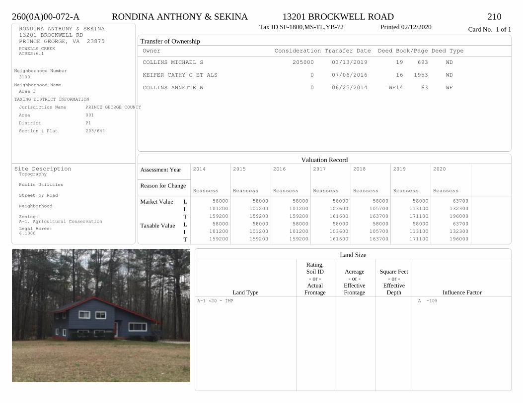
Transfer of Ownership
Valuation RecordAssessment Year
Reason for Change
Market Value
Taxable Value
LITLIT
Land SizeRating,Soil ID Acreage Square Feet- or - - or - - or -
Actual Effective EffectiveLand Type Frontage Frontage Depth Influence Factor
260(0A)00-072-A RONDINA ANTHONY & SEKINA 13201 BROCKWELL ROAD 210Tax ID SF-1800,MS-TL,YB-72 Printed 02/12/2020 Card No. 1 of 1RONDINA ANTHONY & SEKINA
13201 BROCKWELL RDPRINCE GEORGE, VA 23875POWELLS CREEKACRES:6.1
Neighborhood Number3100
Neighborhood NameArea 3
TAXING DISTRICT INFORMATIONJurisdiction Name PRINCE GEORGE COUNTYArea 001 District P1 Section & Plat 203/644
Site DescriptionTopography
Public Utilities
Street or Road
Neighborhood
Zoning:A-1, Agricultural ConservationLegal Acres:6.1000
Owner Consideration Transfer Date Deed Book/Page Deed TypeCOLLINS MICHAEL S 205000 03/13/2019 19 693 WD
KEIFER CATHY C ET ALS 0 07/06/2016 16 1953 WD
COLLINS ANNETTE W 0 06/25/2014 WF14 63 WF
2014
Reassess 58000 101200 159200 58000 101200 159200
2015
Reassess 58000 101200 159200 58000 101200 159200
2016
Reassess 58000 101200 159200 58000 101200 159200
2017
Reassess 58000 103600 161600 58000 103600 161600
2018
Reassess 58000 105700 163700 58000 105700 163700
2019
Reassess 58000 113100 171100 58000 113100 171100
2020
Reassess 63700 132300 196000 63700 132300 196000
A-1 <20 - IMP A -10%

Physical Characteristics
Special Features
Description
Summary of ImprovementsStory Const Year Eff Size or
ID USE Height Type Grade Cons Year Cond Area
260(0A)00-072-A RONDINA ANTHONY & SEKINA 13201 BROCKWELL ROAD 210Tax ID SF-1800,MS-TL,YB-72 Printed 02/12/2020
22
261 s Fr
C
572
22
1 s Fr L (Fin)
572
0.71 s Fr OH 15
16
16Wd Dk
256
Style: 50 TRI-LEVEL OR SPLIT-LEVELOccupancy: Single family
Story Height: Tri-levelFinished Area: 1731 Attic: NoneBasement: None
ROOFINGMaterial: Comp sh to 235#Type: GableFraming: Std for class
FLOORINGSlab LSub and joists 1.0Base Allowance L, 1.0
EXTERIOR COVERBlock 1.0Wood siding 1.0
INTERIOR FINISHDrywall 1.0
ACCOMMODATIONFinished Rooms 7Bedrooms 3HEATING AND AIR CONDITIONINGPrimary Heat: Forced hot air Lower Full Part /Bsmt 1 Upper UpperAir Cond 572 1159 0 0PLUMBING # TF3 Fixt. Baths 2 6Kit Sink 1 1Water Heat 1 1 TOTAL 8
REMODELING AND MODERNIZATION Amount Date
D DWELL 0.00 45 1972 1991 3 1731D : Fireplace
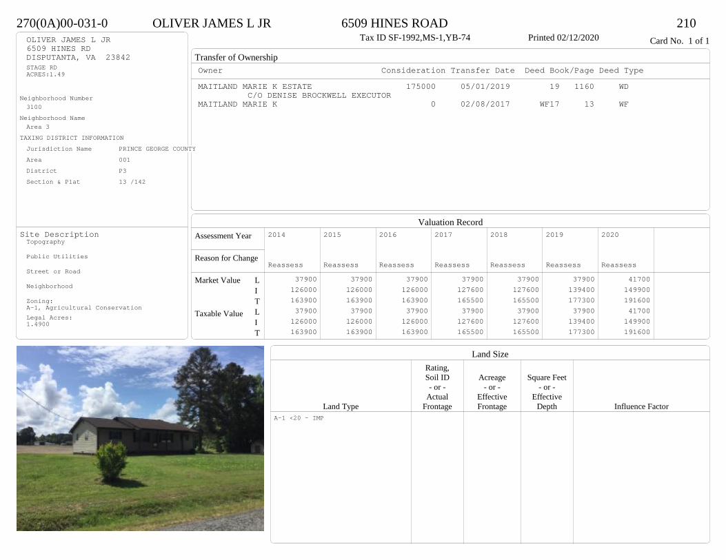
Transfer of Ownership
Valuation RecordAssessment Year
Reason for Change
Market Value
Taxable Value
LITLIT
Land SizeRating,Soil ID Acreage Square Feet- or - - or - - or -
Actual Effective EffectiveLand Type Frontage Frontage Depth Influence Factor
270(0A)00-031-0 OLIVER JAMES L JR 6509 HINES ROAD 210Tax ID SF-1992,MS-1,YB-74 Printed 02/12/2020 Card No. 1 of 1OLIVER JAMES L JR
6509 HINES RDDISPUTANTA, VA 23842STAGE RDACRES:1.49
Neighborhood Number3100
Neighborhood NameArea 3
TAXING DISTRICT INFORMATIONJurisdiction Name PRINCE GEORGE COUNTYArea 001 District P3 Section & Plat 13 /142
Site DescriptionTopography
Public Utilities
Street or Road
Neighborhood
Zoning:A-1, Agricultural ConservationLegal Acres:1.4900
Owner Consideration Transfer Date Deed Book/Page Deed TypeMAITLAND MARIE K ESTATE 175000 05/01/2019 19 1160 WD
C/O DENISE BROCKWELL EXECUTORMAITLAND MARIE K 0 02/08/2017 WF17 13 WF
2014
Reassess 37900 126000 163900 37900 126000 163900
2015
Reassess 37900 126000 163900 37900 126000 163900
2016
Reassess 37900 126000 163900 37900 126000 163900
2017
Reassess 37900 127600 165500 37900 127600 165500
2018
Reassess 37900 127600 165500 37900 127600 165500
2019
Reassess 37900 139400 177300 37900 139400 177300
2020
Reassess 41700 149900 191600 41700 149900 191600
A-1 <20 - IMP

Physical Characteristics
Special Features
Description
Summary of ImprovementsStory Const Year Eff Size or
ID USE Height Type Grade Cons Year Cond Area
270(0A)00-031-0 OLIVER JAMES L JR 6509 HINES ROAD 210Tax ID SF-1992,MS-1,YB-74 Printed 02/12/2020
25
59
48
24
23
35
1 s Fr C
2027
8.3
20.3
Wd Dk
168
5.522.2
OMP 122
6.7
20.9
OMP
140
Style: 13 1 STORY 1970-78Occupancy: Single family
Story Height: 1.0Finished Area: 2027 Attic: NoneBasement: None
ROOFINGMaterial: Comp sh to 235#Type: GableFraming: Std for class
FLOORINGSub and joists 1.0Base Allowance 1.0
EXTERIOR COVERVinyl siding 1.0
INTERIOR FINISHDrywall 1.0
ACCOMMODATIONFinished Rooms 6Bedrooms 4HEATING AND AIR CONDITIONINGPrimary Heat: Electric baseboard Lower Full Part /Bsmt 1 Upper UpperAir Cond 0 2027 0 0PLUMBING # TF3 Fixt. Baths 2 6Kit Sink 1 1Water Heat 1 1 TOTAL 8
REMODELING AND MODERNIZATION Amount Date
D DWELL 0.00 45 1974 1974 3 2027D : Fireplace

Transfer of Ownership
Valuation RecordAssessment Year
Reason for Change
Market Value
Taxable Value
LITLIT
Land SizeRating,Soil ID Acreage Square Feet- or - - or - - or -
Actual Effective EffectiveLand Type Frontage Frontage Depth Influence Factor
380(11)00-003-0 WALRATH ROBERT M & ANGEL R 8773 HINES ROAD 210Tax ID SF-0,MS-0,YB- Printed 02/12/2020 Card No. 1 of 1WALRATH ROBERT M & ANGEL R
8773 HINES RDDISPUTANTA, VA 23842LT:3 BK: SEC:SUB:PLEASANT GROVE ESTATESACRES:10.8
Neighborhood Number3104
Neighborhood NameHines Road Area
TAXING DISTRICT INFORMATIONJurisdiction Name PRINCE GEORGE COUNTYArea 001 District P3 Section & Plat 21 /181
Site DescriptionTopography
Public Utilities
Street or Road
Neighborhood
Zoning:A-1, Agricultural ConservationLegal Acres:10.8000
Owner Consideration Transfer Date Deed Book/Page Deed TypeLOFTIS JAMES R & JANICE B 389900 09/23/2019 19 2818 WD
195800 11/30/1998 461 223
2014
Reassess 81700 290700 372400 81700 290700 372400
2015
Reassess 81700 290700 372400 81700 290700 372400
2016
Reassess 81700 290700 372400 81700 290700 372400
2017
Reassess 81700 288800 370500 81700 288800 370500
2018
Reassess 81700 286100 367800 81700 286100 367800
2019
Reassess 81700 300200 381900 81700 300200 381900
2020
Reassess 89800 324300 414100 89800 324300 414100
A-1 <20 - IMP
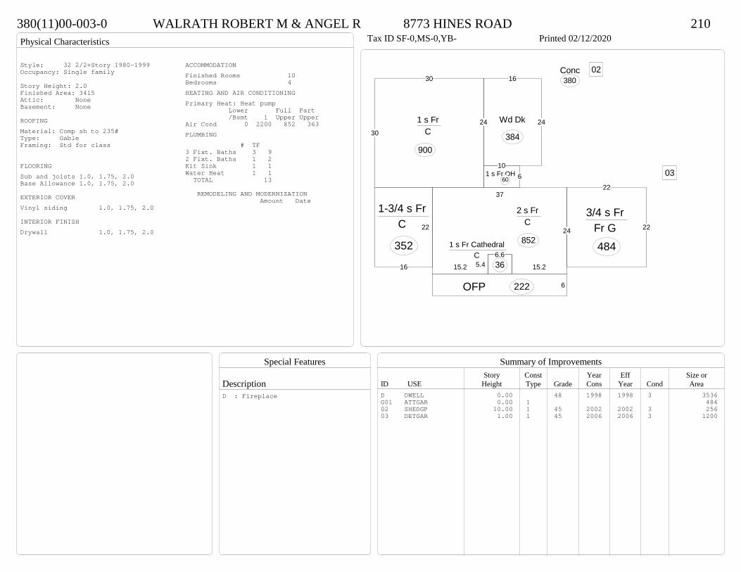
Physical Characteristics
Special Features
Description
Summary of ImprovementsStory Const Year Eff Size or
ID USE Height Type Grade Cons Year Cond Area
380(11)00-003-0 WALRATH ROBERT M & ANGEL R 8773 HINES ROAD 210Tax ID SF-0,MS-0,YB- Printed 02/12/2020
24
15.215.2
37
2 s Fr C
85222
16
1-3/4 s Fr C
352
6OFP 222
30
30
241 s Fr C
900
5.46.6
1 s Fr Cathedral C
36
1061 s Fr OH
60
24
16
24Wd Dk
384
Conc380
22
22
3/4 s Fr Fr G 484
02
03
Style: 32 2/2+Story 1980-1999Occupancy: Single family
Story Height: 2.0Finished Area: 3415 Attic: NoneBasement: None
ROOFINGMaterial: Comp sh to 235#Type: GableFraming: Std for class
FLOORINGSub and joists 1.0, 1.75, 2.0Base Allowance 1.0, 1.75, 2.0
EXTERIOR COVERVinyl siding 1.0, 1.75, 2.0
INTERIOR FINISHDrywall 1.0, 1.75, 2.0
ACCOMMODATIONFinished Rooms 10Bedrooms 4HEATING AND AIR CONDITIONINGPrimary Heat: Heat pump Lower Full Part /Bsmt 1 Upper UpperAir Cond 0 2200 852 363PLUMBING # TF3 Fixt. Baths 3 92 Fixt. Baths 1 2Kit Sink 1 1Water Heat 1 1 TOTAL 13
REMODELING AND MODERNIZATION Amount Date
D DWELL 0.00 48 1998 1998 3 3536G01 ATTGAR 0.00 1 48402 SHEDGP 10.00 1 45 2002 2002 3 25603 DETGAR 1.00 1 45 2006 2006 3 1200
D : Fireplace
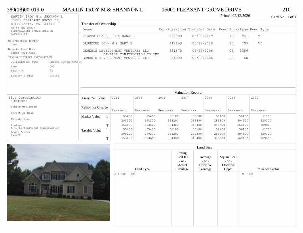
Transfer of Ownership
Valuation RecordAssessment Year
Reason for Change
Market Value
Taxable Value
LITLIT
Land SizeRating,Soil ID Acreage Square Feet- or - - or - - or -
Actual Effective EffectiveLand Type Frontage Frontage Depth Influence Factor
380(18)00-019-0 MARTIN TROY M & SHANNON L 15001 PLEASANT GROVE DRIVE 210Printed 02/12/2020 Card No. 1 of 1MARTIN TROY M & SHANNON L
15001 PLEASANT GROVE DRDISPUTANTA, VA 23842LT:19 BK: SEC:2SUB:PLEASANT GROVE ESTATESACRES:5.637
Neighborhood Number3104
Neighborhood NameHines Road Area
TAXING DISTRICT INFORMATIONJurisdiction Name PRINCE GEORGE COUNTYArea 001 District P3 Section & Plat 23/162
Site DescriptionTopography
Public Utilities
Street or Road
Neighborhood
Zoning:A-1, Agricultural ConservationLegal Acres:5.6370
Owner Consideration Transfer Date Deed Book/Page Deed TypeRIEVES CHARLES E & DANA L 420000 03/29/2019 19 841 WD
DRUMMOND JOHN M & MARY E 412100 03/17/2010 10 793 WD
GENESIS DEVELOPMENT VENTURES LLC 381875 06/26/2006 06 3386 DANRICH CONSTRUCTION CO INC
GENESIS DEVELOPMENT VENTURES LLC 51000 01/06/2006 06 88
2014
Reassess 55400 298200 353600 55400 298200 353600
2015
Reassess 55400 298200 353600 55400 298200 353600
2016
Reassess 56100 298200 354300 56100 298200 354300
2017
Reassess 56100 292300 348400 56100 292300 348400
2018
Reassess 56100 289200 345300 56100 289200 345300
2019
Reassess 56100 304500 360600 56100 304500 360600
2020
Reassess 61700 328100 389800 61700 328100 389800
A-1 <20 - IMP W -10%
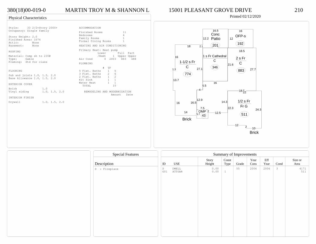
Physical Characteristics
Special Features
Description
Summary of ImprovementsStory Const Year Eff Size or
ID USE Height Type Grade Cons Year Cond Area
380(18)00-019-0 MARTIN TROY M & SHANNON L 15001 PLEASANT GROVE DRIVE 210Printed 02/12/2020
1 s Fr Cathedral C
346
12.2
16.5Conc
201
12
16
OFP-s
192
18.5
27.7
18.5
14.3
12.527.5
12.9
45.5
16
21.6
2 s Fr C
883
2.118
16
1.3
13.7
16
14
16.5
4
27.1
1-1/2 s Fr C
774
5.7OMP
43
22
24.3
10212
22.3
1/2 s Fr Fr G
511Brick
Brick
Patio
Style: 33 2/2+Story 2000+Occupancy: Single family
Story Height: 2.0Finished Area: 3374 Attic: NoneBasement: None
ROOFINGMaterial: Comp sh to 235#Type: GableFraming: Std for class
FLOORINGSub and joists 1.0, 1.5, 2.0Base Allowance 1.0, 1.5, 2.0
EXTERIOR COVERBrick 1.0Vinyl siding 1.0, 1.5, 2.0
INTERIOR FINISHDrywall 1.0, 1.5, 2.0
ACCOMMODATIONFinished Rooms 11Bedrooms 4Family Rooms 1Formal Dining Rooms 1HEATING AND AIR CONDITIONINGPrimary Heat: Heat pump Lower Full Part /Bsmt 1 Upper UpperAir Cond 0 2003 883 488PLUMBING # TF5 Fixt. Baths 1 53 Fixt. Baths 2 62 Fixt. Baths 1 2Kit Sink 1 1Water Heat 1 1 TOTAL 15
REMODELING AND MODERNIZATION Amount Date
D DWELL 0.00 55 2006 2006 3 4171G01 ATTGAR 0.00 1 511
D : Fireplace
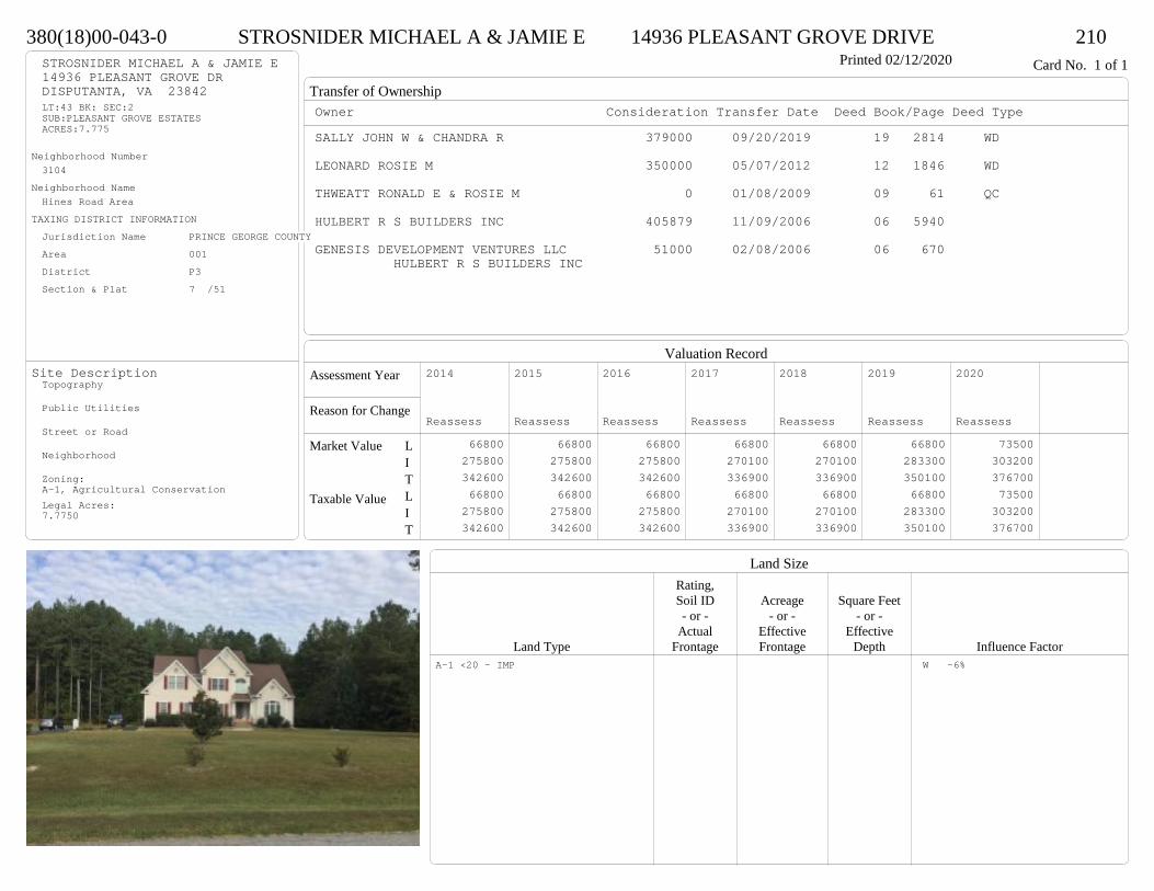
Transfer of Ownership
Valuation RecordAssessment Year
Reason for Change
Market Value
Taxable Value
LITLIT
Land SizeRating,Soil ID Acreage Square Feet- or - - or - - or -
Actual Effective EffectiveLand Type Frontage Frontage Depth Influence Factor
380(18)00-043-0 STROSNIDER MICHAEL A & JAMIE E 14936 PLEASANT GROVE DRIVE 210Printed 02/12/2020 Card No. 1 of 1STROSNIDER MICHAEL A & JAMIE E
14936 PLEASANT GROVE DRDISPUTANTA, VA 23842LT:43 BK: SEC:2SUB:PLEASANT GROVE ESTATESACRES:7.775
Neighborhood Number3104
Neighborhood NameHines Road Area
TAXING DISTRICT INFORMATIONJurisdiction Name PRINCE GEORGE COUNTYArea 001 District P3 Section & Plat 7 /51
Site DescriptionTopography
Public Utilities
Street or Road
Neighborhood
Zoning:A-1, Agricultural ConservationLegal Acres:7.7750
Owner Consideration Transfer Date Deed Book/Page Deed TypeSALLY JOHN W & CHANDRA R 379000 09/20/2019 19 2814 WD
LEONARD ROSIE M 350000 05/07/2012 12 1846 WD
THWEATT RONALD E & ROSIE M 0 01/08/2009 09 61 QC
HULBERT R S BUILDERS INC 405879 11/09/2006 06 5940
GENESIS DEVELOPMENT VENTURES LLC 51000 02/08/2006 06 670 HULBERT R S BUILDERS INC
2014
Reassess 66800 275800 342600 66800 275800 342600
2015
Reassess 66800 275800 342600 66800 275800 342600
2016
Reassess 66800 275800 342600 66800 275800 342600
2017
Reassess 66800 270100 336900 66800 270100 336900
2018
Reassess 66800 270100 336900 66800 270100 336900
2019
Reassess 66800 283300 350100 66800 283300 350100
2020
Reassess 73500 303200 376700 73500 303200 376700
A-1 <20 - IMP W -6%

Physical Characteristics
Special Features
Description
Summary of ImprovementsStory Const Year Eff Size or
ID USE Height Type Grade Cons Year Cond Area
380(18)00-043-0 STROSNIDER MICHAEL A & JAMIE E 14936 PLEASANT GROVE DRIVE 210Printed 02/12/2020
19.5
94.7
21
15.2
1 s Fr Cathedral C
305
6 1 s Fr OH 16
61 s Fr
C 60
7
6.6OMP
46
11.810
7.8
410.8
1012.8
Wd Dk289
12 2.7
38
17.4
1-1/2 s Fr C
673
11.1
412
16.6
12.4
2-1/2 s Fr C
274
23.4
22.4
20 2.9
3.4
2 s Fr C
514
1 s Fr OH (Upper)1322
22
22.7
2
1/2 s Fr Fr G
485
Style: 33 2/2+Story 2000+Occupancy: Single family
Story Height: 1.5Finished Area: 3607 Attic: NoneBasement: None
ROOFINGMaterial: Comp sh to 235#Type: GableFraming: Std for class
FLOORINGSub and joists 1.0, 1.5, 2.0, 2.5Base Allowance 1.0, 1.5, 2.0, 2.5
EXTERIOR COVERVinyl siding 1.0, 1.5, 2.0, 2.5
INTERIOR FINISHDrywall 1.0, 1.5, 2.0, 2.5
ACCOMMODATIONFinished Rooms 10Bedrooms 4Formal Dining Rooms 1HEATING AND AIR CONDITIONINGPrimary Heat: Heat pump Lower Full Part /Bsmt 1 Upper UpperAir Cond 0 1842 801 964PLUMBING # TF5 Fixt. Baths 1 54 Fixt. Baths 1 43 Fixt. Baths 2 62 Fixt. Baths 2 4Kit Sink 1 1Water Heat 1 1 TOTAL 21
REMODELING AND MODERNIZATION Amount Date
D DWELL 0.00 48 2006 2006 3 4075G01 ATTGAR 0.00 1 485
D : Fireplace
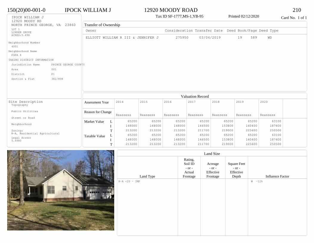
Transfer of Ownership
Valuation RecordAssessment Year
Reason for Change
Market Value
Taxable Value
LITLIT
Land SizeRating,Soil ID Acreage Square Feet- or - - or - - or -
Actual Effective EffectiveLand Type Frontage Frontage Depth Influence Factor
150(20)00-001-0 IPOCK WILLIAM J 12920 MOODY ROAD 210Tax ID SF-1777,MS-1,YB-95 Printed 02/12/2020 Card No. 1 of 1IPOCK WILLIAM J
12920 MOODY RDNORTH PRINCE GEORGE, VA 23860LOT 1LINDEN GROVEACRES:5.498
Neighborhood Number4001
Neighborhood NamePGPA 4
TAXING DISTRICT INFORMATIONJurisdiction Name PRINCE GEORGE COUNTYArea 001 District P1 Section & Plat 382/808
Site DescriptionTopography
Public Utilities
Street or Road
Neighborhood
Zoning:R-A, Residential AgriculturalLegal Acres:5.4980
Owner Consideration Transfer Date Deed Book/Page Deed TypeELLIOTT WILLIAM R III & JENNIFER J 275950 03/04/2019 19 589 WD
2014
Reassess 65200 148000 213200 65200 148000 213200
2015
Reassess 65200 148000 213200 65200 148000 213200
2016
Reassess 65200 148000 213200 65200 148000 213200
2017
Reassess 65200 146500 211700 65200 146500 211700
2018
Reassess 65200 153800 219000 65200 153800 219000
2019
Reassess 65200 160400 225600 65200 160400 225600
2020
Reassess 63100 187400 250500 63100 187400 250500
R-A <20 - IMP W -12%
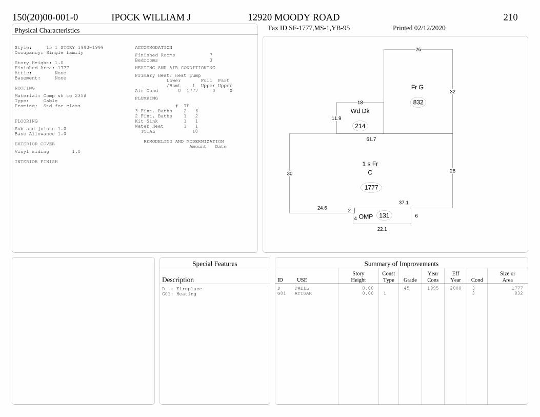
Physical Characteristics
Special Features
Description
Summary of ImprovementsStory Const Year Eff Size or
ID USE Height Type Grade Cons Year Cond Area
150(20)00-001-0 IPOCK WILLIAM J 12920 MOODY ROAD 210Tax ID SF-1777,MS-1,YB-95 Printed 02/12/2020
28
37.1224.6
30
61.7
1 s Fr C
1777
22.1
64 OMP 131
18
11.9Wd Dk
214
32
26
Fr G
832
Style: 15 1 STORY 1990-1999Occupancy: Single family
Story Height: 1.0Finished Area: 1777 Attic: NoneBasement: None
ROOFINGMaterial: Comp sh to 235#Type: GableFraming: Std for class
FLOORINGSub and joists 1.0Base Allowance 1.0
EXTERIOR COVERVinyl siding 1.0
INTERIOR FINISH
ACCOMMODATIONFinished Rooms 7Bedrooms 3HEATING AND AIR CONDITIONINGPrimary Heat: Heat pump Lower Full Part /Bsmt 1 Upper UpperAir Cond 0 1777 0 0PLUMBING # TF3 Fixt. Baths 2 62 Fixt. Baths 1 2Kit Sink 1 1Water Heat 1 1 TOTAL 10
REMODELING AND MODERNIZATION Amount Date
D DWELL 0.00 45 1995 2000 3 1777G01 ATTGAR 0.00 1 3 832
D : FireplaceG01: Heating
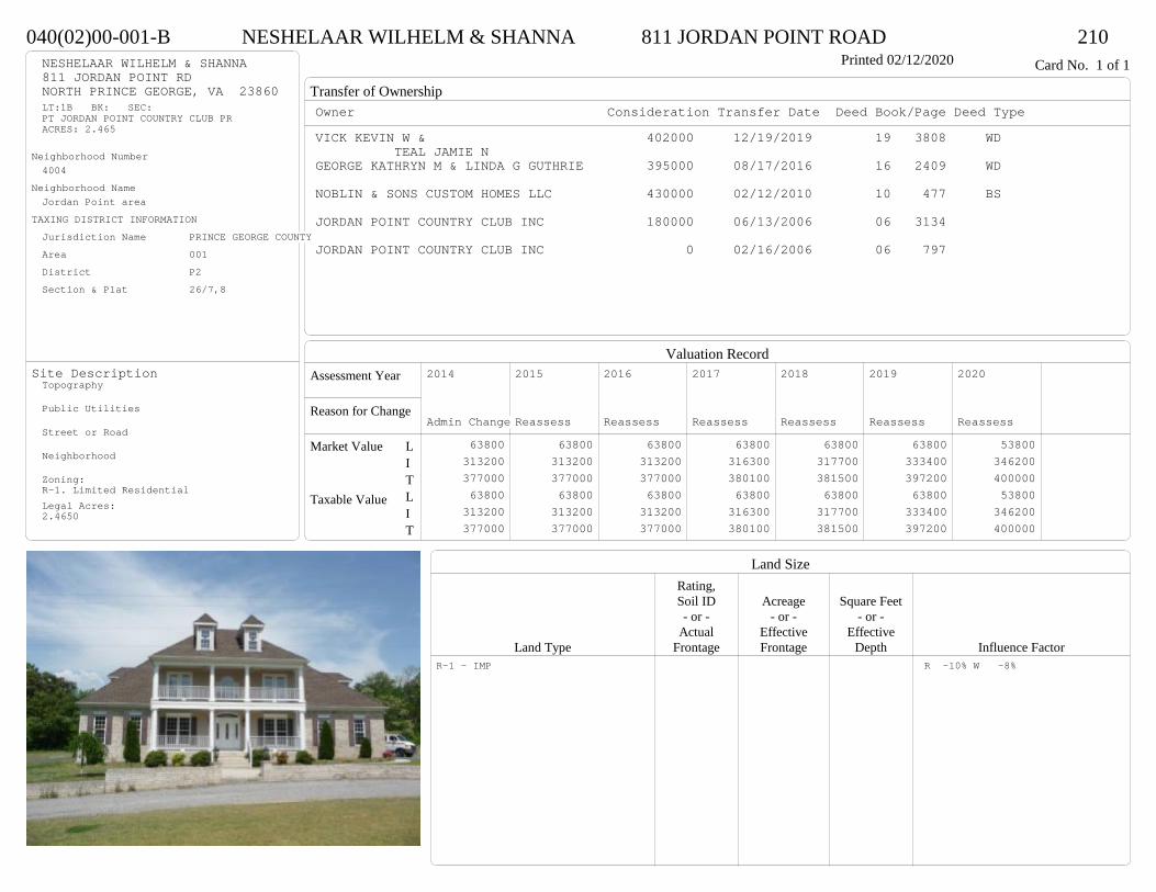
Transfer of Ownership
Valuation RecordAssessment Year
Reason for Change
Market Value
Taxable Value
LITLIT
Land SizeRating,Soil ID Acreage Square Feet- or - - or - - or -
Actual Effective EffectiveLand Type Frontage Frontage Depth Influence Factor
040(02)00-001-B NESHELAAR WILHELM & SHANNA 811 JORDAN POINT ROAD 210Printed 02/12/2020 Card No. 1 of 1NESHELAAR WILHELM & SHANNA
811 JORDAN POINT RDNORTH PRINCE GEORGE, VA 23860LT:1B BK: SEC:PT JORDAN POINT COUNTRY CLUB PRACRES: 2.465
Neighborhood Number4004
Neighborhood NameJordan Point area
TAXING DISTRICT INFORMATIONJurisdiction Name PRINCE GEORGE COUNTYArea 001 District P2 Section & Plat 26/7,8
Site DescriptionTopography
Public Utilities
Street or Road
Neighborhood
Zoning:R-1. Limited ResidentialLegal Acres:2.4650
Owner Consideration Transfer Date Deed Book/Page Deed TypeVICK KEVIN W & 402000 12/19/2019 19 3808 WD
TEAL JAMIE NGEORGE KATHRYN M & LINDA G GUTHRIE 395000 08/17/2016 16 2409 WD
NOBLIN & SONS CUSTOM HOMES LLC 430000 02/12/2010 10 477 BS
JORDAN POINT COUNTRY CLUB INC 180000 06/13/2006 06 3134
JORDAN POINT COUNTRY CLUB INC 0 02/16/2006 06 797
2014
Admin Change 63800 313200 377000 63800 313200 377000
2015
Reassess 63800 313200 377000 63800 313200 377000
2016
Reassess 63800 313200 377000 63800 313200 377000
2017
Reassess 63800 316300 380100 63800 316300 380100
2018
Reassess 63800 317700 381500 63800 317700 381500
2019
Reassess 63800 333400 397200 63800 333400 397200
2020
Reassess 53800 346200 400000 53800 346200 400000
R-1 - IMP R -10% W -8%

Physical Characteristics
Special Features
Description
Summary of ImprovementsStory Const Year Eff Size or
ID USE Height Type Grade Cons Year Cond Area
040(02)00-001-B NESHELAAR WILHELM & SHANNA 811 JORDAN POINT ROAD 210Printed 02/12/2020
11.9 11.9
31.4
30.3
2 s Fr C
877
16
32.2
1 s Fr C
515
13
141 s Fr Cathedral
C 182
44
M Stp
16
9
11.71 s Fr
C 105
8.4 M Stp 134 11
19.7
OMP-s217
632
OFPOMP 192
9.8
7.61 s Fr Cathedral
C
74
3.8
7
1-1/2 s Fr C
171
21
21.8
1/2 s Fr (Fin) Fr G
458
01Style: 33 2/2+Story 2000+Occupancy: Single family
Story Height: 2.0Finished Area: 3177 Attic: NoneBasement: None
ROOFINGMaterial: Comp sh to 235#Type: HipFraming: Std for class
FLOORINGSub and joists 1.0, 1.5, 2.0Base Allowance 1.0, 1.5, 2.0
EXTERIOR COVERBrick 1.0, 1.5, 2.0Vinyl siding 1.0, 1.5, 2.0
INTERIOR FINISHDrywall 1.0, 1.5, 2.0
ACCOMMODATIONFinished Rooms 11Bedrooms 4Formal Dining Rooms 1HEATING AND AIR CONDITIONINGPrimary Heat: Heat pump Lower Full Part /Bsmt 1 Upper UpperAir Cond 0 1924 877 376PLUMBING # TF5 Fixt. Baths 1 54 Fixt. Baths 1 43 Fixt. Baths 1 32 Fixt. Baths 1 2Kit Sink 1 1Water Heat 1 1 TOTAL 16
REMODELING AND MODERNIZATION Amount Date
D DWELL 0.00 55 2007 2007 3 3430G01 ATTGAR 0.00 1 45801 SHEDGP 10.00 1 45 2010 2010 3 231
D : Fireplace, Fireplace
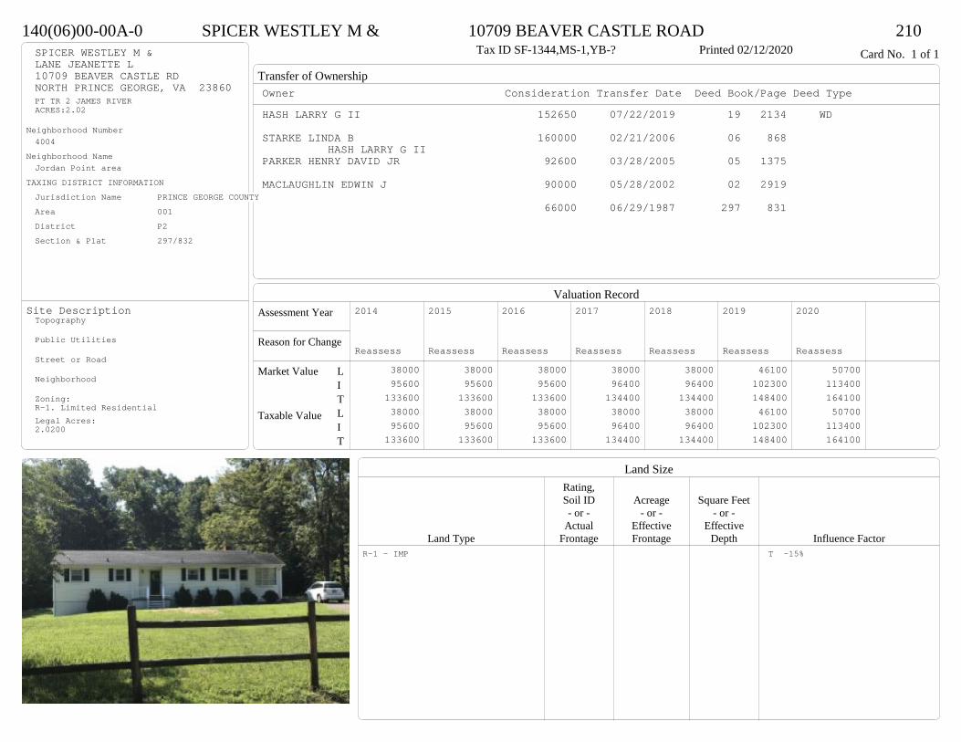
Transfer of Ownership
Valuation RecordAssessment Year
Reason for Change
Market Value
Taxable Value
LITLIT
Land SizeRating,Soil ID Acreage Square Feet- or - - or - - or -
Actual Effective EffectiveLand Type Frontage Frontage Depth Influence Factor
140(06)00-00A-0 SPICER WESTLEY M & 10709 BEAVER CASTLE ROAD 210Tax ID SF-1344,MS-1,YB-? Printed 02/12/2020 Card No. 1 of 1SPICER WESTLEY M &
LANE JEANETTE L10709 BEAVER CASTLE RDNORTH PRINCE GEORGE, VA 23860PT TR 2 JAMES RIVERACRES:2.02
Neighborhood Number4004
Neighborhood NameJordan Point area
TAXING DISTRICT INFORMATIONJurisdiction Name PRINCE GEORGE COUNTYArea 001 District P2 Section & Plat 297/832
Site DescriptionTopography
Public Utilities
Street or Road
Neighborhood
Zoning:R-1. Limited ResidentialLegal Acres:2.0200
Owner Consideration Transfer Date Deed Book/Page Deed TypeHASH LARRY G II 152650 07/22/2019 19 2134 WD
STARKE LINDA B 160000 02/21/2006 06 868 HASH LARRY G II
PARKER HENRY DAVID JR 92600 03/28/2005 05 1375
MACLAUGHLIN EDWIN J 90000 05/28/2002 02 2919
66000 06/29/1987 297 831
2014
Reassess 38000 95600 133600 38000 95600 133600
2015
Reassess 38000 95600 133600 38000 95600 133600
2016
Reassess 38000 95600 133600 38000 95600 133600
2017
Reassess 38000 96400 134400 38000 96400 134400
2018
Reassess 38000 96400 134400 38000 96400 134400
2019
Reassess 46100 102300 148400 46100 102300 148400
2020
Reassess 50700 113400 164100 50700 113400 164100
R-1 - IMP T -15%
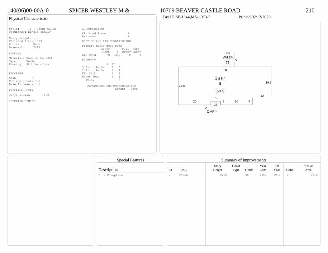
Physical Characteristics
Special Features
Description
Summary of ImprovementsStory Const Year Eff Size or
ID USE Height Type Grade Cons Year Cond Area
140(06)00-00A-0 SPICER WESTLEY M & 10709 BEAVER CASTLE ROAD 210Tax ID SF-1344,MS-1,YB-? Printed 02/12/2020
19.6
12
42026
20
23.6
58
1 s Fr B
1309
8.5
8.6Wd Dk
73
28OMP
28
Style: 11 1 STORY OLDEROccupancy: Single family
Story Height: 1.0Finished Area: 1309 Attic: NoneBasement: Full
ROOFINGMaterial: Comp sh to 235#Type: GableFraming: Std for class
FLOORINGSlab BSub and joists 1.0Base Allowance 1.0
EXTERIOR COVERVinyl siding 1.0
INTERIOR FINISH
ACCOMMODATIONFinished Rooms 5Bedrooms 3HEATING AND AIR CONDITIONINGPrimary Heat: Heat pump Lower Full Part /Bsmt 1 Upper UpperAir Cond 0 1309 0 0PLUMBING # TF3 Fixt. Baths 1 32 Fixt. Baths 1 2Kit Sink 1 1Water Heat 1 1 TOTAL 7
REMODELING AND MODERNIZATION Amount Date
D DWELL 0.00 38 1950 1977 3 2618D : Fireplace

Transfer of Ownership
Valuation RecordAssessment Year
Reason for Change
Market Value
Taxable Value
LITLIT
Land SizeRating,Soil ID Acreage Square Feet- or - - or - - or -
Actual Effective EffectiveLand Type Frontage Frontage Depth Influence Factor
05A(01)02-001-0 HOLLY ANTHONY W 1312 MARL BANK DRIVE 210Tax ID SF-2914,MS-2,YB-72 Printed 02/12/2020 Card No. 1 of 1HOLLY ANTHONY W
1312 MARL BANK DRNORTH PRINCE GEORGE, VA 23860LT:1 BK:2 SEC:1SUB:BEECHWOOD MANOR
Neighborhood Number4005
Neighborhood NameBeechwood Manor S
TAXING DISTRICT INFORMATIONJurisdiction Name PRINCE GEORGE COUNTYArea 001 District P2 Section & Plat 10 /143
Site DescriptionTopography
Public Utilities
Street or Road
Neighborhood
Zoning:R-1. Limited ResidentialLegal Acres:0.0000
Owner Consideration Transfer Date Deed Book/Page Deed TypeENGLAND R STANFORD TRUST 229000 05/14/2019 19 1287 WD
C/O CHERYL ENGLANDENGLAND R STANFORD & JOYCE H 0 07/27/2005 05 3645 G
LESCANEC FRANK E & LUCILLE G 64300 05/22/1975 222 305
BOGESE CONSTRUCTION CO INC 45000 05/15/1972 212 469
2014
Reassess 41000 188400 229400 41000 188400 229400
2015
Reassess 37000 188400 225400 37000 188400 225400
2016
Reassess 37000 188400 225400 37000 188400 225400
2017
Reassess 37000 193000 230000 37000 193000 230000
2018
Reassess 37000 193000 230000 37000 193000 230000
2019
Reassess 37000 203500 240500 37000 203500 240500
2020
Reassess 40700 205100 245800 40700 205100 245800
R-1 - IMP
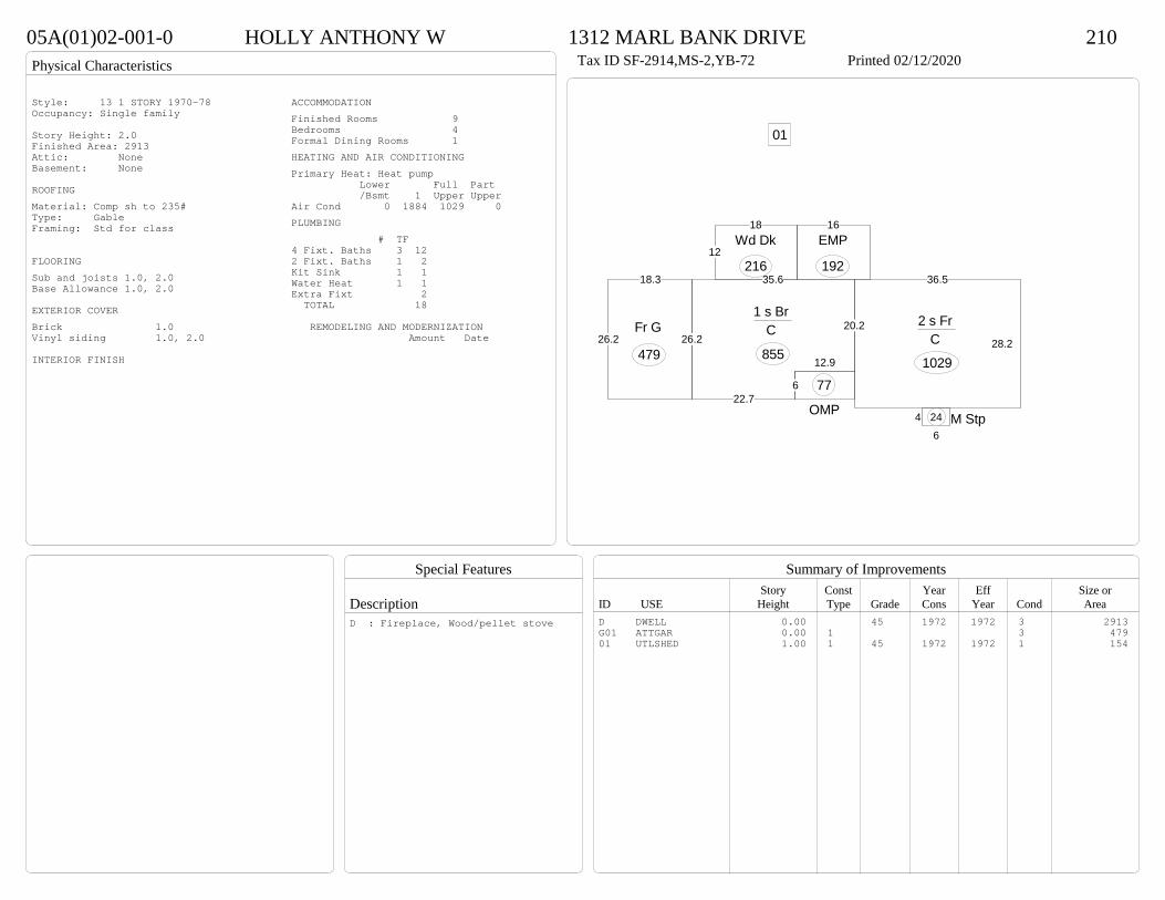
Physical Characteristics
Special Features
Description
Summary of ImprovementsStory Const Year Eff Size or
ID USE Height Type Grade Cons Year Cond Area
05A(01)02-001-0 HOLLY ANTHONY W 1312 MARL BANK DRIVE 210Tax ID SF-2914,MS-2,YB-72 Printed 02/12/2020
12.9
622.7
26.2
35.6
20.21 s Br
C
855
36.5
28.2
2 s Fr C
1029
12
18Wd Dk
216
16EMP
192
46
M Stp24OMP
77
18.3
26.2Fr G
479
01
Style: 13 1 STORY 1970-78Occupancy: Single family
Story Height: 2.0Finished Area: 2913 Attic: NoneBasement: None
ROOFINGMaterial: Comp sh to 235#Type: GableFraming: Std for class
FLOORINGSub and joists 1.0, 2.0Base Allowance 1.0, 2.0
EXTERIOR COVERBrick 1.0Vinyl siding 1.0, 2.0
INTERIOR FINISH
ACCOMMODATIONFinished Rooms 9Bedrooms 4Formal Dining Rooms 1HEATING AND AIR CONDITIONINGPrimary Heat: Heat pump Lower Full Part /Bsmt 1 Upper UpperAir Cond 0 1884 1029 0PLUMBING # TF4 Fixt. Baths 3 122 Fixt. Baths 1 2Kit Sink 1 1Water Heat 1 1Extra Fixt 2 TOTAL 18
REMODELING AND MODERNIZATION Amount Date
D DWELL 0.00 45 1972 1972 3 2913G01 ATTGAR 0.00 1 3 47901 UTLSHED 1.00 1 45 1972 1972 1 154
D : Fireplace, Wood/pellet stove

Transfer of Ownership
Valuation RecordAssessment Year
Reason for Change
Market Value
Taxable Value
LITLIT
Land SizeRating,Soil ID Acreage Square Feet- or - - or - - or -
Actual Effective EffectiveLand Type Frontage Frontage Depth Influence Factor
05A(06)09-010-0 PALMER TIMOTHY 1604 BUTTERNUT DRIVE 210Tax ID SF-1999,MS-TL,YB-77 Printed 02/12/2020 Card No. 1 of 1PALMER TIMOTHY
1604 BUTTERNUT DRIVENORTH PRINCE GEORGE, VA 23860LT:10 BK:9 SEC:6SUB:BEECHWOOD MANORACRES:0.39
Neighborhood Number4005
Neighborhood NameBeechwood Manor S
TAXING DISTRICT INFORMATIONJurisdiction Name PRINCE GEORGE COUNTYArea 001 District P2 Section & Plat 16 /36
Site DescriptionTopography
Public Utilities
Street or Road
Neighborhood
Zoning:R-1. Limited ResidentialLegal Acres:0.3900
Owner Consideration Transfer Date Deed Book/Page Deed Type414 ROSENEATH PROPERTIES LLC 223000 09/16/2019 19 2750 WD
TAGGART MICHAEL J & DIANE S 104650 04/01/2019 19 881 WD
DOHERTY JOHNSTON J & PATRICIA W 136500 11/22/2002 02 6210
BOGESE INCORPORATED AL 63500 12/30/1977 233 433
2015
Reassess 37000 147600 184600 37000 147600 184600
2016
Reassess 37000 147600 184600 37000 147600 184600
2017
Reassess 37000 151000 188000 37000 151000 188000
2018
Reassess 37000 154000 191000 37000 154000 191000
2019
Reassess 37000 159600 196600 37000 159600 196600
2019
Admin Change 37000 145700 182700 37000 145700 182700
2020
Reassess 40700 180500 221200 40700 180500 221200
R-1 - IMP
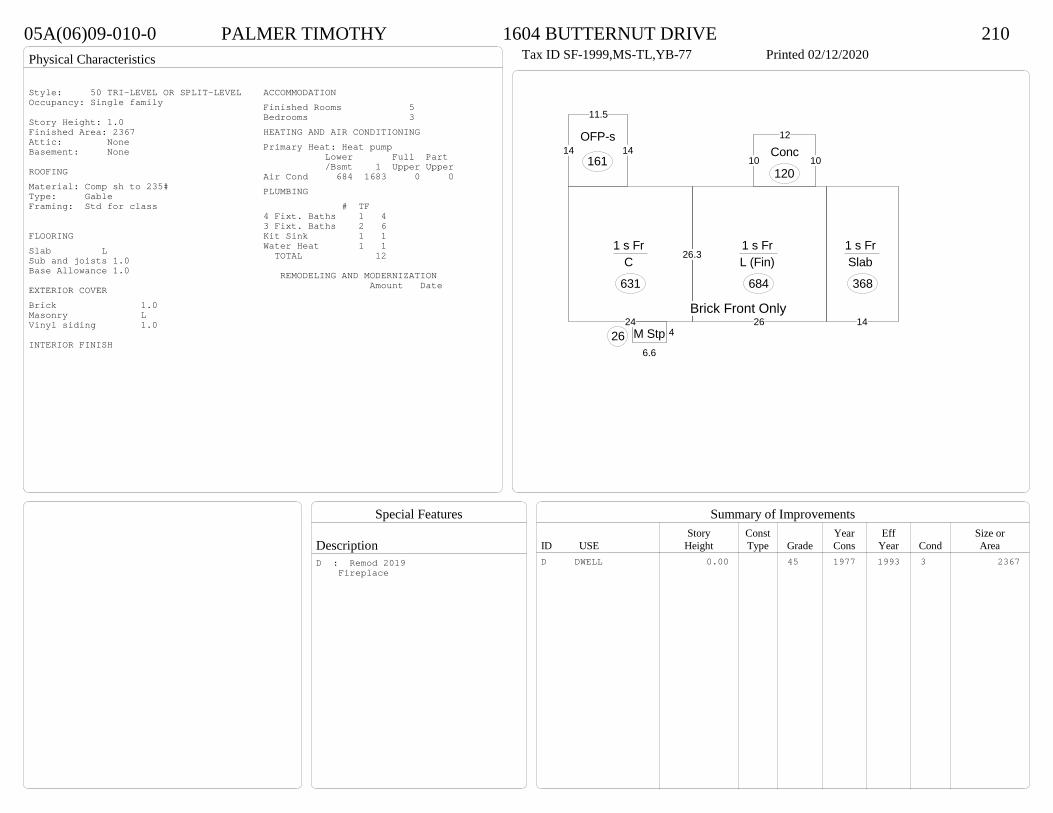
Physical Characteristics
Special Features
Description
Summary of ImprovementsStory Const Year Eff Size or
ID USE Height Type Grade Cons Year Cond Area
05A(06)09-010-0 PALMER TIMOTHY 1604 BUTTERNUT DRIVE 210Tax ID SF-1999,MS-TL,YB-77 Printed 02/12/2020
26.3
24
1 s Fr C
631
4
6.6
M Stp2626
1 s Fr L (Fin)
684
14
1 s Fr Slab
368
14
11.5
14OFP-s
161 10
12
10Conc
120
Brick Front Only
Style: 50 TRI-LEVEL OR SPLIT-LEVELOccupancy: Single family
Story Height: 1.0Finished Area: 2367 Attic: NoneBasement: None
ROOFINGMaterial: Comp sh to 235#Type: GableFraming: Std for class
FLOORINGSlab LSub and joists 1.0Base Allowance 1.0
EXTERIOR COVERBrick 1.0Masonry LVinyl siding 1.0
INTERIOR FINISH
ACCOMMODATIONFinished Rooms 5Bedrooms 3HEATING AND AIR CONDITIONINGPrimary Heat: Heat pump Lower Full Part /Bsmt 1 Upper UpperAir Cond 684 1683 0 0PLUMBING # TF4 Fixt. Baths 1 43 Fixt. Baths 2 6Kit Sink 1 1Water Heat 1 1 TOTAL 12
REMODELING AND MODERNIZATION Amount Date
D DWELL 0.00 45 1977 1993 3 2367D : Remod 2019 Fireplace
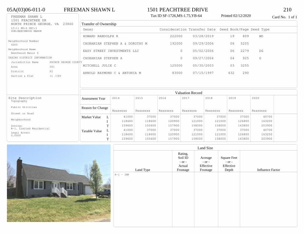
Transfer of Ownership
Valuation RecordAssessment Year
Reason for Change
Market Value
Taxable Value
LITLIT
Land SizeRating,Soil ID Acreage Square Feet- or - - or - - or -
Actual Effective EffectiveLand Type Frontage Frontage Depth Influence Factor
05A(03)06-011-0 FREEMAN SHAWN L 1501 PEACHTREE DRIVE 210Tax ID SF-1726,MS-1.75,YB-64 Printed 02/12/2020 Card No. 1 of 1FREEMAN SHAWN L
1501 PEACHTREE DRNORTH PRINCE GEORGE, VA 23860LT:11 BK:6 SEC:3SUB:BEECHWOOD MANOR
Neighborhood Number4005
Neighborhood NameBeechwood Manor S
TAXING DISTRICT INFORMATIONJurisdiction Name PRINCE GEORGE COUNTYArea 001 District P2 Section & Plat 11 /185
Site DescriptionTopography
Public Utilities
Street or Road
Neighborhood
Zoning:R-1. Limited ResidentialLegal Acres:0.0000
Owner Consideration Transfer Date Deed Book/Page Deed TypeHOWARD RANDOLPH R 222000 03/28/2019 19 809 WD
CHOBANIAN STEPHEN A & DOROTHY M 192000 09/29/2006 06 5205
EASY STREET INVESTMENTS LLC 0 05/02/2006 06 2279 DG
CHOBANIAN STEPHEN A 0 09/27/2004 04 925 G
MITCHELL JULIE C 125000 05/30/2003 03 3255
ARNOLD RAYMOND C & ANTONIA M 83000 07/15/1997 432 290
2014
Reassess 41000 118600 159600 41000 118600 159600
2015
Reassess 37000 118600 155600 37000 118600 155600
2016
Reassess 37000 120900 157900 37000 120900 157900
2017
Reassess 37000 121000 158000 37000 121000 158000
2018
Reassess 37000 121000 158000 37000 121000 158000
2019
Reassess 37000 126800 163800 37000 126800 163800
2020
Reassess 40700 163200 203900 40700 163200 203900
R-1 - IMP

Physical Characteristics
Special Features
Description
Summary of ImprovementsStory Const Year Eff Size or
ID USE Height Type Grade Cons Year Cond Area
05A(03)06-011-0 FREEMAN SHAWN L 1501 PEACHTREE DRIVE 210Tax ID SF-1726,MS-1.75,YB-64 Printed 02/12/2020
36.8
26.81-3/4 s Fr
C
986
11.9
20
EMP
238
47.7
M Stp 31
8
20
Conc 16014.2
22.1
A Fr G
314
01
Style: 21 1+ STORY <1979Occupancy: Single family
Story Height: 0Finished Area: 1774 Attic: UnfinishedBasement: None
ROOFINGMaterial: Comp sh to 235#Type: GableFraming: Std for class
FLOORINGSub and joists 1.0, 1.75, ABase Allowance 1.0, 1.75
EXTERIOR COVERVinyl siding 1.0, 1.75
INTERIOR FINISHDrywall 1.0
ACCOMMODATIONFinished Rooms 7Bedrooms 3HEATING AND AIR CONDITIONINGPrimary Heat: Heat pump Lower Full Part /Bsmt 1 Upper UpperAir Cond 0 986 0 788PLUMBING # TF3 Fixt. Baths 2 6Kit Sink 1 1Water Heat 1 1 TOTAL 8
REMODELING AND MODERNIZATION Amount Date
D DWELL 0.00 45 1964 1986 3 2286G01 ATTGAR 0.00 1 3 31401 UTLSHED 1.00 1 45 2002 2002 3 224
D : Fireplace
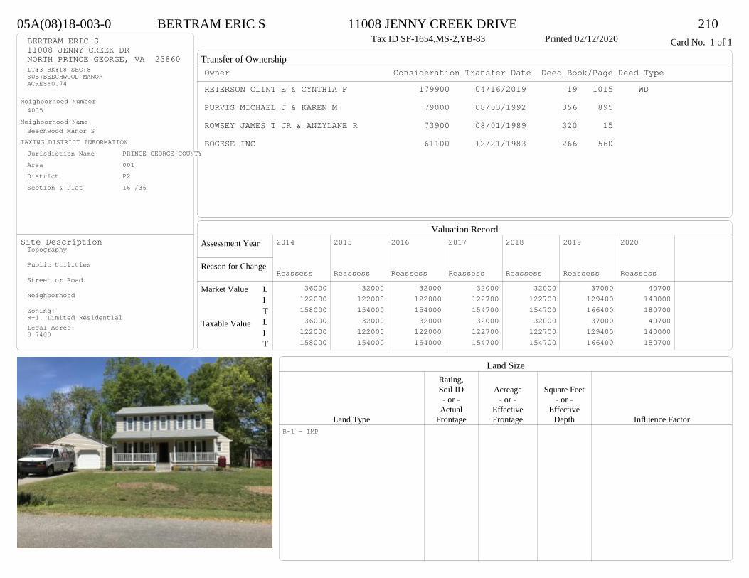
Transfer of Ownership
Valuation RecordAssessment Year
Reason for Change
Market Value
Taxable Value
LITLIT
Land SizeRating,Soil ID Acreage Square Feet- or - - or - - or -
Actual Effective EffectiveLand Type Frontage Frontage Depth Influence Factor
05A(08)18-003-0 BERTRAM ERIC S 11008 JENNY CREEK DRIVE 210Tax ID SF-1654,MS-2,YB-83 Printed 02/12/2020 Card No. 1 of 1BERTRAM ERIC S
11008 JENNY CREEK DRNORTH PRINCE GEORGE, VA 23860LT:3 BK:18 SEC:8SUB:BEECHWOOD MANORACRES:0.74
Neighborhood Number4005
Neighborhood NameBeechwood Manor S
TAXING DISTRICT INFORMATIONJurisdiction Name PRINCE GEORGE COUNTYArea 001 District P2 Section & Plat 16 /36
Site DescriptionTopography
Public Utilities
Street or Road
Neighborhood
Zoning:R-1. Limited ResidentialLegal Acres:0.7400
Owner Consideration Transfer Date Deed Book/Page Deed TypeREIERSON CLINT E & CYNTHIA F 179900 04/16/2019 19 1015 WD
PURVIS MICHAEL J & KAREN M 79000 08/03/1992 356 895
ROWSEY JAMES T JR & ANZYLANE R 73900 08/01/1989 320 15
BOGESE INC 61100 12/21/1983 266 560
2014
Reassess 36000 122000 158000 36000 122000 158000
2015
Reassess 32000 122000 154000 32000 122000 154000
2016
Reassess 32000 122000 154000 32000 122000 154000
2017
Reassess 32000 122700 154700 32000 122700 154700
2018
Reassess 32000 122700 154700 32000 122700 154700
2019
Reassess 37000 129400 166400 37000 129400 166400
2020
Reassess 40700 140000 180700 40700 140000 180700
R-1 - IMP

Physical Characteristics
Special Features
Description
Summary of ImprovementsStory Const Year Eff Size or
ID USE Height Type Grade Cons Year Cond Area
05A(08)18-003-0 BERTRAM ERIC S 11008 JENNY CREEK DRIVE 210Tax ID SF-1654,MS-2,YB-83 Printed 02/12/2020
24
33
2 s Fr C
792
10
7
1 s Fr C
70
8
20
Wd Dk 160
6OFP 198
01
Style: 32 2/2+Story 1980-1999Occupancy: Single family
Story Height: 2.0Finished Area: 1654 Attic: NoneBasement: None
ROOFINGMaterial: Comp sh to 235#Type: GableFraming: Std for class
FLOORINGSub and joists 1.0, 2.0Base Allowance 1.0, 2.0
EXTERIOR COVERVinyl siding 1.0, 2.0
INTERIOR FINISHDrywall 1.0, 2.0
ACCOMMODATIONFinished Rooms 5Bedrooms 3HEATING AND AIR CONDITIONINGPrimary Heat: Heat pump Lower Full Part /Bsmt 1 Upper UpperAir Cond 0 862 792 0PLUMBING # TF3 Fixt. Baths 1 32 Fixt. Baths 1 2Kit Sink 1 1Water Heat 1 1 TOTAL 7
REMODELING AND MODERNIZATION Amount Date
D DWELL 0.00 45 1983 1983 3 165401 DETGAR 1.00 1 45 1992 1992 3 576

Transfer of Ownership
Valuation RecordAssessment Year
Reason for Change
Market Value
Taxable Value
LITLIT
Land SizeRating,Soil ID Acreage Square Feet- or - - or - - or -
Actual Effective EffectiveLand Type Frontage Frontage Depth Influence Factor
05A(06)10-005-0 TOMLINSON MICHAEL D 10916 BEAVER CASTLE ROAD 210Tax ID SF-1568,MS-1,YB-77 Printed 02/12/2020 Card No. 1 of 1TOMLINSON MICHAEL D
10916 BEAVER CASTLE RDNORTH PRINCE GEORGE, VA 23860LT:5 BK:10 SEC:6SUB:BEECHWOOD MANOR
Neighborhood Number4005
Neighborhood NameBeechwood Manor S
TAXING DISTRICT INFORMATIONJurisdiction Name PRINCE GEORGE COUNTYArea 001 District P2 Section & Plat 16 /36
Site DescriptionTopography
Public Utilities
Street or Road
Neighborhood
Zoning:R-1. Limited ResidentialLegal Acres:0.0000
Owner Consideration Transfer Date Deed Book/Page Deed TypeANDERSON KEVIN D & MACHEL D 187500 12/17/2019 19 3776 WD
MILLER FLOYD W & DELORES J 197950 10/30/2007 07 5422
BENNETT ELBERT H JR & MILDRED W 65000 09/26/1980 248 536
BOGESE INCORPORATED 55000 02/17/1978 234 144
2014
Reassess 41000 119900 160900 41000 119900 160900
2015
Reassess 37000 119900 156900 37000 119900 156900
2016
Reassess 37000 119900 156900 37000 119900 156900
2017
Reassess 37000 122700 159700 37000 122700 159700
2018
Reassess 37000 122700 159700 37000 122700 159700
2019
Reassess 37000 129100 166100 37000 129100 166100
2020
Reassess 40700 130600 171300 40700 130600 171300
R-1 - IMP

Physical Characteristics
Special Features
Description
Summary of ImprovementsStory Const Year Eff Size or
ID USE Height Type Grade Cons Year Cond Area
05A(06)10-005-0 TOMLINSON MICHAEL D 10916 BEAVER CASTLE ROAD 210Tax ID SF-1568,MS-1,YB-77 Printed 02/12/2020
28
56
1 s Fr C
1568
46
M Stp24
15
819
9
10.6
5
Wd Dk
60820
Fr G
560
Brick FrontBrick
Style: 13 1 STORY 1970-78Occupancy: Single family
Story Height: 1.0Finished Area: 1568 Attic: NoneBasement: None
ROOFINGMaterial: Comp sh to 235#Type: GableFraming: Std for class
FLOORINGSub and joists 1.0Base Allowance 1.0
EXTERIOR COVERBrick 1.0Vinyl siding 1.0
INTERIOR FINISH
ACCOMMODATIONFinished Rooms 6Bedrooms 4HEATING AND AIR CONDITIONINGPrimary Heat: Heat pump Lower Full Part /Bsmt 1 Upper UpperAir Cond 0 1568 0 0PLUMBING # TF3 Fixt. Baths 2 6Kit Sink 1 1Water Heat 1 1 TOTAL 8
REMODELING AND MODERNIZATION Amount Date
D DWELL 0.00 45 1977 1989 3 1568G01 ATTGAR 0.00 1 560
D : Fireplace
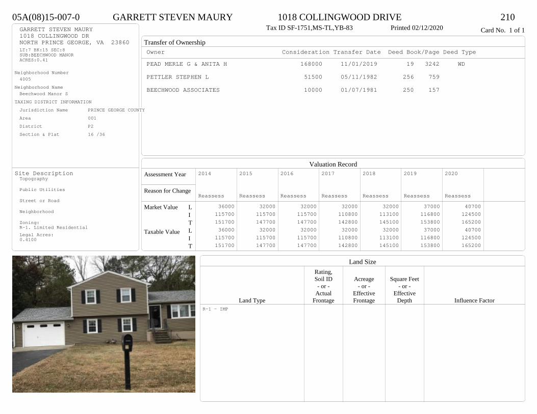
Transfer of Ownership
Valuation RecordAssessment Year
Reason for Change
Market Value
Taxable Value
LITLIT
Land SizeRating,Soil ID Acreage Square Feet- or - - or - - or -
Actual Effective EffectiveLand Type Frontage Frontage Depth Influence Factor
05A(08)15-007-0 GARRETT STEVEN MAURY 1018 COLLINGWOOD DRIVE 210Tax ID SF-1751,MS-TL,YB-83 Printed 02/12/2020 Card No. 1 of 1GARRETT STEVEN MAURY
1018 COLLINGWOOD DRNORTH PRINCE GEORGE, VA 23860LT:7 BK:15 SEC:8SUB:BEECHWOOD MANORACRES:0.41
Neighborhood Number4005
Neighborhood NameBeechwood Manor S
TAXING DISTRICT INFORMATIONJurisdiction Name PRINCE GEORGE COUNTYArea 001 District P2 Section & Plat 16 /36
Site DescriptionTopography
Public Utilities
Street or Road
Neighborhood
Zoning:R-1. Limited ResidentialLegal Acres:0.4100
Owner Consideration Transfer Date Deed Book/Page Deed TypePEAD MERLE G & ANITA H 168000 11/01/2019 19 3242 WD
PETTLER STEPHEN L 51500 05/11/1982 256 759
BEECHWOOD ASSOCIATES 10000 01/07/1981 250 157
2014
Reassess 36000 115700 151700 36000 115700 151700
2015
Reassess 32000 115700 147700 32000 115700 147700
2016
Reassess 32000 115700 147700 32000 115700 147700
2017
Reassess 32000 110800 142800 32000 110800 142800
2018
Reassess 32000 113100 145100 32000 113100 145100
2019
Reassess 37000 116800 153800 37000 116800 153800
2020
Reassess 40700 124500 165200 40700 124500 165200
R-1 - IMP
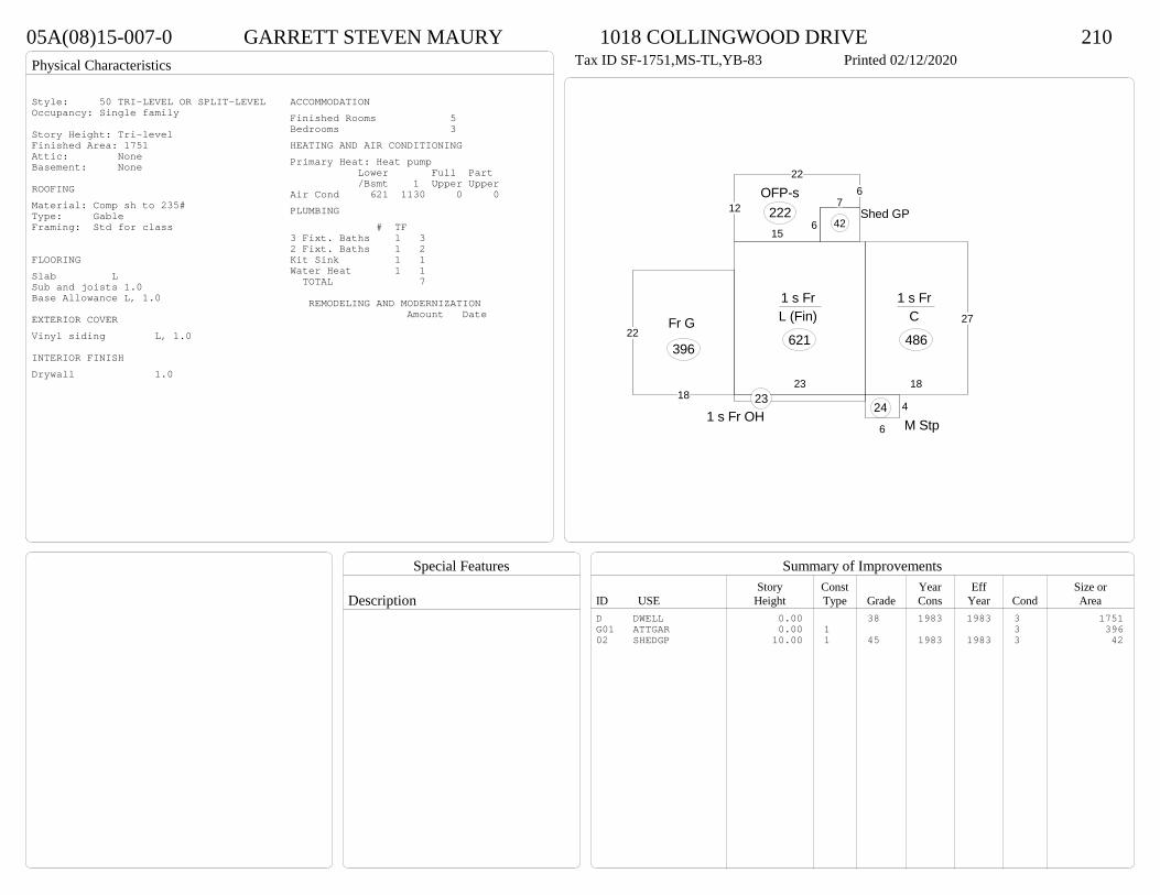
Physical Characteristics
Special Features
Description
Summary of ImprovementsStory Const Year Eff Size or
ID USE Height Type Grade Cons Year Cond Area
05A(08)15-007-0 GARRETT STEVEN MAURY 1018 COLLINGWOOD DRIVE 210Tax ID SF-1751,MS-TL,YB-83 Printed 02/12/2020
27
18
1 s Fr C
486
23
1 s Fr L (Fin)
621
12
226
7
615
OFP-s222
6
4
M Stp24
1 s Fr OH 23
22
18
Fr G
396
Shed GP42
Style: 50 TRI-LEVEL OR SPLIT-LEVELOccupancy: Single family
Story Height: Tri-levelFinished Area: 1751 Attic: NoneBasement: None
ROOFINGMaterial: Comp sh to 235#Type: GableFraming: Std for class
FLOORINGSlab LSub and joists 1.0Base Allowance L, 1.0
EXTERIOR COVERVinyl siding L, 1.0
INTERIOR FINISHDrywall 1.0
ACCOMMODATIONFinished Rooms 5Bedrooms 3HEATING AND AIR CONDITIONINGPrimary Heat: Heat pump Lower Full Part /Bsmt 1 Upper UpperAir Cond 621 1130 0 0PLUMBING # TF3 Fixt. Baths 1 32 Fixt. Baths 1 2Kit Sink 1 1Water Heat 1 1 TOTAL 7
REMODELING AND MODERNIZATION Amount Date
D DWELL 0.00 38 1983 1983 3 1751G01 ATTGAR 0.00 1 3 39602 SHEDGP 10.00 1 45 1983 1983 3 42
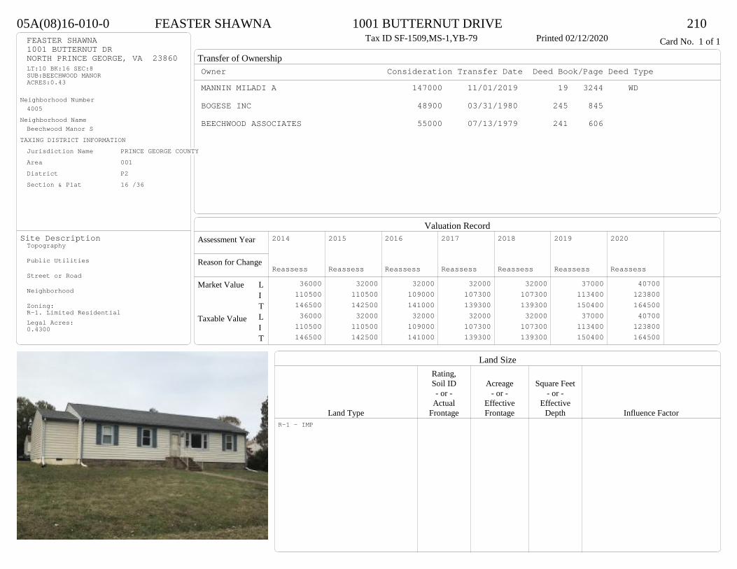
Transfer of Ownership
Valuation RecordAssessment Year
Reason for Change
Market Value
Taxable Value
LITLIT
Land SizeRating,Soil ID Acreage Square Feet- or - - or - - or -
Actual Effective EffectiveLand Type Frontage Frontage Depth Influence Factor
05A(08)16-010-0 FEASTER SHAWNA 1001 BUTTERNUT DRIVE 210Tax ID SF-1509,MS-1,YB-79 Printed 02/12/2020 Card No. 1 of 1FEASTER SHAWNA
1001 BUTTERNUT DRNORTH PRINCE GEORGE, VA 23860LT:10 BK:16 SEC:8SUB:BEECHWOOD MANORACRES:0.43
Neighborhood Number4005
Neighborhood NameBeechwood Manor S
TAXING DISTRICT INFORMATIONJurisdiction Name PRINCE GEORGE COUNTYArea 001 District P2 Section & Plat 16 /36
Site DescriptionTopography
Public Utilities
Street or Road
Neighborhood
Zoning:R-1. Limited ResidentialLegal Acres:0.4300
Owner Consideration Transfer Date Deed Book/Page Deed TypeMANNIN MILADI A 147000 11/01/2019 19 3244 WD
BOGESE INC 48900 03/31/1980 245 845
BEECHWOOD ASSOCIATES 55000 07/13/1979 241 606
2014
Reassess 36000 110500 146500 36000 110500 146500
2015
Reassess 32000 110500 142500 32000 110500 142500
2016
Reassess 32000 109000 141000 32000 109000 141000
2017
Reassess 32000 107300 139300 32000 107300 139300
2018
Reassess 32000 107300 139300 32000 107300 139300
2019
Reassess 37000 113400 150400 37000 113400 150400
2020
Reassess 40700 123800 164500 40700 123800 164500
R-1 - IMP

Physical Characteristics
Special Features
Description
Summary of ImprovementsStory Const Year Eff Size or
ID USE Height Type Grade Cons Year Cond Area
05A(08)16-010-0 FEASTER SHAWNA 1001 BUTTERNUT DRIVE 210Tax ID SF-1509,MS-1,YB-79 Printed 02/12/2020
26
5138
20
83
1 s Fr C
1486
4
6M Stp24
4
4
M Stp
16
10
12
715.5
OFP 145
01
Style: 14 1 STORY 1979-89Occupancy: Single family
Story Height: 1.0Finished Area: 1486 Attic: NoneBasement: None
ROOFINGMaterial: Comp sh to 235#Type: GableFraming: Std for class
FLOORINGSub and joists 1.0Base Allowance 1.0
EXTERIOR COVERVinyl siding 1.0
INTERIOR FINISHDrywall 1.0
ACCOMMODATIONFinished Rooms 6Bedrooms 4HEATING AND AIR CONDITIONINGPrimary Heat: Heat pump Lower Full Part /Bsmt 1 Upper UpperAir Cond 0 1486 0 0PLUMBING # TF3 Fixt. Baths 2 6Kit Sink 1 1Water Heat 1 1 TOTAL 8
REMODELING AND MODERNIZATION Amount Date
D DWELL 0.00 45 1979 1979 3 148601 DETGAR 0.00 1 45 1979 1979 3 576

Transfer of Ownership
Valuation RecordAssessment Year
Reason for Change
Market Value
Taxable Value
LITLIT
Land SizeRating,Soil ID Acreage Square Feet- or - - or - - or -
Actual Effective EffectiveLand Type Frontage Frontage Depth Influence Factor
05A(02)03-003-0 BLANKENSHIP MICHAEL T 1317 LEMONWOOD DRIVE 210Tax ID SF-2009,MS-1,YB-56 Printed 02/12/2020 Card No. 1 of 1BLANKENSHIP MICHAEL T
1317 LEMONWOOD DRNORTH PRINCE GEORGE, VA 23860LT:3 BK:3 SEC:2SUB:BEECHWOOD MANOR
Neighborhood Number4005
Neighborhood NameBeechwood Manor S
TAXING DISTRICT INFORMATIONJurisdiction Name PRINCE GEORGE COUNTYArea 001 District P2 Section & Plat 10 /143
Site DescriptionTopography
Public Utilities
Street or Road
Neighborhood
Zoning:R-1. Limited ResidentialLegal Acres:0.0000
Owner Consideration Transfer Date Deed Book/Page Deed TypeDRAPER BEVERLEY M 162000 04/10/2019 19 957 WD
DRAPER WILLIAM E JR & BEVERLEY M 0 12/21/2015 CD
RUSMISELL ANNE C ESTATE 150000 04/01/2005 05 1459
TRIMBUR WILLIAM & JEANETTE R 32500 02/21/1975 221 342
SEAY THOMAS B & MARY B 18500 07/22/1965 185 264
2014
Reassess 41000 112200 153200 41000 112200 153200
2015
Reassess 37000 112200 149200 37000 112200 149200
2016
Reassess 37000 112200 149200 37000 112200 149200
2017
Reassess 37000 112200 149200 37000 112200 149200
2018
Reassess 37000 112200 149200 37000 112200 149200
2019
Reassess 37000 118900 155900 37000 118900 155900
2020
Reassess 40700 123600 164300 40700 123600 164300
R-1 - IMP
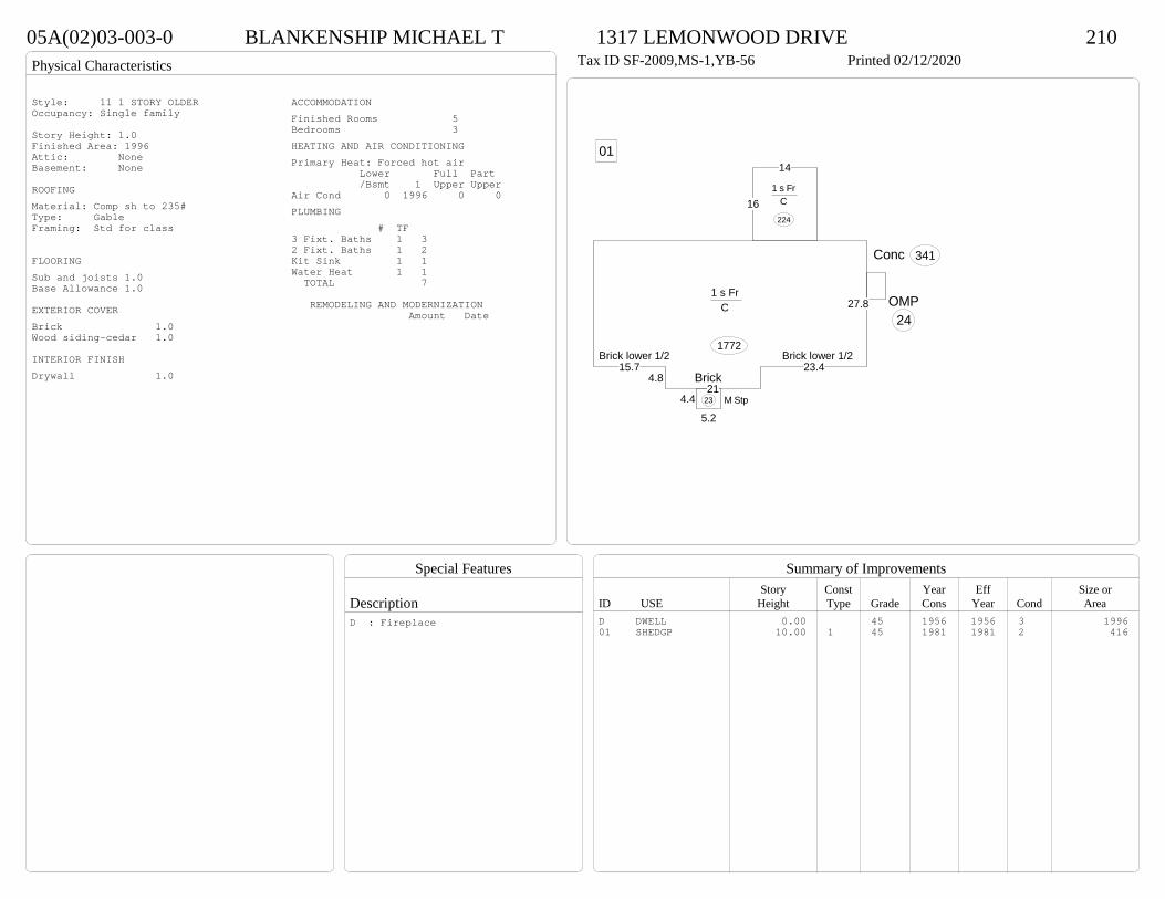
Physical Characteristics
Special Features
Description
Summary of ImprovementsStory Const Year Eff Size or
ID USE Height Type Grade Cons Year Cond Area
05A(02)03-003-0 BLANKENSHIP MICHAEL T 1317 LEMONWOOD DRIVE 210Tax ID SF-2009,MS-1,YB-56 Printed 02/12/2020
15.74.8
21
23.4
27.81 s Fr
C
1772
16
14
1 s Fr C
224
4.4
5.2M Stp23
OMP24
Conc 341
01
Brick
Brick lower 1/2 Brick lower 1/2
Style: 11 1 STORY OLDEROccupancy: Single family
Story Height: 1.0Finished Area: 1996 Attic: NoneBasement: None
ROOFINGMaterial: Comp sh to 235#Type: GableFraming: Std for class
FLOORINGSub and joists 1.0Base Allowance 1.0
EXTERIOR COVERBrick 1.0Wood siding-cedar 1.0
INTERIOR FINISHDrywall 1.0
ACCOMMODATIONFinished Rooms 5Bedrooms 3HEATING AND AIR CONDITIONINGPrimary Heat: Forced hot air Lower Full Part /Bsmt 1 Upper UpperAir Cond 0 1996 0 0PLUMBING # TF3 Fixt. Baths 1 32 Fixt. Baths 1 2Kit Sink 1 1Water Heat 1 1 TOTAL 7
REMODELING AND MODERNIZATION Amount Date
D DWELL 0.00 45 1956 1956 3 199601 SHEDGP 10.00 1 45 1981 1981 2 416
D : Fireplace
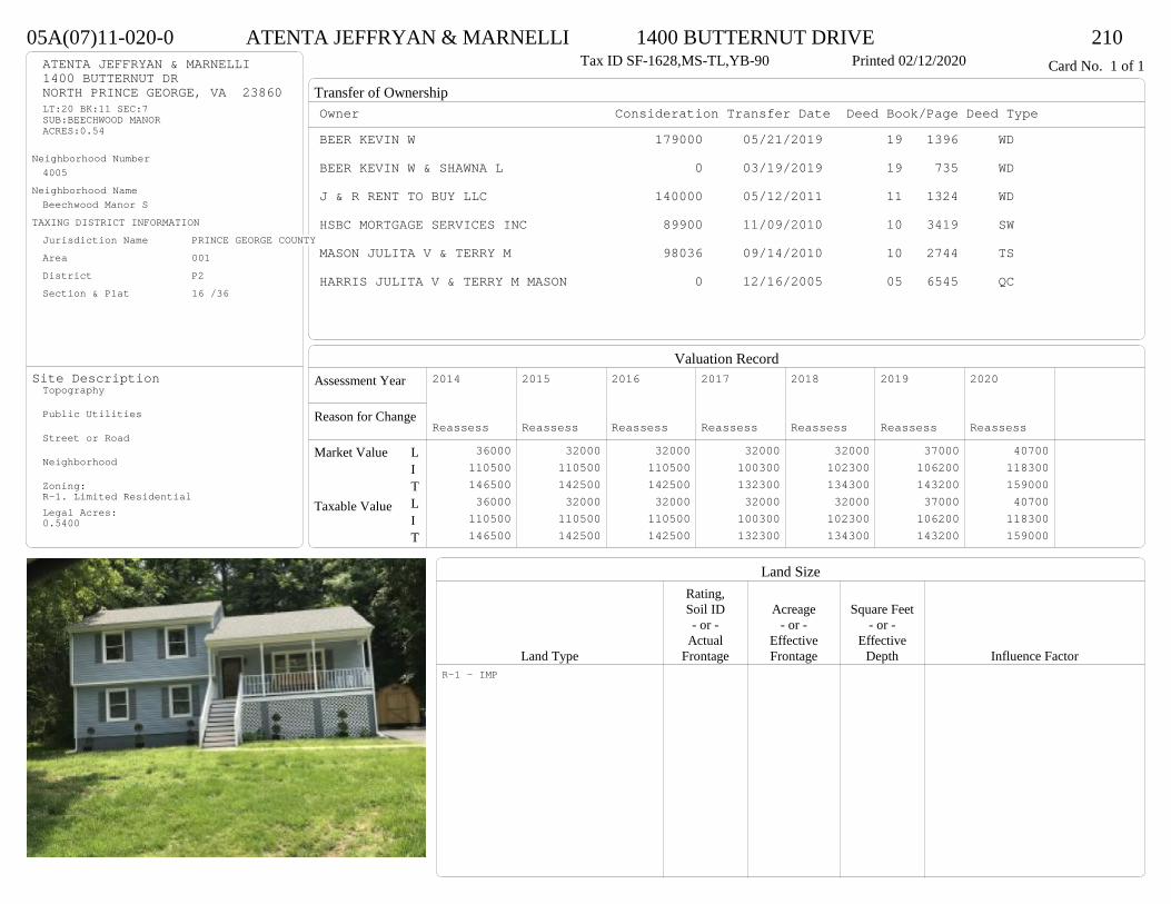
Transfer of Ownership
Valuation RecordAssessment Year
Reason for Change
Market Value
Taxable Value
LITLIT
Land SizeRating,Soil ID Acreage Square Feet- or - - or - - or -
Actual Effective EffectiveLand Type Frontage Frontage Depth Influence Factor
05A(07)11-020-0 ATENTA JEFFRYAN & MARNELLI 1400 BUTTERNUT DRIVE 210Tax ID SF-1628,MS-TL,YB-90 Printed 02/12/2020 Card No. 1 of 1ATENTA JEFFRYAN & MARNELLI
1400 BUTTERNUT DRNORTH PRINCE GEORGE, VA 23860LT:20 BK:11 SEC:7SUB:BEECHWOOD MANORACRES:0.54
Neighborhood Number4005
Neighborhood NameBeechwood Manor S
TAXING DISTRICT INFORMATIONJurisdiction Name PRINCE GEORGE COUNTYArea 001 District P2 Section & Plat 16 /36
Site DescriptionTopography
Public Utilities
Street or Road
Neighborhood
Zoning:R-1. Limited ResidentialLegal Acres:0.5400
Owner Consideration Transfer Date Deed Book/Page Deed TypeBEER KEVIN W 179000 05/21/2019 19 1396 WD
BEER KEVIN W & SHAWNA L 0 03/19/2019 19 735 WD
J & R RENT TO BUY LLC 140000 05/12/2011 11 1324 WD
HSBC MORTGAGE SERVICES INC 89900 11/09/2010 10 3419 SW
MASON JULITA V & TERRY M 98036 09/14/2010 10 2744 TS
HARRIS JULITA V & TERRY M MASON 0 12/16/2005 05 6545 QC
2014
Reassess 36000 110500 146500 36000 110500 146500
2015
Reassess 32000 110500 142500 32000 110500 142500
2016
Reassess 32000 110500 142500 32000 110500 142500
2017
Reassess 32000 100300 132300 32000 100300 132300
2018
Reassess 32000 102300 134300 32000 102300 134300
2019
Reassess 37000 106200 143200 37000 106200 143200
2020
Reassess 40700 118300 159000 40700 118300 159000
R-1 - IMP
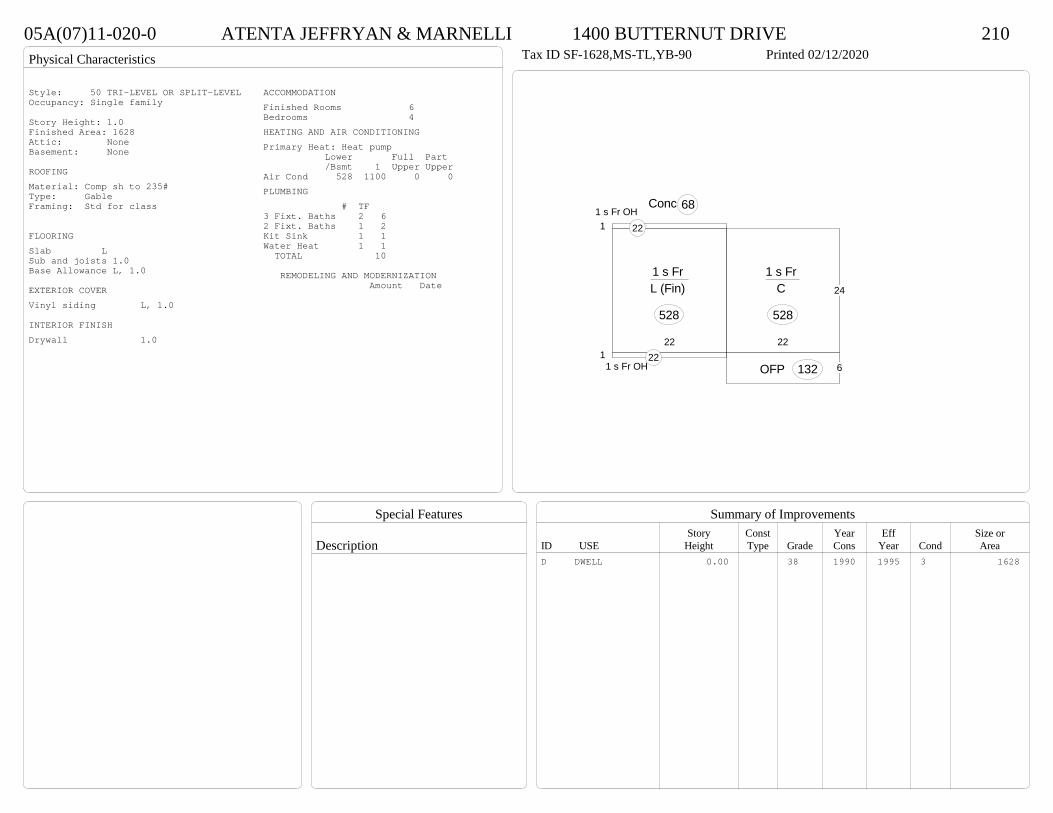
Physical Characteristics
Special Features
Description
Summary of ImprovementsStory Const Year Eff Size or
ID USE Height Type Grade Cons Year Cond Area
05A(07)11-020-0 ATENTA JEFFRYAN & MARNELLI 1400 BUTTERNUT DRIVE 210Tax ID SF-1628,MS-TL,YB-90 Printed 02/12/2020
24
22
1 s Fr C
528
22
1 s Fr L (Fin)
528
6OFP 1321
1 s Fr OH 22
11 s Fr OH
22
Conc 68
Style: 50 TRI-LEVEL OR SPLIT-LEVELOccupancy: Single family
Story Height: 1.0Finished Area: 1628 Attic: NoneBasement: None
ROOFINGMaterial: Comp sh to 235#Type: GableFraming: Std for class
FLOORINGSlab LSub and joists 1.0Base Allowance L, 1.0
EXTERIOR COVERVinyl siding L, 1.0
INTERIOR FINISHDrywall 1.0
ACCOMMODATIONFinished Rooms 6Bedrooms 4HEATING AND AIR CONDITIONINGPrimary Heat: Heat pump Lower Full Part /Bsmt 1 Upper UpperAir Cond 528 1100 0 0PLUMBING # TF3 Fixt. Baths 2 62 Fixt. Baths 1 2Kit Sink 1 1Water Heat 1 1 TOTAL 10
REMODELING AND MODERNIZATION Amount Date
D DWELL 0.00 38 1990 1995 3 1628

Transfer of Ownership
Valuation RecordAssessment Year
Reason for Change
Market Value
Taxable Value
LITLIT
Land SizeRating,Soil ID Acreage Square Feet- or - - or - - or -
Actual Effective EffectiveLand Type Frontage Frontage Depth Influence Factor
05A(07)11-005-0 GREGORY JOSEPH W 11017 SASSAFRAS DRIVE 210Tax ID SF-1628,MS-TL,YB-90 Printed 02/12/2020 Card No. 1 of 1GREGORY JOSEPH W
11017 SASSAFRAS DRNORTH PRINCE GEORGE, VA 23860LT:5 BK:11 SEC:7SUB:BEECHWOOD MANORACRES:0.55
Neighborhood Number4005
Neighborhood NameBeechwood Manor S
TAXING DISTRICT INFORMATIONJurisdiction Name PRINCE GEORGE COUNTYArea 001 District P2 Section & Plat 16 /36
Site DescriptionTopography
Public Utilities
Street or Road
Neighborhood
Zoning:R-1. Limited ResidentialLegal Acres:0.5500
Owner Consideration Transfer Date Deed Book/Page Deed TypeHARRISON DIANNE LEE 177448 07/18/2019 19 2096 WD
LEMON THOMAS A & DIANE L 0 02/05/1992 348 124
BOGESE INC 75500 03/02/1990 326 248
2014
Reassess 36000 107400 143400 36000 107400 143400
2015
Reassess 32000 107400 139400 32000 107400 139400
2016
Reassess 32000 107400 139400 32000 107400 139400
2017
Reassess 32000 99500 131500 32000 99500 131500
2018
Reassess 32000 101400 133400 32000 101400 133400
2019
Reassess 37000 105400 142400 37000 105400 142400
2020
Reassess 40700 113300 154000 40700 113300 154000
R-1 - IMP

Physical Characteristics
Special Features
Description
Summary of ImprovementsStory Const Year Eff Size or
ID USE Height Type Grade Cons Year Cond Area
05A(07)11-005-0 GREGORY JOSEPH W 11017 SASSAFRAS DRIVE 210Tax ID SF-1628,MS-TL,YB-90 Printed 02/12/2020
24
22
1 s Fr C
528
22
1 s Fr L (Fin)
528
10
12
Wd Dk120
5
4
Wd Dk20
1 s Fr OH 22
1 s Fr OH 22
Style: 50 TRI-LEVEL OR SPLIT-LEVELOccupancy: Single family
Story Height: Tri-levelFinished Area: 1628 Attic: NoneBasement: None
ROOFINGMaterial: Comp sh to 235#Type: GableFraming: Std for class
FLOORINGSlab LSub and joists 1.0Base Allowance L, 1.0
EXTERIOR COVERVinyl siding L, 1.0
INTERIOR FINISHDrywall 1.0
ACCOMMODATIONFinished Rooms 5Bedrooms 3HEATING AND AIR CONDITIONINGPrimary Heat: Heat pump Lower Full Part /Bsmt 1 Upper UpperAir Cond 528 1100 0 0PLUMBING # TF3 Fixt. Baths 2 6Kit Sink 1 1Water Heat 1 1 TOTAL 8
REMODELING AND MODERNIZATION Amount Date
D DWELL 0.00 38 1990 1990 3 1628
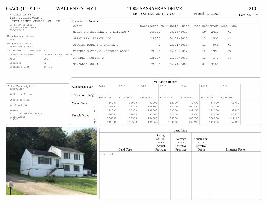
Transfer of Ownership
Valuation RecordAssessment Year
Reason for Change
Market Value
Taxable Value
LITLIT
Land SizeRating,Soil ID Acreage Square Feet- or - - or - - or -
Actual Effective EffectiveLand Type Frontage Frontage Depth Influence Factor
05A(07)11-011-0 WALLEN CATHY L 11005 SASSAFRAS DRIVE 210Tax ID SF-1522,MS-TL,YB-88 Printed 02/12/2020 Card No. 1 of 1WALLEN CATHY L
1124 COLLINGWOOD DRNORTH PRINCE GEORGE, VA 23875LT:11 BK:11 SEC:7SUB:BEECHWOOD MANORACRES:0.48
Neighborhood Number4005
Neighborhood NameBeechwood Manor S
TAXING DISTRICT INFORMATIONJurisdiction Name PRINCE GEORGE COUNTYArea 001 District P2 Section & Plat 16 /36
Site DescriptionTopography
Public Utilities
Street or Road
Neighborhood
Zoning:R-1. Limited ResidentialLegal Acres:0.4800
Owner Consideration Transfer Date Deed Book/Page Deed TypeMOODY CHRISTOPHER D & KRISTEN W 160000 08/16/2019 19 2412 WD
GREAT REAL ESTATE LLC 118000 04/01/2013 13 1091 WD
WIGGINS MARK E & LAURIE J 0 03/21/2013 13 968 WD
FEDERAL NATIONAL MORTGAGE ASSOC 70000 06/18/2012 12 1995 SW
CHANDLER HUSTON C 138647 01/20/2012 12 170 SW
GONZALEZ ADA I 170000 06/21/2007 07 3181
2014
Reassess 36000 106300 142300 36000 106300 142300
2015
Reassess 32000 106300 138300 32000 106300 138300
2016
Reassess 32000 106300 138300 32000 106300 138300
2017
Reassess 32000 98300 130300 32000 98300 130300
2018
Reassess 32000 100200 132200 32000 100200 132200
2019
Reassess 37000 104200 141200 37000 104200 141200
2020
Reassess 40700 112100 152800 40700 112100 152800
R-1 - IMP
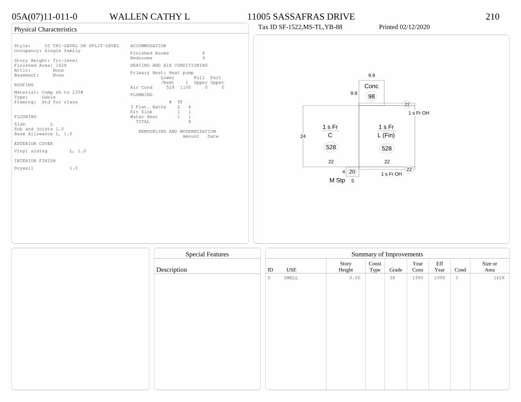
Physical Characteristics
Special Features
Description
Summary of ImprovementsStory Const Year Eff Size or
ID USE Height Type Grade Cons Year Cond Area
05A(07)11-011-0 WALLEN CATHY L 11005 SASSAFRAS DRIVE 210Tax ID SF-1522,MS-TL,YB-88 Printed 02/12/2020
24
22
1 s Fr C
528
22
1 s Fr L (Fin)
528
1 s Fr OH 22
1 s Fr OH
22
5
4
M Stp20
9.9
9.9
Conc98
Style: 50 TRI-LEVEL OR SPLIT-LEVELOccupancy: Single family
Story Height: Tri-levelFinished Area: 1628 Attic: NoneBasement: None
ROOFINGMaterial: Comp sh to 235#Type: GableFraming: Std for class
FLOORINGSlab LSub and joists 1.0Base Allowance L, 1.0
EXTERIOR COVERVinyl siding L, 1.0
INTERIOR FINISHDrywall 1.0
ACCOMMODATIONFinished Rooms 6Bedrooms 4HEATING AND AIR CONDITIONINGPrimary Heat: Heat pump Lower Full Part /Bsmt 1 Upper UpperAir Cond 528 1100 0 0PLUMBING # TF3 Fixt. Baths 2 6Kit Sink 1 1Water Heat 1 1 TOTAL 8
REMODELING AND MODERNIZATION Amount Date
D DWELL 0.00 38 1990 1990 3 1628
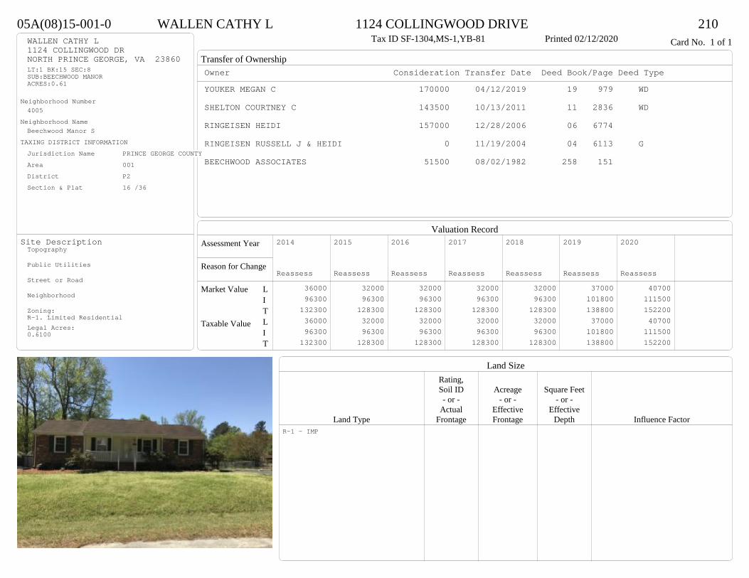
Transfer of Ownership
Valuation RecordAssessment Year
Reason for Change
Market Value
Taxable Value
LITLIT
Land SizeRating,Soil ID Acreage Square Feet- or - - or - - or -
Actual Effective EffectiveLand Type Frontage Frontage Depth Influence Factor
05A(08)15-001-0 WALLEN CATHY L 1124 COLLINGWOOD DRIVE 210Tax ID SF-1304,MS-1,YB-81 Printed 02/12/2020 Card No. 1 of 1WALLEN CATHY L
1124 COLLINGWOOD DRNORTH PRINCE GEORGE, VA 23860LT:1 BK:15 SEC:8SUB:BEECHWOOD MANORACRES:0.61
Neighborhood Number4005
Neighborhood NameBeechwood Manor S
TAXING DISTRICT INFORMATIONJurisdiction Name PRINCE GEORGE COUNTYArea 001 District P2 Section & Plat 16 /36
Site DescriptionTopography
Public Utilities
Street or Road
Neighborhood
Zoning:R-1. Limited ResidentialLegal Acres:0.6100
Owner Consideration Transfer Date Deed Book/Page Deed TypeYOUKER MEGAN C 170000 04/12/2019 19 979 WD
SHELTON COURTNEY C 143500 10/13/2011 11 2836 WD
RINGEISEN HEIDI 157000 12/28/2006 06 6774
RINGEISEN RUSSELL J & HEIDI 0 11/19/2004 04 6113 G
BEECHWOOD ASSOCIATES 51500 08/02/1982 258 151
2014
Reassess 36000 96300 132300 36000 96300 132300
2015
Reassess 32000 96300 128300 32000 96300 128300
2016
Reassess 32000 96300 128300 32000 96300 128300
2017
Reassess 32000 96300 128300 32000 96300 128300
2018
Reassess 32000 96300 128300 32000 96300 128300
2019
Reassess 37000 101800 138800 37000 101800 138800
2020
Reassess 40700 111500 152200 40700 111500 152200
R-1 - IMP

Physical Characteristics
Special Features
Description
Summary of ImprovementsStory Const Year Eff Size or
ID USE Height Type Grade Cons Year Cond Area
05A(08)15-001-0 WALLEN CATHY L 1124 COLLINGWOOD DRIVE 210Tax ID SF-1304,MS-1,YB-81 Printed 02/12/2020
10
12.5
32
24
50
1 s Fr C
1300
15
63
16.3
24.5
14.3
8
Wd Dk
464
3
22
OMP 66
Style: 14 1 STORY 1979-89Occupancy: Single family
Story Height: 1.0Finished Area: 1300 Attic: NoneBasement: None
ROOFINGMaterial: Comp sh to 235#Type: GableFraming: Std for class
FLOORINGSub and joists 1.0Base Allowance 1.0
EXTERIOR COVERBrick 1.0Vinyl siding 1.0
INTERIOR FINISHDrywall 1.0
ACCOMMODATIONFinished Rooms 5Bedrooms 3HEATING AND AIR CONDITIONINGPrimary Heat: Heat pump Lower Full Part /Bsmt 1 Upper UpperAir Cond 0 1300 0 0PLUMBING # TF4 Fixt. Baths 1 42 Fixt. Baths 1 2Kit Sink 1 1Water Heat 1 1 TOTAL 8
REMODELING AND MODERNIZATION Amount Date
D DWELL 0.00 45 1981 1981 3 1300D : Fireplace
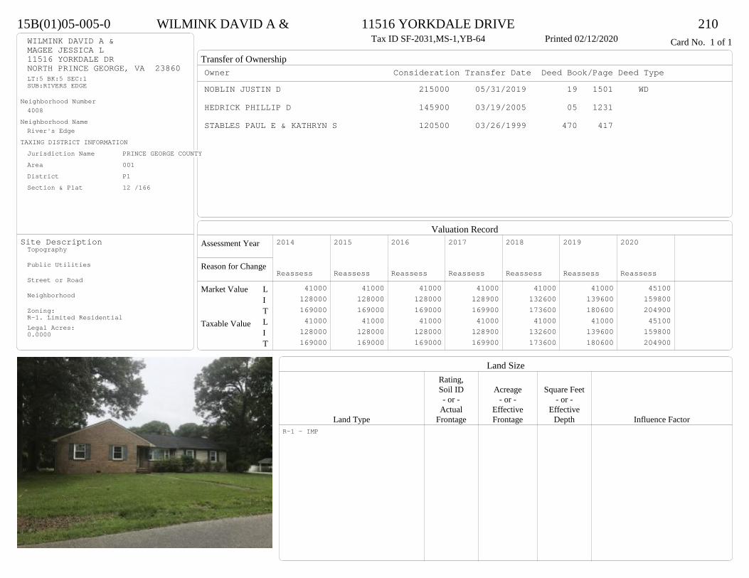
Transfer of Ownership
Valuation RecordAssessment Year
Reason for Change
Market Value
Taxable Value
LITLIT
Land SizeRating,Soil ID Acreage Square Feet- or - - or - - or -
Actual Effective EffectiveLand Type Frontage Frontage Depth Influence Factor
15B(01)05-005-0 WILMINK DAVID A & 11516 YORKDALE DRIVE 210Tax ID SF-2031,MS-1,YB-64 Printed 02/12/2020 Card No. 1 of 1WILMINK DAVID A &
MAGEE JESSICA L11516 YORKDALE DRNORTH PRINCE GEORGE, VA 23860LT:5 BK:5 SEC:1SUB:RIVERS EDGE
Neighborhood Number4008
Neighborhood NameRiver's Edge
TAXING DISTRICT INFORMATIONJurisdiction Name PRINCE GEORGE COUNTYArea 001 District P1 Section & Plat 12 /166
Site DescriptionTopography
Public Utilities
Street or Road
Neighborhood
Zoning:R-1. Limited ResidentialLegal Acres:0.0000
Owner Consideration Transfer Date Deed Book/Page Deed TypeNOBLIN JUSTIN D 215000 05/31/2019 19 1501 WD
HEDRICK PHILLIP D 145900 03/19/2005 05 1231
STABLES PAUL E & KATHRYN S 120500 03/26/1999 470 417
2014
Reassess 41000 128000 169000 41000 128000 169000
2015
Reassess 41000 128000 169000 41000 128000 169000
2016
Reassess 41000 128000 169000 41000 128000 169000
2017
Reassess 41000 128900 169900 41000 128900 169900
2018
Reassess 41000 132600 173600 41000 132600 173600
2019
Reassess 41000 139600 180600 41000 139600 180600
2020
Reassess 45100 159800 204900 45100 159800 204900
R-1 - IMP

Physical Characteristics
Special Features
Description
Summary of ImprovementsStory Const Year Eff Size or
ID USE Height Type Grade Cons Year Cond Area
15B(01)05-005-0 WILMINK DAVID A & 11516 YORKDALE DRIVE 210Tax ID SF-2031,MS-1,YB-64 Printed 02/12/2020
30.8
30.1
12.8
32.9
19.1
23.8
1 s Br C
1310
23.3
26.3
1 s Fr C
613
56OMP
30
12
19.2RFXConc230
24
12Wd Dk
288
01
Style: 12 1 STORY 1960-69Occupancy: Single family
Story Height: 1.0Finished Area: 1923 Attic: NoneBasement: None
ROOFINGMaterial: Comp sh to 235#Type: GableFraming: Std for class
FLOORINGSlab 1.0Base Allowance 1.0
EXTERIOR COVERBrick 1.0Vinyl siding 1.0
INTERIOR FINISHDrywall 1.0
ACCOMMODATIONFinished Rooms 6Bedrooms 4HEATING AND AIR CONDITIONINGPrimary Heat: Central Warm Air Lower Full Part /Bsmt 1 Upper UpperAir Cond 0 1923 0 0PLUMBING # TF3 Fixt. Baths 3 9Kit Sink 1 1Water Heat 1 1 TOTAL 11
REMODELING AND MODERNIZATION Amount Date
D DWELL 0.00 45 1964 1986 3 192301 POOL 0.00 18 45 1980 1980 3 648
D : Fireplace, Fireplace
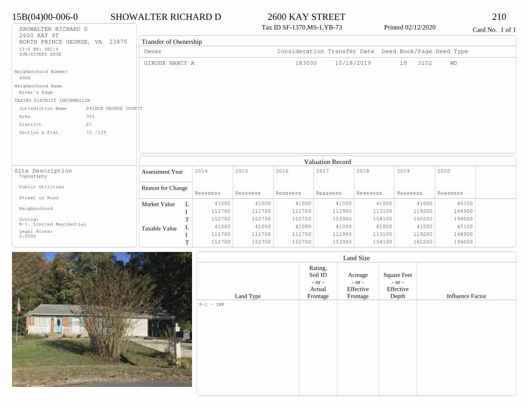
Transfer of Ownership
Valuation RecordAssessment Year
Reason for Change
Market Value
Taxable Value
LITLIT
Land SizeRating,Soil ID Acreage Square Feet- or - - or - - or -
Actual Effective EffectiveLand Type Frontage Frontage Depth Influence Factor
15B(04)00-006-0 SHOWALTER RICHARD D 2600 KAY STREET 210Tax ID SF-1370,MS-1,YB-73 Printed 02/12/2020 Card No. 1 of 1SHOWALTER RICHARD D
2600 KAY STNORTH PRINCE GEORGE, VA 23875LT:6 BK: SEC:4SUB:RIVERS EDGE
Neighborhood Number4008
Neighborhood NameRiver's Edge
TAXING DISTRICT INFORMATIONJurisdiction Name PRINCE GEORGE COUNTYArea 001 District P1 Section & Plat 15 /129
Site DescriptionTopography
Public Utilities
Street or Road
Neighborhood
Zoning:R-1. Limited ResidentialLegal Acres:0.0000
Owner Consideration Transfer Date Deed Book/Page Deed TypeGIROUX NANCY A 183000 10/18/2019 19 3102 WD
2014
Reassess 41000 111700 152700 41000 111700 152700
2015
Reassess 41000 111700 152700 41000 111700 152700
2016
Reassess 41000 111700 152700 41000 111700 152700
2017
Reassess 41000 112900 153900 41000 112900 153900
2018
Reassess 41000 113100 154100 41000 113100 154100
2019
Reassess 41000 119200 160200 41000 119200 160200
2020
Reassess 45100 148900 194000 45100 148900 194000
R-1 - IMP

Physical Characteristics
Special Features
Description
Summary of ImprovementsStory Const Year Eff Size or
ID USE Height Type Grade Cons Year Cond Area
15B(04)00-006-0 SHOWALTER RICHARD D 2600 KAY STREET 210Tax ID SF-1370,MS-1,YB-73 Printed 02/12/2020
29
17 23
26
40
1 s Fr C
1091
14
218
14
12
1 s Fr C 450
M Stp12
1212Wd Dk
236
5.133.2
Wd Dk 16910
10
EFP260
12
26Fr CP
312
Brick Front Only
Style: 13 1 STORY 1970-78Occupancy: Single family
Story Height: 1.0Finished Area: 1541 Attic: NoneBasement: None
ROOFINGMaterial: Comp sh to 235#Type: GableFraming: Std for class
FLOORINGSub and joists 1.0Base Allowance 1.0
EXTERIOR COVERBrick 1.0Vinyl siding 1.0
INTERIOR FINISHDrywall 1.0
ACCOMMODATIONFinished Rooms 6Bedrooms 3HEATING AND AIR CONDITIONINGPrimary Heat: Heat pump Lower Full Part /Bsmt 1 Upper UpperAir Cond 0 1541 0 0PLUMBING # TF3 Fixt. Baths 2 62 Fixt. Baths 1 2Kit Sink 1 1Water Heat 1 1 TOTAL 10
REMODELING AND MODERNIZATION Amount Date
D DWELL 0.00 45 1973 1992 3 1541G01 ICP 0.00 1 3 312
D : Remod 2019 Fireplace
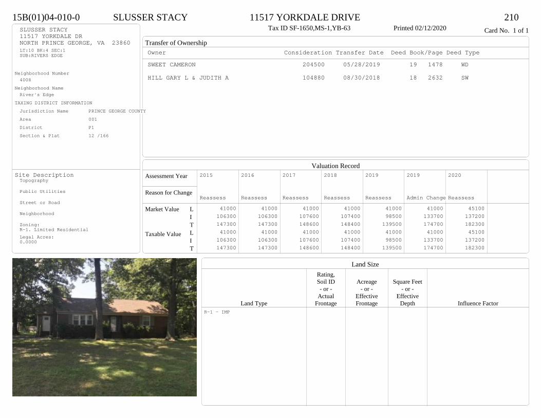
Transfer of Ownership
Valuation RecordAssessment Year
Reason for Change
Market Value
Taxable Value
LITLIT
Land SizeRating,Soil ID Acreage Square Feet- or - - or - - or -
Actual Effective EffectiveLand Type Frontage Frontage Depth Influence Factor
15B(01)04-010-0 SLUSSER STACY 11517 YORKDALE DRIVE 210Tax ID SF-1650,MS-1,YB-63 Printed 02/12/2020 Card No. 1 of 1SLUSSER STACY
11517 YORKDALE DRNORTH PRINCE GEORGE, VA 23860LT:10 BK:4 SEC:1SUB:RIVERS EDGE
Neighborhood Number4008
Neighborhood NameRiver's Edge
TAXING DISTRICT INFORMATIONJurisdiction Name PRINCE GEORGE COUNTYArea 001 District P1 Section & Plat 12 /166
Site DescriptionTopography
Public Utilities
Street or Road
Neighborhood
Zoning:R-1. Limited ResidentialLegal Acres:0.0000
Owner Consideration Transfer Date Deed Book/Page Deed TypeSWEET CAMERON 204500 05/28/2019 19 1478 WD
HILL GARY L & JUDITH A 104880 08/30/2018 18 2632 SW
2015
Reassess 41000 106300 147300 41000 106300 147300
2016
Reassess 41000 106300 147300 41000 106300 147300
2017
Reassess 41000 107600 148600 41000 107600 148600
2018
Reassess 41000 107400 148400 41000 107400 148400
2019
Reassess 41000 98500 139500 41000 98500 139500
2019
Admin Change 41000 133700 174700 41000 133700 174700
2020
Reassess 45100 137200 182300 45100 137200 182300
R-1 - IMP

Physical Characteristics
Special Features
Description
Summary of ImprovementsStory Const Year Eff Size or
ID USE Height Type Grade Cons Year Cond Area
15B(01)04-010-0 SLUSSER STACY 11517 YORKDALE DRIVE 210Tax ID SF-1650,MS-1,YB-63 Printed 02/12/2020
57.3
18.4
10
12.6
20
7
20.3
31
1 s Br C
1633
12.4
12OFP-s
149
4
4
Wd Dk 16
OMP18
M Stp18
9.8
6.2
Shed GP61
Style: 12 1 STORY 1960-69Occupancy: Single family
Story Height: 1.0Finished Area: 1633 Attic: NoneBasement: None
ROOFINGMaterial: Comp sh to 235#Type: GableFraming: Std for class
FLOORINGSub and joists 1.0Base Allowance 1.0
EXTERIOR COVERBrick 1.0Vinyl siding 1.0
INTERIOR FINISH
ACCOMMODATIONFinished Rooms 6Bedrooms 4HEATING AND AIR CONDITIONINGPrimary Heat: Forced hot air Lower Full Part /Bsmt 1 Upper UpperAir Cond 0 1633 0 0PLUMBING # TF3 Fixt. Baths 2 6Kit Sink 1 1Water Heat 1 1 TOTAL 8
REMODELING AND MODERNIZATION Amount Date
D DWELL 0.00 45 1963 1990 3 163301 SHEDGP 10.00 61
D : Remod 2019 Fireplace

Transfer of Ownership
Valuation RecordAssessment Year
Reason for Change
Market Value
Taxable Value
LITLIT
Land SizeRating,Soil ID Acreage Square Feet- or - - or - - or -
Actual Effective EffectiveLand Type Frontage Frontage Depth Influence Factor
15B(01)02-006-0 HALL CYNTHIA A 11417 YORKDALE DRIVE 210Tax ID SF-1525,MS-1,YB-77 Printed 02/12/2020 Card No. 1 of 1HALL CYNTHIA A
11417 YORKDALE DRNORTH PRINCE GEORGE, VA 23860LT:6 BK:2 SEC:1SUB:RIVERS EDGE
Neighborhood Number4008
Neighborhood NameRiver's Edge
TAXING DISTRICT INFORMATIONJurisdiction Name PRINCE GEORGE COUNTYArea 001 District P1 Section & Plat 12 /166
Site DescriptionTopography
Public Utilities
Street or Road
Neighborhood
Zoning:R-1. Limited ResidentialLegal Acres:0.0000
Owner Consideration Transfer Date Deed Book/Page Deed TypeCAIN SANDRA M 167350 01/16/2019 19 160 WD
70700 08/01/1989 320 123
2014
Reassess 41000 101300 142300 41000 101300 142300
2015
Reassess 41000 101300 142300 41000 101300 142300
2016
Reassess 41000 101300 142300 41000 101300 142300
2017
Reassess 41000 103800 144800 41000 103800 144800
2018
Reassess 41000 95800 136800 41000 95800 136800
2019
Reassess 41000 101300 142300 41000 101300 142300
2020
Reassess 45100 118700 163800 45100 118700 163800
R-1 - IMP
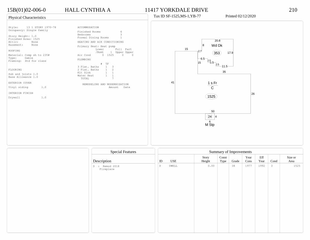
Physical Characteristics
Special Features
Description
Summary of ImprovementsStory Const Year Eff Size or
ID USE Height Type Grade Cons Year Cond Area
15B(01)02-006-0 HALL CYNTHIA A 11417 YORKDALE DRIVE 210Tax ID SF-1525,MS-1,YB-77 Printed 02/12/2020
26
50
41
15
15
35
1 s Fr C
1525
6
4
M Stp
24
2.7
820.8
17.9
11.52.55.5
2.56.5
Wd Dk
353
Style: 13 1 STORY 1970-78Occupancy: Single family
Story Height: 1.0Finished Area: 1525 Attic: NoneBasement: None
ROOFINGMaterial: Comp sh to 235#Type: GableFraming: Std for class
FLOORINGSub and joists 1.0Base Allowance 1.0
EXTERIOR COVERVinyl siding 1.0
INTERIOR FINISHDrywall 1.0
ACCOMMODATIONFinished Rooms 6Bedrooms 3Formal Dining Rooms 1HEATING AND AIR CONDITIONINGPrimary Heat: Heat pump Lower Full Part /Bsmt 1 Upper UpperAir Cond 0 1525 0 0PLUMBING # TF3 Fixt. Baths 1 32 Fixt. Baths 1 2Kit Sink 1 1Water Heat 1 1 TOTAL 7
REMODELING AND MODERNIZATION Amount Date
D DWELL 0.00 38 1977 1992 3 1525D : Remod 2018 Fireplace

Transfer of Ownership
Valuation RecordAssessment Year
Reason for Change
Market Value
Taxable Value
LITLIT
Land SizeRating,Soil ID Acreage Square Feet- or - - or - - or -
Actual Effective EffectiveLand Type Frontage Frontage Depth Influence Factor
15B(01)04-001-0 SANDERSON MARCUS & MARGARET H 11500 TAR BAY ROAD 210Tax ID SF-1893,MS-1,YB-61 Printed 02/12/2020 Card No. 1 of 1SANDERSON MARCUS & MARGARET H
11500 TAR BAY RDNORTH PRINCE GEORGE, VA 23860LT:1 BK:4 SEC:1SUB:RIVERS EDGE
Neighborhood Number4008
Neighborhood NameRiver's Edge
TAXING DISTRICT INFORMATIONJurisdiction Name PRINCE GEORGE COUNTYArea 001 District P1 Section & Plat 12 /166
Site DescriptionTopography
Public Utilities
Street or Road
Neighborhood
Zoning:R-1. Limited ResidentialLegal Acres:0.0000
Owner Consideration Transfer Date Deed Book/Page Deed TypeBAXLEY CHRISTINA N 131000 11/08/2019 19 3356 WD
PAUL JOHN A & WYNONA Y 143000 11/29/2007 07 5933
WALTON KENNETH W JR 94000 09/16/2002 02 4930
FRINK D W & DAISY L 57000 01/18/1994 380 90
2014
Reassess 41000 84200 125200 41000 84200 125200
2015
Reassess 41000 84200 125200 41000 84200 125200
2016
Reassess 41000 84200 125200 41000 84200 125200
2017
Reassess 41000 85200 126200 41000 85200 126200
2018
Reassess 41000 85200 126200 41000 85200 126200
2019
Reassess 41000 90000 131000 41000 90000 131000
2020
Reassess 45100 103700 148800 45100 103700 148800
R-1 - IMP
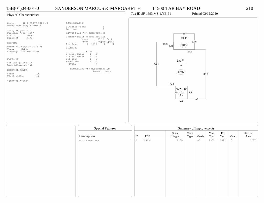
Physical Characteristics
Special Features
Description
Summary of ImprovementsStory Const Year Eff Size or
ID USE Height Type Grade Cons Year Cond Area
15B(01)04-001-0 SANDERSON MARCUS & MARGARET H 11500 TAR BAY ROAD 210Tax ID SF-1893,MS-1,YB-61 Printed 02/12/2020
38.2
24.9
5.813.3
34.1
24.2
9.9
14
1 s Fr C
1297
16
12.5OFP
200
9.5
10Wd Dk
95
Style: 12 1 STORY 1960-69Occupancy: Single family
Story Height: 1.0Finished Area: 1297 Attic: NoneBasement: None
ROOFINGMaterial: Comp sh to 235#Type: GableFraming: Std for class
FLOORINGSub and joists 1.0Base Allowance 1.0
EXTERIOR COVERStone 1.0Vinyl siding 1.0
INTERIOR FINISH
ACCOMMODATIONFinished Rooms 5Bedrooms 3HEATING AND AIR CONDITIONINGPrimary Heat: Forced hot air Lower Full Part /Bsmt 1 Upper UpperAir Cond 0 1297 0 0PLUMBING # TF3 Fixt. Baths 1 32 Fixt. Baths 1 2Kit Sink 1 1Water Heat 1 1 TOTAL 7
REMODELING AND MODERNIZATION Amount Date
D DWELL 0.00 45 1961 1979 3 1297D : Fireplace

Transfer of Ownership
Valuation RecordAssessment Year
Reason for Change
Market Value
Taxable Value
LITLIT
Land SizeRating,Soil ID Acreage Square Feet- or - - or - - or -
Actual Effective EffectiveLand Type Frontage Frontage Depth Influence Factor
290(09)00-004-0 WALIKANGAS JAMES S & 6754 WILLOW HILL ROAD 210Tax ID SF-0,MS-0,YB- Printed 02/12/2020 Card No. 1 of 1WALIKANGAS JAMES S &
DUNCAN TAMMY K6754 WILLOW HILL RDSPRING GROVE, VA 23881LT:4 BK: SEC:SUB:WILLOW RUNACRES:5.06
Neighborhood Number4009
Neighborhood NameEast of Ward's Creek
TAXING DISTRICT INFORMATIONJurisdiction Name PRINCE GEORGE COUNTYArea 001 District P3 Section & Plat 21 /19
Site DescriptionTopography
Public Utilities
Street or Road
Neighborhood
Zoning:A-1, Agricultural ConservationLegal Acres:5.0600
Owner Consideration Transfer Date Deed Book/Page Deed TypeWRIGHT JOSEPH M & KATRINA L 279000 02/19/2019 19 461 WD
SMITH RAYMOND R & JUDITH L 269900 08/21/2017 17 2467 WD
2014
Reassess 59700 155000 214700 59700 155000 214700
2015
Reassess 59700 155000 214700 59700 155000 214700
2016
Reassess 58500 155000 213500 58500 155000 213500
2017
Reassess 58500 153200 211700 58500 153200 211700
2018
Reassess 58500 160800 219300 58500 160800 219300
2019
Reassess 58500 169500 228000 58500 169500 228000
2020
Reassess 64400 189100 253500 64400 189100 253500
A-1 <20 - IMP R -2%
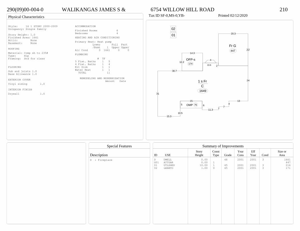
Physical Characteristics
Special Features
Description
Summary of ImprovementsStory Const Year Eff Size or
ID USE Height Type Grade Cons Year Cond Area
290(09)00-004-0 WALIKANGAS JAMES S & 6754 WILLOW HILL ROAD 210Tax ID SF-0,MS-0,YB- Printed 02/12/2020
30.7
31
15.310.5
15
6
11.3 2 74
13
24
210.6
1 s Fr C
1649
14.3
12.2OFP-s
174
5 OMP 75
4
22
20.3
Fr G 447
01
02Style: 16 1 STORY 2000-2009Occupancy: Single family
Story Height: 1.0Finished Area: 1661 Attic: NoneBasement: None
ROOFINGMaterial: Comp sh to 235#Type: HipFraming: Std for class
FLOORINGSub and joists 1.0Base Allowance 1.0
EXTERIOR COVERVinyl siding 1.0
INTERIOR FINISHDrywall 1.0
ACCOMMODATIONFinished Rooms 6Bedrooms 4HEATING AND AIR CONDITIONINGPrimary Heat: Heat pump Lower Full Part /Bsmt 1 Upper UpperAir Cond 0 1661 0 0PLUMBING # TF5 Fixt. Baths 1 54 Fixt. Baths 1 4Kit Sink 1 1Water Heat 1 1 TOTAL 11
REMODELING AND MODERNIZATION Amount Date
D DWELL 0.00 48 2001 2001 3 1661G01 ATTGAR 0.00 1 44701 UTLSHED 10.00 1 45 2001 2001 3 21602 LEANTO 1.00 0 45 2001 2001 3 171
D : Fireplace
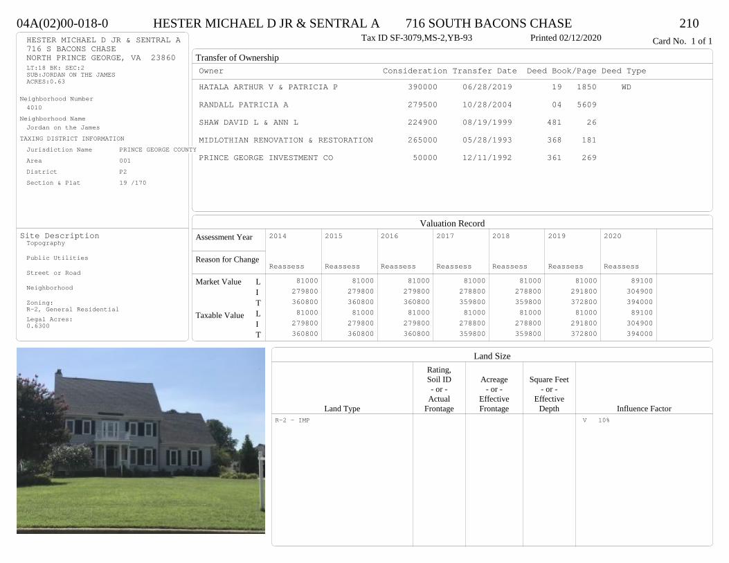
Transfer of Ownership
Valuation RecordAssessment Year
Reason for Change
Market Value
Taxable Value
LITLIT
Land SizeRating,Soil ID Acreage Square Feet- or - - or - - or -
Actual Effective EffectiveLand Type Frontage Frontage Depth Influence Factor
04A(02)00-018-0 HESTER MICHAEL D JR & SENTRAL A 716 SOUTH BACONS CHASE 210Tax ID SF-3079,MS-2,YB-93 Printed 02/12/2020 Card No. 1 of 1HESTER MICHAEL D JR & SENTRAL A
716 S BACONS CHASENORTH PRINCE GEORGE, VA 23860LT:18 BK: SEC:2SUB:JORDAN ON THE JAMESACRES:0.63
Neighborhood Number4010
Neighborhood NameJordan on the James
TAXING DISTRICT INFORMATIONJurisdiction Name PRINCE GEORGE COUNTYArea 001 District P2 Section & Plat 19 /170
Site DescriptionTopography
Public Utilities
Street or Road
Neighborhood
Zoning:R-2, General ResidentialLegal Acres:0.6300
Owner Consideration Transfer Date Deed Book/Page Deed TypeHATALA ARTHUR V & PATRICIA P 390000 06/28/2019 19 1850 WD
RANDALL PATRICIA A 279500 10/28/2004 04 5609
SHAW DAVID L & ANN L 224900 08/19/1999 481 26
MIDLOTHIAN RENOVATION & RESTORATION 265000 05/28/1993 368 181
PRINCE GEORGE INVESTMENT CO 50000 12/11/1992 361 269
2014
Reassess 81000 279800 360800 81000 279800 360800
2015
Reassess 81000 279800 360800 81000 279800 360800
2016
Reassess 81000 279800 360800 81000 279800 360800
2017
Reassess 81000 278800 359800 81000 278800 359800
2018
Reassess 81000 278800 359800 81000 278800 359800
2019
Reassess 81000 291800 372800 81000 291800 372800
2020
Reassess 89100 304900 394000 89100 304900 394000
R-2 - IMP V 10%

Physical Characteristics
Special Features
Description
Summary of ImprovementsStory Const Year Eff Size or
ID USE Height Type Grade Cons Year Cond Area
04A(02)00-018-0 HESTER MICHAEL D JR & SENTRAL A 716 SOUTH BACONS CHASE 210Tax ID SF-3079,MS-2,YB-93 Printed 02/12/2020
32.1
36.3
1/2 s Fr (Fin) 2 s Fr
C
1165
14
20.2
Balc1 s Fr
C 283
8
11.5
BalcOMP 92
48
OMP32
14
414.6
Wd Dk
332
22
28.21/2 s Fr (Fin)
Fr G
620
01Style: 32 2/2+Story 1980-1999Occupancy: Single family
Story Height: 2.0Finished Area: 3276 Attic: NoneBasement: None
ROOFINGMaterial: Comp sh to 235#Type: GableFraming: Std for class
FLOORINGSub and joists 1.0, 1.5, 2.0, 2.5Base Allowance 1.0, 1.5, 2.0, 2.5
EXTERIOR COVERVinyl siding 1.0, 1.5, 2.0, 2.5
INTERIOR FINISHDrywall 1.0
ACCOMMODATIONFinished Rooms 11Bedrooms 4Family Rooms 1Formal Dining Rooms 1HEATING AND AIR CONDITIONINGPrimary Heat: Central Warm Air Lower Full Part /Bsmt 1 Upper UpperAir Cond 0 1448 1165 663PLUMBING # TF5 Fixt. Baths 1 54 Fixt. Baths 1 43 Fixt. Baths 2 6Kit Sink 1 1Water Heat 1 1 TOTAL 17
REMODELING AND MODERNIZATION Amount Date
D DWELL 0.00 48 1993 1993 3 4398G01 ATTGAR 0.00 1 62001 POOL 1.00 6 45 2005 2005 3 450
D : Fireplace, Fireplace
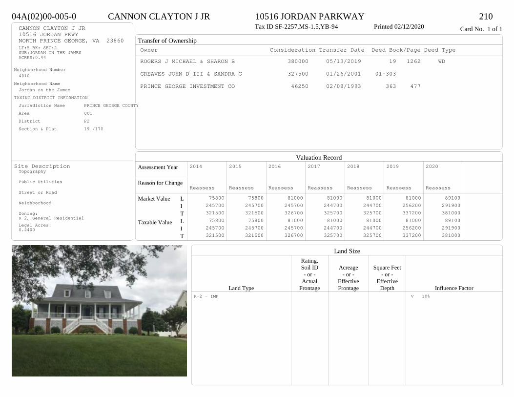
Transfer of Ownership
Valuation RecordAssessment Year
Reason for Change
Market Value
Taxable Value
LITLIT
Land SizeRating,Soil ID Acreage Square Feet- or - - or - - or -
Actual Effective EffectiveLand Type Frontage Frontage Depth Influence Factor
04A(02)00-005-0 CANNON CLAYTON J JR 10516 JORDAN PARKWAY 210Tax ID SF-2257,MS-1.5,YB-94 Printed 02/12/2020 Card No. 1 of 1CANNON CLAYTON J JR
10516 JORDAN PKWYNORTH PRINCE GEORGE, VA 23860LT:5 BK: SEC:2SUB:JORDAN ON THE JAMESACRES:0.44
Neighborhood Number4010
Neighborhood NameJordan on the James
TAXING DISTRICT INFORMATIONJurisdiction Name PRINCE GEORGE COUNTYArea 001 District P2 Section & Plat 19 /170
Site DescriptionTopography
Public Utilities
Street or Road
Neighborhood
Zoning:R-2, General ResidentialLegal Acres:0.4400
Owner Consideration Transfer Date Deed Book/Page Deed TypeROGERS J MICHAEL & SHARON B 380000 05/13/2019 19 1262 WD
GREAVES JOHN D III & SANDRA G 327500 01/26/2001 01-303
PRINCE GEORGE INVESTMENT CO 46250 02/08/1993 363 477
2014
Reassess 75800 245700 321500 75800 245700 321500
2015
Reassess 75800 245700 321500 75800 245700 321500
2016
Reassess 81000 245700 326700 81000 245700 326700
2017
Reassess 81000 244700 325700 81000 244700 325700
2018
Reassess 81000 244700 325700 81000 244700 325700
2019
Reassess 81000 256200 337200 81000 256200 337200
2020
Reassess 89100 291900 381000 89100 291900 381000
R-2 - IMP V 10%
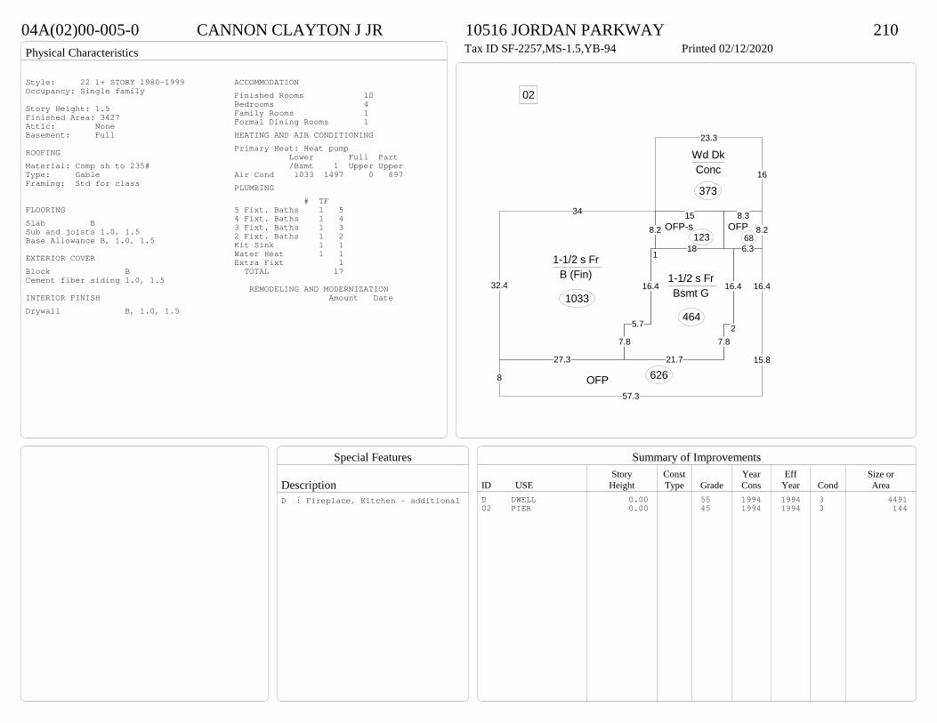
Physical Characteristics
Special Features
Description
Summary of ImprovementsStory Const Year Eff Size or
ID USE Height Type Grade Cons Year Cond Area
04A(02)00-005-0 CANNON CLAYTON J JR 10516 JORDAN PARKWAY 210Tax ID SF-2257,MS-1.5,YB-94 Printed 02/12/2020
32.4
27.3
7.8
5.7
16.4
1
8.2
34
1-1/2 s Fr B (Fin)
1033
21.7
7.82
16.4
18
16.4
5.7
7.8
1-1/2 s Fr Bsmt G
464
8
57.3
15.8
16.4
6.3
16.4
7.8
OFP 626
8.28.3
OFP68
16
23.3
Wd DkConc
373
15OFP-s
123
02Style: 22 1+ STORY 1980-1999Occupancy: Single family
Story Height: 1.5Finished Area: 3427 Attic: NoneBasement: Full
ROOFINGMaterial: Comp sh to 235#Type: GableFraming: Std for class
FLOORINGSlab BSub and joists 1.0, 1.5Base Allowance B, 1.0, 1.5
EXTERIOR COVERBlock BCement fiber siding 1.0, 1.5
INTERIOR FINISHDrywall B, 1.0, 1.5
ACCOMMODATIONFinished Rooms 10Bedrooms 4Family Rooms 1Formal Dining Rooms 1HEATING AND AIR CONDITIONINGPrimary Heat: Heat pump Lower Full Part /Bsmt 1 Upper UpperAir Cond 1033 1497 0 897PLUMBING # TF5 Fixt. Baths 1 54 Fixt. Baths 1 43 Fixt. Baths 1 32 Fixt. Baths 1 2Kit Sink 1 1Water Heat 1 1Extra Fixt 1 TOTAL 17
REMODELING AND MODERNIZATION Amount Date
D DWELL 0.00 55 1994 1994 3 449102 PIER 0.00 45 1994 1994 3 144
D : Fireplace, Kitchen - additional

Transfer of Ownership
Valuation RecordAssessment Year
Reason for Change
Market Value
Taxable Value
LITLIT
Land SizeRating,Soil ID Acreage Square Feet- or - - or - - or -
Actual Effective EffectiveLand Type Frontage Frontage Depth Influence Factor
04A(02)00-016-0 STEBAR GARRY W 700 SOUTH BACONS CHASE 210Tax ID SF-2861,MS-1,YB-92 Printed 02/12/2020 Card No. 1 of 1STEBAR GARRY W
JOHNSTON BERNADETTE G700 S BACONS CHASENORTH PRINCE GEORGE, VA 23860LT:16 BK: SEC:2SUB:JORDAN ON THE JAMESACRES:0.81
Neighborhood Number4010
Neighborhood NameJordan on the James
TAXING DISTRICT INFORMATIONJurisdiction Name PRINCE GEORGE COUNTYArea 001 District P2 Section & Plat 19 /170
Site DescriptionTopography
Public Utilities
Street or Road
Neighborhood
Zoning:R-2, General ResidentialLegal Acres:0.8100
Owner Consideration Transfer Date Deed Book/Page Deed TypeNOWELL PATTY L & J KENNETH 379500 10/16/2019 19 3072 WD
PTASCHEK EDWARD D & LORETTA M 252600 12/28/1998 463 636
PRINCE GEORGE INVESTMENT CO 50000 05/11/1992 352 341
2014
Reassess 81000 242300 323300 81000 242300 323300
2015
Reassess 81000 242300 323300 81000 242300 323300
2016
Reassess 81000 242300 323300 81000 242300 323300
2017
Reassess 81000 245000 326000 81000 245000 326000
2018
Reassess 81000 257300 338300 81000 257300 338300
2019
Reassess 81000 257900 338900 81000 257900 338900
2020
Reassess 89100 289500 378600 89100 289500 378600
R-2 - IMP V 10%
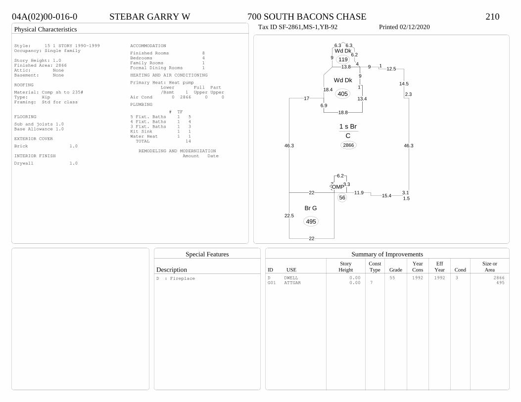
Physical Characteristics
Special Features
Description
Summary of ImprovementsStory Const Year Eff Size or
ID USE Height Type Grade Cons Year Cond Area
04A(02)00-016-0 STEBAR GARRY W 700 SOUTH BACONS CHASE 210Tax ID SF-2861,MS-1,YB-92 Printed 02/12/2020
46.3
176.9
18.8
13.4
1
9
9 1 12.5
14.5
2.3
46.3
3.11.515.411.9
8.3
6.2
33
22
1 s Br C
2866
8.3
6.2
3OMP
56
9
13.4
18.8
18.4
13.8
Wd Dk
405
4
6.2
6.36.3
9Wd Dk
119
22.5
22
Br G
495
Style: 15 1 STORY 1990-1999Occupancy: Single family
Story Height: 1.0Finished Area: 2866 Attic: NoneBasement: None
ROOFINGMaterial: Comp sh to 235#Type: HipFraming: Std for class
FLOORINGSub and joists 1.0Base Allowance 1.0
EXTERIOR COVERBrick 1.0
INTERIOR FINISHDrywall 1.0
ACCOMMODATIONFinished Rooms 8Bedrooms 4Family Rooms 1Formal Dining Rooms 1HEATING AND AIR CONDITIONINGPrimary Heat: Heat pump Lower Full Part /Bsmt 1 Upper UpperAir Cond 0 2866 0 0PLUMBING # TF5 Fixt. Baths 1 54 Fixt. Baths 1 43 Fixt. Baths 1 3Kit Sink 1 1Water Heat 1 1 TOTAL 14
REMODELING AND MODERNIZATION Amount Date
D DWELL 0.00 55 1992 1992 3 2866G01 ATTGAR 0.00 7 495
D : Fireplace
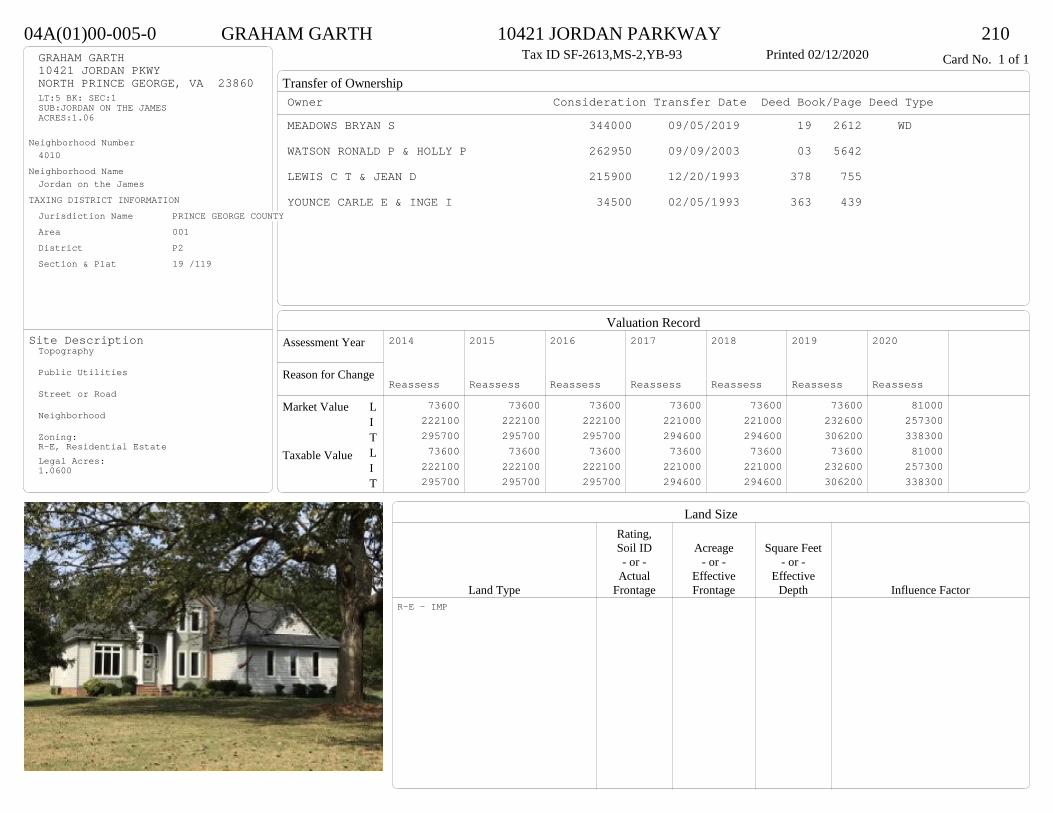
Transfer of Ownership
Valuation RecordAssessment Year
Reason for Change
Market Value
Taxable Value
LITLIT
Land SizeRating,Soil ID Acreage Square Feet- or - - or - - or -
Actual Effective EffectiveLand Type Frontage Frontage Depth Influence Factor
04A(01)00-005-0 GRAHAM GARTH 10421 JORDAN PARKWAY 210Tax ID SF-2613,MS-2,YB-93 Printed 02/12/2020 Card No. 1 of 1GRAHAM GARTH
10421 JORDAN PKWYNORTH PRINCE GEORGE, VA 23860LT:5 BK: SEC:1SUB:JORDAN ON THE JAMESACRES:1.06
Neighborhood Number4010
Neighborhood NameJordan on the James
TAXING DISTRICT INFORMATIONJurisdiction Name PRINCE GEORGE COUNTYArea 001 District P2 Section & Plat 19 /119
Site DescriptionTopography
Public Utilities
Street or Road
Neighborhood
Zoning:R-E, Residential EstateLegal Acres:1.0600
Owner Consideration Transfer Date Deed Book/Page Deed TypeMEADOWS BRYAN S 344000 09/05/2019 19 2612 WD
WATSON RONALD P & HOLLY P 262950 09/09/2003 03 5642
LEWIS C T & JEAN D 215900 12/20/1993 378 755
YOUNCE CARLE E & INGE I 34500 02/05/1993 363 439
2014
Reassess 73600 222100 295700 73600 222100 295700
2015
Reassess 73600 222100 295700 73600 222100 295700
2016
Reassess 73600 222100 295700 73600 222100 295700
2017
Reassess 73600 221000 294600 73600 221000 294600
2018
Reassess 73600 221000 294600 73600 221000 294600
2019
Reassess 73600 232600 306200 73600 232600 306200
2020
Reassess 81000 257300 338300 81000 257300 338300
R-E - IMP
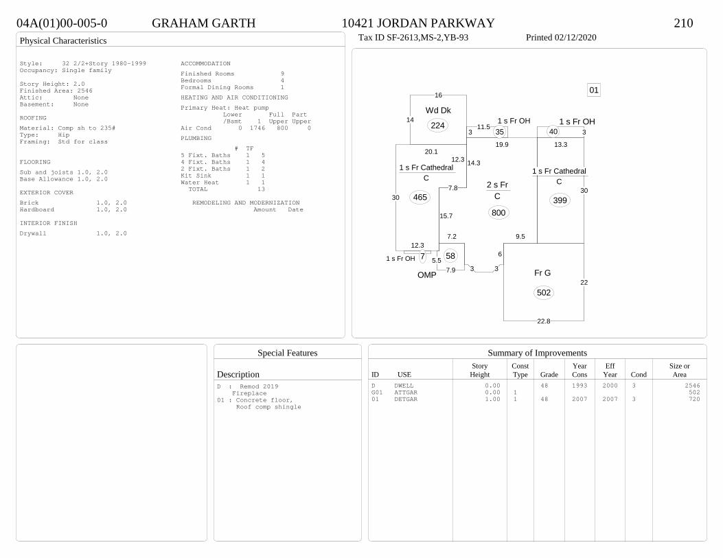
Physical Characteristics
Special Features
Description
Summary of ImprovementsStory Const Year Eff Size or
ID USE Height Type Grade Cons Year Cond Area
04A(01)00-005-0 GRAHAM GARTH 10421 JORDAN PARKWAY 210Tax ID SF-2613,MS-2,YB-93 Printed 02/12/2020
30
13.3
1 s Fr Cathedral C
399
9.5
6
33
7.2
15.7
7.8
14.3
19.9
2 s Fr C
800
20.1
30
12.3
12.31 s Fr Cathedral
C
465
311.5
1 s Fr OH 35 3
1 s Fr OH 40
7.95.5
OMP
58
14
16
Wd Dk
224
1 s Fr OH 7
22
22.8
Fr G
502
01
Style: 32 2/2+Story 1980-1999Occupancy: Single family
Story Height: 2.0Finished Area: 2546 Attic: NoneBasement: None
ROOFINGMaterial: Comp sh to 235#Type: HipFraming: Std for class
FLOORINGSub and joists 1.0, 2.0Base Allowance 1.0, 2.0
EXTERIOR COVERBrick 1.0, 2.0Hardboard 1.0, 2.0
INTERIOR FINISHDrywall 1.0, 2.0
ACCOMMODATIONFinished Rooms 9Bedrooms 4Formal Dining Rooms 1HEATING AND AIR CONDITIONINGPrimary Heat: Heat pump Lower Full Part /Bsmt 1 Upper UpperAir Cond 0 1746 800 0PLUMBING # TF5 Fixt. Baths 1 54 Fixt. Baths 1 42 Fixt. Baths 1 2Kit Sink 1 1Water Heat 1 1 TOTAL 13
REMODELING AND MODERNIZATION Amount Date
D DWELL 0.00 48 1993 2000 3 2546G01 ATTGAR 0.00 1 50201 DETGAR 1.00 1 48 2007 2007 3 720
D : Remod 2019 Fireplace01 : Concrete floor, Roof comp shingle
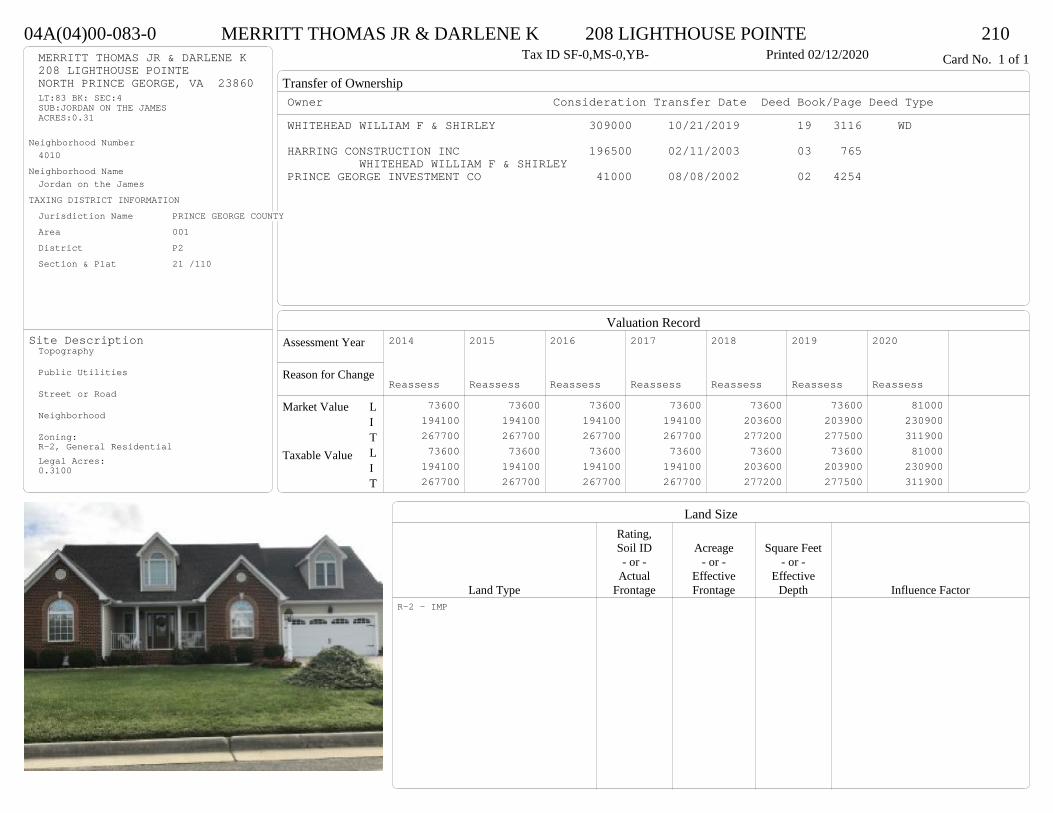
Transfer of Ownership
Valuation RecordAssessment Year
Reason for Change
Market Value
Taxable Value
LITLIT
Land SizeRating,Soil ID Acreage Square Feet- or - - or - - or -
Actual Effective EffectiveLand Type Frontage Frontage Depth Influence Factor
04A(04)00-083-0 MERRITT THOMAS JR & DARLENE K 208 LIGHTHOUSE POINTE 210Tax ID SF-0,MS-0,YB- Printed 02/12/2020 Card No. 1 of 1MERRITT THOMAS JR & DARLENE K
208 LIGHTHOUSE POINTENORTH PRINCE GEORGE, VA 23860LT:83 BK: SEC:4SUB:JORDAN ON THE JAMESACRES:0.31
Neighborhood Number4010
Neighborhood NameJordan on the James
TAXING DISTRICT INFORMATIONJurisdiction Name PRINCE GEORGE COUNTYArea 001 District P2 Section & Plat 21 /110
Site DescriptionTopography
Public Utilities
Street or Road
Neighborhood
Zoning:R-2, General ResidentialLegal Acres:0.3100
Owner Consideration Transfer Date Deed Book/Page Deed TypeWHITEHEAD WILLIAM F & SHIRLEY 309000 10/21/2019 19 3116 WD
HARRING CONSTRUCTION INC 196500 02/11/2003 03 765 WHITEHEAD WILLIAM F & SHIRLEY
PRINCE GEORGE INVESTMENT CO 41000 08/08/2002 02 4254
2014
Reassess 73600 194100 267700 73600 194100 267700
2015
Reassess 73600 194100 267700 73600 194100 267700
2016
Reassess 73600 194100 267700 73600 194100 267700
2017
Reassess 73600 194100 267700 73600 194100 267700
2018
Reassess 73600 203600 277200 73600 203600 277200
2019
Reassess 73600 203900 277500 73600 203900 277500
2020
Reassess 81000 230900 311900 81000 230900 311900
R-2 - IMP
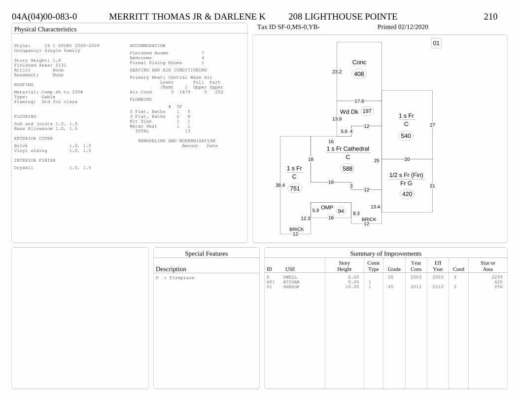
Physical Characteristics
Special Features
Description
Summary of ImprovementsStory Const Year Eff Size or
ID USE Height Type Grade Cons Year Cond Area
04A(04)00-083-0 MERRITT THOMAS JR & DARLENE K 208 LIGHTHOUSE POINTE 210Tax ID SF-0,MS-0,YB- Printed 02/12/2020
27
1 s Fr C
540
165.9 OMP 94
5.6
13.9
17.6
Wd Dk 197
23.2
Conc
408
16
412
25
123
1 s Fr Cathedral C
588
16
13.4
12
8.312.3
12
38.4
18
1 s Fr C
751 21
20
1/2 s Fr (Fin) Fr G
420
01
BRICK
BRICK
Style: 16 1 STORY 2000-2009Occupancy: Single family
Story Height: 1.0Finished Area: 2131 Attic: NoneBasement: None
ROOFINGMaterial: Comp sh to 235#Type: GableFraming: Std for class
FLOORINGSub and joists 1.0, 1.5Base Allowance 1.0, 1.5
EXTERIOR COVERBrick 1.0, 1.5Vinyl siding 1.0, 1.5
INTERIOR FINISHDrywall 1.0, 1.5
ACCOMMODATIONFinished Rooms 7Bedrooms 4Formal Dining Rooms 1HEATING AND AIR CONDITIONINGPrimary Heat: Central Warm Air Lower Full Part /Bsmt 1 Upper UpperAir Cond 0 1879 0 252PLUMBING # TF5 Fixt. Baths 1 53 Fixt. Baths 2 6Kit Sink 1 1Water Heat 1 1 TOTAL 13
REMODELING AND MODERNIZATION Amount Date
D DWELL 0.00 55 2003 2003 3 2299G01 ATTGAR 0.00 1 42001 SHEDGP 10.00 1 45 2012 2012 3 256
D : Fireplace
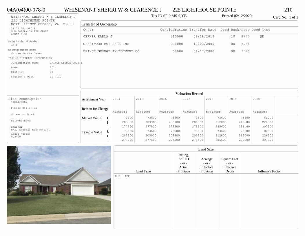
Transfer of Ownership
Valuation RecordAssessment Year
Reason for Change
Market Value
Taxable Value
LITLIT
Land SizeRating,Soil ID Acreage Square Feet- or - - or - - or -
Actual Effective EffectiveLand Type Frontage Frontage Depth Influence Factor
04A(04)00-078-0 WHISENANT SHERRI W & CLARENCE J 225 LIGHTHOUSE POINTE 210Tax ID SF-0,MS-0,YB- Printed 02/12/2020 Card No. 1 of 1WHISENANT SHERRI W & CLARENCE J
225 LIGHTHOUSE POINTENORTH PRINCE GEORGE, VA 23860LT:78 BK: SEC:4SUB:JORDAN ON THE JAMESACRES:0.34
Neighborhood Number4010
Neighborhood NameJordan on the James
TAXING DISTRICT INFORMATIONJurisdiction Name PRINCE GEORGE COUNTYArea 001 District P2 Section & Plat 21 /110
Site DescriptionTopography
Public Utilities
Street or Road
Neighborhood
Zoning:R-2, General ResidentialLegal Acres:0.3400
Owner Consideration Transfer Date Deed Book/Page Deed TypeGERNER KARLA J 310000 09/18/2019 19 2777 WD
CRESTWOOD BUILDERS INC 220000 10/02/2000 00 3931
PRINCE GEORGE INVESTMENT CO 50000 04/17/2000 00 1526
2014
Reassess 73600 203900 277500 73600 203900 277500
2015
Reassess 73600 203900 277500 73600 203900 277500
2016
Reassess 73600 203900 277500 73600 203900 277500
2017
Reassess 73600 201900 275500 73600 201900 275500
2018
Reassess 73600 212000 285600 73600 212000 285600
2019
Reassess 73600 212500 286100 73600 212500 286100
2020
Reassess 81000 226300 307300 81000 226300 307300
R-2 - IMP

Physical Characteristics
Special Features
Description
Summary of ImprovementsStory Const Year Eff Size or
ID USE Height Type Grade Cons Year Cond Area
04A(04)00-078-0 WHISENANT SHERRI W & CLARENCE J 225 LIGHTHOUSE POINTE 210Tax ID SF-0,MS-0,YB- Printed 02/12/2020
19.7
16
2
21.9
14.9
13.722.5
9
3.5
41.81 s Br Slab
1040
13.9
18.2
4.5
5.5
3.65.3
25.5
1 s Br Cathedral Slab
299
18.7
19.9
3.5
26.9
102.5
5.2
44.3
1 s Br Slab
768
8.8
OMP 40
18.1Conc
181
11OMP-s
153
10.7Conc
149
8.111.8
8.6
1 s Br Slab
94 8.8
10
31.7
24.7
25.4
4.7
Br G
665
Style: 16 1 STORY 2000-2009Occupancy: Single family
Story Height: 1.0Finished Area: 2201 Attic: NoneBasement: None
ROOFINGMaterial: Comp sh to 235#Type: GableFraming: Std for class
FLOORINGSlab 1.0Base Allowance 1.0
EXTERIOR COVERBrick 1.0
INTERIOR FINISHDrywall 1.0
ACCOMMODATIONFinished Rooms 7Bedrooms 2Formal Dining Rooms 1HEATING AND AIR CONDITIONINGPrimary Heat: Central Warm Air Lower Full Part /Bsmt 1 Upper UpperAir Cond 0 2201 0 0PLUMBING # TF5 Fixt. Baths 1 53 Fixt. Baths 1 3Kit Sink 1 1Water Heat 1 1 TOTAL 10
REMODELING AND MODERNIZATION Amount Date
D DWELL 0.00 48 2000 2000 3 2201G01 ATTGAR 0.00 7 665
D : Fireplace

Transfer of Ownership
Valuation RecordAssessment Year
Reason for Change
Market Value
Taxable Value
LITLIT
Land SizeRating,Soil ID Acreage Square Feet- or - - or - - or -
Actual Effective EffectiveLand Type Frontage Frontage Depth Influence Factor
04A(04)00-089-0 DAVIS JOHN A & TAYLOR L 10546 JORDAN PARKWAY 210Tax ID SF-0,MS-0,YB- Printed 02/12/2020 Card No. 1 of 1DAVIS JOHN A & TAYLOR L
10546 JORDAN PKWYNORTH PRINCE GEORGE, VA 23860LT:89 BK: SEC:4SUB:JORDAN ON THE JAMESACRES:0.34
Neighborhood Number4010
Neighborhood NameJordan on the James
TAXING DISTRICT INFORMATIONJurisdiction Name PRINCE GEORGE COUNTYArea 001 District P2 Section & Plat 21 /110
Site DescriptionTopography
Public Utilities
Street or Road
Neighborhood
Zoning:R-2, General ResidentialLegal Acres:0.3400
Owner Consideration Transfer Date Deed Book/Page Deed TypeSHOOT ANTHONY J JR 316000 09/26/2019 19 2878 WD
SHOOT ANTHONY J 0 01/20/2015 15 151
HARRELL GARY D & STACIA L 299000 10/03/2006 06 5277
HARRING CONSTRUCTION CO 205000 06/02/2003 03 3270
PRINCE GEORGE INVESTMENT CO 43500 09/24/2002 02 5080
2014
Reassess 73600 191400 265000 73600 191400 265000
2015
Reassess 73600 191400 265000 73600 191400 265000
2016
Reassess 73600 191400 265000 73600 191400 265000
2017
Reassess 73600 191500 265100 73600 191500 265100
2018
Reassess 73600 191500 265100 73600 191500 265100
2019
Reassess 73600 201200 274800 73600 201200 274800
2020
Reassess 81000 213600 294600 81000 213600 294600
R-2 - IMP

Physical Characteristics
Special Features
Description
Summary of ImprovementsStory Const Year Eff Size or
ID USE Height Type Grade Cons Year Cond Area
04A(04)00-089-0 DAVIS JOHN A & TAYLOR L 10546 JORDAN PARKWAY 210Tax ID SF-0,MS-0,YB- Printed 02/12/2020
24
8
10.5
10
15
20
39
2 s Fr C
903
2.8 5.41 s Fr OH
15
9.6
13.8
Wd Dk132
7
13
26OFP 224
1 s Fr OH (Upper)218.5
12.6
5.5
6.61 s Fr Cathedral
C 87
20
22
1/2 s Fr (Fin) Fr G
440
Style: 33 2/2+Story 2000+Occupancy: Single family
Story Height: 2.0Finished Area: 2251 Attic: NoneBasement: None
ROOFINGMaterial: Comp sh to 235#Type: GableFraming: Std for class
FLOORINGSub and joists 1.0, 1.5, 2.0Base Allowance 1.0, 1.5, 2.0
EXTERIOR COVERVinyl siding 1.0, 1.5, 2.0
INTERIOR FINISHDrywall 1.0, 2.0
ACCOMMODATIONFinished Rooms 7Bedrooms 4Formal Dining Rooms 1HEATING AND AIR CONDITIONINGPrimary Heat: Central Warm Air Lower Full Part /Bsmt 1 Upper UpperAir Cond 0 1005 924 322PLUMBING # TF5 Fixt. Baths 1 53 Fixt. Baths 1 32 Fixt. Baths 1 2Kit Sink 1 1Water Heat 1 1 TOTAL 12
REMODELING AND MODERNIZATION Amount Date
D DWELL 0.00 48 2003 2003 3 2369G01 ATTGAR 0.00 1 440
D : Fireplace
Transfer of Ownership
Valuation RecordAssessment Year
Reason for Change
Market Value
Taxable Value
LITLIT
Land SizeRating,Soil ID Acreage Square Feet- or - - or - - or -
Actual Effective EffectiveLand Type Frontage Frontage Depth Influence Factor
04A(03)00-058-0 GABRI STEPHEN A & SHIRLEY A 400 FARRAR LANDING 210Tax ID SF-0,MS-0,YB- Printed 02/12/2020 Card No. 1 of 1GABRI STEPHEN A & SHIRLEY A
400 FARRAR LANDINGNORTH PRINCE GEORGE, VA 23860LT:58 BK: SEC:3SUB:JORDAN ON THE JAMESACRES:0.375
Neighborhood Number4010
Neighborhood NameJordan on the James
TAXING DISTRICT INFORMATIONJurisdiction Name PRINCE GEORGE COUNTYArea 001 District P2 Section & Plat 21 /69
Site DescriptionTopography
Public Utilities
Street or Road
Neighborhood
Zoning:R-2, General ResidentialLegal Acres:0.3750
Owner Consideration Transfer Date Deed Book/Page Deed TypeHARRELSON DAVID S & JANICE B 300000 08/01/2019 19 2247 WD
PRINCE GEORGE INVESTMENT CO 214950 05/29/1998 449 627
2014
Reassess 73600 183600 257200 73600 183600 257200
2015
Reassess 73600 183600 257200 73600 183600 257200
2016
Reassess 73600 183600 257200 73600 183600 257200
2017
Reassess 73600 185300 258900 73600 185300 258900
2018
Reassess 73600 185300 258900 73600 185300 258900
2019
Reassess 73600 193700 267300 73600 193700 267300
2020
Reassess 81000 203500 284500 81000 203500 284500
R-2 - IMP

Physical Characteristics
Special Features
Description
Summary of ImprovementsStory Const Year Eff Size or
ID USE Height Type Grade Cons Year Cond Area
04A(03)00-058-0 GABRI STEPHEN A & SHIRLEY A 400 FARRAR LANDING 210Tax ID SF-0,MS-0,YB- Printed 02/12/2020
17
36.7
17
10
5.421.3
5.45.4
1-3/4 s Br C
739
12
5.421.1
20.5
25.4
5.45.44
1 s Br C
531
48
M Stp32
10
10Wd Dk
100
19
23.1
26.7
23.1
7.7
1/2 s Br Br G
617
Style: 22 1+ STORY 1980-1999Occupancy: Single family
Story Height: 1.5+1Finished Area: 2251 Attic: NoneBasement: None
ROOFINGMaterial: Comp sh to 235#Type: GableFraming: Std for class
FLOORINGSub and joists 1.0, 1.5, 1.75Base Allowance 1.0, 1.5, 1.75
EXTERIOR COVERBrick 1.0, 1.5, 1.75Vinyl siding 1.0, 1.75
INTERIOR FINISHDrywall 1.0
ACCOMMODATIONFinished Rooms 7Bedrooms 4HEATING AND AIR CONDITIONINGPrimary Heat: Heat pump Lower Full Part /Bsmt 1 Upper UpperAir Cond 0 1270 0 981PLUMBING # TF5 Fixt. Baths 1 53 Fixt. Baths 1 32 Fixt. Baths 1 2Kit Sink 1 1Water Heat 1 1Extra Fixt 1 TOTAL 13
REMODELING AND MODERNIZATION Amount Date
D DWELL 0.00 48 1998 1998 3 2626G01 ATTGAR 0.00 7 3 617
D : Fireplace

Transfer of Ownership
Valuation RecordAssessment Year
Reason for Change
Market Value
Taxable Value
LITLIT
Land SizeRating,Soil ID Acreage Square Feet- or - - or - - or -
Actual Effective EffectiveLand Type Frontage Frontage Depth Influence Factor
04A(03)00-066-0 BARBERA LILLIAN 300 LIGHTHOUSE POINTE 210Tax ID SF-0,MS-0,YB- Printed 02/12/2020 Card No. 1 of 1BARBERA LILLIAN
300 LIGHTHOUSE POINTENORTH PRINCE GEORGE, VA 23860LT:66 BK: SEC:3SUB:JORDAN ON THE JAMESACRES:0.307
Neighborhood Number4010
Neighborhood NameJordan on the James
TAXING DISTRICT INFORMATIONJurisdiction Name PRINCE GEORGE COUNTYArea 001 District P2 Section & Plat 21 /69
Site DescriptionTopography
Public Utilities
Street or Road
Neighborhood
Zoning:R-2, General ResidentialLegal Acres:0.3070
Owner Consideration Transfer Date Deed Book/Page Deed TypeHESTER MICHAEL D JR & SENTRAL A 284500 06/28/2019 19 1837 WD
FANNIN JAMES C 250000 05/23/2016 16 1399 WD
FANNIN JOHN R JR 0 08/20/2015 WF15 75 WF
HINES KENNETH W & MICHELLE E 250000 07/26/2013 13 5636 WD
STORY CHARLES D & NANCY E 275000 03/28/2006 06 1548
LLEWELLYN WILLIAM M & LYNN K 172000 09/27/2001 01 4971
2014
Reassess 73600 180900 254500 73600 180900 254500
2015
Reassess 73600 180900 254500 73600 180900 254500
2016
Reassess 73600 180900 254500 73600 180900 254500
2017
Reassess 73600 182800 256400 73600 182800 256400
2018
Reassess 73600 191900 265500 73600 191900 265500
2019
Reassess 73600 191800 265400 73600 191800 265400
2020
Reassess 81000 201600 282600 81000 201600 282600
R-2 - IMP
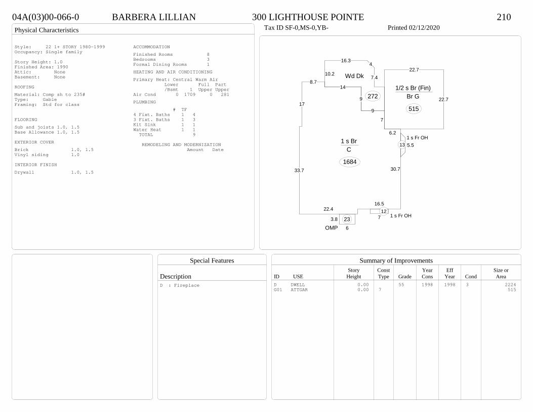
Physical Characteristics
Special Features
Description
Summary of ImprovementsStory Const Year Eff Size or
ID USE Height Type Grade Cons Year Cond Area
04A(03)00-066-0 BARBERA LILLIAN 300 LIGHTHOUSE POINTE 210Tax ID SF-0,MS-0,YB- Printed 02/12/2020
6.2
7
9
148.7
17
33.7
22.416.5
30.7
1 s Br C
1684
6
3.8
OMP23
5.51 s Fr OH
13
7 1 s Fr OH 12
10.2
16.34
7.4
9
Wd Dk
272
22.7
22.7
1/2 s Br (Fin) Br G
515
Style: 22 1+ STORY 1980-1999Occupancy: Single family
Story Height: 1.0Finished Area: 1990 Attic: NoneBasement: None
ROOFINGMaterial: Comp sh to 235#Type: GableFraming: Std for class
FLOORINGSub and joists 1.0, 1.5Base Allowance 1.0, 1.5
EXTERIOR COVERBrick 1.0, 1.5Vinyl siding 1.0
INTERIOR FINISHDrywall 1.0, 1.5
ACCOMMODATIONFinished Rooms 8Bedrooms 3Formal Dining Rooms 1HEATING AND AIR CONDITIONINGPrimary Heat: Central Warm Air Lower Full Part /Bsmt 1 Upper UpperAir Cond 0 1709 0 281PLUMBING # TF4 Fixt. Baths 1 43 Fixt. Baths 1 3Kit Sink 1 1Water Heat 1 1 TOTAL 9
REMODELING AND MODERNIZATION Amount Date
D DWELL 0.00 55 1998 1998 3 2224G01 ATTGAR 0.00 7 515
D : Fireplace

Transfer of Ownership
Valuation RecordAssessment Year
Reason for Change
Market Value
Taxable Value
LITLIT
Land SizeRating,Soil ID Acreage Square Feet- or - - or - - or -
Actual Effective EffectiveLand Type Frontage Frontage Depth Influence Factor
040(03)00-005-0 CURTIN KENNETH J & ROBIN L 9771 JAMESCREST DRIVE 210Tax ID SF-,MS-,YB- Printed 02/12/2020 Card No. 1 of 1CURTIN KENNETH J & ROBIN L
9771 JAMESCREST DRNORTH PRINCE GEORGE, VA 23875LOT 5PT WILSON PROPACRES:2.468
Neighborhood Number4013
Neighborhood NameJamescrest area
TAXING DISTRICT INFORMATIONJurisdiction Name PRINCE GEORGE COUNTYArea 001 District P2 Section & Plat 21 /205
Site DescriptionTopography
Public Utilities
Street or Road
Neighborhood
Zoning:R-A, Residential AgriculturalLegal Acres:2.4680
Owner Consideration Transfer Date Deed Book/Page Deed TypeEDWARDS JOHN D & DEBORAH H 575000 05/15/2019 19 1325 WD
MCDONOUGH REBECCA W 65000 06/04/2001 01 2853
CLAPSADDLE ANNE S 41666 05/10/1999 473 677
CLAPSADDLE MARY W & NATHANIEL S WILS 41666 05/05/1998 448 93
2014
Reassess 102100 557000 659100 102100 557000 659100
2015
Reassess 102100 557000 659100 102100 557000 659100
2016
Reassess 100400 604500 704900 100400 604500 704900
2017
Reassess 100400 600400 700800 100400 600400 700800
2018
Reassess 100400 600400 700800 100400 600400 700800
2019
Reassess 100400 630200 730600 100400 630200 730600
2020
Reassess 110400 674800 785200 110400 674800 785200
R-A <20 - IMP A -15% R -1% V -25%

Physical Characteristics
Special Features
Description
Summary of ImprovementsStory Const Year Eff Size or
ID USE Height Type Grade Cons Year Cond Area
040(03)00-005-0 CURTIN KENNETH J & ROBIN L 9771 JAMESCREST DRIVE 210Tax ID SF-,MS-,YB- Printed 02/12/2020
14.86
16.5
13.26.4
3.5
11.67
19.9
14.4
14.1
23.17.7
2 s Br B-wo (Fin-)
1011
24.9
4.45.6 OMP 127
11.9
Wd DkConc238
10
Wd DkConc148
416.8
54.8
16.8
A (UF) 1 s Br Cathedral
Bsmt G
921
21
20
1 s Br Cathedral B-wo (Fin-)
420
1 s Br Cathedral B-wo (Fin-)
218
9.510.5
1 s Br Cathedral B-wo (Fin-)
181
13.5
34.8
9.4Conc
410
243/4 s Br (Fin)
Br G
554
01
Style: 33 2/2+Story 2000+Occupancy: Single family
Story Height: 2.0Finished Area: 6026 Attic: UnfinishedBasement: 3/4
ROOFINGMaterial: Comp sh to 235#Type: HipFraming: Std for class
FLOORINGSlab BSub and joists 1.0, 1.75, 2.0, ABase Allowance 1.0, 1.75, 2.0
EXTERIOR COVERBrick 1.0, 1.75, 2.0Masonry B
INTERIOR FINISHDrywall 1.0, 1.75
ACCOMMODATIONFinished Rooms 11Bedrooms 4Family Rooms 1HEATING AND AIR CONDITIONINGPrimary Heat: Heat pump Lower Full Part /Bsmt 1 Upper UpperAir Cond 1830 2751 1011 434PLUMBING # TF5 Fixt. Baths 1 54 Fixt. Baths 2 83 Fixt. Baths 1 32 Fixt. Baths 2 4Kit Sink 1 1Water Heat 1 1Extra Fixt 2 TOTAL 24
REMODELING AND MODERNIZATION Amount Date
D DWELL 0.00 58 2002 2002 3 7988G01 ATTGAR 0.00 7 55401 DETGAR 1.50 1 55 2005 2005 3 1800
D : Fireplace, Kitchen - additional
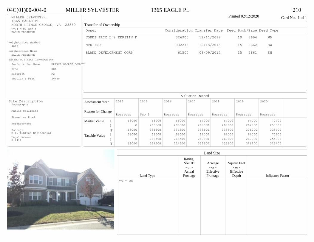
Transfer of Ownership
Valuation RecordAssessment Year
Reason for Change
Market Value
Taxable Value
LITLIT
Land SizeRating,Soil ID Acreage Square Feet- or - - or - - or -
Actual Effective EffectiveLand Type Frontage Frontage Depth Influence Factor
04C(01)00-004-0 MILLER SYLVESTER 1365 EAGLE PL 210Printed 02/12/2020 Card No. 1 of 1MILLER SYLVESTER
1365 EAGLE PLNORTH PRINCE GEORGE, VA 23860LT:4 BLK: SEC:1EAGLE PRESERVE
Neighborhood Number4018
Neighborhood NameEAGLE PRESERVE
TAXING DISTRICT INFORMATIONJurisdiction Name PRINCE GEORGE COUNTYArea 001 District P2 Section & Plat 26/45
Site DescriptionTopography
Public Utilities
Street or Road
Neighborhood
Zoning:R-1. Limited ResidentialLegal Acres:0.4411
Owner Consideration Transfer Date Deed Book/Page Deed TypeJONES ERIC L & KERSTIN F 326900 12/11/2019 19 3694 WD
NVR INC 332275 12/15/2015 15 3662 SW
BLAND DEVELOPMENT CORP 61500 09/09/2015 15 2661 SW
2015
Reassess 68000 0 68000 68000 0 68000
2015
Sup 1 68000 266500 334500 68000 266500 334500
2016
Reassess 68000 266500 334500 68000 266500 334500
2017
Reassess 64000 269600 333600 64000 269600 333600
2018
Reassess 64000 269600 333600 64000 269600 333600
2019
Reassess 64000 262900 326900 64000 262900 326900
2020
Reassess 70400 255000 325400 70400 255000 325400
R-1 - IMP
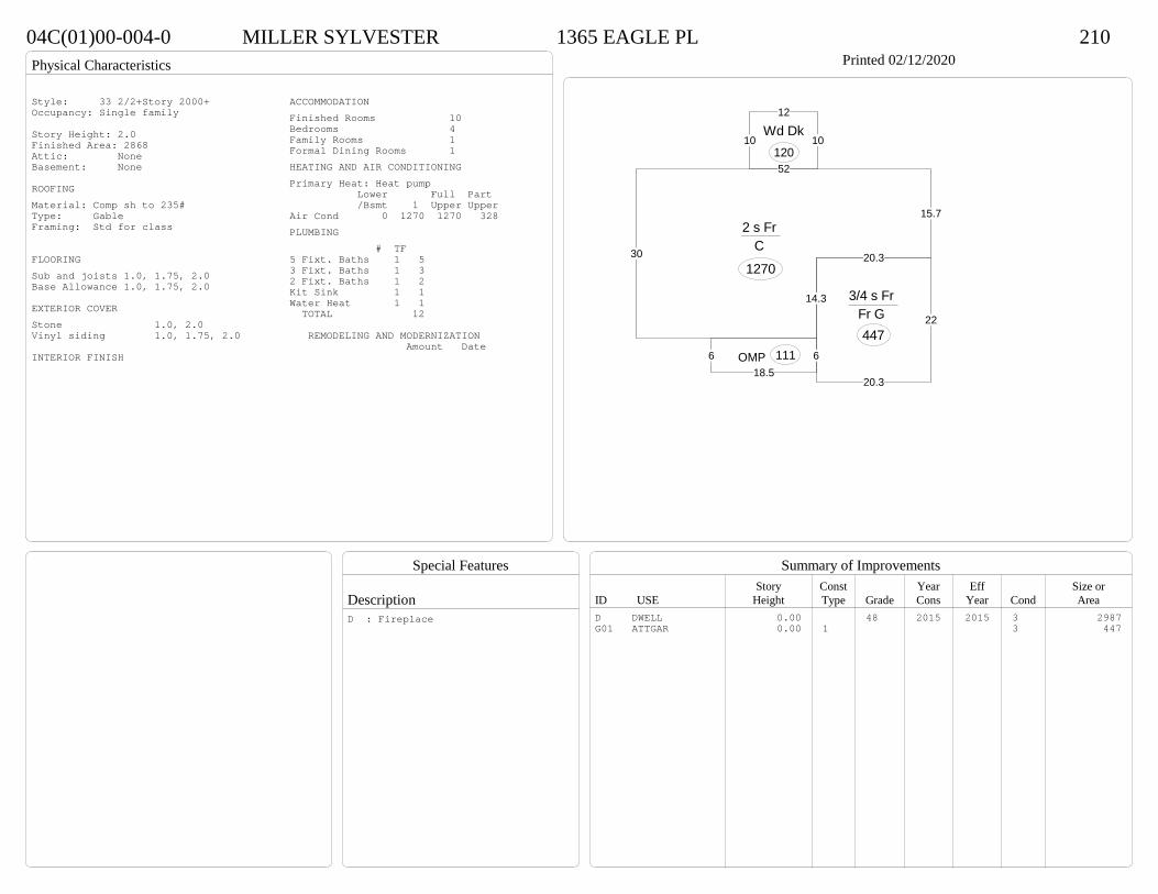
Physical Characteristics
Special Features
Description
Summary of ImprovementsStory Const Year Eff Size or
ID USE Height Type Grade Cons Year Cond Area
04C(01)00-004-0 MILLER SYLVESTER 1365 EAGLE PL 210Printed 02/12/2020
30
52
15.7
20.3
14.3
2 s Fr C
1270
618.5
6 OMP 111
10
12
10Wd Dk
120
20.3
22
20.3
3/4 s Fr Fr G 447
Style: 33 2/2+Story 2000+Occupancy: Single family
Story Height: 2.0Finished Area: 2868 Attic: NoneBasement: None
ROOFINGMaterial: Comp sh to 235#Type: GableFraming: Std for class
FLOORINGSub and joists 1.0, 1.75, 2.0Base Allowance 1.0, 1.75, 2.0
EXTERIOR COVERStone 1.0, 2.0Vinyl siding 1.0, 1.75, 2.0
INTERIOR FINISH
ACCOMMODATIONFinished Rooms 10Bedrooms 4Family Rooms 1Formal Dining Rooms 1HEATING AND AIR CONDITIONINGPrimary Heat: Heat pump Lower Full Part /Bsmt 1 Upper UpperAir Cond 0 1270 1270 328PLUMBING # TF5 Fixt. Baths 1 53 Fixt. Baths 1 32 Fixt. Baths 1 2Kit Sink 1 1Water Heat 1 1 TOTAL 12
REMODELING AND MODERNIZATION Amount Date
D DWELL 0.00 48 2015 2015 3 2987G01 ATTGAR 0.00 1 3 447
D : Fireplace

Transfer of Ownership
Valuation RecordAssessment Year
Reason for Change
Market Value
Taxable Value
LITLIT
Land SizeRating,Soil ID Acreage Square Feet- or - - or - - or -
Actual Effective EffectiveLand Type Frontage Frontage Depth Influence Factor
280(0A)00-008-B JARRELL RUDOLPH J & MISTY 16600 JAMES RIVER DRIVE 210Tax ID SF-2184,MS-1.75,YB-81 Printed 02/12/2020 Card No. 1 of 1JARRELL RUDOLPH J & MISTY
16600 JAMES RIVER DRDISPUTANTA, VA 23842PT H J BURROW PROPACRES:1.0446
Neighborhood Number4100
Neighborhood NameArea 4
TAXING DISTRICT INFORMATIONJurisdiction Name PRINCE GEORGE COUNTYArea 001 District P3 Section & Plat 239/120
Site DescriptionTopography
Public Utilities
Street or Road
Neighborhood
Zoning:A-1, Agricultural ConservationLegal Acres:1.0446
Owner Consideration Transfer Date Deed Book/Page Deed TypeLONG MICHAEL T & DENISE B 214000 08/27/2019 19 2536 WD
MOHAMMAD RADEY 179990 09/19/2016 16 2762 WD
GOLIGHTLY GARY L & DONNA C 180000 04/30/2010 10 1272 WD
PAUL JOHN A & WYONNA Y 79700 08/11/1989 320 393
BUILDERS SUPPLY CO OF HOPEWELL 58000 07/01/1983 263 402
2014
Reassess 33700 150800 184500 33700 150800 184500
2015
Reassess 33700 150800 184500 33700 150800 184500
2016
Reassess 33700 150800 184500 33700 150800 184500
2017
Reassess 33700 161000 194700 33700 161000 194700
2018
Reassess 33700 161000 194700 33700 161000 194700
2019
Reassess 33700 167800 201500 33700 167800 201500
2020
Reassess 37000 191100 228100 37000 191100 228100
A-1 <20 - IMP
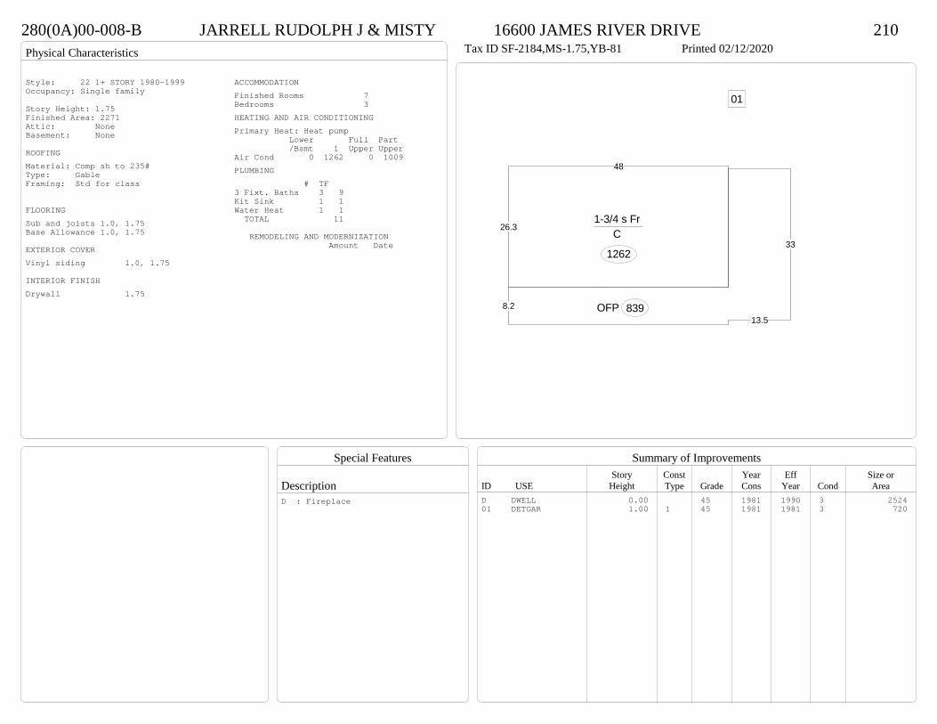
Physical Characteristics
Special Features
Description
Summary of ImprovementsStory Const Year Eff Size or
ID USE Height Type Grade Cons Year Cond Area
280(0A)00-008-B JARRELL RUDOLPH J & MISTY 16600 JAMES RIVER DRIVE 210Tax ID SF-2184,MS-1.75,YB-81 Printed 02/12/2020
26.3
48
1-3/4 s Fr C
1262
8.213.5
33
OFP 839
01Style: 22 1+ STORY 1980-1999Occupancy: Single family
Story Height: 1.75Finished Area: 2271 Attic: NoneBasement: None
ROOFINGMaterial: Comp sh to 235#Type: GableFraming: Std for class
FLOORINGSub and joists 1.0, 1.75Base Allowance 1.0, 1.75
EXTERIOR COVERVinyl siding 1.0, 1.75
INTERIOR FINISHDrywall 1.75
ACCOMMODATIONFinished Rooms 7Bedrooms 3HEATING AND AIR CONDITIONINGPrimary Heat: Heat pump Lower Full Part /Bsmt 1 Upper UpperAir Cond 0 1262 0 1009PLUMBING # TF3 Fixt. Baths 3 9Kit Sink 1 1Water Heat 1 1 TOTAL 11
REMODELING AND MODERNIZATION Amount Date
D DWELL 0.00 45 1981 1990 3 252401 DETGAR 1.00 1 45 1981 1981 3 720
D : Fireplace

Transfer of Ownership
Valuation RecordAssessment Year
Reason for Change
Market Value
Taxable Value
LITLIT
Land SizeRating,Soil ID Acreage Square Feet- or - - or - - or -
Actual Effective EffectiveLand Type Frontage Frontage Depth Influence Factor
27A(01)0B-002-0 DINSMORE JEFFREY S JR 15206 CHIEFTAIN ROAD 210Tax ID SF-1636,MS-TL,YB-72 Printed 02/12/2020 Card No. 1 of 1DINSMORE JEFFREY S JR
15206 CHIEFTAIN RDDISPUTANTA, VA 23842LT:2 BK:B SEC:1SUB:FORT POWHATANACRES:1.01
Neighborhood Number4100
Neighborhood NameArea 4
TAXING DISTRICT INFORMATIONJurisdiction Name PRINCE GEORGE COUNTYArea 001 District P3 Section & Plat 14 /28
Site DescriptionTopography
Public Utilities
Street or Road
Neighborhood
Zoning:A-1, Agricultural ConservationLegal Acres:1.0100
Owner Consideration Transfer Date Deed Book/Page Deed TypeSCHULTZ CLAYTON D 203000 08/09/2019 19 2332 WD
OAKLEY CARYN ASHLEY FOREHAND 185000 01/24/2018 18 239 WD
DILLENBECK JOAN H 33000 09/26/2016 16 2857 WD
DILLENBECK KEITH A & JOAN H 0 09/06/2016 WF16 122 WF
2014
Reassess 33300 119300 152600 33300 119300 152600
2015
Reassess 33300 119300 152600 33300 119300 152600
2016
Reassess 33300 119300 152600 33300 119300 152600
2017
Reassess 33300 64200 97500 33300 64200 97500
2018
Reassess 33300 141700 175000 33300 141700 175000
2019
Reassess 33300 150000 183300 33300 150000 183300
2020
Reassess 36600 172100 208700 36600 172100 208700
A-1 <20 - IMP

Physical Characteristics
Special Features
Description
Summary of ImprovementsStory Const Year Eff Size or
ID USE Height Type Grade Cons Year Cond Area
27A(01)0B-002-0 DINSMORE JEFFREY S JR 15206 CHIEFTAIN ROAD 210Tax ID SF-1636,MS-TL,YB-72 Printed 02/12/2020
26.6
17.5
1 s Fr C
466
26.6
22
2 s Fr C
585
1 s Fr OH 374.7
22OMP103
14OMP
5614
18
Conc
252
28
28 Fr G
784
Style: 31 2/2+ Story<1979Occupancy: Single family
Story Height: 2.0Finished Area: 1673 Attic: NoneBasement: None
ROOFINGMaterial: Comp sh to 235#Type: GableFraming: Std for class
FLOORINGSub and joists 1.0, 2.0Base Allowance 1.0, 2.0
EXTERIOR COVERVinyl siding 1.0, 2.0
INTERIOR FINISHDrywall 1.0
ACCOMMODATIONFinished Rooms 6Bedrooms 3HEATING AND AIR CONDITIONINGPrimary Heat: Heat pump Lower Full Part /Bsmt 1 Upper UpperAir Cond 0 1088 585 0PLUMBING # TF4 Fixt. Baths 2 82 Fixt. Baths 1 2Kit Sink 1 1Water Heat 1 1 TOTAL 12
REMODELING AND MODERNIZATION Amount Date
D DWELL 0.00 45 1972 1995 3 1673G02 ATTGAR 0.00 1 784
D : Remod 2018 Fireplace
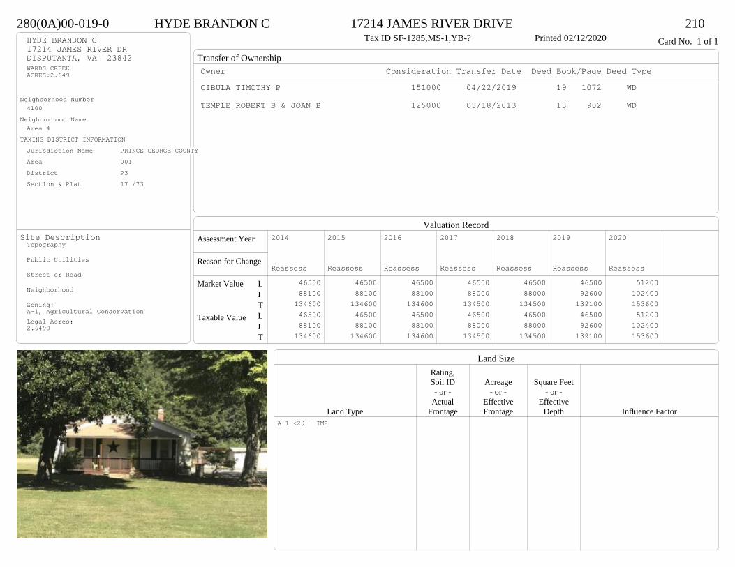
Transfer of Ownership
Valuation RecordAssessment Year
Reason for Change
Market Value
Taxable Value
LITLIT
Land SizeRating,Soil ID Acreage Square Feet- or - - or - - or -
Actual Effective EffectiveLand Type Frontage Frontage Depth Influence Factor
280(0A)00-019-0 HYDE BRANDON C 17214 JAMES RIVER DRIVE 210Tax ID SF-1285,MS-1,YB-? Printed 02/12/2020 Card No. 1 of 1HYDE BRANDON C
17214 JAMES RIVER DRDISPUTANTA, VA 23842WARDS CREEKACRES:2.649
Neighborhood Number4100
Neighborhood NameArea 4
TAXING DISTRICT INFORMATIONJurisdiction Name PRINCE GEORGE COUNTYArea 001 District P3 Section & Plat 17 /73
Site DescriptionTopography
Public Utilities
Street or Road
Neighborhood
Zoning:A-1, Agricultural ConservationLegal Acres:2.6490
Owner Consideration Transfer Date Deed Book/Page Deed TypeCIBULA TIMOTHY P 151000 04/22/2019 19 1072 WD
TEMPLE ROBERT B & JOAN B 125000 03/18/2013 13 902 WD
2014
Reassess 46500 88100 134600 46500 88100 134600
2015
Reassess 46500 88100 134600 46500 88100 134600
2016
Reassess 46500 88100 134600 46500 88100 134600
2017
Reassess 46500 88000 134500 46500 88000 134500
2018
Reassess 46500 88000 134500 46500 88000 134500
2019
Reassess 46500 92600 139100 46500 92600 139100
2020
Reassess 51200 102400 153600 51200 102400 153600
A-1 <20 - IMP
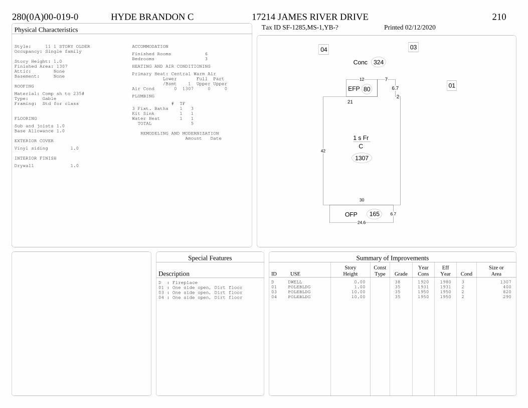
Physical Characteristics
Special Features
Description
Summary of ImprovementsStory Const Year Eff Size or
ID USE Height Type Grade Cons Year Cond Area
280(0A)00-019-0 HYDE BRANDON C 17214 JAMES RIVER DRIVE 210Tax ID SF-1285,MS-1,YB-? Printed 02/12/2020
Conc 324
30
42
21
7
6.7
2
1 s Fr C
1307
6.7
24.6OFP 165
12
EFP 80 01
0304Style: 11 1 STORY OLDEROccupancy: Single family
Story Height: 1.0Finished Area: 1307 Attic: NoneBasement: None
ROOFINGMaterial: Comp sh to 235#Type: GableFraming: Std for class
FLOORINGSub and joists 1.0Base Allowance 1.0
EXTERIOR COVERVinyl siding 1.0
INTERIOR FINISHDrywall 1.0
ACCOMMODATIONFinished Rooms 6Bedrooms 3HEATING AND AIR CONDITIONINGPrimary Heat: Central Warm Air Lower Full Part /Bsmt 1 Upper UpperAir Cond 0 1307 0 0PLUMBING # TF3 Fixt. Baths 1 3Kit Sink 1 1Water Heat 1 1 TOTAL 5
REMODELING AND MODERNIZATION Amount Date
D DWELL 0.00 38 1920 1980 3 130701 POLEBLDG 1.00 35 1931 1931 2 40003 POLEBLDG 10.00 35 1950 1950 2 82004 POLEBLDG 10.00 35 1950 1950 2 290
D : Fireplace01 : One side open, Dirt floor03 : One side open, Dirt floor04 : One side open, Dirt floor
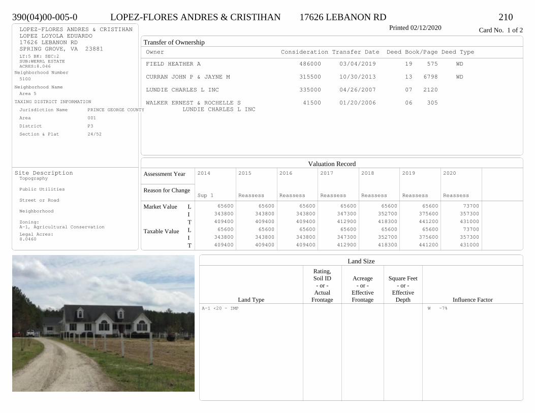
Transfer of Ownership
Valuation RecordAssessment Year
Reason for Change
Market Value
Taxable Value
LITLIT
Land SizeRating,Soil ID Acreage Square Feet- or - - or - - or -
Actual Effective EffectiveLand Type Frontage Frontage Depth Influence Factor
390(04)00-005-0 LOPEZ-FLORES ANDRES & CRISTIHAN 17626 LEBANON RD 210Printed 02/12/2020 Card No. 1 of 2LOPEZ-FLORES ANDRES & CRISTIHAN
LOPEZ LOYOLA EDUARDO17626 LEBANON RDSPRING GROVE, VA 23881LT:5 BK: SEC:2SUB:WERRL ESTATEACRES:8.046
Neighborhood Number5100
Neighborhood NameArea 5
TAXING DISTRICT INFORMATIONJurisdiction Name PRINCE GEORGE COUNTYArea 001 District P3 Section & Plat 24/52
Site DescriptionTopography
Public Utilities
Street or Road
Neighborhood
Zoning:A-1, Agricultural ConservationLegal Acres:8.0460
Owner Consideration Transfer Date Deed Book/Page Deed TypeFIELD HEATHER A 486000 03/04/2019 19 575 WD
CURRAN JOHN P & JAYNE M 315500 10/30/2013 13 6798 WD
LUNDIE CHARLES L INC 335000 04/26/2007 07 2120
WALKER ERNEST & ROCHELLE S 41500 01/20/2006 06 305 LUNDIE CHARLES L INC
2014
Sup 1 65600 343800 409400 65600 343800 409400
2015
Reassess 65600 343800 409400 65600 343800 409400
2016
Reassess 65600 343800 409400 65600 343800 409400
2017
Reassess 65600 347300 412900 65600 347300 412900
2018
Reassess 65600 352700 418300 65600 352700 418300
2019
Reassess 65600 375600 441200 65600 375600 441200
2020
Reassess 73700 357300 431000 73700 357300 431000
A-1 <20 - IMP W -7%

Physical Characteristics
Special Features
Description
Summary of ImprovementsStory Const Year Eff Size or
ID USE Height Type Grade Cons Year Cond Area
390(04)00-005-0 LOPEZ-FLORES ANDRES & CRISTIHAN 17626 LEBANON RD 210Printed 02/12/2020
224
12
9
16
12
12
38
384.524
26.5
1-1/2 s Fr C
1866
5OMP 80
12
16
Wd Dk192
31.5Fr G
756
01
Style: 23 1+ STORY 2000 +Occupancy: Single family
Story Height: 1.5Finished Area: 2756 Attic: NoneBasement: None
ROOFINGMaterial: Comp sh to 235#Type: GableFraming: Std for class
FLOORINGSub and joists 1.0, 1.5Base Allowance 1.0, 1.5
EXTERIOR COVERVinyl siding 1.0, 1.5
INTERIOR FINISHDrywall 1.0, 1.5
ACCOMMODATIONFinished Rooms 9Bedrooms 4Formal Dining Rooms 1HEATING AND AIR CONDITIONINGPrimary Heat: Heat pump Lower Full Part /Bsmt 1 Upper UpperAir Cond 0 1866 0 890PLUMBING # TF4 Fixt. Baths 1 43 Fixt. Baths 2 6Kit Sink 1 1Water Heat 1 1 TOTAL 12
REMODELING AND MODERNIZATION Amount Date
D DWELL 0.00 48 2007 2007 3 3732G01 ATTGAR 0.00 1 3 75601 POLEBLDG 10.00 35 2008 2008 2 302
D : Fireplace01 : One side open, Dirt floor
Transfer of Ownership
Valuation RecordAssessment Year
Reason for Change
Market Value
Taxable Value
LITLIT
Land SizeRating,Soil ID Acreage Square Feet- or - - or - - or -
Actual Effective EffectiveLand Type Frontage Frontage Depth Influence Factor
390(04)00-005-0 LOPEZ-FLORES ANDRES & CRISTIHAN 17626 LEBANON RD 210Printed 02/12/2020 Card No. 2 of 2

Physical Characteristics
Special Features
Description
Summary of ImprovementsStory Const Year Eff Size or
ID USE Height Type Grade Cons Year Cond Area
390(04)00-005-0 LOPEZ-FLORES ANDRES & CRISTIHAN 17626 LEBANON RD 210Printed 02/12/2020
44
27.7
44
27.7
1 s Fr C
1219
8
40
OFP 320
44Wd Dk 16
Style: 15 1 STORY 1990-1999Occupancy: Single family
Story Height: 1.0Finished Area: 1219 Attic: NoneBasement: None
ROOFINGMaterial: Comp sh to 235#Type: GableFraming: Std for class
FLOORINGSub and joists 1.0Base Allowance 1.0
EXTERIOR COVERVinyl siding 1.0
INTERIOR FINISH
ACCOMMODATIONFinished Rooms 5Bedrooms 2HEATING AND AIR CONDITIONINGPrimary Heat: Heat pump Lower Full Part /Bsmt 1 Upper UpperAir Cond 0 1219 0 0PLUMBING # TF4 Fixt. Baths 1 43 Fixt. Baths 1 3Kit Sink 1 1Water Heat 1 1 TOTAL 9
REMODELING AND MODERNIZATION Amount Date
D DWELL 0.00 45 2015 2015 3 1219D : Fireplace

Transfer of Ownership
Valuation RecordAssessment Year
Reason for Change
Market Value
Taxable Value
LITLIT
Land SizeRating,Soil ID Acreage Square Feet- or - - or - - or -
Actual Effective EffectiveLand Type Frontage Frontage Depth Influence Factor
550(0A)00-001-0 SYKORA SHAWN R & AMANDA L 10810 WEBB ROAD 600Tax ID SF-0,MS-0,YB- Printed 02/12/2020 Card No. 1 of 1SYKORA SHAWN R & AMANDA L
16040 ARWOOD RDDISPUTANTA, VA 23842TRACT AMARL VALLEY FARMACRES:170
Neighborhood Number5100
Neighborhood NameArea 5
TAXING DISTRICT INFORMATIONJurisdiction Name PRINCE GEORGE COUNTYArea 001 District P1 Section & Plat 16 /183
Site DescriptionTopography
Public Utilities
Street or Road
Neighborhood
Zoning:R-A, Residential AgriculturalLegal Acres:170.0000
Owner Consideration Transfer Date Deed Book/Page Deed TypeMARL VALLEY FARM LMTD PARTNERSHIP 340000 09/03/2019 19 2603 WD
2014
Reassess 251200 3500 254700 251200 3500 254700
2015
Reassess 251200 3500 254700 251200 3500 254700
2016
Reassess 251200 3500 254700 251200 3500 254700
2017
Reassess 241500 3500 245000 241500 3500 245000
2018
Reassess 318600 7300 325900 318600 7300 325900
2019
Reassess 318600 7300 325900 318600 7300 325900
2020
Reassess 350400 4700 355100 350400 4700 355100
R-A >100 - VAC S -5% T -1% W -21%

Physical Characteristics
Special Features
Description
Summary of ImprovementsStory Const Year Eff Size or
ID USE Height Type Grade Cons Year Cond Area
550(0A)00-001-0 SYKORA SHAWN R & AMANDA L 10810 WEBB ROAD 600Tax ID SF-0,MS-0,YB- Printed 02/12/2020
45
OMP20
12
6.5
OMP78
28
31
Cabin
868
01 CABIN 0.00 0 28 1900 1900 1 868

Transfer of Ownership
Valuation RecordAssessment Year
Reason for Change
Market Value
Taxable Value
LITLIT
Land SizeRating,Soil ID Acreage Square Feet- or - - or - - or -
Actual Effective EffectiveLand Type Frontage Frontage Depth Influence Factor
360(07)00-002-0 BRYANT CHRISTOPHER F & 9401 HOLLYWOOD DRIVE 210Printed 02/12/2020 Card No. 1 of 1BRYANT CHRISTOPHER F &
BRYANT PRISCILLA M9401 HOLLYWOOD DRDISPUTANTA, VA 23842LT:2 BK: SEC:SUB:CENTENNIAL FOREST ESTATESACRES:5
Neighborhood Number5100
Neighborhood NameArea 5
TAXING DISTRICT INFORMATIONJurisdiction Name PRINCE GEORGE COUNTYArea 001 District P1
Site DescriptionTopography
Public Utilities
Street or Road
Neighborhood
Zoning:A-1, Agricultural ConservationLegal Acres:5.0000
Owner Consideration Transfer Date Deed Book/Page Deed TypeJOHNSON MARVIN L & CONNIE J 337000 05/09/2019 19 1254 WD
BEVERLEY HOY N INC 312600 10/07/2005 05 5160
LUNDIE C W BUILDERS INC 52500 09/30/2004 04 5118 HARRY WHITLOCK
2014
Reassess 59400 246700 306100 59400 246700 306100
2015
Reassess 59400 246700 306100 59400 246700 306100
2016
Reassess 59400 246700 306100 59400 246700 306100
2017
Reassess 59400 241700 301100 59400 241700 301100
2018
Reassess 59400 241700 301100 59400 241700 301100
2019
Reassess 59400 287400 346800 59400 287400 346800
2020
Reassess 65300 284300 349600 65300 284300 349600
A-1 <20 - IMP
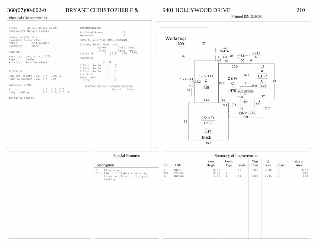
Physical Characteristics
Special Features
Description
Summary of ImprovementsStory Const Year Eff Size or
ID USE Height Type Grade Cons Year Cond Area
360(07)00-002-0 BRYANT CHRISTOPHER F & 9401 HOLLYWOOD DRIVE 210Printed 02/12/2020
14.7
7
13.8
7.63.2
6.3
25.3
20.9
2 s Fr C
479 1 s Fr Cathedral C
97
15
23
12.6
5.5
28.5
A 1 s Fr
C 358
15.3
27.3
1-1/2 s Fr C
418
4
26.81
1 s Fr C
50
2
7.8
1 s Fr OH
16
11.5
236
17
6
OMP 171
12
822 10
10Wd Dk
116
24
25.6
1/2 s Fr Fr G
614
20
30
Det Gar600
Brick
Workshop
Style: 33 2/2+Story 2000+Occupancy: Single family
Story Height: 2.0Finished Area: 2454 Attic: UnfinishedBasement: None
ROOFINGMaterial: Comp sh to 235#Type: GableFraming: Std for class
FLOORINGSub and joists 1.0, 1.5, 2.0, ABase Allowance 1.0, 1.5, 2.0
EXTERIOR COVERBrick 1.0, 1.5, 2.0Vinyl siding 1.0, 1.5, 2.0, A
INTERIOR FINISH
ACCOMMODATIONFinished Rooms 7Bedrooms 4HEATING AND AIR CONDITIONINGPrimary Heat: Heat pump Lower Full Part /Bsmt 1 Upper UpperAir Cond 0 1418 479 557PLUMBING # TF5 Fixt. Baths 1 53 Fixt. Baths 1 32 Fixt. Baths 1 2Kit Sink 1 1Water Heat 1 1 TOTAL 12
REMODELING AND MODERNIZATION Amount Date
D DWELL 0.00 55 2005 2005 3 3287G01 ATTGAR 0.00 1 3 61401 DETGAR 1.50 1 48 2006 2006 3 800
D : Fireplace01 : Electric lights & service, Interior finish - liv qual, Heating

Transfer of Ownership
Valuation RecordAssessment Year
Reason for Change
Market Value
Taxable Value
LITLIT
Land SizeRating,Soil ID Acreage Square Feet- or - - or - - or -
Actual Effective EffectiveLand Type Frontage Frontage Depth Influence Factor
550(02)00-035-0 NORRIS JOSHUA R & LINDSEY M 12077 WEBB RD 210Tax ID SF-0,MS-0,YB- Printed 02/12/2020 Card No. 1 of 1NORRIS JOSHUA R & LINDSEY M
12077 WEBB RDDISPUTANTA, VA 23842HOLDSWORTH PROPTRACT 35ACRES:5.513
Neighborhood Number5100
Neighborhood NameArea 5
TAXING DISTRICT INFORMATIONJurisdiction Name PRINCE GEORGE COUNTYArea 001 District P5 Section & Plat 21 /13
Site DescriptionTopography
Public Utilities
Street or Road
Neighborhood
Zoning:R-A, Residential AgriculturalLegal Acres:5.5130
Owner Consideration Transfer Date Deed Book/Page Deed TypeBAREFOOT REBECCA L 307950 07/01/2019 19 1909 WD
BAREFOOT DANIEL E & REBECCA L 0 03/24/2017 17 802 WD
BENESEK I J JR INC 295000 05/11/2007 07 2439
OWENS FRANK & MARY E 120000 05/19/2006 06 2633
WOODLAND INC 43000 11/08/1995 408 509
2014
Reassess 65300 180500 245800 65300 180500 245800
2015
Reassess 65300 180500 245800 65300 180500 245800
2016
Reassess 65300 180500 245800 65300 180500 245800
2017
Reassess 61800 182500 244300 61800 182500 244300
2018
Reassess 61800 191700 253500 61800 191700 253500
2019
Reassess 61800 198100 259900 61800 198100 259900
2020
Reassess 68000 247900 315900 68000 247900 315900
R-A <20 - IMP

Physical Characteristics
Special Features
Description
Summary of ImprovementsStory Const Year Eff Size or
ID USE Height Type Grade Cons Year Cond Area
550(02)00-035-0 NORRIS JOSHUA R & LINDSEY M 12077 WEBB RD 210Tax ID SF-0,MS-0,YB- Printed 02/12/2020
18
713
5.7
5
34.3
17.7
7.542.3
28
24
12.5
1 s Fr C
2095
6 OMP 108
12
16
OFP-s192
24
24
Fr G
576
Style: 16 1 STORY 2000-2009Occupancy: Single family
Story Height: 1.0Finished Area: 2095 Attic: NoneBasement: None
ROOFINGMaterial: Comp sh to 235#Type: HipFraming: Std for class
FLOORINGSub and joists 1.0Base Allowance 1.0
EXTERIOR COVERVinyl siding 1.0
INTERIOR FINISH
ACCOMMODATIONFinished Rooms 8Bedrooms 3HEATING AND AIR CONDITIONINGPrimary Heat: Heat pump Lower Full Part /Bsmt 1 Upper UpperAir Cond 0 2095 0 0PLUMBING # TF5 Fixt. Baths 1 53 Fixt. Baths 1 32 Fixt. Baths 1 2Kit Sink 1 1Water Heat 1 1 TOTAL 12
REMODELING AND MODERNIZATION Amount Date
D DWELL 0.00 48 2007 2007 3 2095G01 ATTGAR 0.00 1 3 576
D : Fireplace
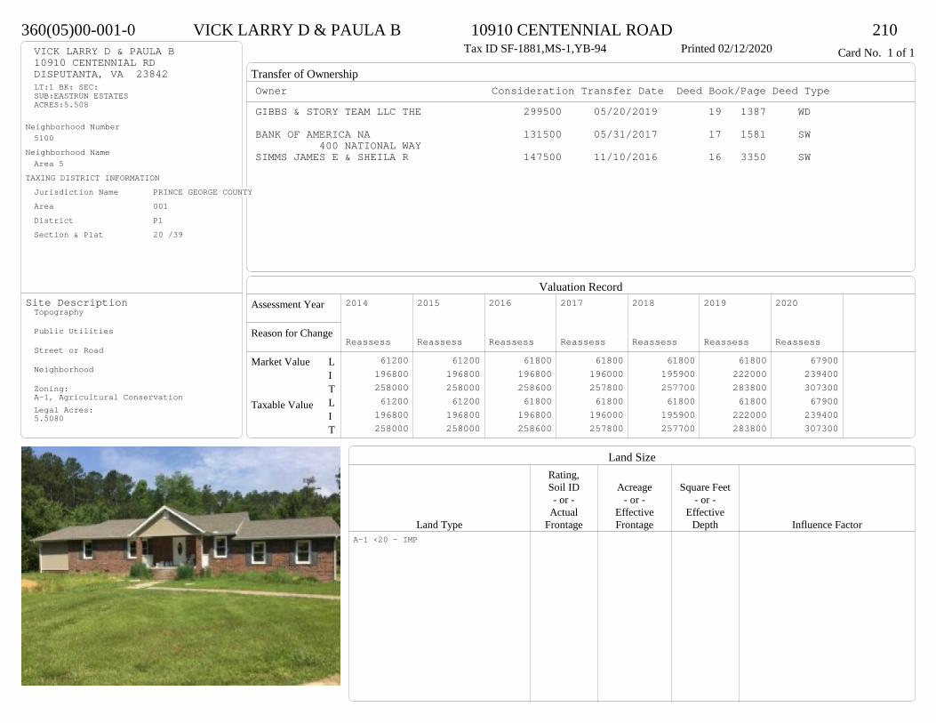
Transfer of Ownership
Valuation RecordAssessment Year
Reason for Change
Market Value
Taxable Value
LITLIT
Land SizeRating,Soil ID Acreage Square Feet- or - - or - - or -
Actual Effective EffectiveLand Type Frontage Frontage Depth Influence Factor
360(05)00-001-0 VICK LARRY D & PAULA B 10910 CENTENNIAL ROAD 210Tax ID SF-1881,MS-1,YB-94 Printed 02/12/2020 Card No. 1 of 1VICK LARRY D & PAULA B
10910 CENTENNIAL RDDISPUTANTA, VA 23842LT:1 BK: SEC:SUB:EASTRUN ESTATESACRES:5.508
Neighborhood Number5100
Neighborhood NameArea 5
TAXING DISTRICT INFORMATIONJurisdiction Name PRINCE GEORGE COUNTYArea 001 District P1 Section & Plat 20 /39
Site DescriptionTopography
Public Utilities
Street or Road
Neighborhood
Zoning:A-1, Agricultural ConservationLegal Acres:5.5080
Owner Consideration Transfer Date Deed Book/Page Deed TypeGIBBS & STORY TEAM LLC THE 299500 05/20/2019 19 1387 WD
BANK OF AMERICA NA 131500 05/31/2017 17 1581 SW400 NATIONAL WAY
SIMMS JAMES E & SHEILA R 147500 11/10/2016 16 3350 SW
2014
Reassess 61200 196800 258000 61200 196800 258000
2015
Reassess 61200 196800 258000 61200 196800 258000
2016
Reassess 61800 196800 258600 61800 196800 258600
2017
Reassess 61800 196000 257800 61800 196000 257800
2018
Reassess 61800 195900 257700 61800 195900 257700
2019
Reassess 61800 222000 283800 61800 222000 283800
2020
Reassess 67900 239400 307300 67900 239400 307300
A-1 <20 - IMP

Physical Characteristics
Special Features
Description
Summary of ImprovementsStory Const Year Eff Size or
ID USE Height Type Grade Cons Year Cond Area
360(05)00-001-0 VICK LARRY D & PAULA B 10910 CENTENNIAL ROAD 210Tax ID SF-1881,MS-1,YB-94 Printed 02/12/2020
40.2
46.8
1 s Br C
1881
10
28EFP
280
7.916.5
OMP 130
9.96Wd Dk
5911
24
16
16
5
8
Wd Dk
344
20
28.8Br G 576
01
Style: 15 1 STORY 1990-1999Occupancy: Single family
Story Height: 1.0Finished Area: 1881 Attic: NoneBasement: None
ROOFINGMaterial: Comp sh to 235#Type: GableFraming: Std for class
FLOORINGSub and joists 1.0Base Allowance 1.0
EXTERIOR COVERBrick 1.0
INTERIOR FINISHDrywall 1.0
ACCOMMODATIONFinished Rooms 7Bedrooms 3HEATING AND AIR CONDITIONINGPrimary Heat: Heat pump Lower Full Part /Bsmt 1 Upper UpperAir Cond 0 1881 0 0PLUMBING # TF4 Fixt. Baths 1 43 Fixt. Baths 1 32 Fixt. Baths 1 2Kit Sink 1 1Water Heat 1 1 TOTAL 11
REMODELING AND MODERNIZATION Amount Date
D DWELL 0.00 48 1994 2002 3 1881G01 ATTGAR 0.00 7 57601 DETGAR 1.00 1 45 1995 1995 3 531
D : Remod 2018 Fireplace

Transfer of Ownership
Valuation RecordAssessment Year
Reason for Change
Market Value
Taxable Value
LITLIT
Land SizeRating,Soil ID Acreage Square Feet- or - - or - - or -
Actual Effective EffectiveLand Type Frontage Frontage Depth Influence Factor
550(02)00-003-0 PAYNE ROBERT & JESSICA 11220 COUNTY DRIVE 210Tax ID SF-0,MS-0,YB- Printed 02/12/2020 Card No. 1 of 1PAYNE ROBERT & JESSICA
11220 COUNTY DRDISPUTANTA, VA 23842-7501HOLDSWORTH PROPTRACT 3ACRES:5.017
Neighborhood Number5100
Neighborhood NameArea 5
TAXING DISTRICT INFORMATIONJurisdiction Name PRINCE GEORGE COUNTYArea 001 District P5 Section & Plat 16 /197
Site DescriptionTopography
Public Utilities
Street or Road
Neighborhood
Zoning:R-A, Residential AgriculturalLegal Acres:5.0170
Owner Consideration Transfer Date Deed Book/Page Deed TypePLATONI PHILLIP P & PAMELA A 292000 10/24/2019 19 3152 WD
PLATONI PHILLIP P 0 05/08/2013 13 1566
PLATONI PHILLIP P & PAMELA A 0 09/10/2008 08 3881 QC
NOBLIN ADAM J 22500 07/23/1999 479 5
2014
Reassess 60300 238600 298900 60300 238600 298900
2015
Reassess 60300 238600 298900 60300 238600 298900
2016
Reassess 60300 238600 298900 60300 238600 298900
2017
Reassess 57100 236400 293500 57100 236400 293500
2018
Reassess 57100 236400 293500 57100 236400 293500
2019
Reassess 57100 257500 314600 57100 257500 314600
2020
Reassess 62100 229900 292000 62100 229900 292000
R-A <20 - IMP W -5%
Physical Characteristics
Special Features
Description
Summary of ImprovementsStory Const Year Eff Size or
ID USE Height Type Grade Cons Year Cond Area
550(02)00-003-0 PAYNE ROBERT & JESSICA 11220 COUNTY DRIVE 210Tax ID SF-0,MS-0,YB- Printed 02/12/2020
20
30
24
11.8
2 s Fr C
647
13
34
9
1 s Fr Cathedral C 395
12
21
44
142
1 s Fr C
910
411
1 s Fr C
441.4
6.71 s Fr OH
10.2
16.6
Wd Dk169
4 OMP 80
Style: 33 2/2+Story 2000+Occupancy: Single family
Story Height: 1.0Finished Area: 2652 Attic: NoneBasement: None
ROOFINGMaterial: Comp sh to 235#Type: GableFraming: Std for class
FLOORINGSub and joists 1.0, 2.0Base Allowance 1.0, 2.0
EXTERIOR COVERVinyl siding 1.0, 2.0
INTERIOR FINISHDrywall 1.0
ACCOMMODATIONFinished Rooms 7Bedrooms 5HEATING AND AIR CONDITIONINGPrimary Heat: Heat pump Lower Full Part /Bsmt 1 Upper UpperAir Cond 0 2005 647 0PLUMBING # TF3 Fixt. Baths 2 62 Fixt. Baths 1 2Kit Sink 1 1Water Heat 1 1Extra Fixt 1 TOTAL 11
REMODELING AND MODERNIZATION Amount Date
D DWELL 0.00 48 2001 2001 3 2652D : Fireplace
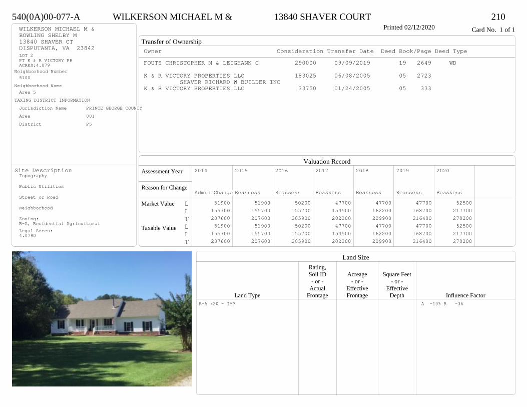
Transfer of Ownership
Valuation RecordAssessment Year
Reason for Change
Market Value
Taxable Value
LITLIT
Land SizeRating,Soil ID Acreage Square Feet- or - - or - - or -
Actual Effective EffectiveLand Type Frontage Frontage Depth Influence Factor
540(0A)00-077-A WILKERSON MICHAEL M & 13840 SHAVER COURT 210Printed 02/12/2020 Card No. 1 of 1WILKERSON MICHAEL M &
BOWLING SHELBY M13840 SHAVER CTDISPUTANTA, VA 23842LOT 2PT K & R VICTORY PRACRES:4.079
Neighborhood Number5100
Neighborhood NameArea 5
TAXING DISTRICT INFORMATIONJurisdiction Name PRINCE GEORGE COUNTYArea 001 District P5
Site DescriptionTopography
Public Utilities
Street or Road
Neighborhood
Zoning:R-A, Residential AgriculturalLegal Acres:4.0790
Owner Consideration Transfer Date Deed Book/Page Deed TypeFOUTS CHRISTOPHER M & LEIGHANN C 290000 09/09/2019 19 2649 WD
K & R VICTORY PROPERTIES LLC 183025 06/08/2005 05 2723 SHAVER RICHARD W BUILDER INC
K & R VICTORY PROPERTIES LLC 33750 01/24/2005 05 333
2014
Admin Change 51900 155700 207600 51900 155700 207600
2015
Reassess 51900 155700 207600 51900 155700 207600
2016
Reassess 50200 155700 205900 50200 155700 205900
2017
Reassess 47700 154500 202200 47700 154500 202200
2018
Reassess 47700 162200 209900 47700 162200 209900
2019
Reassess 47700 168700 216400 47700 168700 216400
2020
Reassess 52500 217700 270200 52500 217700 270200
R-A <20 - IMP A -10% R -3%

Physical Characteristics
Special Features
Description
Summary of ImprovementsStory Const Year Eff Size or
ID USE Height Type Grade Cons Year Cond Area
540(0A)00-077-A WILKERSON MICHAEL M & 13840 SHAVER COURT 210Printed 02/12/2020
57.1
12.3
2
16.7
26.1
15
18
71 s Fr
C
1111
36.91 s Fr OH 21
23
18
Wd Dk
390
45.81 s Fr OH 24
529.9
OMP 150
1 s Fr Cathedral C
270
11
7
13
29
24
1 s Fr Slab
619
A/G POOLStyle: 16 1 STORY 2000-2009Occupancy: Single family
Story Height: 1.0Finished Area: 2045 Attic: NoneBasement: None
ROOFINGMaterial: Comp sh to 235#Type: GableFraming: Std for class
FLOORINGSub and joists 1.0Base Allowance 1.0
EXTERIOR COVERVinyl siding 1.0
INTERIOR FINISHDrywall 1.0
ACCOMMODATIONFinished Rooms 6Bedrooms 3HEATING AND AIR CONDITIONINGPrimary Heat: Heat pump Lower Full Part /Bsmt 1 Upper UpperAir Cond 0 2045 0 0PLUMBING # TF5 Fixt. Baths 1 53 Fixt. Baths 1 3Kit Sink 1 1Water Heat 1 1 TOTAL 10
REMODELING AND MODERNIZATION Amount Date
D DWELL 0.00 48 2005 2005 3 2045
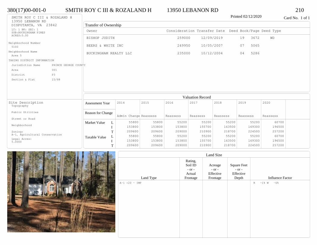
Transfer of Ownership
Valuation RecordAssessment Year
Reason for Change
Market Value
Taxable Value
LITLIT
Land SizeRating,Soil ID Acreage Square Feet- or - - or - - or -
Actual Effective EffectiveLand Type Frontage Frontage Depth Influence Factor
380(17)00-001-0 SMITH ROY C III & ROZALAND H 13950 LEBANON RD 210Printed 02/12/2020 Card No. 1 of 1SMITH ROY C III & ROZALAND H
13950 LEBANON RDDISPUTANTA, VA 23842LT: 1 BK: SEC: 1SUB:BUCKINGHAM PINESACRES:5.00
Neighborhood Number5100
Neighborhood NameArea 5
TAXING DISTRICT INFORMATIONJurisdiction Name PRINCE GEORGE COUNTYArea 001 District P3 Section & Plat 23/88
Site DescriptionTopography
Public Utilities
Street or Road
Neighborhood
Zoning:A-1, Agricultural ConservationLegal Acres:5.0000
Owner Consideration Transfer Date Deed Book/Page Deed TypeBISHOP JUDITH 259000 12/09/2019 19 3672 WD
BEERS & WHITE INC 249950 10/05/2007 07 5065
BUCKINGHAM REALTY LLC 235000 10/12/2004 04 5286
2014
Admin Change 55800 153800 209600 55800 153800 209600
2015
Reassess 55800 153800 209600 55800 153800 209600
2016
Reassess 55200 153800 209000 55200 153800 209000
2017
Reassess 55200 155700 210900 55200 155700 210900
2018
Reassess 55200 163500 218700 55200 163500 218700
2019
Reassess 55200 169300 224500 55200 169300 224500
2020
Reassess 60700 196500 257200 60700 196500 257200
A-1 <20 - IMP R -1% W -6%
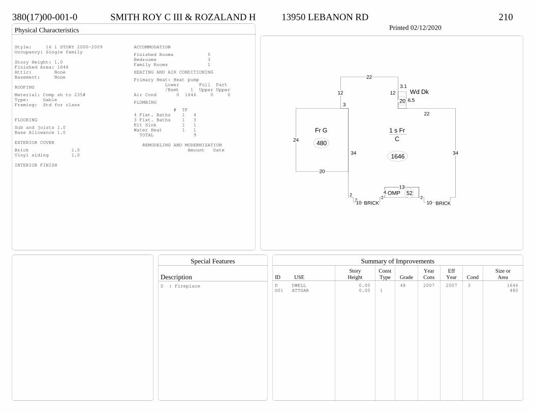
Physical Characteristics
Special Features
Description
Summary of ImprovementsStory Const Year Eff Size or
ID USE Height Type Grade Cons Year Cond Area
380(17)00-001-0 SMITH ROY C III & ROZALAND H 13950 LEBANON RD 210Printed 02/12/2020
2210
24
13
210
34
22
12
22
12
3
34
1 s Fr C
1646
OMP 52
6.5
3.1Wd Dk
20
20
24
Fr G
480
BRICK BRICK
Style: 16 1 STORY 2000-2009Occupancy: Single family
Story Height: 1.0Finished Area: 1646 Attic: NoneBasement: None
ROOFINGMaterial: Comp sh to 235#Type: GableFraming: Std for class
FLOORINGSub and joists 1.0Base Allowance 1.0
EXTERIOR COVERBrick 1.0Vinyl siding 1.0
INTERIOR FINISH
ACCOMMODATIONFinished Rooms 5Bedrooms 3Family Rooms 1HEATING AND AIR CONDITIONINGPrimary Heat: Heat pump Lower Full Part /Bsmt 1 Upper UpperAir Cond 0 1646 0 0PLUMBING # TF4 Fixt. Baths 1 43 Fixt. Baths 1 3Kit Sink 1 1Water Heat 1 1 TOTAL 9
REMODELING AND MODERNIZATION Amount Date
D DWELL 0.00 48 2007 2007 3 1646G01 ATTGAR 0.00 1 480
D : Fireplace
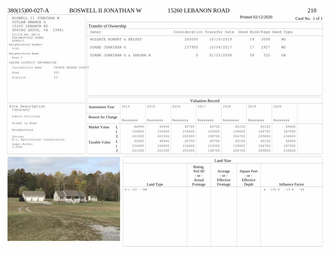
Transfer of Ownership
Valuation RecordAssessment Year
Reason for Change
Market Value
Taxable Value
LITLIT
Land SizeRating,Soil ID Acreage Square Feet- or - - or - - or -
Actual Effective EffectiveLand Type Frontage Frontage Depth Influence Factor
380(15)00-027-A BOSWELL II JONATHAN W 15260 LEBANON ROAD 210Printed 02/12/2020 Card No. 1 of 1BOSWELL II JONATHAN W
OUTLAW AMANDA G15260 LEBANON RDSPRING GROVE, VA 23881LT:27A BK: SEC:2SUB:MAYFIELD FARMSACRES:5
Neighborhood Number5100
Neighborhood NameArea 5
TAXING DISTRICT INFORMATIONJurisdiction Name PRINCE GEORGE COUNTYArea 001 District P3
Site DescriptionTopography
Public Utilities
Street or Road
Neighborhood
Zoning:A-1, Agricultural ConservationLegal Acres:5.0000
Owner Consideration Transfer Date Deed Book/Page Deed TypeHOLGATE ROBERT & KELSEY 265000 10/10/2019 19 3008 WD
DOANE JONATHAN G 237900 10/04/2017 17 2927 WD
DOANE JONATHAN G & SHAUNA R 0 01/25/2008 08 332 DA
2014
Reassess 46900 154600 201500 46900 154600 201500
2015
Reassess 46900 154600 201500 46900 154600 201500
2016
Reassess 45700 154600 200300 45700 154600 200300
2017
Reassess 45700 153000 198700 45700 153000 198700
2018
Reassess 45100 159600 204700 45100 159600 204700
2019
Reassess 45100 164700 209800 45100 164700 209800
2020
Reassess 49600 187000 236600 49600 187000 236600
A-1 <20 - IMP A -15% R -1% W -8%

Physical Characteristics
Special Features
Description
Summary of ImprovementsStory Const Year Eff Size or
ID USE Height Type Grade Cons Year Cond Area
380(15)00-027-A BOSWELL II JONATHAN W 15260 LEBANON ROAD 210Printed 02/12/2020
32
13
16
24
13
50
1 s Fr C
1216
4 1 s Fr OH 12
20.2
10 Wd Dk 202
624.2
OFP 145
1 s Fr Cathedral C
384
01
Style: 16 1 STORY 2000-2009Occupancy: Single family
Story Height: 1.0Finished Area: 1612 Attic: NoneBasement: None
ROOFINGMaterial: Comp sh to 235#Type: GableFraming: Std for class
FLOORINGSub and joists 1.0Base Allowance 1.0
EXTERIOR COVERVinyl siding 1.0
INTERIOR FINISHDrywall 1.0
ACCOMMODATIONFinished Rooms 6Bedrooms 3Formal Dining Rooms 1HEATING AND AIR CONDITIONINGPrimary Heat: Heat pump Lower Full Part /Bsmt 1 Upper UpperAir Cond 0 1612 0 0PLUMBING # TF5 Fixt. Baths 1 53 Fixt. Baths 1 3Kit Sink 1 1Water Heat 1 1 TOTAL 10
REMODELING AND MODERNIZATION Amount Date
D DWELL 0.00 45 2003 2003 3 161201 DETGAR 0.00 1 45 2010 2010 3 1140
D : Fireplace
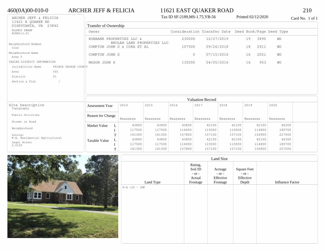
Transfer of Ownership
Valuation RecordAssessment Year
Reason for Change
Market Value
Taxable Value
LITLIT
Land SizeRating,Soil ID Acreage Square Feet- or - - or - - or -
Actual Effective EffectiveLand Type Frontage Frontage Depth Influence Factor
460(0A)00-010-0 ARCHER JEFF & FELICIA 11621 EAST QUAKER ROAD 210Tax ID SF-2189,MS-1.75,YB-56 Printed 02/12/2020 Card No. 1 of 1ARCHER JEFF & FELICIA
11621 E QUAKER RDDISPUTANTA, VA 23842BLANDS SWAMPACRES:2.01
Neighborhood Number5100
Neighborhood NameArea 5
TAXING DISTRICT INFORMATIONJurisdiction Name PRINCE GEORGE COUNTYArea 001 District P1 Section & Plat /
Site DescriptionTopography
Public Utilities
Street or Road
Neighborhood
Zoning:R-A, Residential AgriculturalLegal Acres:2.0100
Owner Consideration Transfer Date Deed Book/Page Deed TypeBUBBANK PROPERTIES LLC & 230000 12/27/2019 19 3890 WD
BEULAH LAND PROPERTIES LLCCOMPTON JOHN D & CORA ET AL 107500 09/26/2018 18 2911 WD
COMPTON JOHN D 0 07/15/2016 16 2051 WD
MASON JOHN H 135000 04/05/2016 16 953 WD
2014
Reassess 43800 117500 161300 43800 117500 161300
2015
Reassess 43800 117500 161300 43800 117500 161300
2016
Reassess 43800 114000 157800 43800 114000 157800
2017
Reassess 42100 115000 157100 42100 115000 157100
2018
Reassess 42100 115000 157100 42100 115000 157100
2019
Reassess 42100 114800 156900 42100 114800 156900
2020
Reassess 46300 180700 227000 46300 180700 227000
R-A <20 - IMP
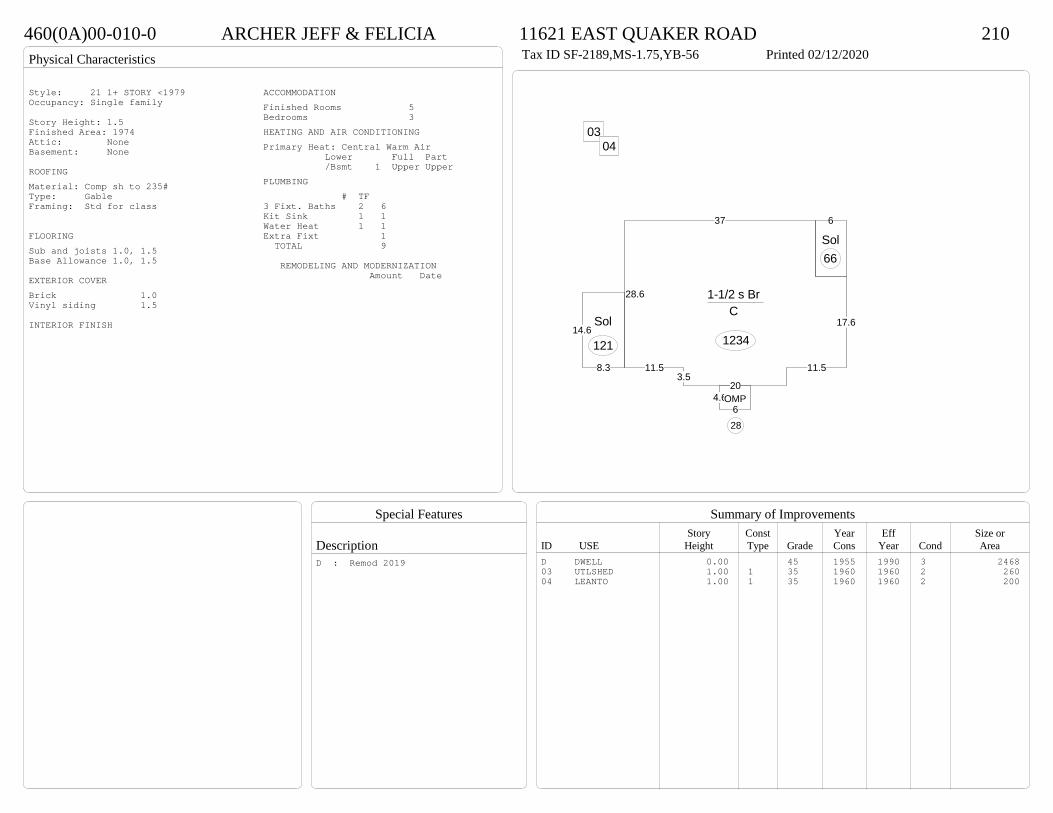
Physical Characteristics
Special Features
Description
Summary of ImprovementsStory Const Year Eff Size or
ID USE Height Type Grade Cons Year Cond Area
460(0A)00-010-0 ARCHER JEFF & FELICIA 11621 EAST QUAKER ROAD 210Tax ID SF-2189,MS-1.75,YB-56 Printed 02/12/2020
37
28.6
11.53.5
20
11.5
17.6
1-1/2 s Br C
1234
6
Sol66
8.3
14.6Sol
121
4.66
OMP
28
0304
Style: 21 1+ STORY <1979Occupancy: Single family
Story Height: 1.5Finished Area: 1974 Attic: NoneBasement: None
ROOFINGMaterial: Comp sh to 235#Type: GableFraming: Std for class
FLOORINGSub and joists 1.0, 1.5Base Allowance 1.0, 1.5
EXTERIOR COVERBrick 1.0Vinyl siding 1.5
INTERIOR FINISH
ACCOMMODATIONFinished Rooms 5Bedrooms 3HEATING AND AIR CONDITIONINGPrimary Heat: Central Warm Air Lower Full Part /Bsmt 1 Upper UpperPLUMBING # TF3 Fixt. Baths 2 6Kit Sink 1 1Water Heat 1 1Extra Fixt 1 TOTAL 9
REMODELING AND MODERNIZATION Amount Date
D DWELL 0.00 45 1955 1990 3 246803 UTLSHED 1.00 1 35 1960 1960 2 26004 LEANTO 1.00 1 35 1960 1960 2 200
D : Remod 2019
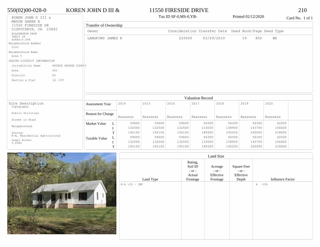
Transfer of Ownership
Valuation RecordAssessment Year
Reason for Change
Market Value
Taxable Value
LITLIT
Land SizeRating,Soil ID Acreage Square Feet- or - - or - - or -
Actual Effective EffectiveLand Type Frontage Frontage Depth Influence Factor
550(02)00-028-0 KOREN JOHN D III & 11550 FIRESIDE DRIVE 210Tax ID SF-0,MS-0,YB- Printed 02/12/2020 Card No. 1 of 1KOREN JOHN D III &
MASON SARAH E11550 FIRESIDE DRDISPUTANTA, VA 23842HOLDSWORTH PROPTRACT 28ACRES:5.698
Neighborhood Number5100
Neighborhood NameArea 5
TAXING DISTRICT INFORMATIONJurisdiction Name PRINCE GEORGE COUNTYArea 001 District P5 Section & Plat 16 /197
Site DescriptionTopography
Public Utilities
Street or Road
Neighborhood
Zoning:R-A, Residential AgriculturalLegal Acres:5.6980
Owner Consideration Transfer Date Deed Book/Page Deed TypeLANGFORD JAMES K 225000 03/29/2019 19 850 WD
2014
Reassess 59600 132500 192100 59600 132500 192100
2015
Reassess 59600 132500 192100 59600 132500 192100
2016
Reassess 59600 132500 192100 59600 132500 192100
2017
Reassess 56300 133000 189300 56300 133000 189300
2018
Reassess 56300 138900 195200 56300 138900 195200
2019
Reassess 56300 143700 200000 56300 143700 200000
2020
Reassess 62000 156600 218600 62000 156600 218600
R-A <20 - IMP A -10%
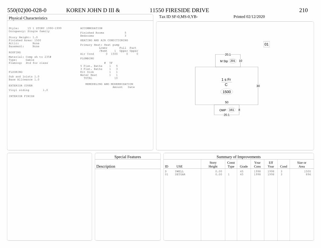
Physical Characteristics
Special Features
Description
Summary of ImprovementsStory Const Year Eff Size or
ID USE Height Type Grade Cons Year Cond Area
550(02)00-028-0 KOREN JOHN D III & 11550 FIRESIDE DRIVE 210Tax ID SF-0,MS-0,YB- Printed 02/12/2020
30
50
1 s Fr C
1500
820.1
OMP 161
10
20.1
M Stp 201
01
Style: 15 1 STORY 1990-1999Occupancy: Single family
Story Height: 1.0Finished Area: 1500 Attic: NoneBasement: None
ROOFINGMaterial: Comp sh to 235#Type: GableFraming: Std for class
FLOORINGSub and joists 1.0Base Allowance 1.0
EXTERIOR COVERVinyl siding 1.0
INTERIOR FINISH
ACCOMMODATIONFinished Rooms 5Bedrooms 3HEATING AND AIR CONDITIONINGPrimary Heat: Heat pump Lower Full Part /Bsmt 1 Upper UpperAir Cond 0 1500 0 0PLUMBING # TF5 Fixt. Baths 1 53 Fixt. Baths 1 3Kit Sink 1 1Water Heat 1 1 TOTAL 10
REMODELING AND MODERNIZATION Amount Date
D DWELL 0.00 45 1998 1998 3 150001 DETGAR 0.00 1 45 1998 1998 3 896

Transfer of Ownership
Valuation RecordAssessment Year
Reason for Change
Market Value
Taxable Value
LITLIT
Land SizeRating,Soil ID Acreage Square Feet- or - - or - - or -
Actual Effective EffectiveLand Type Frontage Frontage Depth Influence Factor
380(14)00-018-0 LEWALLEN JEREMY M & KARI L 9825 CEDAR LANE 210Printed 02/12/2020 Card No. 1 of 1LEWALLEN JEREMY M & KARI L
9825 CEDAR LNDISPUTANTA, VA 23842LT:18 BK: SEC:1SUB:MAYFIELD FARMSACRES:5
Neighborhood Number5100
Neighborhood NameArea 5
TAXING DISTRICT INFORMATIONJurisdiction Name PRINCE GEORGE COUNTYArea 001 District P3 Section & Plat 22/61
Site DescriptionTopography
Public Utilities
Street or Road
Neighborhood
Zoning:A-1, Agricultural ConservationLegal Acres:5.0000
Owner Consideration Transfer Date Deed Book/Page Deed TypeMCGREEVY BRANDON C 210000 01/31/2019 19 278 WD
FETKO PROPERTIES LLC 185000 04/03/2017 17 919 WD
HSBC BANK USA NA TR 112114 10/20/2016 16 3124 SW
WRIGHT GRANT E & REBECCA L 170000 07/27/2016 16 2166 SW
2014
Reassess 53500 114300 167800 53500 114300 167800
2015
Reassess 53500 114300 167800 53500 114300 167800
2016
Reassess 53500 114300 167800 53500 114300 167800
2017
Reassess 53500 114900 168400 53500 114900 168400
2018
Reassess 53500 119300 172800 53500 119300 172800
2019
Reassess 53500 123900 177400 53500 123900 177400
2020
Reassess 51600 146200 197800 51600 146200 197800
A-1 <20 - IMP W -21%
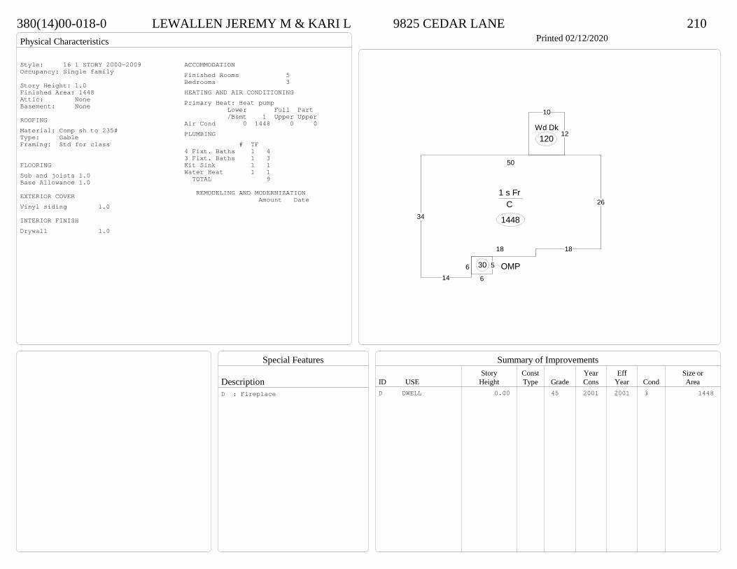
Physical Characteristics
Special Features
Description
Summary of ImprovementsStory Const Year Eff Size or
ID USE Height Type Grade Cons Year Cond Area
380(14)00-018-0 LEWALLEN JEREMY M & KARI L 9825 CEDAR LANE 210Printed 02/12/2020
34
146
18 18
26
50
1 s Fr C
1448
5
6
OMP30
12
10
Wd Dk120
Style: 16 1 STORY 2000-2009Occupancy: Single family
Story Height: 1.0Finished Area: 1448 Attic: NoneBasement: None
ROOFINGMaterial: Comp sh to 235#Type: GableFraming: Std for class
FLOORINGSub and joists 1.0Base Allowance 1.0
EXTERIOR COVERVinyl siding 1.0
INTERIOR FINISHDrywall 1.0
ACCOMMODATIONFinished Rooms 5Bedrooms 3HEATING AND AIR CONDITIONINGPrimary Heat: Heat pump Lower Full Part /Bsmt 1 Upper UpperAir Cond 0 1448 0 0PLUMBING # TF4 Fixt. Baths 1 43 Fixt. Baths 1 3Kit Sink 1 1Water Heat 1 1 TOTAL 9
REMODELING AND MODERNIZATION Amount Date
D DWELL 0.00 45 2001 2001 3 1448D : Fireplace

Transfer of Ownership
Valuation RecordAssessment Year
Reason for Change
Market Value
Taxable Value
LITLIT
Land SizeRating,Soil ID Acreage Square Feet- or - - or - - or -
Actual Effective EffectiveLand Type Frontage Frontage Depth Influence Factor
460(0A)00-092-A SLAUGHTER PAUL M 10920 HITCHCOCK ROAD 210Tax ID SF-1623,MS-1,YB-73 Printed 02/12/2020 Card No. 1 of 1SLAUGHTER PAUL M
10920 HITCHCOCK RDDISPUTANTA, VA 23842BLACKWATER SWAMPACRES:1.05
Neighborhood Number5100
Neighborhood NameArea 5
TAXING DISTRICT INFORMATIONJurisdiction Name PRINCE GEORGE COUNTYArea 001 District P1 Section & Plat 213/642
Site DescriptionTopography
Public Utilities
Street or Road
Neighborhood
Zoning:A-1, Agricultural ConservationLegal Acres:1.0500
Owner Consideration Transfer Date Deed Book/Page Deed TypeAMICK PATRICK R 159000 10/09/2019 19 2998 WD
WYATT ERIC S 165000 04/29/2011 11 1193 WD
WYATT DONALD B 0 01/14/2011 WF11 5 WF
WYATT DONALD B 0 09/13/2010 10 2727 WD
HARDY S & DALE B 79950 05/01/1990 328 139
2014
Reassess 35700 114300 150000 35700 114300 150000
2015
Reassess 35700 114300 150000 35700 114300 150000
2016
Reassess 35700 114300 150000 35700 114300 150000
2017
Reassess 35700 115700 151400 35700 115700 151400
2018
Reassess 35700 115700 151400 35700 115700 151400
2019
Reassess 35700 125900 161600 35700 125900 161600
2020
Reassess 35600 131700 167300 35600 131700 167300
A-1 <20 - IMP W -4%
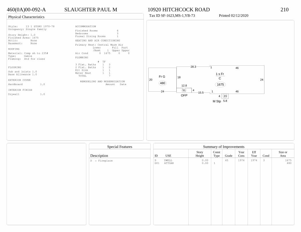
Physical Characteristics
Special Features
Description
Summary of ImprovementsStory Const Year Eff Size or
ID USE Height Type Grade Cons Year Cond Area
460(0A)00-092-A SLAUGHTER PAUL M 10920 HITCHCOCK ROAD 210Tax ID SF-1623,MS-1,YB-73 Printed 02/12/2020
24
46115.54
12.8
18
28.3 1 46
1 s Fr C
1675
45.8M Stp23OFP
51
20
24
Fr G
480
Style: 13 1 STORY 1970-78Occupancy: Single family
Story Height: 1.0Finished Area: 1675 Attic: NoneBasement: None
ROOFINGMaterial: Comp sh to 235#Type: GableFraming: Std for class
FLOORINGSub and joists 1.0Base Allowance 1.0
EXTERIOR COVERHardboard 1.0
INTERIOR FINISHDrywall 1.0
ACCOMMODATIONFinished Rooms 6Bedrooms 3Formal Dining Rooms 1HEATING AND AIR CONDITIONINGPrimary Heat: Central Warm Air Lower Full Part /Bsmt 1 Upper UpperAir Cond 0 1675 0 0PLUMBING # TF3 Fixt. Baths 1 32 Fixt. Baths 1 2Kit Sink 1 1Water Heat 1 1 TOTAL 7
REMODELING AND MODERNIZATION Amount Date
D DWELL 0.00 45 1974 1974 3 1675G01 ATTGAR 0.00 1 480
D : Fireplace
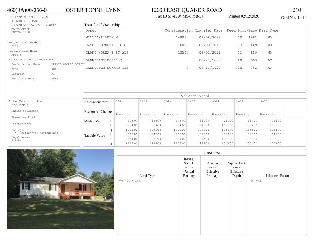
Transfer of Ownership
Valuation RecordAssessment Year
Reason for Change
Market Value
Taxable Value
LITLIT
Land SizeRating,Soil ID Acreage Square Feet- or - - or - - or -
Actual Effective EffectiveLand Type Frontage Frontage Depth Influence Factor
460(0A)00-056-0 OSTER TONNII LYNN 12600 EAST QUAKER ROAD 210Tax ID SF-1294,MS-1,YB-54 Printed 02/12/2020 Card No. 1 of 1OSTER TONNII LYNN
12600 E QUAKER RDDISPUTANTA, VA 23842SANDS SWAMPACRES:1.018
Neighborhood Number5100
Neighborhood NameArea 5
TAXING DISTRICT INFORMATIONJurisdiction Name PRINCE GEORGE COUNTYArea 001 District P1 Section & Plat 25/42
Site DescriptionTopography
Public Utilities
Street or Road
Neighborhood
Zoning:R-A, Residential AgriculturalLegal Acres:1.0180
Owner Consideration Transfer Date Deed Book/Page Deed TypeWILLIAMS ADAM M 149950 07/08/2019 19 1962 WD
DASH PROPERTIES LLC 116000 02/08/2013 13 449 WD
GRANT NORMA B ET ALS 13500 03/01/2011 11 619 WD
BANNISTER ESSIE M 0 02/21/2008 08 663 AF
BANNISTER HOWARD LEE 0 06/11/1997 430 752 AF
2014
Reassess 34500 93400 127900 34500 93400 127900
2015
Reassess 34500 93400 127900 34500 93400 127900
2016
Reassess 34500 93400 127900 34500 93400 127900
2017
Reassess 33400 94500 127900 33400 94500 127900
2018
Reassess 33400 103000 136400 33400 103000 136400
2019
Reassess 33400 103200 136600 33400 103200 136600
2020
Reassess 21300 113800 135100 21300 113800 135100
R-A <20 - IMP W -42%

Physical Characteristics
Special Features
Description
Summary of ImprovementsStory Const Year Eff Size or
ID USE Height Type Grade Cons Year Cond Area
460(0A)00-056-0 OSTER TONNII LYNN 12600 EAST QUAKER ROAD 210Tax ID SF-1294,MS-1,YB-54 Printed 02/12/2020
25.85
22.2
27
335
15
27 1 s Fr C
1242
6.2 OFP 138
3.2
4.4Wd Dk
14
01
Style: 17 1 STORY 2010-2019Occupancy: Single family
Story Height: 1.0Finished Area: 1242 Attic: NoneBasement: None
ROOFINGMaterial: Comp sh to 235#Type: GableFraming: Std for class
FLOORINGSub and joists 1.0Base Allowance 1.0
EXTERIOR COVERVinyl siding 1.0
INTERIOR FINISHDrywall 1.0
ACCOMMODATIONFinished Rooms 6Bedrooms 1HEATING AND AIR CONDITIONINGPrimary Heat: Heat pump Lower Full Part /Bsmt 1 Upper UpperAir Cond 0 1242 0 0PLUMBING # TF3 Fixt. Baths 1 3Kit Sink 1 1Water Heat 1 1 TOTAL 5
REMODELING AND MODERNIZATION Amount Date
D DWELL 0.00 38 2013 2013 3 124201 UTLSHED 0.00 5 38 2016 2016 3 240

Transfer of Ownership
Valuation RecordAssessment Year
Reason for Change
Market Value
Taxable Value
LITLIT
Land SizeRating,Soil ID Acreage Square Feet- or - - or - - or -
Actual Effective EffectiveLand Type Frontage Frontage Depth Influence Factor
550(0A)00-020-E HUNTER ADAM C & HEATHER L 12125 WEBB RD 210Printed 02/12/2020 Card No. 1 of 1HUNTER ADAM C & HEATHER L
12173 WEBB RDDISPUTANTA, VA 23842LT:2 BK: SEC:PT DONALD C HUNTER PRACRES:5.0
Neighborhood Number5100
Neighborhood NameArea 5
TAXING DISTRICT INFORMATIONJurisdiction Name PRINCE GEORGE COUNTYArea 001 District P5 Section & Plat 23/119
Site DescriptionTopography
Public Utilities
Street or Road
Neighborhood
Zoning:R-A, Residential AgriculturalLegal Acres:5.0000
Owner Consideration Transfer Date Deed Book/Page Deed TypeRHOTEN MEAGAN J 66000 12/18/2019 19 3801 WD
JACKSON RITA W 0 07/15/2019 19 2051 WD
JACKSON RITA W & ELIZABETH CLARIS 0 03/17/2006 06 1368 DCJACKSON RITA W
2014
Reassess 62700 1500 64200 62700 1500 64200
2015
Reassess 62700 1500 64200 62700 1500 64200
2016
Reassess 62700 1500 64200 62700 1500 64200
2017
Reassess 59400 1400 60800 59400 1400 60800
2018
Reassess 59400 2500 61900 59400 2500 61900
2019
Reassess 59400 2500 61900 59400 2500 61900
2020
Reassess 65300 2300 67600 65300 2300 67600
R-A <20 - IMP

Physical Characteristics
Special Features
Description
Summary of ImprovementsStory Const Year Eff Size or
ID USE Height Type Grade Cons Year Cond Area
550(0A)00-020-E HUNTER ADAM C & HEATHER L 12125 WEBB RD 210Printed 02/12/2020
01
01 UTLSHED 10.00 1 38 2012 2012 3 320
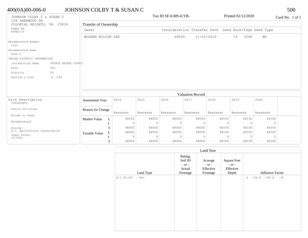
Transfer of Ownership
Valuation RecordAssessment Year
Reason for Change
Market Value
Taxable Value
LITLIT
Land SizeRating,Soil ID Acreage Square Feet- or - - or - - or -
Actual Effective EffectiveLand Type Frontage Frontage Depth Influence Factor
400(0A)00-006-0 JOHNSON COLBY T & SUSAN C 500Tax ID SF-0,MS-0,YB- Printed 02/12/2020 Card No. 1 of 1JOHNSON COLBY T & SUSAN C
128 SHERWOOD DRCOLONIAL HEIGHTS, VA 23834PONDS RDACRES:33
Neighborhood Number5100
Neighborhood NameArea 5
TAXING DISTRICT INFORMATIONJurisdiction Name PRINCE GEORGE COUNTYArea 001 District P3 Section & Plat 11 /199
Site DescriptionTopography
Public Utilities
Street or Road
Neighborhood
Zoning:A-1, Agricultural ConservationLegal Acres:33.0000
Owner Consideration Transfer Date Deed Book/Page Deed TypeWOODEN MILTON LEE 68000 11/25/2019 19 3548 WD
2014
Reassess 48000 0 48000 48000 0 48000
2015
Reassess 48000 0 48000 48000 0 48000
2016
Reassess 48000 0 48000 48000 0 48000
2017
Reassess 48000 0 48000 48000 0 48000
2018
Reassess 48100 0 48100 48100 0 48100
2019
Reassess 48100 0 48100 48100 0 48100
2020
Reassess 64300 0 64300 64300 0 64300
A-1 20<100 - VAC A -15% N -35% W -5%


Transfer of Ownership
Valuation RecordAssessment Year
Reason for Change
Market Value
Taxable Value
LITLIT
Land SizeRating,Soil ID Acreage Square Feet- or - - or - - or -
Actual Effective EffectiveLand Type Frontage Frontage Depth Influence Factor
450(07)02-001-0 PARKER JAMES B & KRISTINE THORE- 8200 KING DRIVE 210Tax ID SF-0,MS-0,YB- Printed 02/12/2020 Card No. 1 of 1PARKER JAMES B & KRISTINE THORE-
8200 KING DRDISPUTANTA, VA 23842TRACT 1 SEC 2ACRES:5.2
Neighborhood Number5105
Neighborhood NameBehind PG CC Estates
TAXING DISTRICT INFORMATIONJurisdiction Name PRINCE GEORGE COUNTYArea 001 District P5 Section & Plat 14 /155
Site DescriptionTopography
Public Utilities
Street or Road
Neighborhood
Zoning:R-A, Residential AgriculturalLegal Acres:5.5434
Owner Consideration Transfer Date Deed Book/Page Deed TypeHEATON MICHAEL M & WANDA FNC 329900 06/20/2019 19 1729 WD
SAC BUILDERS & DESIGNERS INC 212400 06/22/2005 05 2987
KING M FREDERICK & DENISE P 36050 11/29/2004 04 6240
2014
Reassess 57600 194700 252300 57600 194700 252300
2015
Reassess 57600 194700 252300 57600 194700 252300
2016
Reassess 58900 198700 257600 58900 198700 257600
2017
Reassess 55700 196400 252100 55700 196400 252100
2018
Reassess 55700 205800 261500 55700 205800 261500
2019
Reassess 55700 206600 262300 55700 206600 262300
2020
Reassess 61300 252400 313700 61300 252400 313700
R-A <20 - IMP A -10%
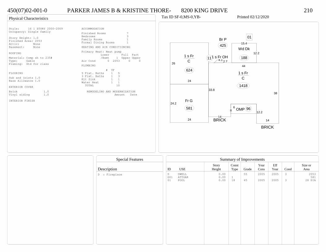
Physical Characteristics
Special Features
Description
Summary of ImprovementsStory Const Year Eff Size or
ID USE Height Type Grade Cons Year Cond Area
450(07)02-001-0 PARKER JAMES B & KRISTINE THORE- 8200 KING DRIVE 210Tax ID SF-0,MS-0,YB- Printed 02/12/2020
26
24
1 s Fr C
62444
38
14
12.28
14
33.8
1 s Fr C
1418
12.2
15.4
Wd Dk
188
6 OMP 96
2.74.11 s Fr OH 11
Br P425
24.2
24
Fr G
581
01
BRICK
BRICK
Style: 16 1 STORY 2000-2009Occupancy: Single family
Story Height: 1.0Finished Area: 2053 Attic: NoneBasement: None
ROOFINGMaterial: Comp sh to 235#Type: GableFraming: Std for class
FLOORINGSub and joists 1.0Base Allowance 1.0
EXTERIOR COVERBrick 1.0Vinyl siding 1.0
INTERIOR FINISH
ACCOMMODATIONFinished Rooms 7Bedrooms 3Family Rooms 1Formal Dining Rooms 1HEATING AND AIR CONDITIONINGPrimary Heat: Heat pump Lower Full Part /Bsmt 1 Upper UpperAir Cond 0 2053 0 0PLUMBING # TF5 Fixt. Baths 1 53 Fixt. Baths 1 3Kit Sink 1 1Water Heat 1 1 TOTAL 10
REMODELING AND MODERNIZATION Amount Date
D DWELL 0.00 55 2005 2005 3 2053G01 ATTGAR 0.00 1 58101 POOL 0.00 18 45 2005 2005 3 28 DIA
D : Fireplace
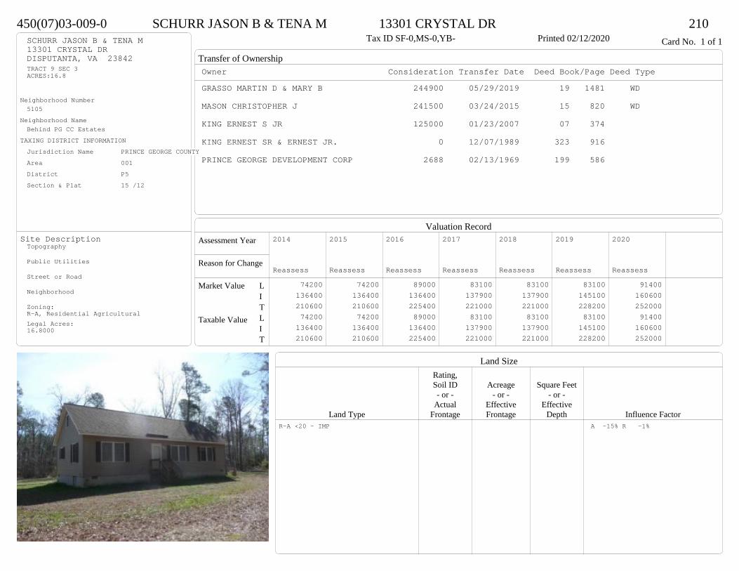
Transfer of Ownership
Valuation RecordAssessment Year
Reason for Change
Market Value
Taxable Value
LITLIT
Land SizeRating,Soil ID Acreage Square Feet- or - - or - - or -
Actual Effective EffectiveLand Type Frontage Frontage Depth Influence Factor
450(07)03-009-0 SCHURR JASON B & TENA M 13301 CRYSTAL DR 210Tax ID SF-0,MS-0,YB- Printed 02/12/2020 Card No. 1 of 1SCHURR JASON B & TENA M
13301 CRYSTAL DRDISPUTANTA, VA 23842TRACT 9 SEC 3ACRES:16.8
Neighborhood Number5105
Neighborhood NameBehind PG CC Estates
TAXING DISTRICT INFORMATIONJurisdiction Name PRINCE GEORGE COUNTYArea 001 District P5 Section & Plat 15 /12
Site DescriptionTopography
Public Utilities
Street or Road
Neighborhood
Zoning:R-A, Residential AgriculturalLegal Acres:16.8000
Owner Consideration Transfer Date Deed Book/Page Deed TypeGRASSO MARTIN D & MARY B 244900 05/29/2019 19 1481 WD
MASON CHRISTOPHER J 241500 03/24/2015 15 820 WD
KING ERNEST S JR 125000 01/23/2007 07 374
KING ERNEST SR & ERNEST JR. 0 12/07/1989 323 916
PRINCE GEORGE DEVELOPMENT CORP 2688 02/13/1969 199 586
2014
Reassess 74200 136400 210600 74200 136400 210600
2015
Reassess 74200 136400 210600 74200 136400 210600
2016
Reassess 89000 136400 225400 89000 136400 225400
2017
Reassess 83100 137900 221000 83100 137900 221000
2018
Reassess 83100 137900 221000 83100 137900 221000
2019
Reassess 83100 145100 228200 83100 145100 228200
2020
Reassess 91400 160600 252000 91400 160600 252000
R-A <20 - IMP A -15% R -1%

Physical Characteristics
Special Features
Description
Summary of ImprovementsStory Const Year Eff Size or
ID USE Height Type Grade Cons Year Cond Area
450(07)03-009-0 SCHURR JASON B & TENA M 13301 CRYSTAL DR 210Tax ID SF-0,MS-0,YB- Printed 02/12/2020
52.1
24
1-1/2 s Fr C
1250
4
5.2 Wd Dk
21
4
7.9 Wd Dk324
5.1 Wd Dk20
Style: 23 1+ STORY 2000 +Occupancy: Single family
Story Height: 1.5Finished Area: 1850 Attic: NoneBasement: None
ROOFINGMaterial: Comp sh to 235#Type: GableFraming: Std for class
FLOORINGSub and joists 1.0, 1.5Base Allowance 1.0, 1.5
EXTERIOR COVERVinyl siding 1.0, 1.5
INTERIOR FINISH
ACCOMMODATIONFinished Rooms 6Bedrooms 3Formal Dining Rooms 1HEATING AND AIR CONDITIONINGPrimary Heat: Heat pump Lower Full Part /Bsmt 1 Upper UpperAir Cond 0 1250 0 600PLUMBING # TF4 Fixt. Baths 1 43 Fixt. Baths 1 3Kit Sink 1 1Water Heat 1 1 TOTAL 9
REMODELING AND MODERNIZATION Amount Date
D DWELL 0.00 45 2007 2007 3 2500

Transfer of Ownership
Valuation RecordAssessment Year
Reason for Change
Market Value
Taxable Value
LITLIT
Land SizeRating,Soil ID Acreage Square Feet- or - - or - - or -
Actual Effective EffectiveLand Type Frontage Frontage Depth Influence Factor
45A(01)E1-018-0 SHAW KENDALE L 8205 POWELL LANE 210Tax ID SF-1971,MS-2,YB-74 Printed 02/12/2020 Card No. 1 of 1SHAW KENDALE L
8205 POWELL LNDISPUTANTA, VA 23842LT:18 BK:E1 SEC:1SUB:P G COUNTRY CLUB ESTATES
Neighborhood Number5105
Neighborhood NameBehind PG CC Estates
TAXING DISTRICT INFORMATIONJurisdiction Name PRINCE GEORGE COUNTYArea 001 District P5 Section & Plat 14 /144
Site DescriptionTopography
Public Utilities
Street or Road
Neighborhood
Zoning:R-1. Limited ResidentialLegal Acres:0.0000
Owner Consideration Transfer Date Deed Book/Page Deed TypeHIGGINBOTHAM ROGER D 225000 09/06/2019 19 2633 WD
HIGGINBOTHAM ROGER D & KARA J 0 01/24/2018 18 235 SW
SHAUG MARIE A 170000 06/13/2012 12 1927 WD
SHAUG JAMES J & MARIE A 0 04/19/2011 CD
SHAUG JAMES J 0 06/25/2010 10 1892 WD
SHAUG JAMES J & EMILY R 0 07/17/1997 432 401 DG
2014
Reassess 42400 156300 198700 42400 156300 198700
2015
Reassess 42400 156300 198700 42400 156300 198700
2016
Reassess 42400 157000 199400 42400 157000 199400
2017
Reassess 42400 158600 201000 42400 158600 201000
2018
Reassess 42400 158600 201000 42400 158600 201000
2019
Reassess 42400 167500 209900 42400 167500 209900
2020
Reassess 46600 193200 239800 46600 193200 239800
R-1 - IMP

Physical Characteristics
Special Features
Description
Summary of ImprovementsStory Const Year Eff Size or
ID USE Height Type Grade Cons Year Cond Area
45A(01)E1-018-0 SHAW KENDALE L 8205 POWELL LANE 210Tax ID SF-1971,MS-2,YB-74 Printed 02/12/2020
28.1
29.6
1 s Fr 1 s Br
B (Fin-)
832
14.11 s Br
C 319
12.56.4M Stp 80
4
Balc (Upper)
118
12Wd P271
20.4
22.6
Br G
461
Style: 31 2/2+ Story<1979Occupancy: Single family
Story Height: 1.0Finished Area: 2815 Attic: NoneBasement: 3/4
ROOFINGMaterial: Comp sh to 235#Type: GableFraming: Std for class
FLOORINGSlab BSub and joists 1.0, 2.0Base Allowance 1.0, 2.0
EXTERIOR COVERBrick 1.0Hardboard 2.0
INTERIOR FINISHDrywall 1.0
ACCOMMODATIONFinished Rooms 7Bedrooms 3Formal Dining Rooms 1HEATING AND AIR CONDITIONINGPrimary Heat: Electric baseboard Lower Full Part /Bsmt 1 Upper UpperAir Cond 832 1151 832 0PLUMBING # TF3 Fixt. Baths 2 62 Fixt. Baths 1 2Kit Sink 1 1Water Heat 1 1 TOTAL 10
REMODELING AND MODERNIZATION Amount Date
D DWELL 0.00 45 1974 1974 3 2815G01 ATTGAR 0.00 7 461
D : Fireplace
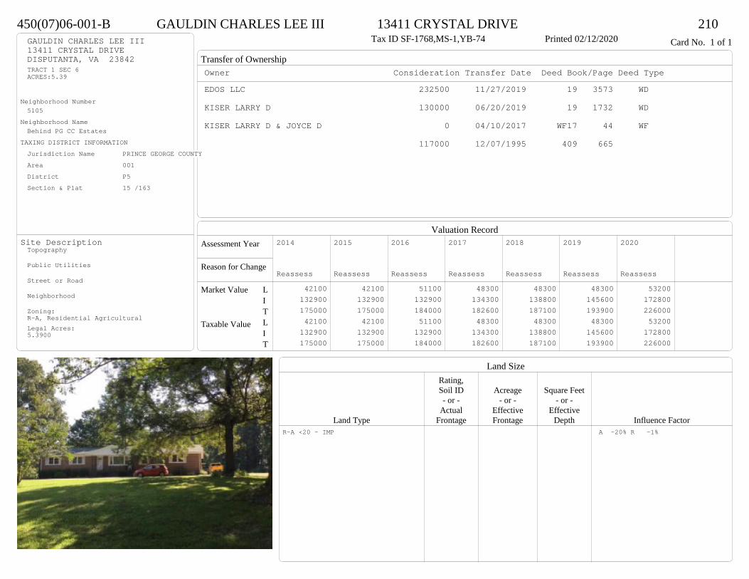
Transfer of Ownership
Valuation RecordAssessment Year
Reason for Change
Market Value
Taxable Value
LITLIT
Land SizeRating,Soil ID Acreage Square Feet- or - - or - - or -
Actual Effective EffectiveLand Type Frontage Frontage Depth Influence Factor
450(07)06-001-B GAULDIN CHARLES LEE III 13411 CRYSTAL DRIVE 210Tax ID SF-1768,MS-1,YB-74 Printed 02/12/2020 Card No. 1 of 1GAULDIN CHARLES LEE III
13411 CRYSTAL DRIVEDISPUTANTA, VA 23842TRACT 1 SEC 6ACRES:5.39
Neighborhood Number5105
Neighborhood NameBehind PG CC Estates
TAXING DISTRICT INFORMATIONJurisdiction Name PRINCE GEORGE COUNTYArea 001 District P5 Section & Plat 15 /163
Site DescriptionTopography
Public Utilities
Street or Road
Neighborhood
Zoning:R-A, Residential AgriculturalLegal Acres:5.3900
Owner Consideration Transfer Date Deed Book/Page Deed TypeEDOS LLC 232500 11/27/2019 19 3573 WD
KISER LARRY D 130000 06/20/2019 19 1732 WD
KISER LARRY D & JOYCE D 0 04/10/2017 WF17 44 WF
117000 12/07/1995 409 665
2014
Reassess 42100 132900 175000 42100 132900 175000
2015
Reassess 42100 132900 175000 42100 132900 175000
2016
Reassess 51100 132900 184000 51100 132900 184000
2017
Reassess 48300 134300 182600 48300 134300 182600
2018
Reassess 48300 138800 187100 48300 138800 187100
2019
Reassess 48300 145600 193900 48300 145600 193900
2020
Reassess 53200 172800 226000 53200 172800 226000
R-A <20 - IMP A -20% R -1%
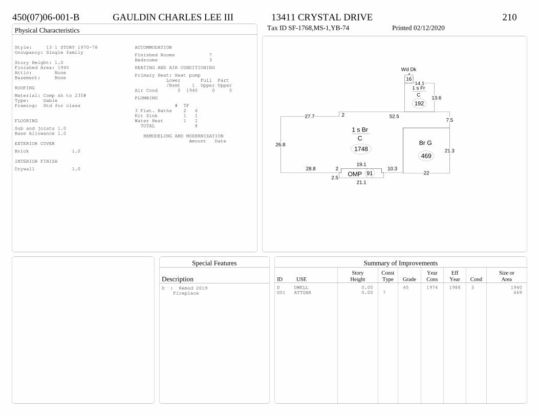
Physical Characteristics
Special Features
Description
Summary of ImprovementsStory Const Year Eff Size or
ID USE Height Type Grade Cons Year Cond Area
450(07)06-001-B GAULDIN CHARLES LEE III 13411 CRYSTAL DRIVE 210Tax ID SF-1768,MS-1,YB-74 Printed 02/12/2020
227.7
26.8
28.8 219.1
10.3
7.552.5
1 s Br C
1748
13.6
14.11 s Fr
C
192
2.521.1
OMP 91
4Wd Dk
16
22
21.3Br G
469
Style: 13 1 STORY 1970-78Occupancy: Single family
Story Height: 1.0Finished Area: 1940 Attic: NoneBasement: None
ROOFINGMaterial: Comp sh to 235#Type: GableFraming: Std for class
FLOORINGSub and joists 1.0Base Allowance 1.0
EXTERIOR COVERBrick 1.0
INTERIOR FINISHDrywall 1.0
ACCOMMODATIONFinished Rooms 7Bedrooms 3HEATING AND AIR CONDITIONINGPrimary Heat: Heat pump Lower Full Part /Bsmt 1 Upper UpperAir Cond 0 1940 0 0PLUMBING # TF3 Fixt. Baths 2 6Kit Sink 1 1Water Heat 1 1 TOTAL 8
REMODELING AND MODERNIZATION Amount Date
D DWELL 0.00 45 1974 1988 3 1940G01 ATTGAR 0.00 7 469
D : Remod 2019 Fireplace
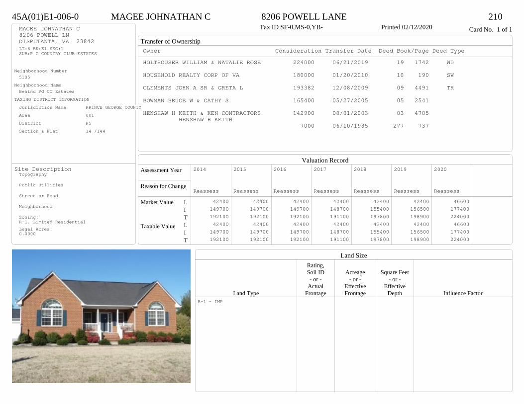
Transfer of Ownership
Valuation RecordAssessment Year
Reason for Change
Market Value
Taxable Value
LITLIT
Land SizeRating,Soil ID Acreage Square Feet- or - - or - - or -
Actual Effective EffectiveLand Type Frontage Frontage Depth Influence Factor
45A(01)E1-006-0 MAGEE JOHNATHAN C 8206 POWELL LANE 210Tax ID SF-0,MS-0,YB- Printed 02/12/2020 Card No. 1 of 1MAGEE JOHNATHAN C
8206 POWELL LNDISPUTANTA, VA 23842LT:6 BK:E1 SEC:1SUB:P G COUNTRY CLUB ESTATES
Neighborhood Number5105
Neighborhood NameBehind PG CC Estates
TAXING DISTRICT INFORMATIONJurisdiction Name PRINCE GEORGE COUNTYArea 001 District P5 Section & Plat 14 /144
Site DescriptionTopography
Public Utilities
Street or Road
Neighborhood
Zoning:R-1. Limited ResidentialLegal Acres:0.0000
Owner Consideration Transfer Date Deed Book/Page Deed TypeHOLTHOUSER WILLIAM & NATALIE ROSE 224000 06/21/2019 19 1742 WD
HOUSEHOLD REALTY CORP OF VA 180000 01/20/2010 10 190 SW
CLEMENTS JOHN A SR & GRETA L 193382 12/08/2009 09 4491 TR
BOWMAN BRUCE W & CATHY S 165400 05/27/2005 05 2541
HENSHAW H KEITH & KEN CONTRACTORS 142900 08/01/2003 03 4705 HENSHAW H KEITH
7000 06/10/1985 277 737
2014
Reassess 42400 149700 192100 42400 149700 192100
2015
Reassess 42400 149700 192100 42400 149700 192100
2016
Reassess 42400 149700 192100 42400 149700 192100
2017
Reassess 42400 148700 191100 42400 148700 191100
2018
Reassess 42400 155400 197800 42400 155400 197800
2019
Reassess 42400 156500 198900 42400 156500 198900
2020
Reassess 46600 177400 224000 46600 177400 224000
R-1 - IMP
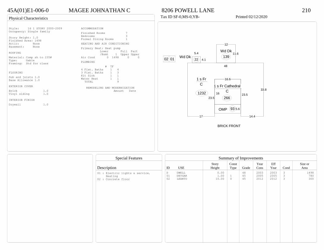
Physical Characteristics
Special Features
Description
Summary of ImprovementsStory Const Year Eff Size or
ID USE Height Type Grade Cons Year Cond Area
45A(01)E1-006-0 MAGEE JOHNATHAN C 8206 POWELL LANE 210Tax ID SF-0,MS-0,YB- Printed 02/12/2020
17
23.523.5
14.4
33.8
48
1 s Fr C
1232
11.6
12
Wd Dk139
5.4
4.1Wd Dk
22
5.6OMP 93
16
16.6
1 s Fr Cathedral C
266
0102
BRICK FRONT
Style: 16 1 STORY 2000-2009Occupancy: Single family
Story Height: 1.0Finished Area: 1498 Attic: NoneBasement: None
ROOFINGMaterial: Comp sh to 235#Type: GableFraming: Std for class
FLOORINGSub and joists 1.0Base Allowance 1.0
EXTERIOR COVERBrick 1.0Vinyl siding 1.0
INTERIOR FINISHDrywall 1.0
ACCOMMODATIONFinished Rooms 7Bedrooms 3Formal Dining Rooms 1HEATING AND AIR CONDITIONINGPrimary Heat: Heat pump Lower Full Part /Bsmt 1 Upper UpperAir Cond 0 1498 0 0PLUMBING # TF4 Fixt. Baths 1 43 Fixt. Baths 1 3Kit Sink 1 1Water Heat 1 1 TOTAL 9
REMODELING AND MODERNIZATION Amount Date
D DWELL 0.00 48 2003 2003 3 149801 DETGAR 1.00 1 45 2005 2005 3 78002 LEANTO 10.00 0 45 2012 2012 3 300
01 : Electric lights & service, Heating02 : Concrete floor

Transfer of Ownership
Valuation RecordAssessment Year
Reason for Change
Market Value
Taxable Value
LITLIT
Land SizeRating,Soil ID Acreage Square Feet- or - - or - - or -
Actual Effective EffectiveLand Type Frontage Frontage Depth Influence Factor
450(07)05-002-0 GILLAM STEVEN WAYNE & LISA RENE 13405 TAYLOR DRIVE 210Tax ID SF-1682,MS-1,YB-76 Printed 02/12/2020 Card No. 1 of 1GILLAM STEVEN WAYNE & LISA RENE
13405 TAYLOR DRDISPUTANTA, VA 23842TRACT 2 SEC 5ACRES:5.995
Neighborhood Number5105
Neighborhood NameBehind PG CC Estates
TAXING DISTRICT INFORMATIONJurisdiction Name PRINCE GEORGE COUNTYArea 001 District P5 Section & Plat 15 /14
Site DescriptionTopography
Public Utilities
Street or Road
Neighborhood
Zoning:R-A, Residential AgriculturalLegal Acres:5.9950
Owner Consideration Transfer Date Deed Book/Page Deed TypeSMITH BARBARA R 220000 11/04/2019 19 3292 WD
SMITH WALTER L & BARBARA R 0 05/26/2017 WFf17 63 WF
72500 02/18/1987 293 437
2014
Reassess 44600 136500 181100 44600 136500 181100
2015
Reassess 44600 136500 181100 44600 136500 181100
2016
Reassess 54100 136500 190600 54100 136500 190600
2017
Reassess 51100 133700 184800 51100 133700 184800
2018
Reassess 51100 133700 184800 51100 133700 184800
2019
Reassess 51100 140300 191400 51100 140300 191400
2020
Reassess 56200 153800 210000 56200 153800 210000
R-A <20 - IMP A -15% R -1% W -4%

Physical Characteristics
Special Features
Description
Summary of ImprovementsStory Const Year Eff Size or
ID USE Height Type Grade Cons Year Cond Area
450(07)05-002-0 GILLAM STEVEN WAYNE & LISA RENE 13405 TAYLOR DRIVE 210Tax ID SF-1682,MS-1,YB-76 Printed 02/12/2020
29
58
1 s Br C
1682
12
12
OFP-s
144
521
OMP 105
0102 03Style: 13 1 STORY 1970-78Occupancy: Single family
Story Height: 1.0Finished Area: 1682 Attic: NoneBasement: None
ROOFINGMaterial: Comp sh to 235#Type: GableFraming: Std for class
FLOORINGSub and joists 1.0Base Allowance 1.0
EXTERIOR COVERBrick 1.0
INTERIOR FINISHDrywall 1.0
ACCOMMODATIONFinished Rooms 5Bedrooms 3HEATING AND AIR CONDITIONINGPrimary Heat: Heat pump Lower Full Part /Bsmt 1 Upper UpperAir Cond 0 1682 0 0PLUMBING # TF3 Fixt. Baths 2 6Kit Sink 1 1Water Heat 1 1 TOTAL 8
REMODELING AND MODERNIZATION Amount Date
D DWELL 0.00 45 1976 1976 3 168201 DETGAR 0.00 1 45 1978 1978 3 100802 LEANTO 1.00 1 45 1980 1980 3 50403 LEANTO 1.00 1 45 1980 1980 3 288
D : Fireplace
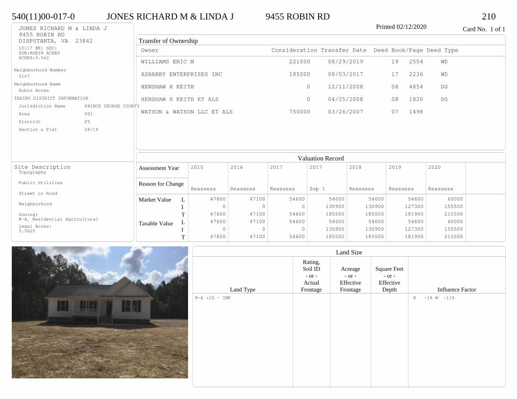
Transfer of Ownership
Valuation RecordAssessment Year
Reason for Change
Market Value
Taxable Value
LITLIT
Land SizeRating,Soil ID Acreage Square Feet- or - - or - - or -
Actual Effective EffectiveLand Type Frontage Frontage Depth Influence Factor
540(11)00-017-0 JONES RICHARD M & LINDA J 9455 ROBIN RD 210Printed 02/12/2020 Card No. 1 of 1JONES RICHARD M & LINDA J
9455 ROBIN RDDISPUTANTA, VA 23842LT:17 BK: SEC:SUB:ROBIN ACRESACRES:5.562
Neighborhood Number5107
Neighborhood NameRobin Acres
TAXING DISTRICT INFORMATIONJurisdiction Name PRINCE GEORGE COUNTYArea 001 District P5 Section & Plat 24/18
Site DescriptionTopography
Public Utilities
Street or Road
Neighborhood
Zoning:R-A, Residential AgriculturalLegal Acres:5.5620
Owner Consideration Transfer Date Deed Book/Page Deed TypeWILLIAMS ERIC M 221000 08/29/2019 19 2554 WD
ASHABBY ENTERPRISES INC 185000 08/03/2017 17 2236 WD
HENSHAW H KEITH 0 12/11/2008 08 4854 DG
HENSHAW H KEITH ET ALS 0 04/25/2008 08 1820 DG
WATSON & WATSON LLC ET ALS 750000 03/26/2007 07 1498
2015
Reassess 47600 0 47600 47600 0 47600
2016
Reassess 47100 0 47100 47100 0 47100
2017
Reassess 54600 0 54600 54600 0 54600
2017
Sup 1 54600 130900 185500 54600 130900 185500
2018
Reassess 54600 130900 185500 54600 130900 185500
2019
Reassess 54600 127300 181900 54600 127300 181900
2020
Reassess 60000 155500 215500 60000 155500 215500
R-A <20 - IMP R -1% W -11%
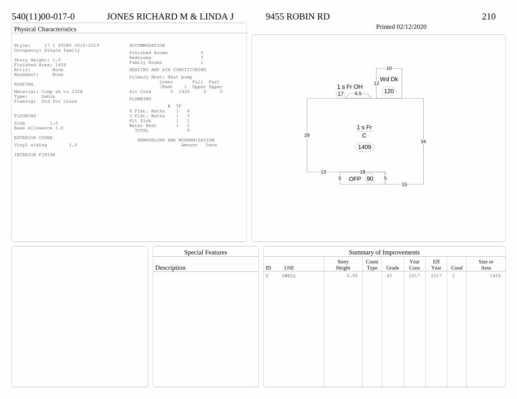
Physical Characteristics
Special Features
Description
Summary of ImprovementsStory Const Year Eff Size or
ID USE Height Type Grade Cons Year Cond Area
540(11)00-017-0 JONES RICHARD M & LINDA J 9455 ROBIN RD 210Printed 02/12/2020
29
135
15
34
1 s Fr C
1409
6.51 s Fr OH 17
185 OFP 90
12
10
Wd Dk
120
Style: 17 1 STORY 2010-2019Occupancy: Single family
Story Height: 1.0Finished Area: 1426 Attic: NoneBasement: None
ROOFINGMaterial: Comp sh to 235#Type: GableFraming: Std for class
FLOORINGSlab 1.0Base Allowance 1.0
EXTERIOR COVERVinyl siding 1.0
INTERIOR FINISH
ACCOMMODATIONFinished Rooms 5Bedrooms 3Family Rooms 1HEATING AND AIR CONDITIONINGPrimary Heat: Heat pump Lower Full Part /Bsmt 1 Upper UpperAir Cond 0 1426 0 0PLUMBING # TF4 Fixt. Baths 1 43 Fixt. Baths 1 3Kit Sink 1 1Water Heat 1 1 TOTAL 9
REMODELING AND MODERNIZATION Amount Date
D DWELL 0.00 45 2017 2017 3 1426
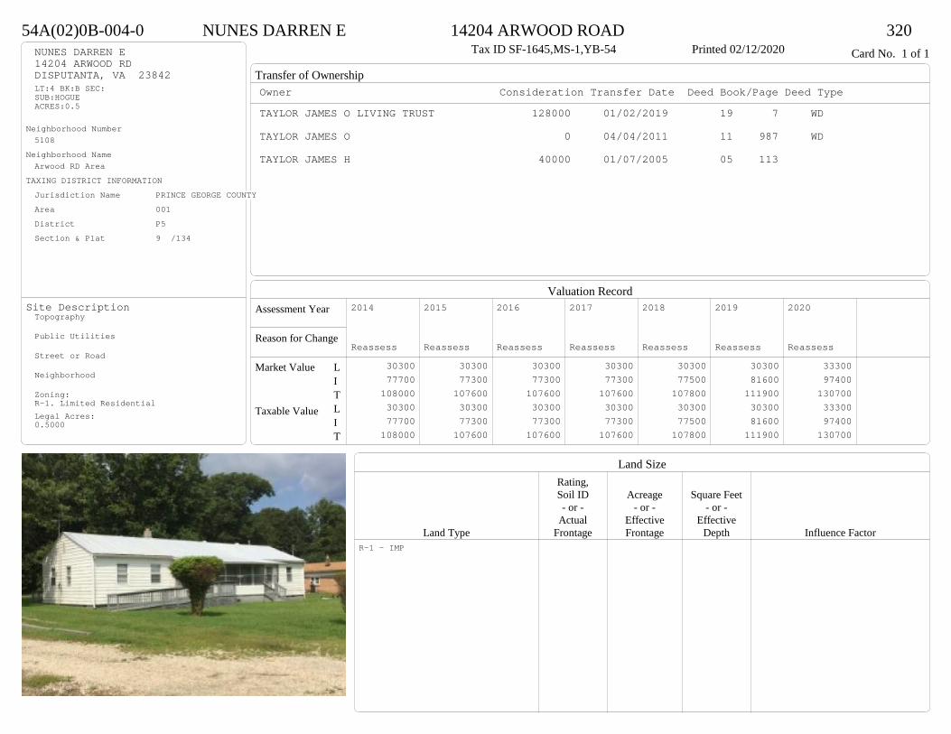
Transfer of Ownership
Valuation RecordAssessment Year
Reason for Change
Market Value
Taxable Value
LITLIT
Land SizeRating,Soil ID Acreage Square Feet- or - - or - - or -
Actual Effective EffectiveLand Type Frontage Frontage Depth Influence Factor
54A(02)0B-004-0 NUNES DARREN E 14204 ARWOOD ROAD 320Tax ID SF-1645,MS-1,YB-54 Printed 02/12/2020 Card No. 1 of 1NUNES DARREN E
14204 ARWOOD RDDISPUTANTA, VA 23842LT:4 BK:B SEC:SUB:HOGUEACRES:0.5
Neighborhood Number5108
Neighborhood NameArwood RD Area
TAXING DISTRICT INFORMATIONJurisdiction Name PRINCE GEORGE COUNTYArea 001 District P5 Section & Plat 9 /134
Site DescriptionTopography
Public Utilities
Street or Road
Neighborhood
Zoning:R-1. Limited ResidentialLegal Acres:0.5000
Owner Consideration Transfer Date Deed Book/Page Deed TypeTAYLOR JAMES O LIVING TRUST 128000 01/02/2019 19 7 WD
TAYLOR JAMES O 0 04/04/2011 11 987 WD
TAYLOR JAMES H 40000 01/07/2005 05 113
2014
Reassess 30300 77700 108000 30300 77700 108000
2015
Reassess 30300 77300 107600 30300 77300 107600
2016
Reassess 30300 77300 107600 30300 77300 107600
2017
Reassess 30300 77300 107600 30300 77300 107600
2018
Reassess 30300 77500 107800 30300 77500 107800
2019
Reassess 30300 81600 111900 30300 81600 111900
2020
Reassess 33300 97400 130700 33300 97400 130700
R-1 - IMP
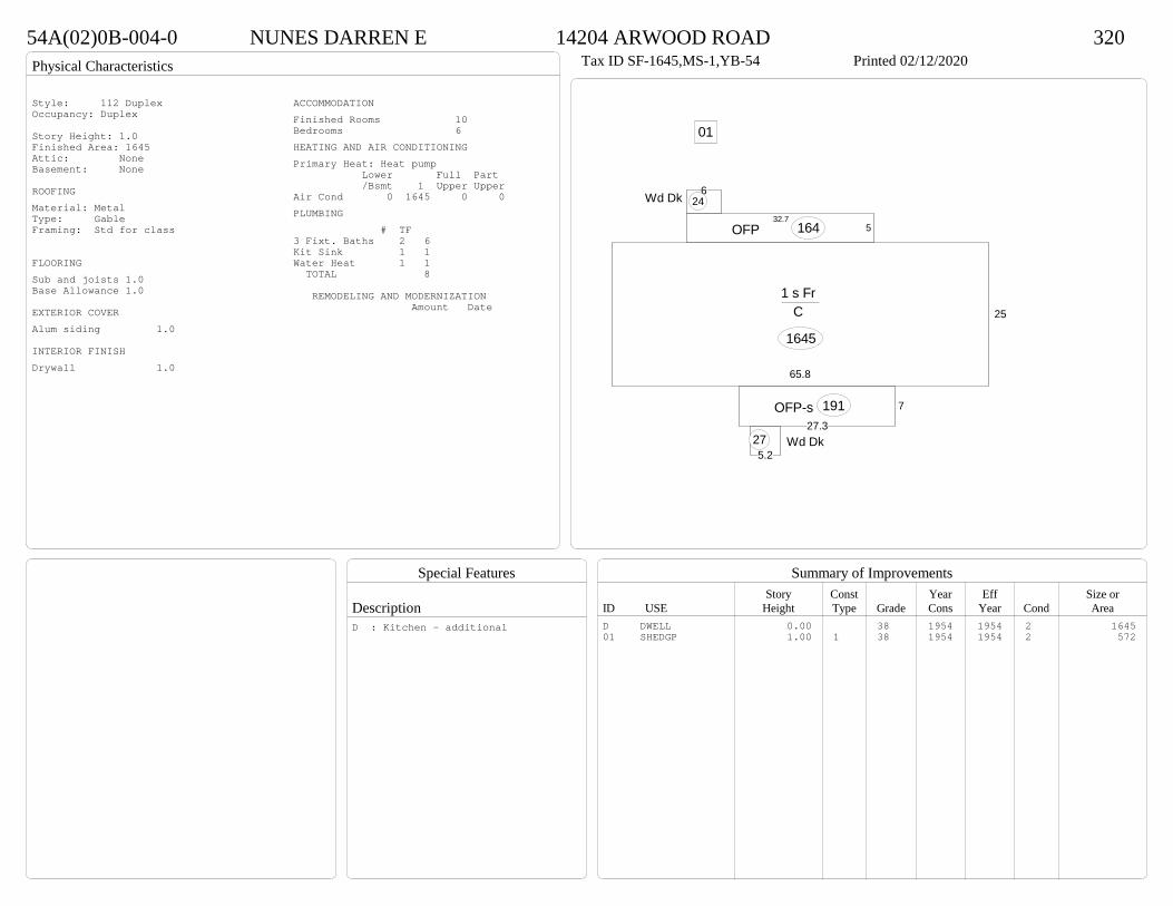
Physical Characteristics
Special Features
Description
Summary of ImprovementsStory Const Year Eff Size or
ID USE Height Type Grade Cons Year Cond Area
54A(02)0B-004-0 NUNES DARREN E 14204 ARWOOD ROAD 320Tax ID SF-1645,MS-1,YB-54 Printed 02/12/2020
25
65.8
1 s Fr C
1645
7
27.3OFP-s 191
5.15.2
Wd Dk27
532.7
OFP 164
46Wd Dk 24
01
Style: 112 DuplexOccupancy: Duplex
Story Height: 1.0Finished Area: 1645 Attic: NoneBasement: None
ROOFINGMaterial: MetalType: GableFraming: Std for class
FLOORINGSub and joists 1.0Base Allowance 1.0
EXTERIOR COVERAlum siding 1.0
INTERIOR FINISHDrywall 1.0
ACCOMMODATIONFinished Rooms 10Bedrooms 6HEATING AND AIR CONDITIONINGPrimary Heat: Heat pump Lower Full Part /Bsmt 1 Upper UpperAir Cond 0 1645 0 0PLUMBING # TF3 Fixt. Baths 2 6Kit Sink 1 1Water Heat 1 1 TOTAL 8
REMODELING AND MODERNIZATION Amount Date
D DWELL 0.00 38 1954 1954 2 164501 SHEDGP 1.00 1 38 1954 1954 2 572
D : Kitchen - additional

Transfer of Ownership
Valuation RecordAssessment Year
Reason for Change
Market Value
Taxable Value
LITLIT
Land SizeRating,Soil ID Acreage Square Feet- or - - or - - or -
Actual Effective EffectiveLand Type Frontage Frontage Depth Influence Factor
530(06)00-001-0 COKER MICHELLE L 13732 PUMPHOUSE RD 210Tax ID SF-0,MS-0,YB- Printed 02/12/2020 Card No. 1 of 1COKER MICHELLE L
13732 PUMPHOUSE RDDISPUTANTA, VA 23842LOT 1ROY W HOGUE SR PROPACRES:2.259
Neighborhood Number6001
Neighborhood NamePGPA 6
TAXING DISTRICT INFORMATIONJurisdiction Name PRINCE GEORGE COUNTYArea 001 District P5 Section & Plat 18 /17
Site DescriptionTopography
Public Utilities
Street or Road
Neighborhood
Zoning:R-A, Residential AgriculturalLegal Acres:2.2590
Owner Consideration Transfer Date Deed Book/Page Deed TypePETERY GAYLA L 275000 03/29/2019 19 834 WD
JOYNER MARK W & TERRI L 273000 09/27/2017 17 2829 WD
D & G PROPERTIES INC 256028 09/19/2007 07 4781
HOGUE ROY W JR 35000 04/02/2007 07 1655
HOGUE ROY W SR & CATHERINE C 0 04/13/1990 327 547
2014
Reassess 45800 181300 227100 45800 181300 227100
2015
Reassess 45800 181300 227100 45800 181300 227100
2016
Reassess 45800 181300 227100 45800 181300 227100
2017
Reassess 45800 181700 227500 45800 181700 227500
2018
Reassess 45800 191000 236800 45800 191000 236800
2019
Reassess 45800 191500 237300 45800 191500 237300
2020
Reassess 50400 223200 273600 50400 223200 273600
R-A <20 - IMP
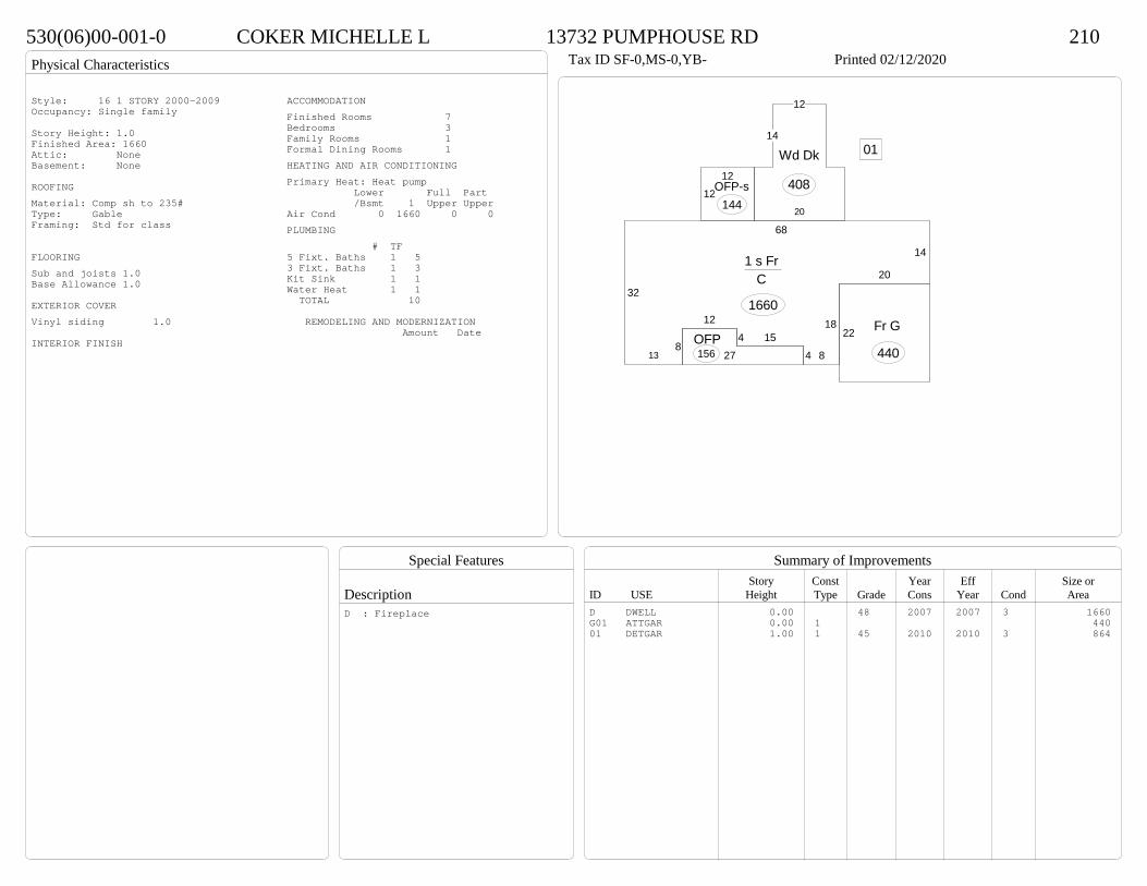
Physical Characteristics
Special Features
Description
Summary of ImprovementsStory Const Year Eff Size or
ID USE Height Type Grade Cons Year Cond Area
530(06)00-001-0 COKER MICHELLE L 13732 PUMPHOUSE RD 210Tax ID SF-0,MS-0,YB- Printed 02/12/2020
32
68
14
20
18
84154
12
813
1 s Fr C
1660
27OFP156
1212
OFP-s144
14
12
20
Wd Dk
408
22 Fr G
440
01
Style: 16 1 STORY 2000-2009Occupancy: Single family
Story Height: 1.0Finished Area: 1660 Attic: NoneBasement: None
ROOFINGMaterial: Comp sh to 235#Type: GableFraming: Std for class
FLOORINGSub and joists 1.0Base Allowance 1.0
EXTERIOR COVERVinyl siding 1.0
INTERIOR FINISH
ACCOMMODATIONFinished Rooms 7Bedrooms 3Family Rooms 1Formal Dining Rooms 1HEATING AND AIR CONDITIONINGPrimary Heat: Heat pump Lower Full Part /Bsmt 1 Upper UpperAir Cond 0 1660 0 0PLUMBING # TF5 Fixt. Baths 1 53 Fixt. Baths 1 3Kit Sink 1 1Water Heat 1 1 TOTAL 10
REMODELING AND MODERNIZATION Amount Date
D DWELL 0.00 48 2007 2007 3 1660G01 ATTGAR 0.00 1 44001 DETGAR 1.00 1 45 2010 2010 3 864
D : Fireplace

Transfer of Ownership
Valuation RecordAssessment Year
Reason for Change
Market Value
Taxable Value
LITLIT
Land SizeRating,Soil ID Acreage Square Feet- or - - or - - or -
Actual Effective EffectiveLand Type Frontage Frontage Depth Influence Factor
580(0A)00-024-B PINKLETON RANDY F 3050 COURTLAND ROAD 610Tax ID SF-4270,MS-1,YB-84 Printed 02/12/2020 Card No. 1 of 1PINKLETON RANDY F
3050 COURTLAND RDPETERSBURG, VA 23805LEE PROPACRES:106.834
Neighborhood Number6100
Neighborhood NameArea 6
TAXING DISTRICT INFORMATIONJurisdiction Name PRINCE GEORGE COUNTYArea 001 District P5 Section & Plat 1 /182
Site DescriptionTopography
Public Utilities
Street or Road
Neighborhood
Zoning:R-A, Residential AgriculturalLegal Acres:106.8340
Owner Consideration Transfer Date Deed Book/Page Deed TypeHIGGINS O PAUL III 659727 06/12/2019 19 1606 WD
2014
Reassess 218100 344300 562400 106000 344300 450300
2015
Reassess 218100 344300 562400 130200 344300 474500
2016
Reassess 259900 344300 604200 137900 344300 482200
2017
Reassess 249200 341900 591100 137100 341900 479000
2018
Reassess 249400 341900 591300 139500 341900 481400
2019
Reassess 249400 379500 628900 149800 379500 529300
2020
Reassess 274400 408000 682400 151200 408000 559200
R-A >100 - IMP W -13%LAND USE CR 33.9900LAND USE PA 0.3740LAND USE FG 70.4700LU-HOMESITE

Physical Characteristics
Special Features
Description
Summary of ImprovementsStory Const Year Eff Size or
ID USE Height Type Grade Cons Year Cond Area
580(0A)00-024-B PINKLETON RANDY F 3050 COURTLAND ROAD 610Tax ID SF-4270,MS-1,YB-84 Printed 02/12/2020
40
19218
8302
2023720
26
6
1018
26
24
26
25
20
195
62
12
1 s Fr C
4270
7
23.7
Wd Dk
215
3522.9
7Wd Dk 489
9.46.3
OFP
59
18Wd Dk
450
24
30
Fr G
72001
Style: 14 1 STORY 1979-89Occupancy: Single family
Story Height: 1.0Finished Area: 4270 Attic: NoneBasement: None
ROOFINGMaterial: Comp sh to 235#Type: GableFraming: Std for class
FLOORINGSub and joists 1.0Base Allowance 1.0
EXTERIOR COVERHardboard 1.0
INTERIOR FINISH
ACCOMMODATIONFinished Rooms 9Bedrooms 4Family Rooms 1HEATING AND AIR CONDITIONINGPrimary Heat: Heat pump Lower Full Part /Bsmt 1 Upper UpperAir Cond 0 4270 0 0PLUMBING # TF3 Fixt. Baths 3 92 Fixt. Baths 1 2Kit Sink 1 1Water Heat 1 1 TOTAL 13
REMODELING AND MODERNIZATION Amount Date
D DWELL 0.00 48 1984 1984 3 4270G01 ATTGAR 0.00 1 3 72001 DETGAR 1.50 1 45 1984 1984 3 1512
D : Fireplace, Fireplace01 : Full bath, Interior finish - liv qual

Transfer of Ownership
Valuation RecordAssessment Year
Reason for Change
Market Value
Taxable Value
LITLIT
Land SizeRating,Soil ID Acreage Square Feet- or - - or - - or -
Actual Effective EffectiveLand Type Frontage Frontage Depth Influence Factor
590(0A)00-009-D MARIN LUIS A & AIDE 17301 TEMPLETON ROAD 210Tax ID SF-3548,MS-2,YB-82 Printed 02/12/2020 Card No. 1 of 1MARIN LUIS A & AIDE
17301 TEMPLETON RDDISPUTANTA, VA 23842CHARLES LUNDIE PROPACRES:5
Neighborhood Number6100
Neighborhood NameArea 6
TAXING DISTRICT INFORMATIONJurisdiction Name PRINCE GEORGE COUNTYArea 001 District P5 Section & Plat 250/39
Site DescriptionTopography
Public Utilities
Street or Road
Neighborhood
Zoning:R-A, Residential AgriculturalLegal Acres:5.0000
Owner Consideration Transfer Date Deed Book/Page Deed TypeLOWERY REHABILITATION TRUST 351000 08/28/2019 19 2547 WD
LOWERY JACOB L SR & ELIZABETH N 237020 12/04/2017 17 3597 WD
CROWDER CONSTANCE A & CHRISTOPOHER S 240000 08/31/2016 16 2555 WD
CROWDER CONSTANCE A LUNDIE- 0 05/27/2010 10 1557 WD
LUNDIE CHARLES L 0 02/06/2009 WF09 11 WF
LUNDIE CHARLES L INC 0 07/13/1999 478 266 DG
2014
Reassess 62700 305800 368500 62700 305800 368500
2015
Reassess 62700 305800 368500 62700 305800 368500
2016
Reassess 62700 305800 368500 62700 305800 368500
2017
Reassess 59400 311200 370600 59400 311200 370600
2018
Reassess 58800 311200 370000 58800 311200 370000
2019
Reassess 58800 346900 405700 58800 346900 405700
2020
Reassess 64600 354300 418900 64600 354300 418900
R-A <20 - IMP W -1%
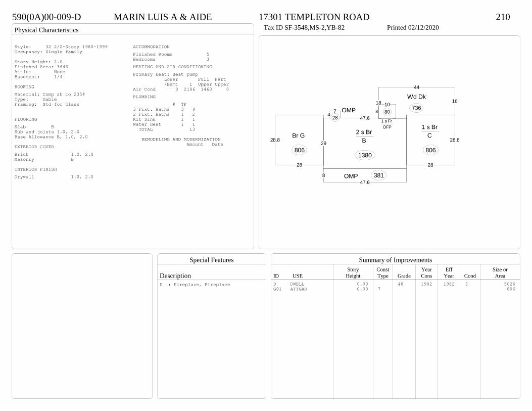
Physical Characteristics
Special Features
Description
Summary of ImprovementsStory Const Year Eff Size or
ID USE Height Type Grade Cons Year Cond Area
590(0A)00-009-D MARIN LUIS A & AIDE 17301 TEMPLETON ROAD 210Tax ID SF-3548,MS-2,YB-82 Printed 02/12/2020
29
47.6
2 s Br B
138028
28.8
1 s Br C
806
16
44
18Wd Dk
736
847.6
OMP 381
47 OMP28
810
1 s Fr OFP
80
28
28.8Br G
806
Style: 32 2/2+Story 1980-1999Occupancy: Single family
Story Height: 2.0Finished Area: 3646 Attic: NoneBasement: 1/4
ROOFINGMaterial: Comp sh to 235#Type: GableFraming: Std for class
FLOORINGSlab BSub and joists 1.0, 2.0Base Allowance B, 1.0, 2.0
EXTERIOR COVERBrick 1.0, 2.0Masonry B
INTERIOR FINISHDrywall 1.0, 2.0
ACCOMMODATIONFinished Rooms 5Bedrooms 3HEATING AND AIR CONDITIONINGPrimary Heat: Heat pump Lower Full Part /Bsmt 1 Upper UpperAir Cond 0 2186 1460 0PLUMBING # TF3 Fixt. Baths 3 92 Fixt. Baths 1 2Kit Sink 1 1Water Heat 1 1 TOTAL 13
REMODELING AND MODERNIZATION Amount Date
D DWELL 0.00 48 1982 1982 3 5026G01 ATTGAR 0.00 7 806
D : Fireplace, Fireplace
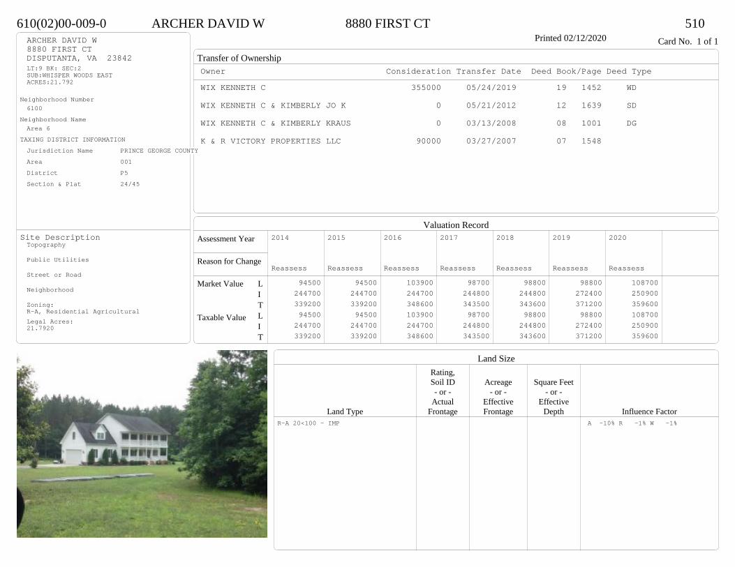
Transfer of Ownership
Valuation RecordAssessment Year
Reason for Change
Market Value
Taxable Value
LITLIT
Land SizeRating,Soil ID Acreage Square Feet- or - - or - - or -
Actual Effective EffectiveLand Type Frontage Frontage Depth Influence Factor
610(02)00-009-0 ARCHER DAVID W 8880 FIRST CT 510Printed 02/12/2020 Card No. 1 of 1ARCHER DAVID W
8880 FIRST CTDISPUTANTA, VA 23842LT:9 BK: SEC:2SUB:WHISPER WOODS EASTACRES:21.792
Neighborhood Number6100
Neighborhood NameArea 6
TAXING DISTRICT INFORMATIONJurisdiction Name PRINCE GEORGE COUNTYArea 001 District P5 Section & Plat 24/45
Site DescriptionTopography
Public Utilities
Street or Road
Neighborhood
Zoning:R-A, Residential AgriculturalLegal Acres:21.7920
Owner Consideration Transfer Date Deed Book/Page Deed TypeWIX KENNETH C 355000 05/24/2019 19 1452 WD
WIX KENNETH C & KIMBERLY JO K 0 05/21/2012 12 1639 SD
WIX KENNETH C & KIMBERLY KRAUS 0 03/13/2008 08 1001 DG
K & R VICTORY PROPERTIES LLC 90000 03/27/2007 07 1548
2014
Reassess 94500 244700 339200 94500 244700 339200
2015
Reassess 94500 244700 339200 94500 244700 339200
2016
Reassess 103900 244700 348600 103900 244700 348600
2017
Reassess 98700 244800 343500 98700 244800 343500
2018
Reassess 98800 244800 343600 98800 244800 343600
2019
Reassess 98800 272400 371200 98800 272400 371200
2020
Reassess 108700 250900 359600 108700 250900 359600
R-A 20<100 - IMP A -10% R -1% W -1%

Physical Characteristics
Special Features
Description
Summary of ImprovementsStory Const Year Eff Size or
ID USE Height Type Grade Cons Year Cond Area
610(02)00-009-0 ARCHER DAVID W 8880 FIRST CT 510Printed 02/12/2020
38
32
2 s Fr C
1216
8OFPOMP 304
12
38
Wd Dk 456
24
24
1/2 s Fr (Fin) Fr G
576
Style: 33 2/2+Story 2000+Occupancy: Single family
Story Height: 2.0Finished Area: 2776 Attic: NoneBasement: None
ROOFINGMaterial: Comp sh to 235#Type: GableFraming: Std for class
FLOORINGSub and joists 1.0, 1.5, 2.0Base Allowance 1.0, 1.5, 2.0
EXTERIOR COVERVinyl siding 1.0, 1.5, 2.0
INTERIOR FINISH
ACCOMMODATIONFinished Rooms 8Bedrooms 4Family Rooms 1Formal Dining Rooms 1HEATING AND AIR CONDITIONINGPrimary Heat: Heat pump Lower Full Part /Bsmt 1 Upper UpperAir Cond 0 1216 1216 344PLUMBING # TF5 Fixt. Baths 1 54 Fixt. Baths 1 42 Fixt. Baths 1 2Kit Sink 1 1Water Heat 1 1 TOTAL 13
REMODELING AND MODERNIZATION Amount Date
D DWELL 0.00 48 2008 2008 3 3008G01 ATTGAR 0.00 1 3 576
D : Fireplace

Transfer of Ownership
Valuation RecordAssessment Year
Reason for Change
Market Value
Taxable Value
LITLIT
Land SizeRating,Soil ID Acreage Square Feet- or - - or - - or -
Actual Effective EffectiveLand Type Frontage Frontage Depth Influence Factor
590(07)00-005-0 LEONARD AMBER L & SCOTT C 17170 TEMPLETON ROAD 210Printed 02/12/2020 Card No. 1 of 1LEONARD AMBER L & SCOTT C
17170 TEMPLETON RDDISPUTANTA, VA 23842LT:5 BK: SEC:SUB:TEMPLETON FORESTACRES:5
Neighborhood Number6100
Neighborhood NameArea 6
TAXING DISTRICT INFORMATIONJurisdiction Name PRINCE GEORGE COUNTYArea 001 District P5 Section & Plat 22/125
Site DescriptionTopography
Public Utilities
Street or Road
Neighborhood
Zoning:R-A, Residential AgriculturalLegal Acres:5.0000
Owner Consideration Transfer Date Deed Book/Page Deed TypeBURNETT THOMAS W & BRANDI W 355000 07/15/2019 19 2039 WD
CHAPPELL CHARLES M & JAMES C STEWART 35000 03/22/2001 01-1003
2014
Reassess 62700 281000 343700 62700 281000 343700
2015
Reassess 62700 281000 343700 62700 281000 343700
2016
Reassess 62700 281000 343700 62700 281000 343700
2017
Reassess 59400 278200 337600 59400 278200 337600
2018
Reassess 59400 278200 337600 59400 278200 337600
2019
Reassess 59400 311800 371200 59400 311800 371200
2020
Reassess 65300 292300 357600 65300 292300 357600
R-A <20 - IMP
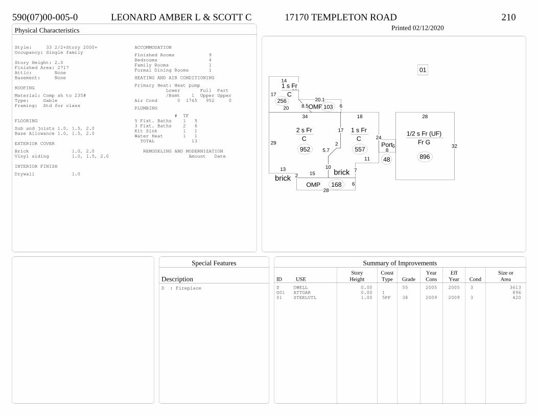
Physical Characteristics
Special Features
Description
Summary of ImprovementsStory Const Year Eff Size or
ID USE Height Type Grade Cons Year Cond Area
590(07)00-005-0 LEONARD AMBER L & SCOTT C 17170 TEMPLETON ROAD 210Printed 02/12/2020
86Port
48
17
1411
8.520
1 s Fr C
256
29
132 15
10
5.72
17
34
2 s Fr C
952
18
24
11
713
1 s Fr C
557
628
OMP 168
14.1 620.1
OMP 10328
32
1/2 s Fr (UF) Fr G
896
01
brickbrick
Style: 33 2/2+Story 2000+Occupancy: Single family
Story Height: 2.0Finished Area: 2717 Attic: NoneBasement: None
ROOFINGMaterial: Comp sh to 235#Type: GableFraming: Std for class
FLOORINGSub and joists 1.0, 1.5, 2.0Base Allowance 1.0, 1.5, 2.0
EXTERIOR COVERBrick 1.0, 2.0Vinyl siding 1.0, 1.5, 2.0
INTERIOR FINISHDrywall 1.0
ACCOMMODATIONFinished Rooms 9Bedrooms 4Family Rooms 1Formal Dining Rooms 1HEATING AND AIR CONDITIONINGPrimary Heat: Heat pump Lower Full Part /Bsmt 1 Upper UpperAir Cond 0 1765 952 0PLUMBING # TF5 Fixt. Baths 1 53 Fixt. Baths 2 6Kit Sink 1 1Water Heat 1 1 TOTAL 13
REMODELING AND MODERNIZATION Amount Date
D DWELL 0.00 55 2005 2005 3 3613G01 ATTGAR 0.00 1 89601 STEELUTL 1.00 5PF 38 2009 2009 3 420
D : Fireplace

Transfer of Ownership
Valuation RecordAssessment Year
Reason for Change
Market Value
Taxable Value
LITLIT
Land SizeRating,Soil ID Acreage Square Feet- or - - or - - or -
Actual Effective EffectiveLand Type Frontage Frontage Depth Influence Factor
520(09)00-013-0 LEONARD MARC L & PAMELA M 3599 WILLOW CREEK DR 210Printed 02/12/2020 Card No. 1 of 1LEONARD MARC L & PAMELA M
3599 WILLOW CREEK DRDISPUTANTA, VA 23842LT:13 BK: SEC:SUB:TEMPLETON ESTATESACRES:5.387
Neighborhood Number6100
Neighborhood NameArea 6
TAXING DISTRICT INFORMATIONJurisdiction Name PRINCE GEORGE COUNTYArea 001 District P5 Section & Plat 24/13
Site DescriptionTopography
Public Utilities
Street or Road
Neighborhood
Zoning:R-A, Residential AgriculturalLegal Acres:5.3870
Owner Consideration Transfer Date Deed Book/Page Deed TypeWALKER DAVID T & SARAH F 320000 07/02/2019 19 1894 WD
SULLIVAN J W CONSTRUCTION INC 312668 08/11/2009 09 3008
2014
Reassess 52400 223300 275700 52400 223300 275700
2015
Reassess 52400 223300 275700 52400 223300 275700
2016
Reassess 56900 223300 280200 56900 223300 280200
2017
Reassess 54500 222100 276600 54500 222100 276600
2018
Reassess 55700 222100 277800 55700 222100 277800
2019
Reassess 55700 245700 301400 55700 245700 301400
2020
Reassess 61200 227900 289100 61200 227900 289100
R-A <20 - IMP W -9%
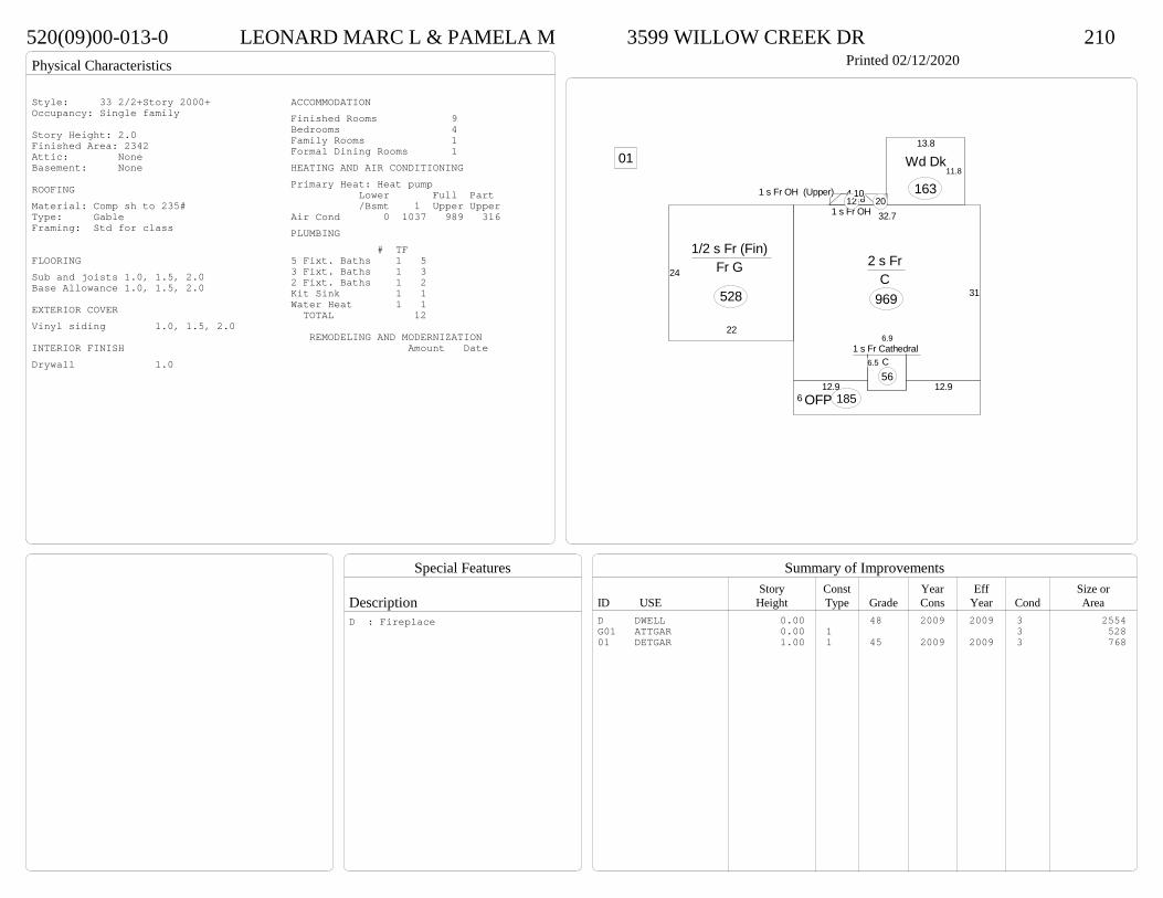
Physical Characteristics
Special Features
Description
Summary of ImprovementsStory Const Year Eff Size or
ID USE Height Type Grade Cons Year Cond Area
520(09)00-013-0 LEONARD MARC L & PAMELA M 3599 WILLOW CREEK DR 210Printed 02/12/2020
6.5
6.9
31
32.7
2 s Fr C
969
2.84.28.2
1 s Fr OH 12 2101 s Fr OH (Upper)
20
11.8
13.8
Wd Dk
163
612.912.9
OFP 185
1 s Fr Cathedral C 56
22
24
1/2 s Fr (Fin) Fr G
528
01
Style: 33 2/2+Story 2000+Occupancy: Single family
Story Height: 2.0Finished Area: 2342 Attic: NoneBasement: None
ROOFINGMaterial: Comp sh to 235#Type: GableFraming: Std for class
FLOORINGSub and joists 1.0, 1.5, 2.0Base Allowance 1.0, 1.5, 2.0
EXTERIOR COVERVinyl siding 1.0, 1.5, 2.0
INTERIOR FINISHDrywall 1.0
ACCOMMODATIONFinished Rooms 9Bedrooms 4Family Rooms 1Formal Dining Rooms 1HEATING AND AIR CONDITIONINGPrimary Heat: Heat pump Lower Full Part /Bsmt 1 Upper UpperAir Cond 0 1037 989 316PLUMBING # TF5 Fixt. Baths 1 53 Fixt. Baths 1 32 Fixt. Baths 1 2Kit Sink 1 1Water Heat 1 1 TOTAL 12
REMODELING AND MODERNIZATION Amount Date
D DWELL 0.00 48 2009 2009 3 2554G01 ATTGAR 0.00 1 3 52801 DETGAR 1.00 1 45 2009 2009 3 768
D : Fireplace
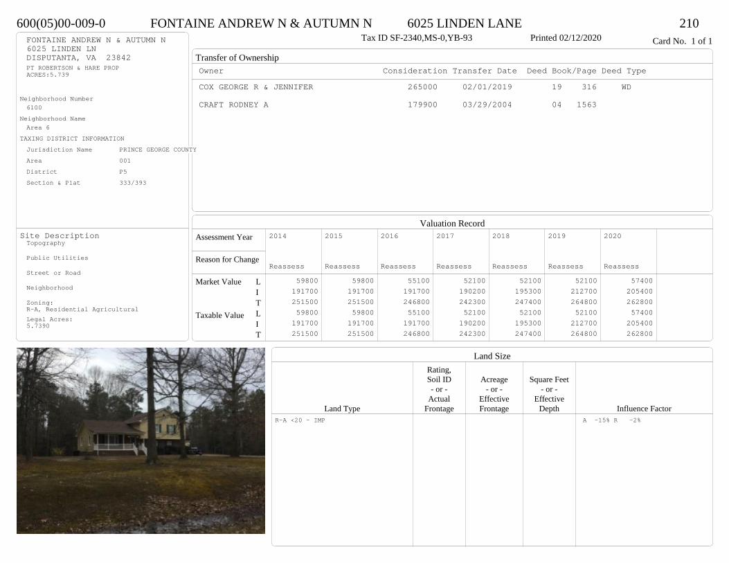
Transfer of Ownership
Valuation RecordAssessment Year
Reason for Change
Market Value
Taxable Value
LITLIT
Land SizeRating,Soil ID Acreage Square Feet- or - - or - - or -
Actual Effective EffectiveLand Type Frontage Frontage Depth Influence Factor
600(05)00-009-0 FONTAINE ANDREW N & AUTUMN N 6025 LINDEN LANE 210Tax ID SF-2340,MS-0,YB-93 Printed 02/12/2020 Card No. 1 of 1FONTAINE ANDREW N & AUTUMN N
6025 LINDEN LNDISPUTANTA, VA 23842PT ROBERTSON & HARE PROPACRES:5.739
Neighborhood Number6100
Neighborhood NameArea 6
TAXING DISTRICT INFORMATIONJurisdiction Name PRINCE GEORGE COUNTYArea 001 District P5 Section & Plat 333/393
Site DescriptionTopography
Public Utilities
Street or Road
Neighborhood
Zoning:R-A, Residential AgriculturalLegal Acres:5.7390
Owner Consideration Transfer Date Deed Book/Page Deed TypeCOX GEORGE R & JENNIFER 265000 02/01/2019 19 316 WD
CRAFT RODNEY A 179900 03/29/2004 04 1563
2014
Reassess 59800 191700 251500 59800 191700 251500
2015
Reassess 59800 191700 251500 59800 191700 251500
2016
Reassess 55100 191700 246800 55100 191700 246800
2017
Reassess 52100 190200 242300 52100 190200 242300
2018
Reassess 52100 195300 247400 52100 195300 247400
2019
Reassess 52100 212700 264800 52100 212700 264800
2020
Reassess 57400 205400 262800 57400 205400 262800
R-A <20 - IMP A -15% R -2%

Physical Characteristics
Special Features
Description
Summary of ImprovementsStory Const Year Eff Size or
ID USE Height Type Grade Cons Year Cond Area
600(05)00-009-0 FONTAINE ANDREW N & AUTUMN N 6025 LINDEN LANE 210Tax ID SF-2340,MS-0,YB-93 Printed 02/12/2020
28.6
28
1 s Fr L (Fin)
801
24
28.6
8.8 2.13.4
8.8
1 s Fr C
694
5.7OMP 137
12
24
3
7.89
16.6
Wd Dk 351
1.61 s Fr OH 45
01
Style: 50 TRI-LEVEL OR SPLIT-LEVELOccupancy: Single family
Story Height: Tri-levelFinished Area: 2341 Attic: NoneBasement: None
ROOFINGMaterial: Comp sh to 235#Type: GableFraming: Std for class
FLOORINGSlab LSub and joists 1.0Base Allowance 1.0
EXTERIOR COVERBrick LVinyl siding 1.0
INTERIOR FINISH
ACCOMMODATIONFinished Rooms 9Bedrooms 3HEATING AND AIR CONDITIONINGPrimary Heat: Heat pump Lower Full Part /Bsmt 1 Upper UpperAir Cond 801 1540 0 0PLUMBING # TF3 Fixt. Baths 3 9Kit Sink 1 1Water Heat 1 1 TOTAL 11
REMODELING AND MODERNIZATION Amount Date
D DWELL 0.00 48 1993 1993 3 234101 DETGAR 0.00 1 48 1993 1993 3 1152
D : Fireplace

Transfer of Ownership
Valuation RecordAssessment Year
Reason for Change
Market Value
Taxable Value
LITLIT
Land SizeRating,Soil ID Acreage Square Feet- or - - or - - or -
Actual Effective EffectiveLand Type Frontage Frontage Depth Influence Factor
590(04)00-002-0 BELL TIMOTHY II 4880 TATUM ROAD 210Tax ID SF-1785,MS-1.5,YB-92 Printed 02/12/2020 Card No. 1 of 1BELL TIMOTHY II
4880 TATUM RDDISPUTANTA, VA 23842LT:2 BK: SEC:1SUB:TATUM ESTATESACRES:5.1
Neighborhood Number6100
Neighborhood NameArea 6
TAXING DISTRICT INFORMATIONJurisdiction Name PRINCE GEORGE COUNTYArea 001 District P5 Section & Plat 19 /207
Site DescriptionTopography
Public Utilities
Street or Road
Neighborhood
Zoning:R-A, Residential AgriculturalLegal Acres:5.1000
Owner Consideration Transfer Date Deed Book/Page Deed TypeBEALE DAVID A & KATHRYN P 273000 11/04/2019 19 3280 WD
2014
Reassess 63200 151300 214500 63200 151300 214500
2015
Reassess 63200 151300 214500 63200 151300 214500
2016
Reassess 63200 151300 214500 63200 151300 214500
2017
Reassess 59900 150700 210600 59900 150700 210600
2018
Reassess 59900 150700 210600 59900 150700 210600
2019
Reassess 58700 171100 229800 58700 171100 229800
2020
Reassess 64600 184100 248700 64600 184100 248700
R-A <20 - IMP R -2%
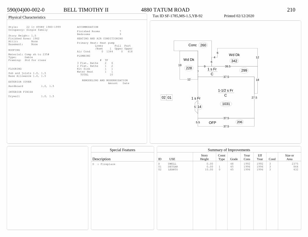
Physical Characteristics
Special Features
Description
Summary of ImprovementsStory Const Year Eff Size or
ID USE Height Type Grade Cons Year Cond Area
590(04)00-002-0 BELL TIMOTHY II 4880 TATUM ROAD 210Tax ID SF-1785,MS-1.5,YB-92 Printed 02/12/2020
37.5
27.5
1-1/2 s Fr C
1031
18
39.5
7
37.5
1 s Fr C
299
5.537.5
OFP 206
12
19
Wd Dk
228
5
1 s Fr
14
64
612
Wd Dk
3429
Conc 260
0102
Style: 22 1+ STORY 1980-1999Occupancy: Single family
Story Height: 1.5Finished Area: 1962 Attic: NoneBasement: None
ROOFINGMaterial: Comp sh to 235#Type: GableFraming: Std for class
FLOORINGSub and joists 1.0, 1.5Base Allowance 1.0, 1.5
EXTERIOR COVERHardboard 1.0, 1.5
INTERIOR FINISHDrywall 1.0, 1.5
ACCOMMODATIONFinished Rooms 7Bedrooms 3HEATING AND AIR CONDITIONINGPrimary Heat: Heat pump Lower Full Part /Bsmt 1 Upper UpperAir Cond 0 1344 0 618PLUMBING # TF3 Fixt. Baths 2 62 Fixt. Baths 1 2Kit Sink 1 1Water Heat 1 1 TOTAL 10
REMODELING AND MODERNIZATION Amount Date
D DWELL 0.00 48 1992 1992 3 237501 DETGAR 0.00 1 45 1996 1996 3 86402 LEANTO 10.00 0 45 1996 1996 3 432
D : Fireplace

Transfer of Ownership
Valuation RecordAssessment Year
Reason for Change
Market Value
Taxable Value
LITLIT
Land SizeRating,Soil ID Acreage Square Feet- or - - or - - or -
Actual Effective EffectiveLand Type Frontage Frontage Depth Influence Factor
510(13)00-021-0 BOMBA JOSEPH P III & ANNETTE L 15501 PRINCE GEORGE DRIVE 210Tax ID SF-1938,MS-2,YB-? Printed 02/12/2020 Card No. 1 of 1BOMBA JOSEPH P III & ANNETTE L
285 LAKE RDSCHENEVUS, NY 12155LT:21 BK: SEC:SUB:WOODCROFTACRES:5.001
Neighborhood Number6100
Neighborhood NameArea 6
TAXING DISTRICT INFORMATIONJurisdiction Name PRINCE GEORGE COUNTYArea 001 District P5 Section & Plat 236/246
Site DescriptionTopography
Public Utilities
Street or Road
Neighborhood
Zoning:R-A, Residential AgriculturalLegal Acres:5.0010
Owner Consideration Transfer Date Deed Book/Page Deed TypeROBERTS REBEKAH L 245000 03/29/2019 19 847 WD
GARNER DAVID W 199500 06/21/2011 11 1680 WD
GARNER DAVID W & SELENA M 0 08/23/2010 10 2486 QC
KELLY DAVID P & KATHRYN C 120000 03/05/2003 03 1222
EVAN THEODORE M & KAREN A 103500 05/01/1991 338 473
2014
Reassess 62000 162200 224200 62000 162200 224200
2015
Reassess 62000 162200 224200 62000 162200 224200
2016
Reassess 62000 162200 224200 62000 162200 224200
2017
Reassess 59400 155700 215100 59400 155700 215100
2018
Reassess 59400 152200 211600 59400 152200 211600
2019
Reassess 59400 167200 226600 59400 167200 226600
2020
Reassess 65400 177800 243200 65400 177800 243200
R-A <20 - IMP
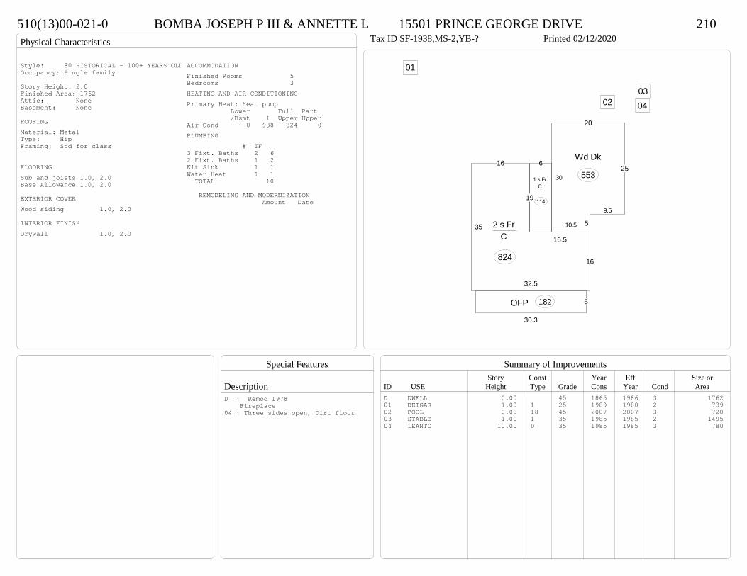
Physical Characteristics
Special Features
Description
Summary of ImprovementsStory Const Year Eff Size or
ID USE Height Type Grade Cons Year Cond Area
510(13)00-021-0 BOMBA JOSEPH P III & ANNETTE L 15501 PRINCE GEORGE DRIVE 210Tax ID SF-1938,MS-2,YB-? Printed 02/12/2020
32.5
16
16.5
19
16
35 2 s Fr C
824
6
30.3
OFP 182
6
19
1 s Fr C
114
30
20
25
9.5
510.5
Wd Dk
553
01
020304
Style: 80 HISTORICAL - 100+ YEARS OLDOccupancy: Single family
Story Height: 2.0Finished Area: 1762 Attic: NoneBasement: None
ROOFINGMaterial: MetalType: HipFraming: Std for class
FLOORINGSub and joists 1.0, 2.0Base Allowance 1.0, 2.0
EXTERIOR COVERWood siding 1.0, 2.0
INTERIOR FINISHDrywall 1.0, 2.0
ACCOMMODATIONFinished Rooms 5Bedrooms 3HEATING AND AIR CONDITIONINGPrimary Heat: Heat pump Lower Full Part /Bsmt 1 Upper UpperAir Cond 0 938 824 0PLUMBING # TF3 Fixt. Baths 2 62 Fixt. Baths 1 2Kit Sink 1 1Water Heat 1 1 TOTAL 10
REMODELING AND MODERNIZATION Amount Date
D DWELL 0.00 45 1865 1986 3 176201 DETGAR 1.00 1 25 1980 1980 2 73902 POOL 0.00 18 45 2007 2007 3 72003 STABLE 1.00 1 35 1985 1985 2 149504 LEANTO 10.00 0 35 1985 1985 3 780
D : Remod 1978 Fireplace04 : Three sides open, Dirt floor
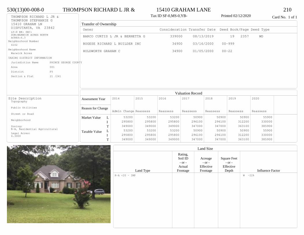
Transfer of Ownership
Valuation RecordAssessment Year
Reason for Change
Market Value
Taxable Value
LITLIT
Land SizeRating,Soil ID Acreage Square Feet- or - - or - - or -
Actual Effective EffectiveLand Type Frontage Frontage Depth Influence Factor
530(13)00-008-0 THOMPSON RICHARD L JR & 15410 GRAHAM LANE 210Tax ID SF-0,MS-0,YB- Printed 02/12/2020 Card No. 1 of 1THOMPSON RICHARD L JR &
THOMPSON STEPHANIE G15410 GRAHAM LNDISPUTANTA, VA 23842LT:8 BK: SEC:SUB:WARWICK ACRES NORTHACRES:6.3
Neighborhood Number6102
Neighborhood NameWarwick Acres
TAXING DISTRICT INFORMATIONJurisdiction Name PRINCE GEORGE COUNTYArea 001 District P5 Section & Plat 21 /241
Site DescriptionTopography
Public Utilities
Street or Road
Neighborhood
Zoning:R-A, Residential AgriculturalLegal Acres:6.3000
Owner Consideration Transfer Date Deed Book/Page Deed TypeBARCO CURTIS L JR & BERNETTA G 339000 08/13/2019 19 2357 WD
BOGESE RICHARD L BUILDER INC 34900 03/16/2000 00-999
HOLDWORTH GRAHAM C 34900 01/05/2000 00-22
2014
Admin Change 53200 295800 349000 53200 295800 349000
2015
Reassess 53200 295800 349000 53200 295800 349000
2016
Reassess 53200 295800 349000 53200 295800 349000
2017
Reassess 50900 296100 347000 50900 296100 347000
2018
Reassess 50900 296100 347000 50900 296100 347000
2019
Reassess 50900 312200 363100 50900 312200 363100
2020
Reassess 55900 330000 385900 55900 330000 385900
R-A <20 - IMP W -22%

Physical Characteristics
Special Features
Description
Summary of ImprovementsStory Const Year Eff Size or
ID USE Height Type Grade Cons Year Cond Area
530(13)00-008-0 THOMPSON RICHARD L JR & 15410 GRAHAM LANE 210Tax ID SF-0,MS-0,YB- Printed 02/12/2020
11
4
7
7.35.812.7
5.4
23.3
8
2.37.7
8.3
4.54
4.55.3
3.8
517.3
2 s Fr C
598
17.7
11
4.515
27.5
1 s Fr Cathedral C
428
8
11.32 12
29.8
9.3
1 s Fr C 296
12.76
2
16
2
18.7
7.3
25.7
13
7.3
6.41.9
12.37.1
6.7
33.5
1 s Fr C
953
10
15.3
12OFP-s
16113.7
114.8
2.6 Wd Dk163
4
6.8 OMP26
12
1 s Fr C
144
23.9
10.7111.3
24.9
22
1/2 s Fr (Fin) Fr G
537
FROG 215 SF
BRICK FRONT
Style: 33 2/2+Story 2000+Occupancy: Single family
Story Height: 2.0Finished Area: 3232 Attic: NoneBasement: None
ROOFINGMaterial: Comp sh to 235#Type: HipFraming: Std for class
FLOORINGSub and joists 1.0, 1.5, 2.0Base Allowance 1.0, 1.5, 2.0
EXTERIOR COVERBrick 1.0Vinyl siding 1.0, 1.5, 2.0
INTERIOR FINISHDrywall 1.0, 1.5, 2.0
ACCOMMODATIONFinished Rooms 11Bedrooms 3Formal Dining Rooms 1HEATING AND AIR CONDITIONINGPrimary Heat: Heat pump Lower Full Part /Bsmt 1 Upper UpperAir Cond 0 2419 598 215PLUMBING # TF5 Fixt. Baths 1 54 Fixt. Baths 1 43 Fixt. Baths 1 3Kit Sink 1 1Water Heat 1 1 TOTAL 14
REMODELING AND MODERNIZATION Amount Date
D DWELL 0.00 55 2002 2002 3 3554G01 ATTGAR 0.00 1 537
D : Fireplace
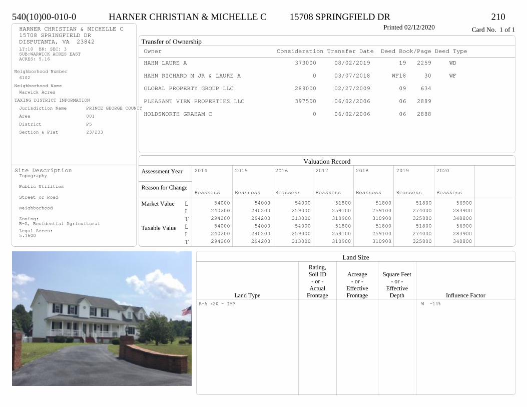
Transfer of Ownership
Valuation RecordAssessment Year
Reason for Change
Market Value
Taxable Value
LITLIT
Land SizeRating,Soil ID Acreage Square Feet- or - - or - - or -
Actual Effective EffectiveLand Type Frontage Frontage Depth Influence Factor
540(10)00-010-0 HARNER CHRISTIAN & MICHELLE C 15708 SPRINGFIELD DR 210Printed 02/12/2020 Card No. 1 of 1HARNER CHRISTIAN & MICHELLE C
15708 SPRINGFIELD DRDISPUTANTA, VA 23842LT:10 BK: SEC: 3SUB:WARWICK ACRES EASTACRES: 5.16
Neighborhood Number6102
Neighborhood NameWarwick Acres
TAXING DISTRICT INFORMATIONJurisdiction Name PRINCE GEORGE COUNTYArea 001 District P5 Section & Plat 23/233
Site DescriptionTopography
Public Utilities
Street or Road
Neighborhood
Zoning:R-A, Residential AgriculturalLegal Acres:5.1600
Owner Consideration Transfer Date Deed Book/Page Deed TypeHAHN LAURE A 373000 08/02/2019 19 2259 WD
HAHN RICHARD M JR & LAURE A 0 03/07/2018 WF18 30 WF
GLOBAL PROPERTY GROUP LLC 289000 02/27/2009 09 634
PLEASANT VIEW PROPERTIES LLC 397500 06/02/2006 06 2889
HOLDSWORTH GRAHAM C 0 06/02/2006 06 2888
2014
Reassess 54000 240200 294200 54000 240200 294200
2015
Reassess 54000 240200 294200 54000 240200 294200
2016
Reassess 54000 259000 313000 54000 259000 313000
2017
Reassess 51800 259100 310900 51800 259100 310900
2018
Reassess 51800 259100 310900 51800 259100 310900
2019
Reassess 51800 274000 325800 51800 274000 325800
2020
Reassess 56900 283900 340800 56900 283900 340800
R-A <20 - IMP W -14%
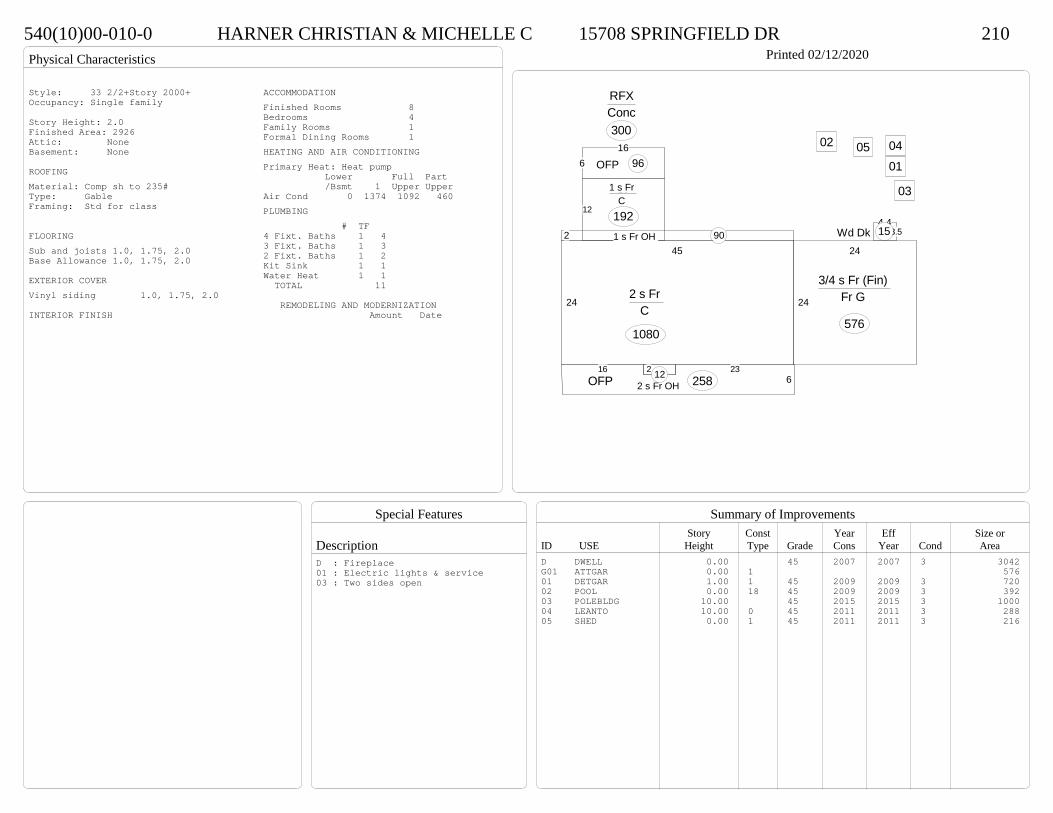
Physical Characteristics
Special Features
Description
Summary of ImprovementsStory Const Year Eff Size or
ID USE Height Type Grade Cons Year Cond Area
540(10)00-010-0 HARNER CHRISTIAN & MICHELLE C 15708 SPRINGFIELD DR 210Printed 02/12/2020
24
45
2 s Fr C
1080
2 1 s Fr OH 90
12
161 s Fr C
192
2 6.22 s Fr OH
1216 236OFP 258
3.54.4
Wd Dk 15
616
OFP 96
RFXConc300
24
24
3/4 s Fr (Fin) Fr G
576
01
02
03
0405
Style: 33 2/2+Story 2000+Occupancy: Single family
Story Height: 2.0Finished Area: 2926 Attic: NoneBasement: None
ROOFINGMaterial: Comp sh to 235#Type: GableFraming: Std for class
FLOORINGSub and joists 1.0, 1.75, 2.0Base Allowance 1.0, 1.75, 2.0
EXTERIOR COVERVinyl siding 1.0, 1.75, 2.0
INTERIOR FINISH
ACCOMMODATIONFinished Rooms 8Bedrooms 4Family Rooms 1Formal Dining Rooms 1HEATING AND AIR CONDITIONINGPrimary Heat: Heat pump Lower Full Part /Bsmt 1 Upper UpperAir Cond 0 1374 1092 460PLUMBING # TF4 Fixt. Baths 1 43 Fixt. Baths 1 32 Fixt. Baths 1 2Kit Sink 1 1Water Heat 1 1 TOTAL 11
REMODELING AND MODERNIZATION Amount Date
D DWELL 0.00 45 2007 2007 3 3042G01 ATTGAR 0.00 1 57601 DETGAR 1.00 1 45 2009 2009 3 72002 POOL 0.00 18 45 2009 2009 3 39203 POLEBLDG 10.00 45 2015 2015 3 100004 LEANTO 10.00 0 45 2011 2011 3 28805 SHED 0.00 1 45 2011 2011 3 216
D : Fireplace01 : Electric lights & service03 : Two sides open
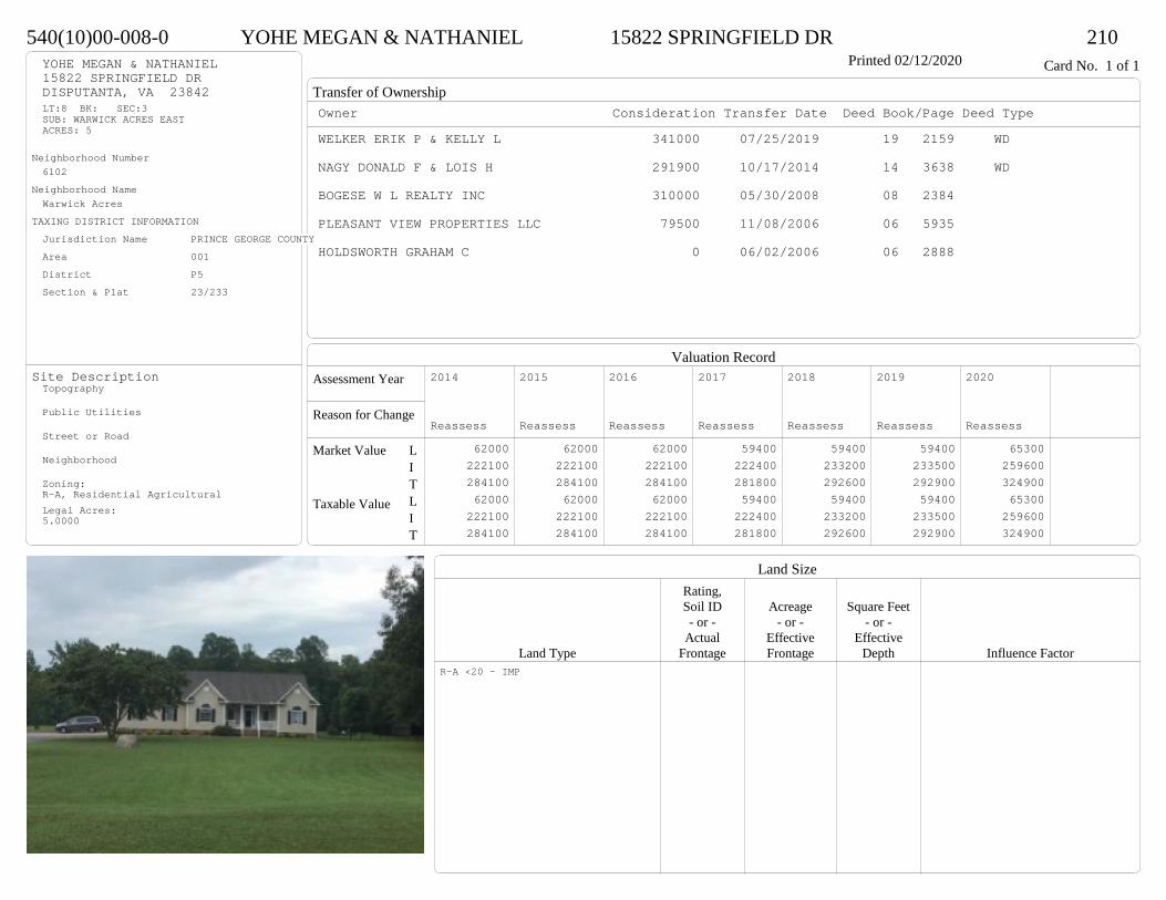
Transfer of Ownership
Valuation RecordAssessment Year
Reason for Change
Market Value
Taxable Value
LITLIT
Land SizeRating,Soil ID Acreage Square Feet- or - - or - - or -
Actual Effective EffectiveLand Type Frontage Frontage Depth Influence Factor
540(10)00-008-0 YOHE MEGAN & NATHANIEL 15822 SPRINGFIELD DR 210Printed 02/12/2020 Card No. 1 of 1YOHE MEGAN & NATHANIEL
15822 SPRINGFIELD DRDISPUTANTA, VA 23842LT:8 BK: SEC:3SUB: WARWICK ACRES EASTACRES: 5
Neighborhood Number6102
Neighborhood NameWarwick Acres
TAXING DISTRICT INFORMATIONJurisdiction Name PRINCE GEORGE COUNTYArea 001 District P5 Section & Plat 23/233
Site DescriptionTopography
Public Utilities
Street or Road
Neighborhood
Zoning:R-A, Residential AgriculturalLegal Acres:5.0000
Owner Consideration Transfer Date Deed Book/Page Deed TypeWELKER ERIK P & KELLY L 341000 07/25/2019 19 2159 WD
NAGY DONALD F & LOIS H 291900 10/17/2014 14 3638 WD
BOGESE W L REALTY INC 310000 05/30/2008 08 2384
PLEASANT VIEW PROPERTIES LLC 79500 11/08/2006 06 5935
HOLDSWORTH GRAHAM C 0 06/02/2006 06 2888
2014
Reassess 62000 222100 284100 62000 222100 284100
2015
Reassess 62000 222100 284100 62000 222100 284100
2016
Reassess 62000 222100 284100 62000 222100 284100
2017
Reassess 59400 222400 281800 59400 222400 281800
2018
Reassess 59400 233200 292600 59400 233200 292600
2019
Reassess 59400 233500 292900 59400 233500 292900
2020
Reassess 65300 259600 324900 65300 259600 324900
R-A <20 - IMP

Physical Characteristics
Special Features
Description
Summary of ImprovementsStory Const Year Eff Size or
ID USE Height Type Grade Cons Year Cond Area
540(10)00-008-0 YOHE MEGAN & NATHANIEL 15822 SPRINGFIELD DR 210Printed 02/12/2020
12.7
8
18
12
12.7
38.9
43.4
16.3
24
27
24.2
1 s Fr C
2069
6 OMP 108
12
20
OFP
240
Conc186
22.2
1/2 s Fr (Fin) Fr G
533
01
Style: 23 1+ STORY 2000 +Occupancy: Single family
Story Height: 1.0Finished Area: 2388 Attic: NoneBasement: None
ROOFINGMaterial: Comp sh to 235#Type: GableFraming: Std for class
FLOORINGSub and joists 1.0, 1.5Base Allowance 1.0, 1.5
EXTERIOR COVERVinyl siding 1.0, 1.5
INTERIOR FINISH
ACCOMMODATIONFinished Rooms 7Bedrooms 3Family Rooms 1Formal Dining Rooms 1HEATING AND AIR CONDITIONINGPrimary Heat: Heat pump Lower Full Part /Bsmt 1 Upper UpperAir Cond 0 2069 0 319PLUMBING # TF5 Fixt. Baths 1 53 Fixt. Baths 1 3Kit Sink 1 1Water Heat 1 1 TOTAL 10
REMODELING AND MODERNIZATION Amount Date
D DWELL 0.00 48 2008 2008 3 2602G01 ATTGAR 0.00 1 3 53301 POOL 1.00 18 45 2008 2008 3 512
D : Fireplace

Transfer of Ownership
Valuation RecordAssessment Year
Reason for Change
Market Value
Taxable Value
LITLIT
Land SizeRating,Soil ID Acreage Square Feet- or - - or - - or -
Actual Effective EffectiveLand Type Frontage Frontage Depth Influence Factor
540(08)00-008-0 WALSTON PHILLIP R & SUZANNE S 9790 HOLDSWORTH ROAD 210Printed 02/12/2020 Card No. 1 of 1WALSTON PHILLIP R & SUZANNE S
9790 HOLDSWORTH RDDISPUTANTA, VA 23842LT:8 BK: SEC:2SUB:WARWICK ACRES EASTACRES:5.27
Neighborhood Number6102
Neighborhood NameWarwick Acres
TAXING DISTRICT INFORMATIONJurisdiction Name PRINCE GEORGE COUNTYArea 001 District P5 Section & Plat 22/148
Site DescriptionTopography
Public Utilities
Street or Road
Neighborhood
Zoning:R-A, Residential AgriculturalLegal Acres:5.2700
Owner Consideration Transfer Date Deed Book/Page Deed TypeLUCAS LORRAINE H 280000 02/04/2019 19 329 WD
LUCAS GERALD E & LORRAINE H 0 05/30/2014 CD
SISSON RONALD W JR & JANIS M 295950 09/14/2007 07 4703
HAWK CARL W SR & PATRICIA C 239950 10/19/2004 04 5446
CENDANT MOBILITY FINANCIAL CORP 239950 10/19/2004 04 5447
PERKINSON CHARLES W 241450 07/16/2004 04 3593
2014
Reassess 63400 188000 251400 63400 188000 251400
2015
Reassess 63400 188000 251400 63400 188000 251400
2016
Reassess 63400 188000 251400 63400 188000 251400
2017
Reassess 60700 186200 246900 60700 186200 246900
2018
Reassess 60700 195500 256200 60700 195500 256200
2019
Reassess 60700 196300 257000 60700 196300 257000
2020
Reassess 66700 228600 295300 66700 228600 295300
R-A <20 - IMP

Physical Characteristics
Special Features
Description
Summary of ImprovementsStory Const Year Eff Size or
ID USE Height Type Grade Cons Year Cond Area
540(08)00-008-0 WALSTON PHILLIP R & SUZANNE S 9790 HOLDSWORTH ROAD 210Printed 02/12/2020
22
17.5
22.5
27.5 814
25.3
238
16
36
1 s Fr C
1414
14
14
1 s Fr Cathedral C 196
6 OMP 138
1 s Fr Cathedral C
394
12.1
15.8
Wd Dk191 5
1 s Fr OH
22 8
30.4
22
Fr G
557
01 02 03
Style: 16 1 STORY 2000-2009Occupancy: Single family
Story Height: 1.0Finished Area: 2026 Attic: NoneBasement: None
ROOFINGMaterial: Comp sh to 235#Type: GableFraming: Std for class
FLOORINGSub and joists 1.0Base Allowance 1.0
EXTERIOR COVERBrick 1.0Vinyl siding 1.0
INTERIOR FINISHDrywall 1.0
ACCOMMODATIONFinished Rooms 7Bedrooms 3Family Rooms 1Formal Dining Rooms 1HEATING AND AIR CONDITIONINGPrimary Heat: Heat pump Lower Full Part /Bsmt 1 Upper UpperAir Cond 0 2026 0 0PLUMBING # TF5 Fixt. Baths 1 53 Fixt. Baths 1 3Kit Sink 1 1Water Heat 1 1 TOTAL 10
REMODELING AND MODERNIZATION Amount Date
D DWELL 0.00 48 2004 2004 3 2026G01 ATTGAR 0.00 1 55701 SHED 0.00 1 45 2012 2012 3 28802 SHED 0.00 1 45 2012 2012 3 36003 SHED 0.00 1 45 2012 2012 3 288
D : Fireplace
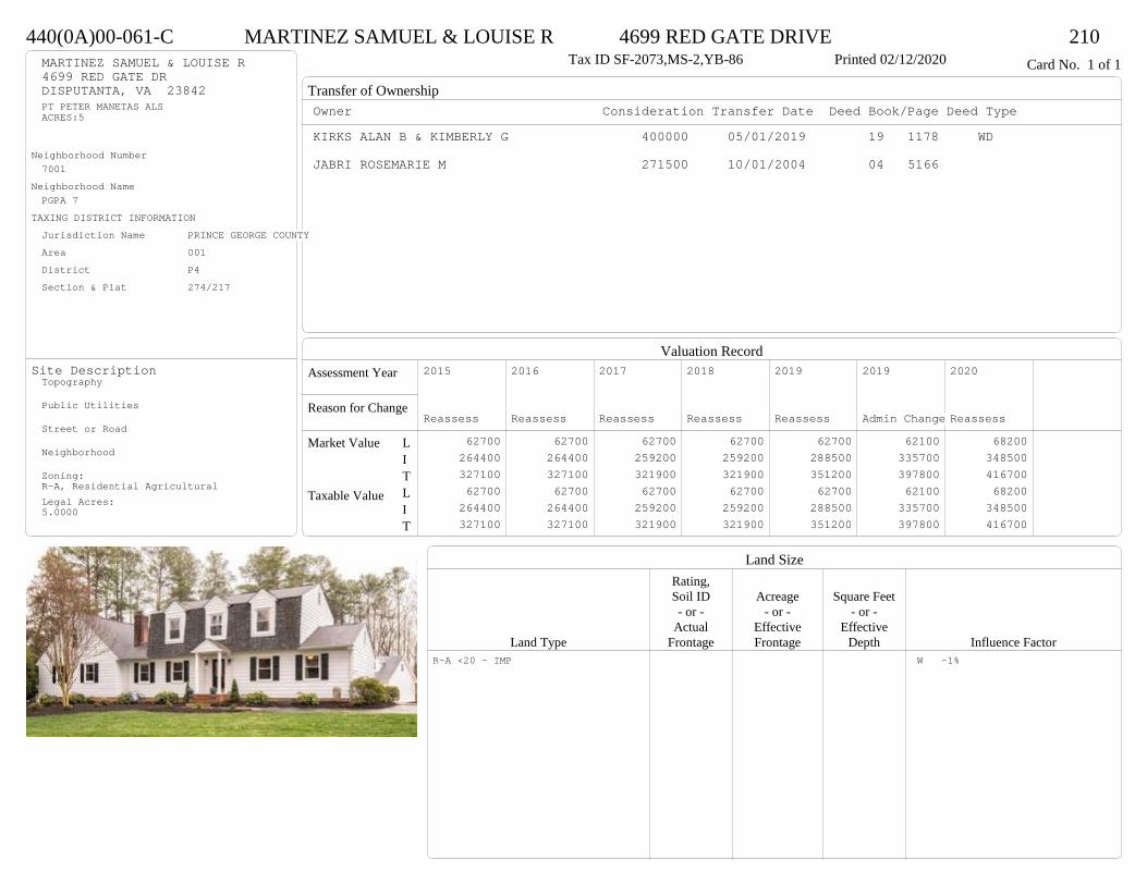
Transfer of Ownership
Valuation RecordAssessment Year
Reason for Change
Market Value
Taxable Value
LITLIT
Land SizeRating,Soil ID Acreage Square Feet- or - - or - - or -
Actual Effective EffectiveLand Type Frontage Frontage Depth Influence Factor
440(0A)00-061-C MARTINEZ SAMUEL & LOUISE R 4699 RED GATE DRIVE 210Tax ID SF-2073,MS-2,YB-86 Printed 02/12/2020 Card No. 1 of 1MARTINEZ SAMUEL & LOUISE R
4699 RED GATE DRDISPUTANTA, VA 23842PT PETER MANETAS ALSACRES:5
Neighborhood Number7001
Neighborhood NamePGPA 7
TAXING DISTRICT INFORMATIONJurisdiction Name PRINCE GEORGE COUNTYArea 001 District P4 Section & Plat 274/217
Site DescriptionTopography
Public Utilities
Street or Road
Neighborhood
Zoning:R-A, Residential AgriculturalLegal Acres:5.0000
Owner Consideration Transfer Date Deed Book/Page Deed TypeKIRKS ALAN B & KIMBERLY G 400000 05/01/2019 19 1178 WD
JABRI ROSEMARIE M 271500 10/01/2004 04 5166
2015
Reassess 62700 264400 327100 62700 264400 327100
2016
Reassess 62700 264400 327100 62700 264400 327100
2017
Reassess 62700 259200 321900 62700 259200 321900
2018
Reassess 62700 259200 321900 62700 259200 321900
2019
Reassess 62700 288500 351200 62700 288500 351200
2019
Admin Change 62100 335700 397800 62100 335700 397800
2020
Reassess 68200 348500 416700 68200 348500 416700
R-A <20 - IMP W -1%
Physical Characteristics
Special Features
Description
Summary of ImprovementsStory Const Year Eff Size or
ID USE Height Type Grade Cons Year Cond Area
440(0A)00-061-C MARTINEZ SAMUEL & LOUISE R 4699 RED GATE DRIVE 210Tax ID SF-2073,MS-2,YB-86 Printed 02/12/2020
Conc437
CnpyConc139
24
34
2 s Fr C
816
9
1 s Fr C
216
9
1 s Fr C
216
26.6
282 s Fr
C
745
12
25
Wd Dk300
4.26.1
OMP
26
01
03
04
05
06
Style: 32 2/2+Story 1980-1999Occupancy: Single family
Story Height: 2.0Finished Area: 3554 Attic: NoneBasement: None
ROOFINGMaterial: Comp sh to 235#Type: GableFraming: Std for class
FLOORINGSub and joists 1.0, 2.0Base Allowance 1.0, 2.0
EXTERIOR COVERWood siding 1.0, 2.0
INTERIOR FINISH
ACCOMMODATIONFinished Rooms 5Bedrooms 3HEATING AND AIR CONDITIONINGPrimary Heat: Heat pump Lower Full Part /Bsmt 1 Upper UpperAir Cond 0 1993 1561 0PLUMBING # TF3 Fixt. Baths 3 92 Fixt. Baths 1 2Kit Sink 1 1Water Heat 1 1 TOTAL 13
REMODELING AND MODERNIZATION Amount Date
D DWELL 0.00 48 1986 1986 3 355401 POOL 0.00 17 45 1989 1989 3 64803 SHEDGP 10.00 1 38 1990 1990 1 33604 DETGAR 1.50 1 45 1996 1996 3 122905 POLEBLDG 10.00 45 2015 2015 3 160006 STEELUTL 10.00 5PF 45 2013 2013 3 1764
D : Remod 2000 Fireplace04 : Concrete floor, Electric lights & service, Interior finish - minimum05 : One side open, Dirt floor06 : Concrete floor, Electric lights & service
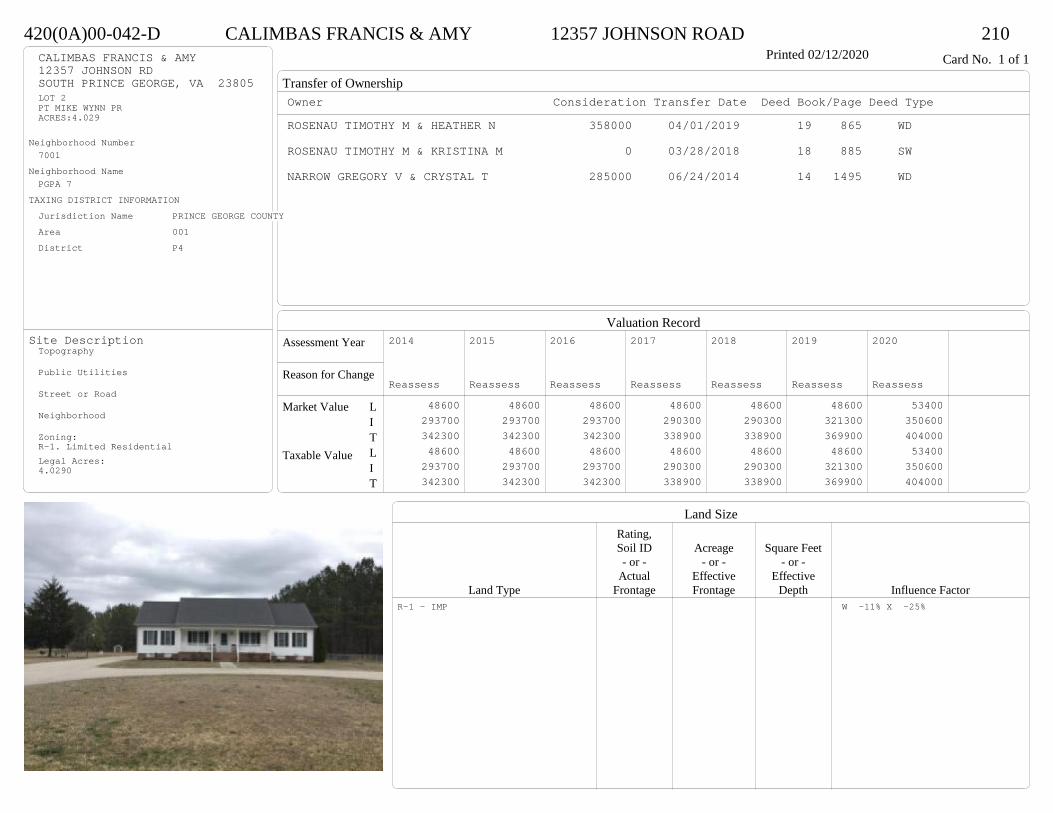
Transfer of Ownership
Valuation RecordAssessment Year
Reason for Change
Market Value
Taxable Value
LITLIT
Land SizeRating,Soil ID Acreage Square Feet- or - - or - - or -
Actual Effective EffectiveLand Type Frontage Frontage Depth Influence Factor
420(0A)00-042-D CALIMBAS FRANCIS & AMY 12357 JOHNSON ROAD 210Printed 02/12/2020 Card No. 1 of 1CALIMBAS FRANCIS & AMY
12357 JOHNSON RDSOUTH PRINCE GEORGE, VA 23805LOT 2PT MIKE WYNN PRACRES:4.029
Neighborhood Number7001
Neighborhood NamePGPA 7
TAXING DISTRICT INFORMATIONJurisdiction Name PRINCE GEORGE COUNTYArea 001 District P4
Site DescriptionTopography
Public Utilities
Street or Road
Neighborhood
Zoning:R-1. Limited ResidentialLegal Acres:4.0290
Owner Consideration Transfer Date Deed Book/Page Deed TypeROSENAU TIMOTHY M & HEATHER N 358000 04/01/2019 19 865 WD
ROSENAU TIMOTHY M & KRISTINA M 0 03/28/2018 18 885 SW
NARROW GREGORY V & CRYSTAL T 285000 06/24/2014 14 1495 WD
2014
Reassess 48600 293700 342300 48600 293700 342300
2015
Reassess 48600 293700 342300 48600 293700 342300
2016
Reassess 48600 293700 342300 48600 293700 342300
2017
Reassess 48600 290300 338900 48600 290300 338900
2018
Reassess 48600 290300 338900 48600 290300 338900
2019
Reassess 48600 321300 369900 48600 321300 369900
2020
Reassess 53400 350600 404000 53400 350600 404000
R-1 - IMP W -11% X -25%

Physical Characteristics
Special Features
Description
Summary of ImprovementsStory Const Year Eff Size or
ID USE Height Type Grade Cons Year Cond Area
420(0A)00-042-D CALIMBAS FRANCIS & AMY 12357 JOHNSON ROAD 210Printed 02/12/2020
28
14.6
18
30
18
15.3
28
14.623015.3
1-1/2 s Fr C
2157
6 OMP 180
44 OMP16
24
30
1/2 s Fr (Fin) Fr G
720
Style: 23 1+ STORY 2000 +Occupancy: Single family
Story Height: 1.5Finished Area: 3897 Attic: NoneBasement: None
ROOFINGMaterial: Comp sh to 235#Type: GableFraming: Std for class
FLOORINGSub and joists 1.0, 1.5Base Allowance 1.0, 1.5
EXTERIOR COVERVinyl siding 1.0, 1.5
INTERIOR FINISH
ACCOMMODATIONFinished Rooms 10Bedrooms 4Family Rooms 1Formal Dining Rooms 1HEATING AND AIR CONDITIONINGPrimary Heat: Heat pump Lower Full Part /Bsmt 1 Upper UpperAir Cond 0 2157 0 1740PLUMBING # TF3 Fixt. Baths 3 92 Fixt. Baths 1 2Kit Sink 1 1Water Heat 1 1 TOTAL 13
REMODELING AND MODERNIZATION Amount Date
D DWELL 0.00 48 2005 2005 3 5034G01 ATTGAR 0.00 1 720
D : Fireplace

Transfer of Ownership
Valuation RecordAssessment Year
Reason for Change
Market Value
Taxable Value
LITLIT
Land SizeRating,Soil ID Acreage Square Feet- or - - or - - or -
Actual Effective EffectiveLand Type Frontage Frontage Depth Influence Factor
510(0A)00-075-0 MCGREEVY BRANDON C & VICTORIA K 2795 DEER RUN PL 510Tax ID SF-0,MS-0,YB- Printed 02/12/2020 Card No. 1 of 1MCGREEVY BRANDON C & VICTORIA K
2795 DEER RUN PLSOUTH PRINCE GEORGE, VA 23805WARWICK SWAMPACRES:28.6
Neighborhood Number7001
Neighborhood NamePGPA 7
TAXING DISTRICT INFORMATIONJurisdiction Name PRINCE GEORGE COUNTYArea 001 District P4 Section & Plat 05/2593
Site DescriptionTopography
Public Utilities
Street or Road
Neighborhood
Zoning:R-A, Residential AgriculturalLegal Acres:28.6000
Owner Consideration Transfer Date Deed Book/Page Deed TypeEVERETT CHAD & JULIE ATTARDO AL 328500 02/01/2019 19 291 WD
BARKER CRYSTAL D 87000 06/24/2015 15 1771 WD
SCHENK TAMARA L 67500 12/16/2009 09 4583 TR
GLASS JEFFREY M 80000 01/08/2009 09 58
GLASS NELLIE K 0 05/14/2001 WF01-26
GLASS H O JR & NELLIE K 0 02/27/1998
2015
Reassess 92700 0 92700 17000 0 17000
2015
Sup 1 103000 191300 294300 16300 191300 207600
2016
Reassess 103000 191300 294300 16300 191300 207600
2017
Reassess 103000 193400 296400 15900 193400 209300
2018
Reassess 103000 193400 296400 16600 193400 210000
2019
Reassess 103000 215600 318600 17900 215600 233500
2020
Reassess 113300 238500 351800 113300 238500 351800
R-A 20<100 - IMP A -20% W -5%
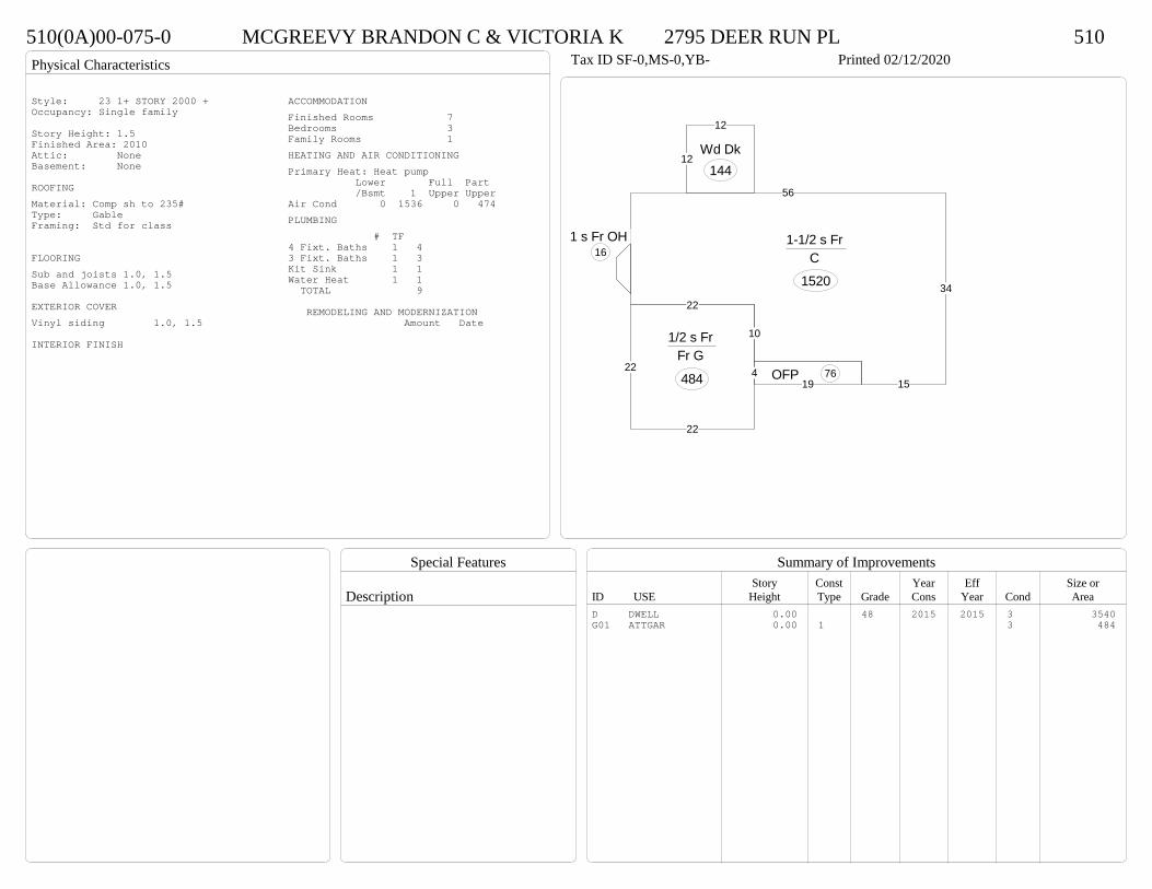
Physical Characteristics
Special Features
Description
Summary of ImprovementsStory Const Year Eff Size or
ID USE Height Type Grade Cons Year Cond Area
510(0A)00-075-0 MCGREEVY BRANDON C & VICTORIA K 2795 DEER RUN PL 510Tax ID SF-0,MS-0,YB- Printed 02/12/2020
56
34
15
10
22
1-1/2 s Fr C
1520
194 OFP 76
1 s Fr OH 16
12
12
Wd Dk144
22
22
22
1/2 s Fr Fr G
484
Style: 23 1+ STORY 2000 +Occupancy: Single family
Story Height: 1.5Finished Area: 2010 Attic: NoneBasement: None
ROOFINGMaterial: Comp sh to 235#Type: GableFraming: Std for class
FLOORINGSub and joists 1.0, 1.5Base Allowance 1.0, 1.5
EXTERIOR COVERVinyl siding 1.0, 1.5
INTERIOR FINISH
ACCOMMODATIONFinished Rooms 7Bedrooms 3Family Rooms 1HEATING AND AIR CONDITIONINGPrimary Heat: Heat pump Lower Full Part /Bsmt 1 Upper UpperAir Cond 0 1536 0 474PLUMBING # TF4 Fixt. Baths 1 43 Fixt. Baths 1 3Kit Sink 1 1Water Heat 1 1 TOTAL 9
REMODELING AND MODERNIZATION Amount Date
D DWELL 0.00 48 2015 2015 3 3540G01 ATTGAR 0.00 1 3 484
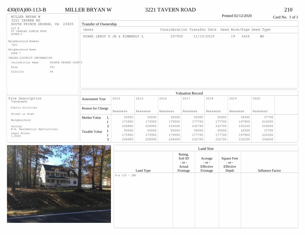
Transfer of Ownership
Valuation RecordAssessment Year
Reason for Change
Market Value
Taxable Value
LITLIT
Land SizeRating,Soil ID Acreage Square Feet- or - - or - - or -
Actual Effective EffectiveLand Type Frontage Frontage Depth Influence Factor
430(0A)00-113-B MILLER BRYAN W 3221 TAVERN ROAD 210Printed 02/12/2020 Card No. 1 of 1MILLER BRYAN W
3221 TAVERN RDSOUTH PRINCE GEORGE, VA 23805LOT BPT CHARLES LUNDIE PROPACRES:1
Neighborhood Number7001
Neighborhood NamePGPA 7
TAXING DISTRICT INFORMATIONJurisdiction Name PRINCE GEORGE COUNTYArea 001 District P4
Site DescriptionTopography
Public Utilities
Street or Road
Neighborhood
Zoning:R-A, Residential AgriculturalLegal Acres:1.0000
Owner Consideration Transfer Date Deed Book/Page Deed TypeEVANS LEROY D JR & KIMBERLY L 257950 11/15/2019 19 3426 WD
2014
Reassess 55000 173900 228900 55000 173900 228900
2015
Reassess 55000 173900 228900 55000 173900 228900
2016
Reassess 55000 179500 234500 55000 179500 234500
2017
Reassess 55000 177700 232700 55000 177700 232700
2018
Reassess 55000 177700 232700 55000 177700 232700
2019
Reassess 34300 197900 232200 34300 197900 232200
2020
Reassess 37700 216300 254000 37700 216300 254000
R-A <20 - IMP
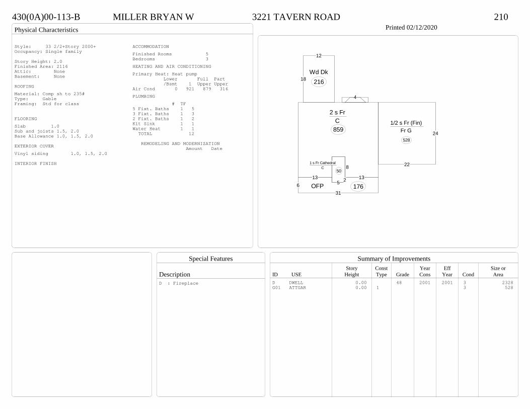
Physical Characteristics
Special Features
Description
Summary of ImprovementsStory Const Year Eff Size or
ID USE Height Type Grade Cons Year Cond Area
430(0A)00-113-B MILLER BRYAN W 3221 TAVERN ROAD 210Printed 02/12/2020
1313
2 s Fr C
859
12
18Wd Dk
216
4
631
135
13
OFP 1765 2
81 s Fr Cathedral
C 50
22
24
1/2 s Fr (Fin) Fr G 528
Style: 33 2/2+Story 2000+Occupancy: Single family
Story Height: 2.0Finished Area: 2116 Attic: NoneBasement: None
ROOFINGMaterial: Comp sh to 235#Type: GableFraming: Std for class
FLOORINGSlab 1.0Sub and joists 1.5, 2.0Base Allowance 1.0, 1.5, 2.0
EXTERIOR COVERVinyl siding 1.0, 1.5, 2.0
INTERIOR FINISH
ACCOMMODATIONFinished Rooms 5Bedrooms 3HEATING AND AIR CONDITIONINGPrimary Heat: Heat pump Lower Full Part /Bsmt 1 Upper UpperAir Cond 0 921 879 316PLUMBING # TF5 Fixt. Baths 1 53 Fixt. Baths 1 32 Fixt. Baths 1 2Kit Sink 1 1Water Heat 1 1 TOTAL 12
REMODELING AND MODERNIZATION Amount Date
D DWELL 0.00 48 2001 2001 3 2328G01 ATTGAR 0.00 1 3 528
D : Fireplace
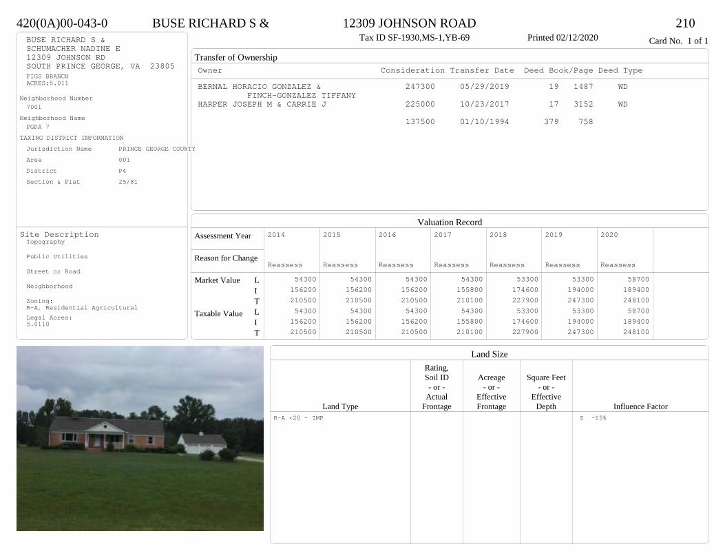
Transfer of Ownership
Valuation RecordAssessment Year
Reason for Change
Market Value
Taxable Value
LITLIT
Land SizeRating,Soil ID Acreage Square Feet- or - - or - - or -
Actual Effective EffectiveLand Type Frontage Frontage Depth Influence Factor
420(0A)00-043-0 BUSE RICHARD S & 12309 JOHNSON ROAD 210Tax ID SF-1930,MS-1,YB-69 Printed 02/12/2020 Card No. 1 of 1BUSE RICHARD S &
SCHUMACHER NADINE E12309 JOHNSON RDSOUTH PRINCE GEORGE, VA 23805FIGS BRANCHACRES:5.011
Neighborhood Number7001
Neighborhood NamePGPA 7
TAXING DISTRICT INFORMATIONJurisdiction Name PRINCE GEORGE COUNTYArea 001 District P4 Section & Plat 25/81
Site DescriptionTopography
Public Utilities
Street or Road
Neighborhood
Zoning:R-A, Residential AgriculturalLegal Acres:5.0110
Owner Consideration Transfer Date Deed Book/Page Deed TypeBERNAL HORACIO GONZALEZ & 247300 05/29/2019 19 1487 WD
FINCH-GONZALEZ TIFFANYHARPER JOSEPH M & CARRIE J 225000 10/23/2017 17 3152 WD
137500 01/10/1994 379 758
2014
Reassess 54300 156200 210500 54300 156200 210500
2015
Reassess 54300 156200 210500 54300 156200 210500
2016
Reassess 54300 156200 210500 54300 156200 210500
2017
Reassess 54300 155800 210100 54300 155800 210100
2018
Reassess 53300 174600 227900 53300 174600 227900
2019
Reassess 53300 194000 247300 53300 194000 247300
2020
Reassess 58700 189400 248100 58700 189400 248100
R-A <20 - IMP S -15%
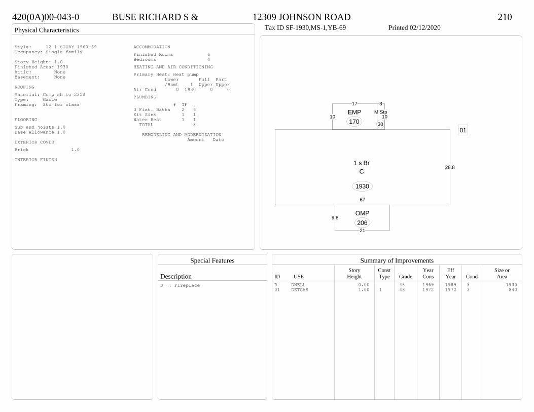
Physical Characteristics
Special Features
Description
Summary of ImprovementsStory Const Year Eff Size or
ID USE Height Type Grade Cons Year Cond Area
420(0A)00-043-0 BUSE RICHARD S & 12309 JOHNSON ROAD 210Tax ID SF-1930,MS-1,YB-69 Printed 02/12/2020
28.8
67
1 s Br C
1930
10
17
EMP170
9.8
21
OMP206
3
10M Stp
3001
Style: 12 1 STORY 1960-69Occupancy: Single family
Story Height: 1.0Finished Area: 1930 Attic: NoneBasement: None
ROOFINGMaterial: Comp sh to 235#Type: GableFraming: Std for class
FLOORINGSub and joists 1.0Base Allowance 1.0
EXTERIOR COVERBrick 1.0
INTERIOR FINISH
ACCOMMODATIONFinished Rooms 6Bedrooms 4HEATING AND AIR CONDITIONINGPrimary Heat: Heat pump Lower Full Part /Bsmt 1 Upper UpperAir Cond 0 1930 0 0PLUMBING # TF3 Fixt. Baths 2 6Kit Sink 1 1Water Heat 1 1 TOTAL 8
REMODELING AND MODERNIZATION Amount Date
D DWELL 0.00 48 1969 1989 3 193001 DETGAR 1.00 1 48 1972 1972 3 840
D : Fireplace

Transfer of Ownership
Valuation RecordAssessment Year
Reason for Change
Market Value
Taxable Value
LITLIT
Land SizeRating,Soil ID Acreage Square Feet- or - - or - - or -
Actual Effective EffectiveLand Type Frontage Frontage Depth Influence Factor
510(08)00-001-0 GILES MICHAEL E 14923 SOUTH CRATER ROAD 210Tax ID SF-1986,MS-1,YB-92 Printed 02/12/2020 Card No. 1 of 1GILES MICHAEL E
14923 S CRATER RDSOUTH PRINCE GEORGE, VA 23805PT LOUIS BLAZEK PROPACRES:1.549
Neighborhood Number7001
Neighborhood NamePGPA 7
TAXING DISTRICT INFORMATIONJurisdiction Name PRINCE GEORGE COUNTYArea 001 District P4 Section & Plat 18 /134
Site DescriptionTopography
Public Utilities
Street or Road
Neighborhood
Zoning:R-A, Residential AgriculturalLegal Acres:1.5490
Owner Consideration Transfer Date Deed Book/Page Deed TypeNESTER JAMES O IV & MARIA J BROCK 259900 09/19/2019 19 2796 WD
SANFORD CAROLYN G ALS 210000 05/10/2013 13 1602 WD
GILL GEORGE E & KATHRYN J 0 03/23/2012 WF12 35 WF
2014
Reassess 39900 159800 199700 39900 159800 199700
2015
Reassess 39900 159800 199700 39900 159800 199700
2016
Reassess 39900 159800 199700 39900 159800 199700
2017
Reassess 39900 160600 200500 39900 160600 200500
2018
Reassess 39900 167900 207800 39900 167900 207800
2019
Reassess 39900 178600 218500 39900 178600 218500
2020
Reassess 43900 196200 240100 43900 196200 240100
R-A <20 - IMP

Physical Characteristics
Special Features
Description
Summary of ImprovementsStory Const Year Eff Size or
ID USE Height Type Grade Cons Year Cond Area
510(08)00-001-0 GILES MICHAEL E 14923 SOUTH CRATER ROAD 210Tax ID SF-1986,MS-1,YB-92 Printed 02/12/2020
25.7
17.3
7.714
19
7.714
34.4
65.3
1 s Fr C
1942
20.7
1 s Fr OH 41
12
42.5
Wd Dk
469
6OMP 114
1 s Fr OH 14
1 s Fr OH 14
1 s Fr OH
14
01Style: 15 1 STORY 1990-1999Occupancy: Single family
Story Height: 1.0Finished Area: 2025 Attic: NoneBasement: None
ROOFINGMaterial: Comp sh to 235#Type: GableFraming: Std for class
FLOORINGSub and joists 1.0Base Allowance 1.0
EXTERIOR COVERVinyl siding 1.0
INTERIOR FINISH
ACCOMMODATIONFinished Rooms 7Bedrooms 3Formal Dining Rooms 1HEATING AND AIR CONDITIONINGPrimary Heat: Central Warm Air Lower Full Part /Bsmt 1 Upper UpperAir Cond 0 2025 0 0PLUMBING # TF5 Fixt. Baths 1 53 Fixt. Baths 1 32 Fixt. Baths 1 2Kit Sink 1 1Water Heat 1 1 TOTAL 12
REMODELING AND MODERNIZATION Amount Date
D DWELL 0.00 45 1992 1992 3 202501 DETGAR 0.00 1 45 1992 1992 3 864
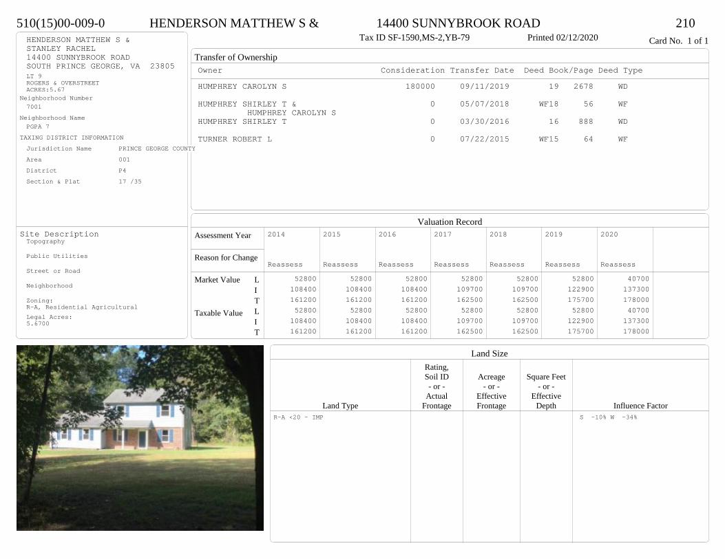
Transfer of Ownership
Valuation RecordAssessment Year
Reason for Change
Market Value
Taxable Value
LITLIT
Land SizeRating,Soil ID Acreage Square Feet- or - - or - - or -
Actual Effective EffectiveLand Type Frontage Frontage Depth Influence Factor
510(15)00-009-0 HENDERSON MATTHEW S & 14400 SUNNYBROOK ROAD 210Tax ID SF-1590,MS-2,YB-79 Printed 02/12/2020 Card No. 1 of 1HENDERSON MATTHEW S &
STANLEY RACHEL14400 SUNNYBROOK ROADSOUTH PRINCE GEORGE, VA 23805LT 9ROGERS & OVERSTREETACRES:5.67
Neighborhood Number7001
Neighborhood NamePGPA 7
TAXING DISTRICT INFORMATIONJurisdiction Name PRINCE GEORGE COUNTYArea 001 District P4 Section & Plat 17 /35
Site DescriptionTopography
Public Utilities
Street or Road
Neighborhood
Zoning:R-A, Residential AgriculturalLegal Acres:5.6700
Owner Consideration Transfer Date Deed Book/Page Deed TypeHUMPHREY CAROLYN S 180000 09/11/2019 19 2678 WD
HUMPHREY SHIRLEY T & 0 05/07/2018 WF18 56 WFHUMPHREY CAROLYN S
HUMPHREY SHIRLEY T 0 03/30/2016 16 888 WD
TURNER ROBERT L 0 07/22/2015 WF15 64 WF
2014
Reassess 52800 108400 161200 52800 108400 161200
2015
Reassess 52800 108400 161200 52800 108400 161200
2016
Reassess 52800 108400 161200 52800 108400 161200
2017
Reassess 52800 109700 162500 52800 109700 162500
2018
Reassess 52800 109700 162500 52800 109700 162500
2019
Reassess 52800 122900 175700 52800 122900 175700
2020
Reassess 40700 137300 178000 40700 137300 178000
R-A <20 - IMP S -10% W -34%

Physical Characteristics
Special Features
Description
Summary of ImprovementsStory Const Year Eff Size or
ID USE Height Type Grade Cons Year Cond Area
510(15)00-009-0 HENDERSON MATTHEW S & 14400 SUNNYBROOK ROAD 210Tax ID SF-1590,MS-2,YB-79 Printed 02/12/2020
26.5
30
2 s Fr C
795
17.84.5OMP 80
10
16
Conc160
26.5
20
Fr G
530
Style: 31 2/2+ Story<1979Occupancy: Single family
Story Height: 2.0Finished Area: 1590 Attic: NoneBasement: None
ROOFINGMaterial: Comp sh to 235#Type: GableFraming: Std for class
FLOORINGSub and joists 1.0, 2.0Base Allowance 1.0, 2.0
EXTERIOR COVERBrick 1.0Hardboard 1.0, 2.0
INTERIOR FINISHDrywall 1.0, 2.0
ACCOMMODATIONFinished Rooms 5Bedrooms 3HEATING AND AIR CONDITIONINGPrimary Heat: Heat pump Lower Full Part /Bsmt 1 Upper UpperAir Cond 0 795 795 0PLUMBING # TF3 Fixt. Baths 1 3Kit Sink 1 1Water Heat 1 1 TOTAL 5
REMODELING AND MODERNIZATION Amount Date
D DWELL 0.00 45 1979 1979 3 1590G01 ATTGAR 0.00 1 530
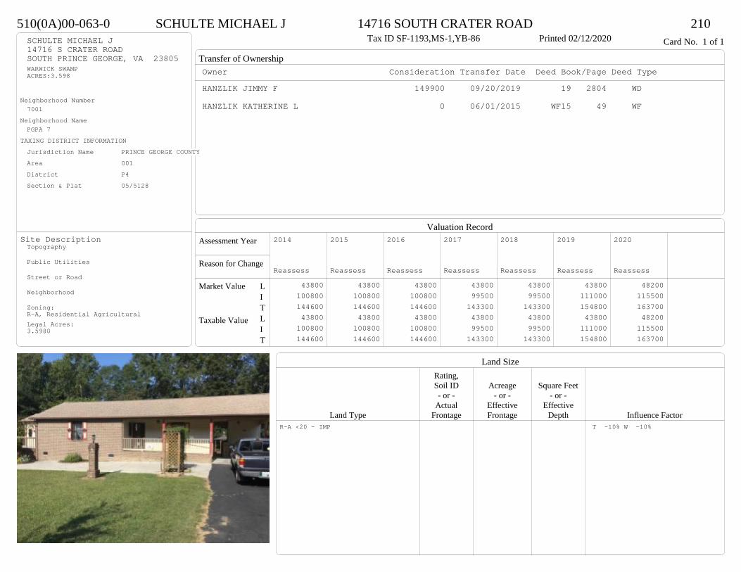
Transfer of Ownership
Valuation RecordAssessment Year
Reason for Change
Market Value
Taxable Value
LITLIT
Land SizeRating,Soil ID Acreage Square Feet- or - - or - - or -
Actual Effective EffectiveLand Type Frontage Frontage Depth Influence Factor
510(0A)00-063-0 SCHULTE MICHAEL J 14716 SOUTH CRATER ROAD 210Tax ID SF-1193,MS-1,YB-86 Printed 02/12/2020 Card No. 1 of 1SCHULTE MICHAEL J
14716 S CRATER ROADSOUTH PRINCE GEORGE, VA 23805WARWICK SWAMPACRES:3.598
Neighborhood Number7001
Neighborhood NamePGPA 7
TAXING DISTRICT INFORMATIONJurisdiction Name PRINCE GEORGE COUNTYArea 001 District P4 Section & Plat 05/5128
Site DescriptionTopography
Public Utilities
Street or Road
Neighborhood
Zoning:R-A, Residential AgriculturalLegal Acres:3.5980
Owner Consideration Transfer Date Deed Book/Page Deed TypeHANZLIK JIMMY F 149900 09/20/2019 19 2804 WD
HANZLIK KATHERINE L 0 06/01/2015 WF15 49 WF
2014
Reassess 43800 100800 144600 43800 100800 144600
2015
Reassess 43800 100800 144600 43800 100800 144600
2016
Reassess 43800 100800 144600 43800 100800 144600
2017
Reassess 43800 99500 143300 43800 99500 143300
2018
Reassess 43800 99500 143300 43800 99500 143300
2019
Reassess 43800 111000 154800 43800 111000 154800
2020
Reassess 48200 115500 163700 48200 115500 163700
R-A <20 - IMP T -10% W -10%

Physical Characteristics
Special Features
Description
Summary of ImprovementsStory Const Year Eff Size or
ID USE Height Type Grade Cons Year Cond Area
510(0A)00-063-0 SCHULTE MICHAEL J 14716 SOUTH CRATER ROAD 210Tax ID SF-1193,MS-1,YB-86 Printed 02/12/2020
19
206
25
25
45
1 s Br C
1005
OMP 120
12
14
1 s Fr C
168
17.8
9.8
14
12
6
19.6
3.1
Wd Dk 266
12
15.8Cnpy(-)
Wd Dk-s(-) 190
16
8 Wd Dk 128Wd Dk
24
19
12
25
4
Br CP
252
68
Shed GP
48
Style: 14 1 STORY 1979-89Occupancy: Single family
Story Height: 1.0Finished Area: 1173 Attic: NoneBasement: None
ROOFINGMaterial: Comp sh to 235#Type: GableFraming: Std for class
FLOORINGSub and joists 1.0Base Allowance 1.0
EXTERIOR COVERBrick 1.0Vinyl siding 1.0
INTERIOR FINISHDrywall 1.0
ACCOMMODATIONFinished Rooms 3Bedrooms 1HEATING AND AIR CONDITIONINGPrimary Heat: Central Warm Air Lower Full Part /Bsmt 1 Upper UpperAir Cond 0 1173 0 0PLUMBING # TF3 Fixt. Baths 2 6Kit Sink 1 1Water Heat 1 1 TOTAL 8
REMODELING AND MODERNIZATION Amount Date
D DWELL 0.00 45 1986 1986 3 1173G01 ICP 0.00 7 25201 SHEDGP 10.00 1 45 1986 1986 3 48
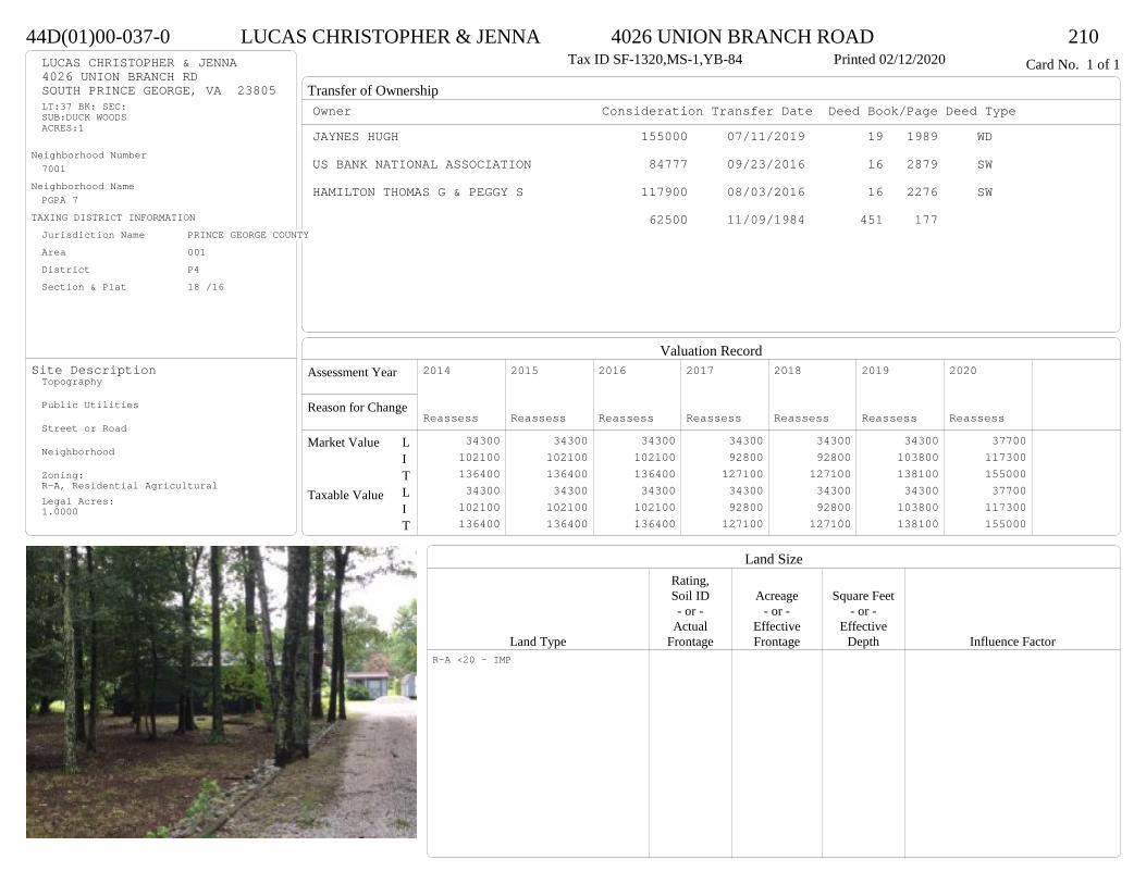
Transfer of Ownership
Valuation RecordAssessment Year
Reason for Change
Market Value
Taxable Value
LITLIT
Land SizeRating,Soil ID Acreage Square Feet- or - - or - - or -
Actual Effective EffectiveLand Type Frontage Frontage Depth Influence Factor
44D(01)00-037-0 LUCAS CHRISTOPHER & JENNA 4026 UNION BRANCH ROAD 210Tax ID SF-1320,MS-1,YB-84 Printed 02/12/2020 Card No. 1 of 1LUCAS CHRISTOPHER & JENNA
4026 UNION BRANCH RDSOUTH PRINCE GEORGE, VA 23805LT:37 BK: SEC:SUB:DUCK WOODSACRES:1
Neighborhood Number7001
Neighborhood NamePGPA 7
TAXING DISTRICT INFORMATIONJurisdiction Name PRINCE GEORGE COUNTYArea 001 District P4 Section & Plat 18 /16
Site DescriptionTopography
Public Utilities
Street or Road
Neighborhood
Zoning:R-A, Residential AgriculturalLegal Acres:1.0000
Owner Consideration Transfer Date Deed Book/Page Deed TypeJAYNES HUGH 155000 07/11/2019 19 1989 WD
US BANK NATIONAL ASSOCIATION 84777 09/23/2016 16 2879 SW
HAMILTON THOMAS G & PEGGY S 117900 08/03/2016 16 2276 SW
62500 11/09/1984 451 177
2014
Reassess 34300 102100 136400 34300 102100 136400
2015
Reassess 34300 102100 136400 34300 102100 136400
2016
Reassess 34300 102100 136400 34300 102100 136400
2017
Reassess 34300 92800 127100 34300 92800 127100
2018
Reassess 34300 92800 127100 34300 92800 127100
2019
Reassess 34300 103800 138100 34300 103800 138100
2020
Reassess 37700 117300 155000 37700 117300 155000
R-A <20 - IMP
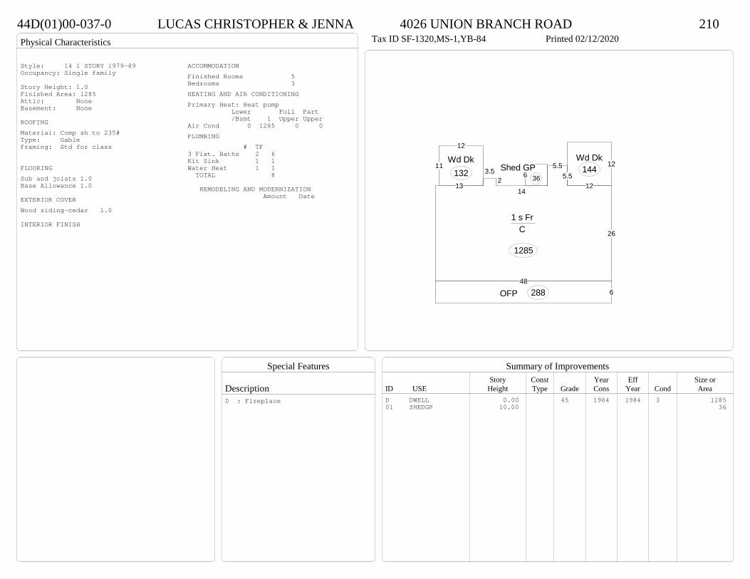
Physical Characteristics
Special Features
Description
Summary of ImprovementsStory Const Year Eff Size or
ID USE Height Type Grade Cons Year Cond Area
44D(01)00-037-0 LUCAS CHRISTOPHER & JENNA 4026 UNION BRANCH ROAD 210Tax ID SF-1320,MS-1,YB-84 Printed 02/12/2020
6OFP 288
12Wd Dk
144
12
11Wd Dk
132
26
125.5
5.5
142
3.5
13
48
1 s Fr C
1285
6Shed GP
36
Style: 14 1 STORY 1979-89Occupancy: Single family
Story Height: 1.0Finished Area: 1285 Attic: NoneBasement: None
ROOFINGMaterial: Comp sh to 235#Type: GableFraming: Std for class
FLOORINGSub and joists 1.0Base Allowance 1.0
EXTERIOR COVERWood siding-cedar 1.0
INTERIOR FINISH
ACCOMMODATIONFinished Rooms 5Bedrooms 3HEATING AND AIR CONDITIONINGPrimary Heat: Heat pump Lower Full Part /Bsmt 1 Upper UpperAir Cond 0 1285 0 0PLUMBING # TF3 Fixt. Baths 2 6Kit Sink 1 1Water Heat 1 1 TOTAL 8
REMODELING AND MODERNIZATION Amount Date
D DWELL 0.00 45 1984 1984 3 128501 SHEDGP 10.00 36
D : Fireplace
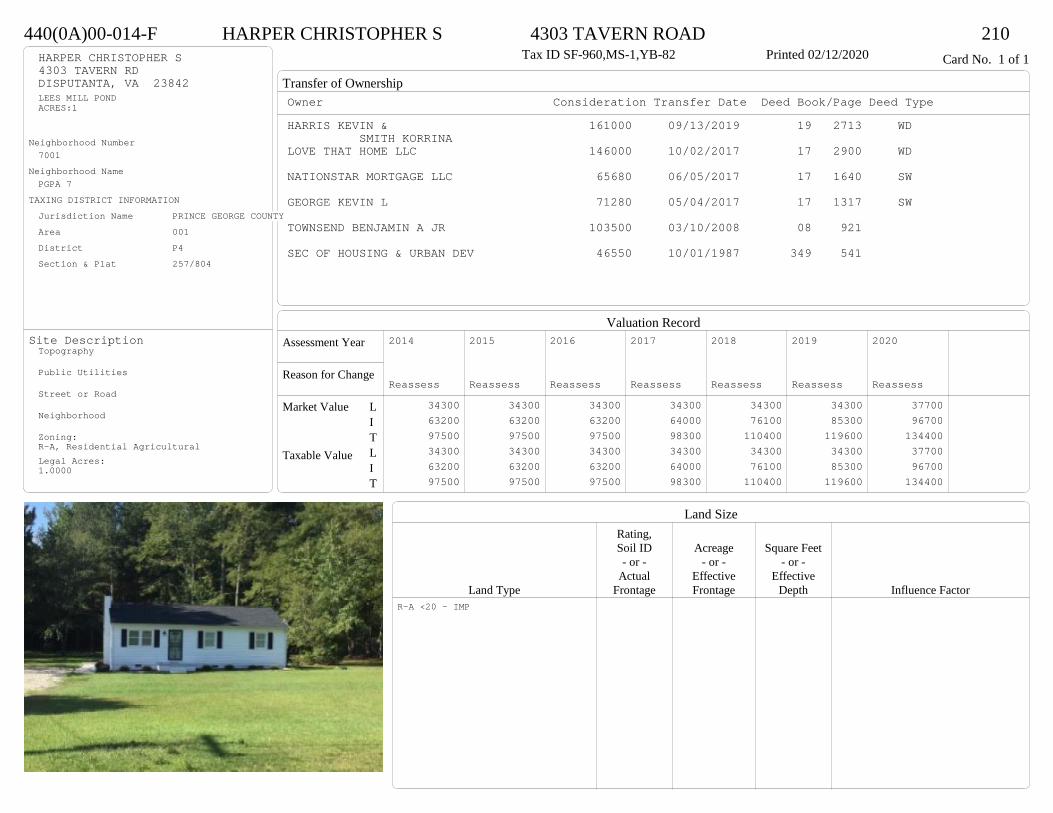
Transfer of Ownership
Valuation RecordAssessment Year
Reason for Change
Market Value
Taxable Value
LITLIT
Land SizeRating,Soil ID Acreage Square Feet- or - - or - - or -
Actual Effective EffectiveLand Type Frontage Frontage Depth Influence Factor
440(0A)00-014-F HARPER CHRISTOPHER S 4303 TAVERN ROAD 210Tax ID SF-960,MS-1,YB-82 Printed 02/12/2020 Card No. 1 of 1HARPER CHRISTOPHER S
4303 TAVERN RDDISPUTANTA, VA 23842LEES MILL PONDACRES:1
Neighborhood Number7001
Neighborhood NamePGPA 7
TAXING DISTRICT INFORMATIONJurisdiction Name PRINCE GEORGE COUNTYArea 001 District P4 Section & Plat 257/804
Site DescriptionTopography
Public Utilities
Street or Road
Neighborhood
Zoning:R-A, Residential AgriculturalLegal Acres:1.0000
Owner Consideration Transfer Date Deed Book/Page Deed TypeHARRIS KEVIN & 161000 09/13/2019 19 2713 WD
SMITH KORRINALOVE THAT HOME LLC 146000 10/02/2017 17 2900 WD
NATIONSTAR MORTGAGE LLC 65680 06/05/2017 17 1640 SW
GEORGE KEVIN L 71280 05/04/2017 17 1317 SW
TOWNSEND BENJAMIN A JR 103500 03/10/2008 08 921
SEC OF HOUSING & URBAN DEV 46550 10/01/1987 349 541
2014
Reassess 34300 63200 97500 34300 63200 97500
2015
Reassess 34300 63200 97500 34300 63200 97500
2016
Reassess 34300 63200 97500 34300 63200 97500
2017
Reassess 34300 64000 98300 34300 64000 98300
2018
Reassess 34300 76100 110400 34300 76100 110400
2019
Reassess 34300 85300 119600 34300 85300 119600
2020
Reassess 37700 96700 134400 37700 96700 134400
R-A <20 - IMP
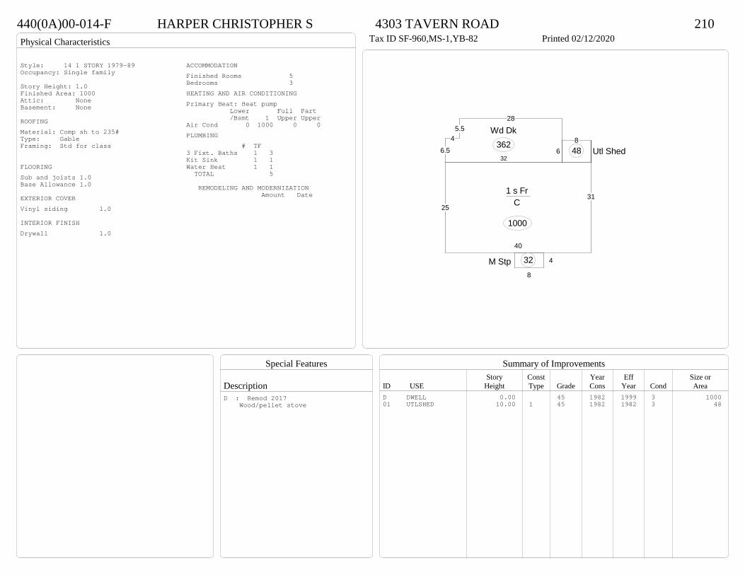
Physical Characteristics
Special Features
Description
Summary of ImprovementsStory Const Year Eff Size or
ID USE Height Type Grade Cons Year Cond Area
440(0A)00-014-F HARPER CHRISTOPHER S 4303 TAVERN ROAD 210Tax ID SF-960,MS-1,YB-82 Printed 02/12/2020
31
40
25
6
1 s Fr C
1000
4
8
M Stp 32
285.5
4
6.532
Wd Dk362 8
Utl Shed48
Style: 14 1 STORY 1979-89Occupancy: Single family
Story Height: 1.0Finished Area: 1000 Attic: NoneBasement: None
ROOFINGMaterial: Comp sh to 235#Type: GableFraming: Std for class
FLOORINGSub and joists 1.0Base Allowance 1.0
EXTERIOR COVERVinyl siding 1.0
INTERIOR FINISHDrywall 1.0
ACCOMMODATIONFinished Rooms 5Bedrooms 3HEATING AND AIR CONDITIONINGPrimary Heat: Heat pump Lower Full Part /Bsmt 1 Upper UpperAir Cond 0 1000 0 0PLUMBING # TF3 Fixt. Baths 1 3Kit Sink 1 1Water Heat 1 1 TOTAL 5
REMODELING AND MODERNIZATION Amount Date
D DWELL 0.00 45 1982 1999 3 100001 UTLSHED 10.00 1 45 1982 1982 3 48
D : Remod 2017 Wood/pellet stove
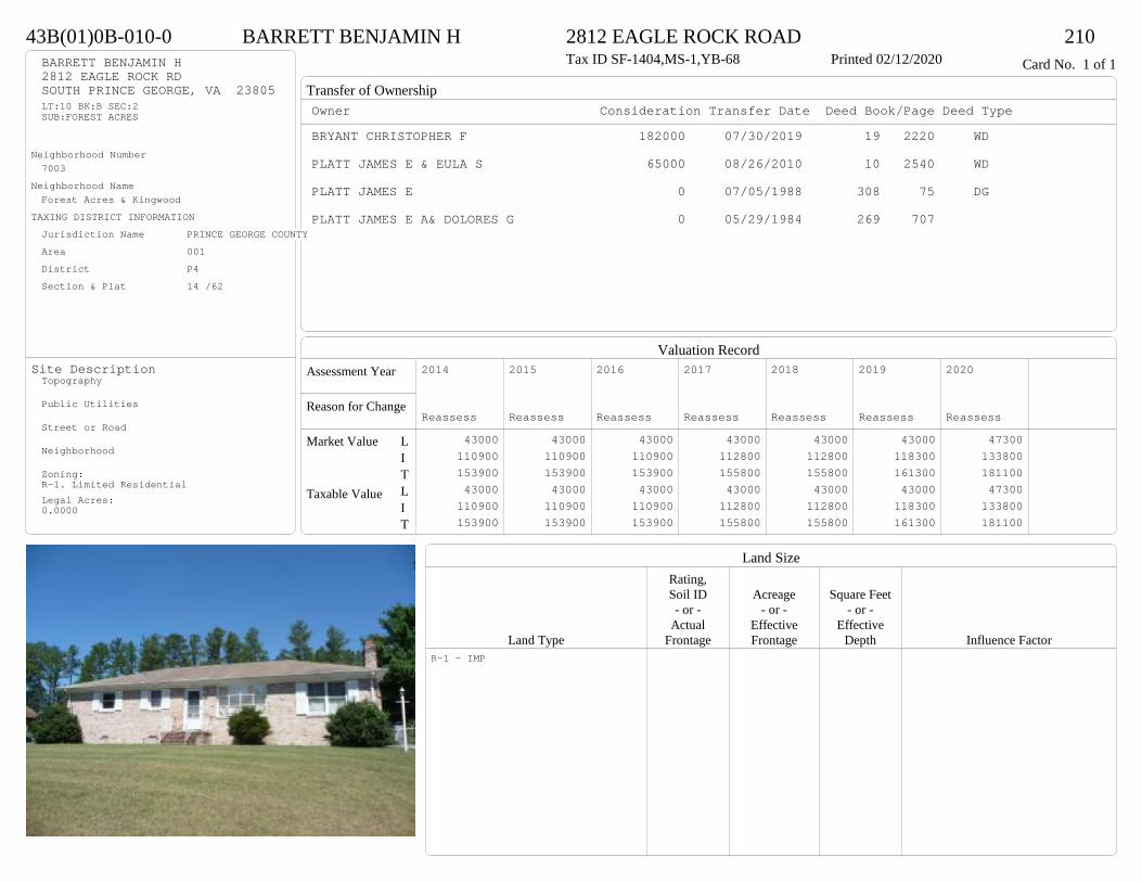
Transfer of Ownership
Valuation RecordAssessment Year
Reason for Change
Market Value
Taxable Value
LITLIT
Land SizeRating,Soil ID Acreage Square Feet- or - - or - - or -
Actual Effective EffectiveLand Type Frontage Frontage Depth Influence Factor
43B(01)0B-010-0 BARRETT BENJAMIN H 2812 EAGLE ROCK ROAD 210Tax ID SF-1404,MS-1,YB-68 Printed 02/12/2020 Card No. 1 of 1BARRETT BENJAMIN H
2812 EAGLE ROCK RDSOUTH PRINCE GEORGE, VA 23805LT:10 BK:B SEC:2SUB:FOREST ACRES
Neighborhood Number7003
Neighborhood NameForest Acres & Kingwood
TAXING DISTRICT INFORMATIONJurisdiction Name PRINCE GEORGE COUNTYArea 001 District P4 Section & Plat 14 /62
Site DescriptionTopography
Public Utilities
Street or Road
Neighborhood
Zoning:R-1. Limited ResidentialLegal Acres:0.0000
Owner Consideration Transfer Date Deed Book/Page Deed TypeBRYANT CHRISTOPHER F 182000 07/30/2019 19 2220 WD
PLATT JAMES E & EULA S 65000 08/26/2010 10 2540 WD
PLATT JAMES E 0 07/05/1988 308 75 DG
PLATT JAMES E A& DOLORES G 0 05/29/1984 269 707
2014
Reassess 43000 110900 153900 43000 110900 153900
2015
Reassess 43000 110900 153900 43000 110900 153900
2016
Reassess 43000 110900 153900 43000 110900 153900
2017
Reassess 43000 112800 155800 43000 112800 155800
2018
Reassess 43000 112800 155800 43000 112800 155800
2019
Reassess 43000 118300 161300 43000 118300 161300
2020
Reassess 47300 133800 181100 47300 133800 181100
R-1 - IMP

Physical Characteristics
Special Features
Description
Summary of ImprovementsStory Const Year Eff Size or
ID USE Height Type Grade Cons Year Cond Area
43B(01)0B-010-0 BARRETT BENJAMIN H 2812 EAGLE ROCK ROAD 210Tax ID SF-1404,MS-1,YB-68 Printed 02/12/2020
52
27
1 s Br C
1404
14
17.1
SolC
239
4.26.8
M Stp29
01
Style: 12 1 STORY 1960-69Occupancy: Single family
Story Height: 1.0Finished Area: 1404 Attic: NoneBasement: None
ROOFINGMaterial: Comp sh to 235#Type: HipFraming: Std for class
FLOORINGSub and joists 1.0Base Allowance 1.0
EXTERIOR COVERBrick 1.0
INTERIOR FINISHDrywall 1.0
ACCOMMODATIONFinished Rooms 5Bedrooms 3HEATING AND AIR CONDITIONINGPrimary Heat: Heat pump Lower Full Part /Bsmt 1 Upper UpperAir Cond 0 1404 0 0PLUMBING # TF3 Fixt. Baths 1 32 Fixt. Baths 1 2Kit Sink 1 1Water Heat 1 1 TOTAL 7
REMODELING AND MODERNIZATION Amount Date
D DWELL 0.00 45 1968 1991 3 140401 DETGAR 1.00 1 38 1978 1978 3 480
D : Remod 2018 Fireplace

Transfer of Ownership
Valuation RecordAssessment Year
Reason for Change
Market Value
Taxable Value
LITLIT
Land SizeRating,Soil ID Acreage Square Feet- or - - or - - or -
Actual Effective EffectiveLand Type Frontage Frontage Depth Influence Factor
43D(01)0D-006-0 LEWIS MARGARITA H & KENISHA S 2004 CLARY RD 210Tax ID SF-0,MS-0,YB- Printed 02/12/2020 Card No. 1 of 1LEWIS MARGARITA H & KENISHA S
2004 CLARY RDSOUTH PRINCE GEORGE, VA 23805LT:6 BK:D SEC:SUB:FRANKLIN FARMSACRES:.69
Neighborhood Number7006
Neighborhood NameFranklin Farms
TAXING DISTRICT INFORMATIONJurisdiction Name PRINCE GEORGE COUNTYArea 001 District P4 Section & Plat 15 /124
Site DescriptionTopography
Public Utilities
Street or Road
Neighborhood
Zoning:R-1. Limited ResidentialLegal Acres:0.6900
Owner Consideration Transfer Date Deed Book/Page Deed TypeLUNDIE JAMIE JO 219000 01/31/2019 19 276 WD
MONTAGUE QUINTON & MELANIE 155000 07/14/2011 11 1952 WD
GLOBAL PROPERTY GROUP LLC THE 218000 04/02/2007 07 1694
SCOTT C F JR & JANE E 80000 06/15/2006 06 3199
2014
Reassess 43000 158800 201800 43000 158800 201800
2015
Reassess 43000 158800 201800 43000 158800 201800
2016
Reassess 43000 158800 201800 43000 158800 201800
2017
Reassess 43000 160700 203700 43000 160700 203700
2018
Reassess 43000 160700 203700 43000 160700 203700
2019
Reassess 43000 179900 222900 43000 179900 222900
2020
Reassess 47300 178200 225500 47300 178200 225500
R-1 - IMP
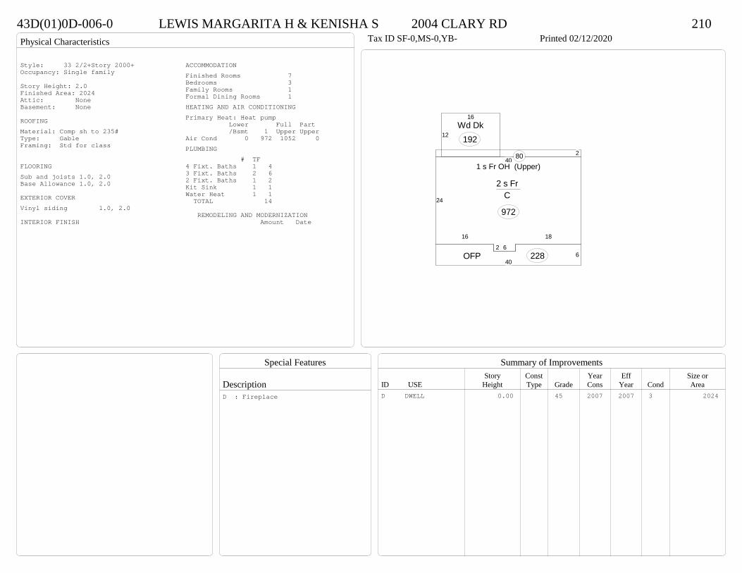
Physical Characteristics
Special Features
Description
Summary of ImprovementsStory Const Year Eff Size or
ID USE Height Type Grade Cons Year Cond Area
43D(01)0D-006-0 LEWIS MARGARITA H & KENISHA S 2004 CLARY RD 210Tax ID SF-0,MS-0,YB- Printed 02/12/2020
24
16
2 6
18
40
2 s Fr C
972
2
1 s Fr OH (Upper)80
640
OFP 228
12
16Wd Dk
192
Style: 33 2/2+Story 2000+Occupancy: Single family
Story Height: 2.0Finished Area: 2024 Attic: NoneBasement: None
ROOFINGMaterial: Comp sh to 235#Type: GableFraming: Std for class
FLOORINGSub and joists 1.0, 2.0Base Allowance 1.0, 2.0
EXTERIOR COVERVinyl siding 1.0, 2.0
INTERIOR FINISH
ACCOMMODATIONFinished Rooms 7Bedrooms 3Family Rooms 1Formal Dining Rooms 1HEATING AND AIR CONDITIONINGPrimary Heat: Heat pump Lower Full Part /Bsmt 1 Upper UpperAir Cond 0 972 1052 0PLUMBING # TF4 Fixt. Baths 1 43 Fixt. Baths 2 62 Fixt. Baths 1 2Kit Sink 1 1Water Heat 1 1 TOTAL 14
REMODELING AND MODERNIZATION Amount Date
D DWELL 0.00 45 2007 2007 3 2024D : Fireplace

Transfer of Ownership
Valuation RecordAssessment Year
Reason for Change
Market Value
Taxable Value
LITLIT
Land SizeRating,Soil ID Acreage Square Feet- or - - or - - or -
Actual Effective EffectiveLand Type Frontage Frontage Depth Influence Factor
44B(04)00-003-0 COVINGTON KATHERINE T 4312 RED CEDAR COURT 210Tax ID SF-0,MS-0,YB- Printed 02/12/2020 Card No. 1 of 1COVINGTON KATHERINE T
4312 RED CEDAR CTDISPUTANTA, VA 23842LT:3 BK: SEC:4SUB:WILDWOOD FARMS
Neighborhood Number7009
Neighborhood NameWildwood Farms
TAXING DISTRICT INFORMATIONJurisdiction Name PRINCE GEORGE COUNTYArea 001 District P4 Section & Plat 20 /33
Site DescriptionTopography
Public Utilities
Street or Road
Neighborhood
Zoning:R-1. Limited ResidentialLegal Acres:0.0000
Owner Consideration Transfer Date Deed Book/Page Deed TypeALLEN TANYA R 239000 06/17/2019 19 1665 WD
ZAHRALBAN MILDRED 215000 10/10/2014 14 3568 WD
2014
Reassess 45000 208900 253900 45000 208900 253900
2015
Reassess 45000 212800 257800 45000 212800 257800
2016
Reassess 45000 212800 257800 45000 212800 257800
2017
Reassess 45000 210500 255500 45000 210500 255500
2018
Reassess 45000 221000 266000 45000 221000 266000
2019
Reassess 45000 221600 266600 45000 221600 266600
2020
Reassess 49500 254800 304300 49500 254800 304300
R-1 - IMP
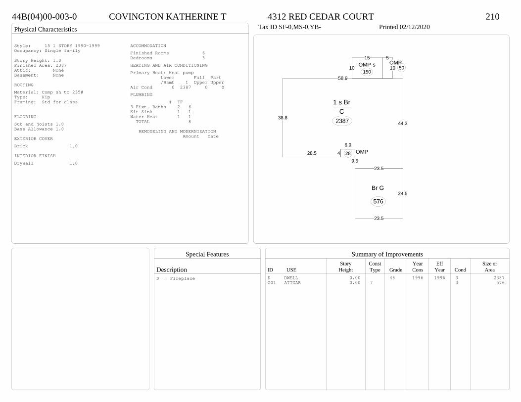
Physical Characteristics
Special Features
Description
Summary of ImprovementsStory Const Year Eff Size or
ID USE Height Type Grade Cons Year Cond Area
44B(04)00-003-0 COVINGTON KATHERINE T 4312 RED CEDAR COURT 210Tax ID SF-0,MS-0,YB- Printed 02/12/2020
38.8
58.9
44.3
23.59.5
6.9428.5
1 s Br C
2387
OMP28
5
10OMP
5010
15OMP-s
150
24.5
23.5
Br G
576
Style: 15 1 STORY 1990-1999Occupancy: Single family
Story Height: 1.0Finished Area: 2387 Attic: NoneBasement: None
ROOFINGMaterial: Comp sh to 235#Type: HipFraming: Std for class
FLOORINGSub and joists 1.0Base Allowance 1.0
EXTERIOR COVERBrick 1.0
INTERIOR FINISHDrywall 1.0
ACCOMMODATIONFinished Rooms 6Bedrooms 3HEATING AND AIR CONDITIONINGPrimary Heat: Heat pump Lower Full Part /Bsmt 1 Upper UpperAir Cond 0 2387 0 0PLUMBING # TF3 Fixt. Baths 2 6Kit Sink 1 1Water Heat 1 1 TOTAL 8
REMODELING AND MODERNIZATION Amount Date
D DWELL 0.00 48 1996 1996 3 2387G01 ATTGAR 0.00 7 3 576
D : Fireplace

Transfer of Ownership
Valuation RecordAssessment Year
Reason for Change
Market Value
Taxable Value
LITLIT
Land SizeRating,Soil ID Acreage Square Feet- or - - or - - or -
Actual Effective EffectiveLand Type Frontage Frontage Depth Influence Factor
43C(06)0B-022-0 WINSTEAD CLARA 11601 MORING DRIVE 210Tax ID SF-1610,MS-1.5,YB-79 Printed 02/12/2020 Card No. 1 of 1WINSTEAD CLARA
11601 MORING DRSOUTH PRINCE GEORGE, VA 23805LT:22 BK:B SEC:3SUB:HUCKLEBERRY HILLS
Neighborhood Number7009
Neighborhood NameWildwood Farms
TAXING DISTRICT INFORMATIONJurisdiction Name PRINCE GEORGE COUNTYArea 001 District P4 Section & Plat 17 /42
Site DescriptionTopography
Public Utilities
Street or Road
Neighborhood
Zoning:R-1. Limited ResidentialLegal Acres:5.8700
Owner Consideration Transfer Date Deed Book/Page Deed TypeDANCE JON MARLON 306000 03/14/2019 19 695 WD
ANDERSON JACK 200000 01/02/2007 07 6
BAIRD DONALD M 72000 04/30/1981 252 151
LUNDIE CHARLES L INC ET AL 15000 07/25/1979 241 842
2015
Sup 1 54000 159100 213100 54000 159100 213100
2016
Reassess 54000 159100 213100 54000 159100 213100
2017
Reassess 54000 158500 212500 54000 158500 212500
2018
Reassess 54000 158500 212500 54000 158500 212500
2019
Reassess 54000 164500 218500 54000 164500 218500
2019
Admin Change 81100 182600 263700 81100 182600 263700
2020
Reassess 97200 206600 303800 97200 206600 303800
R-1 - IMP P 20%

Physical Characteristics
Special Features
Description
Summary of ImprovementsStory Const Year Eff Size or
ID USE Height Type Grade Cons Year Cond Area
43C(06)0B-022-0 WINSTEAD CLARA 11601 MORING DRIVE 210Tax ID SF-1610,MS-1.5,YB-79 Printed 02/12/2020
12.3
1-1/2 s Fr C
347
24.7
28.2
1-3/4 s Fr C
697
9.9
81 s Fr
C 79
14.9
13.9
OFP-s
207
8
8
Wd Dk (Upper)64
5
29.3
OFP 147
01
02
Style: 21 1+ STORY <1979Occupancy: Single family
Story Height: 1.75Finished Area: 1888 Attic: NoneBasement: None
ROOFINGMaterial: MetalType: GableFraming: Std for class
FLOORINGSub and joists 1.0, 1.5, 1.75Base Allowance 1.0, 1.5, 1.75
EXTERIOR COVERWood siding 1.0, 1.5, 1.75
INTERIOR FINISHDrywall 1.0, 1.5, 1.75
ACCOMMODATIONFinished Rooms 5Bedrooms 3HEATING AND AIR CONDITIONINGPrimary Heat: Heat pump Lower Full Part /Bsmt 1 Upper UpperAir Cond 0 1123 0 765PLUMBING # TF3 Fixt. Baths 2 6Kit Sink 1 1Water Heat 1 1 TOTAL 8
REMODELING AND MODERNIZATION Amount Date
D DWELL 0.00 45 1979 1992 3 216701 DETGAR 0.00 1 48 1984 2009 3 57602 DETGAR 0.00 1 48 2016 2016 3 1040
D : Fireplace01 : Concrete floor, Electric lights & service02 : Concrete floor, Electric lights & service
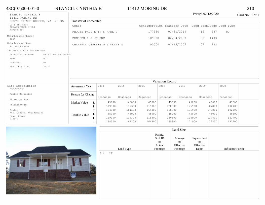
Transfer of Ownership
Valuation RecordAssessment Year
Reason for Change
Market Value
Taxable Value
LITLIT
Land SizeRating,Soil ID Acreage Square Feet- or - - or - - or -
Actual Effective EffectiveLand Type Frontage Frontage Depth Influence Factor
43C(07)00-001-0 STANCIL CYNTHIA B 11412 MORING DR 210Printed 02/12/2020 Card No. 1 of 1STANCIL CYNTHIA B
11412 MORING DRSOUTH PRINCE GEORGE, VA 23805LT:1 BK: SEC:SUB:CHAPPELL HILLSACRES:.286
Neighborhood Number7009
Neighborhood NameWildwood Farms
TAXING DISTRICT INFORMATIONJurisdiction Name PRINCE GEORGE COUNTYArea 001 District P4 Section & Plat 24/11
Site DescriptionTopography
Public Utilities
Street or Road
Neighborhood
Zoning:R-2, General ResidentialLegal Acres:0.2860
Owner Consideration Transfer Date Deed Book/Page Deed TypeRHODES PAUL E IV & ANNE V 177950 01/31/2019 19 287 WD
BENESEK I J JR INC 189900 04/04/2008 08 1403
CHAPPELL CHARLES M & KELLY S 90000 02/14/2007 07 793
2014
Reassess 45000 119300 164300 45000 119300 164300
2015
Reassess 45000 119300 164300 45000 119300 164300
2016
Reassess 45000 119300 164300 45000 119300 164300
2017
Reassess 45000 120800 165800 45000 120800 165800
2018
Reassess 45000 126900 171900 45000 126900 171900
2019
Reassess 45000 127800 172800 45000 127800 172800
2020
Reassess 49500 142700 192200 49500 142700 192200
R-2 - IMP

Physical Characteristics
Special Features
Description
Summary of ImprovementsStory Const Year Eff Size or
ID USE Height Type Grade Cons Year Cond Area
43C(07)00-001-0 STANCIL CYNTHIA B 11412 MORING DR 210Printed 02/12/2020
49
29
1 s Fr C
1421
620
OMP 120
12
12Wd Dk
144
Style: 16 1 STORY 2000-2009Occupancy: Single family
Story Height: 1.0Finished Area: 1421 Attic: NoneBasement: None
ROOFINGMaterial: Comp sh to 235#Type: GableFraming: Std for class
FLOORINGSub and joists 1.0Base Allowance 1.0
EXTERIOR COVERVinyl siding 1.0
INTERIOR FINISH
ACCOMMODATIONFinished Rooms 5Bedrooms 3Family Rooms 1HEATING AND AIR CONDITIONINGPrimary Heat: Heat pump Lower Full Part /Bsmt 1 Upper UpperAir Cond 0 1421 0 0PLUMBING # TF4 Fixt. Baths 1 43 Fixt. Baths 1 3Kit Sink 1 1Water Heat 1 1 TOTAL 9
REMODELING AND MODERNIZATION Amount Date
D DWELL 0.00 45 2007 2007 3 1421D : Fireplace

Transfer of Ownership
Valuation RecordAssessment Year
Reason for Change
Market Value
Taxable Value
LITLIT
Land SizeRating,Soil ID Acreage Square Feet- or - - or - - or -
Actual Effective EffectiveLand Type Frontage Frontage Depth Influence Factor
44A(01)0B-006-0 JACKSON DELVON L 11009 WALTON LAKE ROAD 210Tax ID SF-1760,MS-TL,YB-76 Printed 02/12/2020 Card No. 1 of 1JACKSON DELVON L
11009 WALTON LAKE RDDISPUTANTA, VA 23842LT:6 BK:B SEC:1SUB:TEMPLE ESTATESACRES:0.483
Neighborhood Number7009
Neighborhood NameWildwood Farms
TAXING DISTRICT INFORMATIONJurisdiction Name PRINCE GEORGE COUNTYArea 001 District P4 Section & Plat 16 /71
Site DescriptionTopography
Public Utilities
Street or Road
Neighborhood
Zoning:R-1. Limited ResidentialLegal Acres:0.4830
Owner Consideration Transfer Date Deed Book/Page Deed TypeGIBSON JACQUELYN M 195000 03/07/2019 19 643 WD
SAMUEL GUSTAVIUS P JR & JACQUELYN M 0 06/23/2016 16 1796 WD
POTTS JUAN S & KIM A DAVIS- 178000 11/13/2008 08 4615
SECHREST DONALD L & CYNTHIA W 72000 03/30/2004 04 1616
2014
Reassess 43000 109700 152700 43000 109700 152700
2015
Reassess 43000 109700 152700 43000 109700 152700
2016
Reassess 43000 109700 152700 43000 109700 152700
2017
Reassess 43000 108200 151200 43000 108200 151200
2018
Reassess 43000 110400 153400 43000 110400 153400
2019
Reassess 45000 114600 159600 45000 114600 159600
2020
Reassess 49500 136100 185600 49500 136100 185600
R-1 - IMP
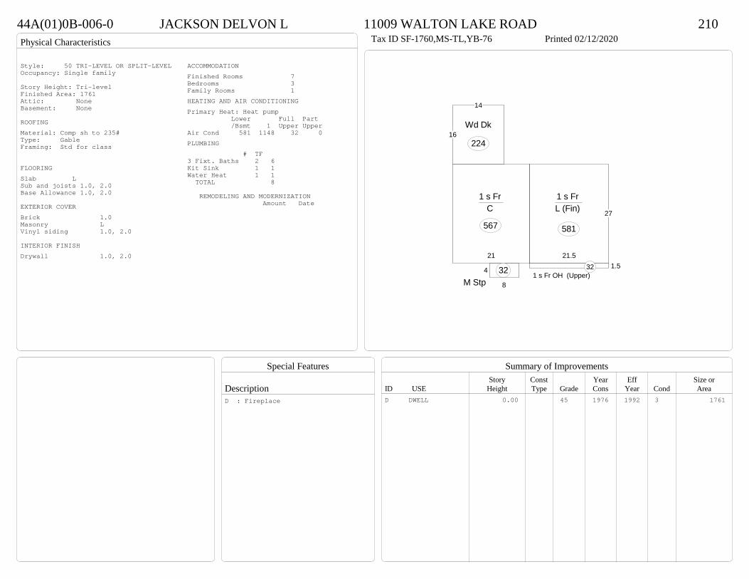
Physical Characteristics
Special Features
Description
Summary of ImprovementsStory Const Year Eff Size or
ID USE Height Type Grade Cons Year Cond Area
44A(01)0B-006-0 JACKSON DELVON L 11009 WALTON LAKE ROAD 210Tax ID SF-1760,MS-TL,YB-76 Printed 02/12/2020
27
21.5
1 s Fr L (Fin)
581
21
1 s Fr C
567
4
8M Stp32 1.5
1 s Fr OH (Upper)32
16
14
Wd Dk
224
Style: 50 TRI-LEVEL OR SPLIT-LEVELOccupancy: Single family
Story Height: Tri-levelFinished Area: 1761 Attic: NoneBasement: None
ROOFINGMaterial: Comp sh to 235#Type: GableFraming: Std for class
FLOORINGSlab LSub and joists 1.0, 2.0Base Allowance 1.0, 2.0
EXTERIOR COVERBrick 1.0Masonry LVinyl siding 1.0, 2.0
INTERIOR FINISHDrywall 1.0, 2.0
ACCOMMODATIONFinished Rooms 7Bedrooms 3Family Rooms 1HEATING AND AIR CONDITIONINGPrimary Heat: Heat pump Lower Full Part /Bsmt 1 Upper UpperAir Cond 581 1148 32 0PLUMBING # TF3 Fixt. Baths 2 6Kit Sink 1 1Water Heat 1 1 TOTAL 8
REMODELING AND MODERNIZATION Amount Date
D DWELL 0.00 45 1976 1992 3 1761D : Fireplace
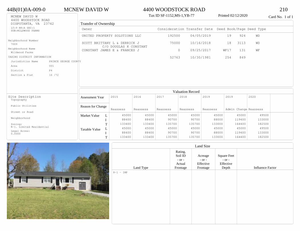
Transfer of Ownership
Valuation RecordAssessment Year
Reason for Change
Market Value
Taxable Value
LITLIT
Land SizeRating,Soil ID Acreage Square Feet- or - - or - - or -
Actual Effective EffectiveLand Type Frontage Frontage Depth Influence Factor
44B(01)0A-009-0 MCNEW DAVID W 4400 WOODSTOCK ROAD 210Tax ID SF-1152,MS-1,YB-77 Printed 02/12/2020 Card No. 1 of 1MCNEW DAVID W
4400 WOODSTOCK ROADDISPUTANTA, VA 23742LT:9 BK:A SEC:1SUB:WILDWOOD FARMS
Neighborhood Number7009
Neighborhood NameWildwood Farms
TAXING DISTRICT INFORMATIONJurisdiction Name PRINCE GEORGE COUNTYArea 001 District P4 Section & Plat 16 /72
Site DescriptionTopography
Public Utilities
Street or Road
Neighborhood
Zoning:R-1. Limited ResidentialLegal Acres:0.0000
Owner Consideration Transfer Date Deed Book/Page Deed TypeUNITED PROPERTY SOLUTIONS LLC 192500 04/05/2019 19 924 WD
SCOTT BRITTANY L & DERRICK J 75000 10/16/2018 18 3113 WDC/O DOUGLAS K CONSTANT
CONSTANT JAMES E & FRANCES J 0 09/25/2017 WF17 131 WF
52763 10/30/1981 254 849
2015
Reassess 45000 88400 133400 45000 88400 133400
2016
Reassess 45000 88400 133400 45000 88400 133400
2017
Reassess 45000 90700 135700 45000 90700 135700
2018
Reassess 45000 90700 135700 45000 90700 135700
2019
Reassess 45000 88000 133000 45000 88000 133000
2019
Admin Change 45000 119400 164400 45000 119400 164400
2020
Reassess 49500 133000 182500 49500 133000 182500
R-1 - IMP

Physical Characteristics
Special Features
Description
Summary of ImprovementsStory Const Year Eff Size or
ID USE Height Type Grade Cons Year Cond Area
44B(01)0A-009-0 MCNEW DAVID W 4400 WOODSTOCK ROAD 210Tax ID SF-1152,MS-1,YB-77 Printed 02/12/2020
24
48
1 s Fr C
1152
46
M Stp24
14
1 s Fr Slab
336
12
12
Wd Dk
144
Style: 13 1 STORY 1970-78Occupancy: Single family
Story Height: 1.0Finished Area: 1488 Attic: NoneBasement: None
ROOFINGMaterial: Comp sh to 235#Type: GableFraming: Std for class
FLOORINGSub and joists 1.0Base Allowance 1.0
EXTERIOR COVERVinyl siding 1.0
INTERIOR FINISHDrywall 1.0
ACCOMMODATIONFinished Rooms 7Bedrooms 3HEATING AND AIR CONDITIONINGPrimary Heat: Heat pump Lower Full Part /Bsmt 1 Upper UpperAir Cond 0 1488 0 0PLUMBING # TF3 Fixt. Baths 1 32 Fixt. Baths 1 2Kit Sink 1 1Water Heat 1 1 TOTAL 7
REMODELING AND MODERNIZATION Amount Date
D DWELL 0.00 45 1977 1998 3 1488D : Remod 2019 Fireplace
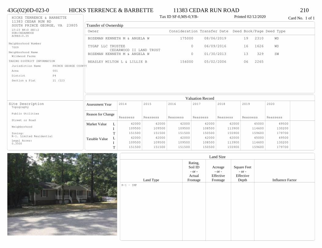
Transfer of Ownership
Valuation RecordAssessment Year
Reason for Change
Market Value
Taxable Value
LITLIT
Land SizeRating,Soil ID Acreage Square Feet- or - - or - - or -
Actual Effective EffectiveLand Type Frontage Frontage Depth Influence Factor
43G(02)0D-023-0 HICKS TERRENCE & BARBETTE 11383 CEDAR RUN ROAD 210Tax ID SF-0,MS-0,YB- Printed 02/12/2020 Card No. 1 of 1HICKS TERRENCE & BARBETTE
11383 CEDAR RUN RDSOUTH PRINCE GEORGE, VA 23805LT:23 BK:D SEC:2SUB:CEDARWOODACRES:0.35
Neighborhood Number7009
Neighborhood NameWildwood Farms
TAXING DISTRICT INFORMATIONJurisdiction Name PRINCE GEORGE COUNTYArea 001 District P4 Section & Plat 21 /223
Site DescriptionTopography
Public Utilities
Street or Road
Neighborhood
Zoning:R-1. Limited ResidentialLegal Acres:0.3500
Owner Consideration Transfer Date Deed Book/Page Deed TypeBOZEMAN KENNETH M & ANGELA W 175000 08/06/2019 19 2310 WD
TYGAP LLC TRUSTEE 0 06/09/2016 16 1626 WDCEDARWOOD II LAND TRUST
BOZEMAN KENNETH M & ANGELA W 0 01/30/2013 13 329 SW
BEASLEY MILTON L & LILLIE B 156000 05/02/2006 06 2265
2014
Reassess 42000 109500 151500 42000 109500 151500
2015
Reassess 42000 109500 151500 42000 109500 151500
2016
Reassess 42000 109500 151500 42000 109500 151500
2017
Reassess 42000 108500 150500 42000 108500 150500
2018
Reassess 42000 113900 155900 42000 113900 155900
2019
Reassess 45000 114600 159600 45000 114600 159600
2020
Reassess 49500 130200 179700 49500 130200 179700
R-1 - IMP
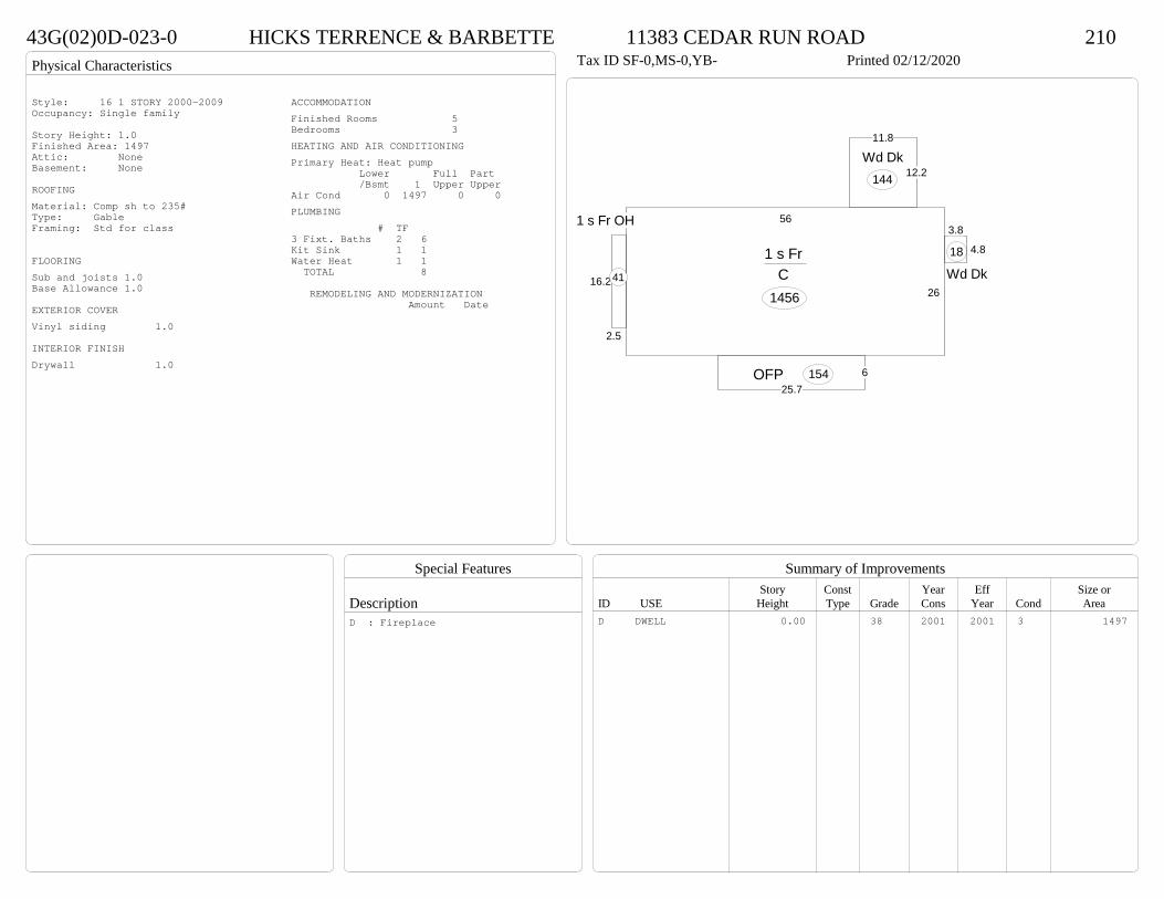
Physical Characteristics
Special Features
Description
Summary of ImprovementsStory Const Year Eff Size or
ID USE Height Type Grade Cons Year Cond Area
43G(02)0D-023-0 HICKS TERRENCE & BARBETTE 11383 CEDAR RUN ROAD 210Tax ID SF-0,MS-0,YB- Printed 02/12/2020
26
56
1 s Fr C
145616.2
2.5
1 s Fr OH
41
12.2
11.8
Wd Dk144
3.8
4.8
Wd Dk18
625.7
OFP 154
Style: 16 1 STORY 2000-2009Occupancy: Single family
Story Height: 1.0Finished Area: 1497 Attic: NoneBasement: None
ROOFINGMaterial: Comp sh to 235#Type: GableFraming: Std for class
FLOORINGSub and joists 1.0Base Allowance 1.0
EXTERIOR COVERVinyl siding 1.0
INTERIOR FINISHDrywall 1.0
ACCOMMODATIONFinished Rooms 5Bedrooms 3HEATING AND AIR CONDITIONINGPrimary Heat: Heat pump Lower Full Part /Bsmt 1 Upper UpperAir Cond 0 1497 0 0PLUMBING # TF3 Fixt. Baths 2 6Kit Sink 1 1Water Heat 1 1 TOTAL 8
REMODELING AND MODERNIZATION Amount Date
D DWELL 0.00 38 2001 2001 3 1497D : Fireplace
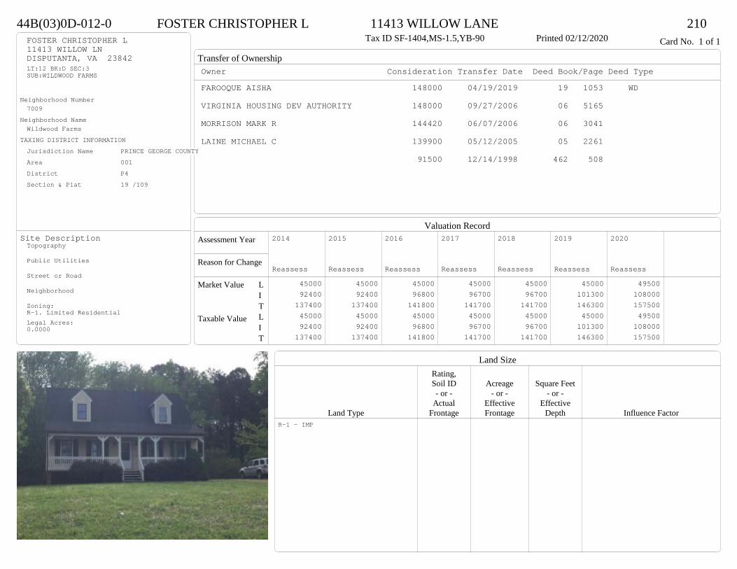
Transfer of Ownership
Valuation RecordAssessment Year
Reason for Change
Market Value
Taxable Value
LITLIT
Land SizeRating,Soil ID Acreage Square Feet- or - - or - - or -
Actual Effective EffectiveLand Type Frontage Frontage Depth Influence Factor
44B(03)0D-012-0 FOSTER CHRISTOPHER L 11413 WILLOW LANE 210Tax ID SF-1404,MS-1.5,YB-90 Printed 02/12/2020 Card No. 1 of 1FOSTER CHRISTOPHER L
11413 WILLOW LNDISPUTANTA, VA 23842LT:12 BK:D SEC:3SUB:WILDWOOD FARMS
Neighborhood Number7009
Neighborhood NameWildwood Farms
TAXING DISTRICT INFORMATIONJurisdiction Name PRINCE GEORGE COUNTYArea 001 District P4 Section & Plat 19 /109
Site DescriptionTopography
Public Utilities
Street or Road
Neighborhood
Zoning:R-1. Limited ResidentialLegal Acres:0.0000
Owner Consideration Transfer Date Deed Book/Page Deed TypeFAROOQUE AISHA 148000 04/19/2019 19 1053 WD
VIRGINIA HOUSING DEV AUTHORITY 148000 09/27/2006 06 5165
MORRISON MARK R 144420 06/07/2006 06 3041
LAINE MICHAEL C 139900 05/12/2005 05 2261
91500 12/14/1998 462 508
2014
Reassess 45000 92400 137400 45000 92400 137400
2015
Reassess 45000 92400 137400 45000 92400 137400
2016
Reassess 45000 96800 141800 45000 96800 141800
2017
Reassess 45000 96700 141700 45000 96700 141700
2018
Reassess 45000 96700 141700 45000 96700 141700
2019
Reassess 45000 101300 146300 45000 101300 146300
2020
Reassess 49500 108000 157500 49500 108000 157500
R-1 - IMP

Physical Characteristics
Special Features
Description
Summary of ImprovementsStory Const Year Eff Size or
ID USE Height Type Grade Cons Year Cond Area
44B(03)0D-012-0 FOSTER CHRISTOPHER L 11413 WILLOW LANE 210Tax ID SF-1404,MS-1.5,YB-90 Printed 02/12/2020
36
26
1-1/2 s Fr C
936
12
16
Wd Dk
192
5OFP 180
Style: 22 1+ STORY 1980-1999Occupancy: Single family
Story Height: 1.5Finished Area: 1497 Attic: NoneBasement: None
ROOFINGMaterial: Comp sh to 235#Type: GableFraming: Std for class
FLOORINGSub and joists 1.0, 1.5Base Allowance 1.0, 1.5
EXTERIOR COVERVinyl siding 1.0, 1.5
INTERIOR FINISHDrywall 1.0, 1.5
ACCOMMODATIONFinished Rooms 5Bedrooms 3HEATING AND AIR CONDITIONINGPrimary Heat: Heat pump Lower Full Part /Bsmt 1 Upper UpperAir Cond 0 936 0 561PLUMBING # TF3 Fixt. Baths 1 3Kit Sink 1 1Water Heat 1 1 TOTAL 5
REMODELING AND MODERNIZATION Amount Date
D DWELL 0.00 38 1990 1990 3 1872

Transfer of Ownership
Valuation RecordAssessment Year
Reason for Change
Market Value
Taxable Value
LITLIT
Land SizeRating,Soil ID Acreage Square Feet- or - - or - - or -
Actual Effective EffectiveLand Type Frontage Frontage Depth Influence Factor
43G(01)0A-008-0 POWERS ASHLEY N 11328 CEDAR RUN ROAD 210Tax ID SF-1170,MS-1.5,YB-90 Printed 02/12/2020 Card No. 1 of 1POWERS ASHLEY N
11328 CEDAR RUN RDSOUTH PRINCE GEORGE, VA 23805LT:8 BK:A SEC:1SUB:CEDARWOOD
Neighborhood Number7009
Neighborhood NameWildwood Farms
TAXING DISTRICT INFORMATIONJurisdiction Name PRINCE GEORGE COUNTYArea 001 District P4 Section & Plat 19 /126
Site DescriptionTopography
Public Utilities
Street or Road
Neighborhood
Zoning:R-1. Limited ResidentialLegal Acres:0.0000
Owner Consideration Transfer Date Deed Book/Page Deed TypeRUTLEDGE EMILY 145000 10/28/2019 19 3180 WD
SECRETARY OF HOUSING & URBAN DEV 82500 10/05/2012 12 3234 SW
WELLS FARGO BANK NA 195502 07/02/2012 12 2156 SW
SLIGH ELIZABETH B & PAUL L WOLLASTON 195502 07/02/2012 12 2155 SW
PRIORITY HOME SOLUTIONS LLC 171500 03/04/2009 09 686
FEDERAL HOME LOAN MTG CORP 106000 07/31/2008 08 3352 ATTN REO SALES & DISPOSITION
2014
Reassess 42000 92500 134500 42000 92500 134500
2015
Reassess 42000 92500 134500 42000 92500 134500
2016
Reassess 42000 92500 134500 42000 92500 134500
2017
Reassess 42000 91400 133400 42000 91400 133400
2018
Reassess 42000 91400 133400 42000 91400 133400
2019
Reassess 45000 95900 140900 45000 95900 140900
2020
Reassess 49500 102300 151800 49500 102300 151800
R-1 - IMP

Physical Characteristics
Special Features
Description
Summary of ImprovementsStory Const Year Eff Size or
ID USE Height Type Grade Cons Year Cond Area
43G(01)0A-008-0 POWERS ASHLEY N 11328 CEDAR RUN ROAD 210Tax ID SF-1170,MS-1.5,YB-90 Printed 02/12/2020
30
26
1-1/2 s Fr C
780
12
12
Wd Dk
144
6 OFP 180
Style: 22 1+ STORY 1980-1999Occupancy: Single family
Story Height: 1.5Finished Area: 1248 Attic: NoneBasement: None
ROOFINGMaterial: Comp sh to 235#Type: GableFraming: Std for class
FLOORINGSub and joists 1.0, 1.5Base Allowance 1.0, 1.5
EXTERIOR COVERVinyl siding 1.0, 1.5
INTERIOR FINISHDrywall 1.0, 1.5
ACCOMMODATIONFinished Rooms 5Bedrooms 3HEATING AND AIR CONDITIONINGPrimary Heat: Heat pump Lower Full Part /Bsmt 1 Upper UpperAir Cond 0 780 0 468PLUMBING # TF3 Fixt. Baths 2 6Kit Sink 1 1Water Heat 1 1 TOTAL 8
REMODELING AND MODERNIZATION Amount Date
D DWELL 0.00 45 1990 1995 3 1560
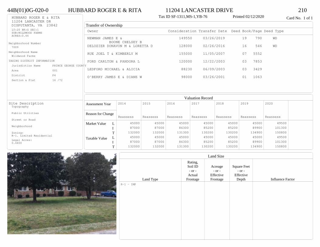
Transfer of Ownership
Valuation RecordAssessment Year
Reason for Change
Market Value
Taxable Value
LITLIT
Land SizeRating,Soil ID Acreage Square Feet- or - - or - - or -
Actual Effective EffectiveLand Type Frontage Frontage Depth Influence Factor
44B(01)0G-020-0 HUBBARD ROGER E & RITA 11204 LANCASTER DRIVE 210Tax ID SF-1311,MS-1,YB-76 Printed 02/12/2020 Card No. 1 of 1HUBBARD ROGER E & RITA
11204 LANCASTER DRDISPUTANTA, VA 23842LT:20 BK:G SEC:1SUB:WILDWOOD FARMSACRES:0.44
Neighborhood Number7009
Neighborhood NameWildwood Farms
TAXING DISTRICT INFORMATIONJurisdiction Name PRINCE GEORGE COUNTYArea 001 District P4 Section & Plat 16 /72
Site DescriptionTopography
Public Utilities
Street or Road
Neighborhood
Zoning:R-1. Limited ResidentialLegal Acres:0.4400
Owner Consideration Transfer Date Deed Book/Page Deed TypeNEWMAN JAMES E & 149550 03/26/2019 19 790 WD
BOONE CHELSEY BDELOZIER DONAVON M & LORETTA D 128000 02/26/2016 16 546 WD
RUE JOEL T & KIMBERLY M 155000 11/05/2007 07 5552
FORD CARLTON & PANDORA L 120000 12/22/2003 03 7853
LEDFORD MICHAEL & ALICIA 88230 06/09/2003 03 3429
O'BERRY JAMES E & DIANE W 98000 03/26/2001 01 1063
2014
Reassess 45000 87000 132000 45000 87000 132000
2015
Reassess 45000 87000 132000 45000 87000 132000
2016
Reassess 45000 86300 131300 45000 86300 131300
2017
Reassess 45000 85200 130200 45000 85200 130200
2018
Reassess 45000 85200 130200 45000 85200 130200
2019
Reassess 45000 89900 134900 45000 89900 134900
2020
Reassess 49500 101300 150800 49500 101300 150800
R-1 - IMP

Physical Characteristics
Special Features
Description
Summary of ImprovementsStory Const Year Eff Size or
ID USE Height Type Grade Cons Year Cond Area
44B(01)0G-020-0 HUBBARD ROGER E & RITA 11204 LANCASTER DRIVE 210Tax ID SF-1311,MS-1,YB-76 Printed 02/12/2020
24.5
53.5
1 s Br C
1311
12
16
Conc
192
44
M Stp
16
46
M Stp 24
Style: 13 1 STORY 1970-78Occupancy: Single family
Story Height: 1.0Finished Area: 1311 Attic: NoneBasement: None
ROOFINGMaterial: Comp sh to 235#Type: GableFraming: Std for class
FLOORINGSub and joists 1.0Base Allowance 1.0
EXTERIOR COVERBrick 1.0
INTERIOR FINISHDrywall 1.0
ACCOMMODATIONFinished Rooms 5Bedrooms 3HEATING AND AIR CONDITIONINGPrimary Heat: Heat pump Lower Full Part /Bsmt 1 Upper UpperAir Cond 0 1311 0 0PLUMBING # TF3 Fixt. Baths 1 32 Fixt. Baths 1 2Kit Sink 1 1Water Heat 1 1 TOTAL 7
REMODELING AND MODERNIZATION Amount Date
D DWELL 0.00 38 1976 1976 3 1311D : Fireplace

Transfer of Ownership
Valuation RecordAssessment Year
Reason for Change
Market Value
Taxable Value
LITLIT
Land SizeRating,Soil ID Acreage Square Feet- or - - or - - or -
Actual Effective EffectiveLand Type Frontage Frontage Depth Influence Factor
44B(03)0E-022-0 MACHUCA LEYLA P & 11410 WILLOW LANE 210Tax ID SF-1296,MS-1.5,YB-90 Printed 02/12/2020 Card No. 1 of 1MACHUCA LEYLA P &
VIGIL FREDY O11410 WILLOW LNDISPUTANTA, VA 23842LT:22 BK:E SEC:3SUB:WILDWOOD FARMS
Neighborhood Number7009
Neighborhood NameWildwood Farms
TAXING DISTRICT INFORMATIONJurisdiction Name PRINCE GEORGE COUNTYArea 001 District P4 Section & Plat 19 /109
Site DescriptionTopography
Public Utilities
Street or Road
Neighborhood
Zoning:R-1. Limited ResidentialLegal Acres:0.0000
Owner Consideration Transfer Date Deed Book/Page Deed TypeCASTLE MICHAEL L II 155000 08/21/2019 19 2464 WD
64000 03/02/1993 364 418
2014
Reassess 45000 87600 132600 45000 87600 132600
2015
Reassess 45000 87600 132600 45000 87600 132600
2016
Reassess 45000 87600 132600 45000 87600 132600
2017
Reassess 45000 87500 132500 45000 87500 132500
2018
Reassess 45000 87500 132500 45000 87500 132500
2019
Reassess 45000 91800 136800 45000 91800 136800
2020
Reassess 49500 98200 147700 49500 98200 147700
R-1 - IMP

Physical Characteristics
Special Features
Description
Summary of ImprovementsStory Const Year Eff Size or
ID USE Height Type Grade Cons Year Cond Area
44B(03)0E-022-0 MACHUCA LEYLA P & 11410 WILLOW LANE 210Tax ID SF-1296,MS-1.5,YB-90 Printed 02/12/2020
36
24
1-1/2 s Fr C
864
10
12
Wd Dk
120
46
M Stp 24
Style: 22 1+ STORY 1980-1999Occupancy: Single family
Story Height: 1.5Finished Area: 1382 Attic: NoneBasement: None
ROOFINGMaterial: Comp sh to 235#Type: GableFraming: Std for class
FLOORINGSub and joists 1.0, 1.5Base Allowance 1.0, 1.5
EXTERIOR COVERVinyl siding 1.0, 1.5
INTERIOR FINISH
ACCOMMODATIONFinished Rooms 4Bedrooms 2HEATING AND AIR CONDITIONINGPrimary Heat: Heat pump Lower Full Part /Bsmt 1 Upper UpperAir Cond 0 864 0 518PLUMBING # TF3 Fixt. Baths 1 3Kit Sink 1 1Water Heat 1 1 TOTAL 5
REMODELING AND MODERNIZATION Amount Date
D DWELL 0.00 38 1990 1990 3 1728

Transfer of Ownership
Valuation RecordAssessment Year
Reason for Change
Market Value
Taxable Value
LITLIT
Land SizeRating,Soil ID Acreage Square Feet- or - - or - - or -
Actual Effective EffectiveLand Type Frontage Frontage Depth Influence Factor
44B(02)0L-004-0 NELSON LAKEYA 4019 UNION BRANCH ROAD 210Tax ID SF-1080,MS-1,YB-84 Printed 02/12/2020 Card No. 1 of 1NELSON LAKEYA
4019 UNION BRANCH RDSOUTH PRINCE GEORGE, VA 23805-7663LT:4 BK:L SEC:2SUB:WILDWOOD FARMS
Neighborhood Number7009
Neighborhood NameWildwood Farms
TAXING DISTRICT INFORMATIONJurisdiction Name PRINCE GEORGE COUNTYArea 001 District P4 Section & Plat 18 /59
Site DescriptionTopography
Public Utilities
Street or Road
Neighborhood
Zoning:R-1. Limited ResidentialLegal Acres:0.0000
Owner Consideration Transfer Date Deed Book/Page Deed TypeGAY STEVEN M 149950 05/31/2019 19 1515 WD
OLIVER KYNDRA L 136500 06/01/2007 07 2815
WARREN JODIE L 92950 04/15/2003 03 2169
WARREN JODIE L JR & JENNIFER F 0 07/25/2002 02 4012
WARREN JODI L JR 0 03/24/1997 427 918
2014
Reassess 45000 72300 117300 45000 72300 117300
2015
Reassess 45000 72300 117300 45000 72300 117300
2016
Reassess 45000 72300 117300 45000 72300 117300
2017
Reassess 45000 72400 117400 45000 72400 117400
2018
Reassess 45000 72400 117400 45000 72400 117400
2019
Reassess 45000 84900 129900 45000 84900 129900
2020
Reassess 49500 95600 145100 49500 95600 145100
R-1 - IMP
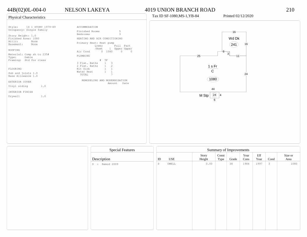
Physical Characteristics
Special Features
Description
Summary of ImprovementsStory Const Year Eff Size or
ID USE Height Type Grade Cons Year Cond Area
44B(02)0L-004-0 NELSON LAKEYA 4019 UNION BRANCH ROAD 210Tax ID SF-1080,MS-1,YB-84 Printed 02/12/2020
44
24
113
825
1 s Fr C
1080
46
M Stp 24
11
16
16
Wd Dk
241
Style: 14 1 STORY 1979-89Occupancy: Single family
Story Height: 1.0Finished Area: 1080 Attic: NoneBasement: None
ROOFINGMaterial: Comp sh to 235#Type: GableFraming: Std for class
FLOORINGSub and joists 1.0Base Allowance 1.0
EXTERIOR COVERVinyl siding 1.0
INTERIOR FINISHDrywall 1.0
ACCOMMODATIONFinished Rooms 5Bedrooms 3HEATING AND AIR CONDITIONINGPrimary Heat: Heat pump Lower Full Part /Bsmt 1 Upper UpperAir Cond 0 1080 0 0PLUMBING # TF3 Fixt. Baths 1 32 Fixt. Baths 1 2Kit Sink 1 1Water Heat 1 1 TOTAL 7
REMODELING AND MODERNIZATION Amount Date
D DWELL 0.00 38 1984 1997 3 1080D : Remod 2009

Transfer of Ownership
Valuation RecordAssessment Year
Reason for Change
Market Value
Taxable Value
LITLIT
Land SizeRating,Soil ID Acreage Square Feet- or - - or - - or -
Actual Effective EffectiveLand Type Frontage Frontage Depth Influence Factor
44B(02)0L-006-0 HA HOIDONG & BETSY 4031 UNION BRANCH ROAD 210Tax ID SF-1080,MS-1,YB-84 Printed 02/12/2020 Card No. 1 of 1HA HOIDONG & BETSY
4031 UNION BRANCH RDSOUTH PRINCE GEORGE, VA 23805LT:6 BK:L SEC:2SUB:WILDWOOD FARMS
Neighborhood Number7009
Neighborhood NameWildwood Farms
TAXING DISTRICT INFORMATIONJurisdiction Name PRINCE GEORGE COUNTYArea 001 District P4 Section & Plat 18 /59
Site DescriptionTopography
Public Utilities
Street or Road
Neighborhood
Zoning:R-1. Limited ResidentialLegal Acres:0.0000
Owner Consideration Transfer Date Deed Book/Page Deed TypePERKINSON SARAH 148000 07/02/2019 19 1891 WD
SCHALL JEFFREY G II 149950 12/18/2009 09 4619
HARLESS JANIS L 79900 08/07/2002 02 4248
CO GRACE C R 73600 05/29/1997 430 90
KING JAMES H & NANCY W 72900 01/03/1994 430 90
2014
Reassess 45000 73300 118300 45000 73300 118300
2015
Reassess 45000 73300 118300 45000 73300 118300
2016
Reassess 45000 73300 118300 45000 73300 118300
2017
Reassess 45000 73400 118400 45000 73400 118400
2018
Reassess 45000 73400 118400 45000 73400 118400
2019
Reassess 45000 77700 122700 45000 77700 122700
2020
Reassess 49500 89200 138700 49500 89200 138700
R-1 - IMP

Physical Characteristics
Special Features
Description
Summary of ImprovementsStory Const Year Eff Size or
ID USE Height Type Grade Cons Year Cond Area
44B(02)0L-006-0 HA HOIDONG & BETSY 4031 UNION BRANCH ROAD 210Tax ID SF-1080,MS-1,YB-84 Printed 02/12/2020
44
24
253
8
1 s Fr C
1080
518
OMP 90
16
10
Wd Dk
160
Style: 14 1 STORY 1979-89Occupancy: Single family
Story Height: 1.0Finished Area: 1080 Attic: NoneBasement: None
ROOFINGMaterial: Comp sh to 235#Type: GableFraming: Std for class
FLOORINGSub and joists 1.0Base Allowance 1.0
EXTERIOR COVERVinyl siding 1.0
INTERIOR FINISHDrywall 1.0
ACCOMMODATIONFinished Rooms 5Bedrooms 3HEATING AND AIR CONDITIONINGPrimary Heat: Electric baseboard Lower Full Part /Bsmt 1 Upper UpperAir Cond 0 1080 0 0PLUMBING # TF3 Fixt. Baths 1 32 Fixt. Baths 1 2Kit Sink 1 1Water Heat 1 1 TOTAL 7
REMODELING AND MODERNIZATION Amount Date
D DWELL 0.00 38 1984 1984 3 1080D : Fireplace
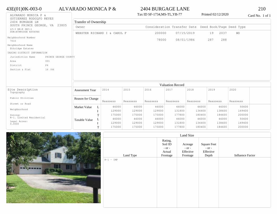
Transfer of Ownership
Valuation RecordAssessment Year
Reason for Change
Market Value
Taxable Value
LITLIT
Land SizeRating,Soil ID Acreage Square Feet- or - - or - - or -
Actual Effective EffectiveLand Type Frontage Frontage Depth Influence Factor
43E(01)0K-003-0 ALVARADO MONICA P & 2404 BURGAGE LANE 210Tax ID SF-1734,MS-TL,YB-77 Printed 02/12/2020 Card No. 1 of 1ALVARADO MONICA P &
GUTIERREZ RODOLFO REYES2404 BURGAGE LNSOUTH PRINCE GEORGE, VA 23805LT:3 BK:K SEC:1SUB:ETHRIDGE ESTATES
Neighborhood Number7010
Neighborhood NameEthridge Estates
TAXING DISTRICT INFORMATIONJurisdiction Name PRINCE GEORGE COUNTYArea 001 District P4 Section & Plat 16 /66
Site DescriptionTopography
Public Utilities
Street or Road
Neighborhood
Zoning:R-1. Limited ResidentialLegal Acres:0.0000
Owner Consideration Transfer Date Deed Book/Page Deed TypeWEBSTER RICHARD I & CAROL F 200000 07/15/2019 19 2037 WD
78000 08/01/1986 287 288
2014
Reassess 46000 129000 175000 46000 129000 175000
2015
Reassess 46000 129000 175000 46000 129000 175000
2016
Reassess 46000 129000 175000 46000 129000 175000
2017
Reassess 46000 131800 177800 46000 131800 177800
2018
Reassess 46000 134400 180400 46000 134400 180400
2019
Reassess 46000 138600 184600 46000 138600 184600
2020
Reassess 50600 149400 200000 50600 149400 200000
R-1 - IMP
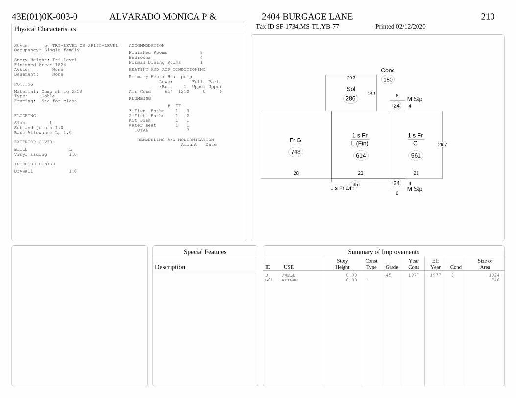
Physical Characteristics
Special Features
Description
Summary of ImprovementsStory Const Year Eff Size or
ID USE Height Type Grade Cons Year Cond Area
43E(01)0K-003-0 ALVARADO MONICA P & 2404 BURGAGE LANE 210Tax ID SF-1734,MS-TL,YB-77 Printed 02/12/2020
23
1 s Fr L (Fin)
614
21
26.7
1 s Fr C
561
1 s Fr OH 35
6
4M Stp
24
6
4M Stp
24
Conc180
14.1
20.3
Sol286
28
Fr G
748
Style: 50 TRI-LEVEL OR SPLIT-LEVELOccupancy: Single family
Story Height: Tri-levelFinished Area: 1824 Attic: NoneBasement: None
ROOFINGMaterial: Comp sh to 235#Type: GableFraming: Std for class
FLOORINGSlab LSub and joists 1.0Base Allowance L, 1.0
EXTERIOR COVERBrick LVinyl siding 1.0
INTERIOR FINISHDrywall 1.0
ACCOMMODATIONFinished Rooms 8Bedrooms 4Formal Dining Rooms 1HEATING AND AIR CONDITIONINGPrimary Heat: Heat pump Lower Full Part /Bsmt 1 Upper UpperAir Cond 614 1210 0 0PLUMBING # TF3 Fixt. Baths 1 32 Fixt. Baths 1 2Kit Sink 1 1Water Heat 1 1 TOTAL 7
REMODELING AND MODERNIZATION Amount Date
D DWELL 0.00 45 1977 1977 3 1824G01 ATTGAR 0.00 1 748

Transfer of Ownership
Valuation RecordAssessment Year
Reason for Change
Market Value
Taxable Value
LITLIT
Land SizeRating,Soil ID Acreage Square Feet- or - - or - - or -
Actual Effective EffectiveLand Type Frontage Frontage Depth Influence Factor
500(09)00-003-0 STEWART MATTHEW & SARAH 1002 DRAYTON ROAD 210Tax ID SF-4603,MS-2,YB-84 Printed 02/12/2020 Card No. 1 of 1STEWART MATTHEW & SARAH
1002 DRAYTON CTSOUTH PRINCE GEORGE, VA 23805LT:3 BK: SEC:SUB:WEDGEWOOD FARMSACRES:5.01
Neighborhood Number7014
Neighborhood NameFairwood/College Roads Area
TAXING DISTRICT INFORMATIONJurisdiction Name PRINCE GEORGE COUNTYArea 001 District P4 Section & Plat 16 /129
Site DescriptionTopography
Public Utilities
Street or Road
Neighborhood
Zoning:R-A, Residential AgriculturalLegal Acres:5.0100
Owner Consideration Transfer Date Deed Book/Page Deed TypeMCPHEARSON JEFFREY A & CARIN S 429900 08/02/2019 19 2275 WD
WHITSELL JOSEPH M & STELLA B 399000 07/24/2013 13 5596 WD
CHANEY KAREN E ET ALS 279000 11/27/2000 00-4611
2014
Reassess 62700 390200 452900 62700 390200 452900
2015
Reassess 62700 390200 452900 62700 390200 452900
2016
Reassess 62700 399900 462600 62700 399900 462600
2017
Reassess 62700 397200 459900 62700 397200 459900
2018
Reassess 62700 397200 459900 62700 397200 459900
2019
Reassess 62700 415500 478200 62700 415500 478200
2020
Reassess 69000 450200 519200 69000 450200 519200
R-A <20 - IMP
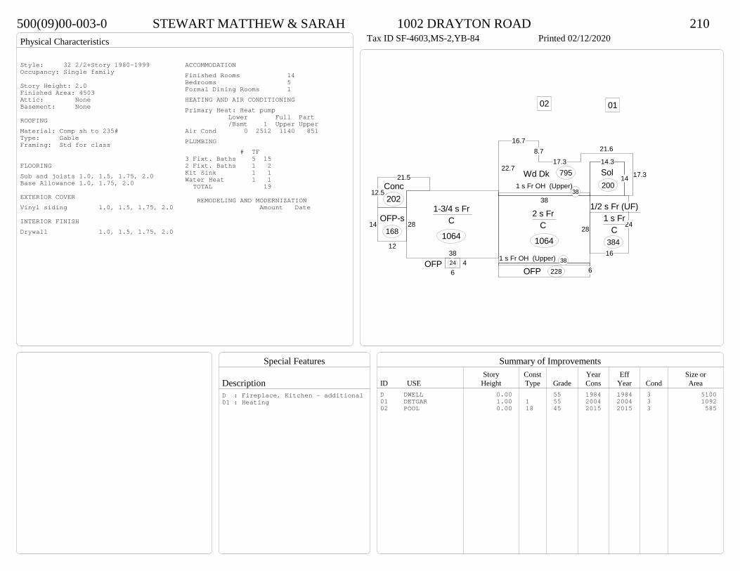
Physical Characteristics
Special Features
Description
Summary of ImprovementsStory Const Year Eff Size or
ID USE Height Type Grade Cons Year Cond Area
500(09)00-003-0 STEWART MATTHEW & SARAH 1002 DRAYTON ROAD 210Tax ID SF-4603,MS-2,YB-84 Printed 02/12/2020
28
38
2 s Fr C
106416
24
1/2 s Fr (UF) 1 s Fr
C 384
38
28
1-3/4 s Fr C
1064
6OFP 228
14.3
14Sol200
1 s Fr OH (Upper) 38
38
1 s Fr OH (Upper)38
22.7
16.78.7
17.3
21.6
17.3Wd Dk 795
12
14OFP-s
168
46
OFP 24
12.5
21.5Conc202
0102
Style: 32 2/2+Story 1980-1999Occupancy: Single family
Story Height: 2.0Finished Area: 4503 Attic: NoneBasement: None
ROOFINGMaterial: Comp sh to 235#Type: GableFraming: Std for class
FLOORINGSub and joists 1.0, 1.5, 1.75, 2.0Base Allowance 1.0, 1.75, 2.0
EXTERIOR COVERVinyl siding 1.0, 1.5, 1.75, 2.0
INTERIOR FINISHDrywall 1.0, 1.5, 1.75, 2.0
ACCOMMODATIONFinished Rooms 14Bedrooms 5Formal Dining Rooms 1HEATING AND AIR CONDITIONINGPrimary Heat: Heat pump Lower Full Part /Bsmt 1 Upper UpperAir Cond 0 2512 1140 851PLUMBING # TF3 Fixt. Baths 5 152 Fixt. Baths 1 2Kit Sink 1 1Water Heat 1 1 TOTAL 19
REMODELING AND MODERNIZATION Amount Date
D DWELL 0.00 55 1984 1984 3 510001 DETGAR 1.00 1 55 2004 2004 3 109202 POOL 0.00 18 45 2015 2015 3 585
D : Fireplace, Kitchen - additional01 : Heating
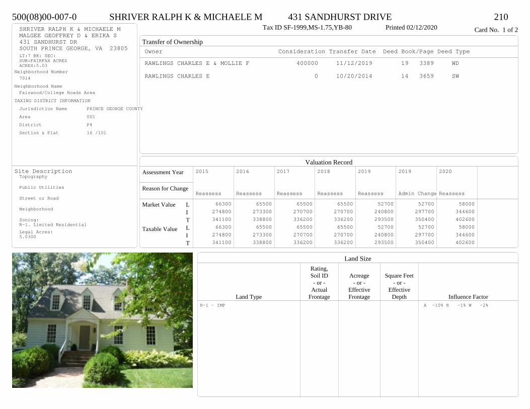
Transfer of Ownership
Valuation RecordAssessment Year
Reason for Change
Market Value
Taxable Value
LITLIT
Land SizeRating,Soil ID Acreage Square Feet- or - - or - - or -
Actual Effective EffectiveLand Type Frontage Frontage Depth Influence Factor
500(08)00-007-0 SHRIVER RALPH K & MICHAELE M 431 SANDHURST DRIVE 210Tax ID SF-1999,MS-1.75,YB-80 Printed 02/12/2020 Card No. 1 of 2SHRIVER RALPH K & MICHAELE M
MALGEE GEOFFREY D & ERIKA S431 SANDHURST DRSOUTH PRINCE GEORGE, VA 23805LT:7 BK: SEC:SUB:FAIRFAX ACRESACRES:5.03
Neighborhood Number7014
Neighborhood NameFairwood/College Roads Area
TAXING DISTRICT INFORMATIONJurisdiction Name PRINCE GEORGE COUNTYArea 001 District P4 Section & Plat 16 /101
Site DescriptionTopography
Public Utilities
Street or Road
Neighborhood
Zoning:R-1. Limited ResidentialLegal Acres:5.0300
Owner Consideration Transfer Date Deed Book/Page Deed TypeRAWLINGS CHARLES E & MOLLIE F 400000 11/12/2019 19 3389 WD
RAWLINGS CHARLES E 0 10/20/2014 14 3659 SW
2015
Reassess 66300 274800 341100 66300 274800 341100
2016
Reassess 65500 273300 338800 65500 273300 338800
2017
Reassess 65500 270700 336200 65500 270700 336200
2018
Reassess 65500 270700 336200 65500 270700 336200
2019
Reassess 52700 240800 293500 52700 240800 293500
2019
Admin Change 52700 297700 350400 52700 297700 350400
2020
Reassess 58000 344600 402600 58000 344600 402600
R-1 - IMP A -10% R -1% W -2%
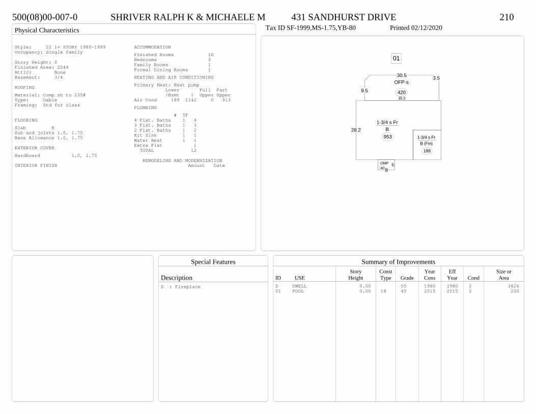
Physical Characteristics
Special Features
Description
Summary of ImprovementsStory Const Year Eff Size or
ID USE Height Type Grade Cons Year Cond Area
500(08)00-007-0 SHRIVER RALPH K & MICHAELE M 431 SANDHURST DRIVE 210Tax ID SF-1999,MS-1.75,YB-80 Printed 02/12/2020
58
OMP40
9.5
30.5 3.5
35.5
OFP-s
420
1-3/4 s Fr B (Fin)
189
28.21-3/4 s Fr
B 953
01
Style: 22 1+ STORY 1980-1999Occupancy: Single family
Story Height: 0Finished Area: 2244 Attic: NoneBasement: 3/4
ROOFINGMaterial: Comp sh to 235#Type: GableFraming: Std for class
FLOORINGSlab BSub and joists 1.0, 1.75Base Allowance 1.0, 1.75
EXTERIOR COVERHardboard 1.0, 1.75
INTERIOR FINISH
ACCOMMODATIONFinished Rooms 10Bedrooms 3Family Rooms 1Formal Dining Rooms 1HEATING AND AIR CONDITIONINGPrimary Heat: Heat pump Lower Full Part /Bsmt 1 Upper UpperAir Cond 189 1142 0 913PLUMBING # TF4 Fixt. Baths 1 43 Fixt. Baths 1 32 Fixt. Baths 1 2Kit Sink 1 1Water Heat 1 1Extra Fixt 1 TOTAL 12
REMODELING AND MODERNIZATION Amount Date
D DWELL 0.00 55 1980 1980 3 342601 POOL 0.00 18 45 2015 2015 3 200
D : Fireplace
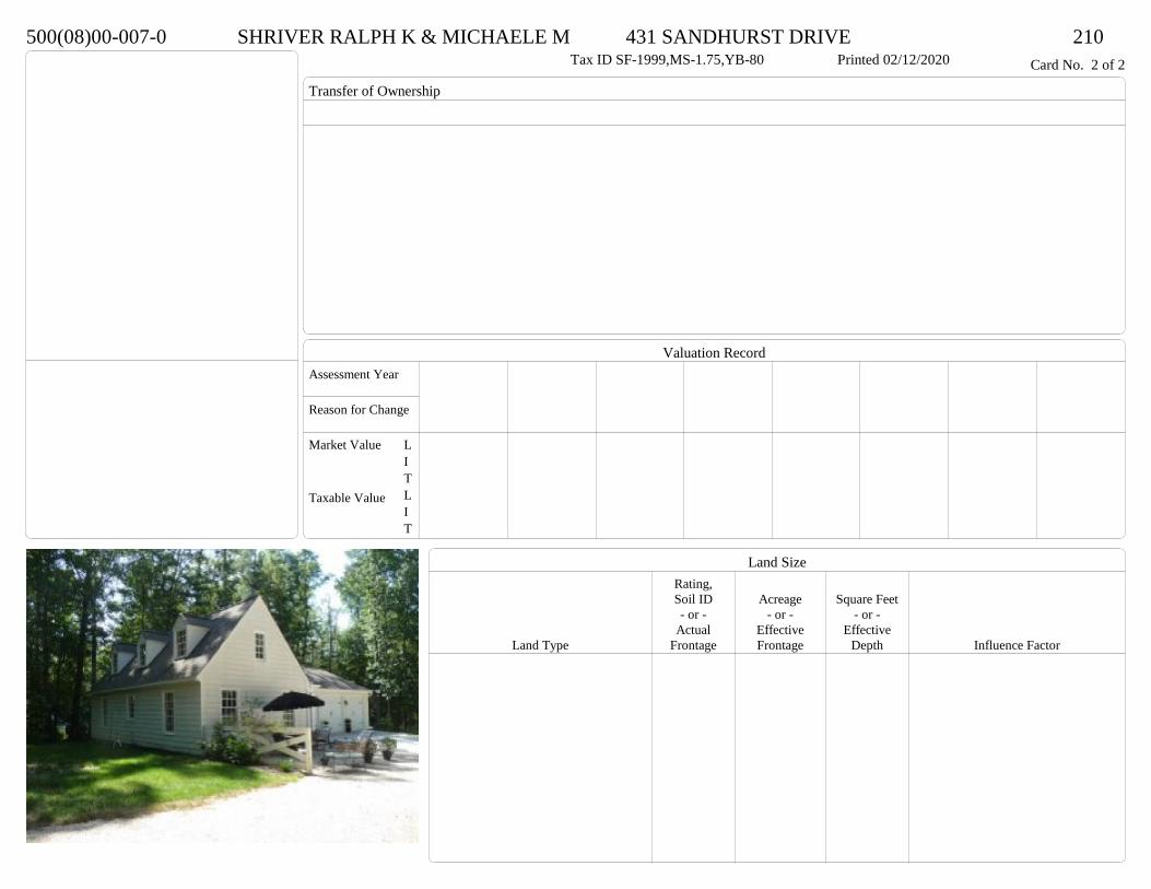
Transfer of Ownership
Valuation RecordAssessment Year
Reason for Change
Market Value
Taxable Value
LITLIT
Land SizeRating,Soil ID Acreage Square Feet- or - - or - - or -
Actual Effective EffectiveLand Type Frontage Frontage Depth Influence Factor
500(08)00-007-0 SHRIVER RALPH K & MICHAELE M 431 SANDHURST DRIVE 210Tax ID SF-1999,MS-1.75,YB-80 Printed 02/12/2020 Card No. 2 of 2

Physical Characteristics
Special Features
Description
Summary of ImprovementsStory Const Year Eff Size or
ID USE Height Type Grade Cons Year Cond Area
500(08)00-007-0 SHRIVER RALPH K & MICHAELE M 431 SANDHURST DRIVE 210Tax ID SF-1999,MS-1.75,YB-80 Printed 02/12/2020
38
20
8
624
6
6
20
1/2 s Fr (UF) 1 s Fr
C 904
55OMP
25
30
24
Fr G
720
Style: 22 1+ STORY 1980-1999Occupancy: Single family
Story Height: 1.75Finished Area: 904 Attic: NoneBasement: None
ROOFINGMaterial: Comp sh to 235#Type: GableFraming: Std for class
FLOORINGSub and joists 1.0, 1.5Base Allowance 1.0, 1.5
EXTERIOR COVERHardboard 1.0, 1.5
INTERIOR FINISH
ACCOMMODATIONFinished Rooms 3Bedrooms 1HEATING AND AIR CONDITIONINGPrimary Heat: Heat pump Lower Full Part /Bsmt 1 Upper UpperAir Cond 0 904 0 0PLUMBING # TF3 Fixt. Baths 1 3Kit Sink 1 1Water Heat 1 1 TOTAL 5
REMODELING AND MODERNIZATION Amount Date
D DWELL 0.00 48 2006 2006 3 1808G01 ATTGAR 0.00 1 720

Transfer of Ownership
Valuation RecordAssessment Year
Reason for Change
Market Value
Taxable Value
LITLIT
Land SizeRating,Soil ID Acreage Square Feet- or - - or - - or -
Actual Effective EffectiveLand Type Frontage Frontage Depth Influence Factor
420(13)00-011-0 HARRISON EARNEST W 418 OLDE KESWICK LANE 210Tax ID SF-2796,MS-1,YB-94 Printed 02/12/2020 Card No. 1 of 1HARRISON EARNEST W
P O BOX 250COLONIAL HEIGHTS, VA 23834LT:11 BK: SEC:SUB:KESWICK FORESTACRES:5.855
Neighborhood Number7014
Neighborhood NameFairwood/College Roads Area
TAXING DISTRICT INFORMATIONJurisdiction Name PRINCE GEORGE COUNTYArea 001 District P4 Section & Plat 19 /237
Site DescriptionTopography
Public Utilities
Street or Road
Neighborhood
Zoning:R-A, Residential AgriculturalLegal Acres:5.8550
Owner Consideration Transfer Date Deed Book/Page Deed TypeBARKSDALE MICHELLE LEE- 330000 01/07/2020 20 0067 SW
HARRISON EARNEST W 359000 04/30/2018 18 1304 WD
MILLER MERRILL T & KATHERINE D WILSO 357180 09/12/2007 07 4653
HARRISON EARNEST W 350000 05/04/2006 06 2336
WHITE JAMES A 229501 10/13/2004 04 5318 T
FARREN CONSTRUCTION CORP 187000 03/02/1994 382 488
2014
Reassess 66900 246900 313800 66900 246900 313800
2015
Reassess 66900 246900 313800 66900 246900 313800
2016
Reassess 66900 246900 313800 66900 246900 313800
2017
Reassess 66900 247200 314100 66900 247200 314100
2018
Reassess 66900 259500 326400 66900 259500 326400
2019
Reassess 66900 262600 329500 66900 262600 329500
2020
Reassess 73600 297000 370600 73600 297000 370600
R-A <20 - IMP

Physical Characteristics
Special Features
Description
Summary of ImprovementsStory Const Year Eff Size or
ID USE Height Type Grade Cons Year Cond Area
420(13)00-011-0 HARRISON EARNEST W 418 OLDE KESWICK LANE 210Tax ID SF-2796,MS-1,YB-94 Printed 02/12/2020
29.33.6
6.9
11.1
23.8
66.3
17.8
22
68
16.7
13.85.5
30.7
13.3
15.5
1 s Br Slab
2872
OMP
39
10
7.613.1
11.1Conc279
23
25
Br G
575
01
Gazebo w/storage area
Style: 15 1 STORY 1990-1999Occupancy: Single family
Story Height: 1.0Finished Area: 2872 Attic: NoneBasement: None
ROOFINGMaterial: Comp sh to 235#Type: HipFraming: Std for class
FLOORINGSub and joists 1.0Base Allowance 1.0
EXTERIOR COVERBrick 1.0
INTERIOR FINISHDrywall 1.0
ACCOMMODATIONFinished Rooms 7Bedrooms 4Formal Dining Rooms 1HEATING AND AIR CONDITIONINGPrimary Heat: Heat pump Lower Full Part /Bsmt 1 Upper UpperAir Cond 0 2872 0 0PLUMBING # TF3 Fixt. Baths 3 9Kit Sink 1 1Water Heat 1 1 TOTAL 11
REMODELING AND MODERNIZATION Amount Date
D DWELL 0.00 55 1994 1994 3 2872G01 ATTGAR 0.00 7 57501 GAZEBO 0.00 45 1994 1994 3 288
D : Fireplace
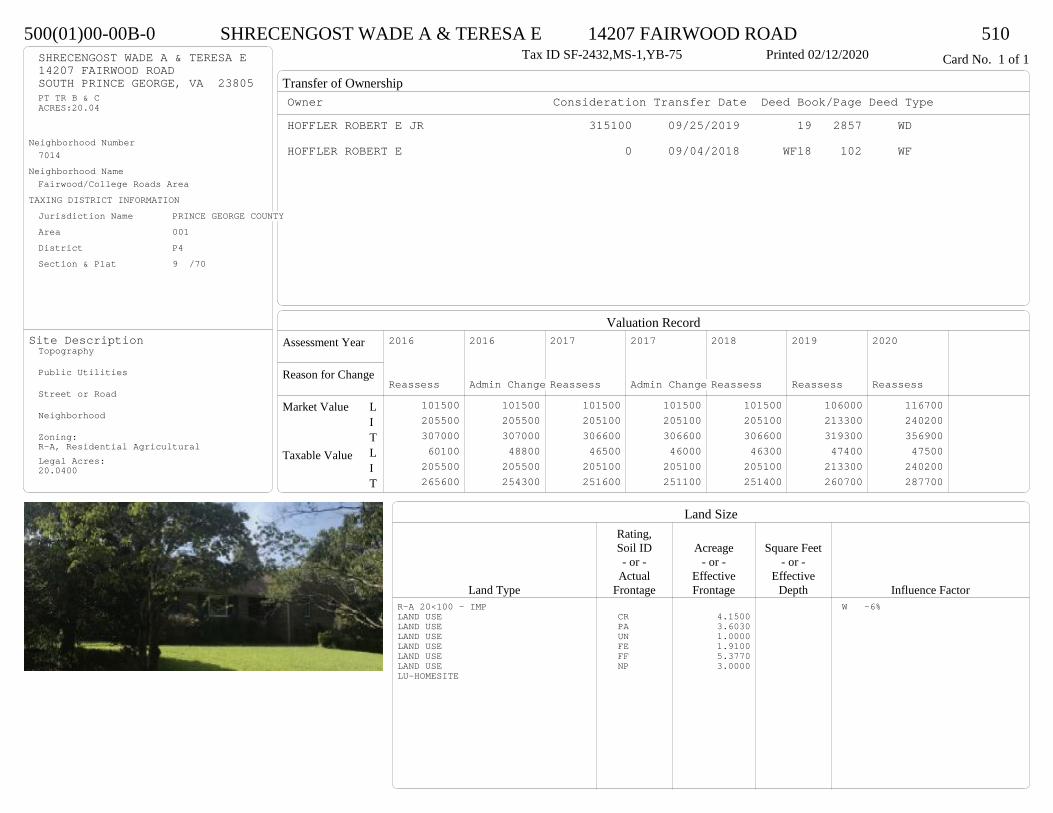
Transfer of Ownership
Valuation RecordAssessment Year
Reason for Change
Market Value
Taxable Value
LITLIT
Land SizeRating,Soil ID Acreage Square Feet- or - - or - - or -
Actual Effective EffectiveLand Type Frontage Frontage Depth Influence Factor
500(01)00-00B-0 SHRECENGOST WADE A & TERESA E 14207 FAIRWOOD ROAD 510Tax ID SF-2432,MS-1,YB-75 Printed 02/12/2020 Card No. 1 of 1SHRECENGOST WADE A & TERESA E
14207 FAIRWOOD ROADSOUTH PRINCE GEORGE, VA 23805PT TR B & CACRES:20.04
Neighborhood Number7014
Neighborhood NameFairwood/College Roads Area
TAXING DISTRICT INFORMATIONJurisdiction Name PRINCE GEORGE COUNTYArea 001 District P4 Section & Plat 9 /70
Site DescriptionTopography
Public Utilities
Street or Road
Neighborhood
Zoning:R-A, Residential AgriculturalLegal Acres:20.0400
Owner Consideration Transfer Date Deed Book/Page Deed TypeHOFFLER ROBERT E JR 315100 09/25/2019 19 2857 WD
HOFFLER ROBERT E 0 09/04/2018 WF18 102 WF
2016
Reassess 101500 205500 307000 60100 205500 265600
2016
Admin Change 101500 205500 307000 48800 205500 254300
2017
Reassess 101500 205100 306600 46500 205100 251600
2017
Admin Change 101500 205100 306600 46000 205100 251100
2018
Reassess 101500 205100 306600 46300 205100 251400
2019
Reassess 106000 213300 319300 47400 213300 260700
2020
Reassess 116700 240200 356900 47500 240200 287700
R-A 20<100 - IMP W -6%LAND USE CR 4.1500LAND USE PA 3.6030LAND USE UN 1.0000LAND USE FE 1.9100LAND USE FF 5.3770LAND USE NP 3.0000LU-HOMESITE
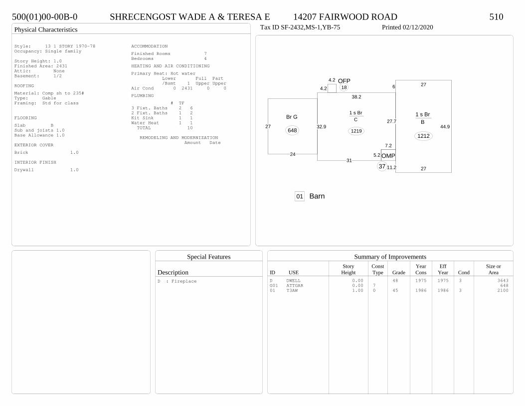
Physical Characteristics
Special Features
Description
Summary of ImprovementsStory Const Year Eff Size or
ID USE Height Type Grade Cons Year Cond Area
500(01)00-00B-0 SHRECENGOST WADE A & TERESA E 14207 FAIRWOOD ROAD 510Tax ID SF-2432,MS-1,YB-75 Printed 02/12/2020
315.2
7.2
27.7
38.2
32.9
1 s Br C
1219
6 27
44.9
2711.2
1 s Br B
1212
OMP
37
4.2
4.2 OFP18
24
27
Br G
648
01 Barn
Style: 13 1 STORY 1970-78Occupancy: Single family
Story Height: 1.0Finished Area: 2431 Attic: NoneBasement: 1/2
ROOFINGMaterial: Comp sh to 235#Type: GableFraming: Std for class
FLOORINGSlab BSub and joists 1.0Base Allowance 1.0
EXTERIOR COVERBrick 1.0
INTERIOR FINISHDrywall 1.0
ACCOMMODATIONFinished Rooms 7Bedrooms 4HEATING AND AIR CONDITIONINGPrimary Heat: Hot water Lower Full Part /Bsmt 1 Upper UpperAir Cond 0 2431 0 0PLUMBING # TF3 Fixt. Baths 2 62 Fixt. Baths 1 2Kit Sink 1 1Water Heat 1 1 TOTAL 10
REMODELING AND MODERNIZATION Amount Date
D DWELL 0.00 48 1975 1975 3 3643G01 ATTGAR 0.00 7 64801 T3AW 1.00 0 45 1986 1986 3 2100
D : Fireplace

Transfer of Ownership
Valuation RecordAssessment Year
Reason for Change
Market Value
Taxable Value
LITLIT
Land SizeRating,Soil ID Acreage Square Feet- or - - or - - or -
Actual Effective EffectiveLand Type Frontage Frontage Depth Influence Factor
500(0A)00-008-0 LAURENZ PAUL K 13900 FAIRWOOD ROAD 210Tax ID SF-2114,MS-1,YB-66 Printed 02/12/2020 Card No. 1 of 1LAURENZ PAUL K
13900 FAIRWOOD RDSOUTH PRINCE GEORGE, VA 23805WARWICK SWAMPACRES:1.9
Neighborhood Number7014
Neighborhood NameFairwood/College Roads Area
TAXING DISTRICT INFORMATIONJurisdiction Name PRINCE GEORGE COUNTYArea 001 District P4 Section & Plat 392/467
Site DescriptionTopography
Public Utilities
Street or Road
Neighborhood
Zoning:R-A, Residential AgriculturalLegal Acres:1.9000
Owner Consideration Transfer Date Deed Book/Page Deed TypeCOLLINS JOE & REBECCA N 249950 08/23/2019 19 2487 WD
HOWARD NELL R 192000 06/22/2015 15 1745 WD
HOWARD CARL R & NELL R 0 04/01/2013 CD
155500 10/04/1994 392 465
2014
Reassess 42900 159700 202600 42900 159700 202600
2015
Reassess 42900 159700 202600 42900 159700 202600
2016
Reassess 42900 157000 199900 42900 157000 199900
2017
Reassess 42900 156600 199500 42900 156600 199500
2018
Reassess 42900 156600 199500 42900 156600 199500
2019
Reassess 42900 165300 208200 42900 165300 208200
2020
Reassess 47200 172700 219900 47200 172700 219900
R-A <20 - IMP

Physical Characteristics
Special Features
Description
Summary of ImprovementsStory Const Year Eff Size or
ID USE Height Type Grade Cons Year Cond Area
500(0A)00-008-0 LAURENZ PAUL K 13900 FAIRWOOD ROAD 210Tax ID SF-2114,MS-1,YB-66 Printed 02/12/2020
70
28.8
2.52.9
5.8
1 s Br C
2087
7.8OMP
25
5.2
5.7
OMP30
Conc 165
01
Style: 12 1 STORY 1960-69Occupancy: Single family
Story Height: 1.0Finished Area: 2087 Attic: NoneBasement: None
ROOFINGMaterial: Comp sh to 235#Type: GableFraming: Std for class
FLOORINGSub and joists 1.0Base Allowance 1.0
EXTERIOR COVERBrick 1.0
INTERIOR FINISH
ACCOMMODATIONFinished Rooms 7Bedrooms 3Formal Dining Rooms 1HEATING AND AIR CONDITIONINGPrimary Heat: Hot water Lower Full Part /Bsmt 1 Upper UpperAir Cond 0 2087 0 0PLUMBING # TF3 Fixt. Baths 2 62 Fixt. Baths 1 2Kit Sink 1 1Water Heat 1 1 TOTAL 10
REMODELING AND MODERNIZATION Amount Date
D DWELL 0.00 48 1966 1966 3 208701 DETGAR 1.00 1 45 1983 1993 4 672
D : Fireplace
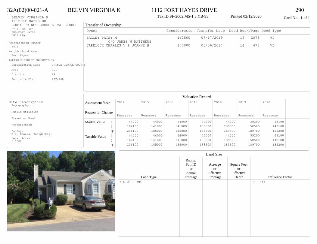
Transfer of Ownership
Valuation RecordAssessment Year
Reason for Change
Market Value
Taxable Value
LITLIT
Land SizeRating,Soil ID Acreage Square Feet- or - - or - - or -
Actual Effective EffectiveLand Type Frontage Frontage Depth Influence Factor
32A(02)00-021-A BELVIN VIRGINIA K 1112 FORT HAYES DRIVE 290Tax ID SF-2002,MS-1.5,YB-95 Printed 02/12/2020 Card No. 1 of 1BELVIN VIRGINIA K
1112 FT HAYES DRSOUTH PRINCE GEORGE, VA 23805LT:21 BK: SEC:SUB:FORT HAYESUNIT 21A
Neighborhood Number7016
Neighborhood NameFort Hayes
TAXING DISTRICT INFORMATIONJurisdiction Name PRINCE GEORGE COUNTYArea 001 District P4 Section & Plat 277/760
Site DescriptionTopography
Public Utilities
Street or Road
Neighborhood
Zoning:R-2, General ResidentialLegal Acres:0.0000
Owner Consideration Transfer Date Deed Book/Page Deed TypeBAGLEY PATSY M 162500 07/17/2019 19 2073 WD
C/O JAMES W MATTHEWSCARELOCK CHARLES V & JOANNE H 175000 03/06/2014 14 478 WD
2014
Reassess 44000 162100 206100 44000 162100 206100
2015
Reassess 44000 141000 185000 44000 141000 185000
2016
Reassess 44000 141000 185000 44000 141000 185000
2017
Reassess 44000 139500 183500 44000 139500 183500
2018
Reassess 44000 139500 183500 44000 139500 183500
2019
Reassess 39200 150500 189700 39200 150500 189700
2020
Reassess 43100 142100 185200 43100 142100 185200
R-A <20 - IMP L -11%
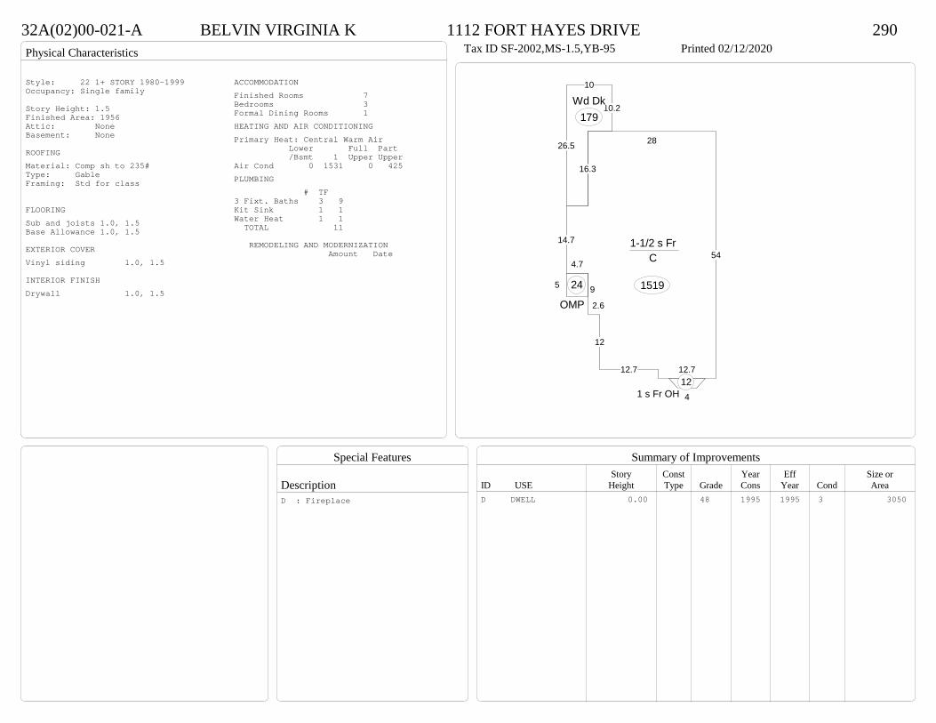
Physical Characteristics
Special Features
Description
Summary of ImprovementsStory Const Year Eff Size or
ID USE Height Type Grade Cons Year Cond Area
32A(02)00-021-A BELVIN VIRGINIA K 1112 FORT HAYES DRIVE 290Tax ID SF-2002,MS-1.5,YB-95 Printed 02/12/2020
54
12.712.7
12
2.6
9
4.7
14.7
16.3
28
1-1/2 s Fr C
1519
26.5
10
10.2Wd Dk
179
5
OMP
24
41 s Fr OH 12
Style: 22 1+ STORY 1980-1999Occupancy: Single family
Story Height: 1.5Finished Area: 1956 Attic: NoneBasement: None
ROOFINGMaterial: Comp sh to 235#Type: GableFraming: Std for class
FLOORINGSub and joists 1.0, 1.5Base Allowance 1.0, 1.5
EXTERIOR COVERVinyl siding 1.0, 1.5
INTERIOR FINISHDrywall 1.0, 1.5
ACCOMMODATIONFinished Rooms 7Bedrooms 3Formal Dining Rooms 1HEATING AND AIR CONDITIONINGPrimary Heat: Central Warm Air Lower Full Part /Bsmt 1 Upper UpperAir Cond 0 1531 0 425PLUMBING # TF3 Fixt. Baths 3 9Kit Sink 1 1Water Heat 1 1 TOTAL 11
REMODELING AND MODERNIZATION Amount Date
D DWELL 0.00 48 1995 1995 3 3050D : Fireplace
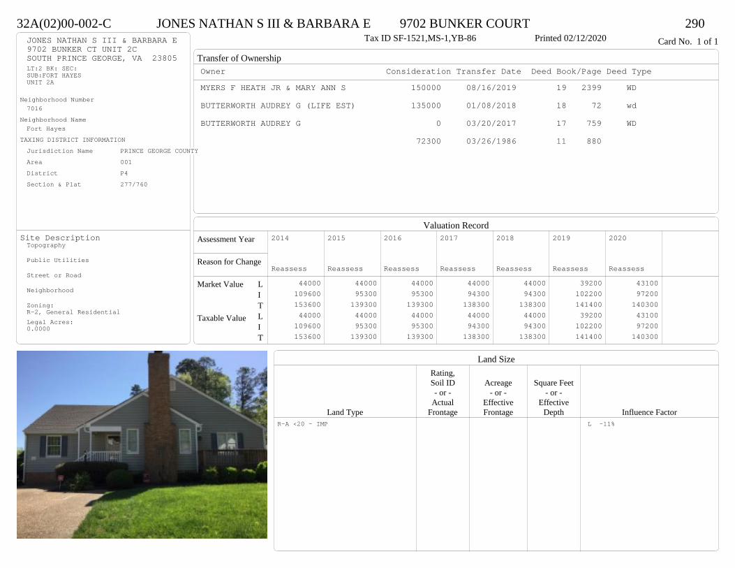
Transfer of Ownership
Valuation RecordAssessment Year
Reason for Change
Market Value
Taxable Value
LITLIT
Land SizeRating,Soil ID Acreage Square Feet- or - - or - - or -
Actual Effective EffectiveLand Type Frontage Frontage Depth Influence Factor
32A(02)00-002-C JONES NATHAN S III & BARBARA E 9702 BUNKER COURT 290Tax ID SF-1521,MS-1,YB-86 Printed 02/12/2020 Card No. 1 of 1JONES NATHAN S III & BARBARA E
9702 BUNKER CT UNIT 2CSOUTH PRINCE GEORGE, VA 23805LT:2 BK: SEC:SUB:FORT HAYESUNIT 2A
Neighborhood Number7016
Neighborhood NameFort Hayes
TAXING DISTRICT INFORMATIONJurisdiction Name PRINCE GEORGE COUNTYArea 001 District P4 Section & Plat 277/760
Site DescriptionTopography
Public Utilities
Street or Road
Neighborhood
Zoning:R-2, General ResidentialLegal Acres:0.0000
Owner Consideration Transfer Date Deed Book/Page Deed TypeMYERS F HEATH JR & MARY ANN S 150000 08/16/2019 19 2399 WD
BUTTERWORTH AUDREY G (LIFE EST) 135000 01/08/2018 18 72 wd
BUTTERWORTH AUDREY G 0 03/20/2017 17 759 WD
72300 03/26/1986 11 880
2014
Reassess 44000 109600 153600 44000 109600 153600
2015
Reassess 44000 95300 139300 44000 95300 139300
2016
Reassess 44000 95300 139300 44000 95300 139300
2017
Reassess 44000 94300 138300 44000 94300 138300
2018
Reassess 44000 94300 138300 44000 94300 138300
2019
Reassess 39200 102200 141400 39200 102200 141400
2020
Reassess 43100 97200 140300 43100 97200 140300
R-A <20 - IMP L -11%
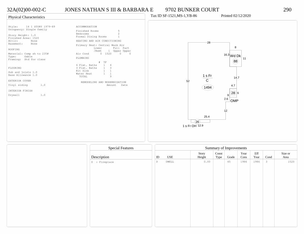
Physical Characteristics
Special Features
Description
Summary of ImprovementsStory Const Year Eff Size or
ID USE Height Type Grade Cons Year Cond Area
32A(02)00-002-C JONES NATHAN S III & BARBARA E 9702 BUNKER COURT 290Tax ID SF-1521,MS-1,YB-86 Printed 02/12/2020
52
25.4
12
2.69
4.7
14.7
16.3
28
1 s Fr C
1494
12.91 s Fr OH 26
11
8
Wd Dk88
6
OMP
28
Style: 14 1 STORY 1979-89Occupancy: Single family
Story Height: 1.0Finished Area: 1520 Attic: NoneBasement: None
ROOFINGMaterial: Comp sh to 235#Type: GableFraming: Std for class
FLOORINGSub and joists 1.0Base Allowance 1.0
EXTERIOR COVERVinyl siding 1.0
INTERIOR FINISHDrywall 1.0
ACCOMMODATIONFinished Rooms 5Bedrooms 2Formal Dining Rooms 1HEATING AND AIR CONDITIONINGPrimary Heat: Central Warm Air Lower Full Part /Bsmt 1 Upper UpperAir Cond 0 1520 0 0PLUMBING # TF4 Fixt. Baths 1 43 Fixt. Baths 1 3Kit Sink 1 1Water Heat 1 1 TOTAL 9
REMODELING AND MODERNIZATION Amount Date
D DWELL 0.00 45 1986 1986 3 1520D : Fireplace
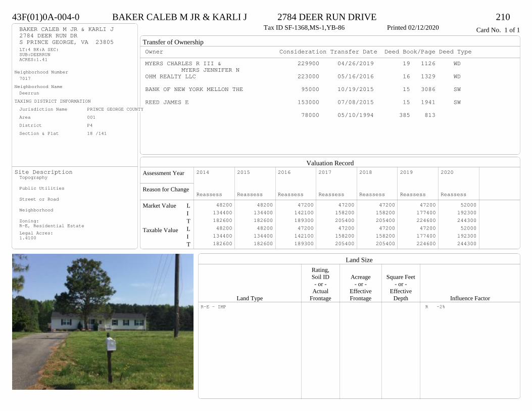
Transfer of Ownership
Valuation RecordAssessment Year
Reason for Change
Market Value
Taxable Value
LITLIT
Land SizeRating,Soil ID Acreage Square Feet- or - - or - - or -
Actual Effective EffectiveLand Type Frontage Frontage Depth Influence Factor
43F(01)0A-004-0 BAKER CALEB M JR & KARLI J 2784 DEER RUN DRIVE 210Tax ID SF-1368,MS-1,YB-86 Printed 02/12/2020 Card No. 1 of 1BAKER CALEB M JR & KARLI J
2784 DEER RUN DRS PRINCE GEORGE, VA 23805LT:4 BK:A SEC:SUB:DEERRUNACRES:1.41
Neighborhood Number7017
Neighborhood NameDeerrun
TAXING DISTRICT INFORMATIONJurisdiction Name PRINCE GEORGE COUNTYArea 001 District P4 Section & Plat 18 /141
Site DescriptionTopography
Public Utilities
Street or Road
Neighborhood
Zoning:R-E, Residential EstateLegal Acres:1.4100
Owner Consideration Transfer Date Deed Book/Page Deed TypeMYERS CHARLES R III & 229900 04/26/2019 19 1126 WD
MYERS JENNIFER NOHM REALTY LLC 223000 05/16/2016 16 1329 WD
BANK OF NEW YORK MELLON THE 95000 10/19/2015 15 3086 SW
REED JAMES E 153000 07/08/2015 15 1941 SW
78000 05/10/1994 385 813
2014
Reassess 48200 134400 182600 48200 134400 182600
2015
Reassess 48200 134400 182600 48200 134400 182600
2016
Reassess 47200 142100 189300 47200 142100 189300
2017
Reassess 47200 158200 205400 47200 158200 205400
2018
Reassess 47200 158200 205400 47200 158200 205400
2019
Reassess 47200 177400 224600 47200 177400 224600
2020
Reassess 52000 192300 244300 52000 192300 244300
R-E - IMP R -2%

Physical Characteristics
Special Features
Description
Summary of ImprovementsStory Const Year Eff Size or
ID USE Height Type Grade Cons Year Cond Area
43F(01)0A-004-0 BAKER CALEB M JR & KARLI J 2784 DEER RUN DRIVE 210Tax ID SF-1368,MS-1,YB-86 Printed 02/12/2020
56
24
1 s Fr C
1344
24
24
1 s Fr C
576
624
OMP 144
56
Wd Dk30
16
28
10Wd Dk 304
25
28
25
28
Conc700
2000 addition
Style: 14 1 STORY 1979-89Occupancy: Single family
Story Height: 1.0Finished Area: 1920 Attic: NoneBasement: None
ROOFINGMaterial: Comp sh to 235#Type: GableFraming: Std for class
FLOORINGSub and joists 1.0Base Allowance 1.0
EXTERIOR COVERVinyl siding 1.0
INTERIOR FINISHDrywall 1.0
ACCOMMODATIONFinished Rooms 5Bedrooms 3HEATING AND AIR CONDITIONINGPrimary Heat: Heat pump Lower Full Part /Bsmt 1 Upper UpperAir Cond 0 1920 0 0PLUMBING # TF3 Fixt. Baths 2 6Kit Sink 1 1Water Heat 1 1 TOTAL 8
REMODELING AND MODERNIZATION Amount Date
D DWELL 0.00 48 1986 1995 3 1920D : Remod 2016 Fireplace
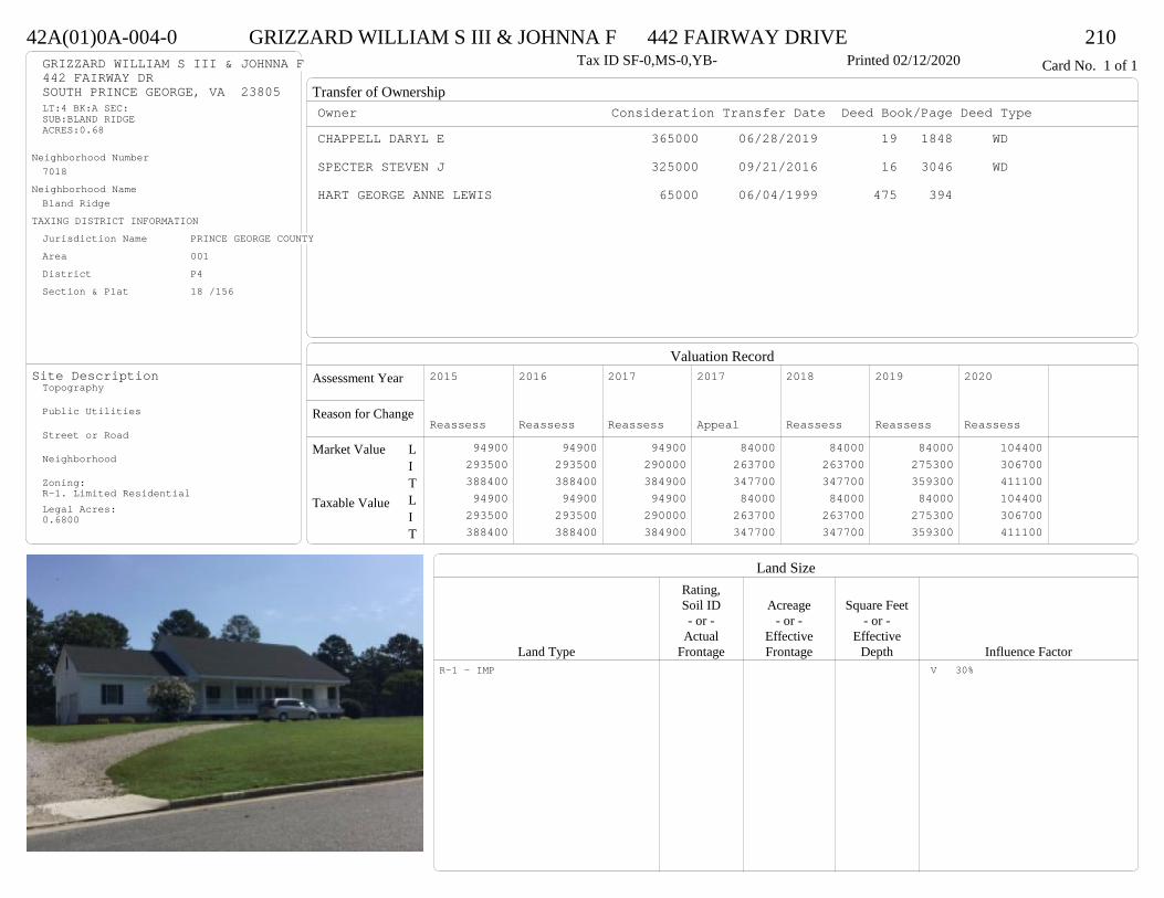
Transfer of Ownership
Valuation RecordAssessment Year
Reason for Change
Market Value
Taxable Value
LITLIT
Land SizeRating,Soil ID Acreage Square Feet- or - - or - - or -
Actual Effective EffectiveLand Type Frontage Frontage Depth Influence Factor
42A(01)0A-004-0 GRIZZARD WILLIAM S III & JOHNNA F 442 FAIRWAY DRIVE 210Tax ID SF-0,MS-0,YB- Printed 02/12/2020 Card No. 1 of 1GRIZZARD WILLIAM S III & JOHNNA F
442 FAIRWAY DRSOUTH PRINCE GEORGE, VA 23805LT:4 BK:A SEC:SUB:BLAND RIDGEACRES:0.68
Neighborhood Number7018
Neighborhood NameBland Ridge
TAXING DISTRICT INFORMATIONJurisdiction Name PRINCE GEORGE COUNTYArea 001 District P4 Section & Plat 18 /156
Site DescriptionTopography
Public Utilities
Street or Road
Neighborhood
Zoning:R-1. Limited ResidentialLegal Acres:0.6800
Owner Consideration Transfer Date Deed Book/Page Deed TypeCHAPPELL DARYL E 365000 06/28/2019 19 1848 WD
SPECTER STEVEN J 325000 09/21/2016 16 3046 WD
HART GEORGE ANNE LEWIS 65000 06/04/1999 475 394
2015
Reassess 94900 293500 388400 94900 293500 388400
2016
Reassess 94900 293500 388400 94900 293500 388400
2017
Reassess 94900 290000 384900 94900 290000 384900
2017
Appeal 84000 263700 347700 84000 263700 347700
2018
Reassess 84000 263700 347700 84000 263700 347700
2019
Reassess 84000 275300 359300 84000 275300 359300
2020
Reassess 104400 306700 411100 104400 306700 411100
R-1 - IMP V 30%
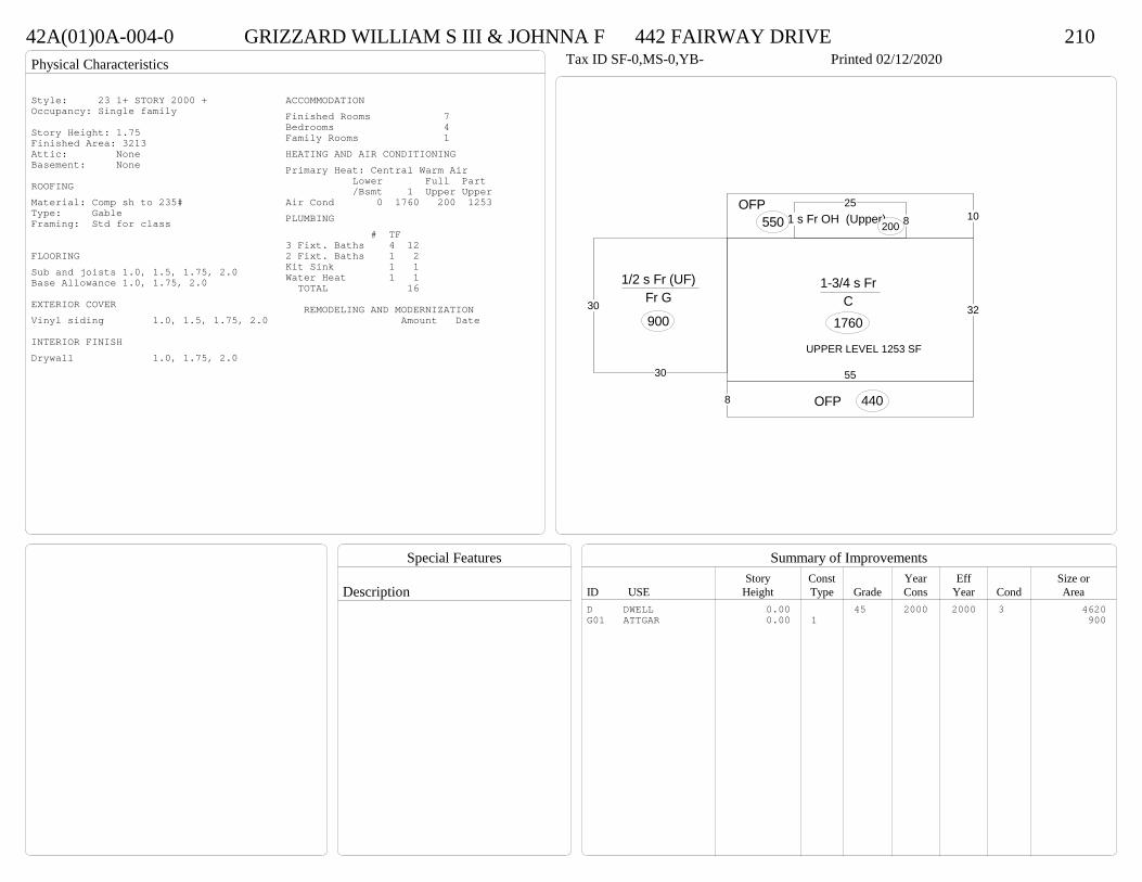
Physical Characteristics
Special Features
Description
Summary of ImprovementsStory Const Year Eff Size or
ID USE Height Type Grade Cons Year Cond Area
42A(01)0A-004-0 GRIZZARD WILLIAM S III & JOHNNA F 442 FAIRWAY DRIVE 210Tax ID SF-0,MS-0,YB- Printed 02/12/2020
55
32
1-3/4 s Fr C
1760
825
1 s Fr OH (Upper)20010
OFP550
8 OFP 440
30
30
1/2 s Fr (UF) Fr G
900
UPPER LEVEL 1253 SF
Style: 23 1+ STORY 2000 +Occupancy: Single family
Story Height: 1.75Finished Area: 3213 Attic: NoneBasement: None
ROOFINGMaterial: Comp sh to 235#Type: GableFraming: Std for class
FLOORINGSub and joists 1.0, 1.5, 1.75, 2.0Base Allowance 1.0, 1.75, 2.0
EXTERIOR COVERVinyl siding 1.0, 1.5, 1.75, 2.0
INTERIOR FINISHDrywall 1.0, 1.75, 2.0
ACCOMMODATIONFinished Rooms 7Bedrooms 4Family Rooms 1HEATING AND AIR CONDITIONINGPrimary Heat: Central Warm Air Lower Full Part /Bsmt 1 Upper UpperAir Cond 0 1760 200 1253PLUMBING # TF3 Fixt. Baths 4 122 Fixt. Baths 1 2Kit Sink 1 1Water Heat 1 1 TOTAL 16
REMODELING AND MODERNIZATION Amount Date
D DWELL 0.00 45 2000 2000 3 4620G01 ATTGAR 0.00 1 900

Transfer of Ownership
Valuation RecordAssessment Year
Reason for Change
Market Value
Taxable Value
LITLIT
Land SizeRating,Soil ID Acreage Square Feet- or - - or - - or -
Actual Effective EffectiveLand Type Frontage Frontage Depth Influence Factor
440(10)00-001-V LYNN DONALD R & JUDITH P 5700 JONZAC DRIVE 210Printed 02/12/2020 Card No. 1 of 1LYNN DONALD R & JUDITH P
5700 JONZAC DRDISPUTANTA, VA 23842LOT VPT HELEN FULCHER PRACRES:6.375
Neighborhood Number7024
Neighborhood NameSpencer Lane/Jonzac Drive Area
TAXING DISTRICT INFORMATIONJurisdiction Name PRINCE GEORGE COUNTYArea 001 District P4
Site DescriptionTopography
Public Utilities
Street or Road
Neighborhood
Zoning:R-A, Residential AgriculturalLegal Acres:6.3750
Owner Consideration Transfer Date Deed Book/Page Deed TypeMIKELL JARED 339000 04/01/2019 19 874 WD
PICKETT REBECCA A 203500 10/26/2017 17 3189 SW
CAPPS REBECCA A 0 01/10/2011 12 96 OR
PRIMACY CLOSING CORP 330731 07/02/2009 09 2432 TR
MORGAN NEIL R & KYONG O 374000 07/02/2009 09 2431 TR
SOBER PROPERTIES INC 330000 09/18/2006 06 4911
2014
Reassess 62500 231200 293700 62500 231200 293700
2015
Reassess 62500 231200 293700 62500 231200 293700
2016
Reassess 62500 231200 293700 62500 231200 293700
2017
Reassess 62500 226300 288800 62500 226300 288800
2018
Reassess 62500 221600 284100 62500 221600 284100
2019
Reassess 62500 236500 299000 62500 236500 299000
2020
Reassess 68700 296800 365500 68700 296800 365500
R-A <20 - IMP A -10%

Physical Characteristics
Special Features
Description
Summary of ImprovementsStory Const Year Eff Size or
ID USE Height Type Grade Cons Year Cond Area
440(10)00-001-V LYNN DONALD R & JUDITH P 5700 JONZAC DRIVE 210Printed 02/12/2020
40.8
51.3
20
15.4
3.8 5.5
14
11.3 2 6.3
5 12.8
1-1/2 s Br C
1614 4
11.5
1 s Br C
46
OMP37
10
11.9Wd Dk
119
23
20.9
26.8
1/2 s Fr (Fin) Br G
539
01
Style: 23 1+ STORY 2000 +Occupancy: Single family
Story Height: 1.5Finished Area: 2532 Attic: NoneBasement: None
ROOFINGMaterial: Comp sh to 235#Type: HipFraming: Std for class
FLOORINGSlab 1.0Sub and joists 1.5Base Allowance 1.0, 1.5
EXTERIOR COVERBrick 1.0Vinyl siding 1.5
INTERIOR FINISHDrywall 1.0
ACCOMMODATIONFinished Rooms 11Bedrooms 4Family Rooms 1Formal Dining Rooms 1HEATING AND AIR CONDITIONINGPrimary Heat: Heat pump Lower Full Part /Bsmt 1 Upper UpperAir Cond 0 1660 0 872PLUMBING # TF5 Fixt. Baths 1 53 Fixt. Baths 2 62 Fixt. Baths 1 2Kit Sink 1 1Water Heat 1 1 TOTAL 15
REMODELING AND MODERNIZATION Amount Date
D DWELL 0.00 48 2006 2006 3 3813G01 ATTGAR 0.00 7 53901 DETGAR 2.00 1 45 2019 2019 3 1362
D : Fireplace01 : Concrete floor, Electric lights & service
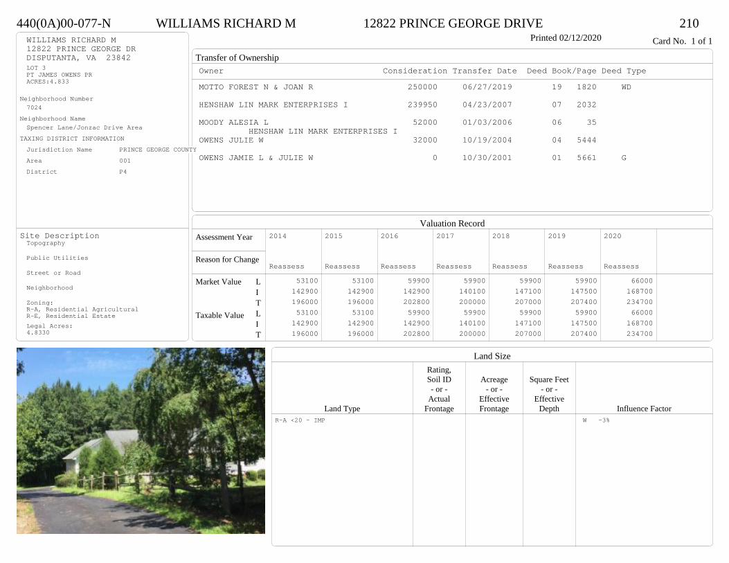
Transfer of Ownership
Valuation RecordAssessment Year
Reason for Change
Market Value
Taxable Value
LITLIT
Land SizeRating,Soil ID Acreage Square Feet- or - - or - - or -
Actual Effective EffectiveLand Type Frontage Frontage Depth Influence Factor
440(0A)00-077-N WILLIAMS RICHARD M 12822 PRINCE GEORGE DRIVE 210Printed 02/12/2020 Card No. 1 of 1WILLIAMS RICHARD M
12822 PRINCE GEORGE DRDISPUTANTA, VA 23842LOT 3PT JAMES OWENS PRACRES:4.833
Neighborhood Number7024
Neighborhood NameSpencer Lane/Jonzac Drive Area
TAXING DISTRICT INFORMATIONJurisdiction Name PRINCE GEORGE COUNTYArea 001 District P4
Site DescriptionTopography
Public Utilities
Street or Road
Neighborhood
Zoning:R-A, Residential AgriculturalR-E, Residential EstateLegal Acres:4.8330
Owner Consideration Transfer Date Deed Book/Page Deed TypeMOTTO FOREST N & JOAN R 250000 06/27/2019 19 1820 WD
HENSHAW LIN MARK ENTERPRISES I 239950 04/23/2007 07 2032
MOODY ALESIA L 52000 01/03/2006 06 35 HENSHAW LIN MARK ENTERPRISES I
OWENS JULIE W 32000 10/19/2004 04 5444
OWENS JAMIE L & JULIE W 0 10/30/2001 01 5661 G
2014
Reassess 53100 142900 196000 53100 142900 196000
2015
Reassess 53100 142900 196000 53100 142900 196000
2016
Reassess 59900 142900 202800 59900 142900 202800
2017
Reassess 59900 140100 200000 59900 140100 200000
2018
Reassess 59900 147100 207000 59900 147100 207000
2019
Reassess 59900 147500 207400 59900 147500 207400
2020
Reassess 66000 168700 234700 66000 168700 234700
R-A <20 - IMP W -3%

Physical Characteristics
Special Features
Description
Summary of ImprovementsStory Const Year Eff Size or
ID USE Height Type Grade Cons Year Cond Area
440(0A)00-077-N WILLIAMS RICHARD M 12822 PRINCE GEORGE DRIVE 210Printed 02/12/2020
20
16
1 s Fr Cathedral C
320
18 18
28
334.563
13.8
28.2
1 s Fr C
1275
626
OMP 156
8.8
11.6
12
8.5
Wd Dk
134
24
24
Fr G
576
Style: 16 1 STORY 2000-2009Occupancy: Single family
Story Height: 1.0Finished Area: 1595 Attic: NoneBasement: None
ROOFINGMaterial: Comp sh to 235#Type: GableFraming: Std for class
FLOORINGSub and joists 1.0Base Allowance 1.0
EXTERIOR COVERVinyl siding 1.0
INTERIOR FINISH
ACCOMMODATIONFinished Rooms 6Bedrooms 3Family Rooms 1HEATING AND AIR CONDITIONINGPrimary Heat: Heat pump Lower Full Part /Bsmt 1 Upper UpperAir Cond 0 1595 0 0PLUMBING # TF4 Fixt. Baths 1 43 Fixt. Baths 1 32 Fixt. Baths 1 2Kit Sink 1 1Water Heat 1 1 TOTAL 11
REMODELING AND MODERNIZATION Amount Date
D DWELL 0.00 45 2006 2006 3 1595G01 ATTGAR 0.00 1 576
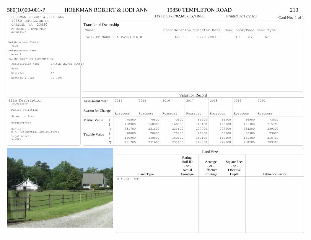
Transfer of Ownership
Valuation RecordAssessment Year
Reason for Change
Market Value
Taxable Value
LITLIT
Land SizeRating,Soil ID Acreage Square Feet- or - - or - - or -
Actual Effective EffectiveLand Type Frontage Frontage Depth Influence Factor
580(10)00-001-P HOEKMAN ROBERT & JODI ANN 19850 TEMPLETON ROAD 210Tax ID SF-1782,MS-1.5,YB-90 Printed 02/12/2020 Card No. 1 of 1HOEKMAN ROBERT & JODI ANN
19850 TEMPLETON RDCARSON, VA 23830PT DENNIS F HARE PROPACRES:6.7
Neighborhood Number7100
Neighborhood NameArea 7
TAXING DISTRICT INFORMATIONJurisdiction Name PRINCE GEORGE COUNTYArea 001 District P5 Section & Plat 19 /198
Site DescriptionTopography
Public Utilities
Street or Road
Neighborhood
Zoning:R-A, Residential AgriculturalLegal Acres:6.7000
Owner Consideration Transfer Date Deed Book/Page Deed TypeTALBOTT MARK E & PATRICIA H 369950 07/01/2019 19 1879 WD
2014
Reassess 70800 160900 231700 70800 160900 231700
2015
Reassess 70800 160800 231600 70800 160800 231600
2016
Reassess 70800 160800 231600 70800 160800 231600
2017
Reassess 66900 160100 227000 66900 160100 227000
2018
Reassess 66900 160100 227000 66900 160100 227000
2019
Reassess 66900 191300 258200 66900 191300 258200
2020
Reassess 73600 215700 289300 73600 215700 289300
R-A <20 - IMP

Physical Characteristics
Special Features
Description
Summary of ImprovementsStory Const Year Eff Size or
ID USE Height Type Grade Cons Year Cond Area
580(10)00-001-P HOEKMAN ROBERT & JODI ANN 19850 TEMPLETON ROAD 210Tax ID SF-1782,MS-1.5,YB-90 Printed 02/12/2020
30
36
1-1/2 s Fr C
1080
6OFP 216
12
13.51 s Fr
C 162
16
13
Wd Dk
208
22
22
1/2 s Fr (Fin) Fr G
484
0405
Style: 22 1+ STORY 1980-1999Occupancy: Single family
Story Height: 1.5Finished Area: 2308 Attic: NoneBasement: None
ROOFINGMaterial: Comp sh to 235#Type: GableFraming: Std for class
FLOORINGSub and joists 1.0, 1.5Base Allowance 1.0, 1.5
EXTERIOR COVERVinyl siding 1.0, 1.5
INTERIOR FINISH
ACCOMMODATIONFinished Rooms 7Bedrooms 3HEATING AND AIR CONDITIONINGPrimary Heat: Heat pump Lower Full Part /Bsmt 1 Upper UpperAir Cond 0 1242 0 1066PLUMBING # TF3 Fixt. Baths 2 6Kit Sink 1 1Water Heat 1 1 TOTAL 8
REMODELING AND MODERNIZATION Amount Date
D DWELL 0.00 48 1990 1990 3 2806G01 ATTGAR 0.00 1 48404 SMALL 10.00 1 48 2006 2006 3 144005 LEANTO 10.00 0 45 2006 2006 3 360
D : Fireplace
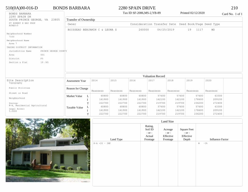
Transfer of Ownership
Valuation RecordAssessment Year
Reason for Change
Market Value
Taxable Value
LITLIT
Land SizeRating,Soil ID Acreage Square Feet- or - - or - - or -
Actual Effective EffectiveLand Type Frontage Frontage Depth Influence Factor
510(0A)00-016-D BONDS BARBARA 2280 SPAIN DRIVE 210Tax ID SF-2086,MS-2,YB-89 Printed 02/12/2020 Card No. 1 of 1BONDS BARBARA
2280 SPAIN DRSOUTH PRINCE GEORGE, VA 23805PT ROBERT E NAY PROPACRES:5
Neighborhood Number7100
Neighborhood NameArea 7
TAXING DISTRICT INFORMATIONJurisdiction Name PRINCE GEORGE COUNTYArea 001 District P5 Section & Plat 19 /65
Site DescriptionTopography
Public Utilities
Street or Road
Neighborhood
Zoning:R-A, Residential AgriculturalLegal Acres:5.0000
Owner Consideration Transfer Date Deed Book/Page Deed TypeBOISSEAU BENJAMIN C & LEONA S 260000 04/25/2019 19 1117 WD
2014
Reassess 60800 161900 222700 60800 161900 222700
2015
Reassess 60800 161900 222700 60800 161900 222700
2016
Reassess 60800 161900 222700 60800 161900 222700
2017
Reassess 57600 162100 219700 57600 162100 219700
2018
Reassess 57600 162100 219700 57600 162100 219700
2019
Reassess 57600 178600 236200 57600 178600 236200
2020
Reassess 63300 209100 272400 63300 209100 272400
R-A <20 - IMP W -3%
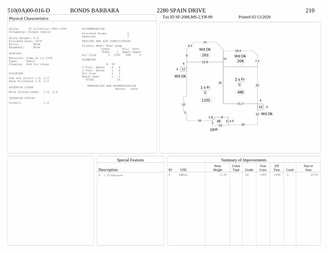
Physical Characteristics
Special Features
Description
Summary of ImprovementsStory Const Year Eff Size or
ID USE Height Type Grade Cons Year Cond Area
510(0A)00-016-D BONDS BARBARA 2280 SPAIN DRIVE 210Tax ID SF-2086,MS-2,YB-89 Printed 02/12/2020
23
21.2
2 s Fr C
488
13
184.5
82.816
2
10
22.8
261 s Fr
C
1102
5310
OFP
48
8
6.214
Wd Dk263
4
4
Wd Dk
16
4
3
Wd Dk
12
10
18.4
7.2Wd Dk
208
Style: 32 2/2+Story 1980-1999Occupancy: Single family
Story Height: 2.0Finished Area: 2078 Attic: NoneBasement: None
ROOFINGMaterial: Comp sh to 235#Type: GableFraming: Std for class
FLOORINGSub and joists 1.0, 2.0Base Allowance 1.0, 2.0
EXTERIOR COVERWood siding-cedar 1.0, 2.0
INTERIOR FINISHDrywall 1.0
ACCOMMODATIONFinished Rooms 5Bedrooms 3HEATING AND AIR CONDITIONINGPrimary Heat: Heat pump Lower Full Part /Bsmt 1 Upper UpperAir Cond 0 1590 488 0PLUMBING # TF3 Fixt. Baths 2 62 Fixt. Baths 1 2Kit Sink 1 1Water Heat 1 1 TOTAL 10
REMODELING AND MODERNIZATION Amount Date
D DWELL 0.00 48 1989 1998 3 2078D : Fireplace
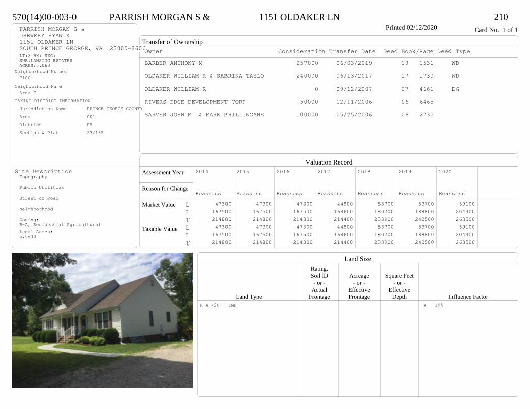
Transfer of Ownership
Valuation RecordAssessment Year
Reason for Change
Market Value
Taxable Value
LITLIT
Land SizeRating,Soil ID Acreage Square Feet- or - - or - - or -
Actual Effective EffectiveLand Type Frontage Frontage Depth Influence Factor
570(14)00-003-0 PARRISH MORGAN S & 1151 OLDAKER LN 210Printed 02/12/2020 Card No. 1 of 1PARRISH MORGAN S &
DREWERY RYAN K1151 OLDAKER LNSOUTH PRINCE GEORGE, VA 23805-8606LT:3 BK: SEC:SUB:LANSING ESTATESACRES:5.063
Neighborhood Number7100
Neighborhood NameArea 7
TAXING DISTRICT INFORMATIONJurisdiction Name PRINCE GEORGE COUNTYArea 001 District P5 Section & Plat 23/185
Site DescriptionTopography
Public Utilities
Street or Road
Neighborhood
Zoning:R-A, Residential AgriculturalLegal Acres:5.0630
Owner Consideration Transfer Date Deed Book/Page Deed TypeBARBER ANTHONY M 257000 06/03/2019 19 1531 WD
OLDAKER WILLIAM R & SABRINA TAYLO 240000 06/13/2017 17 1730 WD
OLDAKER WILLIAM R 0 09/12/2007 07 4661 DG
RIVERS EDGE DEVELOPMENT CORP 50000 12/11/2006 06 6465
SARVER JOHN M & MARK PHILLINGANE 100000 05/25/2006 06 2735
2014
Reassess 47300 167500 214800 47300 167500 214800
2015
Reassess 47300 167500 214800 47300 167500 214800
2016
Reassess 47300 167500 214800 47300 167500 214800
2017
Reassess 44800 169600 214400 44800 169600 214400
2018
Reassess 53700 180200 233900 53700 180200 233900
2019
Reassess 53700 188800 242500 53700 188800 242500
2020
Reassess 59100 204400 263500 59100 204400 263500
R-A <20 - IMP A -10%

Physical Characteristics
Special Features
Description
Summary of ImprovementsStory Const Year Eff Size or
ID USE Height Type Grade Cons Year Cond Area
570(14)00-003-0 PARRISH MORGAN S & 1151 OLDAKER LN 210Printed 02/12/2020
23
32
27
17
4
15
1 s Fr Cathedral C
804
15
32
3
612
381 s Fr
C
552
15
32
19
1 s Fr C
540
626.1
OFP 157
14
20
Wd Dk
2803.8
OFP11
26
28.5
12
12
Conc
510
Style: 16 1 STORY 2000-2009Occupancy: Single family
Story Height: 1.0Finished Area: 1896 Attic: NoneBasement: None
ROOFINGMaterial: Comp sh to 235#Type: GableFraming: Std for class
FLOORINGSub and joists 1.0Base Allowance 1.0
EXTERIOR COVERVinyl siding 1.0
INTERIOR FINISH
ACCOMMODATIONFinished Rooms 7Bedrooms 3Family Rooms 1Formal Dining Rooms 1HEATING AND AIR CONDITIONINGPrimary Heat: Heat pump Lower Full Part /Bsmt 1 Upper UpperAir Cond 0 1896 0 0PLUMBING # TF5 Fixt. Baths 1 53 Fixt. Baths 1 3Kit Sink 1 1Water Heat 1 1 TOTAL 10
REMODELING AND MODERNIZATION Amount Date
D DWELL 0.00 48 2007 2007 3 1896D : Fireplace
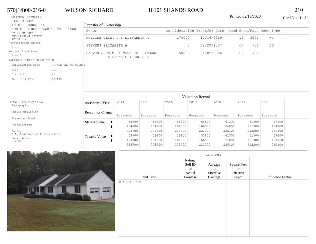
Transfer of Ownership
Valuation RecordAssessment Year
Reason for Change
Market Value
Taxable Value
LITLIT
Land SizeRating,Soil ID Acreage Square Feet- or - - or - - or -
Actual Effective EffectiveLand Type Frontage Frontage Depth Influence Factor
570(14)00-016-0 WILSON RICHARD 18101 SHANDS ROAD 210Printed 02/12/2020 Card No. 1 of 1WILSON RICHARD
HALL KELLY18101 SHANDS RDSOUTH PRINCE GEORGE, VA 23805LT:16 BK: SEC:SUB:LANSING ESTATESACRES:5.40
Neighborhood Number7100
Neighborhood NameArea 7
TAXING DISTRICT INFORMATIONJurisdiction Name PRINCE GEORGE COUNTYArea 001 District P5 Section & Plat 23/185
Site DescriptionTopography
Public Utilities
Street or Road
Neighborhood
Zoning:R-A, Residential AgriculturalLegal Acres:5.4000
Owner Consideration Transfer Date Deed Book/Page Deed TypeHOLCOMB CLINT J & ELIZABETH A 270000 10/16/2019 19 3076 WD
STEVENS ELIZABETH A 0 02/20/2007 07 936 DG
SARVER JOHN M & MARK PHILLINGANE 50000 04/05/2006 06 1795 STEVENS ELIZABETH A
2014
Reassess 58900 164800 223700 58900 164800 223700
2015
Reassess 58900 164800 223700 58900 164800 223700
2016
Reassess 58900 164800 223700 58900 164800 223700
2017
Reassess 55800 166500 222300 55800 166500 222300
2018
Reassess 61300 174800 236100 61300 174800 236100
2019
Reassess 61300 181900 243200 61300 181900 243200
2020
Reassess 67400 194700 262100 67400 194700 262100
R-A <20 - IMP

Physical Characteristics
Special Features
Description
Summary of ImprovementsStory Const Year Eff Size or
ID USE Height Type Grade Cons Year Cond Area
570(14)00-016-0 WILSON RICHARD 18101 SHANDS ROAD 210Printed 02/12/2020
28
56
1 s Fr C
1568
16
16
OFP-s
256
6 24OMP 144
30
26Fr G
780
Style: 16 1 STORY 2000-2009Occupancy: Single family
Story Height: 1.0Finished Area: 1568 Attic: NoneBasement: None
ROOFINGMaterial: Comp sh to 235#Type: GableFraming: Std for class
FLOORINGSub and joists 1.0Base Allowance 1.0
EXTERIOR COVERVinyl siding 1.0
INTERIOR FINISH
ACCOMMODATIONFinished Rooms 6Bedrooms 3HEATING AND AIR CONDITIONINGPrimary Heat: Heat pump Lower Full Part /Bsmt 1 Upper UpperAir Cond 0 1568 0 0PLUMBING # TF4 Fixt. Baths 1 43 Fixt. Baths 1 3Kit Sink 1 1Water Heat 1 1 TOTAL 9
REMODELING AND MODERNIZATION Amount Date
D DWELL 0.00 48 2007 2007 3 1568G01 ATTGAR 0.00 1 780
D : Fireplace
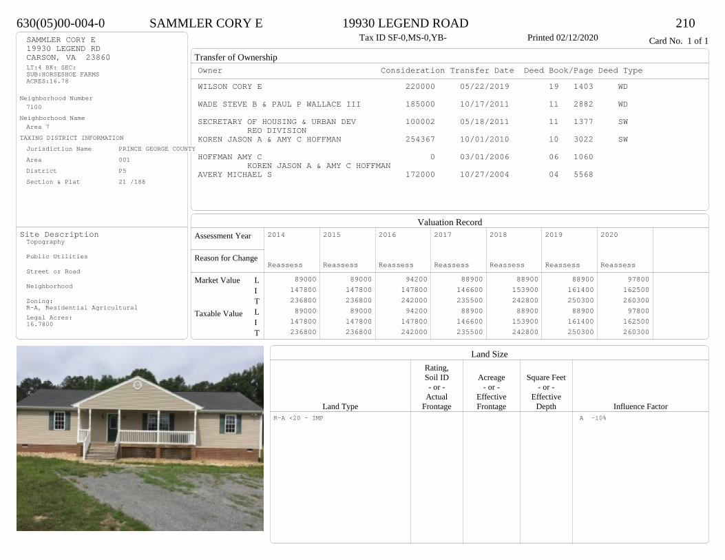
Transfer of Ownership
Valuation RecordAssessment Year
Reason for Change
Market Value
Taxable Value
LITLIT
Land SizeRating,Soil ID Acreage Square Feet- or - - or - - or -
Actual Effective EffectiveLand Type Frontage Frontage Depth Influence Factor
630(05)00-004-0 SAMMLER CORY E 19930 LEGEND ROAD 210Tax ID SF-0,MS-0,YB- Printed 02/12/2020 Card No. 1 of 1SAMMLER CORY E
19930 LEGEND RDCARSON, VA 23860LT:4 BK: SEC:SUB:HORSESHOE FARMSACRES:16.78
Neighborhood Number7100
Neighborhood NameArea 7
TAXING DISTRICT INFORMATIONJurisdiction Name PRINCE GEORGE COUNTYArea 001 District P5 Section & Plat 21 /188
Site DescriptionTopography
Public Utilities
Street or Road
Neighborhood
Zoning:R-A, Residential AgriculturalLegal Acres:16.7800
Owner Consideration Transfer Date Deed Book/Page Deed TypeWILSON CORY E 220000 05/22/2019 19 1403 WD
WADE STEVE B & PAUL P WALLACE III 185000 10/17/2011 11 2882 WD
SECRETARY OF HOUSING & URBAN DEV 100002 05/18/2011 11 1377 SWREO DIVISION
KOREN JASON A & AMY C HOFFMAN 254367 10/01/2010 10 3022 SW
HOFFMAN AMY C 0 03/01/2006 06 1060 KOREN JASON A & AMY C HOFFMAN
AVERY MICHAEL S 172000 10/27/2004 04 5568
2014
Reassess 89000 147800 236800 89000 147800 236800
2015
Reassess 89000 147800 236800 89000 147800 236800
2016
Reassess 94200 147800 242000 94200 147800 242000
2017
Reassess 88900 146600 235500 88900 146600 235500
2018
Reassess 88900 153900 242800 88900 153900 242800
2019
Reassess 88900 161400 250300 88900 161400 250300
2020
Reassess 97800 162500 260300 97800 162500 260300
R-A <20 - IMP A -10%
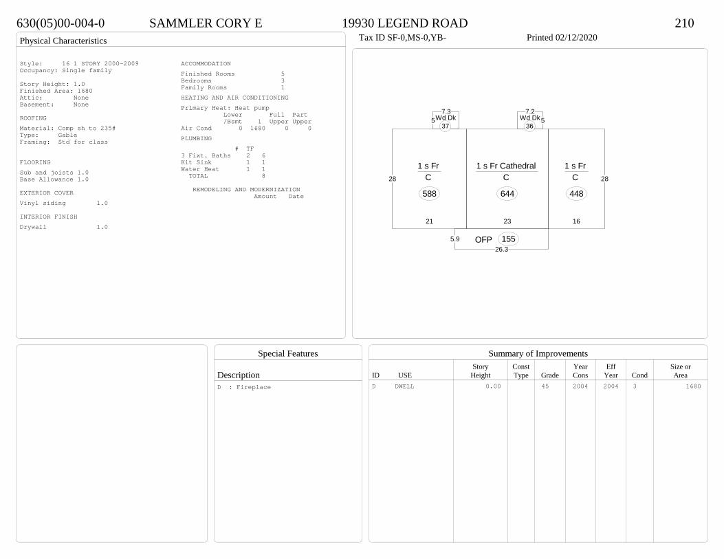
Physical Characteristics
Special Features
Description
Summary of ImprovementsStory Const Year Eff Size or
ID USE Height Type Grade Cons Year Cond Area
630(05)00-004-0 SAMMLER CORY E 19930 LEGEND ROAD 210Tax ID SF-0,MS-0,YB- Printed 02/12/2020
28
21
1 s Fr C
588
23
1 s Fr Cathedral C
644
28
16
1 s Fr C
448
5.926.3
OFP 155
57.3
Wd Dk37
57.2
Wd Dk36
Style: 16 1 STORY 2000-2009Occupancy: Single family
Story Height: 1.0Finished Area: 1680 Attic: NoneBasement: None
ROOFINGMaterial: Comp sh to 235#Type: GableFraming: Std for class
FLOORINGSub and joists 1.0Base Allowance 1.0
EXTERIOR COVERVinyl siding 1.0
INTERIOR FINISHDrywall 1.0
ACCOMMODATIONFinished Rooms 5Bedrooms 3Family Rooms 1HEATING AND AIR CONDITIONINGPrimary Heat: Heat pump Lower Full Part /Bsmt 1 Upper UpperAir Cond 0 1680 0 0PLUMBING # TF3 Fixt. Baths 2 6Kit Sink 1 1Water Heat 1 1 TOTAL 8
REMODELING AND MODERNIZATION Amount Date
D DWELL 0.00 45 2004 2004 3 1680D : Fireplace
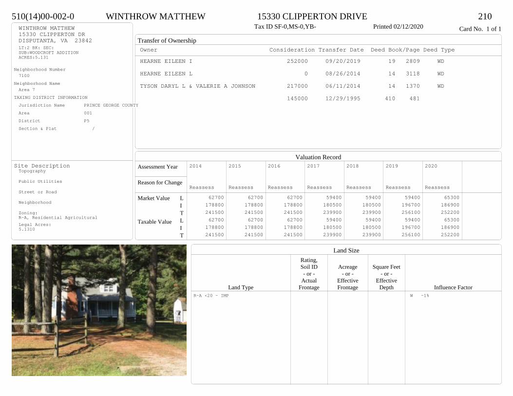
Transfer of Ownership
Valuation RecordAssessment Year
Reason for Change
Market Value
Taxable Value
LITLIT
Land SizeRating,Soil ID Acreage Square Feet- or - - or - - or -
Actual Effective EffectiveLand Type Frontage Frontage Depth Influence Factor
510(14)00-002-0 WINTHROW MATTHEW 15330 CLIPPERTON DRIVE 210Tax ID SF-0,MS-0,YB- Printed 02/12/2020 Card No. 1 of 1WINTHROW MATTHEW
15330 CLIPPERTON DRDISPUTANTA, VA 23842LT:2 BK: SEC:SUB:WOODCROFT ADDITIONACRES:5.131
Neighborhood Number7100
Neighborhood NameArea 7
TAXING DISTRICT INFORMATIONJurisdiction Name PRINCE GEORGE COUNTYArea 001 District P5 Section & Plat /
Site DescriptionTopography
Public Utilities
Street or Road
Neighborhood
Zoning:R-A, Residential AgriculturalLegal Acres:5.1310
Owner Consideration Transfer Date Deed Book/Page Deed TypeHEARNE EILEEN I 252000 09/20/2019 19 2809 WD
HEARNE EILEEN L 0 08/26/2014 14 3118 WD
TYSON DARYL L & VALERIE A JOHNSON 217000 06/11/2014 14 1370 WD
145000 12/29/1995 410 481
2014
Reassess 62700 178800 241500 62700 178800 241500
2015
Reassess 62700 178800 241500 62700 178800 241500
2016
Reassess 62700 178800 241500 62700 178800 241500
2017
Reassess 59400 180500 239900 59400 180500 239900
2018
Reassess 59400 180500 239900 59400 180500 239900
2019
Reassess 59400 196700 256100 59400 196700 256100
2020
Reassess 65300 186900 252200 65300 186900 252200
R-A <20 - IMP W -1%
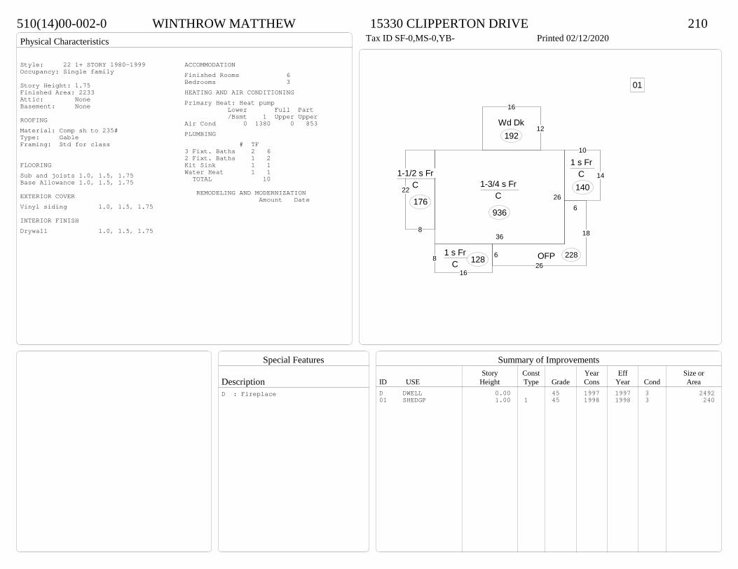
Physical Characteristics
Special Features
Description
Summary of ImprovementsStory Const Year Eff Size or
ID USE Height Type Grade Cons Year Cond Area
510(14)00-002-0 WINTHROW MATTHEW 15330 CLIPPERTON DRIVE 210Tax ID SF-0,MS-0,YB- Printed 02/12/2020
26
36
1-3/4 s Fr C
936
22
8
1-1/2 s Fr C
176
14
10
1 s Fr C
140
8
16
1 s Fr C 128
6
626
18
OFP 228
12
16
Wd Dk192
01
Style: 22 1+ STORY 1980-1999Occupancy: Single family
Story Height: 1.75Finished Area: 2233 Attic: NoneBasement: None
ROOFINGMaterial: Comp sh to 235#Type: GableFraming: Std for class
FLOORINGSub and joists 1.0, 1.5, 1.75Base Allowance 1.0, 1.5, 1.75
EXTERIOR COVERVinyl siding 1.0, 1.5, 1.75
INTERIOR FINISHDrywall 1.0, 1.5, 1.75
ACCOMMODATIONFinished Rooms 6Bedrooms 3HEATING AND AIR CONDITIONINGPrimary Heat: Heat pump Lower Full Part /Bsmt 1 Upper UpperAir Cond 0 1380 0 853PLUMBING # TF3 Fixt. Baths 2 62 Fixt. Baths 1 2Kit Sink 1 1Water Heat 1 1 TOTAL 10
REMODELING AND MODERNIZATION Amount Date
D DWELL 0.00 45 1997 1997 3 249201 SHEDGP 1.00 1 45 1998 1998 3 240
D : Fireplace

Transfer of Ownership
Valuation RecordAssessment Year
Reason for Change
Market Value
Taxable Value
LITLIT
Land SizeRating,Soil ID Acreage Square Feet- or - - or - - or -
Actual Effective EffectiveLand Type Frontage Frontage Depth Influence Factor
630(0A)00-021-D CASEY CAMERON W 20434 HORSESHOE ROAD 210Printed 02/12/2020 Card No. 1 of 1CASEY CAMERON W
20434 HORSESHOE RDCARSON, VA 23830PT ALVIN SMELLEY PRACRES:1.764
Neighborhood Number7100
Neighborhood NameArea 7
TAXING DISTRICT INFORMATIONJurisdiction Name PRINCE GEORGE COUNTYArea 001 District P5 Section & Plat 04/2893
Site DescriptionTopography
Public Utilities
Street or Road
Neighborhood
Zoning:R-A, Residential AgriculturalLegal Acres:1.7600
Owner Consideration Transfer Date Deed Book/Page Deed TypeHOLTEN SCOTT T 225000 06/19/2019 19 1724 WD
HOLTEN SCOTT T & BRENDA C 0 09/17/2016 CD
CYPHER PHILIP G & AMANDA C 203000 10/10/2014 14 3562 WD
VINING THOMAS H & MELINDA 195000 06/03/2009 09 1957
POWROZNIK RYAN D & ASHLEY M 215000 11/19/2007 07 5787
WILLIAMS TIMOTHY S 35000 11/19/2003 03 7244
2014
Reassess 41800 137500 179300 41800 137500 179300
2015
Reassess 41800 137500 179300 41800 137500 179300
2016
Reassess 41800 137500 179300 41800 137500 179300
2017
Reassess 40100 136300 176400 40100 136300 176400
2018
Reassess 40100 143100 183200 40100 143100 183200
2019
Reassess 40100 149900 190000 40100 149900 190000
2020
Reassess 44100 165800 209900 44100 165800 209900
R-A <20 - IMP
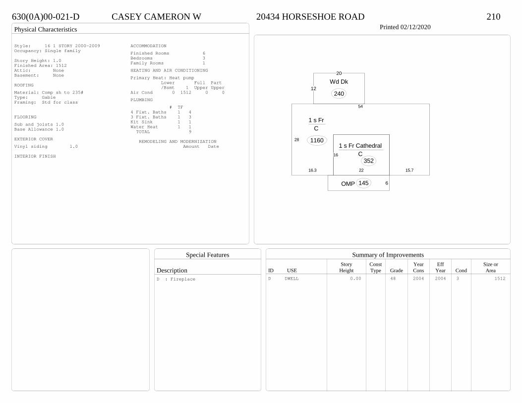
Physical Characteristics
Special Features
Description
Summary of ImprovementsStory Const Year Eff Size or
ID USE Height Type Grade Cons Year Cond Area
630(0A)00-021-D CASEY CAMERON W 20434 HORSESHOE ROAD 210Printed 02/12/2020
6OMP 145
12
20
Wd Dk
240
22
16
1 s Fr Cathedral C
35216.3
28
54
15.7
1 s Fr C
1160
Style: 16 1 STORY 2000-2009Occupancy: Single family
Story Height: 1.0Finished Area: 1512 Attic: NoneBasement: None
ROOFINGMaterial: Comp sh to 235#Type: GableFraming: Std for class
FLOORINGSub and joists 1.0Base Allowance 1.0
EXTERIOR COVERVinyl siding 1.0
INTERIOR FINISH
ACCOMMODATIONFinished Rooms 6Bedrooms 3Family Rooms 1HEATING AND AIR CONDITIONINGPrimary Heat: Heat pump Lower Full Part /Bsmt 1 Upper UpperAir Cond 0 1512 0 0PLUMBING # TF4 Fixt. Baths 1 43 Fixt. Baths 1 3Kit Sink 1 1Water Heat 1 1 TOTAL 9
REMODELING AND MODERNIZATION Amount Date
D DWELL 0.00 48 2004 2004 3 1512D : Fireplace
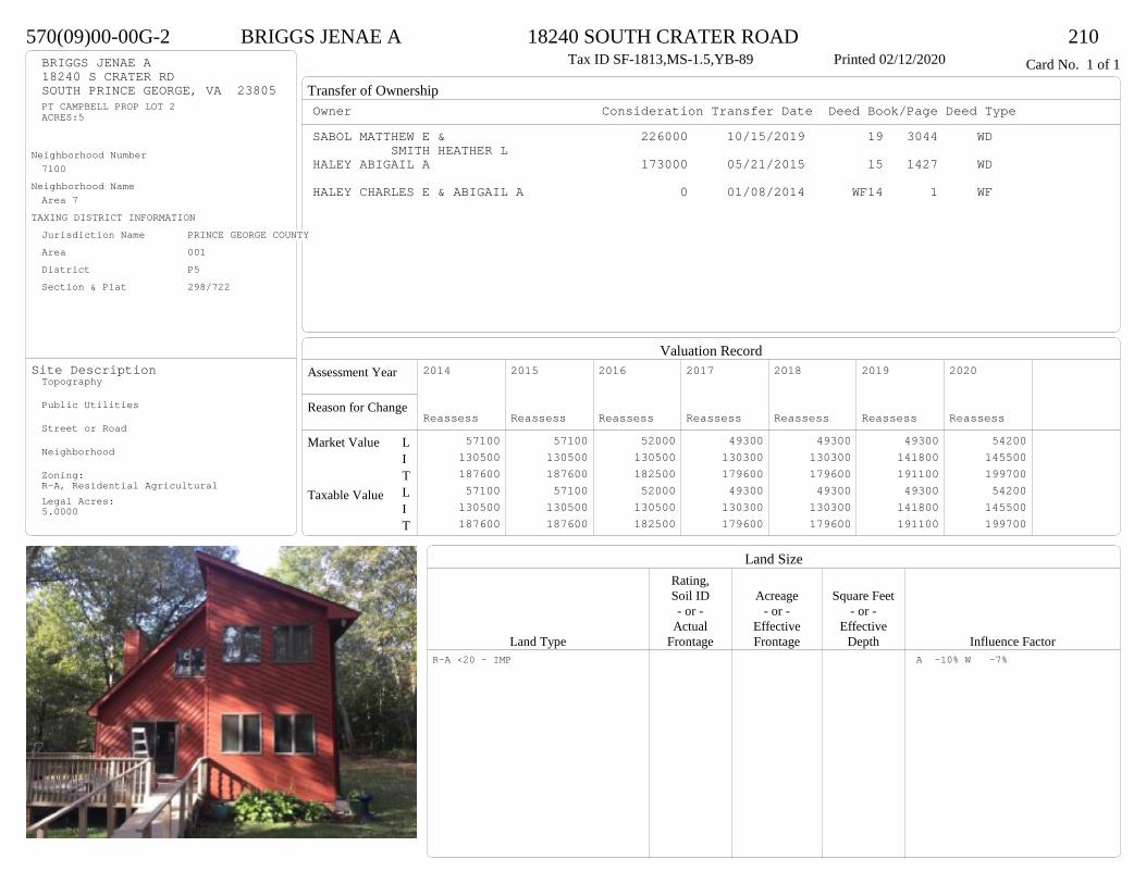
Transfer of Ownership
Valuation RecordAssessment Year
Reason for Change
Market Value
Taxable Value
LITLIT
Land SizeRating,Soil ID Acreage Square Feet- or - - or - - or -
Actual Effective EffectiveLand Type Frontage Frontage Depth Influence Factor
570(09)00-00G-2 BRIGGS JENAE A 18240 SOUTH CRATER ROAD 210Tax ID SF-1813,MS-1.5,YB-89 Printed 02/12/2020 Card No. 1 of 1BRIGGS JENAE A
18240 S CRATER RDSOUTH PRINCE GEORGE, VA 23805PT CAMPBELL PROP LOT 2ACRES:5
Neighborhood Number7100
Neighborhood NameArea 7
TAXING DISTRICT INFORMATIONJurisdiction Name PRINCE GEORGE COUNTYArea 001 District P5 Section & Plat 298/722
Site DescriptionTopography
Public Utilities
Street or Road
Neighborhood
Zoning:R-A, Residential AgriculturalLegal Acres:5.0000
Owner Consideration Transfer Date Deed Book/Page Deed TypeSABOL MATTHEW E & 226000 10/15/2019 19 3044 WD
SMITH HEATHER LHALEY ABIGAIL A 173000 05/21/2015 15 1427 WD
HALEY CHARLES E & ABIGAIL A 0 01/08/2014 WF14 1 WF
2014
Reassess 57100 130500 187600 57100 130500 187600
2015
Reassess 57100 130500 187600 57100 130500 187600
2016
Reassess 52000 130500 182500 52000 130500 182500
2017
Reassess 49300 130300 179600 49300 130300 179600
2018
Reassess 49300 130300 179600 49300 130300 179600
2019
Reassess 49300 141800 191100 49300 141800 191100
2020
Reassess 54200 145500 199700 54200 145500 199700
R-A <20 - IMP A -10% W -7%

Physical Characteristics
Special Features
Description
Summary of ImprovementsStory Const Year Eff Size or
ID USE Height Type Grade Cons Year Cond Area
570(09)00-00G-2 BRIGGS JENAE A 18240 SOUTH CRATER ROAD 210Tax ID SF-1813,MS-1.5,YB-89 Printed 02/12/2020
4
2
27
2
4
8
12
14
35
28
1-3/4 s Fr C
1022
12
14
OFP-s
168
12
22.5
Wd Dk 270
4
4
Wd Dk16
Style: 22 1+ STORY 1980-1999Occupancy: Single family
Story Height: 0Finished Area: 1858 Attic: NoneBasement: None
ROOFINGMaterial: Comp sh to 235#Type: GableFraming: Std for class
FLOORINGSub and joists 1.0, 1.75Base Allowance 1.0, 1.75
EXTERIOR COVERWood siding-cedar 1.0, 1.75
INTERIOR FINISHDrywall 1.0, 1.75
ACCOMMODATIONFinished Rooms 6Bedrooms 3HEATING AND AIR CONDITIONINGPrimary Heat: Heat pump Lower Full Part /Bsmt 1 Upper UpperAir Cond 0 1022 0 836PLUMBING # TF3 Fixt. Baths 2 6Kit Sink 1 1Water Heat 1 1 TOTAL 8
REMODELING AND MODERNIZATION Amount Date
D DWELL 0.00 45 1989 1989 3 2044D : Fireplace

Transfer of Ownership
Valuation RecordAssessment Year
Reason for Change
Market Value
Taxable Value
LITLIT
Land SizeRating,Soil ID Acreage Square Feet- or - - or - - or -
Actual Effective EffectiveLand Type Frontage Frontage Depth Influence Factor
500(17)00-003-0 EDWARDS RYAN W 713 REAMS ROAD 210Tax ID SF-0,MS-0,YB- Printed 02/12/2020 Card No. 1 of 1EDWARDS RYAN W
713 REAMS RDSOUTH PRINCE GEORGE, VA 23805LT:3 BK: SEC:SUB:FOREST GLENACRES:1.961
Neighborhood Number7100
Neighborhood NameArea 7
TAXING DISTRICT INFORMATIONJurisdiction Name PRINCE GEORGE COUNTYArea 001 District P5 Section & Plat 21 /258
Site DescriptionTopography
Public Utilities
Street or Road
Neighborhood
Zoning:R-A, Residential AgriculturalLegal Acres:1.9610
Owner Consideration Transfer Date Deed Book/Page Deed TypeRICE JONATHAN H 212000 11/20/2019 19 3481 WD
SHEAFFER TAMMY D 193500 10/22/2009 09 3894
C & B DEVELOPERS & BUILDERS INC 138900 07/05/2000 00-2700
WYCHE F LEWIS JR 24750 04/21/1999 472 340
2014
Reassess 41200 131200 172400 41200 131200 172400
2015
Reassess 41200 131200 172400 41200 131200 172400
2016
Reassess 41200 131200 172400 41200 131200 172400
2017
Reassess 39600 129900 169500 39600 129900 169500
2018
Reassess 35400 136400 171800 35400 136400 171800
2019
Reassess 35400 142400 177800 35400 142400 177800
2020
Reassess 39000 157500 196500 39000 157500 196500
R-A <20 - IMP A -10% W -5%

Physical Characteristics
Special Features
Description
Summary of ImprovementsStory Const Year Eff Size or
ID USE Height Type Grade Cons Year Cond Area
500(17)00-003-0 EDWARDS RYAN W 713 REAMS ROAD 210Tax ID SF-0,MS-0,YB- Printed 02/12/2020
29
14114
24
318
21
6
856
1 s Fr C
1472
2.516.5
1 s Fr OH 41
12
12.1
Wd Dk145
5.32
OMP
18
1 s Fr OH 13
26
24
20
16
Fr G
576
Style: 16 1 STORY 2000-2009Occupancy: Single family
Story Height: 1.0Finished Area: 1526 Attic: NoneBasement: None
ROOFINGMaterial: Comp sh to 235#Type: GableFraming: Std for class
FLOORINGSub and joists 1.0Base Allowance 1.0
EXTERIOR COVERVinyl siding 1.0
INTERIOR FINISHDrywall 1.0
ACCOMMODATIONFinished Rooms 7Bedrooms 3Formal Dining Rooms 1HEATING AND AIR CONDITIONINGPrimary Heat: Heat pump Lower Full Part /Bsmt 1 Upper UpperAir Cond 0 1526 0 0PLUMBING # TF4 Fixt. Baths 1 43 Fixt. Baths 1 3Kit Sink 1 1Water Heat 1 1 TOTAL 9
REMODELING AND MODERNIZATION Amount Date
D DWELL 0.00 45 2000 2000 3 1526G01 ATTGAR 0.00 1 576
D : Fireplace
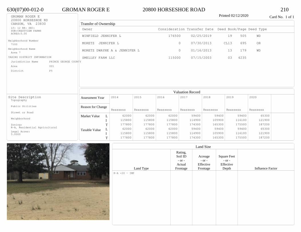
Transfer of Ownership
Valuation RecordAssessment Year
Reason for Change
Market Value
Taxable Value
LITLIT
Land SizeRating,Soil ID Acreage Square Feet- or - - or - - or -
Actual Effective EffectiveLand Type Frontage Frontage Depth Influence Factor
630(07)00-012-0 GROMAN ROGER E 20800 HORSESHOE ROAD 210Printed 02/12/2020 Card No. 1 of 1GROMAN ROGER E
20800 HORSESHOE RDCARSON, VA 23830LT: 12 BK: SEC:SUB:CRESTVIEW FARMSACRES:5.00
Neighborhood Number7100
Neighborhood NameArea 7
TAXING DISTRICT INFORMATIONJurisdiction Name PRINCE GEORGE COUNTYArea 001 District P5
Site DescriptionTopography
Public Utilities
Street or Road
Neighborhood
Zoning:R-A, Residential AgriculturalLegal Acres:5.0000
Owner Consideration Transfer Date Deed Book/Page Deed TypeWINFIELD JENNIFER L 176500 02/25/2019 19 505 WD
MORETZ JENNIFER L 0 07/30/2013 CL13 695 OR
MORETZ DWAYNE A & JENNIFER L 0 01/16/2013 13 179 WD
SMELLEY FARM LLC 115000 07/15/2003 03 4235
2014
Reassess 62000 115800 177800 62000 115800 177800
2015
Reassess 62000 115800 177800 62000 115800 177800
2016
Reassess 62000 115800 177800 62000 115800 177800
2017
Reassess 59400 114900 174300 59400 114900 174300
2018
Reassess 59400 105900 165300 59400 105900 165300
2019
Reassess 59400 116100 175500 59400 116100 175500
2020
Reassess 65300 121900 187200 65300 121900 187200
R-A <20 - IMP
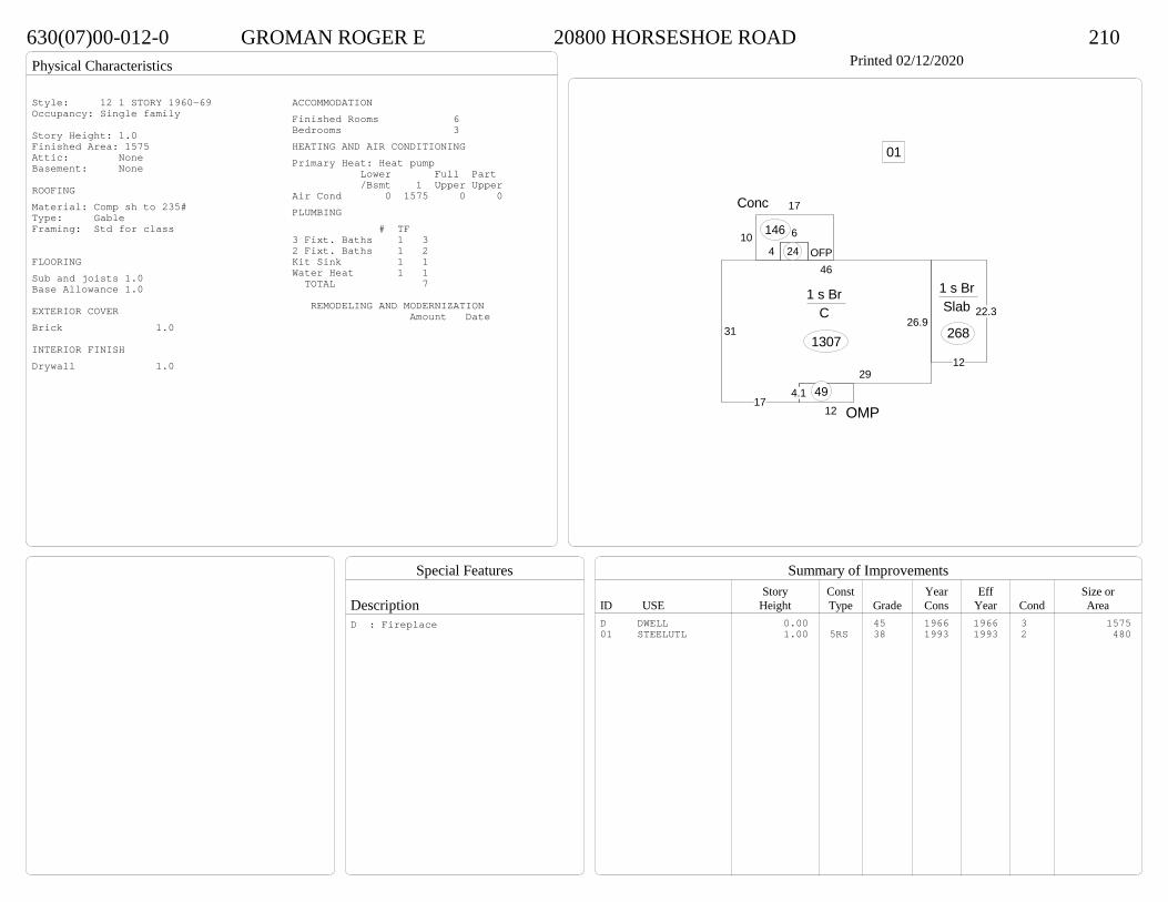
Physical Characteristics
Special Features
Description
Summary of ImprovementsStory Const Year Eff Size or
ID USE Height Type Grade Cons Year Cond Area
630(07)00-012-0 GROMAN ROGER E 20800 HORSESHOE ROAD 210Printed 02/12/2020
31
46
26.9
29
4.117
1 s Br C
1307
46
OFP24
12 OMP49
10
17Conc
146
22.3
12
1 s Br Slab
268
01
Style: 12 1 STORY 1960-69Occupancy: Single family
Story Height: 1.0Finished Area: 1575 Attic: NoneBasement: None
ROOFINGMaterial: Comp sh to 235#Type: GableFraming: Std for class
FLOORINGSub and joists 1.0Base Allowance 1.0
EXTERIOR COVERBrick 1.0
INTERIOR FINISHDrywall 1.0
ACCOMMODATIONFinished Rooms 6Bedrooms 3HEATING AND AIR CONDITIONINGPrimary Heat: Heat pump Lower Full Part /Bsmt 1 Upper UpperAir Cond 0 1575 0 0PLUMBING # TF3 Fixt. Baths 1 32 Fixt. Baths 1 2Kit Sink 1 1Water Heat 1 1 TOTAL 7
REMODELING AND MODERNIZATION Amount Date
D DWELL 0.00 45 1966 1966 3 157501 STEELUTL 1.00 5RS 38 1993 1993 2 480
D : Fireplace
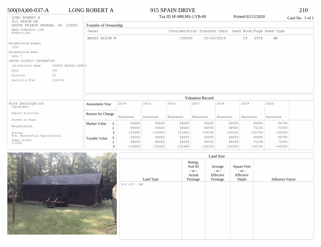
Transfer of Ownership
Valuation RecordAssessment Year
Reason for Change
Market Value
Taxable Value
LITLIT
Land SizeRating,Soil ID Acreage Square Feet- or - - or - - or -
Actual Effective EffectiveLand Type Frontage Frontage Depth Influence Factor
500(0A)00-037-A LONG ROBERT A 915 SPAIN DRIVE 210Tax ID SF-888,MS-1,YB-89 Printed 02/12/2020 Card No. 1 of 1LONG ROBERT A
915 SPAIN DRSOUTH PRINCE GEORGE, VA 23805NEAR DINWIDDIE LINEACRES:5.256
Neighborhood Number7100
Neighborhood NameArea 7
TAXING DISTRICT INFORMATIONJurisdiction Name PRINCE GEORGE COUNTYArea 001 District P5 Section & Plat 230/434
Site DescriptionTopography
Public Utilities
Street or Road
Neighborhood
Zoning:R-A, Residential AgriculturalLegal Acres:5.2560
Owner Consideration Transfer Date Deed Book/Page Deed TypeMOODY ALTON M 150000 10/02/2019 19 2939 WD
2014
Reassess 64000 68600 132600 64000 68600 132600
2015
Reassess 64000 68600 132600 64000 68600 132600
2016
Reassess 64000 68600 132600 64000 68600 132600
2017
Reassess 60600 68500 129100 60600 68500 129100
2018
Reassess 60600 68500 129100 60600 68500 129100
2019
Reassess 60600 75100 135700 60600 75100 135700
2020
Reassess 66700 73300 140000 66700 73300 140000
R-A <20 - IMP

Physical Characteristics
Special Features
Description
Summary of ImprovementsStory Const Year Eff Size or
ID USE Height Type Grade Cons Year Cond Area
500(0A)00-037-A LONG ROBERT A 915 SPAIN DRIVE 210Tax ID SF-888,MS-1,YB-89 Printed 02/12/2020
24
37
1 s Fr C
888
5.310
Wd Dk
53
5.69.5
Wd Dk 53
Style: 60 LOGOccupancy: Single family
Story Height: 1.0Finished Area: 888 Attic: NoneBasement: None
ROOFINGMaterial: Comp sh to 235#Type: GableFraming: Std for class
FLOORINGSub and joists 1.0Base Allowance 1.0
EXTERIOR COVERLog solid 1.0
INTERIOR FINISH
ACCOMMODATIONFinished Rooms 4Bedrooms 2HEATING AND AIR CONDITIONINGPrimary Heat: Heat pump Lower Full Part /Bsmt 1 Upper UpperAir Cond 0 888 0 0PLUMBING # TF3 Fixt. Baths 1 3Kit Sink 1 1Water Heat 1 1 TOTAL 5
REMODELING AND MODERNIZATION Amount Date
D DWELL 0.00 38 1989 1989 3 888

Transfer of Ownership
Valuation RecordAssessment Year
Reason for Change
Market Value
Taxable Value
LITLIT
Land SizeRating,Soil ID Acreage Square Feet- or - - or - - or -
Actual Effective EffectiveLand Type Frontage Frontage Depth Influence Factor
620(0A)00-072-B GRIZZLE GRACE G 714 JOHNS ROAD 210Tax ID SF-2034,MS-0,YB-25 Printed 02/12/2020 Card No. 1 of 1GRIZZLE GRACE G
714 JOHNS RDCARSON, VA 23830SPENCER GRAVESACRES:3.61
Neighborhood Number7100
Neighborhood NameArea 7
TAXING DISTRICT INFORMATIONJurisdiction Name PRINCE GEORGE COUNTYArea 001 District P5 Section & Plat /
Site DescriptionTopography
Public Utilities
Street or Road
Neighborhood
Zoning:R-A, Residential AgriculturalLegal Acres:3.6100
Owner Consideration Transfer Date Deed Book/Page Deed Type714 JOHNS ROAD SERIES RVA DREAMS 119900 05/13/2019 19 1268 WD
BIG BUSINESS TRUST714 JOHNS ROAD SERIES 0 02/19/2019 19 445 SW
FLOWERS JOE ANN 35001 12/14/2018 18 3698 SW
FLOWERS JAMES A 0 03/04/2016 WF16 38 WF
2014
Reassess 43900 56000 99900 43900 56000 99900
2015
Reassess 43900 56000 99900 43900 56000 99900
2016
Reassess 43900 56000 99900 43900 56000 99900
2017
Reassess 41800 56100 97900 41800 56100 97900
2018
Reassess 41800 58900 100700 41800 58900 100700
2019
Reassess 41800 61900 103700 41800 61900 103700
2020
Reassess 57500 70300 127800 57500 70300 127800
R-A <20 - IMP

Physical Characteristics
Special Features
Description
Summary of ImprovementsStory Const Year Eff Size or
ID USE Height Type Grade Cons Year Cond Area
620(0A)00-072-B GRIZZLE GRACE G 714 JOHNS ROAD 210Tax ID SF-2034,MS-0,YB-25 Printed 02/12/2020
24
13.6
6
12.4
30
26
1 s Fr C
698OFP
82
6
8Wd Dk
48
Style: 16 1 STORY 2000-2009Occupancy: Single family
Story Height: 1.0Finished Area: 698 Attic: NoneBasement: None
ROOFINGMaterial: Comp sh to 235#Type: GableFraming: Std for class
FLOORINGSub and joists 1.0Base Allowance 1.0
EXTERIOR COVERVinyl siding 1.0
INTERIOR FINISHDrywall 1.0
ACCOMMODATIONFinished Rooms 4Bedrooms 2HEATING AND AIR CONDITIONINGPrimary Heat: Heat pump Lower Full Part /Bsmt 1 Upper UpperAir Cond 0 698 0 0PLUMBING # TF3 Fixt. Baths 1 3Kit Sink 1 1Water Heat 1 1 TOTAL 5
REMODELING AND MODERNIZATION Amount Date
D DWELL 0.00 38 2002 2005 3 698D : Remod 2019
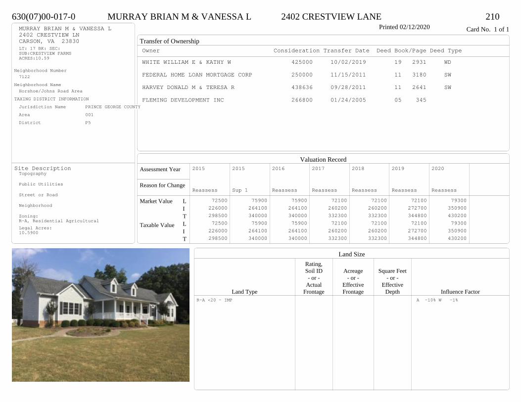
Transfer of Ownership
Valuation RecordAssessment Year
Reason for Change
Market Value
Taxable Value
LITLIT
Land SizeRating,Soil ID Acreage Square Feet- or - - or - - or -
Actual Effective EffectiveLand Type Frontage Frontage Depth Influence Factor
630(07)00-017-0 MURRAY BRIAN M & VANESSA L 2402 CRESTVIEW LANE 210Printed 02/12/2020 Card No. 1 of 1MURRAY BRIAN M & VANESSA L
2402 CRESTVIEW LNCARSON, VA 23830LT: 17 BK: SEC:SUB:CRESTVIEW FARMSACRES:10.59
Neighborhood Number7122
Neighborhood NameHorshoe/Johns Road Area
TAXING DISTRICT INFORMATIONJurisdiction Name PRINCE GEORGE COUNTYArea 001 District P5
Site DescriptionTopography
Public Utilities
Street or Road
Neighborhood
Zoning:R-A, Residential AgriculturalLegal Acres:10.5900
Owner Consideration Transfer Date Deed Book/Page Deed TypeWHITE WILLIAM E & KATHY W 425000 10/02/2019 19 2931 WD
FEDERAL HOME LOAN MORTGAGE CORP 250000 11/15/2011 11 3180 SW
HARVEY DONALD M & TERESA R 438636 09/28/2011 11 2641 SW
FLEMING DEVELOPMENT INC 266800 01/24/2005 05 345
2015
Reassess 72500 226000 298500 72500 226000 298500
2015
Sup 1 75900 264100 340000 75900 264100 340000
2016
Reassess 75900 264100 340000 75900 264100 340000
2017
Reassess 72100 260200 332300 72100 260200 332300
2018
Reassess 72100 260200 332300 72100 260200 332300
2019
Reassess 72100 272700 344800 72100 272700 344800
2020
Reassess 79300 350900 430200 79300 350900 430200
R-A <20 - IMP A -10% W -1%
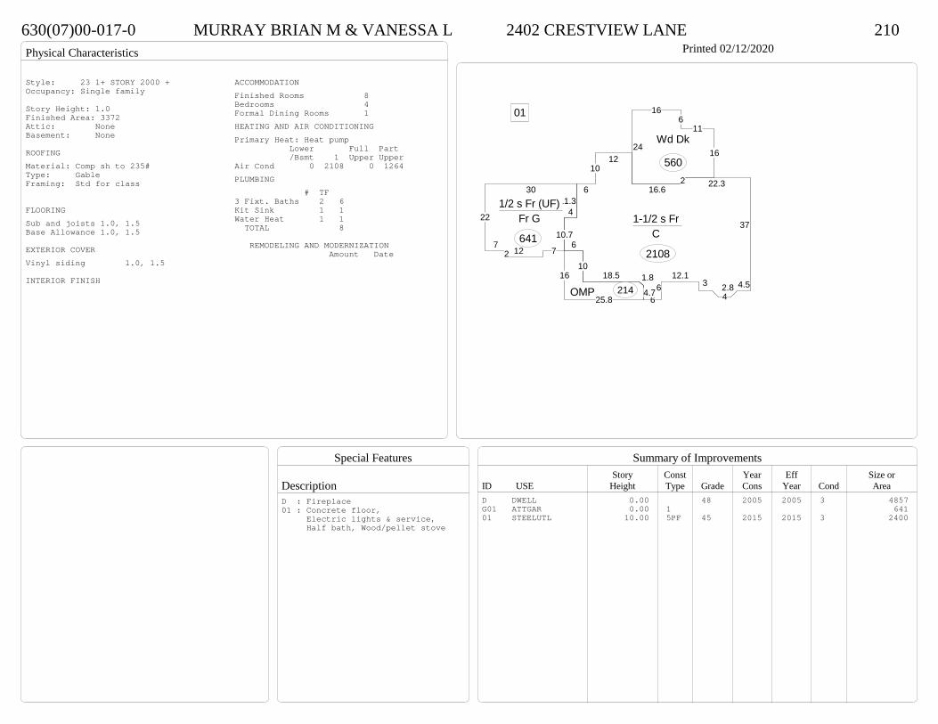
Physical Characteristics
Special Features
Description
Summary of ImprovementsStory Const Year Eff Size or
ID USE Height Type Grade Cons Year Cond Area
630(07)00-017-0 MURRAY BRIAN M & VANESSA L 2402 CRESTVIEW LANE 210Printed 02/12/2020
6
1012
16.62 22.3
37
4.52.84
312.1
66
4.7
1.818.510
610.7
1-1/2 s Fr C
2108
25.8
16
OMP 214
24
166
11
16Wd Dk
560
30
22
72 12 7
411.31/2 s Fr (UF)
Fr G
641
01
Style: 23 1+ STORY 2000 +Occupancy: Single family
Story Height: 1.0Finished Area: 3372 Attic: NoneBasement: None
ROOFINGMaterial: Comp sh to 235#Type: GableFraming: Std for class
FLOORINGSub and joists 1.0, 1.5Base Allowance 1.0, 1.5
EXTERIOR COVERVinyl siding 1.0, 1.5
INTERIOR FINISH
ACCOMMODATIONFinished Rooms 8Bedrooms 4Formal Dining Rooms 1HEATING AND AIR CONDITIONINGPrimary Heat: Heat pump Lower Full Part /Bsmt 1 Upper UpperAir Cond 0 2108 0 1264PLUMBING # TF3 Fixt. Baths 2 6Kit Sink 1 1Water Heat 1 1 TOTAL 8
REMODELING AND MODERNIZATION Amount Date
D DWELL 0.00 48 2005 2005 3 4857G01 ATTGAR 0.00 1 64101 STEELUTL 10.00 5PF 45 2015 2015 3 2400
D : Fireplace01 : Concrete floor, Electric lights & service, Half bath, Wood/pellet stove
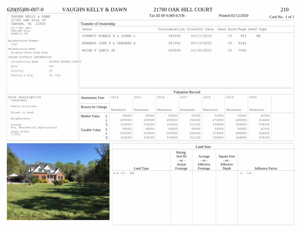
Transfer of Ownership
Valuation RecordAssessment Year
Reason for Change
Market Value
Taxable Value
LITLIT
Land SizeRating,Soil ID Acreage Square Feet- or - - or - - or -
Actual Effective EffectiveLand Type Frontage Frontage Depth Influence Factor
620(05)00-007-0 VAUGHN KELLY & DAWN 21700 OAK HILL COURT 210Tax ID SF-0,MS-0,YB- Printed 02/12/2020 Card No. 1 of 1VAUGHN KELLY & DAWN
21700 OAK HILL CTCARSON, VA 23830LT:7 BK: SEC:SUB:OAK HILLACRES:5.591
Neighborhood Number7122
Neighborhood NameHorshoe/Johns Road Area
TAXING DISTRICT INFORMATIONJurisdiction Name PRINCE GEORGE COUNTYArea 001 District P5 Section & Plat 20 /136
Site DescriptionTopography
Public Utilities
Street or Road
Neighborhood
Zoning:R-A, Residential AgriculturalLegal Acres:5.5910
Owner Consideration Transfer Date Deed Book/Page Deed TypeCORNETT DONALD R & LORNA L 360000 04/11/2019 19 963 WD
EDWARDS JOHN D & DEBORAH H 301945 09/15/2005 05 4642
WYCHE F LEWIS JR 600000 12/30/2003 03 7990
2014
Reassess 59000 259500 318500 59000 259500 318500
2015
Reassess 59000 259500 318500 59000 259500 318500
2016
Reassess 59000 259500 318500 59000 259500 318500
2017
Reassess 55900 256200 312100 55900 256200 312100
2018
Reassess 55900 274900 330800 55900 274900 330800
2019
Reassess 55900 288900 344800 55900 288900 344800
2020
Reassess 61500 316600 378100 61500 316600 378100
R-A <20 - IMP A -10%

Physical Characteristics
Special Features
Description
Summary of ImprovementsStory Const Year Eff Size or
ID USE Height Type Grade Cons Year Cond Area
620(05)00-007-0 VAUGHN KELLY & DAWN 21700 OAK HILL COURT 210Tax ID SF-0,MS-0,YB- Printed 02/12/2020
6.311.7
14
20
21.3
23
17.5
6.53.5
8.5
12.3
2 s Fr C
757
39.7
15
1/2 s Fr (UF) 1 s Fr
C
596
4
13
1 s Fr C
52
21
15
1 s Fr Cathedral C
292
8
193.6
OMP 160
101 s Fr OH 20
10.3
11.5
12.3OFP-s121
24
1/2 s Fr (Fin) Fr G
480
01
02Style: 33 2/2+Story 2000+Occupancy: Single family
Story Height: 2.0Finished Area: 2834 Attic: NoneBasement: None
ROOFINGMaterial: Comp sh to 235#Type: GableFraming: Std for class
FLOORINGSub and joists 1.0, 1.5, 2.0Base Allowance 1.0, 1.5, 2.0
EXTERIOR COVERBrick 1.0Vinyl siding 1.0, 1.5, 2.0
INTERIOR FINISHDrywall 1.0, 1.5, 2.0
ACCOMMODATIONFinished Rooms 10Bedrooms 3Family Rooms 1Formal Dining Rooms 1HEATING AND AIR CONDITIONINGPrimary Heat: Heat pump Lower Full Part /Bsmt 1 Upper UpperAir Cond 0 1717 757 360PLUMBING # TF5 Fixt. Baths 1 53 Fixt. Baths 1 32 Fixt. Baths 1 2Kit Sink 1 1Water Heat 1 1Extra Fixt 1 TOTAL 13
REMODELING AND MODERNIZATION Amount Date
D DWELL 0.00 55 2005 2005 3 3550G01 ATTGAR 0.00 1 48001 DETGAR 1.00 1 48 2005 2005 3 58302 STEELUTL 10.00 5PF 38 2010 2010 3 400
D : Fireplace

Transfer of Ownership
Valuation RecordAssessment Year
Reason for Change
Market Value
Taxable Value
LITLIT
Land SizeRating,Soil ID Acreage Square Feet- or - - or - - or -
Actual Effective EffectiveLand Type Frontage Frontage Depth Influence Factor
580(19)00-002-0 COLBERT ROTESHA 19461 TYLER COURT 210Printed 02/12/2020 Card No. 1 of 1COLBERT ROTESHA
19461 TYLER CTSOUTH PRINCE GEORGE, VA 23805LOT E9PT WILLIAM CANADA PRACRES:5
Neighborhood Number7123
Neighborhood NameIndian Woods Area
TAXING DISTRICT INFORMATIONJurisdiction Name PRINCE GEORGE COUNTYArea 001 District P5
Site DescriptionTopography
Public Utilities
Street or Road
Neighborhood
Zoning:R-A, Residential AgriculturalLegal Acres:5.0000
Owner Consideration Transfer Date Deed Book/Page Deed TypeROBINSON DANIEL W & DEBORAH J 289000 01/02/2019 19 23 WD
TYLER REALTY GROUP INC 288000 11/21/2005 05 6007
CANADA CLARA W 55000 10/07/2004 04 5262
2014
Reassess 48900 200900 249800 48900 200900 249800
2015
Reassess 48900 200900 249800 48900 200900 249800
2016
Reassess 50100 200900 251000 50100 200900 251000
2017
Reassess 48700 198900 247600 48700 198900 247600
2018
Reassess 48700 198900 247600 48700 198900 247600
2019
Reassess 48700 208900 257600 48700 208900 257600
2020
Reassess 53500 225200 278700 53500 225200 278700
R-A <20 - IMP A -15% R -3%
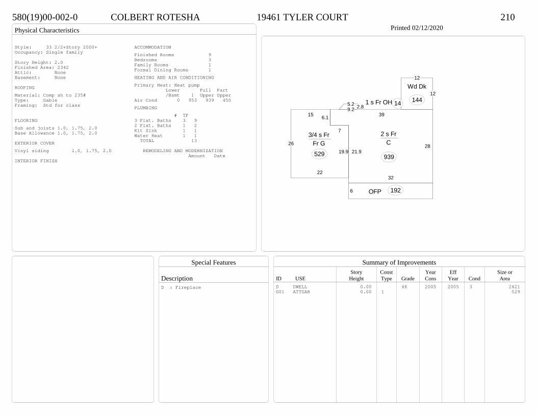
Physical Characteristics
Special Features
Description
Summary of ImprovementsStory Const Year Eff Size or
ID USE Height Type Grade Cons Year Cond Area
580(19)00-002-0 COLBERT ROTESHA 19461 TYLER COURT 210Printed 02/12/2020
39
28
32
21.9
2 s Fr C
939
2.85.29.2
1 s Fr OH 14
6 OFP 192
12
12
Wd Dk
144
15
26
22
19.9
7
6.1
3/4 s Fr Fr G 529
Style: 33 2/2+Story 2000+Occupancy: Single family
Story Height: 2.0Finished Area: 2342 Attic: NoneBasement: None
ROOFINGMaterial: Comp sh to 235#Type: GableFraming: Std for class
FLOORINGSub and joists 1.0, 1.75, 2.0Base Allowance 1.0, 1.75, 2.0
EXTERIOR COVERVinyl siding 1.0, 1.75, 2.0
INTERIOR FINISH
ACCOMMODATIONFinished Rooms 9Bedrooms 3Family Rooms 1Formal Dining Rooms 1HEATING AND AIR CONDITIONINGPrimary Heat: Heat pump Lower Full Part /Bsmt 1 Upper UpperAir Cond 0 953 939 450PLUMBING # TF3 Fixt. Baths 3 92 Fixt. Baths 1 2Kit Sink 1 1Water Heat 1 1 TOTAL 13
REMODELING AND MODERNIZATION Amount Date
D DWELL 0.00 48 2005 2005 3 2421G01 ATTGAR 0.00 1 529
D : Fireplace

Transfer of Ownership
Valuation RecordAssessment Year
Reason for Change
Market Value
Taxable Value
LITLIT
Land SizeRating,Soil ID Acreage Square Feet- or - - or - - or -
Actual Effective EffectiveLand Type Frontage Frontage Depth Influence Factor
570(12)00-010-0 CRIST MATTHEW J & ASHLEY T 19150 INDIAN ROAD 210Printed 02/12/2020 Card No. 1 of 1CRIST MATTHEW J & ASHLEY T
19150 INDIAN RDSOUTH PRINCE GEORGE, VA 23805LT:10 BK: SEC:1SUB:INDIAN WOODSACRES:5.181
Neighborhood Number7123
Neighborhood NameIndian Woods Area
TAXING DISTRICT INFORMATIONJurisdiction Name PRINCE GEORGE COUNTYArea 001 District P5 Section & Plat 21 /167
Site DescriptionTopography
Public Utilities
Street or Road
Neighborhood
Zoning:R-A, Residential AgriculturalLegal Acres:5.1810
Owner Consideration Transfer Date Deed Book/Page Deed TypeVANDEVANDER JOHN & MARY 239900 04/26/2019 19 1128 WD
WILLIAMSON ROY R JR & ELIZABETH N 245000 10/14/2008 08 4264
HOOVER DONALD R 199950 04/01/2005 05 1478
V & R PROPERTIES 146900 12/22/2000 00-4958
H & F PROPERTIES INC 28500 11/03/1999 485 761
2014
Reassess 62000 147900 209900 62000 147900 209900
2015
Reassess 62000 147900 209900 62000 147900 209900
2016
Reassess 62000 147900 209900 62000 147900 209900
2017
Reassess 60300 146400 206700 60300 146400 206700
2018
Reassess 60300 153700 214000 60300 153700 214000
2019
Reassess 60300 154100 214400 60300 154100 214400
2020
Reassess 66300 176000 242300 66300 176000 242300
R-A <20 - IMP
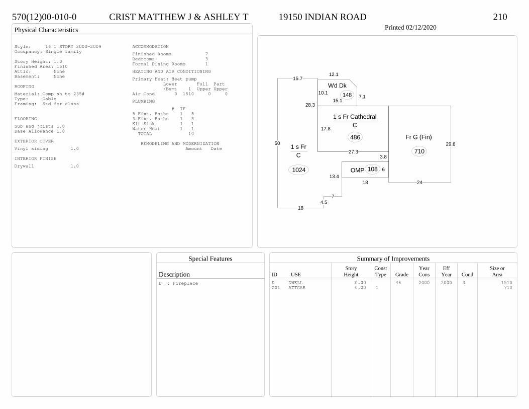
Physical Characteristics
Special Features
Description
Summary of ImprovementsStory Const Year Eff Size or
ID USE Height Type Grade Cons Year Cond Area
570(12)00-010-0 CRIST MATTHEW J & ASHLEY T 19150 INDIAN ROAD 210Printed 02/12/2020
15.7
50
184.5
7
13.4
3.827.3
28.3
1 s Fr C
1024
17.8
1 s Fr Cathedral C
486
6
18
OMP 108
10.1
12.1
7.115.1
Wd Dk148
24
29.6Fr G (Fin)
710
Style: 16 1 STORY 2000-2009Occupancy: Single family
Story Height: 1.0Finished Area: 1510 Attic: NoneBasement: None
ROOFINGMaterial: Comp sh to 235#Type: GableFraming: Std for class
FLOORINGSub and joists 1.0Base Allowance 1.0
EXTERIOR COVERVinyl siding 1.0
INTERIOR FINISHDrywall 1.0
ACCOMMODATIONFinished Rooms 7Bedrooms 3Formal Dining Rooms 1HEATING AND AIR CONDITIONINGPrimary Heat: Heat pump Lower Full Part /Bsmt 1 Upper UpperAir Cond 0 1510 0 0PLUMBING # TF5 Fixt. Baths 1 53 Fixt. Baths 1 3Kit Sink 1 1Water Heat 1 1 TOTAL 10
REMODELING AND MODERNIZATION Amount Date
D DWELL 0.00 48 2000 2000 3 1510G01 ATTGAR 0.00 1 710
D : Fireplace

Transfer of Ownership
Valuation RecordAssessment Year
Reason for Change
Market Value
Taxable Value
LITLIT
Land SizeRating,Soil ID Acreage Square Feet- or - - or - - or -
Actual Effective EffectiveLand Type Frontage Frontage Depth Influence Factor
230(07)00-00A-0 J I L ESTATES LLC 4458 BAXTER ROAD 355Tax ID SF-0,MS-0,YB- Printed 02/12/2020 Card No. 1 of 2J I L ESTATES LLC
9549 AMBERDALE DRNORTH CHESTERFIELD, VA 23236BLACKWATER SWAMPACRES:1.5
Neighborhood Number8002
Neighborhood NameCourthouse Area
TAXING DISTRICT INFORMATIONJurisdiction Name PRINCE GEORGE COUNTYArea 001 District P4 Section & Plat 11 /123
Site DescriptionTopography
Public Utilities
Street or Road
Neighborhood
Zoning:R-2, General ResidentialLegal Acres:1.5000
Owner Consideration Transfer Date Deed Book/Page Deed TypeA L M ENTERPRISES LLC 535000 05/14/2019 19 1311 WD
JARRETT AMBER M 495000 10/11/2005 05 5175
VINSON INVESTMENTS INC 400000 09/17/2004 04 4865
2014
Reassess 53900 457800 511700 53900 457800 511700
2015
Reassess 53900 457800 511700 53900 457800 511700
2016
Reassess 53900 457800 511700 53900 457800 511700
2017
Reassess 53900 457800 511700 53900 457800 511700
2018
Reassess 53900 452800 506700 53900 452800 506700
2019
Reassess 53900 449600 503500 53900 449600 503500
2020
Reassess 59300 480400 539700 59300 480400 539700
R-2 - IMP

Physical Characteristics
Special Features
Description
Summary of ImprovementsStory Const Year Eff Size or
ID USE Height Type Grade Cons Year Cond Area
230(07)00-00A-0 J I L ESTATES LLC 4458 BAXTER ROAD 355Tax ID SF-0,MS-0,YB- Printed 02/12/2020
64.4
28
2 s Fr Slab
1803
81 s Fr OH (Upper) 16
8BalcConc
408
BalcConc
40
Style: 32 2/2+Story 1980-1999Occupancy: 4-6 family
Story Height: 2.0Finished Area: 3622 Attic: NoneBasement: None
ROOFINGMaterial: Comp sh to 235#Type: GableFraming: Std for class
FLOORINGSlab 1.0Sub and joists 2.0Base Allowance 1.0, 2.0
EXTERIOR COVERWood siding 1.0, 2.0
INTERIOR FINISHDrywall 1.0, 2.0
ACCOMMODATIONFinished Rooms 16Bedrooms 8HEATING AND AIR CONDITIONINGPrimary Heat: Heat pump Lower Full Part /Bsmt 1 Upper UpperAir Cond 0 1803 1819 0PLUMBING # TF3 Fixt. Baths 4 12Kit Sink 4 4Water Heat 4 4 TOTAL 20
REMODELING AND MODERNIZATION Amount Date
D DWELL 0.00 38 1986 1986 3 3622
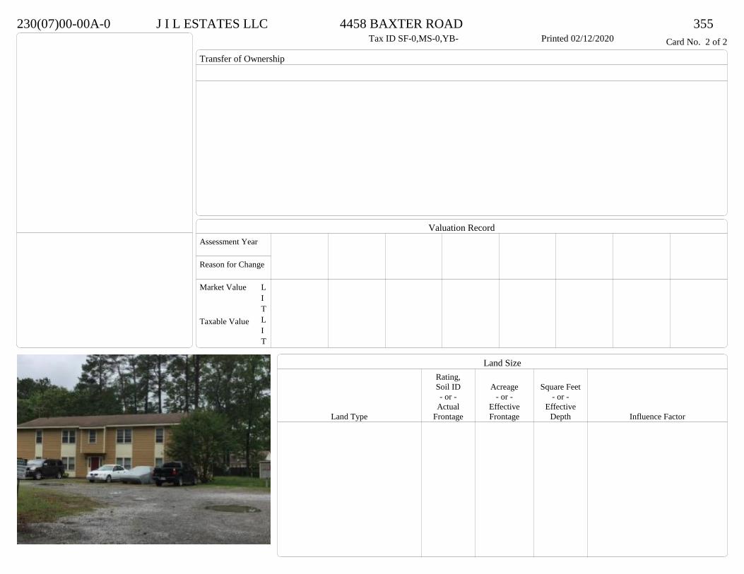
Transfer of Ownership
Valuation RecordAssessment Year
Reason for Change
Market Value
Taxable Value
LITLIT
Land SizeRating,Soil ID Acreage Square Feet- or - - or - - or -
Actual Effective EffectiveLand Type Frontage Frontage Depth Influence Factor
230(07)00-00A-0 J I L ESTATES LLC 4458 BAXTER ROAD 355Tax ID SF-0,MS-0,YB- Printed 02/12/2020 Card No. 2 of 2
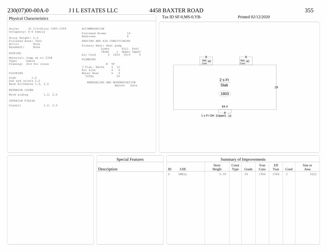
Physical Characteristics
Special Features
Description
Summary of ImprovementsStory Const Year Eff Size or
ID USE Height Type Grade Cons Year Cond Area
230(07)00-00A-0 J I L ESTATES LLC 4458 BAXTER ROAD 355Tax ID SF-0,MS-0,YB- Printed 02/12/2020
64.4
28
2 s Fr Slab
1803
81 s Fr OH (Upper) 16
8BalcConc
408
BalcConc
40
Style: 32 2/2+Story 1980-1999Occupancy: 4-6 family
Story Height: 2.0Finished Area: 3622 Attic: NoneBasement: None
ROOFINGMaterial: Comp sh to 235#Type: GableFraming: Std for class
FLOORINGSlab 1.0Sub and joists 2.0Base Allowance 1.0, 2.0
EXTERIOR COVERWood siding 1.0, 2.0
INTERIOR FINISHDrywall 1.0, 2.0
ACCOMMODATIONFinished Rooms 16Bedrooms 8HEATING AND AIR CONDITIONINGPrimary Heat: Heat pump Lower Full Part /Bsmt 1 Upper UpperAir Cond 0 1803 1819 0PLUMBING # TF3 Fixt. Baths 4 12Kit Sink 4 4Water Heat 4 4 TOTAL 20
REMODELING AND MODERNIZATION Amount Date
D DWELL 0.00 38 1986 1986 3 3622

Transfer of Ownership
Valuation RecordAssessment Year
Reason for Change
Market Value
Taxable Value
LITLIT
Land SizeRating,Soil ID Acreage Square Feet- or - - or - - or -
Actual Effective EffectiveLand Type Frontage Frontage Depth Influence Factor
23B(02)00-00D-0 BETLEY ALTA T 5711 COURTHOUSE RD 210Tax ID SF-0,MS-0,YB- Printed 02/12/2020 Card No. 1 of 1BETLEY ALTA T
5711 COURTHOUSE RDPRINCE GEORGE, VA 23875LT:D BK: SEC:SUB:ALLINSACRES:3.883
Neighborhood Number8002
Neighborhood NameCourthouse Area
TAXING DISTRICT INFORMATIONJurisdiction Name PRINCE GEORGE COUNTYArea 001 District P2 Section & Plat 26/189
Site DescriptionTopography
Public Utilities
Street or Road
Neighborhood
Zoning:R-2, General ResidentialLegal Acres:3.8830
Owner Consideration Transfer Date Deed Book/Page Deed TypeHOKE ROBERT F JR 283000 08/29/2019 19 2553 WD
HUNTER DONALD R 240000 06/26/2018 18 1942 WD
2015
Reassess 25600 0 25600 800 0 800
2016
Reassess 25600 0 25600 1000 0 1000
2017
Reassess 25600 0 25600 1100 0 1100
2018
Reassess 25600 0 25600 1200 0 1200
2018
Ac 59600 210300 269900 59600 210300 269900
2019
Reassess 59600 227500 287100 59600 227500 287100
2020
Reassess 65600 232900 298500 65600 232900 298500
R-A <20 - IMP R -4% Z 10%
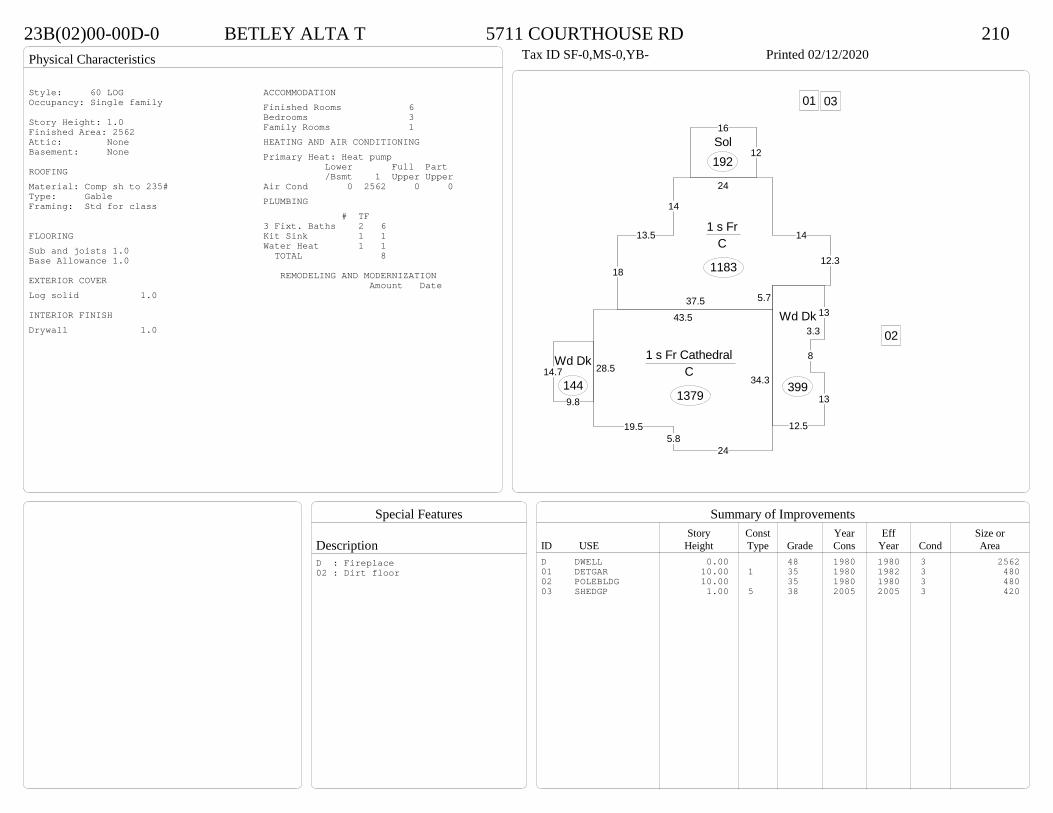
Physical Characteristics
Special Features
Description
Summary of ImprovementsStory Const Year Eff Size or
ID USE Height Type Grade Cons Year Cond Area
23B(02)00-00D-0 BETLEY ALTA T 5711 COURTHOUSE RD 210Tax ID SF-0,MS-0,YB- Printed 02/12/2020
37.5
18
13.5
14
24
14
12.3
5.7
1 s Fr C
1183
13
3.3
8
13
12.5
Wd Dk
3999.8
14.7Wd Dk
144
12
16Sol192
28.5
19.55.8
24
34.3
43.5
1 s Fr Cathedral C
1379
01
02
03Style: 60 LOGOccupancy: Single family
Story Height: 1.0Finished Area: 2562 Attic: NoneBasement: None
ROOFINGMaterial: Comp sh to 235#Type: GableFraming: Std for class
FLOORINGSub and joists 1.0Base Allowance 1.0
EXTERIOR COVERLog solid 1.0
INTERIOR FINISHDrywall 1.0
ACCOMMODATIONFinished Rooms 6Bedrooms 3Family Rooms 1HEATING AND AIR CONDITIONINGPrimary Heat: Heat pump Lower Full Part /Bsmt 1 Upper UpperAir Cond 0 2562 0 0PLUMBING # TF3 Fixt. Baths 2 6Kit Sink 1 1Water Heat 1 1 TOTAL 8
REMODELING AND MODERNIZATION Amount Date
D DWELL 0.00 48 1980 1980 3 256201 DETGAR 10.00 1 35 1980 1982 3 48002 POLEBLDG 10.00 35 1980 1980 3 48003 SHEDGP 1.00 5 38 2005 2005 3 420
D : Fireplace02 : Dirt floor
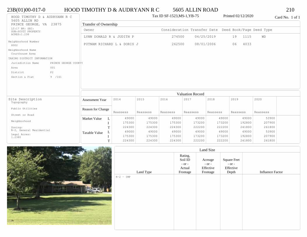
Transfer of Ownership
Valuation RecordAssessment Year
Reason for Change
Market Value
Taxable Value
LITLIT
Land SizeRating,Soil ID Acreage Square Feet- or - - or - - or -
Actual Effective EffectiveLand Type Frontage Frontage Depth Influence Factor
23B(01)00-017-0 HOOD TIMOTHY D & AUDRYANN R C 5605 ALLIN ROAD 210Tax ID SF-1523,MS-1,YB-75 Printed 02/12/2020 Card No. 1 of 1HOOD TIMOTHY D & AUDRYANN R C
5605 ALLIN RDPRINCE GEORGE, VA 23875LT:17 BK: SEC:SUB:SCOTT PROPERTYACRES:1.238
Neighborhood Number8002
Neighborhood NameCourthouse Area
TAXING DISTRICT INFORMATIONJurisdiction Name PRINCE GEORGE COUNTYArea 001 District P2 Section & Plat 9 /161
Site DescriptionTopography
Public Utilities
Street or Road
Neighborhood
Zoning:R-2, General ResidentialLegal Acres:1.2380
Owner Consideration Transfer Date Deed Book/Page Deed TypeLYNN DONALD R & JUDITH P 274500 04/25/2019 19 1115 WD
PUTNAM RICHARD L & DORIS J 262500 08/01/2006 06 4033
2014
Reassess 49000 175300 224300 49000 175300 224300
2015
Reassess 49000 175300 224300 49000 175300 224300
2016
Reassess 49000 175300 224300 49000 175300 224300
2017
Reassess 49000 173200 222200 49000 173200 222200
2018
Reassess 49000 173200 222200 49000 173200 222200
2019
Reassess 49000 192800 241800 49000 192800 241800
2020
Reassess 53900 207900 261800 53900 207900 261800
R-2 - IMP

Physical Characteristics
Special Features
Description
Summary of ImprovementsStory Const Year Eff Size or
ID USE Height Type Grade Cons Year Cond Area
23B(01)00-017-0 HOOD TIMOTHY D & AUDRYANN R C 5605 ALLIN ROAD 210Tax ID SF-1523,MS-1,YB-75 Printed 02/12/2020
21.6
12.2
15.7
12.4
9.98.4
7.810
2217.4
16.1
15.6
58.1
1 s Br C
1891
9.2Sol144
12
OMP 101
20
19
15.8
Conc
342
21.9
21.6Br G
473
01Style: 13 1 STORY 1970-78Occupancy: Single family
Story Height: 1.0Finished Area: 1891 Attic: NoneBasement: None
ROOFINGMaterial: Comp sh to 235#Type: HipFraming: Std for class
FLOORINGSub and joists 1.0Base Allowance 1.0
EXTERIOR COVERBrick 1.0
INTERIOR FINISHDrywall 1.0
ACCOMMODATIONFinished Rooms 7Bedrooms 3Formal Dining Rooms 1HEATING AND AIR CONDITIONINGPrimary Heat: Heat pump Lower Full Part /Bsmt 1 Upper UpperAir Cond 0 1891 0 0PLUMBING # TF3 Fixt. Baths 2 6Kit Sink 1 1Water Heat 1 1 TOTAL 8
REMODELING AND MODERNIZATION Amount Date
D DWELL 0.00 48 1975 1980 3 1891G01 ATTGAR 0.00 7 47301 DETGAR 1.00 1 45 1996 1996 3 720
D : Fireplace

Transfer of Ownership
Valuation RecordAssessment Year
Reason for Change
Market Value
Taxable Value
LITLIT
Land SizeRating,Soil ID Acreage Square Feet- or - - or - - or -
Actual Effective EffectiveLand Type Frontage Frontage Depth Influence Factor
340(0A)00-022-V CARR THOMAS J 8120 GOLD ACRES FARM ROAD 210Printed 02/12/2020 Card No. 1 of 1CARR THOMAS J
8120 GOLD ACRES FARM RDPRINCE GEORGE, VA 23875PT AUBREY BRITT PRACRES:1.06
Neighborhood Number8002
Neighborhood NameCourthouse Area
TAXING DISTRICT INFORMATIONJurisdiction Name PRINCE GEORGE COUNTYArea 001 District P4 Section & Plat 05/6809
Site DescriptionTopography
Public Utilities
Street or Road
Neighborhood
Zoning:Legal Acres:1.0600
Owner Consideration Transfer Date Deed Book/Page Deed TypeINGE DAVID KYLE 264950 05/07/2019 19 1227 WD
ATCHLEY JOSHUA B & STEPHENIE I 235000 03/26/2015 15 843 WD
ATCHLEY JOSHUA B 0 05/28/2013 13 1814 SW
2014
Reassess 35000 186600 221600 35000 186600 221600
2015
Reassess 35000 186600 221600 35000 186600 221600
2016
Reassess 29800 193400 223200 29800 193400 223200
2017
Reassess 29800 191700 221500 29800 191700 221500
2018
Reassess 29800 191700 221500 29800 191700 221500
2019
Reassess 29800 208100 237900 29800 208100 237900
2020
Reassess 32700 215900 248600 32700 215900 248600
R-A <20 - IMP A -15%

Physical Characteristics
Special Features
Description
Summary of ImprovementsStory Const Year Eff Size or
ID USE Height Type Grade Cons Year Cond Area
340(0A)00-022-V CARR THOMAS J 8120 GOLD ACRES FARM ROAD 210Printed 02/12/2020
12
20.32 s Fr
C 722
13
7
18.3
22.7
6.2
12
1 s Fr C
542
6
18.75 OMP 106
18.7
22
12.7
Wd Dk399
21
23.9A (UF) Fr G 436
Style: 33 2/2+Story 2000+Occupancy: Single family
Story Height: 2.0Finished Area: 1986 Attic: UnfinishedBasement: None
ROOFINGMaterial: Comp sh to 235#Type: GableFraming: Std for class
FLOORINGSub and joists 1.0, 2.0, ABase Allowance 1.0, 2.0
EXTERIOR COVERBrick 1.0, 2.0Vinyl siding 1.0, 2.0
INTERIOR FINISH
ACCOMMODATIONFinished Rooms 8Bedrooms 4Formal Dining Rooms 1HEATING AND AIR CONDITIONINGPrimary Heat: Heat pump Lower Full Part /Bsmt 1 Upper UpperAir Cond 0 1264 722 0PLUMBING # TF5 Fixt. Baths 1 54 Fixt. Baths 1 42 Fixt. Baths 1 2Kit Sink 1 1Water Heat 1 1 TOTAL 13
REMODELING AND MODERNIZATION Amount Date
D DWELL 0.00 48 2006 2010 3 2422G01 ATTGAR 0.00 1 3 436
D : Fireplace
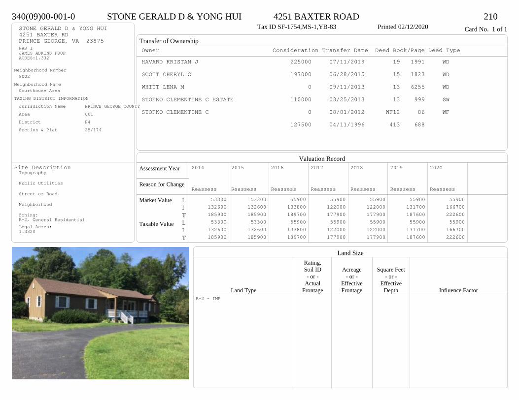
Transfer of Ownership
Valuation RecordAssessment Year
Reason for Change
Market Value
Taxable Value
LITLIT
Land SizeRating,Soil ID Acreage Square Feet- or - - or - - or -
Actual Effective EffectiveLand Type Frontage Frontage Depth Influence Factor
340(09)00-001-0 STONE GERALD D & YONG HUI 4251 BAXTER ROAD 210Tax ID SF-1754,MS-1,YB-83 Printed 02/12/2020 Card No. 1 of 1STONE GERALD D & YONG HUI
4251 BAXTER RDPRINCE GEORGE, VA 23875PAR 1JAMES ADKINS PROPACRES:1.332
Neighborhood Number8002
Neighborhood NameCourthouse Area
TAXING DISTRICT INFORMATIONJurisdiction Name PRINCE GEORGE COUNTYArea 001 District P4 Section & Plat 25/174
Site DescriptionTopography
Public Utilities
Street or Road
Neighborhood
Zoning:R-2, General ResidentialLegal Acres:1.3320
Owner Consideration Transfer Date Deed Book/Page Deed TypeHAVARD KRISTAN J 225000 07/11/2019 19 1991 WD
SCOTT CHERYL C 197000 06/28/2015 15 1823 WD
WHITT LENA M 0 09/11/2013 13 6255 WD
STOFKO CLEMENTINE C ESTATE 110000 03/25/2013 13 999 SW
STOFKO CLEMENTINE C 0 08/01/2012 WF12 86 WF
127500 04/11/1996 413 688
2014
Reassess 53300 132600 185900 53300 132600 185900
2015
Reassess 53300 132600 185900 53300 132600 185900
2016
Reassess 55900 133800 189700 55900 133800 189700
2017
Reassess 55900 122000 177900 55900 122000 177900
2018
Reassess 55900 122000 177900 55900 122000 177900
2019
Reassess 55900 131700 187600 55900 131700 187600
2020
Reassess 55900 166700 222600 55900 166700 222600
R-2 - IMP

Physical Characteristics
Special Features
Description
Summary of ImprovementsStory Const Year Eff Size or
ID USE Height Type Grade Cons Year Cond Area
340(09)00-001-0 STONE GERALD D & YONG HUI 4251 BAXTER ROAD 210Tax ID SF-1754,MS-1,YB-83 Printed 02/12/2020
26
61
1 s Fr C
1586
6.620.7
OFP 137
12
141 s Fr
C 168
714
OFP98
Wd Dk
200
16
181 s Fr
C
288
46
Wd Dk
24
0102Style: 14 1 STORY 1979-89
Occupancy: Single family
Story Height: 1.0Finished Area: 2042 Attic: NoneBasement: None
ROOFINGMaterial: Comp sh to 235#Type: GableFraming: Std for class
FLOORINGSub and joists 1.0Base Allowance 1.0
EXTERIOR COVERStone 1.0Wood siding 1.0
INTERIOR FINISHDrywall 1.0
ACCOMMODATIONFinished Rooms 5Bedrooms 3HEATING AND AIR CONDITIONINGPrimary Heat: Heat pump Lower Full Part /Bsmt 1 Upper UpperAir Cond 0 2042 0 0PLUMBING # TF3 Fixt. Baths 2 6Kit Sink 1 1Water Heat 1 1 TOTAL 8
REMODELING AND MODERNIZATION Amount Date
D DWELL 0.00 45 1983 1983 3 204201 DETGAR 0.00 1 45 1985 1985 3 57602 PIER 0.00 45 1983 1983 3 144
D : Fireplace
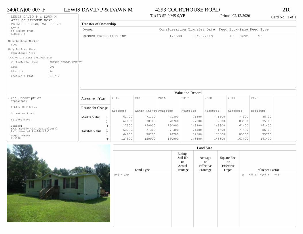
Transfer of Ownership
Valuation RecordAssessment Year
Reason for Change
Market Value
Taxable Value
LITLIT
Land SizeRating,Soil ID Acreage Square Feet- or - - or - - or -
Actual Effective EffectiveLand Type Frontage Frontage Depth Influence Factor
340(0A)00-007-F LEWIS DAVID P & DAWN M 4293 COURTHOUSE ROAD 210Tax ID SF-0,MS-0,YB- Printed 02/12/2020 Card No. 1 of 1LEWIS DAVID P & DAWN M
4293 COURTHOUSE ROADPRINCE GEORGE, VA 23875LOT 2PT WAGNER PROPACRES:8.5
Neighborhood Number8002
Neighborhood NameCourthouse Area
TAXING DISTRICT INFORMATIONJurisdiction Name PRINCE GEORGE COUNTYArea 001 District P4 Section & Plat 21 /77
Site DescriptionTopography
Public Utilities
Street or Road
Neighborhood
Zoning:R-A, Residential AgriculturalR-2, General ResidentialLegal Acres:8.5000
Owner Consideration Transfer Date Deed Book/Page Deed TypeWAGNER PROPERTIES INC 128500 11/20/2019 19 3492 WD
2015
Reassess 62700 64800 127500 62700 64800 127500
2015
Admin Change 71300 78700 150000 71300 78700 150000
2016
Reassess 71300 78700 150000 71300 78700 150000
2017
Reassess 71300 77500 148800 71300 77500 148800
2018
Reassess 71300 77500 148800 71300 77500 148800
2019
Reassess 77900 83500 161400 77900 83500 161400
2020
Reassess 85700 75700 161400 85700 75700 161400
R-2 - IMP R -5% S -10% W -4%
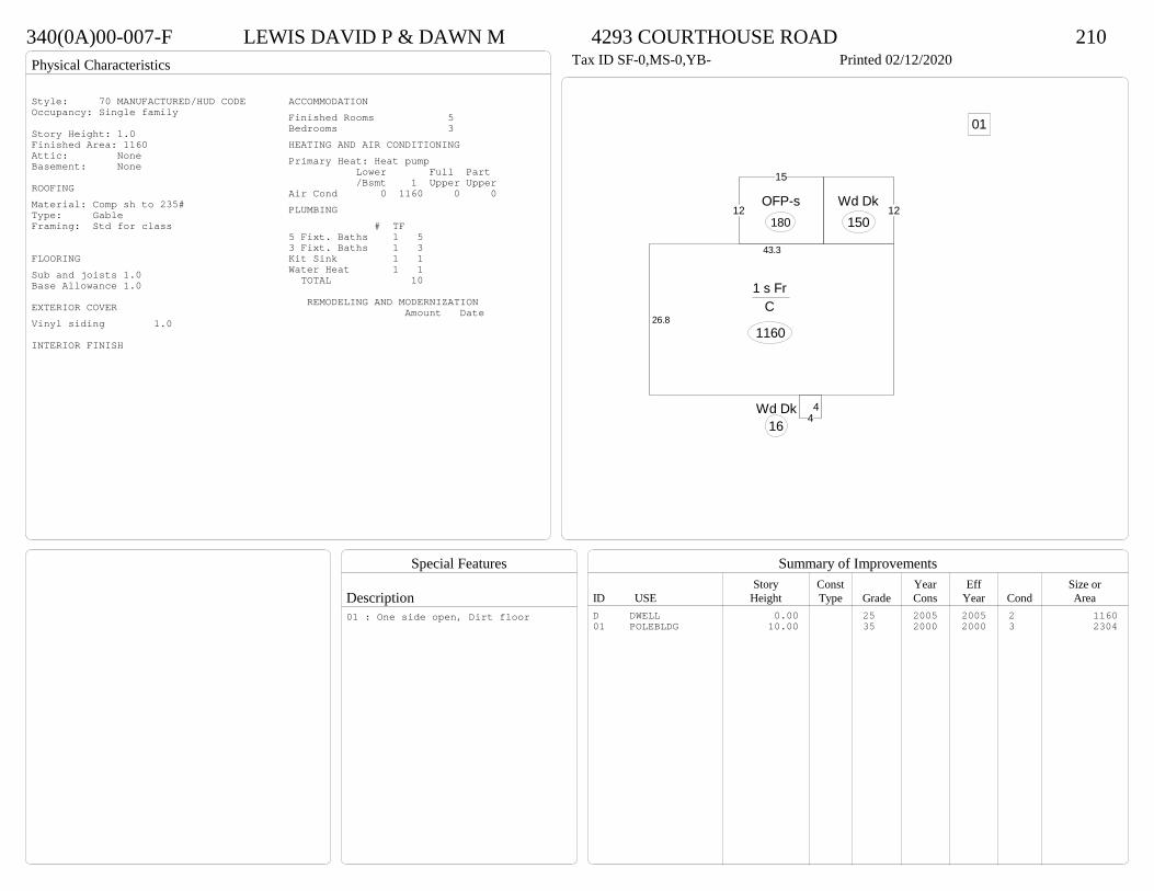
Physical Characteristics
Special Features
Description
Summary of ImprovementsStory Const Year Eff Size or
ID USE Height Type Grade Cons Year Cond Area
340(0A)00-007-F LEWIS DAVID P & DAWN M 4293 COURTHOUSE ROAD 210Tax ID SF-0,MS-0,YB- Printed 02/12/2020
26.8
43.3
1 s Fr C
1160
44
Wd Dk16
12Wd Dk
15012
15
OFP-s180
01
Style: 70 MANUFACTURED/HUD CODEOccupancy: Single family
Story Height: 1.0Finished Area: 1160 Attic: NoneBasement: None
ROOFINGMaterial: Comp sh to 235#Type: GableFraming: Std for class
FLOORINGSub and joists 1.0Base Allowance 1.0
EXTERIOR COVERVinyl siding 1.0
INTERIOR FINISH
ACCOMMODATIONFinished Rooms 5Bedrooms 3HEATING AND AIR CONDITIONINGPrimary Heat: Heat pump Lower Full Part /Bsmt 1 Upper UpperAir Cond 0 1160 0 0PLUMBING # TF5 Fixt. Baths 1 53 Fixt. Baths 1 3Kit Sink 1 1Water Heat 1 1 TOTAL 10
REMODELING AND MODERNIZATION Amount Date
D DWELL 0.00 25 2005 2005 2 116001 POLEBLDG 10.00 35 2000 2000 3 2304
01 : One side open, Dirt floor

Transfer of Ownership
Valuation RecordAssessment Year
Reason for Change
Market Value
Taxable Value
LITLIT
Land SizeRating,Soil ID Acreage Square Feet- or - - or - - or -
Actual Effective EffectiveLand Type Frontage Frontage Depth Influence Factor
230(09)00-00A-1 MCLAUGHLIN TODD 6453 SAWMILL ROAD 210Tax ID SF-0,MS-0,YB- Printed 02/12/2020 Card No. 1 of 1MCLAUGHLIN TODD
6453 SAWMILL RDPRINCE GEORGE, VA 23875PT SAMUEL ALLIN PROPACRES:1.45
Neighborhood Number8002
Neighborhood NameCourthouse Area
TAXING DISTRICT INFORMATIONJurisdiction Name PRINCE GEORGE COUNTYArea 001 District P2 Section & Plat 436/194
Site DescriptionTopography
Public Utilities
Street or Road
Neighborhood
Zoning:R-A, Residential AgriculturalLegal Acres:1.4500
Owner Consideration Transfer Date Deed Book/Page Deed TypeDUMOND MARTIN J & ALICIA M 174500 10/09/2019 19 2994 WD
WHIRLEY RICHARD M JR & BETH A 129900 09/30/2015 15 2889 WD
2014
Admin Change 35100 89400 124500 35100 89400 124500
2015
Reassess 35100 89400 124500 35100 89400 124500
2016
Reassess 33900 92100 126000 33900 92100 126000
2017
Reassess 33900 91100 125000 33900 91100 125000
2018
Reassess 33900 91100 125000 33900 91100 125000
2019
Reassess 33900 99100 133000 33900 99100 133000
2020
Reassess 37200 89900 127100 37200 89900 127100
R-A <20 - IMP A -10% R -3%

Physical Characteristics
Special Features
Description
Summary of ImprovementsStory Const Year Eff Size or
ID USE Height Type Grade Cons Year Cond Area
230(09)00-00A-1 MCLAUGHLIN TODD 6453 SAWMILL ROAD 210Tax ID SF-0,MS-0,YB- Printed 02/12/2020
56
30.7
1 s Fr C
1719
8.4
17.5
Wd Dk 147
44
Wd Dk
16
01
Style: 70 MANUFACTURED/HUD CODEOccupancy: Single family
Story Height: 1.0Finished Area: 1719 Attic: NoneBasement: None
ROOFINGMaterial: Comp sh to 235#Type: GableFraming: Std for class
FLOORINGSub and joists 1.0Base Allowance 1.0
EXTERIOR COVERVinyl siding 1.0
INTERIOR FINISHDrywall 1.0
ACCOMMODATIONFinished Rooms 8Bedrooms 3Formal Dining Rooms 1HEATING AND AIR CONDITIONINGPrimary Heat: Heat pump Lower Full Part /Bsmt 1 Upper UpperAir Cond 0 1719 0 0PLUMBING # TF5 Fixt. Baths 1 53 Fixt. Baths 1 3Kit Sink 1 1Water Heat 1 1 TOTAL 10
REMODELING AND MODERNIZATION Amount Date
D DWELL 0.00 25 2001 2001 3 171901 UTLSHED 10.00 1 45 2007 2007 3 308
D : Fireplace
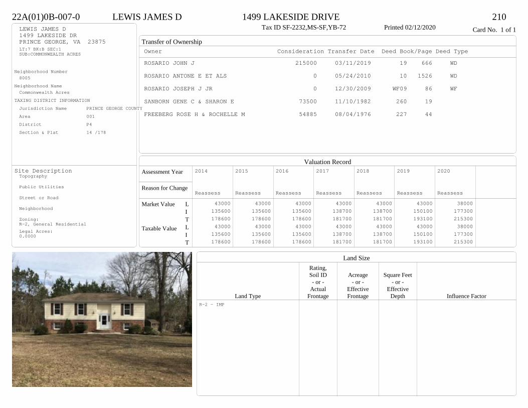
Transfer of Ownership
Valuation RecordAssessment Year
Reason for Change
Market Value
Taxable Value
LITLIT
Land SizeRating,Soil ID Acreage Square Feet- or - - or - - or -
Actual Effective EffectiveLand Type Frontage Frontage Depth Influence Factor
22A(01)0B-007-0 LEWIS JAMES D 1499 LAKESIDE DRIVE 210Tax ID SF-2232,MS-SF,YB-72 Printed 02/12/2020 Card No. 1 of 1LEWIS JAMES D
1499 LAKESIDE DRPRINCE GEORGE, VA 23875LT:7 BK:B SEC:1SUB:COMMONWEALTH ACRES
Neighborhood Number8005
Neighborhood NameCommonwealth Acres
TAXING DISTRICT INFORMATIONJurisdiction Name PRINCE GEORGE COUNTYArea 001 District P4 Section & Plat 14 /178
Site DescriptionTopography
Public Utilities
Street or Road
Neighborhood
Zoning:R-2, General ResidentialLegal Acres:0.0000
Owner Consideration Transfer Date Deed Book/Page Deed TypeROSARIO JOHN J 215000 03/11/2019 19 666 WD
ROSARIO ANTONE E ET ALS 0 05/24/2010 10 1526 WD
ROSARIO JOSEPH J JR 0 12/30/2009 WF09 86 WF
SANBORN GENE C & SHARON E 73500 11/10/1982 260 19
FREEBERG ROSE H & ROCHELLE M 54885 08/04/1976 227 44
2014
Reassess 43000 135600 178600 43000 135600 178600
2015
Reassess 43000 135600 178600 43000 135600 178600
2016
Reassess 43000 135600 178600 43000 135600 178600
2017
Reassess 43000 138700 181700 43000 138700 181700
2018
Reassess 43000 138700 181700 43000 138700 181700
2019
Reassess 43000 150100 193100 43000 150100 193100
2020
Reassess 38000 177300 215300 38000 177300 215300
R-2 - IMP

Physical Characteristics
Special Features
Description
Summary of ImprovementsStory Const Year Eff Size or
ID USE Height Type Grade Cons Year Cond Area
22A(01)0B-007-0 LEWIS JAMES D 1499 LAKESIDE DRIVE 210Tax ID SF-2232,MS-SF,YB-72 Printed 02/12/2020
46
241.3
7.21.3
14.8
26.6
1 s Fr L (Fin)
1214
1.31 s Fr OH
60
12
14Wd DkOMP-s
168
15.9M Stp49
16Conc 128
Style: 40 SPLIT FOYEROccupancy: Single family
Story Height: Bi-levelFinished Area: 2488 Attic: NoneBasement: None
ROOFINGMaterial: Comp sh to 235#Type: HipFraming: Std for class
FLOORINGSlab LSub and joists 1.0Base Allowance L, 1.0
EXTERIOR COVERBrick L, 1.0Block LVinyl siding 1.0
INTERIOR FINISHDrywall 1.0
ACCOMMODATIONFinished Rooms 8Bedrooms 4HEATING AND AIR CONDITIONINGPrimary Heat: Forced hot air Lower Full Part /Bsmt 1 Upper UpperAir Cond 1214 1274 0 0PLUMBING # TF3 Fixt. Baths 1 32 Fixt. Baths 1 2Kit Sink 1 1Water Heat 1 1 TOTAL 7
REMODELING AND MODERNIZATION Amount Date
D DWELL 0.00 45 1972 1984 3 2488D : Fireplace

Transfer of Ownership
Valuation RecordAssessment Year
Reason for Change
Market Value
Taxable Value
LITLIT
Land SizeRating,Soil ID Acreage Square Feet- or - - or - - or -
Actual Effective EffectiveLand Type Frontage Frontage Depth Influence Factor
22A(01)0B-012-0 STEPHENS JOHN ANDREW 1551 LAKESIDE DRIVE 210Tax ID SF-0,MS-0,YB- Printed 02/12/2020 Card No. 1 of 1STEPHENS JOHN ANDREW
1551 LAKESIDE DRPRINCE GEORGE, VA 23875LT:12 BK:B SEC:1SUB:COMMONWEALTH ACRESACRES:0.27
Neighborhood Number8005
Neighborhood NameCommonwealth Acres
TAXING DISTRICT INFORMATIONJurisdiction Name PRINCE GEORGE COUNTYArea 001 District P4 Section & Plat 14 /178
Site DescriptionTopography
Public Utilities
Street or Road
Neighborhood
Zoning:R-2, General ResidentialLegal Acres:0.2700
Owner Consideration Transfer Date Deed Book/Page Deed TypeCOLE DAVID P 212700 09/23/2019 19 2837 WD
QUICK CLARK A SR 225000 12/21/2007 07 6281
2014
Reassess 43000 147200 190200 43000 147200 190200
2015
Reassess 43000 147200 190200 43000 147200 190200
2016
Reassess 43000 147200 190200 43000 147200 190200
2017
Reassess 43000 145800 188800 43000 145800 188800
2018
Reassess 43000 152000 195000 43000 152000 195000
2019
Reassess 43000 155100 198100 43000 155100 198100
2020
Reassess 38000 171100 209100 38000 171100 209100
R-2 - IMP
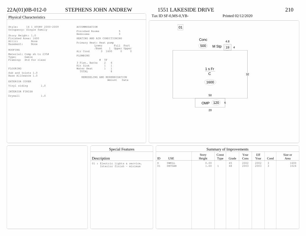
Physical Characteristics
Special Features
Description
Summary of ImprovementsStory Const Year Eff Size or
ID USE Height Type Grade Cons Year Cond Area
22A(01)0B-012-0 STEPHENS JOHN ANDREW 1551 LAKESIDE DRIVE 210Tax ID SF-0,MS-0,YB- Printed 02/12/2020
32
50
1 s Fr C
1600
6
20
OMP 120
4
4.8
M Stp 19
Conc
500
01Style: 16 1 STORY 2000-2009Occupancy: Single family
Story Height: 1.0Finished Area: 1600 Attic: NoneBasement: None
ROOFINGMaterial: Comp sh to 235#Type: GableFraming: Std for class
FLOORINGSub and joists 1.0Base Allowance 1.0
EXTERIOR COVERVinyl siding 1.0
INTERIOR FINISHDrywall 1.0
ACCOMMODATIONFinished Rooms 5Bedrooms 3HEATING AND AIR CONDITIONINGPrimary Heat: Heat pump Lower Full Part /Bsmt 1 Upper UpperAir Cond 0 1600 0 0PLUMBING # TF3 Fixt. Baths 2 6Kit Sink 1 1Water Heat 1 1 TOTAL 8
REMODELING AND MODERNIZATION Amount Date
D DWELL 0.00 45 2002 2002 3 160001 DETGAR 1.00 1 48 2003 2003 3 1024
01 : Electric lights & service, Interior finish - minimum
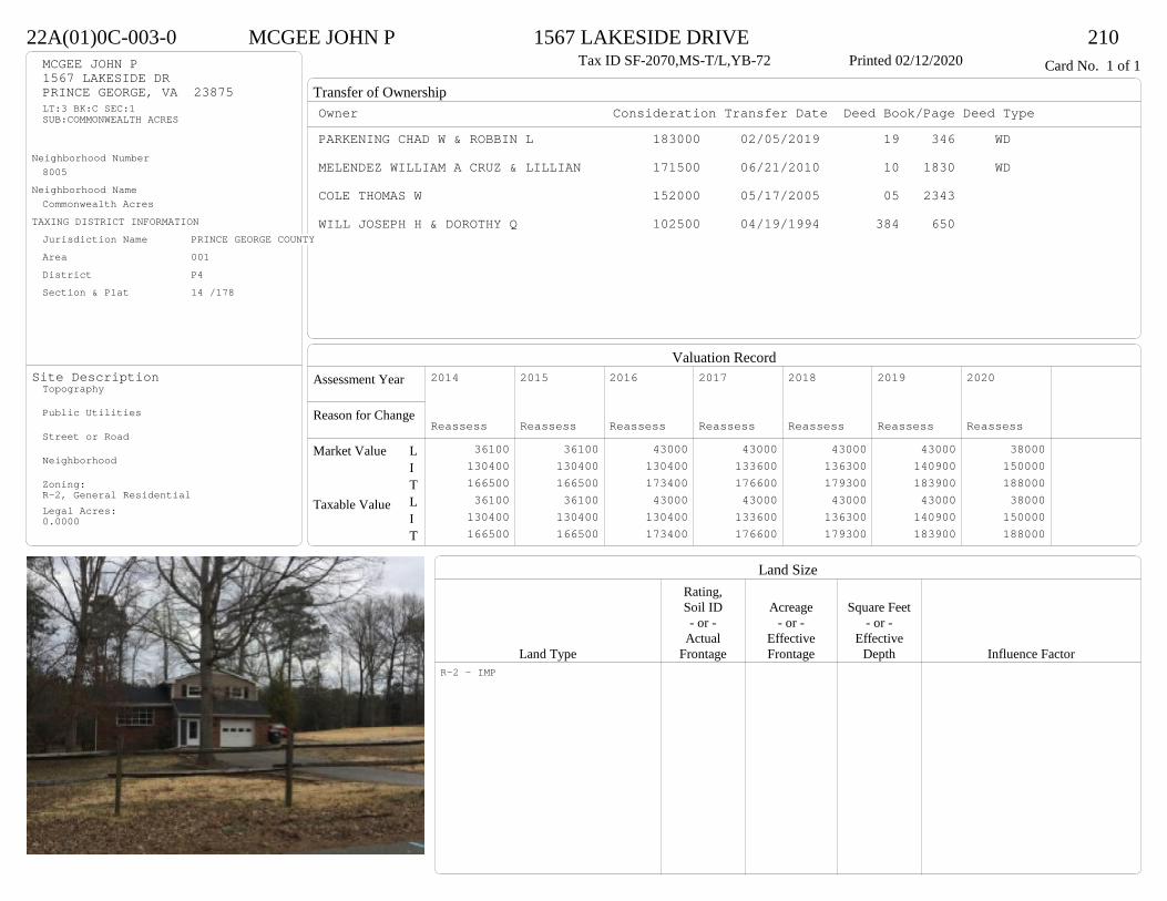
Transfer of Ownership
Valuation RecordAssessment Year
Reason for Change
Market Value
Taxable Value
LITLIT
Land SizeRating,Soil ID Acreage Square Feet- or - - or - - or -
Actual Effective EffectiveLand Type Frontage Frontage Depth Influence Factor
22A(01)0C-003-0 MCGEE JOHN P 1567 LAKESIDE DRIVE 210Tax ID SF-2070,MS-T/L,YB-72 Printed 02/12/2020 Card No. 1 of 1MCGEE JOHN P
1567 LAKESIDE DRPRINCE GEORGE, VA 23875LT:3 BK:C SEC:1SUB:COMMONWEALTH ACRES
Neighborhood Number8005
Neighborhood NameCommonwealth Acres
TAXING DISTRICT INFORMATIONJurisdiction Name PRINCE GEORGE COUNTYArea 001 District P4 Section & Plat 14 /178
Site DescriptionTopography
Public Utilities
Street or Road
Neighborhood
Zoning:R-2, General ResidentialLegal Acres:0.0000
Owner Consideration Transfer Date Deed Book/Page Deed TypePARKENING CHAD W & ROBBIN L 183000 02/05/2019 19 346 WD
MELENDEZ WILLIAM A CRUZ & LILLIAN 171500 06/21/2010 10 1830 WD
COLE THOMAS W 152000 05/17/2005 05 2343
WILL JOSEPH H & DOROTHY Q 102500 04/19/1994 384 650
2014
Reassess 36100 130400 166500 36100 130400 166500
2015
Reassess 36100 130400 166500 36100 130400 166500
2016
Reassess 43000 130400 173400 43000 130400 173400
2017
Reassess 43000 133600 176600 43000 133600 176600
2018
Reassess 43000 136300 179300 43000 136300 179300
2019
Reassess 43000 140900 183900 43000 140900 183900
2020
Reassess 38000 150000 188000 38000 150000 188000
R-2 - IMP
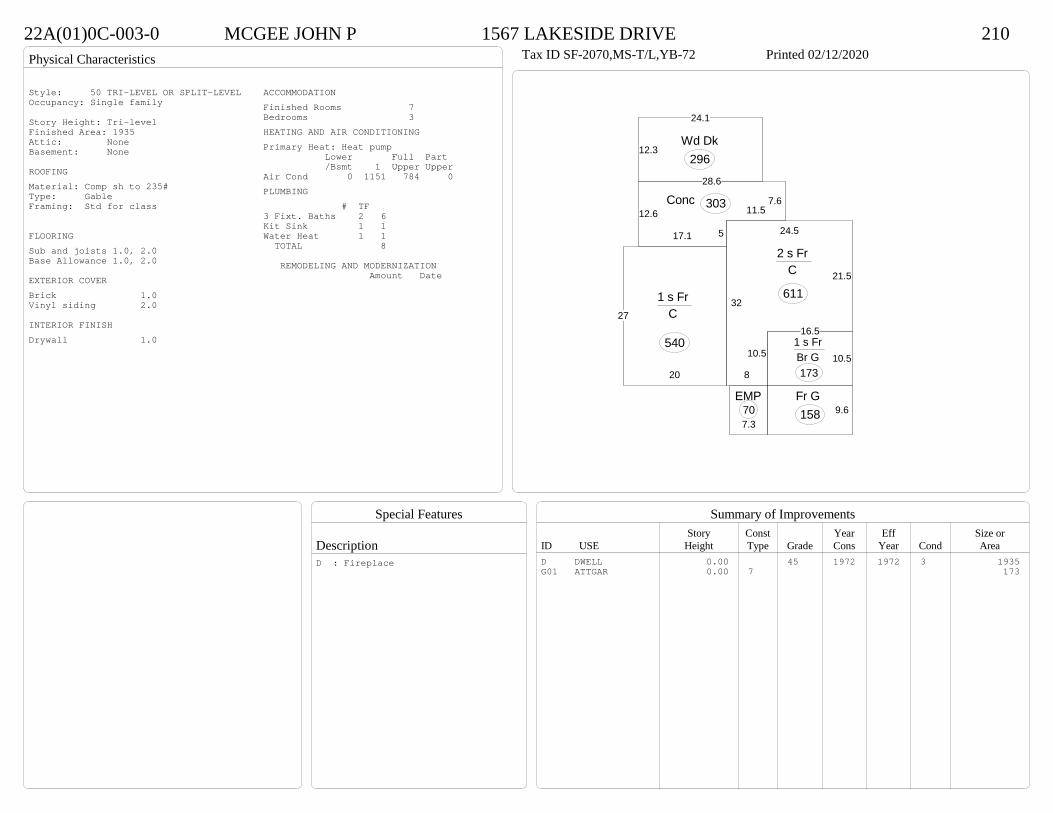
Physical Characteristics
Special Features
Description
Summary of ImprovementsStory Const Year Eff Size or
ID USE Height Type Grade Cons Year Cond Area
22A(01)0C-003-0 MCGEE JOHN P 1567 LAKESIDE DRIVE 210Tax ID SF-2070,MS-T/L,YB-72 Printed 02/12/2020
8
32
24.5
21.5
16.5
10.5
2 s Fr C
611
20
27
1 s Fr C
540
7.3
EMP70
17.1
12.6
28.6
7.611.5
5
Conc 303
12.3
24.1
Wd Dk296
10.51 s Fr Br G 173
9.6Fr G 158
Style: 50 TRI-LEVEL OR SPLIT-LEVELOccupancy: Single family
Story Height: Tri-levelFinished Area: 1935 Attic: NoneBasement: None
ROOFINGMaterial: Comp sh to 235#Type: GableFraming: Std for class
FLOORINGSub and joists 1.0, 2.0Base Allowance 1.0, 2.0
EXTERIOR COVERBrick 1.0Vinyl siding 2.0
INTERIOR FINISHDrywall 1.0
ACCOMMODATIONFinished Rooms 7Bedrooms 3HEATING AND AIR CONDITIONINGPrimary Heat: Heat pump Lower Full Part /Bsmt 1 Upper UpperAir Cond 0 1151 784 0PLUMBING # TF3 Fixt. Baths 2 6Kit Sink 1 1Water Heat 1 1 TOTAL 8
REMODELING AND MODERNIZATION Amount Date
D DWELL 0.00 45 1972 1972 3 1935G01 ATTGAR 0.00 7 173
D : Fireplace
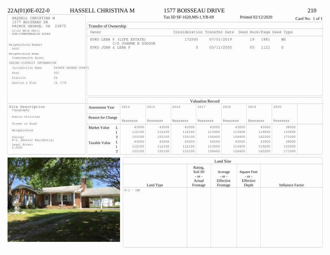
Transfer of Ownership
Valuation RecordAssessment Year
Reason for Change
Market Value
Taxable Value
LITLIT
Land SizeRating,Soil ID Acreage Square Feet- or - - or - - or -
Actual Effective EffectiveLand Type Frontage Frontage Depth Influence Factor
22A(01)0E-022-0 HASSELL CHRISTINA M 1577 BOISSEAU DRIVE 210Tax ID SF-1620,MS-1,YB-69 Printed 02/12/2020 Card No. 1 of 1HASSELL CHRISTINA M
1577 BOISSEAU DRPRINCE GEORGE, VA 23875LT:22 BK:E SEC:1SUB:COMMONWEALTH ACRES
Neighborhood Number8005
Neighborhood NameCommonwealth Acres
TAXING DISTRICT INFORMATIONJurisdiction Name PRINCE GEORGE COUNTYArea 001 District P4 Section & Plat 14 /178
Site DescriptionTopography
Public Utilities
Street or Road
Neighborhood
Zoning:R-2, General ResidentialLegal Acres:0.0000
Owner Consideration Transfer Date Deed Book/Page Deed TypeEVKO LENA F (LIFE ESTATE) 172000 07/01/2019 19 1881 WD
C/O JOANNE E DODSONEVKO JOHN & LENA F 0 03/11/2005 05 1121 G
2014
Reassess 43000 112100 155100 43000 112100 155100
2015
Reassess 43000 112100 155100 43000 112100 155100
2016
Reassess 43000 112100 155100 43000 112100 155100
2017
Reassess 43000 113400 156400 43000 113400 156400
2018
Reassess 43000 113400 156400 43000 113400 156400
2019
Reassess 43000 119200 162200 43000 119200 162200
2020
Reassess 38000 133000 171000 38000 133000 171000
R-2 - IMP

Physical Characteristics
Special Features
Description
Summary of ImprovementsStory Const Year Eff Size or
ID USE Height Type Grade Cons Year Cond Area
22A(01)0E-022-0 HASSELL CHRISTINA M 1577 BOISSEAU DRIVE 210Tax ID SF-1620,MS-1,YB-69 Printed 02/12/2020
24
627
3
27
54
1 s Br C
1620
4OMP 96
17.5
19CnpyConc
333
24
23.6
Fr CP
566
01
Style: 12 1 STORY 1960-69Occupancy: Single family
Story Height: 1.0Finished Area: 1620 Attic: NoneBasement: None
ROOFINGMaterial: Comp sh to 235#Type: GableFraming: Std for class
FLOORINGSub and joists 1.0Base Allowance 1.0
EXTERIOR COVERBrick 1.0
INTERIOR FINISHDrywall 1.0
ACCOMMODATIONFinished Rooms 6Bedrooms 3Formal Dining Rooms 1HEATING AND AIR CONDITIONINGPrimary Heat: Electric baseboard Lower Full Part /Bsmt 1 Upper UpperPLUMBING # TF3 Fixt. Baths 2 6Kit Sink 1 1Water Heat 1 1 TOTAL 8
REMODELING AND MODERNIZATION Amount Date
D DWELL 0.00 45 1969 1980 3 1620G01 ICP 0.00 7 56601 SHEDGP 1.00 1 35 1969 1969 3 320
D : Remod 2019 Fireplace

Transfer of Ownership
Valuation RecordAssessment Year
Reason for Change
Market Value
Taxable Value
LITLIT
Land SizeRating,Soil ID Acreage Square Feet- or - - or - - or -
Actual Effective EffectiveLand Type Frontage Frontage Depth Influence Factor
22A(01)0E-014-0 HOWARD DEBORAH D 1586 LAKESIDE DRIVE 210Tax ID SF-1370,MS-1,YB-68 Printed 02/12/2020 Card No. 1 of 1HOWARD DEBORAH D
1586 LAKESIDE DRPRINCE GEORGE, VA 23875LT:14 BK:E SEC:1SUB:COMMONWEALTH ACRES
Neighborhood Number8005
Neighborhood NameCommonwealth Acres
TAXING DISTRICT INFORMATIONJurisdiction Name PRINCE GEORGE COUNTYArea 001 District P4 Section & Plat 14 /178
Site DescriptionTopography
Public Utilities
Street or Road
Neighborhood
Zoning:R-2, General ResidentialLegal Acres:0.0000
Owner Consideration Transfer Date Deed Book/Page Deed TypeHARRIS ARTHUR L & JUDITH E 172000 07/01/2019 19 1859 WD
BAINES JOHN A JR 134000 08/31/2015 15 2554 WD
BUSCH RALPH & DOROTHY REV LIVING TR 168000 07/16/2008 08 3111
BUSCH RALPH P & DOROTHY M 0 05/24/2007 07 2684 DG
STUTZ JOE 20500 12/02/1968 198 742
2014
Reassess 43000 100600 143600 43000 100600 143600
2015
Reassess 43000 100600 143600 43000 100600 143600
2016
Reassess 43000 100600 143600 43000 100600 143600
2017
Reassess 43000 103000 146000 43000 103000 146000
2018
Reassess 43000 103000 146000 43000 103000 146000
2019
Reassess 43000 108300 151300 43000 108300 151300
2020
Reassess 38000 108500 146500 38000 108500 146500
R-2 - IMP

Physical Characteristics
Special Features
Description
Summary of ImprovementsStory Const Year Eff Size or
ID USE Height Type Grade Cons Year Cond Area
22A(01)0E-014-0 HOWARD DEBORAH D 1586 LAKESIDE DRIVE 210Tax ID SF-1370,MS-1,YB-68 Printed 02/12/2020
48
26.8
472
106
1 s Br C
1342
4
6.2
M Stp25
14
15.5
EMP
217
20.6
12
Wd Dk
247
13
28.8
46
9
22.8
Br G
320
Style: 12 1 STORY 1960-69Occupancy: Single family
Story Height: 1.0Finished Area: 1342 Attic: NoneBasement: None
ROOFINGMaterial: Comp sh to 235#Type: GableFraming: Std for class
FLOORINGSub and joists 1.0Base Allowance 1.0
EXTERIOR COVERBrick 1.0
INTERIOR FINISHDrywall 1.0
ACCOMMODATIONFinished Rooms 6Bedrooms 3HEATING AND AIR CONDITIONINGPrimary Heat: Electric baseboard Lower Full Part /Bsmt 1 Upper UpperAir Cond 0 1342 0 0PLUMBING # TF3 Fixt. Baths 2 6Kit Sink 1 1Water Heat 1 1 TOTAL 8
REMODELING AND MODERNIZATION Amount Date
D DWELL 0.00 45 1968 1968 3 1342G01 ATTGAR 0.00 7 320
D : Remod 1977
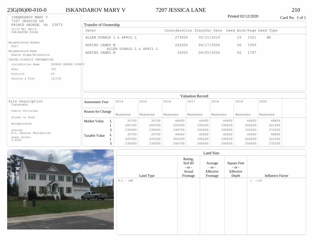
Transfer of Ownership
Valuation RecordAssessment Year
Reason for Change
Market Value
Taxable Value
LITLIT
Land SizeRating,Soil ID Acreage Square Feet- or - - or - - or -
Actual Effective EffectiveLand Type Frontage Frontage Depth Influence Factor
23G(06)00-010-0 ISKANDAROV MARY V 7207 JESSICA LANE 210Printed 02/12/2020 Card No. 1 of 1ISKANDAROV MARY V
7207 JESSICA LNPRINCE GEORGE, VA 23875LT:10 BK: SEC:6SUB:BAXTER RIDGE
Neighborhood Number8007
Neighborhood NameBaxter Ridge/Brookshire
TAXING DISTRICT INFORMATIONJurisdiction Name PRINCE GEORGE COUNTYArea 001 District P4 Section & Plat 22/236
Site DescriptionTopography
Public Utilities
Street or Road
Neighborhood
Zoning:R-2, General ResidentialLegal Acres:0.0000
Owner Consideration Transfer Date Deed Book/Page Deed TypeALLEN DONALD L & APRIL L 274000 05/31/2019 19 1521 WD
ADKINS JAMES M 262450 04/17/2006 06 1959 ALLEN DONALD L & APRIL L
ADKINS JAMES M 30000 04/05/2006 06 1787
2014
Reassess 35700 200300 236000 35700 200300 236000
2015
Reassess 35700 200300 236000 35700 200300 236000
2016
Reassess 44400 200300 244700 44400 200300 244700
2017
Reassess 44400 196200 240600 44400 196200 240600
2018
Reassess 44400 196200 240600 44400 196200 240600
2019
Reassess 44400 206200 250600 44400 206200 250600
2020
Reassess 48800 221400 270200 48800 221400 270200
R-2 - IMP 1 -13%
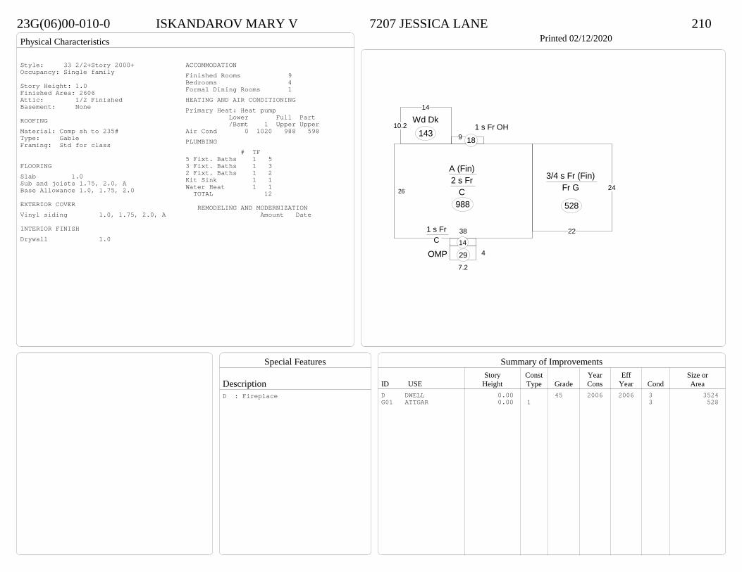
Physical Characteristics
Special Features
Description
Summary of ImprovementsStory Const Year Eff Size or
ID USE Height Type Grade Cons Year Cond Area
23G(06)00-010-0 ISKANDAROV MARY V 7207 JESSICA LANE 210Printed 02/12/2020
38
26
A (Fin) 2 s Fr
C 988
91 s Fr OH
18
10.2
14
Wd Dk143
1 s Fr C 14
4
7.2
OMP 29
22
243/4 s Fr (Fin)
Fr G
528
Style: 33 2/2+Story 2000+Occupancy: Single family
Story Height: 1.0Finished Area: 2606 Attic: 1/2 FinishedBasement: None
ROOFINGMaterial: Comp sh to 235#Type: GableFraming: Std for class
FLOORINGSlab 1.0Sub and joists 1.75, 2.0, ABase Allowance 1.0, 1.75, 2.0
EXTERIOR COVERVinyl siding 1.0, 1.75, 2.0, A
INTERIOR FINISHDrywall 1.0
ACCOMMODATIONFinished Rooms 9Bedrooms 4Formal Dining Rooms 1HEATING AND AIR CONDITIONINGPrimary Heat: Heat pump Lower Full Part /Bsmt 1 Upper UpperAir Cond 0 1020 988 598PLUMBING # TF5 Fixt. Baths 1 53 Fixt. Baths 1 32 Fixt. Baths 1 2Kit Sink 1 1Water Heat 1 1 TOTAL 12
REMODELING AND MODERNIZATION Amount Date
D DWELL 0.00 45 2006 2006 3 3524G01 ATTGAR 0.00 1 3 528
D : Fireplace

Transfer of Ownership
Valuation RecordAssessment Year
Reason for Change
Market Value
Taxable Value
LITLIT
Land SizeRating,Soil ID Acreage Square Feet- or - - or - - or -
Actual Effective EffectiveLand Type Frontage Frontage Depth Influence Factor
23G(04)00-035-0 GREENE CHARLENE & SEQUOIA 7213 BRANDON LANE 210Tax ID SF-0,MS-0,YB- Printed 02/12/2020 Card No. 1 of 1GREENE CHARLENE & SEQUOIA
7213 BRANDON LNPRINCE GEORGE, VA 23875LT:35 BK: SEC:4SUB:BAXTER RIDGEACRES:0.33
Neighborhood Number8007
Neighborhood NameBaxter Ridge/Brookshire
TAXING DISTRICT INFORMATIONJurisdiction Name PRINCE GEORGE COUNTYArea 001 District P4 Section & Plat 21 /127
Site DescriptionTopography
Public Utilities
Street or Road
Neighborhood
Zoning:R-2, General ResidentialLegal Acres:0.3300
Owner Consideration Transfer Date Deed Book/Page Deed TypeRIVERA RAMON D & ANGELA M 261000 03/27/2019 19 794 WD
RIVERA RAMON D 0 09/11/2018 18 2772 WD
RIVERA RAMON D & ANNE B 0 03/11/2010 10 744 WD
SULLIVAN JERRY W SR 135500 02/19/1999 467 703
ADKINS JAMES M 23500 08/25/1998 455 82
2014
Reassess 51000 155800 206800 51000 155800 206800
2015
Reassess 51000 155800 206800 51000 155800 206800
2016
Reassess 51000 155800 206800 51000 155800 206800
2017
Reassess 51000 155800 206800 51000 155800 206800
2018
Reassess 51000 155800 206800 51000 155800 206800
2019
Reassess 51000 163600 214600 51000 163600 214600
2020
Reassess 56100 176800 232900 56100 176800 232900
R-2 - IMP

Physical Characteristics
Special Features
Description
Summary of ImprovementsStory Const Year Eff Size or
ID USE Height Type Grade Cons Year Cond Area
23G(04)00-035-0 GREENE CHARLENE & SEQUOIA 7213 BRANDON LANE 210Tax ID SF-0,MS-0,YB- Printed 02/12/2020
26
31
2 s Fr C
806
6OFP 186
4
17.61 s Fr C 70
11.9
10.1Wd Dk120
24
22
1/2 s Fr (Fin) Fr G
528FROG 308 SF
Style: 32 2/2+Story 1980-1999Occupancy: Single family
Story Height: 2.0Finished Area: 1990 Attic: NoneBasement: None
ROOFINGMaterial: Comp sh to 235#Type: GableFraming: Std for class
FLOORINGSub and joists 1.0, 1.5, 2.0Base Allowance 1.0, 1.5, 2.0
EXTERIOR COVERVinyl siding 1.0, 1.5, 2.0
INTERIOR FINISHDrywall 1.0, 1.5, 2.0
ACCOMMODATIONFinished Rooms 7Bedrooms 4Formal Dining Rooms 1HEATING AND AIR CONDITIONINGPrimary Heat: Heat pump Lower Full Part /Bsmt 1 Upper UpperAir Cond 0 876 806 308PLUMBING # TF3 Fixt. Baths 2 62 Fixt. Baths 1 2Kit Sink 1 1Water Heat 1 1 TOTAL 10
REMODELING AND MODERNIZATION Amount Date
D DWELL 0.00 45 1999 1999 3 2210G01 ATTGAR 0.00 1 528
D : Fireplace
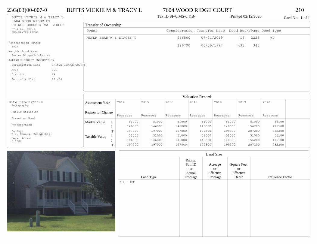
Transfer of Ownership
Valuation RecordAssessment Year
Reason for Change
Market Value
Taxable Value
LITLIT
Land SizeRating,Soil ID Acreage Square Feet- or - - or - - or -
Actual Effective EffectiveLand Type Frontage Frontage Depth Influence Factor
23G(03)00-007-0 BUTTS VICKIE M & TRACY L 7604 WOOD RIDGE COURT 210Tax ID SF-0,MS-0,YB- Printed 02/12/2020 Card No. 1 of 1BUTTS VICKIE M & TRACY L
7604 WOOD RIDGE CTPRINCE GEORGE, VA 23875LT:7 BK: SEC:3SUB:BAXTER RIDGE
Neighborhood Number8007
Neighborhood NameBaxter Ridge/Brookshire
TAXING DISTRICT INFORMATIONJurisdiction Name PRINCE GEORGE COUNTYArea 001 District P4 Section & Plat 21 /86
Site DescriptionTopography
Public Utilities
Street or Road
Neighborhood
Zoning:R-2, General ResidentialLegal Acres:0.0000
Owner Consideration Transfer Date Deed Book/Page Deed TypeMEYER BRAD W & STACEY T 266500 07/31/2019 19 2223 WD
126790 06/30/1997 431 343
2014
Reassess 51000 146000 197000 51000 146000 197000
2015
Reassess 51000 146000 197000 51000 146000 197000
2016
Reassess 51000 146000 197000 51000 146000 197000
2017
Reassess 51000 148300 199300 51000 148300 199300
2018
Reassess 51000 148300 199300 51000 148300 199300
2019
Reassess 51000 156200 207200 51000 156200 207200
2020
Reassess 56100 176100 232200 56100 176100 232200
R-2 - IMP

Physical Characteristics
Special Features
Description
Summary of ImprovementsStory Const Year Eff Size or
ID USE Height Type Grade Cons Year Cond Area
23G(03)00-007-0 BUTTS VICKIE M & TRACY L 7604 WOOD RIDGE COURT 210Tax ID SF-0,MS-0,YB- Printed 02/12/2020
26
30.8
2 s Fr C
801
6 OFP 185
17.4
1 s Fr C
70
1 s Fr OH 14
20
12
Wd Dk240
24
19.6
1/2 s Fr (Fin) Fr G 470
2.4
1/2 s Fr (Fin) Fr G
58
19 SF UP
Style: 32 2/2+Story 1980-1999Occupancy: Single family
Story Height: 2.0Finished Area: 1987 Attic: NoneBasement: None
ROOFINGMaterial: Comp sh to 235#Type: GableFraming: Std for class
FLOORINGSub and joists 1.0, 1.5, 2.0Base Allowance 1.0, 1.5, 2.0
EXTERIOR COVERVinyl siding 1.0, 1.5, 2.0
INTERIOR FINISHDrywall 1.0, 1.5, 2.0
ACCOMMODATIONFinished Rooms 6Bedrooms 3Formal Dining Rooms 1HEATING AND AIR CONDITIONINGPrimary Heat: Heat pump Lower Full Part /Bsmt 1 Upper UpperAir Cond 0 885 801 301PLUMBING # TF3 Fixt. Baths 2 62 Fixt. Baths 1 2Kit Sink 1 1Water Heat 1 1 TOTAL 10
REMODELING AND MODERNIZATION Amount Date
D DWELL 0.00 45 1997 1997 3 2214G01 ATTGAR 0.00 1 470G02 ATTGAR 0.00 1 58
D : Fireplace

Transfer of Ownership
Valuation RecordAssessment Year
Reason for Change
Market Value
Taxable Value
LITLIT
Land SizeRating,Soil ID Acreage Square Feet- or - - or - - or -
Actual Effective EffectiveLand Type Frontage Frontage Depth Influence Factor
23G(01)00-033-0 TAYLOR BRANDON 4141 BAXTER RIDGE DRIVE 210Tax ID SF-0,MS-0,YB- Printed 02/12/2020 Card No. 1 of 1TAYLOR BRANDON
4141 BAXTER RIDGE DRPRINCE GEORGE, VA 23875LT:33 BK: SEC:1SUB:BAXTER RIDGE
Neighborhood Number8007
Neighborhood NameBaxter Ridge/Brookshire
TAXING DISTRICT INFORMATIONJurisdiction Name PRINCE GEORGE COUNTYArea 001 District P4 Section & Plat 20 /183
Site DescriptionTopography
Public Utilities
Street or Road
Neighborhood
Zoning:R-2, General ResidentialLegal Acres:0.0000
Owner Consideration Transfer Date Deed Book/Page Deed TypePEYTON LAJEUNE R 230000 11/25/2019 19 3540 WD
WILLIAMS LAJEUNE R 0 10/06/2014 14 3507 DG
120000 12/31/1997 440 539
2014
Reassess 51000 138600 189600 51000 138600 189600
2015
Reassess 51000 138600 189600 51000 138600 189600
2016
Reassess 51000 138600 189600 51000 138600 189600
2017
Reassess 51000 137200 188200 51000 137200 188200
2018
Reassess 51000 137200 188200 51000 137200 188200
2019
Reassess 51000 145300 196300 51000 145300 196300
2020
Reassess 56100 169200 225300 56100 169200 225300
R-2 - IMP
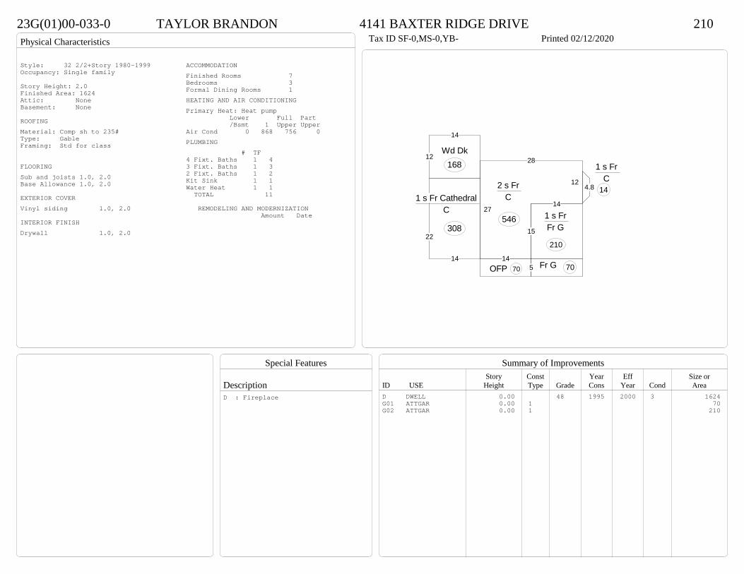
Physical Characteristics
Special Features
Description
Summary of ImprovementsStory Const Year Eff Size or
ID USE Height Type Grade Cons Year Cond Area
23G(01)00-033-0 TAYLOR BRANDON 4141 BAXTER RIDGE DRIVE 210Tax ID SF-0,MS-0,YB- Printed 02/12/2020
14
15
14
12
28
27
2 s Fr C
546
5OFP 7014
22
1 s Fr Cathedral C
308
12
14
Wd Dk168
4.8
1 s Fr C
14
Fr G 70
1 s Fr Fr G
210
Style: 32 2/2+Story 1980-1999Occupancy: Single family
Story Height: 2.0Finished Area: 1624 Attic: NoneBasement: None
ROOFINGMaterial: Comp sh to 235#Type: GableFraming: Std for class
FLOORINGSub and joists 1.0, 2.0Base Allowance 1.0, 2.0
EXTERIOR COVERVinyl siding 1.0, 2.0
INTERIOR FINISHDrywall 1.0, 2.0
ACCOMMODATIONFinished Rooms 7Bedrooms 3Formal Dining Rooms 1HEATING AND AIR CONDITIONINGPrimary Heat: Heat pump Lower Full Part /Bsmt 1 Upper UpperAir Cond 0 868 756 0PLUMBING # TF4 Fixt. Baths 1 43 Fixt. Baths 1 32 Fixt. Baths 1 2Kit Sink 1 1Water Heat 1 1 TOTAL 11
REMODELING AND MODERNIZATION Amount Date
D DWELL 0.00 48 1995 2000 3 1624G01 ATTGAR 0.00 1 70G02 ATTGAR 0.00 1 210
D : Fireplace
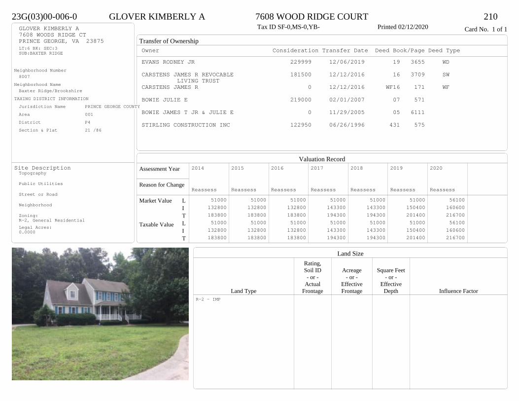
Transfer of Ownership
Valuation RecordAssessment Year
Reason for Change
Market Value
Taxable Value
LITLIT
Land SizeRating,Soil ID Acreage Square Feet- or - - or - - or -
Actual Effective EffectiveLand Type Frontage Frontage Depth Influence Factor
23G(03)00-006-0 GLOVER KIMBERLY A 7608 WOOD RIDGE COURT 210Tax ID SF-0,MS-0,YB- Printed 02/12/2020 Card No. 1 of 1GLOVER KIMBERLY A
7608 WOODS RIDGE CTPRINCE GEORGE, VA 23875LT:6 BK: SEC:3SUB:BAXTER RIDGE
Neighborhood Number8007
Neighborhood NameBaxter Ridge/Brookshire
TAXING DISTRICT INFORMATIONJurisdiction Name PRINCE GEORGE COUNTYArea 001 District P4 Section & Plat 21 /86
Site DescriptionTopography
Public Utilities
Street or Road
Neighborhood
Zoning:R-2, General ResidentialLegal Acres:0.0000
Owner Consideration Transfer Date Deed Book/Page Deed TypeEVANS RODNEY JR 229999 12/06/2019 19 3655 WD
CARSTENS JAMES R REVOCABLE 181500 12/12/2016 16 3709 SWLIVING TRUST
CARSTENS JAMES R 0 12/12/2016 WF16 171 WF
BOWIE JULIE E 219000 02/01/2007 07 571
BOWIE JAMES T JR & JULIE E 0 11/29/2005 05 6111
STIRLING CONSTRUCTION INC 122950 06/26/1996 431 575
2014
Reassess 51000 132800 183800 51000 132800 183800
2015
Reassess 51000 132800 183800 51000 132800 183800
2016
Reassess 51000 132800 183800 51000 132800 183800
2017
Reassess 51000 143300 194300 51000 143300 194300
2018
Reassess 51000 143300 194300 51000 143300 194300
2019
Reassess 51000 150400 201400 51000 150400 201400
2020
Reassess 56100 160600 216700 56100 160600 216700
R-2 - IMP
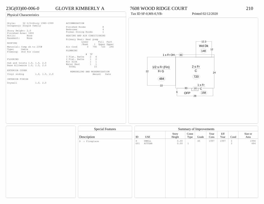
Physical Characteristics
Special Features
Description
Summary of ImprovementsStory Const Year Eff Size or
ID USE Height Type Grade Cons Year Cond Area
23G(03)00-006-0 GLOVER KIMBERLY A 7608 WOOD RIDGE COURT 210Tax ID SF-0,MS-0,YB- Printed 02/12/2020
1 s Fr OH 60
24
30
2 s Fr C
720
12
12.3
Wd Dk148
1 s Fr C 10
628
OFP 158
22
22
1/2 s Fr (Fin) Fr G
484
Style: 32 2/2+Story 1980-1999Occupancy: Single family
Story Height: 2.0Finished Area: 1800 Attic: NoneBasement: None
ROOFINGMaterial: Comp sh to 235#Type: GableFraming: Std for class
FLOORINGSub and joists 1.0, 1.5, 2.0Base Allowance 1.0, 1.5, 2.0
EXTERIOR COVERVinyl siding 1.0, 1.5, 2.0
INTERIOR FINISHDrywall 1.0, 2.0
ACCOMMODATIONFinished Rooms 8Bedrooms 4Formal Dining Rooms 1HEATING AND AIR CONDITIONINGPrimary Heat: Heat pump Lower Full Part /Bsmt 1 Upper UpperAir Cond 0 790 720 290PLUMBING # TF3 Fixt. Baths 2 62 Fixt. Baths 1 2Kit Sink 1 1Water Heat 1 1 TOTAL 10
REMODELING AND MODERNIZATION Amount Date
D DWELL 0.00 45 1997 1997 3 1994G01 ATTGAR 0.00 1 3 484
D : Fireplace
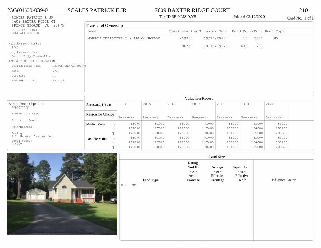
Transfer of Ownership
Valuation RecordAssessment Year
Reason for Change
Market Value
Taxable Value
LITLIT
Land SizeRating,Soil ID Acreage Square Feet- or - - or - - or -
Actual Effective EffectiveLand Type Frontage Frontage Depth Influence Factor
23G(01)00-039-0 SCALES PATRICK E JR 7609 BAXTER RIDGE COURT 210Tax ID SF-0,MS-0,YB- Printed 02/12/2020 Card No. 1 of 1SCALES PATRICK E JR
7609 BAXTER RIDGE CTPRINCE GEORGE, VA 23875LT:39 BK: SEC:1SUB:BAXTER RIDGE
Neighborhood Number8007
Neighborhood NameBaxter Ridge/Brookshire
TAXING DISTRICT INFORMATIONJurisdiction Name PRINCE GEORGE COUNTYArea 001 District P4 Section & Plat 20 /183
Site DescriptionTopography
Public Utilities
Street or Road
Neighborhood
Zoning:R-2, General ResidentialLegal Acres:0.0000
Owner Consideration Transfer Date Deed Book/Page Deed TypeMORROW CHRISTINE M & ALLAN MARROW 219000 08/15/2019 19 2390 WD
96750 08/15/1997 433 783
2014
Reassess 51000 127000 178000 51000 127000 178000
2015
Reassess 51000 127000 178000 51000 127000 178000
2016
Reassess 51000 127000 178000 51000 127000 178000
2017
Reassess 51000 127400 178400 51000 127400 178400
2018
Reassess 51000 133100 184100 51000 133100 184100
2019
Reassess 51000 134000 185000 51000 134000 185000
2020
Reassess 56100 150200 206300 56100 150200 206300
R-2 - IMP

Physical Characteristics
Special Features
Description
Summary of ImprovementsStory Const Year Eff Size or
ID USE Height Type Grade Cons Year Cond Area
23G(01)00-039-0 SCALES PATRICK E JR 7609 BAXTER RIDGE COURT 210Tax ID SF-0,MS-0,YB- Printed 02/12/2020
16
38
32
13.5
12
6
17.5
10
1 s Fr C
1407
5OFP 80
4OFP 24
8.3
16.2
146.7
5.7
9.5
Wd Dk
173
01
Style: 15 1 STORY 1990-1999Occupancy: Single family
Story Height: 1.0Finished Area: 1407 Attic: NoneBasement: None
ROOFINGMaterial: Comp sh to 235#Type: GableFraming: Std for class
FLOORINGSub and joists 1.0Base Allowance 1.0
EXTERIOR COVERVinyl siding 1.0
INTERIOR FINISHDrywall 1.0
ACCOMMODATIONFinished Rooms 5Bedrooms 3HEATING AND AIR CONDITIONINGPrimary Heat: Heat pump Lower Full Part /Bsmt 1 Upper UpperAir Cond 0 1407 0 0PLUMBING # TF3 Fixt. Baths 2 6Kit Sink 1 1Water Heat 1 1 TOTAL 8
REMODELING AND MODERNIZATION Amount Date
D DWELL 0.00 45 1997 1997 3 140701 DETGAR 1.00 1 45 2005 2005 3 720
D : Fireplace

Transfer of Ownership
Valuation RecordAssessment Year
Reason for Change
Market Value
Taxable Value
LITLIT
Land SizeRating,Soil ID Acreage Square Feet- or - - or - - or -
Actual Effective EffectiveLand Type Frontage Frontage Depth Influence Factor
23G(01)00-023-0 JACKSON BRAYLON O & CHARMAINE T 4140 BAXTER RIDGE DRIVE 210Tax ID SF-0,MS-0,YB- Printed 02/12/2020 Card No. 1 of 1JACKSON BRAYLON O & CHARMAINE T
4140 BAXTER RIDGE DRPRINCE GEORGE, VA 23875LT:23 BK: SEC:1SUB:BAXTER RIDGE
Neighborhood Number8007
Neighborhood NameBaxter Ridge/Brookshire
TAXING DISTRICT INFORMATIONJurisdiction Name PRINCE GEORGE COUNTYArea 001 District P4 Section & Plat 20 /183
Site DescriptionTopography
Public Utilities
Street or Road
Neighborhood
Zoning:R-2, General ResidentialLegal Acres:0.0000
Owner Consideration Transfer Date Deed Book/Page Deed TypeJAY SEAN G 205000 02/27/2019 19 522 WD
FISHER TODD H 187000 02/15/2006 06 778 JAY SEAN G
108075 03/05/1996 412 399
2014
Reassess 51000 129200 180200 51000 129200 180200
2015
Reassess 51000 129200 180200 51000 129200 180200
2016
Reassess 51000 129200 180200 51000 129200 180200
2017
Reassess 51000 127900 178900 51000 127900 178900
2018
Reassess 51000 127900 178900 51000 127900 178900
2019
Reassess 51000 135000 186000 51000 135000 186000
2020
Reassess 56100 148800 204900 56100 148800 204900
R-2 - IMP
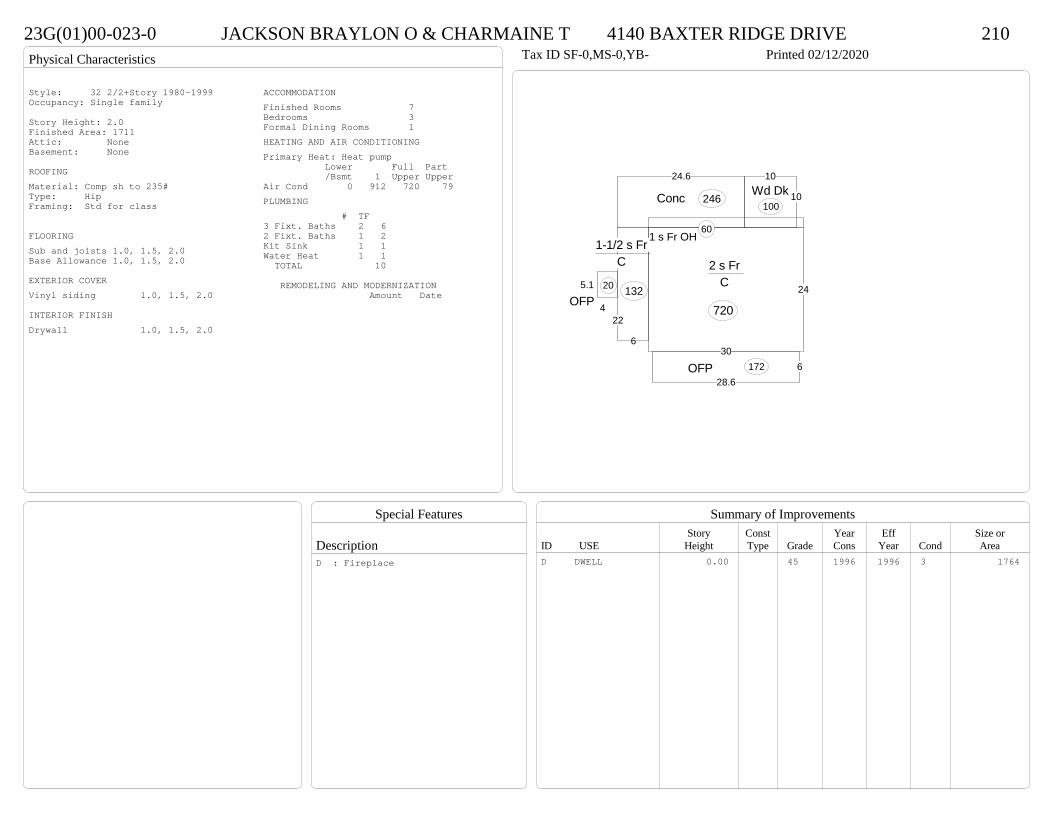
Physical Characteristics
Special Features
Description
Summary of ImprovementsStory Const Year Eff Size or
ID USE Height Type Grade Cons Year Cond Area
23G(01)00-023-0 JACKSON BRAYLON O & CHARMAINE T 4140 BAXTER RIDGE DRIVE 210Tax ID SF-0,MS-0,YB- Printed 02/12/2020
6
22
1-1/2 s Fr C
132
1 s Fr OH 60
24
30
2 s Fr C
720
628.6
OFP 172
10
10Wd Dk
100
24.6
Conc 246
4
5.1
OFP20
Style: 32 2/2+Story 1980-1999Occupancy: Single family
Story Height: 2.0Finished Area: 1711 Attic: NoneBasement: None
ROOFINGMaterial: Comp sh to 235#Type: HipFraming: Std for class
FLOORINGSub and joists 1.0, 1.5, 2.0Base Allowance 1.0, 1.5, 2.0
EXTERIOR COVERVinyl siding 1.0, 1.5, 2.0
INTERIOR FINISHDrywall 1.0, 1.5, 2.0
ACCOMMODATIONFinished Rooms 7Bedrooms 3Formal Dining Rooms 1HEATING AND AIR CONDITIONINGPrimary Heat: Heat pump Lower Full Part /Bsmt 1 Upper UpperAir Cond 0 912 720 79PLUMBING # TF3 Fixt. Baths 2 62 Fixt. Baths 1 2Kit Sink 1 1Water Heat 1 1 TOTAL 10
REMODELING AND MODERNIZATION Amount Date
D DWELL 0.00 45 1996 1996 3 1764D : Fireplace

Transfer of Ownership
Valuation RecordAssessment Year
Reason for Change
Market Value
Taxable Value
LITLIT
Land SizeRating,Soil ID Acreage Square Feet- or - - or - - or -
Actual Effective EffectiveLand Type Frontage Frontage Depth Influence Factor
23G(01)00-048-0 BONDS ANTHONY V & BRANDY R 4105 BAXTER RIDGE DRIVE 210Tax ID SF-0,MS-0,YB- Printed 02/12/2020 Card No. 1 of 1BONDS ANTHONY V & BRANDY R
4105 BAXTER RIDGE DRPRINCE GEORGE, VA 23875LT:48 BK: SEC:1SUB:BAXTER RIDGE
Neighborhood Number8007
Neighborhood NameBaxter Ridge/Brookshire
TAXING DISTRICT INFORMATIONJurisdiction Name PRINCE GEORGE COUNTYArea 001 District P4 Section & Plat 20 /183
Site DescriptionTopography
Public Utilities
Street or Road
Neighborhood
Zoning:R-2, General ResidentialLegal Acres:0.0000
Owner Consideration Transfer Date Deed Book/Page Deed TypeSTEPHENS ELIZABETH D & 190000 03/04/2019 19 594 WD
STEPHENS CHARLES A JRTHOMPSON DANIEL C & KATHERINE B 165000 01/21/2015 15 186 WD
ALBERT DAVID R ET AL 125000 02/01/2012 12 314 WD
ALBERT BETTIE S 0 12/05/2011 WF11 109 WF
SMITH DAVID E & ASSOCIATES INC 109000 04/22/1997 428 556
2014
Reassess 51000 125100 176100 51000 125100 176100
2015
Reassess 51000 125100 176100 51000 125100 176100
2016
Reassess 51000 125100 176100 51000 125100 176100
2017
Reassess 51000 113900 164900 51000 113900 164900
2018
Reassess 51000 119600 170600 51000 119600 170600
2019
Reassess 51000 120000 171000 51000 120000 171000
2020
Reassess 56100 135200 191300 56100 135200 191300
R-2 - IMP

Physical Characteristics
Special Features
Description
Summary of ImprovementsStory Const Year Eff Size or
ID USE Height Type Grade Cons Year Cond Area
23G(01)00-048-0 BONDS ANTHONY V & BRANDY R 4105 BAXTER RIDGE DRIVE 210Tax ID SF-0,MS-0,YB- Printed 02/12/2020
54
26
2 9
1 s Fr C
1422
2
14
1 s Fr OH 28
626
OMP 156
12.2
16.3
Wd Dk199
24
20
Fr G
480
Style: 15 1 STORY 1990-1999Occupancy: Single family
Story Height: 1.0Finished Area: 1450 Attic: NoneBasement: None
ROOFINGMaterial: Comp sh to 235#Type: GableFraming: Std for class
FLOORINGSub and joists 1.0Base Allowance 1.0
EXTERIOR COVERVinyl siding 1.0
INTERIOR FINISHDrywall 1.0
ACCOMMODATIONFinished Rooms 7Bedrooms 3Formal Dining Rooms 1HEATING AND AIR CONDITIONINGPrimary Heat: Heat pump Lower Full Part /Bsmt 1 Upper UpperAir Cond 0 1450 0 0PLUMBING # TF3 Fixt. Baths 2 6Kit Sink 1 1Water Heat 1 1 TOTAL 8
REMODELING AND MODERNIZATION Amount Date
D DWELL 0.00 45 1997 1997 3 1450G01 ATTGAR 0.00 1 3 480
D : Fireplace
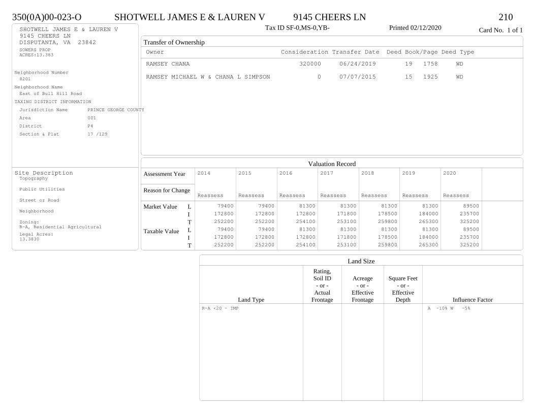
Transfer of Ownership
Valuation RecordAssessment Year
Reason for Change
Market Value
Taxable Value
LITLIT
Land SizeRating,Soil ID Acreage Square Feet- or - - or - - or -
Actual Effective EffectiveLand Type Frontage Frontage Depth Influence Factor
350(0A)00-023-O SHOTWELL JAMES E & LAUREN V 9145 CHEERS LN 210Tax ID SF-0,MS-0,YB- Printed 02/12/2020 Card No. 1 of 1SHOTWELL JAMES E & LAUREN V
9145 CHEERS LNDISPUTANTA, VA 23842SOWERS PROPACRES:13.383
Neighborhood Number8201
Neighborhood NameEast of Bull Hill Road
TAXING DISTRICT INFORMATIONJurisdiction Name PRINCE GEORGE COUNTYArea 001 District P4 Section & Plat 17 /129
Site DescriptionTopography
Public Utilities
Street or Road
Neighborhood
Zoning:R-A, Residential AgriculturalLegal Acres:13.3830
Owner Consideration Transfer Date Deed Book/Page Deed TypeRAMSEY CHANA 320000 06/24/2019 19 1758 WD
RAMSEY MICHAEL W & CHANA L SIMPSON 0 07/07/2015 15 1925 WD
2014
Reassess 79400 172800 252200 79400 172800 252200
2015
Reassess 79400 172800 252200 79400 172800 252200
2016
Reassess 81300 172800 254100 81300 172800 254100
2017
Reassess 81300 171800 253100 81300 171800 253100
2018
Reassess 81300 178500 259800 81300 178500 259800
2019
Reassess 81300 184000 265300 81300 184000 265300
2020
Reassess 89500 235700 325200 89500 235700 325200
R-A <20 - IMP A -10% W -5%

Physical Characteristics
Special Features
Description
Summary of ImprovementsStory Const Year Eff Size or
ID USE Height Type Grade Cons Year Cond Area
350(0A)00-023-O SHOTWELL JAMES E & LAUREN V 9145 CHEERS LN 210Tax ID SF-0,MS-0,YB- Printed 02/12/2020
26
285
1412
40
267
1 s Fr C
1740
7
28.8OFP 198
28OFP 196
1 s Fr OH
10
415
Port60
16
30
Wd Dk480
36
30Det Gar
1080
02
Style: 15 1 STORY 1990-1999Occupancy: Single family
Story Height: 1.0Finished Area: 1750 Attic: NoneBasement: None
ROOFINGMaterial: Comp sh to 235#Type: HipFraming: Std for class
FLOORINGSub and joists 1.0Base Allowance 1.0
EXTERIOR COVERHardboard 1.0
INTERIOR FINISHDrywall 1.0
ACCOMMODATIONFinished Rooms 6Bedrooms 3Formal Dining Rooms 1HEATING AND AIR CONDITIONINGPrimary Heat: Heat pump Lower Full Part /Bsmt 1 Upper UpperAir Cond 0 1750 0 0PLUMBING # TF3 Fixt. Baths 2 6Kit Sink 1 1Water Heat 1 1 TOTAL 8
REMODELING AND MODERNIZATION Amount Date
D DWELL 0.00 45 1997 1997 3 175001 DETGAR 1.75 1 45 2004 2004 3 194402 STEELUTL 10.00 5PF 45 2010 2010 3 672
01 : Electric lights & service, Full bath, Interior finish - liv qual, Fireplace, Heating

Transfer of Ownership
Valuation RecordAssessment Year
Reason for Change
Market Value
Taxable Value
LITLIT
Land SizeRating,Soil ID Acreage Square Feet- or - - or - - or -
Actual Effective EffectiveLand Type Frontage Frontage Depth Influence Factor
340(0A)00-131-0 OWENS ROBERT A 5524 COUNTY DRIVE 210Tax ID SF-1092,MS-1,YB-58 Printed 02/12/2020 Card No. 1 of 1OWENS ROBERT A
5524 COUNTY DRDISPUTANTA, VA 23842NEAR NEW BOHEMIAACRES:1.68
Neighborhood Number8201
Neighborhood NameEast of Bull Hill Road
TAXING DISTRICT INFORMATIONJurisdiction Name PRINCE GEORGE COUNTYArea 001 District P4 Section & Plat /
Site DescriptionTopography
Public Utilities
Street or Road
Neighborhood
Zoning:R-A, Residential AgriculturalLegal Acres:1.6800
Owner Consideration Transfer Date Deed Book/Page Deed TypeREYNOLDS DAVID W 292900 08/07/2019 19 2319 WD
DREAM HOMES BY MARIANNE LLC 299750 06/01/2009 09 1908
FULCHER REALTY INC 75000 02/20/2007 07 907
MOORE GEORGE S & ANNE E 39600 12/21/2006 06 6674 C/O RAYMOND M JOHNSON JR
2014
Reassess 41100 222600 263700 41100 222600 263700
2015
Reassess 41100 222600 263700 41100 222600 263700
2016
Reassess 41100 222600 263700 41100 222600 263700
2017
Reassess 41100 224900 266000 41100 224900 266000
2018
Reassess 41100 224900 266000 41100 224900 266000
2019
Reassess 41100 235900 277000 41100 235900 277000
2020
Reassess 45200 244700 289900 45200 244700 289900
R-A <20 - IMP
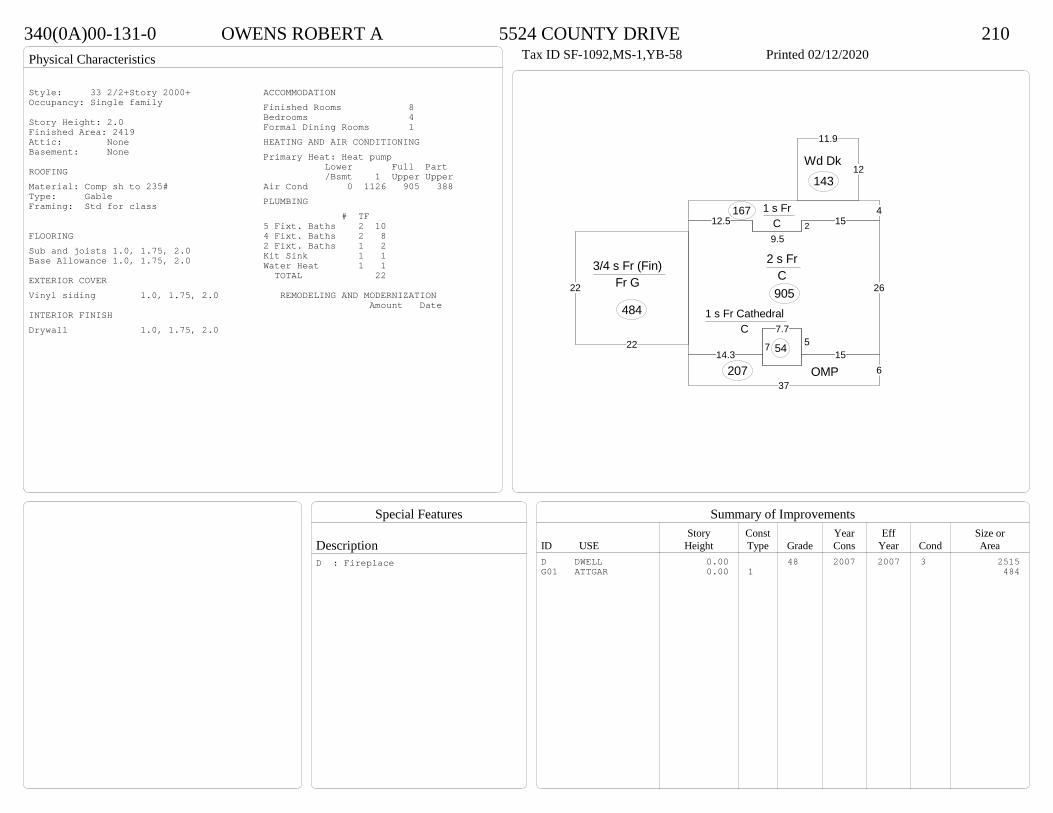
Physical Characteristics
Special Features
Description
Summary of ImprovementsStory Const Year Eff Size or
ID USE Height Type Grade Cons Year Cond Area
340(0A)00-131-0 OWENS ROBERT A 5524 COUNTY DRIVE 210Tax ID SF-1092,MS-1,YB-58 Printed 02/12/2020
26
1529.5
12.5
14.3
7.75
15
2 s Fr C 905
41 s Fr C
167
637
OMP207
12
11.9
Wd Dk143
7
1 s Fr Cathedral C
5422
22
3/4 s Fr (Fin) Fr G
484
Style: 33 2/2+Story 2000+Occupancy: Single family
Story Height: 2.0Finished Area: 2419 Attic: NoneBasement: None
ROOFINGMaterial: Comp sh to 235#Type: GableFraming: Std for class
FLOORINGSub and joists 1.0, 1.75, 2.0Base Allowance 1.0, 1.75, 2.0
EXTERIOR COVERVinyl siding 1.0, 1.75, 2.0
INTERIOR FINISHDrywall 1.0, 1.75, 2.0
ACCOMMODATIONFinished Rooms 8Bedrooms 4Formal Dining Rooms 1HEATING AND AIR CONDITIONINGPrimary Heat: Heat pump Lower Full Part /Bsmt 1 Upper UpperAir Cond 0 1126 905 388PLUMBING # TF5 Fixt. Baths 2 104 Fixt. Baths 2 82 Fixt. Baths 1 2Kit Sink 1 1Water Heat 1 1 TOTAL 22
REMODELING AND MODERNIZATION Amount Date
D DWELL 0.00 48 2007 2007 3 2515G01 ATTGAR 0.00 1 484
D : Fireplace

Transfer of Ownership
Valuation RecordAssessment Year
Reason for Change
Market Value
Taxable Value
LITLIT
Land SizeRating,Soil ID Acreage Square Feet- or - - or - - or -
Actual Effective EffectiveLand Type Frontage Frontage Depth Influence Factor
340(0A)00-035-C WOODRUFF SHANE L 5288 WEST QUAKER ROAD 210Tax ID SF-0,MS-0,YB- Printed 02/12/2020 Card No. 1 of 1WOODRUFF SHANE L
5288 W QUAKER RDDISPUTANTA, VA 23842LOT EPT JOHN VINSH PROPACRES:1.23
Neighborhood Number8201
Neighborhood NameEast of Bull Hill Road
TAXING DISTRICT INFORMATIONJurisdiction Name PRINCE GEORGE COUNTYArea 001 District P4 Section & Plat 415/23
Site DescriptionTopography
Public Utilities
Street or Road
Neighborhood
Zoning:R-A, Residential AgriculturalLegal Acres:1.2300
Owner Consideration Transfer Date Deed Book/Page Deed TypeJARRETT JANICE T 240000 07/15/2019 19 2049 WD
PEADE GERALD E & ANGELA E 236876 12/04/2006 06 6365
118500 12/10/1996 423 335
2014
Reassess 36800 138500 175300 36800 138500 175300
2015
Reassess 36800 138500 175300 36800 138500 175300
2016
Reassess 36800 138500 175300 36800 138500 175300
2017
Reassess 36800 136600 173400 36800 136600 173400
2018
Reassess 36800 136600 173400 36800 136600 173400
2019
Reassess 36800 142800 179600 36800 142800 179600
2020
Reassess 40500 150800 191300 40500 150800 191300
R-A <20 - IMP

Physical Characteristics
Special Features
Description
Summary of ImprovementsStory Const Year Eff Size or
ID USE Height Type Grade Cons Year Cond Area
340(0A)00-035-C WOODRUFF SHANE L 5288 WEST QUAKER ROAD 210Tax ID SF-0,MS-0,YB- Printed 02/12/2020
32.2
11.7
1-1/2 s Fr C
377
19
30.2
1-3/4 s Fr C
574
12
Wd Dk
144 6.310.8
1 s Fr C 68
5.48
OMP43
15
22.1
1/2 s Fr Fr G
332
01
Style: 22 1+ STORY 1980-1999Occupancy: Single family
Story Height: 1.75Finished Area: 1803 Attic: NoneBasement: None
ROOFINGMaterial: Comp sh to 235#Type: GableFraming: Std for class
FLOORINGSub and joists 1.0, 1.5, 1.75Base Allowance 1.0, 1.5, 1.75
EXTERIOR COVERVinyl siding 1.0, 1.5, 1.75
INTERIOR FINISHDrywall 1.0, 1.5, 1.75
ACCOMMODATIONFinished Rooms 5Bedrooms 3HEATING AND AIR CONDITIONINGPrimary Heat: Heat pump Lower Full Part /Bsmt 1 Upper UpperAir Cond 0 1019 0 784PLUMBING # TF3 Fixt. Baths 2 62 Fixt. Baths 1 2Kit Sink 1 1Water Heat 1 1 TOTAL 10
REMODELING AND MODERNIZATION Amount Date
D DWELL 0.00 45 1996 1996 3 2302G01 ATTGAR 0.00 1 33201 SHEDGP 10.00 1 45 1996 1996 3 205