Future of Water Supply and Demand in the Middle Drâa ... · Water 2016, 8, 313 3 of 18 Water 2016,...
18
water Article Future of Water Supply and Demand in the Middle Drâa Valley, Morocco, under Climate and Land Use Change Irene M. Johannsen, Jennifer C. Hengst, Alexander Goll, Britta Höllermann and Bernd Diekkrüger * Department of Geography, University of Bonn, Meckenheimer Allee 166, 53115 Bonn, Germany; [email protected] (I.M.J.); [email protected] (J.C.H.); [email protected] (A.G.); [email protected] (B.H.) * Correspondence: [email protected]; Tel.: +49-228-73-2107 Academic Editor: Sujay Kaushal Received: 3 April 2016; Accepted: 18 July 2016; Published: 25 July 2016 Abstract: Regions of scarce fresh water resources, such as the Middle East and North Africa, are facing great challenges already today, and even more in the future, due to climatic and socioeconomic changes. The Middle Drâa valley in Morocco is one of many semi-arid to arid mountainous areas struggling with increasing water scarcity threatening self-sufficient husbandry. In order to maintain people’s livelihoods water management needs to be adapted. The Water Evaluation And Planning System (WEAP) software has been widely used to examine complex water systems in the water resource planning sector all around the world and proved to be a helpful asset to show the various interactions of water supply and demand. This paper presents the application of WEAP on the Middle Draâ valley’s water demand and supply, including several socioeconomic and land use scenarios under one basic climate change scenario. The climate scenario shows a significant decrease in available water resources up to 2029 while all socioeconomic scenarios show an increase in water demand. In years of droughts groundwater is used for irrigation, leading to increasingly depleted aquifers. The aquifers are recharged by percolation losses from irrigation and by river bed infiltration the latter of which is stronger in the northern oases than in the southern oases due to water withdrawal rules. A drastic reduction of irrigated agricultural area is the only solution to guarantee sustainable water use. Keywords: IWRM; WEAP model; semi-arid; irrigation; water scarcity; groundwater; reservoir 1. Introduction Today, local water availability depends strongly on demographic changes, the local economy and ecology, and the impact of land use and climatic changes [1,2]. Particularly, regions of scarce water resources, such as the Middle East and North Africa, are currently facing great challenges concerning water scarcity, which are very likely to increase in the future [1]. Agriculture is the mainstay of the African national economy and the majority of the poor works and lives in rural areas and is highly dependent on water availability [3]. Rising average temperatures in addition to less and more irregular precipitation events result in higher water demand for agricultural irrigation [3–6]. Particularly, mountainous regions where altitudinal differences already cause high spatial variability of precipitation and evaporation losses [5,7] struggle with the additional pressure of climatic changes [8–10]. In the mountainous regions of Morocco where the elevation gradient ranges from semi-arid subtropical mountains to arid/hyper-arid pre-Saharan foothills water availability is at risk [6,11–13]. Several studies about current and future water availability in arid and hyper-arid mountainous regions have shown that disparities of water Water 2016, 8, 313; doi:10.3390/w8080313 www.mdpi.com/journal/water
Transcript of Future of Water Supply and Demand in the Middle Drâa ... · Water 2016, 8, 313 3 of 18 Water 2016,...

water
Article
Future of Water Supply and Demand in theMiddle Drâa Valley, Morocco, under Climateand Land Use Change
Irene M. Johannsen, Jennifer C. Hengst, Alexander Goll, Britta Höllermannand Bernd Diekkrüger *
Department of Geography, University of Bonn, Meckenheimer Allee 166, 53115 Bonn, Germany;[email protected] (I.M.J.); [email protected] (J.C.H.); [email protected] (A.G.);[email protected] (B.H.)* Correspondence: [email protected]; Tel.: +49-228-73-2107
Academic Editor: Sujay KaushalReceived: 3 April 2016; Accepted: 18 July 2016; Published: 25 July 2016
Abstract: Regions of scarce fresh water resources, such as the Middle East and North Africa, are facinggreat challenges already today, and even more in the future, due to climatic and socioeconomicchanges. The Middle Drâa valley in Morocco is one of many semi-arid to arid mountainous areasstruggling with increasing water scarcity threatening self-sufficient husbandry. In order to maintainpeople’s livelihoods water management needs to be adapted. The Water Evaluation And PlanningSystem (WEAP) software has been widely used to examine complex water systems in the waterresource planning sector all around the world and proved to be a helpful asset to show the variousinteractions of water supply and demand. This paper presents the application of WEAP on theMiddle Draâ valley’s water demand and supply, including several socioeconomic and land usescenarios under one basic climate change scenario. The climate scenario shows a significant decreasein available water resources up to 2029 while all socioeconomic scenarios show an increase in waterdemand. In years of droughts groundwater is used for irrigation, leading to increasingly depletedaquifers. The aquifers are recharged by percolation losses from irrigation and by river bed infiltrationthe latter of which is stronger in the northern oases than in the southern oases due to water withdrawalrules. A drastic reduction of irrigated agricultural area is the only solution to guarantee sustainablewater use.
Keywords: IWRM; WEAP model; semi-arid; irrigation; water scarcity; groundwater; reservoir
1. Introduction
Today, local water availability depends strongly on demographic changes, the local economy andecology, and the impact of land use and climatic changes [1,2]. Particularly, regions of scarce waterresources, such as the Middle East and North Africa, are currently facing great challenges concerningwater scarcity, which are very likely to increase in the future [1]. Agriculture is the mainstay of theAfrican national economy and the majority of the poor works and lives in rural areas and is highlydependent on water availability [3].
Rising average temperatures in addition to less and more irregular precipitation events resultin higher water demand for agricultural irrigation [3–6]. Particularly, mountainous regions wherealtitudinal differences already cause high spatial variability of precipitation and evaporation losses [5,7]struggle with the additional pressure of climatic changes [8–10]. In the mountainous regions ofMorocco where the elevation gradient ranges from semi-arid subtropical mountains to arid/hyper-aridpre-Saharan foothills water availability is at risk [6,11–13]. Several studies about current and futurewater availability in arid and hyper-arid mountainous regions have shown that disparities of water
Water 2016, 8, 313; doi:10.3390/w8080313 www.mdpi.com/journal/water

Water 2016, 8, 313 2 of 18
supply and water demand are increasing. Concomitance of declining renewable water resourcesin [1,5,10] and increasing water demand reveals a strong need for water resource management inNorthern African arid regions [6,9,14,15].
In order to manage such complex systems that combine hydrological, cultural, and politicalaspects, effective Integrated Water Resource Management (IWRM) models are needed [15]. The WaterEvaluation And Planning System (WEAP) software developed by the Stockholm EnvironmentInstitute has shown to be useful for the simulation of possible demand and supply-based changesin water resources systems [16,17]. In the last decade WEAP has been widely used to examinecomplex water systems in the water resource planning sector all around the world [18–20]. As anexample, in several studies of the arid regions of North Africa WEAP revealed connections betweenvulnerable hydrological systems and social influences and their management concepts [1,14–16,21].Recently several WEAP models were applied to basins in the arid and mountainous areas ofMorocco. WEAP proved to be helpful in showing the various interactions of water supply anddemand [1,5,6,8–10].
The aim of this paper is to study the impact of climate change on water availability and waterdemand on the Middle Drâa valley in Morocco under varying socioeconomic and land use scenariosin order to see how e.g., investments in better irrigation techniques or changes in crop shares may alterwater availability in the water system of the Middle Drâa valley. By using socioeconomic and land usescenarios together with climate change scenarios, the study seeks to contribute to an understanding ofthe system and its possible development and to the development of strategies for a sustainable futureof the region.
The present study uses data from the GLOWA IMPETUS-project, with the aim being to analyzethe impact of global change on the water cycle in Benin and Morocco. For more details concerning thisproject refer to [22,23].
2. Study Area
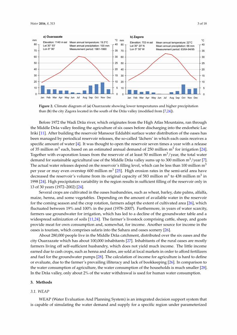
The Middle Drâa valley south of the city of Ouarzazate is part of the region Souss-Massa-Drâa inthe south east of Morocco comprising an area of about 15,000 km2 (Figure 1) [24]. Climatic conditionsare arid to hyper-arid. Rainfall adds up to 200 mm annually in the north of the basin and 30 mm in thesouth, with an average potential evaporation of up to 3000 mm [11] (Figure 2).
Water 2016, 8, 313 2 of 17
disparities of water supply and water demand are increasing. Concomitance of declining renewable water resources in [1,5,10] and increasing water demand reveals a strong need for water resource management in Northern African arid regions [6,9,14,15].
In order to manage such complex systems that combine hydrological, cultural, and political aspects, effective Integrated Water Resource Management (IWRM) models are needed [15]. The Water Evaluation And Planning System (WEAP) software developed by the Stockholm Environment Institute has shown to be useful for the simulation of possible demand and supply-based changes in water resources systems [16,17]. In the last decade WEAP has been widely used to examine complex water systems in the water resource planning sector all around the world [18–20]. As an example, in several studies of the arid regions of North Africa WEAP revealed connections between vulnerable hydrological systems and social influences and their management concepts [1,14–16,21]. Recently several WEAP models were applied to basins in the arid and mountainous areas of Morocco. WEAP proved to be helpful in showing the various interactions of water supply and demand [1,5,6,8–10].
The aim of this paper is to study the impact of climate change on water availability and water demand on the Middle Drâa valley in Morocco under varying socioeconomic and land use scenarios in order to see how e.g., investments in better irrigation techniques or changes in crop shares may alter water availability in the water system of the Middle Drâa valley. By using socioeconomic and land use scenarios together with climate change scenarios, the study seeks to contribute to an understanding of the system and its possible development and to the development of strategies for a sustainable future of the region.
The present study uses data from the GLOWA IMPETUS-project, with the aim being to analyze the impact of global change on the water cycle in Benin and Morocco. For more details concerning this project refer to [22,23].
2 Study Area
The Middle Drâa valley south of the city of Ouarzazate is part of the region Souss-Massa-Drâa in the south east of Morocco comprising an area of about 15,000 km2 (Figure 1) [24]. Climatic conditions are arid to hyper-arid. Rainfall adds up to 200 mm annually in the north of the basin and 30 mm in the south, with an average potential evaporation of up to 3000 mm [11] (Figure 2).
Figure 1. (a) Drâa catchment in an administrative context showing the city of Ouarzazate, the reservoir Mansour Eddahbi and the order of oases along the Wadi Drâa (modified from [24]); (b) WEAP structure as used in this study (GW: groundwater; FR: river network link; HH: domestic water use; LW: agricultural water use; blue arrow: river; green arrow: water transmissions to demand sites; dashed blue arrows: runoff or backflow).
Figure 1. (a) Drâa catchment in an administrative context showing the city of Ouarzazate, the reservoirMansour Eddahbi and the order of oases along the Wadi Drâa (modified from [24]); (b) WEAPstructure as used in this study (GW: groundwater; FR: river network link; HH: domestic water use;LW: agricultural water use; blue arrow: river; green arrow: water transmissions to demand sites;dashed blue arrows: runoff or backflow).
Water 2016, 8, 313 3 of 18Water 2016, 8, 313 3 of 17
Figure 2. Climate diagram of (a) Ouarzazate showing lower temperatures and higher precipitation than (b) the city Zagora located in the south of the Drâa valley (modified from [7,24]).
Before 1972 the Wadi Drâa river, which originates from the High Atlas Mountains, ran through the Middle Drâa valley feeding the agriculture of six oases before discharging into the endorheic Lac Iriki [11]. After building the reservoir Mansour Eddahbi surface water distribution of the oases has been managed by periodical reservoir releases, the so-called ‘lâchers’ in which each oasis receives a specific amount of water [4]. It was thought to open the reservoir seven times a year with a release of 35 million m3 each, based on an estimated annual demand of 250 million m3 for irrigation [24]. Together with evaporation losses from the reservoir of at least 50 million m³/year, the total water demand for sustainable agricultural use of the Middle Drâa valley sums up to 300 million m3/year [7]. The actual water releases depend on the reservoir’s filling level, which can be less than 100 million m3 per year or may even overstep 600 million m3 [25]. High erosion rates in the semi-arid area have decreased the reservoir’s volume from its original capacity of 583 million m3 to 438 million m3 in 1998 [24]. High precipitation variability in the region results in sufficient filling of the reservoir only in 13 of 30 years (1972–2002) [24].
Several crops are cultivated in the oases husbandries, such as wheat, barley, date palms, alfalfa, maize, henna, and some vegetables. Depending on the amount of available water in the reservoir for the coming season and the crop rotation, farmers adapt the extent of cultivated area [26], which fluctuated between 19% and 100% in the past (1978–2007). Furthermore, in years of water scarcity, farmers use groundwater for irrigation, which has led to a decline of the groundwater table and a widespread salinization of soils [11,24]. The farmer’s livestock comprising cattle, sheep, and goats provide meat for own consumption and, somewhat, for income. Another source for income in the oases is tourism, which comprises safaris into the Sahara and oases scenery [26].
About 280,000 people live in the Middle Drâa catchment, distributed over the six oases and the city Ouarzazate which has about 100,000 inhabitants [27]. Inhabitants of the rural oases are mostly farmers living off self-sufficient husbandry, which does not yield much income. The little income earned due to cash crops, such as henna and dates, are sold at local markets in order to afford fertilizers and fuel for the groundwater pumps [28]. The calculation of income for agriculture is hard to define or evaluate, due to the farmer’s prevailing illiteracy and lack of bookkeeping [26]. In comparison to the water consumption of agriculture, the water consumption of the households is much smaller [28]. In the Drâa valley, only about 2% of the water withdrawal is used for human water consumption.
3 Methods
3.1. WEAP
WEAP (Water Evaluation And Planning System) is an integrated decision support system that is capable of simulating the water demand and supply for a specific region under parameterized assumptions [17]. It combines bio-physical factors influencing the water runoff, such as climate,
Figure 2. Climate diagram of (a) Ouarzazate showing lower temperatures and higher precipitationthan (b) the city Zagora located in the south of the Drâa valley (modified from [7,24]).
Before 1972 the Wadi Drâa river, which originates from the High Atlas Mountains, ran throughthe Middle Drâa valley feeding the agriculture of six oases before discharging into the endorheic LacIriki [11]. After building the reservoir Mansour Eddahbi surface water distribution of the oases hasbeen managed by periodical reservoir releases, the so-called ‘lâchers’ in which each oasis receives aspecific amount of water [4]. It was thought to open the reservoir seven times a year with a releaseof 35 million m3 each, based on an estimated annual demand of 250 million m3 for irrigation [24].Together with evaporation losses from the reservoir of at least 50 million m3/year, the total waterdemand for sustainable agricultural use of the Middle Drâa valley sums up to 300 million m3/year [7].The actual water releases depend on the reservoir’s filling level, which can be less than 100 million m3
per year or may even overstep 600 million m3 [25]. High erosion rates in the semi-arid area havedecreased the reservoir’s volume from its original capacity of 583 million m3 to 438 million m3 in1998 [24]. High precipitation variability in the region results in sufficient filling of the reservoir only in13 of 30 years (1972–2002) [24].
Several crops are cultivated in the oases husbandries, such as wheat, barley, date palms, alfalfa,maize, henna, and some vegetables. Depending on the amount of available water in the reservoirfor the coming season and the crop rotation, farmers adapt the extent of cultivated area [26], whichfluctuated between 19% and 100% in the past (1978–2007). Furthermore, in years of water scarcity,farmers use groundwater for irrigation, which has led to a decline of the groundwater table and awidespread salinization of soils [11,24]. The farmer’s livestock comprising cattle, sheep, and goatsprovide meat for own consumption and, somewhat, for income. Another source for income in theoases is tourism, which comprises safaris into the Sahara and oases scenery [26].
About 280,000 people live in the Middle Drâa catchment, distributed over the six oases and thecity Ouarzazate which has about 100,000 inhabitants [27]. Inhabitants of the rural oases are mostlyfarmers living off self-sufficient husbandry, which does not yield much income. The little incomeearned due to cash crops, such as henna and dates, are sold at local markets in order to afford fertilizersand fuel for the groundwater pumps [28]. The calculation of income for agriculture is hard to defineor evaluate, due to the farmer’s prevailing illiteracy and lack of bookkeeping [26]. In comparison tothe water consumption of agriculture, the water consumption of the households is much smaller [28].In the Drâa valley, only about 2% of the water withdrawal is used for human water consumption.
3. Methods
3.1. WEAP
WEAP (Water Evaluation And Planning System) is an integrated decision support system thatis capable of simulating the water demand and supply for a specific region under parameterized

Water 2016, 8, 313 4 of 18
assumptions [17]. It combines bio-physical factors influencing the water runoff, such as climate,groundwater hydrology, and land cover with socioeconomic factors such as land use, infrastructure,and water management priorities [17,20]. WEAP has been successfully used for the simulation ofclimate, land use, and population growth changes [18,19,29].
3.2. Input Data
The simulations were run on a monthly basis. 1978 was chosen as the current account year whichis the starting year in the model. The model consists of six units representing the oases’ husbandryand seven demand sites for the city of Ouarzazate and other households within the oases (Figure 1).Irrigation requirements are calculated for seven different crop types. Water is provided by the upstreamsituated reservoir Mansour Eddahbi and six groundwater bodies situated in the oases. Surface waterwas defined as the primary source for irrigation demands. The households in the oases receive theirwater solely from the groundwater bodies, and the city of Ouarzazate exclusively from the reservoir.The model used a historical dataset from 1978–2007. From this baseline all other scenarios were created.
3.2.1. Hydrologic Parameterization
Monthly reservoir inflow was provided by [7] for the past period 1978–2007, as well as projectiondata for the future. Downstream of the reservoir, river bed infiltration and river evaporation valueswere simulated for each oasis. Groundwater storage is filled by infiltration losses from the Wadi Drâaand by the excess of the irrigation amount.
Annual precipitation data and evapotranspiration for the reservoir were taken from the IMPETUSproject and [7]. Potential evapotranspiration for each oasis was calculated using the Hamon equationand a linear relationship based on the gradient in elevation and temperature data from Ouarzazateand Zagora (Figure 2). The relation between elevation difference and evapotranspiration between thetwo locations was applied to the other oases elevation differences, the result of which was each oasis’specific potential evapotranspiration. The aquifer’s properties such as storage capacity, specific yield,and initial storage were taken from [11] (Table 1). The specific yield of the oases varies between 10%and 22% (sandy clay to fine sand) and is the only parameter defining the soil’s and aquifer’s properties.
Table 1. Properties of the six oases aquifers, initial aquifer storages in 1978, the maximum total fieldsize, and the share of each oasis on the water release from the reservoir [11,26].
OasisName
Aquifer Size/StorageCapacity (Million m3)
Aquifer’sSpecific Yield
Aquifer’s Initial Storage(Million m3 in the Year 1978
Max. TotalField Size (ha)
Share on Total WaterRelease from Reservoir
Mezguita 119 19% 46.4 2419 8%Tinzouline 254 22% 74.5 4015 8%
Ternata 166 15% 42.6 5858 30%Fezouata 156 10% 101.5 3825 14%Ktaoua 5201 13% 363.8 7770 28%
M’Hamid 333 15% 264.0 2231 12%
3.2.2. Reservoir and Households
The water balance in the study area is strongly influenced by the operation of the MansourEddahbi reservoir. For calculating evaporation losses depending on reservoir filling, a volume elevationcurve was taken from [7]. A minimum threshold of 35 million m3 was implemented to guaranteedrinking water supply for the city of Ouarzazate. On basis of the agricultural water demand and thereservoir’s water storage WEAP calculates the required amount of water to satisfy water requirementsdownstream [17].
Data of the population of Ouarzazate and the oases were obtained from the IMPETUS project.For the future years, census data was extrapolated linearly. The people’s mean annual water demandwas determined to 50 liters per capita per day in the cities and to 30 liters per capita per day in theoases [11].

Water 2016, 8, 313 5 of 18
3.2.3. Agricultural Area and Irrigation Requirements
According to the husbandry of the six oases, seven different crop categories were simulated,which were wheat, barley, date palms, alfalfa, maize, vegetables, and henna [26]. Figure 3 shows thecrop type area shares for each oasis in 1978. The crop growth parameters (Kc-values) were taken fromFAO [30]. Due to technical reasons, date palms were simulated as field of crops although, in practice,the date palms frame the fields.
Water 2016, 8, 313 5 of 17
3.2.3. Agricultural Area and Irrigation Requirements
According to the husbandry of the six oases, seven different crop categories were simulated, which were wheat, barley, date palms, alfalfa, maize, vegetables, and henna [26]. Figure 3 shows the crop type area shares for each oasis in 1978. The crop growth parameters (Kc-values) were taken from FAO [30]. Due to technical reasons, date palms were simulated as field of crops although, in practice, the date palms frame the fields.
Figure 3. Area used for agriculture in ha per oases and crop type in the current account year 1978 [26].
When reservoir filling is low at the beginning of the growing season, farmers reduce their field sizes as an adaptation method. This strategy was implemented by a factor multiplied to the maximum potential field size with a value between 0 and 1, which is called ‘oases factor’ in the following. It was taken from the ORMVAO (Organisation de Mise en Valeur Agricole Ouarzazate) for the years 1978–2007 [7,26]. Irrigation efficiency of the agricultural area was specified by WEAP’s option of irrigation fraction, which describes the share of water supply being available for evapotranspiration [17]. The irrigation efficiency was set to 85% representing flood irrigation, and means that only 85% of irrigation water is available for the crops and 15% cannot be used by the crops.
The transmission links from the river to the oases and back represents irrigation channels for flood irrigation. In these channels losses to groundwater and evaporation were simulated on the basis of [11]. Flow requirements determine the oases’ serial order to receive irrigation water. The last oasis, M’Hamid, gets its water first, followed one after another by the other upstream oases, until the uppermost oasis, Mezguita [26]. This inverse order was implemented by the water authority to guarantee a fair distribution of the water resources over the oases.
3.3. Future Scenarios
Based on the current account year 1978 the baseline scenario comprising the years 1979–2007 was constructed. Adapted from the baseline scenario, three main scenarios and two sub-scenarios for the period from 2008 until 2029 were constructed. These scenarios show different socioeconomic changes under the assumption of climate change.
3.3.1. Climate Scenario
The impact of climate change on water inflow within the Upper Drâa valley into the reservoir was analyzed by [7]. He applied an adapted version of the SWAT-model which was calibrated and validated for the period 1978–2007 for quantifying the IPCC climate scenarios A1B and B1 up to 2030. He showed that climate change effects for the period 2000–2029 are subject to considerable uncertainties. Nevertheless, a mean decrease in precipitation (−11%) and especially snowfall (−31%)
Figure 3. Area used for agriculture in ha per oases and crop type in the current account year 1978 [26].
When reservoir filling is low at the beginning of the growing season, farmers reduce theirfield sizes as an adaptation method. This strategy was implemented by a factor multiplied tothe maximum potential field size with a value between 0 and 1, which is called ‘oases factor’in the following. It was taken from the ORMVAO (Organisation de Mise en Valeur AgricoleOuarzazate) for the years 1978–2007 [7,26]. Irrigation efficiency of the agricultural area was specifiedby WEAP’s option of irrigation fraction, which describes the share of water supply being availablefor evapotranspiration [17]. The irrigation efficiency was set to 85% representing flood irrigation, andmeans that only 85% of irrigation water is available for the crops and 15% cannot be used by the crops.
The transmission links from the river to the oases and back represents irrigation channels forflood irrigation. In these channels losses to groundwater and evaporation were simulated on thebasis of [11]. Flow requirements determine the oases’ serial order to receive irrigation water. The lastoasis, M’Hamid, gets its water first, followed one after another by the other upstream oases, until theuppermost oasis, Mezguita [26]. This inverse order was implemented by the water authority toguarantee a fair distribution of the water resources over the oases.
3.3. Future Scenarios
Based on the current account year 1978 the baseline scenario comprising the years 1979–2007 wasconstructed. Adapted from the baseline scenario, three main scenarios and two sub-scenarios for theperiod from 2008 until 2029 were constructed. These scenarios show different socioeconomic changesunder the assumption of climate change.
3.3.1. Climate Scenario
The impact of climate change on water inflow within the Upper Drâa valley into the reservoirwas analyzed by [7]. He applied an adapted version of the SWAT-model which was calibrated andvalidated for the period 1978–2007 for quantifying the IPCC climate scenarios A1B and B1 up to2030. He showed that climate change effects for the period 2000–2029 are subject to considerableuncertainties. Nevertheless, a mean decrease in precipitation (´11%) and especially snowfall (´31%)

Water 2016, 8, 313 6 of 18
was computed. Busche [7] used two climate scenarios (A1B, B1) and analyzed the uncertainty infuture climate related to downscaling methods and ensemble simulations. Since variability in futureclimate was low, a mean climate scenario was calculated and used as boundary condition in this study.Busche showed that, in the past, in 41% to 52% of the years the threshold of 300 Mm3/year [7] wasexceeded, this reduces to 27%–46% of the years up to 2030. For all socioeconomic scenarios the sameclimate scenario is applied, which shows an increasingly infrequent precipitation and a decreasingprecipitation amount, as well as a slow rise in temperature.
3.3.2. Socioeconomic Scenarios
The three socioeconomic scenarios developed in the IMPETUS project consider environmental,technological, economic, political, and social changes [31]. In this study the three IMPETUS scenarioswere reconstructed and applied (Table 2).
Table 2. Characteristics of the IMPETUS scenarios M1, M2, and M3 (2008-2029) [24,31] (OZZ: cityof Ouarzazate).
Topic M1—Marginalization M2—Rural Development M3—Business as Usual
Population OZZ: 6% increase OZZ: 3% increase OZZ: 4% increaseOasis: 6% decrease Oasis: constant growth Oasis: 3% decrease
Siltation of thereservoir
Storage volume decrease:206 Mm3 by 2029
Storage volume decrease:284 Mm3 by 2029
Storage volume decrease:214 Mm3 by 2029
Agriculture areaEffective cultivated areado not exceed 90% of thepossible agriculture area
Effective cultivated area doesnot fall below 60% of thepossible agriculture area
Effective cultivated areafollows the traditionalclimate adaption practices
Irrigation efficiency Decrease of irrigationefficiency down to 75%
Increase of irrigation efficiencyup to 95%
Constant value of 85% forirrigation efficiency
3.3.3. M1: Marginalization—Non-Support of the Drâa Region
Scenario M1 describes a situation of stagnation of the industrial, touristic, and agricultural sectordue to the withdrawal of governmental and international institutions. Work migration towards thecities is occurring, although the industrial sector in Ouarzazate is slowly declining. Tourism focusesalmost solely on the city of Ouarzazate on a low activity level and does not provide opportunitiesfor economic development. Although, not supported either, subsistence farming is the only choicefor many to earn their livelihood. In the oases the agricultural productivity remains constant as aresult of no innovations in irrigation and farming techniques. Due to the lack of farming resources,e.g., fertilizers, farmers cannot compete with their cash crops on other regional or world markets.These developments lead to high work migration rates of young people from the oases to cities such asOuarzazate. As a consequence marginalization is happening in all economic sectors [31,32].
Those changes were generated in WEAP through different parameter adaptations (Table 2):change in population size, sedimentation of the reservoir, the agriculture area, and irrigation efficiency.High migration rates of young people, lead to an increase in population of the city Ouarzazate by6%, while in the oases population decreases by 6%. The decrease in storage capacity of the reservoirsymbolizes the state of non-support, due to the lack of financial grants to delay the erosion processesupstream of the Mansour Eddahbi reservoir. The assumption that no more than 90% effective cultivatedarea will be occupied in the model period represents old, inefficient farming techniques and thedemographic polarization in the oases of very young and very old inhabitants. Lacking maintenanceis constituted by a low irrigation fraction of 75% due to sedimentation of irrigation channels, whichleads to water losses and an increase in evaporation.
3.3.4. M2: Rural Development through Regional Funds
M2 in contrast to M1 describes a scenario of social stability, as well as rural and economicdevelopment. A positive change can be seen in the city and the oases, due to the improvement ofthe infrastructure and the job market in tourism. National subsidies and positive effects on global

Water 2016, 8, 313 7 of 18
markets lead to increases in the agricultural sector. The access to more effective irrigation techniquesenables farmers to cultivate larger areas. Livestock farming decreases but still plays an essential role inthe oases. Work migration processes slow down due to better living conditions such as educationalprograms for farmers or the introduction of family planning programs in the rural area [31].
Table 2 shows the parameter changes for the M2 scenario implemented in WEAP. Ouarzazate’spopulation increases by 3% and remains constant in the oases, because of improving living conditionsin the whole area. The decrease in the reservoir’s storage volume is slower than in the scenarioM1, due to investments in soil protection actions. The assumption for the agriculture area is that atleast 60% is effectively cultivated in the future, due to the improvements in the cultivation processes.The installation of better irrigation techniques leads to an increase in irrigation efficiency to 95%.
3.3.5. M3: Business as Usual
The third scenario, business as usual, describes the current socioeconomic trends of the region toremain constant in the future. M3 shows that individual tourism focuses solely on a few selected areas.The population increases, while labor offers stay constant, leading to an increase in work migration.Investments in the agricultural sector are very hesitant. Only the use of motor pumps and fertilizers arecommon. A small number of farmers profits from rare funding projects by regional organizations [31].
Population growth in the urban area increases by 4% and reduces by 3% in the oases. Due toregional investments the storage volume decrease (sedimentation) is slower than in M1, but higherthan in M2. The oases factor determining the effective cultivated area was not changed. Regarding thenon-investment in irrigation techniques, the irrigation efficiency has a constant value of 85%.
3.3.6. Sub-Scenarios for the Middle Drâa Region
The two sub-scenarios L1—Pro dates and L2—Fallow land show hypothetical developments inthe study area. The additional scenarios are based on the same parameterization as the main scenariosM1, M2, and M3 but consider changes in the used crops as an adaptation strategy to climatic changes.
3.3.7. L1—Pro Dates
In the first sub-scenario, Pro Dates, farmers in the oases increase the amount of date palms andfocus on dates as an economic product. Dates are one of two cash crops in the Middle Drâa region [26],which have low production costs because of low demand on nutrients. Henna, the second cash crop,is very water-demanding and cannot compete with cheaper products from e.g., India, and, as such,it is not further considered here. In addition, the households of the oases profit from the tourism effectof date palms, which show the typical scene of an oasis [26]. Fodder crops for livestock are reduceddue to a very high water demand [33]. Animals do not only need drinking water, values vary fromabout 10 liters per day for a goat up to 50 liters per day for cattle [34], but also water for the productionof the fodder, which is about 50–100 times the drinking amount [35]. In the Middle Drâa valley sheep,goats, and cattle are the main domestic livestock [26].
In scenario L1 the area for dates increased by 10%, while the fodder crops barley and alfalfa werereduced to 3% and 7% (Table 3).
Table 3. Modified agricultural areas for the land use sub-scenarios (2008–2029).
L1—Pro Dates L2—Fallow Land
Dates increased by 10% Barley set to 2%Barley reduced by 3% Alfalfa set to 2%Alfalfa reduced by 7% Henna set to 0%

Water 2016, 8, 313 8 of 18
3.3.8. L2—Fallow Land
In the sub-scenario L2 farmers reduce their domestic livestock further to its minimum for thesame reasons as illustrated in scenario L1. The area that was formerly used for fodder crop productionis now lying fallow in order to save water for essential crops. Due to the high water demand ofhenna [11] and its low economic value, Henna production was set to zero. Additionally, the cultivatedarea of barley and alfalfa were reduced to 2% (Table 3).
4. Results and Discussion
4.1. Water Demand
Figure 4 shows the oases’ past water demand and unmet demand from 1978–2007 in relationto the oases factor. It can be seen that the oases’ water demand was strongly corresponding to thecultivated area. The oases factor fluctuated between 19% (1984) and 100% (1994). Even though fieldsize was reduced significantly, water demand could not be met in the years 1983, 1986, 1995, and from1999–2005.
Water 2016, 8, 313 8 of 17
3.3.8. L2—Fallow Land
In the sub-scenario L2 farmers reduce their domestic livestock further to its minimum for the same reasons as illustrated in scenario L1. The area that was formerly used for fodder crop production is now lying fallow in order to save water for essential crops. Due to the high water demand of henna [11] and its low economic value, Henna production was set to zero. Additionally, the cultivated area of barley and alfalfa were reduced to 2% (Table 3).
4 Results and Discussion
4.1. Water Demand
Figure 4 shows the oases’ past water demand and unmet demand from 1978–2007 in relation to the oases factor. It can be seen that the oases’ water demand was strongly corresponding to the cultivated area. The oases factor fluctuated between 19% (1984) and 100% (1994). Even though field size was reduced significantly, water demand could not be met in the years 1983, 1986, 1995, and from 1999–2005.
Figure 4. Mean annual water and unmet water demand in the six oases for the period of 1978 to 2007 in relation to the oases factor determining field size. The oases factor shows a strong correlation to the total water demand.
The largest proportion of water demand is required for irrigational purposes for agriculture. Only between 0.08% (M1), 0.1% (M2) and 0.09% (M3) of the water demand is required for domestic use. In general, the water demand of all three scenarios is similar, except of the years 2008 to 2010 and 2026 to 2029 (Figure 5). In those years irrigated area in scenario M1 is enlarged by about 10% what causes higher irrigation demands. Within years of equal farm size reduction (oases factor) in 2011–2025 water demand of scenario M2 is calculated to be the lowest due to the enhanced irrigation efficiency. Although the farmed area is enlarged in M2 (2008–2010; 2026–2029), the average annual water demand of M1 exceeds M2 by 50 million m3. The growth before 2017 and the reduction of water demand after 2017 is induced by the reduction of field size as a reaction to water scarcity [26]. After 2017 the field size never surmounts 70%, after 2020 it declines further to 60%. The decline to 20% of field size in 2026 only accounts for scenarios M1 and M3, because the field size of M2 is never allowed to sink below 60%.
Figure 4. Mean annual water and unmet water demand in the six oases for the period of 1978 to 2007in relation to the oases factor determining field size. The oases factor shows a strong correlation to thetotal water demand.
The largest proportion of water demand is required for irrigational purposes for agriculture.Only between 0.08% (M1), 0.1% (M2) and 0.09% (M3) of the water demand is required for domesticuse. In general, the water demand of all three scenarios is similar, except of the years 2008 to 2010 and2026 to 2029 (Figure 5). In those years irrigated area in scenario M1 is enlarged by about 10% whatcauses higher irrigation demands. Within years of equal farm size reduction (oases factor) in 2011–2025water demand of scenario M2 is calculated to be the lowest due to the enhanced irrigation efficiency.Although the farmed area is enlarged in M2 (2008–2010; 2026–2029), the average annual water demandof M1 exceeds M2 by 50 million m3. The growth before 2017 and the reduction of water demand after2017 is induced by the reduction of field size as a reaction to water scarcity [26]. After 2017 the fieldsize never surmounts 70%, after 2020 it declines further to 60%. The decline to 20% of field size in2026 only accounts for scenarios M1 and M3, because the field size of M2 is never allowed to sinkbelow 60%.

Water 2016, 8, 313 9 of 18Water 2016, 8, 313 9 of 17
Figure 5. Mean annual water demand in million m3 of the three IMPETUS scenarios M1 (red), M2 (green), and M3 (blue) (2007–2029) for (a) all demand sites; (b) for the oasis Mezguita; and (c) for the oasis M´Hamid. The drastic decrease of water demand in 2028 and 2029 in scenario M1 and M3 is caused by the reduction of the field size due to water scarcity.
Ghallabi et al. [8], who studied groundwater resources in the Moroccan Tensift-Basin, stated that a change in irrigation efficiency by investments in better techniques is not favored by farmers due to the financial risk. It is particularly traditional practices of cultivation area adaptation or the choice of crops that are changed which show large differences in water demand in their scenarios [8].
In the following, the Oasis Mezguita, which is the first one after the reservoir and the Oasis M’Hamid, which is the last oasis at the Wadi Drâa will be discussed for comparison. The two oases are of similar field size and show the biggest difference in evapotranspiration due to the temperature gradient. The aquifer of M’Hamid has twice the capacity than the aquifer of Mezguita. The difference in water demand between the oases M’Hamid and Mezguita is not caused by the share of crops, but by the difference in ETpot between the most northern and southern oases. The averaged ETpot values (2008–2029) are 2760 mm/year for the northern oasis Mezguita (SD = 105.9 mm/year) and 3704 mm/year for the southern oasis M’Hamid (SD = 106 mm/year), which makes a difference of about 945 mm/year. The higher evapotranspiration is the more water is needed for total irrigation, because near to the surface water is evaporating faster and plants transpire more. If temperatures and therefore ETpot is further increasing, agriculture might not be profitable in M’Hamid first, particularly considering that M’Hamid is suffering of increasing salinization problems resulting from the augmented use of groundwater. Salinization as a water quality parameter and its effects on crops cannot be evaluated with WEAP, but has essential consequences on farmers’ yields [11].
4.2. Reservoir
WEAP’s calculations on past annual reservoir water discharge in the time period from 1978 to 2007 averages to 322 million m3 per year (Figure 6). In comparison the predictive years 2008–2029 average annual water outlets between 292 million m3 (M3) and 296 million m3 (M2). The future scenarios, thus, predict about 8.1% (M2) to 9.3% (M3) less annual reservoir outlet, which comply with all assumptions concerning changing precipitation patterns [13] or the reservoir’s sedimentation [24].
Figure 5. Mean annual water demand in million m3 of the three IMPETUS scenarios M1 (red),M2 (green), and M3 (blue) (2007–2029) for (a) all demand sites; (b) for the oasis Mezguita; and (c) forthe oasis M´Hamid. The drastic decrease of water demand in 2028 and 2029 in scenario M1 and M3 iscaused by the reduction of the field size due to water scarcity.
Ghallabi et al. [8], who studied groundwater resources in the Moroccan Tensift-Basin, stated thata change in irrigation efficiency by investments in better techniques is not favored by farmers due tothe financial risk. It is particularly traditional practices of cultivation area adaptation or the choice ofcrops that are changed which show large differences in water demand in their scenarios [8].
In the following, the Oasis Mezguita, which is the first one after the reservoir and the OasisM’Hamid, which is the last oasis at the Wadi Drâa will be discussed for comparison. The two oasesare of similar field size and show the biggest difference in evapotranspiration due to the temperaturegradient. The aquifer of M’Hamid has twice the capacity than the aquifer of Mezguita. The differencein water demand between the oases M’Hamid and Mezguita is not caused by the share of crops,but by the difference in ETpot between the most northern and southern oases. The averaged ETpotvalues (2008–2029) are 2760 mm/year for the northern oasis Mezguita (SD = 105.9 mm/year) and3704 mm/year for the southern oasis M’Hamid (SD = 106 mm/year), which makes a difference ofabout 945 mm/year. The higher evapotranspiration is the more water is needed for total irrigation,because near to the surface water is evaporating faster and plants transpire more. If temperaturesand therefore ETpot is further increasing, agriculture might not be profitable in M’Hamid first,particularly considering that M’Hamid is suffering of increasing salinization problems resultingfrom the augmented use of groundwater. Salinization as a water quality parameter and its effects oncrops cannot be evaluated with WEAP, but has essential consequences on farmers’ yields [11].
4.2. Reservoir
WEAP’s calculations on past annual reservoir water discharge in the time period from 1978 to2007 averages to 322 million m3 per year (Figure 6). In comparison the predictive years 2008–2029average annual water outlets between 292 million m3 (M3) and 296 million m3 (M2). The future

Water 2016, 8, 313 10 of 18
scenarios, thus, predict about 8.1% (M2) to 9.3% (M3) less annual reservoir outlet, which comply withall assumptions concerning changing precipitation patterns [13] or the reservoir’s sedimentation [24].Although, the average precipitation is reducing in the future, precipitation stays highly infrequent, alsoleading to unusual wet years [1,36], such as 2010–2012, which average to an annual reservoir outlet of840 million m3 (M2) to 878 million m3 (M1).
Water 2016, 8, 313 10 of 17
Although, the average precipitation is reducing in the future, precipitation stays highly infrequent, also leading to unusual wet years [1,36], such as 2010–2012, which average to an annual reservoir outlet of 840 million m3 (M2) to 878 million m3 (M1).
Accordingly, the future years up to 2029 show infrequent and smaller recharge events of the reservoir Mansour Eddahbi (Figure 6), which were also found by Karmaoui et al. [6]. These inflows are not sufficient for irrigation of the Middle Drâa valley and to keep an additional surplus in the reservoir, whereas the reservoir’s water storage is repeatedly reaching the minimum threshold in all three scenarios.
Figure 6. Mansour Eddahbi’s reservoir storage in the reference scenario (1978–2007) in gray, continued by the three scenarios M1 (red), M2 (green), and M3 (blue) in million m3 from 2008–2029. The black line shows the reservoir’s inflows in million m3 and the blue bars depict the reservoir’s net surface evaporation in million m3/year for the whole time period. The reservoir’s inflows show large fluctuations, as does the reservoir’s filling level.
Within the projected years 2008–2029, the reservoir’s actual capacities (1978: 560 million m3) are only exceeded from 2010–2012 after years of extremely high inflow (inflow 2009: 281 million m3; 2010: 969 million m3). In the subsequent years there are only small peaks in the inflow, which cause some annual surpluses in reservoir storage, which are depleted in the next dry year. Altogether, the reservoir is rarely filled to its whole capacity, although Mansour Eddahbi’s total storage capacity is constantly shrinking due to sedimentation (2018: M1: 295 million m3, M2: 327 million m3, M3: 304 million m3).
If the water storage does not reach the threshold of 35 million m3, the highest storage capacity is simulated in scenario M2, due to a general lower water demand. This lower water demand is part of the advanced irrigation efficiency (95%), considering that evapotranspiration is the most influential parameter in semi-arid areas [36]. After 2027 the reservoirs storage of M2 is lower than in the other scenarios, because the agricultural area stays at minimum value of 60%, while the field size of M1 and M3 reduces to 20%. Accordingly, M2 has a higher water demand and requires more reservoir water after 2027.
All in all, the water resources in the reservoir show a declining trend, which was also found by Droogers et al. within the whole Middle Eastern and North African region [1].
4.3. Groundwater Storage
Figure 7a shows drastic groundwater storage fluctuations in all aquifers with a general negative trend. In 2023 all aquifers are exhausted the first time and do not show any permanently improved condition afterwards. The aquifers’ storage level reflects the filling of the reservoir, because the reservoir’s total outlet determines the amount of water infiltrating into the aquifers [11]. The model
Figure 6. Mansour Eddahbi’s reservoir storage in the reference scenario (1978–2007) in gray, continuedby the three scenarios M1 (red), M2 (green), and M3 (blue) in million m3 from 2008–2029. The blackline shows the reservoir’s inflows in million m3 and the blue bars depict the reservoir’s net surfaceevaporation in million m3/year for the whole time period. The reservoir’s inflows show largefluctuations, as does the reservoir’s filling level.
Accordingly, the future years up to 2029 show infrequent and smaller recharge events of thereservoir Mansour Eddahbi (Figure 6), which were also found by Karmaoui et al. [6]. These inflowsare not sufficient for irrigation of the Middle Drâa valley and to keep an additional surplus in thereservoir, whereas the reservoir’s water storage is repeatedly reaching the minimum threshold in allthree scenarios.
Within the projected years 2008–2029, the reservoir’s actual capacities (1978: 560 million m3) areonly exceeded from 2010–2012 after years of extremely high inflow (inflow 2009: 281 million m3; 2010:969 million m3). In the subsequent years there are only small peaks in the inflow, which cause someannual surpluses in reservoir storage, which are depleted in the next dry year. Altogether, the reservoiris rarely filled to its whole capacity, although Mansour Eddahbi’s total storage capacity is constantlyshrinking due to sedimentation (2018: M1: 295 million m3, M2: 327 million m3, M3: 304 million m3).
If the water storage does not reach the threshold of 35 million m3, the highest storage capacity issimulated in scenario M2, due to a general lower water demand. This lower water demand is part ofthe advanced irrigation efficiency (95%), considering that evapotranspiration is the most influentialparameter in semi-arid areas [36]. After 2027 the reservoirs storage of M2 is lower than in the otherscenarios, because the agricultural area stays at minimum value of 60%, while the field size of M1 andM3 reduces to 20%. Accordingly, M2 has a higher water demand and requires more reservoir waterafter 2027.
All in all, the water resources in the reservoir show a declining trend, which was also found byDroogers et al. within the whole Middle Eastern and North African region [1].
4.3. Groundwater Storage
Figure 7a shows drastic groundwater storage fluctuations in all aquifers with a general negativetrend. In 2023 all aquifers are exhausted the first time and do not show any permanently improved

Water 2016, 8, 313 11 of 18
condition afterwards. The aquifers’ storage level reflects the filling of the reservoir, because thereservoir’s total outlet determines the amount of water infiltrating into the aquifers [11]. The modelshows that in years of high inflow into the reservoir (2010–2013) the aquifers in all scenarios arerecovering very well (Figure 6). In times of drought, farmers use groundwater to compensate themissing river inflow [37]. Therefore, groundwater in the Middle Drâa oases functions as a buffer whenno surface water is available [38]. In the following dry years after 2013 the reservoir cannot releaseenough water, whereas groundwater is used for irrigation, stressing the aquifers to its limits by 2017and 2023 at the latest.
Water 2016, 8, 313 11 of 17
shows that in years of high inflow into the reservoir (2010–2013) the aquifers in all scenarios are recovering very well (Figure 6). In times of drought, farmers use groundwater to compensate the missing river inflow [37]. Therefore, groundwater in the Middle Drâa oases functions as a buffer when no surface water is available [38]. In the following dry years after 2013 the reservoir cannot release enough water, whereas groundwater is used for irrigation, stressing the aquifers to its limits by 2017 and 2023 at the latest.
Figure 7. Mean annual groundwater storage in million m3 of the sub-scenarios L1 (small dashed line) and L2 (long dashed line) within the three IMPETUS scenarios M1 (red), M2 (green), and M3 (blue) (2007–2029) for (a) all demand sites; (b) the oasis Mezguita; ans (c) the oasis M’Hamid. The groundwater bodies of L2 are emptied slower than those of L1. The oasis Mezguita shows a strong stability in groundwater table, particularly in scenario L2. After strong recharging events in 2010 and 2011 all aquifers are running empty with time.
Looking at the three scenarios M1, M2, and M3, it is surprising that the aquifer of scenario M2, “rural development”, shows the worst conditions. Due to better irrigation efficiency and less water demand, one would expect higher volumes of groundwater storage in scenario M2 compared to M1 and M3. However, because groundwater recharge through precipitation is very low in semi-arid to hyper-arid areas, the aquifer refill relies on indirect infiltration of, e.g., the river bed [11] and on excess of flood irrigation. With improved irrigation techniques, irrigation demand reduces [39]. The part that does not evaporate percolates to the aquifer. Since the irrigation efficiency is 10% higher in scenario M2 than in scenario M3, less water percolates to the aquifer, resulting in a reduced refilling of the aquifer. The resulting decrease in water demand in M2 leads to less water releases from the reservoir, reducing the amount of water free for percolation. Summing up, the aquifer storage is declining when flood irrigation is replaced by more efficient irrigation techniques and less irrigation water demand. The saving of reservoir water by the new techniques in M2 is still not enough to satisfy the crops’ water demand. Still, additional groundwater has to be used. The saving of water by new irrigation methods must be efficient enough to save sufficient reservoir water to satisfy irrigational purposes in ‘regular dry’ years. The aim should be to use groundwater only in very dry years in order to give the aquifers time to recover and to provide a buffer in years of need. To reach this stable and
Figure 7. Mean annual groundwater storage in million m3 of the sub-scenarios L1 (small dashed line)and L2 (long dashed line) within the three IMPETUS scenarios M1 (red), M2 (green), and M3 (blue)(2007–2029) for (a) all demand sites; (b) the oasis Mezguita; ans (c) the oasis M’Hamid. The groundwaterbodies of L2 are emptied slower than those of L1. The oasis Mezguita shows a strong stability ingroundwater table, particularly in scenario L2. After strong recharging events in 2010 and 2011 allaquifers are running empty with time.
Looking at the three scenarios M1, M2, and M3, it is surprising that the aquifer of scenario M2,“rural development”, shows the worst conditions. Due to better irrigation efficiency and less waterdemand, one would expect higher volumes of groundwater storage in scenario M2 compared to M1and M3. However, because groundwater recharge through precipitation is very low in semi-arid tohyper-arid areas, the aquifer refill relies on indirect infiltration of, e.g., the river bed [11] and on excessof flood irrigation. With improved irrigation techniques, irrigation demand reduces [39]. The part thatdoes not evaporate percolates to the aquifer. Since the irrigation efficiency is 10% higher in scenarioM2 than in scenario M3, less water percolates to the aquifer, resulting in a reduced refilling of theaquifer. The resulting decrease in water demand in M2 leads to less water releases from the reservoir,reducing the amount of water free for percolation. Summing up, the aquifer storage is declining whenflood irrigation is replaced by more efficient irrigation techniques and less irrigation water demand.The saving of reservoir water by the new techniques in M2 is still not enough to satisfy the crops’

Water 2016, 8, 313 12 of 18
water demand. Still, additional groundwater has to be used. The saving of water by new irrigationmethods must be efficient enough to save sufficient reservoir water to satisfy irrigational purposesin ‘regular dry’ years. The aim should be to use groundwater only in very dry years in order togive the aquifers time to recover and to provide a buffer in years of need. To reach this stable andsufficient state, the supply-demand imbalance must be overcome. Since no additional water can beprovided, the water needed must be reduced [14], either by installing better irrigation techniques orby reducing field size. The surplus in reservoir water in scenario M2, however, is not sufficient inorder to relieve groundwater bodies in a regular dry season. As a result, the lower water demand ofscenario M2 caused by better irrigation efficiency cannot counterbalance the lack of aquifer rechargewhen groundwater is used for irrigation.
Looking at the aquifer conditions of Mezguita and M’Hamid (Figure 7b,c), the two aquifers showdifferent developments. Mezguita’s groundwater table is depleted much slower in comparison toM’Hamid’s. There are two reasons for this. First, the general temperature gradient from the north tosouth of the Middle Drâa valley generates a higher potential evapotranspiration in the south than inthe north. Hence, water applied to the fields by flood irrigation in M’Hamid evaporates faster and isnot available for groundwater recharge. Second, Mezguita’s location as the first oasis downstream ofthe reservoir leads to extended riverbed infiltration. Although Mezguita receives surface water forirrigation latest, due to distribution rules, water is running through the riverbed for a longer periodcompared to the other oases. Hence, riverbed infiltration is recharging the aquifer throughout thewhole time when the reservoir is open. This effect loses strength with the subsequent order of oasesdownstream. M’Hamid’s aquifer, which is the oasis last in line, recharges only about 20 to 30 millionm3, while Mezguita’s aquifer recharges about 50 to 70 million m3 in the years of high water supplyfrom 2009–2012. This lack of recharge is also the reason why M’Hamid’s groundwater body is emptyin 2017 before Mezguita’s in 2021.
Although, M’Hamid is the last oasis in line with less riverbed infiltration it shows very high initialgroundwater storage in 2008. The aquifer’s initial good condition in 2008 can be explained by therelation of the M’Hamids’ very small cultivated field size to the large aquifer capacity of 333 million m3
(Table 1). Surface water is mostly capable of satisfying the oasis’ water demand, however, if not,M’Hamid’s aquifer is able to buffer for a long period of time.
Groundwater Storage in the Land Use Scenarios
Years of drought and recovery show different dimensions in the two land use scenarios L1 and L2(Figure 7). Due to the high water demand of date palm trees, groundwater bodies are utilized strongerin scenario L1. For L1 groundwater bodies are nearly emptied by 2016–2017 while, in the fallow landscenario L2, the aquifers are emptied by 2027 because L2 needs less water. For that reason, exploitationhappens slower and recharge events have more effect on the aquifers in L2.
No matter what scenario is chosen, within 20 years the aquifers will be empty. For that reason,none of the scenarios show sustainable water management solutions. The reduction of field size is thekey factor for a sustainable solution that may spare the aquifers. Other variables, such as irrigationefficiency and crop type, significantly influence water demand, but are less likely to be consideredby farmers [8]. The conditions and depletion of aquifers in the Middle Drâa valley are not a singlecase in Morocco. Messouli et al. state that groundwater storages are strongly affected by humanoverexploitation due to uncontrolled groundwater use [5].
4.4. Unmet Demand
For all three scenarios water release from the reservoir in 2010 until 2014 is sufficient to feed theneeds of all farms in the Middle Drâa valley (Figure 8). Afterwards, the reservoir’s storage dropswithin a year because storage capacity is not enough to compensate for longer droughts. From 2012 to2014, the filled up groundwater reserves are capable to buffer parts of the lacking surface water in alloases. The farmer’s choice of enlarging cultivated field sizes lead to a growing unmet demand from

Water 2016, 8, 313 13 of 18
2015 on. The reduction of field size and large precipitation events in the High Atlas Mountains, whichrefill the reservoir and groundwater storages reduce the unmet demand in 2018. Afterwards, fieldsize is constant causing an increase in unmet demand because reservoir and groundwater resourcesare depleted (Figure 6). In the year 2023 the maximum unmet demand of 362 million m3 (M1) issimulated caused by an extreme low inflow into the reservoir. In this year groundwater storages andthe reservoir storage are empty. After a significant reduction in field size and a refill of aquifers andreservoir, the unmet demand reduces to zero in 2028–2029. The unmet demand. hence, reflects theinteractions between groundwater and reservoir storage, as well as the cultivated field size (under theassumption of the same share of crops grown).
Water 2016, 8, 313 13 of 17
aquifers and reservoir, the unmet demand reduces to zero in 2028–2029. The unmet demand. hence, reflects the interactions between groundwater and reservoir storage, as well as the cultivated field size (under the assumption of the same share of crops grown).
Figure 8. Mean annual water demand (wd, small dashed lines) and unmet demand (ud, long dashed lines) in million m3 (a,b) of the three scenarios M1 (red), M2 (green), and M3 (blue) (2007–2029) under the sub-scenarios L1 and L2; (c,d) of the oasis Mezguita; (e,f) of the oasis M’Hamid. Water demand and unmet demand show less magnitude in the sub-scenario L2.
Scenario M2 shows most of the time the lowest unmet demand, but excels with respect to the other scenario’s unmet demands in the years of extended farm sizes. When comparing the ratio between unmet demand and water demand of each scenario M2 shows 31% of water demand being unmet, M1: 26%, and M3: 28%. These results are surprising, considering the water demand of M2 to be much smaller than of scenario M1 or M3. The higher water demand of scenario M1 and M3 are buffered by the aquifers, which show higher storage levels due to differences in the scenario’s irrigation efficiencies. Due to less fillings in the reservoir in scenario M1 and M3, groundwater has to buffer agriculture’s water demand. This causes the higher groundwater levels of scenario M1 and M3 to approximate to those of M2 by 2023.
Figure 8. Mean annual water demand (wd, small dashed lines) and unmet demand (ud, long dashedlines) in million m3 (a,b) of the three scenarios M1 (red), M2 (green), and M3 (blue) (2007–2029) underthe sub-scenarios L1 and L2; (c,d) of the oasis Mezguita; (e,f) of the oasis M’Hamid. Water demandand unmet demand show less magnitude in the sub-scenario L2.

Water 2016, 8, 313 14 of 18
Scenario M2 shows most of the time the lowest unmet demand, but excels with respect to the otherscenario’s unmet demands in the years of extended farm sizes. When comparing the ratio betweenunmet demand and water demand of each scenario M2 shows 31% of water demand being unmet,M1: 26%, and M3: 28%. These results are surprising, considering the water demand of M2 to be muchsmaller than of scenario M1 or M3. The higher water demand of scenario M1 and M3 are buffered bythe aquifers, which show higher storage levels due to differences in the scenario’s irrigation efficiencies.Due to less fillings in the reservoir in scenario M1 and M3, groundwater has to buffer agriculture’swater demand. This causes the higher groundwater levels of scenario M1 and M3 to approximate tothose of M2 by 2023.
At the scale of a single oasis the unmet demand mirrors the depletion of the aquifer.Mezguita shows a peak of unmet demand due to its depleted aquifer in 2009 (Figure 8b), while theaquifer of M’Hamid buffers the lack of surface water in the same year (Figure 8c). The more theaquifers are depleted, the higher is the unmet demand, until the aquifers are empty and only surfacewater is the remaining source for irrigation. In general, unmet demand of M’Hamid is higher dueto its southernmost location, which is prone to higher evapotranspiration losses and less refilling byriverbed infiltration.
It must be considered that WEAP’s groundwater budgeting lacks accuracy and is, thus,bonded with high uncertainties. Important parameters for groundwater infiltration as e.g.,aquifer characteristics, aquifer interactions, or mixed soil properties cannot be taken into consideration.For a certain quantitative analysis of the aquifer’s volume, another model, e.g., MODFLOW, should belinked to WEAP. The simulated trends showed that subsidies for better irrigation techniques wouldhelp reducing water demand in future.
4.4.1. Water Demand and Unmet Demand in the Land Use Scenarios
The change in crops in the land use scenarios result in changed water demands (Figure 8).Date palms need more water than barley or alfalfa, which is why the water demand in scenario L1is generally higher than for the other scenarios. Accordingly, unmet demand rises. Fallow land inscenario L2 reduces irrigated area, which lowers water demand (Figure 8d–f). Thus, scenario L2always has less water demand and less unmet demand than all other scenarios.
Mezguita shows a surprisingly small unmet demand through all land use scenarios (Figure 8b,e),here exemplarily shown for L2-M3 (Figure 8e). This is due to the aquifer of Mezguita, which maintainsstable for a long time due to riverbed infiltration. Together with the reduction in field size in scenarioL2, the aquifer of Mezguita stays filled until 2027. The development of the aquifer of M’Hamid inscenario L1 does not show much difference between the three scenarios (Figure 8c) although the aquiferis filled much longer in scenario L2. Still, scenario L2 is not a sustainable solution for this oasis.
When reducing field size, it must be considered that husbandry in the Middle Drâa valley oases isfor self-supply [26]. To assess future water demand and supply for the Middle Drâa valley, it needs to beanalyzed how much yield is necessary to guarantee a satisfying lifestyle for the farmers. Already, today,farmers reduce fodder production when water is scarce [26].
When growing cash crops as modeled in scenario L1, farmers would be able to buy meat or foodin times of severe droughts. A safe income would give farmers independence from dry years andremittances. A survey conducted by Storm [40] revealed that in the oasis Ternata 33% of farmersalready receive remittances from their sons, which they need in order to buy diesel for the groundwaterpumps or fertilizers. Date palms have a high water demand, which results in a lower unmet demandfor land use scenario L2 than for land use scenario L1. However, date palms tolerate soil and watersalinity [41], which are basic prerequisites for future crops in the Middle Drâa valley’s agriculture [11].
In this paper only water quantities are taken into account. Another important factor for cropyields, though, is water quality. As mentioned before, the Drâa region suffers of growing salinizationdue to groundwater irrigation. Since salinity is observed to increase and aggravated the situation

Water 2016, 8, 313 15 of 18
of water demand, particularly in the southern oases, further research should concentrate on thesalinization of aquifers, e.g., using the FAO AquaCrop model.
5. Conclusions
Self-sufficient crop farming in the future of the Middle Drâa valley will be highly endangered bywater scarcity under global change conditions. The WEAP model of the water resources in the MiddleDrâa valley showed the inhabitant’s high dependency on surface water from the high Atlas Mountainswhich might increasingly become unreliable due to climate change impacts. Additionally, it was shownthat compensatory water taken from the oases’ aquifers is only a temporary and non-sustainablesolution, because recharge events are not sufficient to keep the groundwater table stable.
The gained insights into the Middle Drâa valley’s future water demand and supply show that theway farming is performed today in the oases of the Middle Drâa valley will not work out in future and,therefore, needs management solutions in order to preserve water and food resources [5,6,10,37,42].
The management solutions looked at in this paper are better irrigation techniques, the preventionof the reservoir siltation, the adaptation of field size, and the choice of crops. Enhanced irrigationleads to less water infiltration to the aquifers, but lessens the overall water demand of surface water.Through the prevention of reservoir siltation, more water can be stored in case of high precipitationevents, such as simulated in the years 2010–2012. Adaptation of field size showed the strongestimpact on water demand reduction, but lessens the outcome of already sparse yields. The choice ofcrops also has an impact on water demand, but decreases crop variety and fodder crops for livestock.Further research should focus on the question if the profit out of increased date palm cultivation issufficient to guarantee the farmer’s livelihood.
The two land use scenarios showed the influence of crop types grown and field size reduction.Both possibilities of coping with water scarcity showed no satisfying results. The reduction of fodderplants reduces agriculture’s water demand significantly so that aquifers stay stable longer, but stillshow a decreasing trend. When focusing on the production of cash crops, water demand rose evenhigher. Further research might show how much food farmers could buy for the benefits of dates and ifthis exchange might balance the water they have to use for own food crops. In this case field size offood crops would reduce further and lead to less water demand.
Altogether, the system shows a decrease in water resources and all presented scenarios showed noway to handle these for a sustainable agriculture in the six oases of the Middle Drâa valley. If nothingis done by the stakeholders, self-sufficient husbandry will not be possible in the close future.
Acknowledgments: We would like to thank Anna and Stephan Klose, Henning Busche, Claudia Heidecke,the FAO, and the IMPETUS project for providing us with data. We are thankful to the ORMVAO (Organisation deMise en Valeur Agricole Ouarzazate) for providing data on water resources and oases.
Author Contributions: All authors designed the study, developed the methodology, and discussed the results.Irene Johannsen, Jennifer Hengst and Alexander Goll executed and analyzed the experiments and wrote the paperwhile Britta Höllermann and Bernd Diekkrüger supervised the work.
Conflicts of Interest: The authors declare no conflict of interest. The founding sponsors had no role in the designof the study; in the collection, analyses, or interpretation of data; in the writing of the manuscript, and in thedecision to publish the results.
References
1. Droogers, P.; Immerzeel, W.W.; Terink, W.; Hoogeveen, J.; Bierkens, M.F.P.; van Beek, L.P.H.; Debele, B.Water Resources Trends in Middle East and North Africa Towards 2050. Hydrol. Earth Syst. Sci. 2012, 16,3101–3114. [CrossRef]
2. Le Page, M.; Berjamy, B.; Fakir, Y.; Bourgin, F.; Jarlan, L.; Abourida, A.; Benrhanem, M.; Jacob, G.; Huber, M.;Sghrer, F.; et al. An Integrated DSS for Groundwater Management Based on Remote Sensing. The Case of aSemi-arid Aquifer in Morocco. Water Resour. Manag. 2013, 26, 3209–3230. [CrossRef]

Water 2016, 8, 313 16 of 18
3. Africa Progress Report. Grain, Fish, Money. Financing Africa’s Green and Blue Revolutions; Senegal, 2014.Available online: http://app-cdn.acwupload.co.uk/wp-content/uploads/2014/05/APP_APR2014_24june.pdf (accessed on 14 March 2016).
4. Busche, H.G.K. Hydrology of the Drâa Basin. In Impetus Atlas Morocco: Research Results 2000–2007,3rd ed.; Schulz, O., Judex, M., Eds.; Department of Geography, University of Bonn: Bonn, Germany,2008; pp. 43–44. Available online: http://www.impetus.uni-koeln.de/en/impetus-atlas/impetus-atlas-morocco.html (accessed on 14 March 2016).
5. Messouli, M.; Ben Salem, A.; Ghallabi, B.; Yacoubi-Khebiza, M.; Ait Boughrous, A.; El Alami El Filali, A.;Rochdane, S.; Ezzahra Hammadi, F. Ecohydrology and Groundwater Resources Management under GlobalChange: A Pilot Study in the Pre-Saharan Basins of Southern Morocco. Options Méditer. 2009, 88, 255d–264d.[CrossRef]
6. Karmaoui, A.; Messouli, M.; Ifaadassan, I.; Khebiza, M.Y. A Multidisciplinary Approach to Assess theEnvironmental Vulnerability at Local Scale in Context of Climate Change (Pilot Study in Upper Draa Valley,South Morocco). Glob. J. Technol. Optim. 2014, 6, 1–11. [CrossRef]
7. Busche, H.G.K. Modeling Hydrological Processes in a Semi-arid Mountainous Catchment at the RegionalScale. Dissertation, University of Bonn, Bonn, Germany, August 2012. Available online: http://hss.ulb.uni-bonn.de/2013/3173/3173.htm (accessed on 14 March 2016).
8. Ghallabi, L.B.; Messouli, M.; Yacoubi, M. Integrated Approaches to the Assessment of the Impacts of Climateand Socio-economic Change on Groundwater Resources in the Tensift Basin, Morocco. Int. J. Water Resour.Arid Environ. 2011, 1, 219–225. Available online: http://www.psipw.org/attachments/article/304/IJWRAE_1%283%29219--225.pdf (accessed on 14 March 2016).
9. Ben Salem, A.; Messouli, M.; Yacoubi-khebiza, M. Developing an Oasis-Based Water Management Tool:Ecohydrologic Approach and Weap Software for a Large Arid Catchment in Morocco. Int. J. Water Resour.Arid Environ. 2011, 1, 387–396.
10. Rochdane, S.; Reichert, B.; Messouli, M.; Babqiqi, A.; Khebiza, M.Y. Climate Change Impacts on Water Supplyand Demand in Rheraya Watershed (Morocco), with Potential Adaptation Strategies. Water 2012, 4, 28–44.[CrossRef]
11. Klose, S. Regional Hydrogeology and Groundwater Budget Modeling in the Arid Middle Drâa Catchment.Dissertation, University of Bonn, Bonn, Germany, November 2012. Available online: http://hss.ulb.uni-bonn.de/2013/3330/3330.htm (accessed on 14 March 2016).
12. Fink, A.; Reichert, B.; Christoph, M. West Africa An Integrated Approach to the Efficient Managementof Scarce Water Resources in West Africa. In Impetus Atlas Morocco: Research Results 2000–2007, 3rd ed.;Schulz, O., Judex, M., Eds.; University of Bonn: Bonn, Germany, 2008; pp. 2–4. Available online: http://www.impetus.uni-koeln.de/en/impetus-atlas/impetus-atlas-morocco.html (accessed on 14 March 2016).
13. Schulz, O. Snow Cover Variability in the High Atlas Mountains. In Impetus Atlas Morocco: ResearchResults 2000–2007, 3rd ed.; Schulz, O., Judex, M., Eds.; University of Bonn: Bonn, Germany, 2008;pp. 22–23. Available online: http://www.impetus.uni-koeln.de/en/impetus-atlas/impetus-atlas-morocco.html (accessed on 14 March 2016).
14. Hellegers, P.; Immerzeel, W.; Droogers, P. Economic Concepts to Address Future Water Supply-DemandImbalances in Iran, Morocco and Saudi Arabia. J. Hydrol. 2013, 502, 62–67. [CrossRef]
15. Hamlat, A.; Errih, M.; Guidoum, A. Simulation of Water Resources Management Scenarios in WesternAlgeria Watersheds Using WEAP Model. Arab. J. Geosci. 2013, 6, 2225–2236. [CrossRef]
16. Zaoui, S.O.; Snani, S.; Djebbar, Y. Management of Water Resources at Souk-Ahras Region (Algeria).In Proceedings of the 14th International Water Technology Conference, IWTC 14, Cairo, Egypt, 21–23March 2010; pp. 599–608. Available online: http://www.iwtc.info/2010_pdf/09--05.pdf (accessed on12 March 2016).
17. Yates, D.N.; Sieber, J.; Purkey, D.R.; Huber-Lee, A. WEAP21—A Demand-, Priority-, and Preference-DrivenWater Planning Model. Part 1: Model Characteristics. Water Int. 2005, 30, 487–500. [CrossRef]
18. Joyce, B.; Vicuña, S.; Dale, L.; Dracup, J.; Hanemann, M.; Purkey, D.; Yates, D. Climate Change Impacts onWater for Agriculture in California: A Case Study in the Sacramento Valley; California Climate Change Center:Sacramento, CA, USA, 2006.

Water 2016, 8, 313 17 of 18
19. Purkey, D.; Joyce, B.; Vicuna, S.; Hanemann, M.; Dale, L.; Yates, D.; Dracup, J. Robust Analysis of FutureClimate Change Impacts on Water for Agriculture and Other Sectors: A Case Study in the Sacramento Valley.Clim. Chang. 2008, 87, 109–122. [CrossRef]
20. Höllermann, B.; Giertz, S.; Diekkrüger, B. Benin 2025—Balancing Future Water Availability and DemandUsing the WEAP ‘Water Evaluation and Planning’ System. Water Resour. Manag. 2010, 24, 3591–3613.[CrossRef]
21. Hoff, H.; Bonzi, C.; Joyce, B.; Tielbörger, K. A Water Resources Planning Tool for the Jordan River Basin.Water 2011, 3, 718–736. [CrossRef]
22. Speth, P., Christoph, M., Diekkrüger, B., Eds.; Impacts of Global Change on the Hydrological Cycle in West andNorthwest Africa; Springer Verlag: Heidelberg, Germany, 2010.
23. Schulz, O., Judex, M., Eds.; IMPETUS Atlas Marocco: Research Results 2000–2007, 3rd ed.; Department ofGeography, University of Bonn: Bonn, Germany, 2008.
24. Klose, A. Soil Characteristics and Soil Erosion by Water in a Semi-arid Catchment (Wadi Drâa, SouthMorocco) under the Pressure of Global Change. Dissertation, University of Bonn, Bonn, Germany, August2009. Available online: http://hss.ulb.uni-bonn.de/2009/1959/1959.htm (accessed on 14 December 2016).
25. Diekkrüger, B.; Busche, H.; Giertz, S.; Steup, G. Hydrology. In Impacts of Global Change on the HydrologicalCycle in West and Northwest Africa; Speth, P., Christoph, M., Diekkrüger, B., Eds.; Springer Verlag: Heidelberg,Germany, 2010; pp. 60–64.
26. Heidecke, C. Economic Analysis of Water Use and Management in the Middle Drâa Valley in Morocco.Ph.D. Thesis, University of Bonn, Bonn, Germany, September 2009. Available online: http://hss.ulb.uni-bonn.de/2010/2022/2022.pdf (accessed 14 December 2016).
27. Platt, S. Current Development of the Population in the Provinces of Ouarzazate and Zagora. In ImpetusAtlas Morocco: Research Results 2000–2007, 3rd ed.; Schulz, O., Judex, M., Eds.; University of Bonn: Bonn,Germany, 2008; pp. 59–60. Available online: http://www.impetus.uni-koeln.de/en/impetus-atlas/impetus-atlas-morocco.html (accessed on 14 March 2016).
28. Heidecke, C.; Schmidt, T. Agricultural Land Use. In Impetus Atlas Morocco: Research Results 2000–2007, 3rd ed.;Schulz, O., Judex, M., Eds.; University of Bonn: Bonn, Germany, 2008; pp. 67–68.
29. Mehta, V.K.; Haden, V.R.; Joyce, B.A.; Purkey, D.R.; Jackson, L.E. Irrigation Demand and Supply,Given Projections of Climate and Land-use Change, in Yolo County, California. Agric. Water Manag.2013, 117, 70–82. [CrossRef]
30. FAO. ETc—Single Crop Coefficient (Kc). Available online: http://www.fao.org/docrep/x0490e/x0490e0b.htm (accessed on 25 September 2015).
31. Reichert, B.; Jaeger, A. Socio-economic Scenarios. In Impacts of Global Change on the Hydrological Cycle in Westand Northwest Africa; Speth, P., Christoph, M., Diekkrüger, B., Eds.; Springer Verlag: Heidelberg, Germany,2010; pp. 426–441.
32. Rössler, M.; Kirscht, H.; Rademacher, C.; Platt, S.; Kemmerling, B.; Linstädter, A. Migration and ResourceManagement in the Drâa Valley, Southern Morocco. In Impacts of Global Change on the Hydrological Cyclein West and Northwest Africa; Speth, P., Christoph, M., Diekkrüger, B., Eds.; Springer Verlag: Heidelberg,Germany, 2010; pp. 584–597.
33. Mekonnen, M.M.; Hoekstra, A.Y. A Global Assessment of the Water Footprint of Farm Animal Products.Ecosystems 2012, 15, 401–415. [CrossRef]
34. King, J.M. Livestock Water Needs in Pastoral Africa in Relation to Climate and Forage; International LivestockCentre for Africa: Addis Ababa, Ethiopia, 1983.
35. Descheemaeker, K.; Amede, T.; Haileslassie, A. Improving Water Productivity in Mixed Crop-LivestockFarming Systems of Sub-Saharan Africa. Agric. Water Manag. 2010, 97, 579–586. [CrossRef]
36. Klose, A.; Busche, H.; Klose, S.; Schulz, O.; Diekkrüger, B.; Reichert, B.; Winiger, M. Hydrological Processesand Soil Degradation in Southern Morocco. In Impacts of Global Change on the Hydrological Cycle in West andNorthwest Africa; Speth, P., Christoph, M., Diekkrüger, B., Eds.; Springer Verlag: Heidelberg, Germany, 2010;pp. 198–253.
37. Heidecke, C.; Kuhn, A.; Liebelt, C. Hydro-economic Processes and Institutions in Southern Morocco.In Impacts of Global Change on the Hydrological Cycle in West and Northwest Africa; Speth, P., Christoph, M.,Diekkrüger, B., Eds.; Springer Verlag: Heidelberg, Germany, 2010; pp. 329–341.

Water 2016, 8, 313 18 of 18
38. Tsur, Y. The Stabilization Role of Groundwater When Surface Water Supplies are Uncertain: The Implicationsfor Groundwater Development. Water Resour. Res. 1990, 26, 811–818. [CrossRef]
39. Sieber, J.; Purkey, D. WEAP Water Evaluation and Planning System: User Guide; Stockholm EnvironmentInstitute: Somerville, MA, USA, 2008; Available online: http://www.weap21.org/downloads/WEAP_User_Guide.pdf (accessed on 14 March 2016).
40. Storm, H. Willigness to Pay for Irrigation Water in the Drâa Valley in Morocco—An Application of theContingent Valuation Method and the MIVAD Model. Unpublished Diploma Thesis, University of Bonn,Bonn, Germany, 2009.
41. Askri, B.; Ahmed, A.T.; Abichou, T.; Bouhlila, R. Effects of Shallow Water Table, Salinity and Frequency ofIrrigation Water on the Date Palm Water Use. J. Hydrol. 2014, 513, 81–90. [CrossRef]
42. IPCC. Climate Change 2013: The Physical Science Basis; Intergovernmental Panel on Climate Change: New York,NY, USA, 2013.
© 2016 by the authors; licensee MDPI, Basel, Switzerland. This article is an open accessarticle distributed under the terms and conditions of the Creative Commons Attribution(CC-BY) license (http://creativecommons.org/licenses/by/4.0/).