FUTURE LAND DEVELOPMENT PLAN FOR BUDA · PDF file10/6/2011 · BUDA 2030...
23
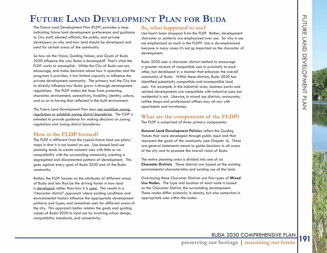
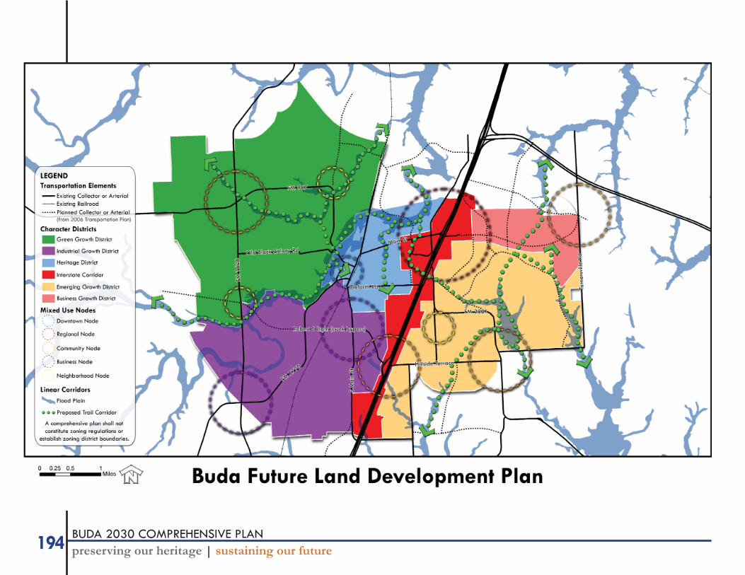
191 BUDA 2030 COMPREHENSIVE PLAN preserving our heritage | sustaining our future FUTURE LAND DEVELOPMENT PLAN FUTURE LAND DEVELOPMENT PLAN FOR BUDA The Future Land Development Plan (FLDP) provides a map indicating future land development preferences and guidance to City staff, elected officials, the public, and private developers on why and how land should be developed and used for certain areas of the community. So how do the Vision, Guiding Values, and Goals of Buda 2030 influence the way Buda is developed? That’s what the FLDP works to accomplish. While the City of Buda can act, encourage, and make decisions about how it operates and the programs it provides, it has limited capacity to influence the private development community. The primary tool the City has to directly influence how Buda grows is through development regulations. The FLDP makes the leap from protecting character, environment, connectivity, livability, identity, culture, and so on to having that reflected in the built environment. The Future Land Development Plan does not constitute zoning regulations or establish zoning district boundaries. The FLDP is intended to provide guidance for making decisions on zoning regulations and zoning district boundaries. How is the FLDP formed? The FLDP is different from the typical future land use plans/ maps in that it is not based on use. Use-based land use planning tends to create isolated uses with little or no compatibility with the surrounding community, creating a segregated and disconnected pattern of development. This goes against every goal of Buda 2030 and of the Buda community. Rather, the FLDP focuses on the attributes of different areas of Buda and lets that be the driving factor in how land is developed rather than how it is used. This results in a “character district” approach where existing conditions and environmental factors influence the appropriate development patterns and types, and sometimes uses for different areas of the city. This approach better relates the goals and guiding values of Buda 2030 to land use by involving urban design, compatibility standards, and connectivity. So, what happened to use? Use hasn’t been dropped from the FLDP. Rather, development character or patterns are emphasized over use. So why is use not emphasized as much in the FLDP? Use is de-emphasized because in many cases it’s not as important as the character of development. Buda 2030 uses a character district method to encourage a greater mixture of compatible uses in proximity to each other, but developed in a manner that enhances the overall community of Buda. Within these districts, Buda 2030 has identified potentially compatible and incompatible land uses. For example, in the industrial area, business parks and related developments are compatible with industrial uses, but residential is not. Likewise, in mixed use districts, restaurants, coffee shops and professional offices may all mix with apartments and townhomes. What are the components of the FLDP? The FLDP is comprised of three primary components: General Land Development Policies reflect the Guiding Values that were developed through public input and that represent the goals of the community (see Chapter 4). These are general statements meant to guide decisions in all areas of the city and to promote the overall vision of Buda. The entire planning area is divided into one of six Character Districts. These districts are based on the existing environmental characteristics and existing use of the land. Overlaying these Character Districts are five types of Mixed Use Nodes. The type and location of each node is based on the Character District, the surrounding development. These nodes differ primarily in density, but also somewhat in appropriate uses within the nodes.
Transcript of FUTURE LAND DEVELOPMENT PLAN FOR BUDA · PDF file10/6/2011 · BUDA 2030...
191BUDA 2030 COMPREHENSIVE PLANpreserving our heritage | sustaining our future
FUTU
RE LAN
D D
EVELO
PMEN
T PLAN
FUTURE LAND DEVELOPMENT PLAN FOR BUDAThe Future Land Development Plan (FLDP) provides a map indicating future land development preferences and guidance to City staff, elected offi cials, the public, and private developers on why and how land should be developed and used for certain areas of the community.
So how do the Vision, Guiding Values, and Goals of Buda 2030 infl uence the way Buda is developed? That’s what the FLDP works to accomplish. While the City of Buda can act, encourage, and make decisions about how it operates and the programs it provides, it has limited capacity to infl uence the private development community. The primary tool the City has to directly infl uence how Buda grows is through development regulations. The FLDP makes the leap from protecting character, environment, connectivity, livability, identity, culture, and so on to having that refl ected in the built environment.
The Future Land Development Plan does not constitute zoning regulations or establish zoning district boundaries. The FLDP is intended to provide guidance for making decisions on zoning regulations and zoning district boundaries.
How is the FLDP formed?The FLDP is different from the typical future land use plans/maps in that it is not based on use. Use-based land use planning tends to create isolated uses with little or no compatibility with the surrounding community, creating a segregated and disconnected pattern of development. This goes against every goal of Buda 2030 and of the Buda community.
Rather, the FLDP focuses on the attributes of different areas of Buda and lets that be the driving factor in how land is developed rather than how it is used. This results in a “character district” approach where existing conditions and environmental factors infl uence the appropriate development patterns and types, and sometimes uses for different areas of the city. This approach better relates the goals and guiding values of Buda 2030 to land use by involving urban design, compatibility standards, and connectivity.
So, what happened to use?Use hasn’t been dropped from the FLDP. Rather, development character or patterns are emphasized over use. So why is use not emphasized as much in the FLDP? Use is de-emphasized because in many cases it’s not as important as the character of development.
Buda 2030 uses a character district method to encourage a greater mixture of compatible uses in proximity to each other, but developed in a manner that enhances the overall community of Buda. Within these districts, Buda 2030 has identifi ed potentially compatible and incompatible land uses. For example, in the industrial area, business parks and related developments are compatible with industrial uses, but residential is not. Likewise, in mixed use districts, restaurants, coffee shops and professional offi ces may all mix with apartments and townhomes.
What are the components of the FLDP?The FLDP is comprised of three primary components:
General Land Development Policies refl ect the Guiding Values that were developed through public input and that represent the goals of the community (see Chapter 4). These are general statements meant to guide decisions in all areas of the city and to promote the overall vision of Buda.
The entire planning area is divided into one of six Character Districts. These districts are based on the existing environmental characteristics and existing use of the land.
Overlaying these Character Districts are fi ve types of Mixed Use Nodes. The type and location of each node is based on the Character District, the surrounding development. These nodes differ primarily in density, but also somewhat in appropriate uses within the nodes.
192 BUDA 2030 COMPREHENSIVE PLANpreserving our heritage | sustaining our future
FUTU
RE L
AN
D D
EVEL
OPM
ENT
PLA
N |
gen
eral
land
deve
lopm
ent p
olici
es GENERAL LAND DEVELOPMENT POLICIESGeneral land development policies are general statements that refl ect the Vision, Guiding Values, Goals, Objectives, and Actions of Buda 2030. They apply to all land development decisions, regardless of what Character District or Mixed Use Node the property is located. They are intended to provide general guidance on decisions related to land development.
Growth Management1. New developments must be compatible with existing
development and community character.
2. New development must maintain the small-town character, look, and feel of Buda.
3. Construct infrastructure in appropriate corridors and growth areas as identifi ed in Buda 2030.
4. New development must occur in a fi scally responsible manner.
5. Direct development within the existing incorporated area and where infrastructure already exists.
Environmental Protection1. Preserve and protect creeks, rivers, waterways, and fl oodplains.
2. Preserve and protect the quality of surface water and ground water resources and other hydrologically-active areas.
3. Cooperate with area governmental entities to ensure suffi cient water quantity and quality.
4. Seek public acquisition of open space or develop conservation development options for areas of environmental sensitivity.
5. Preserve and protect air quality.
6. Protect agricultural and ranch lands. Work with land owners who are interested in conservation easements or transfer of development rights.
7. Promote and incentivize water conservation practices.
8. Promote dense, cluster development in order to protect natural features.
Economic Development1. Seize economic opportunity along IH 35 and along major
arterials.
2. Promote quality development that is compatible with neighboring areas.
3. Promote development that is consistent with community character.
4. Enhance downtown as economic development component for area residents and visitors.
5. Promote economic development consistent with other goals, objectives, and land use policies.
6. Promote sustainable and effi cient business practices.
7. Promote businesses that diversify the Buda economy.
Housing1. Provide housing options for all stages of life and all
income levels within Buda.
2. Improve existing housing stock.
3. Ensure safe housing construction.
4. Ensure housing is compatible with existing neighborhoods and land uses.
5. Promote sustainable and effi cient housing developments.
Parks and Recreation1. Connect existing and future parks.
2. Ensure maintenance and safety of parks and recreation resources
3. Provide open space, parkland, trails, and recreation opportunities in proximity to the maximum number of residents possible.
4. Use linear open space along creeks and fl oodplains for trails as a way to provide connectivity throughout Buda.
193BUDA 2030 COMPREHENSIVE PLANpreserving our heritage | sustaining our future
FUTU
RE LAN
D D
EVELO
PMEN
T PLAN
| general land development policies
Transportation1. The design of streets should refl ect the character of the
community and surrounding environment.
2. Provide more east-west connectivity.
3. Reduce truck traffi c through downtown and encourage alternative routes south of downtown.
4. Provide for safe and ample pedestrian connectivity throughout new and /or existing developments.
5. Provide for safe options in travel, including walking, bicycling, automobile, and mass transit.
6. Improve access across and under IH 35.
7. Ensure that streets and thoroughfare networks are designed with a focus on interconnectivity to provide ample, safe, and appropriately-scaled access throughout and between neighborhoods and to commercial areas.
8. Ensure that appropriate levels of parking are provided for commercial, offi ce, and retail developments in a way that does not deter ease of pedestrian access or compromise the character of the development and surrounding area. Don’t “overpark” if not necessary.
9. Utilize safe and integrated access management.
Urban Design1. Encourage and provide incentives for mixing land uses.
2. Establish neighborhoods as the primary organizing element, each including civic spaces, access to commercial districts, connectivity, and a variety of housing densities and types.
3. Develop compatibility standards for adjoining land uses (e.g., transition zones).
4. Develop streetscape design criteria to ensure safe and desirable pedestrian access and community attractiveness.
5. Utilize design criteria to regulate physical and aesthetic characteristics of the built environment to emphasize the visual integrity of the community.
6. Signage should not detract from the visual integrity of the community.
7. Lighting associated with signs, parking lots, or any development should not pose a safety, environmental, or aesthetic concern, particularly as it relates to the impact on existing or new residential development.
8. Neighborhoods should be designed with a high level of connectivity to provide options in transportation routes as well as promote alternative choices in modes of transportation such as walking or bicycling.
Civic Facilities1. Civic buildings and spaces should be given accessible,
prominent sites.
2. Schools - particularly elementary schools - should be the physical and social center of a neighborhood or group of neighborhoods and located within safe and easy walking distance from the maximum number of dwelling units possible.
3. Civic facilities should be accessible to the public.
Historic Preservation1. Preserve and enhance historic areas throughout the city.
2. Preserve the community character.
3. Use history to promote tourism and economic development.
194 BUDA 2030 COMPREHENSIVE PLANpreserving our heritage | sustaining our future
195BUDA 2030 COMPREHENSIVE PLANpreserving our heritage | sustaining our future
FUTU
RE LAN
D D
EVELO
PMEN
T PLAN
| character districtsCHARACTER DISTRICTS
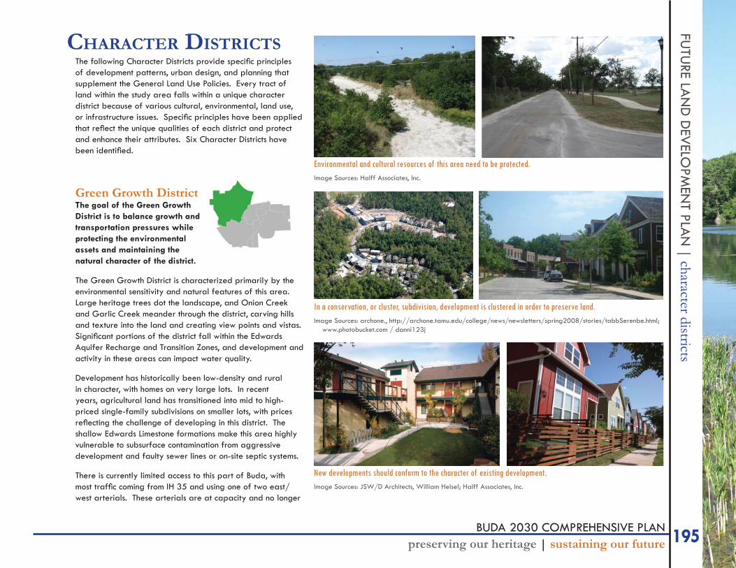
The following Character Districts provide specifi c principles of development patterns, urban design, and planning that supplement the General Land Use Policies. Every tract of land within the study area falls within a unique character district because of various cultural, environmental, land use, or infrastructure issues. Specifi c principles have been applied that refl ect the unique qualities of each district and protect and enhance their attributes. Six Character Districts have been identifi ed.
Green Growth DistrictThe goal of the Green Growth District is to balance growth and transportation pressures while protecting the environmental assets and maintaining the natural character of the district.
The Green Growth District is characterized primarily by the environmental sensitivity and natural features of this area. Large heritage trees dot the landscape, and Onion Creek and Garlic Creek meander through the district, carving hills and texture into the land and creating view points and vistas. Signifi cant portions of the district fall within the Edwards Aquifer Recharge and Transition Zones, and development and activity in these areas can impact water quality.
Development has historically been low-density and rural in character, with homes on very large lots. In recent years, agricultural land has transitioned into mid to high-priced single-family subdivisions on smaller lots, with prices refl ecting the challenge of developing in this district. The shallow Edwards Limestone formations make this area highly vulnerable to subsurface contamination from aggressive development and faulty sewer lines or on-site septic systems.
There is currently limited access to this part of Buda, with most traffi c coming from IH 35 and using one of two east/west arterials. These arterials are at capacity and no longer
In a conservation, or cluster, subdivision, development is clustered in order to preserve land.Image Sources: archone., http://archone.tamu.edu/college/news/newsletters/spring2008/stories/tabbSerenbe.html;
www.photobucket.com / danni123j
New developments should conform to the character of existing development.Image Sources: JSW/D Architects, William Helsel; Halff Associates, Inc.
Environmental and cultural resources of this area need to be protected.Image Sources: Halff Associates, Inc.
196 BUDA 2030 COMPREHENSIVE PLANpreserving our heritage | sustaining our future
FUTU
RE L
AN
D D
EVEL
OPM
ENT
PLA
N |
cha
ract
er d
istric
tssuffi cient to carry the traffi c as they are currently designed. FM 1626 is emerging as a major gateway into Buda. As improvements to this roadway north toward Austin occur, it will only become more of a gateway.
Purpose The purpose of the Green Growth District is to establish protective measures for these environmental features and to protect the City’s drinking water supply. Development in this district should refl ect the goal of environmental protection. Cluster developments should be heavily encouraged, or possibly mandated in this district. Floodplains of Onion and Garlic Creek and their tributaries should be protected in perpetuity from development.
Appropriate Uses and Development TypesThe primary concern in the Green Growth District is the environmental impact of land uses and the pattern of development. Most land uses are permitted in this district, with the exception of those that could negatively impact the environment, such as manufacturing or other heavy industrial.
Environmental protection mechanisms will be instrumental for new developments in this district. Cluster developments should be heavily encouraged, or possibly mandated in this district. Allowing density bonuses in conjunction with cluster developments is appropriate for this area and will encourage use of the zoning district. Floodplains of Onion and Garlic Creeks and their tributaries should be protected in perpetuity from development. These will also create opportunities to develop trails and promote connectivity. Remaining agricultural uses should be supported. Explore community supported agriculture opportunities in this district.
New developments and roadway improvements should refl ect the rural character that is already established by existing and recent developments. The scale and design of commercial and mixed use developments should be sensitive to the rural skyline. High density residential uses should focus on clustering the footprint, rather than adding to height. Existing natural features such as trees, greenbelts,
and creeks should be protected when sites are developed to the fullest extent possible.
As mentioned, the arterials west of IH 35 are in need of redesign to increase capacity (such as FM 967). When TXDOT, Hays County, and the City of Buda move forward on these efforts signifi cant attention needs to be given to how these roadway improvements will affect the character of this area. Creative design such as context sensitive solutions and complete streets need to be considered in the design of future road widening in this district so as to minimize the impact on the character of this area while also enhancing the level of transportation services.
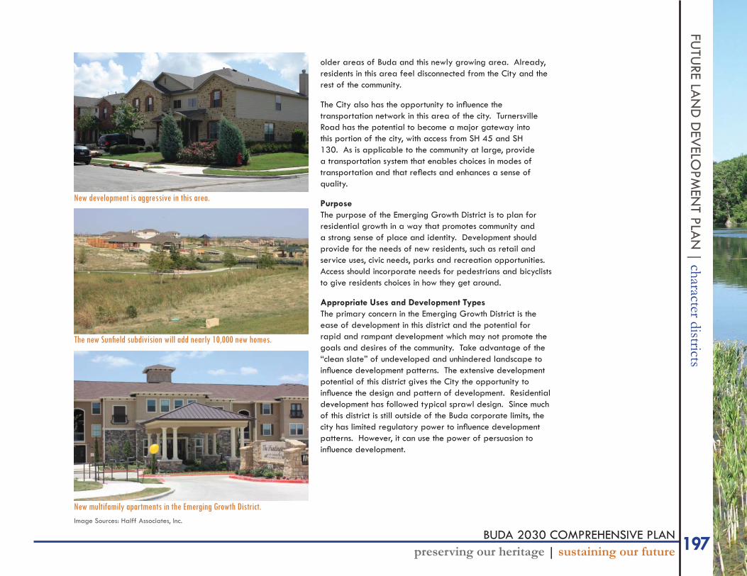
Emerging Growth DistrictThe goal of the Emerging Growth District is to avoid typical sprawl by planning for residential growth while maintaining a sense of community, and also providing for the needs of new residents for retail and service uses, park and recreation opportunities, and pedestrian and bicycle access.
Growth east of IH 35 is a relatively new phenomenon for Buda. In 2002, only 107 acres of this district was in the Buda corporate limits (7.5% of the then incorporated city limits), and in 2010, 12.1% of the incorporated city limits is east of IH 35. This portion of the study area is rapidly being platted for development, and with new development comes the opportunity for the City to shape that new development.
Much of this land is agricultural land transitioning into residential subdivisions. There are fewer environmental concerns. Rather, the more pressing concern is the fast pace of development in this district and the fl eeting opportunity to infl uence it.
IH 35 has the potential to be a physical barrier between the
197BUDA 2030 COMPREHENSIVE PLANpreserving our heritage | sustaining our future
FUTU
RE LAN
D D
EVELO
PMEN
T PLAN
| character districtsolder areas of Buda and this newly growing area. Already, residents in this area feel disconnected from the City and the rest of the community.
The City also has the opportunity to infl uence the transportation network in this area of the city. Turnersville Road has the potential to become a major gateway into this portion of the city, with access from SH 45 and SH 130. As is applicable to the community at large, provide a transportation system that enables choices in modes of transportation and that refl ects and enhances a sense of quality.
Purpose The purpose of the Emerging Growth District is to plan for residential growth in a way that promotes community and a strong sense of place and identity. Development should provide for the needs of new residents, such as retail and service uses, civic needs, parks and recreation opportunities. Access should incorporate needs for pedestrians and bicyclists to give residents choices in how they get around.
Appropriate Uses and Development TypesThe primary concern in the Emerging Growth District is the ease of development in this district and the potential for rapid and rampant development which may not promote the goals and desires of the community. Take advantage of the “clean slate” of undeveloped and unhindered landscape to infl uence development patterns. The extensive development potential of this district gives the City the opportunity to infl uence the design and pattern of development. Residential development has followed typical sprawl design. Since much of this district is still outside of the Buda corporate limits, the city has limited regulatory power to infl uence development patterns. However, it can use the power of persuasion to infl uence development.
New multifamily apartments in the Emerging Growth District.Image Sources: Halff Associates, Inc.
New development is aggressive in this area.
The new Sunfi eld subdivision will add nearly 10,000 new homes.
198 BUDA 2030 COMPREHENSIVE PLANpreserving our heritage | sustaining our future
FUTU
RE L
AN
D D
EVEL
OPM
ENT
PLA
N |
cha
ract
er d
istric
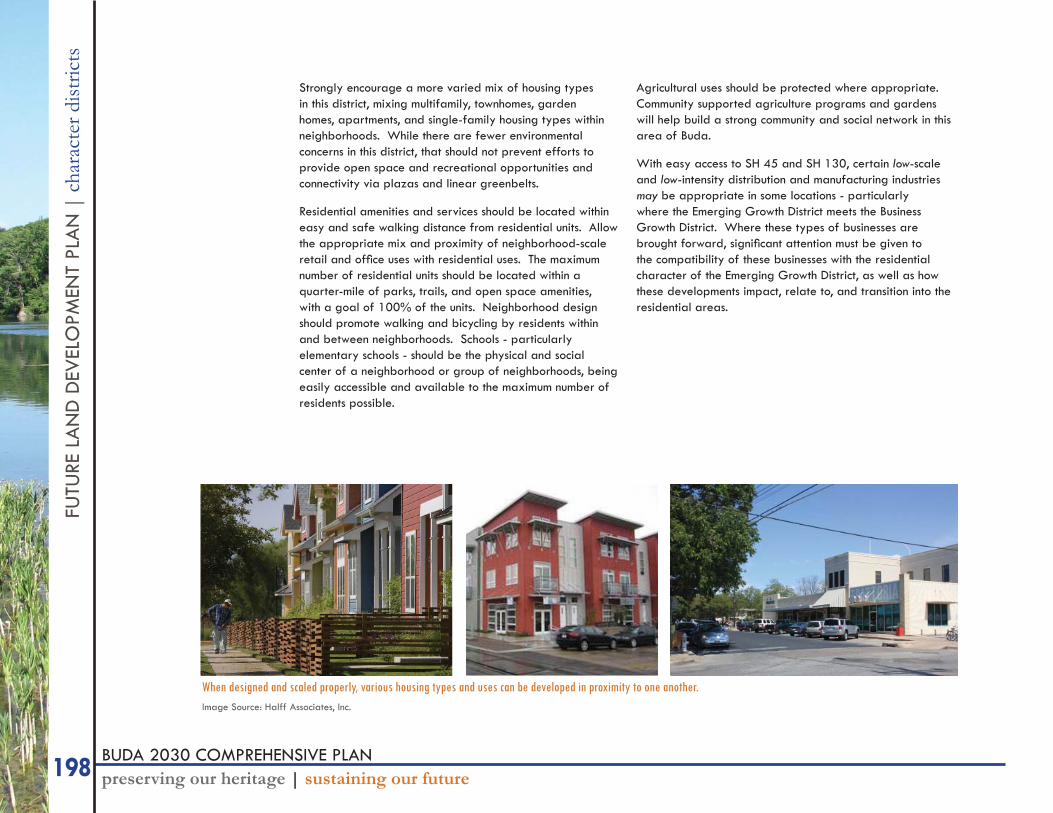
tsStrongly encourage a more varied mix of housing types in this district, mixing multifamily, townhomes, garden homes, apartments, and single-family housing types within neighborhoods. While there are fewer environmental concerns in this district, that should not prevent efforts to provide open space and recreational opportunities and connectivity via plazas and linear greenbelts.
Residential amenities and services should be located within easy and safe walking distance from residential units. Allow the appropriate mix and proximity of neighborhood-scale retail and offi ce uses with residential uses. The maximum number of residential units should be located within a quarter-mile of parks, trails, and open space amenities, with a goal of 100% of the units. Neighborhood design should promote walking and bicycling by residents within and between neighborhoods. Schools - particularly elementary schools - should be the physical and social center of a neighborhood or group of neighborhoods, being easily accessible and available to the maximum number of residents possible.
Agricultural uses should be protected where appropriate. Community supported agriculture programs and gardens will help build a strong community and social network in this area of Buda.
With easy access to SH 45 and SH 130, certain low-scale and low-intensity distribution and manufacturing industries may be appropriate in some locations - particularly where the Emerging Growth District meets the Business Growth District. Where these types of businesses are brought forward, signifi cant attention must be given to the compatibility of these businesses with the residential character of the Emerging Growth District, as well as how these developments impact, relate to, and transition into the residential areas.
When designed and scaled properly, various housing types and uses can be developed in proximity to one another.Image Source: Halff Associates, Inc.
199BUDA 2030 COMPREHENSIVE PLANpreserving our heritage | sustaining our future
FUTU
RE LAN
D D
EVELO
PMEN
T PLAN
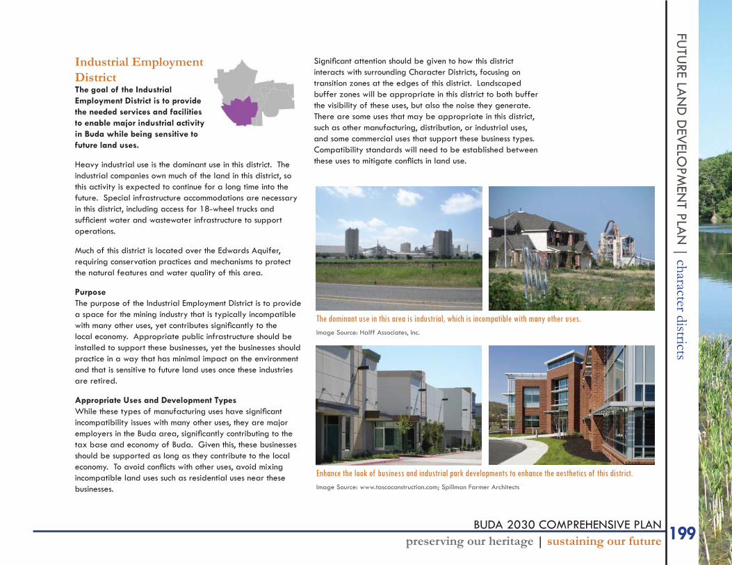
| character districtsIndustrial Employment DistrictThe goal of the Industrial Employment District is to provide the needed services and facilities to enable major industrial activity in Buda while being sensitive to future land uses.
Heavy industrial use is the dominant use in this district. The industrial companies own much of the land in this district, so this activity is expected to continue for a long time into the future. Special infrastructure accommodations are necessary in this district, including access for 18-wheel trucks and suffi cient water and wastewater infrastructure to support operations.
Much of this district is located over the Edwards Aquifer, requiring conservation practices and mechanisms to protect the natural features and water quality of this area.
Purpose The purpose of the Industrial Employment District is to provide a space for the mining industry that is typically incompatible with many other uses, yet contributes signifi cantly to the local economy. Appropriate public infrastructure should be installed to support these businesses, yet the businesses should practice in a way that has minimal impact on the environment and that is sensitive to future land uses once these industries are retired.
Appropriate Uses and Development TypesWhile these types of manufacturing uses have signifi cant incompatibility issues with many other uses, they are major employers in the Buda area, signifi cantly contributing to the tax base and economy of Buda. Given this, these businesses should be supported as long as they contribute to the local economy. To avoid confl icts with other uses, avoid mixing incompatible land uses such as residential uses near these businesses.
Signifi cant attention should be given to how this district interacts with surrounding Character Districts, focusing on transition zones at the edges of this district. Landscaped buffer zones will be appropriate in this district to both buffer the visibility of these uses, but also the noise they generate. There are some uses that may be appropriate in this district, such as other manufacturing, distribution, or industrial uses, and some commercial uses that support these business types. Compatibility standards will need to be established between these uses to mitigate confl icts in land use.
The dominant use in this area is industrial, which is incompatible with many other uses.Image Source: Halff Associates, Inc.
Enhance the look of business and industrial park developments to enhance the aesthetics of this district.Image Source: www.tascoconstruction.com; Spillman Farmer Architects
200 BUDA 2030 COMPREHENSIVE PLANpreserving our heritage | sustaining our future
FUTU
RE L
AN
D D
EVEL
OPM
ENT
PLA
N |
cha
ract
er d
istric
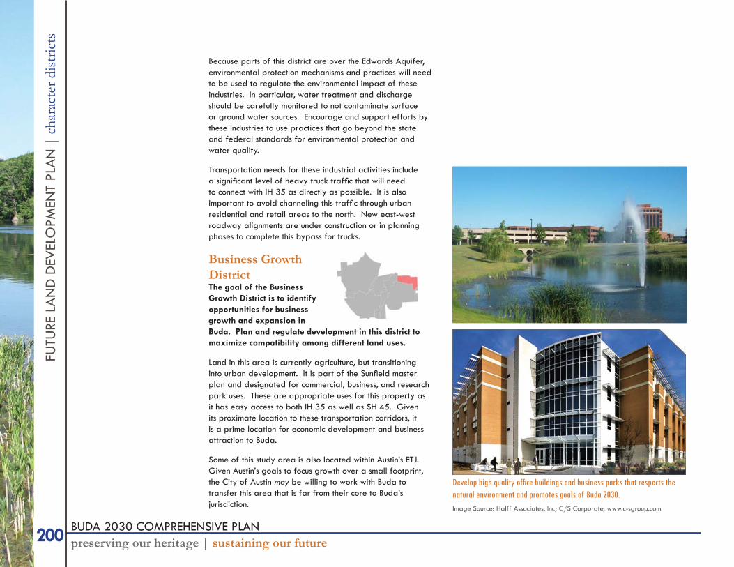
tsBecause parts of this district are over the Edwards Aquifer, environmental protection mechanisms and practices will need to be used to regulate the environmental impact of these industries. In particular, water treatment and discharge should be carefully monitored to not contaminate surface or ground water sources. Encourage and support efforts by these industries to use practices that go beyond the state and federal standards for environmental protection and water quality.
Transportation needs for these industrial activities include a signifi cant level of heavy truck traffi c that will need to connect with IH 35 as directly as possible. It is also important to avoid channeling this traffi c through urban residential and retail areas to the north. New east-west roadway alignments are under construction or in planning phases to complete this bypass for trucks.
Business Growth DistrictThe goal of the Business Growth District is to identify opportunities for business growth and expansion in Buda. Plan and regulate development in this district to maximize compatibility among different land uses.
Land in this area is currently agriculture, but transitioning into urban development. It is part of the Sunfi eld master plan and designated for commercial, business, and research park uses. These are appropriate uses for this property as it has easy access to both IH 35 as well as SH 45. Given its proximate location to these transportation corridors, it is a prime location for economic development and business attraction to Buda.
Some of this study area is also located within Austin’s ETJ. Given Austin’s goals to focus growth over a small footprint, the City of Austin may be willing to work with Buda to transfer this area that is far from their core to Buda’s jurisdiction.
Develop high quality offi ce buildings and business parks that respects the natural environment and promotes goals of Buda 2030.Image Source: Halff Associates, Inc; C/S Corporate, www.c-sgroup.com

201BUDA 2030 COMPREHENSIVE PLANpreserving our heritage | sustaining our future
FUTU
RE LAN
D D
EVELO
PMEN
T PLAN
| character districtsPurpose The purpose of this district is to capitalize on the opportunities for economic and business development given this district’s accessibility location to major transportation corridors.
Appropriate Uses and Development TypesEfforts for this district should focus on developing it as an employment center for Buda, mixing various uses within proximity to one another. Given the lack of existing development, the impact of new developments will be less intrusive, giving property owners and the City the opportunity to increase density.
Mixing jobs, housing, commercial, and civic uses will enable residents of this district to live, work, shop, and play all in this part of Buda. Attract research and development companies, higher education institutions, and services for small or local business development to locate their offi ces in this district.
Strong connectivity of the transportation network, including streets and paths, will enable people to easily access each destination without the need for vehicles. Access to SH 45 and IH 35 should be enhanced, yet still incorporate complete street and context sensitive solution principles in the design of streets.
Carefully identify compatible uses for adjacent and mixed use developments within an area. Compatibility standards and transition areas will need to be established between uses that may encounter confl icts. Use form-based development regulations for these areas to address these transition areas. For businesses requiring truck traffi c, utilize transportation regulations to minimize the impacts of this traffi c on less intense uses, as truck routes or no-truck zones.
As is applicable to all areas of Buda, continue to incorporate the environmental features of the land into developments and encourage sustainable practices such as natural resource protection, water conservation, and low energy consumption.
Mix uses to allow residents to live, work, play, and shop all in this area of Buda.Image Source: Halff Associates, Inc.
202 BUDA 2030 COMPREHENSIVE PLANpreserving our heritage | sustaining our future
FUTU
RE L
AN
D D
EVEL
OPM
ENT
PLA
N |
cha
ract
er d
istric
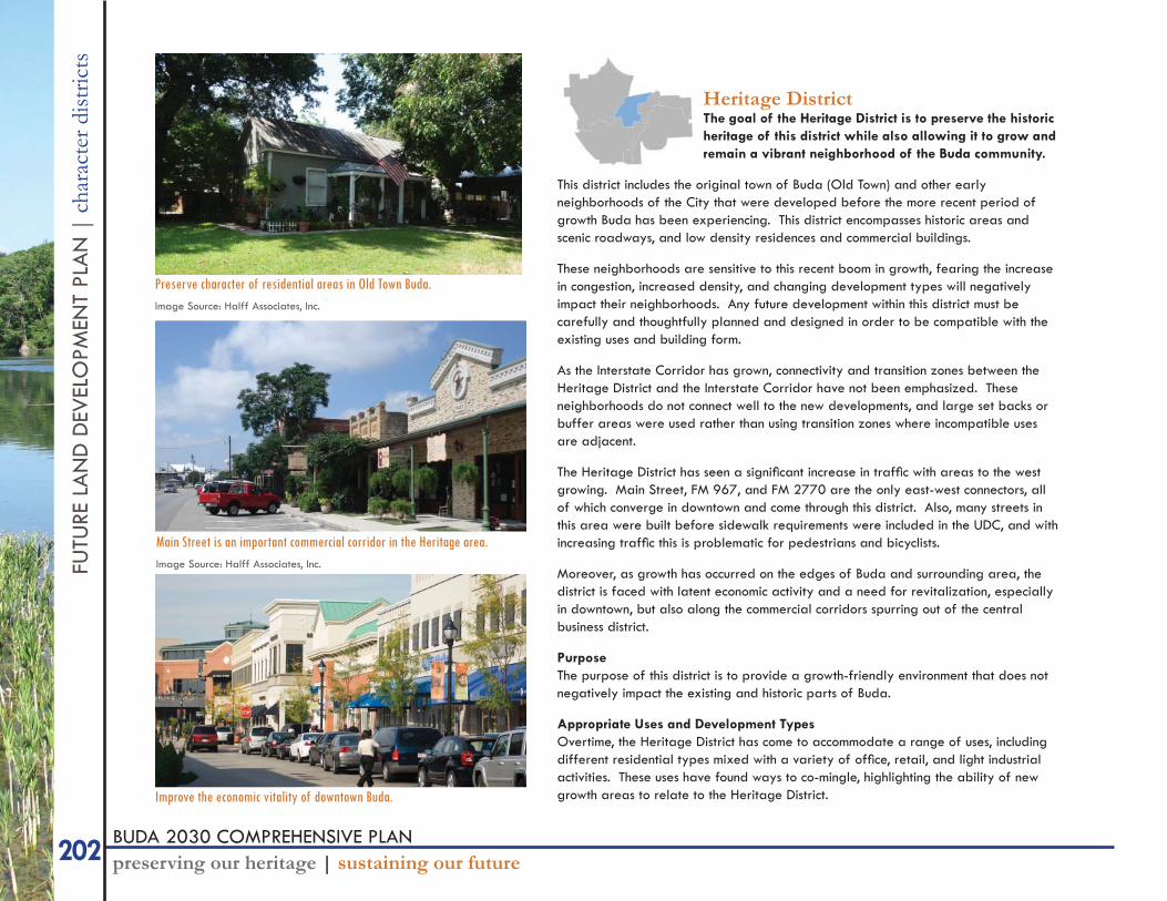
tsHeritage DistrictThe goal of the Heritage District is to preserve the historic heritage of this district while also allowing it to grow and remain a vibrant neighborhood of the Buda community.
This district includes the original town of Buda (Old Town) and other early neighborhoods of the City that were developed before the more recent period of growth Buda has been experiencing. This district encompasses historic areas and scenic roadways, and low density residences and commercial buildings.
These neighborhoods are sensitive to this recent boom in growth, fearing the increase in congestion, increased density, and changing development types will negatively impact their neighborhoods. Any future development within this district must be carefully and thoughtfully planned and designed in order to be compatible with the existing uses and building form.
As the Interstate Corridor has grown, connectivity and transition zones between the Heritage District and the Interstate Corridor have not been emphasized. These neighborhoods do not connect well to the new developments, and large set backs or buffer areas were used rather than using transition zones where incompatible uses are adjacent.
The Heritage District has seen a signifi cant increase in traffi c with areas to the west growing. Main Street, FM 967, and FM 2770 are the only east-west connectors, all of which converge in downtown and come through this district. Also, many streets in this area were built before sidewalk requirements were included in the UDC, and with increasing traffi c this is problematic for pedestrians and bicyclists.
Moreover, as growth has occurred on the edges of Buda and surrounding area, the district is faced with latent economic activity and a need for revitalization, especially in downtown, but also along the commercial corridors spurring out of the central business district.
Purpose The purpose of this district is to provide a growth-friendly environment that does not negatively impact the existing and historic parts of Buda.
Appropriate Uses and Development TypesOvertime, the Heritage District has come to accommodate a range of uses, including different residential types mixed with a variety of offi ce, retail, and light industrial activities. These uses have found ways to co-mingle, highlighting the ability of new growth areas to relate to the Heritage District.
Preserve character of residential areas in Old Town Buda.Image Source: Halff Associates, Inc.
Main Street is an important commercial corridor in the Heritage area.Image Source: Halff Associates, Inc.
Improve the economic vitality of downtown Buda.
203BUDA 2030 COMPREHENSIVE PLANpreserving our heritage | sustaining our future
FUTU
RE LAN
D D
EVELO
PMEN
T PLAN
| character districtsTherefore, the primary concern in this district is establishing clear and predictable compatibility standards that encourage new developments but that compliment the character of the Heritage District. Bulk, height, area, building materials, setbacks, and overall appearance of buildings and spaces should be considered for new developments and redevelopments.
Transition and connectivity must also be emphasized in this district, especially as it relates to the surrounding districts as well as internally to the area. Commit funding and identify opportunities to make connectivity improvements to the street and sidewalk network. Utilize transition zones and form-based regulations where non-compatible uses are adjacent, and program landscaped buffer areas to enable passage through them to enhance connectivity.
Strongly encourage infi ll development in this area and prioritize it over development where infrastructure does not yet exist. Regulate infi ll developments to be compatible with the existing uses and buildings. Support revitalization of this area by committing public funds and efforts to enhance the public realm, including parks, sidewalks, lighting, landscaping, and roadways.
Interstate CorridorThe goal of the Interstate Corridor is to take advantage of the economic potential of IH 35 as a commercial corridor that is compatible with surrounding uses, that establishes Buda’s identity, and that connects with surrounding uses.
The IH 35 corridor will be an important economic development tool and revenue generator for Buda. The 2002 Comprehensive Plan helped create an Interstate-35 Commercial/Offi ce Zoning District and Interstate Overlay Zone that will guide future development and public investment decisions. The district extends along the interstate from the north boundary of the study area to the south boundary. It encompasses several existing industrial and commercial developments. Improvements currently underway and recently completed of the roadway and along the corridor present the opportunity to affect change on this corridor in its general appearance as well as how it serves the residential and business community of Buda.
Portions of this corridor have yet to be incorporated into the city limits and lack the appropriate level of infrastructure to support the intensity of development recommended for this corridor.
IH 35 carries high volumes of traffi c of regular commuters as well as travellers. IH 35 is the front door for many who live in Buda and a window to those passing through. It heavily infl uences the perception and image of Buda that both residents, visitors, and passers-by have. Therefore, the general appearance of the corridor is important for this gateway.
The center at IH 35 between Main Street and Cabela’s Drive serves as a major attractor from a community-wide and even regional area. Cabela’s draws a regional clientele from across Central Texas and much of the State, while HEB and Walmart serve the more local residents of
Create pleasant, friendly places to walk, sit, and visit along Main Street.Image Source: www.pedbikeimages.org / Dan Burden
204 BUDA 2030 COMPREHENSIVE PLANpreserving our heritage | sustaining our future
FUTU
RE L
AN
D D
EVEL
OPM
ENT
PLA
N |
cha
ract
er d
istric
tsBuda. As development has occurred along this corridor, little attention has been given to how it relates to and impacts the surrounding neighborhoods and developments.
Purpose The purpose of this district is to create the infrastructure and support developments that take advantage of the economic opportunities that IH 35 provides. The district should promote economic opportunities such as business and retail service growth and expansion while also improving the look of the corridor to refl ect Buda’s identity.
Appropriate Uses and Development TypesIntense development along the Interstate Corridor is appropriate to take advantage of the economic opportunities this corridor presents. The current zoning code refl ects that desire to concentrate dense commercial development along this corridor. Maximize on the traffi c volumes and visibility of the corridor to attract businesses. Dense multi-family housing is also appropriate for this corridor.
Design standards that regulate building articulation, landscaping, and building material will help shape the visual appearance of developments, improving the aesthetic nature of this corridor. Sign standards should address the visual pollution created by numerous and cluttered signs. Additionally, the City should identify opportunities to bury utility lines, which add to the cluttered look and feel of the corridor.
The corridor easily has the potential to both physically and socially divide the city between “east side” and “west side”. The City needs to take seriously the negative affects this has on the population and the vitality of neighborhoods that are “cut off” from the rest of the community. Serious efforts need to be made to address the physical barrier of the corridor by providing easy and safe access for pedestrians and bicyclists to cross the interstate. Intersections should be designed to indicate connection and fl ow, rather than a barrier that can’t be crossed.
Development along the corridor should also connect to surrounding neighborhoods and developments. New developments must be compatible with existing developments. Utilize transition zones between the Interstate Corridor and surrounding districts by scaling uses appropriately and using landscaping in a manner that communicates connectivity rather than separation.
Provide connectivity through developments along this corridor for vehicular, pedestrian, and bicycle traffi c. Connectivity should include both connections to the surrounding neighborhoods to provide access to the destinations, as well as parallel to the interstate as to connect various commercial and multi-family developments along the corridor. This will help minimize the traffi c impacts along the frontage roads created by development of the corridor.
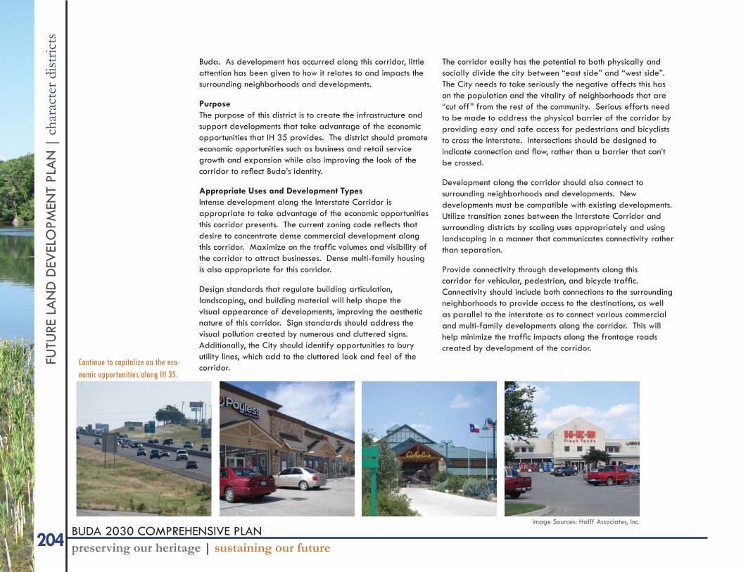
Continue to capitalize on the eco-nomic opportunities along IH 35.
Image Sources: Halff Associates, Inc.
205BUDA 2030 COMPREHENSIVE PLANpreserving our heritage | sustaining our future
FUTU
RE LAN
D D
EVELO
PMEN
T PLAN
| mixed use nodes
MIXED USE NODESThere are fi ve types of mixed use nodes that overlay the Character Districts. Nodes are intended to designate locations where dense, mixed use developments are appropriate and should be encouraged. These nodes should emphasize walkability and be built around the pedestrian, and not the car.
Why Mixed Use?Mixed use development offers several benefi ts to a community. First, mixed use allows for the optimum use of infrastructure by combining uses that have different “peak” times for use of infrastructure and resources than if they were separated. Mixed use developments also allow for a different housing type, diversifying housing choices in Buda. Mixing uses also allows for residential units to be closer to goods, services, and civic activities, reducing the dependence on the car. This particularly benefi ts the elderly and children. It some areas, it also reduces the need for car dependency or even ownership, alleviating rising transportation costs on a household.
Mixed use developments support many other goals of Buda. Having a more walkable community improves health as people are able to be more active. Increasing walking and bicycling over car use also has a positive impact on the environmental concerns associated with automobile use. Mixed use can also be an economic development tool because it creates nodes of intense activity and commerce.
What is Mixed Use?The term “mixed use” refers to many things. It can mean mixing different specifi c uses of the same general category, like housing types. It can also mean bringing different uses near each other (which can also be called “horizontal” mixed use). This is often accomplished with planned-unit development zoning where certain areas of a master planned community are designated for commercial, others for residential, some for parks and so on. The third type of mixed use is “vertical” mixed use. Here, different uses are not only brought near, they converge with each other in dense, walkable, vibrant places.
As you’ve seen in this document, all of these defi nitions of mixed
use are appropriate and encouraged for Buda. However, the “mixed use node” of the land development plan refers primarily to the third defi nition, vertical mixed use, with elements of horizontal mixed use incorporated.
But mixed use isn’t just about bringing uses together. Rather, mixed use policies and developments have specifi c benefi ts they’re trying to achieve - walkability, more sustainable and effi cient development, reduced reliance on the car, active and vibrant places, etc. Creating a successful mixed use node means focusing on creating the environment to generate activity that makes these uses WORK together to create a place. Uses need to be compatible and mutually supportive, working to create a framework for activity, socializing, and commerce.
The design of all mixed use nodes should consider:* Scale (the intensity and density of development and uses)* Mix of housing* Walkability* Public realm* Parking* Access to environment and open space
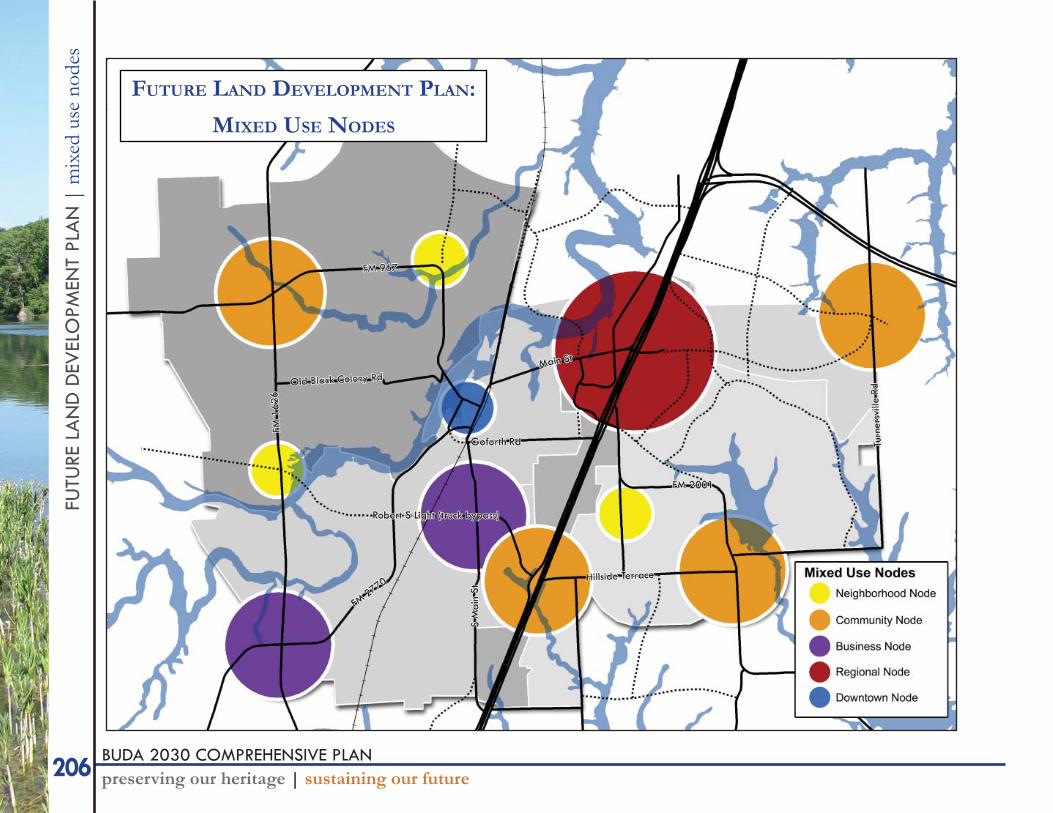
Relation to the Character DistrictsThe type and location of each node is based on the Character District, the surrounding development. Generally, they are located where activity converges - where corridors, neighborhoods, or any other activity-generating element of the city comes together to create a “hot spot” of activity.
These nodes differ primarily in density, and somewhat in appropriate uses within the nodes. Development and appropriate uses in each node should conform to the principles of each Character District. For example, the environmental protection priorities of the Green Growth District should be evident in the development of the Community Node at FM 1626 and FM 967. Also, the Business Nodes in the Industrial Growth District should also recognize that residential is not an appropriate use in that district, and therefore seek a mix of other uses that support the businesses in the area.
206 BUDA 2030 COMPREHENSIVE PLANpreserving our heritage | sustaining our future
FUTU
RE L
AN
D D
EVEL
OPM
ENT
PLA
N |
mix
ed u
se n
odes
FUTURE LAND DEVELOPMENT PLAN:
MIXED USE NODES
207BUDA 2030 COMPREHENSIVE PLANpreserving our heritage | sustaining our future
FUTU
RE LAN
D D
EVELO
PMEN
T PLAN
| mixed use nodes
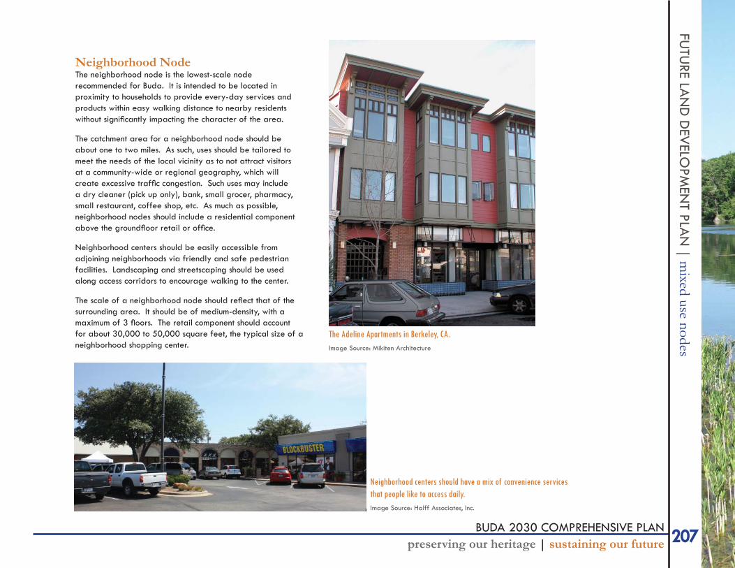
Neighborhood NodeThe neighborhood node is the lowest-scale node recommended for Buda. It is intended to be located in proximity to households to provide every-day services and products within easy walking distance to nearby residents without signifi cantly impacting the character of the area.
The catchment area for a neighborhood node should be about one to two miles. As such, uses should be tailored to meet the needs of the local vicinity as to not attract visitors at a community-wide or regional geography, which will create excessive traffi c congestion. Such uses may include a dry cleaner (pick up only), bank, small grocer, pharmacy, small restaurant, coffee shop, etc. As much as possible, neighborhood nodes should include a residential component above the groundfl oor retail or offi ce.
Neighborhood centers should be easily accessible from adjoining neighborhoods via friendly and safe pedestrian facilities. Landscaping and streetscaping should be used along access corridors to encourage walking to the center.
The scale of a neighborhood node should refl ect that of the surrounding area. It should be of medium-density, with a maximum of 3 fl oors. The retail component should account for about 30,000 to 50,000 square feet, the typical size of a neighborhood shopping center.
The Adeline Apartments in Berkeley, CA.Image Source: Mikiten Architecture
Neighborhood centers should have a mix of convenience services that people like to access daily.Image Source: Halff Associates, Inc.
208 BUDA 2030 COMPREHENSIVE PLANpreserving our heritage | sustaining our future
FUTU
RE L
AN
D D
EVEL
OPM
ENT
PLA
N |
mix
ed u
se n
odes
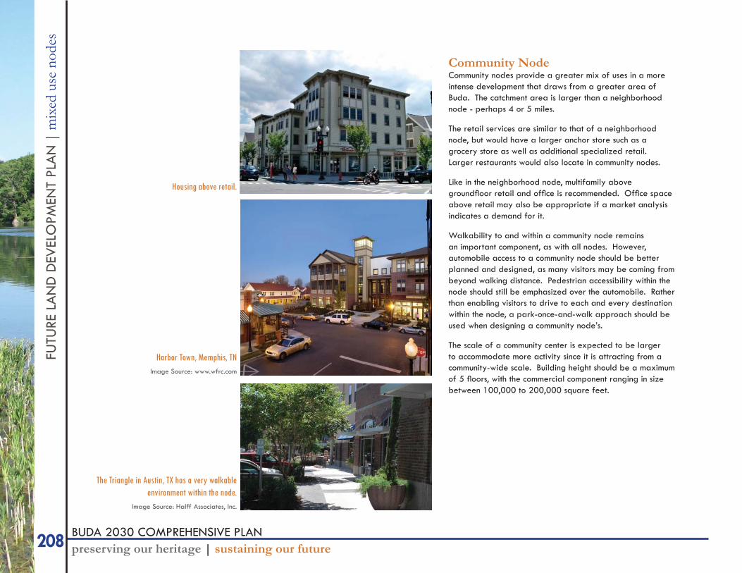
Community NodeCommunity nodes provide a greater mix of uses in a more intense development that draws from a greater area of Buda. The catchment area is larger than a neighborhood node - perhaps 4 or 5 miles.
The retail services are similar to that of a neighborhood node, but would have a larger anchor store such as a grocery store as well as additional specialized retail. Larger restaurants would also locate in community nodes.
Like in the neighborhood node, multifamily above groundfl oor retail and offi ce is recommended. Offi ce space above retail may also be appropriate if a market analysis indicates a demand for it.
Walkability to and within a community node remains an important component, as with all nodes. However, automobile access to a community node should be better planned and designed, as many visitors may be coming from beyond walking distance. Pedestrian accessibility within the node should still be emphasized over the automobile. Rather than enabling visitors to drive to each and every destination within the node, a park-once-and-walk approach should be used when designing a community node’s.
The scale of a community center is expected to be larger to accommodate more activity since it is attracting from a community-wide scale. Building height should be a maximum of 5 fl oors, with the commercial component ranging in size between 100,000 to 200,000 square feet.
Harbor Town, Memphis, TNImage Source: www.wfrc.com
The Triangle in Austin, TX has a very walkable environment within the node.
Image Source: Halff Associates, Inc.
Housing above retail.
209BUDA 2030 COMPREHENSIVE PLANpreserving our heritage | sustaining our future
FUTU
RE LAN
D D
EVELO
PMEN
T PLAN
| mixed use nodes
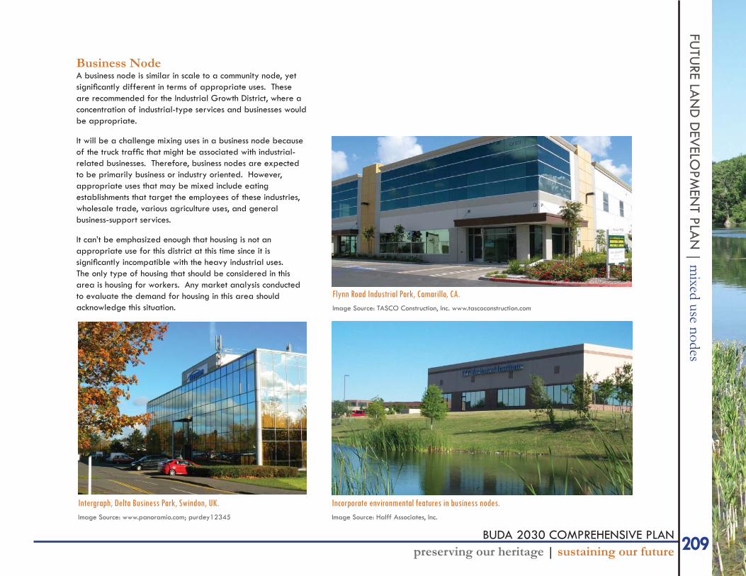
Business NodeA business node is similar in scale to a community node, yet signifi cantly different in terms of appropriate uses. These are recommended for the Industrial Growth District, where a concentration of industrial-type services and businesses would be appropriate.
It will be a challenge mixing uses in a business node because of the truck traffi c that might be associated with industrial-related businesses. Therefore, business nodes are expected to be primarily business or industry oriented. However, appropriate uses that may be mixed include eating establishments that target the employees of these industries, wholesale trade, various agriculture uses, and general business-support services.
It can’t be emphasized enough that housing is not an appropriate use for this district at this time since it is signifi cantly incompatible with the heavy industrial uses. The only type of housing that should be considered in this area is housing for workers. Any market analysis conducted to evaluate the demand for housing in this area should acknowledge this situation.
Flynn Road Industrial Park, Camarillo, CA.Image Source: TASCO Construction, Inc. www.tascoconstruction.com
Incorporate environmental features in business nodes.Image Source: Halff Associates, Inc.
Intergraph, Delta Business Park, Swindon, UK.Image Source: www.panoramio.com; purdey12345
210 BUDA 2030 COMPREHENSIVE PLANpreserving our heritage | sustaining our future
FUTU
RE L
AN
D D
EVEL
OPM
ENT
PLA
N |
mix
ed u
se n
odes
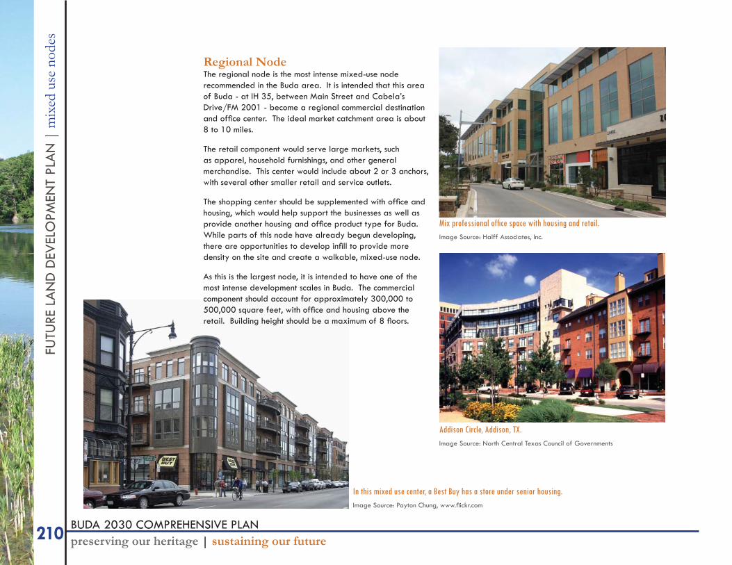
Regional NodeThe regional node is the most intense mixed-use node recommended in the Buda area. It is intended that this area of Buda - at IH 35, between Main Street and Cabela’s Drive/FM 2001 - become a regional commercial destination and offi ce center. The ideal market catchment area is about 8 to 10 miles.
The retail component would serve large markets, such as apparel, household furnishings, and other general merchandise. This center would include about 2 or 3 anchors, with several other smaller retail and service outlets.
The shopping center should be supplemented with offi ce and housing, which would help support the businesses as well as provide another housing and offi ce product type for Buda. While parts of this node have already begun developing, there are opportunities to develop infi ll to provide more density on the site and create a walkable, mixed-use node.
As this is the largest node, it is intended to have one of the most intense development scales in Buda. The commercial component should account for approximately 300,000 to 500,000 square feet, with offi ce and housing above the retail. Building height should be a maximum of 8 fl oors.
Mix professional offi ce space with housing and retail.Image Source: Halff Associates, Inc.
In this mixed use center, a Best Buy has a store under senior housing.Image Source: Payton Chung, www.fl ickr.com
Addison Circle, Addison, TX.Image Source: North Central Texas Council of Governments
211BUDA 2030 COMPREHENSIVE PLANpreserving our heritage | sustaining our future
FUTU
RE LAN
D D
EVELO
PMEN
T PLAN
| mixed use nodes
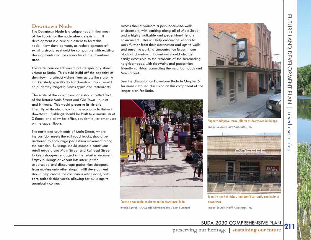
Downtown NodeThe Downtown Node is a unique node in that much of the fabric for the node already exists. Infi ll development is a crucial element to form this node. New developments, or redevelopments of existing structures should be compatible with existing developments and the character of the downtown area.
The retail component would include specialty stores unique to Buda. This would build off the capacity of downtown to attract visitors from across the state. A market study specifi cally for downtown Buda would help identify target business types and restaurants.
The scale of the downtown node should refl ect that of the historic Main Street and Old Town - quaint and intimate. This would preserve its historic integrity while also allowing the economy to thrive in downtown. Buildings should be built to a maximum of 3 fl oors, and allow for offi ce, residential, or other uses on the upper fl oors.
The north and south ends of Main Street, where the corridor meets the rail road tracks, should be anchored to encourage pedestrian movement along the corridor. Buildings should create a continuous retail edge along Main Street and Railroad Street to keep shoppers engaged in the retail environment. Empty buildings or vacant lots interrupt the streetscape and discourage pedestrian shoppers from moving onto other shops. Infi ll development should help create the continuous retail edge, with zero setback side yards, allowing for buildings to seamlessly connect.
Access should promote a park-once-and-walk environment, with parking along all of Main Street and a highly walkable and pedestrian-friendly environment. This will help encourage visitors to park further from their destination and opt to walk and ease the parking concentration issues in one block of downtown. Downtown should also be easily accessible to the residents of the surrounding neighborhoods, with sidewalks and pedestrian-friendly corridors connecting the neighborhoods and Main Street.
See the discussion on Downtown Buda in Chapter 5 for more detailed discussion on this component of the larger plan for Buda.
Identify market niches that aren’t currently available in downtown. Image Source: Halff Associates, Inc.
Support adaptive reuse efforts of downtown buildings.Image Source: Halff Associates, Inc.
Create a walkable environment in downtown Buda.Image Source: www.pedbikeimages.org / Dan Burnham
212 BUDA 2030 COMPREHENSIVE PLANpreserving our heritage | sustaining our future
FUTU
RE L
AN
D D
EVEL
OPM
ENT
PLA
N |
app
ropr
iate
land
use
type
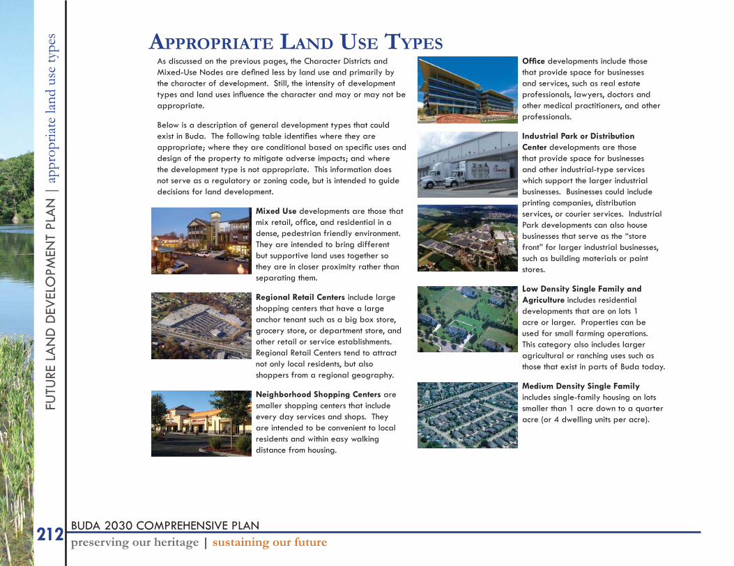
s APPROPRIATE LAND USE TYPESAs discussed on the previous pages, the Character Districts and Mixed-Use Nodes are defi ned less by land use and primarily by the character of development. Still, the intensity of development types and land uses infl uence the character and may or may not be appropriate.
Below is a description of general development types that could exist in Buda. The following table identifi es where they are appropriate; where they are conditional based on specifi c uses and design of the property to mitigate adverse impacts; and where the development type is not appropriate. This information does not serve as a regulatory or zoning code, but is intended to guide decisions for land development.
Mixed Use developments are those that mix retail, offi ce, and residential in a dense, pedestrian friendly environment. They are intended to bring different but supportive land uses together so they are in closer proximity rather than separating them.
Regional Retail Centers include large shopping centers that have a large anchor tenant such as a big box store, grocery store, or department store, and other retail or service establishments. Regional Retail Centers tend to attract not only local residents, but also shoppers from a regional geography.
Neighborhood Shopping Centers are smaller shopping centers that include every day services and shops. They are intended to be convenient to local residents and within easy walking distance from housing.
Offi ce developments include those that provide space for businesses and services, such as real estate professionals, lawyers, doctors and other medical practitioners, and other professionals.
Industrial Park or Distribution Center developments are those that provide space for businesses and other industrial-type services which support the larger industrial businesses. Businesses could include printing companies, distribution services, or courier services. Industrial Park developments can also house businesses that serve as the “store front” for larger industrial businesses, such as building materials or paint stores.
Low Density Single Family and Agriculture includes residential developments that are on lots 1 acre or larger. Properties can be used for small farming operations. This category also includes larger agricultural or ranching uses such as those that exist in parts of Buda today.
Medium Density Single Family includes single-family housing on lots smaller than 1 acre down to a quarter acre (or 4 dwelling units per acre).
213BUDA 2030 COMPREHENSIVE PLANpreserving our heritage | sustaining our future
FUTU
RE LAN
D D
EVELO
PMEN
T PLAN
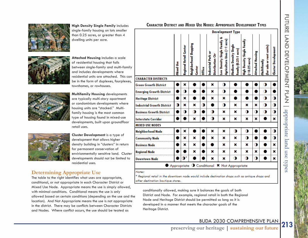
| appropriate land use typesHigh Density Single Family includes single-family housing on lots smaller than 0.25 acres, or greater than 4 dwelling units per acre.
Attached Housing includes a scale of residential housing that falls between single-family and multi-family and includes developments where residential units are attached. This can be in the form of duplexes, fourplexes, townhomes, or rowhouses.
Multifamily Housing developments are typically multi-story apartment or condominium developments where housing units are “stacked.” Multi-family housing is the most common type of housing found in mixed-use developments, built upon groundfl oor retail uses.
Cluster Development is a type of development that allows higher density building in “clusters” in return for permanent conservation of envirionmentally sensitive land. Cluster developments should not be limited to residential uses.
Determining Appropriate UseThe table to the right identifi es what uses are appropriate, conditional, or not appropriate in each Character District or Mixed Use Node. Appropriate means the use is simply allowed, with minimal conditions. Conditional means the use is only allowed based on certain conditions (depending on the use and the location). And Not Appropriate means the use is not appropriate in the district. There may be confl icts between Character Districts and Nodes. Where confl ict occurs, the use should be teated as
conditionally allowed, making sure it balances the goals of both District and Node. For example, regional retail in both the Regional Node and Heritage District should be permitted so long as it is developed in a manner that meets the character goals of the Heritage District.
CHARACTER DISTRICT AND MIXED USE NODES: APPROPRIATE DEVELOPMENT TYPES