FURUNO Tuoteluettelo 2013
58
The information indicated by this brochure is as of January 1, 2013 All other brand and product names are trademarks, registered trademarks or service marks of their respective holders. SPECIFICATIONS SUBJECT TO CHANGE WITHOUT NOTICE Catalog No. GC-028 1302SK www.furuno.com
-
Upload
marika-mannila -
Category
Documents
-
view
248 -
download
15
description
FURUNO Tuoteluettelo 2013, englanninkielinen- FURUNO General Catalog 2013
Transcript of FURUNO Tuoteluettelo 2013

The information indicated by this brochure is as of January 1, 2013
All other brand and product names are trademarks, registered trademarks or service marks of their respective holders.SPECIFICATIONS SUBJECT TO CHANGE WITHOUT NOTICE
Catalog No. GC-028 1302SK
www.furuno.com
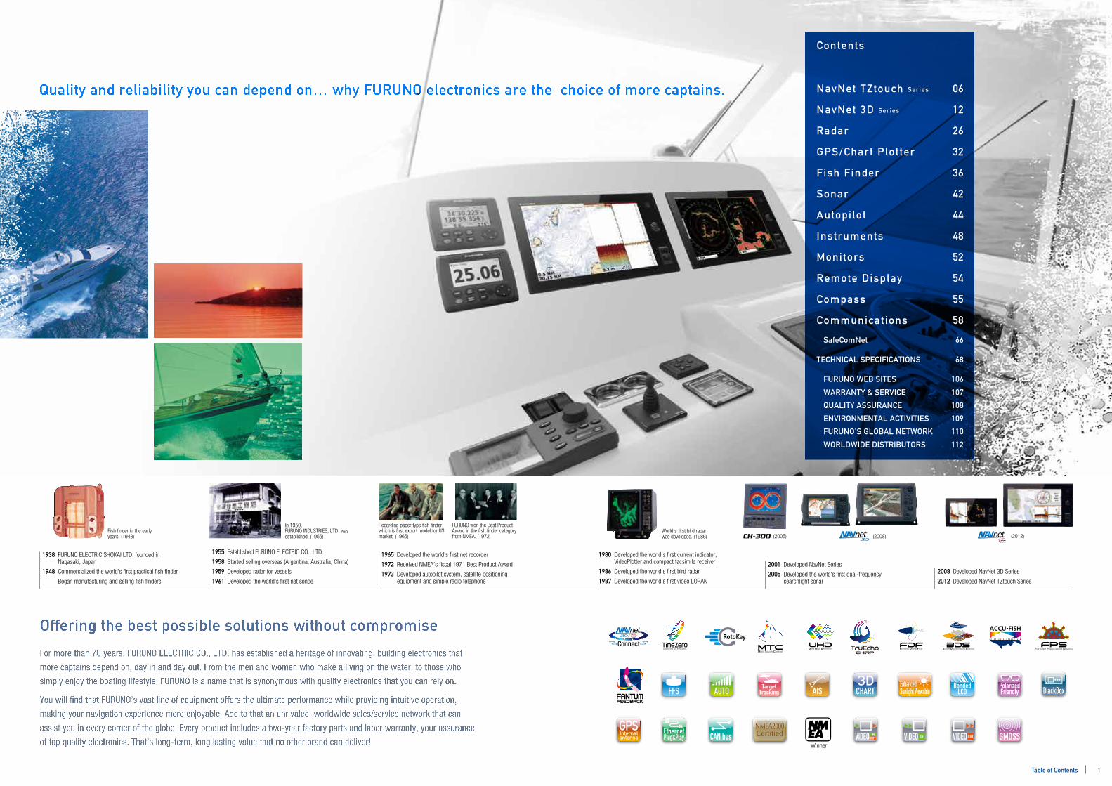
Quality and reliability you can depend on… why FURUNO electronics are the choice of more captains. NavNet TZtouch Series
NavNet 3D Series
Radar
GPS/Chart Plot ter
Fish Finder
Sonar
Autopi lot
Instruments
Monitors
Remote Display
Compass
Communicat ions
SafeComNet
TECHNICAL SPECIFICATIONS
FURUNO WEB SITES
WARRANTY & SERVICE
QUALITY ASSURANCE
ENVIRONMENTAL ACTIVITIES
FURUNO’S GLOBAL NETWORK
WORLDWIDE DISTRIBUTORS
Contents
06
12
26
32
36
42
44
48
52
54
55
58
66
68
106
107
108
109
110
112
1938 FURUNO ELECTRIC SHOKAI LTD. founded in Nagasaki, Japan
1948 Commercialized the world's rst practical sh nder
Began manufacturing and selling sh nders
1955 Established FURUNO ELECTRIC CO., LTD.
1958 Started selling overseas (Argentina, Australia, China)
1959 Developed radar for vessels
1961 Developed the world's rst net sonde
1965 Developed the world's rst net recorder
1972 Received NMEA's scal 1971 Best Product Award
1973 Developed autopilot system, satellite positioning equipment and simple radio telephone
1980 Developed the world's rst current indicator, VideoPlotter and compact facsimile receiver
1986 Developed the world's rst bird radar
1987 Developed the world's rst video LORAN
2001 Developed NavNet Series
2005 Developed the world's rst dual-frequency searchlight sonar
2008 Developed NavNet 3D Series
2012 Developed NavNet TZtouch Series
Fish nder in the early years. (1948)
In 1950, FURUNO INDUSTRIES, LTD. was established. (1955)
Recording paper type sh nder, which is rst export model for US market. (1965)
FURUNO won the Best Product Award in the sh nder category from NMEA. (1972)
World's rst bird radar was developed. (1986) (2005) (2008) (2012)
Offering the best possible solutions without compromise
For more than 70 years, FURUNO ELECTRIC CO., LTD. has established a heritage of innovating, building electronics that
more captains depend on, day in and day out. From the men and women who make a living on the water, to those who
simply enjoy the boating lifestyle, FURUNO is a name that is synonymous with quality electronics that you can rely on.
You will nd that FURUNO’s vast line of equipment offers the ultimate performance while providing intuitive operation,
making your navigation experience more enjoyable. Add to that an unrivaled, worldwide sales/service network that can
assist you in every corner of the globe. Every product includes a two-year factory parts and labor warranty, your assurance
of top quality electronics. That’s long-term, long lasting value that no other brand can deliver!
FFS AUTO
GMDSSVIDEO INOUT VIDEO IN VIDEO OUT
EnhancedSunlight Viewable BlackBox
EthernetPlug&Play CAN bus
NMEA2000Certied
BondedLCDAIS
Winner
CHARTTarget
TrackingPolarizedFriendly
1Table of Contents

Common Runabout Product RecommendationsCommon Runabout Product Recommendations
Common Sport Fishing Product RecommendationsCommon Sport Fishing Product Recommendations
MFD8 MFD12 MFDBB
Under 20 ft 20 ft to 25 ft 25 ft to 30 ft Over 30 ft
GP-33GP-32GP-330BGP-1670/FGP-1870/F
GP-33GP-32GP-330BGP-1670/FGP-1870/F
MFD8 MFD12
MODEL1623MODEL1715
DFF1 / DFF1-UHD / DFF3 / BBDS1FCV-627FCV-587
NAVpilot-711
FI-503FI-504
PG-500PG-700
FM-4721
DST-800
P.P.
P.
P.
GP-33GP-32GP-330BGP-1670/FGP-1870/F
MODEL1623MODEL1715MODEL1835/1935/1945/1937
DFF1 / DFF1-UHD / DFF3 / BBDS1FCV-627FCV-587
NAVpilot-700NAVpilot-711
FI-503FI-504FI-506
MU-150HD
SC-30
FA-30FM-4721
DST-800
GP-33GP-32GP-330BGP-1670/FGP-1870/F
MFD8 MFD12 MFDBB
MODEL1835/1935/1945/1937
DFF1 / DFF1-UHD / DFF3 / BBDS1FCV-295
CH-250CH-270CH-300
NAVpilot-700NAVpilot-711
FI-503FI-504FI-506
MU-150HDMU-190HD
SC-30
FA-30FM-4721
DST-800
LS-4100LS-6100FCV-627
NAVpilot-711
FI-503FI-504
FM-4721
DST-800
Radar
Fish Finder
Sonar
Autopilot
Instruments
Monitors
Compass
Communications
Sensors Sensors
MFDBB
TZTBB
30 ft to 50 ft 50 ft to 80 ft Over 80 ft
GP-33GP-32GP-330BGP-1670/FGP-1870/F
GP-33GP-32GP-330BGP-1870/F
MFD8 MFD12MFDBB
MFD8 MFD12MFDBB
MODEL1835/1935/1945/1937FR-8062/8122/8252FAR-21x7-BB Series
MODEL1835/1935/1945/1937FR-8062/8122/8252FAR-21x7-BB Series
DFF1 / DFF1-UHD / DFF3 / BBDS1FCV-295FCV-1150FCV-1200L
NAVpilot-700NAVpilot-711
FI-503FI-504FI-506FI-507
MU-150HDMU-190HDMU-190
SC-30SC-50/110
SC-30
FA-30/50FM-4721NX-300FAX-30FAX-408
DST-800
TZT9TZT14TZTBB
TZT9TZT14
TZT9TZT14TZTBB
TZT9TZT14TZTBB
TZT9TZT14TZTBB
NAVpilot-700NAVpilot-711
GP-33GP-32GP-150GP-330B
FAR-21x7-BB Series
DFF1 / DFF1-UHD / DFF3 / BBDS1FCV-295FCV-1150FCV-1200L
CH-250CH-270CH-300
FI-503FI-504FI-506FI-507
MU-150HDMU-190HDMU-190MU-231
SC-30SC-50/110
FA-30/50FM-4721LH-3000NX-300FAX-30FAX-408
DST-800
DFF1 / DFF1-UHD / DFF3 / BBDS1FCV-295FCV-1200L
CH-250CH-270CH-300
CH-250CH-270CH-300
NAVpilot-700NAVpilot-711
FI-503FI-504FI-506
MU-150HDMU-190HDMU-190
FA-30/50FM-4721FAX-30
DST-800
Radar
Fish Finder
Sonar
Autopilot
Instruments
Monitors
Compass
Communications
RD-33
P.P.P.P.P.
P.P.
P.P.
P.P.P.
P.
P.P.
P.P.
P. RD-33
P.P.P.
P.P.P.P.P.
P.P.P.
P.P.P.
P.P.
P.P.P.
P.
P.
P.P.
P.
P.P.P.
P.
P.P.P.
P.P.P.P.P.
P.
P.P.
P.P.P.
P.P.
P.P.P.
P.P.
P.
P.P.
P.
P.P.P.
P.RD-33RD-33
P.P.P.P.P.
P.P.P.
P.
P.P.
P.
P.
P.
Remote Display
RD-33
P.P.P.P.
P.P.P.
P.P.P.
P.P.P.
P.P.P.P.
P.P.P.
P.P.
P.P.P.P.
P.P.P.
P.P.
P.P.P.P.P.
P.
P. RD-33
P.P.P.
P.P.
P.
P.
P.P.P.P.
P.
P.P.P.P.
P.P.P.P.
P.P.P.P.
P.P.
P.P.P.P.P.P.
P.
P.RD-33
P.P.P.P.P.
P.P.P.
P.P.P.
P.P.P.
P.P.P.
P.P.P.
P.P.
P.P.P.
P.P.P.
P.
P.P.P.
P.
P.
Remote Display
GPS/Chart Plotter
GPS/Chart Plotter
3333233435
3333233435
1212
2727
203838
44
4949
5757
60
50
121213
3333233435
272728
203838
4444
494949
52
55
5960
50
121213
3333233435
28
2040
434343
4444
494949
5252
55
5960
50
373738
44
4949
60
50
3333233435
33332335
121213
282930
121213
0606
060607
060607
060607
060607
282930
20404041
434343
434343
4444
4444
49494949
525253
5556
5960626363
50
13
07
33333323
30
20404041
49494949
52525353
5556
596062626363
50
204041
434343
4444
494949
525253
55
596063
50
54 54 5454 54 5454
2 3Products LineupProducts Lineup
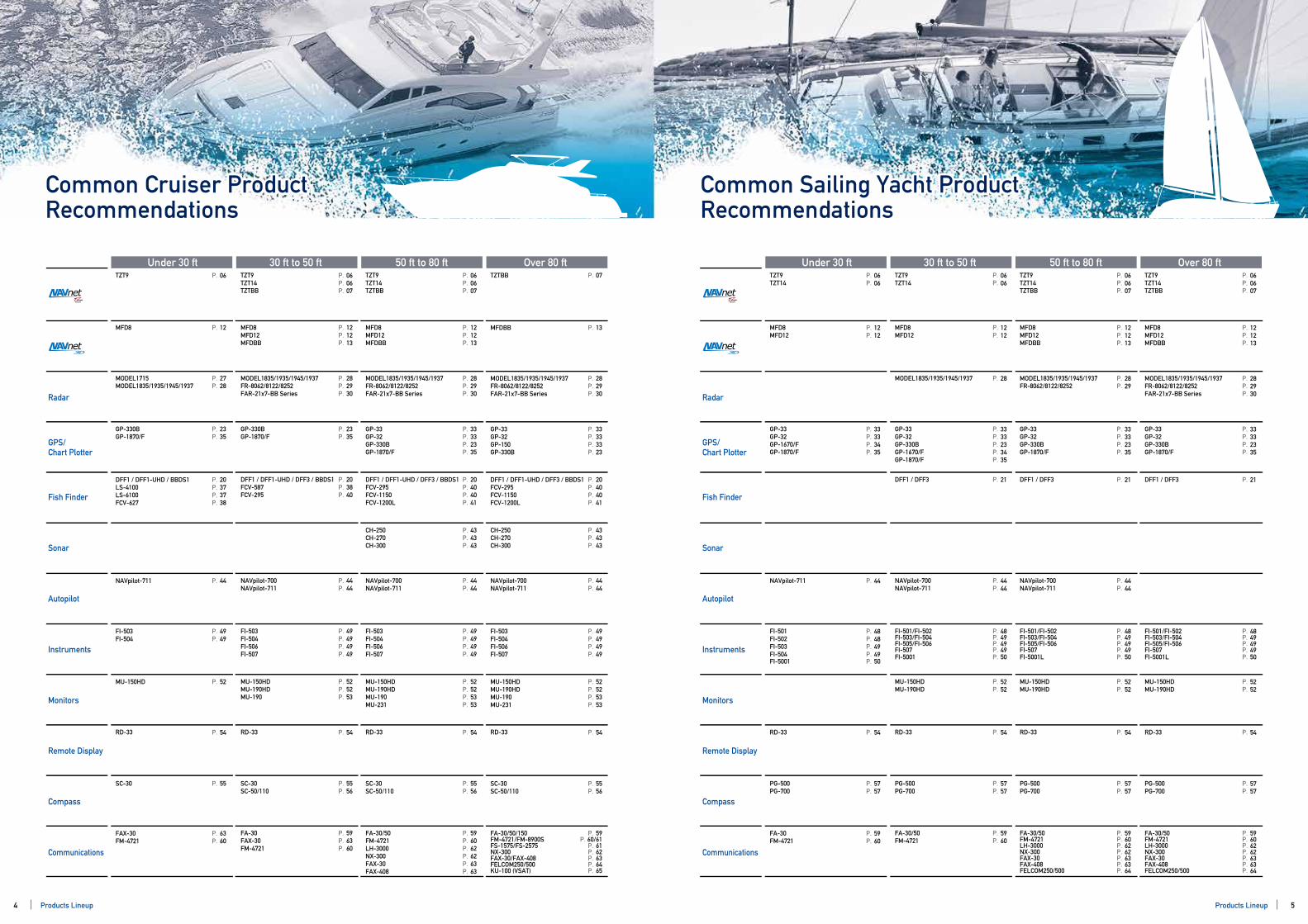
Common Cruiser Product RecommendationsCommon Cruiser Product Recommendations
Common Sailing Yacht Product RecommendationsCommon Sailing Yacht Product Recommendations
MFD8MFD12 MFDBB
Under 30 ft 30 ft to 50 ft 50 ft to 80 ft Over 80 ft
GP-330BGP-1870/F
GP-330BGP-1870/F
MFD8MFD12MFDBB
MODEL1835/1935/1945/1937FR-8062/8122/8252FAR-21x7-BB Series
MFD8
MODEL1715MODEL1835/1935/1945/1937
DFF1 / DFF1-UHD / DFF3 / BBDS1FCV-587FCV-295
NAVpilot-700NAVpilot-711
FI-503FI-504FI-506FI-507
MU-150HDMU-190HDMU-190
SC-30SC-50/110
SC-30
FA-30FAX-30FM-4721
GP-33GP-32GP-330BGP-1870/F
MODEL1835/1935/1945/1937FR-8062/8122/8252FAR-21x7-BB Series
DFF1 / DFF1-UHD / DFF3 / BBDS1FCV-295FCV-1150FCV-1200L
NAVpilot-700NAVpilot-711
FI-503FI-504FI-506FI-507
MU-150HDMU-190HDMU-190MU-231
SC-30SC-50/110
FA-30/50FM-4721LH-3000NX-300FAX-30FAX-408
NAVpilot-700NAVpilot-711
GP-33GP-32GP-150GP-330B
MFDBB
TZTBB
MODEL1835/1935/1945/1937FR-8062/8122/8252FAR-21x7-BB Series
DFF1 / DFF1-UHD / DFF3 / BBDS1FCV-295FCV-1150FCV-1200L
CH-250CH-270CH-300
CH-250CH-270CH-300
FI-503FI-504FI-506FI-507
MU-150HDMU-190HDMU-190MU-231
SC-30SC-50/110
FA-30/50/150FM-4721/FM-8900SFS-1575/FS-2575NX-300FAX-30/FAX-408FELCOM250/500KU-100 (VSAT)
DFF1 / DFF1-UHD / BBDS1LS-4100LS-6100FCV-627
NAVpilot-711
FI-503FI-504
MU-150HD
FAX-30FM-4721
Radar
Fish Finder
Sonar
Autopilot
Instruments
Monitors
Compass
Communications
MFD8 MFD12MFDBB
Under 30 ft 30 ft to 50 ft 50 ft to 80 ft Over 80 ft
GP-33GP-32GP-1670/FGP-1870/F
GP-33GP-32GP-330BGP-1670/FGP-1870/F
MFD8MFD12
MODEL1835/1935/1945/1937
MFD8MFD12
DFF1 / DFF3
NAVpilot-700NAVpilot-711
FI-501/FI-502FI-503/FI-504FI-505/FI-506FI-507
MU-150HDMU-190HD
PG-500PG-700
PG-500PG-700
FA-30/50FM-4721
GP-33GP-32GP-330BGP-1870/F
MODEL1835/1935/1945/1937FR-8062/8122/8252
DFF1 / DFF3
NAVpilot-700NAVpilot-711
FI-501/FI-502FI-503/FI-504FI-505/FI-506FI-507
MU-150HDMU-190HD
PG-500PG-700
FA-30/50FM-4721LH-3000NX-300FAX-30FAX-408FELCOM250/500
GP-33GP-32GP-330BGP-1870/F
MFD8 MFD12 MFDBB
TZT9TZT14TZTBB
TZT9TZT14TZTBB
TZT9 TZT9TZT14TZTBB
TZT9TZT14
TZT9TZT14
TZT9TZT14TZTBB
MODEL1835/1935/1945/1937FR-8062/8122/8252FAR-21x7-BB Series
DFF1 / DFF3
FI-501/FI-502FI-503/FI-504FI-505/FI-506FI-507
MU-150HDMU-190HD
PG-500PG-700
FA-30/50FM-4721LH-3000NX-300FAX-30FAX-408FELCOM250/500
NAVpilot-711
FI-501FI-502FI-503FI-504
FA-30FM-4721
Radar
Fish Finder
Sonar
Autopilot
Instruments
Monitors
Compass
Communications
RD-33 RD-33 RD-33RD-33
P.P.
P.P.
P.P.P.
P.P.P.
P.
P.P.
P.P.P.
P.P.
P.P.P.P.
P.P.P.
P.P.
P.
P.P.P.
P.P.P.
P.P.P.P.
P.P.P.
P.P.P.P.
P.P.
P.P.
P.P.P.P.
P.P.P.P.
P.P.
P.P.P.P.P.P.
P.
P.
P.P.P.P.
P.P.P.
P.P.P.P.
P.P.P.
P.P.P.P.
P.P.P.P.
P.P.
P.P.
P.P.P.P.P.
P.P.P.
P.P.P.P.
P.
P.P.
P.
P.P.
P.P.P.
P. P.P.P.
P. P. P.P.
Remote Display
RD-33
P.P.P.P.P.
P.P.
P.
P.
P.P.
P.P.P.P.
P.P.
P.P.
P.P.
P.P.
P. RD-33
P.P.P.
P.P.P.P.
P.P.
P.
P.P.
P.P.P.P.
P.P.
P.P.
P.P.P.P.P.P.P.
P.P.P.
P.
P.P.P.
P.P.P.P.
P.P.P.
P.
P.P.P.P.
P.P.
P.P.
P.P.P.P.P.P.P.
P.P.P.
P.RD-33RD-33
P.P.P.P.
P.P.
P.P.
P.P.
P.
P.P.P.P.
P.P.
P.
Remote Display
GPS/Chart Plotter
GPS/Chart Plotter
2335
2335
121213
282930
12
2728
203840
4444
49494949
525253
5556
55
596360
121213
33332335
282930
20404041
4444
4444
49494949
52525353
5556
596062626363
13
07
33333323
282930
20404041
434343
49494949
52525353
5556
5960/61
6162636465
434343
20373738
44
4949
52
6360
33333435
3333233435
1212
28
1212
21
4444
48494949
5252
5757
5757
5960
121213
33332335
2829
21
4444
48494949
5252
5757
59606262636364
121213
33332335
282930
21
48494949
5252
5757
59606262636364
060607
06 060607
0606
0606
060607
060607
44
48484949
5960
FI-5001 FI-5001L FI-5001LFI-5001
P. P. P.P.
50 50 5050
54 54 5454 54 54 5454
4 5Products Lineup Products Lineup
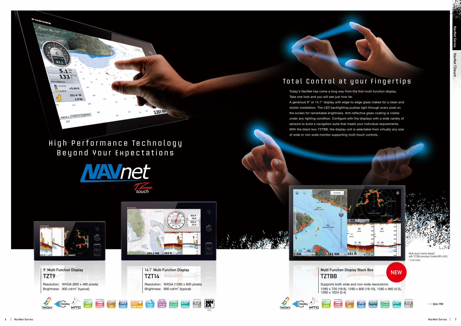
H i g h P e r f o r m a n c e Te c h n o l o g y B e y o n d Y o u r E x p e c t a t i o n s
9" Multi Function Display
TZT914.1" Multi Function Display
TZT14Resolution: WVGA (800 x 480 pixels)Brightness: 900 cd/m2 (typical)
Resolution: WXGA (1280 x 800 pixels)Brightness: 900 cd/m2 (typical)
Today’s NavNet has come a long way from the first multi function display.
Take one look and you will see just how far.
A generous 9” or 14.1” display with edge-to-edge glass makes for a clean and
stylish installation. The LED backlighting pushes light through every pixel on
the screen for remarkable brightness. Anti-reflective glass coating is visible
under any lighting condition. Configure with the displays with a wide variety of
sensors to build a navigation suite that meets your individual requirements.
With the black box TZTBB, the display unit is selectable from virtually any size
of wide or non-wide monitor supporting multi touch controls.
To t a l C o n t r o l a t y o u r F i n g e r t i p s
Multi Function Display Black Box
TZTBBSupports both wide and non-wide resolutions:1280 x 720 (16:9), 1280 x 800 (16:10), 1280 x 960 (4:3), 1280 x 1024 (5:4)
Multi-touch marine display* with TZTBB processor (model MPU-002)* Local supply
Spec P68
2012
6 7
NavN
et TZtouchN
avNet Series
NavNet Series NavNet Series
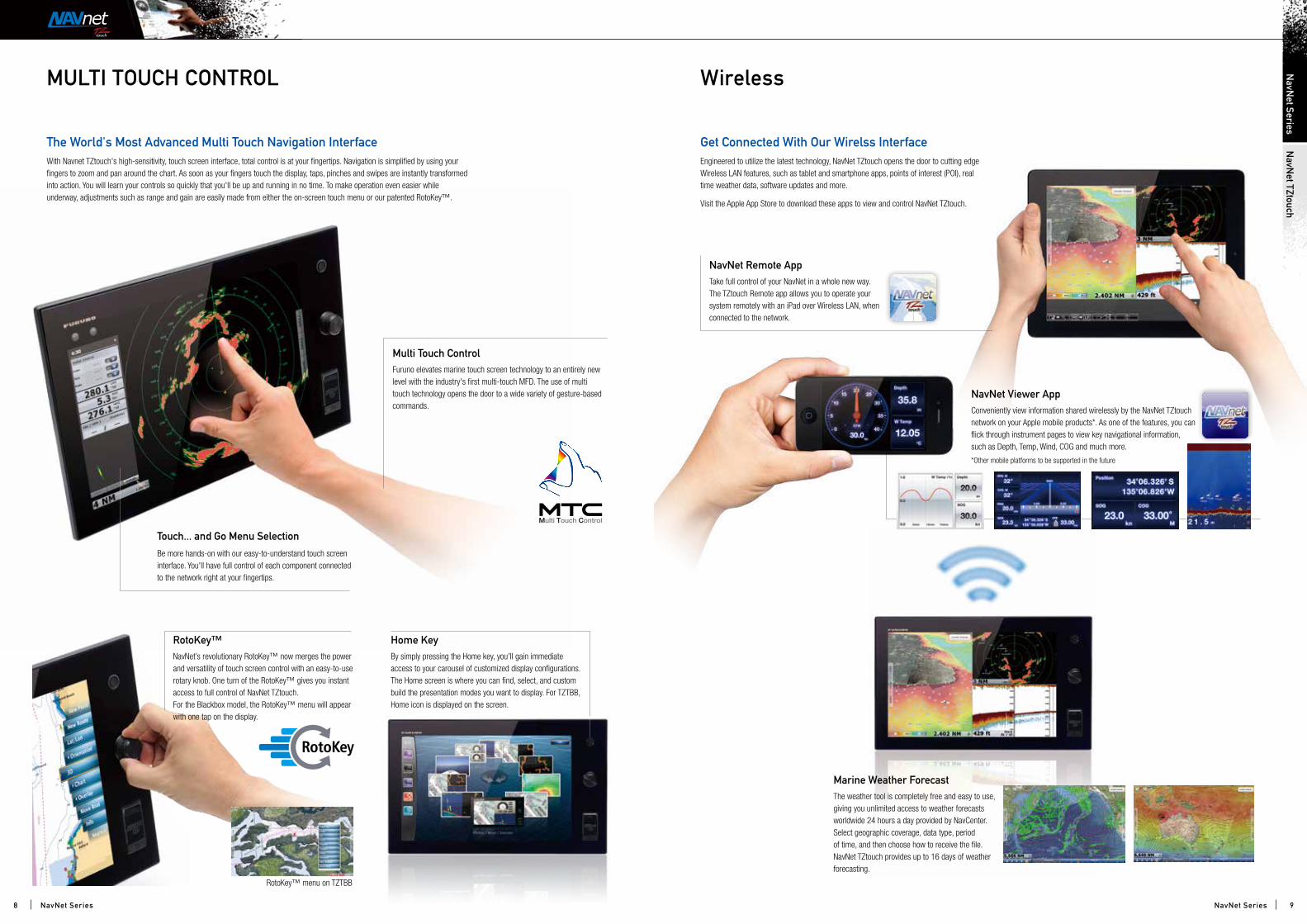
Multi Touch Control
NavNet Remote App
Marine Weather Forecast
NavNet Viewer App
Furuno elevates marine touch screen technology to an entirely new level with the industry's first multi-touch MFD. The use of multi touch technology opens the door to a wide variety of gesture-based commands.
Take full control of your NavNet in a whole new way. The TZtouch Remote app allows you to operate your system remotely with an iPad over Wireless LAN, when connected to the network.
The weather tool is completely free and easy to use, giving you unlimited access to weather forecasts worldwide 24 hours a day provided by NavCenter. Select geographic coverage, data type, period of time, and then choose how to receive the file. NavNet TZtouch provides up to 16 days of weather forecasting.
Conveniently view information shared wirelessly by the NavNet TZtouch network on your Apple mobile products*. As one of the features, you can flick through instrument pages to view key navigational information, such as Depth, Temp, Wind, COG and much more.
*Other mobile platforms to be supported in the future
RotoKey™ Home KeyNavNet’s revolutionary RotoKey™ now merges the power and versatility of touch screen control with an easy-to-use rotary knob. One turn of the RotoKey™ gives you instant access to full control of NavNet TZtouch. For the Blackbox model, the RotoKey™ menu will appear with one tap on the display.
By simply pressing the Home key, you'll gain immediate access to your carousel of customized display configurations. The Home screen is where you can find, select, and custom build the presentation modes you want to display. For TZTBB, Home icon is displayed on the screen.
Touch... and Go Menu Selection
Be more hands-on with our easy-to-understand touch screen interface. You'll have full control of each component connected to the network right at your fingertips.
With Navnet TZtouch's high-sensitivity, touch screen interface, total control is at your fingertips. Navigation is simplified by using your fingers to zoom and pan around the chart. As soon as your fingers touch the display, taps, pinches and swipes are instantly transformed into action. You will learn your controls so quickly that you'll be up and running in no time. To make operation even easier while underway, adjustments such as range and gain are easily made from either the on-screen touch menu or our patented RotoKey™.
Engineered to utilize the latest technology, NavNet TZtouch opens the door to cutting edge Wireless LAN features, such as tablet and smartphone apps, points of interest (POI), real time weather data, software updates and more.
Visit the Apple App Store to download these apps to view and control NavNet TZtouch.
MULTI TOUCH CONTROL Wireless
The World's Most Advanced Multi Touch Navigation Interface Get Connected With Our Wirelss Interface
RotoKey™ menu on TZTBB
8 9
NavN
et TZtouchN
avNet Series
NavNet SeriesNavNet Series
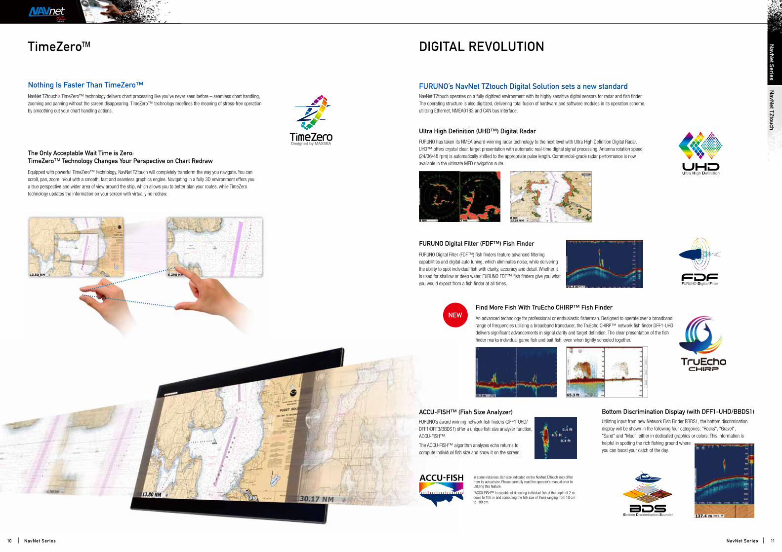
FURUNO Digital Filter (FDF™) Fish Finder
The Only Acceptable Wait Time is Zero:TimeZero™ Technology Changes Your Perspective on Chart Redraw
Equipped with powerful TimeZero™ technology, NavNet TZtouch will completely transform the way you navigate. You can scroll, pan, zoom in/out with a smooth, fast and seamless graphics engine. Navigating in a fully 3D environment offers you a true perspective and wider area of view around the ship, which allows you to better plan your routes, while TimeZero technology updates the information on your screen with virtually no redraw.
Ultra High Definition (UHD™) Digital Radar
FURUNO has taken its NMEA award-winning radar technology to the next level with Ultra High Definition Digital Radar. UHD™ offers crystal clear, target presentation with automatic real-time digital signal processing. Antenna rotation speed (24/36/48 rpm) is automatically shifted to the appropriate pulse length. Commercial-grade radar performance is now available in the ultimate MFD navigation suite.
FURUNO Digital Filter (FDF™) fish finders feature advanced filtering capabilities and digital auto tuning, which eliminates noise, while delivering the ability to spot individual fish with clarity, accuracy and detail. Whether it is used for shallow or deep water, FURUNO FDF™ fish finders give you what you would expect from a fish finder at all times.
NavNet TZtouch operates on a fully digitized environment with its highly sensitive digital sensors for radar and fish finder. The operating structure is also digitized, delivering total fusion of hardware and software modules in its operation scheme, utilizing Ethernet, NMEA0183 and CAN bus interface.
TimeZero™ DIGITAL REVOLUTION
FURUNO’s NavNet TZtouch Digital Solution sets a new standard
ACCU-FISH™ (Fish Size Analyzer) Bottom Discrimination Display (with DFF1-UHD/BBDS1)FURUNO’s award winning network fish finders (DFF1-UHD/DFF1/DFF3/BBDS1) offer a unique fish size analyzer function, ACCU-FISH™.
The ACCU-FISH™ algorithm analyzes echo returns to compute individual fish size and show it on the screen.
Utilizing input from new Network Fish Finder BBDS1, the bottom discrimination display will be shown in the following four categories; "Rocks", "Gravel", "Sand" and "Mud", either in dedicated graphics or colors. This information is helpful in spotting the rich fishing ground where you can boost your catch of the day.
In some instances, fish size indicated on the NavNet TZtouch may differ from its actual size. Please carefully read the operator’s manual prior to utilizing this feature.
*ACCU-FISH™ is capable of detecting individual fish at the depth of 2 m down to 100 m and computing the fish size of those ranging from 10 cm to 199 cm.
NavNet TZtouch’s TimeZero™ technology delivers chart processing like you’ve never seen before – seamless chart handling, zooming and panning without the screen disappearing. TimeZero™ technology redefines the meaning of stress-free operation by smoothing out your chart handling actions.
Nothing Is Faster Than TimeZero™
Find More Fish With TruEcho CHIRP™ Fish Finder
An advanced technology for professional or enthusiastic fisherman. Designed to operate over a broadband range of frequencies utilizing a broadband transducer, the TruEcho CHIRP™ network fish finder DFF1-UHD delivers significant advancements in signal clarity and target definition. The clear presentation of the fish finder marks individual game fish and bait fish, even when tightly schooled together.
10 11
NavN
et TZtouchN
avNet Series
NavNet SeriesNavNet Series
Adding a New Dimension to 3DThe world of onboard navigation systems has evolved.
Never before has so much information been available to
you to improve and enhance your boating experience.
FURUNO’s dedication to deliver the most intuitive,
integrated navigation solution has led to the launch of
NavNet 3D.
Are you wondering if navigating in 3D is really practical?
We’ve not only made it practical, we’ve made it easy!
In fact, once you start navigating in 3D, you’ll wonder
how you ever made your way without it.
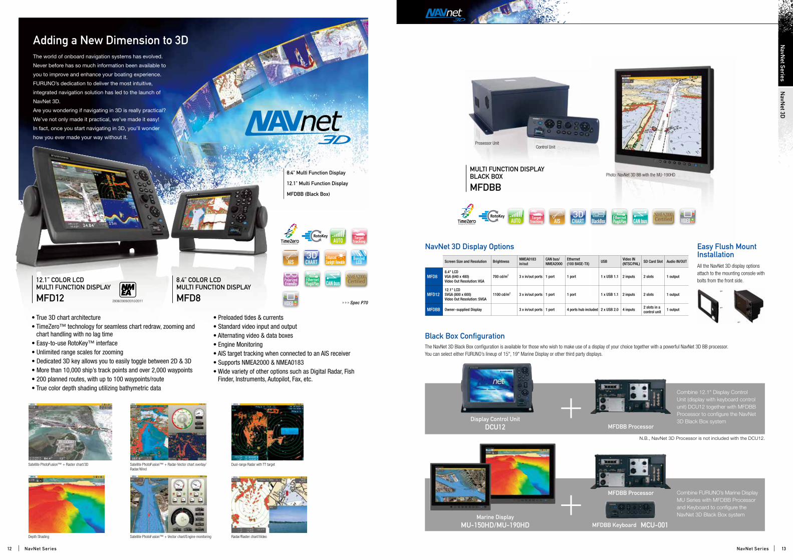
8.4" Multi Function Display
12.1" Multi Function Display
MFDBB (Black Box)
Prosessor UnitControl Unit
Photo: NavNet 3D BB with the MU-190HDMULTI FUNCTION DISPLAY BLACK BOX
MFDBB
Radar/Raster chart/Video
Satellite PhotoFusion™ + Raster chart/3D Satellite PhotoFusion™ + Radar-Vector chart overlay/Radar/Wind
Dual-range Radar with TT target
Depth Shading Satellite PhotoFusion™ + Vector chart/Engine monitoring
NavNet 3D Display Options
Screen Size and Resolution Brightness NMEA0183 in/out
CAN bus/NMEA2000
Ethernet (100 BASE-TX) USB Video IN
(NTSC/PAL) SD Card Slot Audio IN/OUT
MFD88.4" LCDVGA (640 x 480)Video Out Resolution: VGA
700 cd/m2 3 x in/out ports 1 port 1 port 1 x USB 1.1 2 inputs 2 slots 1 output
MFD1212.1" LCDSVGA (800 x 600)Video Out Resolution: SVGA
1100 cd/m2 3 x in/out ports 1 port 1 port 1 x USB 1.1 2 inputs 2 slots 1 output
MFDBB Owner-supplied Display 3 x in/out ports 1 port 4 ports hub included 2 x USB 2.0 4 inputs 2 slots in a control unit 1 output
The NavNet 3D Black Box configuration is available for those who wish to make use of a display of your choice together with a powerful NavNet 3D BB processor. You can select either FURUNO’s lineup of 15", 19" Marine Display or other third party displays.
Black Box Configuration
Combine FURUNO’s Marine Display MU Series with MFDBB Processor and Keyboard to configure the NavNet 3D Black Box system
Combine 12.1" Display Control Unit (display with keyboard control unit) DCU12 together with MFDBB Processor to configure the NavNet 3D Black Box system
N.B., NavNet 3D Processor is not included with the DCU12.
Marine DisplayMU-150HD/MU-190HD
Display Control UnitDCU12 MFDBB Processor
MFDBB Processor
MFDBB Keyboard MCU-001
Easy Flush Mount InstallationAll the NavNet 3D display options attach to the mounting console with bolts from the front side.
2008/2009/2010/2011
8.4” COLOR LCD MULTI FUNCTION DISPLAY
MFD8
12.1” COLOR LCDMULTI FUNCTION DISPLAY
MFD12 Spec P70
• True 3D chart architecture• TimeZero™ technology for seamless chart redraw, zooming and
chart handling with no lag time• Easy-to-use RotoKey™ interface• Unlimited range scales for zooming• Dedicated 3D key allows you to easily toggle between 2D & 3D• More than 10,000 ship’s track points and over 2,000 waypoints• 200 planned routes, with up to 100 waypoints/route• True color depth shading utilizing bathymetric data
• Preloaded tides & currents• Standard video input and output• Alternating video & data boxes• Engine Monitoring• AIS target tracking when connected to an AIS receiver• Supports NMEA2000 & NMEA0183• Wide variety of other options such as Digital Radar, Fish
Finder, Instruments, Autopilot, Fax, etc.
12 13
NavN
et Series
NavNet Series NavNet Series
NavN
et 3D

You can pan the chart freely by simply pressing the scrolling pad. This gives you the freedom to explore the chart, allowing you to focus on a specific area ahead of or around your vessel with greater intensity, without losing track of your position on the chart.
Explore the chart data at your leisure, and then instantly return to own ship at the touch of a single dedicated button. TimeZeroTM technology provides a useful utility for focusing on a specific direction such as the area ahead of your vessel.
3D
2D
Designed by MAXSEA
Navigate in True 3DNavNet 3D incorporates “native 3D chart architecture” that allows for a full time 3-dimensional presentation, as opposed to 2D charts that require special effects to appear 3-dimensional. With NavNet 3D’s true 3D environment, you can see all of the information you want with no limitations.
Plan your routes and enter points directly on your raster or vector native 3D charts, overlay a variety of data with a touch of the RotoKeyTM, such as Radar overlay, AIS and TT targets or all of your chart symbols and depth soundings. Any and all of your information can be displayed at will.
Even though the charts are always operating in their native 3D environment, one long press of the 3D key will toggle the chart from 3D to a familiar 2D, top-down perspective and vice versa.
3D Key
With the incorporation of our TimeZeroTM technology, we have created a chart plotter with blazing speed. The most amazing part is the utilization of native 3D charting architecture, showing the exact position of your vessel in a wide variety of chart presentation formats. Incorporating a dedicated high-speed processor and powerful graphic engine, NavNet 3D delivers an unprecedented level of performance and utility by seamlessly integrating diverse, essential navigational data.
The Most Amazing Chart Plotter You’ve Ever Seen
3D Raster 3D Vector Bathymetric data is needed to display underwater presentation in 3D.
This completely new system design allows you to zoom seamlessly and continuously to whatever chart scale you desire. Instead of limiting you to a small handful of chart scales to choose from, like traditional chart plotters, TimeZeroTM architecture allows you to zoom in or out to the exact magnification level you like without steps or limitations.
Chart scaling without limitation
Easy chart panning gives you the freedom to explore
Smooth scaling delivers any range scale you desire.
CHART PLOTTER CARTOGRAPHY
www.mapmedia.com
NavNet 3D is the only chart plotter on the market providing users the ability to choose from pre-loaded official NOAA raster and vector charts, or optional "C-Map by Jeppesen"** and "Datacore by Navionics" vector cartography. Mapmedia brings an authentic vector and raster chart library for the areas you sail. Mapmedia cartography integrates cutting edge data analytic algorithms with high resolution image processing techniques to deliver a fusion of digital navigation charts and satellite photography. This ensures absolute clarity and detail when displayed by NavNet 3D.
A depth color scale can be applied to both 2D and 3D vector and raster charts. Transparency levels can be adjusted so that the chart data is visible beneath the color shading. This unique feature allows you to view water depths at-a-glance with vibrant colors.No more searching for depth numbers, when you can simply set depths to your specified colors. Whether you want to see the depth for navigation or fishing purposes, this new feature makes it easier than ever.
Bathymetric data is needed to display underwater presentation in 3D.
Mapmedia Vector and Raster Chart Library
Depth Shading
Mapmedia Vector*Vector charts contain a huge volume of data in different layers, each of which can be selectively displayed. As you zoom into the chart, increasing levels of detail can be obtained without any sacrifice in image resolution.
Satellite PhotoFusionTM
Satellite photography is included in the Mapmedia Raster and Vector charts, Satellite PhotoFusionTM within the charts is a feature available only with FURUNO’s NavNet 3D. Land areas (zero depth) are completely opaque, so that these areas are displayed as satellite photos on the chart. As the depth increases, the satellite image is merged with the chart data to provide you, the user, with added detail on seabed areas in shallow water without losing vital chart information. In deeper water where the satellite image has no detail to offer, the chart is displayed without alteration. This ensures that navigational integrity is not only maintained but enhanced where it is most needed in areas where grounding might be a risk.
Mapmedia Raster* Mapmedia raster charts are digitized official paper charts, issued by hydrographic offices. NavNet 3D brings highly reliable, professional hydrographic cartography to the recreational sailor. A high-resolution scan has been applied to Mapmedia raster charts so that quality will not deteriorate even when the chart is viewed in close-up.
Optional "C-Map by Jeppesen" vector cartography**NavNet 3D now offers three different sources of vector chart options with the addition of C-Map by Jeppesen. Optional "C-Map by Jeppesen" vector cartography** delivers a wealth of important chart detail for navigation, including spot soundings and depth contours.
** A software update (v2.05) will be necessary to use the new "C-Map by Jeppesen" charts, which will be available for download at Furuno's web site (www.navnet.com).
Vector + Satellite PhotoFusionTM
Mapmedia Vector
Radar-Chart overlayMapmedia Rastar
You can save the following marks and points in the NavNet 3D internal memory:
• Up to 10,000 ship’s track points;
• Up to 2,000 points and
• 200 planned routes, within which up to 100 waypoints can be placed.
Raster + Satellite PhotoFusionTM
C-Map by Jeppesen 2D Vector
C-Map by Jeppesen 3D Vector
+ Satellite PhotoFusionTM
*Availability of vector and raster cartography depends on the area. Please contact your local Furuno dealer for details.
14 15
NavN
et 3DN
avNet Series
NavNet SeriesNavNet Series
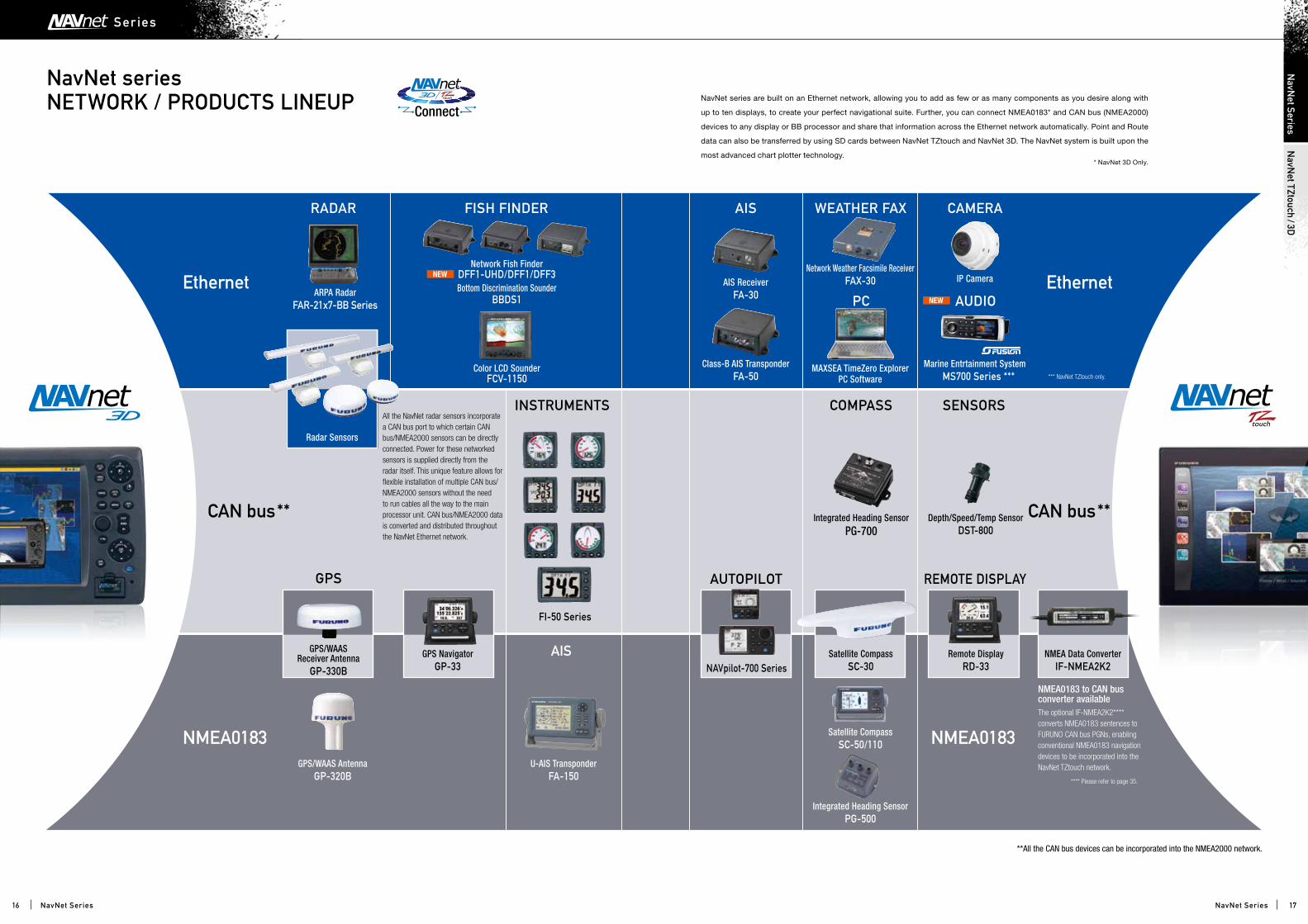
NavNet series NETWORK / PRODUCTS LINEUP NavNet series are built on an Ethernet network, allowing you to add as few or as many components as you desire along with
up to ten displays, to create your perfect navigational suite. Further, you can connect NMEA0183* and CAN bus (NMEA2000)
devices to any display or BB processor and share that information across the Ethernet network automatically. Point and Route
data can also be transferred by using SD cards between NavNet TZtouch and NavNet 3D. The NavNet system is built upon the
most advanced chart plotter technology.* NavNet 3D Only.
**All the CAN bus devices can be incorporated into the NMEA2000 network.
Ethernet Ethernet
NMEA0183 NMEA0183
CAN bus** CAN bus**
All the NavNet radar sensors incorporate a CAN bus port to which certain CAN bus/NMEA2000 sensors can be directly connected. Power for these networked sensors is supplied directly from the radar itself. This unique feature allows for flexible installation of multiple CAN bus/NMEA2000 sensors without the need to run cables all the way to the main processor unit. CAN bus/NMEA2000 data is converted and distributed throughout the NavNet Ethernet network.
RADAR FISH FINDER WEATHER FAX
PC AUDIO
CAMERA
GPS AUTOPILOT
COMPASS
REMOTE DISPLAY
SENSORS
Network Fish FinderDFF1-UHD/DFF1/DFF3Bottom Discrimination Sounder
BBDS1
Integrated Heading SensorPG-700
Integrated Heading SensorPG-500
NAVpilot-700 Series
Depth/Speed/Temp SensorDST-800
Network Weather Facsimile ReceiverFAX-30
Marine Entrtainment System MS700 Series ***
MAXSEA TimeZero ExplorerPC Software
IP Camera
Color LCD SounderFCV-1150
GPS/WAAS Receiver Antenna
GP-330B
GPS/WAAS AntennaGP-320B
Satellite CompassSC-50/110
GPS NavigatorGP-33
Satellite CompassSC-30
Remote DisplayRD-33
NMEA Data ConverterIF-NMEA2K2
ARPA RadarFAR-21x7-BB Series
Radar Sensors
AIS
INSTRUMENTS
AIS
AIS ReceiverFA-30
FI-50 Series
Class-B AIS TransponderFA-50
U-AIS TransponderFA-150
NMEA0183 to CAN bus converter availableThe optional IF-NMEA2K2**** converts NMEA0183 sentences to FURUNO CAN bus PGNs, enabling conventional NMEA0183 navigation devices to be incorporated into the NavNet TZtouch network.
**** Please refer to page 35.
*** NavNet TZtouch only.
16 17
NavN
et TZtouch/3D
NavN
et Series
NavNet SeriesNavNet Series
Ser ies
AIS Target Tracking
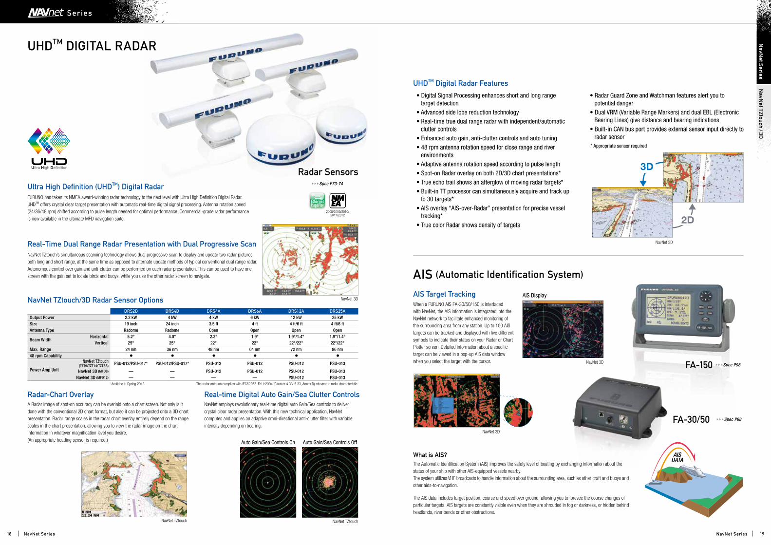
UHDTM DIGITAL RADAR
FURUNO has taken its NMEA award-winning radar technology to the next level with Ultra High Definition Digital Radar. UHDTM offers crystal clear target presentation with automatic real-time digital signal processing. Antenna rotation speed (24/36/48 rpm) shifted according to pulse length needed for optimal performance. Commercial-grade radar performance is now available in the ultimate MFD navigation suite.
NavNet TZtouch’s simultaneous scanning technology allows dual progressive scan to display and update two radar pictures, both long and short range, at the same time as opposed to alternate update methods of typical conventional dual range radar. Autonomous control over gain and anti-clutter can be performed on each radar presentation. This can be used to have one screen with the gain set to locate birds and buoys, while you use the other radar screen to navigate.
Ultra High Definition (UHDTM) Digital Radar
Real-Time Dual Range Radar Presentation with Dual Progressive Scan
Real-time Digital Auto Gain/Sea Clutter ControlsRadar-Chart Overlay
NavNet TZtouch/3D Radar Sensor Options
NavNet employs revolutionary real-time digital auto Gain/Sea controls to deliver crystal clear radar presentation. With this new technical application, NavNet computes and applies an adaptive omni-directional anti-clutter filter with variable intensity depending on bearing.
A Radar image of spot-on accuracy can be overlaid onto a chart screen. Not only is it done with the conventional 2D chart format, but also it can be projected onto a 3D chart presentation. Radar range scales in the radar chart overlay entirely depend on the range scales in the chart presentation, allowing you to view the radar image on the chart information in whatever magnification level you desire.(An appropriate heading sensor is required.)
• Digital Signal Processing enhances short and long range target detection
• Advanced side lobe reduction technology• Real-time true dual range radar with independent/automatic
clutter controls• Enhanced auto gain, anti-clutter controls and auto tuning• 48 rpm antenna rotation speed for close range and river
environments• Adaptive antenna rotation speed according to pulse length• Spot-on Radar overlay on both 2D/3D chart presentations*• True echo trail shows an afterglow of moving radar targets*• Built-in TT processor can simultaneously acquire and track up
to 30 targets*• AIS overlay “AIS-over-Radar” presentation for precise vessel
tracking*• True color Radar shows density of targets
• Radar Guard Zone and Watchman features alert you to potential danger
• Dual VRM (Variable Range Markers) and dual EBL (Electronic Bearing Lines) give distance and bearing indications
• Built-in CAN bus port provides external sensor input directly to radar sensor
* Appropriate sensor required
UHDTM Digital Radar Features
NavNet 3D
2D
3D
NavNet 3D
AIS Display
NavNet 3D
NavNet 3D
NavNet TZtouch
Auto Gain/Sea Controls On Auto Gain/Sea Controls Off
NavNet TZtouch
AISDATA
When a FURUNO AIS FA-30/50/150 is interfaced with NavNet, the AIS information is integrated into the NavNet network to facilitate enhanced monitoring of the surrounding area from any station. Up to 100 AIS targets can be tracked and displayed with five different symbols to indicate their status on your Radar or Chart Plotter screen. Detailed information about a specific target can be viewed in a pop-up AIS data window when you select the target with the cursor.
AIS (Automatic Identification System)
Radar SensorsSpec P73-74
FA-150
FA-30/50 Spec P98
Spec P98
2008/2009/2010/2011/2012
What is AIS? The Automatic Identification System (AIS) improves the safety level of boating by exchanging information about the status of your ship with other AIS-equipped vessels nearby. The system utilizes VHF broadcasts to handle information about the surrounding area, such as other craft and buoys and other aids-to-navigation.
The AIS data includes target position, course and speed over ground, allowing you to foresee the course changes of particular targets. AIS targets are constantly visible even when they are shrouded in fog or darkness, or hidden behind headlands, river bends or other obstructions.
DRS2D DRS4D DRS4A DRS6A DRS12A DRS25AOutput Power 2.2 kW 4 kW 4 kW 6 kW 12 kW 25 kWSize 19 inch 24 inch 3.5 ft 4 ft 4 ft/6 ft 4 ft/6 ftAntenna Type Radome Radome Open Open Open Open
Beam WidthHorizontal 5.2° 4.0° 2.3° 1.9° 1.9°/1.4° 1.9°/1.4°
Vertical 25° 25° 22° 22° 22°/22° 22°/22°Max. Range 24 nm 36 nm 48 nm 64 nm 72 nm 96 nm48 rpm Capability • • • • • •
Power Amp Unit
NavNet TZtouch (TZT9/TZT14/TZTBB) PSU-012/PSU-017* PSU-012/PSU-017* PSU-012 PSU-012 PSU-012 PSU-013
NavNet 3D (MFD8) — — PSU-012 PSU-012 PSU-012 PSU-013NavNet 3D (MFD12) — — — — PSU-012 PSU-013
The radar antenna complies with IEC62252 Ed.1:2004 (Clauses 4.33, 5.33, Annex D) relevant to radio characteristic.*Availabe in Spring 2013
18 19
NavN
et TZtouch/3D
NavN
et Series
NavNet SeriesNavNet Series
Ser ies

FDFTM DIGITAL FISH FINDER
FURUNO Digital Filter (FDFTM) Fish FinderFind More Fish With TruEcho CHIRPTM Fish Finder
FURUNO's Free Synthesizer (FFS), a feature developed for the professional fish finder FCV-1200L, is utilized for the DFF3 transceiver. FFS allows you to operate a fish finder in any of the two operating frequencies from 28 to 200 kHz without using a matching box. The FFS gives you the freedom to choose your operating frequencies for more productive fishing. Output power of the DFF3 can also be selected among 1, 2 and 3 kW to suit a variety of situations.
FURUNO Free Synthesizer (FFS) transceiver on the DFF3 allows you to choose any two frequencies from 28 to 200 kHz
• Two selectable automatic gain control modes: Cruising and Fishing modes to match your boating purposes
• New Bottom Discrimination Display mode available (DFF1-UHD/BBDS1)
• IP address is automatically assigned for Plug and Play installation
• Enhanced detection of fish echo by FURUNO Digital Filter (FDFTM) Fish Finder technology
• Selectable display modes include High or Low Frequency, Dual Frequency, Zoom, Nav Data, A-Scope, Marker Zoom, Bottom Zoom or Bottom-Lock
• FURUNO Free Synthesizer transceiver to let you choose any two operating frequencies from 28 to 200 kHz (DFF3 only)
• Audio and visual alarms alert you whenever preset limits are met for water depth, water temperature and fish echoes
• Designed to operate over a broadband range of frequencies utilizing a broadband transducer
• Clear presentation separates bottom structure from bottom fish, and bait fish from game fish
• Network fish finder works with NavNet 3D & NavNet TZtouch*
*System version requirement for NavNet series: NavNet TZtouch (TZT9/TZT14) - version 3.xx or later - Upcoming update in Spring 2013 NavNet 3D (MFD8/MFD12/MFDBB) - Upcoming update to be announced
FURUNO’s DFF1, DFF3, BBDS1 and new DFF1-UHD feature the FURUNO Digital Filter (FDFTM) technology. These digital network fish finders can turn any NavNet display into a powerful, dual frequency digital fish finder.
The main difference between digital and conventional fish finders lies in the filtering capabilities and auto adjustments. Our award winning FDFTM technology helps to optimally adjust gain, STC (Clutter) and output power as well as suppress surface clutter. It also makes the picture clearer and easier to decipher.
However, even the best digital filter won’t help unless you start with a solid basis, such as FURUNO’s renowned fish finder technology, which has made FURUNO the best friend of professional fishermen for years.
An advanced technology for professional or enthusiastic fisherman. Designed to operate over a broadband range of frequencies utilizing a broadband transducer, the TruEcho CHIPTM network fish finder DFF1-UHD delivers significant advancements in signal clarity and target definition. The clear presentation of the fish finder marks individual game fish and bait fish, even when tightly schooled together.
Spec P72
Spec P72
DFF1 BBDS1 DFF3
Frequency Dual frequency50 kHz and 200 kHz
The synthesized transducerworks with dual frequencies
between 28 and 200 kHz
Range Scale 8 basic range scales customized up to 1,200 m 8 basic range scales customized up to 1,500 m
ACCU-FISH AvailableBottom Discrimination N/A Available N/ATransducer 600 W/1 kW 1/2/3 kWDFF1-UHD
Frequency Dual frequency 50 ± 20 & 200 ± 25 kHz
Range Scale 8 basic range scales customized up to 1,200 m
Broadband AvailableACCU-FISH Available (Advanced)Bottom Discrimination Available (Advanced)Transducer 1 kW
2008
*DFF1 only
BLACK BOXBOTTOM DISCRIMINATION SOUNDER
BBDS1BLACK BOXNETWORK FISH FINDER
DFF1-UHD BLACK BOXNETWORK FISH FINDER
DFF1
BLACK BOXNETWORK FISH FINDER
DFF3
*DFF3 only
DFF1-UHD provides easy reading of:• Density of fish school• Bottom contours• Discrimination of single fish close to bottom• Marks individual game fish and bait fish, even when tightly schooled together
Broadband Transducers*
CM265LH B265LH * Local supply
20 21
NavN
et TZtouch/3D
NavN
et Series
NavNet SeriesNavNet Series
Ser ies
Ethernet
or
GPS/WAAS Receiver antennaGP-330B
Satellite CompassSC-30
CAN bus Network
InstrumentsFI-50 Series
GPS NavigatorGP-33
Remote DisplayRD-33
Satellite CompassSC-30
AutopilotNAVpilot-700 Series
The FURUNO FI-50 series are designed to match the NavNet series and other navigation equipment. The “Plug and Play” system utilizes CAN bus interface protocol, which gives the system exceptional interface ability.
The GP-33 is a new GPS navigator with 4.3" “Sunlight Viewable” color LCD. It displays a variety of “easy-to read” navigation data both graphically and alphanumerically. The GP-33 can easily be integrated into the existing onboard network, because it supports both NMEA0183 and CAN bus interface.
FURUNO’s Remote Display RD-33 is now modernized, while retaining the fame it enjoys, “easy to install”, “flexible presentation options available” and much more. The new RD-33 Remote Display comes with a 4.3" “Sunlight Viewable” color LCD that boosts legibility and visibility of necessary navigation data. The RD-33 can easily be integrated into the existing onboard network, because it also supports both NMEA0183 and CAN bus interface.
Unstable fish finder presentation caused by vessel’s heaving motion will no longer be an issue. FURUNO’s Satellite Compass SC-30/50/110 detects your craft’s heaving motion and transfers the data to the networked fish finder. The network fish finder will then correct the echo distortion to deliver a stable underwater presentation to your network.
When the NAVpilot is added onto the NavNet network, you can set the destination and course to steer on the plotter mode, and transfer the course information to the NAVpilot. The NAVpilot will do the rest, steering your craft automatically to the destination.
FURUNO CAN bus network*The NavNet radar sensor incorporates a CAN bus port to which FURUNO’s CAN bus sensors such as the Weather Station, the GP-330B GPS Sensor and the SC-30 Satellite Compass can be directly connected. Power for these networked CAN bus sensors is supplied from the CAN bus. This unique feature allows for flexible installation of multiple CAN bus sensors without the need to run cables all the way to the main processor unit. CAN bus data can be converted and distributed throughout the NavNet Ethernet network.
What is CAN bus?CAN bus is a communication protocol that shares multiple data and signals through a single backbone cable. You can simply connect any CAN bus devices onto the backbone cable to expand your network onboard. With CAN bus, IDs are assigned to all the devices, and the status of each sensor in the network can be detected. All the CAN bus devices can be incorporated into the NMEA2000 network.
*Third-party CAN bus/NMEA2000 sensors cannot be networked.
Go to P48
Go to P33 Go to P54
Go to P44
Go to P55
CAN bus/NMEA2000 SENSORS
Spec P86
Network integration with NavNet TZtouch/3D
Bottom Discrimination Display
ACCU-FISH™ (Fish Size Analyzer)
With the new DFF1-UHD or BBDS1, NavNet can show the bottom discrimination information from the depth sounder echogram. Bottom discrimination can be displayed in four categories. "Rocks", "Gravel", "Sand" and "Mud", in either easy to read graphics of color display modes. The bottom discrimination function provides you with valuable information to help you locate rich fishing grounds to boost the day's catch. There are two bottom discrimination display modes selectable:
FURUNO’s award winning network fish finders (DFF1-UHD/DFF1/DFF3/BBDS1) offer a unique fish size analyzer function, ACCU-FISH™.
The ACCU-FISH™ algorithm analyzes echo returns to compute individual fish size and show it on the screen.
Please keep the following in mind when using the Bottom Discrimination Sounder:1) Use at a depth of 5 m - 200 m (DFF1-UHD), 5 m - 100 m (BBDS1) .2) Use transducer in transom mount or thru-hull mount.3) To show a consistent display of the actual bottom, set the range display of the fish finder screen to “auto”.4) Enter the ship’s draft value5) Use a ship speed of 10 kn or less.6) In some instances, bottom component indicated on the display may carefully differ from its actual bottom structure.
In some instances, fish size indicated on the NavNet may differ from its actual size. Please carefully read the operator’s manual prior to utilizing this feature.*ACCU-FISH™ is capable of detecting individual fish at the depth of 2 m to 100 m (DFF1/DFF3/BBDS1), 2 m to 200 m (DFF1-UHD) and computing the fish size of those ranging from 10 cm to 199 cm.
Graphic mode The standard graphic display mode shows the most probable bottom composition by graphic or four colors.
Probability mode The probability display mode shows the most probable bottom composition in graph form.
Rocks
Gravel
Sand
Mud
Rocks
Gravel
Sand
Mud
FCV-1150Frequency Dual-frequency from 28-200 kHzRange Scale 5-3,000 m (6-9,800 ft) split range availableACCU-FISH Available*Bottom Discrimination N/ATransducer 1/2/3 kW
*Available when 50/200-1T transducer is connected.
12.1" COLOR LCD SOUNDER
FCV-1150
NavNet 3D
GP-330B
The GPS/WAAS receiver antenna, GP-330B, compiles a variety of data ranging from L/L, Ship’s speed, COG, Date and Time. The data can be output in both NMEA0183 and CAN bus formats. Its processor module is incorporated into the compact sensor so that installation can be done simply by plugging the unit in the CAN bus network.
GPS sensor GP-330B
Spec P73
22 23
NavN
et TZtouch/3D
NavN
et Series
NavNet SeriesNavNet Series
Ser ies

MaxSea is a powerful navigation software programToday's captains expect a lot from their navigation systems.
MaxSea Navigation Software is the ideal system for captains
and crews that demand the best. MaxSea is the only
navigation platform that combines intelligent weather with
superior raster and vector charting support, hallmarks of
MaxSea's superior engineering and expertise. MaxSea is a
powerful navigation software program capable of blending
and analyzing data from multiple sources in real-time.
Features such as multi-screen support and full network
compatibility make it, without a doubt, the most accurate
and advanced onboard tool of its kind. MaxSea offers
simple operation, increased productivity and the
comfort of added confidence and safety.
MaxSea TimeZero Explorer
MaxSea TimeZero Navigator
MaxSea Marine SoftwareCombining NavNet information with MaxSea’s charting capabilities creates a revolutionary improvement in charting accuracy & clarity. Changes in vessels direction are displayed instantaneously on the chart screen. Combining NavNet with MaxSea TimeZero Explorer/Navigator, you get all of the features of MaxSea software plus the added bonus of being able to interface with your NavNet system to gather data from all of the network sensors.
Thanks to TimeZero technology, your software runs and reacts instantaneously. MaxSea TimeZero operates in a fully rendered 3D environment, delivering unparalleled speed and a seamless chart plotting experience. What you see on the screen is realistically representative of what you are experiencing on the bridge of your vessel.
You can switch from the traditional 2D view to the impressive 3D perspective at the click of a mouse. Equipped with powerful TimeZero technology, the new 3D engine will completely transform the way you navigate. Scroll, pan, zoom in and zoom out with a smooth, fast and seamless graphics engine. Navigating in a fully 3D environment offers you a true perspective and wider area of view around the ship, which will allow you to better plan your routes, while TimeZero technology updates the information on your screen with virtually no redraw.
MaxSea TimeZero offers a completely new, innovative user interface which has been designed to be extremely intuitive and easy to use. Thanks to innovative “Work Spaces,” the user interface automatically adapts to your present navigation needs. No more complicated dropdown menus to navigate! You only display the tools you need. MaxSea “Work Spaces” combine functionality with ease of use, providing for a practical and personalized navigating experience.
The ability to fuse satellite images with the chart is a feature unique to MaxSea TimeZero. You have the ability to fuse the satellite photo directly onto your chart. Land areas (zero depth) are completely opaque, showing only high-resolution satellite photography. As the depth increases, the satellite photography becomes more transparent so you can see the chart layer underneath. You will know exactly where the shallows end and the deep water begins!
TimeZero Technology
Full-time 3D environment
Ergonomics and performance
Satellite Photo Fusion
MapMedia provides a complete packaged navigation solution. Each [.mm3d] area includes: High quality nautical charts, 3D data and satellite photos combined to provide the best nautical information available. MapMedia charts and data provide a useful navigation aid tool with TimeZeroTM performance of seamless charts, PhotoFusionTM and 3D data.
MapMedia offers a complete range of nautical charts called [.mm3d] specially designed for Furuno’s NavNet 3D and MaxSea Time Zero. [.mm3d] charts are available in Raster chart format or in Vector chart format. MapMedia Raster charts are based on official hydrographic office and selected, privately sourced paper charts. MapMedia Vector charts are based on official hydrographic office or are “Datacore by Navionics”
MapMedia Charts
MaxSea TimeZero Explorer
MaxSea TimeZero Navigator
• Advanced Weather and Oceanography data and seamless integration with NavNet 3D.• TimeZero Technology: MaxSea TimeZero operates in a fully rendered 3D environment
and delivers unparalleled speed and a seamless chart plotting experience.• Switch from traditional 2D view to impressive 3D perspective at the click of a mouse
for a true perspective and wider area of view around the ship.• TimeZero technology updates the information on your screen with virtually no redraw.• Compatibility with C-MAP by Jeppesen Charts: MaxSea TimeZero V1.9 is compatible
with the new MM3D C-MAP by Jeppesen vector charts. Note: If using the TimeZero "Chart Server" feature as part of a NavNet 3D System, you must upgrade to both MaxSea TZ v1.9 and
NavNet 3D v2.05 software.
• Compatible with AIS: MaxSea TimeZero can be connected to any AIS using NMEA0183 or via. Ethernet when using an Ethernet capable FURUNO AIS.
• Compatibility with DSC: MaxSea TimeZero can be connected to a DSC Radio to display Position Request and Distress Call directly on the chart.
• Direct compatibility with FAR-2xx7 Radar (Explorer only): MaxSea TimeZero can be connected directly to one (or two) FAR-2xx7 radars using a simple Ethernet connection.
• Connect your GPS and autopilot, download/overlay weather, and perform advanced planning.
• TimeZero Technology: MaxSea TimeZero operates in a fully rendered 3D environment and delivers unparalleled speed and a seamless chart plotting experience.
• Switch from traditional 2D view to impressive 3D perspective at the click of a mouse for a true perspective and wider area of view around the ship.
• TimeZero technology updates the information on your screen with virtually no redraw.• Compatibility with C-MAP by Jeppesen Charts: MaxSea TimeZero V1.9 is compatible
with the new MM3D C-MAP by Jeppesen vector charts. Note: If using the TimeZero "Chart Server" feature as part of a NavNet 3D System, you must upgrade to both MaxSea TZ v1.9 and
NavNet 3D v2.05 software.
• Compatible with AIS: MaxSea TimeZero can be connected to any AIS using NMEA0183 or via. Ethernet when using an Ethernet capable FURUNO AIS.
• Compatibility with DSC: MaxSea TimeZero can be connected to a DSC Radio to display Position Request and Distress Call directly on the chart.
Raster chart Vector chart
Spec P75
24 25
MaxSea Marine SoftwareE
xplorer/Navigator
MaxSea Marine Software
MaxSea Marine Sof twareMaxSea Marine Sof tware

LCD RADAR
• Exceptional short range target detection achieved by narrow pulselength and dual IF bandwidth
• Automatic adjustment of antenna rotation speed according to selected range scale for optimum performance on all ranges
• Low power consumption in the Watchman mode — only 8 W
• Display a “lollipop” indication of selected waypoint position (optional input required)
• Excellent screen clarity - day or night
• Reverse video feature for quality nighttime view
• Zoom window for close observation of a specific area
• Intuitive operation with simple key layouts Model MODEL 1623 MODEL 1715Output Power (kW) 2.2 2.2Size 15" Radome 18" RadomeRange Scale (nm) 0.125-16 0.125-24
Antenna Selections
Zoom Reverse NAV Data NAV Data
Spec P76
7" SILVER LCD RADAR
MODEL17156" SILVER LCD RADAR
MODEL1623
Thirty-seven consecutive years of being awarded “Best Radar” — FURUNO is the benchmark in Radar technology.The name FURUNO is synonymous with Radar and when
a FURUNO Radar is on your boat, everyone in the harbor
knows that you demand only the best for your vessel. Our
comprehensive Radar product line accommodates any size
and type of vessel: compact LCD Radar for a small sailing
yacht, high-end LCD Radar for massive tankers and everything
in between. Every FURUNO Radar is made with commercial
grade components, so you can rest assured that your Radar
will withstand anything that Mother Nature can dish out. With
our superb target detection, you can bet that our Radar can
see through anything she throws at it as well.
RadarMODEL1623
MODEL1715
MODEL1835/1935/1945
MODEL1937
FR-8062/8122/8252
FAR-2117-BB/2127-BB/2137S-BB
26 27
RadarR
adar LCD
RA
DA
R
Radar Radar
LCD RADAR
Echo Trail
Full-screen radar presentation
True echo trail is available when a satellite compass is connected to the FR-8xx2 series. True echo trails are helpful for determining own ship’s movement. Heading accuracy and sensing speed ensures that trails are displayed in smooth lines.
• High-resolution 12.1" color LCD (SVGA) with 7 levels of target gradation
• Output power selectable: 6, 12, 25 kW• Superior short range target detection capability• Advanced automatic gain, tuning, and AC
rain/sea controls• Automatic antenna rotation speed switching
(24/36/48 rpm) to meet a variety of user demands• True Motion echo trail
(Heading sensor and L/L position required)
Model FR-8062 FR-8122 FR-8252Output Power (kW) 6 12 25Size (ft) 4/6 (Open Array)Range Scale (nm) 0.125-72 0.125-96
Antenna Selections
Auto Plotter ARP-11 (option)
Target acquisition: Vector mode:Vector length: Target plot interval: Audio visual alarm:Target data display:
Automatic or manual acquisition of up to 10 targets within 0.2-16 nmTrue or relative vector30 sec., 1, 3, 6, 15, or 30 min.15 or 30 sec., 1, 2, 3, 6 or 12 min.Produced against lost targets and targets on collision courseRange, bearing, course, speed and CPA/TCPA of the target chosen
Spec P78
2007
• Easy-to-install 10.4" portrait color LCD (350 cd/m2) display
• Bonded LCD provides clear view in all weather conditions• Stable AIS/TT (ARPA)* with zoom display function• Full Screen Mode lets operators observe a wider range
around the vessel• Enhanced auto tuning/gain/anti-clutter controls • Echoes in yellow, green, orange or multiple colors
* Optional supply required
10.4" LCD RADAR
MODEL1835/1935/194512.1" MARINE RADAR
FR-8062/8122/8252
10.4" LCD RIVER RADAR
MODEL1937
AIS targets can show that a vessel is coming from behind an island, where a Radar beam does not reach.
TT (ARPA) target
AIS target
Clearance between markings of the bearing scale is changed according to the proximity between own ship and the bearing circle, as shown in the images on the left-hand side. It helps to grasp the bearing to the target echo without using an EBL.
Off center mode
Off Center ModeWith a push of the “OFF CENTER” button, own ship position is shifted to a pre-registered point on the screen. This allows the operator to focus on a specific area ahead of or around the vessel without losing track of the position.
• Superb detection in Close-Range• High speed antenna rotation (48 rpm) for faster update of radar image
Superb Discrimination in Close-RangeWith its advanced signal processing technology, the MODEL 1937 demonstrates substantial increases in target detection, particularly in close range.
Radar clearly displays the landscape with clarity
and separation.
The photo taken at Ariake Bay, Japan where
seaweed is harvested.
AIS/TT (ARPA) Display*Up to 100 AIS and 10 TT (ARPA) targets can be tracked and overlaid on the Radar screen to assist the operator in tracking vessel movements. Since AIS works by a VHF transceiver system, a variety of navigational information such as vessel name, speed, course, ROT, length and beam can be included in real time. Unlike TT (ARPA) targets, AIS targets are visible even if they are located behind large ships or islands.
* Optional sensors required
MARINE RADAR
Spec P77
28 29
RadarR
adarLCD
RA
DA
RM
AR
INE R
AD
AR
RadarRadar
Model MODEL 1835 MODEL 1935 MODEL 1945 MODEL 1937Output Power (kW) 4 4 6 4Size 24'' Radome 3.5' Open 4' Open 4' OpenRange Scale (nm) 0.0625-36 0.0625-48 0.0625-64 0.0625-48
Rotation Speed 24 rpm 24 rpm48 rpm (option) 48 rpm
Antenna Selections

BLACK BOX MARINE RADAR
• Superb detection of even small targets• S-band to achieve stable detection under all weather conditions (FAR-2137S-BB)• Advanced signal processing to present crystal clear images in rough sea • Automatic plotting/tracking of 100 manually or
automatically acquired targets• Handles up to 1,000 AIS targets
(separate AIS receiver required)• Straightforward operation by using a trackball
and a wheel menu selector • Up to four sets of radar can be interconnected in the network
without an extra device to share the radar images
Chart Overlay
AIS/TT
Open ArrayX-band radar S-band radar
FAR-2117-BB FAR-2127-BB FAR-2137S-BBOutput Power (kW) 12 25 30Size (ft) 4/6.5/8 10/12Range Scale (nm) 0.125-96
Antenna Selections
12 ft antenna for FAR-2137S-BB
Processor Unit
Our Black Box Radars are the number one selling Radars in the mega yacht and large sport fish markets. Simply walk down any dock, in any harbor and you will see the FURUNO antennas proudly spinning. Why are they so popular? Because of the enhanced target detection techniques, such as echo stretch, echo average and anti-clutter functions. And in true FURUNO style, we offer the best sunlight viewable marine monitors available (see page 52-53), at an affordable price! Connect the monitor to your Radar, PC or camera for a complete system.
Ethernet 100 Base-TX
ELECTRONIC CHART DISPLAYAND INFORMATION SYSTEM
FMD-3200 (19" LCD)FMD-3300 (23.1" LCD)
One of its outstanding features is the Ethernet-based network capability, which makes it possible to create a navigation network with other onboard equipment such as ECDIS (Electronic Chart Display and Information System). The Ethernet-based data link makes the data transfer speedy and stable, while keeping maintenance simple.
Spec P79
Trackball Control Unit
Chart Option:
*Any SXGA display is connectable
BLACK BOX MARINE RADAR*
FAR-2117-BB/2127-BB/2137S-BB
Marine Display
MU-190Marine Display
MU-231
8 ft antenna for FAR-2117-BB/2127-BB
100 Base-TX Ethernet Network System
Monitor Selection
30 31
RadarR
adarB
LA
CK B
OX M
AR
INE R
AD
AR
RadarRadar

GPS NAVIGATOR
GPS/WAAS NAVIGATOR
Spec P81
Plotter Highway COG Nav data User Display
• Stores up to 999 waypoints, 50 routes, and 1,000 track points• One-touch waypoint entry• 6 display modes including 2 user-defined modes• Track Back feature stores waypoints at user-defined intervals
for intuitive trace-back cruising• Waypoints and routes can be uploaded to and downloaded
from a PC
• Fully meets IMO Resolution MSC.112 (73) and IEC 61108-1 Ed.2 for SOLAS carriage requirements
• Ideal position sensor for AIS, Radar and other navigational equipment
• Enhanced accuracy with standard WAAS and optional DGPS receiver (GP-150D)
• Stores up to 2,000 tracks and marks including past positions, 99 event marks, 999 waypoints, and 30 routes with up to 30 waypoints per route
• 4.3" “Sunlight Viewable” color LCD
• Maximum visibility under various ambient conditions both during night and under direct sunlight (brightness of LCD is 700 cd/m2)
• Enhanced data legibility thanks to large characters and high resolution visual aid
• Stores up to 10,000 waypoints, 100 routes, and 3,000 track points
• 7 display modes available, including 2 user-customized modes
• Supports both NMEA0183 and CAN bus interface
• Contact closure capability available on the 10P connector
• SBAS* capable for better measurement
*SBAS (Satellite-Based Augmentation System)SBAS is a general term for a GPS navigation system with differential correction by means of geostationary satellites. In the US, it is called WAAS (Wide Area Augmentation System), whereas in Europe and Japan, it is called EGNOS (European Geostationary Navigation Overlay System) and MSAS (MSAT Satellite-based Augmentation System), respectively.
Spec P82
4.3" GPS NAVIGATOR
GP-33
6" GPS NAVIGATOR
GP-150
4.5" GPS/WAAS NAVIGATOR
GP-32
Charting your position with pinpoint accuracy: FURUNO GPS Navigators and Chart Plotters guide your voyage.
With the aid of GPS, you can quickly and
accurately view where you have been, where you
are and where you are going.
Know your position, course and speed at a glance,
along with other critical navigation data in both
graphic and alphanumeric formats.
GPS/Chart PlotterGP-33
GP-32
GP-150
GP-1670/1670F
GP-1870/1870F
32 33
GP
S/Chart Plotter
GP
S NAVIG
ATOR
GPS/Char t Plot ter
GPS/Chart Plotter GPS/Chart Plotter

GPS/WAAS CHART PLOTTER
Instruments FI-50 seriesWind sensor PB-200Heading sensor PG-700Depth/Speed/Temp sensor DST-800Engine information etc.
Fish Finder FCV-627/FCV-587AIS FA-30/FA-50VHF Radiotelephone FM-4721
CAN bus
GPA-017 (Option)
Transducer
Internal GPS Antenna
Matching BoxMB-1100
Transducer Temperature/Speed Sensor
Transducer12-24 VDC
IF-NMEA2K2
NMEA0183
GP-1670/1670F/1870/1870FOption (GP-1670/1670F/1870/1870F)GP-1670F/1870F onlyOption (GP-1670F/1870F only)
5.7" GPS/WAAS COLOR CHART PLOTTER
GP-1670
7" WIDE GPS/WAAS COLOR CHART PLOTTER
GP-1870
5.7" GPS/WAAS COLOR CHART PLOTTER with FISH FINDER
GP-1670F
7" WIDE GPS/WAAS COLOR CHART PLOTTER with FISH FINDER
GP-1870F
• Bright 800 cd/m2 (GP-1670/1670F) and 900 cd/m2
(GP-1870/1870F) LCD gives excellent readability
• Bright display provides superior viewing even in direct sunlight
- The LCD and the AR glass are bonded together to ensure no
fogging issues.
- Clear visibility even when wearing polarized sunglasses.
• Internal GPS antenna for simple and easy installation
• Standard C-Map 4D chart* available in SD card
• RotoKeyTM revolving menu and familiar point-and-click operation
• Internal memory: Waypoint/Track 30,000 points, Route 1,000 routes
*Please visit, www.jeppesen.com, for details.
GP-1670F/GP-1870F:
• Equipped with FURUNO’s latest technology: the Bottom Discrimination
Function
- Analyze bottom structure**
• ACCU-FISHTM — A unique fish size analyzer based on the latest digital
technology
• Post-processing Gain Control applied to all echoes displayed on the
screen
• White Line feature — Discriminate fish lying near the bottom
- The top edge of the sea floor is displayed in white to clearly show
structures.
** Thru-hull transom transducer mount required.
SYSTEM CONFIGURATION
NMEA DATA CONVERTER IF-NMEA2K2
REPLACEMENT BEZEL KIT (option)
For easy replacement from FURUNO GP-1650 Series/GP-1850 Series/GP-7000 Series.
Furuno’s NMEA DATA CONVERTER is a compact interface unit which converts NMEA0183 data into CAN bus/NMEA2000 data and vice-versa. High speed conversion for control data such as Heading and Rate-of-Turn can be translated in high speed conversion rate.
Clear visibility even when wearing polarized sunglasses
FURUNO New GP Series have LCD screens which does not "black out" when wearing polarized sunglasses at certain angles, providing no loss of visibility while fishing.
Conventional
Black out
GP-1670/F 1870/F
Viewable
Bottom Discrimination feature**The GP-1670F/1870F Bottom Discrimination feature enables the fish finder to indicate if a major component of the bottom is mud, sand, gravel or rocks.
Please keep the following in mind when using the Bottom Discrimination Sounder:1) Use at a depth of 5 m - 100 m.2) Use transducer in transom mount or thru-hull mount.3) To show a consistent display of the actual bottom, set the range display of the fish finder screen to “auto”.4) Enter the ship’s draft value5) Use a ship speed of 10 kn or less.6) In some instances, bottom component indicated on the GP-1670F/1870F may carefully differ from its actual
bottom structure. Please read the operation manual prior to utilizing this feature.
“ACCU-FISHTM” identifies individual fish with size or depth indication and fish symbolIndividual fish size is culculated from echo strength. ACCU-FISHTM can detect the fish size of 10 to 199 cm, in the depth of 2 to 100 m.
In some instances, fish size indicated on the GP-1670F/1870F may differ from its actual size.
Striped
Solid
Large: over 50cmSmall: 10-49cm
Spec P83Spec P83
Plotter + Fish Finder (ACCU-FISH, Bottom Discrimination mode)
Dual range chart display Plotter + SOG + Rotokey
34 35
GPSGPS/Char t Plot terG
PS/Chart P
lotterG
PS/W
AA
S CHA
RT P
LOTTER
GPS/Chart Plotter GPS/Chart Plotter
LCD SOUNDER
Spec P84
Nav Data A-scope Marker Zoom
• Dual-frequency 50/200 kHz with 300 W output power
• “White Line” function to discriminate fish echoes from seabed and reefs
• User-programmable function keys for simple operation
• Two Customizable Navigation Data Display - Displaying digital and analog graphical info, including: Wind Speed/Direction, Ship’s Speed, Steering Screens and more*
• “Mini Navigator” feature allows storage of up to 12 waypoints, with capability to navigate back to these points. XTE/Range and Bearing calculation and steering screens*
• Unique Bottom-Lock Fish alarm provides for audible bottom fish detection *requires appropriate sensors
6" LCD SOUNDER
LS-61005" LCD SOUNDER
LS-4100
Find the fish that others have missedWhether you are a recreational or serious sport fisherman, FURUNO fish finder technology has a model to
ideally suit your needs. Our research and development team has spent extensive on-the-water hours coming
up with the most innovative and useful features to ever be introduced. From our entry-level LS-4100 to our
powerful FCV-1200L, you will find rock-solid FURUNO technology that will help you find fish and save time.
So don’t be a follower, be a leader with a new FURUNO fish finder!
Fish FinderLS-4100/6100
FCV-627
FCV-587
FCV-295
FCV-1150
FCV-1200L
36 37Fish Finder
Fish FinderLCD
SOU
ND
ER
F ish F inder
Fish FinderFish Finder Fish Finder

Spec P85
Swivel mounting bracket to adjust the angle of the display unit
FISH FINDER
“ACCU-FISHTM” identifies individual fish with size or depth indication and fish symbol
Bottom Discrimination feature
Fish Alarm function
Bright LCD for excellent in sunlight viewability
The FCV-627/587’s Bottom Discrimination feature enables the fish finder to indicate if a major component of the bottom is rocks, gravel, sand or mud.The Bottom Discrimination Function provides you with valuable information to locate rich fishing grounds, while boosting your catch of the day.
When fish echoes come in the area which you set above the bottom, beeps sound and the alarm icon flashes at the top right corner of the screen. Furthermore, an integrated alarm setting is also available that can be set by every and each condition, including water depth, target depth, water temp, bottom component, etc.
Bright 800 cd/m2 LCD gives excellent readability even in bright sunlight.
Please keep the following in mind when using the Bottom Discrimination Sounder:1) Use at a depth of 5 m - 100 m.2) Use transducer in transom mount or thru-hull mount.3) To show a consistent display of the actual bottom, set the range display of the
fish finder screen to “auto”.4) Enter the ship’s draft value.5) Use a ship speed of 10 kn or less.6) In some instances, bottom component indicated on the FCV-627/587 may differ
from its actual bottom structure.
In some instances, fish size indicated on the FCV-627/587 may differ from its actual size. Please carefully read the operation manual prior to utilizing this feature.
• Bright 800 cd/m2 LCD gives excellent readability, even in bright sunlight · The LCD and the AR glass are bonded together to ensure no fogging issues. · Clear visibility even when wearing polarized sunglasses.
• Equipped with Furuno’s latest technology: the Bottom Discrimination Function — Analyze bottom structure* · Provides an at-a-glance recognition of bottom form with four types of graphical displays (Rocks/Sand/Gravel/Mud) when connected to required thru-hull or transom mount transducer. * Thru-hull or transom transducer mount required
• ACCU-FISHTM - A unique fish size analyzer based on the latest digital technology
• White Line feature - Discriminate fish lying near the bottom · The top edge of the sea floor is displayed in white to clearly show structures. · This feature helps to discriminate weeds and bottom fish distinctly.
• Configurable Alarm function (depth, fish echoes, etc.)
• Post-processing Gain Control applied to all echoes displayed on the screen
• Share and display information on a chartplotter*
· Furuno’s TLL (Target Lat/Lon) output allows you to interface the FCV-627/587 with your chartplotter so that you can mark fishing spots with various information (L/L, Depth, Water Temp, Fish size, Bottom). * Required connection to chart plotter.
• Fast transmission rate of 3,000 PRR (Pulse Repetition Rate) per minute (at 5 m depth range)
8.4" FISH FINDER
FCV-587
5.7" FISH FINDER
FCV-627
Graphic mode The standard graphic display mode shows the most probable bottom composition by graphic or four colors.
Probability mode The probability display mode shows the most probable bottom composition in graph form.
Rocks
Gravel
Sand
Mud
Rocks
Gravel
Sand
Mud
Recognizes individual or multiple fish instantaneouslyACCU-FISHTM is a revolutionary fish size assessment function of the FCV-627/587. Individual fis sze is culculated from echo strength, ACCU-FISHTM can detect the fish size of 10 to 199 cm, in the depth of 2 to 100 m.
Displaying fish symbolsA fish symbol can be put on fish measured with ACCU-FISHTM helps beginners to identify the fish targets on the display for a more fun fishing experience. Fish symbol is selectable from two types of fish symbols, circle and square. The fish symbol, displayed in two different sizes (Large: over 50 cm, Small: 10 to 49 cm according to fish size), is a great help for anglers to identify fish targets. Circle and square indentify targets without hiding fish echo.
Circles and fish size are displayed on fish echoes. When in dual frequencies mode, you can set the mark displayed on both or either frequency screen.
Displaying fish size or fish depthActivating the ACCU-FISHTM from the menu, FSV-627/587 displays fish size on the individual fish echo. When the ACCU-FISHTM is used concurrently with fish symbols, it greatly helps anglers to identify fish targets on the display. You may also select and display the target depth instead of fish size, which helps to see how far the fish is from the boat.
Striped Circle
Solid Square
FCV-627/587 have a LCD screen which does not "black out" when wearing polarized sunglasses at certain angles, providing no loss of visibility while fishing.
Conventional ConventionalFCV-627/587 FCV-627/587
2012 * FCV-587
*
38 39
Fish F inderFish Finder
FISH FIN
DER
F ish FinderFish Finder
F ish F inder

Spec P86
Spec P86
COLOR LCD SOUNDER
Heaving compensation
ON
Heaving compensation
OFF
11m
10m
9m
5m
0m
FishSeabed
White Edge White Line
Quick Gain ControlGain: 5 Gain: 8
Heaving Compensation (FCV-1150 only)
White Edge
With Quick Gain control, changes you make to the gain setting are applied not only to new echoes, but also to all past echoes on the screen. This lets you compare past and current echoes under the same gain setting. Because the changes are applied to both new and existing returns, you can quickly and easily determine the right Gain setting for your conditions.
Even in rough sea conditions, the FCV-1150 compensates for heaving, presenting a display without undulations caused by the sea conditions. FURUNO SC-30, SC-50 or SC-110 Satellite Compass required.
The top of the seabed is displayed in white to easily discern seabed structure from bottom fish returns. While conventional bottom discrimination function (i.e.: White Line) is applied to the strongest echoes, the White Edge function enhances the discrimination between bottom fish and the seabed.
• FURUNO Free Synthesizer (FFS) Transceiver allows use of easily selected operating frequencies (15/28/38/50/88/107/200/400* kHz)
*400 kHz requires optional transmit board.
• Use of LF or HF only, both LF and HF simultaneously, either LF or HF Zoom, or select from 2 Customized user preset modes
• Independent Low and High frequency range selection in the Dual Frequency mode
• Automatic range shifting mode for continuous bottom acquisition and tracking
• 8 or 16 echo colors with blue, light blue, dark blue, black or white background
• 8 range scales, may be custom set anywhere from 16 to 6,000 feet (5–2000 m)
Change of Display Color Mix Mode
Black Box type
Ground DiscriminationSelectable background colors for easy-to-view presentation under all lighting conditions
Fusion of HF and LF echoes for optimum detection of small targets
(Photo: Control unit with an optional monitor MU-150HD)
The ground is displayed as a straight line, and echoes immediately below this line have enhanced bottom tails. Harder bottom is shown as darker and longer tails. The material and hardness of the bottom can be evaluated by color and tail lengths.
10.4" COLOR LCD SOUNDER
FCV-295
12.1" COLOR LCD SOUNDER
FCV-1150
10.4" COLOR LCD SOUNDER
FCV-1200L
2010/2011 1,000 cd/m2
• Post-processing gain control applies changes to gain setting to all existing returns on the display
• White Edge feature for enhanced bottom discrimination
• FURUNO Digital Filter (FDFTM) delivers crystal clear target presentation
• FURUNO Free Synthesizer (FFS) allows for adjustable operating frequency
• Available Heaving Compensation provides stable echo presentation even in rough seas (FCV-1150 only)**
• A unique fish size analyzing function "ACCU-FISHTM" mode (available when FCV-1150 connected with 50/200-1T transcucer)
**Requires appropriate sensors
40 41
Fish F inderFish Finder
COLO
R LCD
SOU
ND
ER
F ish FinderFish Finder

SEARCHLIGHT SONAR
Spec P88
Vertical Search
Horizontal Search
Searchlight Sonar gives you the ability to search
both horizontally and vertically. With horizontal
search, you can specify the tilt angle to search an
area around your boat. With vertical search, you
can obtain detailed underwater conditions at any
bearing. Combine the two to make your cruising
safer and your fishing operation more productive.
• Waterproof, high-resolution 10.4" Color LCD
• Echo presentation in 8 or 16 color gradation with selectable day or night background color
• Audio Target Detection makes continuous visual watch unnecessary (optional speaker required)
• Target Lock mode keeps track of targets
• L/L mode allows for continual search of particular area of interest
• Available in Black Box configuration to allow for use of custom displays
Full Circle scan allows for detection of fish schools at any bearing
Vertical scan paints the bottom profile within a user-specified vertical plane.
Frequency: 60, 88, 150, 180* kHzFull Circle Scan Vertical Scan
• Incorporates both high and low frequency (60/153 or 85/215 kHz) transducers in a single soundome
• CUSTOM MODE key provides one-touch setup or soft key function
• Variety of display modes including Horizontal and Vertical scans, Mix mode, echo sounder
• Pulse length automatically switched according to range for hands-free optimization
• Target lock tracks selected fish school or L/L position
• Available in Black Box configuration to allow for use of custom displays
Frequency: 60/153, 85/215 kHz
Horizontal scan
Vertical scan
The horizontal scan helps detect fish schools at any tilt, all around the vessel. In the dual-frequency presentation, any two presentations from high/low frequency scan and the mix mode can be displayed. Gain of each mode can be adjusted separately.
The vertical scan paints the bottom profile within a user specified vertical plane in any direction. In the dual-frequency presentation, the vertical scan mode shows any two of high/low frequency scan and the mix mode. The slant range and sonar dome tilt are graphically shown by a cursor indicator.
Horizontal with vertical scan Half-circle horizontal with vertical scan
Combination Full/Half Circle and Vertical scan
A unique feature of this sonar is a mode integrating the two images above. This sonar image can be switched between full and half circle with vertical scan.
Low frequency High frequency
Low frequency High frequency
Sweep indicator (Shows train position)
* CH-250
10.4" SEARCHLIGHT SONAR
CH-250/270
10.4" DUAL-FREQUENCY SEARCHLIGHT SONAR
CH-300
2000/2001/2002/2003/2004
*
Find fish all around your vessel, not just underneath it! FURUNO’s Sonar technology delivers a more productive fishing operation.There is no doubt about it; these are the fisherman's dream machines! FURUNO's
high-powered Sonars have the capability to find fish where other fish finders only
wish they could. With the ability to search 360 degrees around the boat or trained
to sweep a specific sector, FURUNO's Sonars will paint a vivid picture of the world
below your boat.
Sonar CH-250
CH-270
CH-300
42 43
SonarSE
AR
CHLIG
HT SO
NA
RSonar
Sonar Sonar

From the first dock-side setup through the last voyage you made, NAVpilot continues to learn your vessel's steering characteristics. This allows dynamic adjustments to the boat's steering for vessel speed, trim, draft, tide and wind effects, weather, etc. These characteristics are stored in the processor's memory where they are continuously optimized to make the NAVpilot more versatile.
NAVpilot consistently maintains the desired heading, but the vessel may drift off course due to the effects of tide and wind.
Tide and Wind
Tide and Wind
Waypoint
Tide and Wind
Tide and Wind
Waypoint
Waypoint
Tide and Wind
Tide and Wind
Waypoint
Waypoint
NAVpilot consistently maintains the desired heading while compensating for the effects of tide and wind.
NAVpilot consistently maintains the desired heading toward true or apparent wind direction while compensating for the effects of tide and wind.
* This mode is available for sailing craft only. Wind data input is required.
NAVpilot steers the vessel towards the current waypoint while compensating for the effects of tide and wind.
Display modes for NAVpilot-700
Self-learning and adaptive software
Display modes for NAVpilot-711
Rudder Angle User Customizable Display User Customizable Display
Nav mode/Route tracking
Wind mode*
Advanced auto mode
Auto mode
When connected to a GPS Navigator, NAVpilot steers the vessel to follow a series of waypoints in succession. Upon arriving at each waypoint or destination, audible and visual alerts are activated.
Spec P89
• Furuno Fantum FeedbackTM - allows for no physical rudder feedback unit for a streamlined installation and precise course control
• Optional revolutionary SAFE HELM and POWER ASSIST brings unrivaled steering control and comfort at the helm*
• Selectable "Economy" and "Precision" Navigation Modes combine adaptive technology providing fuel and power savings of up to 2.5% or more.**
• "Precision" XTE accuracy: within 0.003 nm• Simplified activation set-up • Perfect for inboard or outboard power boats and sail boats• Simple one-touch mode selection enables flexible steering and
course control
* Required Options - HRP11 or HRP17 Pump and FPS8 Power Steering Module ** Based on Furuno testing and “Scenarios for a Clean Energy Future 2000” - U.S. Department of Energy (www.ornl.gov/sci/eere/cef)
Tide and Wind Tide and Wind Tide and Wind
Wind(True or apparent)
Wind(True or apparent)
Autopi lotNAVpilot-700
NAVpilot-711
FURUNO’s NAVpilot is a revolutionary autopilot designed for a variety of vessels.
It utilizes a self-learning and adaptive software algorithm, and plays ultimate role in course
keeping capability dynamically adjusting essential parameters for navigation i.e., vessel
speed, trim, draught, tide and wind effects, dead band, weather, etc. These parameters are
stored in the system memory and continuously optimized.
Kick back, relax and let NAVpilot steer you to your destination!
NAVpilot
NAVpilot-711NAVpilot-700
NAVpilot’s remarkable self-learning, adaptive software is developed by collaborative works between FURUNO and FLSI.
44 45
NAVpilot
Au
topilot
Autopilot
Autopilot Autopilot

FishHunterTM mode
Quick Response setting
Furuno's all-new "Fantum FeedbackTM" NAVpilot software clears the path to a simplified installation, while also delivering enhanced steering control. With Fantum FeedbackTM, NAVpilot outboard installations no longer require use of a physical rudder feedback unit.
This streamlined installation, combined with Furuno's unique adaptive learning Autopilot technology, provides unmatched outboard Autopilot performance. Fantum FeedbackTM is a menu-selectable feature available in the latest NAVpilot-700 series software. This new software was developed and extensively tested on a wide variety of outboard vessels with hydraulic steering and reversing pump control. Fantum FeedbackTM achieves precise course control, from slow trolling speeds to high-speed cruising, utilizing a newly developed, time-based rudder gain process, rather than traditional rudder angle based control.
The optional SAFE HELM and POWER ASSIST features* provide a unique interface to the vessel’s hydraulic hand steering system, providing unrivaled comfort and control of the vessel’s steering directly from any manual helm on the vessel. These two modes greatly reduce steering effort and enhance the safety of your vessel's autopilot. * Required Options - HRP11 or HRP17 Pump and FPS8 Power Steering Module
FishHunterTM is a unique feature of FURUNO’s NAVpilot series. Find a fish target with your FURUNO sonar/sounder or bird target with your FURUNO radar and feed it to the NAVpilot. The NAVpilot will activate the FishHunterTM to perform square, zigzag, circle, orbit, spiral or figure eight maneuvers around the specified target at a user selected distance. This feature can also be used for Man Overboard (MOB).
SAFE HELM and POWER ASSIST features provide Efficient and Effective Helm Steering Control
SAFE HELM
The SAFE HELM temporarily switches the NAVpilot to manual steering for a specified time interval, taking it out of an automatic steering mode (AUTO, NAV, etc.) After the time interval has elapsed, SAFE HELM is deactivated and the previous automatic steering mode is restored.
POWER ASSIST
The POWER ASSIST incorporates the SAFE HELM concept and provides speed-based, power assisted steering, which greatly reduces manual helm effort in maneuvering situations. POWER ASSIST is a unique helm-activated assisted steering feature that can augment and possibly replace separate electric and power-robbing, engine-driven power steering systems on many vessels. POWER ASSIST reduces steering system complexity and costs while increasing economy.
The Response feature provides for simple setting of the NAVpilot’s parameters. This is useful when you need a quick adjustment to counter the effects of wind, etc. This feature is available in the following conditions:
· AUTO mode · NAV mode · WIND mode · FishHunterTM mode · Sea State is set for FULL-AUTO or SEMI-AUTO
Furuno Fantum FeedbackTM
Square Zigzag Orbit Figure 8 Spiral
WaypointWaypoint
Waypoint
Waypoint
L L
Waypoint
NAVpilot cableCAN busOthers
Processor UnitFAP-7002
Junction BoxFI-5002
Heading SensorPG-700
Hydraulic pump
Multi Function DisplayNavNet TZtouch NAVpilot-711
46 47
NAVpilot
Au
topilot
Autopilot Autopilot
Autopilot Autopilot

FI-50 series
Spec P91
Apparent and True Wind Angle are displayed in both analog and digital format when connected to the FI-5001 or other CAN bus/NMEA2000 wind measurement device.
The FI-502 provides detailed and precise wind bearing measurements from 60 port to 60 Starboard, an important range for Close Hauled (CH) points of sail.
Data displayed•Apparent and true wind speed •Apparent and true wind angle •Maximum true wind speed •MAX/LOW true wind speed alarm •High/Low apparent wind angle alarm •Beaufort wind speed •VMG to windward
The FI-503 displays critical digital navigation data such as depth, speed, temp, and weather data in a 3-way split screen.
Data displayed •Current depth •Shallow/deep alarm •Shallow/deep anchor alarm •Wind angle •High/Low apparent wind angle •Boat speed •MAX/AVG STW •SOG •MAX/AVG SOG •VMG to windward •Wind speed •MAX true wind •MAX/LOW true wind speed alarm •Beaufort wind speed •LOG •Trip •Count up/down timer •Water temperature •Air temperature •Air pressure •Humidity •Wind chill temperature •Dew point
The FI-505 provides a digital compass readout with an analog “Off Course” needle that greatly assists the helmsman in maintaining a desired course. When connected to a satellite compass, smooth and precise ROT (Rate Of Turn) of the boat is shown with the analog needle. The needle can also be used to verify autopilot steering performance.
Data displayed•Current heading •Locked heading •Average heading •Course over ground •ROT
When connected to an autopilot, the analog FI-506 Rudder Angle Display shows precise rudder angle information.
Data displayed•Rudder angle
The FI-504 and FI-507 feature large digital displays with easy-to-read characters presenting all of the information available in the CAN bus network*. Alternating data display mode switches the user-selected information in 3-second intervals.
* Except ROT. ROT can be displayed on FI-505.
1.5 DIN type1 DIN type
Display: Analog and digital LCD (FI-501, 502, 505) Digital LCD (FI-503, 504, 507) Analog (FI-506)Power supply: 12 VDC, less than 0.1 ATemperature: –15°C to +55°CWaterproofing: IP56
Specifications of FI-50 series
WIND
FI-501CH WIND
FI-502
RUDDER
FI-506
DIGITAL
FI-503
MULTI
FI-504MULTI XL
FI-507
COURSE PILOT
FI-505
Data displayed•Displays all information on the FI-50 series* •NAVIGATION (Bearing/distance to WPT, XTE, WPT number/name,
L/L, Satellites tracked, Roll & Pitch) •ENVIRONMENT (Battery voltage, Time & Date) •ENGINE (Trip fuel used, Fuel consumption, Engine RPM)
InstrumentsFI-501
FI-502
FI-503
FI-504
FI-505
FI-506
FI-507
Precision Instruments for Safe and Comfortable BoatingThe FURUNO FI-50 series of navigation is designed to
meet the needs of sail boaters and power boaters alike.
These precision instruments provide a wide variety of
information even under the harshest conditions.
48 49
InstrumentsIn
strum
ents
FI-50 SERIE
S
Instruments InstrumentsInstruments Instruments

FI-50 SERIES
Angle Accuracy: Better than ±10°Speed Accuracy: Better than ±5 % (20 kt)Power supply: 12 VDC, less than 40 mA Transducer cable (option): 30/50 m
CAN bus backbone x 2 portsCAN bus x 6 portsPower supply: 12 VDC, less than 2A
NAVpilot cableCAN busOthers
Processor UnitFAP-7002
Junction BoxFI-5002
Heading SensorPG-700
Wind TransducerFI-5001L
InstrumentsFI-501 Instruments
FI-501
InstrumentsFI-503
InstrumentsFI-503
Multi Function DisplayNavNet TZtouch
Frequency: 235 kHzCable: 6 m
Surface-mount the displays with a hole saw, and then install the four hidden screws under the front bezel. Installation is easy and clean with a finished appearance. (1" (26mm) bulkhead protrusion)
Optional “Low-Profile” flush-mounting front panels provide a cosmetic match to NavNet 3D displays and a custom console appearance (0.4" (10mm) bulkhead protrusion).
Surface mount installation
Easy to Install
Flush mount installation with optional front panel
Sensors and Accessories (Option)
The FI-50 Series utilize high-contrast, backlit LCD displays for superior viewing even in direct sunlight. Each unit features an easy-to-read display and 4 programming buttons for simple operation.
Easy to Read with Silver Bright LCD Displays
FI-503 DIGITAL FI-504 MULTI
41mm
22mm
22mm
Operational guide description on the front panel
Automatic Backlight AdjustmentThe FI-50 series of instruments minimize power consumption by turning off the backlight during the daytime. Sensors on the front panel measure ambient lighting conditions and adjust the on/off condition of the display backlighting accordingly.
Daytime Sunset or after
Back LightTurns On
Back LightTurns Off
Automatic Detection
Wind Transducer comes with a snap-lock fitting that holds the shaft securely in order to prevent the sensor from being damaged from excessive vibration onboard the craft.
Sailboat
Spec P92
Wind Transducer
FI-5001/5001L(Long Shaft)
Depth/Speed/Temp Sensor
DST-800
Junction Box
FI-5002
NAVpilot-711 TZT14 FI-503
NAVpilot-700
NAVpilot-711
Furuno's FI-50 Instrument series and NAVpilot series are designed to match the NavNet TZtouch, NavNet 3D, and other navigation equipment. The “Plug and Play” CAN bus interface allows for easy installation and exceptional interface ability.The diagrams below show typical installations for power and sail boats.
Multi Function DisplayNavNet TZtouch
NAVpilot cableCAN busOthers
InstrumentsFI-504
Processor UnitFAP-7002
Processor UnitFAP-7002
Junction BoxFI-5002
Junction BoxFI-5002
Heading SensorPG-700
Heading SensorPG-700
Hydraulic pump
Hydraulic pump
NAVpilot-711Multi Function Display
NavNet TZtouch
NAVpilot-700
NAVpilot-700Power Boat
50 51
Instru
men
tsIns truments
FI-50 SERIE
S
InstrumentsInstruments
SYSTEM CONFIGURATIONS

MonitorsMU-150HD
MU-190HD
MU-190
MU-231
With the introduction of a variety of Black Box products, marine displays are becoming more of a necessity than a luxury
For crystal clear presentation for your Radar, Chart Plotter, NavNet or other electronics turn
to the unmatched FURUNO quality and reliability that you have can depend on.
MU-150HD MU-190HD MU-190 MU-231
Crystal clear marine grade monitors for use as main or remote display
Bonded LCD provides clear view in any weather condition and avoids concerns such as dew condensation
Available in table top or flush mount (Mounting bracket is optional)
Automatic dimmer sensor adjusts the display brightness as lighting conditions change
Customizable input names for easy on-the- fly identification and switching between onboard Radar, Sonar, Sounder, Camera, etc.
Any of the composite inputs are PIP (Picture-In-Picture) capable, with adjustable size and screen location
Power ON/OFF automatically by the DVI signal
1,000 cd/m2 brightness provides superior visibility even in direct sunlight
Built-in scaler allows accepting up to various resolutions VGA to SXGA VGA to SXGA VGA to SXGA VGA to UXGA
Selectable inputs including RGB analog, DVI (Digital Video Interface) and Composite
MU-190 MU-231MU-150HD
1000 cd/m2
MU-190HD
1000 cd/m2
15" 19" 23.1"
XGA (1024 x 768)SXGA (1280 x 1024) SXGA (1280 x 1024)
UXGA (1600 x 1200)
Composite video (NTSC/PAL) input is available for displaying video images from an onboard TV/DVD player. For MU-150HD/190HD with more than two Composite Video Inputs, the images in the PIP window automatically switch alternately.
For space-saving installation and additional security, flush mount installation is available for all the MU-Display series. The display unit can be fixed from either front or rear with the flush mount kit for MU-150HD/190HD/190/231.
Picture In Picture (PIP)(MU-150HD/190HD/190/231)
Utilizing the latest LED backlight, the MU-Display series delivers sharp, high quality images with bright colors and all at very low power consumption.
Low power consumption(MU-150HD/190HD/190/231)
The MU-Display series is slim in depth, light weight and is so compact that it fits right into virtually any console. Its space-saving design makes optimum use of your dashboard.
Slim, lightweight and compact(MU-150HD/190HD/190/231)
Flush mounting
Flush mounting, fixed from front
photo: MU-150HD/MU-190HD
* Optional for MU-190/231, standard for MU-150HD/190HD
Washer Head Screw
Flush Mount Fixture
Washer Head Screw Flush Mounting Panel
MU-150HD/190HD
Drawing: MU-150HD Drawing: MU-190 Drawing: MU-190
MU-190/231 MU-150HD/190HD/190/231
Washer Head ScrewFlush Mount Panel 19
Self-Tapping Screw(4 places)
Self-Tapping Screw(4 places)
Wing BoltWing NutMounting PlateProtectorMounting Panel
Flush mounting, fixed from rear*
The MU-150HD/190HD has a waterproof display and is built to stand up to tough marine conditions when mounted at fly bridge console. The display can be rinsed in water for easy, worry-free cleaning.
Waterproof(MU-150HD/190HD)
Spec P93-94
52 53
Monitors
MU
SERIE
S
Monitors Monitors

Aaa aaaaaa aa aaaaaa a aaaaaaaaaa aaaa aaaaaaa.Aaa aaaaaa aa aaaaaa a aaaaaaaaaa aaaa aaaaaaa. Aaa aaaaaa aa aaaaaa a
aaaaaaaaaa aaaa aaaaaaa a aaaaaa aa aaaaaa a aaaaaaaaaa aaaa aaaaaaa. Aaa
aaaaaa aa aaaaaa a aaaaaaaaaa aaaa aaaaaaa. Aaa aaaaaa aa aaaaaa a aaaaaaaaaa
aaaa aaaaaaa a aaaaaa aa aaaaaa a aaaaaaaaaa aaaa aaaaaaa.
RD-33
CompassSC-30
SC-50/110
PG-700
PG-500
Revolutionary heading sensor with advanced GPS technology
The new, intuitive graphic remote display lets you easily view the data you need
Our SC-30/50/110 Satellite Compasses use advanced GPS
Kinematic technology to constantly update heading, heaving,
and roll & pitch information. Unlike conventional magnetic
and gyro compasses, accuracy is not affected by G-force or
velocity. They are also free from routine maintenance, because
there are no moving parts!
The RD-33 is a navigational data organizer that allows the operator to select the perfect
way to display data from interfaced equipment such as GPS, chartplotter, radar,
fish finder, autopilot, instruments and other sensors including engine information.
Remote Display
Rem
ote Display
Compass
REM
OTE D
ISPL
AY SATELLITE CO
MPA
SS
Spec P96Spec P95
SOG
Heading
Roll & Pitch
Wind
Two different styles of presentation available
• 4.3" “Sunlight Viewable” color LCD
• Maximum visibility under various ambient conditions both during night and under direct sunlight (brightness of LCD is 700 cd/m2)
• Enhanced data legibility thanks to large characters and high resolution visual aid
• Full-screen single presentation down to six-way split screen presentation available
• Supports both CAN bus and NMEA0183 interface
• Two independent CAN bus input and output ports incorporated for daisy chain networking
• Internal NMEA0183/CAN bus conversion capability available
• Straightforward operation comparable to NavNet series
Basic specifications of SC-30SC-30
Heading Accuracy 0.5˚ rmsGPS Fix 10m (95%)
DGPS Fix N/AWAAS Fix 3m (95%)
Follow-up Rate 45˚ per sec.Setting Time 3 minAntenna Unit Radome
NavNet TZtouch/NavNet 3D/FR-8002 series/etc
RADAR
SONAR CH-300/CH-270/CH-250/etc
True Motion Echo TrailTrue echo trails are available when the satellite compass is connected to your FURUNO radar. True echo trails are helpful for determining own ship’s movement as well as the movement of other vessels. Heading accuracy and sensing speed ensures that trails are displayed in smooth lines.
Pitch And Roll CompensationPitch and Roll Compensation data allows FURUNO sonar systems to display an unwavering presentation on the screen and facilitates stable detection, even in foul weather conditions.
FISH FINDER NavNet TZtouch/NavNet 3D/FCV-1150L/etc
Heaving CompensationThe satellite compass provides compensation data to your Fish Finder to present a display free from undulations due to vessel’s heaving in rough seas.
11m
10m
9m
5m
0m
Heaving compensation
OFF
Heaving compensation
ON
• Combine with Radar for constant target tracking and stable echo trails
• Combine with Radar and Chart Plotter for spot-on Radar Overlay
• Combine with Sonar and Fish Finder for stable echo images and accurate ship’s track information
• Combine with NAVpilot for precise autopilot control
Beam Stabilizer ON Beam Stabilizer OFF
2009/2010/2011
4.3" REMOTE DISPLAY
RD-33
SATELLITE COMPASS
SC-30
54 55Remote Display Compass

Spec P97
INTEGRATED HEADING SENSORSATELLITE COMPASS
• Precise heading data for autopilot, radar, AIS, sonar and chart plotter
• Rapid follow-up rate (45º/s)
• Works as motion sensors with accurate pitch/roll data output
• 100% free from regular maintenance
• Tri-antenna system to improve the accuracy and reduce the effects of ship’s motions
• Heading data output in IEC61162-2
• Pitch and roll output in both analog and digital formats for compensation for ship’s motion
Heading
NAV Data
Compass Rose
Rate of Turn
Basic specifications of SC-50/110SC-50 SC-110
Heading Accuracy 0.5˚ rms 0.3˚ rmsGPS Fix 10m (95%) 10m (95%)
DGPS Fix 5m (95%) 5m (95%)WAAS Fix 3m (95%) 3m (95%)
Follow-up Rate 45˚ per sec. 45˚ per sec.Setting Time 3 min 4 minAntenna Unit Radome/Open Open
Open AntennaSC-1203F for the SC-110
Radome AntennaSC-303 for the SC-50
• Providing heading data of high accuracy
• Black box type fluxgate magnetic sensor
• CAN bus interface incorporated
• Can be mounted on both the bulkhead and floor thanks to L-bracket
• Inexpensive heading sensor with the highest accuracy and stability in this class of equipment
• Automatic correction for local magnetic variation with an appropriate GPS navigator or manual correction with an optional remote display RD-33
• High stability for a solid-state rate gyroscope
• Compact waterproof housing with visual status indicators for a simple installation
• Three heading data output ports: two IEC/NMEA0183 ports, one AD-10 port incorporated
Easy mounting with L-bracket
Rotate by 90°
PG-700 can be mounted on both the bulkhead and floor with L-bracket.*
*Since the L-bracket can rotate by 90 degrees, the PG-700 on the L-bracket can face toward the bow of the craft.
Mounting with L-bracket
SATELLITE COMPASS
SC-50/SC-110 INTEGRATED HEADING SENSOR
PG-700
INTEGRATED HEADING SENSOR
PG-500Spec P96
56 57
C ompassCom
passSATELLITE CO
MPA
SS
INTEG
RATED
HE
AD
ING
SENSO
R
CompassCompass
Safety at sea means staying connectedEven though everything on your boat is well maintained and in good
working order, you’ve got to be sure that you’re safe, and that means
receiving the correct navigational information as well being able to
send out a distress signal in case of emergency.
FURUNO offers a complete line of communications equipment to
keep you connected to others, including AIS, single- or multi-station
radiotelephones, NAVTEX receivers, weather facsimile and Inmarsat
mobile earth stations. Our broad range of communications equipment
offers recreational boaters the same quality and reliability chosen by
the commercial maritime community.
The FA-30 AIS Receiver helps to enhance situational awareness by receiving critical navigation data from other AIS-equipped vessels. The FA-30 outputs AIS data to NavNet series as well as to a PC via Ethernet connection. The FA-30 can also be interfaced with your FURUNO Radar or Chart Plotter.
The FA-150 is a Universal AIS Transponder capable of exchanging navigation and ship data between own ship and other ships or coastal stations. The FA-150 consists of a transponder unit and a compact display unit with 4.5" Silver Bright Display designed to accommodate a simple and space-saving installation with a user-friendly ergonomic design. The FA-150 complies with relevant international regulations and standards, such as IMO, ITU-R, and IEC.
Information to be receivedDynamic Data • Ship's position • Coordinated universal time (UTC) • Course over ground (COG) • Speed over ground (SOG) • Rate of turn (ROT)* • Heading • Navigation status*
Static Data • MMSI (Maritime Mobile Service Identity) • IMO number* • Ship's name • Type of ship • Call sign • Length and beam • Location of position-fixing antenna on the ship
Voyage Related Data • Ship's draft* • Hazardous cargo • Destination and ETA*
Safety-related message* Class-A AIS only
AIS Symbols
AIS COG/SOG vector changes its length with speed and a ROT mark is viewable at the tip of AIS target when a target ship is equipped with a FURUNO satellite compass SC-30/50/110 or other compatible equipment.
Sleeping AIS Target
Lost Target Dangerous Target
Activated Target Selected Target
What is AIS?
AIS, or Automatic Identification System, improves the safety of boating by exchanging information about the status of your own vessel with other AIS-equipped vessels. The system utilizes VHF broadcasts to share information about the navigational situation, including nav data from individual vessels as well as buoys and other aids to navigation. AIS data includes position, course, and speed over ground, allowing you to foresee course changes of specific targets. Because AIS uses VHF rather than line of sight, AIS targets are constantly visible, even when they are shrouded in darkness or fog, or hidden behind capes, bends or other obstructions.
Spec P98
AIS Receiver
The FA-50 is a Class B AIS (Automatic Identification System) capable of exchanging navigation and ship data between own ship and other ships or coastal stations. The FA-50 complies with relevant international regulations and standards, such as IMO, ITU-R, and IEC.The FA-50 sends AIS data to NavNet series networks or a PC via Ethernet connection, and can also be interfaced with a FURUNO Radar or Chart Plotter to supplement these navigation systems.
AIS Transponder
AISDATA
AIS Receiver
FA-30
Class-BAIS Transponder
FA-50
Class-AU-AIS Transponder
FA-150
CommunicationsFA-30/50/150
FM-4721
FS-1575
FS-2575
FM-8900S
LH-3000
NX-300
FAX-408
FAX-30
FELCOM250/500
KU-100
SafeComNetTM
58 59
Comm
unicationsA
ISC ommunic at ions
Communications Communications

VHF RADIOTELEPHONE
Spec P99
• MF/HF radiotelephone with DSC facility
• Fully meets GMDSS carriage requirements for SOLAS ships operating in A3 and A4 sea areas
• Meets the new ITU recommendation on digital selective calling system for use in the Maritime Mobile Service, ITU-R M.493-13
• High-contrast 4.3" bright color LCD (480x272 pixels)
• Capable of distress, safety and routine communication
• Instant selection of 256 user-specified channels with a rotary knob or direct keypad input
•Quick access to DSC message composition by dedicated keys on the control unit
• Quick access to dedicated functions in the menu operation using numeric keypad
• Semi-duplex 25-W VHF radiotelephone with a built-in Class-A DSC and CH70 watch Receiver
• Fully meets GMDSS carriage requirements for SOLAS ships
• Meets the new ITU recommendation on digital selective calling system for use in the Maritime Mobile Service, ITU-R M.493-13
• Easy to read, high-contrast 4.3" bright color LCD
• Further enhancement in noise reduction and speaker for superb voice quality
• Quick access to CH16 key - Press the CH16 key on the keypad to switch to radiotelephone display and select CH16 instantly
• Easy channel selection with rotary control or direct keypad input
• Automatic entry of own ship position and time through the interfaced GPS receiver
• ATIS signal transmission available for inland waterways
• Connect to an office or home via an existing PSTN (Public Switched Telephone Network)
Spec P101
Spec P100
60 61
C ommunic at ionsCom
munications
RA
DIO
TELEPH
ON
E
CommunicationsCommunications
MF/HF RADIOTELEPHONEVHF RADIOTELEPHONE
Charge cradle for BH-2ACD-40
AC Charger for CD-40NC-85
Voice ScramblerFVP-42
• 25 W or 1 W RF Output Power
• Built-in DSC meets Class D ITU-R M493-12/EN 301 025 requirement
• Class D DSC with Distress, Individual and All Ships calls
• Navigation information (LAT/LONG, SOG, COG) shown on display*
• Navigate to a DSC Distress Position*
• ATIS mode available for inland waterway
• Automatic DSC Position Poll request to up to four separate vessels
• 30 W PA/Loudhailer with pre-programmed fog signals and listenback facility
• Two Handsets (Remote control speaker/microphone with display) are available
• Easy channel selection with large rotary control
• Quick access to channel 16/9 Key
• Features a large alphanumeric keypad
*Requires connection to external GPS
Bluetooth Adapter UnitBU-1
HandsetHS-4721
7m extension cable for HandsetCT-100
Flush-Mount Bracket MMB-84
HandmicMH-70F6
Optional Accessories
Bluetooth HeadsetBH-2A
MARINE VHF RADIOTELEPHONE
FM-4721MF/HF RADIOTELEPHONE
FS-1575/FS-2575(150 W) (250 W)
VHF RADIOTELEPHONE
FM-8900S (Simplex/Semi-duplex)

LOUD HAILER/NAVTEX RECEIVER
Spec P103
Spec P103
Spec P102
Spec P102
LOUD HAILER
LH-3000
Optional Intercom Speaker LH-3010
WEATHER FACSIMILE RECEIVER
FAX-408
BLACK BOX WEATHER FACSIMILE RECEIVER
FAX-30
62 63
C ommunic at ionsCom
munications
OTH
ERS
*A PC is to be procured locally.
CommunicationsCommunications
WEATHER FACSIMILE RECEIVER
• Paper-free Navtex receiver
• Dual frequency for both international and domestic/local Navtex messages
• Uninterrupted reception of Navtex messages
• Memory of up to 28,000 characters
• High contrast 4.5" Silver Bright LCD
• Nav data display when connected to GPS
• Automatic selection of the Navtex station according to position when connected to GPS
• Low power consumption
• Memory backup with long-life lithium battery
• High-performance, 30 W output power loud hailer
• Built in, high-quality speaker
• Hail, Intercom and Alarm functions
• Eight automatic warning signals
• Up to four intercoms are connectable for two-way communication between master and one or all remote stations
• Backlit keys for nighttime operation
• Audio input for CD, radio, etc.
• LED indicators keep you informed of equipment status
• Optional low-profile, quality speakers for installation on deck or fly bridge
Message CategoryABCD
EFGH
IJK
L
M-YVZ
Navigation warningMeteorological warningIce reportSearch and rescueinformation/piracy and armedrobberyMeteorological forecastPilot messageDecca messageLoran-C message
Omega messageDifferential omega messageOther electronic navigationalaid and system messageNavigational warning (additional)Reserved – presently not usedNotice to Fishermen (US only)QRU (no message on hand)
Low profile, solidly built intercom speakers can be installed on the deck or flybridge.
Message List Nav Data
• Provides weather charts and satellite images in nine gray levels on 8" thermal paper
• Electronic scanning with thermal head recording system provides high quality facsimile images
• 9-tone gradation recording provides clear and detailed weather images
• Automatic channel selection by judging the quality of signal reception
• All known facsimile channels in 2-25 MHz bands are pre-programmed: 150 channels
• Additional memory capacity of 164 user-programmable channels available
• Full automatic operation by a built-in schedule timer (16 programs can be set per week for automatic operation)
• Quiet thermal printing due to minimal mechanical components
• Cost effective paperless weatherfax and Navtex receiver
• Connect directly to a NavNet display or through an Ethernet hub
• Connect to a generic PC equipped with Ethernet
• Selectable display colors: 8 gray tones, monochrome, blue shades, pink and black, red and blue
• User friendly softkey menu operation on NavNet display
• Web browser navigation on generic PC, no proprietary software required
• Print images and messages from generic PC and printer
• Store a maximum of 12 weatherfax images (depending on file size)
• Navtex messages can be retrieved in a table listing of up to 130 stored files
• Stored images/messages can be shown at any time
• 320 user programmed channels
• Noise rejection for clear image
• Thumbnail view for easy selection of stored images
NAVTEX RECEIVER
NX-300

Onboard LAN Network
Above Deck Equipment
Below Deck Unit
Antenna Control Unit
Satellite Router
8D-FB-CV (up to 50 m)Cable for: TX, RX & 10 MHz Sync. for longer antenna cable, please consult with the local distributor for availability
100-120 VAC200-240 VAC
Switch VoIP Gateway Analog telephone
or
SC-110Satellite CompassGyrocompass
UPS
• IP handsets and Incoming Indicators (option) can be integrated through Ethernet · Multiple IP handsets can be incorporated into the network by using the switching hub · Different ringtones can be set for each of the communication lines for easy recognition of the incoming calls
• IP-PBX incorporated · Comprehensive selection of telephone exchange functions available, i.e., internal communication lines, incoming call routing, etc. · Wide range of incoming call setting available, i.e., group call function, etc.
• Incoming call routing allows for assignment of multiple extension numbers to each of the handsets onboard for each voice line with a single SIM card · Any incoming calls can be routed to any handsets in a ship according to the extension numbers assigned
• Built-in NAT router facilitates smooth network integration to the Internet• Wide variety of security settings available, i.e., firewall, IP filter, etc.• No dedicated software required for configuration setup (web server function incorporated)
· Configuration setup can be done by using web browser
• Supports PPPoE to facilitate automatic dial-up connection/disconnection via applications
• Ku-band maritime VSAT antenna system• Antenna reflector size: 1 m• Available in both Cross-pol and Co-pol feeds• Supports ABS (Auto Beam Switching)• Supports both iDirect platform and KVH
Ku-band VSAT
Model FELCOM250 FELCOM500Standard1. Antenna Unit FB-1250 FB-15002. Communication Unit FB-20003. IP Handset FB-8000OptionIncoming Indicator FB-3000Analog Telephone FC-755D1G3 FAX FAX-2810/2820AC/DC Power Supply Unit PR-240
StandardAbove Deck EquipmentAntenna Unit KU-100ATBelow Deck EquipmentAntenna Control Unit KU-100ACAntenna cable*
*Selectable from8D-FB-CV 30M8D-FB-CV 40M8D-FB-CV 50M
Analog Telephone
G3 FAX
Alarm Equipment
GPS Receiver*(GP-150)
Bridge
PCIncomingIndicator
IP Handset
IP Handset
StandardLANNMEA 0183 ver. 2
*A vessel needs to notify Inmarsat Satellite of which spot beam area where the vessel is located. In this way, the Inmarsat Satellite can transmit the spot beam to the vessels location.
FleetBroadband System Configuration
VSAT System Configuration
Peripheral Equipment
Equipment List
Equipment List
INMARSAT FleetBroadband
KVH iDirect
Satellite Router
Switch
iDirect X5KVH
SRW2008DES-1008PA
INMARSAT FleetBroadband
FELCOM500
INMARSAT FleetBroadband
FELCOM250Ku-band VSAT
KU-100
Spec P104 Spec P105
64 65
C ommunic at ionsCom
munications
INM
AR
SAT FleetBroadband
Ku-band VSAT
CommunicationsCommunications

Safety at sea means staying connected
Solution Overview
About SafeComNetTM
Ku-bandSatellites
Internet
Emailing
Video-streaming
Voice communication
InmarsatSatellites
SafeComNet™ is FURUNO’s new satellite-based broadband communication solution using Inmarsat FleetBroadband and Ku-band VSAT.
In recent years, Information Technology has grown and developed in the marine sector and vessel owners have requested greater
access to communications, email and Internet facilities aboard their ships.
In response to this trend, satellite technology providers have developed FleetBroadband and VSAT as components of their network
infrastructure to facilitate the link between vessels and onshore. FleetBroadband delivers a broadband service of up to 432 kbps around
the globe with moderate communication fees, while VSAT delivers a broadband service with speeds up to 1 Mbps. This is comparable
to the communication speed we enjoy every day at the
office or at home. While the hardware costs are higher,
VSAT offers a flat monthly rate, “Always-on” network
onboard, bringing the vessels network environment up
to speeds comparable to what we are accustomed to
onshore.
Safety and efficiency of navigation have become
increasingly dependent upon IT-based communication
and with increasing demands to enhance crew welfare
onboard the vessels, the need to bring the IT network
environment onboard the vessels has risen. Our
answer to these market needs is a broadband network
infrastructure onboard vessels, provided through
SafeComNet™.
Through SafeComNet™, FURUNO will not only supply
a wide range of navigation products but will also deliver
airtime, applications and worldwide service and support
as an all-inclusive solution package.
IP phone Pre-paid callInternet / email Kiosk PC Surveillance camera Hotspot Monitoring
system
Onboard LAN Network
LCR(Least Cost Routing)
Trafc Control Firewall
IP PBXIP Routing VPN
Ku-band VSATINMARSATFleetBroadband
Stay connected through SafeComNet ™: Seamless broadband communications for ocean-going fleets
Data rate (shared service)
up to 1024 kbps downlink up to 512 kbps uplink
Data rate (dedicated service) available on special arrangement
Voice available (VoIP)
Service area regional (seamless roaming possible)
Billing fixed monthly fee
For making use of VoIP service, extra fee will be charged.
Data rate (shared service)
up to 432 kbps (FELCOM500)up to 284 kbps (FELCOM250)
Data rate (dedicated service)
up to 256 kbps (FELCOM500)up to 128 kbps (FELCOM250)
Voice available
FAX available (3.1 k audio)
SMS available
Service area global
Billing pay-as-you-go
LCR (Least Cost Routing)
LCR is the process of selecting the path of communications traffic based on cost, allowing for automatic selection of the most cost-efficient communication line available. It is possible to set VSAT, which
is charged by monthly fixed flat rate, as the default communication means, and switch over to “pay-as-you-go” FleetBroadband whenever the VSAT line is out. This way, total cost for communication can be reduced.
Traffic ControlTraffic control is the control of onboard network traffic to optimize performance of communication. This can be achieved by setting order of priority for data to be handled (Quality of Service: QoS), and
restricting the volume of communication at a time, applications to be used as well as access to certain contents.
FirewallA firewall is designed to permit or deny network transmissions to protect networks against unauthorized access by malware from the public Internet, i.e., computer viruses and keyloggers, while permitting
legitimate communications to pass.
IP RoutingIP routing is a set of protocols to facilitate IP connection between onboard network and the public Internet.
VPNVPN (Virtual Private Network) is a secure way of connecting to onshore office network from a remote location, using the Internet. Since encryption is applied to the communication, the network data
packets can be transported privately, preventing unauthorized users from reading the private network packets. This way, the same network environment as onshore offices can be constructed onboard vessels. Compared with using exclusive circuit services to construct secure network between vessels and onshore offices, VPN has the advantage of reducing communication cost.
IP PBXIP PBX is a PBX for IP telephones utilizing IP network, unlike PABX commonly used for analog telephone network. The system is designed to interoperate with the conventional PABX, onboard public addressor
system as well as VoIP of Inmarsat and VSAT.
Photo credit Courtesy of AsiaSat
66 67
Comm
unicationsS
afeComN
et TM
C ommunic at ions
CommunicationsCommunications

NavNet Series 68Radar 76GPS/Chart Plotter 81Fish Finder 84Sonar 88Autopilot 89Instruments 91Monitors 93Remote Display 95Compass 96Communications 98
Technical Specifications
293 11.5"326 12.8"
17 0.7"
42 1.7"
100 3.9"162 6.4"151 5.9"29 1.1"
162
6.4
"
240
9.4
"
196
7.7
"
293 11.5"
24 0.9"
42 1.7"
7 0.3"100 3.9"
284 11.2" 4-R13
144 5.7"
162
6.4
"
153
6.0
"
428 16.9"150 5.9"130 5.1"66 2.6"
42 1.7"
17 0.7"
245
9.6
"
273
10.
7"
296
11.
7"395 15.6"
100 3.9"395 15.6"
24 0.9"
386 15.2"42 1.7"
123 4.8"7 0.3"
245
9.6
"
236
9.3
"
100 3.9"
4-R13
MULTI FUNCTION DISPLAY BLACK BOX
TZTBB
DISPLAY UNITType Custom multi-touch panel monitor of your choice
Screen ResolutionSupports both wide and non-wide resolutions:
1280 x 720 (16:9), 1280 x 800 (16:10), 1280 x 960 (4:3), 1280 x 1024 (5:4)
LanguageEnglish (US & UK), French, Spanish, German, Italian, Portuguese, Swedish, Danish, Norwegian, Finnish, Greek,
Chinese (simplified Chinese chracters), JapaneseCHART PLOTTERCartography MapMedia mm3d chart (JeppesenNavionics/NOAA)Memory Capacity 30,000 user points, 30,000 points for ship's tracks, 200 planned routes (500 points per route)Alarms Anchor Watch, XTE, Proximity, Depth, Temperature, Speed, etc.RADARDisplay Modes Head-up, North-up* * Heading input required.
Echo Trail Interval: 15 s, 30 s, 1 min, 3 mins, 6 mins, 15 mins, 30 mins and continuousTarget Tracking 30 Targets* *Heading input required.INTERFACECAN bus 1 Port
Interface(CAN bus)
Input
059392, 059904, 060928, 061184, 065280, 126208, 126720, 126992, 126996, 127237,127245, 127250, 127251, 127257, 127258, 127488, 127489, 127505, 128259, 128267, 129025, 129026, 129029, 129033, 129038, 129039, 129040, 129041, 129538, 129540, 129793, 129794, 129798, 129808, 129809, 129810, 130306, 130310, 130311, 130312, 130313, 130314, 130577
Output059392, 059904, 060928, 061184, 126208, 126464, 126720, 126992, 126996, 127250, 127251, 127257, 127258, 128259, 128267, 129025, 129026, 129029, 129033, 129283, 129284, 129285, 130306, 130310, 130312, 130313, 130314
LAN 3 Ports (100 BASE-TX)USB 6 Ports (USB2.0)Video Output 2 Ports (DVI-D)Video Input 2 Ports (NTSC/PAL)Line Out 1 PortSD Card Slot 2 Slots (SDXC card - supports upto 128GB)ENVIRONMENTTemperature (IEC60945) -15°C to + 55°CWaterproofing Processor unit: IP22 Switch box: IP56 (front panel)POWER
12-24 VDC43.2 W 3.6-1.8 A (includes switch box)
Multi Function Display (Tabletop Mount) TZT9 4.7 kg 10.4 lb
Multi Function Display (Tabletop Mount) TZT14 8.0 kg 17.6 lb
Multi Function Display (Flush Mount) TZT9 4.5 kg 9.9 lb
Multi Function Display (Flush Mount) TZT14 7.1 kg 15.6 lb
NavNet TZtouch
MULTI FUNCTION DISPLAY
TZT9 TZT14
DISPLAY UNITType Color TFT multi touch LCDScreen Size 9" wide 14.1" wideScreen Resolution WVGA 800 x 480 WXGA 1280 x 800Screen Brightness 900 cd/m2 (typical)
LanguageEnglish (US & UK), French, Spanish, German, Italian, Portuguese, Swedish, Danish, Norwegian,
Finnish, Greek, Chinese (simplified Chinese characters), JapaneseCHART PLOTTERCartography MapMedia mm3d chart (Jeppesen/Navionics/NOAA)Memory Capacity 30,000 user points, 30,000 points for ship's tracks, 200 planned routes (500 points per route)Alarms Anchor Watch, XTE, Proximity, Depth, Temperature, Speed, etc.RADARDisplay Modes Head-up, North-up* *Heading input required.
Echo Trail Interval: 15 s, 30 s, 1 min, 3 mins, 6 mins, 15 mins, 30 mins and continuousTarget Tracking 30 Targets* *Heading input required.INTERFACECAN bus 1 Port
Interface(CAN bus)
Input
059392, 059904, 060928, 061184, 065280, 126208, 126720, 126992, 126996, 127237, 127245, 127250, 127251, 127257, 127488, 127489, 128259, 128267, 129025, 129026, 129029, 129033, 129038, 129039, 129040, 129041, 129044, 129538, 129540, 129793, 129794, 129798, 129808, 129809, 129810, 130306, 130310, 130311, 130312, 130313, 130314, 130577, 130578
Output059392, 059904, 060928, 061184, 126208, 126464, 126720, 126992, 126996, 127250, 127251, 127257, 127258, 128259, 128267, 129025, 129026, 129029, 129033, 129283, 129284, 129285, 130306, 130310, 130312, 130313, 130314
LAN 1 Port (100 BASE-TX) 3 Ports (100 BASE-TX)USB 1 Port (USB2.0)Video Output 1 Port (DVI-D)Video Input 2 Ports (NTSC/PAL)Line Out 1 PortMIC In 1 PortSD Card Slot 2 Slots (SDXC card - supports upto 128GB)ENVIRONMENTTemperature (IEC60945) -15°C to + 55°CWaterproofing IP56POWERPower Supply 12-24 VDCPower Consumption 42 W (3.5 - 1.8 A) 60 W (5.0 - 2.5 A)
TZTBB Black Box MPU-002 8 kg 17.6 lb
395 15.6"
100 3.9"100 3.9"
8 0.3"
350
13.
8"20
9 8
.2"
330
13"
300
11.
8"10
0.4
"30
1.2
"
2XR4240 9.4"
TZTBB Black Box MPU-002 8 kg 17.6 lb
395 15.6"
100 3.9"100 3.9"
8 0.3"
350
13.
8"20
9 8
.2"
330
13"
300
11.
8"10
0.4
"30
1.2
"
2XR4240 9.4"
Multi Function Display Black Box TZTBB MPU-002 8 kg 17.6 lb Multi Function Display Black Box TZTBB Switch Box PSD-002 0.75 kg 1.7 lb
4xR10
TZTBB PSD-002Switch Box
97 3.8" 97 3.8"
80 3.1"
86 3.4"
10 0.4"
10 0
.4"
95 3
.7"
60 2.4"7 0.3"
15 0.6" 15 0.6"127 5.0"
9.70.4"
106
4.2
"
Cutout for mounting
0.6 kg 1.3 lb
4xR10
TZTBB PSD-002Switch Box
97 3.8" 97 3.8"
80 3.1"
86 3.4"
10 0.4"
10 0
.4"
95 3
.7"
60 2.4"7 0.3"
15 0.6" 15 0.6"127 5.0"
9.70.4"
106
4.2
"
Cutout for mounting
0.6 kg 1.3 lb
68 69Specifications Specifications
SpecificationsSpec if ic at ions
NavN
et TZtouch

13 0.5"24.5 1.0"
361.4"
491.9"
1505.9"
40 1
.6"
40 1
.6"
293 11.5"
268 10.6"
100
3.9
"83
3.3
"
4ø-5
83 3
.3" 87
3.4
"
218 8.6"268 10.6"272 10.7"
4-ø54
181 7.1"184 7.2"
430 17"400 15.7"374 14.7"
150.6"
411
16.
2"37
6 1
4.8"
280
11"
48 1
.9"
2-ø8
2-R4
MULTI FUNCTION DISPLAY
MFDBB
DISPLAY UNITType Custom monitor of your choiceScreen Size Please refer to the specifications of DCU12, MU-120C/155C/170CScreen Resolution SVGA 800 x 600 pixels, XGA 1024 x 768 pixels or SXGA 1280 x 1024 pixelsScreen Brightness Please refer to the specifications of DCU12, MU-120C/155C/170C (Optional Supply)Display Colors Chart Plotter/Menu: 262,144 colors Fish Finder: 64 colors Radar: 256 Colors
LanguageEnglish (US & UK), French, Spanish, German, Italian, Portuguese, Swedish, Danish, Norwegian, Finnish, Dutch,
Chinese (simplified Chinese chracters), JapanesePLOTTER CHARACTERISTICSMemory Capacity Up to 10,000 points for ship's tracks, 2000 user points, 200 planned routes (100 points per route)Display Modes Course plot, NAV data, Navigational instrument display, Engine monitoring displayLatitude Limit Between 85°N and 85°SAlarms Anchor Watch, XTE, Proximity, Depth, Temperature, Speed, Trip Log, Countdown, Timer, Alarm ClockRADAR CHARCTERISTICSDisplay Modes Head-up, Course-up*, North-up*, Relative Motion, True Motion** (*Heading input required **Heading and speed inputs required)ARPA Target Tracking 30 targetsAIS Target Tracking up to 100 targetsEcho Trail Interval: 15 s, 30 s, 1 min, 3 mins, 6 mins, 15 mins, 30 mins and continuousINTERFACEEthernet 4-Port Hub is included, 100 BASE-TXNMEA0183 3 Ports for Input/OutputInterface (NMEA0183)
Input: DBK, DBS, DBT, DPT, DTM, GGA, GLL, GNS, HDG, HDM, HDT, MDA, MTW, MWV, RMA, RMC, ROT, VDM, VHW, VTG, VWR, VWT, ZDA, FURUNO Proprietary Sentences are used for pitch, roll and heave data input from FURUNO Satellite Compass SC series.
Output: AAM, APB, BOD, BWC, BWR, DBT, DPT, DTM, GGA, GLL, GNS, GTD, HDG, HDT, MTW, MWV, RMA, RMB, RMC, ROT, VHW, VTG, WPL, XTE, ZDA, ZTG, FURUNO Proprietary Sentence is used for true heading, pitch and roll data output.
CAN bus/NMEA2000 1 PortInterface (CAN bus/NMEA2000)
Input: 059392, 059904, 060928, 126208, 126992, 126996, 127245, 127250, 127251, 127257, 127258, 127488, 127489, 128259, 128267, 129025, 129026, 129029, 129033, 129044, 129538, 129540, 129808, 130306, 130310, 130311, 130577
Output: 059392, 059904, 060928, 126208, 126464, 126992, 126996, 127245, 127250, 127251, 127257, 127258, 128275, 128259, 128267, 129025, 129026, 129029, 129033, 129283, 129284, 130306, 130310, 130311
USB Port 2 Ports (USB 2.0)Video Output 2 Ports (DVI-D)Video Input 4 Ports (NTSC/PAL)Line Out 1 PortSD Card Slot 2 SlotsVariable Line Level Stereo Output 1 PortENVIRONMENTTemperature(IEC60945)
Display Unit -15°C to +55°C (DCU12)Processor Unit 0°C to +45°CControl Unit -15°C to +55°C
Waterproofing Display Unit IP56 (DCU12 when flush mounted) IEC60529Processor Unit IP20Control Unit IP56 (MCU-001 when flush mounted) IEC60529
POWER SUPPLY12-24 VDC
104 W/149 W (with DRS2D)/154 W (DRS4D)/195 W (with DRS4A)/207 W (with DRS6A)/222 W (with DRS12A)/249 W (with DRS25A)
100/110/220/230 VAC with optional rectifier RU-1746B-2
Multi Function Display MFDBBBlack Box Processor Unit MPU-001 15.0 kg 33.1 lb
Black Box Control Unit MCU-001 1.0 kg 2.2 lb
418 16.5"398 15.7"
254
10"
281
11.
1"
37 1.5"
289
11.
4"
13.5 0.5"80 3.1"24 0.9" 129 5.1"
45˚
140°
369 14.5"
235
9.3
"
372 14.6" 241
9.5
"
Cutout for Flush Mount
24 0.9"13.5 0.5"
40 1.6"
40 1
.6"
125 4.9" 150 5.9"
37 1.5"
140°25
4 1
0"23
5 9
.3"
398 15.7"369 14.5"
4-ø6
4-ø7
55 2.2"23 0.9" 113 4.4"
13 0.5"
34 1.3"
335 13.1"
231 9.1" 62 2.4"
85 3.3"310 12.2"
308 12.1"
217
8.5
"
190
7.5
"
40 1
.6"
40 1
.6"
34 1.3"
23 0.9"
13 0.5" 116 4.6" 150 5.9"
172
6.8
"
176
6.9
"
286 11.2"
282 11"
Cutout for flush mount
4-ø54
R27
R274-ø54
172
6.8
"19
0 7
.5"
282 11"308 12.1"
4-ø6
fixing holes
4-ø7fixing holes
MULTI FUNCTION DISPLAY
MFD8 MFD12
DISPLAY UNITType 8.4" Color TFT LCD 12.1" Color TFT LCDScreen Size 8.4", 170.4 x 127.8 mm 12.1", 246.0 x 184.5 mm Screen Resolution VGA 640 x 480 pixels SVGA 800 x 600 pixelsScreen Brightness 700 cd/m2 (typical) 1100 cd/m2 (typical)Display Colors Chart Plotter/Menu: 65,536 colors Fish Finder: 64 colors Radar: 32 Colors
LanguageEnglish (US & UK), French, Spanish, German, Italian, Portuguese, Swedish, Danish, Norwegian, Finnish, Dutch,
Chinese (simplified Chinese chracters), JapanesePLOTTER CHARACTERISTICSMemory Capacity Up to 10,000 points for ship's tracks, 2000 user points, 200 planned routes (100 points per route)Display Modes Course plot, NAV data, Navigational instrument display, Engine monitoring displayLatitude Limit Between 85°N and 85°SAlarms Anchor Watch, XTE, Proximity, Depth, Temperature, Speed, Trip Log, Countdown, Timer, Alarm ClockRADAR CHARCTERISTICSDisplay Modes Head-up, Course-up*, North-up*, Relative Motion, True Motion** (*Heading input required **Heading and speed inputs required)ARPA Target Tracking 30 targetsAIS Target Tracking up to 100 targetsEcho Trail Interval: 15 s, 30 s, 1 min, 3 mins, 6 mins, 15 mins, 30 mins and continuousINTERFACEEthernet 1 Port, 100 BASE-TXNMEA0183 3 Ports for Input/OutputInterface (NMEA0183)
Input: DBK, DBS, DBT, DPT, DTM, GGA, GLL, GNS, HDG, HDM, HDT, MDA, MTW, MWV, RMA, RMC, ROT, VDM, VHW, VTG, VWR, VWT, ZDA, FURUNO Proprietary Sentences are used for pitch, roll and heave data input from FURUNO Satellite Compass SC series.
Output: AAM, APB, BOD, BWC, BWR, DBT, DPT, DTM, GGA, GLL, GNS, GTD, HDG, HDT, MTW, MWV, RMA, RMB, RMC, ROT, VHW, VTG, WPL, XTE, ZDA, ZTG, FURUNO Proprietary Sentence is used for true heading, pitch and roll data output.
CAN bus (NMEA2000) 1 PortInterface CAN bus (NMEA2000)
Input: 059392, 059904, 060928, 126208, 126992, 126996, 127245, 127250, 127251, 127257, 127258, 127488, 127489, 128259, 128267, 129025, 129026, 129029, 129033, 129044, 129538, 129540, 129808, 130306, 130310, 130311, 130577
Output: 059392, 059904, 060928, 126208, 126464, 126992, 126996, 127245, 127250, 127251, 127257, 127258, 128275, 128259, 128267, 129025, 129026, 129029, 129033, 129283, 129284, 130306, 130310, 130311
USB Port 1 Port (USB 1.1)Video Output 1 Port (DVI-D VGA) 1 Port (DVI-D SVGA)Video Input 2 Ports (NTSC/PAL)Line Out 1 PortSD Card Slot 2 SlotsENVIRONMENTTemperature(IEC60945)
Display Unit-15°C to +55°C
Processor UnitWaterproofing Display Unit IP56 (IEC60529)POWER SUPPLY
12-24 VDC29 W/73 W (with DRS2D)/77 W (DRS4D)/104 W (with DRS4A)/
131 W (with DRS6A)/143 W (with DRS12A)/174 W (with DRS25A)41 W/86 W (with DRS2D)/91 W (DRS4D)/132 W (with DRS4A)/
144 W (with DRS6A)/159 W (with DRS12A)/186 W (with DRS25A)100/110/220/230 VAC with optional rectifier RU-1746B-2/PR-62/RU-3423
Multi Function Display (Table-top Mount) MFD8 4.7 kg 10.4 lb
Multi Function Display (Table-top Mount) MFD12 6.8 kg 15.0 lb
Multi Function Display (Flush Mount) MFD8 3.9 kg 8.6 lb
Multi Function Display (Flush Mount) MFD12 5.4 kg 11.9 lb
NavNet 3D
70 71Specifications Specifications
SpecificationsSpec if ic at ions
NavN
et 3D
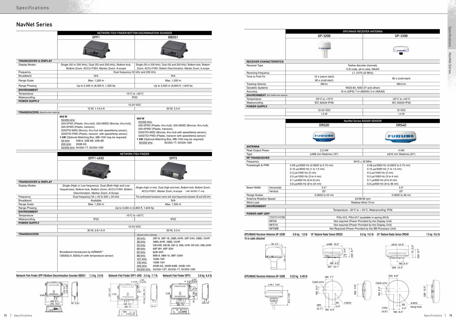
NETWORK FISH FINDER/BOTTOM DISCRIMINATION SOUNDER
DFF1 BBDS1
TRANSCEIVER & DISPLAYDisplay Modes Single (50 or 200 kHz), Dual (50 and 200 kHz), Bottom-lock,
Bottom-Zoom, ACCU-FISH, Marker Zoom, A-scopeSingle (50 or 200 kHz), Dual (50 and 200 kHz), Bottom-lock, Bottom-Zoom, ACCU-FISH, Bottom Discrimination, Marker Zoom, A-scope
Frequency Dual frequency 50 kHz and 200 kHzBroadband N/A N/A
Range Scale Max. 1,200 m Max. 1,200 m
Range Phasing Up to 2,400 m (8,000 ft, 1,300 fa) Up to 3,000 m (9,850 ft, 1,640 fa)
ENVIRONMENTTemperature -15°C to +55°CWaterproofing IP20POWER SUPPLY
12-24 VDC12 W, 1.1-0.4 A 30 W, 3.5 A
TRANSDUCERS (Specify when ordering)
600 W 50/200 kHz: 520-5PSD (Plastic, thru-hull), 520-5MSD (Bronze, thru-hull), 520-5PWD (Plastic, transom), 525STID-MSD (Bronze, thru-hull with speed/temp sensor), 525STID-PWD (Plastic, transom, with speed/temp sensor)1 kW (Optional Matching Box, MB-1100 may be required) 50 kHz: 50B-6, 50B-6B, 50B-9B 200 kHz: 200B-5S, 50/200 kHz: 50/200-1T, 50/200-12M
600 W 50/200 kHz: 520-5PSD (Plastic, thru-hull), 520-5MSD (Bronze, thru-hull), 520-5PWD (Plastic, transom), 525STID-MSD (Bronze, thru-hull with speed/temp sensor), 525STID-PWD (Plastic, transom with speed/temp sensor)1 kW (Optional Matching Box, MB-1100 may be required) 50/200 kHz: 50/200-1T, 50/200-12M
NETWORK FISH FINDER
DFF1-UHD DFF3
TRANSCEIVER & DISPLAYDisplay Modes Single (High or Low frequency), Dual (Both High and Low
frequencies), Bottom-lock, Bottom-Zoom, ACCU-FISH, Bottom Discrimination, Marker Zoom, A-Scope
Single (high or low), Dual (high and low), Bottom-lock, Bottom-Zoom, ACCU-FISH*, Marker Zoom, A-scope * with 50/200-1T only.
Frequency Dual frequency 50 ± 20 & 200 ± 25 kHz The synthesized transducer works with dual frequencies between 28 and 200 kHzBroadband Available N/ARange Scale Max. 1,200 m Max. 1,500 mRange Phasing Up to 3,000 m (9,850 ft, 1,640 fa)ENVIRONMENTTemperature -15°C to +55°CWaterproofing IP22 IP20POWER SUPPLY
12-24 VDC30 W, 2.8-1.4 A 30 W, 3.5 A
TRANSDUCERS
Broadband transducers by AIRMARR CM265LH, B265LH (with temperature sensor)
28 kHz: 28F-8, 28F-18, 28BL-6HR, 28F-24H, 28BL-12HR38 kHz: 38BL-9HR, 38BL-15HR50 kHz: 50B-6/6B, 50B-9B, 50B-12, 50BL-12HR, 50F-24H, 50BL-24HR68 kHz: 68F-8H, 68F-30H82 kHz: 82B-35R88 kHz: 88B-8, 88B-10, 88F-126H107 kHz: 100B-10R150 kHz: 150B-12H200 kHz: 200B-5S, 200B-8/8B, 200B-12H50/200 kHz: 50/200-1ST, 50/200-1T, 50/200-12M
2-ø5
219
8.6
2"14
4 5
.7"
90 3.54"255 10.0"
ø 99.1 3.90"
83.2
3.2
8"
6 0.24"
348 13.7"
230 9.1"
120 4.7"380 15"
60 2
.4"
120.47"
185
7.3
"30
0 1
1.8"
2-R32-ø16
2-ø6
89 3.5"
119
4.7
"
72 2.83"
88 3
.5"
42 1
.7"
25.4 1.0"
44 1.7"
2-ø5
219
8.6
2"14
4 5
.7"
90 3.54"255 10.0"
ø 99.1 3.90"
83.2
3.2
8"
6 0.24"
348 13.7"
230 9.1"
120 4.7"380 15"
60 2
.4"
120.47"
185
7.3
"30
0 1
1.8"
2-R32-ø16
2-ø6
89 3.5"
119
4.7
"
72 2.83"
88 3
.5"
42 1
.7"
25.4 1.0"
44 1.7"
6 0.24 "
348 13.7 "120 4.7 "380 15 "
60 2
.4"
120.47"
185
7.3
"
2-R32-ø16
2-ø6
320
12.
6"
Network Fish Finder DFF1/Bottom Discrimination Sounder BBDS1 1.3 kg 2.9 lb Network Fish Finder DFF3 3.8 kg 8.4 lbNetwork Fish Finder DFF1-UHD 3.5 kg 7.7 lb
NavNet Series RADAR SENSOR
DRS2D DRS4D
ANTENNAPeak Output Power 2.2 kW 4 kWType ø488 mm Radome (19") ø610 mm Radome (24")RF TRANSCEIVERFrequency 9410 ± 30 MHzPulselength & PRR 0.08 µs/3000 Hz (0.0625 to 0.75 nm)
0.15 µs/3000 Hz (1 to 1.5 nm)0.3 µs/1500 Hz (2 nm)0.5 µs/1000 Hz (3 to 4 nm)0.7 µs/600 Hz (6 to 8 nm)0.8 µs/600 Hz (8 to 24 nm)
0.08 µs/3000 Hz (0.0625 to 0.75 nm)0.15 µs/3000 Hz (1 to 1.5 nm)0.3 µs/1500 Hz (2 nm)0.5 µs/1000 Hz (3 to 4 nm)0.7 µs/600 Hz (6 to 8 nm)0.8 µs/600 Hz (8 to 36 nm)
Beam Width Horizontal 5.2° 4.0°Vertical 25° 25°
Range Scales 0.0625 to 24 nm 0.0625 to 36 nmAntenna Rotation Speed 24/36/48 rpmWind Load Relative Wind 70 knENVIRONMENT
Temperature: -30°C to + 55°C, Waterproofing: IP26POWER AMP UNIT
TZT9/TZT14/TZTBB PSU-012, PSU-017 (available in spring 2013)MFD8 Not required (Power Provided by the Display Unit)MFD12 Not required (Power Provided by the Display Unit)MFDBB Not Required (Power Provided by the BB Processor Unit)
4-M10(80)
(3.1")
160
6.3
"
160 6.3"
302
11.
9"
166 6.5"
75 3
.0"
220
8.7
"
307 12.1"
60
2.4"
180 7.1"
ø488 19.2"
338
13.
3"
220
8.7
"
75 3
.0"
165 6.5"
338 13.3"
4-M10
fixing hole
225 8.9"
160
6.3
"
60
2.4"
160 6.3"
(125)
(4.9")
ø610 24.0"
Cable entry Cable entry
4-M10(80)
(3.1")
160
6.3
"
160 6.3"
302
11.
9"
166 6.5"
75 3
.0"
220
8.7
"
307 12.1"
60
2.4"
180 7.1"
ø488 19.2"
338
13.
3"
220
8.7
"
75 3
.0"
165 6.5"
338 13.3"
4-M10
fixing hole
225 8.9"
160
6.3
"
60
2.4"
160 6.3"
(125)
(4.9")
ø610 24.0"
Cable entry Cable entry
19" Radome Radar Sensor DRS2D 6.5 kg 14.3 lb 24" Radome Radar Sensor DRS4D 7.5 kg 16.5 lb
2-ø5
219
8.6
2"14
4 5
.7"
90 3.54"255 10.0"
ø 99.1 3.90"
83.2
3.2
8"
6 0.24"
348 13.7"
230 9.1"
120 4.7"380 15"
60 2
.4"
120.47"
185
7.3
"30
0 1
1.8"
2-R32-ø16
2-ø6
89 3.5"
119
4.7
"
72 2.83"
88 3
.5"
42 1
.7"
25.4 1.0"
44 1.7"
2-ø5
219
8.6
2"14
4 5
.7"
90 3.54"255 10.0"
ø 99.1 3.90"
83.2
3.2
8"
6 0.24"
348 13.7"
230 9.1"
120 4.7"380 15"
60 2
.4"
120.47"
185
7.3
"30
0 1
1.8"
2-R32-ø16
2-ø6
89 3.5"
119
4.7
"
72 2.83"
88 3
.5"
42 1
.7"
25.4 1.0"
44 1.7"
GPS/WAAS RECEIVER ANTENNA
GP-320B GP-330B
RECEIVER CHARACTERISTICSReceiver Type Twelve discrete channels,
C/A code, all-in-view, WAASReceiving Frequency L1 (1575.42 MHz)Time to First Fix 12 s (warm start)
90 s (cold start)90 s (cold start)
Tracking Velocity 999 kn 999.9 knGeodetic Systems WGS-84, NAD-27 and othersAccuracy 10 m (GPS) 7 m (MSAS) 3 m (WAAS)ENVIRONMENT (IEC 60945 test method)
Temperature -25°C to +70°C -25°C to +55°CWaterproofing IEC 60529 IPX6 IEC 60529 IP56POWER SUPPLY
12-24 VDC 12 VDC1.3 W 1.4 W
GPS/WAAS Receiver Antenna GP-330B 0.22 kg 0.49 lb
GPS/WAAS Receiver Antenna GP-320B 0.8 kg 1.8 lb10 m cable attached
NavNet Series
(Specify when ordering)
72 73Specifications Specifications
SpecificationsSpec if ic at ions
NavN
et Series
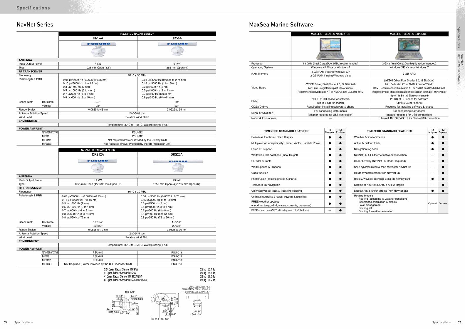
TIMEZERO STANDARD FEATURES TZ Navigator
TZ Explorer
Seamless Electronic Chart Display
Multiple chart compatibility: Raster, Vector, Satellite Photo
Loran TD support
Worldwide tide database (Tidal Height)
US tidal currents
Work Spaces & Ribbons
Undo function
PhotoFusion (satellite photos & charts)
TimeZero 3D navigation
Unlimited vessel track & track line coloring
Unlimited waypoints & routes, waypoint & route lists
FREE weather updates (cloud, air temp, wind, waves, currents, pressures)
FREE ocean data (SST, altimetry, sea color/plankton) —
TIMEZERO STANDARD FEATURES TZ Navigator
TZ Explorer
Weather & tidal animation
Active & historic track
Navigation log book
NavNet 3D full Ethernet network connection —
Radar Overlay (NavNet 3D Radar required) —
Chart synchronization & chart serving for NavNet 3D —
Route synchronization with NavNet 3D —
Route & Waypoint exchange using SD memory card
Display of NavNet 3D AIS & ARPA targets —
Display AIS & ARPA targets (non NavNet 3D)
Routing Module Routing (according to weather conditions) Isochrones calculation & display Polar management Routing list Routing & weather animation
Optional Optional
MAXSEA TIMEZERO NAVIGATOR MAXSEA TIMEZERO EXPLORER
Processor 1.5 GHz (Intel Core2Duo 2GHz recommended) 2 GHz (Intel Core2Duo highly recommended)Operating System Windows XP, Vista or Windows 7 Windows XP, Vista or Windows 7
RAM Memory1 GB RAM if using Windows XP
2 GB RAM if using Windows Vista2 GB RAM
Video Board(WDDM Driver, Pixel Shader 2.0, 32 Bits/pixel)
Min: Intel Integrated chipset 945 or above Recommended: Dedicated ATI or NVIDIA card 2/256Mb RAM
(WDDM Driver, Pixel Shader 2.0, 32 Bits/pixel)Min: Dedicated ATI or NVIDIA card w/256Mb
RAM; Recommended: Dedicated ATI or NVDIA card 2/512Mb RAM; Integrated video chipset not supported; Screen settings: 1,024x768 or
higher; 16 Bit (32 Bit recommended)
HDD20 GB of HD space for software
(up to 5 GB for charts)20 GB of HD space for software
(up to 5 GB for charts)CD/DVD drive Required for installing software & charts Required for installing software & charts
Serial or USB portFor connecting instruments
(adapter required for USB connection)For connecting instruments
(adapter required for USB connection)Network Environment — Ethernet 10/100 BASE-T for NavNet 3D connection
NavNet Series MaxSea Marine SoftwareNavNet 3D RADAR SENSOR
DRS4A DRS6A
ANTENNAPeak Output Power 4 kW 6 kWType 1036 mm Open (3.5') 1255 mm Open (4')RF TRANSCEIVERFrequency 9410 ± 30 MHzPulselength & PRR 0.08 µs/3000 Hz (0.0625 to 0.75 nm)
0.15 µs/3000 Hz (1 to 1.5 nm)0.3 µs/1500 Hz (2 nm)0.5 µs/1000 Hz (3 to 4 nm)0.7 µs/600 Hz (6 to 8 nm)0.8 µs/600 Hz (8 to 48 nm)
0.08 µs/3000 Hz (0.0625 to 0.75 nm)0.15 µs/3000 Hz (1 to 1.5 nm)0.3 µs/1500 Hz (2 nm)0.5 µs/1000 Hz (3 to 4 nm)0.7 µs/600 Hz (6 to 8 nm)0.8 µs/600 Hz (8 to 64 nm)
Beam Width Horizontal 2.3° 1.9°Vertical 22° 22°
Range Scales 0.0625 to 48 nm 0.0625 to 64 nmAntenna Rotation Speed 24/36/48 rpmWind Load Relative Wind 70 knENVIRONMENT
Temperature: -30°C to + 55°C, Waterproofing: IP26POWER AMP UNIT
TZT9/TZT14/TZTBB PSU-012MFD8 PSU-012MFD12 Not required (Power Provided by the Display Unit)MFDBB Not Required (Power Provided by the BB Processor Unit)
NavNet 3D RADAR SENSOR
DRS12A DRS25A
ANTENNAPeak Output Power 12 kW 25 kWType 1255 mm Open (4')/1795 mm Open (6') 1255 mm Open (4')/1795 mm Open (6')RF TRANSCEIVERFrequency 9410 ± 30 MHzPulselength & PRR 0.08 µs/3000 Hz (0.0625 to 0.75 nm)
0.15 µs/3000 Hz (1 to 1.5 nm)0.3 µs/1500 Hz (2 nm)0.5 µs/1000 Hz (3 to 4 nm)0.7 µs/600 Hz (6 to 8 nm)0.8 µs/600 Hz (8 to 64 nm)0.8 µs/550 Hz (72 nm)
0.08 µs/3000 Hz (0.0625 to 0.75 nm)0.15 µs/3000 Hz (1 to 1.5 nm)0.3 µs/1500 Hz (2 nm)0.5 µs/1000 Hz (3 to 4 nm)0.7 µs/600 Hz (6 to 8 nm)0.8 µs/600 Hz (8 to 64 nm)0.8 µs/550 Hz (72 to 96 nm)
Beam Width Horizontal 1.9°/1.4° 1.9°/1.4°Vertical 22°/22° 22°/22°
Range Scales 0.0625 to 72 nm 0.0625 to 96 nmAntenna Rotation Speed 24/36/48 rpmWind Load Relative Wind 70 knENVIRONMENT
Temperature: -30°C to + 55°C, Waterproofing: IP26POWER AMP UNIT
TZT9/TZT14/TZTBB PSU-012 PSU-013MFD8 PSU-012 PSU-013MFD12 PSU-012 PSU-013MFDBB Not Required (Power Provided by the BB Processor Unit) PSU-013
100°
DRS4A (XN10A): 1036 40.8"DRS6A/12A/25A (XN12A): 1255 49.4"
DRS12A/25A (XN13A): 1795 70.7"
Bow
150 5.9"
78 3.1"
140
5.5
"
117 4.6"
92 3.6"
200 7.9"
200
7.9"
357 14.0" 438 17.2"
213 8.4"250 9.8"
112 4.4"
445
17.5
"54
2 2
1.3"
561
22.
1"
250 9.8"340 13.4"
4-ø15 Fixing hole
4-ø15 Fixing hole
3.5' Open Radar Sensor DRS4A 25 kg 55.1 lb4' Open Radar Sensor DRS6A 25 kg 55.1 lb4' Open Radar Sensor DRS12A/25A 26 kg 57.3 lb6' Open Radar Sensor DRS25A/12A/25A 28 kg 61.7 lb
74 75Specifications Specifications
SpecificationsSpec if ic at ions
NavN
et 3DM
axSea Marine Software
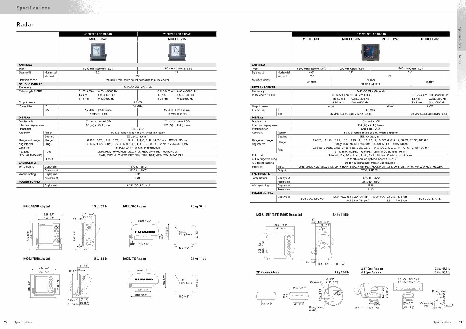
763.0"
215
8.5
"
ø380 15.0"
235 9.3"
77 3.0"
221 8.7"185 7.3"
111 4.4"83 3.3"
30
30
226
8.9
"
232
9.1
"
195
7.7
"
240 9.5"
200 7.9"
114 4.5"
310 12.2"
226 8.9"
160 6.3"
ø460 18.1"
220
8.7
"
160
6.3
"
77 3.0"37 1.5"
33 1.3"
70 2.8"93 3.7"
4-ø6
4-ø11Fixing holes
21 0.8"
200
7.9
"
230
9.1
"
235
9.3
"
160 6.3"
160
6.3
"4-ø11Fixing holes
285
11.
2"
310 12.2"
169 6.7"
129 5.1"170.7"
22 0.9"35°
25 1.0"62 2.4"
323 12.7"
308
12.
1"
278 10.9"
602 23.7"
348 13.7"
266
10.5
"
Cable entry (160 6.3")
(160
6.3
")
Fixing holes4-M10
640
25.2"
BOW
BOW
Cable entry
445
17.
5"
357 14.1"
542
21.
3"
250 9.8"213 8.4"
438 17.2" 340 13.4"
250 9.8"
XN10A :1036 40.8"XN12A :1255 49.4"
4- 15
Fixing holes
200 7.9"
200
7.9
"
25
6" SILVER LCD RADAR 7" SILVER LCD RADAR
MODEL1623 MODEL1715
ANTENNAType ø380 mm radome (15.0") ø460 mm radome (18.1")Beamwidth Horizontal 6.2˚ 5.2˚
Vertical 25˚ Rotation speed 24/31/41 rpm (auto-select according to pulselength) RF TRANSCEIVER Frequency 9410±30 MHz (X-band)Pulselength & PRR 0.125-0.75 nm : 0.08µs/3000 Hz
1-2 nm : 0.3µs/1200 Hz3-16 nm : 0.8µs/600 Hz
0.125-0.75 nm : 0.08µs/3000 Hz1-2 nm : 0.3µs/1200 Hz3-24 nm : 0.8µs/600 Hz
Output power 2.2 kW IF amplifier IF 60 MHz
BW 15 MHz (0.125-0.75 nm)
5 MHz (1-16 nm)
15 MHz (0.125-0.75 nm)
5 MHz (1-24 nm)
DISPLAYDisplay unit 6" monochrome LCD 7" monochrome LCDEffective display area 90 (W) x120 (H) mm 102 (W) x 138 (H) mmResolution 240 x 320 Accuracy Range 1.0 % of range in use or 8 m, which is greater
Bearing EBL accuracy ±1˚ Range and range Range 0.125, 0.25, 0.5, 0.75, 1, 1.5, 2, 3, 4, 6, 8, 12, 16, 24* nm * MODEL1715 only
ring interval Ring 0.0625, 0.125, 0.125, 0.25, 0.25, 0.5, 0.5, 1, 1, 2, 2, 3, 4, 6* nm * MODEL1715 only
Echo trail interval: 30 s, 1, 3, 6 m or continuous
Interface(IEC61162, NMEA0183)
Input GGA, RMC, RMA, RMB, GLL, VTG, VBW, VHW, HDT, HDG, HDM, BWR, BWC, GLC, GTD, DPT, DBK, DBS, DBT, MTW, ZDA, MWV, XTE
Output TLL ENVIRONMENT Temperature Display unit -15°C to +55°C
Antenna unit -25°C to +70°C Waterproofing Display unit IPX5
Antenna unit IPX6 POWER SUPPLY
Display unit 12-24 VDC: 3.2-1.4 A
10.4" COLOR LCD RADAR
MODEL1835 MODEL1935 MODEL1945 MODEL1937
ANTENNAType ø602 mm Radome (24") 1000 mm Open (3.5') 1200 mm Open (4.0')Beamwidth Horizontal 4.0° 2.4° 1.9°
Vertical 20° 22°Rotation speed
24 rpm24 rpm
48 rpm (option)48 rpm
RF TRANSCEIVER Frequency 9410±30 MHz (X-band)Pulselength & PRR 0.0625-1.6 nm : 0.08μs/2100 Hz
1.5-3.2 nm : 0.3μs/1200 Hz3-64 nm : 0.8μs/600 Hz
0.0625-2 nm : 0.06μs/2100 Hz1.5-4 nm : 0.3μs/1200 Hz3-48 nm : 0.8μs/600 Hz
Output power 4 kW 6 kW 4 kWIF amplifier IF 60 MHz
BW 25 MHz (0.08/0.3μs) 3 MHz (0.8μs) 25 MHz (0.06/0.3μs) 3 MHz (0.8μs)DISPLAYDisplay unit 10.4" color LCDEffective display area 158 (W) x 211 (H) mmPixel number 640 x 480, VGAAccuracy Range 1.0 % of range in use or 8 m, which is greater
Bearing EBL accuracy ± 1°Range and rangering interval
Range0.0625, 0.125, 0.25, 0.5, 0.75, 1, 1.5, 1.6, 2, 3, 3.2, 4, 6, 8, 12, 16, 24, 32, 36, 48*, 64*
(*range max. MODEL 1935/1937: 48nm, MODEL 1945: 64nm)
Ring0.03125, 0.0625, 0.125, 0.125, 0.25, 0.25, 0.5, 0.4, 0.5, 1, 0.8, 1, 2, 2, 3, 4, 6, 8, 12, 12*, 16*
(*ring max. MODEL 1935/1937: 12nm, MODEL 1945: 16nm)Echo trail Interval: 15 s, 30 s, 1 min, 3 min, 6 min, 15 min, 30 min, or continuousARPA target tracking Up to 10 (required optional board ARP-11)AIS target tracking Up to 100 (Data input from AIS is required.)
Interface
Input GNS, GGA, RMC, GLL, VTG, VHW, BWR, BWC, RMB, HDT, HDG, HDM, XTE, DPT, DBT, MTW, MWV, VWT, VWR, ZDAOutput TTM, RSD, TLL
ENVIRONMENT Temperature Display unit -15°C to +55°C
Antenna unit -25°C to +55°CWaterproofing Display unit IP55
Antenna unit IP26POWER SUPPLY
Display unit12-24 VDC: 4.1-2.0 A
12-24 VDC: 6.8-3.3 A (24 rpm) 8.2-3.8 A (48 rpm)
12-24 VDC: 7.3-3.5 A (24 rpm) 8.8-4.1 A (48 rpm)
12-24 VDC: 8.1-3.8 A
MODEL1623 Display Unit 1.3 kg 2.9 lb
MODEL1835/1935/1945/1937 Display Unit 5.4 kg 11.9 lb
24" Radome Antenna 8 kg 17.6 lb3.5 ft Open Antenna 22 kg 48.5 lb4 ft Open Antenna 25 kg 55.1 lb
MODEL1715 Display Unit 1.5 kg 3.3 lb
MODEL1623 Antenna 4.6 kg 10.1 lb
MODEL1715 Antenna 5.1 kg 11.2 lb
Radar
76 77Specifications Specifications
SpecificationsSpec if ic at ions
Ra
da
r

357 14.1" 438 17.2"
Cable Entry
Fixing Holes
Bow213 8.4"
250 9.8" 250 9.8"
340 13.4"
445
17.
5"
542
21.
3"
(200
7.9
")
(200 7.9") 4-ø15
with XN12A 1255 49.4"with XN13A 1795 70.7"
Fixing holes4-ø5
331 13"
345
13.
6"
354
13.
9"
54 2.1"16.3˚172 6.8"186 7.3"
292
11.
5"20
0 7
.9"
282 11.1"303 11.9"32
0 1
2.6"
320 12.6"
Table-top mount Flush mount
12.1" LCD RADAR
FR-8062 FR-8122 FR-8252
ANTENNAType 1255 mm Open (4') or 1795 mm Open (6')Beamwidth Horizontal 1.9˚(4' Open: XN-12A) or 1.35˚ (6' Open: XN-13A)
Vertical 22˚ Rotation speed 4 ft ant: 24 rpm
6 ft ant: 24/36/48 rpm (auto select according to pulselength)
24/36/48 rpm (auto select according to pulselength)
RF TRANSCEIVERFrequency 9410±30 MHz (X-band)
Pulselength & PRR 0.125-1.5 nm: 0.08µs/2100 Hz1.5, 2, 3 nm: 0.3µs/1200 Hz3-36 nm: 0.8µs/600 Hz48, 64 nm: 0.8µs/550 Hz72, 96* nm: 0.8µs/500 Hz * FR-8252 only
Output power 6 kW 12 kW 25 kWIF amplifier IF 60 MHz
BW 40 MHz (0.125-1.5 nm) 2.5 MHz (1.5-96 nm)
DISPLAY Display unit 12.1" color LCD Effective display area 184 (H) x 246 (V) mm Pixel number 600 (H) x 800 (V) Accuracy Range 1.0 % of range in use or 8 m, which is greater
Bearing EBL accuracy ±1˚ Range and range Range 0.125, 0.25, 0.5, 0.75, 1, 1.5, 2, 3, 4, 6, 8, 12, 16, 24, 36, 48, 64, 72, 96* nm (range max. FR-8062/8122: 72 nm, FR-8252: 96 nm)
ring interval Ring 0.025, 0.05, 0.1, 0.25, 0.25, 0.25, 0.5, 0.5, 1, 1, 2, 2, 4, 4, 6, 8, 8, 12, 16* nm * FR-8252 only
Echo trail interval: 15 s, 30 s, 1, 3, 6, 15, 30 min., 12, 24 hour., or continuous ARPA target tracking Up to 10 (Required optional board ARP-11)AIS target tracking Up to 100 (Data input from AIS is required)
Interface(IEC61162, NMEA0183)
Input GNS, GGA, RMC, GLL, VTG, VHW, HDT, HDG, HDM, VHW,RMB, BWC, BWR, DPT, DBT, MTW, ZDA, MWV, VWT, VWR
Output TLL, TTM, RSD ENVIRONMENT Temperature Display unit -15°C to +55°C
Antenna unit -25°C to +55°C Waterproofing Display unit IPX5 (front panel)
Antenna unit IPX6POWER SUPPLY
Display unit 12-24 VDC: 3.2 A 12-24 VDC: 3.8 A 12-24 VDC: 5.0 A Power Amp Unit PSU-008
FR-8062/8122/8252 Display Unit 6.9 kg 15.2 lb4 ft Open Antenna 25 kg 55.1 lb6 ft Open Antenna 27 kg 59.5 lb
BLACK BOX MARINE RADAR
FAR-2117-BB FAR-2127-BB FAR-2137S-BB
ANTENNAType 1260 mm Open (4'), 2040 mm Open (6.5') or 2550 mm Open (8') 3090 mm S-band (10') or 3765 mm S-band (12')
Beamwidth Horizontal 1.9˚(4' Open: XN-12AF), 1.23˚(6.5' Open: XN-20AF) or 0.95˚(8' Open: XN-24AF) 2.3˚ (10' S-band: SN-30AF) or 1.8˚ (12' S-band: SN-36AF)
Vertical 20˚ 25˚Rotation speed 24 rpm or 42 rpm 21/26 rpm or 45 rpmRF TRANSCEIVER Frequency 9410±30 MHz (X-band) 3050±30 MHz (S-band)
Pulselength & PRR 0.125, 0.25 nm : 0.07µs/3000 Hz0.5 nm: 0.07, 0.15µs/3000 Hz0.75, 1.5 nm: 0.07, 0.15, 0.3µs/3000, 1500 Hz3 nm: 0.15, 0.3, 0.5, 0.7µs/3000, 1500, 1000 Hz6 nm: 0.3, 0.5, 0.7, 1.2µs/1500, 1000, 600 Hz12, 24 nm: 0.5, 0.7, 1.2µs/1000, 600 Hz48, 96 nm: 1.2µs/600 Hz
Output power 12 kW 25 kW 30 kWIF amplifier IF 60 MHz
BW 40 MHz (Short pulse) 10 MHz (Middle pulse) 3 MHz (Long Pulse)
DISPLAYAccuracy Range 1% of the maximum range of the scale in use or 30 m, whichever is the greater
Bearing ±1˚Range and range Range 0.125, 0.25, 0.5, 0.75, 1, 1.5, 2, 3, 4, 6, 8, 12, 16, 24, 32, 48, 72, 96, 120ring interval Ring 0.025, 0.05, 0.1, 0.25, 0.25, 0.25, 0.5, 0.5, 1, 1, 2, 2, 4, 4, 8, 8, 12, 16, 20Echo trail interval: 15, 30 s, 1, 3, 6, 15, 30 m or continuousARPA target tracking Up to 100AIS target tracking Up to 1000 (Data input from AIS is required)
Interface(IEC61162, NMEA0183)
Input BWC, BWR, DBS, DBT, DPT, DTM, GGA, GLL, HDT, MTW, MWV, RMA, RMB,RMC, RTE VBW, VDR, VHW, VTG, VWR, VWT, WPL, ZDA
Output AAM, TLL, TTM, RSD, ESPENVIRONMENTTemperature Processor unit -15°C to +55°C
Antenna unit -25°C to +55°CWaterproofing Processor unit IPX0
Antenna unit IPX6POWER SUPPLY
Processor unit 24VDC: 7.6 A*1 /8.5 A*2
100-115 VAC: 2.6 A*1 /3.0 A*2
220-230 VAC: 1.6 A*1 /1.7 A*2
*1 : 24 rpm, *2: 42 rpm
24 VDC: 8.8 A*1 /9.7 A*2
100-115 VAC: 3.0 A*1 /3.4 A*2
220-230 VAC: 1.8 A*1 /1.9 A*2
*1 : 24 rpm, *2: 42 rpm
100-115 VAC: 3.0A220-230 VAC: 1.5A
Antenna unit 200/220 VAC: 3.0A380/440 VAC: 1.5A220 VAC: 3.5A (for HSC)440 VAC: 1.7A (for HSC)
Radar
78 79Specifications Specifications
SpecificationsSpec if ic at ions
Ra
da
r
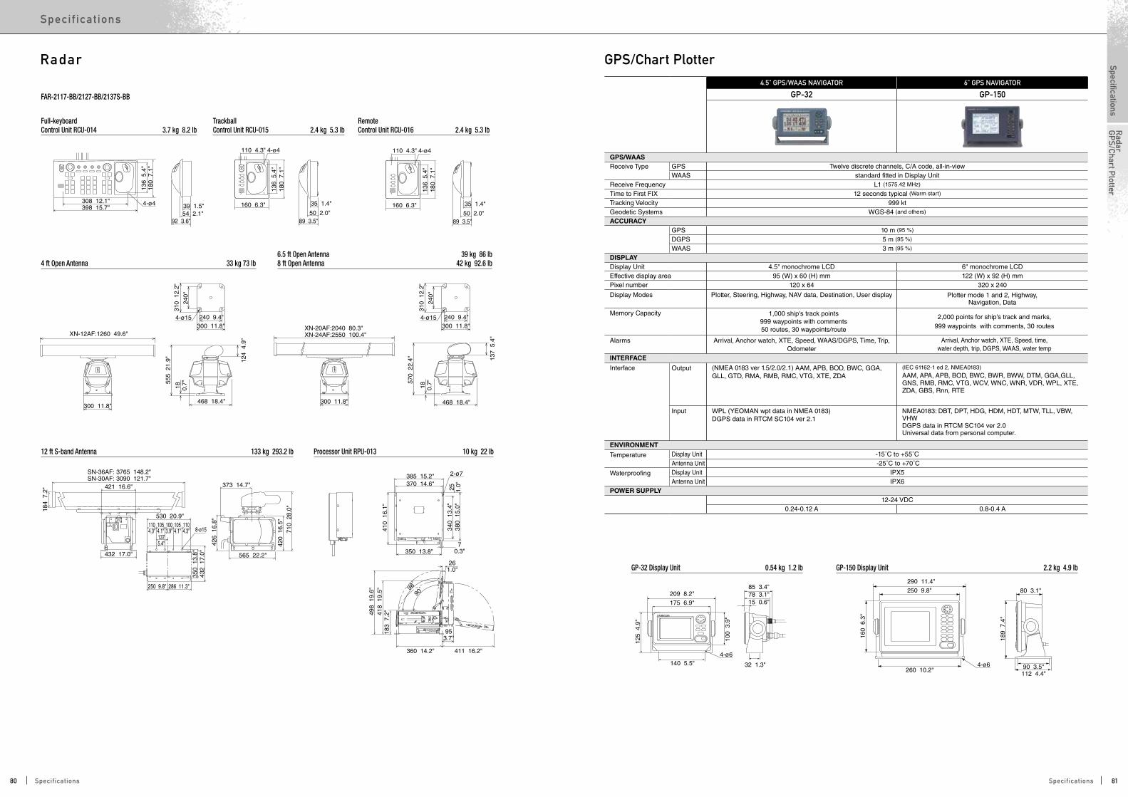
189
7.4
"
4-ø6
4-ø6
160
6.3
"
125
4.9
"
100
3.9
"
112 4.4"90 3.5"
80 3.1"
260 10.2"140 5.5" 32 1.3"
85 3.4"78 3.1"15 0.6"
290 11.4"
250 9.8" 209 8.2"
175 6.9"
308 12.1"398 15.7"
92 3.6"54 2.1"39 1.5"4-ø4
136
5.4
"18
0 7
.1"
110 4.3"
160 6.3"
89 3.5"50 2.0"
35 1.4"
4-ø4
136
5.4
"18
0 7
.1"
110 4.3"
160 6.3"
89 3.5"50 2.0"
35 1.4"
4-ø4
136
5.4
"18
0 7
.1"
426
16.
8"
261.0"
70.3"
184
7.2
"
SN-36AF: 3765 148.2"SN-30AF: 3090 121.7"
432 17.0"
250 9.8" 286 11.3"
530 20.9"
421 16.6"
1104.3"
1054.1"
1104.3"
1054.1"
1003.9"
1375.4"
350
13.
8"43
2 1
7.0"
8-ø15
2-ø7
373 14.7"
565 22.2"
710
28.
0"42
0 1
6.5"
410
16.
1"
340
13.
4"38
0 1
5.0"
498
19.
6"41
8 1
9.5"
183
7.2
"
25 1.0"
385 15.2"370 14.6"
350 13.8"
360 14.2" 411 16.2"
953.7"
98˚
90˚
4-ø15
137
5.4
"
468 18.4"
XN-20AF:2040 80.3" XN-24AF:2550 100.4"
300 11.8"
310
12.
2"
240"
240 9.4"300 11.8"
18 0.7"57
0 2
2.4"
468 18.4"
XN-12AF:1260 49.6"
300 11.8"
124
4.9
"
18 0.7"55
5 2
1.9"
4-ø15
310
12.
2"
240"
240 9.4"300 11.8"
Processor Unit RPU-013 10 kg 22 lb
4 ft Open Antenna 33 kg 73 lb
12 ft S-band Antenna 133 kg 293.2 lb
Full-keyboardControl Unit RCU-014 3.7 kg 8.2 lb
FAR-2117-BB/2127-BB/2137S-BB
TrackballControl Unit RCU-015 2.4 kg 5.3 lb
RemoteControl Unit RCU-016 2.4 kg 5.3 lb
6.5 ft Open Antenna 39 kg 86 lb8 ft Open Antenna 42 kg 92.6 lb
Radar4.5" GPS/WAAS NAVIGATOR 6" GPS NAVIGATOR
GP-32 GP-150
GPS/WAASReceive Type GPS Twelve discrete channels, C/A code, all-in-view
WAAS standard fitted in Display UnitReceive Frequency L1 (1575.42 MHz)
Time to First FIX 12 seconds typical (Warm start)
Tracking Velocity 999 ktGeodetic Systems WGS-84 (and others)
ACCURACY GPS 10 m (95 %)
DGPS 5 m (95 %)
WAAS 3 m (95 %)
DISPLAYDisplay Unit 4.5" monochrome LCD 6" monochrome LCDEffective display area 95 (W) x 60 (H) mm 122 (W) x 92 (H) mmPixel number 120 x 64 320 x 240
Display Modes Plotter, Steering, Highway, NAV data, Destination, User display Plotter mode 1 and 2, Highway, Navigation, Data
Memory Capacity 1,000 ship's track points999 waypoints with comments50 routes, 30 waypoints/route
2,000 points for ship's track and marks,999 waypoints with comments, 30 routes
Alarms Arrival, Anchor watch, XTE, Speed, WAAS/DGPS, Time, Trip, Odometer
Arrival, Anchor watch, XTE, Speed, time,water depth, trip, DGPS, WAAS, water temp
INTERFACE
Interface Output (NMEA 0183 ver 1.5/2.0/2.1) AAM, APB, BOD, BWC, GGA, GLL, GTD, RMA, RMB, RMC, VTG, XTE, ZDA
(IEC 61162-1 ed 2, NMEA0183)
AAM, APA, APB, BOD, BWC, BWR, BWW, DTM, GGA,GLL, GNS, RMB, RMC, VTG, WCV, WNC, WNR, VDR, WPL, XTE, ZDA, GBS, Rnn, RTE
Input WPL (YEOMAN wpt data in NMEA 0183)DGPS data in RTCM SC104 ver 2.1
NMEA0183: DBT, DPT, HDG, HDM, HDT, MTW, TLL, VBW, VHWDGPS data in RTCM SC104 ver 2.0Universal data from personal computer.
ENVIRONMENT
Temperature Display Unit -15˚C to +55˚CAntenna Unit -25˚C to +70˚C
Waterproofing Display Unit IPX5Antenna Unit IPX6
POWER SUPPLY 12-24 VDC
0.24-0.12 A 0.8-0.4 A
GP-150 Display Unit 2.2 kg 4.9 lbGP-32 Display Unit 0.54 kg 1.2 lb
GPS/Chart Plotter
80 81Specifications Specifications
SpecificationsSpec if ic at ions
Radar
GP
S/Chart Plotter

110
4.3
"
58 2.3"
132 5.2"
12 0.5"
145 5.7"
128"
4-Ø3.5
125
4.9
"
125
4.9
"
110
4.3
"
GP-33 (Flush Mount) 0.6 kg 1.3 lb
R12
145
5.7
"
125
4.9
"
153
6.0
"
91 3.5"63 2.5"
176 6.9" 70 2.8"21 0.8"30145 5.7"
146 5.7"
GP-33 0.9 kg 2.0 lb
4-Ø6
40 1
.6"
40 1
.6"
Pilot holes
fixing holes
4.3" GPS NAVIGATOR
GP-33
GPS/WAASReceive Type GPS Twelve discrete channels, C/A code, all-in-view
WAAS Two channelsReceive Frequency L1 (1575.42 MHz)
Time to First FIX Under 90 s, 43 s typical (cold start)Tracking Velocity 999 ktGeodetic Systems WGS-84 (and others)
ACCURACY GPS 10 m (2 drms)MSAS 7 m (2 drms)WAAS 3 m (2 drms)
DISPLAYDisplay Unit 4.3" Color LCDEffective display area 95.04 (W) x 53.85 (H) mmPixel number 480 x 272
Display Modes Plotter, Steering, Highway, NAV data,User display1, User display2, Satellite Monitor Display
Memory Capacity 3,000 ship's track points10,000 waypoints with comments
100 routes, 30 waypoints/route
AlarmsArrival, Anchor watch, XTE, Speed, WAAS, Time, Trip, Odometer
INTERFACEPorts NMEA0183: 1, CAN bus: 1
Interface Output (NMEA0183 ver. 2, 3) AAM, APB, BOD, BWC, BWR, DTM, GGA, GLL, GSA, GSV, RMB, RMC, VTG, XTE, ZDA(CAN bus) 059392, 060928, 061184, 126208, 126464, 126720-1, 126720-2, 126992, 126996, 127258, 129026, 129029, 129033, 129044, 129283, 129284, 129285, 129538, 129539, 129540, 130822, 130823
Input (CAN bus) 059904, 065286, 060928, 061184,126208, 126720ENVIRONMENT
Temperature Display Unit -15˚C to +55˚CAntenna Unit -25°C to +70°C
Waterproofing Display Unit IP56Antenna Unit IPX6
POWER SUPPLY
Non CAN bus 12-24 VDC 0.24-0.12 A
CAN bus 15 VDC LEN7
GP-33 Display Unit (Flush Mount) 0.6 kg 1.3lbGP-33 Display Unit (Bracket Mount) 0.9 kg 2.0 lb
GPS/Chart Plotter 5.7" GPS/WAAS COLOR CHART PLOTTER 7" WIDE GPS/WAAS COLOR CHART PLOTTER
GP-1670 GP-1670F GP-1870 GP-1870F
GPS/WAASReceive Type GPS 50 channels
WAAS 1 channelReceiving Frequency L1 (1575.42 MHz)Time to First FIX 80 s (cold start)Tracking Velocity 999 ktSBAS (Satellite-Based Augmentation System) WAAS, EGNOS, MSASElectronic Chart C-MAP 4DACCURACYInternal Antenna GPS 10 m Max
MSAS 7.5 m MaxExternal Antenna GPA-017 (Option)
GPS 10 m MaxMSAS 7.5 m Max
DISPLAYType 5.7" Color TFT LCD 7" Wide Color TFT LCDScreen Size 115.2 x 86.4 mm 152.4 x 91.4 mmScreen Resolution VGA 640 x 480 pixels WVGA 800 x 480 pixelsScreen Brightness 800 cd/m2 (typical) 900 cd/m2 (typical)
Language English (US & UK), French, Spanish, German, Italian, Portuguese, Danish, Swedish, Norwegian, Finnish, Greek, Japanese, Chinese, Russian, Thai, Vietnamese, Polish, Bahase Malaysia, Bahasa Indonesia
Display Modes
Course plot, Nav Data, Instruments, Engine monitor, Anemometer, Fuel level gauge, GPS status
Course plot, Nav Data, Instruments, Engine monitor, Anemometer, Fuel level gauge, GPS status, Fish finder
Course plot, Nav Data, Instruments, Engine monitor, Anemometer, Fuel level gauge, GPS status
Course plot, Nav Data, Instruments, Engine monitor, Anemometer, Fuel level gauge, GPS status, Fish finder
Memory Capacity30,000 points for ship's track and wayponts
1,000 planned routes (Max. 50 points per route)5,000 quickpoints
INTERFACECAN bus 1 Port
Interface (CAN bus)
Input
059392, 059904, 060928, 061184, 126208, 126992, 126996, 127245, 127250, 127251, 127258, 127488, 127489, 127493, 127496, 127505, 128259, 128267, 129025, 129026, 129029, 129033, 129038, 129039, 129040, 129538, 129540, 129793, 129794, 129798, 129808, 129809, 129810, 130306, 130310, 130311, 130312, 130313, 130314, 130577
059392, 059904, 060928, 061184, 126208, 126992, 126996, 127245, 127250, 127251, 127258, 127488, 127489, 127493, 127496, 127505, 128259, 128267, 129025, 129026, 129029, 129033, 129038, 129039, 129040, 129538, 129540, 129793, 129794, 129798, 129808, 129809, 129810, 130306, 130310, 130311, 130312, 130313, 130314, 130577
Output059392, 059904, 060928, 061184, 126208, 126464, 126992, 126996, 127258, 128259, 128267, 128275, 129025, 129026, 129029, 129033, 129283, 129284, 129285, 130310, 130312
059392, 059904, 060928, 061184, 126208, 126464, 126992, 126996, 127258, 128259, 128267, 128275, 129025, 129026, 129029, 129033, 129283, 129284, 129285, 130310, 130312
USB* 1 Port (2.0)SD Cart Slot 1 Slot (Acceptable up to 32 GB)ECHO SOUDERTransmit Frequency 50/200 kHz 50/200 kHzTransmission 600 W or 1 kW* 600 W or 1 kW*
Display Range 5-1,200 m,shift: 0-500 m
5-1,200 m,shift: 0-500 m
Extension Mode
ACCU-FISH, Auto (Fishing/Cruising/Manual), A-Scope,
Marker Zoom, Bottom Zoom, Bottom Lock,
Bottom Discrimination
ACCU-FISH, Auto (Fishing/Cruising/Manual), A-Scope,
Marker Zoom, Bottom Zoom, Bottom Lock,
Bottom Discrimination
Picture Advance 7 steps: 2/1, 1/1, 1/2, 1/4, 1/8, 1/16, stop
7 steps: 2/1, 1/1, 1/2, 1/4, 1/8, 1/16, stop
ENVIRONMENTTemperature Display Unit -15˚C to +55˚CWaterproofing Display Unit IP56POWER SUPPLY
12-24 VDC 12-24 VDC
0.88 - 0.46 A 1.05 - 0.53 A 0.93 - 0.49 A 1.05 - 0.53 A (Equip 520-5PD)1.37 - 0.64 A (Equip 50/200-1T)
148
5.8
"16
8 6
.6"
224 8.8"243 9.6" 99 3.9"
91 3.9"217.2 8.6" 4- 6
124 3.9"140.6"
3714
8 5
.8"
224 8.8"
Cutout for ush mount
99 3.9"43 1.7" 56 2.2"
132
5.2
"50
.8 2
"4-R16
210 8.3"202 8"
5 0.2"
Cutout for ush mount
99 3.9"43 1.7"56 2.2"
132
5.2
"50
.8 2
"
4-R16238 9.4"230 9.1"
5 0.2"
99 3.9"
91 3.9" 4- 6
124 3.9"140.6"
36
148
5.8
"16
8 6
.6"
252 9.9"271 10.7"
245 9.6"
148
5.8
"
252 9.9"
GP-1670/1670F (Flush Mount) 2.0 kg 4.4 lb
GP-1670/1670F (Bracket Mount) 2.0 kg 4.4 lb
GP-1870/1870F (Flush Mount) 2.0 kg 4.4 lb
GP-1870/1870F (Bracket Mount) 2.0 kg 4.4 lb
* Matching box MB-1100 required
Bracket Mount 1.5 kg 3.3 lbGP-1870/1870F Display Unit Flush Mount 1.3 kg 2.9 lb
Bracket Mount 1.4 kg 3.1 lbGP-1670/1670F Display Unit Flush Mount 1.2 kg 2.6 lb
82 83Specifications Specifications
SpecificationsSpec if ic at ions
GP
S/Chart Plotter

Fish Finder
183 7.2"149 5.9"
93 3.7"56 2.2"
96 3.8"311.2"
251.0"
166
6.5
"14
9 5
.9"
170
6.7
"
123
4.8
"
132
5.2
"
4-ø6
30˚138 5.4"
Cutout for flush mountCutout for flush mount
4.5
221 8.7"185 7.3"
104.5 4.1"
173 6.8"
4.5 0.2"
111 4.4"83 3.3"
331.3"
226
8.9
"19
5 7
.7"
30˚
232
9.1
"
168
6.6
"
178
7.0
"
5" LCD SOUNDER 6" LCD SOUNDER
LS-4100 LS-6100
GeneralFrequency 50 and 200 kHz Transducer 300 WDISPLAYDisplay unit 5" monochrome LCD 6" monochrome LCDEffective display area 76 (W) x 100 (H) mm 92 (W) x 122 (H) mmPixel number 240 x 320Display Mode Single frequency (high/low freq.), Dual-frequency,
Zoom, Nav data, Marker zoom, Bottom zoom, Bottom-lock
Basic Range *m, ft, fa, p/b can be selectable in the menu 2-500 m
Range phasing up to 500 m
Expansion Range Bottom-lock expansion 3-10 m Sectional expansion 2-50 m
Picture advance speed 8 steps: stop, 1/16, 1/8, 1/4, 1/2, 1/1, 2/1, 4/1Pulselength & PRR 0.1-0.8 ms, Max 500 pulse/min 0.1-1.0 ms, Max 550 pulse/min
Interface(IEC61162, NMEA0183)
Input GGA, RMA, RMB, RMC, BWC, GLL, HDT,HDG, VTG, VHW, MTW, MWV, MDA, XTE
Output
MTW*, VHW*, DBT, DPT, RMB*, TLL*: External data required
ENVIRONMENTTemperature Display unit -15°C to +55°C Waterproofing Display unit IPX5POWER SUPPLY
12 VDC : 0.5 A 12 VDC : 0.8 A
LS-4100 Display Unit 0.7 kg 1.5 lb LS-6100 Display Unit 1.3 kg 2.9 lb
170 6.7"
62 2.4"
43 1.7"
106 4.2"132 5.2"
54 2.1"
90˚
170
6.7
"
207
8.2
"
219
8.6
"
170 6.7"54 2.1"52 2"
106 4.2"17
0 6
.7"
120 4.7"4-ø4.5ø127
110 4.3"
Cutout for flush mount
115
4.5
"
55 2.2"
60 2.4"
60 2
.4"
4-ø6
R103
60˚ 60˚
122 4.8"142 5.6"
233 9.2"
158 6.2"110 4.3"
54 2.1"
90˚
233
9.2
"
270
10.
6"
282
11"
70 2.8"
52 2.0"
Cutout for flush mount
233 9.2"
233
9.2
"
152 6.0"
173
6.8
"94.5
3.7
"
66 2
.6"
4-ø4.5ø127
4-ø6
R135
60˚60˚
140 5.5"
54 2.1"57 2.2"
110 4.3"
5.7" FISH FINDER 8.4" FISH FINDER
FCV-627 FCV-587
GeneralFrequency 50 and 200 kHz Transducer 600 W 600 W/1 kW*DISPLAYDisplay unit 5.7" TFT color LCD 8.4" TFT color LCDEffective display area 87.1 (W) x 116.2 (H) mm 128.2 (W) x 170.9 (H) mmPixel number 480 x 640
Display Mode Single frequency (high/low freq.), Dual-frequency, Zoom, Nav data, A-scope, Marker zoom, Bottom zoom, Bottom-lock,
Bottom Discrimination, ACCU-FISH™
Basic Range *m, ft, fa, p/b can be selectable in the menu 2-1200 m
Range phasing up to 1200 m
Expansion Range Bottom-lock expansion 2-10 mSectional expansion 2-1200 m
Picture advance speed 8 steps: stop, 1/16, 1/8, 1/4, 1/2, 1/1, 2/1, 4/1 Pulselength & PRR 0.1-3 ms, Max 3,000 pulse/min
Interface(IEC61162, NMEA0183)
Input RMA, RMB, RMC, BWC, GLL, GGA, GNS, MWV, VTG, VHW, MTW, XTE, MDA, HDT, HDG, ZDA
OutputRMB*, VHW*, MTW*, DBS, DBT, DPT, MTW**, VHW**, TLL
* : GPS sensor required**: Speed/temperature sensor is required.
ENVIRONMENTTemperature Display unit -15°C to +55°C Waterproofing Display unit IP56POWER SUPPLY
12-24 VDC : 1.1 -0.5 A 12-24 VDC : 1.2 - 0.6 A13 W 15.7 W
FCV-627 Bracket Mount 1.3 kg 2.9 lb
FCV-627 Flush Mount 0.9 kg 2.0 lb
FCV-587 Bracket Mount 2.3 kg 5.1 lb
FCV-587 Flush Mount 1.6 kg 3.5 lb
*The FCV-587 can be connected with the transducers of 1 kw output power, when interfaced with the Matching Box MB-1100.
84 85Specifications Specifications
SpecificationsSpec if ic at ions
GP
S/Chart Plotter
Fish Finder

9˚290 11.4"
174 6.9"206 8.1"160 6.3"86 3.4"
357
14.
1"
327
12.
9"
300
11.
8"90
3.5"
210
8.3
"
11˚ 320 12.6" 127 5.0" 411.6"153 6.0" 153 6.0"
334
13.
2"32
0 1
2.6"
6-ø7
334 13.2"320 12.6"
127 5.0" 411.6"36
1.4"
6-ø7
320
12.
6"15
3 6
.0"
153
6.0
"
9˚300 11.8"210 8.3"
174 6.9"236 9.3"160 6.3"99 3.9"
342
13.
5"
317
12.
5"
290
11.
4"
11˚90 3.5"
356 14.0"340 13.4"
320
12.
6"
345
13.
6"
158 6.2"411.6"92
3.6”
356
14.
0"
220.9"
35° 5°
320
12.
6"
320 12.6"
195
7.7
"84
3.3
"
340 13.4"
4-Ø6 120 4.7"
411.6"
135 5.3"
220.9"
304 12.0"
320 12.6"
195
7.7
"
282
11.
1"
65 2.6"
Fixing hole
Cutout for flush mount
R27
306
12.
0"
285
11.
2"
310 12.2"323 12.7" 185 7.3"
128 5.0"180.7"
622.4"
10 0.4"
35˚
311
12.
2"
FCV-1200L/LM (Landscape/Bracket Mount) 5.7 kg 12.6 lb FCV-1200L/LM (Landscape/Flush Mount) 4.2 kg 9.3 lb
FCV-1150 (Bracket Mount) 8.2 kg 18.1 lb
FCV-1200L/LM (Portrait/Bracket Mount) 5.7 kg 12.6 lb
FCV-295 7.0 kg 15.4 lb
FCV-1200L/LM (Portrait/Flush Mount) 4.2 kg 9.3 lb
FCV-1150 (Flush Mount) 6.8 kg 15.0 lb
10.4" LCD SOUNDER 12.1" LCD SOUNDER 10.4" LCD SOUNDER
FCV-295 FCV-1150 FCV-1200L
GeneralFrequency The synthesized transreceiver works with
dual frequencies in 28 to 200 kHz
The synthesized transreceiver works with dual frequencies in 15 to 400 kHz
400 kHz requires optional transmit boardTransducer 1, 2 or 3 kW 1, 2 or 3 kW DISPLAY
Display unit 10.4" TFT color LCD 12.1" TFT color LCD10.4" TFT color LCD or locally supplied for
BlackBox configurationPixel number 640 x 480 800 × 600 640 x 480Display Mode Single mode (high/low frequency), Dual-frequency, Zoom, Mix, A-scope, Marker zoom, Bottom zoom, Bottom-lock expansion
Basic Range *m, ft, fa, p/b can be selectable in the menu 5-3000 m 5-2000 m
Range phasing 0-2000 m
Expansion Range Bottom-lock expansion 5-200 mPicture advance speed 6 steps: stop, 1/16, 1/8, 1/4, 1/2, 1/1, 2/1, 4/1 7 steps: stop, 1/16, 1/8, 1/4, 1/2, 1/1, 2/1, 3/1, 4/1Pulselength & PRR 0.1-5.0 ms, 20-3000 pulse/min 0.2-5.0 ms, 20-3000 pulse/min
Interface(IEC61162, NMEA0183)
Input BWC, GGA, GLC, GLL, GNS, GTD, HDG, HDT, MDA, MTW, MWW, RMA, RMB, RMC, VHW, VTG, XTE
BWC, GGA, GLC, GLL, GNS, GTD, HDG, HDT, MDA, MTW, MWW, RMA, RMB, RMC, VHW, VTG, XTE, HVE, att, hve, req
GGA, GLC, GLL, GTD, MTW, RMA, RMB, RMC, VTG, att, hve
Output DBS, DBT, DPT, MTW*, TLL, SDmrk, VHW, RMB, dat *Optional sensor required
SDDBS, SDDBT, SDDPT, SDTLL, YCMTW*, VRM*Optional sensor required
Output forexternal Monitor
RGB: VGA signal,optional interface IF-8000 required
ENVIRONMENTTemperature Display unit -15°C to +55°C
Control unit -15°C to +55°CProcessor unit -15°C to +55°C
Waterproofing Display unit IP55 (When flush mounted) IPX5Control unit IPX5Processor unit IPX2
POWER SUPPLY12-24 VDC: 2.6-1.3 A, 100/110/220/230 VAC,
optional rectifier required12-24 VDC: 3.3-1.7 A, 100/110/220/230 VAC,
optional rectifier required12-24 VDC: 10.0-5.0 A, 100/110/115/220/230 VAC,
optional rectifier required
Fish Finder
130 5.1"75 3.0"
58 2.3"22 0.9"
68 2.7"
8 0.3"
290 11.4"
169 6.7"206 8.1"160 6.3"
86 3.4"
9˚ 11˚
6 0.2"
22.5 0.9" 26.5 1.0"14 0.6" ø19
64 2
.5"
55 2
.2"
52.5
2.0
"
68 2
.7"
300
11.
8"90
3.5"
16.50.7"
294 11.6"250 9.8"
4-ø6 76 3"475 18.7"431 17"
455 17.9"
210
8.3
"
327
12.
9"
357
14.
1"28
1.1
"44
1.7
"
30 1
.2"
340 13.4"296 11.7"
16.50.7"
76 3"4-ø6475 18.7"428 16.9"
455 17.9"12
0 4
.7"
24 0.9"
68 2.7"
28 1
.1"
128
5.0
"
33 1
.3"
TRANSDUCERS for FCV-1200L1 kW 2 kW 3 kW
15 15F-4S 15F-10 15F-10X228 28F-8 28F-18, 28BL-6HR 28F-24H, 28BL-12HR38 — 38BL-9HR 38BL-15HR50 50B-6/6B, 50B-9B, 50F-8G 50B-12, 50BL-12HR 50F-24H, 50BL-24HR68 68F-8H 68F-30H 68F-30H88 88B-8 88B-10, 82B-35R 88F-126H107 — — 100B-10R150 — — 150B-12H200 200B-5S 200B-8/8B/8N 200B-12H50/200 50/200-1T, 50/200-1ST — —TRANSDUCERS for FCV-295/FCV-1150/DFF3
1 kW 2 kW 3 kW28 28F-8 28F-18, 28BL-6HR 28F-24H, 28BL-12HR38 — 38BL-9HR 38BL-15HR50 50B-6/6B, 50B-9B 50B-12, 50BL-12HR 50F-24H, 50BL-24H, 50BL-24HR68 68F-8H — 68F-30H82 — 82B-35R —88 88B-8 88B-10 88F-126H107 — — 100B-10R150 — — 150B-12H200 200B-5S 200B-8/8B 200B-12H50/200 50/200-1T, 50/200-1ST, 50/200-12M* — —TRANSDUCERS for DFF1-UHD
1 kW42 to 65 (Low)
CM265LH, B265LH 130 to 210 (High)
Transducer 520-5PWD (Plastic, Transom) Transducer 525-5PWD (Plastic, Transom) Transducer 520-5PSD (Plastic, Thru-hull) Transducer Bronze 520-5MSD (Plastic, Thru-hull)
130 5.1"75 3.0"
58 2.3"22 0.9"
68 2.7"
8 0.3"
290 11.4"
169 6.7"206 8.1"160 6.3"
86 3.4"
9˚ 11˚
6 0.2"
22.5 0.9" 26.5 1.0"14 0.6" ø19
64 2
.5"
55 2
.2"
52.5
2.0
"
68 2
.7"
300
11.
8"90
3.5"
16.50.7"
294 11.6"250 9.8"
4-ø6 76 3"475 18.7"431 17"
455 17.9"
210
8.3
"
327
12.
9"
357
14.
1"28
1.1
"44
1.7
"
30 1
.2"
340 13.4"296 11.7"
16.50.7"
76 3"4-ø6475 18.7"428 16.9"
455 17.9"12
0 4
.7"
24 0.9"
68 2.7"
28 1
.1"
128
5.0
"
33 1
.3"
130 5.1"75 3.0"
58 2.3"22 0.9"
68 2.7"
8 0.3"
290 11.4"
169 6.7"206 8.1"160 6.3"
86 3.4"
9˚ 11˚
6 0.2"
22.5 0.9" 26.5 1.0"14 0.6" ø19
64 2
.5"
55 2
.2"
52.5
2.0
"
68 2
.7"
300
11.
8"90
3.5"
16.50.7"
294 11.6"250 9.8"
4-ø6 76 3"475 18.7"431 17"
455 17.9"
210
8.3
"
327
12.
9"
357
14.
1"28
1.1
"44
1.7
"
30 1
.2"
340 13.4"296 11.7"
16.50.7"
76 3"4-ø6475 18.7"428 16.9"
455 17.9"
120
4.7
"
24 0.9"
68 2.7"
28 1
.1"
128
5.0
"
33 1
.3"
*except for FCV-1150
Stand Alone SensorTRANSDUCER LIST LS-4100 LS-6100 FCV-627 FCV-587 GP-1670F GP-1870F DFF1 BBDS1
Frequency TypeMatching Box
requiredMount
Output Power
R
TRANSDUCER
50/200 kHz
520-5PSD Thru-hull
600 W
• • • • • • 525-5PWD Transom • • • • • • 520-5MSD Thru-hull • • • • • • 520-PLD(P319*) Thru-hull — — • • • • — —
525ST(ID)-MSD Thru-hull — — • • • • — • 525ST(ID)-PWD (P66*)
Thru-hull — — • • • • — • 525T-BSD(B45*) Thru-hull — — • • • • — • 525T-PWD(B258*) Thru-hull — — • • • • — • 525T-LTD/12 (B60-12-*)
Thru-hull — — • • • • — —
525T-LTD/20(B60-20-*)
Thru-hull — — • • • • — —
SS60-SLTD/12(DST800*/P617*)
Thru-hull — — • • • • — —
SS60-SLTD/20(DST800*/P617*)
Thru-hull — — • • • • — —
50/200-1T Thru-hull
1 kW
— — — • • • • • 50/200-12M Thru-hull — — — • • • • • 526T(ID)-HDD(B260*)
Thru-hull — — — • • • — —
50 kHz50B-6 Thru-hull
1 kW— — — —
50B-6B Thru-hull — — — — —50B-9B Thru-hull — — — — — — — —
200 kHz200B-5 Thru-hull
1 kW— — — — — — —
200B-5S Thru-hull — — — —
TRIDUCER 50/200 kHz525STID-MSD Transom
600 W • • 525STID-PWD Thru-hull • •
* Airmar transducer •ACCU-FISH mode available Bottom discrimination display mode availableR
86 87Specifications Specifications
SpecificationsSpec if ic at ions
Fish Finder
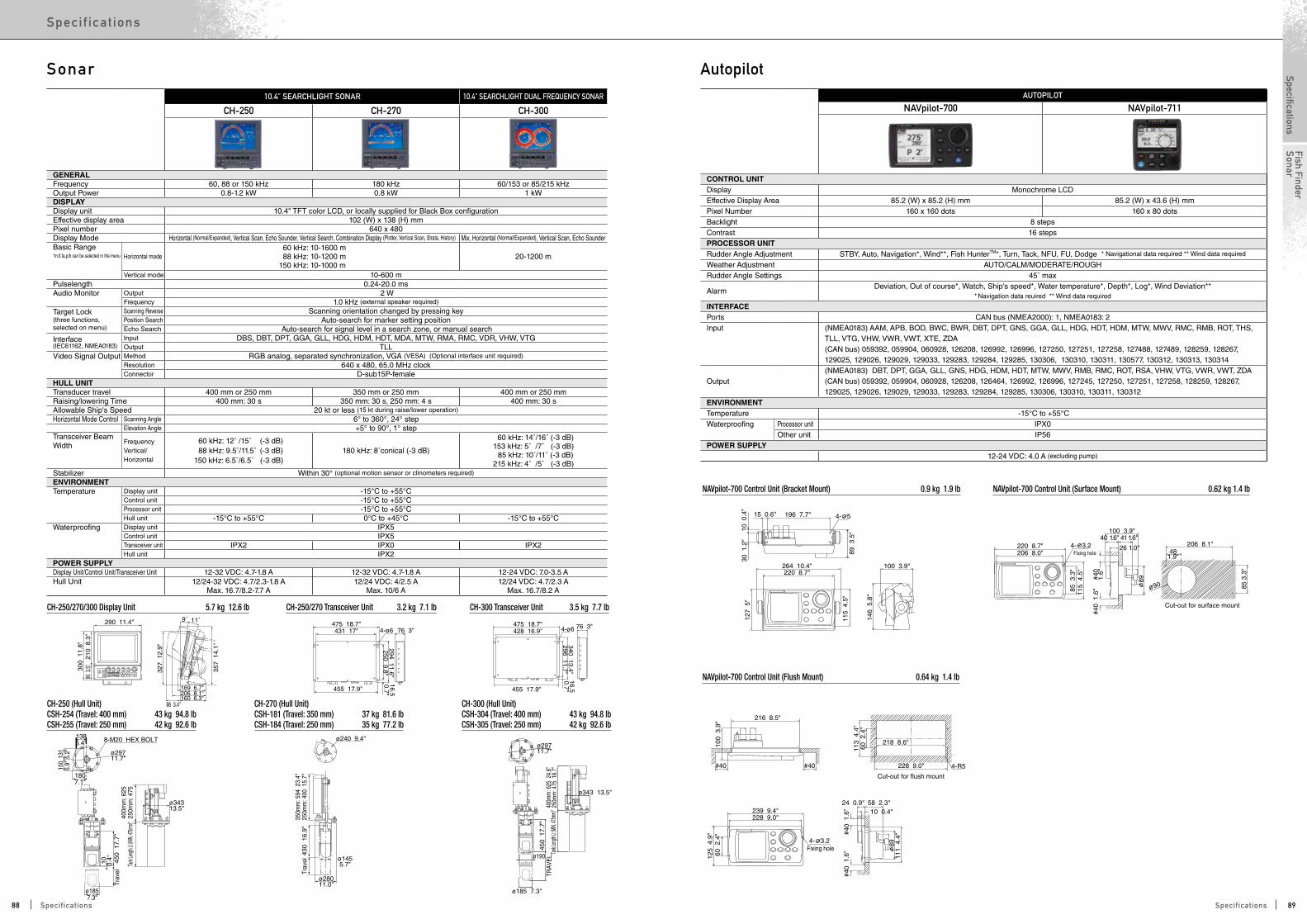
ø29711.7"
ø343 13.5"
ø190
ø185 7.3"
1807.1"
ø1857.3"
ø29711.7"
ø1455.7"
ø28011.0"
ø34313.5"
ø240 9.4"8-M20 HEX BOLT1385.4"
131
5.2"
150
5.9"
Trav
el
10 0.4" 45
0 1
7.7"
Tank
Length
Lt (M
IN, 47
5mm)
"40
0mm
: 625
250m
m: 4
75
Trav
el43
0 1
6.9"
350m
m: 5
94 2
3.4"
250m
m: 4
00 1
5.7"
Tank
Length
Lt (M
IN, 47
5mm)
"TR
AVEL
450
17.
7"40
0mm
: 625
24.
6"25
0mm
: 475
18.
7"
ø29711.7"
ø343 13.5"
ø190
ø185 7.3"
1807.1"
ø1857.3"
ø29711.7"
ø1455.7"
ø28011.0"
ø34313.5"
ø240 9.4"8-M20 HEX BOLT1385.4"
131
5.2"
150
5.9"
Trav
el
10 0.4" 45
0 1
7.7"
Tank
Length
Lt (M
IN, 47
5mm)
"40
0mm
: 625
250m
m: 4
75
Trav
el43
0 1
6.9"
350m
m: 5
94 2
3.4"
250m
m: 4
00 1
5.7"
Tank
Length
Lt (M
IN, 47
5mm)
"TR
AVEL
450
17.
7"40
0mm
: 625
24.
6"25
0mm
: 475
18.
7"
130 5.1"75 3.0"
58 2.3"22 0.9"
68 2.7"
8 0.3"
290 11.4"
169 6.7"206 8.1"160 6.3"
86 3.4"
9˚ 11˚
6 0.2"
22.5 0.9" 26.5 1.0"14 0.6" ø19
64 2
.5"
55 2
.2"
52.5
2.0
"
68 2
.7"
300
11.
8"90
3.5"
16.50.7"
294 11.6"250 9.8"
4-ø6 76 3"475 18.7"431 17"
455 17.9"
210
8.3
"
327
12.
9"
357
14.
1"28
1.1
"44
1.7
"
30 1
.2"
340 13.4"296 11.7"
16.50.7"
76 3"4-ø6475 18.7"428 16.9"
455 17.9"
120
4.7
"
24 0.9"
68 2.7"
28 1
.1"
128
5.0
"
33 1
.3"
CH-250 (Hull Unit)CSH-254 (Travel: 400 mm) 43 kg 94.8 lbCSH-255 (Travel: 250 mm) 42 kg 92.6 lb
CH-270 (Hull Unit)CSH-181 (Travel: 350 mm) 37 kg 81.6 lbCSH-184 (Travel: 250 mm) 35 kg 77.2 lb
CH-300 (Hull Unit)CSH-304 (Travel: 400 mm) 43 kg 94.8 lbCSH-305 (Travel: 250 mm) 42 kg 92.6 lb
130 5.1"75 3.0"
58 2.3"22 0.9"
68 2.7"
8 0.3"
290 11.4"
169 6.7"206 8.1"160 6.3"
86 3.4"
9˚ 11˚
6 0.2"
22.5 0.9" 26.5 1.0"14 0.6" ø19
64 2
.5"
55 2
.2"
52.5
2.0
"
68 2
.7"
300
11.
8"90
3.5"
16.50.7"
294 11.6"250 9.8"
4-ø6 76 3"475 18.7"431 17"
455 17.9"
210
8.3
"
327
12.
9"
357
14.
1"28
1.1
"44
1.7
"
30 1
.2"
340 13.4"296 11.7"
16.50.7"
76 3"4-ø6475 18.7"428 16.9"
455 17.9"
120
4.7
"
24 0.9"
68 2.7"
28 1
.1"
128
5.0
"
33 1
.3"
10.4" SEARCHLIGHT SONAR 10.4" SEARCHLIGHT DUAL FREQUENCY SONAR
CH-250 CH-270 CH-300
GENERALFrequency 60, 88 or 150 kHz 180 kHz 60/153 or 85/215 kHzOutput Power 0.8-1.2 kW 0.8 kW 1 kWDISPLAYDisplay unit 10.4" TFT color LCD, or locally supplied for Black Box configurationEffective display area 102 (W) x 138 (H) mmPixel number 640 x 480Display Mode Horizontal (Normal/Expanded), Vertical Scan, Echo Sounder, Vertical Search, Combination Display (Plotter, Vertical Scan, Strata, History) Mix, Horizontal (Normal/Expanded), Vertical Scan, Echo SounderBasic Range
Horizontal mode 60 kHz: 10-1600 m 88 kHz: 10-1200 m150 kHz: 10-1000 m
20-1200 m*m,ft,fa,p/b can be selected in the menu
Vertical mode 10-600 mPulselength 0.24-20.0 msAudio Monitor Output 2 W
Frequency 1.0 kHz (external speaker required)
Target Lock Scanning Reverse Scanning orientation changed by pressing key(three functions, Position Search Auto-search for marker setting positionselected on menu) Echo Search Auto-search for signal level in a search zone, or manual searchInterface Input DBS, DBT, DPT, GGA, GLL, HDG, HDM, HDT, MDA, MTW, RMA, RMC, VDR, VHW, VTG(IEC61162, NMEA0183) Output TLLVideo Signal Output Method RGB analog, separated synchronization, VGA (VESA) (Optional interface unit required)
Resolution 640 x 480, 65.0 MHz clockConnector D-sub15P-female
HULL UNITTransducer travel 400 mm or 250 mm 350 mm or 250 mm 400 mm or 250 mmRaising/lowering Time 400 mm: 30 s 350 mm: 30 s, 250 mm: 4 s 400 mm: 30 sAllowable Ship's Speed 20 kt or less (15 kt during raise/lower operation)
Horizontal Mode Control Scanning Angle 6° to 360°, 24° stepElevation Angle +5° to 90°, 1° step
Transceiver BeamWidth Frequency
Vertical/Horizontal
60 kHz: 12˚ /15˚ (-3 dB) 88 kHz: 9.5˚/11.5˚ (-3 dB)150 kHz: 6.5˚/6.5˚ (-3 dB)
180 kHz: 8˚conical (-3 dB)
60 kHz: 14˚/16˚ (-3 dB)153 kHz: 5˚ /7˚ (-3 dB) 85 kHz: 10˚/11˚ (-3 dB)215 kHz: 4˚ /5˚ (-3 dB)
Stabilizer Within 30° (optional motion sensor or clinometers required)
ENVIRONMENTTemperature Display unit -15°C to +55°C
Control unit -15°C to +55°CProcessor unit -15°C to +55°CHull unit -15°C to +55°C 0°C to +45°C -15°C to +55°C
Waterproofing Display unit IPX5Control unit IPX5Transceiver unit IPX2 IPX0 IPX2Hull unit IPX2
POWER SUPPLYDisplay Unit/Control Unit/Transceiver Unit 12-32 VDC: 4.7-1.8 A 12-32 VDC: 4.7-1.8 A 12-24 VDC: 7.0-3.5 AHull Unit 12/24-32 VDC: 4.7/2.3-1.8 A
Max. 16.7/8.2-7.7 A12/24 VDC: 4/2.5 A
Max. 10/6 A12/24 VDC: 4.7/2.3 A
Max. 16.7/8.2 A
Sonar
CH-250/270/300 Display Unit 5.7 kg 12.6 lb CH-300 Transceiver Unit 3.5 kg 7.7 lbCH-250/270 Transceiver Unit 3.2 kg 7.1 lb
196 7.7"15 0.6"
264 10.4"220 8.7"
127
5"
115
4.5
"89
3.5
"
30 1
.2"
10 0
.4"
146
5.8
"
100 3.9"
4- 5
85 3
.3"
115
4.5
"
Fixing hole220 8.7"206 8.0"
40 1.6"
26 1.0"
41 1.6"
#40
1.6
"#4
01.
6"
100 3.9"
Cut-out for surface mount
206 8.1"
85 3
.3"
481.9"
Cut-out for flush mount
Fixing hole
239 9.4"
111
4.4
"
24 0.9"
228 9.0"
10 0.4"58 2.3"
#40
1.6
"#4
0 1
.6"
228 9.0"
60 2
.4"
125
4.9
"216 8.5"
#40 #40
100
3.9
"
113
4.4
"60
2.4
"
4-R5
218 8.6"
86 3.4"15 0.6"
150 5.9"110 4.3"
127
5"
115
4.5
"89
3.5
"
30 1
.2"
10 0
.4"
144
5.7
"
100 3.9"
4- 5
110 4.3"80 3.1"
40 1.6"26 1.0"
41 1.6"
115
4.5
"
100 3.9"
60 2.4"
4- 3.2 2-M3
2- 3.5
94 3
.7"
51.5
2"
45 1
.8"
44.6
1.8
"
#30
1.2
" 90
80 3.1"
96 3.8"
45 1
.8"
44.6
1.8
"51.5
2.0
"94
3.7
"
Cut-out for surface mount
129 5.1"
118 4.6"
125
4.9
"
4- 3.2
60 2
.4"
24 0.9"10 0.4"
58 2.3"100 3.9"
111
4.4
"
60 2
.4"
113
4.4
"
Cut-out for flush mount4-R5
108 4.3"
118 4.6"
110 4.3"
52 2"
230
9.1
"
53 2.1"
66 2.6"50.5 2"
3.50.1"
4- 3.2
89
90
894- 3.2
89
4- 5
89
255 10.0"
90 3.5"
259
10.
2"21
9 8
.6"
196 7.7"15 0.6"
264 10.4"220 8.7"
127
5"
115
4.5
"89
3.5
"
30 1
.2"
10 0
.4"
146
5.8
"
100 3.9"
4- 5
85 3
.3"
115
4.5
"
Fixing hole220 8.7"206 8.0"
40 1.6"
26 1.0"
41 1.6"
#40
1.6
"#4
01.
6"
100 3.9"
Cut-out for surface mount
206 8.1"
85 3
.3"
481.9"
Cut-out for flush mount
Fixing hole
239 9.4"
111
4.4
"
24 0.9"
228 9.0"
10 0.4"58 2.3"
#40
1.6
"#4
0 1
.6"
228 9.0"
60 2
.4"
125
4.9
"
216 8.5"
#40 #40
100
3.9
"
113
4.4
"60
2.4
"
4-R5
218 8.6"
86 3.4"15 0.6"
150 5.9"110 4.3"
127
5"
115
4.5
"89
3.5
"
30 1
.2"
10 0
.4"
144
5.7
"
100 3.9"
4- 5
110 4.3"80 3.1"
40 1.6"26 1.0"
41 1.6"
115
4.5
"
100 3.9"
60 2.4"
4- 3.2 2-M3
2- 3.5
94 3
.7"
51.5
2"
45 1
.8"
44.6
1.8
"
#30
1.2
" 90
80 3.1"
96 3.8"
45 1
.8"
44.6
1.8
"51.5
2.0
"94
3.7
"
Cut-out for surface mount
129 5.1"
118 4.6"
125
4.9
"
4- 3.2
60 2
.4"
24 0.9"10 0.4"
58 2.3"100 3.9"
111
4.4
"
60 2
.4"
113
4.4
"
Cut-out for flush mount4-R5
108 4.3"
118 4.6"
110 4.3"
52 2"
230
9.1
"
53 2.1"
66 2.6"50.5 2"
3.50.1"
4- 3.2
89
90
894- 3.2
89
4- 5
89
255 10.0"
90 3.5"
259
10.
2"21
9 8
.6"
NAVpilot-700 Control Unit (Bracket Mount) 0.9 kg 1.9 lb NAVpilot-700 Control Unit (Surface Mount) 0.62 kg 1.4 lb
NAVpilot-700 Control Unit (Flush Mount) 0.64 kg 1.4 lb
AUTOPILOT
NAVpilot-700 NAVpilot-711
CONTROL UNITDisplay Monochrome LCDEffective Display Area 85.2 (W) x 85.2 (H) mm 85.2 (W) x 43.6 (H) mmPixel Number 160 x 160 dots 160 x 80 dotsBacklight 8 stepsContrast 16 stepsPROCESSOR UNITRudder Angle Adjustment STBY, Auto, Navigation*, Wind**, Fish HunterTM*, Turn, Tack, NFU, FU, Dodge * Navigational data required ** Wind data required
Weather Adjustment AUTO/CALM/MODERATE/ROUGHRudder Angle Settings 45˚ max
AlarmDeviation, Out of course*, Watch, Ship's speed*, Water temperature*, Depth*, Log*, Wind Deviation**
* Navigation data reuired ** Wind data required
INTERFACEPorts CAN bus (NMEA2000): 1, NMEA0183: 2Input (NMEA0183) AAM, APB, BOD, BWC, BWR, DBT, DPT, GNS, GGA, GLL, HDG, HDT, HDM, MTW, MWV, RMC, RMB, ROT, THS,
TLL, VTG, VHW, VWR, VWT, XTE, ZDA(CAN bus) 059392, 059904, 060928, 126208, 126992, 126996, 127250, 127251, 127258, 127488, 127489, 128259, 128267, 129025, 129026, 129029, 129033, 129283, 129284, 129285, 130306, 130310, 130311, 130577, 130312, 130313, 130314
Output(NMEA0183) DBT, DPT, GGA, GLL, GNS, HDG, HDM, HDT, MTW, MWV, RMB, RMC, ROT, RSA, VHW, VTG, VWR, VWT, ZDA(CAN bus) 059392, 059904, 060928, 126208, 126464, 126992, 126996, 127245, 127250, 127251, 127258, 128259, 128267, 129025, 129026, 129029, 129033, 129283, 129284, 129285, 130306, 130310, 130311, 130312
ENVIRONMENTTemperature -15°C to +55°CWaterproofing Processor unit IPX0
Other unit IP56POWER SUPPLY
12-24 VDC: 4.0 A (excluding pump)
Autopilot
88 89Specifications Specifications
SpecificationsSpec if ic at ions
Fish Finder S
onar

196 7.7"15 0.6"
264 10.4"220 8.7"
127
5"
115
4.5
"89
3.5
"
30 1
.2"
10 0
.4"
146
5.8
"
100 3.9"
4- 5
85 3
.3"
115
4.5
"
Fixing hole220 8.7"206 8.0"
40 1.6"
26 1.0"
41 1.6"
#40
1.6
"#4
01.
6"
100 3.9"
Cut-out for surface mount
206 8.1"
85 3
.3"
481.9"
Cut-out for flush mount
Fixing hole
239 9.4"
111
4.4
"
24 0.9"
228 9.0"
10 0.4"58 2.3"
#40
1.6
"#4
0 1
.6"
228 9.0"
60 2
.4"
125
4.9
"
216 8.5"
#40 #40
100
3.9
"
113
4.4
"60
2.4
"
4-R5
218 8.6"
86 3.4"15 0.6"
150 5.9"110 4.3"
127
5"
115
4.5
"89
3.5
"
30 1
.2"
10 0
.4"
144
5.7
"
100 3.9"
4- 5
110 4.3"80 3.1"
40 1.6"26 1.0"
41 1.6"
115
4.5
"
100 3.9"
60 2.4"
4- 3.2 2-M3
2- 3.5
94 3
.7"
51.5
2"
45 1
.8"
44.6
1.8
"
#30
1.2
" 90
80 3.1"
96 3.8"
45 1
.8"
44.6
1.8
"51.5
2.0
"94
3.7
"
Cut-out for surface mount
129 5.1"
118 4.6"
125
4.9
"
4- 3.2
60 2
.4"
24 0.9"10 0.4"
58 2.3"100 3.9"
111
4.4
"
60 2
.4"
113
4.4
"
Cut-out for flush mount4-R5
108 4.3"
118 4.6"
110 4.3"
52 2"
230
9.1
"
53 2.1"
66 2.6"50.5 2"
3.50.1"
4- 3.2
89
90
894- 3.2
89
4- 5
89
255 10.0"
90 3.5"
259
10.
2"21
9 8
.6"
196 7.7"15 0.6"
264 10.4"220 8.7"
127
5"
115
4.5
"89
3.5
"
30 1
.2"
10 0
.4"
146
5.8
"
100 3.9"
4- 5
85 3
.3"
115
4.5
"
Fixing hole220 8.7"206 8.0"
40 1.6"
26 1.0"
41 1.6"
#40
1.6
"#4
01.
6"
100 3.9"
Cut-out for surface mount
206 8.1"
85 3
.3"
481.9"
Cut-out for flush mount
Fixing hole
239 9.4"
111
4.4
"
24 0.9"
228 9.0"
10 0.4"58 2.3"
#40
1.6
"#4
0 1
.6"
228 9.0"
60 2
.4"
125
4.9
"
216 8.5"
#40 #40
100
3.9
"
113
4.4
"60
2.4
"
4-R5
218 8.6"
86 3.4"15 0.6"
150 5.9"110 4.3"
127
5"
115
4.5
"89
3.5
"
30 1
.2"
10 0
.4"
144
5.7
"
100 3.9"
4- 5
110 4.3"80 3.1"
40 1.6"26 1.0"
41 1.6"
115
4.5
"
100 3.9"
60 2.4"
4- 3.2 2-M3
2- 3.5
94 3
.7"
51.5
2"
45 1
.8"
44.6
1.8
"
#30
1.2
" 90
80 3.1"
96 3.8"
45 1
.8"
44.6
1.8
"51.5
2.0
"94
3.7
"
Cut-out for surface mount
129 5.1"
118 4.6"12
5 4
.9"
4- 3.2
60 2
.4"
24 0.9"10 0.4"
58 2.3"100 3.9"
111
4.4
"
60 2
.4"
113
4.4
"
Cut-out for flush mount4-R5
108 4.3"
118 4.6"
110 4.3"
52 2"
230
9.1
"
53 2.1"
66 2.6"50.5 2"
3.50.1"
4- 3.2
89
90
894- 3.2
89
4- 5
89
255 10.0"
90 3.5"
259
10.
2"21
9 8
.6"
196 7.7"15 0.6"
264 10.4"220 8.7"
127
5"
115
4.5
"89
3.5
"
30 1
.2"
10 0
.4"
146
5.8
"
100 3.9"
4- 5
85 3
.3"
115
4.5
"
Fixing hole220 8.7"206 8.0"
40 1.6"
26 1.0"
41 1.6"
#40
1.6
"#4
01.
6"
100 3.9"
Cut-out for surface mount
206 8.1"
85 3
.3"
481.9"
Cut-out for flush mount
Fixing hole
239 9.4"
111
4.4
"
24 0.9"
228 9.0"
10 0.4"58 2.3"
#40
1.6
"#4
0 1
.6"
228 9.0"
60 2
.4"
125
4.9
"
216 8.5"
#40 #40
100
3.9
"
113
4.4
"60
2.4
"
4-R5
218 8.6"
86 3.4"15 0.6"
150 5.9"110 4.3"
127
5"
115
4.5
"89
3.5
"
30 1
.2"
10 0
.4"
144
5.7
"
100 3.9"
4- 5
110 4.3"80 3.1"
40 1.6"26 1.0"
41 1.6"
115
4.5
"
100 3.9"
60 2.4"
4- 3.2 2-M3
2- 3.5
94 3
.7"
51.5
2"
45 1
.8"
44.6
1.8
"
#30
1.2
" 90
80 3.1"
96 3.8"
45 1
.8"
44.6
1.8
"51.5
2.0
"94
3.7
"
Cut-out for surface mount
129 5.1"
118 4.6"
125
4.9
"
4- 3.2
60 2
.4"
24 0.9"10 0.4"
58 2.3"100 3.9"
111
4.4
"
60 2
.4"
113
4.4
"
Cut-out for flush mount4-R5
108 4.3"
118 4.6"
110 4.3"
52 2"
230
9.1
"
53 2.1"
66 2.6"50.5 2"
3.50.1"
4- 3.2
89
90
894- 3.2
89
4- 5
89
255 10.0"
90 3.5"
259
10.
2"21
9 8
.6"
196 7.7"15 0.6"
264 10.4"220 8.7"
127
5"
115
4.5
"89
3.5
"
30 1
.2"
10 0
.4"
146
5.8
"
100 3.9"
4- 5
85 3
.3"
115
4.5
"
Fixing hole220 8.7"206 8.0"
40 1.6"
26 1.0"
41 1.6"#4
0 1
.6"
#40
1.6"
100 3.9"
Cut-out for surface mount
206 8.1"
85 3
.3"
481.9"
Cut-out for flush mount
Fixing hole
239 9.4"
111
4.4
"
24 0.9"
228 9.0"
10 0.4"58 2.3"
#40
1.6
"#4
0 1
.6"
228 9.0"
60 2
.4"
125
4.9
"
216 8.5"
#40 #40
100
3.9
"
113
4.4
"60
2.4
"
4-R5
218 8.6"
86 3.4"15 0.6"
150 5.9"110 4.3"
127
5"
115
4.5
"89
3.5
"
30 1
.2"
10 0
.4"
144
5.7
"
100 3.9"
4- 5
110 4.3"80 3.1"
40 1.6"26 1.0"
41 1.6"
115
4.5
"
100 3.9"
60 2.4"
4- 3.2 2-M3
2- 3.5
94 3
.7"
51.5
2"
45 1
.8"
44.6
1.8
"
#30
1.2
" 90
80 3.1"
96 3.8"
45 1
.8"
44.6
1.8
"51.5
2.0
"94
3.7
"
Cut-out for surface mount
129 5.1"
118 4.6"
125
4.9
"4- 3.2
60 2
.4"
24 0.9"10 0.4"
58 2.3"100 3.9"
111
4.4
"
60 2
.4"
113
4.4
"
Cut-out for flush mount4-R5
108 4.3"
118 4.6"
110 4.3"
52 2"
230
9.1
"
53 2.1"
66 2.6"50.5 2"
3.50.1"
4- 3.2
89
90
894- 3.2
89
4- 5
89
255 10.0"
90 3.5"
259
10.
2"21
9 8
.6"
NAVpilot-711 Control Unit (Bracket Mount) 0.52 kg 1.15 lb NAVpilot-711 Control Unit (Surface Mount) 0.34 kg 0.75 lb
NAVpilot-711 Control Unit (Flush Mount) 0.35 kg 0.77 lb Processor Unit 1.9 kg 4.2 lb
AutopilotWIND CH WIND DIGITAL MULTI COURSE PILOT RUDDER MULTI XL
FI-501 FI-502 FI-503 FI-504 FI-505 FI-506 FI-507
Port CAN bus CAN bus CAN bus CAN bus CAN bus CAN bus CAN busWIND×1 WIND×1
DepthCurrent depth - - - -Shallow alarm threshold - - - -Deep alarm threshold - - - -Anchor shallow alarm threshold - - - -Anchor deep alarm threshold - - - -SpeedSTW (Speed through water) - - - -SOG (Speed over ground) - - - -Maximum speed - - - -Average speed - - - -VMG to windward - -Log (0 – 99999nm) - - - -Trip (0.01 – 999nm) - - - -WindApparent wind speed - -Apparent wind angle - -True wind speed - -True wind angle - -Beaufort scale angle - -Maximum wind speed - -Maximum true wind speed alarm - -Low true wind speed alarm - -High apparent wind angle alarm - -Low apparent wind angle alarm - -Ground wind direction - - - - -HeadingHeading - - - -Average heading - - - -Locked heading - - - -Heading on next tack - - -COG (Course over ground) - - - -CMG (Course made good) - - - - -DMG (Distance made good) - - - - -ROT (Rate of turn) - - - - - -NavigationBearing to waypoint - - - - -Distance to waypoint - - - - -Cross track error and error steer bar - - - - -Target waypoint name - - - - -Target waypoint number - - - - -Latitude - - - - -Longitude - - - - -GPS satellite status - - - - -Roll - - - - -Pitch - - - - -SOG - - - -EnvironmentBattery voltage - - - -Battery voltage alarm - - - - -Date and Time - - - - -Water temperature (two decimal points) - - - -Air temperature - - - -Pressure - - - -Humidity - - - -Wind chill temperature - - - -Dew point - - - -TimerCount up timer - - - -Count down timer - - - -AutopilotRudder angle - - - -EngineFuel information - - - - -Fuel consumption - - - - -Engine RPM - - - - -
Instruments
90 91Specifications Specifications
SpecificationsSpec if ic at ions
Autopilot
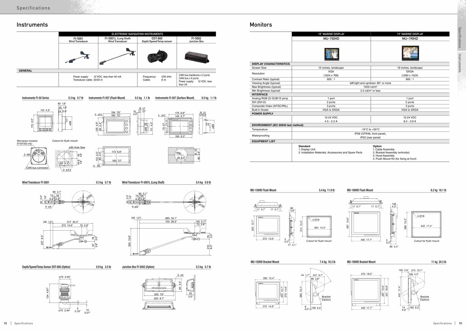
CAN bus connector
Wind sensor connector(FI-501/502 only)
115
4.5
"
110 4.3"
49 1.9"
26 1.0"24 0.9"
ø89
2- ø3.5
45 1.8"
44.6
1.8"
60 2.4"
Cutout for flush mount
ø90 Hole Saw
517 20.4"(30 1.2")
237
9.3
"
76 3.0"
97 3.8"
372 14.6" 70 2.8"
ø290
ø1304- ø5
7.50.3"
552.2"
40 1
.6"
50 2
.0"
80 3.1"
2- ø5
522.0"
200 7.9"
220 8.7"
84 3
.3"
ø75 2.94"
124
4.8
7"
140.57"
50.19"
ø75 2.94"
2- M3
(30 1.2") 865 34.1"
ø290 7.50.3"
552.2"
80 3.1"
50 2
.0"
40
1.6
"
350
13.
8"
76 3.0"
21
08.
3"
720 28.3" 145 5.7" 70 2.8"
4- ø5ø130
125
4.9
"
111
4.3
"
ø89
113
4.4
"60
2.4
"60
2.4
"
194 7.6"
39 1.5"
173 6.8"
183 7.2"
17 0.7"100.4"4- ø3.5 183 7.2"
4- R511
5 4
.5"
ø89
42.5
1.7"
51.5
2.0"
175 6.9" 230.9"
261.0"4- ø3.5 145 5.7"
160 6.3"
90 3
.5"
45 1
.8"
60 2.4"
ø90
1094.3"
450 17.7"
86 3.4"
17 0.7"17 0.7"
50.2"
397
15.
6"
389
15.
3"
442 17.4"
4-Ø18
372 14.6"
77 3.1"
17 0.7" 963.8"17 0.7"
50.2"
322
12.
7"
314
12.
4"
364 14.3"
4-Ø18
Cutout for ush mountCutout for ush mount
372 14.6"
392 15.4"
322
12.
7"
370
14.
6"
96 3.8"
44 1.7" 247 9.7"
158 6.2"60.2"
383
15.
1"
Bracket(Option)
450 17.7"
470 18.5" 109 4.3"
100 3.9" 273 10.7"
160 6.3"140.6"
397
15.
6"
427
16.
8"
441
17.
4"
Bracket(Option)
ELECTRONIC NAVIGATION INSTRUMENTS
FI-5001Wind Transducer
FI-5001L (Long Shaft)Wind Transducer
DST-800Depth/Speed/Temp sensor
FI-5002Junction Box
GENERAL
Power supply: 12 VDC, less than 40 mA Transducer cable: 30/50 m
Frequency: 235 kHzCable: 6 m
CAN bus backbone x 2 portsCAN bus x 6 portsPower supply: 12 VDC, less than 2A
Depth/Speed/Temp Sensor DST-800 (Option) 0.9 kg 2.0 lb Junction Box FI-5002 (Option) 0.3 kg 0.7 lb
Instruments FI-50 Series 0.3 kg 0.7 lb Instruments FI-507 (Flush Mount) 0.5 kg 1.1 lb Instruments FI-507 (Surface Mount) 0.5 kg 1.1 lb
Wind Transducer FI-5001 0.3 kg 0.7 lb Wind Transducer FI-5001L (Long Shaft) 0.4 kg 0.9 lb
Instruments15" MARINE DISPLAY 19" MARINE DISPLAY
MU-150HD MU-190HD
DISPLAY CHARACTERISTICSScreen Size 15 inches, landscape 19 inches, landscape
ResolutionXGA
(1024 x 768)SXGA
(1280 x 1024)Contrast Ratio (typical) 600 : 1 900 : 1Viewing Angle (typical) left/right and up/down: 80° or moreMax Brightness (typical) 1000 cd/m2
Min Brightness (typical) 0.2 cd/m2 or lessINTERFACEAnalog RGB (D-SUB/15 pins) 1 port 1 portDVI (DVI-D) 2 ports 2 portsComposite Video (NTSC/PAL) 3 ports 3 portsBuilt-in Scaler VGA to SXGA VGA to SXGAPOWER SUPPLY
12-24 VDC4.5 - 2.2 A
12-24 VDC8.4 - 3.9 A
ENVIRONMENT (IEC 60945 test method)
Temperature -15°C to +55°C
WaterproofingIP56 (CFR46, front panel),
IP22 (rear panel)EQUIPMENT LIST
Standard1. Display Unit2. Installation Materials, Accessories and Spare Parts
Option1. Cable Assembly2. Bracket Assembly (w/knobs)3. Hood Assembly4. Flush Mount Kit (for fixing at front)
MU-150HD Bracket Mount 7.4 kg 16.3 lb MU-190HD Bracket Mount 11 kg 24.3 lb
MU-150HD Flush Mount 5.4 kg 11.9 lb MU-190HD Flush Mount 8.2 kg 18.1 lb
Monitors
92 93Specifications Specifications
SpecificationsSpec if ic at ions
Instruments

450 17.7"
110 4.3"
389
15.
3"39
7 1
5.6"
448 17.6"
489 19.3"4-Ø18
4-R9
Cutout for ush mount
465
18.
3"
365 14.4"
109 4.3"
456
18.
0"
356 14.0"
4-Ø18
Cutout for ush mount
471
18.
5"
554 21.8"592 23.3"
112 4.4"
484.
9 1
9"
553 21.8"
Cutout for ush mount
380 15"
450 17.7"
470 18.5"
109 4.3"100 3.9"217 8.5" 273 10.7"
160 6.3"80 3.1"14
0.6"
397
15.
6"42
7 1
6.8"
441
17.
4"56
3 2
2"
433
17"
(option)Hood
Bracket(option)
(option)Hood
383 15.1"278 10.9"
241 9.5"
167 6.6"16 0.6"
109 4.3"
495
19.
5"
499
19.
6"51
3 2
0.2"
632
24.
9"
Bracket(Option)
590 23.2"514 20.2"
170 6.7"287 11.3"
236 9.3"112 4.4"
328 12.9"134 5.3"
484.
7 1
9.1"
460
18.
1" 35˚
(option)Hood
Bracket(option)
4-R9
MU-190 Bracket Mount 11 kg 24.3 lb MU-231 Bracket Mount 18.9 kg 41.7 lb
MU-190 Flush Mount 8.8 kg 19.4 lb MU-231 Flush Mount 12.8 kg 28.2 lb
110
4.3
"
61 2.4"
130 5.1"
12 0.5"
145 5.7"
127 5"
4-Ø3.5
125
4.9
"
110
4.3
"
GP-33 (Flush Mount) 0.6 kg 1.3 lb
R12
145
5.7
"
125
4.9
"
153
6.0
"
91 3.5"63 2.5"146 5.7"
176 6.9" 70 2.8"21 0.8"30145 5.7"
GP-33 0.9 kg 2.0 lb
4-Ø6
19" MARINE DISPLAY 23.1" MARINE DISPLAY
MU-190 MU-231
DISPLAY CHARACTERISTICSScreen Size 19 inches, landscape 23.1 inches, landscape
ResolutionSXGA
(1280 x 1024)UXGA
(1600 x 1200)Contrast Ratio (typical) 900 : 1 600 : 1Viewing Angle (typical) left/right and up/down: 80° or moreMax Brightness (typical) 450 cd/m2 400 cd/m2
Min Brightness (typical) 0.2 cd/m2 or lessINTERFACEAnalog RGB (D-SUB/15 pins) 1 port 1 portDVI (DVI-D) 2 ports 2 portsComposite Video (NTSC/PAL) 1 port 1 portBuilt-in Scaler VGA to SXGA VGA to UXGAPOWER SUPPLY
100-230 VAC0.7 - 0.4A
100-230 VAC1.0 - 0.6 A
ENVIRONMENT (IEC 60945 test method)
Temperature -15°C to +55°C
Waterproofing IP22EQUIPMENT LIST
Standard1. Display Unit2. Installation Materials, Accessories and Spare PartsOption1. Cable Assembly2. Bracket Assembly (w/knobs for MU-190)3. Hood Assembly4. Dust Cover5. Flush Mount Kit (for fixing at rear)
MonitorsREMOTE DISPLAY
RD-33
GENERALScreen Size 4.3" color LCDEffective display area 95.04 (W) x 53.85 (H) mmPixel number 480 x 272Display style 1/2/3/4 data, Highway, Graph, Alphanumeric, 6-way splitDisplay mode Nav data, Highway, Heading, Speed, Depth Graph, Graph, Layline, STW, SOG, RPM, Rudder, Wind angle, Airtemp, Humidity, Roll
pitch, ROT, Battery, Engine temp, Oil pressure, Oil temperature, Coolant pressure, Trim, WatchINTERFACEPorts NMEA0183 (ver. 2.0, 3.0): 1, CAN bus: 2 (male/female)
Input(NMEA0183)APB, BWR, BWC, CUR, DBT, DPT, DBS, DBK, GLL, GGA, GNS, GTD, GLC, HDT, HDG, HDM, MTW, MDA, MWV, RSA, RMA, RMB, RMC, ROT, VHW, VBW, VTG, VWT, VWR, VDR, XTE, ZTG, ZDA, PFEC, Gpatt (Pitch & Roll) (CAN bus)059904, 060928, 126208, 126992, 127245, 127250, 127257, 127258, 127488, 127489, 127497, 128259, 128267, 128275, 129025, 129029, 129033, 130306, 130310, 130311, 130577
Output(NMEA0183)DPT, VHW, RMC, MWV, HDT, HDG, XTE, MTW, RSA, VTG(CAN bus)059392, 059904, 060928, 126208, 126464, 126996, 126992, 127245, 127250, 128259, 128267, 129026, 129029, 129283, 129284, 130306, 130311
ENVIRONMENTTemperature -15°C to +55°CWaterproofing IP56 Power Supply
15 VDC:LEN6 (CAN bus)12-24 VDC:0.2-0.1A (Non CAN bus)
RD-33 Display Unit (Flush Mount) 0.59 kg 1.3 lbRD-33 Display Unit (Bracket Mount) 0.7 kg 1.54 lb
Remote Display
94 95Specifications Specifications
SpecificationsSpec if ic at ions
Monitors
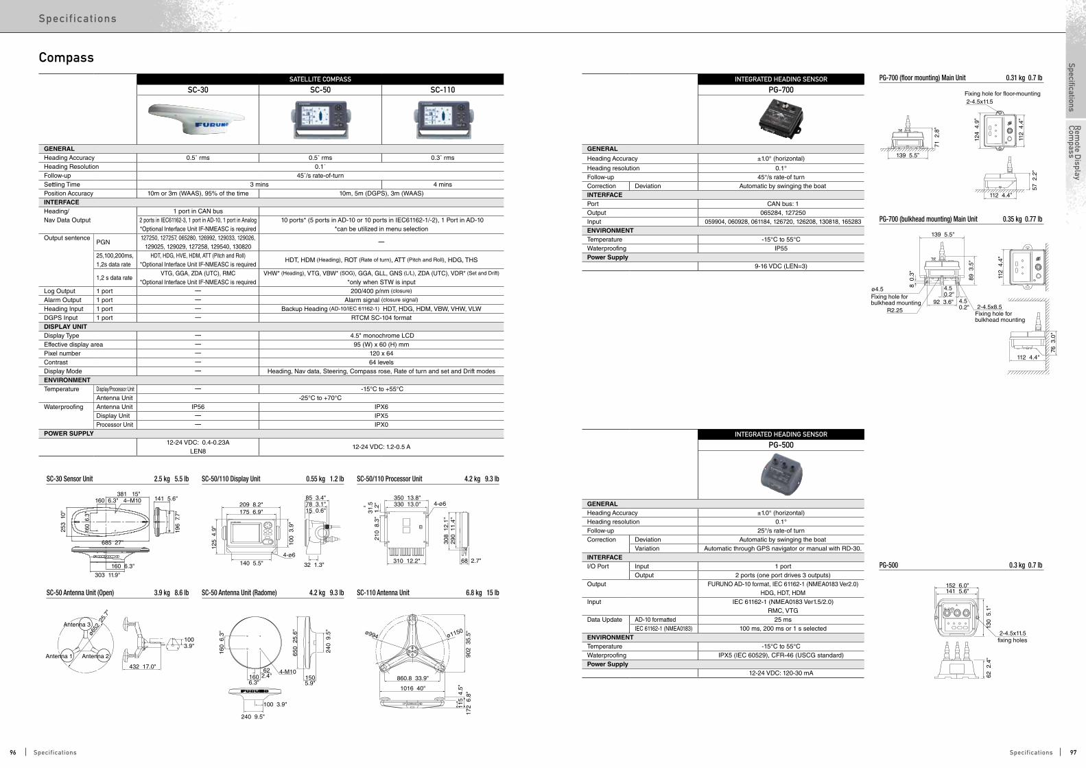
381 15"
303 11.9"
685 27"
160 6.3"
4–M10160 6.3" 141 5.6"
196
7.7
"
160
6.3
"
253
10"
432 17.0"
100 3.9"
240 9.5"
1003.9"
1606.3"
622.4" 150
5.9"
4-M10
209 8.2"175 6.9"
85 3.4"78 3.1"15 0.6"
350 13.8"330 13.0"
310 12.2" 68 2.7"32 1.3"140 5.5"
4-ø6
125
4.9
"
100
3.9
"
210
8.3
"
308
12.
1"29
0 1
1.4"
31.5
1.2"
160
6.3
"
650
25.
6"
240
9.5
"
172
6.8
"11
5 4
.5"
902
35.
5"ø1150ø994
Antenna 1
Antenna 3
Antenna 2
ø652
25.
7"
860.8 33.9"
1016 40"
4-ø6
139 5.5”
71 2
.8”
2-4.5x11.5Fixing hole for floor-mounting
112
4.4
”
112 4.4”
57 2
.2”
124
4.9
”
PG-700 (floor mounting)Main Unit0.35 kg 0.77 lb
112 4.4"
89 3
.5"
8 0
.3"
4.5 0.2"
4.5 0.2"
2-4.5x8.5R2.2592 3.6"
139 5.5"
ø4.5
76 3
.0"
PG-700 (bulkhead mounting)Main Unit0.35 kg 0.77 lb
Fixing hole for bulkhead mounting
Fixing hole for bulkhead mounting
112
4.4
"
PG-500/C-500 0.3 kg 0.7 lb
152 6.0"
2-4.5x11.5fixing holes
141 5.6"
130
5.1
"62
2.4
"
PG-700 (bulkhead mounting) Main Unit 0.35 kg 0.77 lb
SATELLITE COMPASS
SC-30 SC-50 SC-110
GENERALHeading Accuracy 0.5˚ rms 0.5˚ rms 0.3˚ rmsHeading Resolution 0.1˚Follow-up 45˚/s rate-of-turnSettling Time 3 mins 4 minsPosition Accuracy 10m or 3m (WAAS), 95% of the time 10m, 5m (DGPS), 3m (WAAS)INTERFACEHeading/Nav Data Output
1 port in CAN bus2 ports in IEC61162-3, 1 port in AD-10, 1 port in Analog*Optional Interface Unit IF-NMEASC is required
10 ports* (5 ports in AD-10 or 10 ports in IEC61162-1/-2), 1 Port in AD-10 *can be utilized in menu selection
Output sentencePGN
127250, 127257, 065280, 126992, 129033, 129026, 129025, 129029, 127258, 129540, 130820
----
25,100,200ms,1,2s data rate
HDT, HDG, HVE, HDM, ATT (Pitch and Roll)*Optional Interface Unit IF-NMEASC is required
HDT, HDM (Heading), ROT (Rate of turn), ATT (Pitch and Roll), HDG, THS
1,2 s data rateVTG, GGA, ZDA (UTC), RMC
*Optional Interface Unit IF-NMEASC is requiredVHW* (Heading), VTG, VBW* (SOG), GGA, GLL, GNS (L/L), ZDA (UTC), VDR* (Set and Drift)
*only when STW is inputLog Output 1 port ---- 200/400 p/nm (closure)
Alarm Output 1 port ---- Alarm signal (closure signal)
Heading Input 1 port ---- Backup Heading (AD-10/IEC 61162-1) HDT, HDG, HDM, VBW, VHW, VLWDGPS Input 1 port ---- RTCM SC-104 format DISPLAY UNITDisplay Type ---- 4.5" monochrome LCD Effective display area ---- 95 (W) x 60 (H) mm Pixel number ---- 120 x 64 Contrast ---- 64 levels Display Mode ---- Heading, Nav data, Steering, Compass rose, Rate of turn and set and Drift modes ENVIRONMENTTemperature Display/Processor Unit ---- -15°C to +55°C
Antenna Unit -25°C to +70°CWaterproofing Antenna Unit IP56 IPX6
Display Unit ---- IPX5 Processor Unit ---- IPX0
POWER SUPPLY12-24 VDC: 0.4-0.23A
LEN812-24 VDC: 1.2-0.5 A
SC-30 Sensor Unit 2.5 kg 5.5 lb SC-50/110 Display Unit 0.55 kg 1.2 lb SC-50/110 Processor Unit 4.2 kg 9.3 lb
SC-50 Antenna Unit (Open) 3.9 kg 8.6 lb SC-50 Antenna Unit (Radome) 4.2 kg 9.3 lb SC-110 Antenna Unit 6.8 kg 15 lb
CompassINTEGRATED HEADING SENSOR
PG-700
GENERAL
Heading Accuracy ±1.0° (horizontal)
Heading resolution 0.1°Follow-up 45°/s rate-of turnCorrection Deviation Automatic by swinging the boatINTERFACEPort CAN bus: 1Output 065284, 127250Input 059904, 060928, 061184, 126720, 126208, 130818, 165283ENVIRONMENTTemperature -15°C to 55°CWaterproofing IP55Power Supply
9-16 VDC (LEN=3)
PG-700 (floor mounting) Main Unit 0.31 kg 0.7 lb
INTEGRATED HEADING SENSOR
PG-500
GENERALHeading Accuracy ±1.0° (horizontal)Heading resolution 0.1°Follow-up 25°/s rate-of turnCorrection Deviation Automatic by swinging the boat
Variation Automatic through GPS navigator or manual with RD-30.INTERFACEI/O Port Input 1 port
Output 2 ports (one port drives 3 outputs)Output FURUNO AD-10 format, IEC 61162-1 (NMEA0183 Ver2.0)
HDG, HDT, HDMInput IEC 61162-1 (NMEA0183 Ver1.5/2.0)
RMC, VTGData Update AD-10 formatted 25 ms
IEC 61162-1 (NMEA0183) 100 ms, 200 ms or 1 s selectedENVIRONMENTTemperature -15°C to 55°CWaterproofing IPX5 (IEC 60529), CFR-46 (USCG standard)Power Supply
12-24 VDC: 120-30 mA
PG-500 0.3 kg 0.7 lb
96 97Specifications Specifications
SpecificationsSpec if ic at ions
Rem
ote Display
Compass
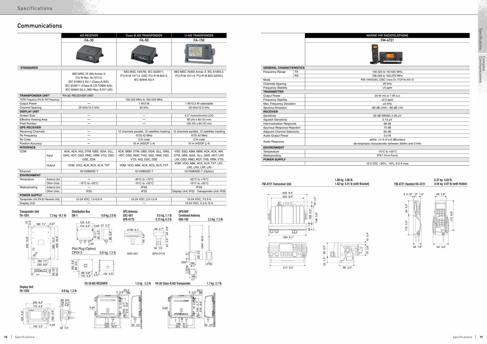
242 9.5"203 8.0"
230 9.1"
217 8.5"
148
5.8
"25
1.0
"
108
4.3
"40
1.6
"
90 3
.5"
70 2
.8"
10 0
.4"
90 3.5"
33 1
.3"
37 1.5" 66 2.6"
92 3.6"
173
6.8
"
4 0.16"
84 3
.3"
115
4.5
"
46 1.8"
100
3.9
"38
5 1
5.2"
420
16.
5"
250 9.8"
R3.
5
405
15.
9"7.
50.
3"
180 7.1"
180 7.1"
103
4.1
"
2-ø7
209 8.2"175 6.9"
85 3.4"78 3.1"15 0.6"
140 5.5"32 1.3"
100
3
.9"
125
4
.9"
4-ø6
125 4.9"57 2.2"113 4.5"
ø5
80 3
.2"
52 2
.1"
98 3
.9"
2-ø5
100
3.9
"88
3.5
"
98 3.9"110 4.3"
110 4.3"90.4"
69 2.7"
32 1.3"
24 0
.9"
61 2
.4"
ø156 6.1"
116
4.6
"
236
9.3
"
169 6.7"
ø155
196 7.7"
96 3.8"
ø50
1245
49.
0"
2-ø5
5 0.2"R2.5
R6
219
8.6
"14
4 5
.7"
12 0
.5"
44 1.7"
230 9.1"255 10.0" 90 3.5"
GSC-001 GPA-017S
2-ø5
R65 0.2"R2.5
219
8.6
"14
4 5
.7"
12 0
.5”
230 9.1"255 10.0"
90 3.5"
44 1.7"
Transponder UnitFA-1501 7.3 kg 16.1 lb
Distribution BoxDB-1 0.9 kg, 2.0 lb
Pilot Plug (Option)OP24-3 0.6 kg, 1.3 lb
GPS/VHF Combined AntennaGVA-100 3.3 kg 7.3 lb
FA-30 AIS RECEIVER 1.5 kg 3.3 lb FA-50 Class-B AIS Transponder 1.7 kg 3.7 lbDisplay UnitFA-1502 0.6 kg 1.3 lb
GPS AntennaGSC-001 0.5 kg, 1.1 lbGPA-017S 0.15 kg, 0.3 lb
AIS RECEIVER Class-B AIS TRANSPONDER U-AIS TRANSPONDER
FA-30 FA-50 FA-150
STANDARDS
IMO MSC.74 (69) Annex 3, ITU-R Rec. M.1371-2,
IEC 61993-2 Ed.1 (Class-A AIS), IEC 62287-1 (Class-B CS-TDMA AIS),IEC 60945 Ed.4, IMO Res. A.917 (22)
IMO MSC.140(76), IEC 62287-1, ITU-R M.1371-2, DSC ITU R M.825-3,
IEC 60945 Ed.4
IMO MSC.74(69) Annex 3, IEC 61993-2, ITU-R M.1371-4, ITU-R M.825-3(DSC)
TRANSPONDER UNIT* *FA-30: RECEIVER UNITTX/RX Frequency (FA-30: RX Frequency) 156.025 MHz to 162.025 MHzOutput Power ---- 1 W/2 W 1 W/12.5 W selectableChannel Spacing 25 kHz/12.5 kHz 25 kHz 25 kHz/12.5 kHzDISPLAY UNITScreen Size ---- ---- 4.5" monochrome LCDEffective Viewing Area ---- ---- 95 (H) x 60 (V) mmPixel Number ---- ---- 120 (H) x 64 (V) mmGPS RECEIVERReceiving Channels ---- 12 channels parallel, 12 satellites tracking 12 channels parallel, 12 satellites trackingRx Frequency ---- 1575.42 MHz 1575.42 MHzRx Code ---- C/A code C/A codePosition Accuracy ---- 10 m (HDOP <= 4) 10 m (HDOP <= 4)INTERFACECOM
InputACK, ACA, AIQ, DTM, GBS, GGA, GLL,
GNS, HDT, OSD, RMC, VBW, VTG, DSC, DSE, ZDA
ACK, BBM, DTM, GBS, GGA, GLL, GNS, HDT, OSD, RMC, THS, SSD, VBW, VSD,
VTG, AIQ, DSC, DSE
VSD, SSD, ABM, BBM, ACA, ACK, AIR, DTM, GBS, GGA, GLL, GNS, HDT, LRF, LRI, OSD, RMC, ROT, THS, VBW, VTG
Output VDM, VDO, ACA, ACS, ALR, TXT VDM, VDO, ABK, ACA, ACS, ALR, TXT VDM, VDO, ABK, ACA, ALR, TXT, LR1,
LR2, LR3, LRF, LRIEthernet 10/100BASE-T 10/100BASE-T 10/100BASE-T (Option)ENVIRONMENTTemprature Antenna Unit ---- -30°C to +70°C -25°C to +70°C
Other Units -15°C to +55°C -15°C to +55°C -15°C to +55°CWaterproofing Antenna Unit ---- IPX6 IPX6
Other Units IP20 IP20 Display Unit: IP22 Transponder Unit: IP20POWER SUPPLYTransponder Unit (FA-30: Receiver Unit) 12-24 VDC, 1.2-0.6 A 12-24 VDC, 2.0-1.0 A 12-24 VDC, 7-3.5 ADisplay Unit ---- ---- 12-24 VDC, 0.3-0.15 A
CommunicationsMARINE VHF RADIOTELEPHONE
FM-4721
GENERAL CHARACTERISTICSFrequency Range TX 156.025 to 157.425 MHz
RX 156.050 to 163.275 MHzMode FM (16K0G3E), DSC (class D): ITUR M.493-12
Channels Spacing 25 kHzFrequency Stability ±5 ppmTRANSMITTER Output Power 25 W (Hi) or 1 W (Lo)
Frequency Stability ±2.5 ppmMax. Frequency Deviation ±5 kHzSpurious Emission -80 dB (25W), -66 dB (1W)
RECEIVER Sensitivity 20 dB SINAD; 0.30 µVSquelch Sensitivity 0.13 µVIntermodulation Response 68 dBSpurious Response Rejection 70 dBAdjacent Channel Selectivity 60 dBAudio Output Power 3.0 W
Audio Responsewithin +1/-3 of a 6 dB/octave
de-emphasis characteristic between 300Hz and 3 kHzENVIRONMENTTemperature -15°C to +55°CWaterproofing IPX7 (Front Panel)
POWER SUPPLY 12.0 VDC +30%, -10%, 6.0 A max
FM-4721 Transceiver Unit 1.66 kg 3.66 lb1.82 kg 4.01 lb (with Bracket) FM-4721 Handset HS-4721
0.37 kg 0.82 lb0.44 kg 0.97 lb (with Holder)
98 99Specifications Specifications
SpecificationsSpec if ic at ions
Compass
Comm
unications
246 9.7"304 12.0"237 9.3"
170.7"
70.3"
258 10.2"
295 11.6"4-ø6
140
5.5"
122
4.8"
277 10.9"
108
4.3
"
35 1.4"55 2.2"
200
7.9
"
HandsetCradle
ø12
57 2.2"77 3.0"
208
8.2
"
773.03”
552.17”
351.38”
200
7.8
7”
CommunicationsMF/HF RADIOTELEPHONE
FS-1575 FS-2575
GENERALFrequency Range TX 1.6 to 27.5 MHz (100Hz Steps)
RX 0.1 to 29.9 MHz (10Hz Steps)
Channels 256 user-specified channels plus ITU, SSB/TELEX channels
Rules and Regulations IMO A.694 (17), A.806 (19), MSC36 (63), MSC68 (68) A3, ETS 300 067 November 1998 A1, EN 300 338 April 1999, ETS 300 373 August 1997 A1, EN 61162-1 July 2000, EN 301 033 August 1998, EN 60945 October 2002, ITU-R M.1173, M.476-5, M.491-1, M.492-6, M.493-13, M.541-9, M.625-3, MSC/Cir. 862
ITU-R M. 1082-1, ITU-R M. 1173, ITU-R M. 476-5, ITU-R M. 490, ITU-R M. 491-1, ITU-R M. 492-6, ITU-R M. 493-13, ITU-R M. 541-9, ITU-R M.625-3, ITU-R M.821-1, IMO Res. A. 694 (17), IMO Res. A. 806 (19), IMO Res. MSC36 (63), IMO Res. MSC68 (68), MSC/Circ. 862, IEC 61162-1 Ed. 4, IEC 60945 Ed. 4, ETS 300 067 ed. 1, EN 300 338-1 V1.3.1, EN 300 338-2 V1.3.1, EN 301 033 V1.3.1, EN 300 373-1 V1.3.1
Communication System Simplex/semi-duplex Class of Emission J3E, H3E, A1A, J2BTRANSCEIVERRF Output Power 150 W pep 250 W pepAntenna 10-18 m whip or wire Tuning Speed within 15 sec. Receiver Sensitivity less than +7 dBµV (4.0-29.99999 MHz, J3E) / less than +13 dBµV (1.6-4 MHz, J3E) DSCReceiving General All DSC frequencies in MF/HFFrequency Distress and safety DSC distress/safety frequencies: 2187.5 kHz, 4207.5 kHz, 6312.0 kHz, 8414.5 kHz, 125770 kHz, 16804.5 kHz Message Storage TX: 50 distress messages, plus 50 non-distress messages
RX: 50 messages, telephone no., frequencies, etc.POWER SUPPLY
24 VDC, 20 A (TX), 5.0 A (RX) 24 VDC, 40 A (TX), 5.0 A (RX)
100/110/120/200/220/240 VAC with optional AC/DCPower Supply PR-300
100/110/120/200/220/240 VAC with optional AC/DCPower Supply PR-850A
Ø16
401.
57”
57 2.24
”15
05.
9”39
0 1
5.3”
416
16.
4”
472
18.
6”
120.
47”
120.
47”
100 3.94”
125 4.92” 125 4.92”
340 13.39”
100 3.94”
4-Ø7.5
2088.19”
Transceiver Unit FS-1575T 15 kg 33.1 lb Antenna Coupler AT-1575 8.8 kg 19.4 lb
Ø16
401.
57"
57 2.24
"15
05.
9"51
0 2
0.07
"
536
21.
1"
592
23.
3"
12 0.47
"12
0.47
"
100 3.94"
125 4.92" 125 4.92"340 13.39"
100 3.94"
4-Ø7.5
400 15.75"45
1.77"Ø8
140
5.51
"71
.42.8
1"47
8 1
8.82
"
380 14.96"
4-7x10FIXING HOLE
330
12.
99"
742.
91"
258 10.16"297 11.69" 161 6.34"
93 3.66"1305.12"
240.94"
MAX 200.79"5
0.2"170.67"
108
4.2
5"90
3.5
4"
2088.19"
Transceiver Unit FS-2575T 20 kg 44.1 lb
Ø16
401.
57"
57 2.24
"15
05.
9"51
0 2
0.07
"
536
21.
1"
592
23.
3"
12 0.47
"12
0.47
"
100 3.94"
125 4.92" 125 4.92"340 13.39"
100 3.94"
4-Ø7.5
400 15.75"45
1.77"Ø8
140
5.51
"71
.42.8
1"47
8 1
8.82
"
380 14.96"
4-7x10FIXING HOLE
330
12.
99"
742.
91"
258 10.16"297 11.69" 161 6.34"
93 3.66"1305.12"
240.94"
MAX 200.79"5
0.2"170.67"
108
4.2
5"90
3.5
4"
2088.19"
FS-2575C 1.8 kg 4.0 lb
Ø16
401.
57"
57 2.24
"15
05.
9"51
0 2
0.07
"
536
21.
1"
592
23.
3"
12 0.47
"12
0.47
"
100 3.94"
125 4.92" 125 4.92"340 13.39"
100 3.94"
4-Ø7.5
400 15.75"45
1.77"Ø8
140
5.51
"71
.42.8
1"47
8 1
8.82
"
380 14.96"
4-7x10FIXING HOLE
330
12.
99"
742.
91"
258 10.16"297 11.69" 161 6.34"
93 3.66"1305.12"
240.94"
MAX 200.79"5
0.2"170.67"
108
4.2
5"90
3.5
4"
2088.19"
Antenna Coupler AT-5075 9.2 kg 20.1 lbHandset HS-2003 0.5 kg 1.2 lb
471.85”
70 2.76”
702.76”
100
3.94
”
Ø8
400
15.
75”
270 10.63”4-Ø8FIXING HOLE
491
19.
33”
442
17.
40”
412
16.
22”
773.03”
552.17”
351.38”
200
7.8
7”
VHF RADIOTELEPHONE
FM-8900S
GENERAL CHARACTERISTICSClass of Emission G3E (Radiotelephone), G2B (DSC)
Communication System Simplex/Semi-duplexChannels All VHF channels according to ITU-R Radio Regulations Appendix 18,
All channels in FCC Part 80, Max 20 Private channels where permitted by Administrations(preset by the service agent), 10 weather channels (USA and Canada, receive only)
Rules and RegulationsVHF Radiotelephone: EN 301 925 V1.3.1 (2010.9)
VHF ATIS: EN 300 698-1 V1.4.1 (2009.12)
DSC: ITU-R M.493-13, (2009-10), ITU-R M.541-9 (2004.05), ITU-R M.689-2 (1994.09), EN 300 338-1/-2 V1.3.1 (2010.02)
Display 4.3 inches WQVGA (480 x 272 dots), color dot matrix LCDTRANSMITTERFrequency Range 155.00 - 161.475 MHzRF Output Power High: Max 25 W, Low: Not exceed 1 W
US version: Manual override for 25 W available on CH13, CH67 and CH77 (usually not exceed 1 W)Frequency Stability less than ±1.5 kHzRECEIVERFrequency Range Simplex 155.000 - 161.475 MHz
Semi-duplex 159.600 - 164.200 MHzReceiving System Double-conversion super-heterodyne
1st IF : 51.1375 MHz, 2nd IF: 62.5 kHzAF Output Power 3 W (4Ω loud speaker), 2 mW (150Ω handset)
Audio Response De-emphasis of 6 dB/oct +1/-3 dBSensitivity less than 6 dBµV at SINAD 20 dBAdjacent Channel Selectivity 70 dB or moreDSC SectionMessage Log Receive 50 distress messages plus 50 non-distress messages
Transmit 50 messagesInterface Nav data IEC61162-1 Ed.4
Printer Centronics-compatibleAlarm Audible and visual on receipt of a DSC callReceiver Characteristics
DSC frequency 156.525 MHz (CH70)Calling sensitivity Symbol error rate: less than 1% (at 0 dBµV)
ENVIRONMENTTemperature -15°C to +55°CWaterproofing FM-8900S: IP20 (IP22 with option), HS-2003: IP24, RB-8900: IP22POWER SUPPLY
24 VDCRX 2.3 A (MAX), 1.3 A (standby)
TX 4.7 A (MAX)
Transceiver Unit (Flushmount) FM-8900S 4.2 kg 9.3 lb Remote Station RB-8900 0.7 kg 1.5 lb Handset HS-2003 0.2 kg 0.4 lb
100 101Specifications Specifications
SpecificationsSpec if ic at ions
Comm
unications
45 1.8"
217 8.5"210 8.3"150 5.9"4-ø6
120.5"
80.3"
48 1.9"
ø64
102.5 4.04"
240 9.45"
350 13.8"4-ø6
300
11.
8"28
5 1
1.2"
264
10.
4"
212
8.4
"
337
13.
3"
321
12.
6"
305
12.
0"
Communications
256 10.1"220 8.7"
Mic entry
Cutout for Flush Mount
165 6.5"
502.0"
45 1.8"180 7.1"
351.4"
140.6"
210 8.3"
130
5.1
"75
3.0
"
110
4.3
"
100
3.9
"
853.4"
300 11.8"
209 8.2"
175 6.9"
140 5.5"
4-ø6
4-ø7.5
32 1.3"
85 3.4"78 3.1"15 0.6"
ø5.00.2"
83.1
3.3
"
55.5
2.2
"
108.
1 4
.3"
70 2.8"
18 0.7"
100
3.9
"
125
4.9
"
156 6.1"
Internal thread 1x14UNS1B
116
4.6
"
124.
5 4
.9"
124.5 4.9" 40 1.6"
68 2.7"79 3.1"
4 0.2"
25 1.0"
25 1.0"11
.5
0.5"
10
0.4"
3- 5
45°
LOUD HAILER
LH-3000
AUDIO OUTPUTHail speaker 30 W, 8ΩIntercom speaker 4.5 W, 4ΩExternal speaker 4.5 W, 4ΩInternal speaker 2.5 W, 4ΩINPUT IMPEDANCEMIC impedance 600ΩAux impedance 10kΩINPUT SENSITIVITYMIC sensitivity -73 dB ±3 dB (0 dB=1V/µBar at 1000Hz)
Aux sensitivity 0 dBm ±3 dB (at 1 kHz)
DISTORTION FACTORHail mode less than 10% (1 kHz 30 W)
Intercom mode less than 10% (1 kHz 2.5 W)
ENVIRONMENTAmbient temperature -15°C to +55°CWaterproofing IPX5 (Front panel), IPX0 (Other)
POWER SUPPLY12 VDC ±20%, less than 5A, less than 280 mA (standby)
NAVTEX RECEIVER
NX-300
NAVTEX RECEIVERReceiving Frequency 518 kHz or 490 kHzMode of Reception F1BSensitivity 2µ V e.m.f. (50 ohms), 4% error rate
Message Category A: Navigational warningB: Meteorological warningC: Ice reportD: Search and rescue information/piracy and armed robberyE: Meteorological forecastF: Pilot messageG: Decca messageH: Loran-C messageI: Omega messageJ: Differential omega messageK: Other electronic navigational aid and system messageL: Navigational warning (additional)
M to Y: Reserve _ presently not usedV: Notice to Fishermen (US only)
Z: QRU (no message on hand)
DISPLAYDisplay 4.5" Monochrome LCDEffective display area 95 (W) X 60 (H) mmPixel number 120 x 64Display Modes Message Selection, NAV Data, Message DisplayMessage Storage 28,000 CharactersLanguages English, Spanish, German, French, Italian, Danish, Dutch, PortugueseINTERFACEInput 0183 Ver.1.5/2.0, RS-232C, 4800 bps
GGA, GLL, RMB, ZDA, RMCOutput Message data for personal computer, RS-232C, 4800 bpsENVIRONMENTTemperature Antenna unit -25°C to +70°C
Display unit -15°C to +55°CWaterproofing Antenna unit IPX6
Display unit IPX5POWER SUPPLY
12-24 VDC: 180-90 mA
LH-3000 2.0 kg 4.4 lb
NX-300 Display Unit 0.68 kg 1.5 lb
Antenna UnitNX-3H-D 0.9 kg 2.0 lb
MicrophoneDM-2003 0.2 kg 0.44 lb
Intercom SpeakerLH-3010 0.56 kg 3.3 lb
FACSIMILE RECEIVER
FAX-30
GENERALFrequency Range 80 kHz to 160 kHz, 2 MHz to 25 MHz, 490 kHz, 518 kHz (NAVTEX)
Class of Emission F3C, J3C, F1B (NAVTEX)
Receiving System Double superheterodyneNumber of Channel 1000 channelsStorage Fax 12 pictures
NAVTEX 130 messagesScanning Speed 60, 90, 120, 180 or 240 r.p.m., automatic or manual selectionI.O.C. 576 or 288, automatic or manual selectionDisplay Color Monochrome, 8 shades of gray, Blue shades,
Pink and black, Red and blueNetworking Standard Ethernet 10Base-T TCP/IPENVIRONMENTTemperature -15°C to +55°CWaterproofing IPX2POWER SUPPLY
12-24 VDC: 1.0-0.5 AMINIMUM SYSTEM REQUIREMENTS FOR PCOS Windows 98, 2000, ME, XP, Vista, 7(32 bit/64 bit)CPU 600 MHz or fasterRAM 128 MB or moreResolution 1024 x 768 pixelsBrowser Internet Explorer Ver. 5.01 SP2/5.5 SP2/6.0 SP1/7.0, SP1/8.0
Netscape Communicator Ver. 4.78/6.2/7.0
FACSIMILE RECEIVER
FAX-408
RECEIVER CHARACTERISTICSFrequency Range 2 MHz to 25 MHz in 100 Hz stepsNumber ofChannels
User programmed 164Pre-programmed 150
Receiving System Synthesized double super heterodyneMode of Reception F3CSensitivity MF/HF: 2µV at 20 dB SINADRECORDER CHARACTERISTICSRecording System Thermal head printing Recording Paper 216 mm x 20 m with effective width of 212 mmScanning Speed 60, 90, 120 rpmGradation 9 levelsPhase Control Automatic or manualOperation Automatic* or manual *By APSS signal
Schedule Timer 16 programs/weekENVIRONMENTTemperature -10°C to +50°CPOWER SUPPLY
12-24 VDC, less than approx. 28 W
FAX-30 Receiver Unit 2.0 kg 4.4 lb
Preamp Unit FAX-5 1.3 kg 2.9 lb
FAX-408 Receiver Unit 5.6 kg 12.3 lb
102 103Specifications Specifications
SpecificationsSpec if ic at ions
Comm
unications

200 7.9"
ø76.3 3.0"
ø410 16.2"
200
7.9
"35
0 1
3.8"
100
3.9
"10
0.4
"
ø653 25.7"
ø139.8 5.5"
254 10"
254
10"
729
28.
7"
320
13.
4"
320 13.4"
77 3
.0"
652
25.
7"
100
3.9
"
20 0
.8"
160
6.3
"52
.5 2
.1"
65 2
.6" 375 14.8"
265 10.4"336 13.0"6 0.2" 65 2.6"
350 13.8"
4-ø6
4- 4.5
18
60 2.4"
351.4"
54 2.1"55 2.2"
200
7.9
"
204
8.0
"
26 1.0" 24
0.9
"
35 1.4"
#100
3.9
"
100 3.9" 45 1.8"60 2.4"
35 1.4"
90 3
.5"
120
4.7
"
15 0.6"
4- 5
CommunicationsINMARSAT FLEETBROADBAND
FELCOM250 FELCOM500
GENERALTransmitting Frequency 1626.5 - 1660.5 MHzReceiving Frequency 1525.0 - 1559.0 MHzINTERFACEEthernet RJ45 4 ports
2-wire analog telephone
RJ11 2 ports
Phoenix 4 pin 2 portsNMEA in/out Phoenix 5 pin (NMEA0183 ver. 2) 1 portAlarm output Phoenix 3 pin Contact
(Normal Close) 1 port
USIM/SIM Plug in type 1 portRS-232 9 pin D-Sub female connector (EIA574) 1 portL-band output BNC 1 portCOMMUNICATION SERVICESVoice 4 kbps circuit switched (AMBE+2 codec)
ISDN 3.1 kHz Audio (Transparent)
Data ISDN UDI/RDI 56/64 kbpsStandard IP(Best Effort Delivery) 284 kbps (RX), 225 kbps (TX) 432 kbps (RX), 372 kbps (TX)
Streaming IP(Guaranteed Service Rate) 8, 16, 32, 64, 128 kbps 8, 16, 32, 64, 128, 256 kbps
SMS (Short Message Service) Up to 160 charactersFAX G3 Fax through 3.1 kHz audioENVIRONMENT
Temperature Antenna Unit (operative temperature) -25°C to +55°CAntenna Unit (storage temperature) +70°C
Below Deck Unit (operative temperature) -25°C to +55°C
Waterproofing IP56Ship's motion Roll ± 30°/8 sec
Pitch ± 10°/6 secYaw ± 8°/50 secRate of Turn 6°/1 sec
Ship's Speed 30 knot
POWER SUPPLYPower Supply 10.8 - 31.2 VDCFuse 12 A (TX) at 12 VDC, 6 A (TX) at 24 VDC
FELCOM250 Antenna FB-1250 6.6 kg 14.5 lb
Communication Unit FB-2000 4.1 kg 9 lb Handset FB-8000 0.38 kg 0.8 lb Incoming Indicator FB-3000 0.37 kg 0.81 lb
FELCOM500 Antenna FB-1500 (with an attachment) 21 kg 46.3 lb
1574 62"
1 700
66.
93"
610
430
17.
0"
482 19"465 18.3"
88.1
3.5
"
44.5
1.8
"
289 11.4"
241 9.5"
51 2
.0"
440 17.3"
408
16.
1"86 3.
4"
600 23.6”
600 23.6”
700
27.
6”10
03.
9”
MIN 2007.9”
MIN 2007.9”
MIN 2007.9”
Antenna Unit 175 kg 385.9 lb 19 inch Rack (Option) TBCAntenna Control Unit 8 kg 17.6 lb
Ku-band VSAT
KU-100
ANTENNA UNITAntenna Diameter Dish size: 1.0 mAntenna Gain Transmission 41.8 dBi at 14.25 GHz
Reception 40.6 dBi at 12.50 GHzTransmitting Frequency 14.0-14.5 GHz (STD), 13.75-14.5 GHz (option)*Receiving Frequency 10.7-12.75 GHzRF Package TX: 8 W BUC (Block Up Converter), 8 W Extended BUC (option) RX: Wideband LNAGPS Receiver Incorporated
Ship's Motion Roll: ±30°/7 sec Pitch: ±10°/5 sec Yaw: ±4°/20 sec Rate of Turn: ±6°/ sec, 1°/ sec2
BELOW DECK UNITAntenna Control Unit KU-100ACInterface Antenna Interface (Power, L-band with control), TRX IF (for Modem), Ethernet, Heading, RS232 (for maintenance)
ENVIRONMENT
EMC IEC 60945 Ed.4 2002-08Shock IEC 60068-2-27Vibration IEC 60945 Ed.4 2002-08
TemperatureOperational ADE: -25 to +55˚C, BDE: 0 to +55˚C
Storage -40˚C to +70˚C
Humidity up to 93% at 40˚CWind Speed 60 m/sec Max.POWER SUPPLY 100 - 240 VAC (50, 60Hz), 300 WUPS (Option) E11A102A002USJ E11A102A001System Topology HybridOutput Power 700 W/1000 VAVoltage 230 VAC 100 VACFrequency 50/60 Hz ± 8 %Battery Type Maintenance free sealeed lead-acid batteryBattery Backup Time 5 mins
ENVIRONMENTOperating Temperature 0˚C to 40˚CHumidity 20% to 90%
VoIP Switch (Option) AFG200 AFG400 AFG800Ports FXS: 2 FXO: 0 VoIP: 2 FXS: 4 FXO: 0 VoIP: 4 FXS: 8 FXO: 0 VoIP: 8Voice Algorism G.723.1a, G.729ab, G.711 Auto codec negotiationFAX Support T.38 (ITU-T) and G3 at 2.4, 4.8, 7.2, 9.6, 14.4 kbpsEcho Canceller ITU Rec. G168, up to 128 msIP Options DHCP ClientInterface RJ-11 for analog telephones, 10/100 Base-T RJ-45 LAN InterfacePOWER SUPPLY 10-240 VAC, 56/60 Hz 22 W*Extended BUC required. **One LAN port must be interfaced with KU-100AC.
E11A102A001 17 kg 37.5 lbUninterruptible Power Supply
1574 62"
1 700
66.
93"
610
430
17.
0"
482 19"465 18.3"
88.1
3.5
"
44.5
1.8
"
289 11.4"
241 9.5"
51 2
.0"
440 17.3"
408
16.
1"86 3.
4"
600 23.6”
600 23.6”
700
27.
6”10
03.
9”
MIN 2007.9”
MIN 2007.9”
MIN 2007.9”
104 105Specifications Specifications
SpecificationsSpec if ic at ions
Comm
unications

When it comes down to reliability, dependability and service, we stand behind our products like no one else!
FURUNO’s network of service agents covers the whole world, led by our continental service
centers located in the US, Germany and Japan. Our field technicians are
well-experienced in the marine industry, and they are teeming with in-depth knowledge about
our entire product line through regularly conducted technical seminars. The combination
of knowledge and experience of our field technicians leads to more thorough,
comprehensive service provision to our customers. On top of that, all FURUNO products
are covered by our two-year worldwide warranty policy to back you up.
This means that you are always protected by FURUNO’s comprehensive back-up
scheme all around the globe at all times!
FURUNO WARRANTY & SERVICEFURUNO WEB SITES
www.furuno.com
www.safecomnet.com
Visit our Corporate web site to access the most up-to-date company information as well as the in-depth product information from FURUNO!
FURUNO ELECTRIC CO., LTD.
FURUNO's portal web site for introducing our satellite-based broadband communications solution "SafeComNetTM", utilising Ku-band VSAT and Inmarsat Fleet Broadband.
Whenever you require any information about NavNet TZtouch and NavNet, just visit our web site (www.navnet.com), solely dedicated to current and prospective users of NavNet series.At navnet.com, you can access the contents with in-depth product information from various angles, including demonstration videos, introduction to the product, product specifications, training video, user interviews, and much more!
Series
106 107Specifications FURUNO WARRANT Y & SERVICE

Quality TestingMaritime electronic equipment is used in particularly harsh environments. To meet any environmental conditions, FURUNO employs a variety of testing equipment to conduct various testing against temperature and humidity, severe shock and vibration as well as package drop and waterproofing testing.
Also, in order to keep the radio wave emission level below a predetermined threshold, FURUNO opened a facility for testing electromagnetic compatibility (EMC).
ENVIRONMENTAL ACTIVITIES
Stance on Quality AssuranceFURUNO's philosophy is that the quality of products depends on the quality of processes. Guided by this policy, FURUNO works to raise quality to earn the trust and satisfaction of customers. One example is the acquisition by all business units of ISO 9001 certification, an international standard for quality control management.
Status of ISO 9001 Certification (As of April 2009)
Business Unit Certification Authority (Registration No.) Scope of Registration
Marine Electronic Products Division
LRQA(No.YKA 0931818)November 1994
Design, development, manufacture, management of installation and provision of services of navigational and fishery equipment and communication equipment.
Systems Product Division TÜV SÜD Japan(No.12 100 17099 TMS)March 1997
Development, production and distribution of in vitro diagnostic biochemical analyzers, ultrasound bone densitometer, fare collection equipment, GPS engine and apparatus, controller for lndustrial robot*Applies to ISO 13485 (No.Q1N 05 08 40403 001) for medical devices
Avionics and Defense Electronics Division
BSK (No.BSK0014)
JAB (No. CM023)
September 1998
Design and development, Production and Service Provision (including Repair) for Electronics of Aviation, Ground use and for Marine use
Committee for environmental controlFor promoting environmental activities, FURUNO has established a committee for promoting environment control under every business units and/or departments.
Environmental PhilosophyAll business units of FURUNO have acquired ISO 14001 certification, an international standard for quality control management. Based on a corporate theme of “endeavoring to create environmentally friendly products for the 21st century”, we aim to conduct business activities that are environmentally responsible, thereby contributing to society.
Promoting the Creation of Environmentally Friendly ProductsIn accordance with our theme, we will continue to develop and manufacture environmentally friendly products contributed to save natural resources and recycle materials. For instance, lead, mercury, cadmium and other hazardous substances are avoided in the production process.We are following each environmental law to prevent land, air and water pollution issues.
Promoting Green ProcurementFURUNO is obtaining raw materials that contain no harmful substances, in addition we source environmentally friendly materials that decrease the burden on the environment.
Promoting Industrial Waste Reduction and RecyclingFURUNO is promoting reduction and controlling of industrial waste as well as recycling. It is strictly processed under waste management and recycle laws.
Promoting effective use of energyFURUNO is making efforts to decrease CO2 emissions by promoting effective use of energy in order to avoid global warming. At the same time, we are cutting down on the use of natural resources for reducing the effects on the environment.
Status of ISO 14001 Certification (As of April 2009)
Business Unit Certification Authority (Registration No.)
Nishinomiya Office JACO
(No.EC00J0300)March 2001
Miki Factory JACO
(No.EC99J1129)December 1999
FURUNO INT Center TÜV SÜD Japan(No.12 104 17099 TMS)August 2003
QUALITY ASSURANCE
108 109ENVIRONMENTAL ACTIVITIESQUALIT Y ASSURANCE
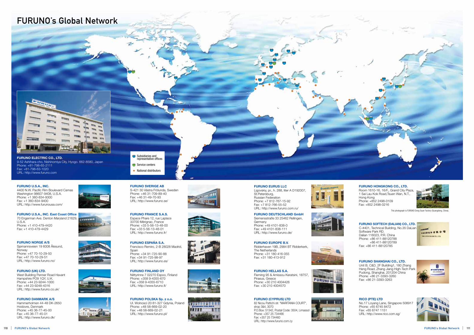
FURUNO’s Global Network
FURUNO ELECTRIC CO., LTD.9-52 Ashihara-cho, Nishinomiya City, Hyogo. 662-8580, JapanPhone: +81-798-65-2111Fax: +81-798-63-1020URL: http://www.furuno.com
FURUNO U.S.A., INC.4400 N.W. Pacific Rim Boulevard Camas Washington 98607-9408, U.S.A.Phone: +1 360-834-9300Fax: +1 360-834-9400URL: http://www.furunousa.com/
FURUNO FRANCE S.A.S.Espace Phare 12, rue Laplace 33700 Mérignac, FrancePhone: +33 5-56-13-48-00 Fax: +33 5-56-13-48-01URL: http://www.furuno.fr/
FURUNO U.S.A., INC. East Coast Office70 Engerman Ave. Denton Maryland 21629, U.S.A.Phone: +1 410-479-4420 Fax: +1 410-479-4429
FURUNO EUROPE B.V.Ridderhaven 19B, 2984 BT Ridderkerk, The NetherlandsPhone: +31 180-416-055 Fax: +31 180-413-912
FURUNO (UK) LTD. West Building Penner Road Havant Hampshire PO9 1QY, U.K.Phone: +44 23-9244-1000Fax: +44 23-9248-4316URL: http://www.furuno.co.uk/
FURUNO DANMARK A/SHammerholmen 44-48 DK-2650 Hvidovre, Denmark Phone: +45 36-77-45-00 Fax: +45 36-77-45-01URL: http://www.furuno.dk/
FURUNO ESPAÑA S.A.Francisco Remiro, 2-B 28028 Madrid, SpainPhone: +34 91-725-90-88Fax: +34 91-725-98-97URL: http://www.furuno.es/
FURUNO DEUTSCHLAND GmbHSiemensstraße 33 25462 Rellingen, GermanyPhone: +49 4101-838-0Fax: +49 4101-838-111URL: http://www.furuno.de/
FURUNO (CYPRUS) LTD82 Nicou Pattichi str. "MARITANIA COURT", shop 3&4, 3070P.O.Box: 51342, Postal Code: 3504, LimassolPhone: +357 25 734466Fax: +357 25 734460URL: http://www.furuno.com.cy
FURUNO EURUS LLCLigovskiy, pr., h. 288, liter A D192007, St.Petersburg, Russian FederationPhone: +7 812-767-15-92Fax: +7 812-766-55-52URL: http://www.furuno.com.ru/
FURUNO SVERIGE ABS-421 30 Västra Frölunda, Sweden Phone: +46 31-709-89-40 Fax: +46 31-49-70-93URL: http://www.furuno.se/
FURUNO FINLAND OYNiittyrinne 7 02270 Espoo, Finland Phone: +358 9-4355-670 Fax: +358 9-4355-6710URL: http://www.furuno.fi/
FURUNO SOFTECH (DALIAN) CO., LTD.C-#401, Technical Building, No.35 DaLian Software Park RD.Dalian 116023, P.R. China Phone: +86 411-88120788 +86 411-88120789 Fax: +86 411-88120785
FURUNO POLSKA Sp. z o.o.Ul. Wolnosci 20 81-327 Gdynia, PolandPhone: +48 58-669-02-20Fax: +48 58-669-02-21URL: http://www.furuno.pl/
FURUNO SHANGHAI CO., LTD.Unit B, C&D, 2F Building1, 180 Zhang Heng Road, Zhang Jiang High-Tech Park Pudong, Shanghai, 201204 ChinaPhone: +86 21-3393-3260Fax: +86 21-3393-3263
FURUNO HONGKONG CO., LTD.Room 1610-16, 16/F., Grand City Plaza, 1 Sai Lau Kok Road,Tsuen Wan, N.T., Hong Kong Phone: +852 2498-0109 Fax: +852 2498-0216
This photograph is FURUNO Dong Guan Factory (Guangdong, China).
Subsidiaries and representative offices
Service centers
National distributors
FURUNO NORGE A/SSjømannsveien 19 6008 Ålesund, Norway Phone: +47 70-10-29-50 Fax: +47 70-10-29-51URL: http://www.furuno.no/
RICO (PTE) LTDNo.17 Loyang Lane, Singapore 508917Phone: +65 6745 8472Fax: +65 6747 1151URL: http://www.rico.com.sg/
FURUNO HELLAS S.A.Fleming 95 & Amissou Keratsini, 18757,Piraeus, GreecePhone: +30 210 4004426Fax: +30 210 4004570
110 111FURUNO’s Global NetworkFURUNO’s Global Network
WORLDWIDE DISTRIBUTORS
NORTH AMERICAU.S.A. / CANADAFURUNO U. S. A., INC.4400 N.W. Pacific Rim Boulevard
Camas
Washington 98607-9408
Phone: +1 360-834-9300
Fax: +1 360-834-9400
E-mail: [email protected]
East Coast Office:FURUNO U. S. A., INC.70 Engerman Ave.
Denton
Maryland 21629
Phone: +1 410-479-4420
Fax: +1 410-479-4429
CENTRAL/SOUTH AMERICAARGENTINANAVAL STAR S.A.9 de julio 817 - Puerto Madryn
(9120) Provincia del Chubut
Phone: +54-280-4472525/
4451929/4451236
Fax: +54 280 4451377
E-mail: [email protected]
Ministro Brin 982
(1158) - Buenos Aires
Phone: +54 11 4362-6874
Fax: +54 11 4362-6874
E-mail: [email protected]
BRAZILRADIOMAR INDÙTRIA E COMÈRCIO, LTDA.Rua Conde de Lages, 44 gr. 1201
Gloria - Rio de Janeiro - RJ.
CEP 20.241-080
Phone: +55 21 2187-2400
Fax: +55 21 2187-2434
E-mail: [email protected]
CHILEMARCO INDUSTRIAL LTDA.Los Gobelinos 2584,
Renca - Santiago
Phone: +56 2-7824400
Fax: +56 2-6464623
E-mail: [email protected]
COLOMBIAITEC ELECTRONICA MARITIMA LTDACC Santa Lucia locales 5 y 6
Cartagena-Colombia
Phone: +57 5 663-3909/663-3789
Fax: +57 5 663-3643
E-mail: [email protected]
RADAR & CIA, LTDA.URBANIZACION VALENCIA CRA.81 NO. 31A-74
BARRIO EL RECREO CARTAGENA DE
INDIAS-COLOMBIA-SURAMERICA.
Phone: +57 5 6816800
E-mail: [email protected]
ECUADORELECTROMARINA CIA. LTDA.Ave. Juan Tanca
Marengo 200
Piso 1 of #1
Guayaquil
Phone: +593 4-2395701/2290486
Fax: +593 4-2286780
E-mail: [email protected]
MEXICONAVALEC SA DE CV.Acapulco No.35, Office No. 702
Colonia Roma, CP 06700
Delegacion Cuauhtemoc
Mexico D.F
Phone: +52 55 52114372
Fax: +52 55 52114372
E-mail: [email protected]
PROESA ELECTROICA S.A. de C.V.Av. 4 Oriente SN
Puerto Industrial Pesquero Languna Azul
C.P. 24140.Cd. del Carmen, Camp. Mexico.
Phone/Fax: +52 938 38 446 32/33
E-mail: [email protected]
PERUMARCO PERUANA, S. A.Avda. Saenz Pena 1439
Callao, 1
Phone: +51 14-294978
Fax: +51 14-659497
E-mail: [email protected]
PANAMANAVSTAR MARINE ELECTRONICS, S.A.Williamson place 0752 B
La Boca, Ancon
P.O.Box 2554, Zona 3
Phone: +507 228 0399/0907
Fax: +507 228 9331/260 7825
E-mail: [email protected]
TRINIDAD AND TOBAGOIMTEC MARINE TRINIDAD & TOBAGO LTD.Atlantic Plaza, Unit B 2.01 Point Lisas, Trinidad, W.I.
Phone: +1 868-679-2887
Fax: +1 868-679-8921
URUGUAYAEROMARINE S.A.Rambla 25 de Agosto 326
Montevideo,11000
Phone: +598 2 916 64 56
+598 94 444 652
Fax: +598 2 916 64 56
CURACAOIMTECH MARINE CURACAO N.V.Emancipatie Boulevard 29
Willemastad
Phone: +5999 462 6866
Fax: +5999 462 6880
E-mail: [email protected]
TRINIDAD AND TOBAGOIMTECH MARINE TRINIDAD & TOBAGOAtlantic Plaza, Unit B 2.01
Point Lisas, Trinidad, W.I.
TRINIDAD AND TOBAGO
Phone: +1 868-679-2887
Fax: +1 868-679-8921
E-mail: [email protected]
EUROPEBELGIUMImtech Marine BelgiumNoordersingel 17
B-2140 Antwerp
Phone: +32 3 320 9960
Fax: +32 3 320 9961
E-mail: [email protected]
BULGARIARefer to OZSAY, TURKEY
CROATIA / SLOVENIAHORA ELEKTRONIK D.O.O.A.B.Simica 65, 51000 Rijeka,
P.O.Box 247
Phone: +385 51-612 000
Fax: +385 51-612 001
E-mail: [email protected]
CYPRUSFURUNO (CYPRUS) LTD82 Nicou Pattichi str. "MARITANIA COURT",
shop 3&4, 3070
P.O.Box: 51342, Postal Code: 3504, Limassol
Phone: +357 25 734466
Fax: +357 25 734460
Email: [email protected],
DENMARKFURUNO DANMARK ASHammerholmen 44-48
DK-2650 Hvidovre
Phone: +45 36 77 45 00
Fax: +45 36 77 45 01
Telex: 27289 FURUNO DK
E-mail: [email protected]
ESTONIARefer to FURUNO DANMARK AS, DENMARK
FAROE ISLANDSRefer to FURUNO DANMARK AS, DENMARK
FINLANDFURUNO FINLAND OYNiittyrinne 7 02270 Espoo
P.O.Box 74 FI-02271 Espoo
Phone: +358 9 4355670
Fax: +358 9 43556710
E-mail: [email protected]
FRANCEFURUNO FRANCE S.A.S.Espace Phare 12, rue Laplace
33700 Mérignac
Phone: +33 5 56 13 48 00
Fax: +33 5 56 13 48 01
E-mail: [email protected]
GERMANYFURUNO DEUTSCHLAND GmbHSiemensstrasse 33
25462 Rellingen
Phone: +49 4101 838 0
Fax: +49 4101 838 111
E-mail: [email protected]
GREECEFURUNO HELLAS S.A.Fleming 95 & Amissou
Keratsini, 18757
Piraeus
Phone: +30 210 4004426
Fax: +30 210 4004570
E-mail: [email protected] (sales)
[email protected] (service)
GREENLANDRefer to FURUNO DANMARK AS, DENMARK
HUNGARYADRIA DUNA TRADE LTDH-1122 Budapest,
Pethenyi KOZ 7
Phone: +36 1-356-0606
Fax: +36 1-225-1450
E-mail: [email protected]
ICELANDRefer to FURUNO DANMARK AS, DENMARK
IRELANDRefer to FURUNO (UK) LIMITED, UK
ITALYARIMAR S.p.A.Via Beneficio II°Tronco 57/A
48015 Montaletto di Cervia(RA)
Phone: +39 0544 965773
Fax: +39 0544 965739
E-mail: [email protected]
LATVIARefer to FURUNO DANMARK AS, DENMARK
LITHUANIARefer to FURUNO DANMARK AS, DENMARK
MALTA G.C.MEDCOMMS LIMITED4, Msida Road, Gzira
GZR03
Phone: +356 21335521/330147
Fax: +356 21310820
Telex: 331 MEDCOM MW
E-mail: [email protected]
MONACORefer to FURUNO FRANCE S.A., FRANCE
NETHERLANDSIMTECH MARINE NETHERLANDS B.V.Sluisjesdijk 155 3087 AG Rotterdam
Phone: +31 10-4283344
Fax: +31 10-4281498
Telex: 28150 RHOT NL
E-mail: [email protected]
NORWAYFURUNO NORGE A/SSjømannsveien 19 6008 Ålesund
Service box 11, N-6025 Ålesund
Phone: +47 70 10 29 50
Fax: +47 70 10 29 51
E-mail: [email protected]
POLANDFURUNO POLSKA Sp. Z.o.o.Ul. Wolnosci 20
81-327 Gdynia
Phone: +48 58 669 02 20
Fax: +48 58 669 02 21
E-mail: [email protected]
PORTUGALIMTECH MARINE PORTUGAL S.A.Av. 24 de Julho, 60 1°
1200-869 Lisbon
Phone: +351 21 3976087
Fax: +351 21 3903739
Telex: 12195 SEMASA P
E-mail: [email protected]
ROMANIARefer to FURUNO (UK) LIMITED, UK
SPAINFURUNO ESPAÑA S.A.Francisco Remiro, 2-B
28028 Madrid
Phone: +34 91-725-90-88
Fax: +34 91-725-98-97
E-mail: [email protected]
SWEDENFURUNO SVERIGE ABGruvgatan 23
S-421 30 Västra Frölunda
Phone: +46 31-709 89 40
Fax: +46 31-49 70 93
E-mail: [email protected] (Sales)
[email protected] (Service)
U.K.FURUNO (UK) LIMITEDWest Building Penner Road Havant
Hampshire PO9 1QY
Phone: +44 2392-441000
Fax: +44 2392-484316
E-mail: [email protected]
UKRAINERefer to OZSAY, TURKEY & FURUNO DANMARK AS, DENMARK
MIDDLE EASTBAHRAINUCO ENGINEERING W.L.L.P.O.Box 5169
Phone: +973 17 700266
Fax: +973 17 702077
E-mail: [email protected]
EGYPTRADIO HOLLAND EGYPT S.A.E.24 Syria St., Roushdy, Alexandria
P.O.Box 2026 Alexandria
Phone: +20 35233454
Fax: +20 35233238
E-mail: [email protected]
SUEZ ELECTRONICS ENGINEERING & TRADING LTD.18 Abou -El-Ataheya Street
Nasr City, Cairo
P.O.Box 7555
District 8
Phone: +20 2 2742911 / 2728493
+20 2 2717466
Fax: +20 2 2745219
E-mail: [email protected]
KUWAITRefer to RADIO HOLLAND B.V. MIDDLE EAST U.A.E.
LEBANONSELCOM MARINE SARLP.O.Box 55541
Dekwaneh Street
Beirut
Phone: +961 1 491489 / 498154
Fax: +961 1 495325
E-mail: [email protected]
OMANRefer to RADIO HOLLAND B.V. MIDDLE EAST, U.A.E.
QATARRefer to RADIO HOLLAND B.V. MIDDLE EAST, U.A.E.
SAUDI ARABIAYUSUF BIN AHMED KANOO MARINE SERVICES GROUPP.O.Box 37
Dammam 31411
Phone: +966 3 8571265
Fax: +966 3 8592433
E-mail: [email protected]
SYRIARefer to SELCOM MARINE SARL., LEBANON.
TURKEYOZSAY DENIZ ELEKTRONIGI A.S.Guzelyali, E-5 Uzeri,
No.18 Pendik, 34903
Istanbul
Phone: +90 216-4933610
Fax: +90 216-4930306
E-mail: [email protected]
UNITED ARAB EMIRATESRADIO HOLLAND B.V. MIDDLE EASTP.O.Box 4592
Sharjah
Floors 1&2, Al Buhairah Insurance
Tower Buhairah Corniche Road
Sharjah
Phone: +971 6-574 4144
Fax: +971 6-574 9998
E-mail: [email protected]
AFRICAALGERIASOCIETE RADIO NAVIGATIONPorte De La Palestine,
Cherchell - W de Tipaza 42100
Phone: +213 24 439189
Fax: +213 24 439185
E-mail: [email protected]
IVORY COASTS.I.E.C.M.I.SOCIETE IVOIRIENN D'ELECTRONIQUE MARITIME ET INDUSTRIELLEPort de Peche
10 B.P.513
Abidjan 10 (R.C.I.)
Phone: +225 21 21-63-45
Fax: +225 21 25-08-23
E-mail: [email protected]
KENYAMARAJANI COMMUNICATIONS TOURS & ASSISTANCES LTD.,P.O.Box 84295
Mombasa, 80100
Phone: +254 41 2222659
Fax: +254 41 2224509
E-mail: [email protected]
MOROCCOSOCIETE ISFOMA S.A.R.L.174 Bd Moulay Youssef Casablanca
Phone: +212 5 22 27 06 60
Fax: +212 5 22 48 72 40
E-mail: [email protected]
NAIGERIARADIAL CIRCLE TELECOMMUNICATIONS LTD.56, Balarabe Musa Crescent,
off Samuel Manuwa Street
Victoria Island, Lagos
Phone: +234 1 4619507
Fax: +234 1 4619882
E-mail: [email protected]
NAMIBIARefer to IMTECH MARINE SOUTH AFRICA (PTY) LTD, SOUTH AFRICA
REPUBLIC OF CONGORefer to IMTECH MARINE SOUTH AFRICA (PTY) LTD, SOUTH AFRICA
SENEGALRefer to S.I.E.C.M.I., IVORY COAST
SEYCHELLESS.E.Y.C.M.I SHEYCHELLES ELECTRONICS MARITIME CO. LTD.Fishing port, P.O.Box 497
Victoria, Mahe
Phone: +248 22 47 52
Fax: +248 22 46 77
E-mail: [email protected]
SOUTH AFRICAIMTECH MARINE SOUTH AFRICA (PTY) LTD.P.O.Box 527
Paarden Eiland 7420
Phone: +27 21 508-4700
Fax: +27 21 508-4888
E-mail: [email protected] (Sales)
TUNISIAGENERAL EQUIPEMENT76, Avenue de Carthage
Tunis
Phone: +216 71 248-034 / 254-352
Fax: +216 71 344-406
E-mail: [email protected]
RUSSIAN FEDERATIONRUSSIAN FEDERATIONFURUNO EURUS LLCLigovskiy, h.228, liter A
192007, St. Petersburg
Phone: +7 812 767-15-92
Fax: +7 812 766-55-52
E-mail: [email protected]
Refer to FURUNO NORGE A/S, NORWAY
MORIKAWA SHOJI KAISHA.LTD2nd Kojimachi Bldg. No.4-2 Kojimachi
Kojimachi, Chiyoda-ku
Tokyo 102-0083, JAPAN
Phone: +81 3 5226 6411
Fax: +81 3 5226 6417
E-mail: [email protected]
ASIAJAPANHeadquarters:FURUNO ELECTRIC CO., LTD.9-52, Ashihara-cho
Nishinomiya 662-8580
Phone: +81 798-65-2111
Fax: +81 798-65-4200
+81 798-66-4622
Tokyo office:FURUNO ELECTRIC CO., LTD.Kandaizumi-cho Asia Building
2-6 Kandaizumi-cho
Chiyoda-ku
Tokyo 101-0024
Phone: +81 3-5687-0411
Fax: +81 3-5687-0380/0381
+81 3-5687-0382/0383
BANGLADESHRefer to RICO (PTE.) LTD, SINGAPORE
BRUNEIRefer to RICO (PTE.) LTD, SINGAPORE
CHINAFURUNO SHANGHAI CO., LTD.Unit B, C&D, 2F Building 1
180 Zhang Heng Road
Zhang Jiang High-Tech Park
Pudong, Shanghai 201204
Phone: +86 21 3393 3260
Fax: +86 21 3393 3263
E-mail: [email protected]
SHANGHAI OCEAN RADIO CO., LTD.2F, No.838 Hua Mu Road
Shanghai 201204
Phone: +86 21 5059-5308
Phone: +86 21 5059-4061
Fax: +86 21 5059-4062
E-mail: [email protected]
ELETEK TECHNOLOGY LIMITEDRm. 2603-2605, 26/F., Millennium City 3,
370 Kwun Tong Road, Kwun Tong,
Kowloon, Hong Kong.
Tel: +852 2343 9833
+852 3996 1500
Fax: +852 2343 2223
VIA MARINE CO., LTD.29 Hai Yi Villa, 97 Song Lin Road, Pudong
Shanghai 200122
Phone: +86 21 5058-7558
Phone: +86 21 5058-7568
Fax: +86 21 5058-7398
E-mail: [email protected]
SIMBO MARINE SYSTEMS LTD.Flat 2605,Building No. 7,1288 Dalian Road
Shanghai 200092
Phone: +86 21 6562-6955
Fax: +86 21 6562-6038
E-mail: [email protected]
WEST GOLD GROUPRoom 2308,Golden Magnolia Plaza
No.1 Dapu Road, Shanghai 200023
Phone: +86 21 5396-1052
Fax: +86 21 5396-1073
E-mail: Sales: [email protected]
Service: [email protected]
DALIAN LEVEAR ELECTRIC CO., LTD.No.300 Honggang Road,
Ganjingzi District, Dalian
Phone: +86 411 86301515
Fax: +86 411 86301415
E-mail: [email protected]
SHUN LEE DEVELOPMENT LTD.5/F, Flat B, Fui Nam Building
48-51 Connaught Road West, Hong Kong
Phone: +852 2517 6049
Fax: +852 2517 6018
E-mail: [email protected]
CHINA/HONG KONGIMTECH MARINE CHINA LTD806 Join-in Hang Sing Centre
71-75 Container Port Road
Kwai Chung N.T.
Phone: +852 2423-9007
Fax: +852 2480-5898
E-mail: [email protected]
INDIAA.S.MOLOOBHOY & SONS"ANCHOR HOUSE", Plot No.58 1st Magazine Cross
Street, Darukhana, Mazagon, Mumbai, 400 010.
Phone: +91 22 23737590
Fax: +91 22 23742678
E-mail: [email protected]
INDONESIARefer to RICO (PTE.) LTD, SINGAPORE
KOREASHIN-A CORPORATION645-3, Nambumin-Dong, Seo-Gu,
Pusan
Phone: +82 51-241-6151
Fax: +82 51-244-2878
E-mail: [email protected]
MALAYSIARefer to RICO (PTE.) LTD, SINGAPORE
MALDIVESRefer to RICO (PTE.) LTD, SINGAPORE
PHILIPPINESSCAN MARINE, INC.P.O. Box 3241
#160 Honorio Lopez Blvd.
Balut, Tondo
Manila
Phone: +632 252-7721 to 25
Fax: +632 253-0308
E-mail: [email protected]
SINGAPORERICO (PTE.) LTD.No. 17 Loyang Lane, SINGAPORE 508917
Phone: +65 6745-8472 (office)
+65 6745-8473 (service)
Fax: +65 6747-1151 (office)
+65 6743-6077 (service)
E-mail: [email protected]
SRILANKAQUEENS RADIO MARINE ELECTRONICS (PTE) LIMITED861 Aluthmawatte Road, Colombo 15, Sri Lanka.
Phone: +94-11-2523511/12
+94-77-7730167 (24Hrs Service)
Fax: +94-11-2523669
E-mail: [email protected] (service)
[email protected] (sales)
[email protected] (general)
TAIWANANCHANG BROTHERS CO., LTD.No. 28, Lane 113
Hou-Pin Road Chien Chen District
P.O. BOX 44-1, Kaohsiung
Phone: +886 7-8114510
Fax: +886 7-8119369
E-mail: [email protected]
THAILANDC. SAHAMONGKOL ENGINEERING LTD., PART.76/92-93 Ratchada-Thapra Road
Bangkok-Yai, Bangkok 10600
Phone: +66 2 4570066
Fax: +66 2 4579428
E-mail: [email protected]
VIETNAMHAIDANG CO., LTD.666/64/30 Ba Thang Hai St.,
Dist.10, Ho Chi Minh City, S.R.
Phone: +84-8-3863 21 59
Fax: +84-8-3863 25 24
E-mail: [email protected]
OCEANIAAUSTRALIAJ. N. TAYLOR & CO. LTD.62 Sparks Road Henderson WA 6166
Phone: +61 (8) 9494-9393
Fax: +61 (8) 9494-9388
E-mail: [email protected]
NEW ZEALANDELECTRONIC NAVIGATION LTD.65 Gaunt Street
Westhaven
Auckland
Phone: +64 9-3735595
Fax: +64 9-3795655
Inmarsat C: 451200183
E-mail: [email protected]
FRENCH POLYNESIA (TAHITI)ASSYSTEM SERVICES INDUSTRIE B. P. 2366
Papeete
Phone: +689 54 94 70
Fax: +689 41 34 56
E-mail: [email protected]
112 113WORLDWIDE DISTRIBUTORSWORLDWIDE DISTRIBUTORS