Funded by The Boeing Company - Bowers Museum · Funded by The Boeing Company √ Mission San Juan...
96
Funded by The Boeing Company
Transcript of Funded by The Boeing Company - Bowers Museum · Funded by The Boeing Company √ Mission San Juan...

Funded by The Boeing Company

Front Cover Art:Equestrian Portrait ofDon Jose AndresSepulveda. Henri JosephPenelon. c. 1856. Oil onCanvas. Born in Lyon,France in 1827 and active inEl Pueblo de Los Angeles by1853, Henri Penelon was apainter and Daguerrephotographer. He decoratedthe front of the PlazaChurch of Los Angeles andcreated a religious paintingfor the Church. This portraitshows Sepulveda astride“Black Swan,” a mareimported from Australia,which he matched againstPio Pico’s unbeaten horse“Sacro.” The race was run in1852 and won by “BlackSwan.” The elaborate saddlein the portrait was of thetype developed between1820 and 1840 and wasdecorated with silver string.Bowers Museum Collection
Historic Letter fromFather Vicente Franciscode Sarria to FatherGeronimo Boscana. SanCarlos, California. May 7,1828. The letter deniesBoscana’s request to retirefrom service at Mission SanJuan Capistrano. He diedthree years later. Bowers Museum Collection
Back Cover Art:Carriage of Pio Pico,Bowers Courtyard. PioPico’s carriage was madeand used during one of themost significant periods inCalifornia history. Bowers Museum Collection
Portrait of Pio Pico.c.1880. Oil on canvas. DonPico Pio was the lastMexican Governor ofCalifornia, serving fromFebruary 1845 to August1846. He was a colorfulfigure with a penchant forgambling, and organized thedefense against Americaninvaders intent on annexingCalifornia from Mexico.Bowers Museum Collection

a resource for teachers
developed in conjunction with the California History Galleriesin the permanent collection at
The Bowers Museum of Cultural Art2002 North Main Street
Santa Ana, California 92706714.567.3600
www.bowers.org
Funded by The Boeing Company
√ Mission San Juan Capistrano is the seventh missionfounded November 1, 1776 by Fr. Junipero Serra. Bowers Museum Collection

PROJECT DIRECTORNancy Warzer-BradyDirector of Education and Public ProgramsThe Bowers Museum of Cultural Art
PRINCIPAL AUTHORPriscilla H. Porter, Ed.DProfessor Emeritus of EducationCalifornia State University, Dominguez Hills
EDITORSSusan MetcalfAnne Olin
PROOFREADERSMarsha WaldmanRae Brugman
DESIGNERRob SextonS Design, Inc.
PROJECT CONSULTANTSSpecial thanks go to Dr. Barbara Milkovich, for herresearch on the ranchos of Orange County; RaeBrugman, Bobbie Westling and Barbara Greek, devotedmembers of the Bowers Museum Docent Guild for theirreview; Dr. Spencer C. Olin for his advice and review;Deborah Granger, Coordinator, History and SocialScience, Orange County Department of Education, forher input and guidance. Special added gratitude to manymuseum staff who made this publication possible: PeterC. Keller, Ph.D., President (thank you for the photog-raphy); Vickie C. Byrd, Executive Vice President;Armand Labbé, Director of Research andCollections/Chief Curator; Alice Bryant, CollectionsManager; Jennifer Ring, Collections Assistant, JenniferMiller, Administrative Assistant. We are also especiallythankful for the generous support of The BoeingCompany, Nancy Lurwig, Manager of CommunityRelations, and the leadership of The Bowers MuseumBoard of Governors members Barry Waldman, ViceChair and Carole Van Houten, Chair, EducationCommittee.
TEACHER CONTRIBUTORSMark Bourgeois Los Angles Unified School District
Karen Kirby Saddleback Unified School District
Akida Kissane Lewis Los Angles Unified School District
Diana ParsonsLos Nietos School District
Denise SmithLos Angeles Unified School District
Cathy SpiessMountain View School District
Dedicated to the teachers, students and the community lovers of California History
Dr. Priscilla H. Porter is the former Director for theCenter for History-Social Science Education, atCalifornia State University, Dominguez Hills. She is theauthor of numerous teacher manuals and publications,including the Southern California Indian Curriculum Guide(Bowers Museum, 2002) and Social Studies, 2000, a textbook series for K-6 grade, published by HarcourtBrace Publishers and adopted by the State of Californiain March 1999.
Almost nothing of the ancient California world remains... in the 16th century there was an estimated population of310,000 native people, speaking some 60 languages. Eachsociety was rich in tradition, oral history and culture, nearlyall of which are now gone forever. Once California was“discovered” by Europeans, the decimation of its indigenouspeoples was relentless.
Los Angeles Times Book Review, 11/23/03 of Brian Fagan’s Before California: An Archaeologist Looks at Our Earliest Inhabitants
The Bowers Museum of Cultural Art
Acknowledgements
Acknowledgements
©2004 by The Bowers Museum of Cultural ArtPermission is hereby granted to reproduce and distribute this publication for educational andresearch purposes.
Direct Inquiries to: Education DepartmentThe Bowers Museum of Cultural Art2002 N. Main Street, Santa Ana, CA 92706

Elementary students, and their teachers, will benefit greatlyfrom this carefully researched, clearly presented, and peda-gogically imaginative Early California History: Explorationand Settlement Curriculum Guide. There is a vast qualitativedifference between this material and what I personallyencountered many years ago in the study of history inelementary school. Considering the many problemscurrently facing our educational systems, at all levels, fromK-12 through research universities, it is gratifying toacknowledge such impressive progress in an important areaof the elementary school curriculum. The CurriculumGuide is composed of three major units, or chapters, aswell as a fourth unit (an early California time line) and auseful appendix that contains resources for students andteachers. Wherever possible, teachers are encouraged to usethe rich historical materials and artifacts of the BowersMuseum to supplement classroom experiences.
Unit One concentrates on the Pacific explorations of thesixteenth century, which substantially influenced subse-quent California culture. By this I mean that, ever sincethose first Spanish maritime explorations, California hasoffered the world both a place on the map and a series oflegends that have kept that place alive in the imagination.In other words, it has offered both a natural and a mentallandscape. Indeed, some have claimed that California’sname was derived from a popular mythic romance writtenin the early sixteenth century by a Spanish author namedMontalvo: “Know ye that at the right hand of the Indiesthere is an island named California, very close to that partof the Terrestrial Paradise….”
Most Western states have known minimal diversity, espe-cially in their early, or founding, years. Not so, California.The state’s very first inhabitants, its Indian peoples, estab-lished the pattern for diversity. Once the Spanish settlersarrived (see Unit Two), California’s population was alreadycharacterized by what historian James Gregory has called“one of the greatest varieties of discrete cultures of anyplace on earth.” By the beginning of Hispanic settlement,more than one hundred different tribes, or approximately
300,000 native people, speaking more than eighty differentlanguages, made their home amidst the incredibly variedtopography of California. And “Hispanicization” of thatindigenous population, rather than its removal, served asthe model settlement plan. In this Unit, among many otherthings, students are asked to explore the impact on thisindigenous population of the Spanish imperial system andits three basic institutions: the mission, the presidio, andthe pueblo.
In Unit Three, which deals with Mexican California duringthe early nineteenth century, students encounter interpreta-tive issues regarding the rise of a vast network of privateranchos. These ranchos fundamentally influenced the futurecourse of California land-use and development.Appropriately, special attention is afforded to the ranchosthat were located in Orange County, and their economicfeatures and contributions.
All in all, then, Early California History addresses significantissues in such a manner that young students are likely tobecome much more knowledgeable about what happened.Perhaps even more important, and because of the way inwhich this Curriculum Guide is conceptualized and struc-tured, they will be made aware that historical inquiry, at itsbest, involves lively and engaging arguments regarding themeaning of what happened. I commend Professor EmeritusPriscilla Porter and other colleagues who are responsible forthis admirable outcome.
Spencer C. OlinProfessor Emeritus of HistoryEdward A. Dixon Emeritus ProfessorUniversity of California, Irvine
Spencer Olin is a specialist in the history of modern America and ofthe American West. He is author, coauthor or coeditor of six booksand anthologies, including Major Problems in California History,California Politics, 1846-1920, and Racism in California.
iEarly California History: Exploration and Settlement Curriculum Guide
Foreword
Foreword

Acknowledgements
Foreword
Table of Contents . . . . . . . . . . . . . . . . . . . . . . . . . . . . ii
Introduction . . . . . . . . . . . . . . . . . . . . . . . . . . . . . . . . iii
Bowers Museum Tour, Cultural Art Class and Outreach Presentation Information . . . . . . . . . . . . iv
Standards for California SchoolsHistory/Social Science Academic Content Standards – Grade 3 and Grade 4 . . . . . . . . . . . . . . v
Historical and Social Sciences Analysis Skills – Grades K-5 . . . . . . . . . . . . . . . . . . . . . . . . . . . . . . . vi
Visual Arts Academic Content Standards – Grade 3 and Grade 4 . . . . . . . . . . . . . . . . . . . . . . . vii
Unit One: The Spirit of Exploration, 1542-1603 . . . . . . . . . . . . . . . . . . . . . . 1
Lesson I: Early Explorations of California . . . . . . . . . 2-11
Unit Two: Spanish Settlements in California, 1769-1834 . . . . . . . . . . . . . . . . . . . . 12-13
Lesson II: Settling Alta California, 1769-1781 . . . . . 14-21
Lesson III: Life at the Missions . . . . . . . . . . . . . . . . 22-27
Unit Three: Mexican California, 1821-1848 . . 28-29
Lesson IV: The Growth of Ranchos . . . . . . . . . . . . 30-37
Unit Four: Putting it all Together . . . . . . . . . . . 38-39
Lesson V: Early California Time Line . . . . . . . . . . . 40-42
Review of Era and Key Historic Figures . . . . . . 42-45
Appendices:
Resources for Students and Teachers . . . . . . . . 46-50
Handouts for Duplication:#1 Explorers of Early California
Graphic Overview . . . . . . . . . . . . . . . . . . . . . . 51-52#2 Identification of Cabrillo’s Route . . . . . . . . . . . . . 53#3 Cabrillo’s Log . . . . . . . . . . . . . . . . . . . . . . . . . . . . 54#4 Written Document Analysis Worksheet . . . . . . . . 55#5 I AM Poem . . . . . . . . . . . . . . . . . . . . . . . . . . . . . . 56#6 Family Migration Interview Form . . . . . . . . . . . . 57#7 Route of Portola Expedition, 1769 . . . . . . . . . . . . 58#8 The Portola Expedition . . . . . . . . . . . . . . . . . . . . . 59#9 Portola Expedition, 1769 . . . . . . . . . . . . . . . . . . . 60#10 Diary of Gaspar de Portola During the
California Expedition of 1769-1770 . . . . . . . . . . . 61#11 Gaspar de Portola Poem . . . . . . . . . . . . . . . . . . . . 62#12 Settler of Alta California from
1769 Graphic Overview . . . . . . . . . . . . . . . . . . . . 63#13 Los Pobladores, The Founders of the
City of Los Angeles . . . . . . . . . . . . . . . . . . . . . . . 64#14 R.A.F.T. . . . . . . . . . . . . . . . . . . . . . . . . . . . . . . . . . 65#15 Daily Life on a California Mission . . . . . . . . . . . . 66#16 Research Activity:
Jobs Performed by Mission Indians . . . . . . . . . . . 67#17 Economic Activity Cards . . . . . . . . . . . . . . . . . . . 68#18 Orange County Map Depicting Ranchos
and Landmarks . . . . . . . . . . . . . . . . . . . . . . . . . . . 69#19 Ranchos of Orange County . . . . . . . . . . . . . . . . . 70#20 Rancho Graphic Overview . . . . . . . . . . . . . . . . . . 71#21 Ranchos of Orange County (Student Reader) . . . 72#22 Diseño of Rancho San Juan Cajon
de Santa Ana . . . . . . . . . . . . . . . . . . . . . . . . . . . . 73#23 Doing a Diseño . . . . . . . . . . . . . . . . . . . . . . . . . . . 74#24 Historic Brands of Orange County . . . . . . . . . . . . 75#25 Early California Time Line . . . . . . . . . . . . . . . 76-77#26 Sequencing Events of
Early California 1542 to 1848 . . . . . . . . . . . . . . . . 78#27 Organizing the Events of Early California . . . . . . 79#28 3-D Chronological Time Line . . . . . . . . . . . . . . . . 80
Evaluation Form . . . . . . . . . . . . . . . . . . . . . . . . . . . . 81
ii The Bowers Museum of Cultural Art
Table of Contents
Table of Contents
Early California History: Exploration and Settlement is acurriculum guide designed to provide teachers in Grades 3,4 and 5 with rich materials and activities to foster students’understanding of the early exploration and settlement ofCalifornia. Key primary sources from the permanent collec-tion of The Bowers Museum of Cultural Art have beenselected as exemplary of the many sources that help to tellthe story of early California. The artifacts and images usedthroughout the guide can be found in the CaliforniaLegacies galleries, which are housed in the historic wing ofthe Bowers Museum and include the Exploration Hall andthe Ruth Segerstrom Gallery (The Mission and Ranchoperiod).
This manual contains four units and five lessons. Lessonmaterials include selected academic content standards,historical and social sciences analysis skills, focus questions,suggested activities, student handouts and teacher back-ground information. The activities and materials supportthe History-Social Science Academic Content Standards forCalifornia Public Schools. Many Reading/Language ArtsStandards have also been incorporated, especially writingand speaking applications. The focus questions for eachlesson are outlined in the chart below.
The manual may be used either as a comprehensive unit ofstudy connected directly to the artifacts in the ExplorationHall and Mission and Rancho gallery or as a source of indi-vidual lessons independent of the exhibit. Teachers whoplan to visit the exhibit with their students are advised tocomplete at least one lesson or a sampling of activities fromseveral lessons prior to attending. You will also find addi-tional Teacher Information Background for your useembedded in the lesson plans and shaded in gray.
The Board of Governors, President, Director of Educationand Public Programs, staff and volunteers of The BowersMuseum of Cultural Art, and its sponsoring corporation for
the guide, The Boeing Company, hope that thiscurriculum guide will be a useful, relevant text for fourthgrade educators and others who are teaching the historyand culture of the local region. Please take time to completethe evaluation form at the end of this guide. Your feedbackis important to us.
We look forward to having many groups of students andteachers, as well as parents, grandparents and childrencoming to The Bowers Museum of Cultural Art andKidseum, our interactive, hands-on museum for childrenand their families, to learn about early California’s historyand settlement period together.
iiiEarly California History: Exploration and Settlement Curriculum Guide
Introduction
Introduction
Lessons Focus Questions
Lesson 1: Who were the early explorers of California? What sea routes did the early explorers follow? What Early technological developments made sea exploration possible? What were the aims and accomplish-Explorers ments of the early explorers of California? What obstacles did they encounter?
Lesson 2: When did your family settle in California and why did they come? Who were the early settlers of Settling Alta California and why did they come? What routes did the early settlers follow? What were the aimsCalifornia and accomplishments of the early settlers of California? What obstacles did they encounter?
Lesson 3: What was life like for the people, native and non-native, who occupied the missions? How did the Life at the Franciscans change the economy of California from a hunter-gatherer economy to an agricultural Missions economy? What influence did the mission economy have on present-day California’s economy?
What were the relationships among soldiers, missionaries, settlers and Indians?
Lesson 4: What is a rancho? What ranchos were located in present-day Orange County? What did the ranchosGrowth of contribute to the economic development of California? What was life like on a rancho?Ranchos
Lesson 5: How can the key events and people of the exploration and settlement of California be placed on a Time Line time line and within a spatial context? Over time, what things change and what things remain the and Review same?

School Tour and Cultural Art ClassBooking Information
History comes alive for students and teachers through first-hand experiences with original works of art. Cultural artclasses, in combination with a tour, reinforce learning andallow students to create artwork that connects to their visit;this artwork can become a souvenir of their museum fieldtrip to take home to remind them of their experience at themuseum, over and over again. Classes, taught by profes-sional art instructors, are held at Kidseum (one block southof the main museum) and last one hour. They can bescheduled in combination with your tour or separately.Gallery tours and art classes last one hour each, and areheld at 9:30 a.m., 11 a.m., 1 p.m. and 2 p.m., Tuesdaysthrough Fridays. For school tour and art class bookinginformation and to make reservations, please call714.567.3680, or view our website at www.bowers.org.
Among the specific art classes offered for California historyare: Rancho and Mission Era Cattle Brands; Orange CrateLabels; and California Indian Sand Paintings or Petroglyphs(all grades 3 and up).
Cultural Art TrunksDesigned to create a “mini-gallery” in your classroom, theCultural Art Trunks include hands-on art objects, labels,interpretative materials, activities and games. Trunks areadaptable to all grade levels. The trunk specific toCalifornia history study is “Changing Faces, ChangingPlaces” (Orange County history) and there are also NativeAmerican trunks. The cost is $35 for a one-week period.Teachers must pick up and drop off trunks. Call714.480.1522 or x 1520 to reserve a trunk.
Art in Your ClassroomKidseum museum educators and art instructors provide ArtProjects with Cultural Presentations in your classroom.These projects are adaptable to all grade levels and aredesigned to familiarize students with a variety of techniques,materials, and objects related to the cultures presented. Theone-hour experience includes presentations, activities anddiscussion, which allow students to look at, talk about, andcreate art. Subjects include: African, Oceanic, and NativeAmerican cultures, as well as many more. Classes take placeat your school. These lessons can be tailored to meetteachers’ specific needs. The price for 30 students is approxi-mately $175.00 (prices vary according to project). Call714.480.1522 or x1520 for information and booking.
School and Community OutreachCustomized Presentations
We can customize a cultural presentation for your class-room or service group. Please call 714.480.1522 or x 1520for fees and information.
Educator Workshops, Institutes and Open Houses
The Bowers Museum and Kidseum offer interactive work-shops and summer institutes for pre K – 12 teachers thatare aligned with the State of California academic contentstandards. Most of the programs offered to teachers offercontinuing education units and are cosponsored by theOrange County Department of Education. Visitwww.bowers.org or call 714.567.3649 for specific informa-tion.
Educator E-Mail List/Ed GramIf you would like to be placed on our Education e-mail
listing to receive updated information on our eventsdesigned specifically for educators, please call 714.567.3649or 714.567.3680 and give us your e-mail address. We wantto hear from you!
Docent Guild Classroom PresentationsDocents provide a stimulating, one-hour presentation withhands-on materials designed to enhance your students’imaginations and to supplement school curriculum, free ofcharge, subject to availability. Selected presentations inCalifornia History include:
Orange County Then and Now (Grades 3 & 4)
Through slides, museum artifacts and hands-on articlesstudents may note the coming of people from all over theworld from the Mission Period.
Off to the Gold Rush! (Grade 4)
Learn about the people who came to work in the goldfields during the California Gold Rush in the 1840s and1850s. Imagine what it truly was like to work in a goldmine during this time period. (Grade 4)
For further information, and to learn how to sign up forthese tours and presentations, please call 714.567.3680 torequest a school brochure or visit our website atwww.bowers.org.
iv The Bowers Museum of Cultural Art
Bowers Museum Tour, Cultural Art Class and Outreach Presentation Information
Bowers Museum Tour, Cultural Art Classand Outreach Presentation Information

This guide supports the attainment of the followingHistory/Social Science Academic Content Standards forCalifornia Public Schools. Lessons corresponding to eachstandard are listed.
GRADE 3 Standard 3: Students draw from historical andcommunity resources to organize the sequence of events inlocal history and describe how each period of settlementleft its mark on the land.
1. Research the explorers who visited here, the newcomerswho settled here, and the people who continue to come tothe region, including their cultural and religious traditionsand contributions. Lessons: I, II, III, IV
2. Describe the economies established by settlers and theirinfluence on the present-day economy, with emphasis onthe importance of private property and entrepreneurship.Lessons: III, IV
3. Trace why their community was established, how indi-viduals and families contributed to its founding and devel-opment, and how the community has changed over time,drawing upon primary sources (e.g., maps, photographs,oral histories…) Lessons: II, IV
GRADE 4 Standard 1: Students demonstrate an under-standing of the physical and human geographic featuresthat define places and regions in California.
1. Explain and use the coordinate grid system of latitudeand longitude to determine the absolute locations of placesin California and on Earth. Lesson: II
2. Describe the various regions of California, including howtheir characteristics and physical environments (e.g., water,landforms, vegetation, climate) affect human activity.Lessons: II, III, IV
3. Identify the locations of the Pacific Ocean, rivers, valleys,and mountain passes and explain their effects on thegrowth of towns. Lesson: II
4. Use maps, charts, and pictures to describe how commu-nities in California vary in land use, vegetation, wildlife,climate… Lessons: II, III
GRADE 4 Standard 2: Students describe the social, polit-ical, cultural, and economic life and interactions amongpeople of California from the pre-Columbian societies tothe Spanish mission and Mexican rancho periods.
2. Identify the early land and sea routes to, and Europeansettlement in, California with a focus on the exploration ofthe North Pole (e.g., …Juan Cabrillo), noting especially theimportance of mountains, deserts, ocean currents, and windpatterns. Lesson: I, II
3. Describe the Spanish exploration and colonization ofCalifornia, including the relationships among soldiers,missionaries, and Indians (e.g., Juan Crespi, Junipero Serra,Gaspar de Portola). Lessons: II, III
4. Describe the mapping of, geographic basis of, andeconomic factors in the placement and function of theSpanish missions; and understand how the mission systemexpanded the influence of Spain and Catholicismthroughout New Spain and Latin America. Lessons: II, III
5. Describe the daily lives of the people, native and nonna-tive, who occupied the presidios, missions, ranchos, andpueblos. Lessons: III, IV
6. Discuss the role of the Franciscans in changing theeconomy of California from a hunter-gatherer economy toan agricultural economy. Lesson: III
7. Describe the effects of the Mexican War forIndependence on Alta California, including its effects onthe territorial boundaries of North America. Lessons: IV, V
8. Discuss the period of Mexican rule in California and itsattributes, including land grants, secularization of themissions, and the rise of the rancho economy. Lessons: III, IV
GRADE 4 Standard 3: Students explain the economic,social, and political life in California from the establishmentof the Bear Flag Republic through the Mexican-AmericanWar, the Gold Rush, and the granting of statehood.
1. Identify the locations of Mexican settlements inCalifornia and those of other settlements, including FortRoss... Lessons: II, IV
GRADE 5 Standard 2: Students trace the routes of earlyexplorers and describe the early explorations of theAmericas.
1. Describe the entrepreneurial characteristics of earlyexplorers …and the technological developments that madesea exploration by latitude and longitude possible (e.g.,compass, sextant, astrolabe, seaworthy ships…). Lesson: I
2. Explain the aims, obstacles, and accomplishments of theexplorers, sponsors, and leaders of key European expedi-tions and the reasons Europeans chose to explore and colo-nize the world. Lesson: II
3. Trace the routes of the major land explorers of theUnited States, the distances traveled by explorers.Lesson: I, II
4. Locate on maps of North and South American landclaimed by Spain and Russia. Lesson: II
vEarly California History: Exploration and Settlement Curriculum Guide
Standards for California Schools
History/Social Science Academic Content Standards

This guide supports the attainment of the followingKindergarten to Grade 5 Historical and Social SciencesAnalysis Skills listed in the Academic Content Standards forCalifornia Public Schools. These skills are to be learnedthrough, and applied to, the content standards.
Chronological and Spatial Thinking (CST)1. Students place key events and people of the historical erathey are studying in a chronological sequence and within aspatial context; they interpret time lines. Lessons: I, II, III, IV, V
2. Students correctly apply terms related to time, includingpast, present, future, decade, century, and generation.Lessons: I, II, III
3. Students explain how the present is connected to thepast, identifying both similarities and differences betweenthe two, and how some things change over time and somethings stay the same. Lesson: IV
4. Students use map and globe skills to determine theabsolute locations of places and interpret information avail-able through a map’s or globe’s legend, scale, and symbolicrepresentations. Lessons: I, II, IV
5. Students judge the significance of the relative location ofa place (e.g., proximity to a harbor, or trade routes) andanalyze how relative advantages or disadvantages canchange over time. Lessons: I, II
Research, Evidence, and Point of View (REPV)1. Students differentiate between primary and secondarysources. Lessons: I, II
2. Students pose relevant questions about events theyencounter in historical documents, eyewitness accounts,oral histories, letters, diaries, artifacts, photographs, maps,artworks, and architecture. Lessons: I, II, III, IV, V
3. Students distinguish fact from fiction by comparingdocumentary sources on historical figures and events withfictionalized characters and events. Lesson: IV
Historical Interpretation (HI)1. Students summarize the key events of the era they arestudying and explain the historical contents of thoseevents. Lessons: I, II, III, IV
2. Students identify the human and physical characteristicsof the places they are studying and explain how thosefeatures form the unique character of those places.Lessons: I, II, III, IV
3. Students identify and interpret the multiple causes andeffects of historical events. Lessons: I, II, III, IV, V
vi The Bowers Museum of Cultural Art
Standards for California Schools
Historical and Social Sciences Analysis Skills
πSilver Spurs of Pio Pico. Mexico, c. 1840. Steel, embossedsilver, leather, fabric. The six spiked and leather buckled strapsof these spurs are typical of the Californio style. It was
necessary for a horseman to remove his spurs when hedismounted or the four-inch long spikes on the rowels would
plow a furrow behind him as he walked. These were given toForster or his wife, Pio Pico's sister, when he stayed with themat San Juan Capistrano or at the Santa Marguerita adobe, whichForster owned. Bowers Museum Collection

This guide supports the attainment of the following VisualArts Academic Content Standards for California PublicSchools. Lessons corresponding to each standard are listed.
GRADE 3, Standard 2: Creative Expression. Studentsapply artistic processes and skills, using a variety of mediato communicate meaning and intent in original works of art.
1. Explore ideas for art in a personal sketchbook. Lesson: I
2. Mix and apply tempera paints to create tints, shades, andneutral colors. Lesson: III, IV
3. Paint or draw a landscape, seascape, or cityscape thatshows the illusion of space. Lesson: III
4. Create a work of art based on the observation of objectsand scenes in daily life, emphasizing value changes.Lessons: I, III, IV
6. Create an original work of art emphasizing rhythm andmovement, using a selected printing process. Lesson: I, III, IV
GRADE 3, Standard 5: Connections, Relationships,and Applications. Students apply what they learned inthe visual arts across subject areas. They develop compe-tencies and creative skills in problem solving, communica-tion and management of time and resources that contributeto lifelong learning and career skills. They also learn aboutcareers in and related to the visual arts.
1. Describe how costumes contribute to the meaning of adance. Lesson: IV
2. Write a poem or story inspired by their own works ofart. Lesson: I
GRADE 4, Standard 2: Creative Expression. Studentsapply artistic processes and skills, using a variety of mediato communicate meaning and intent in original works of art.
1. Use shading (value) to transform a two-dimensionalshape into what appears to be a three-dimensional form(e.g., circle to sphere). Lessons: III, V
2. Use the conventions of facial and figure proportions in afigure study. Lesson: III
5. Use accurate proportions to create an expressive portraitor a figure drawing or painting. Lessons: I, III
6. Use the interaction between positive and negative spaceexpressively in a work of art. Lessons: III
7. Use contrast (light and dark) expressively in an originalwork of art. Lesson: III
8. Use complementary colors in an original composition toshow contrast and emphasis. Lesson: III
GRADE 4, Standard 5: Connections, Relationships,and Applications. Students apply what they learned inthe visual arts across subject areas. They develop compe-tencies and creative skills in problem solving, communica-tion, and management of time and resources thatcontribute to lifelong learning and career skills. They alsolearn about careers in and related to the visual arts.
3. Construct diagrams, maps, graphs, timelines, and illustra-tions to communicate ideas or tell a story about a historicalevent. Lessons: I, II, III, IV, V
viiEarly California History: Exploration and Settlement Curriculum Guide
Standards for California Schools
Visual Arts Academic Content Standards
π Knife. Spanish, c. Early1800’s. Iron, wood, rope. Clasp knifes such as
this Spanish Navaja are still used today. The term “Navaja”literally means “knife” in Spanish. This style of knife would most likely be
used by a vaquero. The metal has been incised with linear "slash" marks. Thewood also is incised with decorative slash marks and a crosshatch design.Bowers Museum Collection
® Waistcoat of Don Juan Forster. California, 1823. Chamois, skin. Though hewas the only non-Hispanic among the Rancheros of Orange County, JohnForster was so well accepted that he received a Spanish name. An Englishmanwho had become a Mexican citizen, John Forster appears in many of the earlydocuments of the era as “Don Juan Forster.” The Spanish terms Don and Doñaare a form of address used with people of great wealth or social standing.Bowers Museum Collection

Lesson I:Early Explorations of California
Indians were the first of California’s ancient peoples to establish villagsand settle along the coast, and in the desert and mountains.Archaeologists and anthropologists have uncovered some evidenceabout how these Indians lived through study of artifacts and oralhistories that have survived.They generally agreed that the nativeCalifornians were hunter-gatherers whose diet was based on large
game, abundant plant foods and rich marine life. Men were responsible forhunting and fishing, while women gathered plant foods and cooked. Therewere many tribes of Indians, speaking more than 100 languages in pre-conquest California.
By the beginning of the Spanish settlement in 1769, approximately300,000 native people lived within what became California. Althoughthey lacked any concept of land ownership, and did not live together inlarge groups, Indians were by no means passive occupants and usedsophisticated techniques of land and resource management. While theprocess of settlement and Christianization destroyed much of theIndian population and their way of life, some Indians managed tosurvive their encounter with the Hispanics who came to thesouthern part of California.
The Spanish exploration of California was part of a larger patternof exploration, which followed the conquest of Aztec Mexico in1521. In 1542, an expedition sailed northward from Mexicounder the command of Juan Rodriguez Cabrillo. On Thursday,September 28, 1542, the expedition pulled into a port, whichthey named San Miguel, but which in fact was the locationof what was to become San Diego. By 1543, Spanish shipshad surveyed the Pacific coast as far north as Oregon layingclaim to the discovered lands in the name of the SpanishCrown. The purpose of these and other explorations wasto gather information that could be used in future
colonization of these lands.

Content StandardsHistory/Social Science: 3.3.1; 4. 2.2; 5.2.1; 5.2.3
Historical and Social Science Analysis Skills: CST 1, 2, 4,and 5; REPV 1 and 2; HI 1, 2, and 3
Visual Arts: 3.2.1; 3.2.4; 3.2.6; 3.5.2; 4.2.5; 4.5.3
Key Artifacts at the Bowers• Helmet, c. 1600. Conquistadors soon learned the heat
and rough terrain of Mexico and the Southwest madesteel suits of armor unusable, so they later turned toleather padded garments for protection from arrows andspears.
• Cannon, c. 17th Century. This iron cannon may havefallen from one of the Spanish trading ships that called atthe Dana Point harbor.
• Octant, c. 1731. This Spanish instrument gave marinersan estimate of their latitude.
• Staff, c. 1775. This Spanish cross staff is the type usedby Columbus and later explorers to measure the altitudeof the sun and stars.
• Statue of Juan Cabrillo, Bowers Museum Courtyard
Key Vocabulary:Words: Astrolabe, circumnavigate, expedition, explorer,
latitude, longitude, galleon, sextant, century,decade, past, present, future
People: Juan Cabrillo, Ferdinand Magellan, HernandoCortez, Sir Francis Drake, Sebastian RodriguezCermeno, Sebastian Vizcaino
Places: Alta California, Baja California, Spain, Phillipines,South America
Focus Questions:• Who were the early explorers of California?
• What sea routes did the early explorers follow?
• What technological developments made sea explorationpossible?
• What were the aims and accomplishments of the earlyexplorers of California? What obstacles did theyencounter?
Focus Question 1: Who Were The Early Explorers Of California?
Suggested Lesson Activities:
Class Discussion: What is an Explorer? Share withstudents information about a time when you exploredsomething new. Have students work in pairsto share a time when they explored some-thing. Ask a few pairs to tell the classwhat their partner explored. Ask,“What do explorers do?” (i.e., investi-gate systematically, examine, searchor travel for the purpose ofdiscovery). Introduce the word“expedition” (a journey undertakenby a group of people with a defi-nite purpose; a trip that is made fora special reason, usually to find orexplore a certain place.)
Activity: Explorer WordSquare. Work together as a classto develop a “word square” for“explorers.” Instruct studentsto fold a blank sheet ofpaper into four sections. Inthe top left-hand corner, writethe word, “EXPLORER.” Insmall groups, have students createtheir definition of an explorer. Ask each group to sharetheir definition. Combine ideas from the various groups todevelop a “class” definition. If desired, several dictionariesor a glossary may be consulted. Write the definition in thelower left-hand corner of the word square.
In the upper right-hand square, have students draw apicture of someone who “is” an explorer. In the lowerright-hand square, students draw a picture of somethingthat “is not” an explorer. For example, a student mightdraw someone watching television.
Write the word Draw a picture to visuallyEXPLORER show an explorer.
Write the class Draw a picture to showdefinition of an what is NOT an explorer.explorer.
Ask students, “If you were an explorer, where would youlike to travel? What would you hope to find?” Have themwrite their response.
2 The Bowers Museum of Cultural Art
Unit One: The Spirit of Exploration, 1542-1603
Lesson I: Early Explorations of California, 1542-1603
π Helmet c. 1600. Bowers Museum Collection

Focus Question 2: What Sea Routes Did TheEarly Explorers Follow?
Suggested Lesson Activities
Class Discussion: Where did the Spanish explorerstravel? Explain to students that in the 1500s, Spanishexplorers claimed large areas of North and South Americafor Spain. From 1519 to 1521, Hernando Cortes withmore than 500 soldiers conquered the Aztecs inTenochtitlan (present-day Mexico City) and madeTenochtitlan the capital of New Spain. Soon afterward,Cortes was commissioned by King Charles V of Spain tosearch for a passageway through North America called theStrait of Anian. Cortes was unsuccessful, but in 1535, hedid get as far north as Baja California, which he claimed forthe King of Spain. Cortes did not journey as far as present-day California.
Activity: Map # 1. Help students locate Spain on a worldmap and on a globe. Trace routes that explorers took toNew Spain (Mexico). Ask students questions that seek toidentify route details:
• What ocean did they cross? (Atlantic)
• What direction did they sail to reach Mexico? (west)
Explain to students that from 1519 to 1522, FerdinandMagellan sailed west from Spain and went around (circum-navigated) the globe. Magellan claimed the PhilippineIslands for Spain in 1519, and named them in honor ofKing Phillip II.
Activity: Map # 2. On the world map and on a globe,identify the two poles, the equator, the prime meridian andthe four hemispheres. Locate the Philippine Islands. Tracethe route to the Philippines by going around SouthAmerica. Note the Strait of Magellan. As needed, include askill lesson on latitude and longitude.
Activity: How did early mapmakers depict California?This activity, called “The Iceberg,” is designed to helpstudents understand why early explorers and mapmakersreached incorrect conclusions regarding the shape and sizeof California and the entire western hemisphere. First,select an object (such as a hammer) that could be misidenti-fied when only a portion of it is seen. Do not identify theobject or show it to the students. Place the object in apaper bag with only a portion of it (such as the handle)exposed to sight. Ask students to sketch what they believethe entire object looks like.
Recommendation: Before students make their sketches, tellthem a make-believe story about the object. Deliberatelymislead students about the object’s use. This is to parallelhow the 1510, fictional Spanish story, Las Serga deEsplandian, misled explorers into believing that there wasan island ruled by the Amazon Queen named “Calafia.”
After all the sketches are complete, reveal the entire objectand have the students make comparisons. Now, present thestory about Queen Calafia and connect the story to theexperience of the explorers who reached the BajaPeninsula. Since the explorers knew the Spanish story, theythought Baja was an island and called it “California” for themythical Queen Calafia. Explain that this was partly thereason why some early mapmakers depicted California asan island. California eventually came to mean all the terri-tory from the tip of Baja northward to the still undiscov-ered Strait of Anian. Explain that the territory now knownas California was identified with that name in 1747, whenFerdinand VI of Spain proclaimed a royal decree,“California is not an island.” (This activity is based on alesson by Diana Parsons.)
Searching for a Shortcut. Believing California to bean island, the early European explorers heard storiesabout a body of water connecting the Atlantic Oceanand the Pacific Ocean. Trade benefits would come toEuropeans who could find this shortcut, as the shortcutwould replace the long trip from Europe around Africaor South America to Asia. Many early explorerssearched for this shortcut or passage called the Strait ofAnian or, as the English called it, the NorthwestPassage.
Explain to students that there is no Strait of Anian orNorthwest Passage. Today the man-made locks thatcreate the Panama Canal serve the purpose of apassage between the two oceans. Have students locatethe Panama Canal on a map of North and SouthAmerica.
Activity: Map # 3. Display a map of present-dayCalifornia and help students identify the absolute locationof Baja California; Alta California (Alta California meansthe region “higher” or farther north than Baja California.);San Diego Bay; the Channel Islands; Monterey Bay; andSan Francisco Bay. Identify the latitude and longitude ofCalifornia. Ask, “Why did the early explorers believeCalifornia was an island?”
Class Discussion: Significance of California’s relativelocation. Help students judge the significance (i.e., climate,access to the Pacific Rim) today of the relative location ofCalifornia. Identify the physical characteristics of Californiaand explain how such features form California’s uniquecharacter. Identify harbors along the coast. Discuss theimportance of mountains and deserts as physical landbarriers to settlement. Note how the relative advantagesand disadvantages of the location of California can changeover time.
3Early California History: Exploration and Settlement Curriculum Guide
Unit I, Lesson I ~ Early Explorations of California, 1542-1603

Focus Question 3: What TechnologicalDevelopments Made Sea Exploration Possible?
Technological developments that made sea explo-ration possible. Throughout the voyages of the earlyexplorers, latitudes, compass directions and distanceswere determined and included in the ship’s log.Latitudes (the distance north and south of the equator)were established by the use of a cross-staff or astro-labe. Both instruments required the user to align itssights with the horizon plus either the sun or theNorth Star. The angle between the horizon and thecelestial body was read off a scale that measureddegrees on the instrument. However, it was impossibleto get a precise reading while on a pitching ship.Latitudes determined on land were more accurate. Theastrolabe has now been replaced by the sextant.
Suggested Lesson Activities
Activity: Construct an astrolabe. Have each studentconstruct an astrolabe to determine a ship’s distance northor south of the equator. Materials needed include: card-board, drinking straw, marker, string, tape and metalwasher.
1. Cut a semi-circle out of cardboard, eight inches wide andfour inches high.
2. Mark degrees as shown in the sketch.
3. Tie a 12-inch string around the middle of a straw.
4. Tie a metal washer on one end of the string.
5. Tape the straw along the straight edge of the semi-circle.
On a clear night, determine your latitude by sighting theNorth Star (Polaris) through the drinking straw. The posi-tion of the weighted string will indicate the latitude. (Thisactivity idea is from Creative Teaching Press Theme Series –Explorers.)
Class Discussion: Technological Instruments. Bring inexamples of an hourglass and compass for students to view.The measurement of longitude, the east-west location of apoint, requires an accurate timepiece. In earlier times, timewas measured with an hourglass. Unfortunately, the sandhourglass was not accurate enough for the early explorersto correctly figure longitude. Compasses were quiteprecise at the time, but many of these tools were aligned towork in Seville, Spain, where the magnetic declinationwould not be accurate to assist anyone in California.Generally, pilots in the sixteenth century were not able todetermine latitude, longitude, or direction with great exact-ness. Chronometers, a more precise tool, were notinvented for centuries.
4 The Bowers Museum of Cultural Art
Unit One: The Spirit of Exploration, 1542-1603
π Astrolabe
® Staff c. 1775. This Spanish cross staff isthe type used by Columbus and laterexplorers to measure the altitude of thesun and stars. Bowers Museum Collection
π Octant c. 1731. This Spanish instrumentgave mariners an estimate of their latitude.Bowers Museum Collection

Focus Question 4: What Were The Aims And Accomplishments Of The Early Explorers Of California?
What Obstacles Did They Encounter?
Obstacles encountered by early explorers. Earlyexplorers consistently mentioned obstacles thatincluded adverse sea and wind currents. Ships, beatenback by opposing winds from the northwest thatthreatened to drive them aground, were forced to gofarther out to sea. From this vantage point, cartogra-phers found it difficult to accurately chart the rockycoastline. Because the dangerous coastline made itdifficult for a ship’s crew to go ashore, the crew neverknew when they would get more clean water andsupplies. This concern was exacerbated betweenOctober and March when severe storms occurred,particularly in Northern California. The dense coastalfog banks reduced visibility and were so thick at timesas to even lead to the explorers missing key strategiclocations such as the large San Francisco Bay. Whennot battling winds and storms, ships could face theopposite condition when the ship was becalmed andstranded at sea for days.
Conditions aboard ship. Today, numerous luxurycruise ships travel the waters along Alta and BajaCalifornia. Conditions on these ships are vastlydifferent from those experienced by the earlyexplorers. The food eaten by early explorers waslimited by a lack of refrigeration. Common menusincluded biscuits, salted meat and fish, beans, bacon,cheese, vegetable oil, vinegar, onions and garlic.Frequently, provisions onboard were not enough tomaintain the crew. Without fresh fruit, sailors sufferedfrom scurvy, a disease caused by a deficiency of vita-mins C and B1. Apart from lacking proper nutrition,crews were often confined by the weather within tiny,poorly provisioned hulls. Plagued by hunger, illnessand the great hardships of sailing uncharted seas, thethreat of dissension and even mutiny was notuncommon.
Goals, accomplishments and struggles of JuanRodriquez Cabrillo. Juan Rodriquez Cabrillo, anable navigator and shipbuilder, is credited withclaiming Alta California for Spain. On June 27, 1542,he set sail from the port of Navidad with three vessels:the San Salvador, a sailing ship about 70 feet long and20 feet wide; the La Victoria; and the much smaller SanMiguel. On September 28, 1542, Cabrillo anchored in abay that he christened San Miguel (later renamed SanDiego by the explorer Sebastian Vizcaino).
Cabrillo’s descriptions of the California shorelineprovided a crude guide for future mariners. His reportsdescribed Indian food, clothing, architecture, tech-nology and reactions to the Europeans. On January 3,1543, Cabrillo died from an infection in his brokenarm. Cabrillo’s senior pilot, Bartolome Ferrelo, tookcommand. Before returning to Navidad, Ferrelo sailednorthward and reached the Rogue River on thepresent-day Oregon coast.
Suggested Lesson Activities
Activity: Map #4. On a map of North America, trace theroute taken by Cabrillo from Navidad (located in present-day Mexico, north of Acapulco), along Baja California tothe Rogue River in Oregon. Note the location of San Diego(where Cabrillo landed) and the Bays of Monterey and SanFrancisco, which he missed due to heavy fog.
Class discussion: Cabrillo’s accomplishments andobstacles. Despite the accomplishments of Cabrillo’svoyage, his voyage disappointed officials in New Spain.After all, there were no treasures found, the Strait of Anianwas not located and the only charts that Cabrillo andFerrelo made of the coastline were fragmentary. Cabrillodescribed California as a remote, desolate and inaccessiblewilderness area with a rocky coastline and treacherouswinds; this was not the fabled paradise Spanish officialshad hoped he would find. When eventually California wassettled, every island, bay and beach named by Cabrillo wasrenamed.
Activity: Graphic Overview - Early Explorers ofCalifornia. Distribute copies of Graphic Overview - EarlyExplorers of California (Handout # 1). Help students recordinformation about Cabrillo on the organizer. If appropriate,have students read additional information about Cabrillo.Discuss what was the goal of Cabrillo’s journey toCalifornia? What did Cabrillo accomplish? Was Cabrillo’sjourney to California considered a success?
Cabrillo’s Records. The records kept by Cabrillo onhis voyage are gone. However, there is a detailedrecord of the voyage that, until recently, was attributedto the 16th century historian, Juan Paez. This log isnow credited to a notary public. Such officials wrotesummaries of various voyages by examining the ship’srecords and interviewing the surviving captain andcrew.
Activity: Identification of Cabrillo’s Route. DistributeIdentification of Cabrillo’s Route (Handout #2). The chartdemonstrates how historians often do not agree about “thefacts.” Explain to the students that the column entitled “LogName” shows the names used by Cabrillo during his expe-
5Early California History: Exploration and Settlement Curriculum Guide
Unit I, Lesson I ~ Early Explorations of California, 1542-1603

dition. The other columns, which are headed by the namesof three prominent historians, show the names thesescholars believe represent the locations listed in Cabrillo’slog. Bancroft published texts in 1884 and 1886; Bolton’sbook was published in 1959; and Wagner’s work dates to1941.
Ask questions about the chart (Handout #2), such as:
• Can you find a date where all three historians use thesame name Cabrillo used?
• Is there a time when all three historians agree, but thename they use is different from the one used byCabrillo?
• Can you find a date where all three historians disagree?
• Why do you think the historians do not agree?
• What other interesting information can you find?
Encourage students to pose relevant questions about theevents in this historical log.
Activity: Cabrillo’s Log. Divide students into groups offour. Provide each group with a copy of the excerpt fromCabrillo’s Log (Handout # 3). Even though students are ingroups, it is recommended that this activity be done as ateacher-directed activity.
Using different colored pencils or highlighters, assign eachstudent a number within the teams of four. Then, allnumber 1’s in each group use one color, all number 2’s usea different color, etc. in order to highlight the informationlisted below on their group’s copy of the log. (This activityis from a lesson developed by Denise Smith.)
• Student #1 Review the document to find descriptions ofthe geographic features.
• Student # 2 Identify any written description of AmericanIndians.
• Student # 3 Find any information about where theexplorers are located.
• Student # 4 Find any clues that tell the date of the entry.
Activity: Written Document Analysis of Cabrillo’sLog. Distribute a copy of the Written Document AnalysisWorksheet (Handout #4). Help students complete the formusing the Identification of Cabrillo’s Route (Handout # 2) andCabrillo’s Log (Handout #3).
Note: To enhance the development of the Historical andSocial Sciences Analysis Skills for “Research, Evidence andPoint of View,” the same form will be used several timesthroughout this manual. Guide students carefully on theform’s first use so that they learn the process and are betterable to complete it independently in the future.
Activity: A Journal of Cabrillo’s Expedition. Thisactivity also engages students in English-Language Artscontent standards. First, review the obstacles encounteredby the early mariners and the conditions aboard the ships.Tell students that the 100 or more men on Cabrillo’s expe-dition included 4 officers, 25 crewmen, 25 soldiers, blackslaves, Indian laborers, merchants, clerks, servants and apriest.
Present students with the following scenario: Imagine youare aboard one of Cabrillo’s ships on the voyage along thecoast of California. Your task is to write two journal entriesusing factual information. Write legibly, use the first-personnarrative and use the conventions of written English,including spelling, word usage, sentence structure, capital-ization and punctuation. Include all the following informa-tion in your journal:
• An appropriate name for you as the journal’s author
• An explanation of your role on the ship
• Two or more daily activities appropriate to your role
• Historically accurate dates from Cabrillo’s voyage
• Historically accurate locations mentioned in Cabrillo’s log
• Weather conditions
• Three or more hardships experienced on board becauseof the weather, the condition of the ship, the workdemanded of the crew, the quantity and quality of thefood or the water supply
• One or more technological developments that made seaexploration by latitude and longitude possible
Optional: Include the difficulties experienced with the windsand ocean currents (an integrated assessment with science.)
Class Discussion: What were the aims and accom-plishments of Francis Drake? What obstacles did heencounter? Share this information with your students: OnDecember 3, 1577, Francis Drake left Plymouth, England,in search of the Northwest Passage (Strait of Anian.) Hewas instructed by Queen Elizabeth I to attack Spanishgalleons and capture their treasure. From June 17 to July 23,1579, a total of 36 days, Drake stopped along theCalifornian coast to make repairs and replenish wood andwater.
Activity: Map # 5. The exact location of Drake’s landingis not known but it is thought to be north of San Francisco,near Point Reyes Peninsula. On a map of California, locatethe area named Drake’s Bay.
6 The Bowers Museum of Cultural Art
Unit One: The Spirit of Exploration, 1542-1603

7Early California History: Exploration and Settlement Curriculum Guide
Unit I, Lesson I ~ Early Explorations of California, 1542-1603
π Juan Rodriquez Cabrillo. In 1542, Juan Cabrillo, navigator and ship builder, led the Photo: Rob Sexton, S2 Design
first European expedition to explore what is now the west coast of the United States.

Drake’s accomplishments and obstacles. Drake claimedCalifornia as Nova Albion (Latin for New England)before he set sail to the west to return home toEngland. Drake did not find the Strait of Anian.However, he returned home with an enormoustreasure from captured Spanish ships. Drake was thefirst Englishmen to circumnavigate (go around) theglobe. The English claim to California, however, wasnot maintained due to inadequate resources.
Activity: Graphic Overview - Early Explorers ofCalifornia. Distribute copies of Graphic Overview - EarlyExplorers of California (Handout # 1). Help students recordinformation about Sir Francis Drake on the organizer. Ifappropriate, have students read additional informationabout Drake. Ask: What was the goal of Drake’s journey toCalifornia? What did Drake accomplish? Why did Spainfeel threatened by Francis Drake? What did the Spanishlearn from Drake’s attacks on their ships?” (The Spanishlearned they needed good harbors in California to protecttheir ships from attack by the English.)
Class discussion: What were Spanish galleons andwhat route did they follow? Spanish galleon shipscarried goods from Spain, which they traded for silver andother riches found in New Spain. They also carried silverfrom New Spain and traded it in Manila in the PhilippineIslands for luxury goods and spices. Thus, they werenamed the Manila galleons.
Display samples of the luxury goodscarried by the Manila galleons, suchas: silk; silk stockings; bolts offine taffeta and damask; tea;fans; carved ivory; preciousstones; inlaid boxes; andpottery. Also, exhibit samples ofspices, e.g. cloves and cinnamon,nutmeg and pepper. Describe theuse of spices to flavor foods andto add distinctive aromas.
The Manila Galleon tradecontinued for 250 years, begin-ning in 1565, and lasting until1815, when Spain was defeated inthe Napoleonic Wars.
Activity: Map #6. Trace the followingroutes of the Spanish galleons on a worldmap.
• Many galleon ships traveled across the AtlanticOcean from Spain toNew Spain.
• Other galleons sailed all the way around the tip of SouthAmerica to reach ports on New Spain’s west coast.
• From Acapulco on the west coast of New Spain, galleonships sailed west across the Pacific Ocean to Manila inthe Philippine Islands. Because Spanish galleon shipsmoved with the wind and the currents, the trip westfrom Acapulco to Manila took the galleon ships anaverage of 60 to 90 days.
• The return voyage from Manila to Acapulco took 7 to 9months. As they left Manila, the sailors steered thegalleons north and east to use the winds and oceancurrents that would bring them across the Pacific Oceanto Alta California and then south to Acapulco.
• Spices and luxury goods were then transported back toNew Spain to be sold. Some of the goods were unloadedon the West coast of New Spain (Mexico), carted over-land to the east coast, and loaded on ships to be sold inSpain.
Activity: Spanish Galleon ship measurement. Manygalleon ships were built in the Philippines. The types ofwood available in the Philippines were teak and mahogany.A typical galleon ship made in the Philippines was 120 feetlong, 36 feet wide and was large enough to handle a loadof between 200 to 400 tons.
To allow students to get a sense of a ship’s size, use theschool’s playground. With a trundle wheel or yardstick,
8 The Bowers Museum of Cultural Art
Unit One: The Spirit of Exploration, 1542-1603
† Cannon c. 17th Century. This iron cannon mayhave fallen from one of the Spanish trading
ships that called at the Dana Pointharbor. Bowers Museum Collection

map out an area 120 feet long and 36 feet wide. Askstudents to imagine what it would be like to share such aspace with 100 people for six months and have them writedown their responses. For science sessions, research theocean and wind currents along the coast of North Americato determine difficulties faced by the explorers
Activity: Replica of a Spanish Galleon Ship. In groupsof four, have students design a replica of a Spanish galleonship using a large sheet of cardboard or tag board as thebackdrop, construction paper, glue, scissors and any otherart supplies. Provide reference books with photos to assiststudents to develop their replicas. Help students draw theirship of approximately 120 feet in length to a scale of 1/4"equals one foot.
The replica galleon ship should include the following:
Points Evaluation Criteria:
50 Cutaway illustration with samples of histori-cally accurate cargo.
10 Ship drawn to scale of 1/4” equals one foot for aship about 120 ft long.
10 A written description of the ship and itscontents, including the ship’s name and whereand when it was built.
10 Creative illustration of the ship, including theuse of color, materials and attractiveness.
10 Project organization, including neat and legibleprinting, and on time completion with the workarea cleaned up.
10 A list of jobs accomplished by each groupmember.
Activity: Ship vocabulary. Sailors have always usedspecial words or terms to refer to parts of their ships andequipment on board. Ask students to collect a list of termsand research their meanings. Samples include: stern, bow,yardarm, cleat, deck, hull, galley and mast. Students candemonstrate their understanding by labeling the areas ontheir galleon ship replicas and by using the terms in theirwritten descriptions of their ships.
The journey of Sebastian Rodriquez Cermeno.The economic success of the Manila galleon traderenewed Spanish interest in Alta California. Wind andcurrents made navigation, usually with a loaded cargoship, difficult. Battered ships often suffered from leakyhulls. Crews frequently suffered from spoiled provi-sions, putrid water, illness and death.
The galleon ships needed a safe place to land on thecoast of California where the crew could collect wood,water and meat as well as make needed repairs. Ratherthan send out a separate ship to explore the Californiacoast, Spanish officials decided that the captain of agalleon ship could explore and survey the coast duringhis ship’s return voyage from Manila.
Captain Sebastian Rodriquez Cermeno, a Portuguesenavigator and merchant, was chosen to explore theAlta Californian coast to find safe places to land. OnJuly 5, 1595, Cermeno and a 90-man crew left Manilain the Philippines in the three-mast galleon SanAgustin. The ship was laden with silks, satins, blankets,spices and other goods. The ship had to follow thetrade wind routes eastward across the North Pacificbecause they could not sail directly into the wind.Upon reaching California in November, severe stormsand a rocky shore made landing impossible. Finally, theSan Agustin was anchored 400 yards off shore at whatis now named Drake’s Bay, near Point Reyes. Cermenoand his crew constructed a smaller, open sailboat thatCermeno believed would be better able to explore therocky coastline.
During stormy weather, the San Agustin’s anchordragged and broke loose. Almost the entire cargo oftreasures and provisions was lost, but the smallerlaunch was used to carry the entire crew safely back toMexico. When Cermeno and his crew returned to theport of Navidad on January 31, 1596, Cermeno wasblamed for the shipwreck and the loss of the cargo. Thecargo of the San Agustin far overshadowed the impor-tance of his coastal exploration in the eyes of officialsand of Cermeno’s contemporaries. A lesson learned,however, by Spanish officials was that a ship ladenwith cargo did not make a good vessel for exploration.
Activity: Graphic Overview - Early Explorers ofCalifornia. Distribute copies of Graphic Overview - EarlyExplorers of California (Handout # 1). Help students recordinformation about Cermeno on the organizer. Ask ques-tions such as, What was the goal of Cermeno’s journey toCalifornia? What did Cermeno accomplish? Would youconsider Cermeno’s journey to California to be a success?
Activity: “Determine the Crew.” Explain to studentsthat they will work together in small groups to list the typeof skills that crew members needed to journey on a galleonship in the 1500s.
Encourage students to think about all of the jobs requiredaboard ship for the many months at sea. How many menshould be hired? What skills are necessary? (Food prepara-tion, ship repair and navigational skills are only a few of
9Early California History: Exploration and Settlement Curriculum Guide
Unit I, Lesson I ~ Early Explorations of California, 1542-1603

the necessary duties.) Remember that “effective”crewmembers are essential for a successful voyage. Asstudents work, post signs that focus their attention uponthe details. Signs could read, “Think ahead” or “Once youare at sea, it will be too late.”
Invite each group to present their list to the class; and, havethe other students evaluate whether they would be quali-fied to sign up for the crew based upon the list of responsi-bilities.
The journey of Sebastian Vizcaino. The viceroy ofNew Spain supported enthusiastically the explorationof California. In 1602, on orders from the Spanishgovernment, an expedition was organized to chart theCalifornian coast accurately and to locate a shelteredport for settlement. Sebastian Vizcaino, a veteranexplorer, was placed in charge of the expedition. Heleft Acapulco on May 5, 1602, with more than 130men aboard three ships.
Like earlier explorations, the Vizcaino voyage wasplagued by bad weather, severe storms and a lack offresh produce. After weeks at sea, almost all of themen suffered from severe body pains, swollen gumsand loose teeth, a result of the scurvy caused by insuf-ficient fresh fruits and vegetables.
The Vizcaino expedition had not yet found a site for aport when they discovered the rocky, foggy,windswept bay that Vizcaino named Monterey.Fearing his voyage would be labeled a failure, Vizcainoexaggerated his descriptions of Monterey (to make itsound very desirable) in his ship’s log so that it wasdescribed as “…sheltered from the winds with manypines for masts and water in great quantity near theshore.”
During the early Spanish exploration of California,Vizcaino’s voyage was considered to be Spain’scrowning achievement. Vizcaino renamed all of theplaces that he explored, including those first named byCabrillo. Since Vizcaino had a mapmaker with him,detailed charts, logs and maps from Vizcaino’s voyagewere widely printed and read, and had a large influ-ence on mapmaking for nearly two centuries.
In the 1760s, Vizcaino’s maps guided the Serra-Portolaexpedition to settle California, with Montereybecoming the focus of their colonizing efforts.However, Vizcaino had so exaggerated Monterey’sappeal and virtues that Portola’s group failed to recog-nize it on the first expedition.
Activity: Graphic Overview - Early Explorers ofCalifornia. Distribute copies of Graphic Overview - EarlyExplorers of California (Handout # 1). Help students torecord information about Vizcaino on the organizer. Askquestions such as, What was the goal of Vizcaino’s journeyto California? What did Vizcaino accomplish? Would youconsider Vizcaino’s journey to California a success?
Prohibition of exploration in California. Spanishinterest evaporated upon Vizcaino’s return to Mexicowhen a newly appointed viceroy took over in NewSpain. The new official concluded that California wastoo close to Mexico to be of much assistance to theManila galleons, and hence, was not worth the effortto explore and settle.
More than 60 years of exploration had created a nega-tive impression of California as a rugged, foul-weath-ered, rocky coast hazardous to ships. Sea captainsfeared California because of unfavorable winds, thethreat of shipwreck and loss of cargo. While AltaCalifornia had a good climate, it had no obvioususefulness nor was there any treasure. In 1606, a royalorder prohibited further exploration of California andfor more than 150 years, no known ships visited theremote coast. Once again, popular maps began toimagine California as an island.
Class discussion: What century is it? Ask students toidentify today’s date. Record it on the chalkboard. Explainthat this is the 21st century. It includes the years 2000 to2099. (Note: Some historians consider 2001 to 2100 as the21st century.) Write the date 1950. Explain that this year isin the 20th century. Ask several students the date of theirbirth. “In what century were you born?”
List a sample of dates on the chalkboard, such as 2001,1925, 1849, 1801, 1769, 1776, 1602 and 1492. Havestudents sort the dates into the proper century. Askstudents to generalize and develop a rule that would iden-tify within which century a specific date falls. Practice iden-tifying and writing the names of the different centuries.Also, have students create sentences and dialogues that usecentury labels.
Activity: Construct a Time Line Begin a time line from1450 to 1900 with 1 inch for each 50 years. At the top ofthe time line, label each century, as shown below.
15th century 16th century 17th century 18th century
1400 1450 1500 1550 1600 1650 1700 1750
Note: It may be valuable to create a large time line alongthe wall(s) of the classroom from 1400 to the present-day.
10 The Bowers Museum of Cultural Art
Unit One: The Spirit of Exploration, 1542-1603

Each decade and/or century can be identified through color-coded paper and pens. Thus text and student-drawn illus-trations can be strung side-by-side to form a colorful chainof construction paper or butcher paper.
Place the names and dates of the key explorers of thishistorical era (Early Explorers of California) in the propercentury and in chronological sequence on the time line. Forexample, the following key people and events may beadded:
• In 1542, Cabrillo entered San Diego Bay and claimedCalifornia for Spain.
• In 1579, Drake claimed California for England.
• In 1595, Cermeno left the Philippines to look for a safeport on the California coast.
• In 1602, Vizcaino left Acapulco to chart accurately theCalifornian coast and to locate a sheltered port for settle-ment.
Discuss the century for each event. Explain that a decadestands for 10 years. Beginning with 1400, have studentspractice reciting the names of the decades, and whereapplicable, identifying and reciting the century for eachgroup of decades. Have students summarize the key eventsof the historical era (Early Explorations of California) andexplain the historical content of those events. Discuss termssuch as past, present and future. Note: Update the time lineduring future lessons.
Activity: “I Am” Poem. Have each student select one ofthe early explorers who visited “California.” Using theEarly Explorers Graphic Overview (Handout #1), textbooksand other reference materials, have each student completean “I Am” poem (Handout #5) to demonstrate what he orshe has learned about the selected explorer.
Activity: Role play. Divide the students into groups andhave them reenact one of the episodes from an explorer’sjourney. This might include props, sound effects andcostumes. Presentations could be videotaped, photographedor documented in text for an in-house newspaper, schoolflier or for display on the classroom bulletin board.
Activity: Compare and Contrast. Review the GraphicOrganizer – Explorers of Early California (Handout # 1)which students have been completing during the lesson.Using the organizer, identify the impact of these historicalevents. Select two early explorers to compare and contrast.Use the following chart or create a Venn diagram.
Compare and Contrast: Cabrillo and Drake
Cabrillo Both Drake
Provide students with some statements to classify, such as:
• He explored the coast of California in the 16th century.(Both)
• He was the first European to set foot on California soil.(Cabrillo)
• His crew attacked and captured Spanish galleon ships.(Drake)
• He claimed California for Spain. (Cabrillo)
• He claimed California for England. (Drake)
• He was rewarded by his government for the activitiesduring his journey. (Drake)
• He died before the completion of his voyage ofdiscovery. (Cabrillo)
• He failed to find a shortcut passage from Europe to Asia.(Both)
Francis Drake’s ship, the Pelican (later renamed theThe Golden Hind), was about 80 feet long. It carried,among other items, 18 pieces of artillery and a forgefor making ship repairs. Drake was knighted by QueenElizabeth I for his accomplishments. There wererumors of a second voyage by Drake. Indeed, Drakeand Queen Elizabeth I outfitted a voyage to establish acolony in California, but the convoy was captured enroute by Spanish ships off the coast of Brazil. At thattime, it was common for English pirates to lay in waitfor overloaded Spanish galleons. The same fatehappened to a Spanish treasure ship from thePhilippines, when in 1587, it was captured off BajaCalifornia by the Englishman Thomas Cavendish.
11Early California History: Exploration and Settlement Curriculum Guide
Unit I, Lesson I ~ Early Explorations of California, 1542-1603

π c. 1895. Bell Tower, Pala Mission. Bowers Museum Collection

Lesson II:Settling Alta California, 1769-1781
The actual colonization of California by the Spanish wasmotivated by several factors: the need for additional ports, theneed to consolidate their colonial holdings against encroachmentby other European powers, and their concern about the growing
threat of Russian colonization of the North Pacific coast of North America.The Portola expedition of 1769 was a first step in addressing these concerns.This important expedition, which was the most significant of four orderedby the Spanish Visitador General, Jose Galvez, arrived in San Diego on July1st. The expedition, which included Father Junipero Serra, Sergeant JoséFrancisco de Ortega, about ten soldiers, two servants, and forty-four BajaCalifornia Native Americans, crossed into what was to become OrangeCounty on July 22, 1769.
Lesson III:Life at the Missions
In 1768, the King of Spain ordered Father Junipero Serra, a Franciscanmissionary from Palma, Spain, to establish a system of missions in an areathat had been visited only by early explorers, and that was currentlyinhabited by native peoples.
Father Serra founded nine missions between 1769 and 1784, following hischarge of establishing missions in the new territory. In the years thatfollowed, a system of interconnected missions, estancias, and presidios wasestablished in Alta California. This mission system would forever changethe lives of California’s Indians, decimating cultures and languages that hadexisted for centuries before, and integrating Indians into a way of life that
would blend the Native, the Christian and the Spanish into a newCalifornian culture.
π c. 1850. Crucifix, wood, brass, ivory. Bowers Museum Collection

First Expedition to Settle Alta California. Jose deGalvez, the chief government official of New Spain,conceived and organized what came to be called the“Sacred Expedition.” The first ship, the San Antonio,sailed north from La Paz on January 9, 1769, arriving inSan Diego on April 11. The San Carlos, which set sailearlier, was blown off course and did not land in SanDiego until April 25. Largely due to the long delay inarrival, half of the San Carlos’s crew had already diedor were dying from scurvy and a lack of food andwater.
The first overland group set out from Baja Californiaon March 22, 1769 under the direction of CaptainFernando Rivera. Traveling with the expedition were apriest named Juan Crespi; and a contingent of 25seasoned, leather-jacket soldiers; 42 Christianizednatives; and, small herds of cattle. The expeditionarrived in San Diego on May 14, 1769, the first over-land party to reach Alta California.
The next day, on May 15, Gaspar de Portola and FatherJunipero Serra set out across the rugged, arid land ofBaja California with a contingent of soldiers and Bajamission Indians. They arrived in San Diego on June 29,1769. (Note: In 1702, a Jesuit cleric, Eusebio Francisco
Kino, explored down the Colorado River for NewSpain. Kino realized that, contrary to his maps,California was not an island. This knowledge madeoverland exploration feasible.)
Portola’s Expedition. The Spanish overland explo-ration of Alta California began as a quest to findMonterey Bay when Gaspar de Portola’s 1769 expedi-tion marched northward from San Diego. Portola wasaccompanied by 62 men (some accounts report 74men) whom he described as “skeletons” and who hadsurvived the “scurvy, hunger and thirst” of theirarduous journey to Alta California. Portola’s soldiers,called “leather jackets,” wore sleeveless jerkins made ofsix layers of deerskin as protection against Indianarrows. Each armed soldier carried a bull-hide shieldalong with a lance, broadsword and musket.
Father Junipero Serra is remembered for foundingthe following nine missions between 1769 and 1784:San Diego (1769); San Carlos Borromeo (1770); SanAntonio (1771); San Gabriel (1771); San Luis Obispo(1772); San Francisco (1776); San Juan Capistrano(1776); Santa Clara (1777) and, San Buenaventura(1782). Serra served as father-president of theCalifornia Mission system from its headquarters at
14 The Bowers Museum of Cultural Art
Unit Two: Spanish Settlements In California, 1769-1834
Lesson II: Settling Alta California, 1769-1781
Content StandardsHistory/Social Science: 3. 3.1; 4.1.1; 4.1.2; 4.1.3; 4.1.4; 4.2.2;4.2.3; 4.2.4; 4.3.1; 5.2.2; 5.2.3; 5.2.4
Historical and Social Science Analysis Skills: CST 1, 2, 4,and 5; REPV 1 and 2; HI 1, 2, and 3
Visual Arts: 4.5.3
Key Artifacts at the Bowers • Coin of the Realm, c. 1762. Spanish American coins
known as “Pieces of Eight” were widely circulated in theAmericans. This silver coin shows the Coat of Arms ofSpain on one side; on the reverse are two globes repre-senting the uniting of the Old and New Worlds.
• Gun, c. 1760. This steel gun was found in the TrabucoCanyon area, where the Portola Party lost a gun. Theparty named the canyon after the lost gun, though thereis no evidence that this is the famed weapon.
• Sword, c. 18th Century. Spanish colonial swords werethe first metal blades used in California. They were usedby soldiers to guard early settlements and, later, missionsand presidios.
Key Vocabulary:Words: Pueblo, presidio
People: King Carlos of Spain, Jose de Galvez, Gaspar dePortola, Father Junipero Serra, Father Juan Crespi,Juan Bautista de Anza, Los Pobladores
Places: Russia, Alaska, La Paz, San Diego, Monterey,Orange County, San Jose
Focus Questions:• When did your family settle in California and why did
they come?
• Who were the early settlers of California and why didthey come?
• What routes did the early settlers follow?
• What were the aims and accomplishments of the earlysettlers of California? What obstacles did theyencounter?

Focus Question 1: When Did Your Family SettleIn California And Why Did They Come?
Suggested Lesson Activities
Activity: When did your family settle in California?Why did they settle in California? Explain to studentsthat many people have migrated or moved to California,including the first European settlers in 1769. Beforestudying about the early settlers, you will conduct researchto find out when and why your family came to California.To model the process of using the “Family MigrationInterview Form” (Handout #6), select a student to interviewyou. (Note: This activity is based on a lesson developed byAkida Kissane Lewis.)
Family Migration Interview Form (Handout #6).
• When did your family (or ancestors) first settle inCalifornia?
• From what area did your family migrate?
• Why did your family choose to settle in California?
• What stories can you share about your family’s migra-tion?
Construct a class chart, “Migration to California,” like theone shown below. Explain how helpful a chart can bewhen interviewing an eyewitness. Model how to recordinformation from your interview on to the chart.
Migration to CaliforniaNames: (Include name Date Arrived Reasons forof person interviewed Arrived From Migration& name of the student.)
15Early California History: Exploration and Settlement Curriculum Guide
Unit Two: Lesson II: Settling Alta California, 1769-1781
Mission San Carlos Borromeo in Carmel, and it wasthere that he died at the age of seventy on August 28,1784. After Serra’s death, Fermín Francisco de Lasuénassumed the role of father-president of the missionsystem; and in that capacity, de Lasuén doubled thenumber of California missions. By 1804, a chain of 21missions had been built from San Diego to Sonoma.
Juan Bautista de Anza’s route began in northernMexico’s small presidio of Tubac, on January 8, 1774.He blazed a trail toward Alta California that coveredharsh terrain and, on March 22, 1774, reached the SanGabriel Mission on the eastern-edge of present-day LosAngeles. Upon Anza’s return to Tubac on May 26, aftertraveling a round trip of more than 2,000 miles, Anzawas authorized immediately to begin plans for anexpedition to colonize the San Francisco Bay area.
Beginning in October 1775, Anza traveled from Tubacto Mission San Gabriel where he arrived on January 4,1776. After a month’s pause, Anza and his expeditionresumed their march northward, traveling the familiarEl Camino Real to Monterey and arriving safely onMarch 10. On this journey, Anza led safely an enor-mous caravan across miles of wilderness. This caravanincluded all the resources to begin a new colony,including 240 settlers, 140 saddle horses, a herd of 65beef cattle and enough mules to carry “thirty-five loadsof provisions, munitions of war, tobacco, baggage andother supplies.”
While the colonists remained in Monterey, Anza and asquad of soldiers spent the following month exploringthe San Francisco Bay area. Before Anza left the San
Francisco Bay area, he designated the site for the futureSan Francisco Presidio and the Mission Dolores. Finally,on April 13, 1776, Juan Bautista de Anza left Montereyand returned to Tubac, Mexico. Two months afterAnza’s departure, the colonists left Monterey andheaded northward “to sew the seeds” for the futurecity of San Francisco. (Note: Two weeks after thecolonists left Monterey for San Francisco, there was anhistoric event on the opposite coastline – It was July 4,1776, and the 13 American colonies on the easternshore of North America formally declared their inde-pendence from England.)
Pueblo de Los Angeles, by 1790, had grown to 141persons, of whom 80 percent were under 16. In thefields around the pueblo grazed 3000 head of cattle. By1820, the pueblo had increased to about 650 residents,the largest civilian community in Spanish California.
Russian Settlement of Alta California did not occuruntil 1812, when Russians established Fort Ross on awindy bluff about 60 miles north of San Francisco.California’s warmer climate appealed to the Russiansin Sitka, Alaska, and an attempt was made to farm thearea with basic crops to supply the Russian’s Alaskansettlement. Farming proved difficult with the thintopsoil, cool climate and hilly terrain. In 1841, FortRoss was abandoned. The Russians retreated toAlaska, and in 1867, the Russian government soldAlaska to the United States for 7.2 million dollars(about two cents an acre). Today, Fort Ross is a statehistoric park.

Activity: Oral Interview. Using Handout #6, studentsconduct an oral interview with a parent, older relative, orguardian. Have students plan ahead what relevant ques-tions can be posed about events related to their family’ssettlement in California. Following the interview, havestudents record the data collected on the class “Migrationto California” chart. (Be sensitive, some families may notwant to share their migration story. Provide the option ofinterviewing a non-family member.)
Activity: Time Line. In Lesson I, a class time line wasestablished. If your time line stops at the end of the 19thcentury, extend the time line to the current day. Using post-it notes, have each student write his or her name and thedate(s) that his or her family settled in California. Affix thepost-its to the class time line according to the decade inwhich the students’ families arrived.
Class discussion: Reasons for Migration – the“push/pull” factors. Corresponding with each decade, askstudents if they know of any major events in the nation,California or Orange County that might have influencedtheir family to move to this area? For example, duringWorld War II, the first half of the 1940s decade, manypeople came to California because of military bases in thestate as well as the development of war-related industriesin California.
“Push” factors are those that help convince people to leavean area while “pull” factors are those that attract people toa new area. Some “push” factors may include the lack ofjobs and political, economic or social discrimination. Some“pull” factors are job opportunities, educational opportuni-ties, climate and prospects for an improved standard ofliving. In many cases, members of an extended family haveencouraged relatives to migrate to California.
Refer back to the “Migration Chart.” Have students classifywhether their family’s move to California was due to“push” factors and/or “pull” factors.
Activity: Movement and Change. To initiate thisactivity, use yourself as an example and tell students abouta movement or change that occurred in your life.Afterward, divide the students into pairs and have the part-ners share a specific event or situation that involved asignificant change, e.g., a move to a new house, a newneighborhood, a new city, a new school or a new class-room. Have students respond to the following promptsduring a Quickwrite:
• Why did you move or change? Was it a push or pullfactor (reason)?
• What changed in your family’s needs to encourage themove?
• Compare your situation before to after you moved.
• Describe how you felt about the change. Did you lookforward to it? If you had mixed feelings about the move,what were they?
• What was it like at the new place? How did you adjust?
Activity: Map #1 - Mapping Your Move. On “post-it”notes, have students record their names and their family’splace of origin. Place notes on a large U.S. and/or a worldmap. Trace family routes from points of origin toCalifornia. Discuss the migration of individual families andof groups. Compare and contrast the patterns of move-ment. Ask, “What are some of the reasons that ‘pushed’ or‘pulled’ people to California?” “Did the physical character-istics of California play a role in any of the reasons formigration (proximity to the ocean or mountains)?”
Additional mapping activities:
• Select a local historic family and trace that family’smigration on a map. Make notations about them on the“Migration chart.”
• Have students draw a family map that includes country,state and town where their family (parents, grandparents,others) lived before residing in California.
• Using yarn or a non-permanent marker, have studentsmark the various routes taken by family members on alarge United States and/or world map.
Class discussion: Why was California forsaken for over150 years? The Spanish did not begin to settle Californiauntil the 1760s, more than 150 years after SebastianVizcaino’s voyage of exploration. As a review from theprevious lesson, Early Explorations of California, discuss thereasons early European explorers did not settle in AltaCalifornia.
Activity: Map #2. Analyze the physical barriers that madeaccess to California difficult for settlers. Remind studentsthe early explorers found California to be an “island”isolated by topography and climate with a rocky, stormy,foggy coastline. Ask students, “How have the advantagesor disadvantages of California’s relative location changed orstayed the same over time? How do the physical character-istics of California form its unique character?”
Focus Question 2: Who Were The Early SettlersOf California And Why Did They Come?
Suggested Lesson Activities
Class discussion: Who were the early settlers ofCalifornia and why did they come? Inform your classthat in 1768, King Carlos of Spain was concerned that newsettlers might encroach upon Spain’s territory in AltaCalifornia. The Spanish King heard that Russian fur tradershunting in Alaska planned to expand their fur trading busi-
16 The Bowers Museum of Cultural Art
Unit Two: Spanish Settlements In California, 1769-1834

ness southward along the Pacific Coast toward northernMexico.
Activity: Map #3. Locate Russia, Alaska and California ona world map. On a map of California, note the future loca-tion (1812) of the Russian colony, Fort Ross. (For additionalinformation on Russian settlement in California, refer tothe Teacher Background Information section at the begin-ning of this lesson.)
Class discussion: Let’s Settle Alta California. Explain tostudents that in 1769, King Carlos of Spain decided that hemust act quickly to settle Alta California in order to protectSpanish claims. Ask students, “If you were King Carlos ofSpain, what might you do to develop settlements in AltaCalifornia?” (King Carlos authorized Spanish explorers tolook for settlement sights, to establish missions, and finallyto establish presidios or forts to protect the land from otherEuropean nations.)
Two by Sea and Two by Land. The chief govern-ment official of New Spain, Jose de Galvez, orderedan expedition to extend Spanish settlement northwardto Alta California. The specific goals of the expeditionwere to found missions, pueblos and presidios at thebays of San Diego and Monterey. Gaspar de Portola,the experienced and loyal governor of Baja, California,was selected by Jose de Galvez to lead and serve asgovernor of the new colony. At the same time, Galvezexpected that missions in Alta California were to bedeveloped under the direction of Father JuniperoSerra, a Spanish Franciscan missionary priest.
Galvez arranged an expedition to found presidios andmissions, both at San Diego and 400 miles farthernorth at Monterey. Two divisions were to go by seaand two by land. The four groups were to convene atthe Bay of San Diego before going on to Monterey, thearea so highly praised in Sebastian Vizcaino’s 1602reports.
Activity: Map #4. Locate La Paz on the tip of BajaCalifornia. Note the locations of San Diego andMonterey.
Focus Question 3: What Routes Did The Early Settlers Follow?
Suggested Lesson Activities
What route did the Portola expedition follow north-ward from San Diego? Share with your class that in1769, Gaspar de Portola’s expedition marched northwardfrom San Diego in search of Monterey Bay. (For additionalinformation about Portola’s expedition, refer to the TeacherBackground section at the beginning of this lesson.)
Activity: Map #5 - Portola’s Expedition intoCalifornia’s present-day Orange County. Distribute acopy of the “Route of Portola Expedition, 1769” (Handout #7). Ask students to study the map (provide magnifyingglasses, if possible) to find Portola’s route and Portola’scamp sites. Interpret the information shown through themap’s symbolic representations (using map and globe skills)and determine the absolute locations of places. Locategeographic features and the names of present-day cities.Explain that none of the locations named on the map wereused at the time of Portola’s expedition. Encourage studentsto pose relevant questions about the map.
Explain to students that the Portola expedition enteredpresent-day Orange County on July 23, 1769. Point out thesite labeled # 1 (on Handout #7), located near San JuanCapistrano.
Class discussion: Father Juan Crespi’s Journal. Read “ThePortola Expedition” (Handout #8), which includes descrip-tions from Father Juan Crespi’s journal. As you read out loud,have students study their copies of the “Route of PortolaExpedition” (Handout # 7). (Note: Part of this lesson wasadapted from the work of Denise Smith and Karen Kirby.)
Activity: Map #6 - Portola Expedition, 1769Worksheet. Duplicate for each student a copy of theworksheet, “Portola Expedition, 1769” (Handout # 9). Usingthe information from Handout #8, have the studentsnumber each dot on the worksheet that corresponds to asite where Portola’s party camped, beginning with #1 at thelower right side of the map. Once each dot is numbered, itwill be easy for students to label the names of the campsusing Handout #8 as a guide. Have the students also recordthe dates Portola’s party camped at each site.
Activity: Map #7 – Modern-day Orange CountyLocations. Using a modern-day map of Orange County,highlight the places where the Portola expedition passedthrough Orange County. Note how closely the newFoothill Freeway follows the route of Portola’s expedition.
17Early California History: Exploration and Settlement Curriculum Guide
Unit Two: Lesson II: Settling Alta California, 1769-1781
√ Coin of the Realm c. 1762.Spanish American coins
known as “Pieces of Eight”were widely circulatedin the Americans. Thissilver coin shows theCoat of Arms of Spainon one side; on thereverse are two globesrepresenting the
uniting of the Old andNew Worlds. Bowers
Museum Collection

Ask students to explain how the present is connected tothe past, and how some things change over time and somethings stay the same.
Diaries of the Gaspar de Portola CaliforniaExpedition of 1769-1770. Gaspar de Portola’s expe-dition was the first recorded land expedition to exploreAlta California. Observations were kept in journals bythe expedition’s leader Gaspar de Portola and twoothers, Miguel Costanso, and Father Juan Crespi.These journals recorded the expedition’s hardships aswell as described the Indian villages and settlementsthat the explorers passed along their way to Monterey
Activity: An eyewitness account. Divide the studentsinto groups of 4 and provide each group with a copy of anexcerpt from the “Diary of Gaspar de Portola during theCalifornia Expedition of 1769-1770” (Handout # 10).Explain to students that the first section, labeled May 1769,was written while Portola’s expedition traveled from BajaCalifornia to San Diego. The other section includes Julyand August excerpts which reflect Portola’s attempts tolocate Monterey Bay. Remind students that this latter expe-dition (from San Diego) traveled through what is todayOrange County.
Within each group, assign specific students number 1 – 4.Then, assign a color (pen, crayon or highlighter) to eachnumber. Students can highlight different parts of the text,see below, on their copies of the primary source (Handout#10). (Note: You may do this as a teacher-directed activityor have students work independently within their group.)
• Student # 1: Underline or highlight any part of the textthat tells the date or the amount of time spent traveling.
• Student # 2: Underline or highlightany parts of the text that describethe condition of the trail, includinghardships faced along the way.Examples are: “a lack of water”and “proceeded over agood road.”
• Student #3: Underline or highlight any parts of the textthat describe a geographic feature, such as a pasture or avalley.
• Student #4: Underline or highlight any parts of the textthat describe Indian villages or their inhabitants.
Have students pose relevant questions about the eventsthat they encountered in the historical eyewitness account(as described in Gaspar de Portola’s diary). Discuss how itmight differ from an eyewitness account written today?
Activity: Analyze information noted in an eyewitnessaccount. Distribute copies of “Analyzing a Document”(Handout #4). After students complete Handout # 4 withintheir group, have them discuss each category with the totalclass. If desired, record the information on an overheadtransparency.
Activity: Gaspar de Portola Poetry. The activityprovides students the opportunity to show what theyknow about the explorer, Gaspar de Portola. Also, thepoem provides practice with parts of speech. Refer toHandout #11 for a template for the Gaspar de Portolapoem. Directions are as follows:
Line 1: Name of the person (Gaspar de Portola)Line 2: 2 adjectives to describe the personLine 3: 3 verbs describing the person’s actionsLine 4: 4 nouns that appropriately relate to the personLine 5: 3 more verbs to describe the person’s actionsLine 6: 2 more adjectives to describe the personLine 7: A new and different noun for the person.
Activity: Graphic Overview – Settling Alta California.Refer to the Graphic Overview from the previous lesson,Early Explorers of California (Handout #1). Extend thegraphic overview by adding a new page, “Settling AltaCalifornia” (Handout #12). Complete the section for Gasparde Portola.
18 The Bowers Museum of Cultural Art
Unit Two: Spanish Settlements In California, 1769-1834
π Gun c. 1760. This steel gun wasfound in the Trabuco Canyon area,where the Portola Party lost a gun. Theparty named the canyon after the lostgun, though there is no evidence thatthis is the famed weapon. BowersMuseum Collection

Focus Question 4: What Were The Aims AndAccomplishments Of The Early Settlers Of
California? What Obstacles Did They Encounter?Suggested Lesson Activities
California missions. Spain sent settlers to AltaCalifornia to make sure that the area became a Spanishcolony and not an English or Russian colony. TheSpanish officials believed that the best way to begin anew colony was to establish a series of missions toconvert the Indians and to transform the convertednatives (or indigenous people) into a reliable laborforce. The Spanish government believed that effectiveChristianization could not be separated from the largerprocess of acculturation. Their aim was to bring abouta rapid and thorough transformation of the Indians,not only in religion, but also in social organization,language, dress, work habits, and virtually every otheraspect of their lives.
This process of transformation would prove disastrousto the culture and way of life of the Indian populationsliving in Southern California when the Spanish arrived.It is important to remember that the Indians theSpanish wanted to “transform” were not passive andwilling recipients of this acculturation process. Eachnative society was rich in its own traditions, oralhistory and culture, nearly all of which is now goneforever due to the effective and relentless goals of theSpanish missionaries and settlers.
For more information on the native cultures thatpreceded the Spanish in Southern California, see theBowers Museum’s Southern California IndianCurriculum Guide.
Activity: Compare and Contrast. Review with studentsthe reasons the early sailing ships visited Alta California.Using a Venn diagram, compare andcontrast these goals with theaims of the Spanish settlersafter 1769.
Class discussion: Whatwas the role of FatherJunipero Serra? Providethe following informationto your students: FatherJunipero Serra stayedbehind in San Diego whileGaspar de Portola searchedfor Monterey Bay. On
May 16, 1769, Father Serra established the first mission inCalifornia, named San Diego de Alcala. Soon after, he
sailed to Monterey Bay, established Mission San Carlosde Monterey and held its first mass on June 3, 1770.This mission, however, was soon moved closer to asource of wood and water. The move was only fourmiles away to the current site of Carmel.
Activity: Graphic Overview – Settling AltaCalifornia. Refer to the graphic overview, “SettlingAlta California” (Handout #12). Complete the section
for Father Junipero Serra.
What geographic factors of California deter-mined the location of the missions? Specificgeographic and human-based requirements werenecessary for the establishment of a workablemission; i.e. arable soil for crops, a plentiful water
supply and a large native population.
19Early California History: Exploration and Settlement Curriculum Guide
Unit Two: Lesson II: Settling Alta California, 1769-1781
® Drawing of FatherJunipero Serra. BowersMuseum Collection
π Statue of Saint Anthony Holding the Infant Jesus c. 1800. Wood, gesso,paint. This statue originally stood in the Serra Chapel at the Mission SanJuan Capistrano. Following the secularization of the California missions,the statue was given to Don Bernardo Yorba. Bowers Museum Collection

Activity: Map # 8. Refer to a textbook map for the loca-tion of the missions with their dates and order of founding.(Additional information about missions can be found inLesson III, Life on a Mission.)
Land routes discovered by Juan Bautista de Anza.Because so many missions were established in AltaCalifornia, Spain wanted to find an easier way todeliver new settlers and supplies. This was not some-thing new, however, as New World Spanish explorershad been seeking such a route through the SouthwestDesert for more than two centuries. It was JuanBautista de Anza, however, who was the first toestablish an overland route from Tubac, Mexicothrough the Sonoran Desert to the Pacific coast ofCalifornia. Stopping at San Gabriel Mission, nearpresent-day Los Angeles, Anza continued on toMonterey and finally San Francisco Bay. Once there hedesignated the site for the future San Francisco Presidioand the Mission Dolores.
Impact of California geography. Anza’s route beganin the Sonoran desert region of New Spain, whereArizona is today. The settlers and their animals facedfierce desert storms, rushing rivers and rugged moun-tains. The land route from Sonora was as difficult asthe one from Baja since the southern deserts andmountains were difficult to cross. Land travel to AltaCalifornia remained very difficult and most suppliesstill had to be sent by ship to San Diego and Monterey.For this reason California remained isolated for manyyears.
Activity: Map # 9. On a map of North America, traceAnza’s route overland from Mexico to Monterey and SanFrancisco Bay.
Activity: Graphic Overview – Settling Alta California.Refer back to Graphic Overview, “Settling Alta California”(Handout #12). Complete the section for Juan Bautista deAnza using some of the background information providedabove.
Purpose and location of the Spanish presidios.While the missions were the central focus of SpanishCalifornia, Spanish officials established four presidios,or military forts, along the Californian coast. The mainpurpose of a presidio was to protect missions fromattack. Spanish colonial officials chose carefully thelocation for each of the Californian presidios. Like themissions, the military forts were placed where freshwater was accessible and as near to ports as possible.Presidios were also needed to defend harbors againstattack from foreign ships. The first Alta Californianpresidio, built in San Diego in 1769, was soon followed
by others. These subsequent presidios were evenlydistributed among the coastal missions at SanFrancisco, Monterey and Santa Barbara.
Activity: Map #10. On a map of California, identify thelocation of the four first presidios. Help students judge thesignificance of the location of the presidios (e.g., proximityto a harbor, on trade routes) and analyze how relativeadvantages or disadvantages can change over time.
Purpose of the Spanish pueblos. One of the mostpressing problems in the early days of SpanishCalifornia was obtaining a sufficient food supply forthe soldiers at the presidios. Government officialsattempted to solve this problem by founding civiliantowns, or pueblos, in northern and southern California.
The pueblos were different from other Spanish settle-ments because priests or soldiers did not run them.Pueblos were small towns developed around presidioswhere soldiers lived with their families. To attractsettlers to the new towns, the government providedfree land, livestock, farming equipment, and an annualallowance for the purchase of clothing and othersupplies. In addition, the settlers were exempt from alltaxes for five years. In return for this aid, the settlerswere required to sell their surplus agricultural productsto the presidios.
Activity: Map #11. The first pueblo to be established inAlta California was San José, and was founded onNovember 29, 1777 near the southern end of San FranciscoBay. Locate San Jose on a map of California.
First settlers of the Los Angeles Region. Thesecond pueblo in Alta California was established on orabout September 4, 1781. The settlers (called LosPobladores or the Founding Forty-Four) traveled fromSonora Mexico under the direction of Captain FernandoRivera to build an agricultural settlement. It was namedEl Pueblo de Nuestra Señora la Reina de los Angeles delRío de Porciúncula. Today, it is known as Los Angeles.
Activity: Map #12. The Pueblo de Los Angeles was locatednear the Porciúncula River (Los Angeles River), about ninemiles southwest of Mission San Gabriel. Locate present-dayLos Angeles, the Los Angeles River and Mission San Gabrielon a map of Southern California. The site had no harbor andno navigable river, but these were deemed nonessential forthe success of a small, agricultural community.
Los Pobladores, Founders of the Pueblo de LosAngeles. The Los Pobladores of the Pueblo de LosAngeles were settlers of mixed backgrounds. More
20 The Bowers Museum of Cultural Art
Unit Two: Spanish Settlements In California, 1769-1834

than half of the original founding families wereAfrican-American. The Los Pobladores built adobehomes, raised animals and farmed the land. CaptainRivera offered the families $400, supplies, tools,animals, clothing, a limited period of no taxation, andaccess to land. The settlers received title to the landafter 5 years of “satisfactory residence” which requiredgood behavior, completion of an adobe home, andprogress in farming and in raising various stock.
Class discussion: Census Analysis. Provide each studentwith a copy of “Los Pobladores – The Founders of the Cityof Los Angeles” (Handout #13). This is the official Spanishcensus list of 1781, which records the names, race, genderand ages of the 44 Los Pobladores. Projection of the censuson an overhead transparency permits a class discussion.
Activity: Construct a Census Chart. Have studentsconstruct a chart of the gender, age and ethnic make-up ofthe Pobladores like the one shown below.
Los Pobladores CensusTOTAL POPULATION:
Adults
Children
GENDER:
Men
Women
ETHNIC GROUP:
Mixed Race
Spanish
Black
Indian
Activity: Conduct a class census. As a comparison tothe 1781 census for the Pueblo de Los Angeles, conduct acensus of your class. Determine the total population andage, gender and ethnic groups. Use names of ethnic groupsappropriate for your classroom. On a similar chart, insertthe census data from your class.
Activity: Analyze the census document. Using the“Written Document Analysis Worksheet” (Handout #4),help students analyze the census. (Note: The census activi-ties are based on the work of Rosie Becerra Davies.)
Activity: Graphic Overview – Settling Alta California.Refer back to Graphic Overview, “Settling Alta California”(Handout #12). Complete the section for the LosPobladores, the founders of the Pueblo de Los Angelesusing some of the background information above.
Activity: Settling Alta California Time Line. Addnames, dates, locations and events from this lesson, SettlingAlta California, to the time line begun in the previouslesson, Early Explorers of California. (Refer to Handout # 25for a sample Early California Time Line.) Duplicate page 1of this time line and cut apart the appropriate sections.Have students practice matching the dates with the events.A class discussion could include, “What length of time doesthe time line show?” “How many centuries are shown onthe time line?” Observe students to see if they can correctlyapply terms related to time, including past, present, future,decade and century. For additional time line activities,review this manual’s Lesson V, Early California Time Line.
Activity: Absolute Location. Provide maps and globes sothat students can identify the absolute location of keyplaces visited during the settlement of Alta California. Usethe map’s legend to identify the scale and distances trav-eled during the various expeditions. Have students judgethe significance of the relative location of the missions andof the settlement locations of San Diego, San Francisco,Monterey Bay and Los Angeles.
Activity: R.A.F.T. As a culminating assignment, havestudents write a letter. In the letter, students write as if itsauthor (Role) was Juan Rodriquez Cabrillo, SebastianVizcaino, Gaspar de Portola or Father Junipero Serra.Emphasize selecting the proper date (Tense); using properletter format (Form); directing the letter to the King ofSpain (Audience), and describing vividly the findings of theexpedition. (Handout # 14)
R: ROLE- Cabrillo, Vizcaino, Portola or Serra
A: AUDIENCE - The King of Spain
F: FORM – Letter
T: TENSE – In the past - 1500’s or 1700’s
Scoring Guide for the R.A.F.T.:
• Identifies the role
• Selects an historically accurate date
• Maintains the historical topic
• Uses important historical facts and reasons to supportdetails
• Shows an understanding of the historical time period
• Has no historical errors
• Writes in a very well organized style
• Follows standard letter format
• Has all required elements of the prompt
(The R.A.F.T. is based on a lesson by Denise Smith.)
21Early California History: Exploration and Settlement Curriculum Guide
Unit Two: Lesson II: Settling Alta California, 1769-1781

Content StandardsHistory/Social Science: 3. 3.1; 3.3.2; 4.1.2; 4.1.4; 4.2.3; 4.2.4;4.2.5; 4.2.6; 4.2.8
Historical and Social Science Analysis Skills: CST 1 and 2;REPV 2; HI 1, 2, and 3
Visual Arts: 3.2.2; 3.2.3; 3.2.4; 3.2.6; 4.2.1; 4.2.2; 4.2.5; 4.2.6;4.2.7; 4.2.8; 4.5.3
Key Artifacts at the Bowers• Statue of Saint Anthony Holding the Infant Jesus, c.
1800. This statue originally stood in the Serra Chapel atthe Mission San Juan Capistrano. Following the secular-ization of the California missions, the statue was givento Don Bernardo Yorba. The statue was eventually giftedby a Yorba descendant to the Bowers Museum.
• Chasuble Vestment, c. 19th Century. This chasuble,accented with golden lamé, is said to have been one ofthe original vestments used in the original old adobe SanAntonio chapel, founded by Don Bernardo Yorba.
• Dispatch Pouch, c. 1780-1820. Leather bags such as thiswere used to carry messages from one mission station toanother by Native American runners. Few dispatch bagshave survived.
• Alambique (Brandy Still),c. 1776 – 1831. This copperbrandy still belonged to DonJuan Forster, who report-edly purchased it during
one of his many seavoyages. It is the first
still to be broughtto Alta (Upper)
California. Brandywas manufactured byboth the missions andearly rancheros forexchange with foreigntraders.
• Painting of SantaBarbara Mission by
Fannie Duvall. c. 1890.Oil on Canvas. In this
painting the artist portraysthe mission against a stark desert,
mountain backdrop. The dormer windows andwood roof allow us to date the painting to the late
19th century.
Key Vocabulary:Words: Adobe, siesta (rest), mural, agriculture, tanning,
tallow, forge
People: Priests, soldiers, settlers,California Indians
Places: Mission, presidio, pueblo,estancia
Focus Questions:• What was life like for the people, native and non-native,
who occupied the missions?
• How did the Franciscans change the economy ofCalifornia from a hunter-gatherer economy to an agricul-tural economy?
• What influence did the mission economy have onpresent-day California’s economy?
• What were the relation-ships among soldiers,missionaries, settlers andIndians?
Focus Question 1: WhatWas Life Like
For The People, NativeAnd Non-Native,
Who Occupied TheMissions?
Suggested Lesson Activities
Activity: Research, writeand present a report onthe daily life at a mission.Present the students with thefollowing prompt (Handout#15): The King of Spain hasasked you to travel to AltaCalifornia to describe (in reportform) the daily lives of thepeople, native and non-native,who occupy the mission settle-ments. Write the reportrequested by the King.
22 The Bowers Museum of Cultural Art
Unit Two: Spanish Settlements In California, 1769-1834
Lesson III: Life at the Missions, 1769-1834
® Crucifix c. 1850. Black painted wood, silver.Spanish style crucifix, donated to Bowers by thegranddaughter of Don José Andres Sepulveda.Bowers Museum Collection
π Chasuble Vestment c. 19th Century.This chasuble, accented with golden lame,is said to have been one of the originalvestments used in the original old adobeSan Antonio chapel, founded by DonBernardo Yorba. Bowers Museum Collection

Class discussion: Daily Life Schedule of Events.Discuss with students the events of their daily life, such asattendance at school, time for sleep, mealtimes, completionof chores and time for relaxation which can include televi-sion, sports, reading, etc. Review the proper method todenote time, e.g., 7:00 a.m. or 8:00 p.m. Have each studentproduce a “schedule” or time line of the events for his orher typical school day.
Class discussion: Daily Life at the Mission. Askstudents, “From your research for the Report to the King ofSpain, what type of a daily schedule did the Indians haveat the missions?” (Mission life was very scheduled, withassigned time for work and prayer. People who lived onmission property grew or made almost everything theyneeded.)
Description of a typical schedule at a mission:5:00 a.m. Wake-Up5:30 a.m. Church services and breakfast6:00 a.m. Work12:00 p.m. Eat and have a siesta (rest/nap).2:00 p.m. Work5:00 p.m. Eat dinner6:00 p.m. Lessons in religion or language9:00 or 10:00 p.m. Bed Time
Activity: Research jobs performed by MissionIndians. Have each student select and research one typicaljob of an Indian who worked at a mission. (Refer toHandout # 16). Identify and describe in writing one type ofjob performed by mission Indians.
• Describe at least three steps required for completion ofthe job.
• Make a list of all of the necessary supplies involved tocomplete the task.
• Come to school prepared to demonstrate how to do the job.
• For extra credit, provide or construct props that can beused in your demonstration
Activity: Demonstration/Reenactment Day. Suppliesinclude: a large bell or musical triangle; paper clock withhands for telling time so that at given times the bell canring; easels or wooden stakes with labels for the differentlocations of the mission, including the quadrangle or centralsquare; the tannery for making leather; an area for makingadobe bricks, soap and candles; pasture lands for cattle,sheep and horses; fields for growing crops; and, orchardsfor growing fruit trees. Note: Most missions were built inthe shape of a four-sided quadrangle with a courtyard,church, living quarters for the padres, workrooms andstorage rooms.
On the day of the student reenactment, organize the schoolday into a schedule similar to that found at a mission. It ishelpful to have parent volunteers to assist at each worklocation. (Note: In California’s public schools, students arenot to do a simulation or role- playing of religious cere-monies or beliefs. Restrict the simulation to nonreligiousactivities at the mission.)
Procedure for the Demonstration/Reenactment:
Without warning, “corral” the students and “herd” them toa new location (i.e. round up the Indians and move them tothe mission). New locations could include the school play-ground, a different classroom or a multipurpose room.
• Do not allow students to bring along any of theirpersonal effects except for items they need to demon-strate their reenactment job.
• Ring the “bells” at the change of every activity during theschool day.
• Serve students a breakfast of corn or grain.
• Following the morning meal, designate the locations onthe playground or in different classrooms for each “job”activity to be conducted.
• After the morning work session, ring the bell for lunch.Lunch at the mission included pozole (a soup made ofgrain, vegetables and a little meat) served in earthen jars.
• Following the mid-day meal, Indians were permitted asiesta allowing them to rest.
• Return for afternoon work.
• Supper included a soup called atole (a cornmeal soupmade from ground corn).
• In the evening, plan time for language lessons.
Invite classes from other grade levels to visit the demon-stration/reenactment sites. Like a Living History Museum,have your students explain their jobs to the visitors,including the supplies they use and the steps necessary toperform their jobs.
23Early California History: Exploration and Settlement Curriculum Guide
Unit Two: Lesson III: Life at the Missions, 1769-1834
√ Dispatch Pouchc. 1780-1820. Native
American runnersused leather
bags such asthis to carrymessages
from onemission station
to another. Fewdispatch bagshave survived.Bowers Museum
Collection

Activity: Paint a Mural to depict the daily life of thepeople, native and non-native, who occupied themissions. A mural is a design or a pictorial representationexecuted on background paper using a variety of media. Itcan be either two- or three-dimensional. Students shoulduse the information from their research for the “report tothe King of Spain” to help them depict a scene that visuallyillustrates the daily life of people, native and non-native,who occupied a mission. First, determine the backgroundof the mural. It should show the local landscape. Next,determine the people, animals, buildings and events thatwill be depicted on the mural. Discuss the proportions ofthe objects that will be constructed and then attached tothe mural. Encourage students to be creative in their use ofmaterials while remaining as historically accurate aspossible.
Focus Question 2: How Did The FranciscansChange The Economy Of California From A Hunter-Gatherer Economy
To An Agricultural Economy?
The natural resources of California were so abundantthat even densely populated Indian villages did notneed an agricultural economy. The land and naturalresources around the Indians determined the types ofhomes they built, the food they ate and the clothingthey wore. Plant fiber was used in making homes,clothing and a wide variety of basketry forms,including string and carrying nets. Much of their foodwas obtained from the ocean and their villages werebuilt along rivers and streams to have access to freshwater. Acorns were the most important staple food of
24 The Bowers Museum of Cultural Art
Unit Two: Spanish Settlements In California, 1769-1834
π Painting, Carmel Mission in the Rain, 1966. Created by Art Riley for California Artists, USA. Bowers Museum Collection

25Early California History: Exploration and Settlement Curriculum Guide
Unit Two: Lesson III: Life at the Missions, 1769-1834
most of California’s Indians. In addition, they gatheredroots, nuts and other wild plants to add to their diet.Soapstone was carved into cups, bowls, animal effigies,pipes and fancy beads. Clam shells were made/shapedinto shell beads, which formed the Indians’ predomi-nant currency. While the Indians obtained many of thethings they needed from their local environment, theyalso obtained a variety of foods and different usefulmaterials by trading with the people from othervillages. (From: Bowers Museum Southern CaliforniaIndian Curriculum Guide)
Even without an agricultural society, California’sindigenous peoples were very familiar with theecology of their food resources and impressivelymanaged their local environments to enhance theirstability and productivity. For example, in places likethe Yosemite Valley, Indians periodically burned theunderbrush to assure that oaks, the source of acorns,would not be choked out by fast-growing evergreens.(Source: Major Problems in California History, Chan andOlin). In contrast, Spanish settlers were unfamiliarwith the climate and land of Southern California.Although the Spanish settlers were relatively few, theirway of life drastically altered California’s fragile naturallandscapes and wildlife. Settlers cut down trees for fueland building materials, causing wood shortages andflooding. Their plowing and soil management practices(te raising of a single crop) exhausted nutrients anddrove out more diverse native plants. Seeds from newcrops spread wildly beyond cultivated fields. Perennialnative grasses and plants could not compete with thehardier invading annuals, particularly on landsdisturbed by cultivation and livestock grazing. Denseherds of cattle devoured vegetation, eroded hillsides,
collapsed the protective banks of streams and pavedthe way for other invading species. By competing forgrass seeds and acorns, the cattle also threatenedIndian hunting and gathering and forced the nativesfrom the land.
Largely cut off from the outside world and hamperedby a lack of rainfall, supplies, machinery, transportationand markets, Spanish Californians devoted their energyto subsistence, rather than commerce. Raising productsfor food and simple processing was their principleendeavor. Because populations were small and thewater supply was erratic, missions and pueblos werefortunate to be able to feed themselves, much lessproduce a surplus.
The most successful agriculture practices introduced bythe Spanish emerged at the missions. Trained infarming under semiarid conditions, the Franciscansadapted Mexican Indians’ and European methods inCalifornia. Also, the missionaries benefited from botha larger labor supply and a more disciplined organiza-tion than existed in the pueblos. By 1784, the missionshad enrolled 5,800 Indians; by the early 19th century,the twenty missions had an Indian population of about20,000. Missions functioned as industrial schoolsteaching the Indians European handicrafts and, ironi-cally, agricultural skills to make the whole communityself-sufficient. Accustomed to highly refined skills intheir culture, Indians quickly learned to plow, plant,harvest to support Spanish agricultural practices, aswell as tended livestock and constructed tools fromstone, wood and leather. As in the other settlements, itwas Indian labor that sustained the struggling colony.(Adapted from Rice, Bullough and Orsi. The ElusiveEden)
Suggested Lesson Activities
Class discussion: Conduct a discussion on the followingtopics: Why did the Spanish want to change California’sIndians’ ways of life? How did the lives of California’sIndians change when they came to the missions? Whymight the Indians have been unhappy about working at themissions?
Activity: Sorting. Provide copies of Handout #17 for eachpair of students. Students will cut out the cards and sortthem into two piles, one labeled “Hunter-GathererEconomy of California’s Indians” and the other“Agricultural Economy of Spanish Settlers.”
Activity: California Indian Journal. This activity alsoengages students in English-Language Arts content stan-dards: Imagine you are a Californian Indian. In a journalentry, describe the changes caused by the missions that you
see taking place. How is your Indian way of life changing?What do you think of these changes?
Activity: What influence did the mission economyhave on present-day California’s economy? The effortsof the missionaries and their Indian laborers (begun over200 years ago) have made California one of the leadingagricultural centers in the United States. Many of themissions’ crops are now a major part of California’sindustry. Some of the same farming and ranching tech-niques, first taught by the Spanish friars, are still in use.
In small groups, have students brainstorm a list of whatthey think are present-day California’s Top 20 farm prod-ucts. Share the following list of farm products and havestudents compare it with their list.

Ask students the following questions: What influence didthe mission economy have on present-day California’seconomy? Which of the products grown today werecommonly produced at the missions? What products arecommonly produced today in Orange County and/orSouthern California?
California Agriculture produces more than 350different varieties of fruits, vegetables, poultry, dairy,livestock and related crops. According to the CaliforniaFarm Bureau, the leading products for the counties ofLos Angeles, Orange and Ventura are nurseries, vegeta-bles, strawberries, tomatoes, lemons and celery.California leads the nation in more than 110 cropsincluding some crops that are only grown in California.These U.S. crops produced only in California includealmonds, artichokes, dates, figs, raisin grapes, kiwifruit,nectarines, olives, clingstone peaches (for canning),persimmons, pistachios, dried plums (prunes), andwalnuts. Most farms today are specialized. Theyproduce one or two main crops or kinds of farmanimals. Types of farms include dairy; egg and poultry;grain; fruit (orchards); vegetable; cattle ranches; and,nurseries. (For further information and/or to request acopy of the most recent Teacher Resource Guide,contact the Foundation for Agriculture in theClassroom by email at [email protected] or theirwebsite at www.cfaitc.org.)
Class discussion: What types of relationships existedamong soldiers, missionaries, settlers and Indians?The mission system in California had three components:missions, presidios, and pueblos. Ask students, “How didthe missions, presidios and pueblos help each other?”“How were missions different from presidios?” “How werethe missions different from the pueblos?”
A mission was a religious settlement formed by Catholicpriests to teach their religious beliefs to the Indians and touse the Indians as a labor force. Spain thought that the bestway to start a colony in Alta California was to buildmissions.
A presidio was a fort where Spanish soldiers lived. Thepurpose of a presidio was the protection of the missionsand the pueblos. One of the biggest problems for thepresidios was a lack of food. In exchange for the protectionof the missions and pueblos, the missions and the pueblosgave the soldiers food. Indian workers built the presidiosand the missions.
A pueblo was a farming community (village) built close tothe missions and settled by people from Mexico. Puebloswere the first Spanish settlements in California not run bypriests or soldiers. A pueblo’s most important person wasthe alcalde who served as a mayor and a judge. Eachpueblo was laid out around a plaza, or square park.
Activity: Hold a panel discussion. Divide the class intogroups to represent each of the following: priests, soldiers,settlers and Indians. Tell the class that there will be a paneldiscussion where each group presents its views about thesettlement of Alta California. Encourage each group toprepare testimony, especially about the problems it faces.
During the panel discussion, students should use thefollowing English-Language Arts Content Standards forListening and Speaking:
• Ask thoughtful questions.
• Summarize major ideas.
• Present effective introductions and conclusions that guideand inform the listener’s understanding of importantideas and evidence.
• Use supporting evidence to substantiate conclusions.
26 The Bowers Museum of Cultural Art
Unit Two: Spanish Settlements In California, 1769-1834
California’s Top 20 Farm Products Millions of DollarsRank Commodity 2001 Rank Commodity 2001
1 Milk & cream $4,630 11 Cotton, All $658
2 Grapes, All $2,651 12 Chickens, All $541
3 Nursery products $2,087 13 Oranges, All $532
4 Lettuce, All $1,370 14 Broccoli $438
5 Cattle & calves $1,352 15 Carrots $434
6 Hay, All $1,021 16 Walnuts $342
7 Flowers $998 17 Avocado $316
8 Strawberries $841 18 Celery $260
9 Tomatoes $766 19 Cantaloupes $252
10 Almonds $732 20 Peaches $247

27Early California History: Exploration and Settlement Curriculum Guide
Unit Two: Lesson III: Life at the Missions, 1769-1834
π Santa Barbara Mission and Grounds, c. 1899. Artist unknown. Handpainted souvenir mail card; print, colored, matted. Bowers Museum Collection

π Portrait of Pio Pico, c. 1880. Oilon canvas. Don Pico Pio was thelast Mexican Governor ofCalifornia, serving from February1845 to August 1846. He was acolorful figure with a penchant forgambling, and organized thedefence against American invadersintent on annexing California fromMexico. Bowers Museum Collection
®Pastel Painting of Santa MargaritaRancho. c. 1880. This watercolorfragment was painted by Alexander F.Harmer. This scene shows a ranchhand leading an unsaddled horse. DonJuan Forster is shown standing in theleft foreground at the Las FloresAdobe, Rancho Santa Margarita.Bowers Museum Collection

Lesson IV:The Growth of Ranchos
TThere were many changes after Mexico achievedindependence from Spain in 1821. Under Spanish rule, landwas largely in the hands of the missions, and there were lessthan 30 land grants recorded. However under Mexican rulethe newly appointed Mexican governors of California(between 1821 and 1848, the period known as the Mexican or
“Rancho” period in California history) awarded over 800 land grants.Once these granted lands were developed under specific landowners,the property was called a rancho or in current speech, a ranch.
While Mexican rule improved land grant distribution, the Ranchoperiod was also a time where close-knit families accumulated greatwealth, and devoted themselves to leisure time and an almostaristocratic lifestyle. The Rancho period was known as “the day ofthe dons,” marked by huge fiestas and sports such as bearbaiting,bull fighting, and cock fighting. A typical rancho had over 100employees including wool combers, tanners, soap-makers,washerwomen, blacksmiths and other trades-persons. Many ofthese local laborers were well-trained Indian “Vaqueros” (cowboys).
The area currently known as Orange County was made up ofRanchos owned by the Yorbas, Picos, Forsters, Avilas, Rios,
Sepulvedas and others. By far the largest ranch was the 25-mile longRancho Santiago de Santa Ana, owned by the Yorba family.

Content StandardsHistory/Social Science: 3. 3.1; 3.3.2; 3.3.3; 4.1.2; 4.2.5; 4.3.1
Historical and Social Science Analysis Skills: CST 1, 3, and4; REPV 2 and 3; HI 1, 2, and 3
Visual Arts: 3.2.2; 3.2.4; 3.2.6; 3.5.1; 4.5.3
Key Artifacts at the Bowers• Engraving of Don Juan Forster, c. 1874. Forster was
the only non-Hispanic rancho grantee in Orange County.He came to California from Guaymas, Mexico in 1833and married Maria Ysidora Pico, the sister of Pio andAndres Pico.
• Portrait of Don Bernardo Yorba, c. 1840. DonBernardo Yorba was the principle heir of the RanchoSantiago de Santa Ana and was known as the wealthiestof the Southern California Rancheros. Don Bernardo wasone of four sons of José Antonio Yorba, the founder ofthe Rancho and Spanish Army sergeant who accompa-nied Portola on his overland exploration.
• Datebook of Pio Pico, c. 1876.
• Historic Cape owned by Doña Maria Jesus Yorbade Scully, Late 19th – Early 20th Century. This blacktaffeta, velvet and silk cape was a carry-over of customsprevalent in Orange County during the Rancho Period.The landed gentry of the Spanish Colonial and Mexican
Rancho Periods were fond of imported fineries obtainedfrom Mexico, Spain, or the Orient. Elite items of clothingwere a reflection of their sense of dignity and landedstatus.
• Branding Iron of Doña Maria de Jesus Yorba, c.1860. Doña Maria was the daughter of Don BernardoYorba, among the wealthiest ranchers in SouthernCalifornia. Rancho family members each had their ownbrands.
Key Vocabulary:Words: Rancho, ranchero (ranch owner), diseño (map),
sombrero (hat), reata (rope), saddle, spurs, tallow,fiesta (party)
People: Manuel Perez Nieto, Juan Pablo Grijalva, JoseAntonio Yorba, Juan Pablo Peralta, Yankee
Places: Nieto Rancho, El Rancho Santiago de Santa AnaJuan Pablo
Focus Questions:• What ranchos were located in present-day Orange
County?
• What did the ranchos contribute to the economic devel-opment of California?
• What was life like on a rancho?
30 The Bowers Museum of Cultural Art
Unit Three: Mexican California 1821-1848
Lesson IV: The Growth of Ranchos
Orange County Ranchos
Ranchos no longer exist in their original form inOrange County. The ranchos that were once locatedhere, however, were granted two different ways intwo different time periods.
Under Spanish Rule: From 1769 to 1821, the Spanishgovernment gave land grants by concession.Concessions were technically not land grants becauseall the lands remained under the ownership of theSpanish monarch. Instead, concessions were a form ofreward for an individual’s service to the crown. Aconcession allowed an individual to have “grazingrights” for his cattle. In order to retain a concession,there were three requirements: build a stone house onthe land; stock the rancho with at least 2,000 head ofcattle; and have enough vaqueros to keep the cattlefrom straying.
After Mexican Independence: Starting in 1821, theMexican government distributed rancho grants.
However, it was not until after The Secularization Actof 1833, when the Mexican government confiscatedmission properties, that new opportunities for landownership really took hold. Then, anyone who was aMexican citizen (native or naturalized), a Catholic andwho had good moral character could obtain a ranchogrant. Applicants (with the above prerequisites) sent apetition to the Mexican governor including a descrip-tion of the property and a diseño, or map.
This was a historic transition, involving the “secular-ization” or conversion of the missions into ordinaryparish churches. It also resulted in the freeing ofIndians from the close supervision by the friars.Together this secularization and emancipation madepossible the rise of a vast network of private ranchos,which eventually covered much of southern California.
The Californios, who were Mexican-Californians,prospered greatly from secularization by taking overenormous amounts of former mission lands and

mission assets, and whose subsequent wealth andpower placed them at the top of a new hierarchicalsystem. For the Indians, many of whom becamemenial laborers on the new ranchos, it was, in contrast,an extremely painful and disruptive experience.Whatever positive effects freedom from the control ofthe missions may have had for the Indians werecompromised by the new system that arose. The secu-larization of the mission lands did not allow Indiansaccess to lands, but shifted the land monopoly from areligious to a secular elite.
Nieto Rancho. One of two Spanish concessionslocated in present-day Orange County was awarded toManual Nieto in 1794. Manuel Nieto’s holdings wereroughly from the San Gabriel River to the Santa AnaRiver, about 300,000 acres. During the Mexican period,the grant was divided among his heirs into severalranchos, including Rancho Los Bolsas, Rancho BolsaChica, Rancho Los Alamitos, Rancho Santa Gertrudes(only the eastern tip extends into Orange County) andRancho Los Coyotes (located entirely in Los AngelesCounty).
Rancho Santiago de Santa Ana. Only one originalSpanish concession was situated entirely withintoday’s Orange County. This was the 11-league (aSpanish league is about 4439 sq. acres) RanchoSantiago de Santa Ana. Pablo Grijalva had possessionof part of Rancho Santiago de Santa Ana by 1801,while the concession for the entire rancho wasconfirmed after his death in 1810 to his son-in-law,José Antonio Yorba, and his nephew, Juan PabloPeralta.
Jose Antonio Yorba, born in Spain, was a soldier andPablo Grivalva’s son-in-law. He accompanied Portolaon the journey from San Diego to Monterrey in 1769,and camped on the river-land that ultimately becamehis own.
Juan Pablo Peralta was the son of Pablo Grijalva’sdaughter and thus Grijalva’s nephew. Peralta estab-lished his own family on the south-side of the SantaAna River and called the settlement, and thesurrounding area, Santa Ana Arriba. The Peraltas andthe Yorbas raised cattle and grew grapes, fruit trees andother crops to meet their household needs. They werethe first rancheros to try to irrigate their lands.
While Nieto, Yorba and Peralta received Spanishconcessions for lands within the borders of the currentOrange County, the rest of Orange County land grantswere made by the Mexican government. There were21 ranchos in the county (including the Mission SanJuan Capistrano lands).
Rancho Canon de Santa Ana. In 1834, the Mexicangovernor, Jose Figueroa granted Rancho Canon deSanta Ana to Bernardo Yorba, a son of Jose AntonioYorba. This rancho, containing 13,328 acres waslocated near the boundary of Orange and SanBernardino Counties, and was north of the Santa AnaRiver as well as along it. Bernardo Yorba, was said tobe able to move his cattle from Riverside to the PacificOcean without ever leaving lands that were includedas his property.
Bernardo Yorba was able toirrigate his land from theriver. Irrigation meant thatcorn, wheat, beans, orchardsand vineyards could begrown. Bernardo Yorbabecame the wealthiest of theYorba family members andmaintained a self-sufficientrancho. Bernardo Yorba wasmarried three times and had
20 children from the three marriages. His two-storyhacienda at Esperanza Road, east of Imperial Highway(6749 Parkwood Court, Yorba Linda) contained some50 rooms with space for his large family, occasionalguests, plus some 20 skilled craftsmen, i.e., a teacher,harness maker, jeweler, plasterer, carpenter, cook,baker and shoemakers. Since there were more than 100employees and household servants on the rancho,Bernardo Yorba built additional quarters surroundingthe adobe. While Indians were laborers on the rancho,they preferred to live in an Indian village located onrancho property. Long after Bernardo Yorba’s death,the hacienda fell into ruins and was finally demolishedin 1926. The location of Yorba’s ranching headquarters,at Esperanza (west of Fairmont in Yorba Linda), is ahistoric landmark site.
Rancho San Juan Cajon de Santa Ana. Rancho SanJuan de Santa Ana, a large rancho owned by JuanPacifico Ontiveros, became the original site for theAnaheim Colony and city. Juan Pacifico Ontiveros’sgrandfather, Josef, was one of the first soldiers to cometo the Orange County area from Mexico. He and hisfamily were part of the group that was sent to settle atLos Angeles in 1781. In the early 1830’s, Juan PatricioOntiveros decided that he wanted to own a ranchoand began the application process to get a Mexicanland grant. Unfortunately, Ontiveros died before hisrequest was finalized. His son, also named JuanPacifico Ontiveros, continued the process and, in 1837,was granted the land called Rancho San Juan Cajon deSanta Ana. After California became an American state,
31Early California History: Exploration and Settlement Curriculum Guide
Unit Three: Lesson IV: The Growth of Ranchos

Ontiveros’ family’s title to the property was confirmedby the U.S. Supreme Court (1857). This rancho was39,970 acres. Today its acreage contains four differentcities: Anaheim, Fullerton, Brea and Placentia.
The Ontiveros family built a typical adobe home withthick walls, small windows and earthen floors in thePlacentia area. The home site has been marked as anOrange County historic site. It is near the corner ofCrowther Avenue and Porter Way in Placentia. Thefamily raised cattle on the vast grassland and had asmall garden near their house. The adobe was lived inand restored by its subsequent owners until 1980when a new owner tore it down.
Southern Orange County Ranchos. In the southernpart of Orange County, the rancho lands were kept inlarger parcels. In the late 20th century, these parcelswere developed on a more uniform basis to formcommunities such as Mission Viejo, Irvine and LakeForest. Much of the south county rancho land,including Rancho Mission Viejo, became part of theDon Juan Forster domainduring the 19th century. Inorder to become a propertyowner and to assimilate into theMexican frontier land culture,an American named JohnForster became a Mexicancitizen (Don Juan Forster) andconverted to Catholicism. In1837, Forster married into theMexican family of Andres andPio Pico (future Mexican governors of California).Forster was able to acquire land and cattle by inheri-tance, grant, loans and personal purchase. Hepurchased the Mission San Juan Capistrano at auctionfrom the Mexican government (Governor Pico) inDecember 1845 for only $750. Forester lived on thegrounds of the mission until Lincoln restored themission lands to the padres during the Civil War. Later,incoming settler Richard O’Neill obtained title to theRancho Mission Viejo, and his heirs continued tooperate the rancho. As the demand for housing inOrange County increased in the 1960s, they, like theIrvine Company, began to develop south countytowns.
The Irvine family came into Orange County in the mid1860s when James Irvine, Llewellyn Bixby, BenjaminFlint and Thomas Flint bought two ranchos, Lomas deSantiago and San Joaquin. Irvine and his partners beganby raising sheep because of demand brought about bythe Civil War. In 1874, James Irvine bought his part-
ners’ share of both ranches. These shares and a slice ofthe Rancho Santiago de Santa Ana became the hugeIrvine Company Ranch (1890s). By then, Irvine realizedthat Orange County, and indeed Southern California,had changed. Railroads cut through the grassland andsettlers arrived to farm, not raise cattle and sheep.Gradually, Irvine converted the ranch to agriculture,raising such field crops as wheat, barley, corn and limabeans. In the 1960s, the Irvine Company again shiftedits interest and began to develop housing for the newsuburbanites who flooded Southern California. Today,houses and a university grace the land where oncecattle roamed freely. (Based on the research of Dr.Barbara Milkovich.)
Rancho Economy. Cattle were the mainstay of therancho economy. Unlike the missionaries whose landwas used to cultivate grapes, figs, citrus fruit andolives, the rancheros used the land for only oneproduct: cattle. More specifically, there was money tobe made from cattle hides because these were in greatdemand back on the east coast. Tallow (hard fatobtained from parts of the bodies of cattle) was melteddown for the type of fat appropriate to make candlesand soap. The cattle were an important source of meatfor food. In addition, ranchers tanned the cattle hides,which were then made into saddles, shoes, harnessesand reatas. The hides were used as “money,” permit-ting a barter system for supplies from the Americaneast coast. Each dried steer hide, referred to as a“California bank note,” was worth approximately onedollar. The rancheros traded the hides for goods thatthey could not make themselves, including silk, shoesand china.
The hides were part of an economic cycle. At thebeginning, the cattle were allowed to mature. Then thecattle hide was cured and tanned. Tanned hides weresold and taken to factories on the east coast. Factoryworkers turned the tanned hides into specific leathergoods. These leather goods were often sold back to therancheros as finished products. Now the cycle wascomplete, beginning with rancheros and their cattleand ending when cattle products were bought for useby the same rancheros.
Jobs on the Rancho. In spring, soon after the calveswere born, all the adult cattle were rounded up andsorted according to their brands. Because the youngcalves followed their mothers, even the unbrandedcalves could be kept with the proper herd. Once thevaqueros separated the cattle, each ranchero had todecide which animals to keep for breeding and whichto kill for their meat, hides and tallow. Those to be
32 The Bowers Museum of Cultural Art
Unit Three: Mexican California 1821-1848

33Early California History: Exploration and Settlement Curriculum Guide
Unit Three: Lesson IV: The Growth of Ranchos
killed were separated from the rest of the herd. Aspecial type of rodeo, called a mantanza, was held eachyear to kill the cattle for their hides and tallow. On thelarge ranchos, sometimes a thousand head of cattlewere killed at a single mantanza. Often only the hideand tallow were taken while the rest of the carcass andsome of the meat were left to decay on the range. Themantanza’s demands caused men from many ranchosto work together at round-up time. It was a time forlong hours and hard work but, afterward, there wastime to celebrate with fiestas, barbecues and dances.
By 1836 all of the mission property in California exceptthe church buildings had been taken from the Fathers.The rancheros found workers more easily after themissions were secularized, because mission Indiansneeded new workplaces. Both the Californios (a termused to describe Mexican-Californians of the time) andthe Indians worked as vaqueros (cowboys), usuallywith a foreman called a mayordomo. They would ropecattle and tame horses. Many Indians worked as houseservants, harness makers, tanners and carpenters. Someworkers would stake out cowhides to dry in the sunwhile other workers made tallow in large iron pots.Indian women would grind corn for tortillas and bakebread in an outdoor oven. Others cooked, sewed orcleaned.
Cattle Brands. Under Mexican law all rancherosneeded a brand, or identifying mark, for their cattleand horses. Because the cattle roamed freely across theland, the brand helped everyone know which animalsbelonged to which ranch. The brand, an iron rod witha design at one end, was made by a blacksmith(herrero) who heated the iron in a forge until it becamered hot and pliable. The blacksmith would then bendthe iron into the shape of the brand. Branding ironsusually had very long handles so that the vaqueroswould not burn their hands when they heated theirons in the fire and so they could keep their distancefrom the flaying legs of a captured calf. The brand wasburned into the hair located on the animal’s hip.
Brands were uniquely designed by each ranchero forhis herd and this brand design was recorded and regis-tered with the government.
Life on the Rancho
Clothing: Clothing was always in short supply on therancho. Items most likely to be unavailable were shoes,silk stockings and other articles of clothing such as therebozo or mantilla (a lightweight lace or scarf worn overthe head and shoulders, often over a high tortoise shellcomb worn in the hair). Men wore full-length trouserswith the exterior seams decorated and open to show adifferent colored fabric beneath.
Education: Most of the children did not learn to readand write because there were almost no schools inCalifornia. Some ranchos were lucky when adischarged soldier moved in with them. The formersoldier, in most cases, could read, write and performbasic arithmetic.
Outdoor Pastimes: Picnics, or meriendas, werepopular. The ranchero rode his horse and the women orchildren arrived in a two-wheeled carts (carretas) pulledby oxen. The typically featured foods at the meriendaswere carne asada (roasted beef), roasted chicken, enchi-ladas, tamales and tortillas. There were celebrationswith fiestas, barbecues and dances (dances included thejarabe or fandango). There were also rodeos (see thesection below). The Spanish-Californian traditionswhich survived until 1860, included a carefree lifestyle;fiestas with music and dancing; rodeos; and gracioushospitality.
Ranchos Today. Unfortunately, there are no intactranchos left in Orange County. A few adobe structuresremain as museum sites to tell the rancho story. TheEstancia on Adams Avenue in Costa Mesa is typical. Itwas probably an outpost shelter built originally byDiego Sepúlveda, but is best known by its later owner,Gabriel Allen. Other adobes include the Peralta Adobein Anaheim and the Serrano Adobe at Heritage Hill inMission Viejo.
Focus Question 1: What Ranchos Were Located In Present-Day Orange County?
Suggested Lesson Activities
Activity: Ranchos of Orange County. Provide studentswith a copy of “Orange County Map depicting Ranchosand Landmarks” (Handout #18). Have students look forfamiliar names on the map. Pass out copies of a contempo-rary map of Orange County. (Note: The Orange Countymap from AAA works well for this activity.) Compare and
contrast the Rancho map with the modern day map. Doany of the original Rancho names still exist today?Determine the location of the rancho where your school islocated. (Note: Maps from Thomas Bros. indicate bound-aries of the ranchos.) Unfortunately, four ranchos are notlabeled on Handout #18. You may want to have studentswrite in the names of these ranchos in their approximatelocation. The rancho grants and their locations aredescribed below:
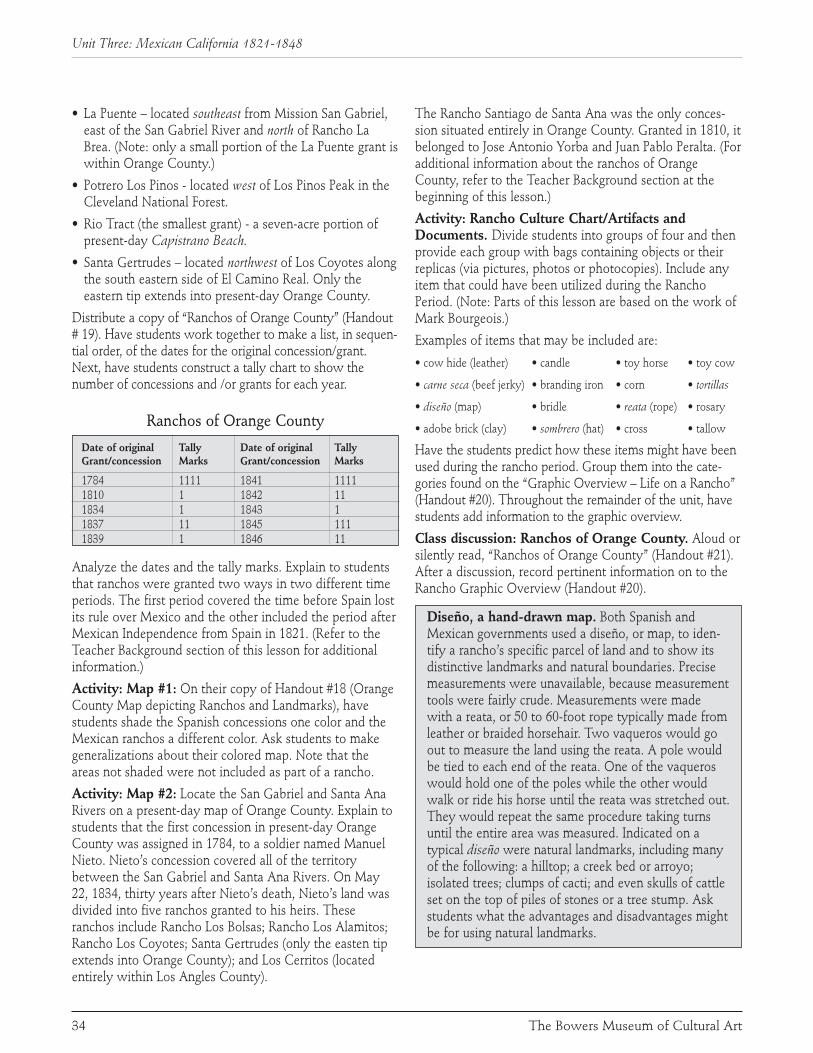
• La Puente – located southeast from Mission San Gabriel,east of the San Gabriel River and north of Rancho LaBrea. (Note: only a small portion of the La Puente grant iswithin Orange County.)
• Potrero Los Pinos - located west of Los Pinos Peak in theCleveland National Forest.
• Rio Tract (the smallest grant) - a seven-acre portion ofpresent-day Capistrano Beach.
• Santa Gertrudes – located northwest of Los Coyotes alongthe south eastern side of El Camino Real. Only theeastern tip extends into present-day Orange County.
Distribute a copy of “Ranchos of Orange County” (Handout# 19). Have students work together to make a list, in sequen-tial order, of the dates for the original concession/grant.Next, have students construct a tally chart to show thenumber of concessions and /or grants for each year.
Ranchos of Orange County
Date of original Tally Date of original TallyGrant/concession Marks Grant/concession Marks
1784 1111 1841 11111810 1 1842 111834 1 1843 11837 11 1845 1111839 1 1846 11
Analyze the dates and the tally marks. Explain to studentsthat ranchos were granted two ways in two different timeperiods. The first period covered the time before Spain lostits rule over Mexico and the other included the period afterMexican Independence from Spain in 1821. (Refer to theTeacher Background section of this lesson for additionalinformation.)
Activity: Map #1: On their copy of Handout #18 (OrangeCounty Map depicting Ranchos and Landmarks), havestudents shade the Spanish concessions one color and theMexican ranchos a different color. Ask students to makegeneralizations about their colored map. Note that theareas not shaded were not included as part of a rancho.
Activity: Map #2: Locate the San Gabriel and Santa AnaRivers on a present-day map of Orange County. Explain tostudents that the first concession in present-day OrangeCounty was assigned in 1784, to a soldier named ManuelNieto. Nieto’s concession covered all of the territorybetween the San Gabriel and Santa Ana Rivers. On May22, 1834, thirty years after Nieto’s death, Nieto’s land wasdivided into five ranchos granted to his heirs. Theseranchos include Rancho Los Bolsas; Rancho Los Alamitos;Rancho Los Coyotes; Santa Gertrudes (only the easten tipextends into Orange County); and Los Cerritos (locatedentirely within Los Angles County).
The Rancho Santiago de Santa Ana was the only conces-sion situated entirely in Orange County. Granted in 1810, itbelonged to Jose Antonio Yorba and Juan Pablo Peralta. (Foradditional information about the ranchos of OrangeCounty, refer to the Teacher Background section at thebeginning of this lesson.)
Activity: Rancho Culture Chart/Artifacts andDocuments. Divide students into groups of four and thenprovide each group with bags containing objects or theirreplicas (via pictures, photos or photocopies). Include anyitem that could have been utilized during the RanchoPeriod. (Note: Parts of this lesson are based on the work ofMark Bourgeois.)
Examples of items that may be included are:
• cow hide (leather) • candle • toy horse • toy cow
• carne seca (beef jerky) • branding iron • corn • tortillas
• diseño (map) • bridle • reata (rope) • rosary
• adobe brick (clay) • sombrero (hat) • cross • tallow
Have the students predict how these items might have beenused during the rancho period. Group them into the cate-gories found on the “Graphic Overview – Life on a Rancho”(Handout #20). Throughout the remainder of the unit, havestudents add information to the graphic overview.
Class discussion: Ranchos of Orange County. Aloud orsilently read, “Ranchos of Orange County” (Handout #21).After a discussion, record pertinent information on to theRancho Graphic Overview (Handout #20).
Diseño, a hand-drawn map. Both Spanish andMexican governments used a diseño, or map, to iden-tify a rancho’s specific parcel of land and to show itsdistinctive landmarks and natural boundaries. Precisemeasurements were unavailable, because measurementtools were fairly crude. Measurements were madewith a reata, or 50 to 60-foot rope typically made fromleather or braided horsehair. Two vaqueros would goout to measure the land using the reata. A pole wouldbe tied to each end of the reata. One of the vaqueroswould hold one of the poles while the other wouldwalk or ride his horse until the reata was stretched out.They would repeat the same procedure taking turnsuntil the entire area was measured. Indicated on atypical diseño were natural landmarks, including manyof the following: a hilltop; a creek bed or arroyo;isolated trees; clumps of cacti; and even skulls of cattleset on the top of piles of stones or a tree stump. Askstudents what the advantages and disadvantages mightbe for using natural landmarks.
34 The Bowers Museum of Cultural Art
Unit Three: Mexican California 1821-1848

Activity: Diseño of Rancho of San Juan de Santa Ana(Don Pacifico Ontiveros). Duplicate a copy of the diseñoof the Rancho San Juan Cajon de Santa Ana (Handout #22). It would be useful to make an overhead transparencyof the diseño to use for demonstration. Share informationabout Rancho San Juan Cajon de Santa Ana from theTeacher Background section at the beginning of this lesson.Ask students to identify all physical and human featuresvisible on Handout #22. Advise students that a diseño isoften difficult to read. (Handout #22 is a copy of the disenorecorded in 1852. It was submitted to the United StatesGovernment after California became a state in 1850.)
Activity: Diseño of the School: Have each student draw adiseño of the area around the school. Select a vantage pointat the center of the school playground or at a high spot nearyour school. Include natural boundaries such as trees, moun-tains, the local hills, rivers, large rocks, etc. Refer to Handout#23 for additional directions for “Creating a Diseño.”
Activity: Diseño of Our Own Rancho: Inform studentsthat a “fictional” Mexican governor is planning to granteach of them a rancho. First, have students create an appro-priate Spanish name for their rancho. Then, have themdraw a diseño showing the physical landmarks on theirproperty. If desired, students may also show the location oftheir adobe home on their diseño. To make the diseño lookmore realistic, draw the diseño on a brown paper bag andthen crumple the bag to give it an “old” look. Students candip their bags into weak tea to make the bags look morelike parchment paper. If crayons are used, the drawing willnot fade when it is dipped in the tea. Refer to Handout #23for additional directions for “Creating a Diseño.”
Measurement with a reata. Have students play the roleof a vaquero and measure the land of the school playgroundusing a reata. Thick yarn or roving can be used to make areata. Cut 3 colors of roving about 40” long. Each studentneeds three lengths, one of each color. Knot the threelengths of yarn together at one end. Distribute a set of yarnto each student. Pin or tape one set to the chalkboard soyou can model how to braid. Have the students tie theknotted end to a chair so both their hands are free to braidthe lengths. Tell the students to separate the colors –yellow to the left, orange in the middle, and brown tothe right (or whatever colors you use). Use the colornames to help the students know which length tobraid as you demonstrate. The reata should be braidedtightly. Working with a partner is helpful.
Once the reata is finished and tied off at the bottom, takeyour students out to the playground to measure its lengthand width using their reata. It is helpful to provide studentsan outline of the playground that can be used to record themeasurements. (Activity developed by Cathy Spiess andMark Bourgeois.)
Focus Question 2: What Did The Ranchos Contribute To The
Economic Development Of California?Suggested Lesson Activities
Class discussion: The Economy of the Ranchos. Askstudents, “How do you think the families of the ranchosused the land to supply food, clothing, shelter and money?”Cattle were the mainstay of the rancho economy. Unlikethe missionaries whose land was used to cultivate grapes,figs, citrus fruit and olives, the rancheros (ranch owners asdistinguished from workers) used the land for only oneproduct: cattle. For more information about the economyof the ranchos, refer to the Teacher Background section atthe beginning of this lesson and below.
Jobs on the Rancho. Many ranchos were 100s ofacres in size, as cattle required enough land to provideenough grass to eat. On such ranchos, the rancheromight hire as many as 100 workers. Ranchos werenearly self-sufficient – they made almost everythingneeded by the people living on them. With the nearestpueblo often more than a day’s ride away, people hadto grow or make most of what they needed. Theygrew their own food, raised their own cattle andsheep, and wove their own wool into cloth.
Activity: Rancho Graphic Overview. Help studentsrecord information about jobs on the rancho on theirgraphic overview (Handout # 20).
Class discussion: Cattle Brands. Under Mexican law allrancheros needed a brand, or identifying mark, for theircattle and horses. Because the cattle roamed freely acrossthe land, the brand helped everyone know which animalsbelonged to which ranch. Using the overhead projector,show students a transparency of some sample brands.(Refer to Handout # 24 for cattle brand samples.)
35Early California History: Exploration and Settlement Curriculum Guide
Unit Three: Lesson IV: The Growth of Ranchos
π Brands. Bowers Museum Collection

Activity: Cattle Brand Art. Materials for this activityinclude tempera paint, paper, pen, cord or thick string, card-board, glue and wide-diameter containers for dipping. Eachstudent can design and then create a cattle brand for his orher imaginary rancho. Brands consist usually of letters,numbers and characters (symbols) or a combination ofthese three. If a letter is “too tired” to stand and “lies” on itsside, it is called “lazy.” A letter that is slanted or in anangular position is known as “tumbling.” A letter that iscurved at the end is spoken of as “running.” Once a brandis pictured/created/drawn, it can be formed by using cordor some thick string glued onto a piece of cardboard. Afterthe glue dries, the brands can be dipped in tempera paintand pressed onto paper. It works exactly like a hand-stamp.
Activity: Cattle Brand/Rancho Writing. Have studentswrite a descriptive paragraph that includes the name oftheir imaginary rancho, the rancho’s natural features andwhat their cattle brand symbolizes. Combine all requiredelements to form a scoring guide. Include items such as:shows an understanding of the historical time period; hasno historical errors; writes in a well organized style; usesdescriptive words; and has all required elements of theprompt.
Focus Question 3: What Was Life Like On A Rancho?
Suggested Lesson Activities:
Activity: Early California Time Line. Choose appro-priate dates that relate to the ranchos era and post these onthe large classroom version of the “Early California TimeLine” (an in-progress activity begun in earlier lessons). Referto the sample “Early California Time Line” (Handout # 25).
Activity: Guided Reading of Frida Maria, a Story ofthe Old Southwest. This activity also engages students inEnglish-Language Arts content standards. Show the cover ofthe book, Frida Maria, by Deborah Nourse Lattimore. Askstudents:
• What do you see on the cover? What is the title? Who isthe author?
• Who do you think is the owner of the fan? What is a fanused for?
• What is meant by the phrase, “a story of the oldSouthwest?”
• When do you think this story, Frida Maria, takes place?How do you know?
First, read page one of Frida Maria. Then, ask students,“What is a fiesta? Why do you think Frida Maria can hardlywait to attend the fiesta?” Direct attention to the first fourpages of the story and ask questions about the details of
the clothing and the architecture in the illustrations.Discuss Frida’s full name.
As you read the rest of the book to the students, have themhelp you identify what happens at a fiesta, and thendevelop a summary list (i.e., invitations, food, decorations,colorful dresses, dancing - including the jarabe dance -singing, playing guitars and horseracing.) Carefully studythe illustrations for additional clues about the clothingworn, the architecture, the art and the types of artifacts.Also, develop a list of the Spanish words and their mean-ings, as identified in Frida Maria.
Activity: Recognizing Historical Fact as distinct fromFiction. Read the note by the author of Frida Maria foundat the end of the book. Review the difference(s) betweenfact and fiction, between fiction and historical fiction.Identify the clues which indicate that “Frida Maria” is afictional person. The story did not actually happen, but thebook does contain some factual information about life on arancho. Return to the text and ask the students which partsof the story are historically accurate (can be proven) andwhich sections are fictional. Create a chart that mayinclude some of the following:
Historical Fact Historical FictionFiestas were held Parts of the plot in theon ranchos. story are accurate for the
specific era. Fictitious characters are included.
Fiestas included food, Frida sewed her dress anddances and songs. New made it into pants. clothing is often sewn and worn at a fiesta.A horse race might be An imaginary person held at a fiesta. named Frida rides an
imaginary horse named Diablo and wins an imaginary race.
A hot, dry, Santa Anawind might blow.
Activity: Dialogue and Quotations. This activity alsoengages students in English-Language Arts content stan-dards. The story Frida Maria is filled with dialogue andquotations. Return to the story and look for dialoguewritten within quotations. Study the four sample quota-tions listed below and analyze the different formats. Notethe punctuation marks used for quotations. Ask students,“How can you identify the person who is doing thespeaking?”
• “Do you think I could ride Diablo at Fiesta?” Frida askedher uncle.
36 The Bowers Museum of Cultural Art
Unit Three: Mexican California 1821-1848

• “We will have to ask your mama, my little fox,” TioNarizo replied.
• Mama walked past fanning herself. “Come,” she said toFrida. “I hate to see you unhappy. Come out with me tomeet Don Ramon and his wife in the garden.”
• “I look forward to the great race,” said Don Ramon. “Noone has ever beaten my horse, Furioso.”
Make a list of all the characters with dialogue in the story(Frida Maria, Tio Narizo, Mama, Cook, Marta, Mercedesand Don Ramon.) Ask students if they think the charactersactually said these words or if the dialogue was created bythe author. Why do they think so?
Activity: Reader’s Theater. Work together with thestudents to turn Frida Maria into a Reader’s Theater.Materials include enough copies of the story for eachreader. The simplest way to adapt a short story for aReader’s Theater leaves the original text intact but dividesthe text so that one reader is the narrator while the otherreaders perform the dialogue for each character. Nametagsfor each character are helpful. Movement, gestures, staging,costumes and simple props can enhance the production,although in a traditional Reader’s Theater, the charactersusually do not “act” out their parts.
Activity: Rancho Days Celebration. Culminate the unitwith a Rancho Days Celebration. Depending on the activi-ties selected, supplies include: typical Spanish and Mexicanheritage outfits for cowboys and Rancho period families; avariety of foods, e.g. tortillas, chips, salsa and beef jerky;Spanish music tapes and instruments; prizes.
Have adult volunteers help with the celebration as partici-pants, organizers and facilitators. Divide students into smallgroups and have groups rotate from one activity to thenext. Sample activities can include:
• Lasso practice with a rope thrown around a desk chairdisguised as a cow.
• Play horseshoes for prizes.
• Dance hall featuring students doing fandango or jarabedances and singing songs of the period.
• Mock Spanish/Mexican government official registryoffice where brands made earlier in the lesson can beregistered. Dip branding irons into tempera paint andthen stamp them onto chart paper for display on theclassroom wall.
37Early California History: Exploration and Settlement Curriculum Guide
Unit Three: Lesson IV: The Growth of Ranchos
π Fan of Doña Ysidora Pico Forster.China, c. 1845. Hand-carved ivory,cerise silk, marabou feather, sequins.Bowers Museum Collection


Lesson V:Early California Time Line
1542-1848
Review of Era andKey Historic Figures
√ Historical communication from Mexican General JoseFigueroa, Political Superior in Chief of Alta California,dated March 21, 1834. The letter authorizes the use of abrand (furro) and stamp (señal). With his arrival in 1833,the plan for secularization of the missions continued,and was completed, enabling the Indians to be freedand land began to be granted. Bowers Museum Collection

Content StandardsHistory/Social Science: 4.2.7
Historical and Social Science Analysis Skills: CST 1; HI 3
Visual Arts: 4.2.1; 4.5.3
Focus Question 1: How Can The Key Events And People Of The Exploration And SettlementOf California Be Placed On A Time Line And Within A Spatial Context?Suggested Lesson Activities:
Activity: Chronological Time Line. A key structuralpattern found in informational text is that of sequential-chronological order. During the study of the early historyof California, many names, locations, events and dates arementioned. A time line can serve as an important frame-work upon which students can place these names, loca-tions, events and dates.
Activity: Cut and Match. For each pair of students, dupli-cate a copy of the “Early California Time Line” (Handout #25). Cut apart the rows of dates and events. Mix each setof strips into an envelope. Have each pair work to matcheach date with its associate event(s) and then place the
events into chronological order. Let students compare theirresults, first with other pairs and afterward with a copy ofHandout # 25. To help students correctly apply termsrelated to time, have them sort the dates by century andwrite a label for each century, i.e., label “16th century” forthe dates 1542, 1579 and 1595.
Discuss/review each event on the time line. Pose the ques-tion, “What else might be included on the “Early CaliforniaTime Line?” If no large classroom version of the time linehas been constructed during earlier lessons, it is recom-mended you make one now. (Refer to Lesson I, Activity:Construct a Timeline.) Continue to add to or revise thetime line as desired.
Activity: Sequencing Events of Early California from1543 to 1848. Provide students with a copy of the “EarlyCalifornia Time Line” (Handout # 25) and a copy of“Sequencing Events of Early California from 1543 to 1848”(Handout # 26). Instruct students to use the time line toplace the following events in their proper sequence bynumbering them from 1 to 10, with 1 being the earliestevent and 10 being the most recent event. (Note: Eventsselected are ones found in this manual. Other events maybe substituted or added.)
40 The Bowers Museum of Cultural Art
Unit Four: Sequence of Events
Lesson V: Early California Time Line
Order Event Proper Sequence
_____ The Mexican-American War ends. . . . . . . . . . . . . . . . . . . . . . . . . . . . . . . . . . . . . . . . . . . . . . . . . . . . . 10
_____ Father Serra establishes the 1st Mission in San Diego. . . . . . . . . . . . . . . . . . . . . . . . . . . . . . . . . . . . . . . 3
_____ Cabrillo claims Alta California for Spain. . . . . . . . . . . . . . . . . . . . . . . . . . . . . . . . . . . . . . . . . . . . . . . . . 1
_____ Portola reaches Monterey Bay and establishes a presidio. . . . . . . . . . . . . . . . . . . . . . . . . . . . . . . . . . . . 4
_____ Vizcaino recommends Monterey Bay for settlement. . . . . . . . . . . . . . . . . . . . . . . . . . . . . . . . . . . . . . . . 2
_____ Los Pobladores establish the Pueblo of Los Angeles. . . . . . . . . . . . . . . . . . . . . . . . . . . . . . . . . . . . . . . . 6
_____ Mission San Juan Capistrano is founded. . . . . . . . . . . . . . . . . . . . . . . . . . . . . . . . . . . . . . . . . . . . . . . . . 5
____ Rancho Santiago de Santa Ana is granted to Yorba & Peralta. . . . . . . . . . . . . . . . . . . . . . . . . . . . . . . . . 7
_____ The Mexican government starts to close missions. . . . . . . . . . . . . . . . . . . . . . . . . . . . . . . . . . . . . . . . . 9
_____ Mexico wins independence from Spain. . . . . . . . . . . . . . . . . . . . . . . . . . . . . . . . . . . . . . . . . . . . . . . . . . 8

Activity: Organizing the Events of Early CaliforniaHistory. Provide students with a copy of “Organizing theEvents of Early California” (Handout # 27). In groups of 4,have students work together to complete the chart shownbelow. Allow students to refer to the graphic overviewsthat they completed throughout the lessons in this manual.The chart includes the same event-sequence as the aboveactivity (#2). Note: The terms “Cause” and “Effect” may besubstituted for the last two column headings.
Focus Question 2: Over Time, What ThingsChange And What Things Remain The Same?
Suggested Lesson Activities
Activity: Newspaper Headlines. Incorporate the eventson the “Early California Time Line” (Handout # 25), into acatchy headline for each event. The activity can be done bystudent pairs or small groups.
Writing New Stories. Divide the class into 8 to 10 groups.Assign each group one of the key events featured on the“Early California Time Line” (Handout #25). Groups, orindividual students, may then develop a series of newsstories about ONE event using each of the formats listedbelow:
• A descriptive story about the event, including who,what, when, where and why
• An “imaginary” interview of a person involved with theevent (include imaginary quotations)
• An advice column suggesting a solution to aproblem/challenge related to the event
• An editorial or a Letter to the Editor about the event
Assemble the articles into a newspaper for each group. Letthe group determine the name of their newspaper, the dateof the issue and the design for the paper’s masthead.
3-D Chronological Time Line. Provide class time toreview the events recorded on the “Early California TimeLine” (Handout # 25). Have students work in groups toconstruct a 3-D time line. Refer to Handout # 28 for a listof the necessary steps for this project. Provide access tolibrary resources, textbooks and websites. Students willneed a variety of art materials (i.e., construction paper,paint, scissors and glue) to construct their 3-D time line.
As each group presents their time line, they should explainhow the events they have depicted made an impact on thehistory of California.
41Early California History: Exploration and Settlement Curriculum Guide
Unit Four: Lesson V: Early California Time Line

Spanish Exploration (1542-1775)Alta (upper) California was first seen by European eyesfrom the sea. Fifty years after the voyage of Columbus, thepeaceful homeland of California Indians, like theAcagchewen and Tongua Indians of Orange County, wasforever changed by the sailing vessels, San Salvador and LaVictoria, which carried the expedition of Portuguese navi-gator, Juan Rodriguez Cabrillo, northward. The year was1542.
Cabrillo accompanied Hernan Cortez and Pedro deAlvarado in the Spanish conquest of Mexico in 1521 and ofGuatemala in 1523. Cortez ventured to Baja California in1536. Cabrillo sailed from Navidad, Mexico in 1542,mapping San Diego Bay, Santa Catalina Island, Point Reyesand Monterey Bay as he searched for a resupply port forthe Manilla Galleons returning to Mexico from Asia.
Cabrillo died of an infection from a broken arm after battlewith California Indians. His exact burial site is unknown.One credible analysis places the site of the battle andCabrillo’s burial on Santa Catalina Island in 1543.
One hundred and sixty-six years later, on July 23, 1769, thefirst overland expedition of Europeans entered OrangeCounty. The party of Baja California Governor, Gaspar dePortola, lost a Spanish blunderbuss called a “Trabuco” a oneof their campsites. Trabuco Mesa and Canyon get theirnames from this lost 18th century weapon. On July 26, St.Anne’s Day, the party named the largest river in the valleyof Orange County the “Santa Ana.”
In 1775, Juan Bautista de Anza reached the mission atMonterey from the presidio in Tubac, Arizona, proving thatsupplies could be transported overland to Monterey andSan Francisco. For 233 years the Spanish explored andmapped the coastal waters and terrain of Alta California.
The Spanish crown desired to keep California from Russianhands and sought ways of settling the land. SpanishVisitador General José Galvez ordered the colonizing ofCalifornia in 1768 and sent Captain Fernando de Rivera yMoncada to make camp at San Diego on May 14, 1769.Franciscan Father Junipero Serra and Governor Gaspar dePortolá joined Rivera y Moncada before Portolá venturedfurther northward. Serra organized missions in AltaCalifornia after inheriting the former Jesuit missions of BajaCalifornia. Spanish pioneers soon established a culturedlifestyle near the missions of Alta and Baja California whilecattle ranching sustained both Padres and Rancheros.
Spanish Settlements In Alta California(1769-1821)
In response to the growing threat of Russian domination ofcoastal California, and rumors of gold and furs, Spain setout to establish what eventually became a series ofmissions, each a day’s horseback ride apart, along thelength of the state. In 1768, the King of Spain orderedFather Junipero Serra, a Franciscan missionary from Palma,Spain, to occupy “Alta California” and to establish a system
42 The Bowers Museum of Cultural Art
Review of Era and Key Historic Figures
Putting it all Together: A Review of the Era and Key Historic Figures
Early Exploration, 1542-1775Missions and Ranchos in California
1768-1822, Spanish Period1823-1848, Mexican Period
π CoiledBasketry Bowlwith Eagle Motifs. MissionIndian Culture, Southern California c. Late 19th - Early 20th Century.Juncus coiled over a grass bundle foundation. Bowers Museum Collection

of missions in an area that had been visited only by earlyexplorers, currently inhabited by native peoples.
On July 1, 1769, Father Serra erected a cross on a hill over-looking San Diego Bay where the first of 21 missionswould be built and where the future path of The RoyalRoad or El Camino Real would start. Eventually, themissions extended from San Diego to its northern limit atSonoma, north of San Francisco. Father Serra and his menplanted mustard seeds all across their journey, becausethese seeds were a wonderful spice for bland mission food.Even today, the bright yellow mustard seed flowers stillcover the hillsides in California.
The 21 mission sites were selected for their strategic aswell as economic importance. They were the hubs ofeconomic activity in the region until 1833, when they wereformally “secularized” and were turned over to theMexican Rancheros (private landowners). TheSecularization Act of 1833 removed the administration ofthe missions from the Spanish church and gave it to thecivil authorities in Mexico. By the end of 1834, themissions were dismantled, while mission lands weregranted to the Mexican Rancheros known as “Californios.”
Life at the Missions:Mission San Juan Capistrano
On November 1, 1776, Father Junipero Serra establishedthe mission of San Juan Capistrano, named in honor ofSaint Giovanni of Capistran, a 14th century Italian theolo-gian. This mission became the first European settlement inOrange County. In fact, from 1778 to 1783, the missionserved as Father Serrra’s home. In 1797, a master builderfrom Mexico City named Isidro Aguilar supervised thebuilding of the mission’s great Romanesque church (capableof holding 1,300 worshipers). Under Aguilera’s supervision,local Indian labor completed his vision within nine years.Christianized Indians lived nearby and grew wheat, corn,barley, grapes, peaches and apricots for the mission. Uponcompletion, Mission San Juan Capistrano was the mostmagnificent example of a California mission. Its architec-ture became famous around the world as representative ofthe “California Mission” style.
Unfortunately, just six years following completion, a strongearthquake destroyed the great church killing 40 Indianworshipers. The great church was never rebuilt and itsruins can be seen today.
Mexican California And Ranchos(1821-1848)
There were many changes after Mexico achieved independ-ence from Spain in 1821. Under Spanish rule, land waslargely in the hands of the missions, and there were less
than 30 land grants recorded. However under Mexican rulethe newly appointed Mexican governors of California(between 1821 and 1848, the period known as the Mexicanor “Rancho” period in California history) awarded over 800land grants. Once these granted lands were developedunder specific landowners, the property was called arancho or in current speech, a ranch.
While Mexican rule improved land grant distribution, theRancho period was also a time where close-knit familiesaccumulated great wealth, and devoted themselves toleisure time and an almost aristocratic lifestyle. The Ranchoperiod was known as “the day of the dons,” marked byhuge fiestas and sports such as bearbaiting, bull fighting,and cock fighting. A typical rancho had over 100employees including wool combers, tanners, soap-makers,washerwomen, blacksmiths and other trades-persons.Many of these local laborers were well-trained Indian“Vaqueros” (cowboys).
The area currently known as Orange County was made upof Ranchos owned by the Yorbas, Picos, Forsters, Avilas,Rios, Sepulvedas and others. By far the largest ranch wasthe 25-mile long Rancho Santiago de Santa Ana, owned bythe Yorba family.
Father Junipero SerraFather Junipero Serra, a Franciscan missionary and brilliantscholar, was born in 1713, off the coast of Spain on thesmall island of Majorca, in the town of Petra. He wasknown as a small, 5’3”, frail priest, who was responsible forconverting thousands of California Indians while helping toestablish the chain of 21 missions between San Diego tothe south and Sonoma to the north. Of the 21 missions inthe California chain that he supervised, Father Serrapersonally established six, including the San Diego mission.
The Spanish Governor, Don Gaspar de Portola, hadauthority over the San Diego mission. De Portola becamefamous after he personally led a column of soldiers north insearch of the famed bay at Monterey.
On that march, Don Gaspar de Portola was accompaniedby two Franciscan priests named Crespi and Lasuen plus ayoung corporal named Yorba. After the expedition, and bythe end of the 18th century, Yorba had acquired land andhad become the patriarch of a very important OrangeCounty family.
Mission IndiansThe missionary zeal of the Franciscan Fathers, under thedirection of Junipero Serra, led to the rapid Christianizationof the California Indians. Along with Christianization, theIndians moved away from their traditional village sites and
43Early California History: Exploration and Settlement Curriculum Guide
Review of Era and Key Historic Figures

relocated around the missions, where they provided a largelabor force. The Indians helped to construct the missions,cultivated untold acres of land that produced grains andfruits, and became proficient “vaqueros” or cowboys whoworked with thousands of head of cattle, horses, sheep andgoats.
As the Indians relocated to the missions and adoptedChristianity, they also gave up many of their traditions andart forms. Throughout California, Indian women adaptedtheir weaving to produce what became known as “missionbaskets.” They altered their Indian clothing to a distinctlyMexican style; and they incorporated Christian crosses andEuropean glass beads into their Indian jewelry.
Jose Antonio YorbaJose Antonio Yorba first traveled through Orange Countyin 1769, when he served as a corporal under Don Gasparde Portolá. By 1776, the young corporal Yorba was one ofthe first settlers in San Francisco. At the same time,Sergeant Juan Pablo Grijalva chose to settle in the area.Grijalva became Yorba’s father-in-law and business partner.Both men retired from the army at the end of the 18thcentury and settled what became known as OrangeCounty.
While in that Orange County area Yorba amassed a fortunetrading sea otter pelts and ranching along the Santa AnaRiver. When Grijalva died in 1806, Yorba filed for andreceived the first Spanish land grant in Orange County. Theland grant was known as Rancho Santiago de Santa Ana.Yorba and his wife had four sons and five daughters attheir rancho. When Yorba died in 1825, just two monthsbefore California ratified the Republican Constitution ofMexico, Yorba’s four sons and daughters would continueYorba’s legacy to be a major force in establishing OrangeCounty.
Bernardo YorbaPerhaps the best known of Jose Antonio Yorba’s offspringwas the third son, Bernardo Yorba. He was well-respectedand held such offices as the chief administrator and judicialofficer of California and “judge of the plains” (juez delcampo). Bernardo Yorba, known both as the “Baron ofSanta Ana” and “Don” Yorba, was the most successfullandowner of Jose Antonio Yorba’s four sons. After beinggranted three leagues (13,328 acres) of land in 1834 byGovernor Figueroa, Bernardo expertly developed his land.The land was located on the north side of the Santa AnaRiver near what is now Yorba Linda. Bernardo’s ranchowas known as Rancho Cañon de Santa Ana, named for SanAntonio, his favorite saint. This rancho had one of thelargest and finest haciendas (homes) known in California
during the Rancho period. It had 30 rooms distributed overtwo stories, plus an additional wing of 20 rooms whichincluded servants’ quarters, classrooms and various work-spaces.
“Don” Yorba was talented. He developed a huge ranchingbusiness in cattle, sheep, burros, mules and horses. Hisagricultural expertise included farming corn, wheat, beans,and fruit trees. Significantly, he was the first person inCalifornia to irrigate his crops with water drawn throughditches. He eventually extended his property by acquiringthe adjacent Rancho Sierra plus Rancho Rincon in Riversideand San Bernardino counties. He could ride 30 miles in anydirection and never leave his land. At Bernardo Yorba’sdeath at the age of 57 in 1859, he left behind 11,000 headsof cattle, 15,000 horses, and 8,000 sheep. Unfortunately,Yorba’s grand “Hacienda San Antonio” fell into disrepair,and was torn down in 1927.
44
Review of Era and Key Historic Figures
The Bowers Museum of Cultural Art
πHistoric Letter by DonSantiago Arguello. Prefectura Politica de LosAngeles. March 20, 1842. Ink on paper. This letter isaddressed to the Mayordomo of the San Gabriel Mission,Los Angeles. It references a previous communication issuedby the Superior Government concerning Mission Vieja.Bowers Museum Collection

What remains is the first non-mission school that was builtby Bernardo and the first cemetery that he had constructed.
Pio PicoPio Pico was the last Mexican governor of California,serving from February 1845 to August 1846. He was acolorful figure with enormous land holdings and apenchant for gambling. Pico organized the defense ofCalifornia against American invaders, along with hisbrother, General Andres Pico. Despite their great determi-nation, they were unsuccessful in their efforts to keepCalifornia part of Mexico. In 1847, General Andres Picosurrendered California to the Americans at the Treaty ofCahuenga in Los Angeles.
After resisting the American take-over of California, he fledto Baja California. Following the Treaty of GuadalupeHildalgo, in which Los Angeles was formally ceded to theUnited State, he returned to California and unsuccessfullyattempted to reclaim his land holdings. Resigned to thenew state of affairs, he became a successful businessmanand served on the Los Angeles City Council. Even withouta full restitution of all his lands, he was able to live a life ofcomfort. He owned the Pico House, Los Angeles’ firstmajor hotel, located in the El Pueblo de Los Angeles(Olivera Street). He was born in 1801 and died in 1894.
The Pico family was among the first settlers ofthe little town that today is themetropolis of Los Angeles. Duringthe Mexican governance period, thePico family allied themselves throughmarriage to a prominent Anglo family.Pico’s sister married John Forster. Duringthe secularization period, when the orderwas given to seize mission lands, Picosold Mission San Juan Capistrano toForster, his brother-in-law. Following theAmerican take-over of California, one of theForster’s granddaughters married Thomas L.McFadden. It was Mrs. Lucana Forster deMcFadden who inherited Pio Pico’s carriageand donated it to the Bowers Museum.
John (Juan) ForsterJohn Forster was an Englishman who arrived inCalifornia in 1833, as master of Facio, a trading shipowned by his uncle. Forster adapted to California withina mere three years of his arrival. In that time he petitionedfor and received Mexican citizenship, changed his name toJuan Forster, joined the Catholic church; and marriedYsidora Pico, both daughter of the important Pico familyand the sister of Pio Pico who was the last Mexicangovernor of California.
In 1844, Forster was working as a shipping agent in thearea around San Pedro, but chose to move his family to SanJuan Capistrano. Within a year, Pio Pico granted RanchoMission Viejo to Portenero de las Piños near SaddlebackMountain to Forster (now his brother-in-law). Soon after,Forster bought the nearby San Juan Capistrano Mission atpublic auction. Forster or “Don San Juan Capistrano” wasnow a major force in the region, using the abandoned SanJuan Capistrano Mission as his home.
Forster assisted the Americans for six months (between July1846 and January 1847) while the war between the UnitedStates and Mexico was raging. In July 1846, Major John C.Freemont and his American forces of 220 fighting soldierssailed from America to invade Mexican California and thento march north to Los Angeles. In July, on their way to LosAngeles, the troops were not only re-supplied and joinedby Forster, but were advised by him of an impendingambush near San Gabriel. Thanks to Forster, they changedtheir route and avoided disaster. By January 10, 1847,Mexican General Andres Pico surrendered California to theAmericans, culminated by the Treaty of Cahuenga in LosAngeles.
45Early California History: Exploration and Settlement Curriculum Guide
Review of Era and Key Historic Figures
√ Portable Writing Desk of DonJosé Antonio Yorba. Mexico, c.1857. Mahogany wood, brass.Don José Antonio Yorba wasgiven this elegant portablewriting desk by his father DonTomas, when Don José Antonioleft home to attend college inBoston. The desk has a nameplate on the center of the lidand keyhole inlaid with brass.The desk contains an inkbottle of composite materialand an ink bottle of glass in a
polished wood containerwith screw top.
Bowers MuseumCollection

Local Resources – Museums and ArchivesThe Bowers Museum of Cultural Art, 2002 North MainStreet, Santa Ana, California, 92706. Open Tuesday-Sundayfrom 10 a.m. to 4 p.m. Closed Mondays. For informationcall 714.567.3600 or visit www.bowers.org. To book aschool tour, rent a cultural trunk, and/or schedule a culturalart class at Kidseum, one block south of the main museum,call 714.480.1520.
Workman and Temple Family Homestead Museum,15415 East Don Julian Road, City of Industry, California91745-1029. One mile north of the #60 Freeway at theHacienda Boulevard exit (twenty miles east of downtown LosAngeles). Open Monday-Friday from 9 a.m. to 5 p.m. TheMuseum is closed on major holidays. This six-acre sitedates from the era when California was still part of Mexicothrough the decade of the 1920s when Los Angeles hadbecome a major American city. Its historical significance,park-like landscaping, meticulous restoration, and educa-tional programs have received numerous awards at theregional, state, and national level, making it one ofCalifornia’s true historic treasures.
Early Explorations of CaliforniaCabrillo National Monument, Point Loma in San Diego.619.293.5450. Witness the reenactment of the 1542 landingof Juan Rodriquez Cabrillo, part of San Diego’s annualCabrillo festival held in late September. The museum has agift shop where primary source maps, charts and journalscan be purchased.
Los Angeles Maritime Museum, Berth 84, Foot of 6thStreet, San Pedro, California, 90731, E-mail:[email protected] Telephone: 310.548.7618,Fax: 310.832.6537. The museum displays: models of shipsfrom the Viking period to the present; sailing tools; and,technology and equipment. The Gift Shop sells model kitsof various vessels and ships. “Changing exhibits” explorethe maritime history of Southern California, while themuseum’s educational affiliate, the Los Angeles MaritimeInstitute, provides sail-training opportunities for studentsyear-round.
San Diego Maritime Musuem, 1492 North Harbor DriveSan Diego, California 92101 Phone : 619.234.9153 Email :[email protected]. Open every day of the year 9:00 a.m.- 8:00 p.m. The Maritime Museum of San Diego displaysour rich maritime heritage and historic connections withthe Pacific world. Founded in 1948, the museum grew outof the earlier efforts of a group of local historians and
maritime enthusiasts who acquired the sailing ship Star ofIndia in 1927. Now fully restored, the Star of India is main-tained by a dedicated group of volunteers and skilledcraftsmen and sailed at least once a year. The Museumdisplays permanent and temporary exhibits, hosts educa-tional and public programs for all ages, hosts public events,and publishes a newsletter and peer-reviewed journal, allwith a maritime theme relating to the museum’s mission.
Nautical Heritage Society and Museum, 4532 DelPrado, Dana Point, California, 92629. For information call,949.661.1001. Monday through Friday hours: 9 a.m. to5p.m. The museum has the “Lighthouse” protruding fromits rooftop and the one-ton cannon (taken from a Spanishgalleon) outside. Headquartered at the museum is the tallship Californian which travels between northern andsouthern California throughout the year, offering daytimesailing programs to school children as well as day-sails onweekends (whenever docked at Dana Point) to the generalpublic. If the Californian is not in port, you can still visit thesociety’s small museum dedicated to nautical history of the“tall sailing ships.” They have ship models, sailing art, arti-facts salvaged from shipwrecks, antiques, and displaysabout sailing life from the late 18th and early 19thcenturies. Of note, the Californian docks next to anotherinteresting ship, the Pilgrim; this ship is the resident tall shipof the Orange County Marine Institute.
Fort Ross State Historic Park, 19005 Coast HighwayOne, Jenner, CA 95450. For more information call707.847.3286. Fort Compound, Visitor Center andBookstore are open daily 10:00am to 4:30pm. Fort Rosswas established in 1812 by Russians as an outpost for seaotter hunters and a permanent trade base. It was the south-ernmost outpost of a Russian presence in the PacificNorthwest. The Russians remained at Fort Ross until seaotters became scarce in 1841. The holdings were sold toJohn Sutter, who later became famous when gold wasdiscovered at his sawmill in the Sierra Nevada foothills.None of the original fort structures remain, howeverseveral buildings have been reconstructed: the first RussianOrthodox chapel south of Alaska, the stockade, and threeother buildings, including the Commander’s House, whichcontains exhibits of the Russian-American Fur Companyand the Russian occupation.
46 The Bowers Museum of Cultural Art
Resources for Teachers, Parents and Students
Resources for Teachers, Parents and Students

Mission Settlement in Orange County, California
Mission San Juan Capistrano, open daily 8:30 a.m. to 5p.m. Telephone: 949.234.1300 or visit www.missionsjc.comfor additional information. Considered the birthplace ofOrange County, the Mission was founded more than 200years ago. Originally built as a self-sufficient community bySpanish padres and Indians, this mission was a center foragriculture, industry, education and religion. Visitors canhear the tolling of century old bells and walk down its timeworn paths. The serenity and peace amid the 10 acres oflush gardens and cool fountains, cloistered by old adobewalls, offers visitors seclusion from the sights and soundsof a busy world. Visit the Serra Chapel, Padres Quarters,Industrial Area, Soldiers Barracks, Cemetery and The GreatStone Church. The Mission is a registered HistoricLandmark and is designated a National Historic Treasure.
Spanish and Mexican Ranchos in Orange County, California
Diego Sepulveda Adobe. At the corner of Adams andMesa Verde Drive in Costa Mesa stands the home of theDiego Sepulveda family. For information of tours andhours, call 949.631.5918. This beautifully restored adobewas originally constructed in 1823. It served for many yearsas a station for the herdsmen of the Capistrano Mission.The location of the adobe offers a commanding view of the“mesa” (coastal plateau) and surrounding communities.Authentically refurbished rooms help the guests relive lifeas it was during the rancho era of early California.
Ramon Peralta Adobe. This adobe, the only such struc-ture from the era of the Spanish and Mexico land grants,still survives in the Santa Ana Canyon area. Built in 1871,at what was then known as the town of Peralta, the fledg-ling community consisted of nine such adobes, a combina-tion saloon and pottery shop, and a school. In 1920, thePeralta Adobe was converted into a roadside restaurant andgas station. For the next four decades, the Peralta Adobecatered to the increasing motor traffic between RiversideCounty and Orange County on the newly paved Santa AnaCanyon Road. Orange County acquired the property in1977 and had the structure restored as a historic site. ThePeralta Adobe is located at the corner of Fairmont Avenueand Santa Ana Canyon Road in Anaheim Hills. For moreinformation call: 714.921.2730.
Pio Pico State Historic Park, 6003 Pioneer Boulevard,#127 Casa de Governor Pio Pico, Whittier, California,90606. For more information, call: 562.695.1217. In theaftermath of the Mexican War, the last Mexican governorPio Pico acquired the 9000 acre Rancho Paso de Bartolo;Pico built an adobe casa at de Bartolo that eventually was
destroyed by the floods of 1883-84. Pico’s second adobecasa, now known as the mansion, represents a compromisebetween Mexican and American culture. While living at themansion , the ex-governor helped to develop the emergingculture of American California. In 1917, the mansion and itsproperty was deeded to the State of California, and was tobe followed by its becoming one of the earliest statehistoric parks in 1927. The mansion in the historic park doesnot look the way it did when Pico lived there, however, forseveral reasons: basic restoration, remodeling (over theyears) and recent “structural stabilization” from the effectsof the 1987 Whittier Narrows Earthquake.
Yorba Cemetery. Jose Antonio Yorba arrived in 1769,with the famed Portola Expedition. He returned in 1801,and set up a homestead on the banks of the Santa AnaRiver. In 1834, the governor of California granted anapproximately 14,000-acre ranch to Jose Antonio’s son,Bernardo. The family was known for their affluence andhospitality. Unfortunately, during the 1920s, the beautifulYorba hacienda and attendant family chapel were demol-ished. Today, the family’s cemetery (which includes manyother early settlers) is cared for by the County of Orange asthe final resting place of Bernardo Yorba. For informationregarding the park’s facilities, call: 714.567.6206.
The Ramon Peralta Adobe Historic Site. 6398 E. SantaAna Canyon Road, Anaheim, CA 92807 For more informa-tion call 714.973.3190 or 714.973.3191. The Peralta Adobeis located on land that once was part of the RanchoSantiago de Santa Ana. It was not the oldest adobe in thisarea but it is the only one remaining today in the SantaAna Canyon. The Ramon Peralta Adobe was officially openfor public use on September 27, 1986. The adobe is avail-able for public visitation and guided tours. Historicalexhibits are available for viewing, which include artifactsexcavated on site, a furnished period room and numerousphotographs tracing the history of the adobe. Structuraldetails uncovered during the restoration work can also beseen by visitors.
Heritage Hill Historic Park. 25151 Serrano Road, LakeForrest, CA 92630. For information call 949.923.2230 or949.923.2232. Heritage Hill Historical Park is composed of4.1 acres and four historic buildings. The fully restored andfurnished historic buildings span the early history of theSaddleback Valley and El Toro area from the MexicanRancho era (Serrano Adobe, circa 1863), to the founding ofthe town of El Toro (El Toro Grammar School, 1890; St.George’s Episcopal Mission, 1891), through the citrusfarming days of the early twentieth century (HarveyBennett Ranch House, 1908). Guided tours through thebuildings are provided for the public Wednesday throughSunday. The tours offer an interpretation of Saddleback
47Early California History: Exploration and Settlement Curriculum Guide
Resources for Teachers, Parents and Students

area history through the artifacts, events and people associ-ated with each building. Landscaping of the park is inkeeping with the historic nature of the buildings.
Books and Resources for Explorers of California
Lemke, Nancy. (1991). Cabrillo: The First EuropeanExplorer of the California Coast. San Luis Obispo, CA:EZ Nature Books. ISBN 0-0945092-19-9. This paperbackbook contains a portrait of Cabrillo’s life and his voyage ofdiscovery.
Paez, J. Cabrillo’s Log 1542-1543 A Voyage ofDiscovery. San Diego, CA: Cabrillo Historical Association.Cabrillo kept a journal/record on his voyage.(Unfortunately, the original was lost, but a summary logwas published.) The summary log’s authorship has under-gone recent scrutiny. Once attributed to Juan Paez (a 16thcentury historian), now the log appears to have beenwritten by a notary public. As an official of the state, anotary wrote a summary of a voyage by examining theship’s records and interviewing the surviving captain andcrew. The 16th century account captured a sense ofdiscovery for each new sight observed by the earlyexplorers (sent by the king). Among the sights describedwas Los Angeles harbor, then called the Bay of Los Fumos(Bay of Smokes); the summary log’s account of the harborcan provide useful analogies to the smog of today. Theappendix can be helpful for students, especially in under-standing how historians differ in their identification of theplaces “Cabrillo” described in his log. A map of California’scoast with place-names identified is in the appendix. Themap allows a comparison between log book names andtoday’s geographic location names.
Wilcox, D. (1993). Voyagers to California (SecondEdition). Elk, CA: Sea Rock Press, 1993. ISBN 0-09630091-7-6. Several chapters of this book provide information onthe early exploration of Alta, California; the ManilaGalleons; Sebastian Vizcaino; Francis Drake; FatherJunipero Serra; and, the Russians at Fort Ross.
Books and Resources for Settlers of Alta California
Brennner, Barbara. Wagon Wheels. Harper CollinsPublishers, 1978. This book describes a black family’stravels in a wagon during the Westward Movement.Comparisons can be drawn to the Gaspar de Portola expe-dition and the experiences of the early settlers of thePueblo of Los Angeles. In pairs, students can list things thateach group took on their journey and compare it with whatthey would take on a journey today. (This activity is cour-tesy of Denise Smith.)
Erskine, D. (1958). The Big Ride. New York: Thomas Y.Crowell. The plot describes the first colonizing expedition toCalifornia from New Spain. The expedition was led byCaptain Anza in 1775. The book describes the experiences ofyoung Pedro, his family and his friend Jaime. The boys endureincredible hardships before reaching the present-day site of SanFrancisco. (Note: The book is out of print but a search online orat local schools or community libraries is worth doing.)
Richter, Glenda. The Stories of Juana Briones – AltaCalifornia Pioneer. Bonita, California: Bookhandler Press.2002. ISBN 0-9700379-1-0. Juana Briones’s life chroniclesthe experiences of a family in early California. This familyfrom the pueblo of Yerba Buena traveled in 1775, withCaptain de Anza to help build the San Francisco Presidio.Her experiences describe a land owner’s struggles to keepher rancho during the period when it became part of theUnited States. The text is clear and easy to read.
Roberts, Margaret. Pioneer California,Tales of Explorers,Indians, and Settlers. San Luis Obispo, CA: PadreProductions. 1982. ISBN 0-914598-4300 (paperback). Thisbook, written in a narrative expository style, containsstories of the Californian adventure from exploration to thegold rush. If available, read to the class “The Long Lost Bayof Monterey” which provides a description of the reasonsfor Spanish settlement, e.g., King Charles III of Spainbecomes worried that Russian explorers will move southalong the coast of California and claim it for Russia.
Smith, Donald, ed. Diary of Gaspar de Portola Duringthe Calif. Expedition 1769-70. CA: University of CABerkeley Press, 1909. This diary is penned by the earlyexplorer Gaspar de Portola. Portola’s account describes theIndians’ lifestyle along the Californian coast in 1769,including Portola’s observations about trading opportuni-ties, as well as clothing, shelter, food and tools used by theIndians. It is available at university libraries.
Books and Resources for the Missions ofCalifornia, especially for Orange County.
Boule’, Mary Null. Mission San Juan Capistrano. Vashon,WA: Merryant Publishing, 1988. ISBN 1-877599-06-0. Thisbooklet, seventh in a series of twenty-one booklets aboutCalifornia missions, provides general information onCalifornia’s missions and a specific discussion of MissionSan Juan Capistrano. To assist students in writing a reportabout Mission San Juan Capistrano, an outline of importanttopics is located at the back of the booklet.
Edgar, Kathleen J. and Susan E. Mission San JuanCapistrano. New York: The Rosen Publishing Group’sPowerKids Press, 2002. ISBN 0-8239-5889-2. This large-typebook is well-suited to 3rd and 4th grade readers. Wellwritten, it tells the story of the “jewel” of the missions from
48 The Bowers Museum of Cultural Art
Resources for Teachers, Parents and Students
early Spanish exploration up to the present. Discussions ofother Californian missions are available in the same series.
Faber, G. and Lasagna, M. (1986). Whispers Along theMission Trail. Alamo, CA: Magpie Publications. In thisfascinating book, the authors take you sailing along thecoast of California with courageous sailors on a Spanishgalleon; you are an eyewitness with the Indians to thearrival of the Spanish; you travel overland with the padres;and, you observe the establishment of the missions. Thisbook is excellent for reading out loud.
Fraser, Mary Ann. A Mission for the People: The Story of LaPurisima. New York: Henry Holt, 1997. ISBN 0-8050-5050-7.Although this book focuses on a mission in Santa Barbara,the author’s beautiful illustrations support a text rich withbackground information about California’s many missions.
Lemke, Nancy. Missions of the Southern Coast.Minneapolis, MN: Lerner Publications, 1996. This informa-tive text for teachers and students charts the histories ofthe Californian missions of San Diego de Alcala’, San JuanCapistrano, and San Luis Rey and briefly describes lifeamong the Native Americans of southwestern Californiabefore the arrival of the Spanish.
MacMillan, Dianne. Missions of the Los Angeles Area.Minneapolis, MN: Lerner Publications, 1996. ISBN 0-8225-1927-5. A companion to the Nancy Lemke book listedabove, the missions of San Gabriel Arcangel, SanBuenaventura and San Fernando Rey de Espana arefeatured.
Nelson, Libby. California Missions: Projects & Layouts.Minneapolis, MN: Lerner Publications, 1998. ISBN 0-8225-1931-3. This project book gives instructions for building amodel of a Californian mission building. Also, it includes abrief history and the building techniques of all the missionsin California, as well as layouts for each mission.
Isaacs, Sally Senzell. Picture the Past: Life in a CaliforniaMission. Chicago, IL: Heinemann Library, 2002. ISBN158810414-1. This pictorial, informational, paperback bookdescribes the daily life in California’s missions from 1769 to1823. It includes beautiful illustrations with many replicasof paintings and drawings from mission times along withmodern photographs of the missions.
Politi, Leo. Song of the Swallows. Young Juan lives in SanJuan Capistrano in the late 1940s, and likes to visit themission gardener. He learns all about the swallows andplants. Eventually, Juan creates a garden of his own, andhopes that his garden will appeal to the swallows the nexttime these birds return to San Juan Capistrano. Written in1948, it is a romanticized version of mission times.
Ramsey, Mabel and Merle. This was Mission County,Orange County, California. Laguna Beach, California:
Mission Printing, 1973. This classic reference book providesbackground information on missions.
Rawls, Jim. Never Turn Back: Father Serra’s Mission.Austin, TX: Raintree Steck Vaughn, 1993. ISBN 0-8114-8061-5. Written in large text for beginning readers, thispaperback describes the life of the Spanish priest whoestablished so many missions in California. The book high-lights the lack of understanding between the priest and theIndians that he came to convert.
White, Florence Meiman. The Story of Junipero Serra,Brave Adventurer. New York: Yearling, 1987. FatherJunipero Serra traveled along the West Coast of Californiafrom San Diego to San Francisco establishing 9 missionswithin 15 years. An appealing book to read aloud, itprovides a colorful overview of Serra’s life. Its flaws includea simplistic point-of-view and an unbelievable, overly-posi-tive rendition of events.
Books and Resources for RanchosBauer, Helen, California Rancho Days. Sacramento, CA:California State Department of Education. 1957. This bookis an excellent classroom resource. A classic, it providesgreat descriptions of the rancho period in California.
Dana, Richard Henry. Two Years Before the Mast. NewYork: Penquin Books, 1981. On board the trading ship, thePilgrim, in 1835, was a young Bostonian named RichardHenry Dana. For 18 months, Dana and his shipmatescollected hides along the Californian coast. He made obser-vations of California’s land and people. When Danareturned to New England in 1840, he published his recollec-tions. Dana provided precise details of the beauties ofCalifornia’s landscape, its capacious harbors, abundantwildlife and salubrious climate “which there can be nobetter in the world.”
Lattimore, Deborah Nourse, Frida Maria, A Story of theOld Southwest. San Diego, CA:Voyager Books (HarcourtBrace & Company). 1994. ISBN 0-15-201515-9. This picturebook is about a young, independent girl during the RanchoPeriod at fiesta time. An enjoyable story with lively illustra-tions, it is full of dialogue and Spanish words. (This book isfeatured in the lesson, The Growth of Ranchos.)
O’Brien, Elaine F., Anita of Rancho Del Mar. SantaBarbara: Fithian Press. 1991. This book is a fictionalizedaccount of a young girl’s life on a Santa Barbara Rancho.The portrayal of life on a rancho is historically accurate.
Osterman, Joe. The Old El Toro Reader: A Guide to thePast. This charming book tells the story of SaddlebackValley in one- and two-page topics that easily adapt todaily lessons. It includes coverage of the ranchos of OrangeCounty and lots of historic photos. Reading level is Grade 5and up. Available from the [email protected]
49Early California History: Exploration and Settlement Curriculum Guide
Resources for Teachers, Parents and Students

Robinson, W.W. Old Spanish and Mexican Ranchos ofOrange County. Los Angeles: Title Insurance and Trust Co.,1950. Classic reference for the ranchos of Orange County.
Silverman, Jim. Rancho Boy Juan Alvarado. Sonoma, CA:Kids History. 1982. This small booklet provides an accountof rancho life and the struggles during the Mexican Period. Itis an easy-to-read book written in both English and Spanish.
General History of California, including Orange County
Beck, Warren and Haase, Ynez D. Historical Atlas ofCalifornia. Oklahoma:University of Oklahoma Press,Norman Publishing Division, 1974. This book contains 101maps which depict the physical characteristics of Californiafrom the Indian era to the present.
Chan, Sucheng, and Olin, Spencer C. Major Problems inCalifornia History. Boston and New York; Houghton Mifflin,1997. This book introduces both primary sources and analyt-ical essays on important topics in California history.
Daniels, Roger and Olin, Spencer C. Racism in California.New York: The Macmillan Company, 1972. This book pullstogether a number of outstanding selections on racial preju-dice and social and legal discrimination in California.
Friis, Fries: Orange County Through Four Centuries. SantaAna, California: Friis-Pioneer Press, 1982. Friis’s bookcontains a history of Orange County with extensive back-ground content for teachers and historians alike. His narra-tives and descriptions are informative and enjoyable to read.
Hallan-Gibson, Pamela. Orange County: The GoldenPromise. Sun Valley, California: American Historical Press,2002. This book is a “must” for anyone interested inOrange County history. It is an accurate and illustratedhistory of Orange County that contains many fine histor-ical photographs and provides in-depth coverage of histor-ical events, beginning with the Mission Period.
Olin, Spencer C. California Politics 1846-1920. SanFrancisco: Boyd & Frazer Publishing Company, 1981. Thisbook traces the emering corporate state as it reviewsCaliforina politics from 1846 through 1920.
Rice, Richard B., Bullough, William A. and Orsi, Richard J.The Elusive Eden: A new History of California, 2ndedition. New York: McGraw Hill, 1996. ISBN 0-07-047908-9. This analysis cuts through the myths and legends ofCalifornia’s history. It provides an insightful background tothe different historical eras with an infusion of materialrelated to past and present ethnic, gender and environ-mental issues.
Rolle, A. F. (2003). California: A History (Sixth Edition).Harlan Davidson. ISBN: 0882959727. Considered by manyto be the standard history book of California, the book
begins with California’s early inhabitants and coversSpanish rule, Mexican control, American exploration andsettlement, the gold rush, immigration, and statehood.Chapters 3-5 provide teachers with sufficient backgroundinformation for the development of sample lessons onEuropean exploration and early settlement.
General BooksPryor, Bonnie, The House on Maple Street. New York:Mulberry Books (William Morrow & Co.) 1987. ISBN 0-688-12031-8. Two girls discover an ancient arrowhead anda broken china cup. The story evolves around the girls’pondering over these artifacts as they ask: Where did theseitems come from? Through the children’s investigation, thehistory of a neighborhood going back for 300 years isrevealed. The book is helpful in introducing the themes ofcontinuity and change.
Visual and Performing Arts ResourcesArlen. Karen W.; Batt, Margaret; Benson, Mary Ann; andKester, Nancie N. They Came Singing: Songs fromCalifornia’s History. Oakland, CA: Calicanto Associates.1995. This booklet and the accompanying disc contain acollection of over 60 traditional songs set in an historicalcontext. The “Songs of the Early Explorers” section includesfive songs from the Spanish and English explorers. A usefultime line, “Explorations in Early California,” is included.
“California’s Gold.” VHS, PBS Los Angeles. This videoseries explores topics about California’s history and aspectsof everyday life in the state. It consists of several videosets, each of which contains 12 programs. A teacher’s guidegives an overview of programs within the set and suggestsvarious resources and interactive instructional strategieswhich are linked to the California History-Social ScienceFramework.
McNeil, Keith and Rusty. California Songbook and Songswith Historical Narrative. The 81 songs on Volume I ofthe CD include music of the California Indians and earlySpanish and English explorers. Also, among the songs arethose typical of the gold rush days and of those sung whileworking on the railroads. The songbook has all the songlyrics plus the music. Available from [email protected]
Web Linkshttp://www.californiahistory.net/index.htm
http://www.oc.ca.gov(County of Orange site, includes a history and a time line.)
http://www.journeystothepast.com (Jacque Nunez, storyteller)
50 The Bowers Museum of Cultural Art
Resources for Teachers, Parents and Students

51
Handout # 1The Bowers Museum of Cultural Art Early California History Curriculum Guide
Expl
orer
Spon
sor
Yea
r(s)
Aim
s/G
oal
Acc
ompl
ishm
ent
Obs
tacl
es/F
ailu
re(F
ull N
ame)
Cou
ntry
Juan
Rod
rique
z Sp
ain
1542
Loca
te th
e St
rait
of A
nian
. Fi
rst E
urop
ean
disc
over
er o
f Fa
iled
to fi
nd th
e St
rait
of A
nian
.C
abril
loEx
plor
e th
e co
ast o
f Alta
Cal
iforn
ia. C
laim
ed C
alifo
rnia
Ship
retu
rned
with
no
trea
sure
.C
alifo
rnia
. Fin
d tr
easu
res
of
for S
pain
. Ope
ned
a ne
w s
eaG
eogr
aphi
c fe
atur
es n
amed
by
Cab
rillo
gold
and
silv
er.
rout
e al
ong
Alta
Cal
iforn
ia a
ndw
ere
late
r ren
amed
. Cab
rillo
die
dle
arne
d ab
out t
he la
nd a
nden
rout
e.pe
ople
of t
he re
gion
.
Sir F
ranc
is
Engl
and
1579
Loca
te a
Nor
thw
est P
assa
geC
laim
ed C
alifo
rnia
for E
ngla
ndFa
iled
to fi
nd th
e N
orth
wes
tD
rake
(Str
ait o
f Ani
an) f
rom
Eur
ope
as N
ova
Alb
ion
(New
Eng
land
).Pa
ssag
e (S
trai
t of A
nian
). Th
e to
Asi
a. C
aptu
re tr
easu
re o
nFi
rst E
nglis
hmen
to c
ircum
-En
glis
h cl
aim
to C
alifo
rnia
was
not
Span
ish
galle
ons.
navi
gate
the
glob
e. C
aptu
red
mai
ntai
ned
due
to in
adeq
uate
reso
urce
s.C
ircum
navi
gate
the
glob
e.en
orm
ous
trea
sure
s fr
om N
ewSp
ain
and
from
Spa
nish
shi
ps.
In 1
581,
Dra
ke w
as k
nigh
ted
by Q
ueen
Eliz
abet
h I.
Seba
stia
n Sp
ain
1595
Expl
ore
the
coas
t of A
ltaC
oast
al e
xplo
ratio
n of
Alta
C
erm
eno’
s ga
lleon
shi
p, S
an A
gust
in,
Rodr
ique
z C
alifo
rnia
for s
afe
harb
ors
Cal
iforn
ia. (
Cer
men
o’s
expl
orat
ion
sank
in a
sto
rm n
ear D
rake
’s Ba
y. T
heC
erm
eno
for M
anila
gal
leon
shi
ps.
was
ove
rsha
dow
ed b
y hi
s lo
ssca
rgo
was
lost
.of
the
San
Agu
stin
and
its c
argo
.)
Seba
stia
n Sp
ain
1602
Acc
urat
ely
char
t the
Cal
iforn
ian
Map
ped
the
coas
t of A
lta C
alifo
rnia
Vizc
aino
’s su
gges
tion
that
Mon
tere
yVi
zcai
noco
ast a
nd lo
cate
a s
helte
red
and
disc
over
ed M
onte
rey
Bay.
wou
ld m
ake
a sa
fe h
arbo
r was
port
for s
ettle
men
t.W
rote
an
enth
usia
stic
and
igno
red
by S
pani
sh o
ffici
als
for
exag
gera
ted
repo
rt o
n th
eov
er 1
50 y
ears
.
Gra
phic
Ove
rvie
w –
Exp
lore
rs o
f Ear
ly C
alifo
rnia
, 154
2-16
03 (T
each
er K
ey)

52
Handout # 1The Bowers Museum of Cultural Art Early California History Curriculum Guide
Expl
orer
Spon
sor
Yea
r(s)
Aim
s/G
oal
Acc
ompl
ishm
ent
Obs
tacl
es/F
ailu
re(F
ull N
ame)
Cou
ntry
1542
Faile
d to
find
the
Stra
it of
Ani
an.
Ship
retu
rned
with
no
trea
sure
.G
eogr
aphi
c fe
atur
es n
amed
by
Cab
rillo
wer
e la
ter r
enam
ed. C
abril
lo d
ied
en ro
ute.
Engl
and
Cla
imed
Cal
iforn
ia fo
r Eng
land
as N
ova
Alb
ion
(New
Eng
land
).Fi
rst E
nglis
hmen
to c
ircum
-na
viga
te th
e gl
obe.
Cap
ture
den
orm
ous
trea
sure
s fr
om N
ewSp
ain
and
from
Spa
nish
shi
ps.
In 1
581,
Dra
ke w
as k
nigh
ted
by Q
ueen
Eliz
abet
h I.
Seba
stia
n 15
95Ro
driq
uez
Cer
men
o
Acc
urat
ely
char
t the
Cal
iforn
ian
coas
t and
loca
te a
she
ltere
dpo
rt fo
r set
tlem
ent.
Gra
phic
Ove
rvie
w –
Exp
lore
rs o
f Ear
ly C
alifo
rnia
, 154
2-16
03 (S
tude
nt C
opy)

53
Handout # 2The Bowers Museum of Cultural Art Early California History Curriculum Guide
Identification of Cabrillo’s RouteThe names Cabrillo gave to the Californian coast were changed over time. Cabrillo’s log was often vague about ship loca-tions during the voyage. The chart below shows some of the location names listed by date in Cabrillo’s log. Historians donot always agree on which modern-day regions correlate to the names Cabrillo used in his log. The chart below is basedupon the location names that three scholars believe are the real locations for Cabrillo’s discoveries.
Date Log Name Bancroft Bolton Wagner(1884, 1886) (1959) (1941)
July 3 California San Lucas Cape Pulmo Cape Pulmo
July 6 San Lucas San Jose San Lucas San Lucas
July 8 Trinidad Margarita Island Cape Tosco Punta Tosco
July 13 San Pedro Magdalena Bay Magdalena Bay
July 19 Magdalena Magdalena Bay Pequena Bay Punta San Juanico
July 20 Santa Catalina San Domingo Point San Domingo Point
July 25 Santiago Abreojos Ballenas Bay Ballenas Bay
Avre Ojo Abreojos Shoals Abreojos Rocks Abreojos Rocks
Santa Ana Isle Asuncion Asuncion Point Punta & Bahia de San Rogue
July 27 Puerto Fondo Bay east of Asuncion Isle San Puablo Bay San Puablo Bay
July 31 Asuncion Isle San Cristobal Bay
Aug. 1 San Pedro Vinculia San Bartolome San Bartolome San Bartolome
Aug. 2 San Esteban Natividad Natividad Island Natividad Island
Aug. 5 Cedros Cedros Islands Cedros Islands Cedros Islands
Aug. 11 Santa Clara Playa Maria Bay Playa Maria Bay Playa Maria Bay
Aug. 15 Mal Abrigo Canoas Point Canoas Bluff Point
Aug. 19 San Bernardo San Geronimo San Geronimo San Geronimo
Aug. 20 Engano Cape Baja Point Baja Point Baja
Aug. 22 Poeseion Virgenes Port of San Quentin Port of San Quentin
Aug. 27 San Agustin San Martin San Martin San Martin
Sept. 7 San Ramon Bay
Sept. 8 Santa Maria San Quentin Point Santo Tomas Cabo Santa Maria
Sept. 14 Cape of Cruz Grajero Point Point Santo Tomas
Sept. 17 San Mateo Todas Santos Todos Santos Bay Ensenado
Sept. 27 Islas Desiertas Los Coronados Islands Los Coronados Islands Los Coronados Islands
Sept. 28 San Miguel San Diego San Diego San Diego
Cabrillo’s Log 1542-1543. A Summary by Juan Paez. Compiled by Clyde J. Lussier. Printed by the Cabrillo Historical Association. San Diego: California, 1968.

54
Handout # 3The Bowers Museum of Cultural Art Early California History Curriculum Guide
The records, kept by Cabrillo on hisvoyage, are lost. However, there is adetailed record of the voyage that, untilrecently, was attributed to Juan Paez (a 16thcentury historian). This log is now creditedto a notary public. As officials of the state,notaries wrote summaries of variousvoyages by examining ship’s records andinterviewing the surviving captain and crew.Following is an excerpt from the log.
…On Saturday the 23rd of September theyleft the port of San Mateo and sailed alongthe coast until Monday, at which time theyhad traveled eighteen leagues. They saw verybeautiful valleys and groves, with the landplain and rugged, but they saw no Indians.
The following Tuesday and Wednesday theysailed along the coast about eight leagues,passing some three uninhabited islands to thelandward. One of the islands is larger thanthe others. It is two leagues in length, andmakes a shelter from the westerlies. Theislands lie at 34 degrees, and we are threeleagues from the mainland. This day they sawon land great smokes [smoke due to fires]. Itappears to be a good land, with great valleys,and inland there are high mountains. Theycalled the island, Islas Desiertas.
On Thursday they went about six leaguesnorth-northwest along the coast and found avery good enclosed port, to which they gavethe name San Miguel. It lies about 34 degrees20’; and, after anchoring they went ashorewhere there were people. Of these, threewaited, and all the others ran away. To thesethree they gave some gifts, and the Indianstold them by signs that people like the
Spaniards had passed inland; they showedmuch fear. At night the Spaniards left theships in a small boat to land and to fish.There happened to be Indians there, and theybegan to shoot with their arrows and theywounded three men.
The next day, in the morning they went withthe boat further into the port, which was large,and caught two boys who understood nothing,not even signs, and they gave them shirts andsoon sent them away.
The day after that, in the morning three largeIndians came to the ships, and by signs toldhow inland there walked men like theSpaniards, bearded and dressed and armedlike the ones on the ships, and they showedthat they had ballistas [i.e., crossbows], andmade gestures with their right arm as if theywere spearing. They went running as if theywere on a horse, and showed that they killedmany of the Indian natives, and for thatreason they were afraid. These people werewell-proportioned and large. They wentaround covered with the furs of animals.While in port, a very large storm passed, butbecause the port was so good they felt nothing.The weather came from the south-southwestand it was rainy. This was the first real stormthey had undergone, and they stayed in theport until the following Tuesday. Here thenatives called the Christians “Guacamal.”
On Tuesday, the 3rd of October, they left theport of San Miguel, and during Wednesday,Thursday and Friday they continued on theirroute about eighteen leagues along the coast,on which they saw many valleys and plainsand many fires [smoke due to fires].
Cabrillo’s Log

55
Handout # 4The Bowers Museum of Cultural Art Early California History Curriculum Guide
Written Document Analysis Worksheet1. Type of Document (check one):
■■ Newspaper ■■ Letter ■■ Log
■■ Memorandum ■■ Map ■■ Telegram
■■ Press Release ■■ Report ■■ Advertisement
■■ Census Report ■■ Other ____________________________________ ________________________________________
2. Unique physical qualities of the document (check all that apply):
■■ Interesting letterhead ■■ Notations ■■ Seals
■■ Handwritten ■■ Typed ■■ Other
■■ “RECEIVED” stamp ■■ Report
3. Date(s) of the document:
4. Who is the Author (or creator) of the document?
What is their Position or (Title)?
5. For what audience was the document written?
6. Document Analysis: (There are many possible ways to answer A-E)
A. List three important things noted in this document:
1.
2.
3.
B. Why do you think this document was written?
C. What evidence in this document helps you understand why it was written? Write
examples of that evidence below.
D. List two things this document describes about life at the time it was written.
1.
2.
E. Write a question (to the author) that is left unanswered by the document.

56
Handout # 5The Bowers Museum of Cultural Art Early California History Curriculum Guide
I Am
I amI wonderI hearI seeI wantI am
I pretendI feelI touchI worryI cryI am
I understandI sayI dreamI believeI needI amAdapted from Cathy Spiess

57
Handout # 6The Bowers Museum of Cultural Art Early California History Curriculum Guide
Name of Interviewer:
Name of Person being Interviewed:
Relationship to the Interviewer:
Date of the Interview:
1. When did your family (or ancestors) first settle in California?
2. From where did your family migrate?
3. Why did your family choose to settle in California?
4. What stories can you share about your family’s migration?
Family Migration Interview Form

58
Handout # 7The Bowers Museum of Cultural Art Early California History Curriculum Guide
Route of Portola Expedition, 1769
Courtesy of OC History Project Teachers

59
Handout # 8The Bowers Museum of Cultural Art Early California History Curriculum Guide
The expedition to Monterey left San Diego Bay in 1769.Gaspar de Portola led a company of 62 men north fromSan Diego. Traveling with Portola were Father Crespi,Father Gomez, five officers, and a number of Indiansfrom Baja California. At the tail-end trudged 100 muleswith their tenders. The backs of the mules were loadedwith heavy bags of equipment and food obtained fromthe ships San Carlos and San Antonio, including driedmeats, bran and flour for the making of tortillas, and aquantity of vegetables such as native squash. Portolaestimated that they had enough supplies to last for sixmonths.
The unfamiliar land was filled with many obstacles, sodaily marches were short. Six soldier scouts rode inadvance of the others. These scouts would choose theroute for the day, break trail and select camping sites foreach night’s rest. One of the scouts was Sergeant JoseFrancisco Ortega, for whom Ortega Highway is named.
Portola and his company were the first known whitemen to come to what is now called Orange County. Theexplorers named many places as they traveled andcamped. They approached the southern boundary ofthe county on July 22, 1769, and camped at what isknown today as Los Cristianitos Canyon (#1 on the“Route of the Portola Expedition 1769” map). Thecanyon’s name means “Canyon of the Little Christians”and it is located a mile east of present-day SanClemente. It was named for what happened at the timethat the soldiers (on scout duty) entered the canyon.These Christian Soldiers encountered two dying nativegirls, who were hurriedly baptized with the names ofMaria Magdalena and Margarita. They were the firstbaptisms in California.
After camping the next day in San Juan Canyon (#2 onmap), the expedition arrived at Trabuco Mesa on July24 (#3 on map). The men first named the mesa SanFrancisco Solano, but “Trabuco” was the name thatstuck after one of Portola’s soldiers lost his trabuco, atype of rifle, on the mesa. The explorers rested on July25. On the morning of July 26, before leaving Trabuco,the members of the expedition celebrated the Feast Dayof Saint Anne. They named the valley below them,
Santa Ana. Later they traveled through SantiagoCanyon, crossed Aliso Creek and passed where El ToroMarine Base was later located. That night they campedat the springs which Father Crespi named “SanPantaleon.” The soldiers called the springs, “The Springsof Father Gomez.” Later the springs were renamed,“Tomato Springs” (#4).
On July 27, the group stopped at a creek near present-day Orange (#5). They named the creek Santiago inhonor of St. James. Father Crespi noted in his diary thatthere was only a trickle of water in the creek, but it wasfull of willows, grapevines and brambles. At noon onJuly 28, the expedition camped on the east bank of ariver near what later became the town of Olive (#6).The soldiers named the river “Rio de Santa Ana,”because it seemed to flow from the mountains justnamed in honor of Saint Anne. Father Crespi called theriver “Dulcisimo Nombre de Jessu de los Tremblores”(or in English, “Sweet Name of Jesus of theEarthquakes”), because a violent earthquake rocked thearea. Four more earthquakes were felt that afternoon.Today, the river is known as the Santa Ana River.
The next day, July 29, the Portola party crossed the riverwith some difficulty because of the swiftness of thecurrent. They marched northwesterly and camped nearthe mouth of Brea Canyon (#7). This last night (in whatis now Orange County) was spent near present-dayHillcrest Park in Fullerton. On July 30, Portola and hismen passed through the Puente Hills and La HabraValley before leaving the county. The expeditioncontinued in search of Monterey Bay but they failed torecognize it. They continued northward, and onNovember 2, 1769, were the first Europeans to viewSan Francisco Bay.
Portola’s group returned to San Diego on January 23,1770. Later in the year, Portola made a second expedi-tion northward and successfully found Monterey, estab-lishing a presidio there. Portola is remembered as theleader of the expedition that traveled over the 1000-miletrail from the Baja Peninsula to discover San FranciscoBay and to settle Monterey . (Courtesy of Karen Kirby and Denise
Smith.)
The Portola Expedition

60
Handout # 9The Bowers Museum of Cultural Art Early California History Curriculum Guide
Portola Expedition, 1769
Courtesy of Karen Kirby

61
Handout # 10The Bowers Museum of Cultural Art Early California History Curriculum Guide
May 1769
The 11th day of May, [1769,] I set out from SantaMaria, the last mission to the north, escorted byfour soldiers, in company with Father JuniperoSerra, president of the missions, and Father MiguelCampa. This day we proceeded for about fourhours with very little water for the animals andwithout any pasture, which obliged us to go onfarther in the afternoon to find some. There was,however, no water.
The 12th, we proceeded over a good road for fivehours and halted at a place called La Poza de AguaDulce. No pasture.
July 1769
(Brea Camp was established on July 29th after a difficultcrossing of the Santa Ana River into the foothills aboveFullerton.)
The 29th, we proceeded for three hours on a goodroad. Much pasture, but water sufficient only forthe men. Here there was an Indian village of aboutfifty inhabitants.
The 30th, we proceeded for four hours on a goodroad, with the exception of two very steep hills.We halted in a very large valley where there wasmuch pasture and water. Here we had to constructa bridge to cross the gully. I consider this a goodplace for a mission.
The 31st, we proceeded for four hours; near thecamp we found much water with a great deal ofpasture which had grown [so tall] that the animalshad to jump in order to get through it. Here werested [for one day]. We experienced six or sevensevere earthquakes. In this valley we discovered,on the south side between two mountains, a springthat flowed like a river, giving evidence of deepsoil.
August 1769
The 2nd, we proceeded for three hours on a goodroad, and halted near a river about fourteen yardswide. On this day we felt three or four earth-quakes.
The 3nd, we proceeded for three hours on a goodroad; to the right of it were extensive swamps ofbitumen which is called chapapote. We debatedwhether this substance, which flows melted fromunderneath the earth, could occasion so manyearthquakes. We had much pasture, water, and anabundance of antelope and deer. Here [the inhabi-tants of] a village of about thirty natives appeared[at our camp]; they gave us presents and we madethem a suitable return.
The 4th, we proceeded for two hours and a half ona good road. Sufficient water and pasture. [Wehalted at a place] occupied by a village of thirtynatives; they made us a present of nuts and acornsand we made them a suitable return.
The 5th, we proceeded for four hours over hills, asthe mountain range obstructed our progress by thesea. In this place we found an Indian village ofabout sixty inhabitants; they made us a present ofmuch grain. Here we rested [for one day] and overtwo hundred natives came [to our camp] withmuch grain.
Diary Of Gaspar De Portola During The California Expedition Of 1769-1770
Excerpts from the diary of the journey that Don Gaspar de Portola, Governor of the Californias, made by land to the ports of San Diego and Monterey, situated in 33 degrees and 37 degrees
[north latitude]. (Edited October, 1909)

62
Handout # 11The Bowers Museum of Cultural Art Early California History Curriculum Guide
Gaspar de Portola PoemThis activity provides you with the opportunity to show what you know about Gaspar de Portola. It alsoallows you to practice the parts of speech. Fill out the spaces below by following the directions.
Line 1: Name of the person (Gaspar de Portola)
Line 2: Two (2) adjectives to describe the person
Line 3: Three (3) verbs describing the person’s actions
Line 4: Four (4) nouns that appropriately relate to the person
Line 5: Three (3) more verbs to describe the person’s actions
Line 6: Two (2) more adjectives to describe the person
Line 7: One (1) new and different noun for the person.
Line 1 ___________________
Line 2 ___________________ ___________________
Line 3 ___________________ ___________________ ___________________
Line 4 ___________________ ___________________ ___________________ ___________________
Line 5 ___________________ ___________________ ___________________
Line 6 ___________________ ___________________
Line 6 ___________________

63
Handout # 12The Bowers Museum of Cultural Art Early California History Curriculum Guide
Expl
orer
Spon
sor
Yea
r(s)
Aim
s/G
oal
Acc
ompl
ishm
ent
Obs
tacl
es/F
ailu
re(F
ull N
ame)
Cou
ntry
Gas
par
Spai
n17
69de
Por
tola
Fath
er17
69-
Juni
pero
Serr
a
Juan
1775
-6Ba
utis
tade
Anz
a
Los
1781
Pueb
lodo
res
Gra
phic
Ove
rvie
w –
Set
tlers
of A
lta C
alifo
rnia
from
176
9

64
Handout # 13The Bowers Museum of Cultural Art Early California History Curriculum Guide
El Pueblo de la Reina de Los Angeles sobre El Rio dela Porciuncula was founded near this site on orabout September 4, 1781 as the first Spanishcivilian settlement in Southern California. Elevenfamilies, including 22 adults and 22 children, wererecruited from the Provinces of Sinaloa and Sonorain New Spain; now called Mexico, by CaptainFernando de Rivera y Moncada, emissary of theGovernor of California, Felipe de Neve. Their taskwas to provide food for the soldiers of thepresidios and to help secure Spain’s hold on this
region. They included farmers, artisans and stockraisers necessary for the survival of the settlement.Escorted by soldiers, the departed Los Alamos,Sonora on February 2, 1781 and arrived in severalgroups during the summer of 1781. The followinglist of the 44 pobladores was taken from the offi-cial Spanish census of 1781, which recorded theirnames, race, sex and age. The pobladores ranged inage from one to sixty-seven and reflected thecultural heritage and racial diversity that link thecity’s past to the present.
LOS POBLADORESThe Founders of the City of Los Angeles
CAMERO
Manuel Mulato Hombre 30
Maria Tomasa Mulata Mujer 24
LARA
Jose Fernando Espanol Hombre 50
Maria Antonia India Mujer 23
Maria Juana Nina 6
Jose Julian Nino 4
Maria Faustina Nina 2
MESA
Antonio Negro Hombre 38
Maria Ana Mulata Mujer 27
Maria Paula Nina 10
Antonio Maria Nino 8
MORENO
Jose Mulato Hombre 22
MariaGuadalupe Mulata Mujer 19
NAVARRO
Jose Antonio Metizo Hombre 42
Maria Regina Mulata Mujer 47
Jose Eduardo (Maria) Nino 10
Jose Clemente Nino 9
Mariana Nina 4
QUINTERO
Luiz Negro Hombre 55
Maria Petra Mulata Mujer 40
Clemente Nino ?
(and five daughters) Ninas ?
RODRIGUEZ
Pablo Indio Hombre 25
Maria Rosalia India Mujer 26
Maria Antonia Nina 1
ROSAS
Basilio Indio Hombre 67
Maria Manuela Mulata Mujer 43
Jose Maximo Nino 15
Jose Carlos Nino 12
Maria Josefa Nina 8
Antonio Rosalino Nino 7
Jose Marcelino Nino 4
Jose Esteban Nino 2
ROSAS
Alejandro Indio Hombre 19
Juana Maria India Mujer 20
VANEGAS
Jose Indio Hombre 28
Maria Bonifacia India Mujer 20
Cosme Damien Nino 1
VILLAVICENCIO
AntonioClemente Espanol Hombre 30
Maria Seferina India Mujer 26
Maria Antonia Nina 8
Dedicated September 4, 1981
Los Angeles 200 Committee

65
Handout # 14The Bowers Museum of Cultural Art Early California History Curriculum Guide
R ROLE Juan Rodriquez Cabrillo, Sebastian Vizcaino, Gaspar de Portola or Father Junipero Serra
A AUDIENCE The King of SpainF FORM A LetterT TENSE Past tense (1500’s or 1700’s)
,
,
To show what you have learned about the explo-ration of Alta California and its first settlements,select one of the following men to be the author ofa fictional letter: Juan Rodriquez Cabrillo, SebastianVizcaino, Gaspar de Portola or Father Junipero
Serra (Role). Select an appropriate date for theletter (Tense); use the proper letter format (Form);and direct the letter to the king of Spain(Audience), describing vividly the findings of theexpedition.
R.A.F.T.

66
Handout # 15The Bowers Museum of Cultural Art Early California History Curriculum Guide
Daily Life on a California MissionThe King of Spain has asked you to travel to Alta California to describe (in report form) the daily lives ofthe people, native and non-native, who occupy the mission settlements. Write the report requested by theKing. To complete this report, follow the directions in the three (3) sections listed below:
Section 1: Research the report
Select one of California’s missions to research. Look for important historical facts about the daily life at the mission, including 3 or more of the following topics:
1. Daily life of the padres (routines, tasks, anything else of interest)
2. Daily life of the Indians (routines, tasks, anything else of interest)
3. Types of work performed at the mission
4. Religious and cultural traditions practiced
5. Relationships between the missionaries and the Indians
6. Comparison between life in the Indian villages to that of life at the mission
• Use the organizational features (e.g., prefaces, appendices) of texts to locate information.
• Draw information from one or more sources. Include a list of the sources used.
• Find details, examples, anecdotes or experiences to explain and clarify your research.
Section 2: Write the report
• Select a historically correct date.
• Include important historical facts about at least 3 of the topics listed above in the research section.
• Use details, examples, and/or experiences toexplain and clarify information in your report.
• Accurately describe events typical of the historical time period.
While writing the report to be delivered to the King of Spain, use the following English-Language Arts Content Standards for Writing Application:
• Frame a central question about life at the mission.
• Include facts and details for focus.
• Write in the formal tone found in reports.
Section 3: Presentation of the report.
While orally presenting the report to the King ofSpain, use the following English-Language Arts Content Standards for Speaking Application:
• Present an effective introduction and conclusion that guides and informs the King’s understanding of the important ideas.
• Use details, examples, anecdotes or experiences to explain and clarify information.
• Emphasize points in ways that help the King to follow important ideas and concepts.
• Use volume, pitch, phrasing, pace, modulation and gestures appropriately to enhance meaning.

67
Handout # 16The Bowers Museum of Cultural Art Early California History Curriculum Guide
Research Activity: Jobs Performed by Mission Indians
Select and research one typical job of an Indian who worked at a mission
Then, complete the following steps.
• Identify and describe in writing one type of job performed by mission Indians.
• Describe at least 3 steps required for completion of the job.
• Make a list of all of the necessary supplies involved to complete the task.
• Come to school prepared to demonstrate how to do the job.
• For extra credit, provide or construct props that can be used in your demonstration.
Examples of the types of jobs performed by Mission Indians:
• Tanning leather (turning animal hides intoleather by soaking them in a special liquid tomake saddles, shoes and hats)
• Herding, raising and managing livestock such ascattle, sheep and goats; branding calves
• Making roof tiles and adobe bricks (sun-driedbricks made of straw, mud and water placedinto molds and dried outdoors in the sun)
• Working the forge (furnace) to shape metal (tomake wagons called carretas, wheels, brandingirons, locks and keys)
• Making soap and candles (using tallow or fatfrom cattle)
• Weaving wool for cloth
• Grinding corn and making tortillas
• Working in the fields planting and harvestingwheat, barley, corn and vegetables
• Planting and tending to orchards of peaches,apricots, walnuts, figs, red and green grapes(used to make wine), oranges, pears, olives(used to make cooking oil and lamp oil) anddate palms
√ Dispatch Pouch c. 1780-1820. NativeAmerican runners used leather bags such
as this to carry messages from onemission station to another. Few
dispatch bags have survived.Bowers Museum Collection

68
Handout # 17The Bowers Museum of Cultural Art Early California History Curriculum Guide
Economic Activity CardsCut apart the Economic Activity Cards. Using your knowledge of the era, sort the cards into two piles,one labeled “Agricultural Economy of Spanish Settlers” and the other “Hunter-gatherer Economy ofCalifornia’s Indians.”
Agricultural Economy ofSpanish Settlers
Hunter-gatherer Economy of California’s Indians
Raised livestock such ascattle, sheep, goats and
horses.
Made adobe bricks and usedthem to construct buildings.
Gathered a variety of acorns,roots, nuts and berries.
Cultivated fields of barley,wheat, beans, corn, melons,
squash and a few othervegetables.
Used plant fiber to makehomes, clothing and a wide
variety of basket forms.
Used clam shells in the formof beads as the predominant
currency.
Made soap and candles fromcattle tallow.
Obtained many of the thingsneeded from the surrounding
natural environment.
Tanned animal hides/skinsturning them into leather.
Worked the forge (furnace) toshape metal to make carretas(wagons), wheels, branding
irons, locks and keys.
Ground corn to maketortillas.
Planted and then tended theorchards of fruits and nuts.
Rode horses and ox-drivencarretas (wagons) as the main
means of transportation
Carved soapstone into cups,bowls, animals effigies, pipes
and fancy beads.
Made mortars and pestles outof steatite and other rocks.
Walked as the main mode oftransportation, although
some used rafts and canoes.

69
Handout # 18The Bowers Museum of Cultural Art Early California History Curriculum Guide
Orange County Map Depicting Ranchos and Landmarks
Courtesy of First American Bank

70
Handout # 19The Bowers Museum of Cultural Art Early California History Curriculum Guide
Ranchos of Orange County
Rancho Date of original Original Ownerconcession/grant
Boca de La Playa May 7, 1846 Emigdio Vejar
Bolsa Chica July 1, 1841 Joaquin Ruiz
Cañada de Los Alisos May 3, 1841 José Serrano
Cañon de Santa Ana August 1, 1834 Bernardo Yorba
La Habra October 22, 1839 Mariano R. Roldon
La Puente July 22, 1845 John Rowland and William Workman
Las Bolsas 1784 (concession) Manuel Nieto
Lomas de Santiago May 26, 1846 Teodocio Yorba
Los Alamitos 1784 (concession) Manuel Nieto
Los Coyotes 1784 (concession) Manuel Nieto
Mission Vieja (or La Paz) April 4, 1845 Agustin Olvera
Niguel June 21, 1842 Juan Avila
Potrero Los Pinos April 5, 1845 John (Juan) Forster
Rincon de La Brea February 13, 1841 Gil Ybarra
Rio Tract July 5, 1843 Santiago Rios
San Joaquin April 15, 1837 & May 13, 1842 José Sepülveda
San Juan Cajon de Santa Ana May 13, 1837 Juan Pacifico Ontiveros
Santa Gertrudes 1784 (concession) Manuel Nieto
Santiago de Santa Ana July 1, 1810 (concession) José Antonio Yorba and Juan Pablo Peralta
Trabucco February 16, 1841 Santiago Arguello
(From Robinson, Old Spanish and Mexican Ranchos of Orange County)

71
Handout # 20The Bowers Museum of Cultural Art Early California History Curriculum Guide
Graphic Overview – Life on a Rancho
Category Life on a Rancho
Food
Clothing
Types of Shelter
Types of Tools Used
Types of Transportation
Jobs (roles)
Elements of the Economy
Religion
Entertainment/Customs

72
Handout # 21The Bowers Museum of Cultural Art Early California History Curriculum Guide
When Spain ruled California, large pieces ofCalifornia land were given to a few soldiers. Thesewere called concessions or land grants. The firstland grant was given to Manuel Perez Nieto for hisservices as a Spanish soldier. He was given all theland between the Santa Ana and San Gabriel rivers.He built a rancho on the land and called it NietoRancho.
The only Spanish concession entirely withinpresent-day Orange County was given to JuanPablo Grijalva. He built the county’s first privateresidence and moved his family there to live. Henamed his rancho El Rancho Santiago de Santa AnaJuan Pablo. Grijalva’s daughter married Jose AntonioYorba, who was a soldier with the Portola expedi-tion. José Yorba and his nephew, Juan Pablo Peralta,received title to the rancho in 1810, after Grijalvadied. They ran a fine rancho with many cowboys,horses and cattle.
After Mexico won independence from Spain andtook over California, many more land grants weremade. There were twenty ranchos in, or partly in,Orange County. Manuel Nieto’s great rancho wasdivided into several smaller ranchos and granted tohis sons. Yorba and Peralta each had so many chil-dren that their rancho was separated into pieces forthe Yorba and Peralta family members to share.
Many ranchos were huge and a complete, self-suffi-cient community. Enough food was raised for thefamily and all of the workers. It was common tofind large vegetable gardens and many fruit treesand grapevines. In addition, wheat and corn wereraised. The main business of the rancho was raisingcattle. The cattle herds roamed freely over the hillsand valleys of Orange County. Each rancho had aunique brand or mark to identify its cattle. Thebrands were burned onto the hides of the cattle.
Once a year in the spring, the ranchos held a rodeoor roundup. Everyone from all the neighboringranchos gathered together. The vaqueros, orcowboys, gathered all the cattle and separated themby their brands. Each unbranded calf was branded
by its owners. All animals that were identified to bekilled for their meat, hides and tallow were sepa-rated, and the rest of the herd was turned loose foranother year.
When the rodeo was over, the rancheros,vaqueros/cowboys and their families had a fiesta(party). After the fiesta, each ranchero with hisvaqueros drove the cattle to be killed back to theirown rancho. The hides and tallow from the cattlewere traded to Yankee trading ships in exchange forsupplies that the rancho needed, i.e., tools, furni-ture, cloth and spices.
The children of the rancheros were taught to readand write by a member of the family, a retiredsoldier or by one of the priests. The boys weretaught by their fathers to ride horse back and to runa rancho. Sometimes, the boys were sent to Mexicoor Spain to go to school. At other times, the boysspent part of their time as soldiers at the presidios(forts). Girls were taught housekeeping skills.
The Spanish people thought that it was importantto be both a good Christian and a good citizen.Children were taught to be truthful, to keep theirpromises, to be kind and to be polite. Life was notall serious. The rancheros thought having a goodtime was an important part of life. So, part of theireducation included learning to sing and dance well.
Any special occasion was a good excuse to hold aMexican fiesta. Guests came from neighboringranchos or as far away as Los Angeles and SanDiego. The men and most of the young people trav-eled on horses, while the elderly and the childrenrode in the squeaking carretas, or carts, which werepulled by oxen. Often a fiesta began in church, butlater moved to one of the rancho adobes. Afterwardthere were good dinners for all, then games, sports,music and dancing. A typical fiesta lasted severaldays. If the distance home was too great, the guestsstayed overnight at the rancho and returned to theirown home at the end of the fiesta.
(Based on the work of Karen Kirby)
Ranchos of Orange County (Student Reader)

73
Handout # 22The Bowers Museum of Cultural Art Early California History Curriculum Guide
Diseño of Rancho San Juan Cajon de Santa Ana

74
Handout # 23The Bowers Museum of Cultural Art Early California History Curriculum Guide
Creating a DiseñoYou have decided to petition the governor of California under Mexico for a grant of land.Along with the petition, you must submit a diseño (drawing of a piece of land.) How do youdo it?
• Make a “vista de ojos” (survey-by-eye) as you, themapmaker, walk over the area.
• Take a pad of paper, a pencil and a compass to theschool playground or an area of high ground near theschool.
• Locate some obvious physical landmarks, such ascreeks, hills, canyons, large trees and boulders.
• Standing at the high ground near the school or aspecific vantage point, and only using your eyes, drawthe topography of the surrounding 10 to 15 miles. Tryto draw individual landmarks as much to scale aspossible, so decide ahead of time decide how big thewhole map will be. For example, if you choose 11"x14"paper, then place the school at the center within a oneinch area. Make all future items on the map in meas-urements that would be in scale with the size of theschool.
• On your diseño, label the physical landmarks you haveidentified.
The governor will respond by granting you a “concedo,” or provisional ownership. Now,within a year, you must build and occupy a house and a corral, stock the land with cattleand plant something. No fence may interrupt traffic on a public road.(Based on the work of Cathy Spiess)

75
Handout # 24The Bowers Museum of Cultural Art Early California History Curriculum Guide
Historic Brands of Orange County
Courtesy of Karen Kirby

76
Handout # 25The Bowers Museum of Cultural Art Early California History Curriculum Guide
Early California Time LineNote: When constructing a large classroom version of the Early California Time Line,
begin with the year 1500 and continue to the present day.
1542 Spanish explorer Juan Rodriquez Cabrillo sails along the Alta Californian coast and claims it for Spain.
1579 English sea captain Francis Drake claims Alta California for England. Drake circumnavigates the globe and captures treasures from Spanish ships.
1595 Sebastian Rodriquez Cermeno leaves the Philippines to look for a safe port on the Californian coast. Cermeno’s exploration is overshadowed by his loss of the San Agustin and its cargo.
1602 Sebastian Vizcaino maps the Californian coast to locate a sheltered port for settlement. His report recommends Monterey Bay, but exaggerates it geographic features as a safe-harbor.
1769 Four Spanish expedition groups arrive in San Diego, two by sea and two overland. The first presidio is built at San Diego. Gaspar de Portola leads an expedition northward from San Diego in search of Monterey Bay. His search leads instead to the discovery of San Francisco Bay. Father Junipero Serra establishes the first mission in Alta California and names it San Diego de Alcala.
1770 Gaspar de Portola reaches Monterey Bay on his 2nd expedition northward. Portola establishes a presidio in Monterey.Father Junipero Serra arrives in Monterey by ship. Serra establishes the Mission San Carlos de Monterey on June 3.
1771 Mission San Gabriel is founded and becomes the first non-native settlement in what is now Los Angeles.
1774 Juan Bautista de Anza reaches Mission San Gabriel on his first overland expedition from Mexico through the Sonoran Desert.
1776 Father Serra dedicates the Mission of San Juan Capistrano on November 1. This mission is present-day Orange County’s first permanent settlement. Juan Bautista de Anza and 240 settlers reach Monterey Bay on Anza’s 2nd expedition. They found a San Francisco colony.
1777 Alta California’s first pueblo is built near the southern end of San Francisco Bay where San Jose is located today.
1781 The Pueblo of Los Angeles is founded on September 4 as a farming community by a group of 44 settlers (Pobladores) recruited from Sinaloa and Sonora villages in Mexico.
1784 A Spanish Concession is granted to Manuel Nieto, including 300,000 acres between the San Gabriel and Santa Ana Rivers.

77
Handout # 25The Bowers Museum of Cultural Art Early California History Curriculum Guide
Early California Time Line
1810 Jose Antonio Yorba and Juan Pablo Peralta receive the first Spanish concession (Rancho Santiago de Santa Ana) situated entirely in present-day Orange County and includes today’s cities of Villa Park, Orange, Tustin, Costa Mesa and Santa Ana.The Mexican War for Independence begins. The priest, Miguel Hildalgo, calls on the Mexican people to revolt against Spain.
1812 The Russians and Aleuts establish Fort Ross on a bluff about 60 miles north of San Francisco near modern-day Bodega Bay. An earthquake destroys the Great Stone Church at Mission San Juan Capistrano and 39 people die.
1821 Mexico wins independence from Spain. Alta California becomes a Mexican province.
1833 The Mexican government begins closing the Californian missions and redistributing its property through land grants to Mexican citizens.
1841 San Juan Capistrano becomes an official Mexican pueblo.
1845 Mission San Juan Capistrano sells at public auction to John Forrester and James McKinley for $710 in gold and hides.
1846 Settlers begin the Bear Flag Revolt in Sonoma declaring California an independent Republic, victory occurs June 14.The Mexican-American War reaches California, and on July 2, the United States navy captures Monterey without firing a shot.
1847 The fighting in California ends with the signing (January 13) of the Treaty of Cahuenga.
1848 Gold is discovered by John Marshall at Sutter’s Mill on January 24. The Mexican-American War ends with the signing of the Treaty of Guadalupe Hidalgo. Mexico gives northern lands to the United States, including all the land of present-day California, Utah and Nevada, but only parts of New Mexico, Arizona, Colorado and Wyoming. In return, the U.S. pays Mexico $15 million.
1849 Americans and Californios gather at a constitutional convention in Monterey, and choose 28 delegates to draft the California Constitution of 1849.
1850 California becomes the 31st state of the union on September 9.

78
Handout # 26The Bowers Museum of Cultural Art Early California History Curriculum Guide
Sequencing Events of Early California, 1542 to 1848Note: First, it is recommended that you use the “Early California Time Line” and/or additional resources to helpstudents in identifying the date(s) for each event. Then, determine the proper sequence of the events.
Place the following events in their proper sequence by numbering them from 1 to 10, with 1 being theearliest event and 10 being the most recent event.
_____ The Mexican American War ends.
_____ Father Serra establishes the first Mission in San Diego.
_____ Cabrillo claims Alta California for Spain.
_____ Portola reaches Monterey Bay and establishes a presidio.
_____ Vizcaino recommends Monterey Bay for settlement.
_____ Los Pobladores found the Pueblo of Los Angeles.
_____ Mission San Juan Capistrano is founded.
_____ Rancho Santiago de Santa Ana is granted to Yorba & Peralta.
_____ The Mexican government starts to close missions.
_____ Mexico wins independence from Spain.
Name Date

79
Handout # 27The Bowers Museum of Cultural Art Early California History Curriculum Guide
Name Date
Organizing the Events of Early CaliforniaComplete the following chart using the “Early California Time Line”
(Handout #25) and/or additional resources.
Date Event Key People Challenges Responses to Faced the Challenges
1542
1602
1769
1770
1776
1781
1810
1821
1833
1848

80
Handout # 28The Bowers Museum of Cultural Art Early California History Curriculum Guide
3-D Chronological Time LineWork in groups to construct a 3-dimensional time line of three to five historic events listed on the “EarlyCalifornia Time Line” (Handout #25). Follow the step-by-step instructions below.
1. Select a chairperson to keep track of the step-by-step progress of your group.
2. Review the events recorded on the “Early California Time Line.”
3. Select three to five historic events for the team’s time line, i.e., Mexico wins independence
4. Create a title for your 3-D Time Line, i.e., Turning Points in California History.
5. Determine the time intervals for your time line, i.e., decades from 1750 to 1850.
6 On a large sheet of paper, use a ruler to create a proportional time line, like the one below.
1750 1760 1770 1780 1790 1800 1810 1820 1830 1840 1850
7. Construct a label/sign for each event. Per label, include the name of the event with its relevant dates andlocations.
1810 1820 1830
8. Determine where to place each label on the time line.
9. Research information about each event.
(a.) Include 4 to 6 facts per event.
(b.) Include the names of key people involved with each event.
(c.) Write the information for each event on a separate sheet of paper to be displayed with your3-D models.
(d.) Per event selected, determine what impact it had on the history of California.
10. Use a variety of art materials (i.e., construction paper, paint, scissors and glue) to construct a 3-dimensional model to illustrate each event. Be creative.
11. Display your 3-D models on the time line or on a table beneath the time line.
12. As your group presents its time line, be prepared to explain how the events depicted had an impact onthe history of California.
(1821) Mexico wins independence from Spain…

Early California History: Exploration and SettlementEVALUATION FORM
We need to know if—and how—this curriculum guide helps you so we can emphasize those areas in future guides. How areyou using it? What would you like to see different? Help us to assist you! We are available and listening! Thank You!
1. Which parts of the Curriculum Guide did you find the most useful? (check all that apply):
■■ Relation to Content Standards ■■ Classroom Activities
■■ Early Explorations of California ■■ Handouts
■■ Settling Alta California ■■ Early California Timeline
■■ Life at the Missions ■■ Document Analysis Worksheet
■■ The Growth of Ranchos ■■ Resources for Students and Teachers
2. Did you use this guide in conjunction with a school tour of the exhibition? ■■ Yes ■■ No
Comments
Did you use this material ■■ Before or ■■ After your students saw the exhibit? How did you use it?
Suggestions for improvement/general comments?
3. Will you keep this guide for further reference? ■■ Yes ■■ No ■■ Maybe
Will you pass it to another teacher? ■■ Yes ■■ No ■■ Maybe
4. For which subjects do you think the materials in this packet are the most appropriate?
■■ Art ■■ Language Arts ■■ Social Studies/History ■■ Humanities
5. How did you find out about this guide?
6. Have you ever visited the Bowers Museum? ■■ Yes ■■ No Bowers Kidseum? ■■ Yes ■■ NoIf yes, please indicate when? which exhibition?
With Students? ■■ or by yourself? ■■ .
Optional
Teacher’s Name Grades you instruct
Subjects you instruct
School Name
City State ZIP
Phone (day) Phone (evening) E-mail
Thank you!
Please send form to: Education Department, The Bowers Museum of Cultural Art
2002 N. Main Street, Santa Ana, CA 92706 Or fax to: 714.567.3603
81
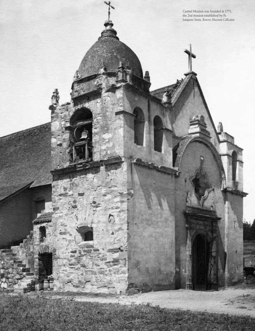
Carmel Mission was founded in 1771,the 2nd mission established by Fr.Junipero Serra. Bowers Museum Collection

√ PastelPainting of Santa
Margarita Rancho. c. 1880. BowersMuseum Collection