A Comprehensive Framework for Classification of Nuclei in ...

Functional Classification
Comprehensive Guide
Prepared by
June 6, 2014

Functional Classification Comprehensive Guide
June 2014 Page | 2
INTRODUCTION
PURPOSE OF DOCUMENT The intent of this document is to provide a comprehensive guide to Virginia Department of
Transportation (VDOT) staff, local government staff /officials, and the public on how the
Commonwealth of Virginia manages functional classification. The document is presented in
four sections. The first section is a general overview of what functional classification is, how
VDOT uses functional class, and who maintains the functional classification. The second
section presents FHWA guidelines such as the functional classification definitions and other
important information needed to decide the functional classification of a roadway. The third
section presents the process for requesting a change to the functional classification system for
existing roadways as well as requesting a functional classification for future roads. The final
section of the document lists resources available for functional classification in the
Commonwealth. After completing this document, the reader should have a basic knowledge of
functional classification and its role in the Commonwealth of Virginia’s transportation system.
FUNCTIONAL CLASS BASICS WHAT IS FUNCTIONAL CLASSIFICATION? Functional classification is the process by which streets and highways are grouped into classes,
or systems, according to the character of service they are intended to provide. Functional
classification outlines how travel can be channelized within the network in a logical and efficient
manner by defining the part that any particular road or street should play in serving the flow of
trips through a highway network.
The bases of the functional usage of a roadway are mobility and accessibility. Travel can be
logically related to the roadway's ability to access land and the mobility through an area. Figure
1 shows the relationship between traffic mobility and land access. Different roadway
classifications offer different levels of mobility and accessibility. For example, local facilities
emphasize the land-access function. Arterials
emphasize a high level of mobility for through
movement, while, collectors offer a compromise
between access and mobility.
Mobility is measured in respect to ability of traffic to
pass through a defined area in a reasonable amount of
time. Common elements of mobility include:
Operating speed
Level of service
Riding comfort
Figure 1: Proportion of Service

Functional Classification Comprehensive Guide
June 2014 Page | 3
Accessibility is measured in terms of the road system’s capability to provide access to and
between land use activities within a defined area.
WHY DO WE HAVE IT? Functional classification began with the passage of the Federal Aid Act of 1921. The Act
established a federal aid primary system. More importantly, the Act commissioned the
construction of a national roadway network. This network is the foundation of the system of a
national defense highway, later known as the national interstate system.
The absence of uniformity among states hindered federal efforts to determine national needs. In
order to address this issue, Congress passed the Federal Aid Highway Act of 1973, which
mandated the realignment of federal aid roads based in a standardized functional classification
system. This process remains in effect today. As part of the process established by the Federal
Highway Act of 1973, the Act also requires states to classify roadways eligible for federal aid
into standardized functional classifications. In the Commonwealth of Virginia, VDOT’s
Mobility Planning Division (TMPD) is responsible for functional classification.
FHWA provides funding to states, territories, and other entities for roadway construction and
improvement projects through various programs and related adjustment accounts. Total miles of
each functional classification should fall within established percentage ranges defined by the
Federal Highway Administration (FHWA). Interstates, urban freeways and expressways, and
principal arterials generally received the highest levels of funding. Minor roads—minor arterials,
major collectors and minor collectors—typically received the lowest levels of funding. In
addition to tracking funding for highway construction and improvement projects, FHWA also
collects data on highway characteristics and usage, including information on the length of the
nation’s highways.
HOW DOES VDOT USE FUNCTIONAL CLASSIFICATION? VDOT uses functional classification for the purposes of, funding, design, determining the urban
network to identify the thoroughfare system, determining statewide network for the State
Highway Needs Assessment Study, and to help establish construction priorities. Functional class
affects several factors in VDOT operation:
Design Horizon Year
Functional classification plays a role in determining a project road improvement’s design
horizon year date. This affects the time span over which the facility must be minimally
adequate. Secondary roads have an eleven-year design horizon after advertisement,
while other systems and selected urban secondary roads require 22-year design horizons
after advertisement.
Geometric Design Standards
Functional classification is used to determine appropriate design standards for roadways.
The AASHTO Green Book includes functional classification as a factor in selecting
appropriate design controls of a facility. Design controls affected by functional class
include design speed and the acceptable degree of congestion during peak hours.
Additionally, the VDOT Roadway Design Manual uses functional classification to
Functional Classification Comprehensive Guide
June 2014 Page | 4
determine which applicable geometric design standards apply to a particular road. Lastly,
VDOT district engineers assess roadways for local and/or subdivisions by the proposed
functional classification, as specified by the VDOT Subdivision Street Requirements.
Allocation of Transportation Funding within the Commonwealth
Functional class plays a key role in the allocations of transportation funds from the
Commonwealth to the VDOT Districts. Virginia code outlines roadways eligible for
funding based on federal functional classification and allocates transportation funding
differently based on functional class. This is the case for state primary roads (arterials)
and lower functional classifications. For example, the Commonwealth Transportation
Board allocates funding for arterials and interstates among the nine VDOT construction
districts. However, in regards to lower functional classifications, VDOT allocates money
to jurisdictions based on the number of moving-lane-miles available to peak-hour traffic
and functional class.
Maintenance Payments
Maintenance payment amounts that a locality will receive, if the locality has
responsibility or assumes responsibility for road maintenance care (dollars per moving
lane mile {open at peak-periods}). The functional classification defines the amount of
funding as well as the type of maintenance funding available for roadways. For example,
maintenance payments to jurisdictions are based on federal functional classification. Two
different categories defined by functional class, principal and minor arterial roads and
collector roads and local streets divide funding allocation. In addition to funding sources,
functional class plays a role in the frequency of VDOT maintenance inspections as well
as prohibitions on vehicle parking on certain roads to reserve through lanes for peak
period use.
Development and Maintenance of Local Roads
According to federal law, development and/or maintenance of local roads are ineligible
for federal funding (per 23 USC 101(a)(5)). Responsibilities for this class of roads are
private, local and/or state government concerns. It is the responsibility of the
Commonwealth to fund maintenance and construction of any roads classified as local by
the functional classification. VDOT maintains local roads for most jurisdictions or
provides funding for jurisdictions that maintain their own roads.
Access Management
Functional class is an important part of design criteria for access management features
(spacing-frequency and/or type of access) such as interchanges, intersections, and
roadside entrance, exit and/or driveway points. For example, roads classified as principal
arterial with a speed limit between 35 and 40 mph are required to have a to have 1,320
feet between intersections. However, a collector with the same speed limit is required to
have 660 feet between intersections.
Traffic Calming
Functional class is one of the factors of eligibility for traffic calming measures.
According to VDOT, only roads classified as collector roads and local roads are eligible

Functional Classification Comprehensive Guide
June 2014 Page | 5
for traffic calming measures. Examples of physical traffic calming measures include
speed humps, chokers, and raised crosswalks. Any roads classified as higher than
collectors are ineligible for such traffic calming measures.
Data Recording, Reporting and Documentation
Data-record group types, such as mileage table records for selected road classes, such as
for highway performance monitoring system (HPMS). For example, urban summaries
reported to HPMS require information about travel, land area and population for
roadways classified as local. However, the urban summary report does not require data
from any other functional classification.
PROGRAMS OR PLANS AFFECTED BY FUNCTIONAL CLASS Functional class most often affects the Long Range Transportation Plan (LRTP) and
Transportation Improvement Plans (TIP). For example the Hampton Roads Transportation
Planning Organization only includes “regionally significant" roadways in its long range
transportation plan. These include selected collector roadways and roadways being defined as
minor arterials and above. Functional class also has an influence on the priority of candidate
projects in the LRTP.
Functional class also effects congestion management planning. This type of planning, among
other things, looks at existing and future roadway congestion levels throughout the region. These
congestion levels are determined using Highway Capacity Manual methods and many
characteristics for each roadway, including functional class.
Other plans and programs that are affected by functional class mentioned:
Corridor Studies
Long Range Bicycle and Pedestrian Plan
Model Networks
Travel Demand Forecasting
Land Use Forecasting
MPO travel demand model updates and maintenance
Rural Work Program, determines what roads can be included in projects
The Transportation segment of the County Comprehensive Plans and City Master Plans
WHO MAINTAINS THE RECORD SYSTEM OF FUNCTIONALLY CLASSIFIED ROADS? The Transportation and Mobility Planning Division (TMPD) has the sole responsibility to
maintain the Federal Functional Classification System for the Commonwealth of Virginia. The
TMPD has the responsibility of maintaining the State Functional Classification inventory and
maps. In order to assign functional class, the TMPD determines the functional classification of
the road by type of trips, volume, what system the roadway connects, and whether the proposed
functional classification falls within the percentage guidelines established by FHWA.

Functional Classification Comprehensive Guide
June 2014 Page | 6
HOW TO IDENTIFY FUNCTIONAL CLASSIFICATION
The FHWA sets functional classification guidelines to preserve consistency between states.
FHWA sets the functional classifications, which changed since the last update in 2005. This
document covers the basic concepts needed to identify the functional classification of a roadway
in two different sections. The first section covers the definitions and features of FHWA’s
functional classifications. The second section explains other concepts related to the functional
classification of roadways.
ROADWAY CLASSIFICATIONS
FHWA has seven functional classifications, interstate, other freeways and expressways, other
principal arterial, minor arterial, major collector, minor collector and local. Each classification is
based on the roadway’s function within the roadway system. FHWA sets requirements for the
functional classifications. FHWA provides descriptions of typical features of each functional
classification. For more detailed descriptions of the FHWA functional classifications, please
refer to FHWA’s Highway Functional Classification Concepts, Criteria and Procedures, 2013
Edition.
Since the last update to the Commonwealth’s functional classification occurred in 2005, there
have been major changes in the functional classifications. New guidelines from FHWA
(Memorandum dated October 14, 2008 – Updated Guidelines for Functional Classification of
Highways) changed the way roadways are classified. The new guideline bases functional class
primarily on the function of the road, not the road’s location in regards to the urban and rural
boundary. Urban and rural boundaries are a secondary category, based on the decennial census.
Table1 outlines the differences between the old and new functional classifications.
Table 1: New Functional Classifications
New Functional Classifications
Old Urban Functional Classifications
Old Rural Functional Classifications
Interstate Urban Interstate Rural Interstate
Other Freeways and
Expressways
Urban Other Freeways and
Expressways
Other Principal Arterial Urban Other Principal
Arterials
Rural Other Principal
Arterials
Minor Arterial Urban Minor Arterial Rural Minor Arterial
Major Collector Urban Collector Rural Major Collector
Minor Collector Rural Minor Collector
Local Urban Local Rural Local

Functional Classification Comprehensive Guide
June 2014 Page | 7
Interstate
Interstates are the highest classification and designed with mobility and long-distance travel in
mind. This classification is for highways designated as part of the Eisenhower Interstate System.
Roadways classified as interstates are limited access, divided highways with the highest level of
mobility. There is also no ambiguity in the functional classification, as only the Secretary of
Transportation can designate a roadway as an interstate.
Other Freeways and Expressways
This classification is for highways that are generally divided with partial or full control-of-
access. They primarily serve through traffic and major circulation movements within or around
Urban Areas. These routes provide connecting links between interstates, principal arterials and
minor arterials.
Change from Previous Guidance: Previously, rural roadways could not be designated as Other
Freeways and Expressways. All arterials in rural areas were designated as Other Principal
Arterials. With the new guidance, rural roadways that meet the criteria can be designated as
Other Freeways or Expressways.
Other Principal Arterials
The classification of Other Principal Arterials differs based on whether the facility is located in
an urban or rural area. In rural areas, Other Principal Arterials serve corridor movements of
substantial statewide or interstate travel and provides an integrated network without stub
connections (dead ends). This network connects all or nearly all Urbanized Areas and a large
majority of Urban Clusters with populations of 25,000 and over.
Other principal arterials in urban areas serve the major activity centers of a metropolitan area and
the highest traffic volume corridors. These facilities carry a high proportion of total urban travel
on the minimum amount of mileage and provide continuity for major rural corridors to
accommodate trips entering and leaving an urban area. Lastly, Other Principal Arterials carry a
significant amount of intra-area travel, and serve demand between the central business district
and outlying residential areas of a metropolitan area.
Minor Arterials
Minor Arterials provide service for trips of moderate length, serve geographic areas that are
smaller than their higher Arterial counterparts and offer connectivity to the higher Arterial
system. Classification is based on whether the facility is in an urban or rural area.
In rural areas, Minor Arterials link cities and large towns, along with other major traffic
generators, and form an integrated network providing interstate and inter-county service. The
design in rural areas typically provides for relatively high overall speeds, with minimum
interference to the through movement. Minor Arterials are spaced at intervals, consistent with
population density, so that all developed areas within the state are within a reasonable distance of

Functional Classification Comprehensive Guide
June 2014 Page | 8
an arterial roadway. They also provide service to corridors with trip lengths and travel density
greater than those served by rural collectors or local systems.
In urban areas, Minor Arterials interconnect with principal arterials, augment the urban principal
arterial system, and provide service to trips of moderate length at a lower level of travel mobility
than principal arterials. Minor Arterials include all arterials not classified as principal arterials
and contain facilities that place more emphasis on land access. These facilities provide more
land access than Principal Arterials without penetrating identifiable neighborhoods. Minor
Arterials serve trips of moderate length at a somewhat lower level of travel mobility than
Principal Arterials and distribute traffic to smaller geographic areas than those served by higher-
level Arterials.
Major Collector
Major Collector routes are longer in length; have lower connecting driveway densities; have
higher speed limits; are spaced at greater intervals; have higher annual average traffic volumes;
and may have more travel lanes than minor collectors may. In rural areas, Major Collectors
provide service to any county seat not on an arterial system, to larger towns not directly served
by higher systems. Major Collectors also link these places to nearby larger towns and cities or
with arterial routes and serve the most important intra-county travel corridor.
Major Collectors in Urban Areas provide land access and traffic circulation within residential
neighborhoods, commercial, and industrial areas. These collectors distribute trips from the
arterials through the aforementioned areas to their ultimate destination, collect traffic from local
streets, and channel it to the arterial system.
Change from Previous Guidance: The most recent functional class guidelines differentiate
between major collectors and minor collectors in both the urban and rural environments.
Previous guidance only considered this division in rural environments, and all collectors in
urban areas were classified as Urban Collectors. However, FHWA guidance allows urban
collectors to be classified as either minor or major collectors with minor collectors in urban
areas still eligible for federal funding. For more information on the classification of Major
Collectors, please refer to FHWA’s Highway Functional Classification Concepts, Criteria and
Procedures, 2013 Edition.
Minor Collector
In rural areas, minor collectors are spaced at intervals, consistent with population density. Minor
Collectors collect traffic from local roads and bring all developed areas within a reasonable
distance of a collector road. Minor Collector facilities provide service to the remaining smaller
communities and link local traffic generators with their rural hinterland.
In urban areas, Minor Collectors serve both land access and traffic circulation in lower density
residential and commercial/industrial areas. Typical operating characteristics of Minor
Collectors include lower speeds and fewer signalized intersections. Minor Collectors penetrate
residential neighborhoods, but only for a short distance.
Functional Classification Comprehensive Guide
June 2014 Page | 9
Local
Locally classified roads account for the largest percentage of all roadways in terms of mileage.
They are not intended for use in long distance travel, except at the origin or destination end of
the trip, due to their provision of direct access to abutting land. Bus routes generally do not run
on Local Roads.
In rural areas, local roads serve primarily to provide direct access to adjacent land. Local Roads
provide service to travel over relatively short distance as compared to collectors or other higher
systems. All facilities not classified on one of the higher systems in rural areas are classified as
Local Roads.
In urban areas, Local Roads serve primarily as direct access to abutting land. Local Roads
provide access to higher order systems and all facilities not on one of the higher systems.
Through traffic movement is deliberately discouraged for Local Roads in urban areas.
OTHER FUNCTIONAL CLASSIFICATION INFORMATION The FHWA includes other guidelines to follow in the classification of roadways. This includes
the National Highway Systems (NHS), Principal Arterial requirements, the urban/rural boundary,
crossings, route spacing, and the state functional classification system. These guidelines help
with the functional classification of roadways beyond FHWA’s definitions.
National Highway Systems (NHS)
The National Highway System (NHS) is a system of roadways of significant importance to the
economy, defense and mobility of the United States. It is not limited to interstates, and includes
many different types of roadways. During the functional classification update, roadways are
assessed for eligibility of the national highway system. There are five classifications for the
NHS:
The Interstate System: Consists of facilities designated as part of the Eisenhower
Interstate System of Highways by FHWA.
Other Principal Arterials: These are highways in rural and urban areas, which
provide access between an arterial and a major port, airport, public transportation
facility, or other intermodal facility. With the passage MAP-21, all principal
arterials are automatically added to the National Highway System.
Strategic Highway Network (STRAHNET): The STRAHNET is a network of
highways that are important to the United States' strategic defense policy. This
highway network provides defense access, continuity and emergency capabilities
for defense purposes. STRAHNET includes highway connectors to major
military installations and ports. Not all routes leading to military installations
and ports are included in STRAHNET, only the route that is most direct and has
the highest functional class.
Major Strategic Highway Network Connectors: These highways provide access
between major military installations and highways that are part of the Strategic
Highway Network.
Functional Classification Comprehensive Guide
June 2014 Page | 10
Intermodal Connectors: These highways provide access between major
intermodal facilities and the other four subsystems making up the National
Highway System. The primary criteria are based on annual passenger volumes,
annual freight volumes, or daily vehicular traffic on one or more principal routes
that serve the intermodal facility. The secondary criteria include factors that
underscore the importance of an intermodal facility within a specific state.
The NHS helps identify high priority corridors of national importance, and direct funding where
it is most needed. When assessing the functional classification of a roadway, it is important to
also decide if the roadway meets the qualifications of one of the NHS classification to maximize
the funding available for a roadway. For more on the NHS, visit FHWA’s website on NHS.
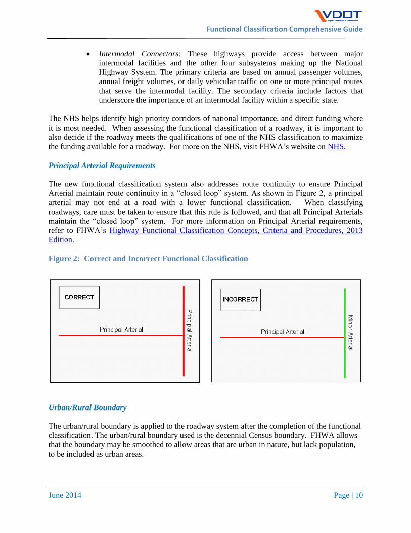
Principal Arterial Requirements
The new functional classification system also addresses route continuity to ensure Principal
Arterial maintain route continuity in a “closed loop” system. As shown in Figure 2, a principal
arterial may not end at a road with a lower functional classification. When classifying
roadways, care must be taken to ensure that this rule is followed, and that all Principal Arterials
maintain the “closed loop” system. For more information on Principal Arterial requirements,
refer to FHWA’s Highway Functional Classification Concepts, Criteria and Procedures, 2013
Edition.
Figure 2: Correct and Incorrect Functional Classification
Urban/Rural Boundary
The urban/rural boundary is applied to the roadway system after the completion of the functional
classification. The urban/rural boundary used is the decennial Census boundary. FHWA allows
that the boundary may be smoothed to allow areas that are urban in nature, but lack population,
to be included as urban areas.

Functional Classification Comprehensive Guide
June 2014 Page | 11
Changes from Previous Guidance: The role of the urban and rural boundary in functional
class has changed with the new FHWA guidelines. Historically, a roadway’s functional
classification would change at an urbanized area boundary going from rural to urban areas with
the route being classified one category higher in the urban area. With new guidelines, the urban
/rural boundary does not play a role in the functional classifications and the road should be
classified as how it functions.
Crossings
Extra care should be taken when classifying routes that cross either rivers or freeways and
expressways. Though some of these crossing may carry low volumes, they may also be the only
crossing for a significant distance. Therefore, the roadway functions more as a collector rather
than a local roadway. Those classifying these crossings should take the number of crossings
within a reasonable distance into consideration.
Route Spacing
Distance between routes is another major part of assigning functional classification. Typically,
roadways of higher classification are at a greater distance from each other than lower functional
classifications. For example, arterial streets are typically spaced at greater intervals than
collector streets, which are spaced at much greater intervals than local streets. The spacing
between the same functional classifications can vary considerably for different areas; in densely
populated urban areas, spacing of all routes types is smaller and generally more consistent than
the spacing in sparsely developed rural areas. Geographic barriers can also greatly influence the
layout and spacing of roadways.
For example, the spacing of arterials in urban areas is closely related to the density
characteristics of activity centers in urban areas. The spacing (in larger urban areas) may vary
from less than one mile in highly developed central business areas to five miles or more in the
sparsely developed suburban areas. Conversely, in rural settings, Minor Arterials are spaced at
intervals consistent with population density, so that all developed areas are within a reasonable
distance of a higher level arterial. The spacing of Minor Arterial streets may typically vary from
1/8- to 1/2-mile in the central business district (CBD) and two to three miles in the suburban
fringes.
Federal versus State Functional Classification System
VDOT uses Federal Functional Classification Guidelines to classify Virginia roadways. Virginia
currently uses other classifications for State administrative-funding classifications that refer to
the State Primary, Secondary and Urban systems. Virginia has applications that use the federal
system in mixture with the state administrative systems. One example of this is distributing
maintenance funds for urban and urbanized area localities who undertake maintenance
responsibility in their jurisdiction. Table 2 below from the VDOT 2007 Urban Manual,
maintenance payments (as either arterial or non-arterial payments) are mapped between the
federal and state systems.

Functional Classification Comprehensive Guide
June 2014 Page | 12
Table 2: Policy for Functional Classification of Urban Highways, Federal and State
Systems (Appendix L, of 2007 Urban Manual, for Cities and Towns
Federal Area Class Federal Classification State Classification for
Maintenance
Urbanized (Pop > 50,000)
Principal Arterial Arterial (Principal)
Minor Arterial Arterial (Minor)
Collector Collector
Local Local
Urban (Pop 5,000 – 50,000)
Principal Arterial Arterial (Principal)
Minor Arterial Arterial (Minor)
Collector Collector
Local Local
Rural (Town 3,500 - <5,000, or if under 3,500 maintains its own streets)
Principal Arterial Arterial (Principal)
Minor Arterial Arterial (Minor)
Major Collector Arterial (Minor)* Minor Collector Collector
Local Local
* Those facilities that qualify as major collector in the federal system in areas of under 5,000 population will be functionally classified in the state system as an Arterial (per Policy, item e.).
Functional Classification Comprehensive Guide
June 2014 Page | 13
REQUESTING CHANGES TO AN EXISTING ROAD’S
FUNCTIONAL CLASSIFICATION
VDOT assigns all public roads within the Commonwealth of Virginia a functional classification
based on the criteria and guidance provided by FHWA. The functional classification assigned to
a particular roadway is based on its function. Over time, the function of a particular road may
change and thus requires that its functional classification should also change. Some examples or
reasons of why a road’s function could change include:
A new parallel facility is built that better serves through (region) traffic while the old
facility now predominately serves local traffic resulting in the needed to lower the
functional classification on the old road;
Over time, a road is widened and traffic volumes significantly increase on the road. The
regional significance of the roadway increases resulting in a need to increase the
functional classification on the road;
Regional activity centers are developed along a particular road increasing the importance
of the road for regional mobility resulting in a need to increase the functional
classification on the road;
A road is extended and connected to a higher functional classification road requiring the
existing road to be upgraded to the higher functional classification, and
A road is disconnected by development from higher functional classification roads
requiring the existing road to be downgraded to a lower functional classification.
Over the years, VDOT received many requests to change the functional classification of many
roads. The basis of some requests was not on the road’s function, but for other reasons. The
following are NOT reasons to change a road’s functional classification:
Upgrading a road’s functional classification to be available for additional funding sources
such as federal aid funds or maintenance funds;
Upgrading a road’s functional classification to increase its priority in receiving
improvements;
Downgrading a road’s functional classification to relax design standards or access
management standards, and
Downgrading a road so it is eligible for traffic calming measures.
The channels to request a functional classification change differ based on the nature of the
request and the person or entity making the request. When a road’s function has changed or will
change based on other infrastructure improvements, VDOT’s Transportation & Mobility
Division receives the request to change the road’s functional classification. Request for changes
generally begin with local governments whether a City, Town or County or with a Metropolitan
Planning Organization (MPO). Requests from local governments within MPO areas should go
through the MPO. Citizens or developers that want a change must work through their local
government’s technical staff and elected officials to request a change. VDOT staff can also
initiate a functional class change. Other governmental agencies requesting a change, such as a
transit agency, should work through VDOT, a MPO or a local government.
Functional Classification Comprehensive Guide
June 2014 Page | 14
The next three sections discuss the process for making functional classification changes on
existing roads for requests from 1) Local Governments in MPO Regions; 2) Local Governments
outside MPO Regions; 3) VDOT or other governmental/quasi-governmental agency. Each
request case includes a flowchart diagramming the process. The flowchart and accompanying
text is expected to help local governments, MPOs and VDOT to navigate smoothly through the
functional classification change process.
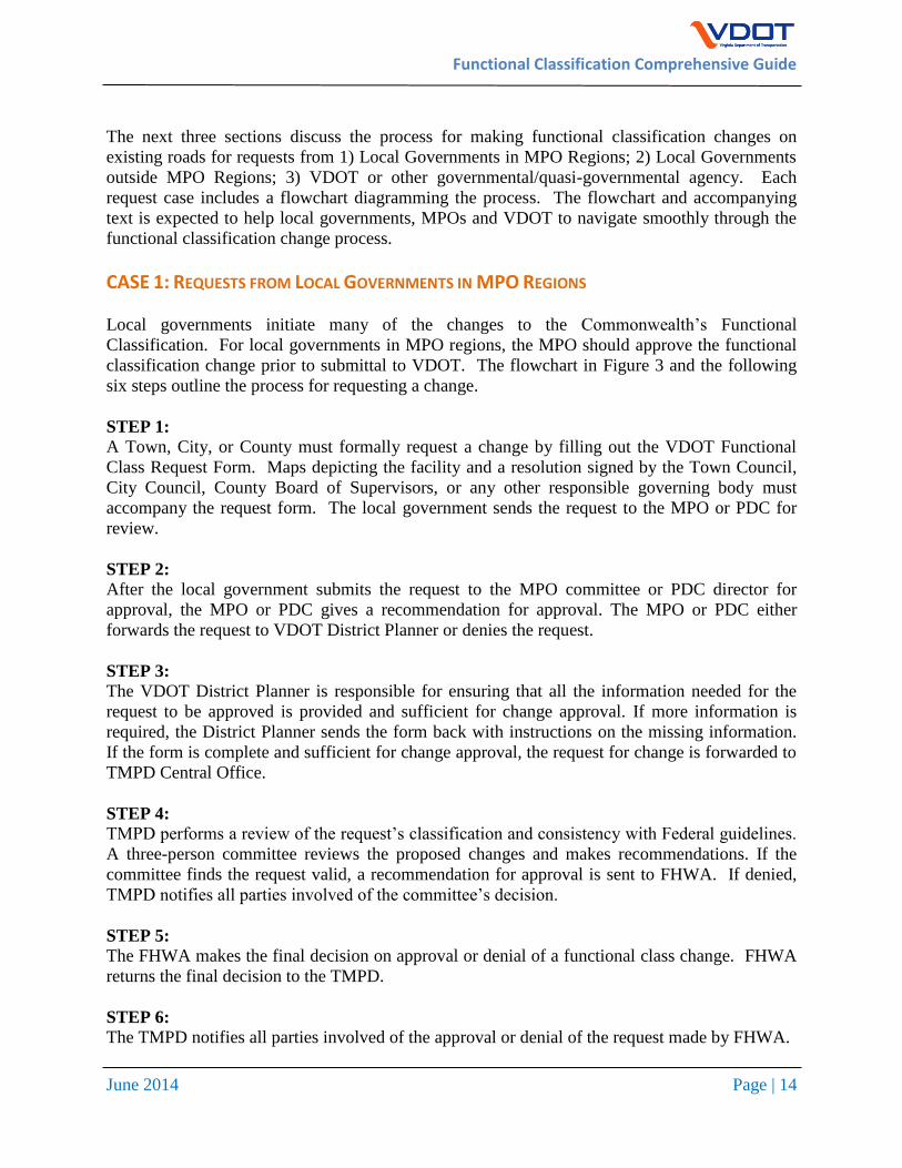
CASE 1: REQUESTS FROM LOCAL GOVERNMENTS IN MPO REGIONS
Local governments initiate many of the changes to the Commonwealth’s Functional
Classification. For local governments in MPO regions, the MPO should approve the functional
classification change prior to submittal to VDOT. The flowchart in Figure 3 and the following
six steps outline the process for requesting a change.
STEP 1:
A Town, City, or County must formally request a change by filling out the VDOT Functional
Class Request Form. Maps depicting the facility and a resolution signed by the Town Council,
City Council, County Board of Supervisors, or any other responsible governing body must
accompany the request form. The local government sends the request to the MPO or PDC for
review.
STEP 2:
After the local government submits the request to the MPO committee or PDC director for
approval, the MPO or PDC gives a recommendation for approval. The MPO or PDC either
forwards the request to VDOT District Planner or denies the request.
STEP 3:
The VDOT District Planner is responsible for ensuring that all the information needed for the
request to be approved is provided and sufficient for change approval. If more information is
required, the District Planner sends the form back with instructions on the missing information.
If the form is complete and sufficient for change approval, the request for change is forwarded to
TMPD Central Office.
STEP 4: TMPD performs a review of the request’s classification and consistency with Federal guidelines.
A three-person committee reviews the proposed changes and makes recommendations. If the
committee finds the request valid, a recommendation for approval is sent to FHWA. If denied,
TMPD notifies all parties involved of the committee’s decision.
STEP 5:
The FHWA makes the final decision on approval or denial of a functional class change. FHWA
returns the final decision to the TMPD.
STEP 6:
The TMPD notifies all parties involved of the approval or denial of the request made by FHWA.

Functional Classification Comprehensive Guide
June 2014 Page | 15
TOWN, CITY, or COUNTY request
change to classification
VDOT District Planner
VDOT TMPD
Functional Classification
Committee
FHWA
Review
Notification of Approval or Denial to VDOT
TMPD Approval and Recommend
to FHWA
Notification of Denial to All
Parties
MPO/PDC
Step 1
Step 2
Step 3
Step 4
Step 5
Step 6
Recommend for Approval
Denied
Recommend for Approval
Figure 3: Case 1-Requests from Local Government in MPO Regions
Ad
d an
y missin
g
info
rmatio
n
Functional Classification Comprehensive Guide
June 2014 Page | 16
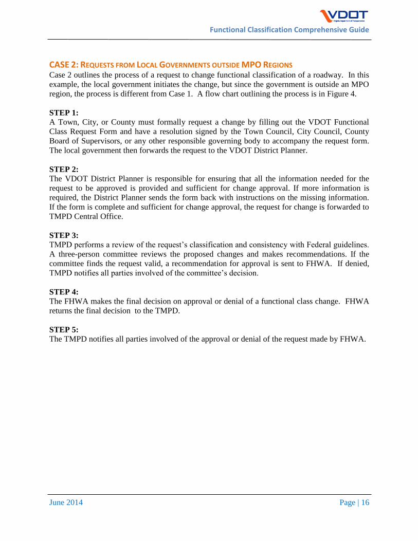
CASE 2: REQUESTS FROM LOCAL GOVERNMENTS OUTSIDE MPO REGIONS Case 2 outlines the process of a request to change functional classification of a roadway. In this
example, the local government initiates the change, but since the government is outside an MPO
region, the process is different from Case 1. A flow chart outlining the process is in Figure 4.
STEP 1:
A Town, City, or County must formally request a change by filling out the VDOT Functional
Class Request Form and have a resolution signed by the Town Council, City Council, County
Board of Supervisors, or any other responsible governing body to accompany the request form.
The local government then forwards the request to the VDOT District Planner.
STEP 2:
The VDOT District Planner is responsible for ensuring that all the information needed for the
request to be approved is provided and sufficient for change approval. If more information is
required, the District Planner sends the form back with instructions on the missing information.
If the form is complete and sufficient for change approval, the request for change is forwarded to
TMPD Central Office.
STEP 3: TMPD performs a review of the request’s classification and consistency with Federal guidelines.
A three-person committee reviews the proposed changes and makes recommendations. If the
committee finds the request valid, a recommendation for approval is sent to FHWA. If denied,
TMPD notifies all parties involved of the committee’s decision.
STEP 4:
The FHWA makes the final decision on approval or denial of a functional class change. FHWA
returns the final decision to the TMPD.
STEP 5:
The TMPD notifies all parties involved of the approval or denial of the request made by FHWA.

Functional Classification Comprehensive Guide
June 2014 Page | 17
VDOT District Planner
VDOT TMPD
Functional Classification
Committee TMPD
Notification of Denial
to all parties.
Step 1
Step 2
Step 3
Recommend for Approval
Ad
d an
y missin
g in
form
ation
TOWN, CITY, or COUNTY request
change to classification
Figure 4: Case 2- Request from Local Government outside MPO Regions
FHWA Review
Notification of Approval or Denial to VDOT
TMPD Approval and Recommend
to FHWA
Step 4
Step 5
Functional Classification Comprehensive Guide
June 2014 Page | 18
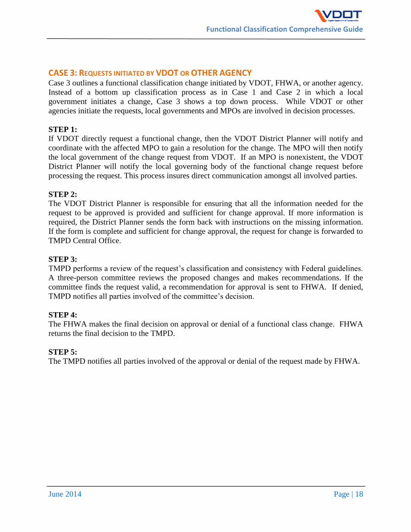
CASE 3: REQUESTS INITIATED BY VDOT OR OTHER AGENCY Case 3 outlines a functional classification change initiated by VDOT, FHWA, or another agency.
Instead of a bottom up classification process as in Case 1 and Case 2 in which a local
government initiates a change, Case 3 shows a top down process. While VDOT or other
agencies initiate the requests, local governments and MPOs are involved in decision processes.
STEP 1:
If VDOT directly request a functional change, then the VDOT District Planner will notify and
coordinate with the affected MPO to gain a resolution for the change. The MPO will then notify
the local government of the change request from VDOT. If an MPO is nonexistent, the VDOT
District Planner will notify the local governing body of the functional change request before
processing the request. This process insures direct communication amongst all involved parties.
STEP 2:
The VDOT District Planner is responsible for ensuring that all the information needed for the
request to be approved is provided and sufficient for change approval. If more information is
required, the District Planner sends the form back with instructions on the missing information.
If the form is complete and sufficient for change approval, the request for change is forwarded to
TMPD Central Office.
STEP 3: TMPD performs a review of the request’s classification and consistency with Federal guidelines.
A three-person committee reviews the proposed changes and makes recommendations. If the
committee finds the request valid, a recommendation for approval is sent to FHWA. If denied,
TMPD notifies all parties involved of the committee’s decision.
STEP 4:
The FHWA makes the final decision on approval or denial of a functional class change. FHWA
returns the final decision to the TMPD.
STEP 5:
The TMPD notifies all parties involved of the approval or denial of the request made by FHWA.

Functional Classification Comprehensive Guide
June 2014 Page | 19
VDOT District Planner
VDOT TMPD
Functional Classification
Committee
Step 1
Step 2
Recommend for Approval
VDOT or Other Agency request
change to classification
Coordination with TOWN, CITY, COUNTY, and
MPO/PDC
Figure 5: Case 3: Requests Initiated by VDOT or Other Agency
Ad
d an
y missin
g in
form
ation
TMPD Notification of
Denial to all parties.
Step 3
FHWA
Review
Notification of Approval or Denial to VDOT
TMPD Approval and Recommend
to FHWA
Step 4
Step 5
Functional Classification Comprehensive Guide
June 2014 Page | 20
FUTURE ROADWAYS While functional classification is based on the current roadway use, it is important to classify
future roadways early in the planning process. Functional classification helps determine
eligibility for funding from many federal funding sources and maximizes the potential for future
funding. Recent guidelines have further outlined the inclusion of future roadways to the existing
functional classification. In 2008, FHWA reinforced the four-year limit for including future
roads in existing functional class. The 2008 Memorandum dated October 14, 2008, “As of this
interim guidance, the timeframe in which the "future route" is expected to be under construction
should generally be consistent with the STIP timeframe of 4 years or less.” This guidance allows
VDOT to assign a functional classification for roads that are scheduled for construction within
four years. For this reason, it is recommended that VDOT include new roadways that are
included in the Six- Year Statewide Transportation Improvement Program (STIP) for
construction.
PROCESS FOR ESTABLISHING FUNCTIONAL CLASSIFICATION OF FUTURE ROADWAYS The process for establishing the functional classification for a future roadway is different than
changing the functional classification of an existing roadway. Future (new location) roadways
are traditionally identified in a locality, MPO or other long-range plan and then incorporated into
the STIP. The locality, MPO, VDOT district or other entity behind development of the project
should submit a Functional Classification Request Form to TMPD to recommend a functional
classification for the future road whenever the roadway is included in the STIP. The applicant
should complete the form with the anticipated statistics of the future roadway, such as volume.
However, since the road does not yet exist, certain fields will not be applicable when filling out a
request. The applicant should fill in N/A for these fields. Along with the application, the
applicant should provide a GIS shapefile or similar mapping to show the roadway centerline so
that it can be properly integrated into VDOT’s GIS systems.
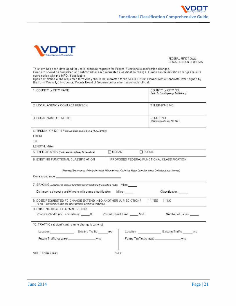
FUNCTIONAL CLASS FORM
The current Functional Classification Request Form that VDOT uses is extremely basic and does
not allow for a description of the change. A new form derived from one used in Washington
State has been adopted to be used for all future functional class change request.
To ensure that a thorough request for functional classification change is made, the new proposed
VDOT form allows those filing a request to provide detailed information on the location and the
surrounding influences such as land use, traffic generators, and the attachment of data or maps
that provide justification for the change request. The new recommended request form is provided
on the following page.
Functional Classification Comprehensive Guide
June 2014 Page | 21

Functional Classification Comprehensive Guide
June 2014 Page | 22
11. Is the route on the National Highway System?
12. If applicable please list major traffic Generators (Generators that
route serves – est. VPD)
SHOPPING CENTER: Total SQFT VPD
INDUSTRIAL: Employees VPD
GOV. INSTITUTION: Employees VPD
AIRPORTS: Annual Flights VPD
MILITARY INSTALLATIONS: Type VPD
SHIPPING POINTS: Annual Tons VPD
MAJOR TOURIST SITES: Annual Visitors VPD (parks, ski resorts, lakes, beaches, etc.)
COLLEGE OR UNIVERSITY: Enrollment VPD
OTHER: Type VPD
13. A brief description why the proposed change is requested and justification for the change.
14. Additional remarks to more fully explain the situation.
15. Attach a vicinity map showing the proposed changes, and existing Federal Functional Classifications.

Functional Classification Comprehensive Guide
June 2014 Page | 23
FUNCTIONAL CLASSIFICATION MAPS AND DATABASES
DATABASES AVAILABLE FROM TMPD VDOT is making various GIS layers and databases available via its ArcGIS Online account.
Citizens and users can access the most recent quarterly release of the VDOT Linear Referencing
System centerlines and various other GIS data from ArcGIS Online by searching for “VDOT”
content (http://www.arcgis.com/home/search.html?q=vdot&t=content). REPORTING ERRORS OR CORRECTIONS TO THE VDOT FUNCTIONAL CLASSIFICATION SYSTEM
Any user of the VDOT’s functional classification data, databases or maps that finds any errors or
corrections that should be made to the data are requested to contact VDOT’s Transportation &
Mobility Planning Division representatives as noted below.
These errors could include but not limited to mislabeled functional classification on individual
roadway links, incorrect geometry of roads or incorrect roadway characteristics for a link. If
possible, please provide a screen shot of the data error or the correct roadway geometry
alignment (in GIS format).
VDOT CONTACT FOR QUESTIONS OR CLARIFICATION
VDOT Transportation & Mobility Planning Division
Mr. Lewis Parsley
Senior Transportation Planner
[email protected], (804) 786-4063
Mr. Chris Detmer
Long Range Planning Section Manager
[email protected], (804) 786-3599