Frontier Exploration Potential Down Under · Frontier Exploration Potential Down Under ... As there...
7
Final separation of Eastern Gondwana - Plate kinematics and their implications for frontier exploration. Jamie Higton Neftex Insights, Halliburton, 97 Jubilee Avenue, Abingdon OX14 4RW, UK Frontier Exploration Potential Down Under The offshore regions south and east of Australia and the continental fragments containing New Zealand and the Lord Howe Rise (Zealandia) comprise over 10 million km 2 of submerged continental crust that has yet to be properly explored for hydrocarbons. This vast area holds promise, as there are plenty of producing fields on the shallow-water fringes of the Otway, Gippsland, and Taranaki basins, which prove the presence of regional petroleum systems (Figure 1). All proven and potential plays in the region are tied to the protracted separation of Australia, Antarctica, and Zealandia, which began in the Middle Jurassic and was not complete until the Early Eocene. This period was punctuated by a complicated series of extensional events that have influenced prospective petroleum systems from the Bight Basin of Australia to the Great South Basin of New Zealand. The revised Neftex® Plate Model can be used to assess frontier petroleum prospectivity and help explain potential source rock and reservoir distribution, by thinking within a palinspastic context. This article looks at how the regional kinematic evolution may have influenced potential source rock development and preservation in the Bight Basin, southern Australia, as well as the transient development of a hinterland source area for potential reservoir units in the Great South Basin of New Zealand. Revised Kinematic Model The re-evaluation of continent-ocean boundary (COB) locations across the Antarctica–Australia– Zealandia conjugate margins provided a framework to remodel the pre-rift fit of the East Gondwana continental blocks. For example, some of the oldest magnetic anomalies, previously regarded as ocean floor isochrons on the southern Australia–Antarctic conjugate, are now interpreted as crests of exhumed continental lithospheric mantle. These form linear peridotite ridges discernible on seismic lines (Figure 2b) and sampled by dredging (Direen et al., 2012; White et al., 2013). The oldest true oceanic isochrons on this margin are now interpreted as C34n, which correlates well with the break-up unconformity below the base Campanian Hammerhead Formation clastics, in the Bight Basin. There are several possible models already proposed for the Australia–Antarctic fit (White et al., 2013), many tying various combinations of fracture zones that may or may not have been active in the final stages of break-up. The most robust geological tie across the Australia–Antarctic margin is the correlative early Paleozoic Grampian-Staveley Arc Complex, which can be traced through the western South Tasman Rise and into the Bowers Terrane of Antarctica. Any robust plate model requires restoration of the whole system, including Australia–Antarctica, and must account for significant mid-Cretaceous extension, in both the West Antarctic Rift (Siddoway, 2008) and basins across Zealandia, to get a sensible palinspastic fit.
Transcript of Frontier Exploration Potential Down Under · Frontier Exploration Potential Down Under ... As there...
Final separation of Eastern Gondwana - Plate kinematics and their implications
for frontier exploration.
Jamie Higton
Neftex Insights, Halliburton, 97 Jubilee Avenue, Abingdon OX14 4RW, UK
Frontier Exploration Potential Down Under The offshore regions south and east of Australia and the continental fragments containing New
Zealand and the Lord Howe Rise (Zealandia) comprise over 10 million km2 of submerged continental
crust that has yet to be properly explored for hydrocarbons. This vast area holds promise, as there
are plenty of producing fields on the shallow-water fringes of the Otway, Gippsland, and Taranaki
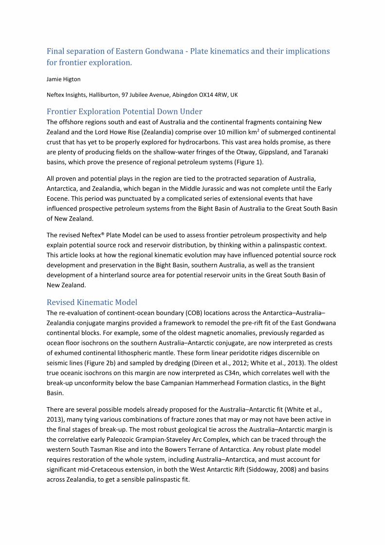
basins, which prove the presence of regional petroleum systems (Figure 1).
All proven and potential plays in the region are tied to the protracted separation of Australia,
Antarctica, and Zealandia, which began in the Middle Jurassic and was not complete until the Early
Eocene. This period was punctuated by a complicated series of extensional events that have
influenced prospective petroleum systems from the Bight Basin of Australia to the Great South Basin
of New Zealand.
The revised Neftex® Plate Model can be used to assess frontier petroleum prospectivity and help
explain potential source rock and reservoir distribution, by thinking within a palinspastic context.
This article looks at how the regional kinematic evolution may have influenced potential source rock
development and preservation in the Bight Basin, southern Australia, as well as the transient
development of a hinterland source area for potential reservoir units in the Great South Basin of
New Zealand.
Revised Kinematic Model The re-evaluation of continent-ocean boundary (COB) locations across the Antarctica–Australia–
Zealandia conjugate margins provided a framework to remodel the pre-rift fit of the East Gondwana
continental blocks. For example, some of the oldest magnetic anomalies, previously regarded as
ocean floor isochrons on the southern Australia–Antarctic conjugate, are now interpreted as crests
of exhumed continental lithospheric mantle. These form linear peridotite ridges discernible on
seismic lines (Figure 2b) and sampled by dredging (Direen et al., 2012; White et al., 2013). The oldest
true oceanic isochrons on this margin are now interpreted as C34n, which correlates well with the
break-up unconformity below the base Campanian Hammerhead Formation clastics, in the Bight
Basin.
There are several possible models already proposed for the Australia–Antarctic fit (White et al.,
2013), many tying various combinations of fracture zones that may or may not have been active in
the final stages of break-up. The most robust geological tie across the Australia–Antarctic margin is
the correlative early Paleozoic Grampian-Staveley Arc Complex, which can be traced through the
western South Tasman Rise and into the Bowers Terrane of Antarctica. Any robust plate model
requires restoration of the whole system, including Australia–Antarctica, and must account for
significant mid-Cretaceous extension, in both the West Antarctic Rift (Siddoway, 2008) and basins
across Zealandia, to get a sensible palinspastic fit.
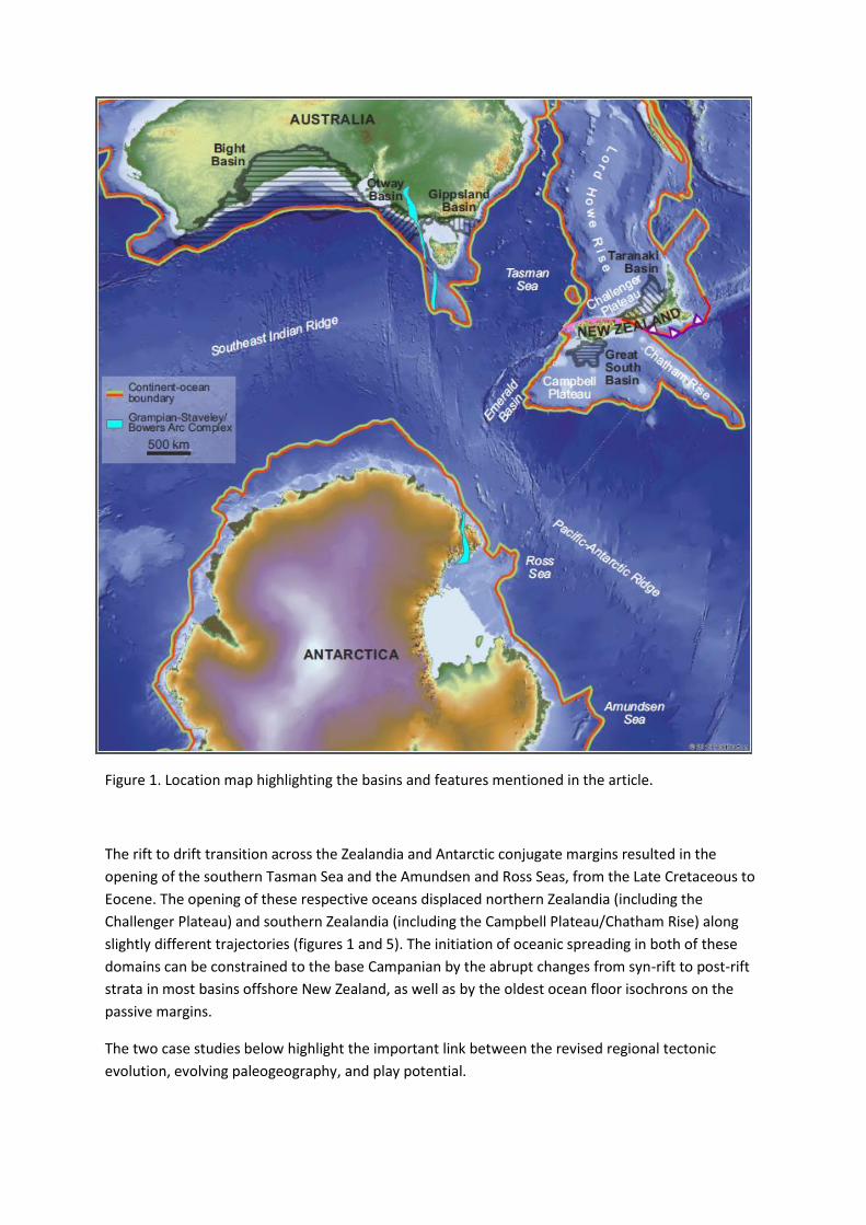
Figure 1. Location map highlighting the basins and features mentioned in the article.
The rift to drift transition across the Zealandia and Antarctic conjugate margins resulted in the
opening of the southern Tasman Sea and the Amundsen and Ross Seas, from the Late Cretaceous to
Eocene. The opening of these respective oceans displaced northern Zealandia (including the
Challenger Plateau) and southern Zealandia (including the Campbell Plateau/Chatham Rise) along
slightly different trajectories (figures 1 and 5). The initiation of oceanic spreading in both of these
domains can be constrained to the base Campanian by the abrupt changes from syn-rift to post-rift
strata in most basins offshore New Zealand, as well as by the oldest ocean floor isochrons on the
passive margins.
The two case studies below highlight the important link between the revised regional tectonic
evolution, evolving paleogeography, and play potential.
Protracted Break-up and Source Rocks in the Bight Basin Regionally, the stratigraphy of basins along the southern margin of Australia records two classic syn-
rift packages: an earlier Callovian–Barremian phase observed, at least in part, along the entire
margin; and a Late Cretaceous phase, which is restricted to the Otway Basin margin, where
divergence was more transtensional. In the Ceduna Sub-basin (Bight Basin), deep seismic profiles
confirm that a thick, early syn-rift section is present, controlled by basement faulting. However, the
succeeding late syn-rift succession, below the base Hammerhead Formation break-up unconformity,
appears more akin to a sag phase, with gravity-driven delta tectonics clearly visible (Figure 2c). This
architecture is unique among syn-rift passive margin successions, where deltaic gravity-driven
successions are exclusively found in the post-rift, and thus implies the Bight Basin requires a
different syn-rift extension model from those of typical passive margins.
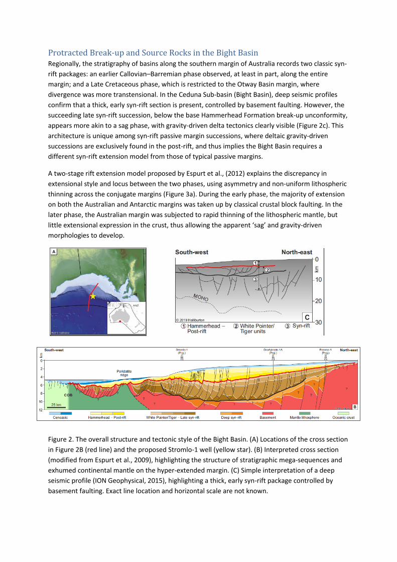
A two-stage rift extension model proposed by Espurt et al., (2012) explains the discrepancy in
extensional style and locus between the two phases, using asymmetry and non-uniform lithospheric
thinning across the conjugate margins (Figure 3a). During the early phase, the majority of extension
on both the Australian and Antarctic margins was taken up by classical crustal block faulting. In the
later phase, the Australian margin was subjected to rapid thinning of the lithospheric mantle, but
little extensional expression in the crust, thus allowing the apparent ‘sag’ and gravity-driven
morphologies to develop.
Figure 2. The overall structure and tectonic style of the Bight Basin. (A) Locations of the cross section
in Figure 2B (red line) and the proposed Stromlo-1 well (yellow star). (B) Interpreted cross section
(modified from Espurt et al., 2009), highlighting the structure of stratigraphic mega-sequences and
exhumed continental mantle on the hyper-extended margin. (C) Simple interpretation of a deep
seismic profile (ION Geophysical, 2015), highlighting a thick, early syn-rift package controlled by
basement faulting. Exact line location and horizontal scale are not known.
This break-up model has important implications for the deposition and preservation of the proposed
main source rock interval in the deep-water Bight Basin. Cenomanian–Santonian organic-rich marine
shales, sampled by dredging, provide the best opportunity for a mature, oil-prone source and were
deposited during the later ‘syn-rift’ phase. As there was little, if any, active tectonism (e.g. crustal
faulting, uplift, and erosion on footwalls), units of this age could have accumulated and been
preserved across a wide area (Figure 3b). The revised plate model, incorporating a longer-lived and
more quiescent separation, maximises the time over which a narrow, restricted seaway existed,
favourable for source intervals to accumulate. Source rock presence is likely to be one of the key
exploration risks for the upcoming Stromlo-1 commitment well (location shown in Figure 2a;
Equinor, 2018), highlighting the importance of plate model assessment in frontier play-based
understanding.
Figure 3. (A) Graph detailing the extensional history of the Australia-Antarctic conjugate (after Espurt
et al., 2012). The two periods of extension are highlighted by yellow ellipses. In the later extensional
phase, the Bight Basin margin elongation is accommodated by lithospheric mantle exhumation, in
contrast to the Antarctic margin, where crustal extension is still prevalent. (B) Later extensional
phase — late Cenomanian Neftex® Palinspastic Gross Depositional Environment map showing a
possible restricted source rock model, where preservation is favoured along the more tectonically
quiescent Bight Basin margin.

Paleo-hinterlands of the Great South Basin The Great South Basin (GSB), offshore south-eastern New Zealand, is a vast frontier province of
100,000 km2 with only approximately 12 wells drilled. The syn-rift Hoiho Group likely contains the
most prospective source rocks, whilst the post-rift succession may contain some of the highest
quality clastic reservoir targets. A series of large, stacked delta-top lobes have been mapped on
seismic (Uruski, 2017) and show significant clastic input from the west, particularly during the
Campanian to Early Eocene (Figure 4). Thereafter, the clastic supply appears to have reduced
dramatically, and the delta systems seem to have shut down throughout the later Paleogene.
It is not clear what events drove this sediment supply pattern, nor where the hinterland was that
derived the material. The modern hinterland topography and drainage of New Zealand’s South
Island is a result of Neogene transpressional convergence along the Alpine Fault system and is not
valid as a guide for assessing Late Cretaceous sediment pathways.
Figure 4. A distinct period of high clastic supply to the Great South Basin took place in the Late
Cretaceous–Eocene, producing stacked delta-top lobes in (A) map view, and (B) interpreted cross
section view (after Uruski, 2017). The major progradational clastic systems sit within the Campanian
to Early Eocene section, prior to eventual shut-down in the Middle or Late Eocene.
The Neftex Plate Model trajectories of the northern and southern (present-day coordinates)
Zealandia continental blocks, during the early drift phase, provide insight into the possible tectonic
driving mechanisms for hinterland evolution (Figure 5). From break-up (base Campanian) through
the latest Cretaceous and into the Early Paleogene, the spreading at the Tasman Sea and Pacific-
Antarctic ridges displaced the two Zealandia continental blocks in a manner that necessitated some
convergence between them, in the region of the present-day western Challenger Plateau and the
eastern Campbell Plateau. Convergence across this zone could be responsible for the significant
clastic supply into parts of the GSB during this time interval.
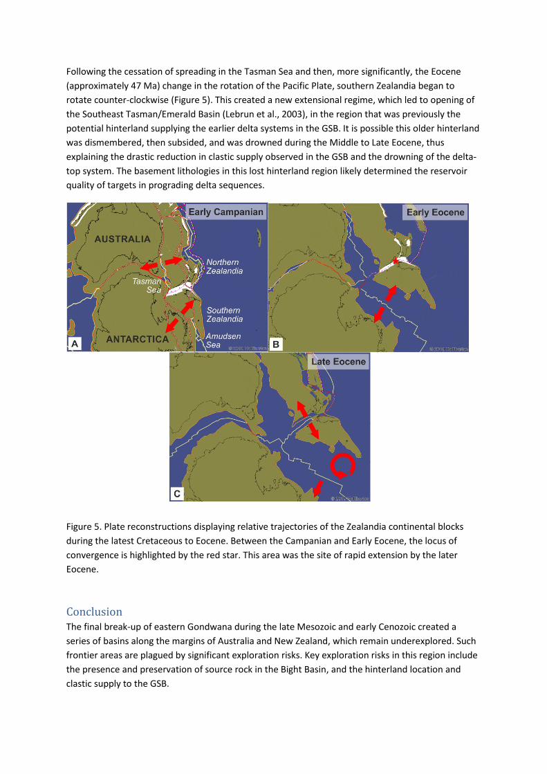
Following the cessation of spreading in the Tasman Sea and then, more significantly, the Eocene
(approximately 47 Ma) change in the rotation of the Pacific Plate, southern Zealandia began to
rotate counter-clockwise (Figure 5). This created a new extensional regime, which led to opening of
the Southeast Tasman/Emerald Basin (Lebrun et al., 2003), in the region that was previously the
potential hinterland supplying the earlier delta systems in the GSB. It is possible this older hinterland
was dismembered, then subsided, and was drowned during the Middle to Late Eocene, thus
explaining the drastic reduction in clastic supply observed in the GSB and the drowning of the delta-
top system. The basement lithologies in this lost hinterland region likely determined the reservoir
quality of targets in prograding delta sequences.
Figure 5. Plate reconstructions displaying relative trajectories of the Zealandia continental blocks
during the latest Cretaceous to Eocene. Between the Campanian and Early Eocene, the locus of
convergence is highlighted by the red star. This area was the site of rapid extension by the later
Eocene.
Conclusion The final break-up of eastern Gondwana during the late Mesozoic and early Cenozoic created a
series of basins along the margins of Australia and New Zealand, which remain underexplored. Such
frontier areas are plagued by significant exploration risks. Key exploration risks in this region include
the presence and preservation of source rock in the Bight Basin, and the hinterland location and
clastic supply to the GSB.
Utilizing plate models and palinspastic gross depositional environment (GDE) maps can better inform
explorationists about regional basin evolution, by highlighting critical deposition periods, as well as
helping to identify and reduce uncertainty.
In the Bight Basin, timing and duration of rift events and their tectonic style may be key factors in
supporting widespread Late Cretaceous organic-rich facies models. In the GSB, relative plate motions
through time (localized convergence/divergence) could help explain paleo-hinterland evolution and
its effect on supply and shut-down of prospective clastic systems. These case studies highlight how
evolving plate models are useful tools in the early-stage process of exploring prospective plays and
opening up future potential.
References Direen, N.G., H.M.J. Stagg, P.A. Symonds and I.O. Norton 2012. Variations in rift symmetry:
cautionary examples from the Southern Rift System (Australia–Antarctica). In W.U. Mohriak, A.
Danforth, P.J. Post, D.E. Brown, G.C. Tari, M. Nemčok and S.T. Sinha (Eds.), Conjugate Divergent
Margins. Geological Society of London - Special Publications no. 369, p. 1-25.
Equinor 2018. Where we are - Australia. https://www.equinor.com/en/where-we-are/australia.html
Espurt, N., J. Callot, J. Totterdell, H. Struckmeyer and R. Vially 2009. Interactions between
continental breakup dynamics and large-scale delta system evolution: Insights from the Cretaceous
Ceduna delta system, Bight Basin, Southern Australian margin. Tectonics, v. 28, TC6002.
Espurt, N., J.-P. Callot, F. Roure, J.M. Totterdell, H.I.M. Struckmeyer and R. Vially 2012. Transition
from symmetry to asymmetry during continental rifting: an example from the Bight Basin–Terre
Adelie (Australian and Antarctic conjugate margins). Terra Nova, v. 24, no. 3, p. 167-180.
ION Geophysical 2015. ION BightSPAN Data Sheet. Ion Geophysical, Houston, TX.
Lebrun, J., G. Lamarche and J. Collot 2003. Subduction initiation at a strike-slip plate boundary: The
Cenozoic Pacific-Australian plate boundary, south of New Zealand. Journal of Geophysical Research:
Solid Earth, no. 108, p. 2453.
Siddoway, C.S. 2008. Tectonics of the West Antarctic Rift System: New Light on the History and
Dynamics of Distributed Intracontinental Extension. In A.K. Cooper, P.J. Barrett, H. Stagg, B. Storey,
E. Stump, W. Wise and the 10th ISAES editorial team (Eds.), Antarctica: A Keystone In A Changing
World. Proceedings of the 10th International Symposium on Antarctic Earth Sciences, Washington,
D.C., p. 91-114.
Uruski, C. 2017. Stacked Deltas in the Great South Basin. PPANZ New Zealand Petroleum Conference
2017. Presentation. Petroleum Exploration and Production Authority (PEPA).
White, L.T., G.M. Gibson and G.S. Lister 2013. A reassessment of paleogeographic reconstructions of
eastern Gondwana: Bringing geology back into the equation. Gondwana Research, v. 24, no. 3-4, p.
984-998.


![Evaluating the Efficiency of Frontier-Based Exploration ... · based exploration strategies [8], presents a strategy incor-porating a map segmentation algorithm for exploring the](https://static.fdocuments.in/doc/165x107/5f8764cfc51954486637fdfe/evaluating-the-efficiency-of-frontier-based-exploration-based-exploration-strategies.jpg)