Front Street Action Plan - CONNECT! the...
27
Front Street Action Plan June 2017
Transcript of Front Street Action Plan - CONNECT! the...

Front Street Action PlanJune 2017
AcknowledgmentsCity StaffTom Dixon, Community Development AdministratorJim Hossley, Public Works and Community Development DirectorJennifer Wirsing, PE, Wastewater Project Administrator
Brownfield Advisory CommitteeHilary BakerJim BergChristine ColesNathan ClausenLucinda DiNovoAnnie DonnellyChris GedroseArianne LyonsElizabeth Spona
Special ThanksConnie Stopher, South Coast Development Council George Wright, Coos History MuseumJoe Monahan, Coos Bay-North Bend Visitor and Convention Bureau
Consultant TeamLorelei Juntunen, Emily Picha, and Andrea Pastor, ECONorthwestLeonard Farr, StantecKim Parducci-Walker, Southern Oregon Transportation EngineeringSaumya Kini and Ken Pirie, Walker MacyAaron Speakman, The Dyer Partnership

Table of ContentsPlan Purpose and Background 1
Vision 8
Development Framework 10
Investment Framework 13
Implications 22
Appendices 23


Plan Purpose and Background | 1
Plan Purpose and BackgroundLike most coastal communities in Oregon, Coos Bay has been working to diversify its traditionally resource-based economy toward a service-based economy. Though it is the largest of the coastal cities, with a population of 16,000, its location far from the major Oregon population centers in the Willamette Valley means it has seen less overall economic growth and tourist activity replacing its industry base than other coastal communities. The City has focused its energy on economic development initiatives, and continues that effort through this Front Street Action Plan (Action Plan) focused specifically on the Front Street area on the waterfront. The City has long envisioned Front Street as a more vibrant and integrated part of the City’s fabric, and a more active contributor to its economy and tax base.
In that context, the Action Plan’s purpose is to identify implementable actions in the Front Street area that increase connectivity, foster community access to the waterfront, attract private investment, and diversify Coos Bay’s economy.
Coos Bay’s diversifying economy creates an opportunity for Front Street. The City and its partners can commit to improving the area’s economic performance, leveraging the area’s authentic identity to attract tourists, and continuing to explore other types of job growth opportunities that benefit from the area’s waterfront location. The City has long envisioned that the area could be a catalyst within its economic development strategy. However, private redevelopment in Coos Bay is a risky undertaking, given the
relatively low achievable rents in the area and other infrastructure challenges which have limited redevelopment potential. This situation, coupled with the major infrastructure investments needed in the area, suggests a need for a thoughtful, creative strategy for Front Street reinvestment.
A History of Front StreetThe City of Marshfield was founded in 1853 by James Tolman at “the point designated by nature as the future emporium of the bay.” Its name was changed to Coos Bay by special election on December 28, 1944. Front Street was occupied by hotels, saloons, and retail and served as the City’s hub until a fire destroyed a major portion of it in July, 1922. During rebuilding of the City, a new hub evolved centered around Central Avenue and Broadway Street.
The first industry in Coos Bay was a sawmill constructed in 1867. By 1930, the City boasted a population of 5,287, and its major industries included fishing, timber, dairy, and produce.

2 | Front Street Action Plan
The Action Plan complements previous planning efforts, including the Waterfront Park and Walkway Plan (2012) and the Front Street Master Plan (1998). These plans have each furthered the City’s aim of supporting redevelopment on Front Street, as laid out in the Downtown Urban Renewal Plan (1988) and Coos Bay’s update to the Comprehensive Plan (2010).
However, the Action Plan is intended to advance improvements in the area to enable redevelopment of available sites. Grounded in financial and market analyses, and supported by a range of ideas from public and stakeholder input, this Plan details a set of actions for the City of Coos Bay, along with other partners, to encourage private investment on Front Street.
1988 1998 2015 2017
Downtown Urban Renewal District
formed
Front Street Master Plan Adopted
Front Street Action Plan Completed
City of Coos Bay wins EPA Brownfi elds
Assessment Grant
Front Street Master Plan Completed in 1998, the Front Street Master Plan is a 20-year vision plan to reclaim the City’s waterfront heritage through redevelopment. Many of the challenges identified in the 1998 Plan remain the same: infrastructure deficiencies, vacant properties, and a need to mitigate potential conflicts between existing active businesses and future redevelopment. The plan includes goals to increase public access to the waterfront, encourage development (including increasing the number of allowed uses), and support a diversified economy. Design proposals in the plan included heritage gateways, a waterfront boardwalk, pedestrian enhancements (e.g. bulb outs, crossings), and two piers at Alder and Date Avenues. While the goals and objectives
in this Action Plan remain consistent with the Master Plan, the key difference is that the Action Plan recommends greater partnerships with community organizations and a more incremental approach to Front Street investments.
Timeline of Front Street Planning Efforts
Study Area | 3
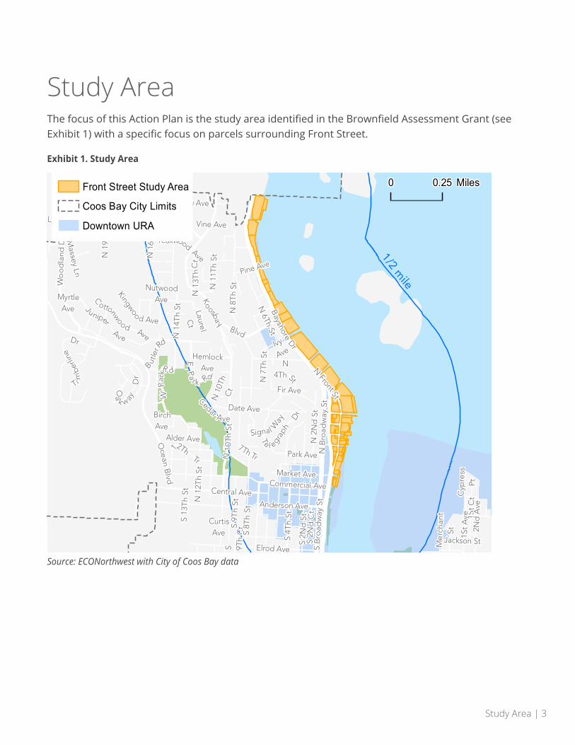
Study AreaThe focus of this Action Plan is the study area identified in the Brownfield Assessment Grant (see Exhibit 1) with a specific focus on parcels surrounding Front Street.
Exhibit 1. Study Area
1/2 mile
Lynne Dr
S 13
Th
St
BirchAve
CurtisAve
Vine Ave
Laurel
Ct
1St
CtC
ypre
ssPt
NutwoodAve
Massey Ln
Yew Ave
MyrtleAve
Cedar Ave
Kinney
Rd
S 9Th
Ct
N 1
1Th
St
Oa
k w ayD
r
Alder Ave
S 2N
d C
t
Me
rcha
ntSt
Pine Ave
7Th Tr
Jackson St
N 1
5Th
St
N1 3
Th
Ct
Ivy
Ave
N 1
9Th
St
N 1
2Th
St
S 8T
h St
S 9T
h St
Signa l Way
Elrod Ave
Ti
mbe
rline
Dr
N 7
Th S
t
B utle
rRd
12ThTr
Fir Ave
Kingwoo d Ave
HemlockAve
N 1
6Th
St
S 2N
d S
t
TeakwoodAve
Ocean
Blvd
2Nd
Ave
1St
Ave
S B
road
way
St
S 4T
h St
Park Ave
Market Ave
Anderson Ave
C
ottonwood Ave
N 6Th St
Central Ave
Date Ave
N 2
Nd
St
Ju niper
Ave N 1
4Th
St
Thompson Rd
N4Th St
N 1
0Th
Ct
N10
ThS t
Koosba
yBlvd
EPa
r k Rd
WPa
rk
R d
Bayshore
Dr
T
e l egrap
hD
r
N 8
Th
St
N B
road
way
St
NFront St
Wo
od
land
Dr
Commercial Ave
0 0.25 MilesFront Street Study Area
Coos Bay City Limits
Downtown URA
Source: ECONorthwest with City of Coos Bay data

4 | Front Street Action Plan
Public OutreachThis Action Plan is in part a result of several years of community outreach and input. Following on the heels of the work performed by the Brownfields Advisory Committee (BAC) as part of the EPA Brownfields Community-Wide Assessment Grant, the BAC continued to meet to advise the consulting team and City staff on issues that required careful consideration.
BAC members included members from the City Council, the City’s Design Assistance Team (DAT), CONNECT the Boardwalks representatives, real estate professionals, architects, citizen activists, and an area property owner representative.
Additionally, two public meetings were held in Coos Bay regarding the Front Street Action Plan. One was a public meeting around the time of the project’s inception, and was attended primarily by members of the BAC. The second was an Open House held on September 15, 2016, which provided flipcharts where attendees could write other comments and suggestions. Approximately 40 people attended the event.
The BAC and participating members of the community were the key contributors to the Action Plan’s vision statement, actions, and priorities.
Coos Bay community members made their interests clear during the outreach portion of this Plan: they are aware that Front Street was once a vibrant, public place and want to see it resume that function.
Open House activity, September 2016
Envisioning the waterfront, September 2016.
Opportunities and Barriers | 5
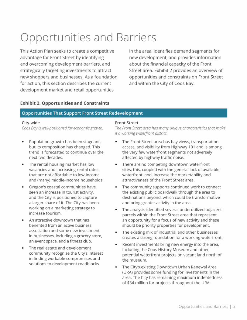
Opportunities and BarriersThis Action Plan seeks to create a competitive advantage for Front Street by identifying and overcoming development barriers, and strategically targeting investments to attract new shoppers and businesses. As a foundation for action, this section describes the current development market and retail opportunities
in the area, identifies demand segments for new development, and provides information about the financial capacity of the Front Street area. Exhibit 2 provides an overview of opportunities and constraints on Front Street and within the City of Coos Bay.
Exhibit 2. Opportunities and Constraints
Opportunities That Support Front Street Redevelopment
City-wideCoos Bay is well-positioned for economic growth.
Front StreetThe Front Street area has many unique characteristics that make it a working waterfront district.
• Population growth has been stagnant, but its composition has changed. This trend is forecasted to continue over the next two decades.
• The rental housing market has low vacancies and increasing rental rates that are not affordable to low-income and (many) middle-income households.
• Oregon’s coastal communities have seen an increase in tourist activity, and the City is positioned to capture a larger share of it. The City has been working on a marketing strategy to increase tourism.
• An attractive downtown that has benefited from an active business association and some new investment in businesses, including a grocery store, an event space, and a fitness club.
• The real estate and development community recognize the City’s interest in finding workable compromises and solutions to development roadblocks.
• The Front Street area has bay views, transportation access, and visibility from Highway 101 and is among the very few waterfront segments not adversely affected by highway traffic noise.
• There are no competing downtown waterfront sites; this, coupled with the general lack of available waterfront land, increase the marketability and attractiveness of the Front Street area.
• The community supports continued work to connect the existing public boardwalk through the area to destinations beyond, which could be transformative and bring greater activity in the area.
• The analysis identified several underutilized adjacent parcels within the Front Street area that represent an opportunity for a focus of new activity and these should be priority properties for development.
• The existing mix of industrial and other businesses creates a strong foundation for a working waterfront.
• Recent investments bring new energy into the area, including the Coos History Museum and other potential waterfront projects on vacant land north of the museum.
• The City’s existing Downtown Urban Renewal Area (URA) provides some funding for investments in the area. The City has remaining maximum indebtedness of $34 million for projects throughout the URA.
6 | Front Street Action Plan
Inadequate and aging stormwater infrastructure needs upgrades.Credit: Aaron Speakman
Seasonal inundation from the Bay creates localized flooding along Front Street.
Constraints That May Challenge Front Street Redevelopment
City-wideDespite the many opportunities, conditions in Coos Bay suggest that redevelopment could be limited without coordinated action.
Front StreetRedeveloping the Front Street area will not be easy.
• Coos Bay not experienced the population growth of other coastal communities and has lower incomes.
• Funding capacity in the City is limited, and there are competing needs. For example, the City’s sewer system is due for major upgrades, which will be costly.
• Despite recent new investments in downtown, there are many vacant storefronts. These could serve as incubator spaces for retail businesses with building improvements and property owner interest.
• There is a mismatch between the types of retail properties available for lease or redevelopment and the downtown’s market demand. There are many vacant storefronts downtown that could serve as incubator spaces for retail businesses with adequate investment and property owner interest.
• The area’s stormwater and sewer infrastructure is aging and in need of significant and costly repairs.
• A rail-line runs through the center of the area, creating conflict with all other modes of traffic and limiting the options available for redesigning the streetscape.
• Many parcels have a long history of industrial use, and this legacy may increase redevelopment costs because of the need to assess the environmental condition of these industrial properties.
• The area sits in the City’s floodplain and the tsunami inundation zone, limiting development options and requiring the inclusion of safety measures in any major waterfront development projects.
• The prior use of fill material and the need for seismic construction standards increases construction costs and processes.
• Some of the existing uses in the area are not dependent on water access, and have business-related activities that create conflicts for parking, traffic, and pedestrian activity.
• Public transit to the area does not presently exist.

Opportunities and Barriers | 7
The area’s greatest opportunities—waterfront views and access plus an authentic working waterfront environment—could be desirable for private developers. The combination of opportunities and constraints in the area suggest that redevelopment will be a challenging endeavor, and is unlikely to occur in a coordinated way that achieves public goals without planning and direct public investment. Partnerships between the public and private sectors will be necessary. Development will need to capitalize on the amenity of the waterfront in a way that considers the floodplain, recognizes the challenge of transportation access in a rail corridor, and addresses other site constraints. Some infrastructure investments are necessary regardless of the kinds of development that will occur in the area
This Plan prioritizes the following types of investments to set the stage for successful redevelopment and implementation:
1. Open space and pedestrian connectivity, which creates access to the waterfront and reduces the amount of development in the floodplain.
2. Employment uses that require access to the waterfront for success.
3. Improvements to the transportation network that improve multi-modal safety. Reflecting market challenges and the City’s fiscal position, implementation should be phased in a way that limits the near-term investment in anything but the most critical of infrastructure investments.
4. The need for public transit of some kind to the area.
An active rail line runs down the middle of Front Street.Credit: Kim Parducci-Walker

8 | Front Street Action Plan
Vision Front Street, located near downtown and with a direct connection to the bay front, is unique within the City of Coos Bay. Located just across Highway 101 and the downtown commercial core and visitor amenities, Front Street is well-positioned to accommodate a greater mix of uses while still celebrating and maintaining its industrial heritage and utility for water-dependent businesses.
Using statements made by community members as they described their preferred future for the area, the team developed a vision statement. It is an aspirational, long-view description for Front Street that could result from the successful implementation of this Plan:
In the future, Front Street will be a more bustling, vibrant, and inviting district with a mix of waterfront-related industrial employment, commercial, and limited residential uses. The area’s amenities and transportation facilities are more safely and easily accessible to pedestrians and cyclists, making connections to the rest of the City seamless. The continuation of the Coos Bay Boardwalk will serve as an attraction and provide for the enjoyment of the revitalized waterfront.
Through public street improvements, redevelopment of vacant or underutilized sites, and repurposing of key structures where possible, Front Street can become an accessible and welcoming place for all users, including community members, visitors, and employees of Front Street businesses. Front Street can become a more active and attractive part of the City that provides varied
amenities and programming, improved infrastructure and multimodal access, and opportunities for people to have better access to the water’s edge.
Extending the Coos Bay Boardwalk is key to creating an amenity that will attract visitors and future mixed-use development.Credit: Sheila Sund
Vision | 9
Revitalization of Front Street should incorporate three key themes:
• Pedestrian and bicycle access to the waterfront. The Coos Bay Boardwalk should be extended along the east side of Front Street as a 14-foot-wide multi-use path, providing continuous pedestrian and cyclist access to the Coos History Museum (“Museum”). Along this path, City-owned right-of-way parcels along the waterfront can provide overlooks and places to sit and enjoy the view. The boardwalk alignment is shown in Exhibit 3 (page 11), Front Street Framework Map. Crossings of Highway 101 should be added to strengthen Front Street’s connection to downtown, and traffic flow along Front Street should be reconfigured to safely allow access for all modes of travel. A preferred concept for traffic configuration is shown in Exhibit 5 (page 13), Preferred Traffic Configuration Concept.
• Programming and amenities. Through the planning process, community members expressed a strong desire for waterfront restaurants and breweries, as well as for pedestrian and boat access by extending the existing boardwalk north to a new light watercraft launch at the Museum. Other preferred uses include retail shops, water-dependent light industrial uses, and a park, plaza, or amphitheater with seating. Public open spaces should include places to sit, lighting, and shelter from the elements.
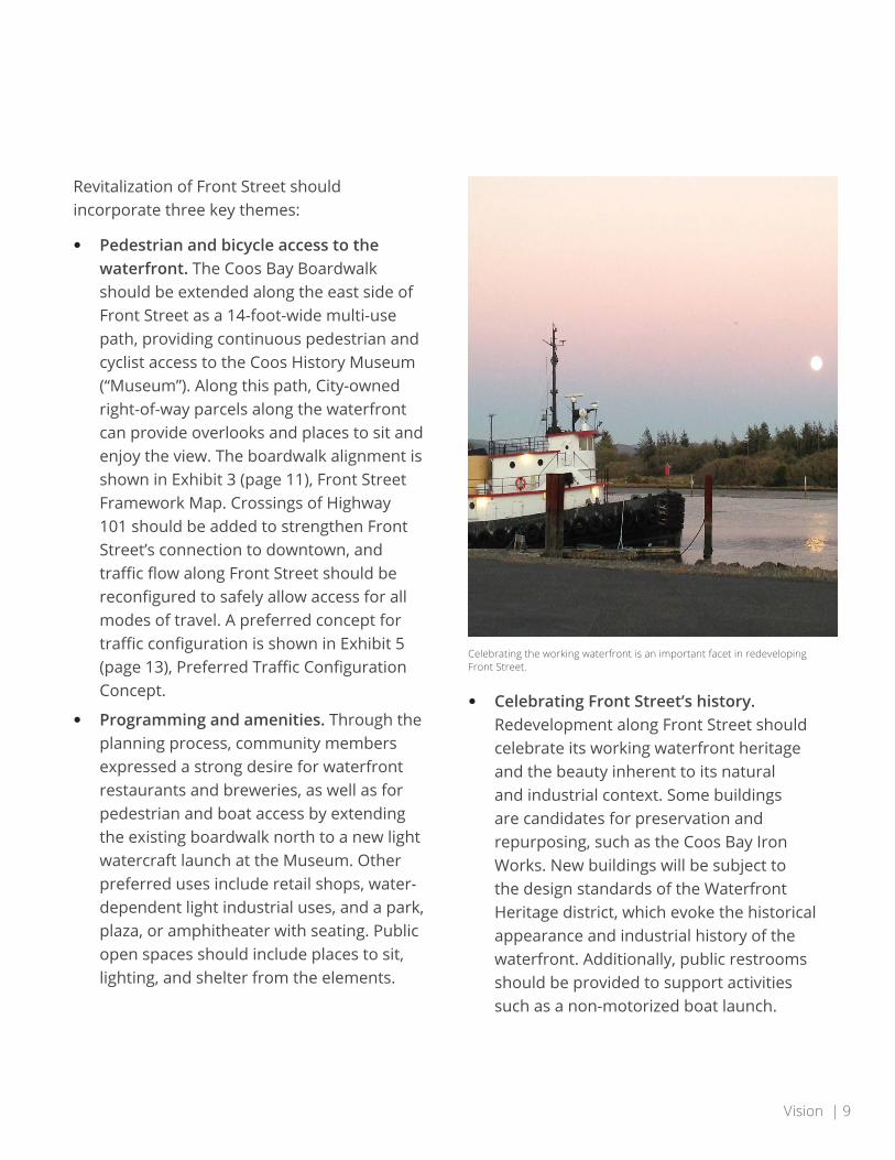
• Celebrating Front Street’s history. Redevelopment along Front Street should celebrate its working waterfront heritage and the beauty inherent to its natural and industrial context. Some buildings are candidates for preservation and repurposing, such as the Coos Bay Iron Works. New buildings will be subject to the design standards of the Waterfront Heritage district, which evoke the historical appearance and industrial history of the waterfront. Additionally, public restrooms should be provided to support activities such as a non-motorized boat launch.
Celebrating the working waterfront is an important facet in redeveloping Front Street.
10 | Front Street Action Plan
Development Framework
This framework map is a general outline that focuses on identifying the most important public improvements that will form the basis for future public-private redevelopment. It shows general alignments for public access ways, outlines areas for future development, and defines the connective pathway through the area. The map will guide future, more detailed development plans on specific sites, to be prepared by separate development, design, and engineering teams as property improvements take place. The City Council adopted the map as part of the Action Plan, thereby guiding future qualitative assessment of more detailed plans for individual properties and buildings.
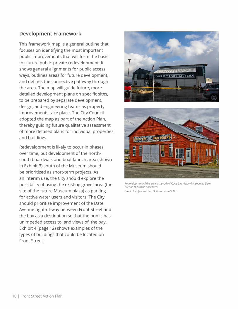
Redevelopment is likely to occur in phases over time, but development of the north-south boardwalk and boat launch area (shown in Exhibit 3) south of the Museum should be prioritized as short-term projects. As an interim use, the City should explore the possibility of using the existing gravel area (the site of the future Museum plaza) as parking for active water users and visitors. The City should prioritize improvement of the Date Avenue right-of-way between Front Street and the bay as a destination so that the public has unimpeded access to, and views of, the bay. Exhibit 4 (page 12) shows examples of the types of buildings that could be located on Front Street.
Redevelopment of the area just south of Coos Bay History Museum to Date Avenue should be prioritized.Credit: Top: Jeanne Hart; Bottom: Lance V. Nix

Vision | 11RIGHT-OF-WAYLINE
TIDAL SHORELINE
EXISTING DOCKS
OPPORTUNITY SITESFRONT STREET AREA PLAN
FRONT STREET BOARDWALK ALIGNMENT
PEDESTRIANCONNECTION
RAILROADTRACKS
FUTURELIGHT WATERCRAFTLAUNCH
EXISTINGPILINGS
FUTURECHMMCPLAZA
CHMMC
DEVELOPMENT OPPORTUNITY WITH VIEWS OF THE BAY/ENHANCED PUBLIC ACCESS
IRONWORKS
POTENTIALREDEVELOPMENT
buildingdemolished
BIRCH AVE
ALDER AVE
MARKET AVE
COMMERCIAL AVE
CEDAR AVE
DATE AVE
NEWCROSSWALK
NEWCROSSWALKS
PUBLIC ACCESS/OVERLOOK
POTENTIAL OVERLOOK (EASEMENT)
PUBLIC ACCESS/OVERLOOK
PUBLIC ACCESS/OVERLOOK
PUBLIC ACCESS/OVERLOOK
N B
AYSHO
RE D
RIVE
FRON
T STREET
Exhibit 3. Front Street Framework Map
RIGHT-OF-WAYLINE
TIDAL SHORELINE
EXISTING DOCKS
OPPORTUNITY SITESFRONT STREET AREA PLAN
FRONT STREET BOARDWALK ALIGNMENT
PEDESTRIANCONNECTION
RAILROADTRACKS
FUTURELIGHT WATERCRAFTLAUNCH
EXISTINGPILINGS
FUTURECHMMCPLAZA
CHMMC
DEVELOPMENT OPPORTUNITY WITH VIEWS OF THE BAY/ENHANCED PUBLIC ACCESS
IRONWORKS
POTENTIALREDEVELOPMENT
buildingdemolished
BIRCH AVE
ALDER AVE
MARKET AVE
COMMERCIAL AVE
CEDAR AVE
DATE AVE
NEWCROSSWALK
NEWCROSSWALKS
PUBLIC ACCESS/OVERLOOK
POTENTIAL OVERLOOK (EASEMENT)
PUBLIC ACCESS/OVERLOOK
PUBLIC ACCESS/OVERLOOK
PUBLIC ACCESS/OVERLOOK
N B
AYSHO
RE D
RIVE
FRON
T STREET
12 | Front Street Action Plan
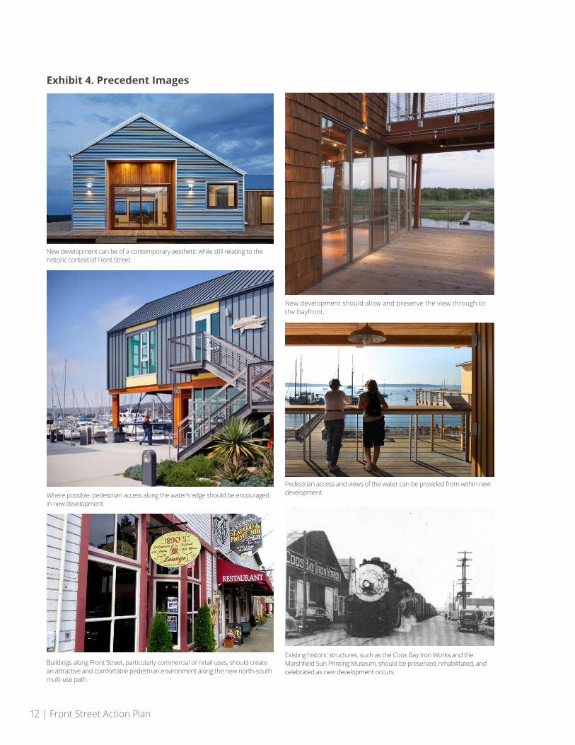
Exhibit 4. Precedent Images
New development should allow and preserve the view through to the bayfront.
Pedestrian access and views of the water can be provided from within new development.
New development can be of a contemporary aesthetic while still relating to the historic context of Front Street.
Existing historic structures, such as the Coos Bay Iron Works and the Marshfield Sun Printing Museum, should be preserved, rehabilitated, and celebrated as new development occurs.
Where possible, pedestrian access along the water’s edge should be encouraged in new development.
Buildings along Front Street, particularly commercial or retail uses, should create an attractive and comfortable pedestrian environment along the new north-south multi-use path.
Vision | 13
RIGHT-OF-WAY LINE
TIDAL SHORELINE
EXISTING DOCKS
FRONT STREET AREA PLAN
PREFERRED TRAFFIC CONFIGURATIONCOMBINED ONE- & TWO-WAY TRAFFIC
VEHICULAR ROUTE
FUTURELIGHT WATERCRAFTLAUNCH
FUTURECHMMCPLAZA
CHMMC
IRONWORKS
ONE-WAYNORTHBOUNDTRAFFIC
TWO-WAYTRAFFIC
BIRCH AVE
ALDER AVE
MARKET AVE
HEMLOCK AVE
COMMERCIAL AVE
CEDAR AVE
DATE AVE
NEWCROSSWALK
NEWCROSSWALKS
N B
AYSHO
RE D
RIVE
N B
RO
AD
WAY D
RIVE
FRONT STREET building
demolished
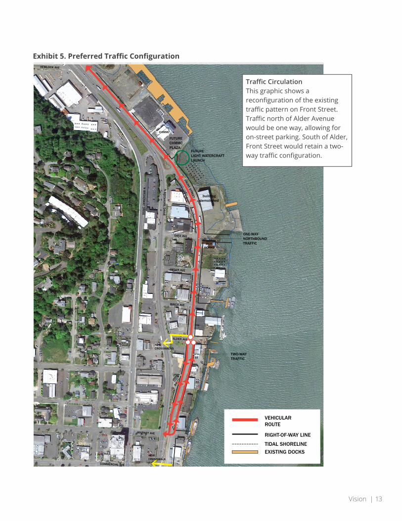
Exhibit 5. Preferred Traffic Configuration
Traffic CirculationThis graphic shows a reconfiguration of the existing traffic pattern on Front Street. Traffic north of Alder Avenue would be one way, allowing for on-street parking. South of Alder, Front Street would retain a two-way traffic configuration.
RIGHT-OF-WAY LINE
TIDAL SHORELINE
EXISTING DOCKS
FRONT STREET AREA PLAN
PREFERRED TRAFFIC CONFIGURATIONCOMBINED ONE- & TWO-WAY TRAFFIC
VEHICULAR ROUTE
FUTURELIGHT WATERCRAFTLAUNCH
FUTURECHMMCPLAZA
CHMMC
IRONWORKS
OPPORTUNITY FORPUBLIC ACCESS/OPEN SPACE/VIEWS OF THE WATER
ONE-WAYNORTHBOUNDTRAFFIC
TWO-WAYSOUTHBOUNDTRAFFIC
BIRCH AVE
ALDER AVE
MARKET AVE
HEMLOCK AVE
COMMERCIAL AVE
CEDAR AVE
DATE AVE
NEWCROSSWALK
NEWCROSSWALKS
N B
AYSHO
RE D
RIVE
N B
RO
AD
WAY D
RIVE
FRONT STREET building
demolished
14 | Front Street Action Plan
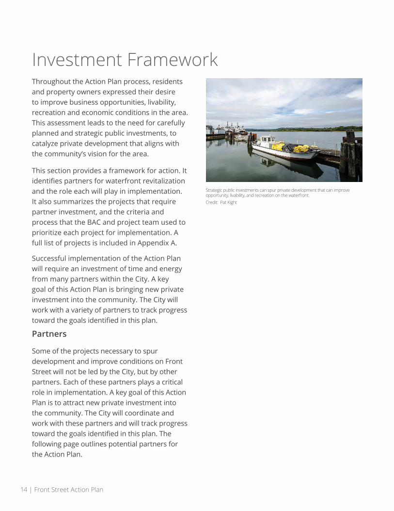
Investment Framework Throughout the Action Plan process, residents and property owners expressed their desire to improve business opportunities, livability, recreation and economic conditions in the area. This assessment leads to the need for carefully planned and strategic public investments, to catalyze private development that aligns with the community’s vision for the area.
This section provides a framework for action. It identifies partners for waterfront revitalization and the role each will play in implementation. It also summarizes the projects that require partner investment, and the criteria and process that the BAC and project team used to prioritize each project for implementation. A full list of projects is included in Appendix A.
Successful implementation of the Action Plan will require an investment of time and energy from many partners within the City. A key goal of this Action Plan is bringing new private investment into the community. The City will work with a variety of partners to track progress toward the goals identified in this plan.
Partners
Some of the projects necessary to spur development and improve conditions on Front Street will not be led by the City, but by other partners. Each of these partners plays a critical role in implementation. A key goal of this Action Plan is to attract new private investment into the community. The City will coordinate and work with these partners and will track progress toward the goals identified in this plan. The following page outlines potential partners for the Action Plan.
Strategic public investments can spur private development that can improve opportunity, livability, and recreation on the waterfront.Credit: Pat Kight
Investment Framework | 15
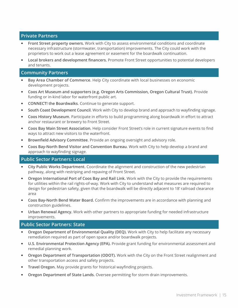
Private Partners• Front Street property owners. Work with City to assess environmental conditions and coordinate
necessary infrastructure (stormwater, transportation) improvements. The City could work with the proprietors to work out a lease agreement or easement for the boardwalk continuation.
• Local brokers and development financers. Promote Front Street opportunities to potential developers and tenants.
Community Partners• Bay Area Chamber of Commerce. Help City coordinate with local businesses on economic
development projects.
• Coos Art Museum and supporters (e.g. Oregon Arts Commission, Oregon Cultural Trust). Provide funding or in-kind labor for waterfront public art.
• CONNECT! the Boardwalks. Continue to generate support.
• South Coast Development Council. Work with City to develop brand and approach to wayfinding signage.
• Coos History Museum. Participate in efforts to build programming along boardwalk in effort to attract anchor restaurant or brewery to Front Street.
• Coos Bay Main Street Association. Help consider Front Street’s role in current signature events to find ways to attract new visitors to the waterfront.
• Brownfield Advisory Committee. Provide an ongoing oversight and advisory role.
• Coos Bay-North Bend Visitor and Convention Bureau. Work with City to help develop a brand and approach to wayfinding signage.
Public Sector Partners: Local• City Public Works Department. Coordinate the alignment and construction of the new pedestrian
pathway, along with restriping and repaving of Front Street.
• Oregon International Port of Coos Bay and Rail Link. Work with the City to provide the requirements for utilities within the rail rights-of-way. Work with City to understand what measures are required to design for pedestrian safety, given that the boardwalk will be directly adjacent to 18’ railroad clearance area
• Coos Bay-North Bend Water Board. Confirm the improvements are in accordance with planning and construction guidelines.
• Urban Renewal Agency. Work with other partners to appropriate funding for needed infrastructure improvements.
Public Sector Partners: State• Oregon Department of Environmental Quality (DEQ). Work with City to help facilitate any necessary
remediation required as part of open space and/or boardwalk projects.
• U.S. Environmental Protection Agency (EPA). Provide grant funding for environmental assessment and remedial planning work.
• Oregon Department of Transportation (ODOT). Work with the City on the Front Street realignment and other transportation access and safety projects.
• Travel Oregon. May provide grants for historical wayfinding projects.
• Oregon Department of State Lands. Oversee permitting for storm drain improvements.

16 | Front Street Action Plan
Project Phasing and Prioritization Criteria
Targeted investments and partnerships will be necessary for the City to achieve its vision for a more active waterfront. Besides advancing a specific project, these investments will show the City’s commitment to the area and increase private sector confidence. Some projects also provide a bridge for pioneering development projects to overcome development barriers. This section describes the projects and their prioritization.
Because limited public funds are available for capital projects and programs, it is necessary to prioritize these investments in a phased approach to implementation. The Action Plan recommends three distinct categories of projects as a way to organize use of public money:
Near-term catalytic projects (Exhibit 6, page 18)
These are projects that meet the BAC criteria for near-term investment (described on page 17), and are advanced in this Plan as important priorities in the near-term (next 5 years). Many projects do not require substantial upfront capital investments, but do require coordination and dedication from City staff and partners at other organizations.
Development supportive programs and investments (Exhibit 7, page 19)
These projects generally have high community support and enhance the environment for successful redevelopment of the area. Some of these projects can be advanced through the activities of other (non-City) partners.
Infrastructure Improvements: (Exhibit 8, page 20)
These projects include the following:
• Connectivity and Amenity Improvements: Area enhancements to support Front Street redevelopment.
• Utility Infrastructure Enhancements: These are critical improvements to address failing or insufficient infrastructure that is physically located in the Front Street area, but serves areas outside of Front Street in the City of Coos Bay. Investments in this infrastructure are prioritized based on system need in the City as a whole, but should be coordinated with Front Street investments.

Investment Framework | 17
Within these three categories, the BAC developed a set of specific criteria to determine which projects fall into the near-term priorities for resource expenditures and partner activities. The criteria incorporate the opportunities and constraints findings, community input, and BAC priorities. Implementation will take time, and require attention from partners and stakeholders over many years. Over time, as the financial situation stabilizes and if the feasibility for new development changes, different criteria can guide the next set of investments for Coos Bay.
The criteria articulate a set of considerations that the City should evaluate when investing in new projects. Any project that the City invests in during the near-term should:
1. Be simple and affordable to implement.
2. Support development on underutilized or vacant sites.
3. Improve public access and pedestrian mobility.
4. Celebrate the history and natural environment of Coos Bay.
5. Promote economic growth that generates property tax revenue.
6. Support resiliency for the district.
The remainder of this section provides a summary of the projects and their categories.
Coos Bay hosts an annual Festival of Sail in June, which brings thousands of visitors to see the tall ships on their way to Tacoma.Credit: David K, via Flickr. https://creativecommons.org/licenses/by/2.0/

18 | Front Street Action Plan
Exhibit 6. Near-Term Catalytic Projects
Project Description Rationale
A1: Public Waterfront Access Improvements
• Install boat launch near the south side of the Museum; consider using existing gravel area for parking as an interim use before the Plaza is built.
• Improve the Date Avenue right-of-way between Front Street and the bay as a destination.
Make initial steps to enhance experience for visitors, including enhancements to access and views of the bay.
A2: Food Truck Attraction Strategy
Explore regulations on food carts / trucks to be parked, on occasion, in the area.
Provide an attractor to the area for visitors and existing Front Street employees.
A3: Facade Improvement Program Enhancements
Increase the financial amounts of the façade improvement grants program.
Leverage significant building upgrades to improve Front Street aesthetics.
A4: Track Opportunity Sites
Maintain a property database that tracks property activity; work with property owners to improve buildings and recruit potential tenants.
Barriers to development and strong community desire for revitalized waterfront.
A5: Funding Toolkit and Partnerships
Identify funding sources to support priority projects (especially infrastructure and programmatic efforts).
Development market creates barriers on vacant and underutilized sites in the area. Targeted partnerships can address these barriers.
BAC-identified Catalytic Projects
The BAC agreed that immediate results need to come from the Action Plan. Exhibit 6 summarizes the projects that the group prioritized for the near-term. In particular, the group prioritized enhanced access to the bay (Project A1) and providing immediate improvements to programs to support property owners interested in investing in their properties (Project A5).

Investment Framework | 19
Development Supportive Projects
Exhibit 7 describes a specific set of projects identified through the Action Plan Process that would help to attract new users to vacant and underutilized sites, and provide a more welcoming environment for visitors to the area. Appendix A provides details on each of the projects described below.
Exhibit 7. Development Supportive Policies
Project Description Rationale
B1: Historical Wayfinding Initiate a wayfinding master plan for the Front Street waterfront area.
No current signage in the area, and limited information about the history of Front Street. Increase visitor engagement and historical interest.
B2: Restaurant Recruitment Strategy
Outline outreach activities and identify opportunities to recruit businesses that meet the community’s vision.
Strong community desire for waterfront restaurants.
B3: Environmental Assessment and Cleanup
Explore a strategy for selective removal of existing piles within Coos Bay, and work with property owners to evaluate and address potential soil, sediment, and/or groundwater contamination.
Environmental hazards may hinder feasibility for future development.
B4: Create Supportive Environment for Public Events
Make near-term programmatic changes to encourage events on the waterfront, with longer-term infrastructure improvements to better accommodate events.
Community support to re-embrace the waterfront, providing more opportunities for community gatherings. Attract tourists.
B5: Public Parking Management Strategy
Develop a parking management strategy that outlines policies and programs that result in more efficient use of parking resources on Front Street.
Limited on-street parking creates barriers for redevelopment. Coordinating a parking strategy could allow for shared parking solutions.

20 | Front Street Action Plan
Infrastructure Projects
Exhibit 8 shows the infrastructure investments needed to support development in this area. Investments in these projects will take significant funding, and should be evaluated by an updated set of criteria.
Exhibit 8. Infrastructure Projects
Project Description Rationale
Connectivity and Amenity Enhancements
C1: Pedestrian North-South Connection (Connect the Boardwalks)
Complete a north-south pedestrian pathway along the eastern side of Front Street.
Active community support. Mixed-use development will require enhanced pedestrian access.
C2: Improved Bicycle/Pedestrian Crossings across Highway 101
Install two crosswalk improvements.
New development will require better crosswalks and safety features across U.S. 101.
C3: Circulation and Connectivity Improvements
Complete road configuration changes to better serve new development.
A well-connected street network would make the area attractive to the public.
C4: Access/Intersection Improvements
Complete access management improvements.
Improves safety, reduces congestion, and makes circulation more efficient.
Utility Infrastructure Enhancements
C5: Sewer Collection System Enhancements
Replace the sewer collection system on Front Street.
Meets future needs of the area and addresses aging infrastructure.
C6: Storm Drain Improvements
Replace the storm drain system on Front Street.
Aging infrastructure that is prone to surcharging during tidal events. Requires upgrade to support new development.
C7: Water Distribution System Enhancements
Replace the water distribution system on Front Street.
Meets infrastructure needs for future development. Water system has approached the end of its usable lifespan.
Implications | 21
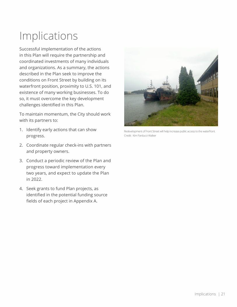
Implications Successful implementation of the actions in this Plan will require the partnership and coordinated investments of many individuals and organizations. As a summary, the actions described in the Plan seek to improve the conditions on Front Street by building on its waterfront position, proximity to U.S. 101, and existence of many working businesses. To do so, it must overcome the key development challenges identified in this Plan.
To maintain momentum, the City should work with its partners to:
1. Identify early actions that can show progress.
2. Coordinate regular check-ins with partners and property owners.
3. Conduct a periodic review of the Plan and progress toward implementation every two years, and expect to update the Plan in 2022.
4. Seek grants to fund Plan projects, as identified in the potential funding source fields of each project in Appendix A.
Redevelopment of Front Street will help increase public access to the waterfront.Credit: Kim Parducci-Walker

22 | Front Street Action Plan
AppendicesA. Detailed Project Sheets
B. Opportunities and Barriers Report
C. Open House Summary