From Vacant to Verdant
73
Ander From Vacant to Verdant: A look at the feasibility of urban agriculture in Orange and Durham counties
Transcript of From Vacant to Verdant

Ander
From Vacant to Verdant:
A look at the feasibility of
urban agriculture in
Orange and
Durham counties
Ander
2
PREFACE
“In the end, we will conserve only what we love; we will love only what we understand; and we will understand
only what we have been taught.” ~Baba Dioum I aim to leave the world a greener, healthier, happier place. I believe the most valu-able way to do this is by reconnecting people to nature and to each other. Humans are creatures of habit. We feel compassion and empathy for the things that we love. The ability to love is learned from parents, peers, and personal experiences especially at an early age but also over the course of a lifetime. My conservation ethic and love for nature were born and nurtured in my childhood and remain the driving force in my life but many have not been given the opportunity to positively connect with nature. I want to create opportunities for others to make this connection through urban agricul-ture. My study explored the feasibility of using urban agriculture as a means of recon-necting communities to nature in Orange and Durham counties.
We cannot separate ourselves from the natural world, it is part of us. However, we have had the financial means and technology to work against nature for many dec-ades. This cannot last. It is a counter productive task. Our holding capacity is near. The advent of peak oil is upon us. Global temperatures are rising. Humans spend 90% of their time indoors (EPA, 1987). Doctors prescribe depression medications more often than any other drug (Cohen, 2007). America is experiencing the worst economic re-cession since the Great Depression. Children are unable to identify the native flora and fauna of their environs. Obesity rates climb each year. In 2008, 64.5 percent of adults were overweight or obese (Trust for America’s Health, 2008). The divide be-tween rich and poor continues to grow while the price of fresh fruits and vegetables rise and processed foods remain cheap. Globalization sucks money and jobs from lo-cal communities. DDT remains in American mother’s breast milk 37 years after being banned in the United States. Children think water comes from the tap and food comes from the grocery store. Food travels on average 1,500 miles before arriving on our plates and often contains genetically modified organisms (GMOs), and antibiotics (Pirog & Benjamin, 2003). But there is hope. We can harness the sun, wind, and tides to provide energy. We can compost to create high quality soil while keeping refuse out of our landfills. We can build water treatment systems that use wetlands to filter pollutants. We can use native vegetation for landscaping thereby reducing the amount of water and fertilizer neces-sary to keep lawns lush and green. We can provide vegetated, riparian buffers to cre-ate wildlife corridors and limit stormwater runoff. We can use rain barrels, cisterns, and other water collectors to provide grey water for irrigation and flushing our toilets. “At colleges around the country, students seem to be flocking to environmental stud-ies,” (Galbraith, 2009). GMOs have been rejected across the globe. The number of land trusts, CSAs, and farmer’s markets continues to rise. Companies are taking re-sponsibility for their products from cradle-to-grave. And we can garden on vacant land within our towns and cities to feed ourselves locally.
Preface

Ander
3
TABLE OF CONTENTS Page Preface……………………………………………………………………………….. ………………2 1. Introduction……………………………………………………………………………………….4 2. Purpose………………………………………………………………………………………….4-7 2.1. Research Question…………………………………………………………………...5 2.2. Why Urban Agriculture?..................................................................................…7 3. Literature Review…………………………………………………………………………….7-14 3.1. Key Principles for UA to Succeed………...…….………………………………….8 4. Question One: Physical Feasibility—Land Inventory Analysis…………………14-23
4.1 Purpose of the Land Inventory Analysis…..………………………………….14 4.2 Land Inventory Analysis…………………………………………..……………...14 4.2.1 Methodology………..…….………………………………...…...……...14 4.2.2 Types of Urban Agriculture……………………….………….……….16 4.3 Results of the Land Inventory Analysis……………………………………………16
5. Question Two: Regulatory Feasibility—Local Land Use Policy Assessment….23-29 5.1 Purpose of the Local Land Use Policy Assessment ………………………..23 5.2 Methodology for the Local Land Use Policy Assessment …………….…...23 5.3 Results of the Local Land Use Policy Assessment ……….………………...24 5.3.1 Orange County Land Use Policies……………………….…….……....24 5.3.1.1 Barriers created by Orange County Land Use Policies....26 5.3.2 Durham County Land Use Policies…………….….………….………...27 5.3.2.1Barriers created by Durham County Land Use Policies…..28 5.3.2.2 Durham Text Amendment Process………...…………...…..29 6. Findings ….…………………………………………..……………………………………...29-33
6.1 Insurance…………………………………………………………………….….....30 6.2 Management………………………………………………………….……..…...31 6.3 Perception of Vacant Land………………………………….…………….…..31 6.4 Regulations differ on Private versus Public Land…………..……….……...31 6.5 The Semantics of the term Urban Agriculture…..……………..….………..32 6.6 Temporary Tenure…………….…………….………………………………..…..32 6.7 Legal Issues………………..………………………….…………………………...32 6.8 Costs…………....………………………………………………………………..…..32
7. Limitations of the Study…………………………………………………...………………33-34 8. Conclusions………………………………………………………….……..…………...…..34-36 9. Recommendations.…………………………………………………………………...…..36-38 10. References……………………………………………………………………...….…….....39-42 11. Appendix…………………………………………………………………….……………...43-72
“Gardening is civil and social, but it wants the vigor and freedom of the forest and the outlaw.” ~Henry David Thoreau
Table of Contents
Ander
4
1. INTRODUCTION Abuzz in the planning field is this idea of greening our cities to create sustainable, resil-ient places. According to the authors of Resilient Cities: Responding to Peak Oil and Climate Change, “Such cities will innovate so that they become based on renewable energy, not oil; are eco-efficient and carbon-neutral; will produce energy and grow food locally; and will take other measures to reduce consumption and become sus-tainable. They will be transit-based (especially rail), not car-dependent, and far more in tune with nature, and they’ll create much more viable and pleasant walking and cycling spaces,” (DeMark, 2009). How do we create these places? I believe that ur-ban agriculture is a crucial element to achieving sustainable, resilient communities. What is urban agriculture? Urban agriculture is a practice that has occurred for as many years as humans have resided in cities but it was only in the late 1990s that the term was coined. “Urban Agriculture is an industry located within (intra-urban) or on the fringe (peri-urban) of a town, an urban centre, a city or metropolis, which grows or raises, processes and distributes a diversity of food and non-food products, reusing mainly human and material resources, products and services found in and around that urban area, and in turn supplying human and material resources, products and ser-vices largely to that urban area,” (Mougeot, 1999). Urban agriculture, or UA for short, is an academic term that encompasses but is not limited to the following agricultural ac-tivities: a pot of herbs grown on a balcony, backyard gardening, rooftop gardening, greenhouses, market and community gardens, edible landscaping, fruit trees, aqua-culture, farmers markets, small-scale farming, hobby beekeeping, food composting, greenhouses, window boxes, community farming, mushroom cultivation, raising small livestock, and sustainable forestry (Collective Roots, 2008; Mendes, Balmer, Kaethler, & Rhoades, 2008). The most well-known form of UA and the most commonly found in the United States is community gardening. For this reason, this paper will often look at urban agriculture in the form of community gardening. The paper will begin by more clearly defining the research question by looking at the meaning of each component of the question and will move into the key principles that must be present for success as understood by the current literature. From there the research question will be explored from two angles, the physical feasibility and the regulatory feasibility of urban agriculture, through an explanation of the methodology and findings of each analysis. Overall findings, barri-ers, and limitations of the study will then be presented with the paper ending with rec-ommendations for implementing the research that has been conducted to date. 2. PURPOSE The purpose of this study is twofold, 1) to explore urban agriculture as a way to con-nect people, particularly urban dwellers, to their local environment, to one another, and to the local community and 2) to create a land inventory of each of the four study areas to present a strong case, to each community, for implementing local plan-ning and agricultural policies that support the use of vacant, publicly-owned land for
Introduction

Ander
5
temporary, urban agriculture. To begin the research question must be fleshed out to truly understand what it is asking by explaining each of the elements it encompasses.
Feasibility Feasibility, according to Merriam-Webster, means “capable of being done or carried out,” (Merriam-Webster Online, 2009). For this study two forms of feasibility were ex-plored, physical and regulatory. Physical feasibility looks at what parcels are available and suitable for urban agricultural activities including site location, land cover, zoning, and ownership. Regulatory feasibility entails how zoning and policy affect what types of urban agricultural activities can occur on qualified parcels. Combining these two types of feasibility produces a land inventory of vacant, government-owned parcels where urban agricultural activities are permissible. Vacant Vacant is a term that has, “no formal or standardized definition” but “often refers to many different types of unutilized or underutilized parcels…It can be small or irregularly shaped parcels left over from earlier development. It can be parcels with physical limitation, virtually unbuildable due to steep slope or flood hazard. [or] Land in tempo-rary use (e.g. storage, pasture)...” (Pagano and Bowman, 2000). Orange County’s Tax Assessor’s Office defines vacant land as “any parcel that does not contain a building or contains a building with no electricity running to it,” (R. Gunn, personal communica-tion, March 9, 2009). Durham’s Department of Tax Administration defines it as, “A par-cel having no permanently affixed improvements,” (Durham County Office of Tax Ad-ministration, 2008). Neither Orange nor Durham County’s Planning Departments recog-nize the term vacant. Instead the term underutilized is used. Therefore vacant per-tains to valuation not land use. In this study vacant is equal to an appraised building value of zero. Government-Owned Government-owned describes land that is owned by a local government body and used to serve a public purpose. These lands include schools, government buildings, parking lots, parks, trails, greenways, rights-of-way, landfills, water and wastewater treatment facilities, conservation lands, sewer easements, libraries, surplus property, reservoirs, etc. For this study parcels under Orange County, Durham County, the Town of Hillsborough, and the City of Durham ownership were used. Temporary A temporary use is a use that lasts for a limited time. Limited time has no set duration. This study looks at urban agriculture as a temporary use because government-owned property is purchased for a particular, public purpose (see previous section for a list of typical purposes). A parcel that is both vacant and government-owned likely will only
2.1 RESEARCH QUESTION: What is the feasibility of using vacant, government-owned land for temporary urban agriculture in Orange and Durham Counties,
the Town of Hillsborough, and the City of Durham, North Carolina?
Purpose

Ander
6
remain so until it is converted to its intended use. Urban agriculture could take place on the parcel until the conversion occurs, allowing community groups temporary ten-ure on the parcels and providing government with the necessary flexibility it needs to serve the public interest. Urban Agriculture The following uses were considered in this study as possible urban agricultural activities, based on the definition of urban agriculture used in the Introduction of this paper.
• Community gardening • Sustainable forestry • Container gardening • Raising small livestock (chickens, rabbits, ducks, goats) • Food composting • Community farming • School gardening • Edible landscaping • Bee keeping • Fruit trees and berry bushes • Mushroom cultivation • Greenhouses
Study Areas The analysis looked at four separate subject areas: Orange County, Durham County, the Town of Hillsborough, and the City of Durham. For each study area all of the par-cels under government ownership where lo-cated. Table 1 displays the various owner names within each area. This list does not include surplus property. Surplus property is prop-erty acquired by a gov-ernment, often through the foreclosure process, that the government intends to dispose of, in a timely fashion, through the auction process to the private real estate market in order to recuperate lost tax revenue. Due to its short-term ownership by government it was not included in the analysis.
Municipality Ownership Name
Orange County
County of Orange, Orange County North Carolina, Orange County c/o County Manager, Orange County of, Orange County%McAdoo Public Works, Orange County Board of Education, Orange County% Planning Dept, Orange County c/o Geoffrey E. Gledhill, Orange County of Attention Beverly Blythe, Orange County North Carolina c/o Geoffrey E. Glehill, Orange County ATTN Pam Jones,
Durham CountyCounty of Durham, Durham Soil & Water, Durham Public Schools Board, Durham County Brd of Education
Hillsborough
Hillsborough, Hillsborough City of, Hillsborough Town of, Hillsborough Town of Cemetary, Hillsborough Historic Commission, Hillsborough Town of c/o Eric Swanson
Durham City of Durham
Table 1: Owner Name by Study Area
Purpose

Ander
7
2.2 Why urban agriculture? With the recent discussion about how to green our communities to create sustainable, resilient places, urban agriculture is an important but often overlooked means of achieving this goal. All four study area governments are committed to greener, more sustainable communities. Over the past two years Durham has hired a sustainability manager; embarked on an urban open space plan; passed a Limited Agriculture ordi-nance; and allowed hens and bees in city limits; while Orange County has created a native landscaping ordinance; conducted a Greenhouse Gas Emissions Inventory; fo-cused its Lands Legacy1 dollars on protecting farmland through conservation ease-ments; and incorporated community gardening into its New Hope Park at Blackwood Farm master plan (Orange County, 2004). These are all important steps but more must be done. “One-third of the 2 million farms in the United States alone are located within metropolitan areas, and produce 35% of U.S. vegetables, fruit, livestock, poultry, and fish,” (Bellows, Brown, Smit, 2003). This sta-tistic recognizes the importance of urban agriculture to each of us as consumers and as residents. Allowing for urban agriculture throughout the communities of Orange and Durham counties can increase this figure, increase local food security, strengthen community networks, improve air quality, lessen stormwater run-off, beautify, and re-duce energy consumption. All of these elements contribute to greener, more sustain-able places. 3. LITERATURE REVIEW Although research on urban agriculture is limited and only more recently available it is viewed with hope as a viable step to greening communities while connecting people to one another and with the physical environment. UA is cited as having positive com-munity benefits - socially, environmentally, and economically. Social benefits include: reducing crime, making communities more walkable, enabling food education, con-tributing to food banks, bringing fresh produce to neighborhoods where fresh fruits and vegetables often are not available, providing recreation and exercise for neighbor-hood residents, providing a focal point for community organizing and social networks, promoting interaction between the diverse residents of an urban neighborhood, dis-couraging illegal dumping and vandalism, empowering residents to take on more ac-tive roles in the further development of their neighborhoods, influencing overall food consumption patterns and improving dietary knowledge, providing a relatively secure and more locally controlled food source, addressing simultaneously the physical, men-tal, spiritual and social health of individuals and their communities, increasing self-esteem, pride, confidence, personal satisfaction and efficacy, providing job training, preventing illness, and beautification (Hess & Winner, 2007; Voicu & Been, 2008; Schu-koske, 1999; Glover & Parry, 2005; Kirby, 2000; Bellow, Brown, & Smit, 2003). Environmental benefits include: enhancing green spaces, preserving open space, re-ducing the number of food miles traveled from field to fork, decreasing energy use,
Purpose
1. In April 2000, the Orange County Board of Commissioners adopted the Lands Legacy Program to pro-tect the county’s most important natural and cultural areas through voluntary means, including pur-chasing land or working with private landowners to develop conservation easements.

Ander
8
shrinking our carbon footprint, improving air quality, increasing the range of biodiver-sity, improving soil quality, stabilizing soils, reducing erosion, lowering urban mass tem-perature, and providing flood control (Schukoske, 1999; Bellow, Brown, & Smit, 2003; Spirn, 1984). Economic benefits include: stabilizing and improving host neighborhoods, reducing blight, spurring neighborhood revitalization, increasing the value of neighboring prop-erties, saving household food dollars, increasing tax revenues, and encouraging invest-ment (Voicu and Been, 2008). It is powerful to me that one type of activity can have such far-reaching, positive ef-fects. These overarching benefits will provide the necessary justification for the study areas’ governments to support planning and policymaking processes that allow for UA. But how can these diverse benefits be achieved on the ground? Despite the Triangle area’s reputation as being a haven for foodies, and having a population that is supportive of a strong local foods system, little research has been done on UA in the region. To begin to fill this knowledge gap, my study focused on the current physical and regulatory feasibility of using vacant, government-owned land for ur-ban agriculture in the communities of Orange and Durham counties, Hillsborough, and Dur-ham. From a review of the current literature emerged a series of key principles, necessary to urban agriculture’s success. 1. Community Driven Community drive is the most critical of all the principles. Without community participa-tion the garden is destined to fail. Community meetings should be held throughout the process, from seed to table, to get input regarding what to grow, level of experience, marketing of the sites, needs for and while participating. Getting people to meetings and to participate happens through word of mouth, through churches, civic organiza-tions, ethnic organizations, community gardening non-profits, and other community groups. “UA typically involves a wide range of people, and has been identified as an exemplary “networked movement” because of its cross-sectoral nature and its citizen-led approach to knowledge and solutions,” (Werkerle, 2004; Welsh & MacRae, 1998). The benefits of public participation will be felt by local government in that the policies they produce will be more likely to meet the needs of all effected parties and to be supported by the community. Greater pride and buy-in will result from the process be-ing community-driven. 2. Accessibility Sites should be within walking distance of residences, work places, and public transit
3.1 Key Principles for UA to Succeed
1. Community Driven 2. Accessible 3. Well Designed 4. Strong Partnerships 5. Well Managed 6. Supportive Policy 7. Land Availability 8. Land Tenure 9. Vacant Land, An Opportunity
Literature Review

Ander
9
stops. The community should be able to reach the UA sites without having to get into an automobile. Sites should be within a 10-15 minute walk or a quarter mile of resi-dences or transit stops. Walkability is ideal, particularly if tools need to be brought to the site. At the same time the site should have road access to allow for deliveries of compost and mulch and pick-ups of refuse and produce. If possible there should be enough room on the site to provide minimal parking for those who must drive to the site including inspectors, visitors, and participants. Public transportation must run regularly and participants must be able to get to the site multiple times a week for it to be successful. “It was observed that without regular transportation, attendance at both the farm and the market suffered,” and, “A bus schedule [was] not a [reasonable] solution,” (Andreatta, 2006). Without accessibiity the site likely will not succeed particularly if the target population is low-income or im-migrants because often these groups do not have access to reliable vehicles. 3. Well Designed Proper and good designs are needed for urban agriculture sites. Each design should be based on the goals of the individual site and the group maintaining the site. Sites should be designed to be built with the skill and labor of the participants. This will keep costs low because the design will respect what can be contributed by the community. A plot or area of community gardens should be constructed for use by children giving them their own place to experiment separate from their parents. If it is a vegetable garden it will need at least six hours of full sun a day. Each community garden site should have access to a permanent source of fresh water. Raised beds will be neces-sary if there is any soil contamination. Community gardens can be used strategically to, “create “defensible space” – neighborhood areas in which escape routes for criminal perpetrators are limited and public range of vision is maximized to prevent illicit conduct,” (Schukoske, 1999). Sites should be located and designed in such a way that they are visible and can be moni-tored by surrounding residences, providing eyes on the site. This will deter vandals and other illicit behavior (American Community Gardening Association, 2009). Vegetation should remain low enough to expose unlawful behavior by providing clean site lines. To reduce vandalism berry bushes should be planted around the perimeter to create a natural, unwelcoming barrier. Common, prolific producers should be placed within the berry buffer to deter vandals from the more unique and specialized produce in the center of the garden. It is, “more energy efficient for a tract of land to be designed to serve multiple func-tions…to improve air and water quality, to prevent or mitigate natural hazards, to re-claim derelict land, to conserve energy resources, and to enhance the city’s beauty,” to name a few (Spirn, 1984). “The most successful school gardens are actually com-munity gardens located on school grounds, (Hess and Winner, 2007). This is because school gardens often fail during summer recess because no one is there to maintain them. This issue is avoided by having community members whose children attend the school or who live close to the school participate year-round.
Literature Review
Ander
10
4. Strong Partnerships “Community gardens flourish in cities where there is a strong nonprofit advocacy or-ganization that can build partnerships with the city government,” (Hess and Winner, 2007). Partnering is fundamental for both groups. For government, “working with non-profit partners and community groups, and by using federal block-grants, existing pub-lic lands, state university extension services, and foundation resources, the single em-ployee working on community gardening programs can leverage his or her job into a multiorganizational network,” (Hess and Winner, 2007). Additionally, “Because the work of gardeners is voluntary, the city government can leverage extensive resources by serving as a source of networking and information exchange without incurring the full cost of program implementation,” (Hess and Winner, 2007). “The primary role of the city government is to serve as a catalyst that connects neighborhood groups with community gardens, the broader local food system and local nonprofit organizations and funders,” with government filing the role of coordinator, supporter, and facilitator of land tenure (Hess and Winner, 2007). This will allow programs to be set up in ways that leverage the power of the city government at minimal cost. From the perspective of the non-profit or community group, government can provide start-up services, such as soil-testing, soil remediation, initial materials, and education and training. They can also provide trash removal, compost, equipment, water taps, and police patrols. Community groups are the driving force providing political sup-port, physical labor, creativity, financial support, management responsibility, liability insurance, public participation, cooperation, and coordination. There must be an open line of communication between the two parties and a point person within each party who is available and responsive. Another critical relationship is within government itself. Gardening programs should be located within “a strong department where there is support for the program” (Hess and Winner, 2007). The program should be located within the department whose mis-sion most closely aligns with that of the program so that both move forward in the same direction. For example if the goal of the program is to enhance community de-velopment or provide job training the program should be located in a Neighborhood, Community, or Economic Development Department. If the goal is to provide environ-mental education or recreation, the opportunity to reconnect with nature, or make the area more sustainable it should be located in the Parks, Recreation & Open Space Department. Without support from inside government the program will never succeed because it will be thought of as additional work rather than an integral part of the de-partment’s mission. 5. Well Managed Building off the principle of strong relationships is that of good management. In order for urban agriculture to succeed there must be one person who manages the site. This person must be respected by the UA participants, the government agency, and the greater community. This person would be in charge of divvying up garden plots, main-taining the relationship with local government, the neighbors, suppliers, distributors, etc. They would also ensure that the participants maintain their sites through watering, weeding, and picking of produce and flowers. A good manager provides consistency
Literature Review
Ander
11
between growing seasons, allowing the garden to remain viable for a longer period of time. Management can come from a community member, a local non-profit, or a government agency. For the most part it is better for it to be an established non-profit organization that the community knows will be around into the future and is not re-stricted by bureaucracy. 6. Supportive Policy There is no one, right way to formulate policies that are supportive of urban agriculture but having policies is key for success. The groundwork should be set by discussing ur-ban agriculture as a goal within a government’s planning and visioning documents particularly within comprehensive plans (Hess and Winner, 2007). These overarching plans are the basis for creating policies and programs that allow for urban agriculture and local food systems and once they policies and programs are in place these docu-ments provide grounds for securing funding. “Cities without comprehensive open space strategies and the benefit of working partnerships are less likely to achieve high-level results,” (Kirby, 2000). Some states including New York and Tennessee have statutes that allow for commu-nity gardening on public lands. Support at the state level makes it easier for commu-nity members and local governments to create, maintain, and enforce local ordi-nances. When no express urban agriculture statutes exist guidance can be found from agricultural and parks and recreation related policies. “Legislators should realize that community gardening is consistent with social policies such as the promotion of health and welfare, environmental protection, economic de-velopment, education, youth employment and tourism,” keeping in mind that, “Provisions permitting government officials to summarily close community gardens are inconsistent with the aforementioned social policies,” (Schukoske, 1999). When struc-turing urban agriculture policies specific public purposes should be identified that merit broad based support. “By stating the gardens’ public purposes, ordinances promoting community gardens clarify what distinguishes them from for-profit agricultural produc-tion. Courts have held that a lease, granted to a private party and yielding a legiti-mate public benefit, constitutes a valid public purpose,” (Schukoske, 1999). 7. Land Availability “When considering land use for future farms, other factors need to be incorporated into site selection and not just the availability of a vacant lot, (Andreatta, 2006). This principle is more complex than it appears. Obviously there must be available land for urban agriculture to take place on. What is less clear is what land qualifies as avail-able. As discussed above site selection should be “arranged to reduce distance as an obvious barrier to anyone’s participation,” it must be out of the floodplain, the soil must be tested for contamination, it must be located at least 50 feet from busy streets, away from old painted structures, within a residential zoning district or another district that allows these uses, must have access to air, water, light, and nutrients to survive and succeed, be available for at least a growing season, and should be accessible by multiple forms of transportation (Andreatta, 2006; Spirn, 1984).
Literature Review

Ander
12
“Cities across the United States that have considerable vacant land are debating whether to foster community gardens on that land, while cities with land shortages are debating when to replace gardens with other uses,” (Voicu and Been, 2008). Govern-ments can play a significant role, “…by providing access to public land on parks and other city property,” (Hess and Winner, 2007). Often time governments own land that is underutilized or already being used for a public purpose. Urban agriculture could be an additional use of these properties. 8. Land Tenure The length of time that the potential site can be used by the community for urban ag-riculture is critical to the success of each endeavor. “When allowing community groups to use vacant lots for gardening, the city needs to consider the length of ten-ure and the size of the garden. Conversion of a vacant lot to gardening requires con-siderable investment from the gardeners and advocacy groups, and the gardeners are more likely to develop and maintain the garden if they have a long-term agree-ment with the city and if the gardening group is large enough to accommodate turn-over of membership,” (Hess and Winner, 2007). It should be determined at the begin-ning of the agreement whether or not the parcel could potentially be purchased by the community group. If so this may spur the group to form a non-profit and to seek funding to acquire the site. This could be a boon for government by relieving it of the fiscal and management requirements, while knowing that the property will contribute to the greening of the jurisdiction. “Outright ownership of garden lands provides the greatest degree of control. While ownership of garden lots may be feasible and prudent for community organizations that are firmly established, the process of obtaining title may require a greater invest-ment of resources and a longer time commitment than less established garden organi-zations can provide,” (Schukoske, 1999). Outright ownership may often not make long-term sense for either government or the community particularly if the site is within the city or town’s urban core. Firstly the land is more valuable as potential real estate. For government, being able to sell this prime land to private real estate developers will provide the greatest financial benefit to itself and the community. Green spaces can disrupt an area’s urban fabric. Open space on a successful block may indicate the end of the business district to someone strolling down the street despite the fact that there are open businesses in the building just past the open lot. Secondly many have negative associations with open spaces in urban areas and are unwilling to walk past or through them. Although there is no specific minimum tenure that must be achieved a commitment of at least three to five years would be ideal (American Community Gardening Associa-tion, 2009). “The duration of garden lot leases is specified in various authorizing laws, and ranges from as long as five years (renewable) in Seattle, to two years in Boston, to as short as one growing season under New York law,” (Schukoske, 1999). They are of-ten terminable on short notice, 30 days is typical for a public purpose and five for a public nuisance,” (Schukoske, 1999). Often agreements are indefinitely renewable.
Literature Review

Ander
13
9. Vacant Lands – An Opportunity Vacant and underutilized land is a good way to provide both temporary and perma-nent sites for urban agriculture. Most of the sites that have been developed through-out the United States have been in disenfranchised, minority communities in large ur-ban areas. Most are parcels owned by municipal governments, which they obtained through foreclosure, condemnation, unsettled wills, or abandonment, but do not have the funds to maintain (Accordino & Johnson, 2000). These sites are eyesores and foster urban crime. Disinvested lots have been scientifically correlated with urban violence. With the assistance of non-profit and civic partners, cities have been able to turn some of these lots into community gardens. Having stewards on-site, working the land and reaping its rewards, minimizes negative activities from occurring. Cultural Views Vacant and abandoned lands are stigmatized though often for good reason. When properties are left vacant or abandoned the entire area suffers from increased crime, decreased property values, increased insurance costs, decreased positive aesthetics, decreased wealth, decreased availability of affordable housing, decreased tax base and services offered, decreased quality of life, decreased business, and decreased potential for new businesses (Accordino & Johnson, 2000; Schukoske, 1999). These con-cerns directly play a role in determining how professionals manage and use these lands. The APA feels that the term vacancy should not be used as a land use classifi-cation. The vacant classification is interpreted as land that has no value to the com-munity as is. This is an anthropocentric bias that does not even give value for the natu-ral processes that are sustained by the land. How vacancy is described, valued, and perceived by the community is critical to un-derstanding how it is treated and how it can be used to change our perceptions (Accordino & Johnson, 2000). Artists have provided a different way to view aban-doned lots. By terming them “open sites” and focusing on the benefits they provide, allowing light, air and sun to penetrate dense areas bringing nature to the urban fab-ric (Corbin, 2003). It has also been pointed out that vacant sites provide municipalities with opportunities and flexibility. “…vacant retains an idea of value, though perhaps deferred to the future,” (Corbin, 2003). These are properties that currently were un-available to the city and can be used for new, more appropriate uses. Allowing mu-nicipalities to ask, “What needs are not being met within the community?” and using these parcels to address those needs. Social Impacts Vacant sites do have both positive and negative social impacts on the communities they are found within. They fill a need as places for children to gather and play, which is often a public service that is lacking within the disenfranchised neighborhoods where abandoned lots are more likely to be found (Ries et al, 2008). More often they become spaces for less reputable members of the community involved with urban crime to gather. The longer the lots are abandoned, the more comfortable people feel in these spaces, the more likely the structures are to be damaged, and the higher and denser the vegetation becomes. In order to successfully turn these properties around the community must be involved in the process. They have to want change to
Literature Review

Ander
14
occur and must be committed to making it happen by providing time, knowledge, money and skills or allowing those with these qualities to come in and do so. Economic Impacts Land is valued in two ways, by aesthetics and by its highest and best use with the latter having significantly greater influence. Vacant and abandoned lands do not have worth under either of these systems. When dealing with vacant lands, cities must de-termine how important the loss of value is to their tax base and reputation and use a strategy that will address these concerns. Unfortunately even if a city would like to tackle this problem there are legal and economic barriers that make the process time consuming and expensive. America’s legal system favors private property owners over community rights, placing the burden of proof on the municipality. Tax foreclo-sure proceedings take time, usually about 12 months per property, and funding, re-sources that government often does not have enough of. Using this list of nine guiding principles, I was able to analyze parcel data and evaluate zoning ordinances to determine potentially feasible sites for urban agriculture in the four study areas. 4. QUESTION ONE: What is the physical feasibility of urban agriculture? 4.1 Purpose of the Land Inventory Analysis This question looks at the physical feasibility of using publicly-owned land in Orange and Durham counties, Hillsborough, and Durham for urban agriculture. Physical feasi-bility is defined by what lands are appropriate for varying agricultural activities based on land cover, improvements, distance from residences, land use, road access, visibil-ity, and topography. This analysis assumes that every parcel that is vacant and owned by a local government is available for urban agriculture. Through a simple analysis us-ing GIS it was determined, which parcels would be appropriate for urban agriculture. 4.2 Land Inventory Analysis A land inventory analysis was conducted for each of the four study areas. Although a similar methodology was used for each of the study areas they were not precisely the same (See Appendix 1 for a step-by-step analysis of each jurisdiction to understand the methodological differences). This section lays out the general methodology that was used and discusses the varying types of urban agriculture that the study considers. 4.2.1 Methodology A two step analysis was conducted to determine potential sites for urban agriculture in each of the four study areas. Step 1: GIS Evaluation Basic shapefile data including county and municipal boundaries, parcels, roads, flood-plain, and zoning was obtained from Orange and Durham counties. The ownername and building value fields of the parcel layer attribute tables was used to identify gov-ernment-owned parcels that are currently vacant.
Literature Review

Ander
15
By defining characteristics that would make a site good for urban agriculture, a list of criteria was created. Potential UA sites must: a) be within a quarter to a half-mile of residences, b) not be in the 100-year floodplain, c) not be part of a reservoir, d) be in a residential zoning district, e) be at least 50 feet from major roadways, f) be publicly-owned, and g) be vacant. Step 2: GoogleTM Earth Evaluation The parcels identified in Step 1 were then individually evaluated in GoogleTM Earth to determine if they were appropriate for UA activities. By zooming in on satellite imagery of each parcel I was able see the land cover of each parcel and if there were build-ings, parking lots or other improvements on site. Based on the data gathered during the visual inspection I was able to make a determination about what type of urban agriculture was appropriate for each site, if any. The data from Steps 1 and 2 was compiled to create maps displaying the potential sites for urban agriculture for each of the study areas as well as tables showing the same data but broken down by total parcels and total acres by type of urban agricul-ture.
Question One
Type Size Land Cover Agricultural Uses
Community Gardens At least 0.2 Acres cleared vegetable gardens, flower gardens including individual garden plots or
shared gardening spaces
Small-Scale Farming/ Undisturbed Land
Greater than .09 Acres but less than 10
Acres
cleared and/or pine
and hard wood forests
berry bushes, fruit trees, mushroom cultivation, apiculture, composting
Community Farm At least 3 Acrescleared and/or
wooded land
vegetables, apiculture, raising chickens, horticulture, aquaculture, berry bushes, fruit trees, horticulture,
composting
Impervious Surface Gardening
At least 0.1 Acresparking lots,
roof tops
vegetables, flowers, greenhouse, vermiculture in containers or raised
beds
Edible Landscaping Less than 0.25 Acres Anyvegetative landscaping around
buildings planted in pots or in the ground
School Gardens At least 0.25 Acrescleared and/or
wooded land
educational gardens for school children and the community
Table 2: Types of Urban Agriculture
At least 10 Acrespine and
hardwood forests
horse-logging, timber management
Sustainable Forestry (government use only)

Ander
16
4.2.2 Types of Urban Agriculture Using the City of Portland, Oregon’s Diggable City’s urban agriculture categories for guidance, I created a list of urban agriculture types and defined them by parcel size, land cover, and type of agricultural use (Mendes etal., 2008). Each is included in Table 2. Sites completely covered by hardwood and pine forests that were over ten acres were categorized as appropriate for sustainable forestry but only available for govern-ment use. Sustainable forestry is defined by the Ministerial Conference on the Protec-tion of Forests in Europe (MCPFE) as, “the stewardship and use of forests and forest lands in a way, and at a rate, that maintains their biodiversity, productivity, regenera-tion capacity, vitality and their potential to fulfill, now and in the future, relevant eco-logical, economic and social functions, at local, national, and global levels, and that does not cause damage to other ecosystems,” (MCPFE, 2009). According to Thomas Craven, a North Carolina registered forester, approximately 10 acres would be needed to make it worthwhile for a forester and logger to be interested in creating a timber management plan and removing timber for a sustainable forestry job (T. Cra-ven, personal communication, March 28, 2009). Additionally I determined that sustain-able forestry should only be undertaken by the jurisdiction itself because it is an activity that requires a level of expertise the general public does not have and it requires the landowner to have an interest in holding on to the parcel for an extended period of time to allow time for the trees to grow and mature, 10-50 years. Due to the expense of contracting with a forester and engaging in a logging operation, it would be wise for the jurisdiction to create an overall forest management plan for the area rather than one plan for each parcel. Scale not land cover dictates small-scale versus community farming. If the site was completely covered by trees or was a mix of trees and cleared land and less than ten acres it was categorized as available for small-scale farming. Mostly cleared sites with some wooded areas that were greater than three acres were categorized as being appropriate for community farming, the farming of one tract of land by multiple indi-viduals. Gravel and paved parking lots were appropriate for impervious surface gar-dening including container gardening, raised beds, farm stands, or other sale and dis-tribution practices. Government-owned parcels where buildings and parking lots are the dominant features were appropriate for edible landscaping, which occupies the same amount of space as commercial landscaping while requiring less water and maintenance. Any site with a school was categorized as available for school garden-ing though they may be community gardens as long as they contain an educational component. Community garden sites were cleared sites, greater than 0.2 acres. This acreage was chosen to allow sites to be available to enough participants for them to be successful. 4.3 Results of the Land Inventory Analysis The physical feasibility of using local, publicly-owned, vacant land for urban agricul-ture is good. The number of potential sites varies based upon the size of the jurisdiction with the City of Durham having the greatest number of sites, 304 parcels totaling 1,209 acres, and the Town of Hillsborough having the fewest sites, 13 parcels totaling 63 acres.
Question One

Ander
17
Very few parcels within each jurisdiction are more than a ½ mile distance from resi-dences due to the generally suburban nature of the study areas. This increased the number of parcels for potential UA sites in theory. In practice I fear that the layout of the neighborhoods and land uses will prevent people from being able to access the sites without either a car or a walk that is greater than a ½ mile distance. Mostly this is due to the lack of direct routes to the sites due to private property and the lack of a grid-iron street pattern except within the town and city centers. If this analysis were run again I would limit the potential site buffer to a ¼ mile and would take into considera-tion how long the walk actually is rather than making this determination based on GIS. Many of the potential sites are located on school grounds. Partnering with the school system to create school gardens that are maintained by the community would be the ideal use for these sites. That way the gardens can provide educational opportunities for the students while having year-round maintenance. A visual inspection of the sites is necessary to understand what sites are viable for UA. Making a site visit would allow me to gather information regarding what kind of access is available to the site, the density of the land cover, identify what purposes the vary-ing buildings serve, how accessible it is via foot and automobile, how large the site is, etc. Upon visual inspection I would expect that the number of viable sites would drop significantly for each type except for the sustainable forestry and school gardens.
Question One
Type Community Garden
Small-Scale Farming/
Undisturbed Land
Community Farm
Sustainable Forestry
(government use only)
Impervious Surface
Gardening
Edible Landscaping
School Garden
Total
Orange County
9 parcels 26 parcels 9 parcels 19 parcels 3 parcels 3 parcels21
parcels 90
Orange County
25 acres 54 acres 343 acres 399 acres 35 acres 1 acres386
acres1,243 acres
Town of Hillsborough
7 parcels 2 parcels 0 parcels 1 parcel 0 parcels 3 parcels0
parcels 13
Town of Hillsborough
38 acres 0.3 acres 0 acres 25 acres 0 acres 0.04 acres 0 acres 63 acres
Durham County
38 parcels 29 parcels 1 parcel 36 parcels 2 parcels 1 parcel17
parcels 124
Durham County
27 acres 13 acres 4 acres 782 acres 1 acres 0.4 acres540
acres1,367 acres
City of Durham
50 parcels 191 parcels 11 parcels 48 parcels 1 parcel 2 parcels1
parcel 304
City of Durham
299 acres 73 acres 59 acres 770 acres 0.2 acres 6 acres 2 acres 1,209 acres
Total Potential
Sites104 248 21 104 6 9 39 531
Total Potential
Acres389 140 406 1,976 36 7 928 3,832
acres
Stud
y A
reas
Tota
ls
Table 3: Potential Sites & Acres for Urban Agriculture

Ander
18
Figure 1: Potential Urban Agriculture Sites in Hillsborough, NC
Question One

Ander
19
Figure 2: Potential Urban Agriculture Sites in Orange County, NC
Question One

Ander
20
Figure 3: Potential Urban Agriculture Sites in Durham County, NC
Question One
Ander
21
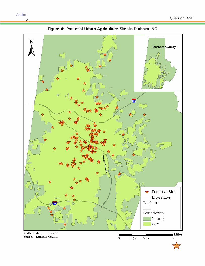
Figure 4: Potential Urban Agriculture Sites in Durham, NC
Question One

Ander
22
Town of Hillsborough The fact that Hillsborough is a small town with a fairly tight-knit downtown community makes it an ideal place for UA to succeed. Hillsborough has 13 potential sites for ur-ban agriculture totaling 63 acres with the majority of sites located in Downtown west of Churton Street, Hillsborough’s main thoroughfare. Forty percent of this land is con-tained within one of two parcels that make up Fairview Park, a joint project between Hillsborough and Orange County. Although the master plan does not provide an area for community gardening or other UA activities it would be an ideal location because it is bound on three sides by residential development with Orange County’s Public Works Department residing to the east. (See Figure 1). Orange County Orange County has 90 potential urban agriculture sites totaling 1,243 acres. The po-tential sites in Orange County are generally located around municipalities, Hillsbor-ough and Carrboro in particular, and along the interstate corridors. The majority of publicly-owned sites are government buildings, schools, parks, or open space dedi-cated to the county by developers meeting the county’s open space requirement. All of these uses are conducive to varying types of urban agriculture. Government build-ings are appropriate sites for edible landscaping or demonstration sites, schools and parks are ideal for educational gardens open to the community and sustainable for-estry, and dedicated open space is ideal for small-scale agriculture to community farming and gardening. (See Figure 2). Durham County Durham County has 124 potential urban agriculture sites totaling 1,367 acres. The ma-jority of these sites are located downtown, which is where government facilities and services are sited. The remaining sites are scattered throughout the county though there are more located in the southern half of the county than in the northern half. Southern Durham is under significant development pressure while Northern Durham remains rural and agricultural. (See Figure 3). City of Durham The City of Durham has 304 potential urban agriculture sites totaling 1,209 acres. As the most urban of the four study areas it is not surprising that Durham has the greatest number of potential sites and lags behind both counties in total acreage available for UA. Urban areas have a significantly greater number of parcels, due to increased population density and smaller parcel sizes. The potential for creating successful com-munity gardens and small-scale farming is higher because many of the parcels are lo-cated downtown near population centers and contain a mix of cleared and forested land. This combination of land cover allows for the greatest number of possible UA ac-tivities. (See Figure 4).
Question One
Ander
23
5. QUESTION TWO: What is the regulatory feasibility of urban agriculture? 5.1 Purpose of the Local Land Use Policies Assessment This question looks at the current zoning ordinances for each jurisdiction to understand how urban agriculture fits within the established land uses. Do these regulations bar or support the use of county and municipally-owned land for urban agriculture? It further looks to understand what would need to change within the current regulatory frame-work to fully allow urban agriculture to take place. This is done through an under-standing of county and municipal policing powers and how they influence the current zoning ordinances and the process for creating text amendments to the zoning ordi-nance. 5.2 Methodology for the Local Land Use Policies Assessment Through a series of interviews and reading each jurisdiction’s zoning ordinance I was able to determine the regulatory feasibility of urban agriculture in three of the four study areas. I began by contacting government employees in the county tax offices by email introduction. I heard back from Durham rather quickly but never received a response from Orange County. Instead I made an in-person trip and was able to talk with a series of staffers regarding the county’s definition of vacant land. These staffers provided further county contacts that I followed up with either by email or in-person. Each contact I made referred me to another staffer in another department that could answer a different question that I had. Thanks to the referrals I was able to name drop in my email introductions, which increased the number of responses I received. I heard back from the majority of staffers that I contacted with some providing informa-tion via email and others providing information via in-person interviews. In total I con-tacted 24 individuals, received feedback from 22 of them, and conducted 14 in-person interviews. I found that it was much easier to get time with people by dropping in on them during the business day rather than calling or emailing. Everyone was willing to stop the task at hand in order to hear about my project and answer a few questions. I assumed this was because it is difficult for people to turn you away when you are present and also the fact that it allows a small break from the ordinary while providing a venue to share their expertise. I found that it was critical to understand how the various departments interact and communicate and what roles each serve in order to receive relevant an-swers. I did not go into the majority of my interviews with this understanding so many of my questions were unanswerable because they were misdirected. Without working within the structure it is often hard to understand the interconnections. Land is an asset that is dealt with by a large number of departments. The tax office determines its tax value and assesses and collects property taxes based upon that value. The tax department also initiates the foreclosure process when property owners do not pay their property taxes. The planning department defines and regulates what can be done on the land. The real estate department manages surplus property and runs the auction process to disinvest the government from this property. Departments including parks & recreation, open space, public works, solid waste, and the school board have exclusive use to particular tracts of land and construct appropriate facili-
Question Two

Ander
24
ties in the public interest. 5.3 Results of the Local Land Use Policies Assessment “Local government power to legislate derives from state constitutional provisions, state statutes, and home rule powers. These grants of power vary from state to state,” (Schukoske, 1999). In North Carolina, a Dillon’s Rule state, Chapter 153A and 160A of the North Carolina General Statutes grants and defines the powers and re-sponsibilities of county and municipal governments. Articles 19 and 18, respectively, outline the powers of adopting and enforcing zoning ordinances for cities and coun-ties. Powers and responsibilities, although generally the same for both jurisdictions, do have some differences one of particular relevance when it comes to regulating agri-cultural activities. “Bona fide farms are exempt from county zoning, but not from city zoning. This distinction has been in the NC statutes since counties were first given zon-ing power in 1959,” (D. Owens, personal communication, March 29, 2009). This statute is found under NCGS § 153A‑340, Grant of Power, rather than NCGS §106-581.1 which defines agriculture. 5.3.1 Orange County Land Use Policies Vacant is defined by the Orange County Tax Assessor’s office as any parcel without a building or with a building without power (electricity running to it) (R. Gunn, personal communication, March 9, 2009). This definition is used to appraise the value of the im-provements on the parcel and is equal to the building value. The parcel is also as-sessed based upon its zoning, which determines the land value. These two values are added together to get the total value of the property. While the tax office recognizes the term vacant, the Planning Department does not. When talking about a vacant property they use the term underutilized. The term underutilized means that the parcel is not being used for its ‘highest and best use’ according to its zoning. The Planning Department looks at parcels solely based on what can be done on the parcel based upon the zoning code. Therefore a vacant property can be located in any zoning dis-trict. This was a critical distinction to make in the interviews The term temporary is used within my research question as an adjective to describe the length of time for urban agriculture on a particular site. Unlike in Durham, the term is not defined or used in the Orange County Zoning Ordinance. When asked if Orange County has a temporary use, Zoning Officer, Michael Harvey chuckled and said, “Temporary uses don’t exist. The use is or it isn’t, there is no in-between,” (M. Harvey, personal communication, March 27, 2009). Urban agriculture is not covered under any section of Orange County’s zoning ordi-nance. The ordinance allows for gardens in every zone but it only allows for them as an accessory use (Orange County Planning Department, 2006). Agriculture is not de-fined though different activities that are considered to be agricultural are including: ‘specialized animal husbandry’, ‘agricultural services’, ‘commercial feeder operation’, ‘specialized horticulture’, ‘farming’, and ‘avocational farming’. Avocational farming is defined as, “The use of land for those activities which constitute general farming on less than five acres or have sales less than $1,000 for the preceding three years or less than ten acres of forest land for which a management plan has been prepared. The
Question Two

Ander
25
use of the land for the raising and keeping of animals, reptiles, etc., or the propagation of ornamental plants, fruits and vegetables, in a manner which does not constitute specialized animal husbandry or specialized horticulture. Avocational farming does not include home gardening or the keeping of pets, both of which are allowed in any zone. Those uses are customarily accessory uses to the primary use of the land,” (Orange County Planning Department, 2006). Farming is defined as, “The use of land primarily for one or more of the following: The production in the open of cash grains, field crops, vegetables, melons, fruits, berries and nuts. The raising or keeping of general livestock and poultry for the sale of such livestock and poultry for the products thereof or the breeding of such livestock and poultry. Farming includes any buildings or structures which are customarily incidental or subordinate to the farming activities listed above, including residences for the owners, operators or employees of the farm and their families. General livestock and poultry includes those animals involved which are customarily and traditionally raised on farms, such as beef and dairy cattle, hogs, sheep, goats, rabbits and horses, mules, ponies, chickens, turkeys, ducks, and geese for the purpose listed above. Farming does not include agricultural services and proc-essing, avocational farming, specialized commercial horticulture, and specialized commercial animal husbandry,” (Orange County Planning Department, 2006). Bona fide farm is defined as, “The use of land for farming meeting one of he following crite-ria: (1) composing two or more acres on one or more tracts owned or leased by the bona fide farm unit; (2) average annual sales of $1,000 for the preceding three years; or a minimum of twenty of forest land for which a management plan has been pre-pared,” (Orange County Planning Department, 2006). The Orange County Planning Department uses a very broad definition of farming and agriculture because these ac-tivities are regulated by the State. In my estimation, under the definitions of bona fide farm and avocational farming, all types of urban agriculture are allowed. Additionally, neither is restricted to specific zones. With that said, the concern becomes not what the agricultural activity is or whether or not it is income producing but whether the land is privately or publicly owned. Private property rights are well protected in North Carolina. A landowner may do whatever he or she pleases as long as it is contained within the bounds of their parcel and is not a nuisance to neighbors. While county and municipal land is owned for the benefit of the public and therefore any activity that takes place on the land must be equally available to every resident within the jurisdiction. In Michael Harvey’s estimation urban agriculture, specifically in the form of community gardening, on public land, is prohib-ited by the Orange County Zoning Ordinance because the use is not expressly listed in the Permitted Use Table and according to Article 3.12, Prohibited Uses, “Use of land or structures which are not expressly listed in the Permitted Use Table, Article 4, as Permit-ted Principal Uses, Permitted Accessory Uses or Special Uses in a district are prohibited and shall not be established within that district,” (Orange County Planning Depart-ment, 2006). There appear to be at least three strategies for allowing urban agriculture in accor-dance with Orange County’s Zoning Ordinance.
1) The first is to include urban agriculture within new master plans for municipal properties. Once the master plan is approved by the County Commissioners
Question Two

Ander
26
the use is condoned for the life of the property or until the use is revoked by the Commissioners. This has been used for Orange County’s New Hope Park at Blackwood Farm, which calls for community gardens on 1.7 acres located northeast of the original farmstead (See Appendix 2 for a map of the master plan). 2) The second is for urban agriculture to be an accessory use to a site. This is currently happening at Orange County’s Planning and Agricultural Building on Revere Road in the form of a demonstration compost pile. Although it is rarely used, there are two bins set up, one for new material and one for material that has had time to break down and a sign explaining the function of the bins and the process of food breaking down into soil. Another example is the Eno River Farmer’s Market held in the Public Meeting House in Downtown Hillsborough, which is co-located with multiple Orange County office buildings, an Ecosystem Enhancement Program restoration project, Occoneechee Village, and the Sheriff’s Department. Finally edible landscaping would be a particularly easy accessory use to accommodate because it can be done anywhere there is commercial landscaping. “Edible landscaping is the use of plants that produce food in place of more commonly used ornamental plants,” (City of Vancouver, 2009). 3) The third strategy is for a community group to find a site, determine a county agency that is supportive that can partner on the project, and write a letter di-rected to a zoning officer within the planning department laying out the project in a manner that strictly defines the land use as bona fide farming within Or-ange County’s parameters cited above, and request approval of the use. The letter would need to address the issue of private liability insurance, which would be in addition to the insurance coverage held by the county; provision of facili-ties including parking, restrooms, water, sewer, lighting, etc., if necessary; and the proposed period of time the use will occur for. Potential government part-ners are the Environment and Resource Conservation Department, the Orange County Cooperative Extension Agency, the School Board and Board of Educa-tion, and Recreation and Parks. The most influential support that could be gained is that of one or multiple county commissioners. Currently there are at least three commissioners who are interested in supporting agricultural activity and farmers within the county. There may be support from some School Board members as well.
5.3.1.1 Barriers created by Orange County’s Land Use Policies It is encouraging that there are tactics for overcoming the fact that urban agriculture is prohibited from the zoning ordinance, strictly speaking, yet barriers remain. Firstly there are economic costs implied by the ordinance that could easily make urban agri-culture on municipal land infeasible. Only a portion of Orange County’s jurisdiction is served by the Orange Water and Sewer Authority (OWASA) with the remaining areas of the county requiring a well and septic system. Water and sewer fees through OWASA would total approximately $3,000 for a 5/8 inch connection. See Appendix 3 for a full fee schedule. Drilling a well and providing a septic field would be an addi-tional expense. The permit process alone for a new well and septic system costs
Question Two

Ander
27
$610, $350 for Site Evaluation and $260, for Construction Authorization and requires submittal of a site plan. In my estimation a septic system would not be necessary but even with the use of cisterns, a permanent water source is critical. Liability insurance coverage must be provided. If all of the typical regulatory requirements must be provided including restrooms, light-ing, parking, a site plan, than urban agriculture is economically infeasible. Secondly Mr. Harvey felt that because it was a public property being used for a public purpose that every member of the community should have equal access to the prop-erty. In order to provide this resource to all, a county-wide program would have to be implemented by inventorying all possible sites and then divvying them up through some sort of lottery system. This would be time-consuming, expensive, and likely unsat-isfying to all parties involved, again making urban agriculture infeasible. 5.3.2 Durham City-County Land Use Policies On January 1, 2006 Durham’s City-County Unified Development Ordinance (UDO) went into effect after being passed by the Board of County Commissioners and City Council at a joint meeting in December 2005. The UDO defines one type of agricul-ture, commercial agriculture, but allows for two types, commercial within the county and limited agriculture within the city. Agricultural uses are defined as, “Land used as pasture or in the commercial production of crops, horticultural products, fish hatcher-ies or aquaculture. Also for the purposes of this Ordinance, the keeping of livestock for commercial or noncommercial purposes is defined as an agricultural use. Livestock includes but is not limited to poultry and hoofed animals such as cattle, horses, goats, sheep, and swine;…Also included in this definition of agricultural uses are agricultural accessory buildings, and sales of agricultural products grown or raised on the premises. Not included in this definition are any use conducted pursuant to a valid permit issued under Sec.3.23, Limited Agriculture Permit, apiculture, the commercial slaughtering of animals for marketing, and farm tenant dwellings,” (Durham City/County Planning De-partment, 2006). Agricultural activities in the county are only allowed within the Resi-dential Rural and Residential Suburban zones while limited agriculture in the city is al-lowed in any of the Residential zones. Agricultural uses can be the primary land use if the land is in county, but under the Limited Agriculture ordinance agricultural uses are only allowed to be accessory within the city. Currently the Limited Agriculture ordi-nance only allows for the keeping of female chickens while another ordinance allows for apiculture (bee-keeping). Other uses would require additional text amendments. Although the UDO contains a section in regards to temporary uses, urban agricultural uses do not fall within this categorization. Temporary uses require permits, are allowed for up to 45 days, and include carnivals, construction trailers, Christmas tree lots, etc. Currently urban agriculture, except in the form of domestic chickens, apiculture, greenhouses, nurseries, and forestry, is not explicitly allowed in Durham. Additionally these uses are only allowed in residential zones and as non-commercial, accessory uses. Gardens themselves are not mentioned within the UDO. Forestry activities are allowed in any zone and are regulated by the State (Durham City/County Planning
Question Two

Ander
28
Department, 2006). Only recently, the end of 2008, has Durham amended its ordi-nance to include Limited Agriculture, Section 5.4.12 (See Appendix 4). To date the only subsections it covers are general terms and domestic chickens. Limited agricul-ture requires a limited agriculture permit to conduct the use; a building permit to con-struct any accessory structure associated with the use; can only be done for non-commercial purposes; and cannot create a nuisance. All of these seem reasonable for urban agriculture except for the non-commercial aspect. This requirement would limit urban agriculture activities by not allowing for community farms, farm stands, farmers markets, or sustainable forestry. It would force these activities to take place within the County’s jurisdiction or into other use districts. It is possible that these barriers could be overcome through the crafting of additional text amendments that specifi-cally relate to each of the activities. With that said the fact that the Limited Agriculture amendment was added and in such a short time period—6 months, according to Julia Mullen, the planner who writes Durham’s ordinance text--and comprises an entire section with the UDO rather than being positioned within another section, indicates that there is support for such land uses and that there is openness to expanding these uses (J. Mullen, personal corre-spondence, March 25, 2009). Section 5.4.12 is the best place for including urban agri-culture as a land use within the UDO. Mullen believes that there is support for urban agriculture within the community, within both city and county government, and with some elected officials. 5.3.2.1 Barriers created by Durham City-County’s Land Use Policies In addition to the barriers mentioned above – limited agriculture is only allowed in resi-dential zones, is limited to particular activities, does not include non-commercial uses, and only can occur as an accessory use — there is also the difference between public versus private land and the costs associated with bringing a parcel to the appropriate standards to allow for urban agriculture. Currently there are community gardens within the City of Durham; however, with the exception of the small educational garden run by SEEDS, which is located on the same site as the Durham Farmer’s Market, none are located on government owned prop-erty. Based on my interviews with Durham staff in Tax Administration, Real Estate Ser-vices, and Planning, Durham does not have any agreements with private citizens or community groups for use of government owned property. Prohibitive costs may include water tap fees, liability insurance, and text amendment additions. Fees related to bringing water onto a site for a 5/8 inch meter total $995 up-front plus monthly water usage fees (See Appendix 3 for a fee schedule). Construction of a tool shed may require a permit depending on the ratio of the building to the over-all site. Although based upon the correspondence I received from John Read, an in-spector for Durham, there is no definitive answer to the question, “What is the maxi-mum size a building can be without having to get a permit to construct it?” (J. Read, personal correspondence, March 31, 2009). He did refer me to the 2006 N.C. Interna-tional Building Code a document that Durham uses as a reference guide. Unlike Orange County no one I spoke with in Durham mentioned required facilities –
Question Two

Ander
29
parking, restrooms, lighting, landscaping, buffering, etc. The only concern of that na-ture that was brought up was stormwater. Any site disturbance that is greater than 12,000 square feet, a 1/4 acre, requires a stormwater management plan. I was told that a stormwater management plan could likely be avoided unless the government receives a complaint from a neighbor about excessive stormwater runoff. I would imagine that having plant material on the site would reduce rather than increase stormwater runoff and this would not be an issue. Durham officials were more con-cerned with liability insurance, vandalism, harboring negative activities via vegetative cover, aesthetics (what the garden would look like at the end of the season), man-agement (who maintains the site, who provides enforcement), environmental educa-tion, and the duration of the activity. 5.3.2.2 Text Amendment Process The text amendment process takes anywhere from six months to two years. It begins with a citizen, internal staff, or an elected official bringing forth an issue to the Planning Department. If it is a citizen that brings forward the amendment the cost to do so is $3,000+. It is infrequent that a request comes forward in this manner. Typically a citi-zen will solicit the support of an elected official and have them bring the issue forward. Since staff are directed by elected officials this is probably the most effective scenario. An application is submitted to planning staff along with the appropriate fees. A meet-ing is held between the applicant and the appropriate staff member to ensure the meaning of the amendment is understood. Staff researches the request, sends notices out to the appropriate organizations and interested individuals, and brings forward their recommendation to a Joint City-County Planning Committee (JCCPC). The JCCPC hears the amendment and determines whether or not it is in the public interest. If it is they recommend staff to move forward and if not no staff initiative is taken. Staff drafts text for the amendment and sends it out to all departments for internal com-ment and feedback, then incorporates this feedback. The amendment goes forward to the Planning Commission who holds a public hearing, discusses the subject, and makes a recommendation to the JCCPC. The JCCPC holds a public hearing and ei-ther makes a final decision or postpones the decision until their next meeting. Notice of both public hearings is sent via letter and/or published in the Durham Herald-Sun, 10-25 days before the hearing. The applicant is notified within seven days of the final de-cision (J. Mullen, personal correspondence, March 25, 2009). Going through the text amendment process is the best way to ensure that urban agri-culture is allowed as a land use through both administrative and political changes within Durham’s government. 6. FINDINGS
Urban agriculture is a subject with growing support from the Triangle community. This is most evident from the increasing number of farmer’s markets, 14, and community sup-ported agriculture programs, 24, that have sprouted up in the area over the past few years (LocalHarvest, 2009). It is also apparent by the discussion and passing of zoning ordinances to allow female chickens within city limits throughout the Triangle. This sup-
Question Two

Ander
30
port was reaffirmed during the interview process for this project. Nearly everyone I spoke with was interested in the subject matter either personally or from the perspec-tive of the community or elected officials. That said each staffer I interviewed was also very logical in his/her assessment of the subject matter and the issues that must be ad-dressed when considering urban agriculture, particularly if a text amendment is going to be requested and written or if the activities are going to take place on publicly-owned land. These issues include liability insurance, vandalism, communication be-tween the government agency and the community group, management, duration of land tenure, equal access, provision of facilities, accessing water, and insuring the par-cel is always aesthetically pleasing. 6.1 Insurance The one concern that each person I interviewed brought up was the issue of liability insurance. Although each government entity holds liability insurance on every parcel it owns, in order to enter into any formal agreement with a private group, personal li-ability insurance would have to be obtained for the duration of the agreement. The purpose of the insurance would be to assure that the government entity could not be held liable if any member of the public was to become injured on the site and if some-one was to become injured that it would be the leasee’s responsibility not the govern-ment’s. Unfortunately insurance companies have limited experience insuring community gar-dens and other types of urban agriculture. It is recommended by the American Com-munity Garden Association that insurance be obtained from one of the nation’s larg-est insurers as they are more likely to have experience with this type of land use. How-ever, it is significantly less costly to have the government entity add the use of public land for community gardening to its policy than to have the community group itself get an insurance policy. Adding on community gardening as a rider to the existing policy would be the most financially efficient means of achieving this goal. Insurance apparently is more an issue of politics. If a government is truly supportive they may be willing to take on the cost of insuring the property. Another possibility is getting “umbrella coverage”, which is an add-on to homeowner’s or renter’s insurance (Hale, 1999). It is also possible for all urban agriculture sites to get one insurance policy to insure a large number of parcels rather than just one parcel. This would need to be done through a local non-profit who is involved in this type of work or related work and would be willing to sponsor this activity. According to the Gardening Matters Web site, an insurance policy for the average home lot should be no more than $150. 6.2 Management Many in government view the issue of consistent management as crucial to the suc-cess of urban agriculture. This is not an activity that local government has the capac-ity to undertake. Government would have to rely on the community group to provide itself with oversight and management. The managing entity would ensure that the land is maintained for the uses described in the agreement with the government agency, that participants remain involved, that the site does not create a nuisance to
Findings

Ander
31
its neighbors, that oversight is provided, that illicit activities are not taking place on-site, remains the contact for the extent of the agreement or if this changes informs the overseeing department of the change, and maintains consistency from year-to-year. 6.3 Perception of Vacant Land Both Planning Departments I spoke with had a very negative association with the term vacant. The connotation is so strong that the term has been replaced with underuti-lized – land that is not being used to its highest and best use under current zoning. Va-cant land is associated with disinvestment, crime, as unwanted and uncared for. With a change in perception this disadvantage could be viewed instead as an economic opportunity for growth and recovery (Pagano & Bowman, 2000). 6.4 Regulations differ on Private versus Public Land Legally there is a difference between privately and publicly-owned land. Basically anything can occur on privately owned land as long as zoning ordinances are heeded and nuisances do not arise. Because publicly-owned land is owned in the public interest it must benefit the public. Leasing public property to one community group eliminates the possibility of equal access to that site to all. Mr. Harvey mentioned that equal access could be provided through a lottery or me-dallion system. This way all interested individuals and groups would have equal oppor-tunity for participation. Unfortunately this would also mean that those who would want to participate in UA close to home would have the same chance of being chosen for the site closest to their home as the person who lived furthest from the site. This would defeat the additional purposes that UA serves within a community including getting people to make trips without their cars, providing eyes on-site, and creating social net-works. He also stated that in order for a community group to use the property for UA public facilities would have to be provided. In Orange County these include water and sewer, lighting, restrooms, parking, and handicapped accessibility. This would allow equal access to every citizen to participate in UA at each site. It would also eliminate UA as a potential land use for these sites because it would be cost prohibitive. It would be difficult enough for groups to be able to pay the initial water tap fee, monthly wa-ter bills, annual liability insurance costs, purchase seeds, pay property taxes (if any), set up water catchment systems, site clean-up, construct a tool shed (if necessary), and rent necessary equipment without adding the burden of public facilities. 6.5 The Semantics of the term Urban Agriculture The term “urban agriculture” although relatively implicit, is unfamiliar to most outside of the academic community, while the term community garden is well understood. In my interview with Keith Luck, Assistant Planning Director for Durham City/County Plan-ning Department, he suggested that I consider a new term for urban agriculture, one that resonates and is clear to the average citizen (K. Luck, personal correspondence, March 11, 2009). UA is vague. It is apparent in that it means producing agricultural products within urban environments but it does not suggest what types of activities are encompassed within it, where it should take place, how much land is needed, if it in-
Findings

Ander
32
volves all citizens or just community groups, etc. Agricultural activities are broad and some of these activities do not belong in urban areas like animal feedlots and raising large livestock. These uses can create public health and safety concerns. At the same time many agricultural uses that are feasible are prevented due to the way the zoning ordinances are written. Gardening as anything other than an accessory use falls in this category. For this paper it makes sense to use the term “urban agriculture” but in order to move this research into reality a new term must be coined or an old term must be found that encompasses the essence of UA while also being a descriptor for what it is. 6.6 Legal Issues There must be some sort of legal agreement between the two parties that is signed and recorded at the Register of Deeds for a UA program to be successful. This agree-ment could be in the form of a contract, a lease, a license, a deed, etc. A binding legal agreement would lay out who owns the land, for what purpose the land is owned, a legal description of the property, who is leasing the land, for how much, for how long, for what purpose, as well as the responsibilities of each party. The agree-ment would protect both parties and would allow each party to terminate the agree-ment and under what circumstances termination could take place. Drafting an agreement might prove to be a large hurdle because it would require that a docu-ment be drafted by the government’s attorney and approved by the elected body before it could be used. Each agreement would require review and approval by both the attorney and the elected body. Based upon the interviews I conducted Orange County was the only study area that had engaged in such agreements for any purpose. Orange County has used a li-cense agreement and a liability waiver, which document is used is dependent upon the requested duration of use (See Appendix 5 and 6 for sample agreements). 6.7 Temporary Land Tenure The key finding here is that the agreement period must be long enough for UA to be viable but short enough not to restrict government from using the property for its in-tended purpose. Time is critical for agriculture of any kind to succeed and one grow-ing season would be an insufficient tenure period. The amount of labor and resources it would take to prepare a site for agriculture is too intensive and draining for a group to be willing to do UA for this time period. Temporary would have to be defined de-pending on each individual parcel, its future use and its proposed agricultural use. 6.8 Costs It is possible that the costs mentioned earlier, even without considering the possibility of having to provide public facilities to each site, would be too great for UA to succeed. A community group’s ability to pay for these fees is directly related to the length of their agreement with the government. Fixed costs, including a water tap, permitting fees, constructing a tool shed, testing the site for soil contamination, and preparing the site for agricultural use (cleaning up the site and bringing in new soil if necessary), are incurred upfront so the longer the timeframe, the cheaper these expenses are if they are considered over the term of the agreement. These upfront costs will make or
Findings

Ander
33
break the endeavor. On the other hand if the site is close enough to residences and the water tap is not re-quired, a water hose or rain barrel could be used as a water source, preparation of the site is free because labor is provided by volunteers, soil testing is conducted through Cooperative Extension, a tool shed is not needed because gardeners bring their own tools or a garden shed is donated or, and if the government provides free compost then the project would be financially feasible. Despite this support there are barriers that must be overcome. Luckily overcoming the barriers is often possible if there is enough support for the land use, which appears to be the case in Orange and Durham counties. 7. LIMITATIONS OF THE STUDY There are many limitations to the study I conducted. Many were found during the re-search process and reinforced by the interview process. Non-profit Input Probably the largest limitation of my study was the fact that I was unable to speak with anyone from SEEDS, South Eastern Efforts Developing Sustainable Spaces, a Durham non-profit. SEEDS is the local expert on community gardening and would have the greatest knowledge on urban agriculture. Community Interest Although I knew there was local interest in urban agriculture this study does not ac-count for its feasibility from a community perspective. Site Evaluation Making site visits to all of the potential urban agriculture sites is necessary to create an accurate listing of sites. Unfortunately I did not have enough time to perform this step of the analysis. Human Attachment to Land Gardening is a very personal activity that directly attaches a person to a distinct place. This attachment burgeons over the course of a growing season and deepens further with time no matter who owns the land. Despite a full understanding of the time frame of the agreement at commencement when the agreement comes to an end it may be difficult for the community group to separate itself from the site. Land Ownership I focused on publicly-owned rather than on privately-owned land because private land is more difficult to regulate, there is significantly more of it, data is more difficult to access, and the number of interviews that would need to be conducted would be overly ambitious given the study’s timeframe.
Findings
Ander
34
Measurement of Walking Distance The differing road and land ownership patterns between the urban, Durham and Hills-borough, and rural, Durham and Orange counties, study areas created a discrepancy in determining which sites were truly within a quarter to a half mile walking distance of residences. Temporary Land Uses Focusing on publicly-owned land necessitated that I look at temporary uses. Owning real estate and having the ability to sell it on the private market is one of a handful of revenue generating options available to government. For a government to give this right away by allowing urban agriculture or any other non-revenue generating activity to occur on the land for perpetuity would be fiscally unwise and likely not the highest-and-best use of the land. Organizational Structure The study did not look extensively at ways of organizing urban agriculture programs and therefore does not provide recommendations on the best way to structure new programs in Orange and Durham counties. Human Error and Bias Significant human error arose during the GIS analysis from fatigue and inconsistent judgment. Google Earth Satellite Imagery Due to legal concerns with GoogleTM Earth satellite imagery, specifically with the Street View feature, I likely should have used an alternative imagery data source for my site-by-site visual evaluation. I did attempt to gather data from LandCover and from the local governments but these data sources to be much more complex and time con-suming to use. 8. CONCLUSIONS Temporary, urban agriculture is feasible on vacant, government-owned land from a physical standpoint but technically not from a regulatory standpoint. Yet UA is hap-pening in Orange County and in the City of Durham. It is this discrepancy between what is allowed and what is occurring on the ground, in concert with the interest I en-countered over the course of this project that incites my belief that UA is possible and that the time is ripe to move urban agriculture forward across the four study areas. There is unmet community demand, as local groups search for land available for ur-ban agriculture. During the course of my research I encountered an anthropology professor at UNC-Chapel Hill who is looking for a site to do community gardening in North East Central Durham; discovered a group of young farmers called the Crop Mop who are looking for affordable land to produce food on; participated in an urban farm tour of Carrboro, NC whose goal was to expose community members to many forms of urban agriculture taking place within town limits to inspire others to use land creatively to produce food; and met multiple students who are frustrated by the lack
Limitations

Ander
35
of community composting facilities because they live in apartments and are unable to compost at home. I learned all of these things through random community connec-tions not because I was seeking them out so I would imagine that if I conducted a sur-vey I would discover significant demand throughout the community. Urban agriculture is already on the ground in Orange and Durham counties despite the lack of regulatory support. It is occurring on both privately-owned and publicly-owned land. Privately held examples include the Anathoth community garden at Ce-dar Grove United Methodist Church in Orange County; a community garden under construction at St. Bartholomew’s Episcopal Church in downtown Durham; two educa-tional gardens at SEEDS office in downtown Durham; two community gardens have come to fruition on the Duke University campus, one beside the Smart Home and one in Sarah P. Duke Gardens; the Arcadia co-housing community in Orange County shares a quarter acre community garden near the center of the development. On publicly-owned land there is a miniature SEEDS garden on the Durham Farmers Market site, owned by the City of Durham; a community garden is part of Orange County’s master plan for New Hope Park at Blackwood Farm; a compost demonstration site at the Orange County Planning and Agricultural Services building in Hillsborough; flower gardens outside classroom windows at New Hope Elementary; and the farm enterprise incubator program at Breeze Farm in rural Orange County where interested residents learn agricultural techniques and also can rent land to grow. These examples are encouraging because they prove that there is support from both the private and public sectors for urban agriculture. It is this broad-based support that will provide the cornerstone for creating and moving forward local government ordi-nances and policies that allow for urban agriculture. The diversity of examples helps to define the breadth of activities that the term UA encompasses. It is also encouraging that the 2030 Orange County Comprehensive Plan supports locating community gar-den sites throughout the county in its Natural and Cultural Systems Element Section. “Orange County should continue to identify suitable locations for agricultural facili-ties—processing centers, community kitchens, demonstration tracts, community gar-dens and the like”. It also encourages community farms by encouraging, “…small-scale farmers to pursue more cooperative ventures and seek more regional programs to compete with corporate operations,” (Orange County Planning Department, 2008). We must build off of these success stories to make these opportunities available to a larger populace. Doing so will directly contribute to the greening of our community. Having regulations that allow for urban agriculture will help Orange County meet Ob-jective AG-7 of the Comprehensive Plan which states, “Complete an examination of the local food system, and create a regional sustainable food network, whereby local residents consume 10% locally grown and produced products in five years,” (Orange County Planning Department, 2008). Urban agriculture is possible and it is necessary for the Orange and Durham communities to achieve their goal of becoming green, sustainable, resilient places. We need all kinds of UA and must create policies that al-low for it on public land and on private land, for temporary timeframes and for long term ones, to educate youth, to support our local farming economies, to provide food security, to clean up our towns and cities, to use underutilized land in creative ways, to
Limitations

Ander
36
beautify our communities, to buffer us during periods of recession, to invest in our com-munities, and to reconnect people to nature and to one another. 9. RECOMMENDATIONS A series of recommendations resulted from my study that may be used to move this study forward so that it may be useful to the four study area governments. Recommendation 1: Locate one staff member within each local government to act as a point person. This person should be known and respected within their agency, have an understanding of government and community politics, have a good rapport within their community, and have a personal interest in the subject matter. The point person would provide information on the vacant sites owned by the government – why they acquired them, when they acquired them, if they are currently being used for their intended purpose, and if not a timeframe for when they will be. In Orange County this person would be Rich Shaw, Land Conservation Manager with the Environment and Resource Conservation Department. Mr. Shaw maintains a list of the counties owned, vacant parcels, has relationships with or connections to staff in the county departments that would be interested in this subject matter, and has a per-sonal interest in the topic. In Durham City/County it would be Keith Luck, Assistant Director of Planning and In-spections. He has been with Durham for a couple of decades and understands inter and intradepartmental interactions as well as the most appropriate contacts within each department. In Hillsborough the best staff member would be Margaret Hauth, Director of Planning. Although I did not speak with her about my project she has been with the town for many years and understands town politics and the community pulse as well as the his-tory of almost every parcel in Hillsborough. She would know the purpose of Hillsbor-ough owning each of its vacant parcels and whether or not they would be feasible UA sites. She would also know which groups in town would be interested in using the sites and whether or not these uses would be feasible from a regulatory standpoint. Recommendation 2 Working with the point person, determine a list of criteria to use in a land suitability analysis for potential UA sites. Conduct a land suitability analysis using GIS. This will cre-ate a list of potential sites in ranked order. This list can be further subdivided into type of agricultural use. Recommendation 3 Make site visits to the potential vacant parcels to determine if they are truly suitable for urban agriculture. Drive to each site to determine accessibility. Walk around the site to get a feel for the land cover, topography, slope, current uses, former uses, and
Recommendations

Ander
37
overall size to determine what agricultural types would be possible. Recommendation 4 Remove any parcels from the potential sites list that are planned to be used by the government within the next three years. These sites will not make successful UA sites. Create maps from the data gathered showing UA sites color coded by type of urban agriculture. Recommendation 5 Determine if there is support at a staff and departmental level within the local govern-ment for initiating some sort of program. Provide the initial list of urban agriculture sites to them to solicit their feedback. This list will also need to be shared and okayed by Cooperative Extension, the School Board, Parks & Recreation, ERCD, General Services – Open Space and Real Estate division, Hillsborough Historic District Commission, and Soil & Water because some of the sites are held or intended for their use. Recommendation 6 If there is support from within government contact Town Council, City Council and Board of County Commissioners to find supporters among the elected officials. Deter-mine with them the best way to go about moving UA forward.
Have an elected official(s) propose that planning staff look into the feasibility of a text amendment to the zoning ordinance or unified development ordi-nance that would allow for urban agriculture. In Durham’s UDO it would fall under Section 5: Limited Agriculture. The best fit must be determined for Hillsborough and Orange County’s ordinances.
In Durham, work with Julia Mullen to understand what elements need to be re-searched in order to make a text amendment feasible. Provide as much of this research as possible to assist staff to move the process forward.
Craft another term for UA that is understood by the general public. Recommendation 7, concurrent with Recommendation 6 Work with both Durham and Orange Cooperative Extension to figure out how to struc-ture a program for UA and a process that is clear to the community without overly bur-dening the staff. Potential Roles for Cooperative Extension:
Provide oversight by being the main point of contact for the government to the community
Appoint a Master Gardener to oversee each site Provide technical expertise and education
Extension Agent Master Gardener
3) Determine what kinds of government services can be provided and which department would provide them. Possible services to be considered: a) Trash pick up, b) Water taps, c) Technical assistance, d) Seeds, e) Equipment, f) Compost, g) Site design advice, h) Policing if any vandalism issues, i) Rider on insurance
Recommendations

Ander
38
policy, j) Management, k) Oversight Recommendation 8 Get the word out to the community about the possible program through the local pa-per, contacting neighborhood associations near available properties, contacting lo-cal community gardens, related listservs, Craigslist, related non-profits who can pass the word along, etc. This support will be crucial to having the text amendment pass through all elected bodies. Support must be broad-based and consistent during the decision making process. Recommendation 9 Have government attorney draft legal agreement. Recommendation 10 Pass text amendment Recommendation 11 Encourage community use of the regulation.
Recommendations
Ander
39
10. REFERENCES
Accordino, J. and Johnson, G. (2000). Addressing the Vacant and Abandoned Prop-erty Problem. Journal of Urban Affairs, 22(3), 301-315. American Community Gardening Associaiton. (2009). Starting a Community Garden. Retrieved March 7, 2009, from http://www.communitygarden.org/learn/starting-a-community-garden.php#prepare. Andreatta, S.L. (2006). When a good project goes awry: Community re-connecting with an urban farm. The Institute, Inc., 35(1), 75-103. Beatley, T. (2004). Native to nowhere: Sustaining home and community in a global age. Washington: Island Press. Bellows, A.C., Brown, K., & Smit, J. (2003, January 1). Health Benefits of Urban Agricul-ture. Community Food Security Commission. Retrieved January 20, 2009 from Issue Lab Web site: http://www.issuelab.org/research/health_benefits_of_urban_agriculture. City of Vancouver. (2009). Glossary. Retrieved March 28, 2009, from EcoDensity Plan-ning Initiative Web site: http://www.vancouver-ecodensity.ca/glossary.php. Cohen, E. (2007, July 9). CDC: Antidepressants Most Prescribed Drug in U.S. CNN on the Web. Retrieved February 26, 2009, from CNN Web site: http://www.cnn.com/2007/HEALTH/07/09/antidepressants/index.html. Collective Roots. (2008). Urban Agriculture. Retrieved March22, 2009, from Collective Roots. Web site: http://www.collectiveroots.org/rootpedia/u/urban_agriculture. Corbin, C. (2003). Vacancy and the Landscape: Cultural Context and Design Re-sponse. Landscape Journal, 22(1-03), 12-24. DeMark, S. (2009, February 20). List: Ten Actions for Sustainable Cities. Retrieved April 6, 2009, from Mindful Walker Web site: http://www.mindfulwalker.com/beyond-gotham/lists-ten-actions-for-sustainable-cities. Durham City/County Planning Department. (2006). Durham City/County Unified De-velopment Ordinance. Durham, NC: Author. Durham County Office of Tax Administration. (2008). Property Classification: Final Land Use Coding. Durham, NC: Author. Galbraith, K. (2009, February 24). Environmental Studies Enrollment Soars. New York Times on the Web. Retrieved February 26, 2009, from New York Times Web site: http://greeninc.blogs.nytimes.com/2009/02/24/environmental-studies-enrollments-soar/?scp=1&sq=Environmental%20Studies%20Enrollment%20Soars.%20%20&st=cse
References
Ander
40
Glover, T., & Parry, D. (2005). Building relationships, accessing resources: Mobilizing so-cial capital in community garden contexts. National Recreation and Park Association. Journal of Leisure Research, 37(4), 450-474. Gottlieb, R. (2007). Reinventing Los Angeles: Nature and community in the global city. Cambridge, MA: The MIT Press. Garden Works. Liability Insurance: Recommendations for Community Gardens. Re-trieved April 6, 2009, from Gardening Matters Web site: http://74.125.47.132/search?q=cache:s9hRGZHobkcJ:www.gardeningmatters.org/Resources/GW_ins.pdf+liability+insurance+for+community+gardens&cd=9&hl=en&ct=clnk&gl=us&lr=lang_en&client=firefox-a. Hale, Jack N. (2000). Insurance for Community Gardens. Retrieved April 6, 2009, from Knox Parks Foundation Web site: http://74.125.47.132/search?q=cache:naPV4Vze0SsJ:7d8ca58ce9d1641c9251f63b606b91782998fa39.gripelements.com/docs/InsuranceforCommunityGar-dens.pdf+liability+insurance+for+community+gardens&cd=1&hl=en&ct=clnk&gl=us&lr=lang_en&client=firefox-a. Hess, D., & Winner, L. (August 2007). Enhancing justice and sustainability at the local level: Affordable policies for urban governments. Local Environment, 12(4), 379-395. Kirby, Ellen. (2000). Protecting Community Gardening. American Community Gar-dening Association. Community Greening Review, 10, 1-28. Lawson, L.J. (2005). City bountiful: A century of community gardening in America. Berkeley, CA: University of California Press. LocalHarvest. (2009). LocalHarvest homepage. Retrieved March 29, 2009, from Local-Harvest Web site: http://www.localharvest.org. Mendes, W., Balmer, K., Kaethler, T., & Rhoads, A. (Autumn 2008). Using Land Invento-ries to Plan for Urban Agriculture. Journal of the American Planning Association, 74(4), 435-449. Merriam-Webster, Incorporated. (2009). Feasibility. Retrieved March 22, 2009, from Merriam-Webster Online Web site: http://www.merriam-webster.com/dictionary/feasibility. Ministerial Conference on the Protection of Forests in Europe. (2009). Retrieved April 5, 2009, from Ministerial Conference on the Protection of Forests in Europe Web site: http://www.mcpfe.org/. Mougeot, L. (1999): Urban agriculture: Definition, Presence, Potentials and Risks, and Policy Challenges. Paper presented to the International Workshop "Growing Cities, Growing Food", October 11-15 1999, Havana, Cuba.
References

Ander
41
Orange County Commission for the Environment. (2004). 2004 Orange County State of the Environment report. Retrieved April 12, 2009, from Orange County Environment and Resource Conservation Department Web site: http://www.co.orange.nc.us/ercd/reports_and_publications.asp. Orange County Government. (2008). Orange County 2030 Comprehensive Plan, Chapter 6: Natural and Cultural Systems Element. Retrieved April 9, 2009, from Or-ange County Planning Department Web site: http://www.co.orange.nc.us/planning/compre_cpupdate.asp. Orange County Planning Department. (2006). Zoning Ordinance, Orange County, NC. Orange County, NC: Author. Pagano, M.A., & Bowman, A.O. (December 2000). Vacant land in cities: An urban resource. Survey Series. The Brookings Institution Center on Urban and Metropolitan Policy, 1-9. Pirog, R., & Benjamin, A. (July 2003). Checking the food odometer: Comparing food miles for local versus conventional produce sales in Iowa institutions. Leopold Center for Sustainable Agriculture. Ries, A.V, Gittelsohn, J., Voorhees, C.C, Roche, K.M., Clifton, K.J., & Astone, N.M. (September/October 2008). The environment and urban adolescents’ use of recrea-tional facilities for physical activity: A qualitative study. American Journal of Health Promotion, 43-50. SEEDS. (2002). SEEDS Homepage. Retrieved April 8, 2009, from SEEDS Web site: http://www.seedsnc.org/. Shape2Earth. Shape2Earth Hompage. Retrieved March 21, 2009, from Shape2Earth Web site: http://shape2earth.com/default.aspx. Spirn, A.W. (1984). The Granite Garden. New York: Basic Books, Inc. U.S. Environmental Protection Agency. (1987). The Total Exposure Assessment Method-ology (TEAM) Study. Retrieved April 12, 2009 from EPA Web site: http://www.epa.gov/ncepihom. Triangle Land Conservancy. (2007). Triangle Land Conservancy Homepage. Re-trieved April 8, 2009, from Triangle Land Conservancy Web site: http://www.triangleland.org/. Trust for America’s Health. (August 2008). F as in Fat: How Obesity Policies are Failing in America. Retrieved February 26, 2009, from Trust for America’s Health Web site: <http://healthyamericans.org/reports/obesity2008/> Voicu, L., & Been, V. (2008). The Effect of Community Gardens on Neighboring Prop-
References
Ander
42
erty Values. American Real Estate and Urban Economics Association. Real Estate Eco-nomics, 36(2), 241-283. Schukoske, J. (1999). Community Development through Gardening: State and Local Policies Transforming Urban Open Space. New York University Journal of Legislation and Public Policy: 3, 351-392. Wekerle, G.R. (2004). Food justice movements: Policy, planning, and networks. Jour-nal of Planning Education and Research, 23(4), 378-386. Welsh, J., & MacRae, R. (1998). Food citizenship and community food security: Lessons from Toronto, ON, Canada. Canadian Journal of Development Studies, 19, 237-255.
References

Ander
43
Appendix
Appendix

Ander
44 Appendix
APPENDIX 1: Land Inventory Analysis— Step-by-Step Methodology
Hillsborough The following data layers were used for the analysis: the Orange County parcel layer, the Planning Department’s official floodplains layer, the Orange County Boundary layer, the Municipality Boundary layer, and the main Orange County zoning layer. All data was as of March 13, 2009 and was provided by Beth Young of Orange County’s Environment and Resource Conservation Department. Step 1: Using the Orange County parcel layer I opened the attribute table and used the Se-lect by Attributes feature to create a new shapefile for “Vacant Parcels owned by Hillsborough”. Vacant is defined by parcels without the presence of buildings, which is understood by a building value of zero, $0.00. Using the building value field I selected for parcels with a building value of zero. Hillsborough parcels include those parcels with Owner Name – Hillsborough, Hillsborough Town of, Hillsborough City of, and Hills-borough Historic Commission. This generated a total of 95 parcels. Step 2: Of these 95 parcels, Hillsborough’s West Fork on the Eno Reservoir accounts for 56 of them. These parcels were removed from the “Vacant Parcels owned by Hillsborough” layer leaving 39 parcels available for urban agriculture. This was achieved by setting the “Selectable Layers” tool to “Vacant Parcels owned by Hillsborough” layer, select-ing all of the parcels making up the reservoir, using the “Switch Selection” tool to select the remaining parcels, and finally exporting these records into a new shapefile. Future right-of-way parcels were removed in the same manner. Step 3: The “Vacant Parcels owned by Hillsborough” layer was then clipped with Orange County’s official floodplain layer and these parcels were removed from the vacant parcels layer using the same steps as above. Step 4: Next these parcels were visually compared against Hillsborough’s 2010 Vision Plan (see Appendix 7), which includes a hand drawn zoning map to determine, which parcels were in residential use districts. Those parcels that were not in residential zones were removed from the layer using the Switch Selection and Export tools. Step 5: A multi-ring buffer of one-quarter and one-half miles was applied to the remaining va-cant parcels to determine which parcels are walkable from residences. Step 6: The next part of the evaluation used GoogleTM Earth to visually explore each of the physically feasible, vacant, Hillsborough-owned parcels. First the “Vacant Parcels owned by Hillsborough” layer was exported to .kml using Open Source MapWindow-

Ander
45 Appendix
GIS and a limited-time free version of Shape2Earth. The .kml file was then imported into GoogleTM Earth. Step 7: Each parcel was visually inspected to determine if it would be appropriate for urban agriculture and if so what type of agricultural activity. Parcels were inspected by hav-ing GoogleTM Earth with the exported .kml file open on one computer and having the Orange County GIS webpage and an Excel spreadsheet, listing the appropriate par-cels sorted by North Carolina Parcel Identification Number (PIN), open on a second computer. Step 8: The Excel spreadsheet was created by exporting the “Vacant Parcels owned by Hills-borough” layer into a .dbf file and then opening the .dbf using a converter tool (which was already installed on a co-worker’s computer) in Excel and saving it as an .xls file. The Excel file was then sorted by PIN, copied, pasted into a new worksheet, unneces-sary fields were deleted, and finally fields were added for “Feasibility, Yes or No”, “Type of Use”, and “Notes”. Step 9: Each parcel was visually inspected by first locating the PIN in Excel, using the “Search” feature on the Orange County GIS web site to locate the parcel by PIN, and then find-ing the corresponding parcel on GoogleTM Earth and zooming in to see what was on the ground. I then made a judgment call, using the GoogleTM Earth image and my own personal knowledge of the specific sites, to determine the most appropriate agri-cultural use, if any. Any parcel that was inappropriate was deleted from the Excel file. As each parcel was inspected I recorded information for feasibility, type of use, and wrote a brief description of the property including land cover, adjacency to other publicly-owned parcels, if there were buildings on the site, if there was road access, and what the site was used for when that information was known. Step 10: The Excel spreadsheet was then sorted by “Feasibility’”. “No’s” were removed. The attribute table for the “Vacant Parcels owned by Hillsborough” layer was opened in ArcMap along with the Excel spreadsheet. Each parcel was searched for using the “Find and Replace” function under “Options” on the attribute table and any that were not found in Excel were deleted from the layer by performing a Switch Selection and Exporting the new feature. Step 11: The remaining 13 parcels were the physically-feasible potential sites for urban agricul-ture in the Town of Hillsborough. This polygon feature was then converted to points us-ing the “Features to Points” tool in ArcToolbox under Data Management Tools. This tool uses the centroid of each parcel’s polygon to create a point. Step 12: An Orange County roads layer was downloaded from the U.S. Census Tiger/Line web-

Ander
46
site. I chose to create a new feature from this layer that included Interstates 40 and 85, U.S. Highway 70, and State Roads 86 and 57. This layer will be used to provide con-text for the location of the potential UA sites on the final map. Step 13: Using the point feature, along with the Hillsborough boundary feature, the Orange County boundary feature, and the roads feature I was able to create a map showing Potential Sites for Urban Agriculture in Hillsborough, NC. Orange County Step 1: I followed Step 1 for Hillsborough with the exception of selecting those parcels with the following Owner Names – Orange County, County of Orange, Orange County School Board, Orange County Board of Education, Orange County Soil & Water. This layer was named “Vacant Parcels owned by Orange”. Step 2: The “Vacant Parcels owned by Orange County” layer was then clipped with Orange County’s official floodplain layer and these parcels were removed from the vacant parcels layer using the same steps as above. Step 3: The remaining parcels were reduced further using Orange County’s zoning shapefile. Using the “Select by Attributes” I was able to select those parcels that were within resi-dential zoning districts including Rural Buffer (RB), Agricultural Residential (AR), Rural Residential (R-1), Low and Medium Intensity Residential (R-2, R-3, R-4), and High Inten-sity Residential (R-5, R-8, R-13). Those that were not were removed from the layer by exporting the selected features into a new layer. Step 4: A multi-ring buffer of one-quarter and one-half miles was applied to the remaining va-cant parcels to determine which parcels are walkable from residences. Step 5: The next part of the evaluation used GoogleTM Earth to visually explore each of the physically feasible, vacant, Hillsborough-owned parcels. First the “Vacant Parcels owned by Hillsborough” layer was exported to .kml using Open Source MapWindow-GIS and a limited-time free version of Shape2Earth. The .kml file was then imported into GoogleTM Earth. Step 6: Each parcel was visually inspected to determine if it would be appropriate for urban agriculture and if so what type of agricultural activity. Parcels were inspected by hav-ing GoogleTM Earth with the exported .kml file open on one computer and having the Orange County GIS webpage and an Excel spreadsheet, listing the appropriate par-cels sorted by North Carolina Parcel Identification Number (PIN), open on a second computer.
Appendix

Ander
47
Step 7: The Excel spreadsheet was created by exporting the “Vacant Parcels owned by Hills-borough” layer into a .dbf file and then opening the .dbf using a converter tool (which was already installed on a co-worker’s computer) in Excel and saving it as an .xls file. The Excel file was then sorted by PIN, copied, pasted into a new worksheet, unneces-sary fields were deleted, and finally fields were added for “Feasibility, Yes or No”, “Type of Use”, and “Notes”. Step 8: Each parcel was visually inspected by first locating the PIN in Excel, using the “Search” feature on the Orange County GIS web site to locate the parcel by PIN, and then find-ing the corresponding parcel on GoogleTM Earth and zooming in to see what was on the ground. I then made a judgment call, using the GoogleTM Earth image and my own personal knowledge of the specific sites, to determine the most appropriate agri-cultural use, if any. Any parcel that was inappropriate was deleted from the Excel file. As each parcel was inspected I recorded information for feasibility, type of use, and wrote a brief description of the property including land cover, adjacency to other publicly-owned parcels, if there were buildings on the site, if there was road access, and what the site was used for when that information was known. Step 9: The Excel spreadsheet was then sorted by “Feasibility’”. “No’s” were removed. The attribute table for the “Vacant Parcels owned by Hillsborough” layer was opened in ArcMap along with the Excel spreadsheet. Each parcel was searched for using the “Find and Replace” function under “Options” on the attribute table and any that were not found in Excel were deleted from the layer by performing a Switch Selection and Exporting the new feature. Step 10: The remaining 13 parcels were the physically-feasible potential sites for urban agricul-ture in the Town of Hillsborough. This polygon feature was then converted to points us-ing the “Features to Points” tool in ArcToolbox under Data Management Tools. This tool uses the centroid of each parcel’s polygon to create a point. Step 11: An Orange County roads layer was downloaded from the U.S. Census Tiger/Line web-site. I chose to create a new feature from this layer that included Interstates 40 and 85, U.S. Highway 70 and 54, and State Roads 86, 49, and 57. This roads layer will be used to provide context for the location of the potential UA sites on the final map. Step 12: Using the point feature, along with the Orange County boundary feature I was able to create a map showing 90 Potential Sites for Urban Agriculture in Orange County. Durham County I used the following data layers for this analysis: the Durham parcel layer, the FEMA 2006 floodplain layer, the Durham City-County Boundary layer, and the Durham zon-
Appendix

Ander
48
ing. All data was as of March 9, 2009 and was provided by Greg Schuster of Durham County’s General Services Department – Open Space and Real Estate Division. Step 1: Using the Durham County parcel layer I opened the attribute table and used the Se-lect by Attributes feature to create a new shapefile for “Vacant Parcels owned by Dur-ham County”. Vacant is defined by parcels without the presence of buildings, which is understood by a building value of zero, $0.00. Using the building value field I selected for parcels with a building value of zero. Durham County parcels include those parcels with Owner Name – Durham County Brd of Education, Durham Public Schools, County of Durham State of, Durham Public Schools Board, County of Durham, and Durham Soil & Water. Step 2: From this layer I removed parcels that were part of either of Durham’s Reservoirs - Lake Michie or Little River. This was done by setting the “Selectable Layers” tool to “Vacant Parcels owned by Durham County” layer, selecting all of the parcels making up the reservoirs, using the “Switch Selection” tool to select the remaining parcels, and finally exporting these records into a new shapefile. Future right-of-way parcels were re-moved in the same manner. Step 3: The FEMA 2006 layer for Durham County was added to the map. Using the “Select by Location” tool all parcels that were in the “Vacant Parcels owned by Durham County” layer located in the floodplain layer were selected. These parcels were visually in-spected to determine what percentage was in the floodplain. Any parcel that was more than two-thirds outside of the floodplain was left in as a possible site for urban agriculture. The rest were removed from the vacant parcels layer using the “Switch Selection” and “Export” tools. Step 4: The remaining parcels were reduced further using Durham County’s zoning shapefile. Using the “Select by Attributes” I was able to select those parcels that were within resi-dential districts including Residential Rural (RR), Residential Suburban-20 (RS-20), Resi-dential Suburban-10 (RS-10), Residential Suburban-8 (RS-8), Residential Suburban Multi-family (RS-M), Residential Urban-5 (RU-5), Residential Urban-5(2) (RU-5(2)), Residential Compact (RC), Residential Urban Multifamily (RU-M), and Mixed Use (MU). Those that were not within one of these 10 districts were removed from the layer by exporting the selected features into a new feature. Step 5: A multi-ring buffer of one-quarter and one-half miles was applied to the remaining va-cant parcels to determine which parcels are walkable from residences. Step 6: The next part of the evaluation used GoogleTM Earth to visually explore each of the physically feasible, vacant, Hillsborough-owned parcels. First the “Vacant Parcels
Appendix

Ander
49
owned by Durham County” layer was exported to .kml using Open Source MapWin-dowGIS and a limited-time free version of Shape2Earth. The .kml file was then im-ported into GoogleTM Earth. Step 7: Each parcel was visually inspected to determine if it would be appropriate for some type of urban agriculture and if so what type. Parcels were inspected by opening GoogleTM Earth with the exported .kml file, the attribute table for the “Vacant Parcels owned by Durham County” feature in ArcMap 9.3, and an Excel spreadsheet listing the appropriate parcels sorted by North Carolina Parcel Identification Number (PIN) on one computer. Step 8: The Excel spreadsheet was created by exporting the “Vacant Parcels owned by Dur-ham County” layer into a .dbf file and then opening the .dbf using a converter tool (which was already installed on a co-worker’s computer) in Excel and saving it as an .xls file. The Excel file was then sorted by PIN, copied, pasted into a new worksheet, unnecessary fields were deleted, and finally fields were added for “Feasibility, Yes or No”, “Type of Use”, and “Notes”. Step 9: Since Durham’s GIS website does not have a Search by PIN option I used a different methodology for visually inspecting the Durham-owned, vacant parcels. Each parcel was visually inspected by first locating the PIN in Excel, using the “Find” tool under op-tions in the attribute table in ArcMap, choosing “Zoom to Layer” to determine the ap-proximate location of the parcel, zooming in on the parcel to determine its shape, then finding the corresponding parcel on GoogleTM Earth, and zooming in to see the land cover. I then made a judgment call using the GoogleTM Earth image and my own personal knowledge of the specific sites to determine the most appropriate agricul-tural use, if any. Any parcel that was inappropriate was deleted from both the Excel file and from the shapefile. As each parcel was inspected I recorded information for feasibility, type of use, and a description of the property including land cover, adja-cency to other publicly-owned parcels, if there were buildings on the site, if there was road access, and what the site was used for, when that information was known. Step 10: The Excel spreadsheet was then sorted by “Feasibility’”. “No’s” were removed from the spreadsheet. Step 11: The remaining parcels were the physically-feasible potential sites for urban agriculture in Durham County. This polygon feature was then converted to points using the “Features to Points” tool in ArcToolbox under Data Management Tools. This tool uses the centroid of each parcel’s polygon to create a point. Step 12: A Durham County roads layer was downloaded from the U.S. Census Tiger/Line web-
Appendix

Ander
50
site. I chose to create a new feature from this layer that included Interstates 40 and 85, and the Durham Freeway, N.C. Highway 147. This roads layer will be used to pro-vide context for the location of the potential UA sites on the final map. Step 13: Using the point feature, along with the Durham County boundary feature, and the roads feature I was able to create a map showing a total of 124 potential urban agri-culture sites Durham County. City of Durham Step 1: Using the Durham parcel layer, I followed Step I above with the exception of selecting those parcels with the following Owner Names – City of Durham and Durham City of. This generated a total of 923 vacant parcels. The layer was named “Vacant Parcels owned by City of Durham”. Step 2: The “Vacant Parcels owned by City of Durham” layer was then clipped with the 2006 FEMA floodplain layer and these parcels were removed from the vacant parcels layer using the “Switch Selection” and “Export” tools. Step 3: The remaining parcels were reduced further using Durham’s zoning shapefile. Using the “Select by Attributes” I was able to select those parcels that were within residential districts including Residential Rural (RR), Residential Suburban-20 (RS-20), Residential Suburban-10 (RS-10), Residential Suburban-8 (RS-8), Residential Suburban Multifamily (RS-M), Residential Urban-5 (RU-5), Residential Urban-5(2) (RU-5(2)), Residential Com-pact (RC), Residential Urban Multifamily (RU-M), and Mixed Use (MU). Those that were not within one of these 10 districts were removed from the layer by exporting the se-lected features into a new feature. Step 4: A multi-ring buffer of one-quarter and one-half miles was applied to the remaining va-cant parcels to determine which parcels were walkable from residences. Step 5: Due to the large number of parcels that still remained, 567, I further reduced the par-cels by removing any parcel smaller than 0.09 acres. This was accomplished using the Editor tool, which allowed selected parcels to be deleted directly from the attribute table after sorting the records by parcel size and highlighting the records that were less than 0.09 acres, pressing delete, and then saving the feature. Step 6: Each parcel was visually inspected to determine if it would be appropriate for some type of urban agriculture and if so what type. Parcels were inspected by opening GoogleTM Earth with the exported .kml file, the attribute table for the “Vacant Parcels owned by Durham” feature in ArcMap 9.3, and an Excel spreadsheet listing the appro-priate parcels sorted by North Carolina Parcel Identification Number (PIN) on one computer.
Appendix

Ander
51
Step 7: The Excel spreadsheet was created by exporting the “Vacant Parcels owned by Dur-ham” layer into a .dbf file and then opening the .dbf using a converter tool (which was already installed on a co-worker’s computer) in Excel and saving it as an .xls file. The Excel file was then sorted by PIN, copied, pasted into a new worksheet, unneces-sary fields were deleted, and finally fields were added for “Feasibility, Yes or No”, “Type of Use”, and “Notes”. Step 8: Since Durham’s GIS website does not have a Search by PIN option I used a different methodology for visually inspecting the Durham-owned, vacant parcels. Each parcel was visually inspected by first locating the PIN in Excel, using the “Find” tool under op-tions in the attribute table in ArcMap, choosing “Zoom to Layer” to determine the ap-proximate location of the parcel, zooming in on the parcel to determine its shape, then finding the corresponding parcel on GoogleTM Earth, and zooming in to see the land cover. I then made a judgment call using the GoogleTM Earth image and my own personal knowledge of the specific sites to determine the most appropriate agricul-tural use, if any. Any parcel that was inappropriate was deleted from both the Excel file and from the shapefile. Parcels were deleted from the shapefile using the Editor tool. As each parcel was inspected I recorded information for feasibility, type of use, and a description of the property including land cover, adjacency to other publicly-owned parcels, if there were buildings on the site, if there was road access, and what the site was used for, when that information was known. Step 9: The Excel spreadsheet was then sorted by “Feasibility’”. “No’s” were removed from the spreadsheet. Step 10: The remaining parcels were the physically-feasible potential sites for urban agriculture in Durham. This polygon feature was then converted to points using the “Features to Points” tool in ArcToolbox under Data Management Tools. This tool uses the centroid of each parcel’s polygon to create a point. Step 11: A Durham County roads layer was downloaded from the U.S. Census Tiger/Line web-site. I chose to create a new feature from this layer that included Interstates 40 and 85, and the Durham Freeway, N.C. Highway 147. This roads layer will be used to pro-vide context for the location of the potential UA sites on the final map. Step 12: Using the point feature, along with the City of Durham boundary feature, the Durham County boundary feature, and the roads layer I was able to create a map showing 304 Potential Sites for Urban Agriculture in Durham, NC.
Appendix

Ander
52
APPENDIX 2: New Hope Park at Blackwood Farm Master Plan
Community Garden Site (1.7 acres)
Appendix

Ander
53
Durham City/County Orange County Capital Facilities (Water &
Sewer) Durham County OWASA
Meter Size 5/8 inch 5/8 inch
Frontage Charges N/A Water Availability Fee
Water Only N/A Single Family Residential ranges from $1095 -$6597
Inside City $17.50/Linear Foot Non-residential = $3,202
Outside City $19.50/Linear Foot Water $915
Water Meter - pick up and city installation $80
Water Service Installation = $2,643; Meter only =
$199
Water Rates
Irrigation/Outdoor Use $3.87 per 100 cf
Tier 1: 0-200 cf $1.71 Block One: 1000-2000gallons = $2.15
Tier 2: 200-500 cf $1.82 Block Two: 3000-5000 = $5.22
Water Service Charge $5.11 $12.02
Water Irrigation Service Charge N/A $19.25
Sedimentation & Erosion no plan needed if under 12,000
sqft in surface area or for ag and forestry uses
Source http://www.durhamnc.gov/departments/wm/rates.cfm
http://www.owasa.org/home/DocView.aspx?
IDX=349
APPENDIX 3: Fee Schedule
Appendix

Ander
54

Ander
55

Ander
56
APPENDIX 4: Durham’s Limited Agriculture Ordinance (City Only)
Article 5 | Use Regulations Sec. 5.4 Accessory Uses and Structures
Durham, North Carolina Amended 3/23/2009 5-65 Unified Development Ordinance
5.4.12 Limited Agriculture (City Only) Limited agriculture shall be subject to the following regulations: A. General 1. Permits Required a. A permit under Sec. 3.23, Limited Agriculture Permit (City Only), is required in order to con-duct the uses designated by this section. Such uses are distinct from agricultural uses or agri-cultural use categories permitted under this Ordinance. The limited agriculture permit is per-sonal to the permittee and may not be assigned. b. A building permit issued by the City-County Inspections Department is required for any ac-cessory structure associated with a limited agriculture permit. 2. Permit Revocation and Removal of Items a. Compliance with the requirements of this Ordinance shall create a presumption that the per-mitted use does not create a nuisance or threat to public health or safety. The permit shall, however, be revoked if the Planning Director determines that the permitted use does create a nuisance or detriment to public health or safety. b. Violation of ordinance standards shall result in permit revocation under Sec. 3.23.4, Revoca-tion, and possible enforcement under Article 15, Enforcement, including civil and criminal pen-alties. Misrepresentation by a permittee shall result in permit revocation or voiding under Sec. 15.3.7, Permit Revocation or Voiding. c. Regardless of whether an ordinance violation has occurred, the Planning Director is author-ized to order immediate removal of items and structures associated with the permitted use that the Director determines create a nuisance or detriment to public health or safety. 3. Non-Commercial Use Only Uses authorized under a Limited Agriculture Permit shall be non-commercial only. Commer-cial activities are prohibited. Domestic animals authorized by a Limited Agriculture Permit shall be kept as pets or for personal use only. 4. Nuisance Prohibited Uses authorized under a Limited Agriculture Permit shall not create a nuisance. Uses shall be conducted in a manner that does not disturb the use or enjoyment of adjacent properties. Odor generated shall not be perceptible at the property boundaries, and noise generated shall not disturb people of reasonable sensitivity at the property boundaries. Only motion-activated lighting shall be used to light any limited agriculture area. 5. Public Health and Safety Uses authorized under a Limited Agriculture Permit shall not create a detriment to public health or safety.
Appendix

Ander
57
B. Domestic Chickens 1. Purpose The purpose of this section is to authorize and provide standards for the keeping of domesti-cated chickens. It is intended to enable residents to responsibly keep a small number of female chickens on a non-commercial basis while limiting the potential adverse impacts on the sur-rounding neighborhood. 2. Definitions "Chicken", "Chicken Coop", and "Chicken Pen" are defined in Sec. 16.3, Defined Terms. 3. Number and Type of Chickens Allowed The maximum number of chickens allowed is ten (10) per lot, regardless of how many dwelling units are on the lot. Only female chickens are allowed. There is no restriction on chicken breeds. 4. Housing Types Allowed to Keep Chickens Residents of single-family houses and townhouses may keep chickens as authorized under this section. A limited agriculture permit shall not be issued for chickens at other housing types. 5. Personal Use Only a. Eggs, chicks, adult chickens, and processed chickens shall not be sold. Chicken manure and compost using chicken manure shall not be sold or otherwise distributed. b. Produce on which chicken manure from the permitted chickens has been used as fertilizer, or on which compost made with such manure has been used, shall not be sold. 6. Chickens Enclosed A chicken coop and chicken pen shall be provided. Chickens shall be secured in the chicken coop during non-daylight hours. During daylight hours chickens may be located in the chicken pen and may be located outside of the pen in a securely fenced yard or chicken tractor/portable pen if supervised by an adult person. 7. Construction and Design a. The chicken coop shall comply with the requirements of Sec. 5.4, Accessory Uses and Struc-tures. The coop shall be enclosed with solid material on all sides and have a solid roof and door(s). The coop shall be at least 18 inches high, and provide at least 3 square feet of floor area per chicken. The coop shall provide 1 square foot of window per 15 square feet of floor area, and vents as necessary to ensure adequate ventilation. The materials for each element, e.g., walls, roof, windows and doors, shall be uniform and in har-mony with the surrounding area. Doors shall be constructed so that they can shut and lock. Windows shall be constructed so they can shut. Windows and vents shall be covered with wire that is 14 1/2-gauge or less with maximum spacing of 1 inch by 1 inch. The coop shall be imper-meable to rodents, wild birds, and predators, including dogs and cats. b. The chicken pen shall be constructed of wood or metal posts and wire fencing material that is 14 1/2-gauge or less with maximum spacing, overall or along the lower portion for graduated poultry fencing, of 1 inch by 6 inches. The pen shall provide at least 10 square feet of area per chicken. The fence shall rise at least 4 feet above the ground and be buried at least 1 foot in the ground. The pen shall be covered with wire, aviary netting, or solid roofing.
Appendix
Ander
58
8. Maintenance The chicken coop, chicken pen, and surrounding area shall be kept clean, dry, odor-free, and in a neat and sanitary condition at all times. All manure, uneaten feed, and other trash shall be removed in a timely manner and disposed of in a sanitary manner. The permittee is subject to, and shall comply with, the requirements of Chapter 70, Utilities, Article V, Stormwater Man-agement and Pollution Control. The permittee shall take all necessary action to reduce the at-traction of predators and rodents and the potential infestation of insects and parasites. Slaughter and other processing of chickens shall be con-ducted in accordance with Small Flock Management Resources guidance provided by the Poul-try Science Division of the North Carolina Cooperative Extension/North Carolina State Univer-sity College of Agriculture and Life Sciences. Slaughter shall not be visible from any adjacent property, public area, or right-of-way. If a chicken dies from causes other than slaughter, it shall promptly be placed into a plastic bag, which shall be closed securely and disposed of with household waste. 9. Living Conditions The chicken coop shall provide adequate security, ventilation, and shelter from moisture and extremes of temperature. The chicken pen shall provide adequate security and sun and shade. Chickens shall have access to feed and clean water at all times, and such feed and water shall be inaccessible to rodents, wild birds, and predators. Chickens shall be provided adequate bed-ding in the chicken coop and perches are encouraged. 10. Waste Storage and Use a. No more than 2 cubic feet of chicken manure shall be stored, for use as unprocessed fertil-izer. All other manure shall be disposed of or composted. All stored manure shall be completely contained in a waterproof container. b. Any compost using chicken manure shall be produced in an enclosed backyard composter. Commentary: Be aware that unprocessed chicken manure may contain pathogens that can be transmitted to produce on which it is used as fertilizer. A proper mix of materials and maintaining a temperature of at least 131 degrees Fahrenheit for at least 3 consecutive days is necessary to destroy pathogens in compost. 11. Location Notwithstanding the location requirements of Sec. 5.4, Accessory Uses and Structures, chicken coops shall be located at least 15 feet from any property line or public right of way, and chicken pens shall be located at least 5 feet from any property line or right-of-way.
Appendix

Ander
59
APPENDIX 5: Orange County Request for Use Form
Appendix

Ander
60
APPENDIX 6: Orange County License Agreement (page 1 only)
Appendix

Ander
61 Appendix

Ander
62

Ander
63

Ander
64
Ander
65

Ander
66

Ander
67
APPENDIX 7: Hillsborough 2010 Vision Zoning Map

Ander
68
APPENDIX 8: Contacts
Name Agency Position Department Type of Contact Responded
Dr. Fletcher Barber, Jr.
Orange County
Director, Cooperative
Extension
Cooperative Extension
In-person Group
Interview Y
Mike Lanier Orange County
Area Agent, Cooperative
Extension
Cooperative Extension
In-person Group
Interview Y
Karen McAdams
Orange County
Extension Agent, Cooperative
Extension
Cooperative Extension
In-person Group
Interview Y
Michael Harvey Orange County
Zoning Enforcement Officer Supervisor/Planner II, Planning
Department
Planning Department
In-person Interview Y
Rich Shaw Orange County
Land Conservation Manager, Environ-
ment and Resource Conservation Department
Environment and Resource Conservation Department
In-person Interview Y
Roger Gunn Orange County
Appraiser II, Tax Assessor's Office
Tax Assessor's Office
In-person Interview Y
Miriam Coleman
Orange County
GIS Project Manager II, Planning Depart-
ment
Planning Department
In-person Interview Y
Noah Ranells Orange County
Ag Economic Devel-opment Coordinator, Economic Develop-ment Commission
Economic Development Commission
Email Y
Pam Jones Orange County
Director of Purchas-ing and Central Ser-
vices, Purchasing Department
Purchasing Department Email N
Debbie Roos Chatham County
Director, Coopera-tive Extension
Cooperative Extension Email Y
Vicki Westbrook Durham County
Deputy Director, Department of Water
Management
Department of Water
Management Email Y
Appendix

Ander
69
Wendy Seddon Durham County
Open Space and Real Estate Coordi-nator, Open Space/Real Estate Division of the Engineering
Department
Open Space/Real Estate
Division of the Engineering Department
In-person Interview Y
Greg Schuster Durham County
Open Space Lands Manager, Open
Space & Real Estate Division of the Engineering Department
Open Space/Real Estate
Division of the Engineering Department
In-person Interview Y
Jane Korest Durham County
Administrator, Open Space/Real Estate
Division of the Engineering Department
Open Space/Real Estate
Division of the Engineering Department
In-person Interview Y
Josie Owens Durham County
Chair, Open Space Sub-Committee of the Durham Open Space and Trails
Commission
Durham Open Space and Trails
Commission Email Y
Teresa Hairston Durham County
Revaluation Supervisor,
Tax Administration
Tax Administration
In-person Interview Y
Kim Simpson Durham County
Tax Administrator, Tax Administration
Tax Administration
In-person Interview Y
John Read Durham City/County
Plans Examiner, Inspections Department
Inspections Department Email Y
Julia Mullen Durham City/County
Planner, Planning Department
Planning Department
In-person Interview Y
Keith Luck Durham City/County
Assistant Director, Planning Department
Planning Department
In-person Interview Y
Jessica Sanders Non-Profit DIG Co-Coordinator
and Director's Assistant
SEEDS Email N
David Owens UNC-CH
Gladys Hall Coates Professor of Public
Law and Government
School of Government Email Y
Appendix

Ander
70
APPENDIX 9: Interview Questions
Durham City-County Keith Luck – Planning Department, Assistant Director 1. What is the Urban Open Space Plan? How far along is it? Who is/will be involved in creating it? What is the process for creating a new plan in Durham? 2. What kinds of uses will it accommodate? 3. What are the criteria for selecting parcels as part of the plan? 4. How does/would UA play a role? What role would you see it playing? 5. What is the regulatory process for designating and protecting land? 6. What role do surplus properties play, if any? 7. Does the City/County currently have any agreements with community groups to use municipal land? Julia Mullen – Planning Department, Planner 1. Agriculture is only defined in commercial terms. There is no mention or definition of small-scale farming or farming activities in urban areas. How are farmers markets, gar-dens, or community gardens dealt with? 2. How do chickens fit in? 3. Did the community or the city initiate the Limited Agriculture Ordinance? 4. Does this ordinance open up the opportunity for other types of agriculture? Bee-keeping, sustainable forestry, composting 5. Can you walk me through the regulatory process that took place to successfully pass the Limited Agriculture Ordinance? 6. What approvals were necessary? Planning Department, Planning Board, City Council, BOCC 7. How long did the process take? How long can it take? 8. What were the barriers within government and from the community regarding al-lowing chickens within the city? Kim Simpson - Tax Administration Department, Director 1. How does the Tax Administration Department deal with surplus property? 2. What is the process for foreclosing on a property and then for selling it back to the private market? 3. How long does the process take? Teresa Hairston – Tax Administration Department, Revaluation Supervisor 1. How is the Tax Administration Office structured? 2. How does the Tax Administration Department define ‘vacant’? 3. There is a field within the attribute table on Durham’s GIS parcel layer that lists the land classification of each parcel. It includes vacant, agricultural-vacant, commercial-vacant, residential-vacant, as well as other combinations of land uses with vacant. What is the difference between parcels which are vacant and those that are a par-ticular land use + vacant? Are they all considered vacant? 4. How is a parcel reclassified from vacant to another classification?
Appendix

Ander
71
5. Do vacant parcels generate any tax revenue if they are under private ownership? What about public? 6. What are the methods by which the County/City comes to own vacant land? 7. Do they actively try to get these parcels back into private ownership in order to generate tax revenue? 8. Is the purchase of property open to anyone? 9. How are vacant parcels viewed by the department? As a burden? As an opportu-nity? 10. Are you aware of any of the municipally-owned, vacant parcels being used by community groups? If so are the uses temporary? Are the parcels leased? What is the typical lease period for such an agreement? 11. If this is not currently happening, do you think the Tax Administration Department would be open to working with the community to temporarily using some of these par-cels for urban agriculture? 12. Is such an arrangement legal? Do you know who I would need to contact within the Tech Solutions or Planning De-partment to get the most up-to-date GIS parcel shapefile? Orange County Orange County Cooperative Extension Staff: Fletcher Barber, Jr. – Director Mike Lanier – Extension Agent Kay McAdams – Extension Agent 1. What is your vision for urban agriculture in Orange County? 2. What role does/would the Coop. Ext. play? 3. What physical and regulatory barriers do you see with this idea? Economic? Politi-cal? 4. How does UA fit within the Coop. Ext. mission and work plan? 5. From 1976-1993 the USDA had a Urban Garden Program that was administered through county cooperative extension agencies. Did Orange County ever receive any of this funding? 6. Does Coop. Ext. currently offer any lands or assistance for UA? 7. How do you work with the OC Master Gardeners? Would you recommend I speak with them? 8. Who else should I speak with? 9. Would Coop. Ext. be able to offer expertise, soil sampling, assistance preparing soil, developing plans for the site, providing management/oversight, etc.? 10. How would you envision such an inventory being used? What is the process for a community group coming to the county to use county land? Rich Shaw – Environment and Resource Conservation Department 1. What kind of vacant land does the County own? 2. Who manages this land? 3. What is considered vacant? 4. What is allowed on the property?
Appendix

Ander
72
5. Has the County ever entered into an agreement with a community group or private citizen to use County land for a temporary use? 6. What kind of document is used for such an agreement? Roger Gunn – Tax Assessor’s Office, Appraiser Same questions as were asked of Teresa Hairston Michael Harvey – Planning Department, Zoning Enforcement Officer Supervisor/Planner II 1. Are there ordinances or policies in place that would allow or prevent urban ag from occurring on county-owned land? 2. Would urban agriculture be allowed on any vacant parcel from a zoning stand-point? Gardening is allowed based upon the Code of Ordinances. 3. Would a CUP or SUP be required? 4. Are there requirements for restrooms, parking, etc. for any “public” sites? Does it make a difference if the use is temporary vs. permanent? 5. Would such a land inventory be useful to the County? Does it fit within the 2008 Comprehensive Plan? 6. How would a community group go about getting approval to use public land for urban agriculture? Department approval, Planning Board, BOCC? 7. Can you walk me through the process of a text amendment? 8. Are there any ordinances, policies, plans the county has that I should read that would be applicable to this subject matter? 9. Who else within the county should I speak with?
Appendix

Ander
73