From the Lorton & Derwent Fells LHS Newsletter noderwentfells.com/pdfs/journal/Journal54.pdf ·...
16
Coaching up Newlands Hause, by Abrahams The Journal No. 54 – August 2014 Lorton & Derwent Fells Local History Society Brackenthwaite Buttermere Embleton Loweswater Mockerkin Pardshaw Whinfell Wythop www.derwentfells.com
Transcript of From the Lorton & Derwent Fells LHS Newsletter noderwentfells.com/pdfs/journal/Journal54.pdf ·...
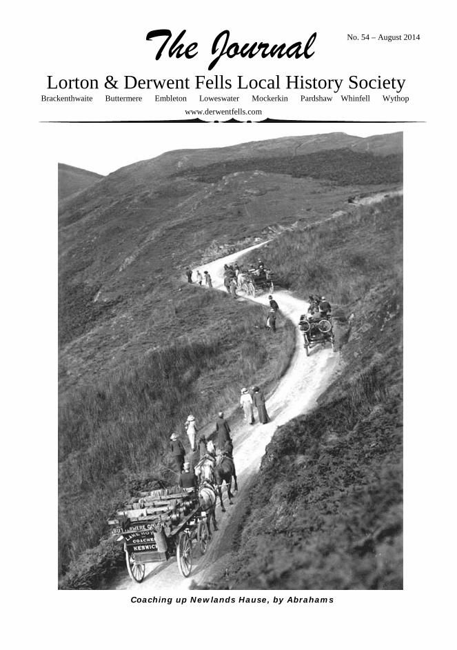
Coaching up Newlands Hause, by Abrahams
The Journal No. 54 – August 2014
Lorton & Derwent Fells Local History Society Brackenthwaite Buttermere Embleton Loweswater Mockerkin Pardshaw Whinfell Wythop
www.derwentfells.com
2
The Journal This issue is a little shorter than usual, at sixteen pages, because the previous issue covering the exhibition was rather larger, and in colour. So the available space is crammed with interesting articles.
I hope that Walter Head’s piece on WW1 acts to inspire members to produce articles on their own townships over the next few years. Let us try to cover our ground.
As members will know we lost Michael Grieve in March. He was Editor of the Journal, or the Newsletter as it then was, up to issue 38. We remember him partly by the making available his Greenwood maps on our website.
Previously the Journal has not ventured often into Buttermere, and so it is good that Roz Southey has strayed from familiar Loweswater onto more dangerous roads.
And following the excellent visit to Whitehaven and St. Bees arranged by John Macfarlane, Roger Asquith has been inspired to search for the elusive St. Bega. Derek Denman
L&DFLHS 2014-15
President Professor Angus Winchester Financial Examiner Peter Hubbard
Officers and Committee 2014-15 Chairman Charles Lambrick Vice–Chairman Dr John Hudson Secretary Sandra Shaw Treasurer Christopher Thomas Committee members:- Anne Asquith Membership Dr Derek Denman Journal, website Richard Easton Talks Walter Head Dorothy Hind Tim Stanley-Clamp
Contents of Journal No. 54 The First World War remembered 2 Taming the pass 4 The Greenwood maps online 9 Myths, Miracles and Legends: the early history of St Bees 13 Books by Mick Jane 16 Online Certificate in History 16 The Society’s programme 16
First World War 1914–18 remembered.
by Walter Head
The assassination of Archduke Franz Ferdinand of Austria by 19 year old Gavrilo Princip at Sarajevo on the 28th June 1914 set in motion a train of events which led to Great Britain declaring war on Germany on 4th August 1914. It led to the mobilisation of 68 million men, 8.5 million would be killed and 23 million wounded. 45% of combatants were either killed or wounded and it is estimated that 230 combatants perished for each hour of the four and a quarter year war. The first shot of the war was fired at a German mine-layer by H.M.S. Lance.
At the outbreak of war the call went out for volunteers to join the fight, seven of the local men who joined up in the early stages in 1914 were later killed in action. They were Skelton Eland, Thomas Head, Robert Moffat, John Towers Mounsey, Alison White Towers, John James Swanston and William Walker. Casualties were so high in 1914 and 1915 that the supply of volunteers could not fully replace the number killed or injured so in March 1916 conscription was introduced for all single males between the ages of 18 and 41. In May 1916 conscription was extended to include married men and in 1918 the upper age was increased to 51 year olds, conscription raised 2.5 million men. The medically unfit, clergymen, teachers, and certain classes of men who were deemed by the government to be important and crucial to the war effort at home were exempt. The West Cumberland Times of the period carried details of Military Service Tribunals and appeals of local people who thought they should be exempt from joining up. Nationally 16,000 men registered as conscientious objectors when conscription was introduced, half of them lost their appeal and were drafted. I have a full list of all the men from Buttermere, Embleton & Wythop who joined up but my list for Lorton and Loweswater is incomplete. It would be assumed that all the local men would join the local Border Regiment but this was not the case and the men joined a variety of regiments, although a great number did join the Border Regiment.
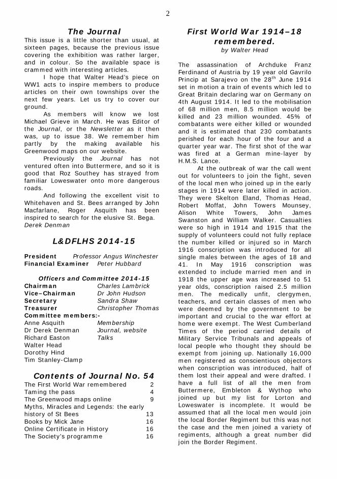
3 The memorial in St Cuthbert’s, Lorton.
The use of gas at Ypres in April 1915 marked an escalation of hostilities and the sinking of the Lusitania on the 7th May 1915 by the German submarine U-20 commanded by captain Schwieger was the start of a concerted campaign by the Germans to starve Great Britain into submission by targeting supply ships. The U-boats sank almost 5,000 ships with a tonnage of approximately 13 million tons. During this campaign the Germans lost 178 U-boats and approximately 5,000 men. The tactic reduced the supplies reaching Britain and the government took over 2.5 million acres of land for farming, much of the work being carried out by the Women’s Land Army, rationing was introduced in February 1918 and ration books issued. Britain’s naval blockade of Germany in the North sea caused problems for food supplies in Germany but no rationing was introduced which caused great hardship to the civilian population especially in the latter stages of the war. Germany had already banned the production of sausages as the cows intestines used for the sausage skin was required to make gas holding cells in zeppelins, 250,000 intestines were required per airship.
The first British soldier killed in the war was 16 year old John Parr of the 4th battalion the Middlesex Regiment who was killed at Mons on the 21st August 1914. He is buried in St Symphorien Military Cemetery South East of Mons, his grave faces that of Private George Edwin Ellison of the 5th Royal Irish Lancers who was the last British soldier to be killed he was also killed at Mons at 0930 hours on the 11th November 1918 just 90 minutes before the end of hostilities. The first soldier from this area to be killed was Bernard Gamble who died on 13th December 1914 and the last
to be killed was William Walker who died on 2nd September 1918.
Rev John Gamble, vicar at Loweswater and his wife Mary lost two sons in this war. Bernard Gamble lost his life on 13th December 1914 and their second son to be killed was Percy Gamble who died 5th March 1917. John Benson who was born at Rogerscale and who emigrated to Canada in 1912 returned to fight with the 58th Battalion Canadian Infantry, he was badly injured and was returned to England where he died of his wounds on 22nd May 1917. He is the only one from this area who is buried in Lorton Churchyard. (Over 60,000 Canadians died during WW 1). 750,000 men had been assembled for the battle of the Somme which commenced on 1st July 1916. 20,000 soldiers were killed on the first day of the action including four local men, Skelton Eland, Robert Moffat, John Towers Mounsey and John Needham.
Thomas and Jane Head of Low Hollins Farm had seen 3 sons-in-law and 5 sons leave to fight. All three sons-in-law returned but one of their sons, Thomas, had been killed on 13th August 1915. Of the other sons who returned William was badly affected by the experience, he never married, worked as a lengthman on the roads and lived a quiet life at Rogerscale.
4 Walter returned to his love of shepherding and was killed in a fall at Rannerdale trying to rescue a sheep in May 1931. Sons Fred and Joseph followed their elder brother John to start a new life in Canada. None of these three ever returned to England but some of their descendants have visited the area.
Following the end of hostilities on the 11th November 1918 the thoughts of villages and towns turned to erecting memorials to the fallen. There was a mixed approach which resulted in the names of some casualties being included at their place of birth and others at the location of their next of kin. Thus some men born in Loweswater are on the roll of honour at Dean and some men born outside of Cumberland are recorded at Lorton, it even resulted in some men like Wilson Rothery being included on two different memorials. Embleton and Mosser erected memorials in their churchyards, Lorton and Wythop erected brass plaques in their respective churches, Buttermere placed a locally embroidered scroll in a frame in the church and Loweswater had the names carved on the oak lectern in the church. The lectern and two oak chairs were stolen from the church in 1998, they have since been replaced. Twenty one men are recorded on the war memorials in the area covered by the history society including two men who had enlisted in the army prior to 1914, Bernard Gamble and John Needham. Of all the Cumberland villages that sent men to fight only one village saw all their men return safely.
Of all the documents I have seen during my research the one which I remember most vividly is the following extract from the war diaries of the 1st Battalion of the Border Regiment. Front Line 07.30 hours 1st July. The Battalion, less 10% who were held in reserve, advanced just South of Beaumont Hamel, their objective being Beaumont Redoubt. The 2nd S.W.B’s whose objective was the first two German lines were wiped out by machine gun fire in our own wire. The 1st Battalion the Border Regiment then went over the top from our support lines and over the first line, the bridge over our front trench having been ranged by the German machine gunners the previous day. We met heavy losses while crossing these bridges and passing through lanes
cut in our wire. The men were absolutely magnificent and formed up as ordered outside our wire, made a right incline and advanced into ‘no mans land’ at a slow walk, also as ordered. The advance continued until only little groups of half a dozen men were left here and there, and finding that no reinforcements were in sight took cover in shell holes or wherever they could. Front Line 08.00 hours. The advance was brought entirely to a standstill.
The names of the men inscribed on the memorials in the area covered by the society are :- George Armstrong, Joseph Beck, Thomas Cecil Beck, John Benson, William Crooks, Skelton Eland, Bernard Gamble, Percy Gamble, Thomas Head, Robert Moffat, John Towers Mounsey, John Needham, Edwin Arthur Norman, Alfred Pearson, Wilson Rothery, John James Swanston, Alison White Towers, David Vickers, William Walker, Alfred Edmund Watson and Robinson Watson. We should remember them. We will remember them. Sources. West Cumberland Times, Commonwealth War Graves Commission, Soldiers Died in the Great War 1914 – 1918, Local War Memorials, Canadian Great War Project, Parish Records and Zeppelin production.
Taming the Pass by Roz Southey
An anonymous letter-writer in the Westmorland Gazette, writing in August 1890, was adamant: ‘Perhaps the worst bit of road in the whole of the Lake District is that over which, during the tourist season, there is the most traffic.’ He was referring to Honister Pass.
In the 18th and 19th centuries, horse-drawn tourist coaches, engaged on the ‘Buttermere round’, would leave Keswick, drive through Borrowdale to Seatoller and then take the ‘steep, rough road, which climbs up the side of the hill, with a deep ravine overhung by trees on [the] left, and the hill rising steeply up ahead.’ Passengers were forced to walk up the pass, to ease the burden on the horses, and to walk down the other side for the same reason. After a visit to Buttermere, the return journey was accomplished via Newlands Pass which was
5 almost as difficult a road as Honister. ‘Although better made, [the road] is hardly safe, being in many parts scarcely wide enough for vehicles to pass one another, and having an open precipice on the left for about a mile.’ The Gazette’s correspondent said that he had travelled extensively in Norway and never come across such bad roads; it was up to the local inn-keepers, he suggested, to keep the roads in better order, as they were the ones who profited most from the tourist trade.
The advent of first the bicycle and then the motor car brought even more tourists to the Lake District, eager to prove their abilities with the new machines. Many cyclists and motorists came to look on the conquering of Honister as a kind of rite-of-passage. ‘Honister Pass is a practicable coach-road,’ said the Leeds Mercury in August 1899, ‘but for cycling its ascent is impossible alike on account of gradients and surface.’ Even the coaches did not tackle the Pass from the Buttermere side which was considered to be impassable, but always drove up from Seatoller.
For those early cyclists who were determined to follow the coaches, the only possible means of getting over the pass was on foot, carrying their machines. The Mercury’s writer – an intrepid cyclist who had tackled the pass with others in his local club – described descending the pass on the Buttermere side.
It was difficult at times to hold the machine in. For the first mile or two riding was quite out of the question, and even when the track became a road, and we were able to resume the saddle, we did so at the risk of cutting up the tires. The surface might well have been prepared by a syndicate of tire manufacturers, for it was stuccoed with sharp, slatey stones, which generally had the business side upwards.
He added that ‘the vast bulk of
cyclists will not greatly enjoy this famous round “as a ride” and truly the ascent of Honister is a task better suited to the hardy mountaineer than to the delicately nurtured cyclist. The climb is not an easy one assisted by an Alpine-stock; encumbered by a bicycle it is – an experience.’
Esimates of the gradients on the descent varied between 1 in 6 to 1 in 3 or
3½; the surface was unmade and a mass of loose stones. The poor state of the road was caused in large part by the horse charabancs which operated well into the 1930s. These had a ‘slipper skid’ attached to one of the back wheels which acted as a brake, dragging through the loose stones of the road and leaving furrows akin to those of a plough.
Cyclists kept trying to conquer the pass, however. The Yorkshire Evening Post of 18 August 1902, recorded that ‘a cyclist from Workington on Saturday attempted to rid down the Honister Pass. He lost control of his machine and ran into a coach. He had his arm broken.’ A Dundee paper, The Evening Post, recorded the following year that Honister was not so high as Kirkstone, but ‘a hundred times more wild – its roads a sliding mass of boulders over which footing was painful, and cycling madness. A lady cyclist with her husband took it, however, on the same day as us.’
Motor car owners were also eager to prove their ability and the capabilities of their machines, and at Easter every year motorists flocked to Keswick to try their hands at the famous pass. A motorist in a ‘Gladiator’ car allegedly managed the first crossing (from the Seatoller side) shortly before 1902, although newspapers were still reporting ‘first’ crossings as late as 1905 when the Exeter and Plymouth Gazette recorded on 16 November that: ‘Mr Julian Orde recently drove his motor car over the Honister Pass, in Cumberland, having taken the wrong road by mistake. The pass has hitherto been considered impracticable to wheeled vehicles of any kind.’
By this time, improvements had been started on some of the local roads although they were limited in scope. In 1904, the Cockermouth Rural District Council drew up plans to construct a new road from Seatoller to the top of the pass, with a uniform gradient of one in 13. They presented their plans to the County Council with a plea for financial aid and both the plans and the donation (of £2000 towards the cost of £2500) were approved. However, the County Council refused to adopt the road even after construction unless the Rural District Council built a similar road from the top of the pass down to Gatesgarth, with a gradient of not more than 1 in 16. This project was apparently
6 not even contemplated by the Rural District Council.
This work was in addition to the upgrading of the Borrowdale road which was carried out at a cost of £10,000. The project went slowly, however; eight years later, in 1912, Borrowdale Parish Council were still contacting both the Rural District Council and the County Council with pleas for them to press on with the section from Grange to Rosthwaite. In 1924, a further widening of the road was started at a cost of £24,000, and by 1928, was completed with the stretch between Lodore and Seatoller; this made the road a uniform width of twenty feet throughout (except at Rosthwaite Post Office). The Yorkshire Post reported that the work had ‘presented considerable engineering difficulties, large masses of rock having to be blasted’. In the meantime, shortly before 1912, a new road had been opened by the Slate Quarry Company to facilitate transport of the stone; this led from the top of the pass down to Seatoller by easier gradients and with a better surface than the existing road. The company opened this private road to the public on payment of a toll, but it was only open six days a week.
Undoubtedly the difficulties of getting over the pass were what attracted such heavy traffic. The scene in the summer of 1922 was typical of most years: According to the Yorkshire Post of June 1922:
In Lakeland there was astonishing heavy motor traffic on the main arteries while at times there was a procession of cars over the mountain passes. Many stuck at Newlands Pass, the rubble on the road preventing further progress, and once four cars had to retreat to Keswick, much to the disgust of oncoming drivers. Scores of motorists attempted the ascent of Honister Pass from the Buttermere end, but all signally failed.
Despite not taking up the County
Council’s invitation to improve the road on the descent into Buttermere, the Rural District Council tried to mitigate the worst of the problems, by putting up signs warning motorists that the pass was not suitable for motor traffic. But the would-be conquerors kept coming and the inevitable usual failures took on a heroic aura. The Dundee Courier reported, ‘A motorist wrote that he “stuck” twice near the top,
and would never have got up had not eight men pushed the car. He had motored several thousand miles through the high passes of Europe, but this was the worst place he had encountered’.
Adventurous cyclists were not deterred by the difficulties, although many opted for a cautious approach. In June 1912, a cyclist from Keswick wrote an account of a cycle tour in the area under the name of D. W. G., relating that: ‘We found ourselves at the bottom of that problem to cyclists, the Honister Pass … By paying the exorbitant sum of 2d each we were allowed to push our machines up the Pass [on the Seatoller side] by a new private road.’ They pushed their machines for 2½ miles before reaching the summit, only to find ‘the most wretched of roads’ on the descent. Their problems were exacerbated by heavy rain; they sheltered for some time then decided to chance their luck. ‘We … continued downhill at a rate our bikes were never built for, considering the road.’
Typical of the attitude of motorists was that of the anonymous motoring and road correspondent of the Yorkshire Post, who in 1923 – offered a drive in a friend’s new Essex car – immediately decided to test the car on Honister.
The modern motor car has brought almost every hill in England within its range … Yet there are one or two hills left which still have their terrors, to conquer which is a subject of reasonable pride. And the chief of these is the Honister Pass, in the Lake District. It will be remembered that at Easter scores of cars tried to climb the Pass, and failed, even from the Borrowdale side, the only side, in fact, from which it is really climbable, though I am aware that there have been a few ascents from Buttermere.
The writer’s aim was to show off the
qualities of the car but his care on approaching the Pass shows how daunting the climb could be, and how exciting. ‘To go up Honister Hause and down into Buttermere, two things are absolutely essential – a car on which you can rely with the utmost confidence, and steady nerves.’
We came to a stop, and surveyed the
situation, even walked for a couple of hundred yards up the steep, rough road, which climbs up the side of the hill, with a deep ravine overhung
7
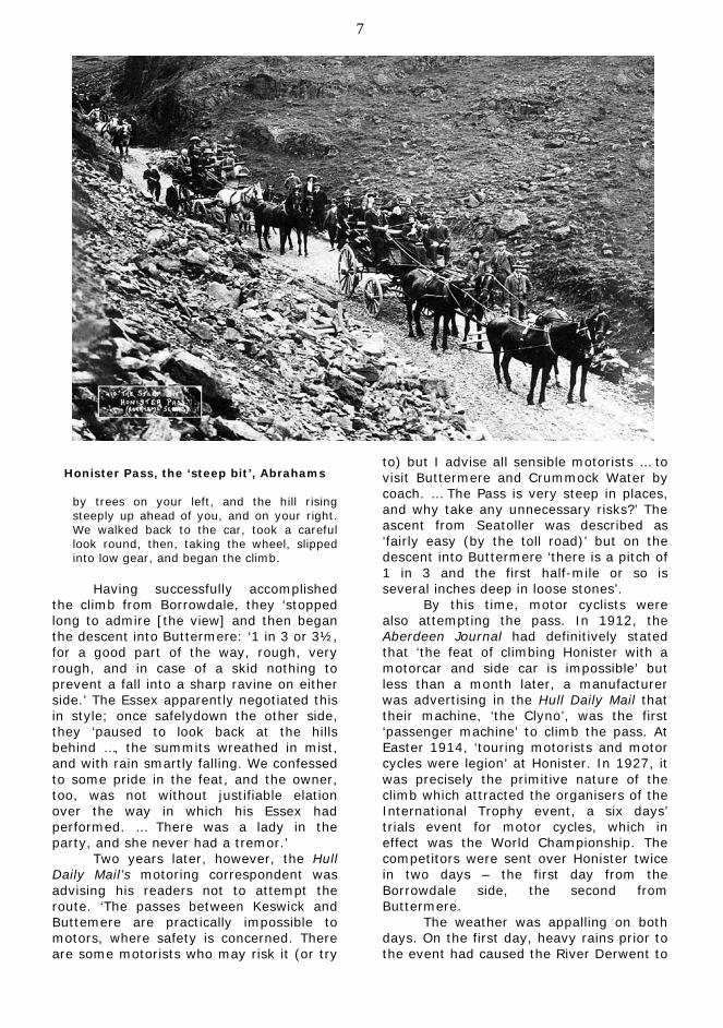
Honister Pass, the ‘steep bit’, Abrahams
by trees on your left, and the hill rising steeply up ahead of you, and on your right. We walked back to the car, took a careful look round, then, taking the wheel, slipped into low gear, and began the climb.
Having successfully accomplished
the climb from Borrowdale, they ‘stopped long to admire [the view] and then began the descent into Buttermere: ‘1 in 3 or 3½, for a good part of the way, rough, very rough, and in case of a skid nothing to prevent a fall into a sharp ravine on either side.’ The Essex apparently negotiated this in style; once safelydown the other side, they ‘paused to look back at the hills behind …, the summits wreathed in mist, and with rain smartly falling. We confessed to some pride in the feat, and the owner, too, was not without justifiable elation over the way in which his Essex had performed. … There was a lady in the party, and she never had a tremor.’
Two years later, however, the Hull Daily Mail’s motoring correspondent was advising his readers not to attempt the route. ‘The passes between Keswick and Buttemere are practically impossible to motors, where safety is concerned. There are some motorists who may risk it (or try
to) but I advise all sensible motorists … to visit Buttermere and Crummock Water by coach. … The Pass is very steep in places, and why take any unnecessary risks?’ The ascent from Seatoller was described as ‘fairly easy (by the toll road)’ but on the descent into Buttermere ‘there is a pitch of 1 in 3 and the first half-mile or so is several inches deep in loose stones’.
By this time, motor cyclists were also attempting the pass. In 1912, the Aberdeen Journal had definitively stated that ‘the feat of climbing Honister with a motorcar and side car is impossible’ but less than a month later, a manufacturer was advertising in the Hull Daily Mail that their machine, ‘the Clyno’, was the first ‘passenger machine’ to climb the pass. At Easter 1914, ‘touring motorists and motor cycles were legion’ at Honister. In 1927, it was precisely the primitive nature of the climb which attracted the organisers of the International Trophy event, a six days’ trials event for motor cycles, which in effect was the World Championship. The competitors were sent over Honister twice in two days – the first day from the Borrowdale side, the second from Buttermere.
The weather was appalling on both days. On the first day, heavy rains prior to the event had caused the River Derwent to
8 overflow its banks. ‘Women riders had to wade nearly waist deep in the flood, and some of the men who attempted to ride through fell, so that their machines were entirely submerged.’ When the competitors came to Honister, there was a cloud burst and considerable damage: ‘C. H. Harley crashed into a rocky roadside and collided with a woman spectator, who was bruised. Two of the German riders failed, and that practically eliminated the German team from the international contest, but British and Swedish teams did well. The secondary representation for Britain fared badly, all three riders being delayed.’
On the second day, 321 competitors scaled the pass from the Buttermere side.
A local guide had warned that it was unclimbable and he warned the officials that nobody would make the ascent without assistance. His knowledge of motor cycles was not very considerable, however, and he was an amazed guide when he saw one hundred and twenty clean ascents, and only three failures.
The riders took the pass in their
stride: ‘It was just a case of hard riding over difficult roads, with rain falling heavily most of the time, although ‘the discreet riding of the international competitors contrasted sharply with the ‘hectic ascents of those who risked clear climbs for the sake of the spectacular’. Chief amongst the more spectacular riders was apparently an Australian, A. G. Melrose, who made the fastest ascent. Some of the solutions to problems were idiosyncratic. ‘The bad weather has set a new fashion in motor-cycling, the men’s berets being superseded by ladies’ bathing caps.’ It was in fact the ladies who came out triumphant, all three competitors in the British ladies’ team riding up Honister on both days faultlessly, without the deduction of any points. The British men’s team came last.
As vehicles improved, the difficulties of the road began to seem less and in May 1931, the motoring correspondent of the Yorkshire Post commented that he would not hesitate to climb Honister ‘which has been rid of some of its terrors through the by-pass road [the toll road], though the descent … on the other side is still rough and calls for care.’ This provoked a sharp reply from a local man, however, who felt that the dangers had been
underestimated, particularly those of the descent on the Buttermere side.
The road should never be used by a motor car with passengers in it. … I admit it is not infrequently negotiated by cars in the summer months, but in nine cases out of ten, it is done out of ignorance, while the tenth case is probably some young fellow who makes the descent out of mere bravado, or because he has a bet on it.
His unequivocal advice was that no
tourist should attempt the descent into Buttermere, particularly if he had ladies on board. He admitted that it was impossible to see the real difficulties of the descent from the summit but advised drivers unexpectedly worried after committing themselves to the descent – ‘you can’t turn back’ – to pull up and let out all the passengers. Otherwise, he finished, there was ‘a small risk of giving our Coroner a job’.
This last comment was probably considered as scaremongering by tourists eager to try out the pass but fatal accidents were not unknown on the pass. In May 1935, two men were killed in an accident on the toll road down into Seatoller. Fourteen quarry workers going home were told by management not to ride on a lorry taking slate down into Borrowdale, but ignored the advice. The situation was exacerbated by the fact that the lorry driver had never driven any vehicle on the pass before. On the steepest part of the road – a gradient of 1 in 4 – the lorry ran away, despite the brakes being in good condition and a low gear being engaged. The driver desperately tried to steer the lorry into a hedge to slow it down, the lorry skidded, hit a bank on the other side of the road and overturned.
But plans were in hand at long last to give the pass a proper surface throughout, though not without considerable opposition. County Council plans were opposed by William Marshall of Patterdale Hall, and by the National Trust, both of whom were concerned about the impact on the landscape. The plans were taken eventually before Mr Justice Eve in the Chancery Division, who gave the plans the go ahead. Work began almost immediately and the road was ready for the summer season of 1936.
9
Inevitably, the Yorkshire Post’s motoring correspondent was eager to try out the new road, which he described as ‘a great modern road built under difficulties’. His opinion was that it was now ‘one of the finest motor roads of its type in Great Britain, and, although some of the gradients are severe near the summit of the pass, they are not bad enough to tax unduly a modern car whether its horsepower be 7 or 70.’
He still encountered opposition to the road, even now it was a fait accompli. ‘Walkers have told me that the road detracts from the wild charm of the district, but that to my mind is a prejudice which cannot be justified’. Having crossed the pass on his own on a weekday, he possibly did not appreciate the volume of traffic that generally tackled the pass at weekends and at Easter, and merely commented that ‘possibly a stream of cars at the week-end would be an intrusion which walkers of the older generation could not tolerate, but in the middle of the week, at any rate, the amount of traffic is not sufficient to cause a nuisance’. And as for the road spoiling the aesthetic appeal of the area, to his mind, it merely added to the beauty of the area – he stopped at the top of the pass to admire the attractions of the descent to Buttermere: ‘the road twists and turns like a snake crawling between rugged peaks to left and right’.
Yet perhaps a regret or two did linger. After his eulogy of the road and of his car’s ability to climb the new pass easily, his summary of the ride was not as upbeat as might have been expected. The pass was ‘no longer the adventure it was of old – but still exciting enough.’
Sources Most of the information in this article is taken from contemporary newspapers such as the Yorkshire Post and the Hull Daily Mail, both of which had motoring correspondents from a very early date. An obviously vibrant cycling culture in Scotland around the turn of the 19th and 20th centuries was reported on at length by the Dundee Courier, the Evening Post (also a Dundee newspaper) and the Aberdeen Journal. Newspapers of this kind can be consulted on the British Library’s website at www.britishnewspaperarchive.co.uk
The Greenwood maps online. by Derek Denman
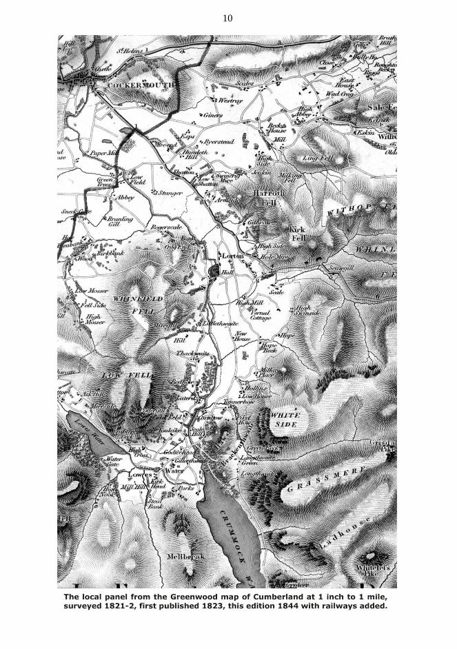
The late Michael Grieve, who made such a large contribution to the Society, wished us to have his copies of the Greenwood maps of Cumberland and Westmorland. The committee has agreed that these maps should be part of our archive, but also that a project should be established to scan the maps and to make them freely available on line for historical researchers and others. This would be done in his memory, recalling his personal interest in old maps. This article provides a short discussion of the maps and a guide to their use on the Society’s website at www.derwentfells.com/greenwood . These Greenwood maps are part of a series of county maps surveyed and published by Charles and John Greenwood from 1817. The Cumberland map was surveyed in 1821-2 and first published on 10 April 1823 The Westmorland map was surveyed in 1822-3 and first published in 1824. Single sheet versions at three inches were published in 1830. At the one inch scale a county would be covered by a number of sheets, originally three in the case of Cumberland and two for Westmorland. Ours are on paper, glued in sections to linen to form folding maps, all housed in a single leather cloth slip case. They are hand coloured and are the second edition of 1844, which differs only in having the railways to that date superimposed on the original survey, and with Cumberland being on four sheets. The Cumberland map, surveyed in 1821-2, remained the best and most detailed map of the county until the Ordnance Survey of the late 1850s/early 1860s. This allowed the Greenwoods a good period to make a return on their investment, for this was a private commercial venture for profit, and part of no official or quasi-official sponsored project. It seems a daunting project for two brothers to seek to map the country at that scale, and they did not complete all the counties. But their task was made easier by the fact that there had been an earlier part-sponsored project to map the counties accurately. From 1759 the Society of Arts offered prizes for the creation of
10
11
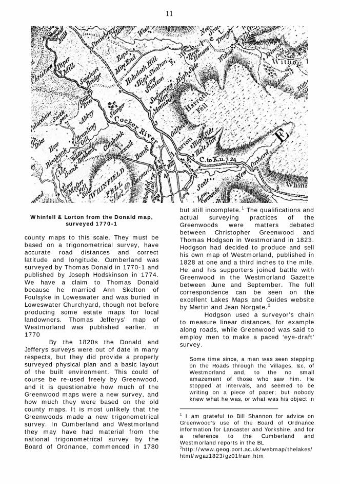
Whinfell & Lorton from the Donald map,
surveyed 1770-1
county maps to this scale. They must be based on a trigonometrical survey, have accurate road distances and correct latitude and longitude. Cumberland was surveyed by Thomas Donald in 1770-1 and published by Joseph Hodskinson in 1774. We have a claim to Thomas Donald because he married Ann Skelton of Foulsyke in Loweswater and was buried in Loweswater Churchyard, though not before producing some estate maps for local landowners. Thomas Jefferys’ map of Westmorland was published earlier, in 1770 By the 1820s the Donald and Jefferys surveys were out of date in many respects, but they did provide a properly surveyed physical plan and a basic layout of the built environment. This could of course be re-used freely by Greenwood, and it is questionable how much of the Greenwood maps were a new survey, and how much they were based on the old county maps. It is most unlikely that the Greenwoods made a new trigonometrical survey. In Cumberland and Westmorland they may have had material from the national trigonometrical survey by the Board of Ordnance, commenced in 1780
but still incomplete.1 The qualifications and actual surveying practices of the Greenwoods were matters debated between Christopher Greenwood and Thomas Hodgson in Westmorland in 1823. Hodgson had decided to produce and sell his own map of Westmorland, published in 1828 at one and a third inches to the mile. He and his supporters joined battle with Greenwood in the Westmorland Gazette between June and September. The full correspondence can be seen on the excellent Lakes Maps and Guides website by Martin and Jean Norgate.2
Hodgson used a surveyor’s chain to measure linear distances, for example along roads, while Greenwood was said to employ men to make a paced ‘eye-draft’ survey.
Some time since, a man was seen stepping on the Roads through the Villages, &c. of Westmorland and, to the no small amazement of those who saw him. He stopped at intervals, and seemed to be writing on a piece of paper; but nobody knew what he was, or what was his object in
1 I am grateful to Bill Shannon for advice on Greenwood’s use of the Board of Ordnance information for Lancaster and Yorkshire, and for a reference to the Cumberland and Westmorland reports in the BL 2http://www.geog.port.ac.uk/webmap/thelakes/html/wgaz1823/gz01fram.htm
12
marching about in that way. Can Mr. Greenwood, (from his superlative education, together with the instructions he had at Leeds,) tell me whether it is possible for this man to have been taking a Survey for a County Map?3
The rivals debated their training as surveyors and their access to mathematical and astronomical instruments, but never their actual use of these techniques and equipment – which one therefore suspects was minimal. It was not the accuracy of the survey of the C18th maps which was the problem, but that the content was out of date. This debate about the accuracy of the rival surveys was probably just a diversion. They each needed to spend their time and money on adding content, and to divert their rival into resurveying the land.
The potential threat to the viability of these maps came from the official and quasi-official mapping projects which were slowly developing. Maps of the Board of Ordnance at one inch scale were briefly available in southern England starting with Kent in 1801. Publication was prohibited between 1811 and 1816, but thereafter Ordnance Survey one inch maps became increasingly available in the south.4
The duration of the window of commercial opportunity open to the
The need for publically funded mapping came firstly from military requirements, and then for cadastral surveys which were sufficiently accurate and detailed to act as a basis of valuation and taxation of landholdings. It was the latter need which caused the Board of Ordnance to be charged in 1824 with mapping Ireland, which had been part of the United Kingdom since 1800. The Ordnance Survey Act was not passed until 1841, and from 1846 maps started to become available from the full survey of England Scotland and Wales at six inches and approximately 25 inches to the mile. An earlier opportunity to use the Tithe Commutation Act of 1836 as the justification for a full cadastral survey of England and Wales had been rejected due to the cost.
3 Westmorland Gazette, 26 July 1823. 4 See W A Seymour, A history of the Ordnance Survey, Dawson Folkestone 1980. http://www.ordnancesurvey.co.uk/docs/ebooks/a-history-of-the-ordnance-survey/index.html
Greenwoods was most uncertain when they started, which clearly added to the pressure to make their surveys as simple and speedy as possible, and their county maps just sufficient for the needs of their customers for an up to date county map. One compromise was perhaps to exclude any heights or contours, or indications of steep roads, which could have been useful to travellers, especially with carriages. This might have been particularly useful in Cumberland and Westmorland – for example on the Whinlatter Pass. However, the Greenwood map did recognise the local importance of tourism by its depiction of the fells. Donald had shown the periphery of the fells by hachures and added a few names. Greenwood used extensive hachuring to give more detail of the fells themselves, plus their watercourses. Many more names of fells, watercourses and summits were given, with a list of the heights of the principal mountains.
A further compromise might be found in the exclusion of information which might quickly become outdated. Donald had charged gentlemen to have their names against their seats, but Greenwood did not offer that. Raisbeck Lucock Bragg’s seat at Lorton Hall was clearly surveyed by Greenwood and shown as a ‘C’ shape, but its owner’s name was not given. More surprising is the exclusion of roadside inns and alehouses, important to travellers and particularly in our district, but perhaps too fluid to name.
The deficiency in the Greenwood Cumberland map was the lack of any town plans at a larger scale. Donald had provided plans of the three most important in 1770, Carlisle, Whitehaven and Cockermouth. The industrial revolution was in full swing in 1820, even in parts of Cumberland, and so Donald’s plans needed updating and could have been included. Greenwood, instead, used some of the white space for a view of Carlisle from across the river. The Westmorland map had no plan of Kendal, which Jefferys had included. However, the excellence of Greenwood’s map of London of 1827, at eight inches to the mile, must be appreciated.
The main changes that the Greenwoods captured in our area were the roads, particularly in the context of the enclosure of the commons. Many of the
13 turnpike roads were already on the C18th maps, for example the two from Cockermouth on the section shown, to Keswick and Kendal via Whinlatter, and to Penrith via Heskett Newmarket (not via Keswick). The Greenwood survey pre-dated the new turnpike from 1825 through Embleton and down the West side of Bassenthwaite, intended as a level alternative to Whinlatter. But elsewhere an up to date map of the good turnpike roads was needed.
Locally the major change was the enclosed commons, which by the time of the survey had reached Whinfell Embleton and Wythop, but not Mosser Loweswater and Lorton. The enclosed commons restricted the man on horseback, or walking, to the roads now available. Before they were enclosed and divided it was convenient to use the commons to pass over the fells from place to place, often avoiding the valley roads which were longer and often gated in many places. For example the route which Wordsworth and Coleridge used to walk from Embleton to Lorton in 1799 was not available in 1823.
To illustrate the change, a section including the Whinfell, Lorton and Embleton commons is shown here from Donald’s map. The extent of the enclosures on both maps is shown as a thin full line, erratically in Donald, and roads on the commons are shown dashed as unfenced. On the Donald map the road from Low Lorton Bridge over Whinfell common approached Wood, while Greenwood shows the full new enclosure roads, as in Embleton but not Lorton. It is interesting that the enclosure awards for Embleton and Whinfell were dated 1824 and 1826, after the Greenwood survey. The process of enclosure started after the earlier Acts of Parliament, and the awards recorded the completed process.
Further additions to the Donald map were boundaries, of Cockermouth borough, heavily coloured in blue, and of the divisions of townships/parishes as dashed lines. The boundaries between Lorton and Embleton were found and added in fine detail, though that with Brackenthwaite was missed. Clearly a new survey had been made, as evidenced by the transient Vernal Cottage name at Birketts. For our edition, of 1844, the railways to date had been drawn over the
survey. The CK&PR did not yet exist, but our map includes the Cockermouth and Workington Railway, opened in 1847.
For a commercial venture, with an uncertain period to recoup the cost, the plan of the Greenwoods to map the counties must be considered ambitious and successful. For historians the maps provide a valuable and detailed 1820s update of the eighteenth century county maps, which would not be improved until the Ordnance Survey maps, starting in the late 1850s.
Myths, Miracles and
Legends: the early history of St Bees
by Roger Asquith.
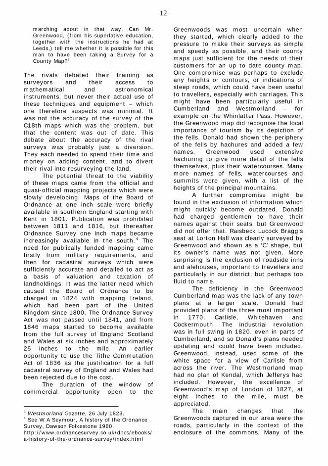
The Society’s outing to St Bees on 23rd May prompted a number of questions worthy of further investigation. First and foremost was the need for an understanding of the early, pre-conquest, history as distinct from stories, snow miracles and legends. From the foundation of the Priory in or about the year 1125 to the present time the historical account can call upon substantial documentary, architectural and archaeological evidence.
The west door to the Priory Church of St Mary and St Bega, c.1140. Photograph -
John Macfarlane
14
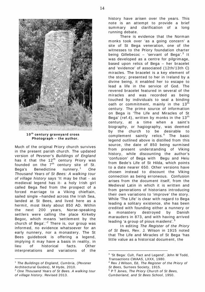
10th century graveyard cross Photograph – the author.
Much of the original Priory church survives in the present parish church. The updated version of Pevsner’s Buildings of England has it that the 12th century Priory was founded on the 7th century site of St. Bega’s Benedictine nunnery.1 One Thousand Years of St Bees: A walking tour of village history says ‘It may be that - as medieval legend has it- a holy Irish girl called Bega fled from the prospect of a forced marriage to a Viking chieftain, sailed single –handed across the Irish Sea, landed at St Bees, and lived here as a hermit, most likely about 850 AD. Within the next 200 years, Norse-speaking settlers were calling the place Kirkeby Begoc, which means ’settlement by the church of Bega’.’2
1 The Buildings of England, Cumbria, (Pevsner Architectural Guides), M Hyde, 2010.
There is, our group was informed, no evidence whatsoever for an early nunnery, nor a monastery. The St Bees guidebook is offering a legend, implying it may have a basis in reality, in lieu of historical facts. Other interpretations and variations of the
2 One Thousand Years of St Bees. A walking tour of village history. Revised 2013.
history have arisen over the years. This note is an attempt to provide a brief summary and clarification of a long running debate.
There is evidence that the Norman monks took over ‘as a going concern’ a site of St Bega veneration, one of the witnesses to the Priory foundation charter being Gillebecoc – ‘servant of Bega’.3 It was developed as a centre for pilgrimage, based upon relics of Bega – her bracelet and ‘evidence’ of associated (12th/13th C) miracles. The bracelet is a key element of the story; presented to her in Ireland by a divine being, it enabled her to escape to lead a life in the service of God. The revered bracelet featured in several of the miracles and was recorded as being touched by individuals to seal a binding oath or commitment, mainly in the 13th century. The prime source of information on Bega is ‘The Life and Miracles of St Bega’ (ref.4), written by monks in the 13th century, at a time when a saint’s biography, or hagiography, was deemed by the church to be desirable to complement saintly relics.4 The basic legend outlined above is distilled from this source, the date of 850 being surmised from present understanding of Viking history, while discounting the author’s ‘confusion’ of Bega with Begu and Heiu from Bede’s Life of St Hilda, which points to a date nearer 650. Other versions have chosen instead to discount the Viking connection as being erroneous. Confusion arises from the document itself, from the Medieval Latin in which it is written and from generations of historians introducing their own variations to ‘improve’ the story. While ‘The Life’ is clear with regard to Bega leading a solitary existence, she has been credited with founding either a nunnery or a monastery destroyed by Danish marauders in 873, and with having arrived leading ‘a group of pious maidens’.5
In editing The Register of the Priory of St Bees, Rev. J. Wilson in 1915 noted that The Life and Miracles of St Bega ‘has little value as a historical document, the
3 ’St Bega: Cult, Fact and Legend’, John M Todd, Transactions CWAAS, LXXX, 1980. 4 Rev J Wilson, Ed, The Register of the Priory of St Bees, Surtees Society, 1915. 5 P T Jones, The Priory Church of St Bees, Cumberland, and St Bees School, 1950.
15 lives of two or three saints with similar names having been woven together’. He continued ‘… it cannot be held other than remarkable that language yields a common origin to the saint and her bracelet: sancta Bega is good ecclesiastical Latin for the Anglo-Saxon halgan beage or its English equivalent holy bracelet’. In 1925 T.H.B.Graham and W.G.Collingwood were similarly sceptical, categorising St Bega as one of only two mythic patron saints in the Diocese of Carlisle.6 A mid-9th century date for a sequence of events involving Bega’s escape from betrothal to a Norwegian prince, dwelling in the wooded district of St Bees until fear of pirate raids prompted her departure, as proposed by Canon Last, was considered ‘quite probable’ by L.A.S.Butler.7 He proceeded to identify a type or style of bracelet consistent with the mid-9th century date and the description of the item given in ‘The Life and Miracles of St Bega’. While the bracelet identified might be consistent with the medieval relic, its value in terms of proving St Bega’s existence seems debatable. The late John Todd, historian, solicitor, and a long term resident of St Bees, critically reviewed the evidence and arguments regarding St Bega, concluding that although the events as recorded by Canon Last could have happened towards the end of the 9th century, a seeker for the historical St Bega ‘may well be disappointed’.8
Taken in a local history context John Todd’s question (cult, fact or legend?) might not have progressed further. However, it has more recently been considered in the wider context of medieval Irish saints and parallels to Bega’s story in Gaelic and Scandinavian literature. C. Downham (2007, ref. 9) makes a convincing case for the cult of St Bega having arrived in the St Bees area from Ireland with the 10th century Gaelic/Viking settlers, along with language (including place names, Kirkbibeccoch
6 T.H.B.Graham and W.G.Collingwood, ‘Patron Saints of the Diocese of Carlisle’, Transactions CWAAS, XXV, 1925 7 Canon C E Last, ‘St Bega and her bracelet’, Transactions CWAAS, LII, 1952. 8. L A S Butler, ‘A Bracelet for St Bega’, Transactions CWAAS, LXVI, 1966. 8 Todd, ‘Bega’, 1980.
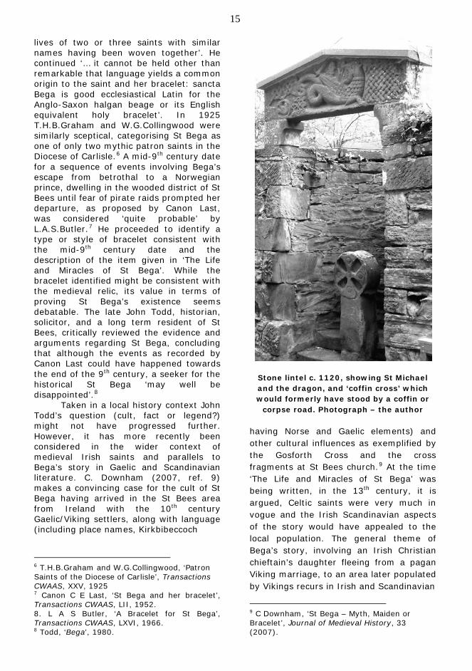
Stone lintel c. 1120, showing St Michael and the dragon, and ‘coffin cross’ which would formerly have stood by a coffin or
corpse road. Photograph – the author having Norse and Gaelic elements) and other cultural influences as exemplified by the Gosforth Cross and the cross fragments at St Bees church.9
9 C Downham, ‘St Bega – Myth, Maiden or Bracelet’, Journal of Medieval History, 33 (2007).
At the time ‘The Life and Miracles of St Bega’ was being written, in the 13th century, it is argued, Celtic saints were very much in vogue and the Irish Scandinavian aspects of the story would have appealed to the local population. The general theme of Bega’s story, involving an Irish Christian chieftain’s daughter fleeing from a pagan Viking marriage, to an area later populated by Vikings recurs in Irish and Scandinavian
16
literature. Just as the author of ‘The Life’ relied upon elements of Bede’s Ecclesiastical history of the English people, so, it is argued, he also drew upon Irish literary examples. In essence then, the ‘Life of St Bega’ is a story, not a history.
It is evident that the pagan and Christian aspects of the Gosforth Cross were intended to appeal to the diverse origins and cultures of the local population. The St Bees ‘Dragon Stone’, dated to around 1120, is interpreted as St Michael fighting the Dragon, representing the battle between good and evil. The evil beast, however, is of the ‘strength and barbaric nature’ of the Viking dragon as per depictions of the Scandinavian myth of Sigurd slaying Fafnir, the dragon (ref.10), potentially a further example of appealing to the background of the local population.10
Though perhaps it may be less palatable to residents and members of the church congregation for the founding figure of St Bees to be mythical rather than historical, it does seem an inevitable conclusion. There seems, however, to be a determination to perpetuate the story of St Bega, in spite of the words of the Oxford Dictionary of National Biography: ‘As a result [of developments in historical research] formerly ‘real’ figures – such as the 7th century St Bega – now pass into myth’.
11
10 S E McAndrew, ‘The Dragon Stone at St Bees and other carvings’, www.stbees.org.uk/history/essays/dragon/chapter_6.html 11 ‘Myth, legend and mystery in the ODNB’, www.oxforddnb.com/public/themes/92/92732.html
Books by Mick Jane For the last 15 years Mick Jane, now of Fletchertown but formerly of Cockermouth, has been gathering information and writing booklets about the history of this area, its people and notable events. His history of Lorton School is the only one known, and is closely connected with that of the local Victorian squire and philanthropist William Lancaster Alexander, of Oak Hill. For a whole range of local subjects in inexpensive booklets, including WW1 in Cockermouth and Keswick, please visit Mick’s website at www.cumbrianhistory.co.uk or email him at [email protected] Derek Denman
Online Postgraduate
Certificate in Regional and Local History: Sources and
Approaches
This online course, created and run by Dr Michael Winstanley, is just right for anyone who wishes to become a qualified local historian without travelling to Lancaster University. It covers mainly the Georgian & Victorian periods. Apply by 29th August for the one year course starting in October. Full details, including the course handbook, are at http://www.lancaster.ac.uk/fass/history/postgrad/pgcertificate.htm
The Journal Journal 55 will be published for 1st February 2015. Please send contributions by 7th January. Back issues of The Journal are available on-line at www.derwentfells.com/journal Copyright remains with the individual contributors. Published by Lorton & Derwent Fells Local History Society. Beech Cottage, High Lorton, Cockermouth CA13 9UQ
L&DFLHS – Programme for 2014 Date Event
5th September The Bernard Bradbury memorial lecture. Andrew Lowe will speak on Lakeland architecture at the Kirkgate Centre. With the Cockermouth Civic Society and Cockermouth Museum Group. Tickets £3.50 (see flyer)
11th September St Bees man and St Bees lady, by Chris Robson 16th September Historical walk in Loweswater (see flyer) 9th October 2014 Local Knowledge Challenge (see flyer) 13th November Cumbrian curiosities, by Brian Martland
Talks are held at the Yew Tree Hall in Lorton at 7.30pm. Visitors £2.50 with refreshments.