FROM SCIENCE TO GOVERNANCE: THE DEMANDS AND CONSTRAINTS … · FROM SCIENCE TO GOVERNANCE: THE...
64
FROM SCIENCE TO GOVERNANCE: THE DEMANDS AND CONSTRAINTS OF POLICY- MAKERS IN MANAGING THE BALTIC SEA Professor Mike Elliott and Sue Boyes Institute of Estuarine and Coastal Studies (IECS), University of Hull, Hull, UK
Transcript of FROM SCIENCE TO GOVERNANCE: THE DEMANDS AND CONSTRAINTS … · FROM SCIENCE TO GOVERNANCE: THE...
FROM SCIENCE TO GOVERNANCE: THE DEMANDS AND CONSTRAINTS OF POLICY-MAKERS IN MANAGING THE BALTIC SEA
Professor Mike Elliott and Sue Boyes
Institute of Estuarine and Coastal Studies (IECS), University of Hull, Hull, UK

Challenges for science & management
There is only one big idea in
marine management: how to
maintain and protect ecological
structure and functioning while at
the same time allowing the
system to produce ecosystem
services from which we derive
societal benefits.
MSFD
MSPD

Holistic & adaptive marine environmental management
(red arrows denote linkages between topics; black arrows denote direction of influence)
Extractors (D, P) (econ., technol.)
Inputters (D, P) (econ., technol.)
Regulators (R) (leg., admin.)
Affectees (I) (soc., ethic., cult.)
Influencers (I) (polit.)
Beneficiaries (I) (soc., ethic, cult.)
Horizontal Integration across stakeholders (refer to DAPSI(W)R(M) and 10 tenets)
.... Ecosystem Services & deliver .....(I(W))
who raise awareness of ...... (comm.)
....Societal Benefits for the ...
uses/users providing .../affecting ........ who control the ...
…. fundamental processes (S) (ecol.) to create… (D+A+P) + R(M) ≠ S + I(W)
e.g. Conflict Res., 10 tenets, PPP, PP, EIA, CBA, MCA, LPI
Indicators + monitoring, e.g. EII
Maintaining, protecting and enhancing nature & .... (S) (ecol.)
The Ecosystem Approach
(b) localised human demands (endogenic managed pressures)
(a) wider pressures, e.g. climate change (exogenic unmanaged pressures)
Vertical Integration of governance across geopolitical levels
global
ecoregion
regional
national
local
Source of problems (activity-pressure-impact chain) which require ....
..... Risk assessment methods & response
to ensure no impact on .....

Management Questions:
• Where are the problems & What changes do they cause?
• What is the impact of these on ecosystem structure and functioning?
• What are the repercussions for ecosystem valuation based on economy-ecology interactions?
• What are the future environmental changes and economic futures?
• What governance framework is there, what do stakeholders need?
• What can we do about the problems?
• Where are the risks and how to address them now and in the future?
• What are the governance successes, failures and implications?
• How ‘good’ is the decision-making?
• What are the bottlenecks, showstoppers and train-wrecks?

Tackling the Problem - Management Framework:
• Setting Vision – the HELCOM-aim/vision is a good starting-point that can easily be tackled & tested (what has/has not been achieved)
• Agreeing Objectives – is the HELCOM BSAP ‘the only way’ forward?
• Defining priorities – how is this done and by whom?
• Deciding Action – what can be done
• Creating a management plan – then do it!
• Implementing Actions/Measures
• Determining if action is successful
• Iteration cycle to improve with each iteration

VISIONA healthy Baltic Sea environment, with diverse biological
components functioning in balance, resulting in good environmental/ecological status and supporting a wide
range of sustainable human economic and social activities.
(cf. UK vision for clean, healthy, safe, productive and biologically diverse oceans and seas)

Ecosystem services
of the Baltic Sea.
Underlying
ecosystem services
important for fish as
food are marked with
yellow arrows and
illustrate linkages
between different
ecosystem
services and benefits
(From SwAM 2013,
in Scharin et al., 2016)

Stage Detail1. Problem Formulation What needs to be assessed?2. Hazard Identification What can go wrong? (What are the hazards?)3. Cause Identification What can lead to the hazard occurring? (What causes the
hazard?)Quantitative: How often or how likely is it that these causes will occur?
4. Exposure Assessment(This is a quantitative step that is not necessary but adds value to the risk assessment)
Quantitative: How does the hazard reach the receptor? At what intensity? How long for and/or how frequently does the hazard reach or affect the receptor?Quantitative: How likely is it that the receptors will be exposed to the hazard?
5. Consequence or Effect Identification
What are the consequences of the hazard if it occurs?
6. Risk Characterisation and Estimation for Consequences
What are the risks (quantitative or qualitative measure)? Quantitative: What is the probability of the consequence happening? Estimated for both before and after preventative and mitigation measures are put in place.

Governance:
• Policies – HELCOM, EU, Member States, Third states (Russia)
• Politics – different outlooks/philosophies/histories /environmental culture (Scandinavia vs Baltic States vs Germany/Poland vs Russia incl. Kaliningrad)
• Administrations
• Legislation

Governance: globally agreed underlying policies, politics, laws and administrations for the adoption of internationally recognised principles:
• ecologically sustainable development;
• Inter-generational equity;
• the precautionary principle;
• conservation of biological diversity and ecological integrity and ecological valuation;
• economic valuation of environmental factors, including willingness to pay
• the polluter pays principle;
• waste minimisation, and
• public participation - the role of individuals and ethics!

Hazard leading to Risk (depending on assets)
A) Surface hydrological hazards
B) Surface physiographic removal by natural processes - chronic/long-term
C) Surface physiographic removal by human actions - chronic/long-term
D) Surface physiographic removal - acute/short-term
E) Climatological hazards - acute/short term
F) Climatological hazards - chronic/long term
G) Tectonic hazards - acute/short term
H) Tectonic hazards - chronic/ long term
I) Anthropogenic microbial biohazards
J) Anthropogenic macrobial biohazards
K) Anthropogenic introduced technological hazards
L) Anthropogenic extractive technological hazards
M) Anthropogenic acute chemical hazards
N) Anthropogenic chronic chemical hazards
Hazard & Risk Typology:
= Risk Assessment & Risk Management (RA&RM):
• Hazard Identification:• Risk Assessment:• Risk Management:• Risk Communication:
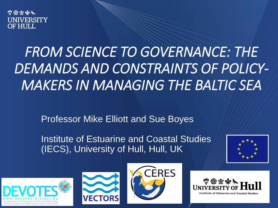
Drivers (societal basic needs)
Activities (of society)
Pressures (resulting from activities)
State change (on the natural system)
Impacts (on human Welfare) (changes affecting wealth
creation, quality of life)
Responses (economic, legal, etc) (Measures)
DAPSI(W)R(M) framework
(for each EnMP cf. ExUP)

Drivers = Basic Human Needs:
Maslow’s hierarchy of needs
Relaxation & enjoyment
WELL-BEING
Employment
Health & welfare
Security & safety
Provision & delivery of
goods
Space, shelter
Results of provisioning
services (food, water, O2,
space shelter)

Activity
Aquaculture
Extraction of living
resources
Transport & Shipping
Renewable Energy
Non-renewable (fossil fuel)
Energy
Non-renewable (nuclear)
Energy
Extraction of non-living
resources
Navigational Dredging
Coastal Infrastructure
Land-based Industry
Agriculture
Tourism/Recreation
Military
Research
Carbon Sequestration
Activities contributing to Endogenic Managed Pressures (Elliott et al 2017)
Pressures
Smothering
Substratum loss
Changes in siltation
Abrasion
Selective extraction of
non-living resources
(habitat removal)
Underwater noise
Litter
Thermal regime change
Salinity regime change
Introduction of synthetic
compounds
Introduction of non-
synthetic compounds
Introduction of
radionuclides
Introduction of other
substances
Nitrogen and
phosphorus enrichment
Input of organic matter
Introduction of microbial
pathogens
Introduction of non-
indigenous species and
translocations
Selective extraction of
species
Death or injury by
collision
Barrier to species
movement
Emergence regime
change
Water flow rate changes
pH changes
Electromagnetic
changes
Change in wave
exposure

P
S
R(M)
P
S
DI(W)
R(M)
P
S
D
I(W)
R(M)
P
S
D
I(W) R(M)
A D
I(W)
Outside Management
Plan Area
Boundary
Management
Plan Area
Natural
Change
Natural
Change
Natural
Change
Natural
Change
ExUP
ExUP
ExUP
EnMP
A
A
A
ExUP
...N II
I
III
Vision of
Management
Plan


To be successful, management measures or responses to changes resulting from human activities should be:• Ecologically sustainable• Technologically feasible• Economically viable• Socially desirable/tolerable• Legally permissible• Administratively achievable• Politically expedient• Ethically defensible (morally
correct)• Culturally inclusive• Effectively communicable
The 10 tenets:
(cf. PESTLE)


Natural Environment Research Council (NERC)
(ACRE reports through Defra)
KEY
Ministerial Depts
Inte
rnational
Oblig
ations
Euro
pean
Unio
n
Planning Inspectorate
- Health & safety w ith respect to working at sea- Ships surveys & inspections
- Emergency response including search & rescue, counter pollution & response, receiver of w reck, maritime incident response group (MIRG) & resilience.
NI
Executive
Department of Energy & Climate Change (DECC)
Department for Transport (DfT)
Cabinet Office
Home Office
Maritime and Coastguard Agency
Trinity House Lighthouse Service
Inte
rnatio
nal
Maritim
e
Org
anis
atio
n
(IM
O)
Department for Communities and Local Government (DCLG)
Department for Environment Food and Rural Affairs (DEFRA)
Wels
h
Gove
rnm
ent
Scott
ish
Gove
rnm
ent
UK
Ship
pin
g
Crown Estate
- Ow ns 55% of the foreshore (between mean high and mean low water) and approximately
half of the beds of estuarial areas and tidal rivers in the United Kingdom. - Ow ns the seabed out to the 12 mile territorial limit, including the rights to explore and exploit
the natural resources of the UK continental shelf, excluding oil, gas and coal.- Leases of easement for pipelines and cables, offshore renewable energy developments.
- Royalties from the extraction of minerals, principally marine aggregates.
Parliament
House of Commons
House of Lords
National Maritime Museum
Harbour Authorities
Local Authorities
Executive Agencies
National Infrastructure Directorate
Executive Non-Departmental Public Bodies
- Independent body examining applications for nationally signif icant infrastructure projects
(NSIPs) e.g. large w ind farms >100MW, pow er stations etc. Issue development consents under the Planning Act 2008 (Localism Act 2011)
- National Planning Policy Framew ork- Planning Policy Guidance (PPGs)
- Marine Minerals Guidance Notes (MMGs)- Strategic Environmental Assessments (SEAs)
Local Government Bodies
Ministry of Defence (MOD)
UK Hydrographic Office
- Waterborne security of HM dockyards and HM naval bases
- Jurisdiction w ithin territorial w aters- Enforce legislation e.g. Port Orders and Merchant Shipping Act
Defence Science & Technology Lab
Oil and Pipelines Agency
MOD Police Marine Unit
- Provide hydrographic services for UK w aters as required under (SOLAS)
Trading Fund Agency
- Maritime technology e.g. ships & submarines
- Operation of the Government Pipeline and Storage System (GPSS)
Committee on Climate Change - Advises government on emissions targets and reports greenhouse gases
- Oil & gas licensing under Petroleum Act 1998- Renew able energy – w ave, tidal and w ind &
Safety Zones for >100MW w indfarms- Energy Act 2008 & 2010; and Climate Change Act 2008- National Policy Statements (NPS) on energy Secretary of States
Representative for Maritime
Salvage & Intervention(SOREP)
- Represent the DECC (in relation to offshore installations) & the DfT(in relation to ships) by
removing or reducing the risk to safety, property and the UK environment arising from accidents involving ships, f ixed or f loating platforms or sub-sea infrastructure.
HM Coastguard
- Shipping, marine safety & security, inland w aterways, navigation, ships registers,
transport national planning guidance (NPG)
Advisory Committees
Marine Energy Programme Board
Please refer to Defra diagram
UK
GO
VE
RN
ME
NT
- Partnership of the main Government Departments, the Devolved Administrations of
Scotland, Northern Ireland & Wales, the Environment Agencies & research bodies involved in funding and carrying out marine science in the UK. Co-ordination of marine
research & delivering the UK Marine Monitoring & Assessment Strategy (UKMMSS).
Marine Science Co-ordination Committee (MSCC)
Advisory Committee on Releases to the Environment (ACRE)
- Advice to UK Governments on the release & marketing of genetically modif ied organisms.
Department for Business Innovation & Skills (BIS)
UK Met Off ice
Food Standards Agency - Food safety and hygiene (e.g. chemical levels in shellf ish and f ish)
Department for Culture, Media and Sport (DCMS)
English Heritage
- Protected w recks, protection of marine historic environment, map historic seascapes,
fund coastal & marine heritage research. (Although the UK has not ratif ied the UNESCO Convention on the Protection of the Underw ater Heritage, English Heritage follow
the Rules annexed to the Convention as representing best practice in marine underw ater archaeology projects).
Tenet:
Administratively
achievable

Favourable status of Baltic Sea biodiversityNatural marine and coastal landscapesThriving and balanced communities of plants and animalsViable populations of species
Enviromentally friendly maritime activitiesEnforcement of international regulations – no illegal dischargesSafe maritime traffic without accidental pollutionEfficient emergency and response capabilitiesMinimum sewage pollution from shipsNo introductions of alien species from shipsMinimum air pollution from shipsZero discharges from offshore platformsMinimum threats from offshore installations

Oil Pollution

Invasive Species

Over Fishing

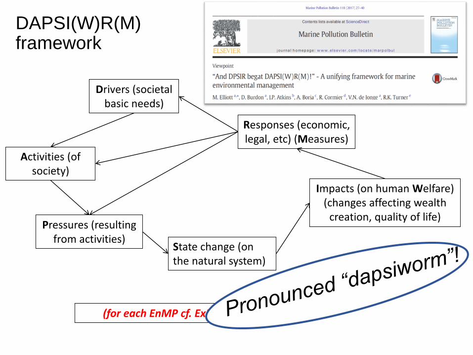
Baltic Sea unaffected by eutrophication•Clear water•Natural level of algal blooms•Natural distribution and occurrence of plants and animals•Natural oxygen levels
Baltic Sea undisturbed by hazardous substances•Concentrations of hazardous substances close to natural levels•All fish are safe to eat•Healthy wildlife•Radioactivity at the pre-Chernobyl level
Eutrophication

Hazardous Substances

Drivers (societal basic needs)
Activities (of society)
Pressures (resulting from
activities)
State change (on the natural system)
Impacts (on human Welfare)
(changes affecting wealth creation, quality
of life)
Responses (economic, legal, etc)
(Measures)
DAPSI(W)R(M) framework
E.g. Indicators:
Ecosystem
service
Societal benefits
Human health
status
E.g. Indicators:
Number of
regulations
Economic costs
10-tenets values
E.g. Indicators:
Natural health status
Population levels
Community structure
E.g. Indicators:
Footprint of effects
Stressor intensity
E.g. Indicators:
Number of activities
Navigation routes
Size of fishing fleet
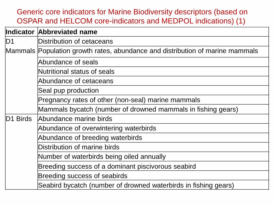
Indicator Abbreviated name
D1
Mammals
Distribution of cetaceans
Population growth rates, abundance and distribution of marine mammals
Abundance of seals
Nutritional status of seals
Abundance of cetaceans
Seal pup production
Pregnancy rates of other (non-seal) marine mammals
Mammals bycatch (number of drowned mammals in fishing gears)
D1 Birds Abundance marine birds
Abundance of overwintering waterbirds
Abundance of breeding waterbirds
Distribution of marine birds
Number of waterbirds being oiled annually
Breeding success of a dominant piscivorous seabird
Breeding success of seabirds
Seabird bycatch (number of drowned waterbirds in fishing gears)
Generic core indicators for Marine Biodiversity descriptors (based on
OSPAR and HELCOM core-indicators and MEDPOL indications) (1)
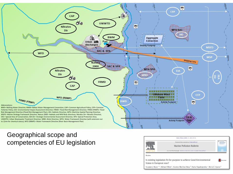
Abbreviations:BWD= Bathing Water Directive; BWM= Ballast Water Management Convention; CAP= Common Agricultural Policy; CFP= Common Fisheries Policy; EIA= Environmental Impact Assessment Directive; FRMD= Flood Risk Management Directive; FRMD (FRMP)= Flood Risk Management Directive (Flood Risk Management Plan); HD= Habitats Directive; MPS= Maritime Spatial Planning Directive; MSFD= Marine Strategy Framework Directive; Natura 2000= Habitats and Wild Birds directives; Nitrates Dir= Nitrates Directive;SAC= Special Area of Conservation; SEA Dir= Strategic Environmental Assessment Directive; SPA= Special Protection Area; UWWTD= Urban Wastewater Treatment Directive; WBD= Birds Directive; WFD= Water Framework Directive (with extension out to 12nm for chemical status); WFD (RBMP)= Water Framework Directive (River Basin Management Plan)
Geographical scope and
competencies of EU legislation

Marine Strategy Framework Directive (MSFD,
2008/56/EC) (the marine environmental quality
directive!)
• Aim: ‘to promote sustainable use of the seasand conserve marine ecosystems’
• Achieve Good Environmental Status (GES),by 2020
• The concept of environmental statusaccommodates the structure, function andprocesses of the marine ecosystems togetherwith natural physiographic, geographic andclimatic factors, as well as physical andchemical conditions including those resultingfrom human activities in the area concerned

• Aim: “the sustainable growth of maritime and coastal economies and the sustainable use of marine and coastal resources”.
• MSP is about planning when and where human activities take place at sea – to ensure these are as efficient and sustainable as possible.
• ensure a coordinated approach to MSP throughout Europe;
• enable the efficient and smooth application of MSP in cross-border marine areas;
• to favour the development of maritime activities; and
• the protection of the marine environment based on a common framework
Maritime Spatial Planning (& Directive)

Challenge – to merge environmental quality management (e.g. MSFD)
with maritime spatial planning and Blue Growth initiatives (e.g. MSPD)

For existing activities: Which activities are there, how many and what is their duration and frequency?
What area do they occupy?
Is there a monitoring programme for the activity?
What are the near- and far-field footprints of the pressure(s) they give rise to?
Which of the activities overlap?
What proportion of the area to be managed is occupied by those footprints?
What is the effect of the cumulative footprints on the area environmental status
and quality?
Have the existing activities exceeded the assimilative capacity of the area?
Have the existing activities reduced the natural carrying capacity of the area?
Can we determine the assimilative and carrying capacities?
What is the influence on the occupied and unoccupied space from external
influences such as climate change?
Maritime Spatial Planning

But (and there is always a ‘but’):
Should a new activity be located: Where the developer wants it to be?
Where the regulator wants it to be?
Where all the stakeholders want it to be?
Where the conditions are suitable for it?
Where there is available space for it?
Where it is compatible with existing
activities?
Where the assimilative capacity of the
system can accommodate it?
And, if the capacity cannot accommodate it,
will the environmental regulator say it
cannot be allowed despite prevailing
economic drivers or other imperative
reasons of overriding public interest (IROPI)?
Can we predict the change in the
assimilative and carrying capacities if new
activities are permitted?

(65 km coast, 3462 km2)

(1) that an area has a finite environmental quality status
which is intact in the pristine state and then decreases with
each activity permitted;
(2) that an area has an assimilative capacity to absorb the
effects of an activity;
(3) that the reduction in environmental quality status and
assimilative capacity in an area depends on the precise
activity, its spatial and temporal footprint, and the
cumulative and in-combination effects;
(4) that these also depend on any mitigation and/or
compensation measures performed on any components/
habitat, and on the particular descriptor in question;
(5) that the environmental quality status and the
assimilative capacity is regained with mitigation or
compensation;
(6) that GES can still be achieved with the permitted
activities in place.
Good environmental status and successful maritime spatial planning – theoretical compatibility – assumptions:

Assimilative Capacity/Carrying Capacity
Previously Proposed
Assimilative capacity
the ability of a body of
water to assimilate a
contaminant without
showing adverse
changes
the amount of an activity
or activities allowed in a
body of water before it
adversely affects the
quality
Carrying capacity
the amount of biota
(e.g. number of birds
or fishes) that a given
habitat can support
the ability of a body of
water to support a given
amount of activity or
activities or ecological
component

No activities
GES threshold (∑ of 11 MSFD Descriptors)
Existingmarine
Offshore Renewables
Aquaculture
BiotechnologyTourism
Trajectory of environmental quality as the marine area is used by multiple activities
Regained environmental quality with mitigation and/or compensation measures
Deep seamining
Envi
ronm
enta
lQ
ua
lity
Pristine marine environment with no activities
KEY
Ass
imila
tive
Cap
acit
y
Pressure
Environmental Quality Model incl. mitigation measures
for cumulative Blue Growth Activities

Calculation of impact of activities and their footprints as a % of the whole marine area
(* a pressure rather than an activity but used here as a surrogate for the net result of all discharges (diffuse and point source) to the catchment)
Activity % of Area
Aquaculture 0.29
Biotechnology 0.11
Estuarine outflow (from mouth of estuary) (*) 3.69
Fisheries 14.77
Infrastructure (bridges, groynes, sea-defences) 0.30
Navigation and ports 6.37
Offshore energy (including cables) 3.69
Oil and gas (including pipelines) 1.76
Seabed Mining 2.44
Shore-based discharges (from HW) 0.27
Tourism/recreation (from HW) 1.23
Total Area (%) 34.92

Windroses: median
score of the activity
effect levels on each
Descriptor (the central
value represents the
overall median score,
calculated across all
activities)
(from Elliott et al., in review)

Estimated values of % Area
Weighted Effect on overall Good
Environmental Status(from Elliott et al., in review)
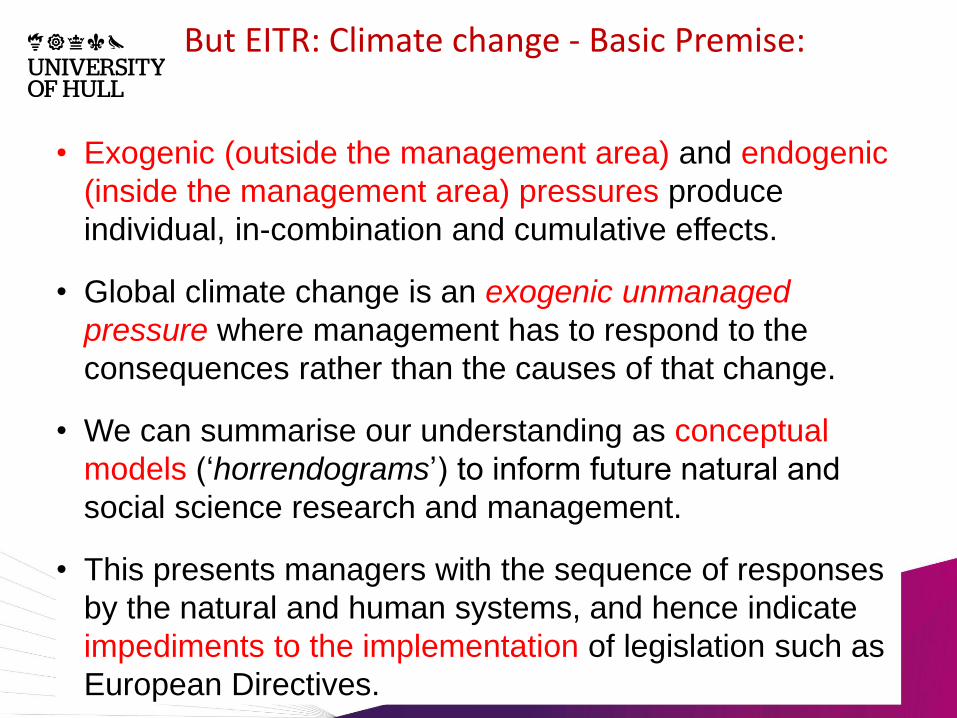
But EITR: Climate change - Basic Premise:
• Exogenic (outside the management area) and endogenic
(inside the management area) pressures produce
individual, in-combination and cumulative effects.
• Global climate change is an exogenic unmanaged
pressure where management has to respond to the
consequences rather than the causes of that change.
• We can summarise our understanding as conceptual
models (‘horrendograms’) to inform future natural and
social science research and management.
• This presents managers with the sequence of responses
by the natural and human systems, and hence indicate
impediments to the implementation of legislation such as
European Directives.

Figure 2 Primary drivers and consequences of marine global climate change (cross-
referring to other figures)
Increased atmospheric CO2
Altered temperature
regime
Physico-chemical
water changes
Loss of polar
ice-cover
(Fig. 10)
Increase in relative
sea level
Physiographic
changes (Fig.
5)
Physiological
responses
(Fig. 4) Changes to
coastal
hydrodynamics
(Fig. 6)
Ocean
acidification
(Fig. 9)
Species re-
distribution (Fig.
3)
Changes to
climate patterns
Changes to
estuarine
hydrodynamics
(Fig. 8)
Changes to
NAO/EAO and
rainfall run-off
(Fig. 7)
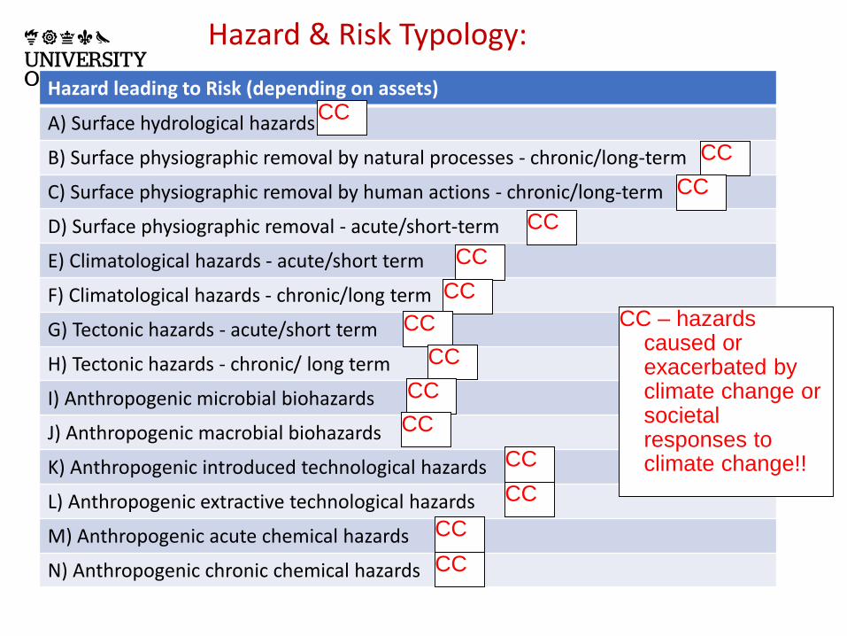
Hazard leading to Risk (depending on assets)
A) Surface hydrological hazards
B) Surface physiographic removal by natural processes - chronic/long-term
C) Surface physiographic removal by human actions - chronic/long-term
D) Surface physiographic removal - acute/short-term
E) Climatological hazards - acute/short term
F) Climatological hazards - chronic/long term
G) Tectonic hazards - acute/short term
H) Tectonic hazards - chronic/ long term
I) Anthropogenic microbial biohazards
J) Anthropogenic macrobial biohazards
K) Anthropogenic introduced technological hazards
L) Anthropogenic extractive technological hazards
M) Anthropogenic acute chemical hazards
N) Anthropogenic chronic chemical hazards
CC – hazards caused or exacerbated by climate change or societal responses to climate change!!
CC
CC
CC
CC
CC
CC
CC
CC
CC
CC
CC
CC
CC
CC
Hazard & Risk Typology:

Topics Descriptor 1 2 3 4 5 6 7 8 9 10 11
I Altered temperature regime – species re-
distribution and community response
II Altered temperature regime – individual
physiological/phenological response
III Increased relative sea-level rise -
physiographic changes
IV Increased climate variability effects on
coastal hydrodynamics
V Changes to large scale climatic patterns
due to land run-off
VI Increased relative sea-level rise
changing estuarine hydrodynamics
VII Increased ocean acidification and
seawater physico-chemical changes
VIII Loss of polar ice cover and global
transport repercussions
Sum categories 8 3 6 8 3 7 5 2 2 1 1
Summary: Marine consequences of climate change and their
influence on the GEnS descriptors
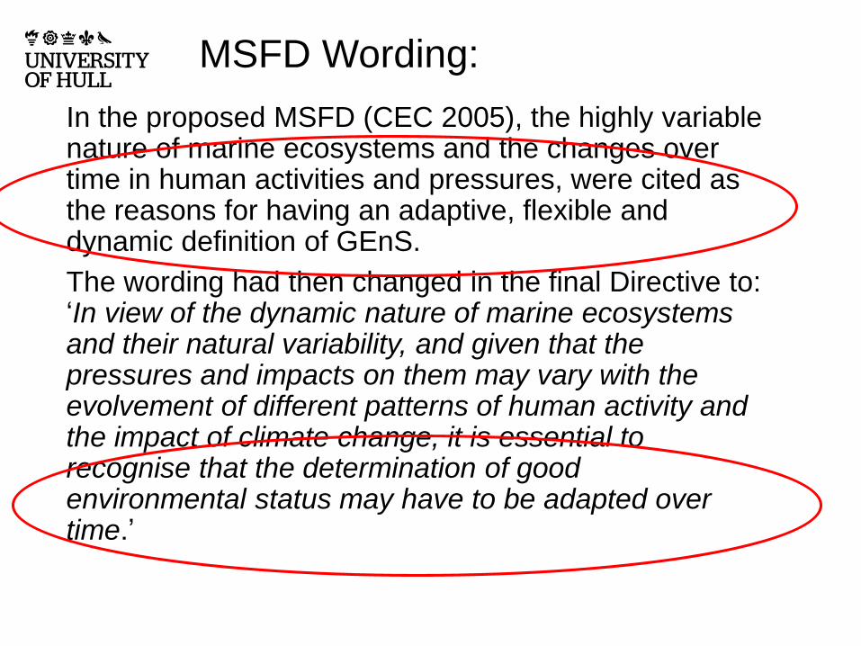
MSFD Wording:
In the proposed MSFD (CEC 2005), the highly variable nature of marine ecosystems and the changes over time in human activities and pressures, were cited as the reasons for having an adaptive, flexible and dynamic definition of GEnS.
The wording had then changed in the final Directive to: ‘In view of the dynamic nature of marine ecosystems and their natural variability, and given that the pressures and impacts on them may vary with the evolvement of different patterns of human activity and the impact of climate change, it is essential to recognise that the determination of good environmental status may have to be adapted over time.’

Art. 14 of MSFD and Art. 2 of WFD – not meeting GEnS or GEcS?
47
a) action or inaction for which the Member State concerned is not responsible,
b) natural causes,
c) force majeure,
d) modifications or alterations to the physical characteristics of marine waters brought about by actions taken for reasons of overriding public interest which outweigh the negative impact on the environment, including any transboundary impact,
e) natural conditions which do not allow timely improvement in the status of the marine waters concerned.

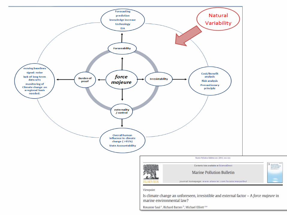
Force majeure:
“Force majeure is literally translated as ‘superior forces’. In contractual terms, it is recognised as the occurrence of an unexpected event / events beyond the control of either contracting party which disrupts the operation of the contract such that the contracting parties are excused from their liabilities and/or obligations under the contract.
It is however not intended to excuse any negligence or malfeasance. It can also suspend the performance of an obligation or extend the time to perform the same.
This would include an "Act of God" / "forces of nature" event but can also extend to extraneous human intervention events.”
(Legal Dictionary)

‘Bottlenecks, Showstoppers &
Trainwrecks’:

Bottlenecks Showstoppers Trainwrecks
Lack of clear objectivesNo stakeholder forumPoor scientific understandingPoor adviceConfusing planning systemManageable hazardsPoor communication
Complex regulationPoor knowledgePoor trainingOverlapping designationConflicting designationSectoral managementPoor administrationEconomic prerogativeLack of technologiesLack of toolsIncreasing governanceSlow planning systemNon-integrated planning systemManageable hazards
IntransigenceLack of fundingLegal challengesPolitical willUnwillingness to adopt joint aims/visionInflexible planning systemUnmanageable hazardsLack of permissionsCultural conflictsIconic ecologyEthically immoral
(but does climate
change become the
biggest ‘get-out’
clause?!)

Moving Baselines - difficult to detect anthropogenic change against background variability
• Historic modification – new, accepted system,
• Climate change - temperature regimes,
• Climate change - relative sea level,
• Climate change - species presence – alien species
• Population dynamics and species abundance,
• Isostatic rebound vs sea level rise.
So what? – the legal repercussions?

2012 Assessment
report baseline
2012 status with increased variability
Moving Baselines (MSFD)?
Fixed baseline 2012 Extended baseline
Moving baseline?
2020 status
2032 status
2026 status
2038 status
2044 status
2050 status
2056 status
2062 status
2068 status
2074 status

Impediments to achieving GEnS with regard to
Climate Change (1)
(1) We have a good conceptual science-base but poor
precise links between changes in biota and climate features;
(2) Climate change produces ‘shifting baselines’ which need
to be accommodated in monitoring together with ‘unbounded
boundaries’;
(3) Despite budget cuts, more cost-effective spatial and
temporal monitoring is required otherwise there is poor
predictability;
(4) ‘Wicked problem’ - determine GEnS on a Descriptor-by-
Descriptor basis or by 2020 vs. aggregation; will an area be
‘unhealthy’ or just different;
(5) Challenge of detecting local anthropogenic change
against wide climate change;

Impediments to achieving GEnS with regard to
Climate Change (2)
(6) Climate change-induced geographical disparity
to achieving GEnS;
(7) How to resolve non-achieving GEnS for the
Ecosystem Services and Societal Benefits against
climate change;
(8) Unknown unknowns – legal challenges if
climate change treated as a force majeure?
(9) Challenge of making the core generic RSC
indicators SMART and robust to climate change?
(10) Lessons are applicable to all seas and marine
directives.
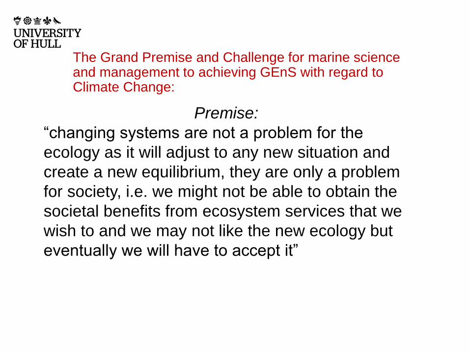
The Grand Premise and Challenge for marine science and management to achieving GEnS with regard to Climate Change:
Premise:
“changing systems are not a problem for the
ecology as it will adjust to any new situation and
create a new equilibrium, they are only a problem
for society, i.e. we might not be able to obtain the
societal benefits from ecosystem services that we
wish to and we may not like the new ecology but
eventually we will have to accept it”

Challenge:
“for management to deal with especially
unpredictable exogenic unmanaged
pressures when it cannot manage the causes
but can only respond to the consequences, it
has to realise what is manageable and what
is not”
PS - But (and there is always a ‘but’!):
Climate change will make it more complicated!

Quality Assurance in Marine Decision-making
Knowledge
Information
Data
Evidence ‘Mining’
Sources
Audit Trail / ProofCoastal Futures, SOAS, 23-24 January 2013
Importance of audit trails,
defendable actions and
policies
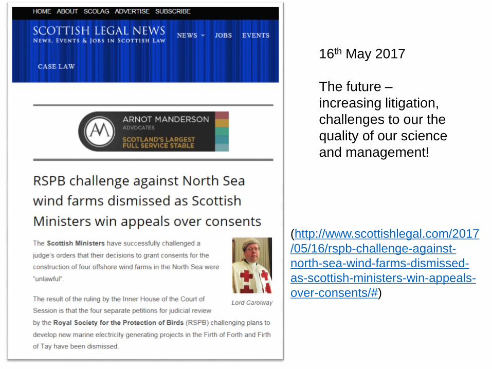
16th May 2017
The future –
increasing litigation,
challenges to our the
quality of our science
and management!
(http://www.scottishlegal.com/2017
/05/16/rspb-challenge-against-
north-sea-wind-farms-dismissed-
as-scottish-ministers-win-appeals-
over-consents/#)
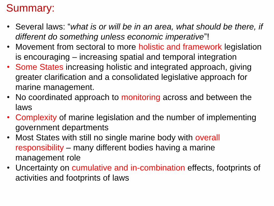
Summary:
• Several laws: “what is or will be in an area, what should be there, if
different do something unless economic imperative”!
• Movement from sectoral to more holistic and framework legislation
is encouraging – increasing spatial and temporal integration
• Some States increasing holistic and integrated approach, giving
greater clarification and a consolidated legislative approach for
marine management.
• No coordinated approach to monitoring across and between the
laws
• Complexity of marine legislation and the number of implementing
government departments
• Most States with still no single marine body with overall
responsibility – many different bodies having a marine
management role
• Uncertainty on cumulative and in-combination effects, footprints of
activities and footprints of laws

Grand Challenges (to be addressed):• Ensure competent authorities are the same for MSFD and MSPD or accommodate different ones• Resolve jurisdiction areas (e.g. Directive limits, Land planning to low water)• Ensure within and between MS transborder coordination - with other MS and 3rd Countries• Implementation using Regional Seas Conventions and harmonise assessments• Determine if each activity affects each descriptor in different ways and has different spatial and temporal footprints• Take land-sea interactions into account (e.g. erosion and dredging)• Determine how much assimilative capacity can you use before breaching GES•Determine whether Blue Growth or GES-achievement takes precedence

For discussion:
• Are the rules and implementation effective?• Would the results of the governance be seen within reasonable timescales?• Can the legal framework cope with moving baselines and highly variable systems?• Is the science and management overwhelming reactive instead of proactive?• Is science still focussing on the ‘nice-to-know’ instead of the ‘need-to-know’?• Does science- and evidence-based management conflict with the desire for ‘quick-fixes’?• Are the available indicators really SMART and valid in relation to BSAP?• Does vertical and horizontal integration on management and governance exist for the Baltic?•Should there be a joint Baltic science and policy panel?
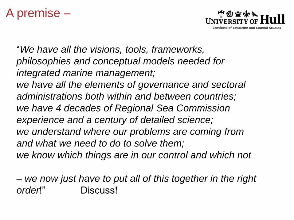
A premise –
“We have all the visions, tools, frameworks,
philosophies and conceptual models needed for
integrated marine management;
we have all the elements of governance and sectoral
administrations both within and between countries;
we have 4 decades of Regional Sea Commission
experience and a century of detailed science;
we understand where our problems are coming from
and what we need to do to solve them;
we know which things are in our control and which not
– we now just have to put all of this together in the right
order!” Discuss!

Thank youFor more information visitwww.hull.ac.uk
[email protected]://www.hull.ac.uk/Faculties/staff-profiles/Professor-Mike-Elliott.aspx (Open Access book)