From Mobile and Through the Cloud to AutoCAD® Civil...
28
© 2012 Autodesk From Mobile and Through the Cloud to AutoCAD® Civil 3D® Augusto Goncalves Senior Developer Consultant
Transcript of From Mobile and Through the Cloud to AutoCAD® Civil...

© 2012 Autodesk
From Mobile and Through the Cloud to
AutoCAD® Civil 3D®
Augusto Goncalves Senior Developer Consultant

© 2012 Autodesk
Class Summary
How collect coordinate points using Mobile with GPS enabled devices
running Android or iOS, then store and merge those at the Cloud to finally
generate Civil 3D objects, like surfaces, alignments or parcels.
The case study will use Android phone equipped GPS and camera, using
Windows Azure as cloud service to generate AutoCAD Civil 3D Cogo
points.

© 2012 Autodesk
Learning Objectives
At the end of this class, you will be able to:
1. Understand cloud development with mobile and desktop
2. Create, set-up and deploy a website on Azure cloud service
3. Configure, develop and install Android application
4. Connect Civil 3D to webservice (cloud) with .NET API

© 2012 Autodesk
Overview

© 2012 Autodesk
Flow of Information (Motivation)
No Parking Zone sign
What do we
have here?
How can we collect that data
using mobile GPS & camera?

© 2012 Autodesk
Proposed Arquitecture

© 2012 Autodesk
Players (Case Study)
AutoCAD Civil 3D

© 2012 Autodesk
Technology (Case Study)

© 2012 Autodesk
The Cloud (Windows Azure)

© 2012 Autodesk
Overview Windows Azure
Website, SQL data, Storage, Virtual Machines
SDK for development with Visual Studio (link)
Start as low as $10/month, on demand plans
Test with a 3 month trial period
See more at http://www.windowsazure.com
September/2012

© 2012 Autodesk
Overview Web Development
ASP.NET based development
Same language skills of Autodesk APIs with VB.NET/C#
Full support for databases (e.g. SQL Server)
Fully supported for local development
and deployment on the cloud
SDK for Windows Azure (link)
(Really) Quick deployment
Good tutorials (link)

© 2012 Autodesk
Web Services for Desktop Access
Simply create a .asmx service
No special requirement
On this level, bandwidth
is not a concern
Can return custom data
[WebMethod] public PointData[] GetPointData() {
}

© 2012 Autodesk
Web Services for Mobile Access
Prefer a lighter connection protocol: bandwidth is related to battery use
ASP.NET return XML based on SOAP, extra bandwidth required
Alternatively, consider:
REST (REpresentational State Transfer) based on HTTP requests (link)
Return data with JSON (JavaScript Object Notation) format (link)
[WebMethod] [ScriptMethod(ResponseFormat = ResponseFormat.Json)] public string PostData() {
} → Return string is required for JSON

© 2012 Autodesk
Deployment on Windows Azure
Download publish settings from Azure account manager
Publish using the settings

© 2012 Autodesk
Demonstration
Required
Visual Studio 2010
Windows Azure account
Web and Database features enabled
Extra: Geography data-type
Feature Pack with CLR Types for SQL Server 2010 (link)
Windows Azure supports .NET 4.0 and SQL Server 2010 (September/2012)

© 2012 Autodesk
The Mobile (Android)
© 2012 Autodesk
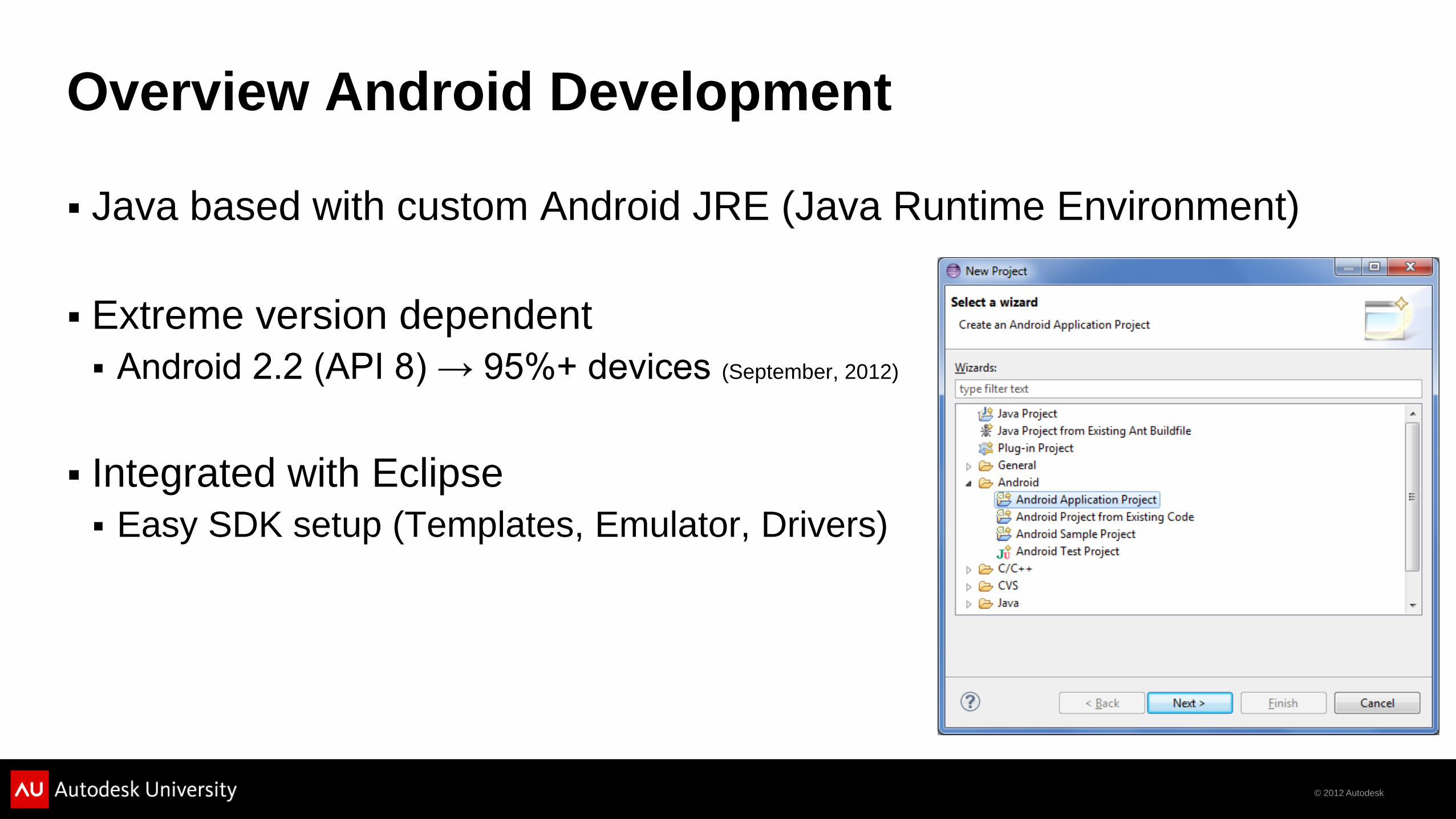
Overview Android Development
Java based with custom Android JRE (Java Runtime Environment)
Extreme version dependent
Android 2.2 (API 8) → 95%+ devices (September, 2012)
Integrated with Eclipse
Easy SDK setup (Templates, Emulator, Drivers)
© 2012 Autodesk
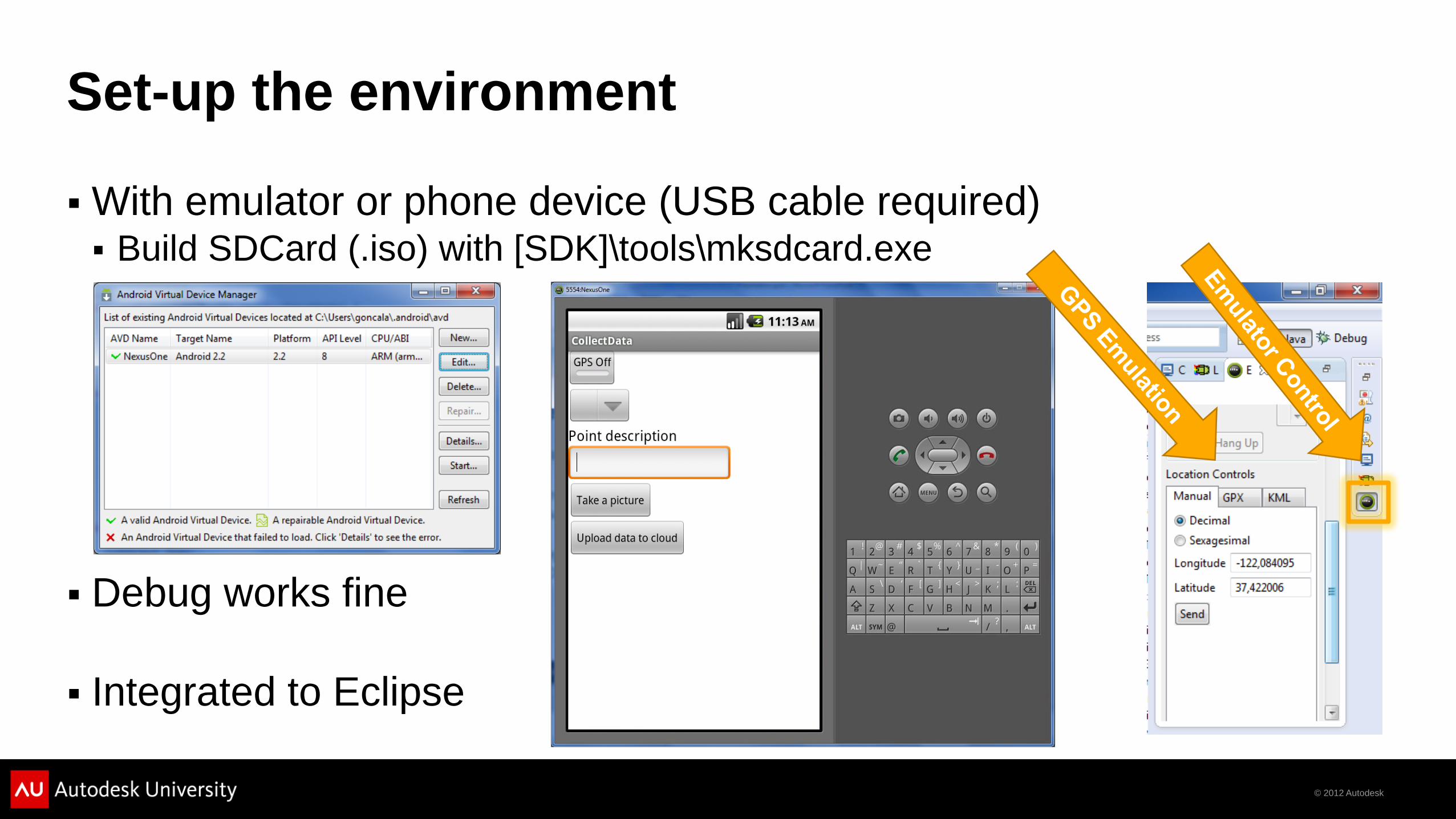
Set-up the environment
With emulator or phone device (USB cable required) Build SDCard (.iso) with [SDK]\tools\mksdcard.exe
Debug works fine
Integrated to Eclipse

© 2012 Autodesk
General development tips
Special attention to permissions (under manifest XML)
Custom class extends Activity
GPS require custom class LocationListener, look for onLocationChanged method trigger
Camera start a built-in activity Call startActivityForResult and wait for result at onActivityResult callback
Emulator camera only on API 14 SDK
When connecting to localhost, use 10.0.2.2 instead

© 2012 Autodesk
Demonstration
Required
Android SDK (link)
Eclipse IDE (link)
Java Development Kit (link)
Android phone & cable or emulator (SDK) with:
GPS (when debugging on device, go outside or close to a window )
Camera (device only)
Data plan (for outdoor GPS positioning)

© 2012 Autodesk
In the field

© 2012 Autodesk
Collect data
Take a picture
Upload to the cloud (GPS is captured here)

© 2012 Autodesk
The Desktop (AutoCAD Civil 3D)

© 2012 Autodesk
Overview Civil 3D Development
.NET based development with APIs
Create new DLLs and custom commands
No special requirement, except a internet connection (Cloud access)
AutoCAD & Civil 3D API trainings at Developer Center (link)

© 2012 Autodesk
Accessing Web Services
Configuration under app.config
Temporary solution: copy the content to
AutoCAD config file

© 2012 Autodesk
Demonstration
Required
AutoCAD Civil 3D 2013
Geo-referenced drawing
OSGeo DLL references for coordinate conversion
Visual Studio 2010 (.NET 4.0)

© 2012 Autodesk
Thank you

© 2012 Autodesk
Autodesk, AutoCAD* [*if/when mentioned in the pertinent material, followed by an alphabetical list of all other trademarks mentioned in the material] are registered trademarks or trademarks of Autodesk, Inc., and/or its subsidiaries and/or affiliates in the USA and/or other countries. All other brand names, product names, or trademarks belong to their respective holders. Autodesk reserves the right to alter product and
services offerings, and specifications and pricing at any time without notice, and is not responsible for typographical or graphical errors that may appear in this document. © 2012 Autodesk, Inc. All rights reserved.