From Decision Support System to Urban Land Readjustment · From Decision Support System to Urban...
6
143 TS 4 – Poster presentations INGEO 2014 – 6 th International Conference on Engineering Surveying Prague, Czech republic, April 3-4, 2014 From Decision Support System to Urban Land Readjustment Ališi , I., Masteli Ivi , S., Tomi , H. and Tomljenovi , M. Faculty of Geodesy, University of Zagreb, Ka i eva 26, 10000 Zagreb, Croatia Web site: www.geof.unizg.hr, E-mail: [email protected], [email protected], [email protected], [email protected] Abstract The paper discusses the importance of effective and efficient decision support system in urban planning, based on the principles of geomarketing. Geomarketing, as an integration of geographical intelligence and marketing, is used to include and valuate various aspects of spatial resources. The core base of geomarketing system in spatial planning is land administration data, which is stored and maintained by many different administrative bodies. Development in the field of the spatial technologies is making possible integration of all land administration and other available data, and with that an establishment of the decision support system, which could make urban planning more sustainable, economically approved and ecologically controlled. Decision support system with those data included can be used also to enable the planning of raising the real estate value by the procedures of land readjustment. Raising the transparency level by mass valuation in the planning process makes possible to facilitate and accelerate the subsequent procedure of spatial plans implementation. Key words: decision support system, land readjustment, mass valuation, geomarketing 1 INTRODUCTION Land information management is impossible without its physical organization as well as organized land registers. Land fragmentation is visible in many areas of the world, and the reasons for that are numerous. The fragmentation significantly disables efficient agricultural production in rural, and the implementation of spatial plans in urban areas. The fragmented parcels are inappropriate in urban space use, so urban land readjustment is needed in order to make buildable land parcels. This paper emphasizes the importance of effective and efficient decision support system (DSS) in urban planning, based on the principles of geomarketing. Geomarketing, as an integration of geographical intelligence and marketing, is used to include and valuate various aspects of spatial resources. The core base of geomarketing system in spatial planning is land administration data, which is stored and maintained by many different administrative bodies. Geomarketing comprises a wide range of components and services. The geomarketing software, market data, digital maps and specialised consultancy services offer a multiple approach to answering queries related to location in sales, marketing and controlling.
Transcript of From Decision Support System to Urban Land Readjustment · From Decision Support System to Urban...

143
TS 4 – Poster presentations
INGEO 2014 – 6th International Conference on Engineering Surveying
Prague, Czech republic, April 3-4, 2014
From Decision Support System to Urban Land Readjustment
Ališi , I., Masteli Ivi , S., Tomi , H. and Tomljenovi , M.
Faculty of Geodesy, University of Zagreb, Ka i eva 26, 10000 Zagreb, Croatia
Web site: www.geof.unizg.hr, E-mail: [email protected], [email protected], [email protected],
Abstract
The paper discusses the importance of effective and efficient decision support system in
urban planning, based on the principles of geomarketing. Geomarketing, as an integration of
geographical intelligence and marketing, is used to include and valuate various aspects of
spatial resources. The core base of geomarketing system in spatial planning is land
administration data, which is stored and maintained by many different administrative bodies.
Development in the field of the spatial technologies is making possible integration of all land
administration and other available data, and with that an establishment of the decision support
system, which could make urban planning more sustainable, economically approved and
ecologically controlled. Decision support system with those data included can be used also to
enable the planning of raising the real estate value by the procedures of land readjustment.
Raising the transparency level by mass valuation in the planning process makes possible to
facilitate and accelerate the subsequent procedure of spatial plans implementation.
Key words: decision support system, land readjustment, mass valuation, geomarketing
1 INTRODUCTION
Land information management is impossible without its physical organization as well as
organized land registers. Land fragmentation is visible in many areas of the world, and the
reasons for that are numerous. The fragmentation significantly disables efficient agricultural
production in rural, and the implementation of spatial plans in urban areas. The fragmented
parcels are inappropriate in urban space use, so urban land readjustment is needed in order to
make buildable land parcels.
This paper emphasizes the importance of effective and efficient decision support system
(DSS) in urban planning, based on the principles of geomarketing. Geomarketing, as an
integration of geographical intelligence and marketing, is used to include and valuate various
aspects of spatial resources. The core base of geomarketing system in spatial planning is land
administration data, which is stored and maintained by many different administrative bodies.
Geomarketing comprises a wide range of components and services. The geomarketing
software, market data, digital maps and specialised consultancy services offer a multiple
approach to answering queries related to location in sales, marketing and controlling.

144 INGEO 2014
2 PLANNING, DECISION MAKING AND DSS
There are different phases of the decision making process. Decision support systems (DSS)
are interactive, computer-based systems that aid users in judgment and choice activities.
Decision support systems aim mainly at this broadest type of decision making, and in addition
to supporting choice, they aid in modelling and analysing systems (such as complex
organizations), identifying decision opportunities, and structuring decision problems (Marek,
2002).
Figure 1 DSS decision-making process (Shim et al. 2002)
Combining of DSS with a Geographic Information System – GIS lead to development of
Spatial Decision Support System – SDSS. SDSS has an explicit spatial component, and it is
designed to assist in decision making while solving semi-structured spatial problem. The
difference between the SDSS and classic GIS with generic spatial functions is a higher level
of analytical and statistical modelling capabilities.
There are three main components of SDSSs (Sage 1991):
Spatial Data Base Management System (SDBMS):
A DBMS serves as a data bank for the DSS. It stores large quantities of data that
are relevant to the class of problems for which the DSS has been designed and
provides logical data structures.
Analytical model:
The purpose of an analytical model is to transform data from the SDBMS into
information that is useful in decision making.
User interface – Dialog Generation and Management System (DGMS):
The primary responsibility to give a user interface and enhance the ability of the
system user to utilize and benefit from the use of DSS.
SDSS capable to assist in a process of urban planning and land readjustment have to be
capable of multi-criteria and multi-objective decision analysis, based on relatively large
quantities of spatial and non-spatial data.
3 URBAN PLANNING AND LAND READJUSTMENT
Rural land consolidation is the most complete and the most complex agricultural option,
whose main purpose is consolidation of scattered property (Cetl 2001). Along with hydro
melioration work, the consolidation gives exceptional results in agricultural land
development.
Problem Recognition Problem
Definition
Alternate Generation
Model Development
Alternative Analysis
Choice
Implementation
Ališi , I. et al.: From Decision Support System to Urban Land Readjustment 145
Urban land readjustment, or urban consolidation – as named and defined in Croatian Law
on Physical Planning and Building (Official Gazette 76/2007), is recognized as an quality
instrument in the process of spatial plans implementation. Procedure of land readjustment is
described as merging buildable land parcels into one whole and its division on building and
other parcels in accordance with the detailed urban plan – DUP. In the same time it deals with
ownership and other real rights with the goal of dividing buildable parcels to land owners and
units of local self-government for the need of public areas.
Urban land readjustment, as described in the mentioned Law, had very poor and
inadequate definition of land valuation: in the procedure of land valuation definition of urban
consolidation did not predict the valuation of new building parcels that are allocated to the
owners according to squares, nor does it take into consideration various values of building
parcels depending on the purpose zone and the use of space, according to the detailed urban
plan. That is the reason why, according to the available literature, land readjustment
procedure was not ever performed.
Since the 1st of January 2014, there are new regulation on physical planning and
construction in Croatia (Law on Physical Planning and the Law on Building – Official
Gazette 153/2013). None of these Acts regulate the institute of urban land readjustment
anymore. By this, current legal framework on land consolidation is based on Law on Land
Consolidation which dates from 1979, and it is unenforceable. The new Law on Land
Consolidation, which is in preparation for a long time, will have to cover and define this
important procedures, as it is recognized and emphasized in many international
recommendations and studies, and also in the Croatian Strategy of Spatial Development.
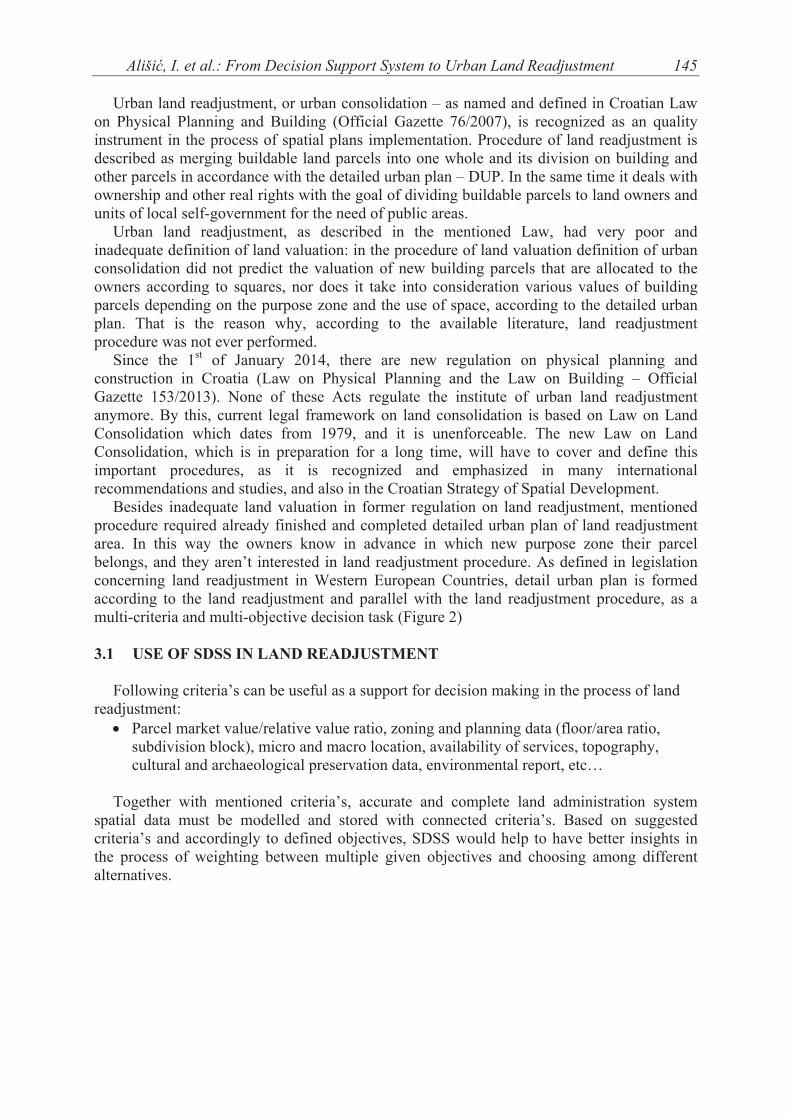
Besides inadequate land valuation in former regulation on land readjustment, mentioned
procedure required already finished and completed detailed urban plan of land readjustment
area. In this way the owners know in advance in which new purpose zone their parcel
belongs, and they aren’t interested in land readjustment procedure. As defined in legislation
concerning land readjustment in Western European Countries, detail urban plan is formed
according to the land readjustment and parallel with the land readjustment procedure, as a
multi-criteria and multi-objective decision task (Figure 2)
3.1 USE OF SDSS IN LAND READJUSTMENT
Following criteria’s can be useful as a support for decision making in the process of land
readjustment:
Parcel market value/relative value ratio, zoning and planning data (floor/area ratio,
subdivision block), micro and macro location, availability of services, topography,
cultural and archaeological preservation data, environmental report, etc…
Together with mentioned criteria’s, accurate and complete land administration system
spatial data must be modelled and stored with connected criteria’s. Based on suggested
criteria’s and accordingly to defined objectives, SDSS would help to have better insights in
the process of weighting between multiple given objectives and choosing among different
alternatives.
146
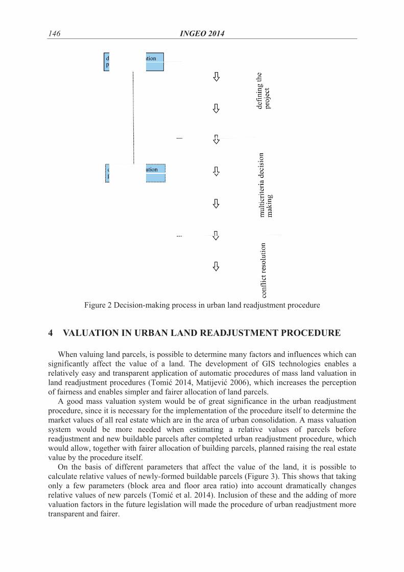
4 VA
Whe
significa
relativel
land rea
of fairne
A go
procedu
market
system
readjust
would a
value by
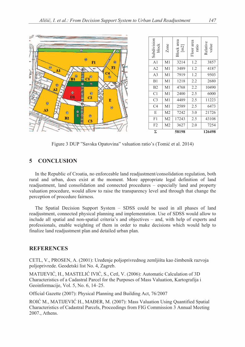
On t
calculat
only a
relative
valuatio
transpar
Figure 2
ALUATIO
n valuing la
antly affect
ly easy and
adjustment
ess and enab
ood mass v
ure, since it
values of al
would be
tment and n
allow, toget
y the proced
the basis of
te relative v
few parame
values of n
on factors in
rent and fair
2 Decision-m
ON IN UR
and parcels,
t the value
d transparen
procedures
bles simple
aluation sy
is necessary
ll real estate
e more nee
new buildab
her with fai
dure itself.
f different
values of new
eters (block
new parcels
n the future
rer.
I
making pro
RBAN LA
, is possible
e of a land
nt applicatio
(Tomi 20
er and fairer
stem would
y for the im
e which are
eded when
ble parcels a
irer allocati
parameters
wly-formed
k area and
s (Tomi et
legislation
INGEO 201
cess in urba
AND REA
e to determi
d. The deve
on of autom
014, Matijev
r allocation
d be of gre
mplementatio
in the area
n estimatin
after comple
on of buildi
that affect
d buildable
floor area
al. 2014). I
will made t
14
an land read
ADJUSTM
ne many fa
elopment o
matic proced
vi 2006), w
of land parc
at significa
on of the pr
a of urban co
ng a relativ
eted urban r
ing parcels,
t the value
parcels (Fig
ratio) into
Inclusion of
the procedu
djustment pr
MENT PR
ctors and in
f GIS tech
dures of mas
which incre
cels.
ance in the
rocedure its
onsolidation
ve values
readjustmen
, planned ra
of the lan
gure 3). Thi
account dr
f these and
ure of urban
rocedure
ROCEDUR
nfluences w
hnologies en
ss land valu
eases the pe
urban readj
self to determ
n. A mass v
of parcels
nt procedur
aising the re
nd, it is pos
is shows tha
ramatically
the adding
n readjustme
RE
which can
nables a
uation in
erception
justment
mine the
valuation
s before
e, which
eal estate
ssible to
at taking
changes
of more
ent more
Ali
5 CO
In th
rural an
readjust
valuatio
percepti
The
readjust
include
professi
finalize
REFE
CETL, V
poljopri
MATIJE
Charact
Geoinfo
Official
ROI M
Charact
2007., A
iši , I. et al.
Figure 3
ONCLUS
he Republic
nd urban,
tment, land
on procedur
ion of proce
Spatial De
tment, conn
all spatial
ionals, enab
land readju
ERENCES
V., PROSE
ivrede. Geo
EVI , H., M
teristics of a
ormacije, V
l Gazette (2
M., MATIJE
teristics of C
Athens.
: From Dec
3 DUP ”Sav
ION
of Croatia,
does exist
d consolidat
re, would al
edure fairne
ecision Sup
nected physi
and non-sp
ble weighti
ustment plan
S
EN, A. (2001
detski list N
MASTELI
a Cadastral
ol. 5, No. 6
007): Physi
EVI H., M
Cadastral Pa
cision Supp
vska Opatov
no enforce
at the mo
tion and co
llow to rais
ess.
pport Syste
ical plannin
patial criter
ing of them
n and detail
1): Ure enj
No. 4, Zagre
IVI , S., C
Parcel for th
, 14–25.
ical Plannin
MA ER, M.
arcels, Proc
ort System
vina” valuat
able land re
oment. Mo
onnected pr
e the transp
em – SDSS
ng and impl
ria’s and ob
m in order
led urban pl
e poljoprivr
eb.
Cetl, V. (20
he Purposes
ng and Build
(2007): Ma
ceedings fro
to Urban La
Sub
div
isio
n
A
A
A
B
B
C
C
C
E
F
F
tion ratio’s
eadjustment
ore appropr
rocedures –
parency leve
S could be
lementation
bjectives –
to make de
lan.
rednog zem
006): Autom
s of Mass V
ding Act, 76
ass Valuatio
m FIG Com
and Readju
blo
ck
Zo
ne
Blo
ckar
ea
A1 M1 3
A2 M1 3
A3 M1 7
B1 M1
B2 M1 4
C1 M1 2
C3 M1 4
C4 M1 2
E M2 7
F1 M2 17
F2 M2 3
58
(Tomi et a
t/consolidat
riate legal
– especially
el and throu
e used in
n. Use of SD
and, with h
ecisions wh
mljišta kao i
matic Calcul
Valuation, K
6/2007
on Using Qu
mmission 3
ustment
Blo
ck a
rea
[m2
]
Flo
or
area
rati
o
3214 1.2
3489 1.2
7919 1.2
1218 2.2
4768 2.2
2400 2.5
4489 2.5
2589 2.5
7242 3.0
7243 2.5
3627 2.0
8198
al. 2014)
ion regulati
definition
y land and
ugh that ch
all phases
DSS would
help of exp
hich would
imbenik raz
lation of 3D
Kartografija
uantified Sp
Annual Me
147
Rel
ativ
e
val
ue
3857
4187
9503
2680
10490
6000
11223
6473
21726
43108
7254
126498
ion, both
of land
property
ange the
of land
allow to
perts and
d help to
zvoja
D
i
patial
eeting

148 INGEO 2014
SAGE, A. P. (1991): Decision Support Systems Engineering. John Wiley & Sons, Inc., New
York.
SHARIFI, M.A., ZUCCA, A. (2010): Concepts, and Application of Integrated Planning and
Decision Support Systems, GSDI 12 World Conference: „Realising Spatially Enabled
Societies“. Singapore, 19-22 October 2010.
SHIM, J. P., WARKENTIN, M., COURTNEY, J. F., POWER, D. J., SHARDA, R.,
CARLSSON, C. (2002): Past, present, and future of decision support technology. Decision
Support Systems vol. 33, pages 111-126.
TOMI , H., MASTELI IVI , S., ROI , M. (2014): Transparent Valuation as a Planning
Support for Just Land Management System (LMS). Paper reviewed, will be published in
Proceeding of XXV FIG International Congress: “Engaging the Challenges, Enhancing the
Relevance”. Kuala Lumpur, Malaysia, 16-21 June 2014.