Friog Corner Rock Protection Works
24
REPORT Friog Corner Rock Protection Works Water Framework Directive Compliance Assessment - Stages 1 and 2 (Preliminary Assessment) Client: Natural Resources Wales Reference: I&BPB6936R001F0.2 Revision: 0.2/Final Date: 27/06/2018
Transcript of Friog Corner Rock Protection Works

REPORT
Friog Corner Rock Protection Works
Water Framework Directive Compliance Assessment -
Stages 1 and 2 (Preliminary Assessment)
Client: Natural Resources Wales
Reference: I&BPB6936R001F0.2
Revision: 0.2/Final
Date: 27/06/2018

P r o j e c t r e l a t e d
27/06/2018 WFD COMPLIANCE ASSESSMENT: FRIOG CORNER SEA DEFENCE REPAIR AND IMPROVEMENT WORKS
I&BPB6936R001F0.2 i
HASKONINGDHV UK LTD.
Stratus House
Emperor Way
Exeter
EX1 3QS
Industry & Buildings
VAT registration number: 792428892
+44 1392 447999
+44 1392 446148
royalhaskoningdhv.com
T
F
E
W
Document title: Friog Corner Rock Protection Works
Document short title: WFD Compliance Assessment: Friog Corner Sea Defence Repair and
Improvement Works
Reference: I&BPB6936R001F0.2
Revision: 0.2/Final
Date: 27/06/2018
Project name:
Project number: PB6936
Author(s): Christa Page
Drafted by: Christa Page
Checked by: Dr Peter R Brunner
Date / initials: 6/6/2018 PRB
Approved by: Rachel Jones
Date / initials: 27/06/2018 RJ (Revision 0.2)
Classification
Project related
Disclaimer
No part of these specifications/printed matter may be reproduced and/or published by print, photocopy, microfilm or by
any other means, without the prior written permission of HaskoningDHV UK Ltd.; nor may they be used, without such
permission, for any purposes other than that for which they were produced. HaskoningDHV UK Ltd. accepts no
responsibility or liability for these specifications/printed matter to any party other than the persons by whom it was
commissioned and as concluded under that Appointment. The integrated QHSE management system of
HaskoningDHV UK Ltd. has been certified in accordance with ISO 9001:2015, ISO 14001:2015 and OHSAS
18001:2007.

P r o j e c t r e l a t e d
27/06/2018 WFD COMPLIANCE ASSESSMENT: FRIOG CORNER SEA DEFENCE REPAIR AND IMPROVEMENT WORKS
I&BPB6936R001F0.2 ii
Table of Contents
1 Introduction 1
1.1 Outline scheme details 1
1.2 The WFD Process 2
1.3 WFD Screening 3
1.4 Scheme Activities for assessment 3
2 WFD Assessment 5
2.1 Method of Assessment 5
2.2 In-built scheme control measures 5
2.3 WFD Scoping 5
2.4 Mitigation Measures 6
2.5 Requirement for further assessment 7
2.6 Cumulative Assessment 7
2.7 Overall Findings 7
3 References 8
Table of Tables
Table 2-1 Summary of Output from Stage 2 5
Table of Figures
Figure 1.1 Location Plan 1
Figure 1.2 Proposed New Revetment General Arrangement 2
Figure 1.3 Example Cross Section of the Proposed Revetment 2
Figure 1.4 Location of Scheme Against the Outlines of the WFD Water Bodies 4
Appendices
Appendix A WFD Water Body Information
Appendix B WFD Scoping

P r o j e c t r e l a t e d
27/06/2018 WFD COMPLIANCE ASSESSMENT: FRIOG CORNER SEA DEFENCE REPAIR AND IMPROVEMENT WORKS
I&BPB6936R001F0.2 iii
Acronyms
Acronym Acronym description
EAP Environmental Action Plan
MHWS Mean High Water Springs
NRW Natural Resources Wales
WFD Water Framework Directive

P r o j e c t r e l a t e d
27/06/2018 WFD COMPLIANCE ASSESSMENT: FRIOG CORNER SEA DEFENCE REPAIR AND IMPROVEMENT WORKS
I&BPB6936R001F0.2 1
1 Introduction
1.1 Outline scheme details
This Water Framework Directive (WFD) Compliance Preliminary Assessment has been produced to support
the applications for a marine licence and planning permission for the Friog Corner Sea Defence Repair and
Improvement Works. These works require sea defence repair and improvement works at the southern end
of Fairbourne beach (referred to as Friog Corner), located near Dolgellau, in Gwynedd (Figure 1.1).
Figure 1.1 Location Plan
• Full details of the required works can be found in the within Section 4.4 of the Stage 3 Detailed
Design Report (Royal HaskoningDHV, 2018a). In summary, the proposed scheme comprises the
construction of a new rock revetment along the existing sea defence alignment for 260m (with widths
between 10m and 20m), using larger stones locally sourced where possible.
The toe of the new revetment would, in place, be below Mean High Water Spring (MHWS), with construction
works and plant movement required at beach level. The general arrangement and example cross-section
of the proposed new revetment works are presented in Figure 1.2 and Figure 1.3.
Site Location

P r o j e c t r e l a t e d
27/06/2018 WFD COMPLIANCE ASSESSMENT: FRIOG CORNER SEA DEFENCE REPAIR AND IMPROVEMENT WORKS
I&BPB6936R001F0.2 2
Figure 1.2 Proposed New Revetment General Arrangement
Figure 1.3 Example Cross Section of the Proposed Revetment
1.2 The WFD Process
This assessment is carried out in line with the internal Natural Resources Wales (NRW) guidance ‘OGN 72
Guidance for assessing activities and projects for Compliance with the Water Framework Directive’ (Natural
Resources Wales, 2018a) which replaces the Environment Agency’s guidance ‘Clearing the Waters on
dredging and disposal activity in coastal and estuarine environments’ (Environment Agency, 2010). It is
also supplemented by the Environment Agency’s guidance ‘Clearing the Waters For All’ (Environment

P r o j e c t r e l a t e d
27/06/2018 WFD COMPLIANCE ASSESSMENT: FRIOG CORNER SEA DEFENCE REPAIR AND IMPROVEMENT WORKS
I&BPB6936R001F0.2 3
Agency, 2017) to ensure consistency of process. The OGN 72 guidance details a three step process as
follows:
• Screening: exclude any activities that do not need to go through the scoping and detailed
assessment stages;
• Scoping: identify the quality elements that are potentially at risk from the proposed activity and need
further assessment; and
• Detailed assessment: consider the potential impacts of activities on surface and ground water
bodies, identify ways to minimise the effect and identify if an activity may prevent the water body
achieving good status or cause deterioration.
The following sections detail the output of Stages 1 and 2 and form the basis of the Preliminary Assessment.
1.3 WFD Screening
Within OGN 72 there are activities that Natural Resources Wales considers not at risk of causing
deterioration or preventing a water body from achieving its objective when all criteria set out in Stage 1
Screening are met. This step includes screening for the low number of water bodies at high status or with
high status morphology. The list of these activities can be found in Appendix 2 of OGN 72.
Comparison against these criteria indicates that the proposed activities should be carried forward to the
scoping stage as they do not fit into minor construction and repairs, deposit activities, removal activities or
beach management activities. Note that the water body in which the activities will occur is not identified as
being at high status for morphology.
1.4 Scheme Activities for assessment
The first stage in the assessment is to break down the proposed scheme into activities that can be checked
against scoping criteria and then determine which water bodies that could potentially be impacted. The
proposed scheme footprint is therefore shown against the outlines of the WFD water bodies in Figure 1.4.
It can be seen from Figure 1.4 that whilst the footprint of the scheme does not fall within the boundaries of
the Cardigan Bay North (GB621009600000) WFD coastal water body, it is located adjacent to the boundary
and within 3m at its closest point. Additionally, the footprint of the scheme is located within the Meirionnydd
WFD groundwater body (GB41002G203200). However, given that there will be minimal excavation to
construct the revetment it is not anticipated that the groundwater body is at risk. As a result, it is not
anticipated that this water body will be impacted and it is not considered further in this assessment.
For the purposes of the assessment, the proposals have been split into the following activities:
• Construction Phase: Placement of the rock and general construction.
• Operational Phase: Presence of rock revetment
• Decommissioning Phase: Work is still being undertaken through the Fairbourne Coastal
Adaptation Masterplan for the decommissioning of Fairbourne. This will examine the most
appropriate course of action in relation to decommissioning of the defences along the entire
frontage. The associated issues will need to be reviewed and mitigated within the supporting
environmental documents and assessments. This will consider the impacts upon the WFD
waterbodies and designated sites. As such, decommissioning of the proposed rock revetment at
Friog Corner is not considered further within this assessment.

P r o j e c t r e l a t e d
27/06/2018 WFD COMPLIANCE ASSESSMENT: FRIOG CORNER SEA DEFENCE REPAIR AND IMPROVEMENT WORKS
I&BPB6936R001F0.2 4
Figure 1.4 Location of Scheme Against the Outlines of the WFD Water Bodies
P r o j e c t r e l a t e d
27/06/2018 WFD COMPLIANCE ASSESSMENT: FRIOG CORNER SEA DEFENCE REPAIR AND IMPROVEMENT WORKS
I&BPB6936R001F0.2 5
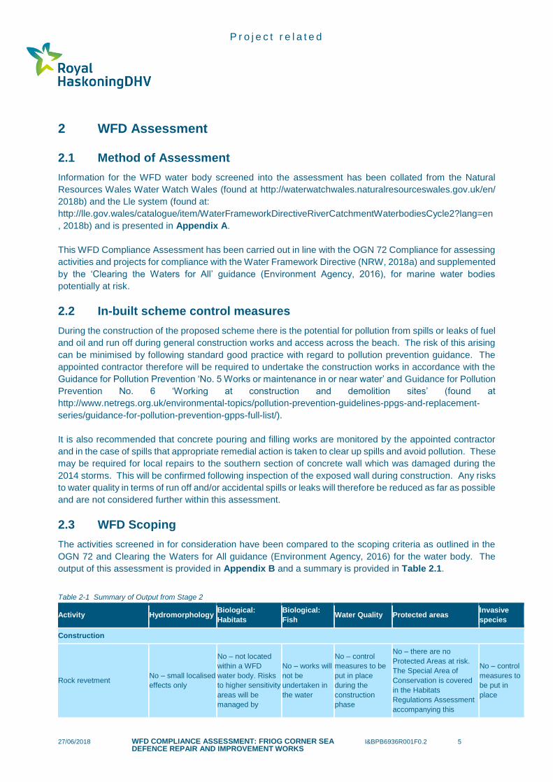
2 WFD Assessment
2.1 Method of Assessment
Information for the WFD water body screened into the assessment has been collated from the Natural
Resources Wales Water Watch Wales (found at http://waterwatchwales.naturalresourceswales.gov.uk/en/
2018b) and the Lle system (found at:
http://lle.gov.wales/catalogue/item/WaterFrameworkDirectiveRiverCatchmentWaterbodiesCycle2?lang=en
, 2018b) and is presented in Appendix A.
This WFD Compliance Assessment has been carried out in line with the OGN 72 Compliance for assessing
activities and projects for compliance with the Water Framework Directive (NRW, 2018a) and supplemented
by the ‘Clearing the Waters for All’ guidance (Environment Agency, 2016), for marine water bodies
potentially at risk.
2.2 In-built scheme control measures
During the construction of the proposed scheme there is the potential for pollution from spills or leaks of fuel
and oil and run off during general construction works and access across the beach. The risk of this arising
can be minimised by following standard good practice with regard to pollution prevention guidance. The
appointed contractor therefore will be required to undertake the construction works in accordance with the
Guidance for Pollution Prevention ‘No. 5 Works or maintenance in or near water’ and Guidance for Pollution
Prevention No. 6 ‘Working at construction and demolition sites’ (found at
http://www.netregs.org.uk/environmental-topics/pollution-prevention-guidelines-ppgs-and-replacement-
series/guidance-for-pollution-prevention-gpps-full-list/).
It is also recommended that concrete pouring and filling works are monitored by the appointed contractor
and in the case of spills that appropriate remedial action is taken to clear up spills and avoid pollution. These
may be required for local repairs to the southern section of concrete wall which was damaged during the
2014 storms. This will be confirmed following inspection of the exposed wall during construction. Any risks
to water quality in terms of run off and/or accidental spills or leaks will therefore be reduced as far as possible
and are not considered further within this assessment.
2.3 WFD Scoping
The activities screened in for consideration have been compared to the scoping criteria as outlined in the
OGN 72 and Clearing the Waters for All guidance (Environment Agency, 2016) for the water body. The
output of this assessment is provided in Appendix B and a summary is provided in Table 2.1.
Table 2-1 Summary of Output from Stage 2
Activity Hydromorphology Biological:
Habitats
Biological:
Fish Water Quality Protected areas
Invasive
species
Construction
Rock revetment No – small localised
effects only
No – not located
within a WFD
water body. Risks
to higher sensitivity
areas will be
managed by
No – works will
not be
undertaken in
the water
No – control
measures to be
put in place
during the
construction
phase
No – there are no
Protected Areas at risk.
The Special Area of
Conservation is covered
in the Habitats
Regulations Assessment
accompanying this
No – control
measures to
be put in
place

P r o j e c t r e l a t e d
27/06/2018 WFD COMPLIANCE ASSESSMENT: FRIOG CORNER SEA DEFENCE REPAIR AND IMPROVEMENT WORKS
I&BPB6936R001F0.2 6
Activity Hydromorphology Biological:
Habitats
Biological:
Fish Water Quality Protected areas
Invasive
species
demarcation and
avoided
application (Natural
Resources Wales, 2018c)
Operation
Presence of rock
revetment
No – small localised
effects only
No – the
operational phase
does not present a
risk to biological
habitats within the
WFD water body
No – the
operational
phase of the
scheme does
not present a
hazard to fish
No – control
measures to be
put in place
during any
maintenance
works required
No – the operational
phase does not present a
risk to Protected Areas
No risks
identified
during the
operational
phase
2.4 Mitigation Measures
The following mitigation measures will be implemented to reduce the potential for effects on WFD
compliance parameters:
• With specific reference to the Sabellaria alveolata biogenic reef located nearby:
o Reef areas to be demarcated on plans and avoided during construction.
o Offloading of rocks from a barge would be within a localised area on to sandy
beach deposits in the shallowest waters possible, (therefore any disturbed
sediment from initial impact would settle back at the same location) and further
rock would be offloaded above the waterline.
o Delivery of all rock from a barge would be at a location greater than 200m from
the nearest area of Sabellaria alveolata biogenic reef.
o The length of time that rock is stockpiled should be minimised.
o Rock supply specification to include <2% fine grained material.
o A biosecurity risk assessment would be undertaken and agreed (as part of the
Marine Licencing process) for the delivery of rock by boat and barge.
o A Maximum possible distance to be maintained between revetment works and the
Reefs feature to ensure no direct impact from construction activities such as plant
movement.
• Implementation of a Environmental Action Plan (EAP) and contractor Method Statement
to be drafted in consultation with the relevant regulators to include:
o Protection of biogenic reef measures as outlined above.
o Excavations to be covered with a geotextile and some quantity of rock to weigh it
down, or similar method before each tide so this limits the tidal erosion / sediment
disturbance.
o Site supervision of material delivery and movement to ensure no encroachment
into designated sensitive areas.
o Avoid water ingress in to excavations to minimise mobilisation of sediment as far
as possible.
o Use of plant machinery above the limits of the low tide range to prevent silt
migration.
o All plant / machinery to use biodegradable oils in hydraulic systems.
o Emergency spill kit fitted in each item of plant.
o All refuelling activities to be undertaken in a designated area within the site
compound away from the foreshore.

P r o j e c t r e l a t e d
27/06/2018 WFD COMPLIANCE ASSESSMENT: FRIOG CORNER SEA DEFENCE REPAIR AND IMPROVEMENT WORKS
I&BPB6936R001F0.2 7
• Implementation of a waste management plan (to include the requirement that all
demolition material to be collected and removed from site). This could be included as a
component to the EAP.
• The commitment to the reinstatement of the site once works have been completed.
2.5 Requirement for further assessment
The comparison of the two activities against the WFD scoping criteria has not identified any risk to WFD
compliance receptors. Therefore, no further assessment is required.
2.6 Cumulative Assessment
The only potential for cumulative effects could occur as a result of nearby emergency works planned by
Network Rail. This small project requires repairs to a failure in the seawall in the area of Friog which is
causing concern regarding the integrity of the rock outcrop above and the railway infrastructure. However,
it is understood that these works are to commence in late July/August 2018 and would last four weeks.
Therefore, given the differing timescales over which these projects will occur, cumulative impacts are not
predicted.
2.7 Overall Findings
Comparison of the proposed activities against the WFD scoping criteria did not identify any risk to
WFD compliance parameters. The potential for significant cumulative effects was considered in Section
2.6 and none were identified. As a result, no further assessment is required and the WFD compliance
assessment is considered to be complete.

P r o j e c t r e l a t e d
27/06/2018 WFD COMPLIANCE ASSESSMENT: FRIOG CORNER SEA DEFENCE REPAIR AND IMPROVEMENT WORKS
I&BPB6936R001F0.2 8
3 References
Enfys Ecology (2018) Friog Corner, Meirionnydd Gwynedd: Preliminary Ecological Appraisal. V2. For
Natural Resources Wales.
Environment Agency (2010) Clearing the Waters. Found at
https://www.gov.uk/government/publications/complying-with-the-water-framework-directive-marine-
dredging.
Environment Agency (2016) Clearing the Waters for All. Found at: https://www.gov.uk/guidance/water-
framework-directive-assessment-estuarine-and-coastal-waters.
Guidance for Pollution Prevention (various) http://www.netregs.org.uk/environmental-topics/pollution-
prevention-guidelines-ppgs-and-replacement-series/guidance-for-pollution-prevention-gpps-full-list/
[accessed May 2018].
Natural Resources Wales (2018a) OGN 72 Compliance for assessing activities and projects for
compliance with the Water Framework Directive.
Natural Resources Wales (2018b) Map Application found at
https://nrw.maps.arcgis.com/apps/webappviewer/index.html?id=2176397a06d64731af8b21fd69a143f6.
Natural Resources Wales (2018c) Record of a Habitats Regulations Assessment of a project OGN 200
Form 1.
Royal HaskoningDHV (2018a) Stage 3 Report.
Royal HaskoningDHV (2018b) Fairbourne Open Coast – Review of Geomorphology and Influence of
Climate Change on Defence Management.

Appendix A
WFD Water Body Information

P r o j e c t r e l a t e d
27/06/2018 APPENDIX I&BPB6936R001F0.2 A1
Table A1 Information for Cardigan Bay North Coastal Water Body
Water body Description, notes or more information
WFD water body name Cardigan Bay North
Water body ID GB621009600000
River basin district name Western Wales
Water body type (estuarine or coastal) Coastal
Water body total area (km2) 712.19
Overall water body status Moderate
Ecological status Good
Chemical status Fail (Tributyl Tin compounds)
Target water body status and deadline Good by 2021
Hydromorphology status of water body Not high
Heavily modified water body and for what use
Not heavily modified
Higher sensitivity habitats present1 Honeycomb worm (Sabellaria alveolata) reefs located not within the footprint of the proposed works but in close proximity to the works (Lle system, 2018). Other potentially higher sensitive habitats include habitats within the Aber Mawddach SSSI located approximately 1km to the north. This is a large shallow estuary that contains saltmarsh, reed beds and raised mires. Presence of higher sensitivity habitats are not located within the scheme footprint.
Lower sensitivity habitats present2 Marine habitats within and adjacent to the site within the WFD water body include intertidal cobbles and shingle and shingle/gravel above mean high water (Enfys Ecology, 2018) – See Figure A1. Outside of the boundary to the west is an extensive stretch of intertidal mud with small partially buried rocks.
Phytoplankton status High
History of harmful algae Not recorded
WFD protected areas within 2km Pen Llyn a'r Sarnau / Lleyn Peninsula and the Sarnau SAC and Fairbourne designated bathing water within 2km
1 Higher sensitivity habitats are defined in the Clearing the Waters For All guidance to include: •chalk reef, clam, cockle and oyster beds, intertidal seagrass, maerl, mussel beds, including blue and horse mussel, polychaete reef, saltmarsh, subtidal kelp beds and subtidal seagrass. This concurs with the principle of critical habitats detailed in the NRW guidance note OGN 072 which are described as being of unique importance or offering a rare combination of features that are critical to the ecological health of the water body. For higher sensitivity habitats therefore, the list provided by the Clearing the Waters for all guidance has been used. 2 Lower sensitivity habitats include all other habitats potentially present, such as cobbles, gravel and shingle, intertidal soft sediments like sand and mud, rocky shore, subtidal boulder fields, subtidal rocky reef and subtidal soft sediments

P r o j e c t r e l a t e d
27/06/2018 APPENDIX I&BPB6936R001F0.2 A2
Figure A1 Phase 1 Habitat Survey Map of the Survey Area (taken from Enfys Ecology, 2018)

Appendix B
WFD Scoping

P r o j e c t r e l a t e d
27/06/2018 APPENDIX I&BPB6936R001F0.2 B1
Completed scoping tables for activity: Construction and presence of rock revetment The following tables summarise the information relevant to the consideration of the requirements of the Water Framework Directive for construction and presence
of the rock revetment (tables taken from Clearing the Waters for All; Environment Agency, 2016). Note that although the answer to the question could be yes, there
is enough information to enable the compliance parameter to be scoped out in the notes section where either issues have been addressed in other supporting
information or through discussion with the WFD team at NRW.
Activity Information
Your activity Description, notes or more information
Applicant name Natural Resources Wales
Application reference number (where applicable) TBC
Name of activity Construction and presence of new rock revetment
Brief description of activity Construction Phase: Repair and improve the existing sea defence at Friog Corner which will comprise of the construction of a new rock revetment along the existing sea defence alignment, using larger stones locally sourced. The approximate length of the new revetment would be 260m, with widths between 10m and 20m. The toe of the new revetment would be, in places, below MHWS, with construction works and plant movement required at beach level. The works for the new revetment will consist of the following key elements:
• Excavation of the revetment;
• Placement of geotextile filter;
• Placement of 500m3 of reused (existing) 300kg to 1T rock;
• Placement of 1500m3 of 60-300kg rock (to be delivered by either road and/or sea);
• Placement of 9,250m3 of 3-6T rock to (be delivered by either road and/or sea; and
• Relocation of 66 WW2 Tank Traps.
Operational Phase maintenance: The rock revetment is designed to meet the ‘non-damage criterion’ (Sd = 2) during a 1 in 50 year storm event, which represents between 0-5% displacement of rock. An event of this magnitude would require minor maintenance works. The rock revetment is designed not fail (Sd < 8) during a 1 in 100 year storm event, which represents displacement of the primary rock armour layer so that the filter layer is exposed. An event of this in excess of this magnitude would require more significant maintenance works.

P r o j e c t r e l a t e d
27/06/2018 APPENDIX I&BPB6936R001F0.2 B2
Your activity Description, notes or more information
Minor maintenance, limited to the toe of the rock revetment may require access on to the beach for a 21T excavator. Should more significant maintenance works be required, access on to the beach for a 45T excavator may be required. Access would be along the toe of the structure and would not encroach upon the water body.
Location of activity See Figure 1.1
Footprint of activity Approximately 4000m2
Timings of activity (including start and finish dates) Estimated to commence in late 2018, lasting approximately four months. The design life of the structure is in line with the wider management plans for the frontage, which require protection of the village of Fairbourne through to 2054.
Extent of activity (for example size, scale frequency, expected volumes of output or discharge)
See above
Use or release of chemicals (state which ones) None

P r o j e c t r e l a t e d
27/06/2018 APPENDIX I&BPB6936R001F0.2 B3
Surface Water Compliance Criteria: Hydromorphology
Consider if your activity: Yes No Hydromorphology risk issue(s)
Construction of rock revetment Presence of rock revetment
Could impact on the hydromorphology (for example morphology or tidal patterns) of a water body at high status
✓ No, the water body is not at high status.
Could significantly impact the hydromorphology of any water body
✓ Depth Variation: The proposed rock revetment works fall entirely outside of the WFD water body. The beach profile
will be locally amended within the footprint of the rock revetment and the revetment will fix the position of the
backshore over its anticipated life of 36 years. There is the potential for local beach lowering in front of the revetment
but this is unlikely to extend as far as the boundary of the water body. The revetment will therefore have no broader
scale impact on the depth of water in the area.
Seabed: There is a net northerly movement of sediment along the frontage at Fairbourne. A review of the historic
change, also illustrates that there appears to be a decreasing supply of sediment in to Friog Corner. This lack of supply
of sediment in to Friog Corner, coupled with the continued net movement of sediment to the north, has left Friog
Corner increasingly vulnerable (Royal HaskoningDHV. 2018b). The proposed rock revetment is therefore required to
protect Friog Corner. This will reduce the risk of further erosion immediately at Friog Corner, however it will have a
negligible impact upon net sediment movement along the frontage or over the wider area.
Intertidal zone structure: The toe of the proposed revetment encroaches marginally beyond the Mean High Water
Spring contour (2.56mAOD) but does not extend into the area of the water body. There will be no impact on the sea
bed beyond the immediate local area of the structure.
Tidal currents and waves: The structure will not directly influence or change the reflected wave from the cliffs but
will act to dissipate wave energy at the shoreline. This potentially would reduce subsequent wave reflection,
reflecting back across the foreshore. The influence will be very low further down the foreshore in the area of the
water body. Tidal currents are low along the frontage and the revetment would have no significant influence on
these flows.
In in a water body that is heavily modified for the same use as your activity?
✓ Not heavily modified

P r o j e c t r e l a t e d
27/06/2018 APPENDIX I&BPB6936R001F0.2 B4

P r o j e c t r e l a t e d
27/06/2018 APPENDIX I&BPB6936R001F0.2 B5
Surface Water Compliance Criteria: Biology
Consider if the footprint of your activity is:
Yes No Biology habitats risk issue(s)
Construction of rock revetment Presence of rock revetment
0.5km2 or larger ✓
The footprint of the revetment is not within the WFD water body. There may be some disturbance of the beach sediments during the construction phase however the area will be returned to its natural state following completion of the revetment and any associated habitats will recover.
The footprint of the revetment is not within the WFD water body.
1% or more of the water body’s area
✓
Within 500m of any higher sensitivity habitat
✓
The potential for impacts on the Sabellaria alveolata reefs are considered to only be associated with the construction phase given their lack of presence in the direct footprint of the scheme (which means no direct habitat loss). The risks therefore only relate to the potential indirect risks associated with the discharge of pollutants from accidental spills and potentially due to spoil and silt laden runoff or disturbance of sediments during barge delivery of rock. To avoid impacts, commitment to mitigation measures to reduce the risk of these indirect impacts will be put in place (see Section 2.2 above). Additionally, it is recommended that these areas where reefs are known to be presented are demarcation on plans alongside instructions to contractor to avoid these areas.
There are not anticipated to be any impacts associated with the presence of the rock revetment since the presence of the scheme is expected to be of low impact since the resulting landscape will be broadly similar in habitats and conditions (Enfys Ecology, 2018).
1% or more of any lower sensitivity habitat
✓
The loss of habitat under the footprint is associated with shingle, cobble and gravel. The report by Enfys Ecology (2018) states that this habitat contains relatively low diversity therefore the impact of the proposed works on habitat diversity is low. Additionally, the report states that the most diverse habitats are outside of the site boundary therefore works would have no effect on habitat or species diversity within the WFD water body.

P r o j e c t r e l a t e d
27/06/2018 APPENDIX I&BPB6936R001F0.2 B6
Surface Water Compliance Criteria: Fish
Consider if your activity: Yes No Biology fish risk issue(s)
Construction of rock revetment Presence of rock revetment
Is in an estuary and could affect fish in the estuary, outside the estuary but could delay or prevent fish entering it or could affect fish migrating through the estuary
✓ There is the potential for indirect impacts on water quality to occur however the mitigation measures detailed in Section 2.2 remove the risk of water quality impacts as far as possible.
The presence of the rock revetment will not impact on water quality therefore there are no impacts on fish anticipated.
Could impact on normal fish behaviour like movement, migration or spawning (for example creating a physical barrier, noise, chemical change or a change in depth or flow)
✓
Could cause entrainment or impingement of fish ✓ No risk of entrainment either during construction or operation of the scheme.
Surface Water Compliance Criteria: Water Quality
Consider if your activity: Yes No Water quality risk issue(s)
Construction of rock revetment Presence of rock revetment
Could affect water clarity, temperature, salinity, oxygen levels, nutrients or microbial patterns continuously for longer than a spring neap tidal cycle (about 14 days)
✓ There is the potential for indirect impacts on water quality to occur however the mitigation measures detailed in Section 2.2 remove the risk of water quality impacts as far as possible. As a result, no permanent changes to water quality status are predicted.
The presence of the rock revetment will not impact on water quality.
Is in a water body with a phytoplankton status of moderate, poor or bad
✓ No, status is good.
Is in a water body with a history of harmful algae ✓ Since impacts on water quality are not predicted, there is no potential to impact on harmful algal
growth.

P r o j e c t r e l a t e d
27/06/2018 APPENDIX I&BPB6936R001F0.2 B7
If your activity uses or releases chemicals (for example through sediment disturbance or building works) consider if:
Yes No Water quality risk issue(s)
Construction of rock revetment Presence of rock revetment
The chemicals are on the Environmental Quality Standards Directive (EQSD) list
✓ No chemicals will be released as part of the proposed works (see Section 2.2 above regarding mitigation measures to be implemented).
No effects on the water environment anticipated during the operational phase.
It disturbs sediment with contaminants above Cefas Action Level 1
✓ The sediment in and around the scheme is shingle and gravel. There is therefore little risk of contaminated sediment to be present (usually associated with smaller grained mud particles) therefore any excavation carried with it minimal risk of releasing contaminated sediments into the water environment.
No effects on the water environment anticipated during the operational phase.
Surface Water Compliance Criteria: Protected Areas
Consider if your activity is:
Yes No Protected areas risk issue(s)
Construction of rock revetment Presence of rock revetment
Within 2km of any WFD protected area
✓ European designated sites are considered within the Habitats Regulations Assessment (HRA) (NRW, 2018c) accompanying the application. The presence of the designated bathing water to the north will be protected by the requirement to implement the EAP since it is considered that the only potential risks to the designated bathing water are associated with indirect water quality effects.
There are no anticipated risks to Protected Areas during the operation of the proposed scheme.

P r o j e c t r e l a t e d
27/06/2018 APPENDIX I&BPB6936R001F0.2 B8
Surface Water Compliance Criteria: Invasive Species
Consider if your activity could:
Yes No INNS risk issue(s)
Construction of rock revetment Presence of rock revetment
Introduce or spread INNS
✓ A biosecurity risk assessment will be carried out and the recommendations implemented for the duration of the works.
There are no risks to invasive species transport during the operational period of the scheme.
Water Body Summary
Receptor Potential risk to receptor? Note the risk issue(s) for impact assessment
Hydromorphology No Minimal changes to hydromorphological parameters on a very localised scale.
Biology: habitats No Higher sensitive habitats are located within the vicinity of the proposed scheme however mitigation measures to be put in place will reduce the risk of impacts on these habitats. The area under the footprint is general shingle/cobble with low diversity. Loss of this area is therefore not anticipated to impact on the diversity of the biological habitats within the WFD water body.
Biology: fish No Mitigation measures will be put in place to reduce any risks of indirect impacts associated with the construction of the rock revetment. As a result, no impacts on fish are anticipated.
Water quality No Mitigation measures will be put in place to reduce any risks of indirect impacts associated with the construction of the rock revetment.
Protected areas No Mitigation measures will be put in place to reduce any risks of indirect impacts associated with the construction of the rock revetment regarding the potential effects at the designated bathing water. The presence of the SAC is covered in the HRA.
Invasive non-native species No A biosecurity risk assessment will be carried out and any recommendations adhered to.