Friday 03 September 2021 NIGHT Time of Issue: 2000 hours ...
16
Friday 03 September 2021 NIGHT Time of Issue: 2000 hours IST ALL INDIA WEATHER SUMMARY AND FORECAST BULLETIN Significant Weather Features ♦ The western end of monsoon trough lies south of its normal position and its eastern end has shifted to north of its normal position. The western end is very likely to shift gradually northwards till 06th September. The monsoon trough is very likely to shift with the likely formation of a low pressure area over north & adjoining central Bay of Bengal around 06th September, 2021. ♦ A shear zone runs roughly along Latitude 10°N in middle tropospheric levels. It is very likely to persist over south Peninsular India during next 4-5 days. ♦ A cyclonic circulation lies over coastal Andhra Pradesh & neighbourhood in lower tropospheric levels tilting southwards with height. It is likely to become less marked during next 24 hours. ♦ A cyclonic circulation lies over eastcentral Bay of Bengal in middle tropospheric levels. ♦ Due to above meteorological conditions: (i) Scattered to fairly widespread rainfall activity with isolated heavy falls very likely over Punjab, Haryana & Chandigarh, northwest Rajasthan, Himachal Pradesh on today, the 03rd September and decrease thereafter on 04th & 05th September. Rainfall activity is likely to increase with scattered to fairly widespread rainfall from 06th September over northwest India. Isolated heavy falls are also likely over Himachal Pradesh on 07th; West Uttar Pradesh, East Rajasthan on 06th & 07th; Uttarakhand during 04th to 07th; Haryana on 07th; East Uttar Pradesh on 06th September. (ii) Enhanced Rainfall activity with fairly widespread to widespread rainfall with isolated heavy falls likely over peninsular India and west coast from 05th to 07th and over Telangana and Coastal Andhra Pradesh where rainfall activity is likely to continue during next 5 days. Isolated very heavy falls very likely over Marathwada & Konkan & Goa on 06th & 07th Sept.; over ghat area of Madhya Maharashtra on 07th September; Telangana on 03rd & 04th; Coastal Andhra Pradesh on 03rd September. (iii) Rainfall activity over Central & East India is also very likely to increase from 05th September with fairly widespread rainfall activity & isolated heavy falls over Odisha during 04th - 07th ; Chhattisgarh during 03rd -07th ; Vidarbha, East Madhya Pradesh during 05th -07th September and over West Madhya Pradesh & Gangetic West Bengal on 06th & 07th September. Main Weather Observations ♦ Rainfall/Thundershowers observed (from 0830 hours IST to 1730 hours IST of today): at most places over Andaman & Nicobar Islands, Konkan & Goa and Coastal Karnataka; at many places over Himachal Pradesh, Punjab and Saurashtra & Kutch; at a few places over West Rajasthan, Madhya Pradesh, Gujarat region, Coastal Andhra Pradesh & Yanam, Telangana, Chhattisgarh and Tamil Nadu, Puducherry & Karaikal and at isolated places over Assam & Meghalaya, Nagaland, Manipur, Mizoram & Tripura, Bihar, Uttarakhand, Haryana, Chandigarh & Delhi, Jharkhand, West Bengal & Sikkim, East Rajasthan, Interior Karnataka, Rayalaseema, Odisha, Uttar Pradesh, Jammu, Kashmir, Ladakh, Gilgit, Baltistan & Muzaffarabad, Lakshadweep, Kerala & Mahe, Madhya Maharashtra and Marathwada. ♦ Heavy Rainfall observed (from 0830 hours IST to 1730 hours IST of today): Heavy rainfall at isolated places over Himachal Pradesh. ♦ Rainfall Amount recorded (from 0830 hours IST to 1730 hours IST of today)(1 cm or more): Shimla-7; Hissar, Pilani and Dwarka-4 each; Long Island and Mumbai (Santacruz)-3 each; Amritsar, Meerut, Phalodi, Porbandar, Pachmarhi, Hirakud, Krishnanagar, Port Blair, Maya Bandar, Ramgundam, Chandrapur, Ongole, Harnai, Ratnagiri and Matheran-2 each; Katra, Churu, Okha, Sultanpur, Varanasi, Sagar, Ambikapur, Durg, Kohima, Midnapore, Gadag, Atiramapattinam, Mumbai (Colaba) and Alibag-1 each. ♦ Thunderstorm observed (from 0830 hours IST to 1730 hours IST of today): at isolated places over Jammu & Kashmir, Ladakh, Gilgit-Baltistan & Muzaffarabad, Himachal Pradesh, Punjab, Haryana, Chandigarh & Delhi, West Rajasthan, Uttar Pradesh, East Madhya Pradesh, West Bengal & Sikkim, Assam & Meghalaya, Bihar, Jharkhand, Vidarbha, Telangana, Coastal Andhra Pradesh & Yanam and Chhattisgarh. ♦ Maximum Temperature Departures as on 03-09-2021: Maximum temperatures are appreciably above normal (3.1°C to 5.0°C) at a few places over East Madhya Pradesh and Chhattisgarh; at isolated places over West Madhya Pradesh, East Uttar Pradesh, Vidarbha, Odisha and Gangetic West Bengal; above normal (1.6°C to 3.0°C) at most places over Uttarakhand and Nagaland, Manipur, Mizoram & Tripura; at many places over Jammu & Kashmir, Ladakh, Gilgit-Baltistan & Muzaffarabad, Assam & Meghalaya, Madhya Maharashtra and Jharkhand. They are markedly below normal (-5.1°C or less) at isolated places over Himachal Pradesh, West Rajasthan and Coastal Andhra Pradesh & Yanam; appreciably below normal (-3.1°C to -5.0°C) at a few places over Rayalaseema and Tamil Nadu, Puducherry & Karaikal; at isolated places over Haryana, Chandigarh & Delhi, Punjab, Saurashtra & Kutch and Andaman & Nicobar Islands; below normal (-1.6°C to -3.0°C) at isolated places over East Rajasthan, Telangana and South Interior Karnataka and near normal over rest parts of the country. Today, the highest maximum temperature of 37.0°C reported at Varanasi (East Uttar Pradesh). ♦ Minimum Temperature Departures as on 03-09-2021: Minimum temperatures are appreciably above normal (3.1°C to 5.0°C) at isolated places over East Madhya Pradesh; above normal (1.6°C to 3.0°C) at most places over Punjab; at many places over Chhattisgarh; at a few places over Himachal Pradesh, East Rajasthan, East Madhya Pradesh, Jharkhand, Gangetic West Bengal and Lakshadweep; at isolated places West Uttar Pradesh, West Rajasthan, West Madhya Pradesh, Vidarbha and Odisha. They are appreciably below normal (-3.1°C to -5.0°C) at isolated places over Tamil Nadu, Puducherry & Karaikal; below normal (-1.6°C to -3.0°C) at isolated places over Haryana, Chandigarh & Delhi, Assam & Meghalaya and Telangana and near normal over rest parts of the country. Today, the lowest minimum temperature of 19.0°C is reported at Khargone (West Madhya Pradesh) over the plains of the country. * Red color warning does not mean "Red Alert" Red color warning means "Take Action". Forecast and Warning for any day is valid from 0830 hours IST of day till 0830 hours IST of next day For more details kindly visit www.imd.gov.in or contact : +91 11 24631913, 24643965, 24629798 (Service to the Nation since 1875)
Transcript of Friday 03 September 2021 NIGHT Time of Issue: 2000 hours ...
Friday 03 September 2021NIGHT
Time of Issue: 2000 hours ISTALL INDIA WEATHER SUMMARY AND FORECAST BULLETIN
Significant Weather Features
♦ The western end of monsoon trough lies south of its normal position and its eastern end has shifted to north of its normal position. The western end is very likely to shift gradually northwards till 06th September. The monsoon trough is very likely to shift with the likely formation of a low pressure area over north & adjoining central Bay of Bengal around 06th September, 2021.
♦ A shear zone runs roughly along Latitude 10°N in middle tropospheric levels. It is very likely to persist over south Peninsular India during next 4-5 days.
♦ A cyclonic circulation lies over coastal Andhra Pradesh & neighbourhood in lower tropospheric levels tilting southwards with height. It is likely to become less marked during next 24 hours.
♦ A cyclonic circulation lies over eastcentral Bay of Bengal in middle tropospheric levels.
♦ Due to above meteorological conditions:
(i) Scattered to fairly widespread rainfall activity with isolated heavy falls very likely over Punjab, Haryana & Chandigarh, northwest Rajasthan, Himachal Pradesh on today, the 03rd September and decrease thereafter on 04th & 05th September. Rainfall activity is likely to increase with scattered to fairly widespread rainfall from 06th September over northwest India. Isolated heavy falls are also likely over Himachal Pradesh on 07th; West Uttar Pradesh, East Rajasthan on 06th & 07th; Uttarakhand during 04th to 07th; Haryana on 07th; East Uttar Pradesh on 06th September.
(ii) Enhanced Rainfall activity with fairly widespread to widespread rainfall with isolated heavy falls likely over peninsular India and west coast from 05th to 07th and over Telangana and Coastal Andhra Pradesh where rainfall activity is likely to continue during next 5 days. Isolated very heavy falls very likely over Marathwada & Konkan & Goa on 06th & 07th Sept.; over ghat area of Madhya Maharashtra on 07th September; Telangana on 03rd & 04th; Coastal Andhra Pradesh on 03rd September.
(iii) Rainfall activity over Central & East India is also very likely to increase from 05th September with fairly widespread rainfall activity & isolated heavy falls over Odisha during 04th - 07th ; Chhattisgarh during 03rd -07th ; Vidarbha, East Madhya Pradesh during 05th -07th September and over West Madhya Pradesh & Gangetic West Bengal on 06th & 07th September.
Main Weather Observations
♦ Rainfall/Thundershowers observed (from 0830 hours IST to 1730 hours IST of today): at most places over Andaman & Nicobar Islands, Konkan & Goa and Coastal Karnataka; at many places over Himachal Pradesh, Punjab and Saurashtra & Kutch; at a few places over West Rajasthan, Madhya Pradesh, Gujarat region, Coastal Andhra Pradesh & Yanam, Telangana, Chhattisgarh and Tamil Nadu, Puducherry & Karaikal and at isolated places over Assam & Meghalaya, Nagaland, Manipur, Mizoram & Tripura, Bihar, Uttarakhand, Haryana, Chandigarh & Delhi, Jharkhand, West Bengal & Sikkim, East Rajasthan, Interior Karnataka, Rayalaseema, Odisha, Uttar Pradesh, Jammu, Kashmir, Ladakh, Gilgit, Baltistan & Muzaffarabad, Lakshadweep, Kerala & Mahe, Madhya Maharashtra and Marathwada.
♦ Heavy Rainfall observed (from 0830 hours IST to 1730 hours IST of today): Heavy rainfall at isolated places over Himachal Pradesh.♦ Rainfall Amount recorded (from 0830 hours IST to 1730 hours IST of today)(1 cm or more): Shimla-7; Hissar, Pilani and Dwarka-4 each; Long Island and Mumbai (Santacruz)-3 each; Amritsar, Meerut, Phalodi, Porbandar, Pachmarhi, Hirakud, Krishnanagar, Port Blair, Maya Bandar, Ramgundam, Chandrapur, Ongole, Harnai, Ratnagiri and Matheran-2 each; Katra, Churu, Okha, Sultanpur, Varanasi, Sagar, Ambikapur, Durg, Kohima, Midnapore, Gadag, Atiramapattinam, Mumbai (Colaba) and Alibag-1 each.
♦ Thunderstorm observed (from 0830 hours IST to 1730 hours IST of today): at isolated places over Jammu & Kashmir, Ladakh, Gilgit-Baltistan & Muzaffarabad, Himachal Pradesh, Punjab, Haryana, Chandigarh & Delhi, West Rajasthan, Uttar Pradesh, East Madhya Pradesh, West Bengal & Sikkim, Assam & Meghalaya, Bihar, Jharkhand, Vidarbha, Telangana, Coastal Andhra Pradesh & Yanam and Chhattisgarh.
♦ Maximum Temperature Departures as on 03-09-2021: Maximum temperatures are appreciably above normal (3.1°C to 5.0°C) at a few places over East Madhya Pradesh and Chhattisgarh; at isolated places over West Madhya Pradesh, East Uttar Pradesh, Vidarbha, Odisha and Gangetic West Bengal; above normal (1.6°C to 3.0°C) at most places over Uttarakhand and Nagaland, Manipur, Mizoram & Tripura; at many places over Jammu & Kashmir, Ladakh, Gilgit-Baltistan & Muzaffarabad, Assam & Meghalaya, Madhya Maharashtra and Jharkhand. They are markedly below normal (-5.1°C or less) at isolated places over Himachal Pradesh, West Rajasthan and Coastal Andhra Pradesh & Yanam; appreciably below normal (-3.1°C to -5.0°C) at a few places over Rayalaseema and Tamil Nadu, Puducherry & Karaikal; at isolated places over Haryana, Chandigarh & Delhi, Punjab, Saurashtra & Kutch and Andaman & Nicobar Islands; below normal (-1.6°C to -3.0°C) at isolated places over East Rajasthan, Telangana and South Interior Karnataka and near normal over rest parts of the country. Today, the highest maximum temperature of 37.0°C reported at Varanasi (East Uttar Pradesh).
♦ Minimum Temperature Departures as on 03-09-2021: Minimum temperatures are appreciably above normal (3.1°C to 5.0°C) at isolated places over East Madhya Pradesh; above normal (1.6°C to 3.0°C) at most places over Punjab; at many places over Chhattisgarh; at a few places over Himachal Pradesh, East Rajasthan, East Madhya Pradesh, Jharkhand, Gangetic West Bengal and Lakshadweep; at isolated places West Uttar Pradesh, West Rajasthan, West Madhya Pradesh, Vidarbha and Odisha. They are appreciably below normal (-3.1°C to -5.0°C) at isolated places over Tamil Nadu, Puducherry & Karaikal; below normal (-1.6°C to -3.0°C) at isolated places over Haryana, Chandigarh & Delhi, Assam & Meghalaya and Telangana and near normal over rest parts of the country. Today, the lowest minimum temperature of 19.0°C is reported at Khargone (West Madhya Pradesh) over the plains of the country.
* Red color warning does not mean "Red Alert" Red color warning means "Take Action". Forecast and Warning for any day is valid from 0830 hours IST of day till 0830 hours IST of next day
For more details kindly visit www.imd.gov.in or contact : +91 11 24631913, 24643965, 24629798 (Service to the Nation since 1875)

Meteorological Analysis (Based on 1730 hours IST)
♦ The monsoon trough at mean sea level continues to pass through Bikaner, Shivpuri, Sidhi, Gaya, Malda and thence eastwards to Manipur.
♦ The cyclonic circulation over Northwest Rajasthan & neighbourhood extending upto 2.1 km above mean sea level persists.
♦ The Western Disturbance as a trough in lower & middle tropospheric westerlies with its axis at 5.8 km above mean sea level roughly along Long. 65°E to the north of Lat. 25°N persists.
♦ The trough in westerlies between 3.1 km & 5.8 km above mean sea level roughly along Long. 90°E to the north of Lat. 25°N persists.
♦ The cyclonic circulation over Northeast Arabian Sea & adjoining Saurashtra extending upto 5.8 km above mean sea level tilting southwestwards with height persists.
♦ The cyclonic circulation over Coastal Andhra Pradesh & neighbourhood between 1.5 km & 4.5 km above mean sea level tilting southwards with height persists.
♦ The cyclonic circulation over Eastcentral Bay of Bengal between 4.5 km & 5.8 km above mean sea level persists.
♦ The shear zone roughly along Latitude 10°N between 5.8 km & 7.6 km above mean sea level persists.
♦ A Low Pressure Area is likely to form over North & adjoining Central Bay of Bengal around 6th September, 2021.
Weather Forecast for next 5 days * upto 0830 hours IST of 08th September, 2021
♦ Meteorological sub-division wise detailed 5 days precipitation forecast is given in Table-1.
♦ No significant change in maximum temperatures over most parts of the country during next 5 days.
Weather Outlook for subsequent 2 days from 08th September 2021 to 10th September 2021
♦ Fairly widespread to widespread rainfall with isolated heavy falls likely over Northeast, East, Central & Northwest India; Maharashtra, Gujarat and Andaman & Nicobar Islands. Isolated to scattered rainfall likely over rest parts of the country.
* Red color warning does not mean "Red Alert" Red color warning means "Take Action". Forecast and Warning for any day is valid from 0830 hours IST of day till 0830 hours IST of next day
For more details kindly visit www.imd.gov.in or contact : +91 11 24631913, 24643965, 24629798 (Service to the Nation since 1875)

Weather Warning during next 5 days *
03 September (Day 1): ♦ Heavy to very heavy rainfall very likely at isolated places over Coastal Andhra Pradesh & Yanam and Telangana and heavy rainfall at isolated places over Himachal Pradesh, Uttarakhand, Punjab, Haryana, Chandigarh & Delhi, northwest Rajasthan, West Uttar Pradesh, Madhya Pradesh, Chhattisgarh, Sub-Himalayan West Bengal & Sikkim, Andaman & Nicobar Islands, Assam & Meghalaya, Rayalseema, South Interior Karnataka Kerala & Mahe and Tamil Nadu, Puducherry & Karaikal.
♦ Thunderstorm accompanied with lightning very likely at isolated places over Himachal Pradesh, Uttarakhand, Punjab, Haryana, Chandigarh & Delhi, Uttar Pradesh, Rajasthan, Madhya Pradesh, Vidarbha, Chhattisgarh, Bihar, Jharkhand, Odisha, Gangetic West Bengal, Coastal Andhra Pradesh & Yanam, Assam & Meghalaya, Nagaland, Manipur, Mizoram & Tripura, Marathwada, Coastal Andhra Pradesh & Yanam, Telangana, Rayalaseema, South Interior Karnataka, Kerala & Mahe and Tamilnadu, Puducherry & Karaikal.
♦ Squally weather (wind speed 40-50 kmph to gusting 60 kmph) very likely over Southwest & Westcentral Arabian Sea; Gujarat coast and Southwest Bay of Bengal. Fisherman are advised not to venture into these areas.
04 September (Day 2): ♦ Heavy to very heavy rainfall very likely at isolated places over Telangana and heavy rainfall at isolated places over Uttarakhand, Chhattisgarh, Odisha, Andaman & Nicobar Islands, Assam & Meghalaya, Coastal Andhra Pradesh & Yanam and Tamil Nadu, Puducherry & Karaikal.
♦ Thunderstorm accompanied with lightning very likely at isolated places over Uttarakhand, Madhya Pradesh, Vidarbha, Chhattisgarh, Bihar, Jharkhand, Odisha, Gangetic West Bengal, Madhya Maharashtra, Marathwada, Coastal Andhra Pradesh & Yanam, Telangana, Rayalaseema, Kerala & Mahe and Tamilnadu, Puducherry & Karaikal.
♦ Squally weather (wind speed 40-50 kmph to gusting 60 kmph) very likely over Southwest & Westcentral Arabian Sea; Andaman Sea and Southwest Bay of Bengal. Fisherman are advised not to venture into these areas.
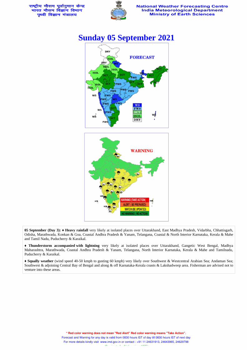
05 September (Day 3): ♦ Heavy rainfall very likely at isolated places over Uttarakhand, East Madhya Pradesh, Vidarbha, Chhattisgarh, Odisha, Marathwada, Konkan & Goa, Coastal Andhra Pradesh & Yanam, Telangana, Coastal & North Interior Karnataka, Kerala & Mahe and Tamil Nadu, Puducherry & Karaikal.
♦ Thunderstorm accompanied with lightning very likely at isolated places over Uttarakhand, Gangetic West Bengal, Madhya Maharashtra, Marathwada, Coastal Andhra Pradesh & Yanam, Telangana, North Interior Karnataka, Kerala & Mahe and Tamilnadu, Puducherry & Karaikal.
♦ Squally weather (wind speed 40-50 kmph to gusting 60 kmph) very likely over Southwest & Westcentral Arabian Sea; Andaman Sea; Southwest & adjoining Central Bay of Bengal and along & off Karnataka-Kerala coasts & Lakshadweep area. Fisherman are advised not to venture into these areas.
06 September (Day 4): ♦ Heavy to very rainfall likely at isolated places over Uttarakhand, Odisha, Marathwada and Konkan & Goa and heavy rainfall at isolated places over Uttar Pradesh, East Rajasthan, Madhya Pradesh, Vidarbha, Chhattisgarh, West Bengal & Sikkim, Gujarat Region, ghat areas of Madhya Maharashtra, Coastal Andhra Pradesh & Yanam, Telangana, Karnataka and Kerala & Mahe.
♦ Thunderstorm accompanied with lightning likely at isolated places over Uttarakhand, Gangetic West Bengal, Coastal Andhra Pradesh & Yanam, Telangana, Karnataka and Kerala & Mahe.
♦ Squally weather (wind speed 40-50 kmph to gusting 60 kmph) likely over Southwest & Westcentral Arabian Sea; North Bay of Bengal and along & off West Bengal coast; Southwest & adjoining Central Bay of Bengal and along & off Karnataka-Kerala coasts & Lakshadweep area. Fisherman are advised not to venture into these areas.
07 September (Day 5): ♦ Heavy to very rainfall likely at isolated places over ghat areas of Madhya Maharashtra, Marathwada and Konkan & Goa and heavy rainfall at isolated places over Himachal Pradesh, Uttarakhand, Haryana, Chandigarh & Delhi, West Uttar Pradesh, East Rajasthan, Madhya Pradesh, Vidarbha, Chhattisgarh, West Bengal & Sikkim, Odisha, Assam & Meghalaya, Nagaland, Manipur, Mizoram & Tripura, Gujarat state, Coastal Andhra Pradesh & Yanam, Telangana, Coastal Karnataka, ghat areas of South Interior Karnataka and Kerala & Mahe.
♦ Thunderstorm accompanied with lightning likely at isolated places over Jammu, Kashmir, Ladakh, Gilgit, Baltistan & Muzaffarabad, Himachal Pradesh, Uttarakhand, Punjab, Haryana, Chandigarh & Delhi, Uttar Pradesh, Rajasthan, Coastal Andhra Pradesh & Yanam, Telangana, Karnataka and Kerala & Mahe.
♦ Squally weather (wind speed 40-50 kmph to gusting 60 kmph) likely over Southwest & Westcentral Arabian Sea; along & off Gujarat-Maharashtra coasts; North Bay of Bengal and along & off West Bengal coast and along & off Karnataka-Kerala coasts & Lakshadweep area. Fisherman are advised not to venture into these areas.
Kindly download MAUSAM APP for location specific forecast & warning, MEGHDOOT APP for Agromet advisory and DAMINI APP for Lightning Warning & visit state MC/RMC websites for district wise warning.
* Red color warning does not mean "Red Alert" Red color warning means "Take Action". Forecast and Warning for any day is valid from 0830 hours IST of day till 0830 hours IST of next day
For more details kindly visit www.imd.gov.in or contact : +91 11 24631913, 24643965, 24629798 (Service to the Nation since 1875)

Table-1
* Red color warning does not mean "Red Alert" Red color warning means "Take Action". Forecast and Warning for any day is valid from 0830 hours IST of day till 0830 hours IST of next day
For more details kindly visit www.imd.gov.in or contact : +91 11 24631913, 24643965, 24629798 (Service to the Nation since 1875)
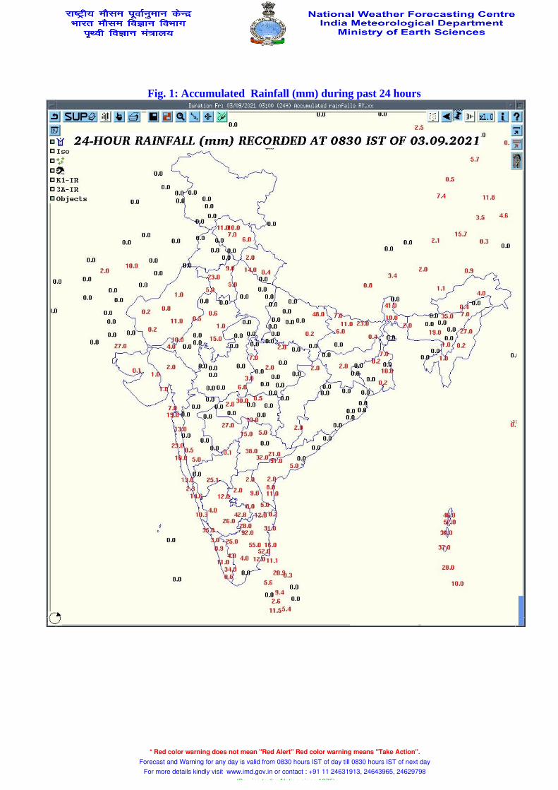
Fig. 1: Accumulated Rainfall (mm) during past 24 hours
* Red color warning does not mean "Red Alert" Red color warning means "Take Action". Forecast and Warning for any day is valid from 0830 hours IST of day till 0830 hours IST of next day
For more details kindly visit www.imd.gov.in or contact : +91 11 24631913, 24643965, 24629798 (Service to the Nation since 1875)

Fig. 2: Maximum Temperature during past 24 hours
* Red color warning does not mean "Red Alert" Red color warning means "Take Action". Forecast and Warning for any day is valid from 0830 hours IST of day till 0830 hours IST of next day
For more details kindly visit www.imd.gov.in or contact : +91 11 24631913, 24643965, 24629798 (Service to the Nation since 1875)
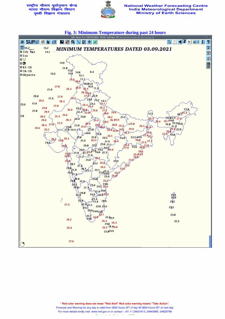
Fig. 3: Minimum Temperature during past 24 hours
* Red color warning does not mean "Red Alert" Red color warning means "Take Action". Forecast and Warning for any day is valid from 0830 hours IST of day till 0830 hours IST of next day
For more details kindly visit www.imd.gov.in or contact : +91 11 24631913, 24643965, 24629798 (Service to the Nation since 1875)

Fig. 4 : Departure from Normal of Maximum Temperatures
* Red color warning does not mean "Red Alert" Red color warning means "Take Action". Forecast and Warning for any day is valid from 0830 hours IST of day till 0830 hours IST of next day
For more details kindly visit www.imd.gov.in or contact : +91 11 24631913, 24643965, 24629798 (Service to the Nation since 1875)

Fig. 5 : Departure from Normal of Minimum Temperatures
* Red color warning does not mean "Red Alert" Red color warning means "Take Action". Forecast and Warning for any day is valid from 0830 hours IST of day till 0830 hours IST of next day
For more details kindly visit www.imd.gov.in or contact : +91 11 24631913, 24643965, 24629798 (Service to the Nation since 1875)

Friday 03 September 2021
03 September (Day 1): ♦ Heavy to very heavy rainfall very likely at isolated places over Coastal Andhra Pradesh & Yanam and Telangana and heavy rainfall at isolated places over Himachal Pradesh, Uttarakhand, Punjab, Haryana, Chandigarh & Delhi, northwest Rajasthan, West Uttar Pradesh, Madhya Pradesh, Chhattisgarh, Sub-Himalayan West Bengal & Sikkim, Andaman & Nicobar Islands, Assam & Meghalaya, Rayalseema, South Interior Karnataka Kerala & Mahe and Tamil Nadu, Puducherry & Karaikal.
♦ Thunderstorm accompanied with lightning very likely at isolated places over Himachal Pradesh, Uttarakhand, Punjab, Haryana, Chandigarh & Delhi, Uttar Pradesh, Rajasthan, Madhya Pradesh, Vidarbha, Chhattisgarh, Bihar, Jharkhand, Odisha, Gangetic West Bengal, Coastal Andhra Pradesh & Yanam, Assam & Meghalaya, Nagaland, Manipur, Mizoram & Tripura, Marathwada, Coastal Andhra Pradesh & Yanam, Telangana, Rayalaseema, South Interior Karnataka, Kerala & Mahe and Tamilnadu, Puducherry & Karaikal.
♦ Squally weather (wind speed 40-50 kmph to gusting 60 kmph) very likely over Southwest & Westcentral Arabian Sea; Gujarat coast and Southwest Bay of Bengal. Fisherman are advised not to venture into these areas.
* Red color warning does not mean "Red Alert" Red color warning means "Take Action". Forecast and Warning for any day is valid from 0830 hours IST of day till 0830 hours IST of next day
For more details kindly visit www.imd.gov.in or contact : +91 11 24631913, 24643965, 24629798 (Service to the Nation since 1875)

Saturday 04 September 2021
04 September (Day 2): ♦ Heavy to very heavy rainfall very likely at isolated places over Telangana and heavy rainfall at isolated places over Uttarakhand, Chhattisgarh, Odisha, Andaman & Nicobar Islands, Assam & Meghalaya, Coastal Andhra Pradesh & Yanam and Tamil Nadu, Puducherry & Karaikal.
♦ Thunderstorm accompanied with lightning very likely at isolated places over Uttarakhand, Madhya Pradesh, Vidarbha, Chhattisgarh, Bihar, Jharkhand, Odisha, Gangetic West Bengal, Madhya Maharashtra, Marathwada, Coastal Andhra Pradesh & Yanam, Telangana, Rayalaseema, Kerala & Mahe and Tamilnadu, Puducherry & Karaikal.
♦ Squally weather (wind speed 40-50 kmph to gusting 60 kmph) very likely over Southwest & Westcentral Arabian Sea; Andaman Sea and Southwest Bay of Bengal. Fisherman are advised not to venture into these areas.
* Red color warning does not mean "Red Alert" Red color warning means "Take Action". Forecast and Warning for any day is valid from 0830 hours IST of day till 0830 hours IST of next day
For more details kindly visit www.imd.gov.in or contact : +91 11 24631913, 24643965, 24629798 (Service to the Nation since 1875)
Sunday 05 September 2021
05 September (Day 3): ♦ Heavy rainfall very likely at isolated places over Uttarakhand, East Madhya Pradesh, Vidarbha, Chhattisgarh, Odisha, Marathwada, Konkan & Goa, Coastal Andhra Pradesh & Yanam, Telangana, Coastal & North Interior Karnataka, Kerala & Mahe and Tamil Nadu, Puducherry & Karaikal.
♦ Thunderstorm accompanied with lightning very likely at isolated places over Uttarakhand, Gangetic West Bengal, Madhya Maharashtra, Marathwada, Coastal Andhra Pradesh & Yanam, Telangana, North Interior Karnataka, Kerala & Mahe and Tamilnadu, Puducherry & Karaikal.
♦ Squally weather (wind speed 40-50 kmph to gusting 60 kmph) very likely over Southwest & Westcentral Arabian Sea; Andaman Sea; Southwest & adjoining Central Bay of Bengal and along & off Karnataka-Kerala coasts & Lakshadweep area. Fisherman are advised not to venture into these areas.
* Red color warning does not mean "Red Alert" Red color warning means "Take Action". Forecast and Warning for any day is valid from 0830 hours IST of day till 0830 hours IST of next day
For more details kindly visit www.imd.gov.in or contact : +91 11 24631913, 24643965, 24629798 (Service to the Nation since 1875)
Monday 06 September 2021
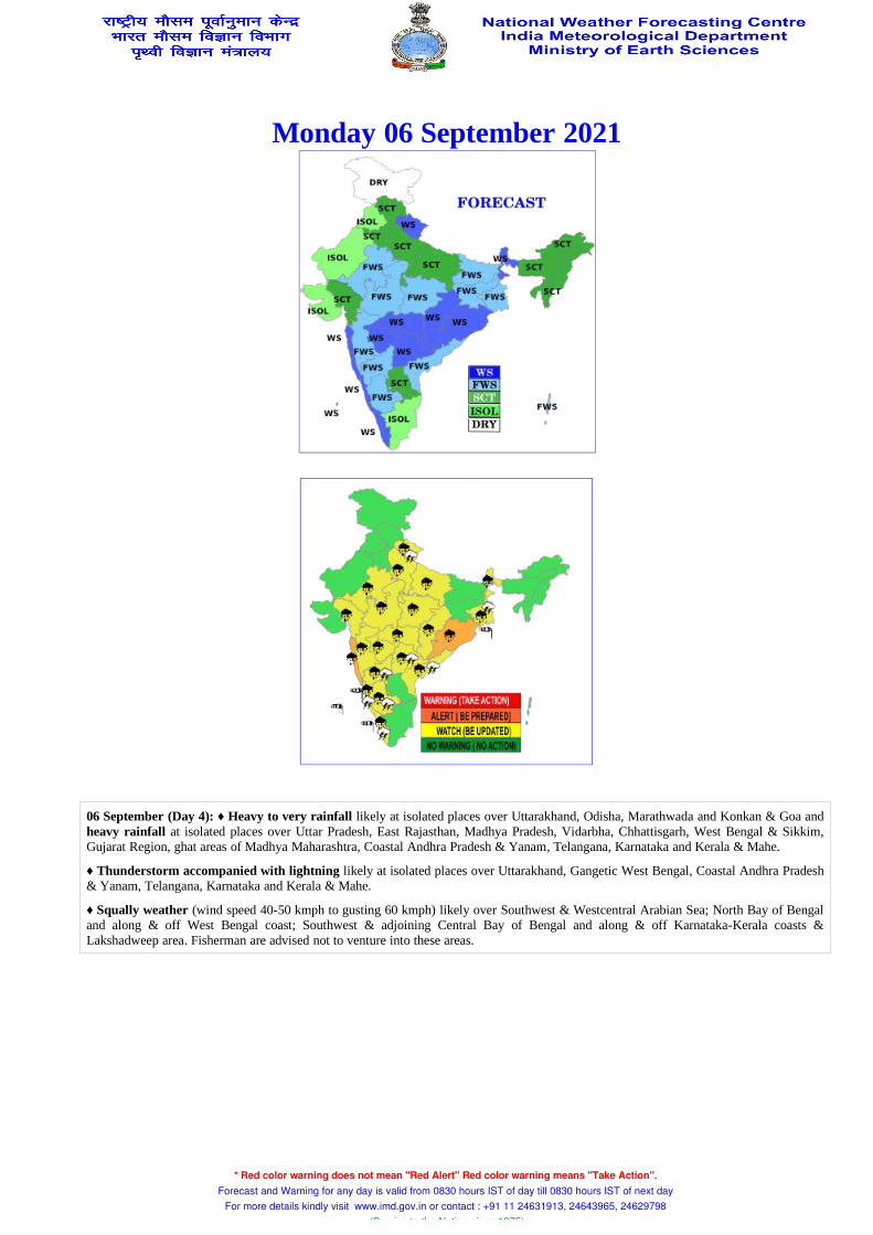
06 September (Day 4): ♦ Heavy to very rainfall likely at isolated places over Uttarakhand, Odisha, Marathwada and Konkan & Goa and heavy rainfall at isolated places over Uttar Pradesh, East Rajasthan, Madhya Pradesh, Vidarbha, Chhattisgarh, West Bengal & Sikkim, Gujarat Region, ghat areas of Madhya Maharashtra, Coastal Andhra Pradesh & Yanam, Telangana, Karnataka and Kerala & Mahe.
♦ Thunderstorm accompanied with lightning likely at isolated places over Uttarakhand, Gangetic West Bengal, Coastal Andhra Pradesh & Yanam, Telangana, Karnataka and Kerala & Mahe.
♦ Squally weather (wind speed 40-50 kmph to gusting 60 kmph) likely over Southwest & Westcentral Arabian Sea; North Bay of Bengal and along & off West Bengal coast; Southwest & adjoining Central Bay of Bengal and along & off Karnataka-Kerala coasts & Lakshadweep area. Fisherman are advised not to venture into these areas.
* Red color warning does not mean "Red Alert" Red color warning means "Take Action". Forecast and Warning for any day is valid from 0830 hours IST of day till 0830 hours IST of next day
For more details kindly visit www.imd.gov.in or contact : +91 11 24631913, 24643965, 24629798 (Service to the Nation since 1875)
Tuesday 07 September 2021
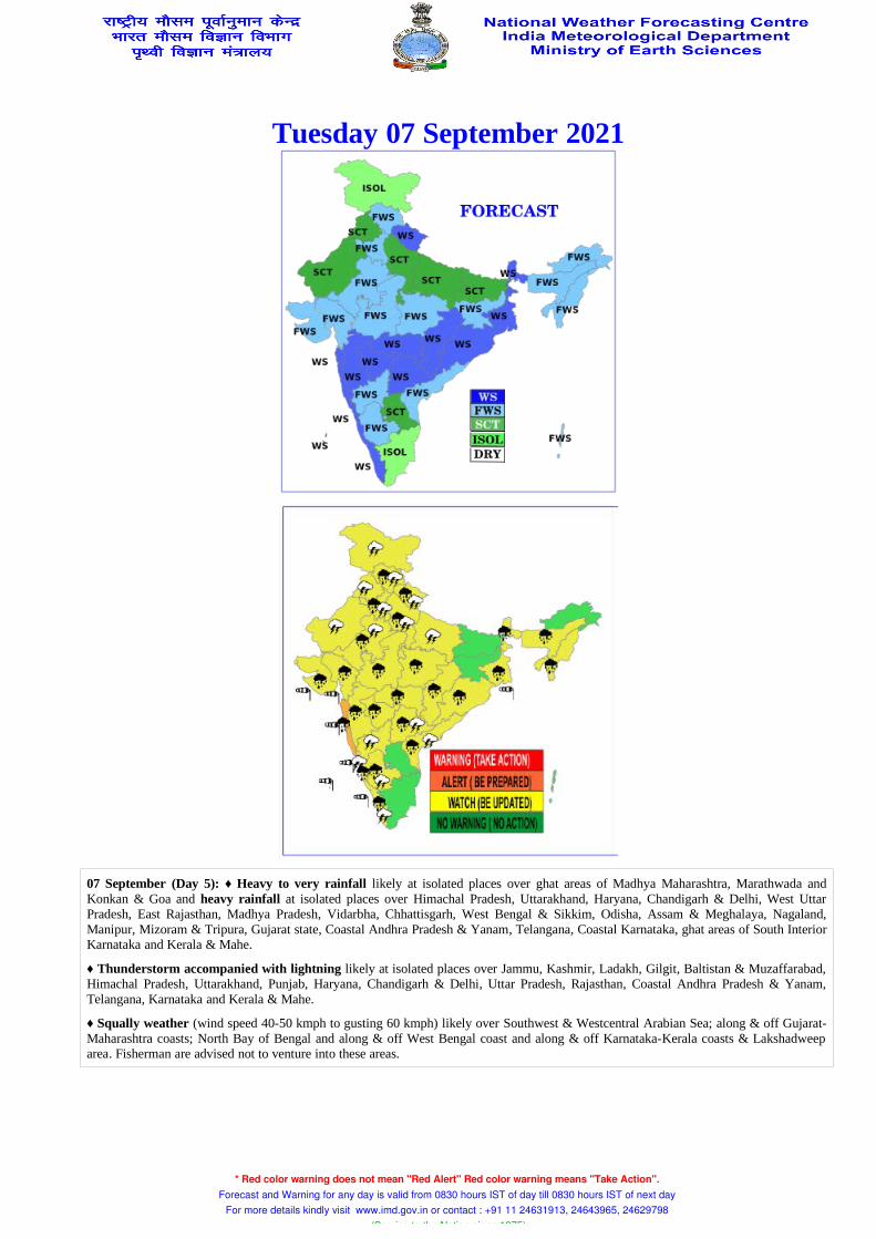
07 September (Day 5): ♦ Heavy to very rainfall likely at isolated places over ghat areas of Madhya Maharashtra, Marathwada and Konkan & Goa and heavy rainfall at isolated places over Himachal Pradesh, Uttarakhand, Haryana, Chandigarh & Delhi, West Uttar Pradesh, East Rajasthan, Madhya Pradesh, Vidarbha, Chhattisgarh, West Bengal & Sikkim, Odisha, Assam & Meghalaya, Nagaland, Manipur, Mizoram & Tripura, Gujarat state, Coastal Andhra Pradesh & Yanam, Telangana, Coastal Karnataka, ghat areas of South Interior Karnataka and Kerala & Mahe.
♦ Thunderstorm accompanied with lightning likely at isolated places over Jammu, Kashmir, Ladakh, Gilgit, Baltistan & Muzaffarabad, Himachal Pradesh, Uttarakhand, Punjab, Haryana, Chandigarh & Delhi, Uttar Pradesh, Rajasthan, Coastal Andhra Pradesh & Yanam, Telangana, Karnataka and Kerala & Mahe.
♦ Squally weather (wind speed 40-50 kmph to gusting 60 kmph) likely over Southwest & Westcentral Arabian Sea; along & off Gujarat-Maharashtra coasts; North Bay of Bengal and along & off West Bengal coast and along & off Karnataka-Kerala coasts & Lakshadweep area. Fisherman are advised not to venture into these areas.
* Red color warning does not mean "Red Alert" Red color warning means "Take Action". Forecast and Warning for any day is valid from 0830 hours IST of day till 0830 hours IST of next day
For more details kindly visit www.imd.gov.in or contact : +91 11 24631913, 24643965, 24629798 (Service to the Nation since 1875)