FOURTH FIVE-YEAR REVIEW REPORT FOR THE … · review reports. This document will ... silt, sand,...
36
FOURTH FIVE-YEAR REVIEW REPORT for THE GOOSE FARM SUPERFUND SITE PLUMSTED TOWNSHIP, OCEAN COUNTY, NEW JERSEY PREPARED BY: U.S. Environmental Protection Agency Region 2 New York, New York September 2013 Walter E. Mugdan, Director Date Emergency and Remedial Response Division 218212 llllllilllllillllll
-
Upload
hoangduong -
Category
Documents
-
view
215 -
download
2
Transcript of FOURTH FIVE-YEAR REVIEW REPORT FOR THE … · review reports. This document will ... silt, sand,...

FOURTH FIVE-YEAR REVIEW REPORT
for
THE GOOSE FARM SUPERFUND SITE
PLUMSTED TOWNSHIP, OCEAN COUNTY, NEW JERSEY
PREPARED BY:
U.S. Environmental Protection Agency Region 2
New York, New York
September 2013
Walter E. Mugdan, Director Date Emergency and Remedial Response Division
218212
llllllilllllillllll

TABLE OF CONTENTS
Executive Summary i i i
Five-Year Review Summary Form iv
I . Introduction 1
II . Site Chronology 1
III . Site Background 2
Geology/Hydrogeology 3
Land and Resource Use 4
History of Contamination 4
Initial Response 4
Basis for Taking Action 5
IV. Remedial Actions 5
Remedy Selection and Implementation 5
Institutional Controls Implementation 8
System Operations/Operation and Maintenance (O&M) 8
V. Progress Since the Last Review 10
VI. Five-Year Review Process 10
Community Notification and Involvement 11
Document Review 11
Data Review 11
Site Inspection 15
Interviews 16
VII. Technical Assessment 16
Question A: Is the remedy functioning as intended by the decision document? 16
Question B: Are the exposure assumptions, toxicity data, cleanup levels, and remedial action objectives used at the time of remedy selection still valid? 16
Question C: Has any other information come to light that could call into question the protectiveness of the remedy? 18
VIII. Issues 18
IX. Recommendations and Follow-up Actions 18
X. Protectiveness Statement 18
XI . Next Review 18
ii

Executive Summary
This is the fourth five-year review for the Goose Farm Superfund Site (site). The site is located in Plumsted Township, Ocean County, New Jersey. The site is being addressed in one phase or operable unit (OU1) covered by a 1985 Record of Decision (ROD). The ROD called for the extraction and treatment of contaminated groundwater, the re-injection of treated water into the aquifer, and flushing the soil using the treated water. The remedy was selected on the basis of its implementability and proven effectiveness in addressing the groundwater contamination. The remedial design (RD) was completed in August 1992. From September 1992 to April 1993 construction of the groundwater remediation system as well as the installation of the slurry wall occurred. The goal of groundwater remediation is to comply with applicable federal and state drinking water quality and other environmental standards for contaminants at the site. When this goal is reached, Environmental Protection Agency (EPA) will evaluate soils to determine the need to cap the site. A second component of the OU1 ROD was to remove polychlorinated biphenyls (PCB) contaminated soils. All contaminated soils were removed by July 1989.
Based upon a review of the ROD, a number of site-related reports prepared by the Potentially Responsible Party (PRP), and the site inspection, it has been concluded that the remedy at the site is protective of human health and the environment.
iii

Five-Year Review Summary Form
SITE IDENTIFICATION
Site Name: Goose Farm Superfund Site
EPA ID: NJD980530109
Region: 2 State: N.J. City/County: Plumsted Township, Ocean County
NPL Status: Final
Multiple OUs? No
Has the site achieved construction completion? Yes
Lead agency: EPA If "Other Federal Agency" was selected above, enter Agency name: Click k-iv : < com
text.
Author name (Federal or State Project Manager): Trevor Anderson
Author affiliation: EPA Region 2
Review period: September 25, 2008 - June 30, 2013
Date of site inspection: May 02, 2013
Type of review: Policy
Review number: 4
Triggering action date: September 25, 2008
Due date (five years after triggering action date): September 25, 2013
iv
Five-Year Review Summary Form (continued)
Issues/Recommendations
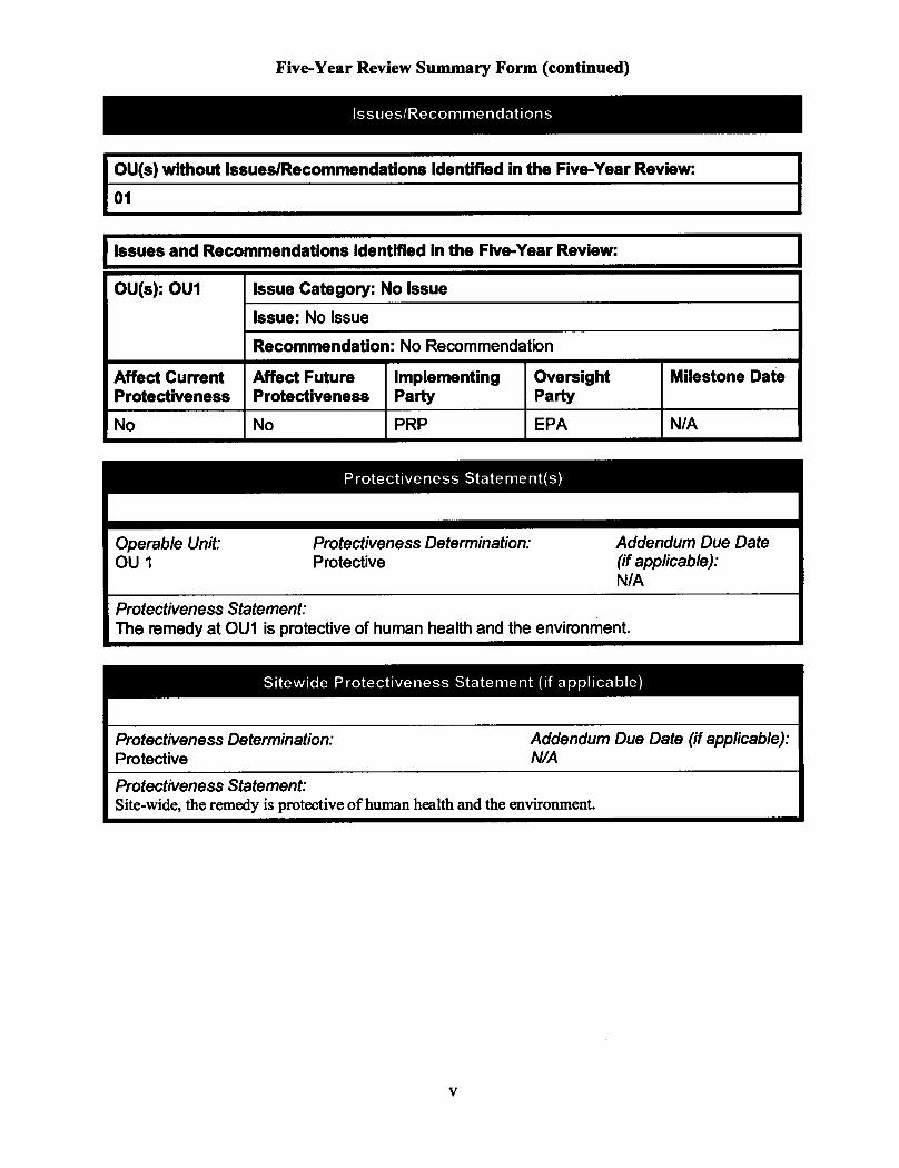
OU(s) without Issues/Recommendations Identified in the Five-Year Review:
01
Issues and Recommendations Identified in the Five-Year Review:
OU(s): OU1 Issue Category: No Issue OU(s): OU1
Issue: No Issue
OU(s): OU1
Recommendation: No Recommendation
Affect Current Protectiveness
Affect Future Protectiveness
Implementing Party
Oversight Party
Milestone Date
No No PRP EPA N/A
Protectiveness Statement(s)
Operable Unit: OU 1
Protectiveness Determination: Protective
Addendum Due Date (if applicable): N/A
Protectiveness Statement: The remedy at OU1 is protective of human health and the environment.
Sitewide Protectiveness Statement (if applicable)
Protectiveness Determination: Addendum Due Date (if applicable): Protective N/A
Protectiveness Statement: Site-wide, the remedy is protective of human health and the environment.
v

Five-Year Review Report
I . Introduction
This is the fourth five-year review for the site. This five-year review was conducted by Trevor Anderson, EPA remedial project manager (RPM). This review was conducted in accordance with the Comprehensive Five-Year Review Guidance, OSWER Directive 9355.7-03B-P (June 2001). The purpose of a five-year review is to determine whether the remedy at a site is protective of human health and the environment and functions as intended by the decision documents. The methods, findings, and conclusions of reviews are documented in five-year review reports. This document will become part of the site file.
The site is addressed in one phase or operable unit (OU1) covered by a ROD. The OU1 remedy included: excavation and treatment/disposal of all soil with PCB contamination; installation and operation of a groundwater extraction, treatment and re-injection system The PCB contaminated soil was removed by July 1989. The groundwater extraction and treatment system was completed in 1993 and has been operating since. This fourth five-year review is a policy review. The triggering action for the first five-year review was the issuance of the Preliminary Close-out Report in June 1993. In September 1998, EPA completed the first five-year review for the site. In September 2003, EPA completed a second five-review. In September 2008, EPA completed a third five-review.
II. Site Chronology
Table 1, below, summarizes site-related events from discovery to present operation and maintenance activities:
Table 1: Chronology of Site Events
Events Date
Hazardous waste disposal site 1940 to 1970
The Plumsted Township Sheriffs office informed the New Jersey Department of Environmental Protection(NJDEP) of the existence of the site
1980
Removal activities - NJDEP removed several containers of waste 1980
Interim remedial activities - collection and treatment of groundwater and the excavation and disposal of contaminated soil
1980
The termination of the groundwater collection and treatment system 1981
Final listing on the National Priorities List 1983
Remedial investigation/feasibility study (RI/FS) was conducted by NJDEP 1982-1985
RI/FS was issued to public 1985
1

Table 1: Chronology of Site Events
Events Date
EPA issued ROD 1985
Potential responsible party (PRP) signed Consent Decree to conduct the remedial activities
1988
PRP submits draft design report to EPA 1990
EPA approved design report 1992
Construction of groundwater pump and treat system began 1993
Operation of the groundwater treatment plant began 1993
EPA completed first five year review 1998
Second five year review 2003
PRP completes comprehensive soil and groundwater sampling event. Installed new groundwater monitoring wells, and developed the water budget.
2005
Third five year review 2008
PRP completes sediment and surface water sampling event 2010
PRP completes hydraulic gradient study 2012
III. Site Background
Physical Characteristics
The site is located on Block 58, Lots 1 and 12, and Block 46, Lot 1 in the Township of Plumsted, New Jersey. The site is located approximately two miles northeast of the town of New Egypt in Plumsted Township, Ocean County, New Jersey (see Figure 1). The site lies approximately one mile north of the intersection of County Routes 528 and 539. Approximately 1.1 acres of the 6.6 acres is currently undergoing groundwater remediation. The site is located adjacent to an intermittent stream which is a tributary of Lahaway Creek. The site is owned by the PRP, Morton International, Inc., a wholly owned subsidiary of Rohm & Haas, which is currently a wholly owned subsidiary of The Dow Chemical Company.
2

Geology/Hydrogeology
The site contains little vegetation and is gently sloping toward the north at about four percent. The site is well drained and is located adjacent to a pine/oak forest and a small stream which flows north into the Lahaway Creek which is a tributary of Crosswicks Creek and the Delaware River. Surface elevations range from approximately 100-115 feet above sea level near the streams to 120-150 feet above sea level further upland.
Groundwater is used for the potable water supply throughout Plumsted Township and the surrounding area. Hornerstown is served by private wells, while New Egypt is served by the New Egypt Water Company. Regional groundwater at the site flows to the north-northwest.
The site is located in the Atlantic Coastal Plain physiographic province. This province is characterized by unconsolidated deposits consisting of alternating layers of clay, silt, sand, and gravel that dip gently to the southeast and outcrop at the surface in generally parallel northeast-southwest striking bands. The Kirkwood Formation and the Vincentown Formation outcrop in the area around the site. Other regional units that could lie beneath the site include the Manasquan and Hornerstown formations.
Two major hydro-stratigraphic units were observed during the investigation of the site: a surficial aquifer that extends to a depth of 45 feet at the northwest side and 75 feet at the southeast side of the site and a confining unit, which underlies the surficial aquifer.
The surficial aquifer contains an upper and a lower unit, which are separated by a semi-confining unit that ranges in thickness from about 4 to 6 feet. The upper unit of the surficial aquifer is typically composed of fine sand with some medium sand and some silt. The uppermost 3 to 5 feet of the upper unit is not fully saturated. The thickness of the upper unit varies across the site from about 30 to 50 feet. A local silt layer consisting of micaceous silt, fine sand, and clay is present in the upper unit in the southern portion of the site at depths of about four (4) feet to 14 feet below the ground. This local silt layer decreases in thickness from 14 feet at the southern edge of the site until it pinches out at the center of the site.
The underlying semi-confining unit consists of cemented fine sand, silty clayey sand, and calcareous clay, and is differentiated from the upper unit by its increase in percentage of fines and an increase in cementation. However, the bottom of the upper unit contains varying percentages of fines and is partially cemented in discrete layers as well. The presence of the discrete layers of cemented sand at the bottom of the upper unit is significant in that the areas of cemented sand will have a lower hydraulic conductivity than areas with noncemented sand.
The lower unit of the surficial aquifer is typically partially cemented fine sand with some silt. A layer of abundant shells marks the contact between the lower unit and the underlying confining unit.
The confining unit beneath the site consists of glauconitic fine sand, clayey sand, and clay. Lab testing of clay from the clay beds indicates a vertical hydraulic conductivity of 1 x 10"8
centimeters per second.
3

Groundwater in the upper unit at the site contains organic and inorganic constituents. The semi-confining unit hinders vertical groundwater flow and retards the transport of organic compounds from the upper into the lower unit. Site remediation is focused on the upper unit and the groundwater in both the upper and lower units of the surficial aquifer is monitored.
A slurry wall was constructed around the area of contamination. As indicated in the 1988 Consent Decree, the goal is to maintain an inward hydraulic gradient (water level is higher outside than inside) across the slurry wall and not to contain subsurface contamination. A network of recovery wells within and outside the wall is pumped to extract and treat the groundwater.
Land and Resource Use
The site lies in a rural area characterized predominantly by agricultural land use and low density residential development. Residential homes lie within one-quarter mile of the site and rely on private wells for potable water. Other significant types of land use in the vicinity of the site include the Great Adventure Amusement Park, Fort Dix, McGuire Air Force Military Base, and the Collier Mills Wildlife Management Area. The most highly developed area in the vicinity of the site is New Egypt, which is located approximately 2.5 miles southwest of the site. Hornerstown is located approximately one mile northwest of the site.
History of Contamination
The site was used as a hazardous waste disposal site from the mid 1940's to the mid 1970's by Morton Thiokol Chemical Company, a manufacturer of polysulfide rubber and solid rocket fuel propellant. Morton Thiokol Chemical Company was later known as Morton International, Inc., a wholly owned subsidiary of Rohm & Haas Chemical LLC, which in turn, is currently a wholly owned subsidiary of The Dow Chemical Company. The majority of wastes were dumped into a pit dug through the fine sand. The dimensions of the pit were approximately 100 by 300 and 15 feet deep. Lab packs, 55 gallon drums, and bulk liquids were dumped into this pit.
Initial Response
In January 1980, during an investigation of pesticide contamination of local potable wells, the Plumsted Township sheriffs office informed the NJDEP of the existence of the site as well as several other disposal sites in the area. From February to June 1980, the NJDEP conducted an investigation of the site. The investigation included the installation and sampling of 17 groundwater monitoring wells, and metal detection and resistivity surveys. The results of this work indicated that a contaminated plume of organic and inorganic compounds, which originated from the waste pit area, was migrating northwards toward the nearby stream. During the next phase of the investigation, NJDEP installed and sampled 34 additional wells. The data indicated that the contaminated plume was less than 140 feet wide and approximately 35 feet deep.
4

In September 1980, the NJDEP initiated remedial activities at the site in an attempt to prevent the further migration of the plume to the nearby stream Approximately 5,000 containers of waste were removed from the waste pit area as well as an estimated 9,000 gallons of bulk liquids. These wastes were disposed of off-site. In addition, NJDEP installed a well-point collection and spray irrigation system downgradient of the waste pit area and upgradient of the stream Following the collection and treatment of the groundwater, the effluent was re-injected into the aquifer. In March 1981, NJDEP terminated the flushing and treatment system During its operation, the system treated approximately 7,800,000 gallons of contaminated groundwater. The final component of the interim remedy included the excavation and disposal of contaminated soil from the waste pit areas. Approximately 3,500 tons of soil and an additional 12 drums of PCB waste were transported to an off-site facility for disposal.
Basis for Taking Action
The site was placed on the National Priorities List in September 1983. The RI/FS was initiated at the site by NJDEP to determine the nature and extent of the groundwater and soil contamination at the site. The RI/FS was completed in 1985. The RI/FS concluded that the groundwater and the soil at the site remained contaminated with significant levels of organic and inorganic contaminants. After reviewing the ROD, in 1989, the Agency for Toxic Substances and Disease Registry (ATSDR) conducted a human health assessment at the site. ATSDR concluded that there is the possibility that the human population near the site may be exposed to site related contaminants via dermal, inhalation, and oral exposure. The ATSDR report indicated that the remedial action proposed by the ROD should be protective of public health.
I V . Remedial Actions
Remedy Selection and Implementation
On September 27, 1985, EPA issued a ROD to address groundwater and soil contamination at the site. Data collected during the RI/FS were used to develop the remedial objectives for the site. The remedial objectives for the site were divided into two groups:
Source Control Response Objectives:
• Remove, treat or contain contaminants. • Control general migration pathways. • Control release of volatile compounds in air. • Control water infiltration. • Control soil erosion. • Control direct contact.
5

Management of Migration Response Objectives:
• Mitigate the potential contamination of potable water supplies.
• Prevent the movement of contaminants to other areas where exposure to these compounds through direct contact may occur.
The major components of the remedy selected in the ROD include the following:
• Groundwater extraction, treatment and reinjection. Reinjection of treated groundwater on site will result in soil flushing;
• Following groundwater recovery and treatment, and soil flushing, conduct an extensive testing program to determine the need to cap the site; and
• During and after groundwater recovery and treatment activities and soil flushing, conduct an extensive testing program to determine the extent of PCB contamination in the former drum pit area. Based on this program, determine the need, i f any, to remediate PCB-contaminated soil
Remedy Implementation
In a Consent Decree (CD) issued on July 22, 1988, Rohm & Haas agreed to undertake the remedial design/remedial action (RD/RA) for the site. The RD was conducted in conformance with the ROD and the Scope of Work (SOW), which was included in the CD.
The CD and the attached SOW specified that Rohm & Haas would undertake the following actions to implement the selected remedy for the site:
1. Excavate and treat and/or dispose of all soils with total PCB concentrations greater than, or equal to, 5 parts per million (ppm) and backfill the excavation with soil that contains less than 1 ppm PCBs;
2. Install and operate a groundwater extraction, treatment and reinjection system to provide soil flushing, and if feasible, utilize in-situ biological reclamation to enhance treatment and removal of contaminants;
3. Treat extracted groundwater using methods such as air stripping and vapor phase carbon adsorption to remove volatile organic compounds (VOCs);
4. Manage recovered groundwater which is not re-injected, i f any, in a lawful manner; and
5. Operate the soil flushing system as prescribed by the SOW.
6

In addition, since Rohm & Haas decided to install a slurry wall around the contaminated groundwater, the following provisions regarding the construction and maintenance of the slurry wall were added to the SOW:
1. Construct a slurry wall approximately 2,000 feet long and about 65 feet deep which will circumscribes the area of contaminated soil and the groundwater plume;
2. Circulate the groundwater within the slurry wall at a rate of about 35 gallon per minutes or at a rate necessary to maintain an inward hydraulic gradient to provide soil flushing and in-situ biological reclamation (or its approved equivalent);
3. Inward (higher outside than inside) hydraulic gradient shall be maintained across the slurry wall; and
4. Address and remediate, as necessary, any monitoring wells found outside the slurry wall with site related contaminants above established groundwater levels.
The site cleanup was conducted in two phases. The first phase included the excavation and off-site disposal of all soils containing concentrations of PCBs equal to or greater than 5 ppm from the former drum pit area. This work began in November 1988 and concluded in July 1989. Approximately 9,000 cubic yards of soil were removed and disposed of at an off-site facility.
The second phase of cleanup included the design, construction, and operation of a groundwater extraction, treatment and soil flushing system, and the evaluation of the use of in-situ biodegradation to enhance the efficiency of the soil flushing/groundwater treatment system.
From December 1989 to September 1990, as part of the second phase of the cleanup, Rohm & Haas conducted pre-design field investigations including groundwater, soil and surface water sampling. A treatability study was conducted to detennine if in-situ biodegradation was a viable option for enhancing the efficiency of the soil flushing/groundwater treatment system The study indicated in-situ biodegradation was not an appropriate technology for addressing groundwater contamination at the site. The RD was completed in August 1992. The design called for the installation of 41 groundwater extraction wells, a groundwater treatment system, which included an equalization tank, air stripper, carbon adsorption tanks, a thermal oxidizer, infiltration trenches to provide for soil flushing, and a slurry wall.
From September 1992 to April 1993, Rohm & Haas undertook the construction of the groundwater remediation system under EPA oversight. During this period, the installation of the slurry wall was completed. The purpose of the slurry wall is to facilitate the soil flushing portion of the remedy and not to contain the subsurface contamination. The slurry wall is keyed into the semi-confining unit found at a depth of 30 to 45 feet below the ground surface. A relatively small area of contaminated groundwater in the northeastern portion of the site remained outside of the slurry wall due to its proximity to wetlands and the topography, which includes a steep slope down to the unnamed stream Approximately 41 groundwater extraction wells were installed.
7

Thirty-seven (37) wells were installed within the slurry wall area and four were installed outside the slurry wall in the northeastern portion of the site. In addition, a groundwater treatment plant was constructed to treat the contaminated groundwater. Four infiltration trenches were constructed, two located inside the area enclosed by the slurry wall, and two located in areas outside and to the north and west of the slurry wall. The infiltration trenches were constructed to re-infiltrate the treated water into the aquifer.
In June 1993, the site achieved construction completion status upon the issuance of the Preliminary Close-out Report and commencement of the groundwater remediation system. EPA and the state detennined that the RA construction activities were completed in accordance with the design specifications.
Following completion of groundwater remediation, a sampling program including a risk assessment will be performed to determine the need for any additional soil removal or installation of a cap.
Institutional Controls Implementation
The CD established institutional controls for the site. The CD required the PRP to record a copy of the CD with the County Clerk office in Ocean County, New Jersey to prevent actions at the site that would be considered inconsistent with the remedy. The CD was recorded in 1988. The CD also indicated that PRP would immediately record a deed restriction, if requested by EPA. The installation of a gate and fencing around the site prevent access. In addition, the site is designated as a Currently Known Extent site by NJDEP. This designation restricts the drilling of potable wells within the boundaries of the slurry wall.
System Operations/Operation and Maintenance (O&M):
Rohm & Haas has been operating the groundwater extraction, treatment and reinjection system and conducting long-term monitoring and maintenance activities according to the operation and maintenance (O&M) plan that was approved by EPA in April 1993. The primary activities associated with O&M include the following:
• Monitor, observe, and evaluate the distribution and migration of contaminants in groundwater, and to assess the ongoing performance of the treatment system;
• Collect and analyze groundwater and treatment plant discharge for VOCs; and,
• Monitor the hydraulic gradient across the slurry wall and evaluate the effectiveness of the slurry wall.
Water level measurements, and groundwater and surface water samples are collected semiannually. The semi-annual sampling events include the collection of groundwater samples from approximately 38 groundwater monitoring and recovery wells at the site. The monitoring program allows for some flexibility in the number of wells to be sampled. Surface water samples are collected from three locations in the unnamed stream. In addition, water level measurements
8

are collected from 31 piezometers and wells both inside and outside the slurry wall. The water level data are used to calculate the horizontal and vertical hydraulic gradients across the slurry wall.
In addition, inspection of the slurry wall, security fence, piezometers, groundwater monitoring and recovery wells, infiltration trenches, and treatment plant are conducted quarterly. These visual inspections involve walking around the site and inspecting each component of the remedy to determine if they are in good working condition. In addition to site inspections, recovery wells are electronically connected to the treatment plant computerized system which can detect indications that recovery wells are not functioning as intended and are in need of repair. Recovery wells are replaced or repaired on a regular basis. For example, in 2012, three (3) recovery wells were replaced or repaired.
During its operation, a number of modifications have been made to improve the effectiveness and efficiency of the remedy. In 1994, Rohm & Haas completed the installation of a 1,800 gallon pre-treatment tank placed before the equalization tank to reduce iron fouling of the air stripper. In addition, since it was determined that the air discharge stream from the air stripper would meet the NJDEP's air discharge permitting requirements without additional treatment, Rohm & Haas discontinued using the thermal oxidizer in 1998.
In 2003, Rohm & Haas upgraded the software and hardware within the treatment plant which control the air stripper and recovery wells. The portable air monitor was also replaced with an air monitor that is permanently affixed to the air stripper. The new air monitor transmits air quality data directly from the air stripper to the plant's computerized control system Also, over the years, as part of O&M activities, additional groundwater monitoring wells and piezometers were installed to address data gaps. Six additional wells were installed in 2003 and one additional monitoring well was installed in 2008. Currently, there are 55 groundwater monitoring wells, 21 piezometers, and 41 recovery wells (four (4)) of these recovery wells are located outside of the slurry wall) at the site (see Figure 2).
The groundwater treatment plant has treated a total of 381 million gallons of contaminated groundwater since it began operating in 1993. In addition, total concentrations of organic contaminants in groundwater have declined from an average concentration of 54,000 parts per billion (ppb) in 1993 to an average of 1,918 ppb in 2012. The yearly maximum and minimum influent concentrations are depicted in Figure 2b. The O&M costs for the past five years are provided in Table 5.
The groundwater extraction system and treatment plant were designed to handle groundwater at an average flow rate of 107.5 gallon per minutes (gpm) with a maximum of 150 gpm During the start of plant operations, it was determined that the aquifer could not provide sufficient groundwater yield to meet this goal. In 2012, the average flow rate of groundwater through the treatment plant was 12 gallon per minutes (gpm).
9

V. Progress Since the Last Review
The last five-year review identified one follow-up action to be performed at the site. This action indicated that EPA would evaluate the potential exposure pathway from the past migration of PCBs to sediments of the unnamed stream near the site and an associated pond. EPA will perform an inspection of the area and determine i f sediment sampling is warranted. Note that no PCBs are currently migrating from the site to the stream, however, there was a potential for this to have occurred in the past, prior to soils remediation that took place in the 1980's.
In 2009, Rohm & Haas was requested to collect sediment samples from six (6) locations along the unnamed stream for a distance of approximately 0.9 miles from the site. The sampling event was completed in 2010. No PCBs or any of the other site-related contaminants were detected in the stream As a result, EPA has concluded that the potential exposure pathway from the past migration of PCBs to sediments of the unnamed stream near the site and an associated pond did not occur at the site.
Rohm & Haas is conducting routine O&M activities and adjustments are made on an on-going basis as needed. As part of O&M activities to address the hydraulic control issues at the site, EPA has requested that Rohm & Haas install a new monitoring well in the area outside the northeast portion of the slurry wall, collect monthly water level measurements from all wells at the site, and discharge all treated water to the trench located outside of the slurry wall.
In 2007, EPA directed Rohm & Haas to discharge all treated water to trenches located outside the slurry wall area for a period of one (1) year, collect monthly water levels measurements from all wells and piezometers, install a new monitoring well in the northeastern corner of the slurry wall, and to collect groundwater samples from all piezometers and monitoring and recovery wells located outside the slurry wall. The groundwater samples were to be collected during the semi-annual groundwater sampling events. In addition, following the conclusion of this one-year period, Rohm & Haas was requested to submit a report summarizing the data and information that was collected during the study. In 2012, Rohm & Haas completed the study and submitted the requested report.
Finally, visual inspections of the wetlands in the vicinity of the site were discontinued in 2011. The January 2011 Historical Data Review Report that was submitted by the PRP indicated that the adjacent wetlands have not been impacted by the site, slurry wall, and the groundwater treatment system.
V I . Five-Year Review Process
For this five-year review, the review team consisted of Trevor Anderson (EPA-Remedial Project Manager (RPM)), Charles Nace (EPA-Risk and Ecological Assessor), Kathryn Flynn (EPA-Hydro-geologist), and Wanda Ayala, (EPA, Community Involvement Coordinator).
10

Community Notification and Involvement
On February 07, 2013, five-year review notices were sent to the following site repositories located in the vicinity of the site: the Ocean County Library-Toms River, the Ocean County Library-Plumsted Branch, and the Plumsted Township Municipal Building. The notices indicated that EPA would be conducting a fourth five-year review of the remedy for the site to ensure that the implemented remedy remains protective of public health and the environment and is functioning as designed. The notices also indicated that once the five-year review is completed, the results will be made available in the site repository at the facility. In addition, the RPMs address, telephone number, and e-mail address were provided for questions from the community related to the five-year review process or the Goose Farm Superfund site. The EPA RPM was not contacted by any members of the community regarding this five-year review.
Document Review
This five-year review consisted of a review of the relevant documents including O&M and maintenance records and monitoring data. Applicable ROD cleanup standards were reviewed as well as current groundwater cleanup standards. The documents, data, and information that were reviewed in completing this fourth five-year review are summarized in Attachment A.
Data Review
Groundwater, soil flushing, surface water, sediment, and wetlands data associated with the selected remedy for the site were reviewed during the five-year review process. Although, not an element of the selected remedy for the site, hydraulic gradient and 1,4-dioxane data were also reviewed. The results of these reviews are provided below.
Groundwater Monitoring
The groundwater is classified by NJDEP as a potable aquifer, indicating a potential drinking water source. Currently, the groundwater at the site is not being used for ingestion and the exposure pathway has been interrupted by the installation of a gate and fencing. Groundwater samples are collected semi-annually and are analyzed for VOCs and S VOCs. In addition to piezometers, groundwater samples are collected from recovery and monitoring wells located both inside and outside of the slurry wall areas of the site.
Overall, the concentration of organic constituents found in the groundwater entering the treatment plant has been declining since the startup of the groundwater remediation system. However, there was a slight increase in the mean monthly influent contaminant concentrations between 2008 and 2012. In 2008, the year of the last five-year review, the mean monthly influent contaminant concentration level was 992 ppb. In 2012, the mean monthly influent contaminant concentration level was 1,918 ppb. This increase is expected, as areas of highly contaminated groundwater moves to the recovery wells for capture and treatment. Table 4 provides a list of chemicals that were detected at elevated concentrations in the groundwater over the last five years and the corresponding drinking water standards. Benzene and toluene are responsible for
11

the increase in the mean monthly influent concentrations in 2012. These contaminants are detected most frequently and at the highest concentrations of any other contaminants entering the treatment plant.
While the groundwater shows an overall downward trend in contamination over time, there are a number of recovery wells located in the area of the former waste pit which are showing an upward trend in contamination. This upward trend in groundwater concentrations is expected and is a clear indication that the treatment system is effectively removing and treating the contaminated groundwater, as the discharge from the treatment system are meeting clean-up goals.
The slurry wall was installed to facilitate the soil flusliing portion of the remedy and not to contain subsurface contamination. The slurry wall that was constructed at the site surrounds most of the groundwater contaminant plume and is keyed into a semi-confining unit at a depth that varies between approximately 35 to 50 feet below ground surface. Due to topography, a portion of the groundwater plume in the northeast portion of the site was not enclosed within the slurry wall and four (4) recovery wells present at the site are located in this area. During the last groundwater sampling event held in October 2012, levels of total volatile contaminants in these four recovery wells outside the slurry wall met cleanup goals established for the site (see Figure 3, 4, 5, and 6). In fact, no site-related contaminants were detected above cleanup standards anywhere outside the slurry wall areas of the site. Although the slurry wall was not installed to contain the subsurface contamination, groundwater data collected from outside the slurry wall area of the site indicates that the slurry wall is working with the groundwater treatment system to prevent the migration of the contaminated groundwater plume to areas unaffected by the site contamination.
The groundwater data collected in October 2012 indicates that the groundwater remedy is effectively capturing contaminated groundwater. However, there are areas within the slurry wall where the groundwater contamination remains above current state and federal drinking water standards. These areas include the former waste source area and in the central portion of the site. As stated above, the recovery well system is effective in preventing the migration of contaminated groundwater to areas outside the slurry wall, which is an indication the remedy is functioning as intended by the decision document.
Soil Flushing
The 1985 ROD indicates that during and after groundwater recovery and treatment activities and soil flushing, an extensive testing program should be conducted to determine the extent of PCB contamination in the former waste pit area and based on this program determine if there is a need to remediate residual PCB-contaminated soil. The August 2003 soil sampling event was conducted to determine the extent of PCB contamination in the former drum pit area and to determine if there is a need to remediate the soil. Rohm & Haas collected a total of 91 soil samples from 30 soil borings from within the slurry wall area of the site.
12

The soil sampling event was completed in February 2005. The data indicated that although some residual soil contamination remains at the site, the levels and frequency of detected contaminants do not indicate gross or widespread soil contamination. Based on the data, EPA concluded that there are no immediate risks presented by site soils, as the site is not being used for residential or industrial purposes and is owned by the PRP, who is using it for the sole purpose of implementing the remedy.
As previously discussed, in order to address concerns regarding the periodic loss of hydraulic control in the northeastern portion of the site, the discharge of all treated groundwater is currently taking place outside of the slurry wall. The decision to discharge all treated groundwater outside of the slurry wall was made because the soil met cleanup goals, which indicated that the soil flushing component of the remedy is no longer needed to facilitate the cleanup of the site soil.
Surface Water Monitoring
The O&M plan for the site requires the collection of surface water samples from three locations (SW-1, SW-2, and SW-3) along the small stream (Figure 2). Since the stream is intermittent and frequently dry, samples are usually collected when there is water in the stream. SW-1 and SW-2 are located in the vicinity of the northeastern portion of the site and SW-3 is located about 120 feet southeast and just before the boundary of the site outside the fence. A review of surface water data collected in 2012 reveals the presence of two organic constituents (acetone and 2-butanone). Since both compounds are common laboratory contaminants, EPA believes that the detection of these contaminants in the surface water is related to sampling procedures or laboratory techniques and do not represent surface water quality at the site.
Wetlands
A long-term wetland monitoring program was developed to assess the effects of groundwater withdrawal system on the adjacent wetlands. Over the years, no significant impacts to the wetlands were ever observed and in 2011, visual inspections of the wetlands in the vicinity of the site were discontinued.
Hydraulic gradient
The periodic loss of hydraulic controls over the northeastern portion of the slurry wall is well documented in previous five-year reviews. As indicated in the SOW in the CD an inward and upward groundwater gradient with respect to the slurry wall should be maintained. Also, the CD indicated that the purpose of the slurry wall is to facilitate the soil flushing portion of the remedy and not to contain subsurface contamination. In addition, any groundwater contamination found outside the slurry wall would be addressed and remediated, as needed, by the four (4) outside recovery wells. While there has been periodic loss of hydraulic control over this portion of the slurry wall, it should be noted that no site-related groundwater contaminants have ever been
13

detected in monitoring and recovery wells, and piezometers outside the boundaries of the slurry wall. Groundwater monitoring and recovery wells located outside slurry wall are monitored semi-annually and remain un-impacted. Therefore, this issue has not affected the protectiveness of the remedy.
As stated in previous five-year reviews, a combination of factors is believed to be causing the periodic loss of hydraulic control over this portion of the slurry wall. The combination of concurrent groundwater extraction on both sides of the slurry wall, along with contributions to the shallow groundwater table from the reinjection of treated groundwater to trenches located within the slurry wall as well as precipitation and seasonal fluctuations in water level are all factors contributing to the situation. In addition, since the slurry wall could not be constructed around the edge of the plume (due in part to the steep sloping of the topography to the unnamed stream), inward gradient has been difficult to maintain in this area.
The 2008 five-year review indicated soil data collected in August 2003 shows that the levels of soil contamination meets site cleanup goals and site soils presented no immediate risks to residents. In addition, the groundwater data indicated that all monitoring and recovery wells located outside the slurry wall are not impacted by the site. Based on this information and in an attempt to determine if soil flushing is responsible for the periodic loss hydraulic control in the northeastern section of the slurry wall, in 2007, EPA temporarily suspended the soil flushing portion of the remedy. Specifically, Rohm & Haas was required to discharge all treated water to trenches located outside the slurry wall area for a period of one (1) year, collect monthly water levels measurements from all wells and piezometers, install a new monitoring well in the northeastern corner of the slurry wall, discontinue the extraction of groundwater from outside recovery wells, increase the groundwater extraction rates at recovery wells in the northeastern section, and collect groundwater samples from all piezometers and monitoring and recovery wells located outside the slurry wall during the semi-annual groundwater sampling events. Rohm & Haas implemented these actions in February 2008.
In November 2010, Rohm & Haas discontinued the extraction of groundwater from outside recovery wells, started discharging treated water to outside trenches, and initiated well rehabilitation activities. Twenty-one (21) recovery wells were rehabilitated to remove and clean biological growth and/or iron fouling from within the wells. The study was completed in March 2012.
The following conclusions were derived from the hydraulic gradient study:
• Rehabilitating the recovery wells inside the slurry wall caused a significant initial increase in average groundwater extraction rate;
• The increase in groundwater extraction rate was aligned with a significant improvement in gradient across the northeastern portion of the site; however, it is possible that some of the improvement may be related to seasonal/trends based on historical data;
14

• Concentrations of site-related contaminants located outside the northeastern portion of the slurry wall remain below site-specific cleanup goals and there is no increasing trend in total VOCs outside the slurry wall.
The positive results of the study were temporary, the loss of hydraulic gradient across the northeastern portion of the site was observed at the end of 2011. However, the study demonstrated that rehabilitating the recovery wells will improve their performances and increase their ability to improve site gradient across the northeastern portion of the slurry wall. EPA will continue to monitor site conditions and adjust site operation and maintenance, as appropriate, to ensure that the various components of the treatment system, including the recovery and monitoring wells continue to operate as intended by the remedy.
1.4-Dioxane
In 2012, Rohm & Haas collected groundwater samples from approximately fifteen (15) locations around the site in order to have the samples analyzed for 1,4-dioxane. The hydro-punch boring technique was used to collect these samples. This technique enabled the collection of samples from various depths along the water column. In addition, some of the samples were analyzed for semi-volatile organic compounds. 1, 4-dioxane was detected in all samples. Concentrations of 1, 4-dioxane were detected at levels between 1.1 ppb to 7.2 ppb. Since the NJDEP Groundwater Quality Standards for 1, 4-dioxane is 10 ppb, EPA does not believe that the detection of 1, 4-dioxane at levels below the NJDEP's cleanup standards poses any threats to human health and the environment.
Site Inspection
An inspection of the Goose Farm Superfund site was conducted on May 2, 2013. The following parties were in attendance:
Trevor Anderson, EPA Region II Project manager Kathryn Flynn, EPA Region II Hydrogeologist Charles Nace, EPA Region II Risk Assessor Jeff Josephson, EPA Region II Section Chief Carl Coker, Remediation Leader for Dow Chemical Company Paul Morgan, Rohm & Haas Plant Manager Carmen Manning, Parsons (a Rohm & Haas' Environmental Consultant) Richard Simun, Parsons (a Rohm & Haas' Environmental Consultant) Jainil Shah, Parsons (a Rohm & Haas' Environmental Consultant)
During the site inspection, the access road to the site, site covering, slurry wall perimeter, infiltration trenches, security fence and gates, monitoring and recovery wells, treatment plant, and the northeastern portion of the site were inspected. Areas outside the security fence, including the stream and the outside trench were also inspected.
15

In general, all components of the remedy were in good working conditions and the site was properly maintained.
Interviews
No interviews were conducted during the site inspection.
VII. Technical Assessment
Question A: Is the remedy functioning as intended by the decision document?
Yes, the remedy is functioning as intended. The primary components of the remedy were to excavate PCB contaminated soil, install a groundwater extraction system with treatment and reinjection into the aquifer, and soil washing to reduce soil contamination. The heavily contaminated soils were excavated, the soil washing component has been completed, with the majority of the soils meeting the prescribed cleanup values, and the groundwater extraction and treatment facility is in operation. Although not a remedy, the slurry wall in conjunction with the groundwater extraction and treatment system is effectively containing the groundwater plume. Therefore, the remedy is functioning as intended.
Question B: Are the exposure assumptions, toxicity data, cleanup levels, and remedial action objectives used at the time of remedy selection still valid?
Exposure Assumptions/Toxicity
There have been no changes in the physical conditions of the site over the past five years that would change the protectiveness of the remedy. The site has limited access based on its location with a significant portion of the property being surrounded by a wooded area and wetlands; the closest private residences are located across the street opposite the site on Route 539. Exposure to site soils and groundwater by child and adult residents of the area has been eliminated by the installation of the security fence and gate. Although the site is zoned residential, Rohm & Haas owns the site and properties surrounding the site, and is using it for the sole purpose of implementing the remedy. The general land use and drinking water sources in the vicinity of the site have not changed since the issuance of the ROD in 1985. Groundwater use at the site is not expected to change.
The 2008 five-year review identified a potential exposure pathway that was not adequately evaluated. This pathway, exposure of biota or humans to PCBs which may have historically migrated via surface runoff from the site to sediments of the unnamed stream and an associated pond located approximately 0.9 miles downstream of the site, was addressed over the past five years. Sediment samples were collected from the unnamed stream at three different depths to determine if PCBs migrated from the site. The results of the sediment sampling indicated that PCBs were not detected in the stream sediments, which suggests that PCBs did not migrate off site into the sediments of the stream or pond. Thus, the exposure to biota or humans from PCBs in the stream and pond does not appear to be a complete pathway.
16
Cleanup Standards
Groundwater: The ROD required that concentrations of individual VOCs in the groundwater plume should not exceed 50 parts per billion. This does not reflect current drinking water standards. The federal and state's Safe Drinking Water Acts (SDWA) established Maximum Contaminant Levels (MCLs) and Maximum Contaminant Levels Goals (MCLGs) for many of the contaminants detected in the groundwater plume at the site. The New Jersey Groundwater Quality Criteria (NJGWQC) was also considered during the five-year review. Federal and state MCLs and NJGWQC for eighteen (18) contaminants within the plume are more stringent than the technology standards that were established in the ROD. Although the cleanup standards presented in the ROD are no longer valid, the effluent from the treatment plant meets current federal and state MCLs, and NJGWQC prior to its reinjection back into the aquifer; therefore the current operation of the remedy does meet valid cleanup criteria. In addition, groundwater outside of the treatment area (slurry wall) does not exceed federal and state MCLs for all contaminants of concern.
Soil: A preliminary evaluation of soil data that was collected in 2008 was conducted as part of the 2008 five-year review. The evaluation that was performed by EPA indicated that although some residual soil contamination remains at the site, the levels and frequency of detected contaminants do not indicate gross or widespread contamination. There are no immediate risks presented by site soils, as the site is not being put to residential or industrial use now and is owned by the PRP, who is using it for the sole purpose of implementing the remedy. However, some of the samples exceeded residential screening criteria. The site is still zoned for residential use; therefore the residential cleanup values identified in the ROD are still valid. As indicated above, additional evaluation of the soil data is needed to determine if a cap is necessary for the site.
Soil Vapor Intrusion: Vapor intrusion was not evaluated as part of the original risk assessment but it was evaluated in the 2008 five-year review. The evaluation found that the vapor intrusion pathway was not complete since there were no buildings located over the plume, there were no current receptors, and it did not appear that anyone would be living over the plume in the near future. This evaluation is still valid and therefore at this time, vapor intrusion is not an issue at this site. If buildings were to be built over the plume in the future, a more thorough evaluation will need to be completed to ensure that the vapor intrusion pathway is not a potential problem.
Remedial Action Objectives (RAOs)
The following are the remedial action objectives, which focused on source and migration controls, for the site were established in the ROD:
Source Control Response Objectives:
• Remove, treat or contain contaminants. • Control general migration pathways. • Control release of volatile compounds in air. • Control water infiltration.
17

• Control soil erosion. • Control direct contact.
Management of Migration Response Objectives:
• Mitigate the potential contamination of potable water supplies.
• Prevent the movement of contaminants to other areas where exposure to these compounds through direct contact may occur.
The RAOs are still valid. The remedy continues to address groundwater contamination by containing, extracting, treating and then discharging the treated groundwater into the aquifer through the infiltration trenches located outside of the slurry wall.
Question C: Has any other information come to light that could call into question the protectiveness of the remedy?
No other information has come to light that could call into question the protectiveness of the remedy.
Technical Assessment Summary
According to the data reviewed and the site inspection, EPA has concluded that the remedy is functioning as intended by the decision documents. Source control and groundwater containment activities are effectively preventing migration of contamination off site. There have been no changes in the physical conditions of the site that would affect the protectiveness of the remedy.
V I I I . Issues
There are no issues.
I X . Recommendations and Follow-up Actions
There are no recommendations and follow-up actions
X . Protectiveness Statement
QUI - The remedy at OU1 is protective of human health and the environment.
Site-wide - The remedy is protective of human health and the environment.
X I . Next Review
The next Five-Year Review for the Goose Farm Superfund Site should be completed by June 2018.
18

Figures
19

20

IKF i i i"MT 10*1 " ( K M
W « » m i n i i i u Ni t .
ftcancm
inut t « I M M f t w iK.uai
earMZ una u ta .m i K t i *
GOUM Farm Superfund Sit* Plunsted Township, New Jersey
P A R Preset No
«I8730IOOO FIGURE 2

Figure 2b


100000
10000
RW-39
r ~ ~ -— - -
<—• • <—1 «—. ca to to a>
3 3 s 3
i> Jo o oo
0> 3 i o o
§ t
o
3 3
t o t_*l
I I
~ O
6> 3
2 o 3 O
t _ «—i
* • B> C3 B> 3 3 3 3
1 • O •—'
P A R S O N S TOTAL ORGANIC CONSTITUENT CONCENTRATIONS AT S E L E C T E D RECOVERY' WELLS
RW-39 Goose Farm Supcrfand Site
PluniiteJ Township, New Jersey
Project No. 447412.02000
Figarel 4

TOTAL ORGANIC CONSTITUENT CONCENTRATIONS AT SELECTED RECOVERY* WELLS RW-40
Gome Farm Superfund Site PluBMtetl Tnwnihip. New Jersey
Project No. 447412.02000
Figure 5

1000 RW-41
o.oi OS 3
I
0> 3
i SO - J
NO S O
OJ 3
*—* a> 3
Jan-
<—.
Jan^
-b O
o o © o o
3 I
O O
OJ 3
0» a 1— 03 3
e—. B> 3
<—• a
Jan
O o oo o O
i i
t3
£0 3
F > A R S O N S TOTAL ORGANIC CONSTITUENT CONCENTRATIONS AT SELECTED HFCOVERY WFI I S
RW-41 Goose Farm Superfuml Site
Plnmsted Township. New Jersey
Project No. 447412.02000
Figure" £

Tables
27

Table 2: Documents, Data, Information Reviewed for Five-Year Review
Document Title and Author Submittal Year
First Five -Year Review Report, EPA September 1998.
Second Five-Year Review, EPA. September 2003
Third Five-Year Review, EPA September 2008
The Record of Decision for Goose Farm Superfund Site, EPA September 1985
Operation and Maintenance Manual, Rohm & Haas August 1993
October 2012 Annual Operational Report, Rohm & Haas April 2012
Monitoring Event Reports, Rohm & Haas April 2009 to October 2012
NJDEP Soil Cleanup Criteria, NJDEP May 12,1999
Project Completion Report, Rohm & Haas November 1994
Basis for Design Report, Rohm & Haas November 1990
Goose Farm Final Detailed Design Report, Rohm & Haas June 1992
NJDEP Ground Water Quality Standard (N.J.A.C. 7:9-6), NJDEP January 7,1993
Report on monitoring Well Installation and Sampling, Soil Chemical Characteristics Inside the Slurry Wall Area, and Water Budget for the Goose Farm Superfund Site, Rohm & Haas
February 2005
Final Report: Endangerment Assessment Goose Farm Superfund Site, Rohm & Haas March 1988.
Hydraulic Gradient Evaluation Report, Rohm & Haas March 2012.
28

Table 3: Changes in Chemical-Specific Standards and TBCs Requirements
Contaminants ROD Cleanup
Standards (ppb)
Federal MCLs
Standards (ppb)
State MCLs Standards
(ppb)
NJ GWQC (ppb)
Benzene 50 5 1 0.2
Bromoform 50 - - 4
Carbon Tetrachloride 50 5 2 0.4
Chlorobenzene 50 100 50 50
Chloroform 50 - " 70
1,2-Dichloroethane 50 5 2 0.3
1,1 -Dichloroethene 50 7 2 1
1,2-Dichloropropane 50 5 5 0.5
Cis 1,3,-Dichloropropene 50 - 70 0.4
Trans 1,3-Dichloropropene 50 - 100 0.4
Methylene Chloride 50 - 3 3
1,1,2,2-Tetrachloroethane 50 - 1 1
Tetrachloroethene 50 5 1 0.4
1,1,1 -Trichloroethane 50 200 30 30
1,1,2-Trichloroethane 50 30 3 3
Trichloroethene 50 5 1 1
Vinyl Chloride 50 2 2 0.08
Xylenes (total) 50 10,000 1,000 1,000
29

TABLE 4 ORGANIC CONSTITUENTS DETECTED AT A CONCENTRATION
ABOVE THE CLEANUP GOALS IN OCTOBER 2012 Goose Farm Superfund Site
Plumsted Township, New Jersey
Units are in micrograms per liter
Constituent
Number of Monitoring Locations Where
Constituent Was Detected Above Cleanup Goal
Maximum Organic
Constituent Concentration
Location of Maximum Concentration
1,1-Dichloroethane 1 210 D MW-25 1,2-Dichloroethane 1 380 D MW-25 2-Methylphenol 1 59 RW-35 Benzene 15 2,000 D RW-23 Bis(2-chloroethoxy) methane 5 1,600 D MW-25 Carbon Disulfide 1 58 MW-21 cis-1,2-Dichloroethene 4 1,400 D MW-24 Ethylbenzene 6 1,203 DJ MW-25 Methylene Chloride 1 700 D MW-25 Toluene 9 22,000 D RW-28 Trichloroethene 2 110 DJ MW-25 Total Xylenes 7 840 DU RW-28 Vinyl Chloride 5 540 DU RW-28
Notes:
The groundwater cleanup objective as per the Consent Decree is SO micrograms per liter tor each volatile constituent.
J - Estimated quantity. The analyte was positively identified, but the reported value may not be accurate or precise.
D - Muted Sample.
II - Not detected substantially above the level reported in laboratory or field blanks.
30

Table 5: O&M Costs Records
Calendar Year O&M Costs
2008 $333,000
2009 $403,000
2010 $657,000
2011 $580,000
2012 $543,000
31