fossick 2005 colour - Lapidary Worldlapidaryworld.com/pdf/locations_tasmania.pdf · Coal Hill ......
35
ossicking Areas F in Tasmania MINERAL RESOURCES TASMANIA Tasmania DEPARTMENT of INFRASTRUCTURE, ENERGY and RESOURCES
Transcript of fossick 2005 colour - Lapidary Worldlapidaryworld.com/pdf/locations_tasmania.pdf · Coal Hill ......

ossicking AreasF in Tasmania
MINERAL RESOURCES TASMANIATasmania
DEPARTMENT of INFRASTRUCTURE, ENERGY and RESOURCES

MINERAL RESOURCESTASMANIA
30
40
50 50
60
40
30
5200000 mN
60
00
00 m
E
50
40
50
40
30
5200000 mN
60
00
00 m
E
Launceston
Hobart
KILLIECRANKIE
WEYMOUTHPENGUIN
— TASMANIA —FOSSICKING AREAS

Fossicking Areasin Tasmania
1
Mineral Resources Tasmania l PO Box 56 l Rosny Park l Tasmania l 7018
ISBN ISBN 0 7246 4015
Compiled byC. A. Bacon and R. S. Bottrill
May 2001Amended March 2005

2
While every care has been taken in the preparation of these guidelines, nowarranty is given as to the correctness of the information and no liability isaccepted for any statement or opinion or for any error or omission. No readershould act or fail to act on the basis of any material contained herein. Readersshould consult professional advisers. As a result the Crown in Right of theState of Tasmania and its employees, contractors and agents expresslydisclaim all and any liability (including all liability from or attributable to anynegligent or wrongful act or omission) to any persons whatsoever in respect ofanything done or omitted to be done by any such person in reliance whether in whole or in part upon any of the material in these guidelines.

CONTENTS
General Information … … … … … … … … … … … … … … 4
Conditions relating to Fossicking Areas … … … … … … … 6
Descriptions of Fossicking Areas
Lune River … … … … … … … … … … … … … … … 8
Coal Hill … … … … … … … … … … … … … … … … 10
Penguin … … … … … … … … … … … … … … … … 12
Colebrook Hill … … … … … … … … … … … … … … 14
Lord Brassey Mine … … … … … … … … … … … … … 17
Magnet Mine … … … … … … … … … … … … … … 20
Weld River … … … … … … … … … … … … … … … 25
Killiecrankie Bay … … … … … … … … … … … … … 28
Weymouth … … … … … … … … … … … … … … … 30
Gladstone… … … … … … … … … … … … … … … … 32
3

Fossicking Areas —General Information
There are many localities within Tasmania where interesting lapidaryand mineralogical material occur. In recognition of the recreationalactivity of fossicking, some of the best of these areas have been set aside for the use of fossickers.
The areas shown in this booklet have been declared official FossickingAreas under the Mineral Resources Development Act 1995. This means that the areas shown are specially set aside for the use of fossickers and gemand mineral collectors. Under some circumstances, Fossicking Areas maybe included in an Exploration Licence.
The areas extend from the ground surface to a depth of two (2) metres.
Explorers will be expected to use the same prospecting methods asfossickers; i.e. no costeaning, trenching or large-scale pitting. Howeverdrilling will be allowed with the written permission of the Director ofMines, subject to conditions to protect the integrity of the site.
Conditions apply to the use of Fossicking Areas. Fossickers shouldavoid causing undue damage to the land, and should take only a ‘fair share’ of material. Don’t be greedy! Fossicking areas are set aside for the use ofamateur fossickers and cannot sustain any degree of commercialcollecting.
Please read the following conditions of use of these areas and be sure toabide by them when in the field.
4
PersonalProtection
0 Wear a broad-rimmed hat whenever working in the sun and use asun-block preparation. The Tasmanian sun may feel cool, but it canburn rapidly.
0 Always use appropriate clothing — take a warm jumper, raincoat andwear sturdy footwear.
0 Be prepared for snow and rain at any time of year, and very suddenchanges in weather, particularly in western Tasmania.
0 Wear goggles or safety glasses when smashing rocks.
0 Gloves will help protect your hands.
0 Take extreme care when fossicking near old mine workings or pits, andavoid entering such.
0 Avoid visiting the isolated areas alone, and always let someone know of your plans.
Fossicking andGem Clubs
Club contacts change frequently. A list of the most recent contactaddresses can be obtained from:
Registrar of MinesMineral Resources TasmaniaPO Box 56Rosny Park Tasmania 7018
Telephone: (03) 6233 8341Facsimile: (03) 6233 8338Email: [email protected]
5

Conditions relating toFossicking Areas
Fossickers do not need a permit to fossick in the designated
Fossicking Areas, although the conditions on pages 6 and 7 of
this booklet must be followed.
Fossicking outside of designated Fossicking Areas is ILLEGAL
without a prospecting permit. Further details are available
from the Registrar of Mines.
1. The areas are to be used by amateur fossickers only and commercialremoval of material is prohibited.
2. Fossicking Areas are on land managed by various agencies.Fossickers should be aware that entry into some areas may berestricted due to timber harvesting, reseeding, burn-offs and so on.
3. Only hand fossicking for material is allowed. The use ofpower-operated equipment or mechanical machinery, or anyexplosives, is prohibited. All care is to be taken in the fossicking ofmaterials and any diggings shall be restored to normal surface levelbefore leaving the area.
4. No fossicker shall remove from any area, in a period of 48 hours, aquantity of gemstones, semi-precious stones or rocks or anycombination thereof exceeding 10 kg.
5. Any material capable of being removed by hand becomes theproperty of the fossicker. If the material found is of such weight thatit cannot be carried by hand by a single person it shall remain theproperty of the Crown and shall not be removed from the area norshall it be destroyed. The presence of such material shall bereported to the Director of Mines.
6. Fossickers will ensure that run-off or drainage from the operation isdischarged so as not to erode or pollute any land, stream or creek.
7. Fossickers will conduct operations in a manner so as not to cause oraggravate soil erosion.
6

8. No major excavation is permitted on any natural stream bank.Banks must not be undermined.
9. There will be no fossicking in roadside gutters, or extraction fromroad embankments.
10. No track cutting is permitted.
11. No timber will be cut, ring-barked or removed.
12. No trees or shrubs having a trunk diameter of more than 100 mmwill be cleared.
13. Rare or unusual specimens of silicified plant material found onCrown land remain the property of the Crown so as to ensure thatopportunity exists for proper study of the palaeofloras of theseareas. Discovery of material that is not recognised as commonshould be referred to the Parks and Wildlife Service.
14. Discovery of mineral specimens not recognised as common shouldbe referred to Mineral Resources Tasmania.
15. No Aboriginal artefacts or site, or historic relics (including miningrelics) or site, should be damaged or removed.
16. No speleothems (stalactites etc.) are to be removed from limestonecaves, whether these be previously broken or not. Removal ofspeleothems is an offence and offenders can be prosecuted.
17. No excavation is to be made in any sinkhole in a karst area or within10 metres of the entrance of any cave.
18. No fossicking is permitted within any cave, nor in any undergroundworkings.
19. Vehicles will not be taken off formed tracks.
20. No fires will be lit without the permission of the relevant landmanager.
7

8
Lune River
Ac cess
This 5 km2 area is located about 100 km south of Hobart, and is reachedvia Huonville on a good sealed road as far as Lune River. A collapsedbridge has made the Leprena Road impassable to normal vehicles after 1.5kilometres.
Col lect ing area
Over an area east of Lune Sugarloaf, starting 2 km south from the oldIda Bay township, extending east to cover flats surrounding the nowdisused (old) road to Catamaran. The main collecting area is in the vicinity of the junction of the South Cape and Catamaran roads, at approximatelyAMG reference 491 800 mE, 5 187 400 mN. Material is widespread on thesurface, in outcrop, creeks and small pits.
IDABAY
RAILWAY
FORMATIO
N
RAILWAY
G N
LUNE RIVER FOSSIL SITE(Fossicking prohibited)
SOUTHPORT
LAGOON
SOUTHPORT LAGOONCONSERVATION AREA
LUNESUGARLOAF
CATAMARAN(approx. 10 km)
Lepre
na
Tra
ck
(4w
d o
nly
)L
UN
ER
IVE
RR
OA
D
RO
AD
CA
PE
SO
UTH
IDA BAY(approx. 500 m)
2 km10
RO
AD
LUNE
SOUTH

Please note that collecting is not permitted in the wildlife sanctuary,
which covers most of the area to the east of the Leprena Road. Collecting
within the proclaimed Lune River Fossil Site is not permitted.
Ma te rial
The area yields petrified fern (commonly, but incorrectly, described as
manfern), agate, petrified wood and jasper. The petrified fern is highly
prized in lapidary circles and this is one of the few sources of the material
known within Tasmania. The material is derived from the weathering of
some Jurassic basalt and sedimentary rocks.
Spe cial con di tions
0 The Southport Lagoon Wildlife Sanctuary is excluded from theFossicking Area.
0 No speleothems (stalactites, etc.) to be collected from any caves in thevicinity of this Fossicking Area.
0 Unusual specimens of petrified fern must be submitted to the Parksand Wildlife Service to allow study of palaeofloras represented bythese finds.
0 The Fossicking Area excludes a block of private property and theSouthport Lagoon Wildlife Sanctuary, as shown on the attached map.
0 Open fires are not to be lit and there will be no ‘burning off’ to facilitatedigging without the approval of the District Forester.
Ad di tional in for ma tion
Fossickers sometimes journey to Benders Quarry, off South Lune Road,
whilst in the area. Specimens of travertine and calcite crystals have been
found in the quarried limestone. The quarry has been closed and the area
is now National Park within the Tasmanian Wilderness World Heritage
Area managed by the Parks and Wildlife Service. Collection of specimens
from the quarry site is ILLEGAL without the permission of the Parks and
Wildlife Service.
Laumontite, heulandite and other zeolites (crystals and massive forms)
have been collected at another quarry on South Lune Road, operated by
Forestry Tasmania. Entry into this quarry can only be made with the
permission of the District Forester.
9

Coal Hi l l
Ac cess
This 9 km2 area is about 90 km SSW of Hobart, and is reached viaHuonville on good sealed roads as far as Lune River or Dover, and then onfair unsealed roads and forestry tracks. The Lune River fossicking area isnearby. Travellers should watch out for log trucks and forestry operations.
10
RO
AD
COALHILL
RO
AD
CR
EE
KTO
NR
OA
D
HIL
L
COAL
SOUTHPORT
(approx. 6 km)
HIG
HW
AYH
UO
N
DO
VE
R (
10 k
m)
SHINGLEHILL
ROADD
OV
ER
(12
km
)
DOVER(approx. 18 km)
ROAD
HA
ST
ING
S
CAVES
HASTINGS
BAY
Hastings
OLD
FACY
RD
TU
GH
AN
AH
ROADHASTINGS
CAVES
HA
STIN
GS
ROAD
TON
GU
E
HASTINGSCAVES POOL
RO
AD
LUNE
2 km10
Principal fossicking areas
CATAMARAN (approx. 15 km)(Lune River fossicking areais approx. 2 km to the south) LU
NE Ida B
ay
GEMSHOP
RIV
ER
RIVER
Ida Bay
LuneRiver

Col lect ing area
Over an area around and to the southeast of Coal Hill, approximatelyfour kilometres northwest of Hastings. Collecting is best in recentlyclear-felled areas.
Ma te rial
The area yields fine specimens of agate and chalcedony. Some agatesmay contain geodes with crystalline quartz, rarely amethystine.
Spe cial con di tions
0 No fossicking within 200 m of the centreline of the Hastings CavesRoad.
0 No fossicking to take place in any area of new plantation orregeneration until the trees are five metres tall or five years old,whichever is the sooner, subject to the discretion of the DistrictForester.
0 No fossicking to take place within any area where a forestry operationis being carried out (e.g. logging, clearing, burning, sowing or planting).
0 Fossickers abide by the Forestry safety, health and welfare regulations.
11

Penguin
Ac cess
This 0.5 km2 area is about 300 km NNW of Hobart, and is reached viaPenguin or Ulverstone on good sealed roads. Because of the coastallocation, tidal charts may need to be consulted.
Ma te rial
Jasper
12
PENGUIN (3 km)
(approx. 10 km)
PENGUIN
BASS
ULVERSTONE
LONAH
HIGHWAY
ULVERSTONE(10 km)
Three Sisters–
Goat Island
Nature Reserve
ROAD
ROCKLIFFS ROAD
LoddersPoint
Penguin Point
BASS
STRAIT
1000 m5000
Tea Tree Point
PENGUIN (3 km)
(approx. 10 km)
PENGUIN
BASS
ULVERSTONE
LONAH
HIGHWAY
ULVERSTONE(10 km)
Three Sisters–
Goat Island
Nature Reserve
ROAD
ROCKLIFFS ROAD
LoddersPoint
Penguin Point
BASS
STRAIT
1000 m5000
Tea Tree Point

Spe cial Con di tions
Jasper occurs as small water-worn pebbles scattered along theforeshore. Pebbles are found near to, and between large, dark-colouredrocks which are a type of basalt. These foreshore rocks form part of thePenguin Geological Monument, as recognised by the Geological Society ofAustralia. The rocks near Tea Tree Point are part of the Motton Spillite,and include good examples of basalt ‘pillows’. This location is used byteaching excursions at secondary and tertiary level, and fossickers arerequested not to damage the basalt formation.
Fossickers may collect the loose jasper pebbles but must not damagethe rock formations.
13

Colebrook Hil l
Ac cess
This 0.5 km2 area is about 200 km northwest of Hobart, and is reached
via Queenstown or Rosebery on the Murchison Highway, a good sealed
road. Access to the mine is via a disused vehicular track which leaves the
Murchison Highway approximately 500 metres west of the Rosebery Golf
Course. Follow the vehicular track some 600 metres to the start of a
walking track which heads more directly uphill until it joins another
disused vehicular track leading directly past the fossicking area.
Travellers should be prepared for snow and other severe weather
conditions at all times (both on the road and in the bush).
14
RENISON
(approx. 3 km)
PIEMAN
LAKE
RoseberyGolf Course
ROSEBERY(approx. 3 km)
WestcottHill
CR
EE
K
NA
TO
NE
JOS
EP
HIN
EC
RE
EK
1000 m5000
Walking track
4WD tracks only
CR
EE
K
EX
E
ColebrookHill
HIGHWAY
MURCHISON

Col lect ing area
The collecting area lies at the top of Colebrook Hill, 4.5 km southwest of Rosebery. A large open cut on the southern side of the hill, close to thesummit (at AMG reference 374 800 mE, 5 371 700 mN) affords a goodcollecting location.
Ma te rial
This location has produced Australia’s best ferroaxinite specimens,some of which are world class. The deposit occurs in an unusual rock type, sometimes described as allimurite or axinite-hornfels. The rock hasformed because boron-rich solutions from an underlying granite reactedwith limestone or other reactive calcium-rich rock types. The mine wasoriginally worked for copper, but silver, gold, tin, lead, zinc and tungstenminerals are also present. The deposit is very complex and of greatmineralogical interest, and is presently being worked for specimenminerals, most of which need to be acid-treated to dissolve the enclosingcalcite.
Minerals, many rare, that can be collected and identified in handspecimens include:
0 Calcite CaCO3 — very common as white to colourless massivematerial, enclosing other minerals, and less commonly as well-formedrhombohedral crystals.
0 Chalcopyrite CuFeS2 — common as massive or granular material with a bright brassy yellow colour and rough fracture, sometimes tarnishedpurplish.
0 Danburite CaB2(SiO4)2 — rarely observed as pale yellow to colourlessorthorhombic crystals.
0 Datolite CaBSiO4(OH) — uncommon, as glassy white or very paleblue-green, short prismatic monoclinic crystals to about 20millimetres.
0 Ferroaxinite Ca2(Fe,Mn)Al2BSiO4O15OH — this is the dominantmineral in the lodes and occurs as massive or crystalline material of adeep violet colour. Well-formed wedge-shaped triclinic crystals up to20 mm in length occur, and may be very lustrous and attractive.
0 Loellingite FeAs2 and Arsenopyrite FeAsS — loellingite is ratherabundant as massive material or as excellent orthorhombic crystals toabout 10 mm, with a bright silver-grey colour. Arsenopyrite has alsobeen reported, but this mineral is difficult to distinguish withoutspecial tests.
15

0 Quartz SiO2 — this is quite common as massive material and ashexagonal crystals, milky white in colour, to about 20 mm in length.
0 Tremolite-actinolite Ca2(Mg,Fe)5Si8O22(OH,F)2 — this occurs as amassive, coarse-grained fibrous material, and as radiating aggregatesand ragged to fibrous monoclinic crystals, up to a centimetre or so insize. The colour is usually a pale grey-green.
0 Scheelite CaWO4 — this mineral has been reported to occur rarely assmall groups of white tetragonal crystals.
Other minerals reportedly found at this locality include:
pyrite pyrrhotite bornitegalena sphalerite marcasitetetrahedrite azurite olivenite (var. leucochalcite)malachite cuprite
16
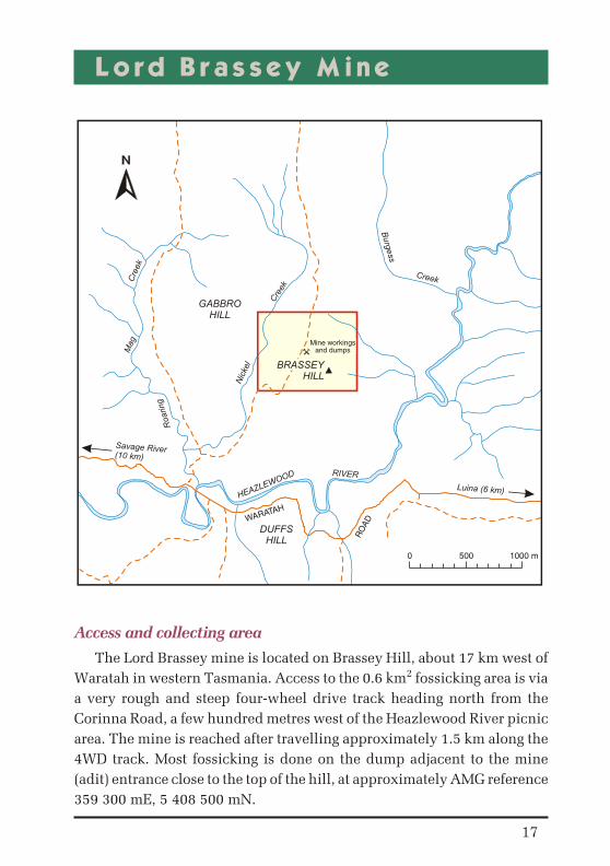
Lord Brassey Mine
Ac cess and col lect ing area
The Lord Brassey mine is located on Brassey Hill, about 17 km west of
Waratah in western Tasmania. Access to the 0.6 km2 fossicking area is via
a very rough and steep four-wheel drive track heading north from the
Corinna Road, a few hundred metres west of the Heazlewood River picnic
area. The mine is reached after travelling approximately 1.5 km along the
4WD track. Most fossicking is done on the dump adjacent to the mine
(adit) entrance close to the top of the hill, at approximately AMG reference
359 300 mE, 5 408 500 mN.
17
Mine workingsand dumps
BRASSEYHILL
Savage River(10 km)
Cre
ek
Mag
Roaring
1000 m5000
Luina (6 km)
RIVER
HEAZLEWOOD
RO
AD
WARATAH
DUFFSHILL
GABBROHILL
Cre
ek
Nic
kel
Creek
Burg
ess

The mine and its min er als
This small mine operated on a nickel sulphide occurrence in ultrabasic rocks (serpentinite and pyroxenite). The sulphide ores probably formedduring deformation of these rock types, and later weathering convertedsome of the sulphides into carbonates. Minerals, many rare, that can becollected and identified in hand specimens include:
0 Andradite Ca3Fe2(SiO4)3 — ‘chrome’ green veinlets in serpentine.
0 Antigorite Mg3Si2O5(OH)4 — apple green serpentine.
0 Awaruite (Ni,Fe) — metallic white, rusty.
0 Chrysotile Mg3Si2O5(OH)4 — white, asbestiform serpentine.
0 Clinochlore Mg6(Si,Al)4O10(OH)8 — chlorite, dark green.
0 Diopside CaMgSi2O6 — white veins in serpentine.
0 Dypingite Mg5(CO3)4(OH)2.5H2O — pale blue to white, botryoidalcrusts on serpentine.
0 Heazlewoodite Ni3S2 — bronzy yellow metallic patches in serpentine.
0 Hellyerite NiCO3.6H2O — pale blue coatings and small crystals,<2 mm.
0 Lizardite Mg3Si2O5(OH)4 — black serpentine.
0 Magnetite Fe3O4 — small black grains, in serpentine.
0 Molybdenite MoS2 — small patches of massive dark grey tooccasionally purple grey.
0 Opal SiO2 — glassy veinlets in serpentine.
0 Pentlandite (Fe,Ni)9S8 — brassy yellow metallic patches in serpentine.
0 Reevesite Ni6Fe23+(CO3)(OH)16.4H2O — a lemon yellow crust on
sulphides in serpentine.
0 Retgersite NiSO4.6H2O — pale to mid blue, powdery crusts.
0 Theophrastite Ni(OH)2 — a green crystalline crust on slickensidedserpentine.
0 Zaratite Ni3(CO3)(OH)4.4H2O — emerald green, blue green and olivegreen coatings and mammillary, stalactitic or amorphousencrustations along the shear planes and joint surfaces of theserpentine.
18

Spe cial con di tions
1. Historic mining relics occur in this area. Fossickers are asked torespect these relics by avoiding disturbance of historic workingsand not collecting artefacts (e.g. bottles, pieces of machinery, etc.)from this area.
2. UNDER NO CIRCUMSTANCES should fossickers enter the disused adit.
19

Magnet Mine
Col lect ing area and ac cess
The old Magnet mine is located six kilometres directly west ofWaratah, although access is by a somewhat circuitous route. The mine isreached by traversing a good unsealed road (the Magnet Road) leading off
20
Quarry
MAGNET
MagnetDam
Cre
ek
Mag
net
WAR
ATAH
(approx. 10 km)
LUINA(approx. 4 km)
ROAD
WARATAH
LinePower
WhyteHill
PhilosopherFalls
RIVER
ARTHURROAD
BUTLERS
Sch
oo
l
Main mineworkings
Main gossan /collecting area
1000 m5000
CreekMile
Seve
n
MAGNET
RANGECreek
Kyber
Cre
ek
Cre
ek
Magnet
ROAD (4wd only)
Creek
Bootful
RIVER
WH
YTE

the sealed Corinna Road opposite Whyte Hill (on which a Telecom towerhas been erected). This junction is approximately 12 km west of town ofWaratah. The main collecting area is the ferromanganese gossan, which islocated above the ruins of the old mill beside the access road (at AMGreference 370 100 mE, 5 410 650 mN). The collecting point is reached after travelling approximately 3 km along the unsealed road and passingthrough a gravel pit. The Magnet Road continues back to Waratah, but theMagnet Creek crossing is usually impassable by normal vehicles.
Ma te rial
The site is important as it is possibly the only known location at whichyellow ‘chrome’ cerussite has been found in the world, and is one of only afew locations for crocoite.
This mine has been intermittently worked for silver, lead and zinc formany years, and more recently for specimen minerals. The primary oreconsists of sulphide minerals in a banded carbonate vein in basic andultrabasic rocks. There is an extensive oxidised zone developed abovethis, with many interesting secondary minerals in the gossan.
Col lect ing
Minerals that can be collected on site include:
0 Anglesite PbSO4 — occurs uncommonly as attractive whiteorthorhombic crystals to a few millimetres, with crocoite,pyromorphite and embolite.
0 Argentite (acanthite) Ag2S — small patches and scales of this metallicgrey mineral occur in galena.
0 Arsenopyrite FeAsS — occurs commonly as small prismatic crystalsto a few millimetres in vughs in siderite and quartz.
0 Boulangerite Pb5Sb4S11 — this grey metallic sulphide usually occursas fibrous or fine-grained bands with galena.
0 Cerussite PbCO3 — this mine is famous for its ‘chrome cerussite’,which occurs rather abundantly as very attractive crystallineaggregates of yellow crystals, possibly coloured by traces of chromium.More normal white to colourless cerussite also commonly occurs at themine.
0 Chalcophanite (Zn,Mn,Fe)Mn2O5.2H2O — this mineral occurs asfinely drusy masses of lustrous purplish black hexagonal crystals onpsilomelane, with small cerussite crystals. It is also massive and darkbrown.
21

0 Chalcopyrite CuFeS2 — this mineral occurs as fine grains in primaryore, with sphalerite and siderite.
0 Chlorargyrite AgCl — this mineral forms waxy masses and crusts,varying from yellow to green when fresh, darkening to violet brownwith exposure to light. It is an important secondary silver ore in thegossans. It has been called ‘embolite’, the bromian variety.
0 Chromite FeCr2O4 — occurs as small, lustrous, black crystals to onemillimetre in the green country rock.
0 Crocoite PbCrO4 — this rare mineral is comparatively common hereas attractive, fine, monoclinic prismatic crystals to 50 mm, with abright orange to red colour. The crystals occur as entangled masses, assingle crystals on gossan, or intergrown with yellow ‘chrome cerussite’. Terminated crystals, unusual for this mineral, also occur.
0 Dolomite Ca(Fe,Mg)(CO3)2 — common as a gangue mineral in theprimary ore, with a white to brown colour, often described as ankerite.These banded ores may make attractive specimens.
0 Galena PbS — this metallic grey mineral with perfect cubic cleavageswas an important primary ore of lead, and is still common.
0 Goethite FeO(OH) — an important constituent of the gossans. Usuallymassive, powdery yellow to brown and black when massive.
0 Greenockite/Hawleyite CdS — this occurs as a bright yellow powderycoating on gossan.
0 Lepidocrocite FeO(OH) — this mineral occurs as red patches withanglesite on goethite.
0 Mimetite Pb5(AsO4)3Cl — relatively common in the gossans as small,colourless to yellow, orange, red and brownish-green hexagonalprismatic crystals, containing a little chromium. Sometimes describedincorrectly as vanadinite, endlichite, pyromorphite or carminite.
0 Muscovite KAl3Si3O10(OH)2 — the green, Cr-rich variety ‘fuchsite’ can be collected in altered wallrock samples on the dumps.
0 Phosgenite Pb2(CO3)Cl2 — another rare secondary lead mineralrecorded in the gossans as rather large adamantine, brown to colourless crystals on galena. Rarely reported, but probably mistaken for anglesite or cerussite.
0 Plumbojarosite PbAl6(SO4)4(OH)12 — this powdery yellow-brownmineral occurs uncommonly on gossan.
22

0 Proustite Ag3AsS3 — this ‘ruby silver’ mineral was reported as rareprismatic hexagonal crystals and thin coatings, sometimes with nativesilver. The fresh mineral is an attractive scarlet vermilion, but darkensto black with exposure to light. It has reportedly been recentlycollected.
0 Pyrargyrite Ag3SbS3 — this ‘ruby silver’ mineral is very similar toproustite in appearance and occurrence. It was reported here as rarecrystals and in association with galena and native silver.
0 Pyrolusite MnO2 — this powdery brown-black mineral occurs in thegossan.
0 Quartz SiO2 — fine quartz crystals occur in some veins.
0 Rhodochrosite MnCO3 — recorded as a primary mineral in the ores,sometimes termed ‘manganosiderite’, grading into siderite. A pinkishmineral with pearly cleavages.
0 Romanechite (psilomelane) BaMn9O16(OH)4 — this mineral is present in the gossans as massive or stalactitic, hard black material.
0 Siderite FeCO3 — recorded as a primary mineral in the ores,sometimes termed ‘manganosiderite’, grading into rhodochrosite. Abrownish mineral with pearly cleavages.
0 Silver Ag — ‘native’ silver was an important secondary mineral in thisdeposit, where it occurred as hair-like patches in sphalerite. It is asilvery metal, often tarnished grey or black.
0 Sphalerite ZnS — common in the primary ores with galena, siderite,etc. It is black and coarsely crystalline, with good cleavages.
0 Smithsonite ZnCO3 — this mineral is rare in the gossans, but occurs as translucent grey hexagonal-rhombohedral crystals lining cavities.
23

Other reported minerals (not all confirmed) include:
vanadinite (endlichite) matlockite pyromorphitecarminite aragonite pharmacosideriteankerite phoenicochroite tetrahedritesymplesite stibnite jamesoniteacanthite (argentite) kottigite beresoviteminium
Spe cial con di tions
Historic mining relics occur in this area. Fossickers are asked to respect these relics by avoiding disturbance of historic workings and notcollecting artefacts (e.g. bottles, pieces of machinery, etc.) from this area.
24

Weld River
Ac cess
This 2 km2 area is about 250 km northeast of Hobart, and is reached viaScottsdale or St Helens on good sealed roads.
Col lect ing area
The two main collecting areas are shown on the accompanying map. Oneis reached from Frome Road, which leaves the Tasman Highway oppositethe Moorina Golf Course, by walking along the banks of the Weld River.The other is reached via an all-weather track which leaves the TasmanHighway approximately two kilometres south of Moorina.
25
RO
AD
FRO
ME
River
Frome
HIG
HW
AY
TAS
MA
N
RO
AD
AM
OS
River
ChineseCemetery
Moorina
Weld
Riv
er
Rin
garo
oma
Herr
ick
(appro
x. 4
km
)
FromeDam
1000 m5000
Main areas for sapphiresWeldborough (approx. 6 km)
ROAD
GAR
IBAL
DI
KENTHILL
MOORINAHILL
PrivateLand

Ma te rial
This area has extensive alluvial deposits which were worked for tin for
many years. The alluvial material was derived by weathering and erosion
of granite, basalt and other rock types.
0 Corundum (‘Sapphire’) Al2O3 — this is one of the most sought afterminerals in the area, and is moderately common as subrounded towell-rounded grains, usually small but rarely up to a few centimetres in size. The colour is usually a dark blue, but is sometimes green orparti-coloured. Some dark grains show chatoyancy from includedrutile, and may be termed ‘star sapphire’. Tabular fragments ofhexagonal crystals are often seen. The mineral is thought to originatedeep in the crust and was brought to the surface in Tertiary basalt.Some pink stones found in the area have been described as ruby.
0 Hercynite FeAl2O4 — this is one of the more common heavy mineralsin the alluvial materials and occurs as subrounded to well-roundedgrains up to about a centimetre in size. The colour is usually opaqueblack in hand specimen, but it may be blue, green or brown intransmitted light. Hercynite was known as ‘blackjack’ amongst tinminers. Well-formed octahedral crystal fragments are often seen. Themineral is thought to originate deep in the crust and was brought to thesurface in Tertiary basalt.
0 Cassiterite SnO2 — this was the major economic mineral in northeastTasmania, and tin mines were widespread in the area. It is stillabundant as a major constituent of the heavy black alluvial sands,occurring as subrounded to well-rounded grains up to a fewmillimetres in size. Cassiterite is usually a dark brown to black colour,but is sometimes ruby red (‘ruby tin’). The mineral originated in thetin-bearing granites common in the area.
0 Topaz Al2SiO4(OH,F)2 — this occurs as occasional small glassy grainsto a few millimetres in size, usually colourless, pale blue or translucentwhite. It was derived from the tin-bearing granite.
0 Chrysoberyl BeAl2O4 — this rare mineral has been found as smallgrains in alluvial materials. It superficially resembles sapphire but isalways pale green. Some grains are red under artificial light, indicatingthat they are the variety ‘alexandrite’. Some stones exhibit a ‘cats-eye’chatoyant effect, and are known as ‘cymophane’. Their origin isuncertain, but may be in deep-seated rocks, brought up with sapphiresetc., although some other beryllium minerals have been recorded insome of the tin granites.
26
0 Zircon ZrSiO4 — this is one of the more common heavy minerals in thealluvial materials, and occurs as angular to well-rounded grains up to afew millimetres in size. The colour is usually pale pink to reddishbrown, and tetragonal crystals are often seen. The mineral has a mixedorigin; some is derived from granite, while some of the coarser zircon isthought to originate deep in the crust, and was brought to the surface inTertiary basalt. This is shown by Tertiary ages obtained from fissiontrack dating.
27

Kil l iecrankie Bay
Ac cess
This 1 km2 area is 30 km north of Whitemark on Flinders Island, about400 km NNE of Hobart, and is reached via air or sea and then on unsealedroads. Because of the coastal location tidal chrts may need to be consulted.
Col lect ing area
The main collecting area is among granite boulders on the foreshore inthe vicinity of Diamond Gully Creek (AMG reference 572 500 mE,5 591 900 mN).
28
The Dock
Old MansHead
MOUNTKILLIECRANKIEG
ully
Dia
mond
ROADQUOIN
KilliecrankieBay
BASS
STRAIT
LittleIsland
NobbysRock
DeepBight
2 km10 Cr.
Killiecrankie
RD
KILLIECRANKIE
LANDINGGROUND
Killiecrankie
WH
ITE
MA
RK
(ap
pro
x. 4
0 k
m)
CreekStony
RO
AD
PALA
NA
Cre
ek
Edens

Ma te rial
The area yields topaz crystals and pieces (known colloquially as‘Killiecrankie Diamonds’), along with smoky quartz, zircon and beryl. Themain product from this area is the topaz; the most common form iscolourless but pale blue and pink forms have been found.
0 Topaz Al2SiO4(OH,F)2 — this occurs as glassy, well-formedorthorhombic crystals or waterworn pebbles, usually colourless to pale blue but also translucent white or in pale shades of pink and yellow.Crystals up to about 20 mm in size are abundant, and some up to 80 mm have been reported. The topaz was derived from tin-bearing pegmatitein the local granites.
Ad di tional in for ma tion
Topaz occurs in other locations around Killiecrankie Bay. Another area of interest to fossickers is the old Tanners Creek tin mine.
29

Weymouth
Ac cess
This 0.5 km2 area is about 200 km north of Hobart, and 50 km north ofLaunceston and is reached via Pipers River on sealed roads. Because of thecoastal location tidal charts may need to be consulted.
Col lect ing area
The main collecting area is on a beach west of Weymouth atapproximately AMG reference 511 200 mE, 5 460 400 mN.
30
1000 m5000
PIPERS RIVER
(11 km)WEYMOUTH ROAD
NOLAND BAY
Weymouth
Bellingham
RIV
ER
PIP
ER
S
BASS STRAIT

Ma te rial
The area has yielded fine-grained quartz pebbles, petrified wood andsome agates and chalcedony, all of which are regarded as importantsources of tumbling material for lapidarists.
Spe cial con di tions
This area is surrounded by private property. Public access to theforeshore can be obtained from public roads at the eastern end of thefossicking area.
31

Gladstone
Ac cess
This 8 km2 area is about 250 km NNE of Hobart, and can be reached viaScottsdale, Bridport or St Helens on good sealed roads.
Col lect ing area
The main collecting area is around the old tin workings from Ah KawCreek and Mt Cameron Creek to Alhambra Creek (AMG reference583 400 mE, 5 464 000 mN).
Ma te rial
The area has yielded good specimens of smoky quartz, clear quartz,amethyst and jasper. The area is particularly renowned for large crystals of smoky quartz.
Spe cial con di tions
Historic mining relics occur in this area. Fossickers are asked to respect these relics by avoiding disturbance of historic workings and notcollecting artefacts (e.g. bottles, pieces of machinery etc.) from this area.
32

33
0 500 1000 m
G N
Old mine
Mine
FIRSTSUGARLOAF
Mine
Mine
GravelPit
Scotia Mine(inactive)
Gladstone
Lass
Cr.
Gal
loway
Cr.
Dry
den
Cr.
Cam
ero
n
Mt
Cre
ek
Filu
mena
Cre
ek
RINGAROOMA
RIVER
Bridport (59km)
Pio
neer
(approx. 15 km)
WATE
RH
OU
SE
ROAD
Mineworkings