FORTUNE GREEN & WEST HAMPSTEAD NEIGHBOURHOOD PLAN
78
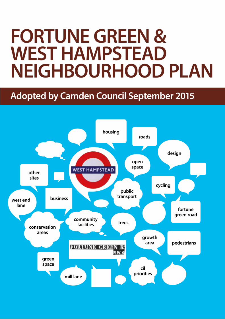
public transport fortune green road cil priorities other sites roads cycling business housing pedestrians conservation areas community facilities west end lane open space green space mill lane design trees growth area FORTUNE GREEN & WEST HAMPSTEAD NEIGHBOURHOOD PLAN Adopted by Camden Council September 2015
Transcript of FORTUNE GREEN & WEST HAMPSTEAD NEIGHBOURHOOD PLAN
public transport
fortune green road
cil priorities
other sites
roads
cycling
business
housing
pedestrians
conservation areas
community facilities
west end lane
open space
green space
mill lane
design
trees
growth area
FORTUNE GREEN & WEST HAMPSTEADNEIGHBOURHOOD PLANAdopted by Camden Council September 2015

Contents
CONTENTS 2
www.ndpwesthampstead.org.uk
@WHampsteadNDF
click the buttons or section headings to navigate
5-6
8-10
12
14-62
64-71
73-75
77
INTRODUCTION
AREA
VISION & OBJECTIVES
POLICIES
DELIVERY PLAN
OTHER PLANS
ACKNOWLEDGMENTS
01
02
03
04
05
06
07
Contents
CONTENTS 3
Policy 1 Housing
Policy 2 Design & Character
Policy 3 Safeguarding & enhancing Conservation Areas & heritage assets
Policy 4 West Hampstead Growth Area
Policy 5 Public Transport
Policy 6 Public Transport Facilities
Policy 7 Sustainable Transport
Policy 8 Cycling
Policy 9 Pavements & Pedestrians
Policy 10 New & Improved Community Facilities
Policy 11 Protecting Community Facilities
Policy 12 Business, Commercial and Employment Premises & Sites
Policy 13 West Hampstead Town Centre
Policy 14 Mill Lane Neighbourhood Centre
Policy 15 Fortune Green Neighbourhood Centre
Policy 16 Local Green Space
Policy 17 Green/Open Space
Policy 18 Trees
Policy 19 Community Infrastructure Levy Priorities
Recommendation A Housing, Design & Character
Recommendation B Conservation Areas & Heritage Assets
Recommendation C West Hampstead Growth Area
Recommendation D Other Sites
Recommendation E Public Transport
Recommendation F Sustainable Transport
Recommendation G Cycling
Recommendation H Pavements & Pedestrians
Recommendation I Mill Lane Neighbourhood Centre
Recommendation J Green/Open Space
Recommendation K Trees
Recommendation L Planning Agreements
14
16
23
27
39
41
43
45
46
48
50
51
53
55
56
57
60
62
69
20
26
34
38
42
44
45
47
55
61
62
68
POLICIES & RECOMMENDATIONS
click the buttons or section headings to navigate

INTRODUCTION
Contents

Contents
INTRODUCTION 5
01 INTRODUCTION
1.1 This Neighbourhood Development Plan (NDP, the Plan) has been drawn up using the powers in the Localism Act 2011. The Plan was written by the Fortune Green & West Hampstead Neighbourhood Development Forum (NDF, the Forum) which was established in January 2012. The Forum was recognised by Camden Council in May 2013.
1.2 The Plan has been written to conform with the policies and objectives of the National Planning Policy Framework (NPPF), March 2012. It has been prepared with the aim of contributing to the achievement of sustainable development and is prepared in accordance with the presumption in favour of sustainable development.
1.3 The Plan has also been prepared to be in general conformity with the strategic policies in the development plan: the London Plan (2011) (as amended) and the relevant Local Plan - Camden Council’s adopted planning policies: Camden Core Strategy (CCS) 2010-2025 (adopted 8 November 2010); Camden Development Policies 2010-2025 (adopted 8 November 2010); and Camden Site Allocations (adopted 9 September 2013).
1.4 As well as the three over-arching plans - at National, London and Local level - the Plan draws on and adds to Camden Council’s Supplementary Planning Guidance. It also reflects the recommendations in Camden Council’s Place Plan for West Hampstead (March 2012), and has drawn on the consultations and findings upon which this document was based.
1.5 The Plan provides planning policies and guidance at a neighbourhood level. It has been drawn up by people living and working in Fortune Green & West Hampstead, for the benefit of people who will live and work in the Area in the years to come. As demonstrated in the Consultation Statement that accompanies this document, the Plan is based on extensive discussions, engagement and consultation to ensure that it clearly reflects the will of the community and has broad support. It is important that Fortune Green & West Hampstead clearly benefits from development and the challenges it brings.
1.6 The Plan sets out policies (in blue boxes) for the future development of the Area between 2015 and 2031. The end date has been chosen as it marks the end date of the current London Plan and the end date of its growth target for part of West Hampstead (the West Hampstead Growth Area). The Plan seeks to provide a framework for how planning decisions will be made in the Area, with clear policies to be followed and applied.
1.7 The Plan also sets out recommendations (in green boxes), which describe non-statutory complementary action which will help achieve the Vision and Objectives (see 3.1), and which are in support of the Plan’s policies. In order to produce a Plan that is clear, accountable and has wide support, these recommendations (or projects) are included next to policies to which they refer.
For the avoidance of doubt, it is emphasised that these are aspirations and do not constitute or suggest agreement with Camden Council or other relevant bodies to fund or act on them.
1.8 Within the policy section of the Plan, the text sets out the justification for the policy. While the policy takes precedence, the text explains the formation of the policies and provides further detail as to how the policies should be implemented.
1.9 The mechanism for the achievement of both the polices and the recommendations in this Plan is set out in the Delivery Plan (see section 5). It is noted that all eligible development must pay the Community Infrastructure Levy (CIL) as well as - by way of a Section 106 Agreement - contribute to the costs of any specific site requirements that are necessary to make the development acceptable in planning terms; that are directly related to the development; and which are fairly and reasonably related in scale and kind to the development. The Plan highlights that development should contribute towards the positive development of the Area in different ways. Contributions may be in the form of both CIL and S106 financial contributions and/or appropriate design measures and ‘in kind’ improvements.

Contents
INTRODUCTION 6
01 INTRODUCTION
The neighbourhood portion of the CIL can be spent on a wide range of items, provided that they meet the requirement to support development of the Area.
1.10 Planning applications that accord with the policies in this Plan - as well as the NPPF, London Plan & Local Plan - will be approved without delay. Planning applications that conflict with the policies in this Plan will be refused, unless material considerations indicate otherwise.
1.11 While it is recognised that development decisions mean weighing up a number of factors in determining whether to develop sites or buildings, the Neighbourhood Plan requires the application of its Vision, Objectives and Policies in all schemes in the Area. Rather than repeating viability as a factor throughout this Plan, it is highlighted here that the viability of development is recognised as an essential element of delivery and will be taken into consideration when proposals come forward as set out in para 173 of the NPPF. Depending on the nature of each development, some objectives may have a higher priority in the circumstances at that particular time than others.
1.12 The Plan should be read alongside the three supporting documents which accompany it.
They are:
• Statement of Basic Conditions
• Consultation Statement
• Strategic Environmental Assessment

PAGE DESCRIPTION 7
Contents
AREA
Contents

Contents
AREA 8
02 AREA
2.1 The Area covered by the Plan is largely the existing council wards of Fortune Green and West Hampstead, with the exception of Cricklewood Broadway and Kilburn High Road (see Map 1). The Area represents a clearly defined community which is widely acknowledged by both local residents and Camden Council. There is an obvious boundary in the north with the Camden-Barnet boundary; in the east with Finchley Road; and in the west with the A5 road and the Camden-Brent boundary. The two wards are often counted as one area by community groups and residents. Consultation of local groups and residents found strong support for a Neighbourhood Area covering these boundaries. This Area was agreed by the NDF in March 2012 and approved by Camden Council in May 2013.
2.2 Historical records show that until the 19th century the Area was largely rural farmland. It centred on the hamlet of West End, which was within the manor and parish of Hampstead. The arrival of the Midlands Railway in 1871 brought rapid development. The development of the Area from the 1870s to the turn of the 20th century has given the area a distinctive and attractive appearance – from individual houses, to terraced housing, to mansion blocks, to streetscapes, to the overall image of the Area. The main architectural feature of the Area is the notable red brick Victorian and Edwardian terraces and mansion blocks. These buildings have numerous design features, detailing and characteristics - which are highly valued and appreciated. The Area therefore has a strong and distinct architectural heritage- including a significant number of listed buildings as well as large conservation areas - which are extremely important in signifying the Area’s look and feel. Preserving and enhancing the architectural heritage of Fortune Green and West Hampstead is of great importance to local residents.
2.3 Census data for 2011 reveals the following statistics for the Area:
• A population of nearly 24,000 - a 16.5% increase on 2001
• There are 11,000 households - a 13.5% increase on 2001
• Most housing consists of flats or apartments (71%)
• Owner occupied households account for 36% of housing; 44% is private rented & 20% is social rented
• A high proportion of the population is aged between 20-44 (56%)
• The economically active working age population (16-74) is 77%
• Most of the working age population is employed in managerial or professional roles (69%)
• The Area covers 189 hectares.
2.4 There are plans for significant development and associated population increase in the West Hampstead Growth Area (See Map 4 & section 4B). The London Plan sets a target of a minimum of 800 new homes and 100 jobs between 2010 and 2031. Population projections for the Area as a whole suggest there will be significant population growth in both Fortune Green and particularly West Hampstead wards in the coming years and decades from both new development and increased household sizes (see ‘GLA ward-level population projections’). This growth in the Area’s population will place additional pressure on services, resources and infrastructure.

MAP 1Contents

Contents
AREA 10
2.5 Recent development in the past decade has raised a number of concerns, particularly as the population of the Area grows, more new homes are built, and the population density of the Area increases. While this Plan cannot affect recent development or consented planning applications, it is worth noting the issues that have been raised during work on this Plan.
For many residents the height of new buildings is a key issue. In an area largely made up of houses and buildings between two and five storeys high, new developments of six storeys or higher are likely to cause strong objections. While new buildings should not slavishly copy the style of buildings built in the late 19th century and early 20th century, there is a broad consensus that new development needs to fit in with existing development in the Area. In most cases, this means buildings that are not starkly modern or out of place. There is also widespread support for most buildings to be predominately made of high quality red brick or London stock brick. Recent buildings made of grey brick have proved to be unpopular and are widely considered to be inappropriate for the Area, because of their impact on conservation areas and the overall character of the Area. (For more detail on this issue, please see the Consultation Statement and its appendices).
2.6 Consultations undertaken by the NDF during the formation of this Plan found that those living and working in the Area were in favour of:
• The development of specific planning guidance for the Area.
• A far more co-ordinated approach to planning decisions in the Area.
• Stronger enforcement of planning rules and decisions.
• Greater efforts to protect buildings and the street environment in conservation areas.
• More positive engagement by developers with the community.
A survey completed by 180 people in the summer of 2012 found that:
• the vast majority felt the Area had ‘a village feel’ (85%)did not want more high-rise buildings (75%)
• wanted more to be done to protect older buildings and design features (70%)
• wanted more of the Area to be included in conservation areas (61%)
• didn’t think there was enough open space (66%)
• and wanted more street space given to pedestrians (67%).
The full results of this survey - and all the other research conducted by the NDF - can be found on the Evidence Base section of the NDF’s website: www.ndpwesthampstead.org.uk as well as in the Consultation Statement.
The findings of the NDF’s extensive engagement, consultation and research - as well as all the documents which make up the evidence base (including the seven drafts of the Plan published before this final version) - form the basis for the Vision, Objectives, Polices and Recommendations which follow.
02 AREA
PAGE DESCRIPTION 11
Contents
VISION & OBJECTIVES
Contents

Contents
VISION & OBJECTIVES 12
03 VISION & OBJECTIVES
3.1 The aim of this document is to provide a strategic and long-term plan for Fortune Green and West Hampstead - which is in accordance with the wishes of those living and working in the Area, and which recognises the need for sustainable development. This is set out in the following vision statement.
3.2 This Vision for the Area will be achieved through the delivery of the following six Objectives.
1. Housing
Development in Fortune Green & West Hampstead will provide a range of housing and housing types, including social and affordable housing, as well as housing suitable for families, older people and young people. The West Hampstead Growth Area will be the focus for new development and will provide new housing and accompanying additional infrastructure. Development outside the Growth Area will be on a smaller scale.
2. Design & Character
Development will be of high-quality design and will need to reflect the existing styles of the Area, large parts of which are covered by Conservation Areas. The height of new buildings shall have regard to and respect the proportion, scale, massing and rooflines of existing buildings in their vicinity and setting. In all development there shall be a clear presumption in favour of preserving the distinct character and appearance of the Area, as well as the views across it.
3. Transport
Development will support and contribute towards enhancing the provision of public transport - as well as improving movement around the Area. West Hampstead’s three rail stations, and the areas around them, shall be the focus of improvements. Making better provision for pedestrian and cyclist movement through the Area - particularly in and around the West Hampstead Growth Area - is a key priority.
4. Public & Community Facilities
Development will support and contribute to public and community facilities in the Area - bringing improvements to meet the needs of the growing population. Local services and community facilities – including schools, nurseries, health centres, libraries, community centres and youth facilities – are all highly important in delivering a sustainable community.
5. Economy
Development will promote and support a successful local economy, with thriving town and neighbourhood centres. Development shall protect and support existing jobs and employment sites - as well as providing new jobs and attracting new businesses to the Area. Such development shall also provide flexible employment space suitable for a wide range of commercial uses, particularly for small and micro-businesses.
6. Natural Environment
Development will protect and enhance existing green/open space and the local environment. Development shall also provide, or contribute towards, new green/open public space. Development shall promote bio-diversity and nature conservation, and allow for the planting of new trees.
THE VISION:
Development in Fortune Green and West Hampstead will allow for a mixed, vibrant and successful local community. The Area has a distinct and widely appreciated village character with a variety of amenities and excellent transport links. This Plan seeks to retain and protect these positive features, while allowing for new housing, new jobs and sustainable growth in the years ahead.

PAGE DESCRIPTION 13
Contents
POLICIES
Contents

Contents
POLICIES 14
04 POLICIES
A1. In accordance with the Vision and Objective 1, the focus of development shall be to provide new housing to meet the needs of a growing community. In addition, all development in the Area - whether residential or commercial - will need to be well designed so as to complement and reflect existing buildings in the Area (Objective 2).
A2. With rising house prices, the issue of affordable housing is extremely important in any new development. The definition of affordable housing is set out in Annex 2 of the NPPF and includes: social rented, affordable rented and intermediate housing - which is “provided to eligible households whose needs are not met by the market”. The Camden Core Strategy (CCS) (Policy CS6) says it will “seek to ensure that 50% of the borough-wide target for additional self-contained homes is provided as affordable housing”. It also (6.35) will “seek a mix of homes of different sizes, which should include small homes as well as large ones”. These borough-wide aims shall be fully applied in the Area, subject to Camden Council’s sliding scale and minimum development size criteria.
A3. Consideration needs to be given to the different needs of people living in different forms of housing. Council and housing association run estates – such as West End Sidings, Templar House, Westcroft Close, Lymington Road and Lithos Road – need to be well run and maintained, and should not be neglected as the rest of the Area is developed. There is also a need for Council provision of new social housing in the Area - particularly 3 and 4 bedroom properties for families.
A4. The Area has a high and growing number of homes in the private rented sector, which can have the effect of producing a transient and unconnected section of the local population. It is necessary to accommodate and assess the needs and requirements of this important and growing section of the community. Census figures for 2011 suggest 44% of the Area’s households are in private rented housing (significantly higher than the Camden average of 32%). This figure is likely to grow in the years ahead - and, based on current growth, could soon exceed 50%. With many of the newer properties in the Area being bought by investors to rent, greater thought needs to be given to this issue.
A. HOUSING, DESIGN & CHARACTERHOUSING
Residential development shall provide a range of housing types, to meet a range of needs, as appropriate, related to the scale of the development.
This shall be achieved by:
i. The provision of affordable, social, intermediate, and shared-ownership housing - in line with the 50% target as set out in the development plan.
ii. The provision of a range of different unit sizes, including three and four bedroom homes, where appropriate, suitable for families.
iii. The appropriate provision of homes for the elderly and disabled, which promote accessibility.
iv. The provision of homes which aim to meet or exceed national environmental standards and for zero-carbon homes.
POLICY 1: Housing

Contents
POLICIES 15
04 POLICIES
A6. As the population ages - both in the UK and in the NDP area - greater thought and consideration needs to be given to elderly residents. Accessible homes designed for older people will need to be incorporated into some new developments, to enable older residents to stay in the area and to downsize. Provision should also be made for additional sheltered housing in appropriate locations. Developers should engage with relevant user groups at an early stage in order to ensure that the specific needs of elderly and disabled people are taken into account; and should be encouraged to extend their product range to meet these needs.
A7. Student housing: a number of large developments for student housing have recently been developed (on Blackburn Road & Midland Crescent – proposed). In all this will provide nearly 500 student units. The vast majority of universities in Camden are in the south of the borough. As there are no major higher educational institutions in the Area or near to it, additional large-scale student housing has not been identified as a priority need for development within the Area.
Some local authorities are introducing a register of private landlords in their areas in order to give greater protection to private tenants and make landlords more accountable; it is recommended that this is something Camden Council should consider, following the example of other councils in London which have taken such action.
A5. The condition of some Houses in Multiple Occupation (HMO) in the Area has been raised in consultation as an issue of concern - particularly the poor quality of such development and the lack of enforcement of existing rules (both building regulations and environmental health). This relates to both the interior and exterior of such developments. The conversion of houses into multiple units should be strongly controlled and high standards enforced. In the case of new conversions where planning permission is required, there should be restrictions covering: the number of units to be provided within an existing property; the effect on the character and appearance of the building, or adjacent buildings or the streetscape; the impact on neighbouring residential properties and amenities; and the provision of adequate storage space for waste and recycling bins and containers.
A. HOUSING, DESIGN & CHARACTERHOUSING

Contents
POLICIES 16
04 POLICIES
All development shall be of a high quality of design, which complements and enhances the distinct local character and identity of Fortune Green and West Hampstead.
This shall be achieved by:
i. Development which positively interfaces with the street and streetscape in which it is located.
ii. Development which maintains the positive contributions to character of existing buildings and structures.
iii. Development which is human in scale, in order to maintain and create a positive relationship between buildings and street level activity.
iv. Development which has regard to the form, function, structure and heritage of its context - including the scale, mass, orientation, pattern and grain of surrounding buildings, streets and spaces.
v. A presumption in favour of a colour palate which reflects, or is in harmony with, the materials of its context.
vi. New buildings and extensions that respect and are sensitive to the height of existing buildings in their vicinity and setting. Tall buildings in the Growth Area will need to have regard to their impact on the setting of the two immediately adjacent conservation areas, in order to avoid any negative impact on them.
vii. Extensions - and infill development - being in character and proportion with its context and setting, including the relationship to any adjoining properties.
viii. The provision of associated high quality public realm.
ix. Having regard to the impact on local views across the Area and the streetscapes within the Area (as identified in A11 and Map 2).
x. Development which aims to fulfil the criteria set out in Building for Life 12 (as detailed in A18).
POLICY 2: Design & Character
A. HOUSING, DESIGN & CHARACTERDESIGN

CHARACTER PHOTOGRAPHS
POLICIES 17
Contents

Contents
POLICIES 18
04 POLICIES
A8. The NPPF states as a core planning principle (paragraph 17) that planning should “always seek to secure high quality design and a good standard of amenity for all existing and future occupants of land and buildings”. It also states (56) that “good design is a key aspect of sustainable development, is indivisible from good planning, and should contribute positively to making places better for people”. The London Plan (Policy 7.6) says that “architecture should make a positive contribution to a coherent public realm, streetscape and wider cityscape. It should incorporate the highest quality materials and designs appropriate to its context”. These principles and policies shall be clearly and demonstrably applied in Fortune Green and West Hampstead.
A9. The NPPF (60) states that it is “proper to seek to promote or reinforce local distinctiveness” and says (58) that development shall “respond to local character and history, and reflect the identity of local surroundings and materials”. As outlined in 2.2 & 2.5 many parts of Fortune Green and West Hampstead have a clear architectural heritage – with an attractive character and a distinct local identity. These positive features are strongly supported (as set out in the Consultation Statement) and need to be protected and preserved. New developments in such areas – particularly terraced streets – need to be sensitive to the defining characteristics of the local area in terms of their proportion, height, scale, massing, materials, storey height and rooflines. Larger developments, while reflecting new design, need to incorporate design features that reflect the character of existing development, using materials (such as red brick) which complement existing buildings. Innovation is not ruled out, however schemes incorporating innovation will need to make a persuasive case for such development and demonstrate the suitability of such schemes.
(Also see character photographs)
A10. The height of existing development in Fortune Green and West Hampstead makes a significant contribution to the overall character of the Area. The NPPF (59) recognises height as an important consideration and that design policies “…should concentrate on guiding the overall scale, density, massing, height, landscape, layout, materials and access of new development in relation to neighbouring buildings and the local area more generally”. Much of the Neighbourhood Plan Area consists of terraced housing, which is normally two or three storeys high. Mansion blocks tend to be four, five or six storeys in height.
New buildings and development will need to be based on a human scale and efficiently use the site area. High density developments are not ruled out, and it is noted (see recent reports on ‘Mid-Rise Housing’ from the Prince’s Foundation and other groups) that high densities can be achieved through high quality design, without the need for tall buildings. In order to promote and reinforce the distinct and widely appreciated local character of Fortune Green and West Hampstead, new development shall respect, and be sensitive to, the height of existing buildings in their vicinity and setting.
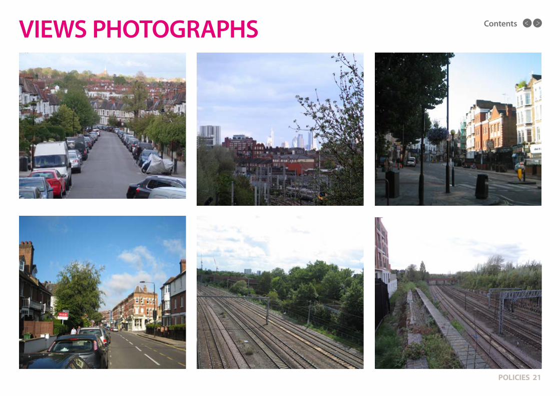
A11. Also of importance to the character of the Area are the views across it, which give a widely appreciated sense of openness and space. (See Map 2) Of particular note are the views to the east to Hampstead (in particular the view of St John’s Church) and, from the higher parts of the Area, the views to the south to the skyline of central London. Views of, from, and around the Area’s conservation areas are of great importance to their setting. The railway corridors provide the space for significant views across the Area and an important sense of openness - in particular in and around the West Hampstead Growth Area. In addition, streetscape views are important, particularly in areas of terraced housing and mansion blocks. The streetscapes of the main roads through the area - especially West End Lane, Fortune Green Road and Mill Lane - are also of note.
(Also see views photographs)
A. HOUSING, DESIGN & CHARACTERDESIGN

Contents
POLICIES 19
04 POLICIES
A12. Infill developments: any replacement of a house or houses, or addition of a new house, within an existing terrace should be to the same scale as the terrace, including the roofline. It should be similar in form, materials and details. Replication of particular exterior details is strongly recommended where such details are consistent in streets. Houses should be set back from the pavement and match or fit the building lines of existing properties, with front garden areas remaining unpaved. The same principles should apply to vacant sites in streets where there is already a pattern of existing development.
A13. Garden developments: in order to protect the Area’s green/open spaces, the development of new dwellings in private gardens should be avoided. If any developments are approved, they should maintain a much lower profile than existing housing stock, usually one or two storeys. (Also see Policy 17).
A14. Roof extensions and loft conversions should fit in with existing rooflines and be in keeping with existing development. Such extensions should be in proportion to the existing building and should not block views.
A15. Basement developments: there is concern in the Area about the increasing number of such developments. These concerns include the effect on the structural stability of adjacent properties; damage or loss to the character and biodiversity of gardens; the impact on sustainable drainage; and the impact on carbon emissions. Camden Planning Guidance (CPG4) states that the council will only permit basement and underground developments that do not: cause harm to the built and natural environment and local amenity; result in flooding; or lead to ground instability. The NDP fully supports the requirement for full and rigorous Basement Impact Assessments before any such applications are considered. The Guidance cites West Hampstead, South Hampstead and Cricklewood as areas that have been identified as being subject to localised flooding from surface water due to local soil conditions and topography; it also cites a large number of streets in the Area that have been subject to surface water flooding in the past.
Basement and underground developments in these areas should therefore be normally avoided. Given that some of the existing Victorian and Edwardian housing stock was built with basements and cellars, it is considered that some sites in the Area may be able to accommodate one storey basement developments (subject to the requirements set out in CPG4). However, there needs to be greater caution about basements deeper than one storey to ensure that they do not raise concerns about the stability of existing buildings - many of which were built with shallow foundations - and do not cause problems for surface water drainage.
A16. New development should also seek to achieve high environmental standards and support the aims of the NPPF (95) in “the move to a low-carbon future”. Development should aim to reduce greenhouse gas emissions, support energy efficiency - and, where possible, should aim to exceed national standards. The national target for zero-carbon new homes from 2017 is welcomed and should be applied in this Area before that date. Measures to retrofit existing buildings to make them eco-friendly and sustainable are strongly supported. Such measures have been trialled elsewhere in Camden, including in conservation areas, and would be welcomed in Fortune Green and West Hampstead.
A17. All development should provide adequate space for waste and recycling bins and containers. Such provision should not encroach onto pavements and should not have a negative impact on the public realm.
A. HOUSING, DESIGN & CHARACTERDESIGN

Contents
POLICIES 20
04 POLICIES
A18. In line with the policies in this section and other sections of this Plan - as well as the findings in the Consultation Statement accompanying this Plan - the NDF strongly supports the 12 criteria set out in the Building for Life 12 document - published in 2012 by Cabe at the Design Council, Design for Homes and the Home Builders Association. This sets out “the industry standard, endorsed by Government, for well-designed homes and neighbourhoods that local communities, local authorities and developers are invited to use to stimulate conversations about creating good places to live”. The NDF urges all those proposing development in the Area to consider these criteria and, where relevant, to seek to apply them. This is particularly important for those proposing large development which will have an impact on a wider area than the immediate site.
A19. The NPPF states (207) that “effective enforcement is important as a means of maintaining public confidence in the planning system”. It suggests local authorities publish information about their enforcement activities. During its consultations, the NDF found concern about weak levels of enforcement (including in Conservation Areas) and a lack of clarity about the processes involved. The NDF would welcome the publication of clear information about the enforcement of planning policies in the Area and greater transparency on this issue by Camden Council.
A20. In all development, this Plan welcomes and encourages early, positive and meaningful engagement between developers and those living and working in the Area. The NPPF states (188) that “early engagement has the potential to improve the efficiency and effectiveness of the planning application system for all parties” resulting in “improved outcomes for the community”. The NDF strongly encourages those planning development in this Area to use this Plan as the basis for positive and constructive engagement. This particularly applies to large developments, and any development in the West Hampstead Growth Area, where early, positive and ongoing consultation with the community is required.
i. That greater efforts be given to monitor and enforce approved planning applications and planning policies in the Area, and that this process is made more transparent.
ii. That all large developments have - as a condition of their approval - the mandatory formation of a consultation group with local residents and groups, to discuss the development between planning approval and completion.
iii. That significant schemes aim to retain the proposed architect or architectural practice for the development from application to completion - in order to give a consistent approach to design.
iv. The introduction of a register of private landlords in the Area.
v. That consideration is given to the needs of the large and growing private rented community.
vi. The enforcement of more rigorous controls on HMOs.
vii. The positive and proactive engagement with the community by those bringing forward plans for development - as plans are prepared and submitted, and as development takes place. All planning applications for development which is likely to have an impact beyond the immediate site should be accompanied by a Statement of Community Engagement.
RECOMMENDATION A: In support of Policies 1 & 2, the following actions are recommended to fulfil and complement the aims of these policies:
Complementary action: as elsewhere in section 4 of the Plan, in support of Policies 1 & 2 the recommendations which follow set out a range of actions which seek to complement and support the objectives of the above polices - and which the NDF will seek to promote with the relevant agencies (see 5.1)
A. HOUSING, DESIGN & CHARACTERDESIGN
VIEWS PHOTOGRAPHS
POLICIES 21
Contents

MAP 2Contents
Contents
In terms of West End Lane, the AMS finds that “…signage is large and disorderly and the street and pavements are overlaid with clutter” and “…some recent ad hoc extensions from the restaurants are of poor design and quality” and that “the Lane has become cluttered with signs, barriers and advertisements”. It adds that “the proliferation of advertisements and decline of the shop fronts is detrimental to the area”. It suggests the declaration of an Area of Special Control of Advertisements to control and restrict the use of outdoor signage, which can degrade the streetscape.
In the rest of the area, the AMS notes concerns about poor quality alterations to houses, particularly windows and doors – as well as the demolition of boundary walls and the paving over of front gardens. It says “the erosion of the details and the gardens is detrimental to the quality of the residential area”. It says any new work or buildings in the area “should reflect the materials, colour palette, scale and character of the area” and that new development “must preserve or enhance the character or appearance” of the Conservation Area. In order to prevent a deterioration of the Conservation Area, the AMS suggests the use of an Article 4 Direction on residential and commercial properties in the Conservation Area. An Article 4 Direction imposes additional restrictions on alterations to properties without planning consent.
POLICIES 23
04 POLICIES
i. Development that enhances or preserves Conservations Areas and heritage assets in the Area – as well as their distinct character, appearance, and setting – will be supported.
ii. Proposals which detract from the special character, and/or, architectural and/or historic significance, and setting of Conservation Areas and heritage assets in the Area will not be supported.
iii. In West end Lane, development will be expected to deliver improvements to the street environment and public realm of West End Lane, where appropriate. Such improvements shall be of a high standard and shall preserve or enhance the character of the West End Green and South Hampstead Conservation Areas (as appropriate).
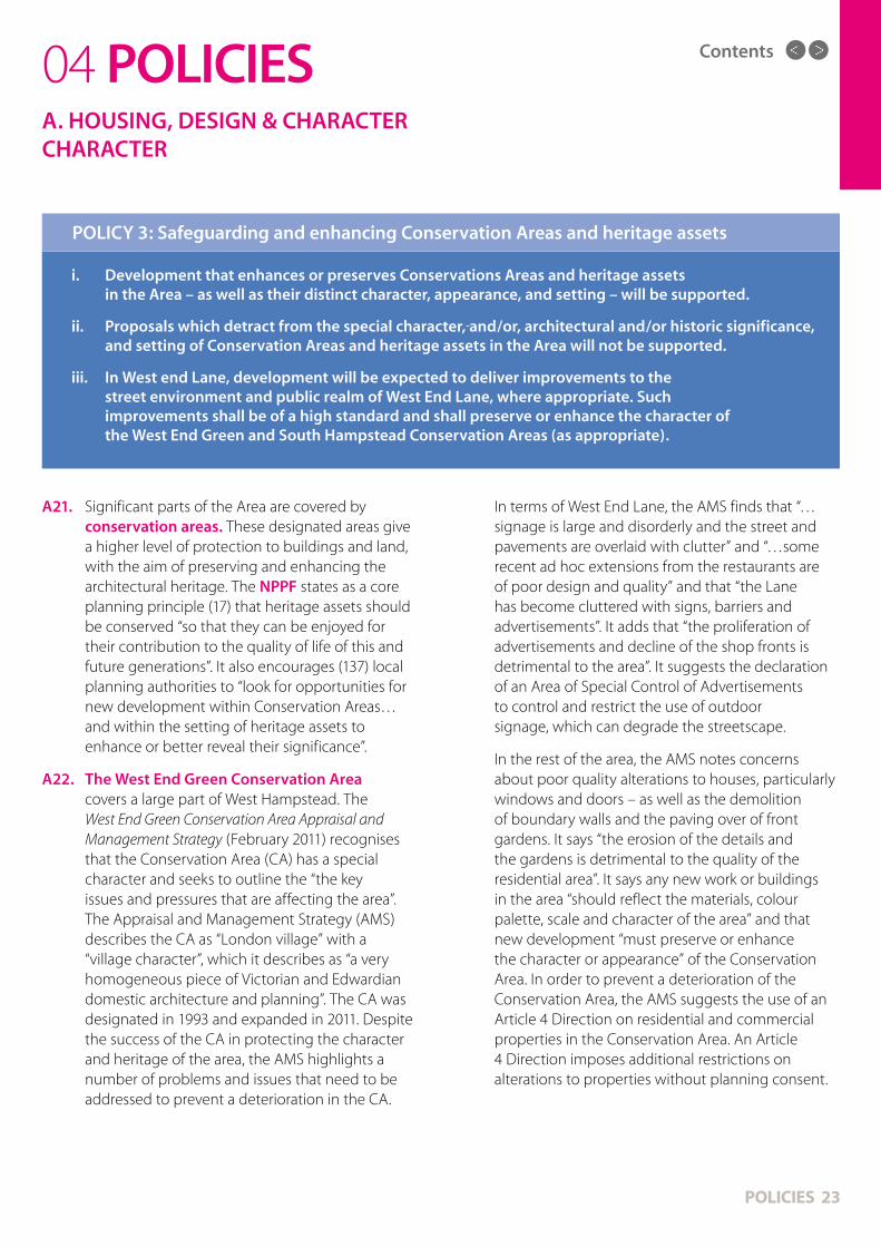
POLICY 3: Safeguarding and enhancing Conservation Areas and heritage assets
A21. Significant parts of the Area are covered by conservation areas. These designated areas give a higher level of protection to buildings and land, with the aim of preserving and enhancing the architectural heritage. The NPPF states as a core planning principle (17) that heritage assets should be conserved “so that they can be enjoyed for their contribution to the quality of life of this and future generations”. It also encourages (137) local planning authorities to “look for opportunities for new development within Conservation Areas…and within the setting of heritage assets to enhance or better reveal their significance”.
A22. The West End Green Conservation Area covers a large part of West Hampstead. The West End Green Conservation Area Appraisal and Management Strategy (February 2011) recognises that the Conservation Area (CA) has a special character and seeks to outline the “the key issues and pressures that are affecting the area”. The Appraisal and Management Strategy (AMS) describes the CA as “London village” with a “village character”, which it describes as “a very homogeneous piece of Victorian and Edwardian domestic architecture and planning”. The CA was designated in 1993 and expanded in 2011. Despite the success of the CA in protecting the character and heritage of the area, the AMS highlights a number of problems and issues that need to be addressed to prevent a deterioration in the CA.
A. HOUSING, DESIGN & CHARACTERCHARACTER

MAP 3Contents

Contents
POLICIES 25
The AMS also raises significant concern about the overall street environment of the area: “This is an area of fairly low grade public realm and very little original surfacing or street furniture. Worn-out and outdated concrete paving is a characteristic of the pavements; side streets are predominantly tarmac and in many cases lifted by tree roots”.
Consultations for this Plan revealed concerns among a large number of local residents and businesses about a lack of enforcement of the rules and policies of this Conservation Area. In particular, concern was also expressed about the state of West End Lane and damage to the historic character and streetscape of the road and its surroundings.
A23. The southern part of the Area includes a small part of the South Hampstead Conservation Area. As the vast majority of this conservation area is outside the Area of this NDP, it is not felt necessary to make extensive comments on this CA – other than to say that this NDP supports the strong enforcement of CA policies (including the existing Article 4 Direction) and requires the involvement of local residents in any changes to these rules.
A24. Residents in some parts of the Area have expressed interest in new Conservation Areas. The main proposal (as suggested in the West End Green Conservation Area AMS) is for a ‘Fortune Green Conservation Area’ covering the Green, the cemetery and the ‘Greek streets’ (Ajax Road, Agamemnon Road, Ulysses Road & Achilles Road). This could also include Hillfield Road and Gondar Gardens. Camden Council should keep their conservation areas under review and investigate the merits of designating new CAs in the Area, where a clear majority of residents request them.
A25. In addition to the list above, Camden Council is compiling a Local List for heritage assets that are of importance to the community as being significant elements of the borough’s heritage. It is proposed that these assets will merit consideration in the planning process. The NDF supports the formation of such a List and the protection if affords to these assets. The final version of this List should be based on widespread consultation and engagement in the local area - and be subject to regular review.
A26. The Area has a number of listed buildings which are widely appreciated and which provide an important element to the feel of the Area. These heritage assets, and their settings, should receive the highest possible levels of protection and care, in accordance with the Planning (Listed Buildings and Conservation Areas) Act 1990.
The main listed buildings in the Area are:
• Hampstead Synagogue, Dennington Park Road (1892-1901), Grade II*
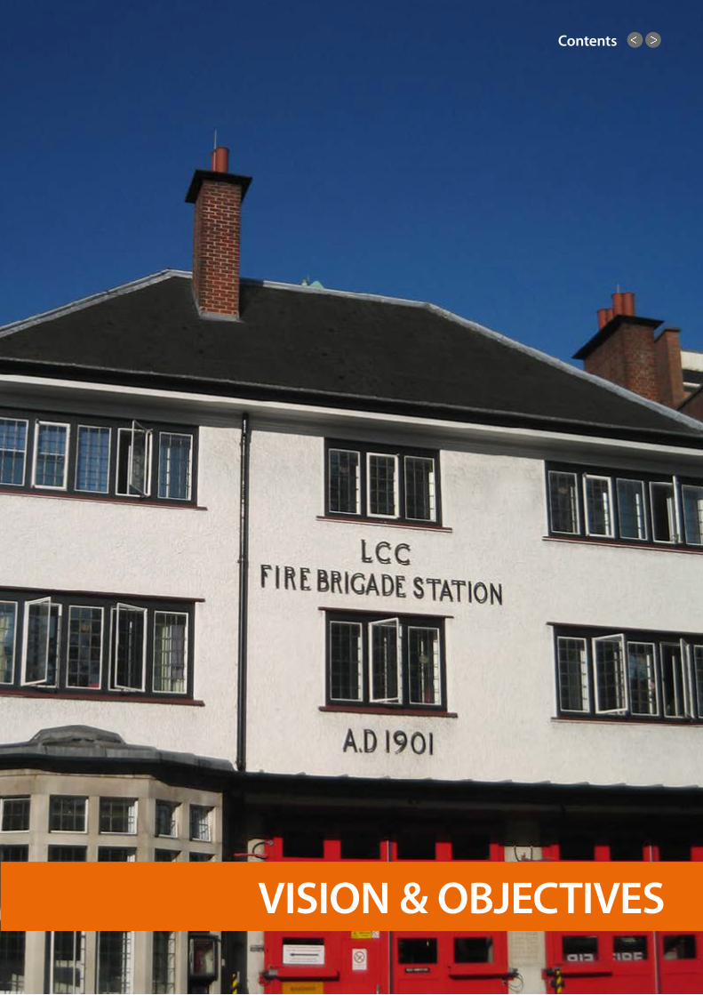
• Fire Station & firemen’s cottages, 325 West End Lane (1901), Grade II
• Emmanuel Church (1897-1903), Lyncroft Gardens, Grade II
• Beckford Primary School buildings (1885-6 & 1891), Grade II
• Hampstead Cemetery buildings & various gravestones (mainly Grade II)
• Public Conveniences (1890s), West End Green, Grade II
• Drinking Fountain, West End Green, Grade II
• St James’ Church (1887-8), Sheriff Road, Grade II
04 POLICIESA. HOUSING, DESIGN & CHARACTERCHARACTER

Contents
POLICIES 26
04 POLICIES
i. The introduction of an Article 4 Direction on all commercial and residential properties on West End Lane.
ii. The declaration of an Area of Special Control of Advertisements on West End Lane.
iii. Consultations on new Conservation Areas where residents request them. Such consultations should be open to all those living or working in the Neighbourhood Plan Area.
RECOMMENDATION B: in support of Policy 3 the following actions are recommended.
A. HOUSING, DESIGN & CHARACTERCHARACTER
Contents
POLICIES 27
04 POLICIESB. WEST HAMPSTEAD GROWTH AREA
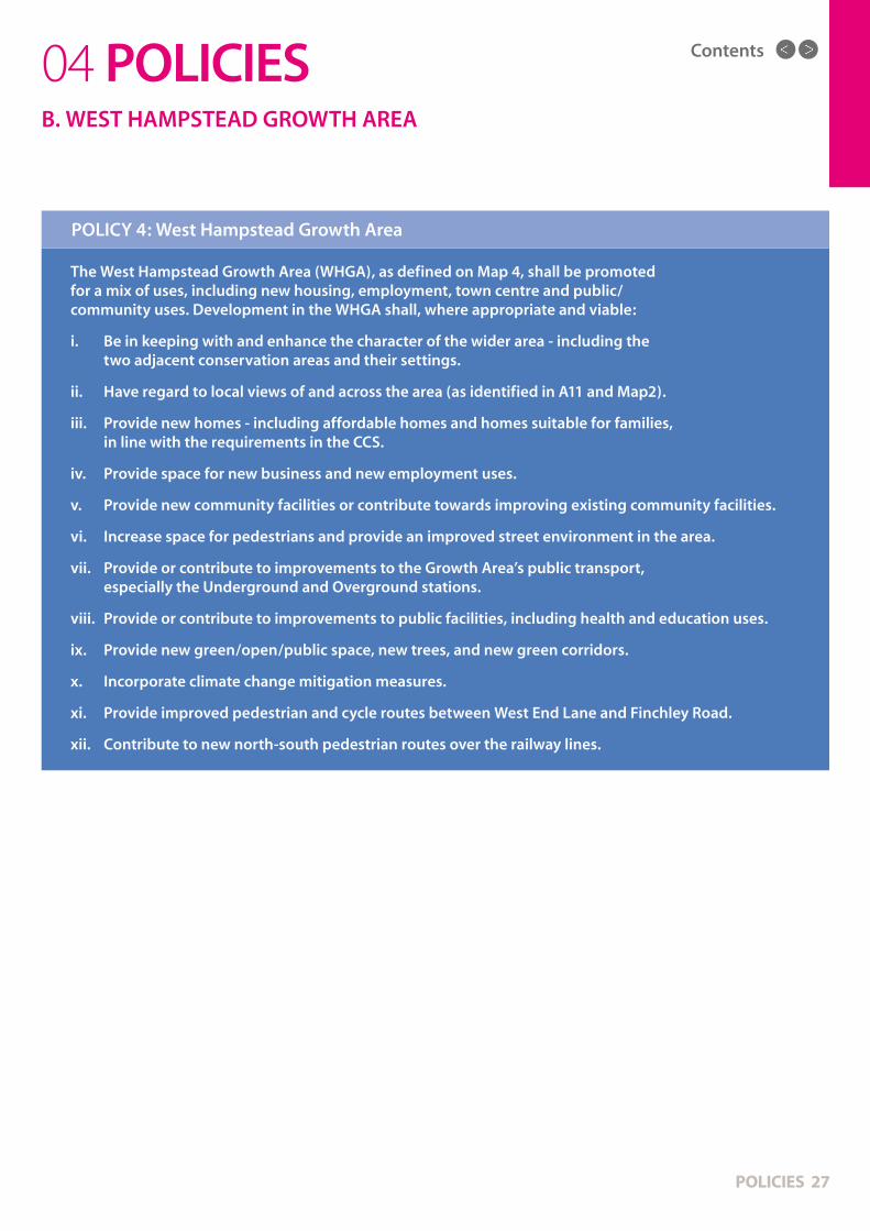
The West Hampstead Growth Area (WHGA), as defined on Map 4, shall be promoted for a mix of uses, including new housing, employment, town centre and public/community uses. Development in the WHGA shall, where appropriate and viable:
i. Be in keeping with and enhance the character of the wider area - including the two adjacent conservation areas and their settings.
ii. Have regard to local views of and across the area (as identified in A11 and Map2).
iii. Provide new homes - including affordable homes and homes suitable for families, in line with the requirements in the CCS.
iv. Provide space for new business and new employment uses.
v. Provide new community facilities or contribute towards improving existing community facilities.
vi. Increase space for pedestrians and provide an improved street environment in the area.
vii. Provide or contribute to improvements to the Growth Area’s public transport, especially the Underground and Overground stations.
viii. Provide or contribute to improvements to public facilities, including health and education uses.
ix. Provide new green/open/public space, new trees, and new green corridors.
x. Incorporate climate change mitigation measures.
xi. Provide improved pedestrian and cycle routes between West End Lane and Finchley Road.
xii. Contribute to new north-south pedestrian routes over the railway lines.
POLICY 4: West Hampstead Growth Area

Contents
POLICIES 28
B1. Part of West Hampstead has been identified as an “Area for Intensification” in the London Plan (Table A1.2) – see Map 4. Between 2010 and 2031 the stated aim is to provide a minimum of 800 new homes and 100 jobs. The CCS expects there will be around 1,000 new homes in the area during this period and an additional 7,000 square metres of business floorspace. The London Plan describes the area as “a significant inner London transport interchange with potential to improve connections between rail, underground and bus and to secure an uplift in development capacity through intensification”. Development is also planned on the edges of this area.
B2. The projected scale of development in this area will undoubtedly transform this part of West Hampstead, as well as the wider area. The expansion in the number of homes will present a series of challenges, which will need to be addressed. The West Hampstead Place Plan states that “the scale of potential change in the area needs to be managed carefully so that best advantage can be taken of the opportunities to protect and enhance the area and allow stakeholders to be involved in shaping the change”.
The CCS expects development in the Growth Area to be predominantly housing and seeks to encourage high density development. It adds that (1.22) “such schemes should be of excellent design quality and sensitively consider the amenity of occupiers and neighbours and the character and built form of their surroundings, particularly in conservation areas” and that (2.6) “it is important to note that the growth areas are next to, and sometime even include, existing residential communities and heritage assets such as conservation areas. Development must therefore take account of its sensitive context”.
While - in contrast to the rest of the Neighbourhood Plan area - there may be a need for higher density development and higher buildings in the WHGA - the built form of any proposed development will need to carefully justified by the developer.
This is particularly the case due to the Growth Area’s location, which lies between two conservation areas. As the Place Plan states, “any higher density development needs to be clearly balanced against the potential impact on the character of the area”.
The CCS (CS2) says “individual development schemes in the growth area will be expected to contribute to interchange improvements”. It expects improvements at the Interchange and supporting infrastructure to include:
• A mix of uses, including substantial new housing, town centre, employment and community uses and open space.
• Improved transport interchange accessibility and capacity and improved pedestrian and bicycle movement and routes.
• A substantially improved street environment around transport facilities, including improved crossing and wider pavements.
• Sustainable and safe design of the highest quality that respects the character and heritage value of West Hampstead.
The CCS (Policy 19) says the Council will “work with relevant providers to ensure that necessary infrastructure is secured to support Camden’s growth and provide the facilities needed for the borough’s communities”. As new developments are built, they will also need to include provision for health services, such as additional GP and dentist surgeries; schools and nurseries; community facilities; and other vital infrastructure.
It is also noted that the part of the WHGA which includes West End Lane is also in the area of the West Hampstead Town Centre (see F7 & Policy 13) and that the eastern part of the Growth Area is in the Finchley Road Town Centre (see F11).
04 POLICIESB. WEST HAMPSTEAD GROWTH AREA

MAP 4Contents
Contents
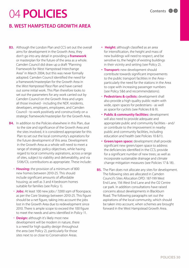
B3. Although the London Plan and CCS set out the overall aims for development in the Growth Area, they don’t go into any detail in providing a framework or masterplan for the future of the area as a whole. Camden Council did draw up a draft “Planning Framework for West Hampstead Interchange Area” in March 2004, but this was never formally adopted. Camden Council identified the need for a framework/masterplan for the Growth Area in the West Hampstead Place Plan and have carried out some initial work. This Plan therefore looks to set out the parameters for any work carried out by Camden Council on the Growth Area and urges all those involved - including the NDF, residents, developers, employers, employees, and Camden Council - to work positively and constructively on a strategic framework/masterplan for the Growth Area.
B4. I n addition to the Policies elsewhere in this Plan, due to the size and significance of the Growth Area and the sites involved, it is considered appropriate for this Plan to set out the local community’s aspirations for the future development of this area. Development in the Growth Area as a whole will need to meet a range of strategic policy objectives, while having regard to local community aspirations, across a range of sites, subject to viability and deliverability, and via S106/CIL contributions as appropriate. These include:
• Housing: the provision of a minimum of 800 new homes between 2010-25. This should include significant amounts of affordable housing; as well as 3 and 4 bedroom homes suitable for families (see Policy 1).
• Jobs: At least 100 new jobs / 7,000 sqm of floorspace, as per the Core Strategy between 2010-25. This figure should be a net figure, taking into account the jobs lost in the Growth Area due to redevelopment since 2010. There is ample scope to exceed the 100 figure to meet the needs and aims identified in Policy 11.
• Design: although it’s likely most new development will be modern in nature, there is a need for high quality design throughout the area (see Policy 2), particularly for those sites next to or close to Conservation Areas.
• Height: although classified as an area for intensification, the height and mass of new buildings will need to respect, and be sensitive to, the height of existing buildings in their vicinity and setting (see Policy 2).
• Transport: new development should contribute towards significant improvements to the public transport facilities in the Area - particularly the need for the stations in the Area to cope with increasing passenger numbers (see Policy 5&6 and recommendations).
• Pedestrians & cyclists: development shall also provide a high quality public realm with wide, open spaces for pedestrians - as well as space for cyclists (see Policies 8 & 9).
• Public & community facilities: development will also need to provide adequate and appropriate public and community facilities - and/or contribute to the improvement in nearby public and community facilities, including education and health (see Policies 10 &11).
• Green/open space: development shall provide significant new green/open space to address the deficiencies identified in the CCS; provide for a significant number of new trees; as well as incorporate sustainable drainage and climate change mitigation measures (see Policies 17 & 18).
B5. The Plan does not allocate any sites for development. The following sites are allocated in Camden Council’s Sites Allocation DPD: 187-199 West End Lane, 156 West End Lane and the O2 Centre car park. In addition consultations have raised concerns about developments in Blackburn Road. The following paragraphs set out the aspirations of the local community, which should be taken into account, when schemes are brought forward in the West Hampstead Growth Area.
POLICIES 30
04 POLICIESB. WEST HAMPSTEAD GROWTH AREA

Contents
• The design of any new building will need to reflect the design of neighbouring buildings and the neighbouring Conservation Area (see Policies 2 & 3), including use of red brick.
• The site shall provide an improved design relationship to the adjoining Canterbury Mansions and West End Green Conservation Area, to protect and enhance the character and appearance of the area. Therefore, the height of any new development should ensure the overall design and transition in massing achieves an appropriate relationship with neighbouring properties - and it can be demonstrated that no harm is caused to the character and appearance of the Conservation Area, its setting.
• The provision of new green/open space to address the deficiencies outlined in the CCS.
• The provision of space for a community meeting room for local groups and businesses.
• Improvements to the neighbouring Potteries Path to provide a safe route for pedestrians and cyclists.
• The investigation of opportunities for a pedestrian bridge over the railway line to the O2 Centre car park.
The ground floor of the site is currently occupied by the builders’ merchant, Travis Perkins (TP). The company has been based in the area for many years, is a significant local employer, and is keen to remain on the site. Protection for land in viable existing employment use is given in this Plan (see Policy 12) and also the CCS (CS8 & DP13).
B8. O2 Centre car park. This site was developed in the late 1990s from railway land. The O2 Centre is significant leisure and shopping facility in this part of north-west London and a significant employer. The land currently occupied by the car park has been identified as a significant site for redevelopment in the London Plan and CCS. The site is also within the Finchley Road Town Centre. In discussions with the NDF, the owners of the site, Land Securities, indicated that they would consider plans for a future redevelopment, but were keen to stress the constraints on the site and the need to accommodate car parking as a condition of the leases for the commercial tenants of the O2 Centre.
POLICIES 31
B6. 187-199 West End Lane. Planning permission was granted in March 2012 for a large development on this site, consisting of seven blocks of flats between five and 12 storeys high, with 198 new homes, planning permission is being implemented. Significant concerns have been expressed by local residents and businesses about the height and density of this development and its impact on the area. Considerable effort needs to be made to ensure that as much open space is provided as possible at the front of this development, where it meets West End Lane. It is also important to integrate a redeveloped West Hampstead Overground station into this development (see Policy 6). Although classified as a car free development, when completed, the site has the potential to cause significant traffic problems (particularly due to delivery and servicing vehicles), which could impact on the development of other sites in the immediate area. Further consideration also needs to be given to the pedestrian links from this site to the rest of West Hampstead (see Policy 9 and recommendations) when any future planning applications are brought forward for this site and/or this area.
B7. 156 West End Lane. This site, currently owned by Camden Council, is due to be sold and redeveloped. As part of the West Hampstead Growth Area it is expected to provide a significant number of new homes, as well as employment opportunities.The existing building on the site is considered of poor quality design and to have a negative impact on the immediately adjacent Conservation Area. Any redevelopment of this site needs to provide a mixed-use development, satisfying or making an appropriate contribution to the following needs:
• Housing, including a significant amount of affordable homes and 3 or 4 bedroom homes (see Policy 1).
• Offices for small, micro and start-up businesses - including the possibility of serviced offices and studio space.
• Flexible commercial and retail space that can be used for a range of employment uses.
• Retail space on the ground floor along West End Lane, which is fitting of the character of the Town Centre (see Policy 13) and set back from the pavement.
04 POLICIESB. WEST HAMPSTEAD GROWTH AREA
Contents
POLICIES 32
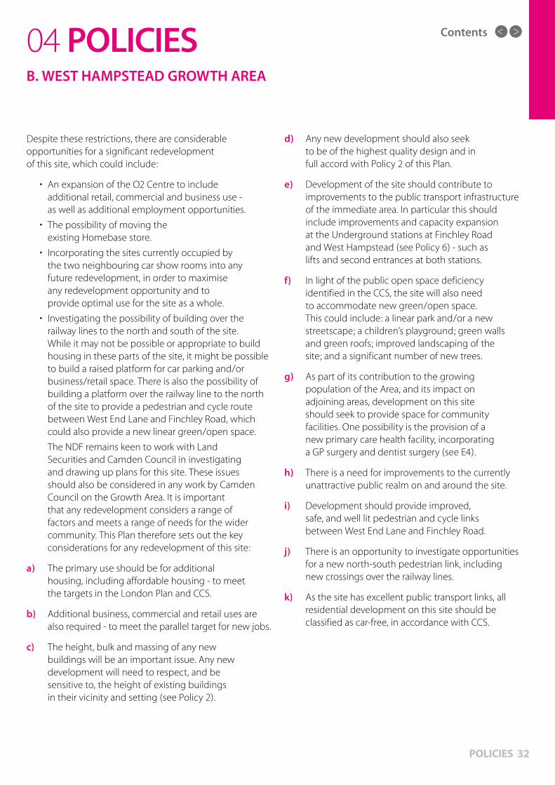
Despite these restrictions, there are considerable opportunities for a significant redevelopment of this site, which could include:
• An expansion of the O2 Centre to include additional retail, commercial and business use - as well as additional employment opportunities.
• The possibility of moving the existing Homebase store.
• Incorporating the sites currently occupied by the two neighbouring car show rooms into any future redevelopment, in order to maximise any redevelopment opportunity and to provide optimal use for the site as a whole.
• Investigating the possibility of building over the railway lines to the north and south of the site. While it may not be possible or appropriate to build housing in these parts of the site, it might be possible to build a raised platform for car parking and/or business/retail space. There is also the possibility of building a platform over the railway line to the north of the site to provide a pedestrian and cycle route between West End Lane and Finchley Road, which could also provide a new linear green/open space.
The NDF remains keen to work with Land Securities and Camden Council in investigating and drawing up plans for this site. These issues should also be considered in any work by Camden Council on the Growth Area. It is important that any redevelopment considers a range of factors and meets a range of needs for the wider community. This Plan therefore sets out the key considerations for any redevelopment of this site:
a) The primary use should be for additional housing, including affordable housing - to meet the targets in the London Plan and CCS.
b) Additional business, commercial and retail uses are also required - to meet the parallel target for new jobs.
c) The height, bulk and massing of any new buildings will be an important issue. Any new development will need to respect, and be sensitive to, the height of existing buildings in their vicinity and setting (see Policy 2).
d) Any new development should also seek to be of the highest quality design and in full accord with Policy 2 of this Plan.
e) Development of the site should contribute to improvements to the public transport infrastructure of the immediate area. In particular this should include improvements and capacity expansion at the Underground stations at Finchley Road and West Hampstead (see Policy 6) - such as lifts and second entrances at both stations.
f) In light of the public open space deficiency identified in the CCS, the site will also need to accommodate new green/open space. This could include: a linear park and/or a new streetscape; a children’s playground; green walls and green roofs; improved landscaping of the site; and a significant number of new trees.
g) As part of its contribution to the growing population of the Area, and its impact on adjoining areas, development on this site should seek to provide space for community facilities. One possibility is the provision of a new primary care health facility, incorporating a GP surgery and dentist surgery (see E4).
h) There is a need for improvements to the currently unattractive public realm on and around the site.
i) Development should provide improved, safe, and well lit pedestrian and cycle links between West End Lane and Finchley Road.
j) There is an opportunity to investigate opportunities for a new north-south pedestrian link, including new crossings over the railway lines.
k) As the site has excellent public transport links, all residential development on this site should be classified as car-free, in accordance with CCS.
04 POLICIESB. WEST HAMPSTEAD GROWTH AREA

Contents
POLICIES 33
B9. Blackburn Road. As part of the Growth Area, a number of developments have been developed or are being proposed on this road. A large development, consisting of student accommodation, has recently been built at the end of this small road. Other sites on either side of this road are likely to be developed in the future.
Responses to consultations for this Plan found widespread concern about the street environment of Blackburn Road, with complaints about litter, dumping and a perception that it was a neglected and unsafe area. As such, there is considerable scope to improve the public realm in this area - and to provide a more welcoming street environment, particularly for pedestrians and cyclists.
There is also concern about access to these sites along a narrow cul-de-sac, which currently has parking on both sides, leading to congestion and gridlock. The road is clearly not capable of accommodating the parking and traffic needs currently being placed on it. Once the developments mentioned below are completed, proposals should be brought forward by Camden Council for a review of access to this road. While the need for vehicle access to the properties on the road is noted, the preferred approach would be for a route giving priority to pedestrians and cyclists - as part of a wider scheme to provide an improved traffic-free route between West End Lane and the O2 Centre/Finchley Road. In light of Blackburn Road’s immediate proximity to public transport links, residential developments on this road should be classified as car-free.
Any development on or close to Blackburn Road should therefore: contribute towards improvements in public transport facilities in the area, particularly the immediately adjacent West Hampstead Underground station (see Policy 6 & recommendations); contribute to new green/open space; provide new trees; provide an improved public realm and streetscape; and contribute to community facilities in the immediate area.
In terms of the specific development sites on Blackburn Road, this Plan sets out the following priorities:
• 1 4 Blackburn Road (Builder Depot): this site has been in commercial use for many years; it has historical planning permission dating from 2004 for redevelopment for residential and business use. While the NDF is advised that this permission is still valid, it is noted that it pre-dates the current CCS, the current London Plan and the NPPF. As the owner of the site has not completed the approved scheme in a period of more than ten years, the NDF would suggest that new plans are submitted for a scheme that is in accordance with the three over-arching planning documents - as well as the policies in this Plan. Any redevelopment should be primarily residential (with appropriate affordable housing), with employment use (office and/or retail would be preferred) on the ground floor. Health, education, or community uses would also be considered appropriate. Employment uses are preferred on the ground floor in order to provide an economically viable, attractive and welcoming street environment on Blackburn Road - as well as providing a valuable link between the West Hampstead and Finchley Road Town Centres. There is also an opportunity to link this site to the West Hampstead Town Centre by incorporating the neighbouring buildings on West End Lane (next to the Underground station) in any new proposal.
04 POLICIESB. WEST HAMPSTEAD GROWTH AREA

Contents
POLICIES 34
In terms of improving the street and pedestrian environment on Blackburn Road, contributions could be made to improvements to the pedestrian bridge over the railway lines at the east of the site; as well as incorporating new green space and/or a pocket park on the immediately adjacent land on the north side of the bridge (subject to agreement from Network Rail/TfL).
• Asher House (and neighbouring land): is also proposed for redevelopment. Any new building should take into account the change in ground levels of Blackburn Road and respect the character of the immediate area, for example by being lower in height than the student block or by following the alignment of rooflines on West End Lane. A range of uses could be considered for this site including business/commercial; retail/hotel; residential (including affordable housing) and health/education/community uses. Employment use would be preferred on the ground floor (in line with the principles set out in the above paragraph).
04 POLICIESB. WEST HAMPSTEAD GROWTH AREA
i. A masterplan for the Growth Area should be drawn up by Camden Council following consultations with local residents, groups, employers, employees and developers. This masterplan should use the policies and text in this section of the Plan as the basis for its work.
ii. Camden Council should bring forward for consultation proposals for the future of Blackburn Road - with the aim of providing a significantly improved public realm, giving greater priority for pedestrians and cyclists, and providing an improved car-free link between West End Lane and Finchley Road.
RECOMMENDATION C: in support of Policy 4, the following actions are recommended.

Contents
POLICIES 35
C0. A number of sites and areas outside the West Hampstead Growth Area are proposed for development or may be developed in future. This Plan does not seek to allocate these sites for development; this section merely outlines the factors and aspirations that the local community believes should be considered if proposals are brought forward for development during the lifetime of this Plan. This Plan therefore seeks to provide detailed suggestions for how these locations could be developed. The aspirations in this section should also be read in conjunction with the policies elsewhere in this Plan - and are all subject to the proviso that development of sites must be viable.
C1. Liddell Road. Camden Council has decided that a primary school should be built on this site. While the Plan strongly supports the need for additional primary school places in the Area, the redevelopment of this site poses a number of problems which will need to be carefully assessed in any proposed scheme.
The following issues should be carefully considered when drawing up the scheme:
• The need to provide for a mix of uses, as well as a school building.
• The loss of businesses and employment (33 single light industrial units) will be significant. Added to the loss of jobs from other new developments nearby, the loss of this high quality employment site is a cause of concern. Any new development should maintain the existing employment floor space (see Policy 11) and provide new light industrial space.
• The height of any new buildings on the site will be an important issue. The current buildings on the site are not more than two storeys high; neighbouring buildings on Maygrove Road are generally three or four storeys high.
• The design of the new buildings will also be an important consideration. Although not in a Conservation Area, any new development on this site will be expected to designed to a high standard and in full accord with Policy 2 of this Plan.
• The priority for any redevelopment is to provide new employment space as well as a school.
Consequently the need for housing may be less on this site. Priority should be given to affordable housing, in line with the targets in the CCS.
• There is a need to consider other recently built/approved development around Liddell Road. The developments at 59 Maygrove Road, 65-67 Maygrove Road, 159 Iverson Road & 161-163 Iverson Road will mean more than 180 new homes around the edges of this development. It’s not clear how these additional homes can be integrated into the community without additional infrastructure and facilities.
• As the site is in an area classified as deficient in open space, there is a need to protect the existing green and open space; this includes the ‘Maygrove open space’ between the site and Maygrove Road. Any development should create new green/open space and provide for an expansion of the neighbouring Maygrove Peace Park onto the site. The avenue of 14 trees on the site is also deemed to be significant. Any plans to remove these trees should be accompanied by plans for a replanting of a significant number of new trees on the site.
• The impact of the school on traffic in the area will also need to be considered. With parking on both sides, Maygrove Road is in effect a single track road. As large new residential developments in the area are being made to be car-free, should this be a car-free school.
• There is a need to improve links between the site and the rest of West Hampstead.
C2. Gondar Gardens Reservoir: in recent years, three developments have been proposed for this site. All three have been rejected by Camden Council, although one has been granted on appeal. At the time of writing, an appeal on the third scheme is pending. In light of its designation as a Site of Importance to Nature Conservation in existing planning documents, any development should retain as much open space as possible and offer limited, managed public access consistent with maintaining suitable conditions for bio-diversity and wildlife. Due to the significant amount of open space the site provides, views across the site should be protected from significant damage or loss; of particular significance is the view to the east to
04 POLICIESC. OTHER SITES

Contents
Hampstead. Any development of the frontage on Gondar Gardens shall match the character of existing development and shall be no higher or deeper than adjacent buildings (see Policy 2).
C3. West Hampstead police station: the Metropolitan Police is reducing the number of police stations in London and may, in future, decide to sell the building, leading to a redevelopment of the site. The site is at the end of a residential street (Hillfield Road), is opposite a Conservation Area, and is adjacent to the Fortune Green Road neighbourhood centre. Any redevelopment should reflect the height of existing buildings and should broadly be in keeping with the building lines of the existing building, being set well back from the pavements on both Hillfield Road & Fortune Green Road. While any development should be primarily residential, space should be considered on the ground floor for a number of uses, such as: retail units; space for small businesses/studios; a community meeting place; and a base for local police officers.
C4. West Hampstead fire station: while there are currently no plans to change the use of this building, if proposals are bought forward for a sale or redevelopment, there should be no change to the overall structure of the building due to its listed status. An appropriate commercial use would be considered most suitable on the ground floor, with residential use on the upper floors. The cottages (behind the building) should also be protected and there is the potential to link this site to the neighbouring Mill Lane Open Space. The preferred use of the cottages is residential.
C5. Fortune Green Play Centre: the site should be retained for community use - ideally educational/children’s use. Any redevelopment should not significantly increase the quantity of built floor space at the expense of open space. A two-storey replacement building may be acceptable if located and detailed so as not to reduce views north from Fortune Green towards the cemetery. Any play areas on the site should seek to maximise public access.
C6. Mill Lane: a number of modern developments have recently been built on the north side of Mill Lane between Gondar Gardens and Sumatra Road, in the gardens of properties on Hillfield Road. The piecemeal development of this strip of land – in a variety of styles and designs – is a cause for concern. Future developments should be no higher than those structures already built and should be set well back from the pavement to provide maximum space for safe pedestrian movement on the north side of Mill Lane.
The ground floor of existing buildings in the Mill Lane neighbourhood centre is primarily retail, restaurant/cafe, and business/commercial. This mix should be preserved, in order to provide a vibrant and economically active neighbourhood centre (see Policy 14).
C7. Maygrove Road: a number of large developments have been built and are planned for this road. Any further developments should be no higher than existing buildings on the street and should be mindful of the impact of other recent developments. As the area has been neglected in the past, CIL funds from developments on the Road should be focussed on the Road and its immediate vicinity – particularly Sidings Community Centre and Maygrove Peace Park. In view of the limited road space, any large developments should be car-free.
C8. Iverson Road: the road currently has a mix of residential and business/commercial space. This mix should be preserved. Business space, including under the railway lines, should be retained and recognised as an important source of local employment for light industrial uses. Heavy industrial uses are not considered appropriate, due to the immediate proximity of residential properties.
POLICIES 36
04 POLICIESC. OTHER SITES

Contents
MAP 5Contents
Contents
POLICIES 38
04 POLICIESC. OTHER SITES
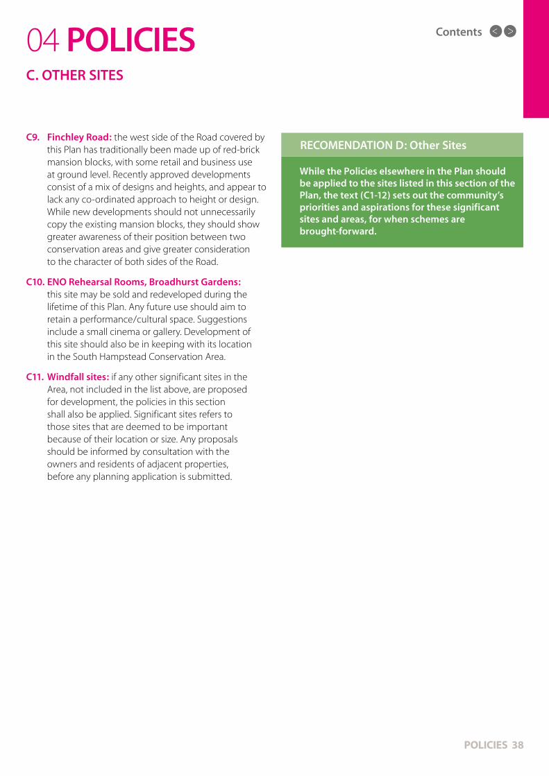
C9. Finchley Road: the west side of the Road covered by this Plan has traditionally been made up of red-brick mansion blocks, with some retail and business use at ground level. Recently approved developments consist of a mix of designs and heights, and appear to lack any co-ordinated approach to height or design. While new developments should not unnecessarily copy the existing mansion blocks, they should show greater awareness of their position between two conservation areas and give greater consideration to the character of both sides of the Road.
C10. ENO Rehearsal Rooms, Broadhurst Gardens: this site may be sold and redeveloped during the lifetime of this Plan. Any future use should aim to retain a performance/cultural space. Suggestions include a small cinema or gallery. Development of this site should also be in keeping with its location in the South Hampstead Conservation Area.
C11. Windfall sites: if any other significant sites in the Area, not included in the list above, are proposed for development, the policies in this section shall also be applied. Significant sites refers to those sites that are deemed to be important because of their location or size. Any proposals should be informed by consultation with the owners and residents of adjacent properties, before any planning application is submitted.
POLICY 5: Other Sites
While the Policies elsewhere in the Plan should be applied to the sites listed in this section of the Plan, the text (C1-12) sets out the community’s priorities and aspirations for these significant sites and areas, for when schemes are brought-forward.
RECOMENDATION D: Other Sites

Contents
POLICIES 39
D1. Residents and businesses appreciate the excellent public transport the area offers, with good links to central London and beyond. The area is served by London Underground, London Overground and the Thameslink national rail route, as well as a number of bus routes. The NPPF states as a core planning principle (17) that planning should "actively manage patterns of growth to make the fullest possible use of public transport, walking and cycling". This section seeks to fulfil this requirement, by promoting sustainable transport and the aims of Objective 3.
D2. There are three rail stations in West Hampstead, all in close proximity. Most recent statistics (2012/3) show that more than 16 million people use the three stations every year, with significant increases in usage.
( See Table in Page 41)
Many people from outside the Area use the stations and interchange between them. In addition, the large scale development of the West Hampstead
04 POLICIESD. PUBLIC TRANSPORT
Growth Area, as well as sites near to it, mean there is additional pressure on these stations and the areas around them - particularly as nearly all such development is classed as ‘car-free’. The area around the stations (often referred to as ‘the interchange’) is regularly crowded, with little room for pedestrians, causing them to spill over onto the road. This area is dominated by traffic, with narrow, cluttered and highly congested pavements – which are used both by local residents and commuters travelling in and out of central London. Urgent improvements to the public realm are needed in this area to make pedestrian movement safer and easier. Future developments in this area should be set back to provide wider footpaths. As the area around the stations is increasingly developed, there will be an ongoing need to support the improvement of the facilities at all three stations as the population increases. Improving the character of this area is also important, as it sits between two conservation areas. The current look and feel of this area can be unattractive and unappealing, with too many advertising hoardings and retail signs.
Development shall make appropriate provision for, and/or contribute towards, improvements to the public transport infrastructure of the Area –particularly in the West Hampstead Growth Area.
POLICY 5: Public Transport

MAP 6Contents

Contents
POLICIES 41
(Source: TfL & ORR; total numbers of entrances & exits per station)
04 POLICIESD. PUBLIC TRANSPORT
West Hampstead
2008/9 2009/10 2010/11 2011/12 2012/13% increase
2008/9-2012/3
Underground 7,360,000 7,440,000 7,450,000 8,234,838 9,713,151 32%
Overground 1,500,000 1,315,000 1,897,000 2,880,760 3,674,166 145%
Thameslink 2,318,000 2,231,000 2,576,000 2,777,862 2,817,070 22%
Total 11,178,000 10,986,000 11,923,000 13,893,460 16,204,387 45%
TRANSPORT TABLE
Proposals to improve the capacity, quality and accessibility of public transport facilities in the Area will be supported at the following locations:
• West Hampstead Underground Station: to allow for additional capacity - including providing an expanded and/or new/second entrance; and a lift from street to platform level.
• West Hampstead Overground Station: to allow for additional capacity - including an expanded entrance hall; a new building set back from the existing building line; and lifts to both platforms.
• Finchley Road Underground Station: to allow for additional capacity - including an enlarged entrance hall and lifts to both platforms.
• Finchley Road and Frognal Overground Station: to allow for additional capacity - including an enlarged entrance and lifts from street to platform level.
POLICY 6: Public Transport Facilities

Contents
D7. Finchley Road Underground station: is on the edge of the Area, and is widely used by residents as an interchange between the Jubilee and Metropolitan lines. Development in the Growth Area will lead to an increase in passenger use at this station. Further development of this station - including an expansion of the existing entrance; the provision of a second entrance (from the O2 Centre car park site); and the installation of lifts - will all need to be considered by TfL. Such improvements could be partly funded by CIL payments.
D8. The Chiltern national rail route from Marylebone Station runs through the Area, but does not stop in or near it. In the past, plans have been proposed for a West Hampstead station for this route. If space can be found for a station, this is likely to be welcomed - particularly if it could link with the neighbouring Underground station - subject to discussions with TfL and Network Rail.
POLICIES 42
04 POLICIESD. PUBLIC TRANSPORT
i. A review of bus stops in the Area - particularly around the three stations on West End Lane - to ensure their current location is not restricting passenger or pedestrian requirements.
ii. Measures to prevent empty buses using Mill Lane to return to their depot.
iii. Consideration of plans for a West Hampstead station on the Chiltern national rail route.
RECOMMENDATION E: in support of Policies 5 & 6 the following actions are recommended.
D3. West Hampstead Thameslink station: has recently been redeveloped and has successfully provided more space for both passengers and pedestrians - particularly around the new station building on Iverson Road. These principles should be followed when other stations in the Area are redeveloped.
D4. West Hampstead London Underground station: is within the South Hampstead Conservation Area and has significant architectural merit, including the Art Deco style waiting rooms, which should be preserved. There is a need for a lift at the station to provide access for disabled people – as well as the elderly and those with push-chairs. The installation of a lift should be an urgent priority, in order to improve accessibility and provide an effective interchange. The station is regularly overcrowded, especially during the morning and evening rush hour, and the entrance hall needs to be enlarged. Proposals should also be brought forward for the provision of a second entrance to the station - either from west side of the bridge on West End Lane and/or from the pedestrian bridge at the eastern end of the station (this could be part-funded by CIL payments).
D5. West Hampstead London Overground station: the current station is small and is often overcrowded, particularly at peak times. There is no disabled access and the installation of lifts should be a priority. There is an urgent need to fully redevelop the whole station. Proposals for a redevelopment of the station (which are being drawn up by TfL at time of writing) should feature an enlarged entrance and be set well back from West End Lane to allow more space for pedestrians.
D6. Finchley Road & Frognal Overground station is also in the Area and needs to be considered for improvements and expansion to cope with the increasing population. At time of writing, TfL has funded plans for improvements to the station - including an enlarged entrance - which are welcomed. The provision of lifts at the station is also needed to make the station fully accessible.
Contents
POLICIES 43
04 POLICIESD. SUSTAINABLE TRANSPORT
In order to encourage the safe movement of traffic on roads in the Area, and to promote a reduction in car use, development will be supported which includes the appropriate provision of:
i. Car-free or car-capped developments.
ii. Car club spaces.
iii. Charging points and dedicated parking spaces for electric cars.
iv. Contributions to safer road layouts, traffic calming, and the removal of rat-runs.
v. Proposals which will result in a reduction in air pollution caused by vehicle emissions.
vi. The appropriate provision of loading bays for commercial use that requires regular deliveries.
POLICY 7: Sustainable Transport
D9. As a busy urban area, a number of roads in the Area suffer from congestion, particularly the main routes through the Area: West End Lane, Fortune Green Road and Mill Lane. There are particular problems on the part of West End Lane around the railway stations, where the existing layout is not meeting the needs of vehicles or pedestrians. There are also concerns about speeding on some quieter roads and some routes being used as rat runs. Camden Council has introduced a borough-wide 20mph speed limit, which this Plan supports along with other road safety measures. The CSS (11.21) says “the demand for movement, deliveries and car parking on Camden’s roads already exceeds the space available, meaning that effective management of Camden’s road network is essential. The Council will seek to ensure that new development does not cause harm to Camden’s road hierarchy, or to the ability of the Council to manage the road network” and that (11.25) “the Council will also seek to ensure that the impact of construction traffic and the servicing of future developments are kept to a minimum”. Camden Council policy is for a reduction in car use and many developments in the area - especially those close to public transport links - are classed as ‘car free’ (this is a legal requirement on properties which prevents occupiers receiving a residents permit, which would allow people to park in the area). Census figures for 2011 show that 57% of households in the Area do not have access to a car or van (a 7% increase since 2001).
D10. The CCS (16.14) states that Camden suffers from poor air quality and that “the Council has declared the whole borough an Air Quality Management Area for failing to meet the government’s health based air quality objectives for nitrogen dioxide and particulate matter”. In order to reduce the emissions from vehicles in the Area, car reduction measures – such as car free developments, parking spaces for car club vehicles and charging points for electric cars – are strongly supported.
D11. There are a range of views on street parking, which this Plan does not attempt to address. Some businesses and residents have called for more short-term parking in retail areas and neighbourhood centres. Camden Council should bring forward proposals for such provision and consult with residents and businesses about how to take these plans forward. There is widespread concern about the parking of delivery lorries - particularly those servicing the small supermarkets on West End Lane - which block the road and cause congestion. Such premises should ideally be allocated parking space away from main routes.

Contents
POLICIES 44
04 POLICIESD. SUSTAINABLE TRANSPORT
i. A study to consider improvements to West End Lane around the three West Hampstead stations - including the possibility of widening the bridges over the railway lines, to give more space to pedestrians and cyclists.
ii. The introduction of a lane rental scheme for road works in the Area.
iii. The introduction of measures, including tough penalties, to prevent delivery lorries obstructing main roads in the Area.
iv. Measures to monitor the air quality of the Area - particularly on West End Lane - and to publicly publish this information.
RECOMMENDATION F: in support of Policy 7 the following actions are recommended.
D12. Facilities for buses: the Area is well provided by a number of bus routes, however a number of issues need to be addressed. Empty buses travelling between West End Green and Cricklewood bus garage should not use Mill Lane, as this route is not suitable for large double-decker buses. The layout of bus stops around the West Hampstead railway stations needs to be redesigned to reduce congestion and allow more space for passengers and pedestrians. It is likely that additional bus routes, and greater frequency of existing services, will be needed to accommodate the Area’s growing population - particularly the rising population of the Growth Area and its car free developments.
Contents
POLICIES 45
04 POLICIESD. SUSTAINABLE TRANSPORT
Development shall promote improved provision for cycling throughout the Area and encourage cycling. This shall be achieved, where appropriate, by:
i. Contributions to the improvement of existing bicycle lanes and paths.
ii. Contributions to the provision of safe and well designated cycle routes, especially on the main roads through the Area: West End Lane, Fortune Green Road & Mill Lane - as well as on the main roads on the boundary of the Area: Finchley Road & Kilburn High Road/Shoot-up-Hill/Cricklewood Broadway.
iii. Contributions to the provision of new bicycle lanes and paths.
iv. Contributions to the provision of new bicycle stands in all parts of the Area - and particularly in town and neighbourhood centres.
v. The provision of appropriate bicycle storage in residential and commercial development.
POLICY 8: Cycling
D13. Cycling: The London Plan (6.33) states that “the Mayor is committed to seeing a revolution in cycling in London. The quality and safety of London’s street environment should be improved to make the experience of cycling more pleasant and an increasingly viable alternative to the private car”. The CSS (Policy CS11) says the Camden Council will “continue to improve facilities for cyclists, including increasing the availability of cycle parking…and enhancing cycle links”. With more and more journeys in the Area being made by bicycle, better facilities and infrastructure are needed to accommodate and ensure the safety of such journeys.
Contributions to improve cycling opportunities will be sought where appropriate and may be in the form of financial and / or appropriate design measures or in kind improvement.
i. The extension of the London bicycle hire scheme to cover the Area.
RECOMMENDATION G: in support of Policy 8 the following action is recommended.

Contents
A particular problem is the pavements between the three stations on West End Lane. At busy times, especially during the rush hour, the pavements become congested and pedestrians regularly spill onto the road. During the course of its work, the NDF looked into the possibility of a survey of pedestrian movements and flows in the area to shape the design of future improvements and policies. The cost was beyond the financial resources of the NDF, but the Plan calls on Camden Council to implement such a study. This could be funded from S106 or CIL money. (see Transport Table)
There is scope to improve the safety of the pedestrian crossings to give more space for pedestrians, including wheelchair users and those with pushchairs on the following roads in the area:
• West End Lane • Mill Lane • Fortune Green Road • Finchley Road • Shoot-up-Hill
POLICIES 46
04 POLICIES
Pedestrian access in the Area - particularly in and around the West Hampstead Growth Area - shall be improved by development that takes into account the following:
i. Provides safe and wide pavements, giving the maximum possible space to pedestrians.
ii. Is set well back from the pavement, where appropriate, with the aim of giving additional pavement space.
iii. Improves accessibility for disabled people and those with push chairs.
iv. Contributes to improved and safer pedestrian crossings - particularly on the roads listed in D14.
v. Increases the amount of space for pedestrians around public transport facilities.
vi. Improves the existing network of paths in the Area.
vii. Contributes to the provision of new paths and, where viable, new crossings over the railway lines.
POLICY 9: Pavements & Pedestrians
D14. Pavements & Pedestrians: The London Plan (Policy 6.10) says “the Mayor will work with all relevant partners to bring about a significant increase in walking in London, by emphasising the quality of the pedestrian and street environment, including the use of shared space principles – promoting simplified streetscape, decluttering and access for all”. The CCS notes (p.9) that walking accounts for nearly half the journeys taken by Camden residents and says (14.20) “the Council will seek improvements for all pedestrians to ensure good quality access and circulation arrangements, including improvement to existing routes and footways”.
There is strong support for additional space(s) for pedestrians in the Area (Objective 3). In many parts of the Area, pedestrians are forced onto narrow, uneven and poorly maintained pavements. A popular example of where additional space has recently been made for pedestrians is the entrance to the Thameslink station on Iverson Road. Other similarly creative schemes should be brought forward for other parts of the Area.
D. SUSTAINABLE TRANSPORT

Contents
POLICIES 47
04 POLICIES
i. The removal of clutter and obstructions from pavements and paths in the Area.
ii. Efforts to promote the removal of unnecessary visual clutter, signs and advertising.
iii. A survey of pedestrian movements around the three West Hampstead stations to inform and provide improvements for pedestrians in this area.
Such a scheme should consider:
• A new pedestrian crossing outside West Hampstead tube station and the removal of other nearby pedestrian crossings.
• An expanded pedestrian area on the railway bridge above the Underground lines, linking with the new pedestrian space at 189-199 West End Lane.
• A redeveloped London Overground station set well back from the pavement.
• The removal of all street clutter between the Overground station and Iverson Road to provide a clear pedestrian connection to the Thameslink station forecourt.
RECOMMENDATION H: in support of Policy 9 the following actions are recommended.
D15. Street clutter: a range of signs, traffic signals, bins, black boxes, railings and commercial signs appear on many pavements in the Area. In order to make more space for pedestrians and to improve movement these items should be minimised; where they are needed, they should be set back as far as possible or placed on side streets. Visual clutter - such as out of date street signs and estate agent boards - should also be minimised. Waste and recycling from residential and commercial premises should not be left on pavements for long periods. Fly-tipping should be strongly discouraged and heavily penalised.
D16. Pathways: a number of paths in the Area provide important pedestrian routes.
They are:
• Billy Fury Way (West End Lane to Finchley Road)
• Black Path (West End Lane to Broomsleigh Street)
• Potteries Path (West End Lane to Lymington Road)
• ‘O2 Centre path’ (Blackburn Road to O2 Centre)
• Wayne Kirkham Way (Mill Lane to West End Sidings estate)
These routes should be well maintained, well lit, safe and secure - including, where appropriate, the use of CCTV cameras. Where possible, they should also be opened up and widened. Due to concerns about its safety, Wayne Kirkham Way would benefit from renovation and/or redesign.
There is also a need for new pedestrian routes in the area, particularly in and around the Growth Area and for new crossings over the railway lines. The railways lines divide the area and are a barrier to movement, with limited crossing points. Suggestions for new crossings over the railway lines include new north/south routes through the Growth Area (see 4B).
D. SUSTAINABLE TRANSPORT

Contents
POLICIES 48
04 POLICIESE. PUBLIC & COMMUNITY FACILITIES
Development that increases the demand for community facilities and services shall make provision where appropriate - or contribute towards - appropriate community facilities to meet the needs of a diverse and growing population. This shall be achieved by the provision of relevant facilities, such as:
i. New school places, particularly for primary pupils.
ii. Additional nursery places in the Area.
iii. Primary care health facilities, particularly in or near the West Hampstead Growth Area.
iv. Improvements to existing community centres and the range of services they provide.
v. New community facilities, where appropriate and where there is an identified need.
POLICY 10: New and Improved Community Facilities
E1. The CSS (Policy CS10) says Camden Council will “require development that increases the demand for community facilities and services to make appropriate contributions towards providing new facilities or improving existing facilities” and it will “support the retention and enhancement of existing community, leisure and cultural facilities”. The NPPF states as a core principle (17) that planning shall “deliver sufficient community and cultural facilities and services to meet local needs”. In light of the expansion in the population of the Area - particularly in the West Hampstead Growth Area - new and expanded public, social and community facilities shall be developed (Objective 4). There is also scope to link existing council facilities – such as schools, community centres and libraries – that can be used as ‘community hubs’, particularly at evenings and weekends.
E2. The following primary and secondary schools are located in the Area:
• Hampstead Secondary school, Westbere Road
• Emmanuel Primary school, Mill Lane
• Beckford Primary school, Dornfell Street
The London Plan (3.103) states that “land already in educational use should be safeguarded and new sites secured to meet additional demands or changes in provision. Boroughs should identify at an early stage the need for additional schools arising from development and regeneration, particularly where there are existing shortages”. The NPPF (72) says “local planning authorities should take a proactive, positive and collaborative approach to meeting this requirement (for new schools), and to development that will widen choice in education”.
Camden Council has identified a lack of primary school places in this part of the borough. This issue will becoming more pressing as the population of the Area continues to increase. It is expected that at least one, and possibly two, new primary schools will need to be built in or near the Area during the timescale of this Plan.

Contents
POLICIES 49
Given the rising demand for primary school places, the community anticipate that this will lead to increased demand for secondary school places in the years to come. It is therefore possible that an additional secondary school may need to be built in or near the Area during the lifetime of this Plan; an extension of an existing secondary school could be considered as an alternative.
In considering sites for new schools, the community would like the following principles to be considered:
• The intake for new schools in the Area should be primarily children living in the immediate area.
• Sites should be accessible and give priority to ‘walk to school’ policies and car-free schools.
• Where possible, priority should be given to state schools over private institutions.
E3. Nurseries in the Area - and the facilities they provide - should be protected. Space for new nurseries should be provided to meet the needs of a growing population and the increase in the number of young children in the Area.
E4. The Area has a number of health services which serve the local community. Doctors’ surgeries are located at the following sites in the Area:
• West Hampstead Medical Centre, Solent Road
• Fortune Green Medical Centre, Fortune Green Road
• Cholmley Gardens Medical Centre, Mill Lane
• Westfield Medical Centre, Finchley Road
The CCS (Appendix 1, 16 & 19) cites a need for an additional GP Clinic and an additional dentist surgery in North-West Camden by 2026. As the NHS is restructured to move care away from hospitals, it is anticipated that more primary care facilities will be needed in the Area. This is particularly the case in and around the West Hampstead Growth Area, where the population will increase significantly. Space should be provided in or near the Growth Area for new public primary care facilities (see section 4B & B9). Ideally, this would be a mixed use NHS primary care centre, incorporating a drop-in centre, and possibly a dentist, open seven days a week.
E5. The scale of development in the Area is already putting pressure on water supplies. Victorian water mains pipes burst regularly and are in need of upgrading. Additional sewerage and drainage pipes are also likely to be required. New developments will need to consider their effect on this important part of the local infrastructure. Developers and Camden Council will need to work with Thames Water, and other relevant bodies, to ensure the Area has sufficient and robust water supplies.
E6. New developments - particularly large schemes - will also need to consider their effect on the power infrastructure of the Area. The Area has been affected by power cuts in the past, which has led to questions about the resilience of the local electricity network. Developers will need to work with power companies and providers to ensure that adequate power infrastructure is in place to accommodate any new development.
04 POLICIESE. PUBLIC & COMMUNITY FACILITIES
Contents
POLICIES 50
04 POLICIESE. PUBLIC & COMMUNITY FACILITIES
POLICY 10: Public & Community Facilities
The Plan supports the retention and enhancement of existing community facilities. This will be achieved by:
i. Resisting the loss of the facilities and sites listed in E7 and E8, unless a replacement facility is provided.
ii. Improvements to existing facilities will be supported.
POLICY 11: Protecting Community Facilities
E7. The Area has a number of community facilities that are widely used, appreciated and which support the community’s needs. These facilities, listed below, should be supported and their sites protected:
• West Hampstead Library, Dennington Park Road
• West Hampstead Community Centre, Broomsleigh Street
• Sidings Community Centre, Brassey Road
• Jewish Community Centre, Finchley Road
• 96-98 Shoot-up Hill
• Sherriff Centre, St James’ Church, Sherriff Road
• Emmanuel Church, community rooms (proposed)
• Tenants’ halls: Templar House & Lymington Estate
E8. The Area’s places of worship are also important to the community and their sites should be protected:
• Emmanuel Church, Lyncroft Gardens
• St James’ Church, Sherriff Road
• St Cuthbert’s Church, Fordwych Road
• Brondesbury Christian Church, Iverson Road
• Hampstead Synagogue, Dennington Park Road
• Shomrei Hadath Synagogue, Burrard Road
E9. The Metropolitan Police has a significant building in the Area, West Hampstead Police station on Fortune Green Road. There is also a base for the local Safer Neighbourhoods teams on West End Lane. The local community considers that it is important to keep local police teams based in the Area at these bases or alternative sites (see C3).
E10. West Hampstead Fire station is a Grade II listed building which forms a focal point at the top of West End Lane. It is important to keep this amenity in the Area. The local community considers that if this site is sold and/or redeveloped, the look, facade and surroundings of this building should be fully preserved (see C4).
E11. The provision of public toilet facilities is an important amenity. The public toilets at West End Green are listed and protected (see A24); new/additional facilities would be welcomed.
E12. Other public services, such as post offices and banks are also important to the Area, particularly the town and neighbourhood centres. Space for these facilities should be a priority in these centres.
Contents
POLICIES 51
04 POLICIESF. BUSINESS
F1. The NDP supports the development of existing and new businesses in the Area to provide a strong and resilient local economy, as well as a range of employment opportunities (Objective 5).
F2. The NPPF (19) says the planning system should operate to encourage “sustainable economic growth”. The London Plan (Table 1.1) predicts a 24.5% increase in employment in the borough of Camden between 2007 and 2031. There is also a target for at least 100 new jobs in the West Hampstead Growth Area between 2010 and 2031. The CCS (Policy CS8) seeks to promote a successful and inclusive economy in the borough. It aims to “safeguard existing employment sites” and provide “a mix of employment facilities and types”. It also highlights the fact that Camden has a large proportion of small businesses, 75% of which employ less than five people. However, it notes (8.20) “there is a lack of high quality premises suitable for small business, particularly those less than 100 sq m”. It adds: “we will seek the provision of innovative new employment floor space in developments that will provide a range of facilities including: flexible occupancy terms, flexible layouts, studios, workshops, networking, socialising and
meeting space that will meet the needs of a range of business types and sizes”. The West Hampstead Place Plan says “a mix of employment space is important to the local economy and employment opportunities” and there is “a desire for small businesses to be able to stay in the area” and a need to “develop space…affordable to their needs”.
F3. During consultations for this Plan, concerns were expressed that commercial sites in Area were being replaced with residential developments, causing damage to the local economy, reducing employment opportunities, and restricting economic growth. The protection of existing jobs and employment sites in the Area - and the provision of new jobs and new employment sites - is therefore of great importance to the local community and its sustainability, the local service sector, and existing businesses. It is vitally important that the Area does not become a “commuter town” for those working in central London and the City.
Development in Fortune Green and West Hampstead shall promote economic growth and employment. Developments that provide sites and premises for business, commercial and employment use will be supported. Development of commercial and mixed use premises and sites shall promote economic growth and employment, where viable and appropriate by:
i. A presumption in favour of retaining existing employment sites.
ii. Ensuring that where the redevelopment of existing employment sites takes place, the level of employment floorspace is maintained or increased.
iii. The provision of additional and /or new business space.
iv. The provision of space for light industrial uses in appropriate locations.
v. The provision of flexible business and commercial space suited to a range of uses.
vi. The provision of a range of different sized units, particularly smaller spaces for micro-businesses and studio space.
vii. The provision of affordable or subsidised business space, where appropriate.
Policy 12: Business, Commercial and Employment Premises and Sites

Contents
POLICIES 52
04 POLICIESF. BUSINESS
F4. Due to its well educated workforce, proximity to central London, and good transport links, Fortune Green & West Hampstead is well suited to the development of small and micro businesses, which should be encouraged to set up in the Area. Small businesses are defined as those with fewer than 50 employees; micro businesses have fewer than 10 employees. Such businesses provide a vital role in providing employment and boosting the daytime economy of the Area. There is also an opportunity to encourage high technology and high skill firms, which would benefit from the Area’s well educated population.
F5. Given the rising number of self-employed people working from home, consideration should also be given to residential development incorporating work/office space; as well as facilities in the Area for such people to use shared office and meeting space.
F6. New sites should be considered for business use across the Area, including in primarily residential developments. Such sites should satisfy a range of needs, including: small workshops; serviced offices; studio space; and home/office developments.
F7. Light industrial uses are considered appropriate for the Area, particularly close to the railway lines - including in the West Hampstead Growth Area. The CCS (8.10) acknowledges that such sites are highly limited in the borough. Such sites should therefore be protected from redevelopment. Due to the built up nature of the Area, its congested roads, and its proximity to central London, heavy industrial uses are not considered appropriate.
F8. New business and commercial development should seek to secure apprenticeships for local residents - in order to improve the Area’s skills-base, reduce unemployment, and to provide for future economic development.

Contents
POLICIES 53
04 POLICIESF. COMMERCIAL CENTRES
Development shall preserve or enhance the village character of the Town Centre as a mixed retail area with a diverse range of shops and businesses. This shall be achieved by, where appropriate:
i. A presumption in favour of preserving or enhancing the character of the Town Centre - especially the large parts of which are also in the West End Green and South Hampstead Conservation Areas.
ii. The control of signage, adverts and forecourt developments in keeping with the site context and Conservation Areas, where applicable.
iii. Increasing the range of retail outlets, food/drink outlets and commercial premises.
iv. Support for development of small/independent shops and businesses, including affordable space.
v. Contributions to public realm improvements - which enhance the character of the Town Centre and which are in keeping with the Conservation Areas - where applicable.
POLICY 13: West Hampstead Town Centre
F10. West Hampstead Town Centre: the NPPF (23) says plans should “promote competitive town centres that provide customer choice and a diverse retail offer and which reflect the individuality of town centres”. The London Plan (Table A2.1) classifies West Hampstead as a “district centre” with potential for “medium growth”. The CCS (Policy CS7) says “the council will promote successful and vibrant centres…to serve the needs of residents, workers and visitors” by protecting and enhancing their unique character; providing for a range of shops and services; protecting and promoting small and independent shops; making sure that food, drink and entertainment uses do not have a harmful impact on residents and the local area; and pursuing individual planning objectives for each centre. The CCS notes (p.74) that the northern end of the centre “has a high quality environment with a ‘village’ character”, while the southern end of the centre, around the stations, “is less attractive and has a poor quality pedestrian environment”. It says the Council will “make sure that development conserves or enhances the special character and appearance
F9. The Area covered by this Plan includes a number areas classified as Town Centres and Neighbourhood Centres in the CCS, which are of significant importance to the local economy. Town Centres are defined as areas that provide shops, services and facilities for a wide area. Neighbourhood Centres are defined as areas that cater for the day-to-day needs of people living, working and staying nearby.
of West Hampstead by applying the guidance in the conservation area statements for the area”. Most of the Town Centre is included in a Conservation Area (see 4A); part of the southern end of the Town Centre is also in the West Hampstead Growth Area (see 4B). Consultations for this Plan and the Place Plan found that residents and businesses were clear in their demand for a successful, diverse and well managed town centre. While residents accept that changes will take place, there is a need for a range of shops, independent retailers, restaurants and other businesses.
Camden Planning Guidance (CPG 5, 2011) says the Council “will control food, drink and entertainment uses to ensure that our town centres are balanced and vibrant as well as ensuring that these uses do not harm the amenity of local residents and businesses”. Those living and working in the Area appreciate the wide variety of food and drink establishments. With many people living in or near town and neighbourhood centres in the Area, there is no evidence of a demand for premises to have late licences or for the night-time economy of the Area to be developed.
The CCS (7.16) says “tourist uses such as hotels and employment generating uses such as offices can make an important contribution to the success of town centres”. It has been noted that West Hampstead has limited hotel space; such a development could be suitable on an appropriate site.
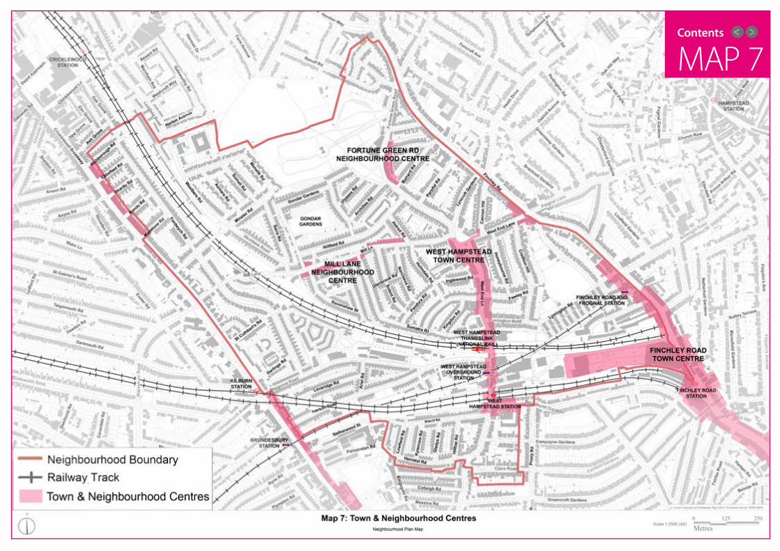
MAP 7Contents

Contents
POLICIES 55
04 POLICIESF. COMMERCIAL CENTRES
Development (including changes of use) shall preserve or enhance the character of the Neighbourhood Centre and promote a diverse range of shops, businesses and economic activity. This shall be achieved, where appropriate by:
i. Support for proposals to improve and restore the original character of shop-fronts, including windows, signs and external fittings.
ii. Proposals to convert ground floor retail/business space into residential use will not be supported.
iii. Contributions to public realm improvements to improve the character of the Neighbourhood Centre, where applicable.
POLICY 14: Mill Lane Neighbourhood Centre
F11. Mill Lane Neighbourhood Centre: it is important to recognise that this area – although linked to the West Hampstead Town Centre – has its own separate and distinct identity, character and requirements. The Centre contains a range of small businesses and retailers, with a high proportion of independent businesses. It also has the character of a late Victorian/early Edwardian shopping area, with notable historic signage, windows and shop-fronts. However, unlike most of the West Hampstead Town Centre, it is not included in a conservation area, so lacks that level of protection.
The CCS says (p.80) that “the Council will seek to retain a strong element of convenience shopping for local residents in Camden’s neighbourhood centres and ensure that any development in them does not harm the function, character or success of that centre”. The Place Plan calls for action to tackle high vacancy rates, suggesting “…working with landlords, more effective promotion of shops and services, and physical improvements”. There is a need to support existing shops and businesses on Mill Lane and to encourage the development of new retail businesses, including cafes and restaurants, which are likely to increase footfall in the area.
i. Camden Council should draw up a ‘Mill Lane Action Plan’ to give focus to and revitalise the Neighbourhood Centre.
ii. Such a Plan should include:
• A ‘Shop Front Design Guide’ for the Neighbourhood Centre.
• Measures to attract a diverse range of shops, food/drink outlets and businesses to the Centre.
• Improvements to pavements and the public realm - and the removal of street clutter.
• Improved signage to attract people to Mill Lane - particularly from West End Lane.
RECOMMENDATION I: in support of Policy 14, the following actions are recommended.

Contents
POLICIES 56
04 POLICIESF. COMMERCIAL CENTRES
Development (including change of use ) shall preserve or and enhance the character of the neighbourhood centre and provide for a diverse range of shops, businesses and economic activity.
POLICY 15: Fortune Green Road Neighbourhood Centre
F12 . The retail area of Fortune Green Road is also designated by Camden Council as a Neighbourhood Centre. Like the Mill Lane Neighbourhood Centre, this area has a notable and distinct character - reflecting its proximity to the West End Green Conservation Area and the open space of Fortune Green. The Centre would benefit from: better signage; improvements to pavements and shop fronts; and other measures designed to encourage footfall and use.
F13. The western part of Finchley Road includes a small neighbourhood centre around the junction with West End Lane. A number of the ground floor units are empty and boarded up. If no commercial use can be found for these sites, a change of use to residential could be considered.
F14. The Area also includes a small part of the Finchley Road Town Centre. As most of the Centre is outside the Area covered by this NDP, it is not considered appropriate to draw up policies for this Town Centre. The main interest for this Plan is the area covered by the O2 Centre site (see B8). In terms of the west part of Finchley Road north of the O2 Centre, there is an urgent need for improvements to enhance this part of the Centre. There is a lack of community space, social space, green/open space and trees. There is an opportunity to regenerate the character of this part of the Centre, with a much improved public realm and new businesses. Efforts should also be made to improve the pedestrian crossings across Finchley Road (see D14 & Policy 9) and to improve conditions for cyclists (see Policy 8 & recommendation).
(For general comments about Finchley Road, see 6.5).
F15. There is strong support for the development of regular open-air markets in the Area. The NPPF (23) says local authorities should “retain and enhance existing markets and…create new ones”. Adequate space needs to be found to accommodate such markets, particularly in large new developments. Traders, especially those from the local area, should be able to sell a range of products including food, crafts and seasonal products. The existing farmers’ market – which takes place outside West Hampstead Thameslink station on Iverson Road on Saturdays – is popular and well used, and should be protected and encouraged.
The provision of space for markets and short term ‘pop-up’ shops is welcomed in appropriate locations.

Contents
They all have a high environmental value, are local in character, are in close proximity to the community they serve, and provide important benefits to the biodiversity of the Area. They therefore fulfil the requirements set out in paragraph 77 of the NPPF. This Plan uses the additional protection afforded in the NPPF to designate these sites as Local Green Space.
POLICIES 57
G1. The NPPF states as a core planning principle (17) that planning should “contribute to conserving and enhancing the natural environment and reducing pollution”. It also states that “allocations of land for development should prefer land of lesser environmental value”.
G2. The Area has a number of green and open spaces which are highly valued by those who live and work in the Area, as well those who visit the Area. These areas shall be protected and enhanced (Objective 6). The NPPF (76) states that “local communities through local and neighbourhood plans should be able to identify for special protection green areas of particular importance to them. By designating land as Local Green Space local communities will be able to rule out new development other than in very special circumstances”. The sites listed in this section are all included and mapped in Camden Council’s Local Development Framework Proposals Map (2010). In a relatively densely developed urban community these sites have a vital role in providing an essential amenity, as well as space for exercise, relaxation and the appreciation of nature.
04 POLICIESG. NATURAL ENVIRONMENT
The sites in the Area listed below (a-o) and identified on Map 8 are all designated as Local Green Space:
a) Fortune Green, b) Hampstead Cemetery, c) West End Green, d) Gondar Gardens Reservoir, e) Mill Lane Open Space, f) Westbere Copse & Jenny WoodNature Reserve g) 1 Mill Lane/Minster Road Nature Reserve, h) Maygrove Peace Park, i) Hampstead & Cumberland Clubs, j) Sumatra Road playground, k) Iverson Road Open Space, l) Maygrove Open Space, m) Crown Close Open Space, n) Medley Orchard, o) Railway embankments (various locations).
POLICY 16: Local Green Space
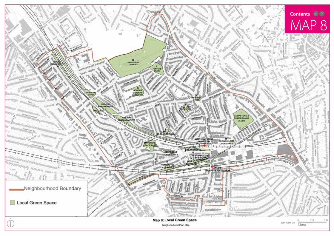
MAP 8Contents

Contents
POLICIES 59
04 POLICIESG. NATURAL ENVIRONMENT
i) Hampstead & Cumberland Clubs - although in private ownership, these clubs provide an important local amenity, both in terms of opportunities for sport, exercise, and the provision of a significant area of green space.
j) Sumatra Road playground - this small park provides an important site for recreation for local residents, particularly young children.
k) Iverson Road Open Space - a small park with children’s play areas which is well-used by local residents.
l) Maygrove Open Space - a green strip of land on the north side of Maygrove Road, which provides
an important space for trees and wildlife and makes a highly positive contribution to the character of Maygrove Road. Camden Council has stated that this site will be protected in any future redevelopment of the neighbouring Liddell Road site (see C1).
m) Crown Close Open Space - a children’s play area and small park providing an important amenity for local residents and for exercise.
n) Medley Orchard (SINC) - a significant and protected space for biodiversity, trees and wildlife.
o) Railway embankments, various locations (SINC) - as set out in G5 below, these sites provide hugely important spaces for biodiversity and wildlife and make a huge contribution to the ‘green feel’ of the Area, the number of trees in the Area, as well as to views through and across the Area (see A5 and Map 2).
Details of the spaces and importance to the community are listed below:
a) Fortune Green (Queen Elizabeth II Field In Trust) - a long standing public park which forms the focal point of the wider Fortune Green area and an important and significant local amenity.
b) Hampstead Cemetery is a Site of Importance for Nature Conservation (SINC) - a historical part of the wider area with significant heritage assets and listed structures (see A25) as well as an important area for biodiversity and wildlife.
c) West End Green (London Square) - this public park forms the historic heart of the West Hampstead ‘village’ and dates from the previous hamlet of West End (see 2.2) and is vital asset to the community.
d) Gondar Gardens Reservoir (SINC) - this large area of open space has a high environmental value, with significant biodiversity (including a habitat for protected slow-worms).
e) Mill Lane Open Space (SINC) - this area provides an important local area of green space, as well as facilities for children and a garden centre.
f) Westbere Copse & Jenny Wood Nature Reserve (SINC) - a well established nature site, providing a protected space for biodiversity with access to local residents.
g) 1 Mill Lane/Minster Road Nature Reserve (SINC) - this site was given to Camden Council as part of the development of 1 Mill Lane (The Mill Apartments); the site was designated as a protected nature reserve, with limited public access. The stated aim is that the site will become a significant location for biodiversity and wildlife in the years ahead.
h) Maygrove Peace Park - this award-winning public park forms a focal point for the community in this part of the area. It has recently been upgraded to incorporate a children’s play area, an outdoor gym, and new planting - and as such is a highly significant local asset.

Contents
POLICIES 60
04 POLICIESG. NATURAL ENVIRONMENT
Development shall protect and improve, where appropriate, existing green/open space.Development that increases the demand for recreation or amenity shall provide for new green/open space. This shall by achieved by, where appropriate:
i. The protection of existing green/open space - from significant damage, or loss, through development.
ii. The appropriate provision (relative to the size of the development) of new green/open space, or contributing towards addressing the open space deficiencies in the Area as identified in the development plan.
iii. Appropriate contributions to the maintenance and enhancement of existing and new green/open space, where applicable.
iv. The offsetting of any loss of green/open space, ideally within the Area.
v. The protection and appropriate provision of green corridors through existing and new streetscapes.
vi. The appropriate provision of new small green/open space - such as pocket parks and active green spaces (eg green walls and green roofs) - and their maintenance.
vii. The use of Sustainable Drainage Systems in all development, unless there are practical or viability reasons for not doing so.
viii. The appropriate provision of outdoor leisure facilities - such as playgrounds, gyms and recreational spaces - and their maintenance, where applicable.
ix. Development that has a positive impact on the relationship between urban and natural features.
POLICY 17: Green/Open Space
G3. The London Plan (Policy 7.18) says “the Mayor supports the creation of new open space in London to ensure satisfactory levels of local provision to address areas of deficiency”. The CCS (Policy CS15) says “the council will protect and improve Camden’s parks and open spaces” and will “tackle deficiencies and under-provision and meet increased demand for open space…securing additional on-site public open space in the growth areas”, including the West Hampstead Interchange. It also states that the Council will work on “securing other opportunities for additional public open space”.
The West Hampstead area has been identified by Camden Council (CCS 15.9) as an area deficient in public open space. Research by the NDF found a strong desire for more green areas and open space, as well as improvements to existing spaces.
G4. The CCS says (15.3) “sites of nature conservation in Camden are generally small and undervalued, with pressure from adjoining sites and limited opportunity for expansion”. It adds (Policy CS15) “the council will protect and improve sites of nature conservation and biodiversity” and will “seek to improve opportunities to experience nature, in particular in South and West Hampstead…where such opportunities are lacking”. Development shall protect existing nature conservation sites and provide new sites appropriate to their size.
G5. The existing ‘green corridors’ alongside railway lines are an important habitat for plants and animals, and include a number of Sites of Nature Conservation Importance (SNCI). These areas of biodiversity are highly valued and need to be protected from development or loss.
Contents
POLICIES 61
04 POLICIESG. NATURAL ENVIRONMENT
i. Local residents should be involved in the management of existing and new green/open spaces.
ii. Existing green/open spaces should provide varying levels of public access.
iii. New green/open space should provide public access.
RECOMMENDATION J: in support of Policy 16 and 17 the following actions are recommended:
G6. Space for green corridors should also be found in new development and streetscapes, particularly in and around the West Hampstead Growth Area. These can be used to link sites, as well as providing new views and open space.
G7. There is scope for the development of pocket parks in the Area on small areas of land. Examples of such sites are: the junction of Maygrove/Iverson Roads; Sarre Road/Gondar Gardens path; and on a number of sites in the West Hampstead Growth Area.
G8. There is also ample scope for the development of active green spaces in the Area. These include green roofs, green walls, planting around street trees, and small scale allotments.
G9. The London Plan (Policy 5.13) promotes the use of Sustainable Drainage Systems (SuDS). These contribute to the creation of green spaces and have benefits for drainage, water quality, biodiversity and amenity. As the Area has been identified as an area likely to be affected by surface water flood risk, the use of SuDs is strongly supported in all development in the Area.
G10. To meet the needs of the growing population, especially young people, there is a need for more outdoor leisure facilities - including: outdoor gyms and exercise areas for all ages; outdoor play areas for young children; and sports facilities.
G11. Any new green/open space should provide public access for the benefit and enjoyment of those living and working in the Area. Nature conservation sites may provide more limited access, depending on conditions.

Contents
There is also ample scope for the planting of new trees alongside the main roads in the area - including West End Lane, Fortune Green Road, Mill Lane, Kilburn High Road/Shoot-up-Hill/Cricklewood Broadway, and Finchley Road - as a means of absorbing high levels of air pollution caused by vehicle emissions.
POLICIES 62
04 POLICIES
Development shall protect trees in good health that contribute to the character of the Area, individual streetscapes, and green spaces. This shall be achieved by development that:
i. Protects existing trees and provides for their maintenance.
ii. Makes provision for the planting of equivalent numbers of new trees where trees are cut down.
iii. Makes provision for the appropriate planting of additional trees, relative to the size of the development.
iv. Makes appropriate provision for the planting and maintenance of new street trees - particularly alongside the main roads identified in G12.
i. Additional Tree Protection Orders should be designated by Camden Council to protect existing trees and to promote a variety of species.
ii. The use of funding from private companies and other sources should also be used to provide additional trees.
iii. The views of residents, businesses and local groups should be sought as to where new trees should be planted.
iv. A publicly available programme of tree maintenance for trees in the Area should be published by Camden Council, allowing for the removal of old trees and the planting of new ones.
G12. The London Plan (7.64) says “trees” play an invaluable role in terms of the natural environment, air quality, adapting to and mitigating climate change and contributing to the quality and character of London’s environment”. The Mayor wants to see “an increase in tree cover with an additional two million trees by 2025”. The CCS (Policy 15) commits the Council to “protecting trees and promoting the provision of new trees and vegetation, including additional street trees”. Its Tree Strategy (CCS 15.22) “aims to retain trees and provide new trees on Council land” and says “we will resist the loss of trees and groups of trees wherever possible”. Trees - both on public and private land - make a hugely valued contribution to the character of the Area, and are widely appreciated and enjoyed by those living and working in the Area. They also make an important contribution to the biodiversity of the Area and play a highly significant role in improving the air quality of the Area. There is strong public support for the protection of existing trees and the planting of new trees at every available opportunity. The planting of new trees on streets, in parks and open spaces, on private land, and alongside new development is therefore strongly welcomed. The loss and removal of trees should be avoided unless in exceptional circumstances. In order to recompense for the removal of trees, additional trees should be planted to make up for the loss and to contribute further to the provision of trees in the Area.
G. NATURAL ENVIRONMENT
RECOMMENDATION K: in support of Policy 17 the following actions are recommended.
POLICY 18: Trees

PAGE DESCRIPTION 63
Contents
DELIVERY PLAN
Contents
Contents
DELIVERY PLAN 64
5.1 In order for the Vision, Objectives and Recommendations of this Plan to be delivered, a range of organisations and groups will need to work in close collaboration. The Delivery Plan sets out the mechanism for this to happen during the lifetime of this Neighbourhood Plan. It is important to note that the fulfilment of one policy does not remove the need to satisfy any of the other policies to be in accord with the Neighbourhood Plan.
Table 1 sets out timescales for each Objective (O) and Policy (P).
The suggested process for the delivery of the Recommendations (R) is set out in Table 2. While the recommendations (or projects) do not form part of the policies of the Plan, they are deemed to play an important and significant part in the delivery of the Plan (see 1.7). The recommendations should guide Camden Council, developers, and other relevant agencies in how the community wants development to be shaped in the Area. Given that it is not possible to accurately predict the size and scale of future development in the Area, not every recommendation has been costed or agreed. However, the recommendations should inform Camden Council policy - in particular the spending of CIL monies in the Area (see 5.3, Policy 19 & Table 3).
The timescales set out in Table 1 and Table 2 are defined as follows:
• Immediate - upon approval of the Neighbourhood Plan
• Short - within one year of the approval of the Plan
• Medium - between one and five years of the Plan being approved
• Long - between five years of the Plan being approved and the end period of the Plan
• Ongoing - throughout the lifetime of the Plan
05 DELIVERY PLAN

Contents
DELIVERY PLAN 65
05 DELIVERY PLANTABLE 1: OBJECTIVES & POLICIES
Objective / Policy
Actions Timescale By whom?
O1 & P1Providing a range of housing types
Immediate & OngoingCamden Council planners & developers
O2 & P2Ensuring high quality design in all development
Immediate & OngoingCamden Council planners & developers
P3Preserving and enhancing the character of Conservation Areas & heritage assets
Immediate & OngoingCamden Council planners; developers; local residents/owners/occupiers
P4Development in the West Hampstead Growth Area
Ongoing & LongCamden Council planners & developers
P5 Specific Sites Ongoing & LongCamden Council planners & developers
O3 & P5 & P6 Public transport improvements Ongoing
Camden Council; developers; TfL; Network Rail;train operating companies
O3 & P7 Traffic & reduction in car use Ongoing Camden Council
O3 & P8 Promoting cycling OngoingCamden Council & TfL; cycling groups
O3 & P9Pavements, pedestrians and paths
OngoingCamden Council; landowners; developers; Network Rail; TfL
O4 & P10 & P11
Public & community facilities Ongoing & LongCamden Council; NHS London; developers
O5 & P12Promoting business, economic growth and employment
Immediate & OngoingCamden Council; developers; business groups
O5 & P13West Hampstead Town Centre protection & improvements
Short & Ongoing Camden Council
O5 & P14 Mill Lane Neighbourhood Centre Medium & Ongoing Camden Council
O5 & P15Fortune Green Road Neighbourhood Centre protection & improvements
Medium & Ongoing Camden Council
O6 & P16 Local Green Space Immediate & Ongoing Camden Council
O6 & P17Protecting and enhancing green/open space; creating new green/open space
OngoingCamden Council, developers and local residents
O6 & P18Protecting existing trees and the planting of new trees
Immediate & OngoingCamden Council & developers
P19 (see below)
Community Infrastructure Levy Priorities
Immediate & Ongoing Camden Council

Contents
DELIVERY PLAN 66
05 DELIVERY PLANTABLE 2: RECOMMENDATIONS
Recomm. Actions Timescale By whom?
A – Housing, Design & Character
• Monitoring & enforcement of planning applications
• Consultation Groups established for large developments
• Architectural consistency until completion
• Introduction of a private landlord register
• Consideration of private rented community needs
• Controls on HMOs
• Community engagement
Ongoing
Camden Council;
Camden Council / developers; landowners
Developers
Camden Council / landowners
Camden Council / landowners
Camden Council
Developers / community /Camden council
B – Conservation Areas & Heritage Assets
• Article 4 declaration in West End Lane
• Area of Special Control of Advertisements on West End Lane
• Consultation for new Conservation Areas
Immediate & Ongoing
Camden Council; local groups; local residents, businesses
Camden Council; businesses
Camden Council, Local groups
C – West Hampstead Growth Area
• Growth Area Masterplan
• Blackburn Road improvements
Immediate & Ongoing
Camden Council; developers; landowners; local residents & workers
D – Other sites • Other Sites guidanceImmediate & Ongoing
Camden Council & TfL & Network Rail
E – Public Transport
• Review of bus stops in the Area
• Empty buses using Mill Lane
• Consideration for a Chiltern line station in West Hampstead
Medium & Long
Camden Council; TfL; bus operators;
Bus operators / tfl
Network Rail; train operators
F – Sustainable Transport
• West End Lane improvements around stations
• Road works rental scheme
• Measures regarding delivery lorries
• Air quality monitoring
Medium & Ongoing
Camden Council; TfL; train operators
GLA
GLA / Camden Council

Contents
DELIVERY PLAN 67
05 DELIVERY PLANTABLE 2: RECOMMENDATIONS
Recomm. Actions Timescale By whom?
G - Cycling • Bicycle hire scheme Medium TFL
H – Pavements & Pedestrians
• Removal of street clutter
• Removal of visual clutter
• Survey of pedestrian movement in Interchange area
Immediate & Ongoing
Camden Council; TfL, businesses, utility companies
Camden Council / businesses, advertisers
Local residents / voluntary groups, Developers
I – Mill Lane Neighbourhood Centre
• Mill Lane Action PlanImmediate & Ongoing
Camden Council; property owners; business/shop owners; business groups
J – Green/Open Space
• Management of green/open space
• Public access to green/open space
Immediate & Ongoing
Camden Council; Friends groups; local residents
K –Trees
• Use of Tree Protection Orders
• Funding for new trees
• Consultation re new trees
• Maintenance programme should be published
Immediate & Ongoing
Local residents , Camden Council;
developers; landowners; private funding;
Camden council, local groups; local residents
Camden Council
L - Planning agreements
• Publishing draft agreements
• Consultation on draft agreements with local groups
• Clear breakdown of payments to who and when
• Updates on money being spent
• Contributions should be spent within the Neighbourhood Area
Ongoing
Camden Council; developers
Camden Council/ local groups
Camden Council
Camden Council

Contents
DELIVERY PLAN 68
05 DELIVERY PLAN
5.2 One of the key aims of this Plan is to ensure that development in the Area brings clear benefits to the Area. During consultations the Forum found that many residents were critical of the seemingly opaque and secretive way in which planning agreements (such as Section 106 agreements) were drawn up between Camden Council and developers. During the process of drawing up this Plan, Camden Council sought to improve the situation by publishing details of S106 contributions on its website. This Plan sets out recommendations for a more open, transparent and accountable process for allocating the funds payable to the community from new developments in the Area.
5.3 The NPPF (175) says the Community Infrastructure Levy (CIL) should “place control over a meaningful
proportion of the funds raised with the neighbourhoods where development takes place”. In areas with approved Neighbourhood Plans, the government has decided that a minimum of 25% of CIL money should be spent in the Area. The NDF strongly supports this measure and urges Camden Council to use this Plan as the basis for allocating CIL money in this Area. The Plan’s policies and recommendations contain a series of measures which would benefit from CIL funding. The list below sets out the main priority areas for such spending. These projects and schemes - as identified in the Plan’s policies and recommendations - should be the main recipients of planning gain monies (such as S106 agreements, CIL, and any other such schemes) in the Area:
• Significant contributions to improvement of public transport facilities in the Area, particularly West Hampstead’s three stations – including lifts and more public space.
• Contributions to the improvement and expansion of public facilities in the Area. This shall include West Hampstead Community Centre, Sidings Community Centre and (although outside the Area) Kingsgate Community Centre. Money shall also be made available for new community facilities and community space, such as is proposed for Emmanuel Church. Funds should also be allocated to West Hampstead Library and the new Sherriff Centre.
• Contributions to improve educational facilities in the area, including nurseries.
• Improvements to the West End Lane retail area and the Mill Lane & Fortune Green neighbourhood centres, including street furniture, signs and pavements.
• Contributions to schemes providing more space for pedestrians and improving pavements to a high standard.
• Funding to improve existing paths and to provide new paths - including new bridges over railway lines.
• Additional bicycle routes and stands.
• Improvements to existing parks/green/open space and provision of new public green/open space.
• Funding for Friends of parks/cemetery groups.
• Additional tree planting.
i. When available, draft agreements should be published with all relevant planning applications.
ii. Camden Council should have a duty to consult with local residents and groups on the content of any draft agreement.
iii. The final text of an agreement should be published on the Camden Council website as soon as possible after approval is given to an application. This should include a clear breakdown of which payments will be made to whom and at what time.
iv. Camden Council should provide updates when money is spent and on what it has been spent.
v. As a general principle, developer contributions (whether CIL or S106) should be spent on projects close to the development and should be kept in the Area.
RECOMMENDATION L: Planning agreements

Contents
DELIVERY PLAN 69
In order to provide a clear expression of the community’s wishes, the list is broken down into three categories:
• Category A: Most urgent
• Category B: Should be provided
• Category C: Also needed
05 DELIVERY PLAN
Table 3 sets out the projects and schemes which are the Neighbourhood Plan’s priorities for the use of Community Infrastructure Levy, or, if applicable, S106 funding, and/or other such schemes, in the Neighbourhood Area.
POLICY 19: Community Infrastructure Levy Priorities
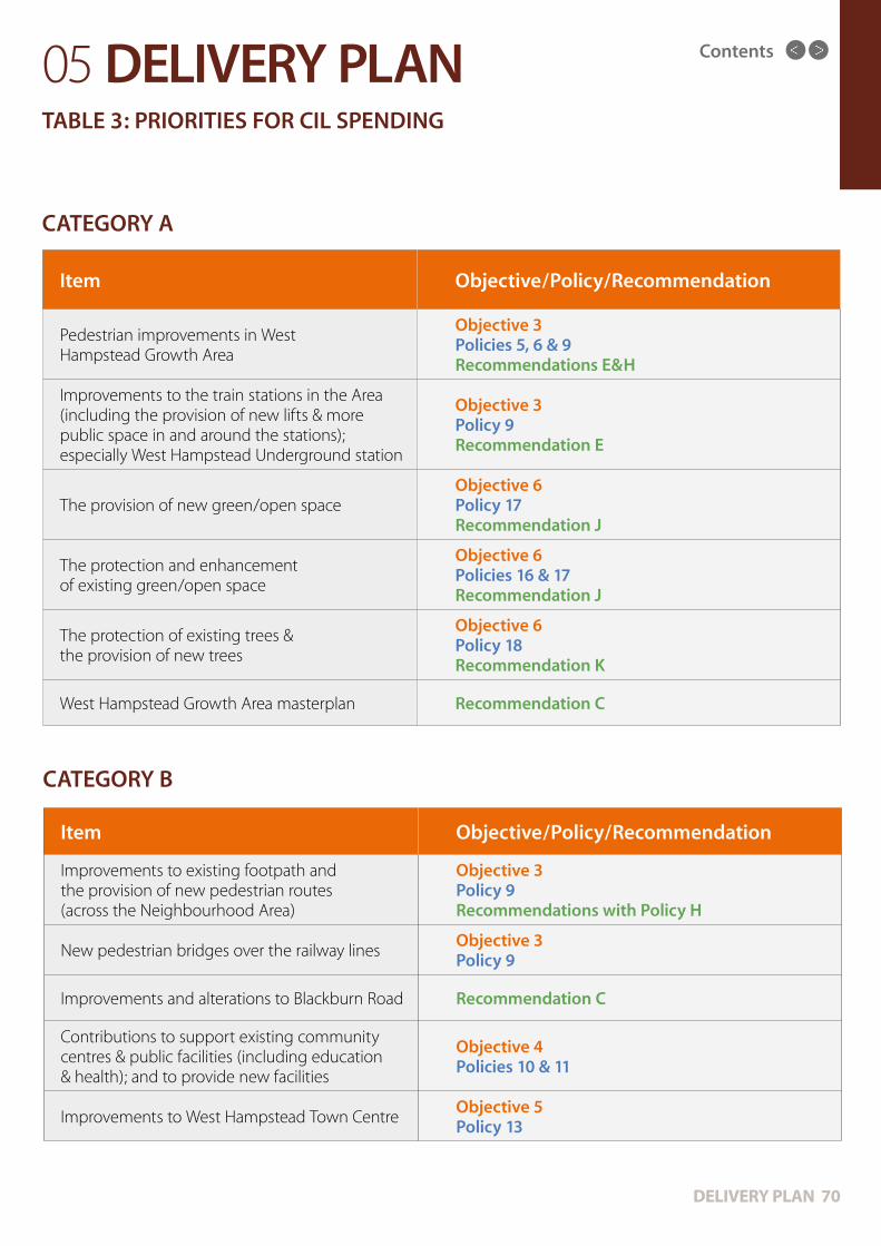
Contents
DELIVERY PLAN 70
05 DELIVERY PLANTABLE 3: PRIORITIES FOR CIL SPENDING
CATEGORY A
CATEGORY B
Item Objective/Policy/Recommendation
Pedestrian improvements in West Hampstead Growth Area
Objective 3 Policies 5, 6 & 9 Recommendations E&H
Improvements to the train stations in the Area (including the provision of new lifts & more public space in and around the stations); especially West Hampstead Underground station
Objective 3 Policy 9 Recommendation E
The provision of new green/open spaceObjective 6 Policy 17 Recommendation J
The protection and enhancement of existing green/open space
Objective 6 Policies 16 & 17 Recommendation J
The protection of existing trees & the provision of new trees
Objective 6 Policy 18 Recommendation K
West Hampstead Growth Area masterplan Recommendation C
Item Objective/Policy/Recommendation
Improvements to existing footpath and the provision of new pedestrian routes (across the Neighbourhood Area)
Objective 3 Policy 9 Recommendations with Policy H
New pedestrian bridges over the railway linesObjective 3 Policy 9
Improvements and alterations to Blackburn Road Recommendation C
Contributions to support existing community centres & public facilities (including education & health); and to provide new facilities
Objective 4 Policies 10 & 11
Improvements to West Hampstead Town CentreObjective 5 Policy 13
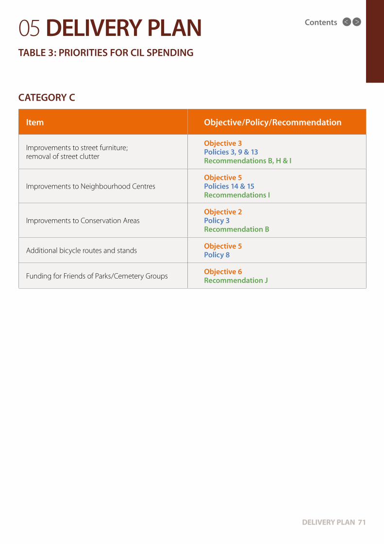
Contents
DELIVERY PLAN 71
05 DELIVERY PLANTABLE 3: PRIORITIES FOR CIL SPENDING
CATEGORY C
Item Objective/Policy/Recommendation
Improvements to street furniture; removal of street clutter
Objective 3 Policies 3, 9 & 13 Recommendations B, H & I
Improvements to Neighbourhood CentresObjective 5 Policies 14 & 15 Recommendations I
Improvements to Conservation AreasObjective 2 Policy 3 Recommendation B
Additional bicycle routes and standsObjective 5 Policy 8
Funding for Friends of Parks/Cemetery GroupsObjective 6 Recommendation J

PAGE DESCRIPTION 72
Contents
OTHER PLANS & ADDITIONAL INFO
Contents

Contents
OTHER PLANS & INFO 73
6.1 The National Planning Policy Framework (March 2012) sets out the government’s planning policies for England and provides “a framework within which local people…can produce their own distinctive local and neighbourhood plans, which reflect the needs and priorities of their communities”. The NPPF states that the purpose of the planning system is to contribute to the achievement of sustainable development, taking economic, social and environmental factors into account. The NPPF says neighbourhoods should develop plans that support the strategic development needs set out in Local Plans, including policies for housing and economic development and “plan positively to support local development”. The NPPF says neighbourhood planning “provides a powerful set of tools for local people to ensure that they get the right types of development for their community” and that neighbourhood plans “will be able to shape and direct sustainable development in their area”.
6.2 The London Plan (July2011) is “the overall strategic plan for London, setting out an integrated economic, environmental, transport and social framework for the development of London over the next 20-25 years”.
The Plan sets out six objectives (1.53) for the sustainable development of London:
• A city that meets the challenges of economic and population growth.
• An internationally competitive and successful city, with a strong and diverse economy.
• A city of diverse, strong, secure and accessible neighbourhoods.
• A city that delights the senses and takes care of its buildings and streets.
• A city that becomes a world leader in improving the environment, locally and globally.
• A city where it is easy, safe and convenient for everyone to access jobs, opportunities and facilities.
However, the Plan notes (1.44) “a perceived tension between the demands of growth and the conditions for a good – and improving – quality of life, and a concern about the loss of things that have made living in London and its neighbourhoods a distinctive experience”. The Plan highlights a number of ‘quality
of life’ issues, such as: ensuring there are enough homes meeting the needs of Londoners at different stages of their lives; protecting and improving London’s natural environment and habitats; ensuring a network of vibrant and exciting town centres with a range of shops and other facilities; providing adequate, efficient transports networks, and support for cycling and walking; and the importance of a range of readily accessible community and cultural facilities.
The Plan designates Camden borough as part of Inner London and part of the Central sub-region (Maps 2.1 & 2.2). However, it is noted that the Area of this NDP – in the north-west of the borough – is on the boundary of Inner/Outer London and on the boundaries of the Central, North and West sub-regions. This location has the potential to be problematic, as a number of issues which apply to central London are not applicable in this Area; equally the Area does not have many of the characteristics of outer London. This fact needs to be considered in planning applications and the development of the Area, in order protect the unique ‘feel’ and characteristics of this Area on the edge of these zones.
The Plan designates the West Hampstead Interchange as one of ten intensification areas (Map 2.4). These are defined (2.59) as “typically built-up areas with good existing or potential public transport accessibility which can support redevelopment at higher densities. They have significant capacity for new jobs and homes but at a level below that which can be achieved in the opportunity areas”.
6.3 Camden Council’s Core Strategy (November 2010) is the central part of the Local Development Framework for the borough, covering the period 2010-2025. The Camden Core Strategy (CCS) “covers the physical aspects of location and land use but also addresses other factors that make places attractive, sustainable and successful, such as social and economic matters. It plays a key part in shaping the kind of place Camden will be in the future, balancing the needs of residents, businesses and future generations”.
06 OTHER PLANS & ADDITIONAL INFORMATION

Contents
OTHER PLANS & INFO 74
in the borough to achieve the vision and objectives of the Core Strategy”. Camden Site Allocations (September 2013) “sets out the Council’s key objectives and guidance for the development of land and buildings on significant sites which are likely to be subject to development proposals during the lifetime of the Core Strategy (2010-25)”. The relevant sites for the Neighbourhood Plan in the Site Allocations document are set out in section 5 (p.117-129) and include three sites: 187-199 West End Lane, 156 West End & O2 Centre Car Park (see B6 of this Plan).
6.4 The Camden Council Place Plan for West Hampstead (March 2012) is also relevant. Although not a formal planning document, the report – as well as the consultations linked to its preparation – has informed the NDP in a number of areas. The NDP echoes the Place Plan’s calls for support for a successful local economy; the need for enhanced open spaces and environmental improvements; the need to improve movement around the area, especially for pedestrians; and the need for improved local services.
The plan is broken down into five sections, each with its own series of objectives:
• Development: “to secure real local benefit from development opportunities”. Objectives: working with the community to develop more detailed area planning guidance; involve the local community in identifying priorities for how developer contributions are used; recognise the local housing priorities in future developments.
• Economy: “to support a successful local economy with a thriving neighbourhood”. Objectives: provide space and support for micro and start-up businesses; protect and promote the village character of the area; support West End Lane & Mill Lane shops and businesses; meet the needs of the people who live, work and visit the area.
• Environment: “to provide new open space and improve the local environment”. Objectives: provide new accessible local space to benefit the area; continue to improve open spaces, food growing, biodiversity and sustainability; maintain the valued quality and historic character of the area.
06 OTHER PLANS & ADDITIONAL INFORMATION
The overall vision of the CCS is that “Camden will be a borough of opportunity” and sets out four themes:
• A sustainable Camden that adapts to a growing population.
• A strong Camden economy that includes everyone.
• A connected Camden community where people lead active, healthy lives.
• A safe Camden that is a vibrant part of our world city.
The CCS estimates that Camden’s population will grow by 18% between 2006 and 2026. It says the borough’s growth will be focused in five areas – one of which is the West Hampstead Interchange. It says growth will be focussed on these areas as they (1.6) “can support higher density development, reducing pressure for substantial development in predominantly residential areas”. It adds that (1.12) “development at West Hampstead Interchange is expected to be predominantly housing”. Outside these five growth areas, six other areas – including the West Hampstead retail area – are (1.15) “considered suitable locations for significant development as they are highly accessible by a range of means of transport”.
Parts of the borough away from these areas are (1.18) “generally expected to experience more limited development and change”. Policy CS4 states that “the Council will ensure that development in the areas of more limited change respects the character of its surroundings, conserves heritage and other important features and provides environmental improvements and other local benefits where appropriate”.
The CCS says the Council will strike a balance between the needs and benefits of development and the needs of the local area, stating (5.9) “…we will take into account the cumulative impacts of developments, or particular types of development, on local areas and communities”.
Further detail about Camden Council’s planning policies is set out in Camden Development Policies (November 2010), which contribute towards the delivery of the Core Strategy “by setting out detailed planning policies that the Council will use when determining applications for planning permission

Contents
OTHER PLANS & INFO 75
• Services: “to deliver improved local services”. Objectives: continue to monitor the demand for school places and nursery provision; continue to support local voluntary sector organisations and investigate innovative delivery of services; negotiate with developers for affordable provision of community space for local groups.
• Transport: “to make it easier and more pleasant for people to move around the area”. Objectives: continue to improve how people move around the area and between the three stations; public realm improvements to the northern part of the town centre and Mill Lane; long term improvements to footpaths in the area; improved environment for cycling; review of loading and waiting restrictions on West End Lane.
6.5 While focused on the Area as designated, the NDF was keen to consider issues of relevance to neighbouring areas and how they interact with the Area. The following areas were considered:
• Cricklewood: The area centred on Cricklewood Broadway has been neglected for a number of years and suffers from being at the meeting point of three boroughs (Camden, Barnet & Brent). Recent efforts to improve the area have been led by the Cricklewood Improvement Programme, which has indicated it would like to draw up an NDP for this area. There are also plans for a large and extensive development in and around Brent Cross, which will have a significant impact on Cricklewood. The Fortune Green and West Hampstead NDP strongly supports improvements to the Cricklewood area, as this will also have benefits for the north-west of our Area. Any developments in this area should be mindful of their effect on Cricklewood as a whole and the changes planned for this area.
• Kilburn: The area focused on Kilburn High Road has been at the centre of recent attempts to rejuvenate the area. In recent years, Camden and Brent councils have sought to work together for the benefit of residents and businesses on both sides of the High Road. The Fortune Green and West Hampstead NDP strongly supports these efforts and would like to see a cross-borough NDP for this area.
• Finchley Road: While it provides a clear boundary for the area covered by this NDP, Finchley Road is an important and major artery for the area and
town centre in its own right. The NDP would like to see Camden Council take a stronger role in the development of this area, as well as improving links with Transport for London, who are responsible for the road itself. During consultations, the NDF found a number of things which could be improved in this area, including traffic signals, pedestrian crossings and the development of shops and businesses. During work on the final draft of this Plan, the Neighbourhood Forums covering Finchley Road began efforts to lobby Camden Council and TfL to bring forward improvements to the Road and the Town Centre. These efforts - including a much improved street environment; measures to address air pollution; tree planting; measures to make the Road safer for pedestrians and cyclists; and measures to boost the economy of the Town Centre - are strongly supported by this Plan.
• South Hampstead: When the boundaries of this NDP were being agreed, it proved difficult to establish the precise boundary between West Hampstead and South Hampstead. In the absence of an obvious boundary, the Forum chose the existing boundary of the southern part of West Hampstead ward. Consultations with residents in this area revealed a range of views, but no consensus on expanding the area of this NDP. Clearly, many residents of the northern part of South Hampstead have strong links with West Hampstead and its amenities. Any future developments in South Hampstead should take into account their potential effect on West Hampstead residents and infrastructure, especially transport. Any future NDP for South Hampstead should seek to link as closely as possible to the relevant policies in this NDP.
06 OTHER PLANS & ADDITIONAL INFORMATION
6.6 Future Review: the NDF was concerned that because of the range of developments proposed for the area - and the increasing population across a range of age groups - the NDP could soon become out of date. The Forum has sought, where possible, to make sure that the Plan is both relevant at the time of writing and in future years. The NPPF states as a core planning principle (17) that “plans should be kept up-to-date”. The Forum would like to have the option to review and amend the NDP in the future as circumstances change. The Forum suggests the Plan is regularly reviewed to reflect changing circumstances and developments.

PAGE DESCRIPTION 76
Contents
ACKNOWLEDGEMENTS
Contents

Contents
ACKNOWLEDGEMENTS 77
This Neighbourhood Plan has been prepared thanks to the help and support of many people.
The main thanks go to the members of the NDF committee: Keith Moffitt, Mark Stonebanks, Nick Jackson, Sue Measures & Stephen Nathan.
Thanks also go to all members of the Forum, all those who’ve attended our meetings during the past two and a half years, all those who’ve completed our surveys, and all those who’ve contributed their views.
We would like to thank the Camden Council planners who have assisted the work on this Plan: Brian O’Donnell, Kate Goodman, Richard Mileham, Jennifer Walsh & Nicola Tulley.
Thanks also go to our graphic designer, Purni Gupta, for her work on the design of the Plan and the NDF’s promotional material; to Andrew Parkinson for his legal advice; and to Aaron Davis for the maps.
Finally, we appreciate the considerable help, advice and assistance given by our outside planning consultants: Vincent Goodstadt & Biljana Savic.
James Earl
Chair, Fortune Green & West Hampstead Neighbourhood Development Forum
(August 2014)
07 ACKNOWLEDGEMENTS

PAGE DESCRIPTION 78
Contents
Follow us on Twitter: @WHampsteadNDF
Graphic Design by Purni Gupta ([email protected])