FORESTS, FOREST COVER - UPSC Civil Services
53
For Cov in FORESTS, FOREST COVER AND WILDLIFE
Transcript of FORESTS, FOREST COVER - UPSC Civil Services
For Cov in
FORESTS, FOREST COVER
AND WILDLIFE


Tropical Evergreen & Semi Evergreen Forests
Tropical means ‘Tropical Region’, and Evergreen means ‘green leaves throughout the year’.
They are found in – western slopes of the Western Ghats, hills of theNortheastern region and the Andaman and Nicobar Islands
Usually occurs in areas having an annual mean temp of 22°C and annual rainfall of over 200 cm.
Trees in these forests are dense, tall and very green.
Forest structure –
Ground level – shrubs, creeper plants
Short trees of 20 – 30 m
Long trees of 60 m & above
Leaves of the trees are large, long and have a narrow ending (drip tip).
Trees don’t shed their leaves at once.
Some of the trees include – rosewood, mahogany, aini, ebony etc…


Tropical Semi-Evergreen Forests
They are transitional forests between tropical wet evergreen forests and tropical deciduous forests.
They are comparatively found in less rainy parts compared to tropical wet evergreen forests.
Tree species found in this region are hollock, white cedar and kail.

Tropical Deciduous Forests
Tropical means ‘Tropical Region’, and Deciduous means ‘plants, trees that shed their leaves each year’.
They are found in both Tropical and Subtropical region.
They are also called Monsoon forests. Leaves regrow during monsoon and shed during summer.
These forests occurs in places that receive rainfall between 70 to 200 cm.
Based on the availability of water, Tropical Deciduous forest is subdivided into –
Moist deciduous forests
Dry deciduous forests

Moist Deciduous ForestsThese forests are found in regions that have rainfall between 100-200 cm.
They are found in the states of foothills of Himalaya (West Bengal, Mizoram, Manipur), Chhota Nagpur Plateau (WB, Chhattisgarh, Bihar, Jharkhand), Eastern coastal plains of Odisha, eastern foothills of western ghats (Kerala, Karnataka, and Maharashtra).
Trees shed their leaves during dry winter and dry summer due to lack of moisture.
These forests are a victim of human activities like –irrigation and agricultural activities.
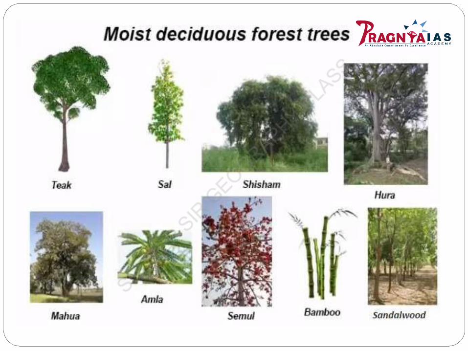
Some common trees include – teak, sal, shisham, hurra, mahua, amla, semul, kusum, bamboo, and sandalwood.
Dry Deciduous Forests
Dry means the region where rainfall is lesser (between 70 to 100 cm) than Moist deciduous forests.They are similar to Moist deciduous forest, the only difference is Dry deciduous forest can grow in areas of less rainfall.The forest appears like a vast grassland with naked trees during dry season.At ground level, you will find solid growth of Grass and climber plants.They suffer from overgrazing, forest fire and vast clearance due to agricultural activities.They are found in – Punjab, Haryana, parts of Uttar Pradesh, Madhya Pradesh and South-east of Rajasthan. Basically Central Deccan plateau.Some common trees include – teak, sal, laurel, tendu, palas, amaltas, bel, khair, axlewood etc.

Tropical Thorn Forests
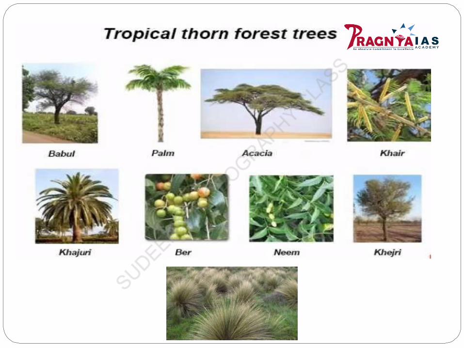
Tropical means ‘Tropical Region’, and Thorn means ‘a sharp pointed wood’. It is a dense, and scrub like vegetation.They occur in areas that receive rainfall less than 50 cm (semi-arid regions).Trees remain leafless for most part of the year and water is stored in stem of the trees.They are found in the areas of – southwest Punjab, Haryana, Rajasthan, Gujarat, Madhya Pradesh, and Uttar Pradesh. They are also found on the lower side of the Western Ghats covering large areas of Maharashtra, Karnataka, Telangana, Andhra Pradesh, and Tamil Nadu.Some common trees are – Babul, Palm, Acacia, Kokko, Khair, Khajuri, Ber, Neem, Khejri, Palas, etc.Tussock species of grass is quite popular in this forest. They grow up to a height of 2m.
Montane Forests inIndiaMontane means ‘mountainous region’. In mountainous region, with increase in altitude temperature decreases.
In India, mountains are located in –
North India – The Himalayan mountains from Jammu & Kashmir – (Sikkim, Assam, Arunachal Pradesh, Manipur, Tripura, Nagaland, Meghalaya and Mizoram) Purvanchal mountains in the extreme east of India.
South India – Western Ghats, the Vindhya range and the Nilgiris.
Northern Mountains (Eastern Himalayas)
Between 4,000 – 5,300 meters – Alpine forest belt exists. Trees like – Silver firs, junipers, pines, birch, willows, primroses, and rhododendrons are found here. Alpine grasslands with herbaceous vegetation and short duration flowers are found at the higher region.
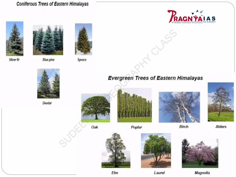
Between 2,700 – 4,000 meters – Coniferous Forest Belt exists. Trees like – silver fir, bluepine, spruce, and deodar are found here.
Between 1,300 – 2,700 meters – Evergreen Forest Belt exists. Trees like Oaks, poplar, elms, laurel, birches, alders, magnolia are found here.
Deciduous forests are found at the foothills of the Himalayas up to an elevation of 1300 m.Trees like sal, teak, bamboo grow in abundance.

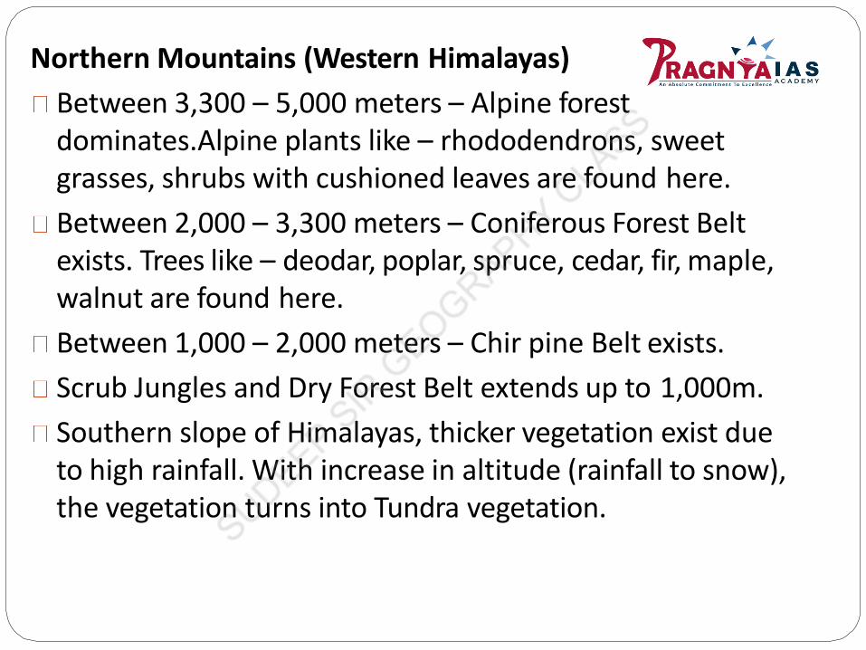
Northern Mountains (Western Himalayas)
Between 3,300 – 5,000 meters – Alpine forest dominates.Alpine plants like – rhododendrons, sweet grasses, shrubs with cushioned leaves are found here.
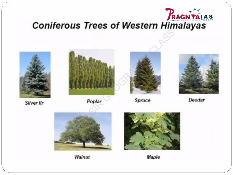
Between 2,000 – 3,300 meters – Coniferous Forest Belt exists. Trees like – deodar, poplar, spruce, cedar, fir, maple, walnut are found here.
Between 1,000 – 2,000 meters – Chir pine Belt exists.
Scrub Jungles and Dry Forest Belt extends up to 1,000m.
Southern slope of Himalayas, thicker vegetation exist due to high rainfall. With increase in altitude (rainfall to snow), the vegetation turns into Tundra vegetation.

Southern Mountains of India
Mountains in South India are mainly found in the Western Ghats, the Vindhya range, and the Nilgiris. They are Tropical region and their elevation is around 1500 meters above the sea level.
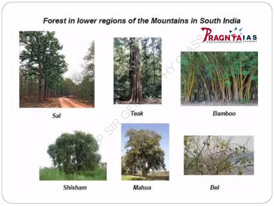
Lower regions have Subtropical vegetation or Moist & Drydeciduous forests due to less rainfall (leeward side). Sometrees that are found here are – Teak, sal, shisham, Mahua,Bel, Bamboos etc.
Higher regions of these mountains have temperate forest or evergreen forest vegetation due to good rainfall. These Forests are called sholas in the Nilgiris, Anaimalai and Palani hills. Some trees of these forests are – magnolia, laurel, cinchona, and wattle.

Littoral forests and Swamp forestsLittoral forests and Swamp forests are also called the wetland forests. India has a rich varietyof these types of forests. Littoral and Swamp Forests.
Wetlands are defined as lands transitional between terrestrial and aquatic eco-systemswhere the water table is usually at or near the surface or the land is covered by shallow water.
These are found in – Sunderban delta, Eastern coastal plain of river Godavari, Krishna, Kaveri,Mahanadi, desert region of Rajasthan and Gujarat, Kashmir and Ladakh, Andaman & Nicobarislands, Lakshadweep islands, Western coastal plains of Malabar coast to Konkan coast.
There is an intergovernmental treaty for the protection and sustainable use of the wetlands,it’s called the ‘Ramsar Convention’. India currently has around 37 Ramsar sites.

Littoral forests can be classified into the following types:Beach forests: In the Beach forests, the temperature in these forests is moderate. The common plants found in these forests are Manilkara Littoralis, Thespesia, Spinifex Littoreus, Casuarina Equisetifolia, Pandanus, Cocos Nucifera, Pongamia. A number of twiners and climbers are also found in these forests.Tidal forests: The Tidal forests are also popularly known as the or Mangrove forests. Mangrove forests grow along the coast in the salt marshes, tidal creeks, and estuaries. It is home to a large variety of birds. The Tidal forests are further broadly classified into the following four types:(i) Tree mangrove forests(ii) Low mangrove forests(iii) Saltwater forests and(iv) Brackish water forests.Freshwater swamp forests: Important plants found here are Salix Tetrasperma, Acer, Putranjiva, Holoptelia, Olea, Phoebe, Ficus, Canna and a variety of grasses.


On the basis of administration, the forests in India are of 3 categories:
1.Reserved Forests:
These forests are under the direct supervision of the government and no public entry is allowed for collection of timber or grazing of cattle. About 53 per cent of the total forest area falls in this category.
2. Protected Forests:
These forests are looked after by the government, but the local people are allowed to collect fuel-wood/timber and graze their cattle without causing serious damage to the forests. These forests occupy about 29 per cent of the total forest area of the country.
3. Unclassified Forests:
The unclassified forests are those in which there is no restrictionon the cutting of trees and grazing of cattle. About 18 per cent ofthe total forest area of the country falls under this category.
Difference between forest area and forest cover :
The term 'Forest Area' (or recorded forest area) generally
refers to all the geographic areas recorded as forest in
government records. Recorded forest areas largely
comprise Reserved Forests (RF) and Protected Forests
(PF), which have been constituted under the provisions of
Indian Forest Act, 1927. Besides RFs and PFs, therecorded
forest area may include all such areas, which have been
recorded as forests in the revenue records or have been
constituted so under any State Act or local laws.
On the other hand, the term 'Forest Cover' as used in the
'SFR' refers to all lands more than one hectare in area,
having a tree canopy density of more than 10%. Thus the
term 'forest area' denotes the legal status of the land as per
the government records, whereas the term 'forest cover'
indicates presence of trees over any land.

FOREST COVER IN INDIA(India State of Forest Report, 2019)
Total Forest cover is 7,12,249 sq. km, which is 21.67% of
the total geographical area of the country.
The Tree cover of the country is estimated to be 95,027 sq.
km which is 2.89% of the geographical area.
The total forest and tree cover of the country as per this
assessment is 8,07,276 sq km( 80.73 million hectare) which
is 24.56% of the geographical area of the country.
There is an increase of 5,188 sq. km in the total forest
and tree cover of the country as compared to the previous
assessment i.e. ISFR 2017. Out of this, the increase in the
forest cover has been observed as 3,976 sq km and that in
tree cover is 1,212 sq. km

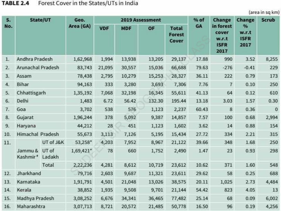
Area-wise Madhya Pradesh has the largest forest cover in the country followed
by Arunachal Pradesh, Chhattisgarh,Odisha and Maharashtra.
In terms of forest cover as percentage of total geographical area, the top five
States are Mizoram (85.41%), Arunachal Pradesh (79.63%), Meghalaya (76.33%),
Manipur (75.46%) and Nagaland (75.31%).

The top 5 States in terms of increase in forest cover are Karnataka (1,025 sq km), Andhra Pradesh (990 sq km), Kerala (823 sq km), Jammu & Kashmir (371 sq km) and Himachal Pradesh (334 sq km).
The total forest cover in the tribal districts is 4,22,351 sq km, which is 37.54% of the geographical area of these districts. The current assessment shows a decrease of 741 sq km of forest cover within the RFA/GW in the tribal districts and an increase of 1,922 sq km outside.
Total forest cover in the North Eastern region is 1,70,541 sq km, which is 65.05% of its geographical area. The current assessment shows a decrease of forest cover to the extent of 765 sq km (0.45%) in the region. Except Assam and Tripura, all the States in the region show decrease in forest cover.
Mangrove forests
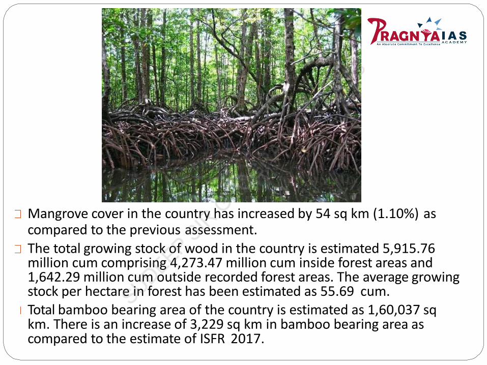
Mangrove cover in the country has increased by 54 sq km (1.10%) ascompared to the previous assessment.
The total growing stock of wood in the country is estimated 5,915.76 million cum comprising 4,273.47 million cum inside forest areas and 1,642.29 million cum outside recorded forest areas. The average growing stock per hectare in forest has been estimated as 55.69 cum.Total bamboo bearing area of the country is estimated as 1,60,037 sq km. There is an increase of 3,229 sq km in bamboo bearing area as compared to the estimate of ISFR 2017.

Based on Canopy Density: FSI categorizes forests
based on the canopy density:
Scrubs: The degraded forest lands which have a
Canopy density of less than 10% are called Scrubs.
Open Forests: The Lands with Canopy density of 10-
40% are called Open Forests.
Moderately Dense Forest: The Land with forest cover
having a canopy density of 40-70% is called the
Moderately Dense Forest (MDF).
Very Dense Forests: The Lands with forest cover
having a canopy density of 70% and more are called
Very Dense Forests (VDF).
Non- forest: Lands not included in any of the above
classes(includes water).


India’s Global Position :
India is ranked 10th in world, with 24.56% of land area under forest and tree cover, even though it accounts for 2.4 % of the world surface area andsustains needs of 17 % of human and 18 % livestockpopulation.India was placed 8th in list of Top 10 nations reporting the greatest annualnetgain in forest area.


NATIONAL FOREST POLICY1988
India adopted a forest policy in 1952, which was further modified in 1988.
According to the new forest policy, the Government will emphasize sustainable
forest management in order to conserve and expand forest reserve on the one hand,
and to meet the needs of local people on the other.
The forest policy of the Government of India aims at:
i. bringing 33 per cent of the geographical areas under forestcover;
ii.maintaining environmental stability and to restore forests where ecological
balance was disturbed;
iii. conserving the natural heritage of the country, its biodiversity and genetic pool;
iv.checks soil erosion, extension of desert lands &reduction of floods and droughts;
v.increasing the forest cover through social forestry and afforestation on degraded
land;
vi. increasing the productivity of forests to make timber, fuel, fodder and food available
to rural population dependant on forests, encourage substitution of wood;
vii. Creating of a massive people’s movement involving women to encourageplanting
of trees, stop felling of trees and thus, reduce pressure on the existing forest.
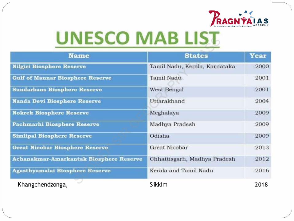
Khangchendzonga, Sikkim 2018
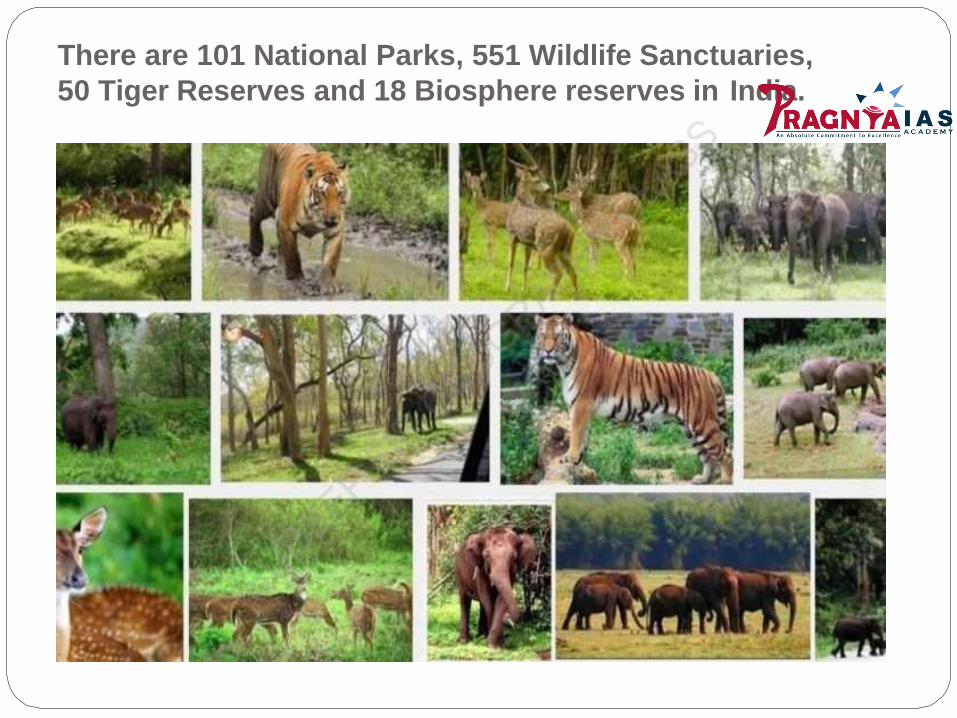
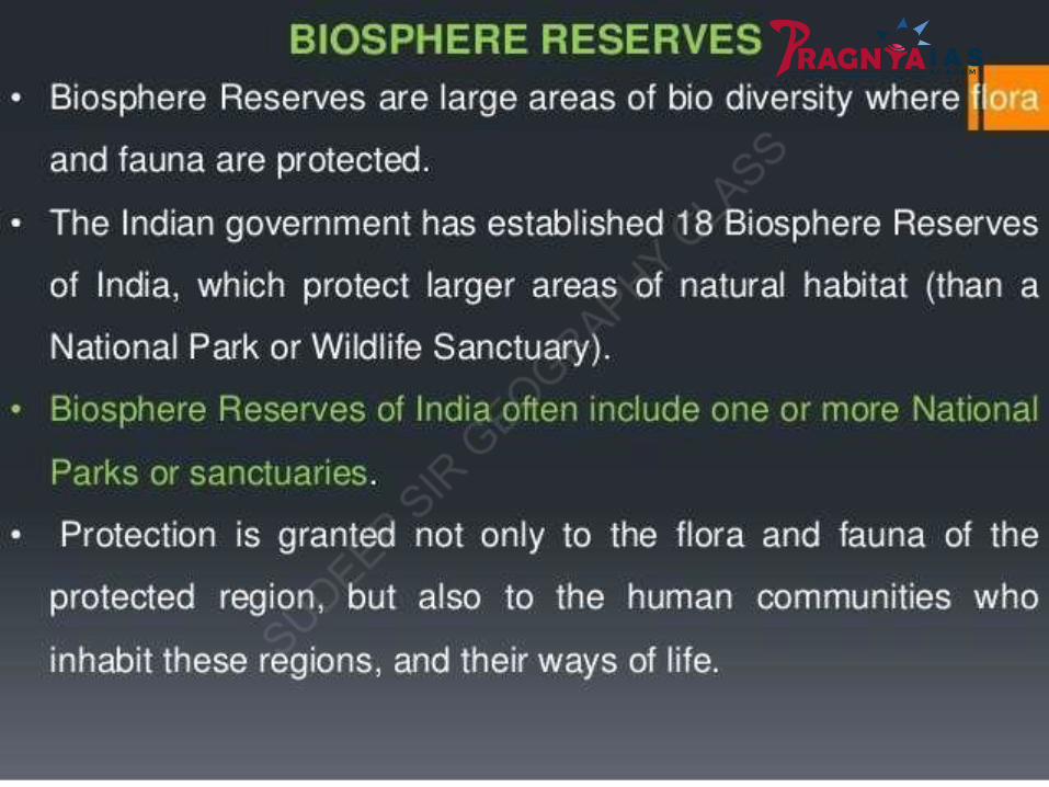
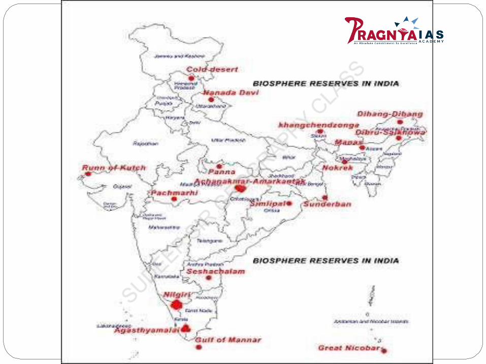
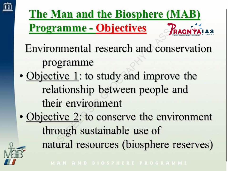
There are 101 National Parks, 551 Wildlife Sanctuaries,
50 Tiger Reserves and 18 Biosphere reserves in India.

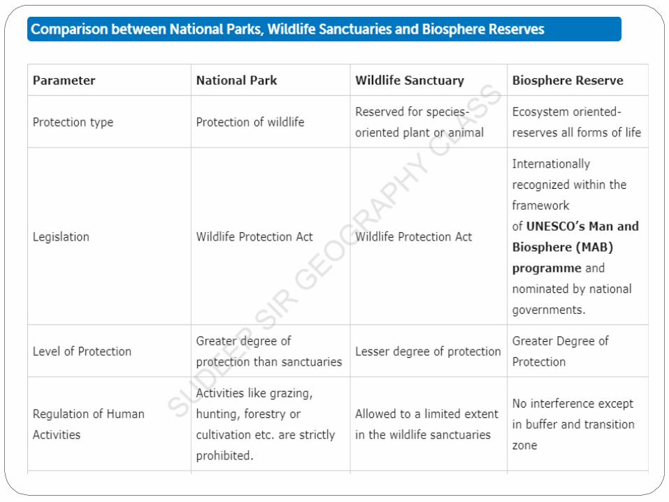
What is a National Park?An area can be notified by the state government to be constituted as aNational Park, by reason of
-its ecological, faunal, floral, geomorphological, or zoological association or importance, &-needed to for the purpose of protecting & propagating or developingwildlife therein or its environment.
No human activity is permitted inside the national park except for the onespermitted by the Chief Wildlife Warden of the state.
What is a Wildlife Sanctuary?
Any area other than area comprised with any reserve forest or the territorial waters can be notified by the State Government to constitute as a sanctuary if-such area is of adequate ecological, faunal, floral, geomorphological,natural. or zoological significance,-for the purpose of protecting, propagating or developing wildlife or itsenvironment.
Some restricted human activities are allowed inside the Sanctuary area.
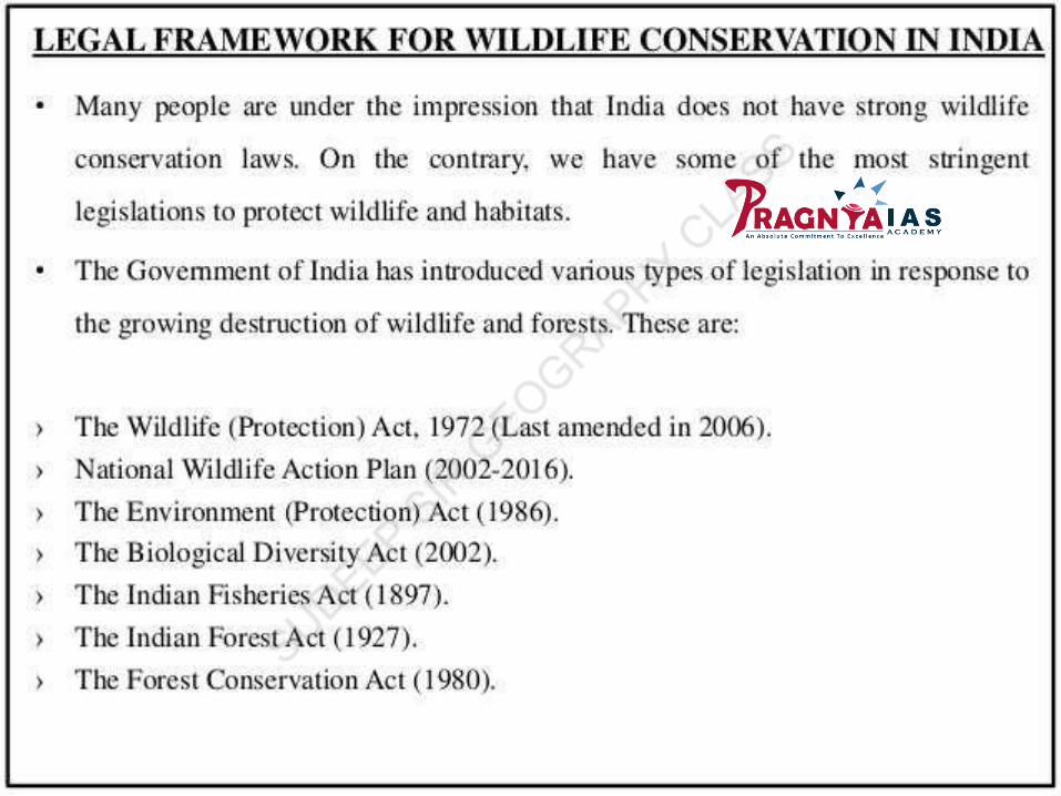
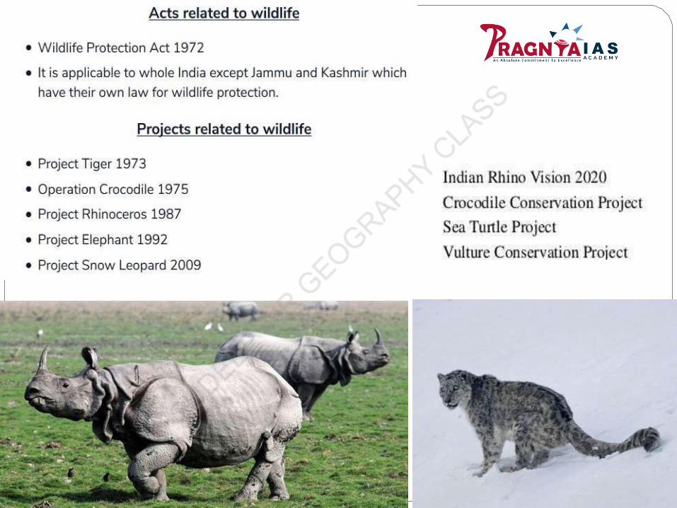

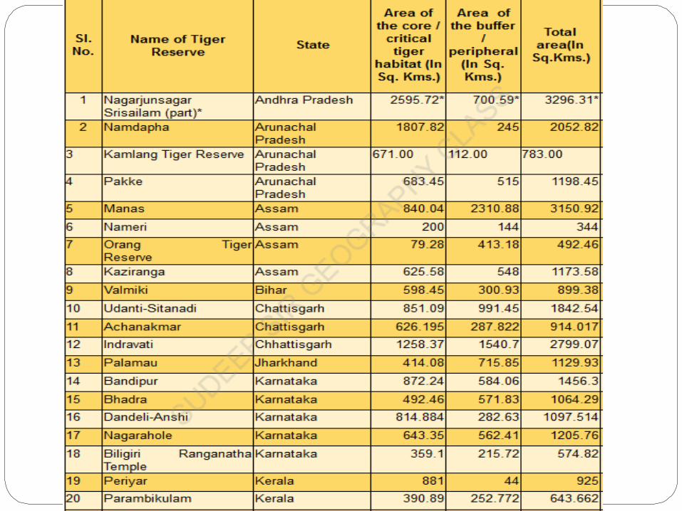
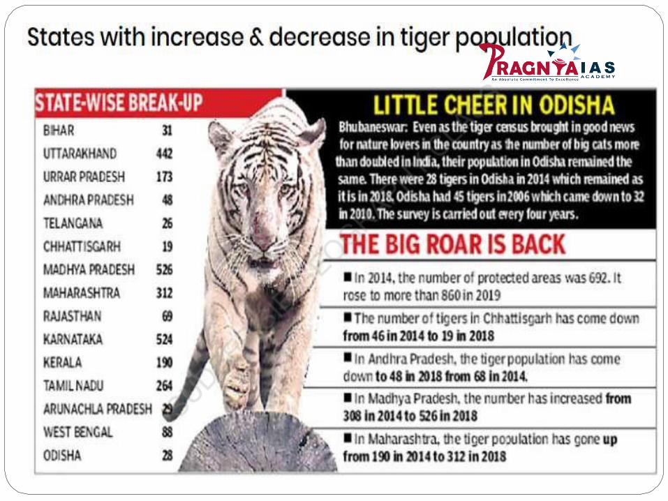
Tiger Reserves
Project Tiger was launched by the Government of India in the year 1973 to save
the endangered species of tiger in thecountry.
Starting from nine (9) reserves in 1973, the number is grown up to fifty (50) now. A
total area of 71027.10 sq km is covered by these project tiger areas.


Elephant Reserves
The Indian elephant Elephas maximus occurs in the central and southern Western Ghats, North-east India, eastern India and northern India and in some parts of southern peninsular India.
It is included in Schedule I of the Indian Wildlife (Protection) Act, 1972 and in Appendix I of the Convention on International Trade in Endangered Species of Flora and Fauna (CITES).It occurs in 16 of the 29 states in the country and is showing anincreasing trend across its distributional range.In 2012 the population was estimated to be between 27,785and 31,368.As per Elephant Census in 2017, India has 27,312 elephants.While numbers are lower than in 2012, previous counts were notsynchronized and may have had duplication.