
Forest and Water
92
-
Upload
steve-b-salonga -
Category
Documents
-
view
67 -
download
4
Transcript of Forest and Water


iii
Contents
Foreword vAcknowledgements viiAcronyms viiiExecutive summary ix
1. Introduction 1
2. Forests and water quantity 5Too much water? 5
Not enough water? 7
Groundwater levels 10
Guidelines 11
3. Forests and water quality 13Erosion and sediment 13
Other water pollutants 15
Guidelines 17
4. “Red flag” forest situations 19Mountain cloud or fog forests 19
Swamp forests 23
Forests on saline-susceptible soils 29
Forests on sites with high landslip risk 33
Riparian buffer zones 38
Municipal water supply forests 41
Vernal pools 46
Avalanche protection forests 48
5. The special case of mountainous small islands 55
6. Payments for environmental services 59Ecosystem services provided by watersheds 59
Types of payment initiatives 60
Payments for environmental services in practice – defining watershed services 63
Institutional challenges 64
Conclusion: key challenges in design and development 66
7. Recommendations 67
References 69
iv
Tables1 Spatial dimension of land-use effects 4
2 Examples of amounts of horizontal precipitation in tropical montane
cloud forests as determined by fog catchers 20
Figures 1 The hydrologic cycle 3
2 Erosion and sedimentation processes in a watershed 14
3 Ahupua`a – typical land division in Hawaii 57
Boxes1 Forests with a protective function 2
2 Stormflow and flooding from land-use activities 8
3 Effects of forest manipulation on water yield 9
4 Examples of cloud forests and water supply 21
5 Papua New Guinea Logging Codea 40
6 International experiences: the avalanche winter of 1999 in the
European Alpine regiona 49
Case studies1 Forest plantations in semi-arid South Africa 10
2 Reservoir sediment reduction in Taiwan Province of China 16
3 The Panama Canal and water quality 17
4 Fragmentation threats to cloud forest in Xalapa, Veracruz, Mexico 24
5 Conservation and sustainable use of the Southeast Pahang peat swamp forest (SEPPSF) 26
6 Deforestation and salinity in Western Australia 31
7 Deforestation and salinity in northeastern Thailand 32
8 Floods and landslips in southern Thailand 36
9 Forest avalanche protection in Switzerland 51
10 Government/community watershed management on Pohnpei 56
11 Hawaiian ahupua`a 57
12 New York City watershed agreement 62
13 Costa Rica’s National Forestry Financing Fund 63

v
Foreword
The availability and quality of clean water in many regions of the world isincreasingly threatened by overuse, misuse and pollution. In this context, therelationship between forests and water is a critical issue that must be accorded highpriority.
Forested catchments supply a high proportion of the water for domestic,agricultural, industrial and ecological needs in both upstream and downstreamareas. A key challenge faced by land, forest and water managers is to maximize thiswide range of multi-sectoral forest benefits without detriment to water resourcesand ecosystem function. To address this challenge, there is an urgent need for betterunderstanding of the interface between forests/trees and water, for awareness raisingand capacity building in forest hydrology, and for embedding this knowledge andresearch findings in policies. There is also need to develop institutional mechanismsto enhance synergies in dealing with forests and water issues and to implement andenforce action programmes at the national and regional levels.
Until a few years ago, forests and water policies were based on the assumptionthat under any hydrological and ecological circumstances, forest is the best landcover for maximizing water yield, regulating seasonal flows and ensuring highwater quality. According to this assumption, conserving (or extending) forestcover in upstream watersheds was the most effective measure for enhancing wateravailability for agriculture, industrial and domestic uses, as well as for preventingfloods in downstream areas. However, forest hydrology research conducted duringthe 1980s and 1990s suggests a different picture. Although the important role ofupstream forest cover in ensuring the delivery of quality water has been confirmed,generalizations about the impact of such cover on downstream annual and seasonalflows are fallacious and misleading. Instead, studies have shown that, especiallyin arid or semi-arid ecosystems, forests are not the best land cover for increasingdownstream water yields. Moreover, there is solid evidence that the protectiveeffects of upstream forest cover against seasonal downstream floods have oftenbeen overestimated. This is especially true regarding major events affecting large-scale watersheds or river basins.
The International Year of Freshwater (IYF 2003) and the Third World WaterForum (Kyoto, Japan, 2003) advanced the incorporation of this new understandingof biophysical interactions between forests and water into policies. In particular,the International Expert Meeting on Forest and Water, held in Shiga, Japan inNovember 2002 in preparation for IYF and the Third Water Forum (InternationalForestry Cooperation Office, 2002), highlighted the need for a more holisticapproach to capture interactions among water, forest, other land uses andsocio-economic factors in complex watershed ecosystems. Since then, the Shiga

vi
Declaration has become a key reference for the development of a new generationof forests and water policies.
In the work of the FAO Forestry Department, the relationship between forestsand water has been receiving increased attention over recent years. The chapterentitled “Sustainable use and management of freshwater resources: the role offorests” in the State of the World’s Forests 2003 (FAO, 2003) was a milestone inestablishing the Forestry Department’s forest and water programme entity. Therelationship between forests and water was a major component in the FAO-ledglobal review of watershed management programmes and projects (FAO, 2006b).
This thematic study on forests and water was developed in the context of theGlobal Forest Resources Assessment programme. It is directed to a broad range oftechnical experts, scientists and decision-makers, particularly national authorities,and presents recommendations on giving more attention to the role of forests andtrees in water protection and management at the national level. It also calls forstronger collaboration between the water and forest communities.
Jose Antonio PradoDirector
Forest Management DivisionFAO Forestry Department

vii
Acknowledgements
The Global Forest Resources Assessment 2005 (FRA 2005) represents a major effortof FAO’s Forestry Department, FAO member countries, donors, partners andindividual experts. It involved more than 800 people, with national correspondentsand their teams providing detailed country reports. In addition to the main report(FAO, 2006a), several thematic studies have been prepared. Forests and water isthe report of a thematic study carried out in response to the increasing worldwideattention to this topic.
The main author of this publication is L.S. Hamilton, a world-renowned expertin forest hydrology. As well as writing the bulk of the material, Professor Hamiltoncoordinated a small team of authors who contributed specific sections of thestudy: N. Hassan (swamp forests), D. Lamb (forests on saline susceptible soils), N.Dudley and S. Stolton (municipal water supply forests), P. Greminger (avalancheprotection forests) and S. Tognetti (payment for environmental services).
The study was prepared under the overall supervision of T. Hofer, the officerin charge of the programme entity on forests and water in the FAO ForestryDepartment. M. Achouri, M. Wilkie, P. Warren, D. McGuire and P. Ceci providedtechnical advice and support. W. Fleming, P.-C. Zingari, A. Whiteman and T. Faconsubmitted valuable review comments. L. Ball edited the report and A. Perlis, officerin charge of publications in the Forestry Department, oversaw the finalization ofthe book.

viii
Acronyms
CIFOR Center for International Forestry ResearchFEMAT Forest Ecosystem Management Assessment Team
(United States)FONAFIFO Fondo Nacional de Financiamiento Forestal (Costa
Rica)FRA Global Forest Resources AssessmentFRIM Forest Research Institute of MalaysiaGDP gross domestic productGEF Global Environment FacilityICL International Consortium on LandslidesIIED International Institute for Environment and
DevelopmentIUCN International Union for the Conservation of NatureIYF International Year of FreshwaterNGO non-governmental organizationNWFP non-wood forest productPES payment for environmental servicesSFRA streamflow reduction activityUNDP United Nations Development ProgrammeUNEP United Nations Environment ProgrammeUNESCO United Nations Educational, Scientific and Cultural
OrganizationUSGS United States Geological SurveyWCMC World Conservation Monitoring Centre (UNEP)WWF World Wide Fund for Nature
ix
Executive summary
Overall, current forest hydrology research suggests that the assumption that moretrees equals more water (which has inspired most forests and water policy) is basedon incorrect understanding of the hydrological cycle in forest ecosystems. Theforest ecosystem is in fact a major user of water. Tree canopies reduce groundwaterand streamflow, through interception of precipitation, and evaporation andtranspiration from foliage. As both natural and human-established forests usemore water than most replacement land cover (including agriculture and grazing),there is no question that even partial forest removal increases downstream wateryields. The removal of water-demanding forest cover has therefore sometimes beensuggested as a means of preventing or mitigating droughts, especially in semi-aridareas. However, such a policy should be weighed against the consequent loss of themany other services and goods that forests supply. These include erosion control,improved water quality, carbon fixation, reduced salinization, recreation andaesthetic appeal, timber, fuelwood, other forest products, and biodiversity.
It is well established that partial or complete removal of the tree coveraccelerates water discharge, increasing the risk of flood during the rainy season anddrought in the dry season. Forest cover’s importance in regulating hydrologicalflows has often been overestimated, however; the impacts of forest cover removalare evident only at the micro-level and in association with short-duration and low-intensity rainfall events (which tend to be the most frequent). As rainfall durationor intensity increases and the distance down the watershed and river basin becomesgreater, other factors start to override or dwarf the effects experienced close to thedeforested area.
At the macro-scale, natural processes – rather than land management in theupper watershed – are responsible for flooding. Hence, although there are manygood reasons for reforesting watersheds (e.g. reducing soil loss, keeping sedimentsout of streams, maintaining agricultural production, wildlife habitat), reducingflood risk control is certainly not one of them. Reforestation to prevent or reducefloods is effective at only a local scale of a few hundred hectares.
Forests’ most significant contribution to the hydrological balance of watershedecosystems is in maintaining high-quality water. This is achieved throughminimizing soil erosion on site, reducing sediment in water bodies (wetlands,ponds and lakes, streams and rivers) and trapping/filtering other water pollutants inthe forest litter and underwood. Good forest cover is the most effective land coverfor keeping water as sediment-free as possible. Forest is certainly the best coverfor drinking-water supply watersheds, because forestry activities involve no use offertilizer, pesticide and fossil fuel, or outfalls from domestic sewage or industrialprocesses.
x
A number of special forest situations are very important for water resources andtheir management:
• Cloud forests should be maintained as forest because they are important forwater production, erosion control and biodiversity, and generally unsuitablefor other sustainable uses. They need to be identified in local, regional andnational inventories. Loss of cloud forests is irreversible because of thecomplex relationships among their flora, fauna and soil. The conservationof cloud forests and their designation as protected areas should be a nationalpriority.
• Swamp forests have a unique role in local water balance and the globalecology. They should be designated as environmentally sensitive areas wherethe maintenance of hydrological integrity is a management priority. Theyshould be given legal protection, and the potential long-term and immediateeffects of any planned large-scale conversion to other land use should besubject to environmental impact assessment.
• Salinization is a widespread problem, particularly in regions with an extendeddry season. Recent reports suggest that worldwide, 77 million ha of landis affected by salinization induced by human activities, mainly changes invegetative cover and excessive irrigation. Deforestation should be avoidedin forested areas with saline subsoils or groundwater. Any change to thehydrological cycle in such landscapes may mobilize stored salts.
• Because of their undergrowth, leaf litter, debris and uncompacted soils, forestsare almost certainly the best and safest land cover for minimizing all kinds ofsurface erosion. Areas prone to slippage, which is probably the most seriousform of erosion, need to be kept in forest cover, woodland or agroforestry/sylvopastoral systems with fairly dense tree cover.
• Vegetated strips along stream/riverbanks and lake/pond shores have importantwater-protective functions. Forested buffer zones perform these particularlywell because of deep, strong root systems. Forest riparian buffers can stabilizethe banks of flowing water bodies, minimizing erosion and thus reducing thesediment entering the water. The forest floor and soil can also trap sedimentas it moves towards flowing water from upslope areas outside the buffer.Forested riparian buffer zones that shield perennial watercourses and otherwater bodies from quality impairment should be identified and officiallydesignated for special treatment in land use.
• Lack of clean drinking-water and adequate sanitation reduces the qualityof life for an estimated 1 billion city dwellers around the world, alongwith many people living in rural areas, principally in Africa, Asia andLatin America. Tight budgets are forcing many municipalities to exploreinnovative approaches to maintaining supplies of pure drinking-water.Increasingly, this includes examining the potential for forested catchments tosupply urban drinking-water. Although forests are already viewed as watersuppliers, much remains to be learned and applied in order to maximize thesebenefits.
xi
• Avalanche protection is an existential challenge for the inhabitants of highmountain regions around the world, whose lives and activities also face manyother considerable risks. Forests play a significant role in avalanche reduction.Mountain hazard mapping should make specific reference to protective forestsand designate them for special treatment.
On small mountainous islands, forests’ classic influences on water quantityand quality prevail. The relative shortness of the streams leads to close upstream-downstream linkages; what happens in the uplands usually alters the quantityand quality of water, including through flooding, low flows, sedimentation andwater-borne pollutants. Freshwater resources on small islands are very often scarceand therefore precious. Forest management decision-makers must therefore beespecially cautious about alterations or removals that impair water resources.
The degradation of watersheds has led to greater recognition of the numerousways they support human well-being through ecosystem services, and consequentlyto greater value being placed on them. Watershed services may include provisionof freshwater, regulation of both water and sediment flows and maintenance ofnatural flow regimes, which support entire ecosystems and ways of life. However,the complexity and natural variability of watershed processes, which are dominatedby randomly timed and extreme events, make it difficult, if not impossible,unequivocally to link all causes and effects. Payments for watershed services willnot solve all watershed degradation problems, but can be an important componentof a broader management strategy.


Introduction 1
1. Introduction
Lack of access to water for meeting basic needs such as health, hygiene and food
security undermines development and inflicts enormous hardship on more than
a billion members of the human family. And its quality reveals everything,
right or wrong, that we do in safeguarding the global environment.
Former United Nations Secretary-General Kofi Annan (UNESCO, 2003)
At the United Nations Millennium Summit in 2000, 147 world leaders adoptedthe target of halving, by 2015, the proportion of people who are unable to reachor afford safe drinking-water. Although most of the earth’s surface is water, thereseems to be insufficient freshwater to meet the needs and wants of its burgeoninghuman population or its plants and animals, both domesticated and wild. TheUnited Nations International Year of Freshwater (IYF) in 2003 highlighted thecritical need to have water available – in the right place, in adequate amounts, ofsufficient quality and at the right time. Forests play a key role in this availability,but the Economic Commission for Europe (2004) warns:
The current attention given to freshwater issues does not put enough emphasison the role of water-related ecosystems in providing solutions, possibly dueto lack of awareness. Promoting awareness, for instance through informationcampaigns and other specific activities, about the role of wetlands and forestsas water suppliers among the different stakeholders in the whole watershed(national authorities, the public and the private sector) is essential. The benefitto upstream and downstream populations should be publicized.
It is therefore very appropriate that “Forests and water” was selected as one ofthe thematic studies implemented for FAO’s Global Forest Resources Assessment2005 (FRA 2005) (see Box 1).
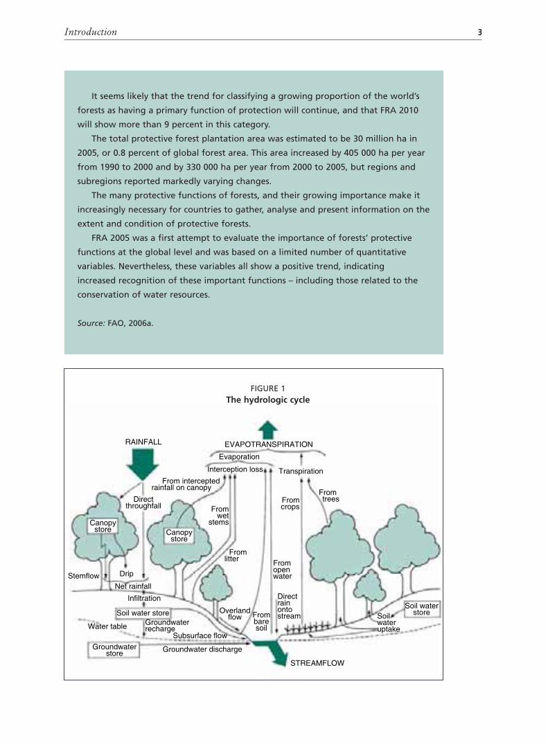
This study deals with the extent to which forests cover land surface and withtheir importance to the hydrological cycle (Figure 1). It provides information formuch-needed efforts to maintain and restore water-related ecosystems – identifiedby the United Nations Commission for Europe as a global priority. By interceptingprecipitation, evaporating moisture from vegetative surfaces, transpiring soilmoisture, capturing fog water and maintaining soil infiltration, forests influencethe amount of water available from groundwater, surface watercourses and waterbodies. By maintaining or improving soil infiltration and soil water storagecapacity, they influence the timing of water delivery. By minimizing erosion, theyminimize impairment of water quality due to sedimentation. Forests can alsoprotect water bodies and watercourses by trapping sediments and pollutants fromother upslope land uses and activities. Along streams, forests provide shade, thusreducing water temperature. As watershed land cover, protected or well-managed

Forests and water2
BOX 1
Forests with a protective function
Early assessments of forest resources focused on forests’ productive functions,
particularly wood supply, which policy-makers identified as the main issue. In many
countries there is now increased awareness of forests’ importance in providing
environmental services through their protective functions. FRA 2005 therefore
included a first assessment of the area of forest with a protective function.
Information on the following two variables was collected.
Area of forest designated for protective purposes
This variable indicates the extent of forest areas set aside for protective purposes,
either by legal prescription or by decision of the landowner or manager.
The world’s forests have many protective functions, some local and some global.
These include influence on climate, protection from wind erosion, coastal protection,
protection from avalanches, air-pollution filtering and protection of water resources.
Forest designation is reported as “primary function” and “total area with
function”. Forest areas whose designated protection function is considered
significantly more important than its other functions are reported as having
protection as their primary function. All forest areas with a designated protective
function (not necessarily primary) are reported under total area with function.
Area of protective forest plantations
Protective forest plantations are forests of introduced and, sometimes, native species
established through planting or seeding, with few species, even spacing and/or even-
aged stands. They are predominantly for providing services such as soil and water
protection, rehabilitation of degraded lands and combating desertification.
In FRA 2005, not all countries were able to provide quantitative information
for these variables, but an initial evaluation was made of the importance of the
protective functions of forests worldwide.
Key findings
In 2005, the extent of forest with protection as its designated primary function
was estimated to be 348 million ha, or 9 percent of the global forest area. Some
1 190 million ha of forest – or 65 percent of the total – was identified as having a
designated protective function (not necessarily as its primary function).
The findings of FRA 2005 suggest that there is a trend towards identifying and
designating increasing areas for forest protection. Worldwide, the percentage of
forest with protection as its primary function grew from 8 percent in 1990 to 9 percent
in 2005 – representing an increase of more than 50 million ha. The proportion of the
world’s forests designated with a protective function also expanded, from 61 percent
in 1990 to 65 percent in 2005 – an increase of nearly 60 million ha.
Introduction 3
Canopystore
Canopystore
RAINFALL EVAPOTRANSPIRATION
STREAMFLOW
Evaporation
TranspirationInterception loss
Fromwet
stems
Fromlitter
Fromcrops
From trees
Fromopenwater
Frombaresoil
Directrainontostream
Overlandflow
Subsurface flow
Soil water storeGroundwaterrecharge
Infiltration
Water table
Groundwaterstore Groundwater discharge
Net rainfall
DripStemflow
Directthroughfall
From interceptedrainfall on canopy
Soilwateruptake
Soil waterstore
FIGURE 1The hydrologic cycle
It seems likely that the trend for classifying a growing proportion of the world’s
forests as having a primary function of protection will continue, and that FRA 2010
will show more than 9 percent in this category.
The total protective forest plantation area was estimated to be 30 million ha in
2005, or 0.8 percent of global forest area. This area increased by 405 000 ha per year
from 1990 to 2000 and by 330 000 ha per year from 2000 to 2005, but regions and
subregions reported markedly varying changes.
The many protective functions of forests, and their growing importance make it
increasingly necessary for countries to gather, analyse and present information on the
extent and condition of protective forests.
FRA 2005 was a first attempt to evaluate the importance of forests’ protective
functions at the global level and was based on a limited number of quantitative
variables. Nevertheless, these variables all show a positive trend, indicating
increased recognition of these important functions – including those related to the
conservation of water resources.
Source: FAO, 2006a.

Forests and water4
forests are without equal in increasing hydrological and erosion safety and waterquality: water may well be forests’ most useful and important product. Thefollowing chapters take a closer look at some of these issues.
As well as protecting water resources, forests also conserve biodiversity.National commitments to the United Nations Convention on Biological Diversityare being fulfilled through measures to safeguard water and establish “protected”and “protective” forests, as well as many kinds of forests certified for sustainability.Forests also provide carbon fixation and several other environmental services.
Climate change will have a significant impact on hydrology and waterresources (Bergkamp, Orlando and Burton, 2003). This may be manifested inincreased catastrophes such as floods, droughts and landslides – all of which maybe influenced by forest cover. Situations affecting the most vulnerable groupswithin societies require particular attention. Restoration of damaged/degradedforest ecosystems can help forests to “cushion” the effects of climate change.
A brief discussion of forests’ role regarding water quantity (Chapter 2) andquality (Chapter 3) is followed by descriptions of special forest types or situationswhere the relationship between forests and water is especially significant (Chapter4). These can be considered “red flag” warning situations, where protective valuesare very high. The special case of mountainous small islands is discussed in Chapter5. Chapter 6 analyses the rationale and examples of payment for environmentalservices (PES) programmes. These chapters explain and amplify the informationpresented in Table 1, which shows the impact of change in land use, for exampleamong forest, agriculture and managed grassland, on various water parameters, atdifferent scales. Guidelines are offered at the end of each section, and the studyconcludes with a brief set of recommendations in Chapter 7.
TABLE 1 Impact of change in land use on water parameters, by basin size
Parameter Basin size (km2)
0.1 1 10 100 1 000 10 000 100 000
Average flow x x x x o o o
Peak flow x x x x o o o
Base flow x x x x o o o
Groundwater recharge x x x x o o o
Sediment load x x x x o o o
Nutrients x x x x x o o
Organic matter x x x x o o o
Pathogens x x x o o o o
Salinity x x x x x x x
Pesticides x x x x x x x
Heavy metals x x x x x x x
Thermal regime x x o o o o o
x = observable impact; o = no observable impact.Source: FAO, 2001.

Forests and water quantity 5
2. Forests and water quantity
The conversion of precipitation to groundwater and streamflow is reduced by theinterception of forests and by evaporation from the tree canopy (see Figure 1). Itis reduced further through transpiration of soil moisture from foliage. These canbe described as losses to the useful water system, but it is through this water useand photosynthesis that trees produce wood, leaves, flowers, fruit and seeds. Withits flora and fauna, the forest ecosystem is a major user of water, but also providesenormous benefits for humanity: from birds to boards to bears, from fuelwoodto medicines, from carbon fixation to orchids and chestnuts, there is a treasuryof products from forest biodiversity. Recreation and landscape aesthetics can beadded to these, as well as a high degree of soil erosion control, and – in the rightcircumstances – avalanche hazard reduction.
Human society is concerned about the beneficial and deleterious impactsof forests on water quantity, because sometimes there is too much water(flooding) and sometimes not enough. This concern involves many myths andmisunderstandings and much misinterpretation and misinformation – the “fourMs” (Hamilton, 1985). It has been claimed, for instance, that logging and landclearing in the Nepalese Himalayas have been responsible for devastating floodingof the lower Ganges in India, and that restoring forests can cause dry rivers toflow again, relieving drought (World Water, 1981). Such misinterpretations ofhydrological science persist.
TOO MUCH WATER?It is confirmed that partial or complete removal of the tree cover increases thetotal amount of water in streams flowing from the catchment area. This is largelybecause of decreased evapotranspiration by trees, which act as deep-rooted “waterpumps” (Hamilton and King, 1983; Bruijnzeel, 1990). Higher water yields continuethroughout the year, with the greatest percentage increase (often a doubling of pre-removal flow) occurring in the dry season. Light, selective harvesting or removalof non-wood forest products (NWFPs) has little or no impact on streamflow,but the effect increases with the amount of trees removed, up to clear-cutting(Bruijnzeel, 1990). Yield increase seems desirable during streamflow shortages inthe dry season, but can present a problem during the wet season, when increasedflows make flooding a hazard. Effects on flow occur close to the forest area beingcut, but only for short-duration/low-intensity rainfall events (which are usuallyalso the most frequent).
As rainfall duration or intensity increase and the distance down the watershed andriver basin becomes greater, other factors override or dwarf the effects experiencedclose to the treated area. These factors include the size and morphometry of thebasin, what happens in other tributary streams, the direction of the storm path and

Forests and water6
the intensity and duration of the storm. Ives and Messerli (1989) described thisphenomenon in terms of microscale watersheds (< 50 km2), mesoscale watersheds(50 to 20 000 km2) and macroscale basins (> 20 000 km2). At the microscale, land-use practices may influence streamflow and sediment discharge, depending on soildepth and precipitation variability. At the mesoscale, downstream effects of forestoperations and other land uses are probably obliterated by the high intensityand high variability of natural events and discharges from other watersheds.At the macroscale, natural processes – rather than human interventions in theupper watershed – are responsible for flooding and high sedimentation rates.Hewlett (1982) reviewed the evidence from watershed research worldwide andreported that no cause and effect was demonstrated between forest cutting in theheadwaters and floods in the lower basin. No conflicting information has beenpublished since, more than 20 years later.
Even on the local scale, much depends on the depth of the soil and the characterof the precipitation event. Deep soils can store more water before they becomesaturated, and deep-rooted trees make the soil mantle more receptive for storingwater from a new event. Antecedent rainfall and soil water storage have a greatinfluence on the generation of runoff. Thus, for frequently occurring rainfallevents of short duration or low intensity, forested soils may reduce or preventflash floods locally. For the rarer prolonged or high-intensity storms, however,once the soil layer becomes saturated, water will run off, even where there is full,undisturbed forest cover. On shallow soils, especially steep ones, storage is muchless and the watershed is more prone to flash floods; trees or other vegetation orland use can do little to stem the fast subsurface and overland flows.
The four Ms persist, however. The disastrous floods of November 1988 insouthern Thailand were mistakenly blamed on logging, and the governmentissued a nationwide ban on logging (Rao, 1988). The same year, a flood disasterin Bangladesh was erroneously attributed to deforestation in the Indian andNepalese mountains, where the mighty Ganges and Brahmaputra rivers have theirheadwaters. This was international scapegoating to avoid tough decisions aboutfloodplain occupancy and river management in the lower basin (Hamilton, 1988).Many more examples could be cited of this popular misinformation. A recentmajor publication related to hydrological processes in large river basins (Hoferand Messerli, 2006) presents strong scientific evidence for abandoning the myththat deforestation in the Himalayas creates major floods in the lowlands of theGanges and Brahmaputra. A publication by FAO and the Center for InternationalForestry Research (FAO and CIFOR, 2005) has this to say:
Although forests can play a certain role in delaying and reducing peakfloodwater flows at local levels, scientific evidence clearly indicates that forestscannot stop catastrophic large-scale floods, commonly caused by severemeteorological events …. This in no way diminishes the need for propermanagement and conservation of upland forests. But it does point toward thecritical need for integrated approaches in river-basin management that lookbeyond simplistic forest-based “solutions”.

Forests and water quantity 7
However, flooding and flood damage are often greatly aggravated by sedimentand debris arriving in stream channels from the landslips and landslides thatfrequently accompany flood-producing rainfall events. Scatena, Planos-Gutiérrezand Schellekens (2005) suggest that intense, short-duration events create shallowslips and debris flows, while long-duration, low-intensity events produce larger,deeper debris avalanches and slumps. Research has shown that tree roots impartsubstantial strength to soils, giving a higher safety margin against shallowlandslipping and debris flows (O’Loughlin, 1974). Thus, although forest covermay not appreciably reduce the amount of water moving into watercourses froma large storm event, it can influence the severity of flooding and flood damage.
The misperception persists that reforesting watersheds is effective in reducingor preventing floods. Again, there is no evidence for this, except at the verylocal scale of a few hundred hectares. There are many very good reasons forrehabilitating watersheds, including reducing soil loss, keeping sediment outof streams, maintaining agricultural production and increasing forest wildlifehabitat, but achieving substantial flood reduction is not one of them (Hamiltonand Pearce, 1987).
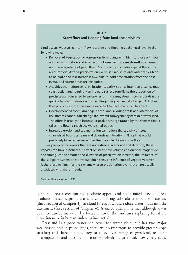
Box 2 presents a summary of the usual effects that land uses involving forestshave on stormflow response and flooding at the local level.
NOT ENOUGH WATER?There is no question that forest removal, even partial, increases overall wateryield. Both natural and planted forests use more water than most replacement landcover, including agriculture and grazing. Reported first-year increases in wateryield following forest clearance in the humid tropics, for instance, range from 110to 825 mm, depending on local rainfall (Box 3). Evaporation/transpiration lossesare greater from evergreen than from deciduous forest, and the drier and lesswindy the climate, the less the evaporation loss, because leaves in dry climates aregenerally narrower and smaller (Nisbet and McKay, 2002).
A dated, but still valid review of almost 100 paired catchment experimentsthroughout the world (Bosch and Hewlett, 1982) indicated that all of thoseinvolving removal of forest cover resulted in higher streamflow totals. More recentreviews (e.g. Grip, Fritsch and Bruijnzeel, 2005) have not altered this information.However, this does not hold true when montane cloud forests are cut or removed(see Chapter 4). In conifer forests, where much water arrives as snow, closed- oronly slightly open-canopied forest can delay snow-melt, allowing more timefor discharge from lower, open lands to clear out of channels. This may have anameliorating effect on floods and increase the period during which snow-meltprovides water for downstream uses. Light cutting can increase the snowfallreaching the ground by reducing that held in the crowns and evaporated.
Does this mean that trees or forests should be removed because of their heavyuse of water? This has sometimes been suggested during droughts, but it wouldimpair or eliminate the many values that forests supply, including forest wildlifeand flora, erosion minimization, improved water quality (Chapter 3), carbon
Forests and water8
BOX 2
Stormflow and flooding from land-use activities
Land-use activities affect stormflow response and flooding at the local level in the
following ways:
Removal of vegetation or conversion from plants with high to those with low
annual transpiration and interception losses can increase stormflow volumes
and the magnitude of peak flows. Such practices can also expand the source
areas of flow. After a precipitation event, soil moisture and water tables tend
to be higher, so less storage is available to hold precipitation from the next
event, and source areas are expanded.
Activities that reduce soils’ infiltration capacity, such as intensive grazing, road
construction and logging, can increase surface runoff. As the proportion of
precipitation converted to surface runoff increases, streamflow responds more
quickly to precipitation events, resulting in higher peak discharges. Activities
that promote infiltration can be expected to have the opposite effect.
Development of roads, drainage ditches and skidding trails and alterations of
the stream channel can change the overall conveyance system in a watershed.
The effect is usually an increase in peak discharge caused by the shorter time it
takes the flow to reach the watershed outlet.
Increased erosion and sedimentation can reduce the capacity of stream
channels at both upstream and downstream locations. Flows that would
previously have remained within the streambanks may now flood.
For precipitation events that are not extreme in amount and duration, these
impacts can have a noticeable effect on stormflow volume and on peak magnitude
and timing. As the amount and duration of precipitation increase, the influence of
the soil-plant system on stormflow diminishes. The influence of vegetative cover
is therefore minimal for the extremely large precipitation events that are usually
associated with major floods.
Source: Brooks et al., 1991.
fixation, forest recreation and aesthetic appeal, and a continued flow of forestproducts. In saline-prone areas, it would bring salts closer to the soil surface(third section of Chapter 4). In cloud forest, it would reduce water input into thecatchment (first section of Chapter 4). A major dilemma is that although waterquantity can be increased by forest removal, the land uses replacing forest aremore intensive in human and/or animal activity.
Grassland is a good watershed cover for water yield, but has two majorweaknesses: on slip-prone lands, there are no tree roots to provide greater slopestability; and there is a tendency to allow overgrazing of grassland, resultingin compaction and possible soil erosion, which increase peak flows, may cause

Forests and water quantity 9
sediment discharge into watercourses and can even reduce infiltration so severelythat base flows decline (Hamilton and King, 1983). Tree harvesting through partialcutting or forest regeneration retains the site in tree cover (rather than convertingit) and temporarily increases water yields throughout the year, but the use of skidtrails, haul roads, winching channels and landings for the removal of wood tendsto impair water quality, owing to accelerated erosion until recovery is complete.The greatest yield increases will occur on the deeper soils, where deep root systemsexploit more soil moisture. Thang and Chappell (2005) present up-to-date guidelinesfor minimizing the hydrological impact of forest harvesting in Malaysia.
The effects of reforestation or afforestation on water yields are usually thereverse of those for forest removal (Hamilton and Pearce, 1987). They varydepending on whether the land is still in reasonable hydrological health or has beenseverely degraded from long-term, non-conservative use. Locally, for frequentshort, low-intensity storm events, flash flooding should be reduced where soilsare deep. On the other hand, low flows are usually diminished as well, especiallywhere fast-growing, heavy water-using species are employed (Case study 1). Forinstance, the Fiji Pine Commission’s planting of Caribbean Pinus in their dry zonegrasslands resulted in dry-season streamflow reductions of 65 percent (Kammer
BOX 3
Effects of forest manipulation on water yield
Carefully executed light, selective harvesting will have little if any effect on
streamflow, which increases with the amount of timber removed.
The data set for the humid tropics supports the general finding of Bosch and
Hewlett (1982) that removal of natural forest cover may result in a considerable
initial increase in water yield (up to 800 mm per year); possibly more in high-
rainfall regions, depending mainly on the amount of rain received after
treatment.
Depending on rainfall patterns, there is a rather irregular decline in streamflow
gain, with time, associated with the establishment of the new cover. No data
have been published regarding the number of years needed for a return to
pre-cut streamflow totals in the case of natural regrowth, but it may take more
than eight years.
Water yield after maturation of the new vegetation may: remain above original
streamflow totals in the case of conversion to annual cropping, grassland or
tea plantations; return to original levels (Pinus plantation after full canopy
closure); or remain below previous values (reforestation of grassland with Pinus
or Eucalyptus). Coppicing of Eucalyptus after ten years caused even stronger
reductions for two years.
Source: Extracted from Bruijnzeel, 1990.
Forests and water10
and Raj, 1979). There are many stories of flow reductions following Eucalyptus
plantation, encouraging FAO to publish The eucalypt dilemma (FAO, 1988b).Scott, Bruijnzeel and Mackensen (2005) reviewed the experience and research inthis topic. The special case of reforestation in mountains where persistent wind-driven fog or cloud occurs should result in more water in dry-season streamflows,but there is not yet any scientific evidence to corroborate this (see Chapter 4).
GROUNDWATER LEVELSForest cover influences groundwater levels, wells and springs, as well assafeguarding water quality. As noted by Foster and Chilton, (1993):
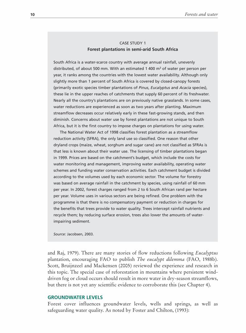
CASE STUDY 1
Forest plantations in semi-arid South Africa
South Africa is a water-scarce country with average annual rainfall, unevenly
distributed, of about 500 mm. With an estimated 1 400 m3 of water per person per
year, it ranks among the countries with the lowest water availability. Although only
slightly more than 1 percent of South Africa is covered by closed-canopy forests
(primarily exotic species timber plantations of Pinus, Eucalyptus and Acacia species),
these lie in the upper reaches of catchments that supply 60 percent of its freshwater.
Nearly all the country’s plantations are on previously native grasslands. In some cases,
water reductions are experienced as soon as two years after planting. Maximum
streamflow decreases occur relatively early in these fast-growing stands, and then
diminish. Concerns about water use by forest plantations are not unique to South
Africa, but it is the first country to impose charges on plantations for using water.
The National Water Act of 1998 classifies forest plantation as a streamflow
reduction activity (SFRA), the only land use so classified. One reason that other
dryland crops (maize, wheat, sorghum and sugar cane) are not classified as SFRAs is
that less is known about their water use. The licensing of timber plantations began
in 1999. Prices are based on the catchment’s budget, which include the costs for
water monitoring and management, improving water availability, operating water
schemes and funding water conservation activities. Each catchment budget is divided
according to the volumes used by each economic sector. The volume for forestry
was based on average rainfall in the catchment by species, using rainfall of 60 mm
per year. In 2002, forest charges ranged from 2 to 6 South African rand per hectare
per year. Volume uses in various sectors are being refined. One problem with the
programme is that there is no compensatory payment or reduction in charges for
the benefits that trees provide to water quality. Trees intercept rainfall nutrients and
recycle them; by reducing surface erosion, trees also lower the amounts of water-
impairing sediment.
Source: Jacobsen, 2003.

Forests and water quantity 11
Groundwater should be regarded as a valuable, but potentially fragile resource in the humid tropics, which, in some cases, is highly vulnerable to pollution from the uncontrolled disposal of urban and industrial liquid effluents and solid wastes, as well as from intensive agricultural cultivation, and saline intrusion in coastal areas due to local overexploitation.
This statement is true for more than the humid tropics. The safest protectionfor groundwater is forest cover on its sources. Harvesting or removing theforest raises groundwater levels (Working Group on the Influence of Man onthe Hydrologic Cycle, 1972). Any salts present in the upper soil layers could bemoved into the rooting zone of plants, with deleterious effects (e.g. the Australianexperience described in the section on Forests on saline-susceptible soils inChapter 4). Conversely, planting forests on open land where the water table isclose to the surface will lower groundwater levels, improving drainage.
GUIDELINESForest removal, either partial or total, results in increased streamflows and highergroundwater levels. These effects occur mainly at the local, small watershed leveland cannot be extrapolated to large river basins where flooding or insufficient dry-season flows are problems. Even at the local level, these effects may be desirable orundesirable. It is the soil that stores water, not the trees, and tree roots are morelike pumps than sponges. Soil depth and precipitation characteristics cause greatvariations in the general pattern. Prolonged or high-intensity storm events usuallyoverride the influence that forests and forest manipulation have on water yields,with the exception of those very close to the area being treated. Manipulationsto improve water yield must take into account the possible impairment of waterquality (see Chapter 3) and other values, such as landslip and avalanche protection,wildlife habitat and biodiversity maintenance.
Reforestation or afforestation of open land generally has the opposite effects onwater quantity to those of forest removal. Sediment discharge may be significantlyreduced, which may result in less severe flooding.

Forests and water quality 13
3. Forests and water quality
Forests’ most significant contribution to water for all living things is in maintaininghigh water quality. They achieve this through minimizing soil erosion on site, thusreducing sediment in water bodies (wetlands, ponds and lakes, streams and rivers),and through trapping or filtering other water pollutants.
EROSION AND SEDIMENTTransported and deposited erosion is called sediment. This section describes howforests – and forest alteration – influence sediment from transport and depositionby minimizing erosion. Although one of the most serious consequences of erosionis loss of soil productivity, this section is concerned mostly with the effect on waterresources. Erosion decreases soil’s water storage capacity, and usually causes reducedinfiltration on eroded sites, thus speeding both subsurface and overland flow.
Sediment deposition can be beneficial if it occurs in the right place, but thereare usually a host of unwanted effects from transported and deposited sediment.Sediment can reduce reservoir capacity; impair water for drinking and domesticor industrial uses; obstruct navigation channels; raise river beds, which reduces thecapacity to handle water safely; adversely alter aquatic habitat in streams; fill thespawning grounds of fish; wear down turbine blades in power installations; andcause landslides, which damage people and their structures and block channels,resulting in floods.
In riparian zones and along the shores of water bodies where wave action is afactor, the roots of shrubs in the tree and forest understorey stabilize banks againsterosion. This occurs in coastal mangroves, streambanks and large ponds and lakes.For meandering rivers, forest cover may only delay the inexorable natural erosionthat contributes much sediment to watercourses, but delay is often important toland users on the outcurves of such watercourses. Streambank stabilization withtree plantings (often with willow cuttings and fibre mats) can slow the process, butif done on one small stretch alone, may simply shift the problem elsewhere.
On sloping land, soil moves downhill owing to gravity and displacement bythe splash action of raindrops. Forest cover provides the most effective barrier tonatural erosion, and loss of forest cover, resulting from other land uses, alwaysincreases human-accelerated erosion, unless soil conservation is carried out.
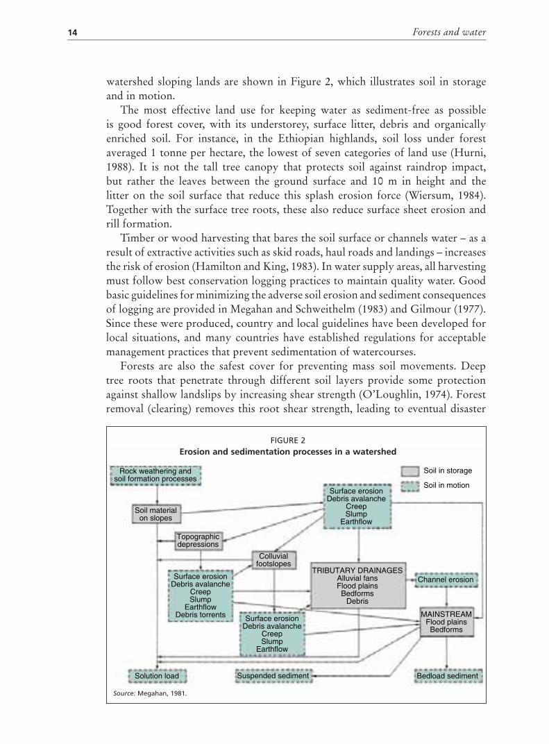
Erosion spans a range of phenomena from surface erosion (sheetwash andrills) through gullies (advanced surface erosion) to mass soil movement (landslips,slumps, debris avalanches and landslides). These are all natural processes and canoccur on land under forest. Mass soil movements are usually caused by earthtremors or high-intensity or prolonged storms that saturate soils and resultin high pore pressure and buoyancy. Erosion and sedimentation processes on
Forests and water14
watershed sloping lands are shown in Figure 2, which illustrates soil in storageand in motion.
The most effective land use for keeping water as sediment-free as possibleis good forest cover, with its understorey, surface litter, debris and organicallyenriched soil. For instance, in the Ethiopian highlands, soil loss under forestaveraged 1 tonne per hectare, the lowest of seven categories of land use (Hurni,1988). It is not the tall tree canopy that protects soil against raindrop impact,but rather the leaves between the ground surface and 10 m in height and thelitter on the soil surface that reduce this splash erosion force (Wiersum, 1984).Together with the surface tree roots, these also reduce surface sheet erosion andrill formation.
Timber or wood harvesting that bares the soil surface or channels water – as aresult of extractive activities such as skid roads, haul roads and landings – increasesthe risk of erosion (Hamilton and King, 1983). In water supply areas, all harvestingmust follow best conservation logging practices to maintain quality water. Goodbasic guidelines for minimizing the adverse soil erosion and sediment consequencesof logging are provided in Megahan and Schweithelm (1983) and Gilmour (1977).Since these were produced, country and local guidelines have been developed forlocal situations, and many countries have established regulations for acceptablemanagement practices that prevent sedimentation of watercourses.
Forests are also the safest cover for preventing mass soil movements. Deeptree roots that penetrate through different soil layers provide some protectionagainst shallow landslips by increasing shear strength (O’Loughlin, 1974). Forestremoval (clearing) removes this root shear strength, leading to eventual disaster
Soil in storage
Soil in motion
Channel erosion
MAINSTREAMFlood plains
Bedforms
TRIBUTARY DRAINAGESAlluvial fansFlood plains
BedformsDebris
Surface erosionDebris avalanche
CreepSlump
Earthflow
Colluvialfootslopes
Topographicdepressions
Solution load Suspended sediment Bedload sediment
Surface erosionDebris avalanche
CreepSlump
Earthflow
Surface erosionDebris avalanche
CreepSlump
EarthflowDebris torrents
Soil materialon slopes
Rock weathering andsoil formation processes
FIGURE 2Erosion and sedimentation processes in a watershed
Source: Megahan, 1981.

Forests and water quality 15
in landslip-prone sites, while forest harvesting (logging) reduces it, depending onthe heaviness of the cut and the rate at which the regenerating forest re-establishesdeep root systems (discussed further in Chapter 4).
Erosion material arriving from upslope as sheetwash or rills can be filtered andtrapped by adequate streamside forest buffer zones. Gullies and mass erosion can bestopped by only exceptionally wide riparian buffers (also discussed in Chapter 4).
Forest restoration is one of the best ways of restoring productivity andreducing sedimentation in degraded areas of cleared land experiencing any kindof accelerated erosion. Forest restoration may be used in conjunction with otherconservation land uses or physical structures, and is a separate topic. It usuallyrequires an integrated and multifaceted rehabilitation programme, in whichreforestation is a major component. For instance, the Green Hills watershedprogramme instituted in the degraded Chitagong Hill tracts of Bangladeshincludes tree planting, development of self-help community organizations forwater supply, fire control, health and improved agricultural practices (MoungThowai Ching, personal communication, 2003). Case study 2 describes howa watershed restoration project in Taiwan Province of China helped to reducereservoir sedimentation by 45 percent.
OTHER WATER POLLUTANTSSoil is not the only material that can impair water quality. Depending on the typeof land use, various levels of other pollutants can also drain into the watercourse.Forest cover in the watershed above the site of concern (e.g. a drinking-watersupply reservoir) is the best option for limiting this. Most forest uses involveno fertilizer, pesticides, fossil fuel runoff or outfalls from domestic sewage orindustrial processes. Where logging occurs, care should be taken with machineryfuels and lubricants, as the accumulation of small spills during routine handling,or larger, accidental spills, can seriously contaminate soils and drainage water. Alloils, particularly diesel, migrate quickly through soil, and even small quantitiescan taint drinking-water supplies and disrupt water treatment processes (Nisbetand McKay, 2002). Other types of land use that use machine fuels and lubricants,such as agriculture and transportation routes, are even more risky owing to thefrequency of spills and intensity of use compared with forest harvesting.
Forests in water supply catchments are the best solution for reducing pollutionrisks. If they are logged using mechanical equipment and roads, good conservationlogging regimes must be used. Many drinking-water catchments – for examplepart of the Melbourne, Australia water supply area – have been carefully loggedfor decades with no apparent water quality problems (Dudley and Stolton, 2003),although about half the watershed’s lands are in unharvested national parks.
The impact of changed land uses when forest areas become suburban is wellillustrated by a New York City water catchment, the Croton system. Here, a partlyprotected and partly “working” forest landscape is gradually shifting from forestmanagement to rural residence – single home ownerships with large backyardsof 0.5 to 2 ha. This is resulting in increased nutrient loading from septic systems,

Forests and water16
lawn fertilizers, animal wastes (often horses) and road salts; nutrient transportis accelerated by the growing areas of impervious surfaces (Heisig, 2000). Thechemicals studied include ammonia, total phosphorous and orthophosphates, butnitrogen and others may also increase.
Any non-point source pollution can be greatly reduced, or even eliminated, byadequate forest buffer zones along watercourses (see Chapter 4 for more detail).Such zones do not prevent groundwater contamination, however, which needs tobe addressed by modified on-site practices.
The following are the only cases in which forests are not the most effectivewatershed cover for delivering the highest-quality water:
in some dense, planted monocultures with little or no understorey andground cover, which experience increased surface erosion rates (see earlierdiscussion);
CASE STUDY 2
Reservoir sediment reduction in Taiwan Province of China
The 20 480-ha Wuseh watershed in the Central Mountain Range of Taiwan drains into
the Wushah Reservoir (completed in 1958). The terrain is steep, with an average slope
of 57 percent. Average annual rainfall is 2 235 mm, mostly from May to October, with
a dry period from October to January. Two-thirds of the watershed was covered in
natural forest (14 099 ha); there were 4 205 ha of grasslands; 856 ha of cultivated
land; 1 046 ha of denuded land resulting from unsustainable slash–and-burn
cultivation; 276 ha of other uses. The aboriginal population numbered 1 900.
A programme of land-use changes and education was instituted. By 1988, with an
average annual expenditure of US$200 000, the following was accomplished:
2 660 ha of reforestation;
490 ha of soil conservation on cultivated lands;
three fire lookout towers and a suppression network;
33 km of new forest road and bank protection on 38 km of a major highway
(the latter due to typhoon damage in 1982);
eight check dams and gully control work;
introduction of fruit trees and agroforestry, conservation farming, new crop
varieties and marketing;
training courses in tree planting, fire protection, soil conservation, home
economics and hand crafts for women.
From 1957, reservoir sedimentation data were collected and a base rate
established. From 1965 until 1985, attributed to the rehabilitation programme,
sedimentation was reduced by 55 percent of the base rate. The unit cost of reducing
1 cubic metre was US$0.20.
Source: Extracted from Sheng, 1986.

Forests and water quality 17
where atmospheric pollutants are “captured” by trees more than by othervegetation (owing to the trees’ height and aerodynamic resistance) andadded to the soil and water. This occurs prevalently in mountain forests ofthe industrialized Northern Hemisphere (Hamilton, Gilmour and Cassells,1997).
GUIDELINESWhen water quality is a high priority, forests are the best cover or land use(Case Study 3). Undisturbed forest cover provides the greatest protection againsterosion, sedimentation and impairment by other contaminants. The best use isdesignated forests with management regimes, such as core zones of national parksor watershed protected reserves. The values foregone in commercial harvests maybe more than offset as quality water becomes more scarce and more valuable.Many municipalities throughout the world, such as Caracas, Freetown, Harare,New York City, Quito and Singapore, have sought to establish water supply areasin protected forests (see Chapter 4), which are not intensively used by humans,domestic animals or machines.
Where forest extraction is carried out, sediment production and chemicalpollution should be minimized. Roads, log landings, skid trails and soil compactionneed to be addressed as the chief sources of sediment. Landslip-prone areas can
CASE STUDY 3
The Panama Canal and water quality
Sedimentation and growth of water weeds create problems for shipping in the
Panama Canal, and require expensive dredging. An adequate, regulated supply
of freshwater is also needed. Forests’ role in both these issues is recognized by
the Smithsonian Tropical Research Institute in Panama, which has recommended
reforestation of denuded parts of the watershed. This would reduce not only
sedimentation, but also the flow into the canal of nutrients that stimulate aquatic
vegetation growth. Reforestation would decrease total water inflow, but the
regulated effect of reducing peak flows would result in more useful water, requiring
less water storage. It has been proposed that companies dependent on the canal buy
bonds to pay for the reforestation.
In the meantime, a US$10 million debt-for-nature swap over 14 years through
The Nature Conservancy (which is pledging US$1.6 million) is strengthening the
protection of existing forest watershed land. This involves 129 000 ha in Chagres
National Park, with its rich biodiversity. The watershed also provides drinking-water
for Colón and Panama City.
Source: Adapted from Plant Talk, 2003.

Forests and water18
be major contributors to sedimentation and flooding. They need identificationand special care and should be harvested only lightly by non-mechanized means.Recreational infrastructure must also be carefully sited and managed. Riparianbuffer zones of forest or dense vegetation and adequate width are extremelyimportant.

“Red flag” forest situations 19
4. “Red flag” forest situations
MOUNTAIN CLOUD OR FOG FORESTSOf all forest situations, cloud or fog forests have the closest interrelationship withfreshwater. These forests occur on mountains or upland areas that are bathedin frequent or persistent fog, particularly where wind-driven cloud intersectsdirectly with the surface. Occurring particularly in the tropics, cloud forests arecommon on large mountains in the interior, at elevations of 2 000 to 3 000 m. Oncoastal ranges, they can occur at about 1 200 m, and on small oceanic islands mayoccur even at 500 m (Hamilton, Juvik and Scatena, 1994). In addition to normalvertical precipitation, these forests have another source of water: the interceptionand water-stripping of horizontally moving fog, which can add hundreds ofmillimetres of water per year to the ecosystem and its watershed (Bruijnzeel andHamilton, 2000).
Recent estimates of the extent of cloud forests in the tropics vary considerably.The official estimate of the World Conservation Monitoring Centre (WCMC) ofthe United Nations Environment Programme (UNEP) is based on forest coverand altitudinal range and gives potential global area. In 2004 this estimate was380 000 km2, less than 2.5 percent of all tropical forests (Bubb et al., 2004). An
Cloud forests are important for water production, erosion control and biodiversity (Malaysia)
K. S
HO
NO

Forests and water20
estimate based on cloud-affected forest modelling gives a much larger figure of2.2 million km2 (14.2 percent of all tropical forests) (Mulligan and Burke, 2005).This variation reflects the difficulty in defining and locating these ecosystems.A database at UNEP-WCMC locates more than 560 points known to be cloudforests (Aldrich et al., 1997).
Cloud forest trees are usually shorter in stature than those in lower montaneforests, much more mossy and more heavily laden with bromeliads, orchids, ferns,lichens and liverworts (epiphytes). Tree stems become increasingly crooked andgnarled with elevation, tree ferns and bamboo are common, and mosses coverthe rocks and fallen stems. In a few situations, however, fine, straight, taller treescan develop, as in the Podocarpus cloud forests in the Andes and the Quercus
forests in Costa Rica’s Talamanca Cordillera. All the epiphytic vegetative surfaces,together with the tree foliage, twigs, branches, stems and shrubs provide a “net”for capturing horizontal precipitation from fog or cloud and adding it as fogdrip or stem flow to the watershed budget. Transpiration is relatively low in fog-shrouded forests with small leaves and often wet and waterlogged soils, so thisloss is minimized.
The amount of “extra” water obtained by cloud forests varies markedlyaccording to rainfall patterns, topographic position, frequency or persistence ofcloud and extent to which clouds are wind-driven (Table 2). The increase maybe 15 to 20 percent of rainfall for rainfalls of 2 000 to 3 000 mm per year, andup to 50 to 60 percent for exposed ridge-top locations and lower precipitation
TABLE 2 Examples of amounts of horizontal precipitation in tropical montane cloud forests asdetermined by fog catchers
Location Elevationin metres
Horizontalprecipitation as
% of rainfall
Period
Colombia, Serrania de Maquira 865 63 dry season
Costa Rica, Cerro Buenavista 3 500 18 annual
Costa Rica, Balalaica 1 300 33 annual
Costa Rica, Balalaica 1 300 15 wet season
Hawaii, Mauna Loa 1 580 30 annual
Hawaii, Mauna Loa 2 530 68 annual
Malaysia, Gunung Silam 884 9 annual
Mexico, Sierra Madre 1 330 15 wet season
Mexico, Sierra Madre 1 330 85 dry season
Puerto Rico, Pico del Oeste 1 050 7 annual
Venezuela, Cerro Santa Ana 815 32 annual
Venezuela, Cerro Santa Ana 815 66 dry season
Venezuela, Cerro Copey 987 11 annual
Venezuela, Cerro Copey 987 9 dry season
Venezuela, Zumbador 3 100 4 annual
Venezuela, Zumbador 3 100 19 dry season
Source: Nik, 1996.

“Red flag” forest situations 21
BOX 4
Examples of cloud forests and water supply
Millions of people depend on high-quality freshwater flowing from mountain cloud
and similar forests. The cloud forests in La Tigra National Park in Honduras sustain
a well-regulated, quality water flow throughout the year, providing more than
40 percent of the water supply of the 850 000 people in the capital city, Tegucigalpa.
The 2.5 million people in the Tanzanian city of Dar es Salaam rely on drinking-water
from the Uluguru Mountains and hydroelectric power from the cloud forests of the
Udzungwa Mountains, which are now the focus of modest conservation actions.
Other city populations supplied by cloud forest water include the 1.3 million people
in Quito and the 20 million in Mexico City.
Celaque Mountain in the north of Honduras is called “Box of Water” in the
Lencan language and has been worshipped by the Lenca for millennia as a god
mountain that supplies life-giving water to the land and people. With dense cloud
forest cover, Celaque Mountain generates nine major rivers and countless streams,
which feed clean water to nearby cities and communities. In Guatemala, the Sierra
de las Minas Biosphere Reserve contains 60 percent of the country’s remaining cloud
forest habitat. More than 60 permanent rivers drain the reserve, making it the
country’s biggest single water resource. This is especially significant for the Motagua
Valley to the southeast of the sierra, which is a rain-shadow desert heavily dependent
on irrigation. In arid and semi-arid areas, patches of cloud forest are even more
crucial for water supply to surrounding communities, especially during the dry season,
for example on Mount Kenya.
Without the River Chagres, construction of the Panama Canal would have
been nearly impossible. Its source is high up on the upper watershed in a series of
mountains blanketed by tropical cloud forest. This ecosystem ensures the water
supply for Lake Madden and Lake Gatun, which provide the necessary draft for
transiting ships.
Source: IUCN and WWF, 2000.
(Bruijnzeel and Hamilton, 2000). Water catch in fog/cloud situations in areas oflower and seasonal rainfall can be 100 percent or more higher than that in lowerforests. In areas of low rainfall, but frequent, wind-driven fog, even single treescan become important water collectors for wildlife, domestic stock or people. Afamous examples was found on El Hierro, one of the Canary Islands, where oneof several “fountain trees” (a laurel) was used for centuries as the main source ofwater for people and their animals until it was uprooted by a storm (Gioda et al.,1992). The tree was so important that it is depicted on the island’s municipal coatof arms. A replacement tree was established in 1945, and continues to capturevaluable amounts of fog water to this day.
Forests and water22
Trees can be planted in strategic fog locations to capture horizontal precipitationfor use. Where tree planting is difficult because of lack of rainfall, as in the coastalhills of Chile and Peru, mesh barriers have been erected, creating an artificial fogforest that provides potable water for water-scarce communities.
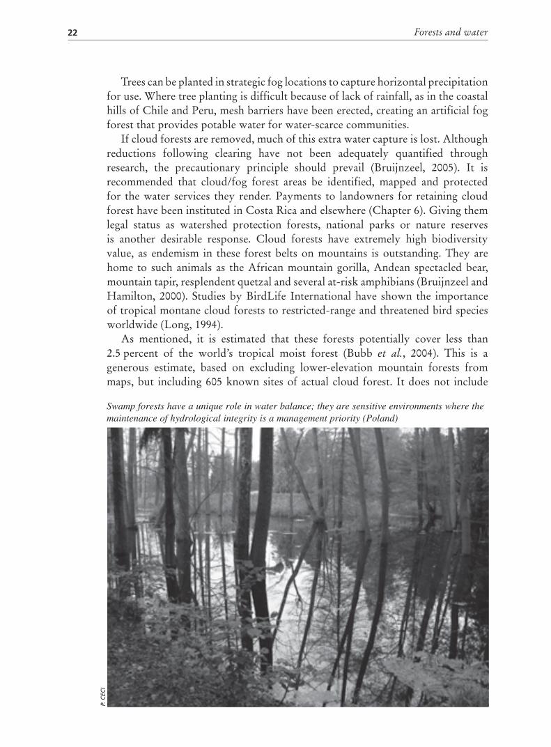
If cloud forests are removed, much of this extra water capture is lost. Althoughreductions following clearing have not been adequately quantified throughresearch, the precautionary principle should prevail (Bruijnzeel, 2005). It isrecommended that cloud/fog forest areas be identified, mapped and protectedfor the water services they render. Payments to landowners for retaining cloudforest have been instituted in Costa Rica and elsewhere (Chapter 6). Giving themlegal status as watershed protection forests, national parks or nature reservesis another desirable response. Cloud forests have extremely high biodiversityvalue, as endemism in these forest belts on mountains is outstanding. They arehome to such animals as the African mountain gorilla, Andean spectacled bear,mountain tapir, resplendent quetzal and several at-risk amphibians (Bruijnzeel andHamilton, 2000). Studies by BirdLife International have shown the importanceof tropical montane cloud forests to restricted-range and threatened bird speciesworldwide (Long, 1994).
As mentioned, it is estimated that these forests potentially cover less than2.5 percent of the world’s tropical moist forest (Bubb et al., 2004). This is agenerous estimate, based on excluding lower-elevation mountain forests frommaps, but including 605 known sites of actual cloud forest. It does not include
Swamp forests have a unique role in water balance; they are sensitive environments where the maintenance of hydrological integrity is a management priority (Poland)
P. C
ECI

“Red flag” forest situations 23
subtropical montane cloud forest. It is of interest that potential cloud forest inAsia is estimated to be 14.6 percent of the continent’s tropical mountain forests, ahigher proportion than in other continents.
Although cloud forest sites are often unsuitable for conversion to othersustainable uses – because of soil limitations, climate and accessibility problems– vegetable production, opium or coca growing, grazing, coffee growing andeven golf courses and resorts are threats. Overcutting for charcoal production orfuelwood is also a danger in these cool montane locations (Case study 4). Globalwarming appears to be raising the cloud deck in some places, with potentiallyserious adverse impacts on both water supply and biodiversity.
GuidelinesIn view of their importance for water production, erosion control and biodiversity,and their general unsuitability for other sustainable uses, cloud forests should bemaintained as forest. They need to be identified in local, regional and nationalinventories. Their loss is irreversible owing to the complex relationships amongtheir flora, fauna and soils (Hamilton, 1995). The conservation of cloud forests andtheir designation as protected areas should be national priorities.
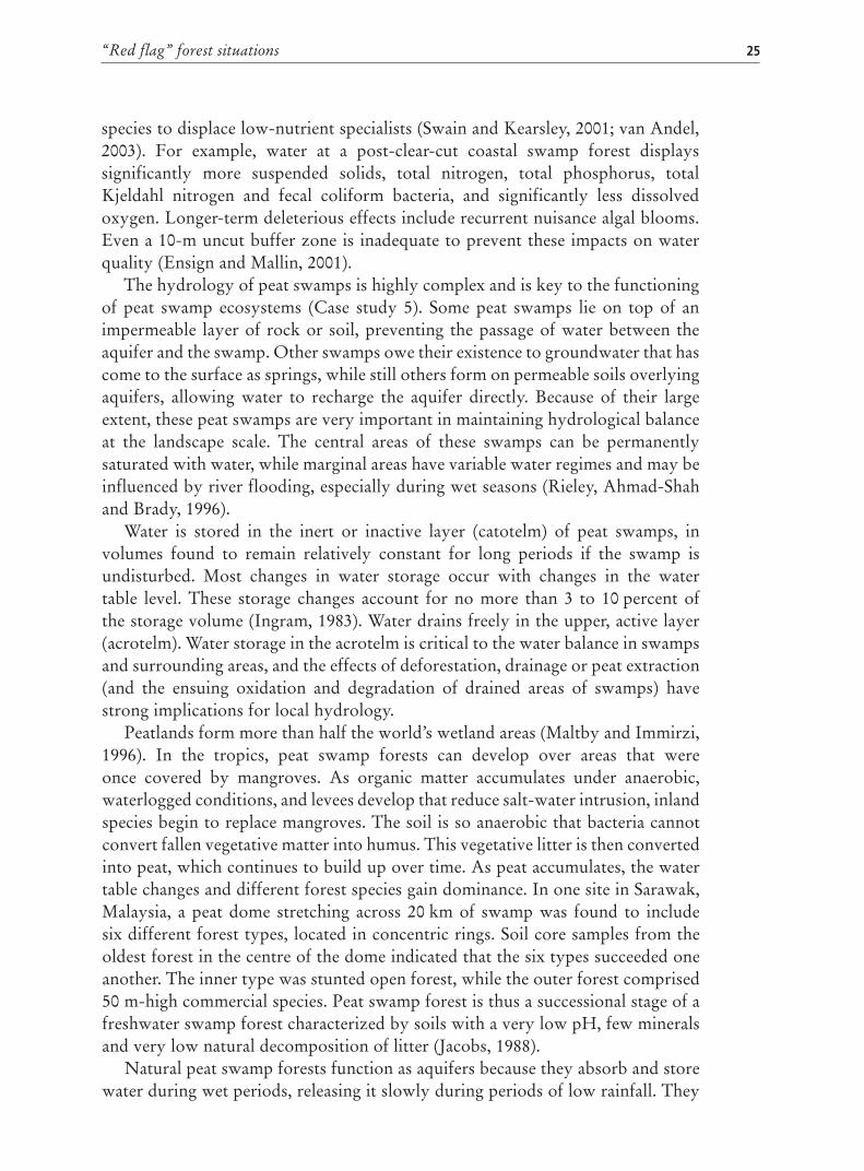
SWAMP FORESTSSwamp forests are a major forest type with a unique role in local water balanceand the global ecology. A swamp forest is any wetland with woody vegetation– irrespective of the size of the plants, which can range from 1 m, such as themangrove plant Rhizophora mangle, to the 50-m tall cypress Taxodium distichum
(Lugo, Brinson and Brown, 1990). Freshwater swamp forests are an importantsource of fish and other aquatic foods and of timber and fuelwood. They interactwith biogeochemical cycles and the food chain, have a fundamental role in thedynamics of local water quantity and quality (Maltby, 1997; Maltby and Proctor,1996) and provide distinctive habitats for biodiversity. Inland swamp forestsprotect watersheds, while coastal swamps protect coasts against tides, rising seawater levels and natural hazards.
In any climatic zone, hydrology is the most important determinant for theestablishment and maintenance of specific types of swamp (Lugo, Brinson andBrown, 1990; Mitsch and Gosselink, 1993). It is also a key determinant in speciesdistribution, wetland productivity (biomass produced per unit of time) andnutrient cycling and availability. The hydrology of basin wetlands (i.e. those intopographic depressions) is different from that of riverine or fringe wetlands.Local topography also affects water flow. A large basin wetland may include amixture of wetland types of varying behaviour (basin or riverine), according tothe location and season. The level of nutrients flowing in or out of a swamp is alsoimportant in determining its nature.
A better model of potential swamp forest structure and function is obtainedwhen hydrology is considered together with nutrient content and flow (eutrophicversus oligotrophic or minerotrophic versus ombrotrophic) (Brown, 1981; Odum,

Forests and water24
1984, both cited in Lugo, Brinson and Brown, 1990). These last authors stress theneed to consider the chemical aspects of forested wetlands more holistically. Theyalso allude to the confused state of the nomenclature used to identify forestedwetlands, resulting from the emphasis on species composition and vegetationtypes, which vary geographically, rather than on hydrology and geomorphology,for which geographic variation is much less. For example, Swain and Kearsley(2001) identified 11 distinct classes of temperate swamp forests based onpredominant tree species (conifer, hardwood and shrub vegetation).
Forested swamps develop more structure and are more productive underriverine conditions (Lugo, Brinson and Brown, 1990). Alteration of swampvegetative cover, such as through timber harvesting, alters water quality andquantity (Immirzi, Maltby and Vijanrnsorn, 1996; Ensign and Mallin, 2001).Hydrological alterations affecting water quality or quantity in swamp forestsaffect community structure and component species. Nutrient enrichment fromsurrounding land use also affects community structure by allowing less tolerant
CASE STUDY 4
Fragmentation threats to cloud forest in Xalapa, Veracruz, Mexico
The destruction of tropical montane cloud forest in the western region of Xalapa,
Veracruz has accelerated considerably in the last few decades. To determine
the degree and pattern of cloud forest fragmentation in this region, 33 aerial
photographs (scale 1:20 000) were digitized and photo-interpreted to generate maps
of vegetation and land use. Additional information on slope, slope aspect and human
settlements was incorporated into a geographic information system. In the study area
of 12 843 ha, 19 fragments of undisturbed forest remain, occupying just 10 percent of
the region. The dominant land uses are pasture (37 percent), urban areas (1 percent),
secondary vegetation (17 percent) and disturbed forest (17 percent).
The few flat areas available in the region (3.2 percent) are occupied by urban
zones and pasture, while undisturbed forest is found mostly on steep slopes, with
a northern exposure and located far from human activity. Fragments of forests are
surrounded by pasture, disturbed forests and secondary vegetation, which may
produce strong edge effects and reduce the overall undisturbed forest cover by
another 15 to 54 percent, depending on the size of the forest fragment. Results
indicate that 90 percent of the forest in the region has already been destroyed, and
the remainder is in danger of disappearing. There is need for a regional development
plan that considers the importance of cloud forests as biodiversity reservoirs and
providers of key environmental services, protects surviving fragments of undisturbed
forest, and promotes ecological restoration of disturbed forest and establishment of
corridors connecting forest remnants.
Source: Abstracted from Williams-Linera, Manson and Isunza Vera, 2000.
“Red flag” forest situations 25
species to displace low-nutrient specialists (Swain and Kearsley, 2001; van Andel,2003). For example, water at a post-clear-cut coastal swamp forest displayssignificantly more suspended solids, total nitrogen, total phosphorus, totalKjeldahl nitrogen and fecal coliform bacteria, and significantly less dissolvedoxygen. Longer-term deleterious effects include recurrent nuisance algal blooms.Even a 10-m uncut buffer zone is inadequate to prevent these impacts on waterquality (Ensign and Mallin, 2001).
The hydrology of peat swamps is highly complex and is key to the functioningof peat swamp ecosystems (Case study 5). Some peat swamps lie on top of animpermeable layer of rock or soil, preventing the passage of water between theaquifer and the swamp. Other swamps owe their existence to groundwater that hascome to the surface as springs, while still others form on permeable soils overlyingaquifers, allowing water to recharge the aquifer directly. Because of their largeextent, these peat swamps are very important in maintaining hydrological balanceat the landscape scale. The central areas of these swamps can be permanentlysaturated with water, while marginal areas have variable water regimes and may beinfluenced by river flooding, especially during wet seasons (Rieley, Ahmad-Shahand Brady, 1996).
Water is stored in the inert or inactive layer (catotelm) of peat swamps, involumes found to remain relatively constant for long periods if the swamp isundisturbed. Most changes in water storage occur with changes in the watertable level. These storage changes account for no more than 3 to 10 percent ofthe storage volume (Ingram, 1983). Water drains freely in the upper, active layer(acrotelm). Water storage in the acrotelm is critical to the water balance in swampsand surrounding areas, and the effects of deforestation, drainage or peat extraction(and the ensuing oxidation and degradation of drained areas of swamps) havestrong implications for local hydrology.
Peatlands form more than half the world’s wetland areas (Maltby and Immirzi,1996). In the tropics, peat swamp forests can develop over areas that wereonce covered by mangroves. As organic matter accumulates under anaerobic,waterlogged conditions, and levees develop that reduce salt-water intrusion, inlandspecies begin to replace mangroves. The soil is so anaerobic that bacteria cannotconvert fallen vegetative matter into humus. This vegetative litter is then convertedinto peat, which continues to build up over time. As peat accumulates, the watertable changes and different forest species gain dominance. In one site in Sarawak,Malaysia, a peat dome stretching across 20 km of swamp was found to includesix different forest types, located in concentric rings. Soil core samples from theoldest forest in the centre of the dome indicated that the six types succeeded oneanother. The inner type was stunted open forest, while the outer forest comprised50 m-high commercial species. Peat swamp forest is thus a successional stage of afreshwater swamp forest characterized by soils with a very low pH, few mineralsand very low natural decomposition of litter (Jacobs, 1988).
Natural peat swamp forests function as aquifers because they absorb and storewater during wet periods, releasing it slowly during periods of low rainfall. They

Forests and water26
CASE STUDY 5
Conservation and sustainable use of theSoutheast Pahang peat swamp forest
Peat swamp forest cover in Malaysia is now restricted to small areas in northern and
southeastern Selangor, Tasek Bera (southern Pahang), a large complex in southeastern
Pahang, the Klias Peninsula in Sabah, the inland reaches of the Baram River and the
periphery of Loagan Bunut in Sarawak. The Southeast Pahang peat swamp forest
is believed to be the largest, least disturbed peat swamp forest in mainland Asia
remaining as a single, nearly contiguous forest complex.
As one of the most threatened wetland habitat types in the world, this forest
is the focus of global conservation interest. It harbours a unique assemblage of
lowland tropical forest biodiversity, provides important benefits and services and
supports the livelihoods of numerous local communities. At the national level, it has
been designated as a highly threatened, environmentally sensitive areas under the
draft national plan recently prepared by the Federal Town and Country Planning
Department. BirdLife International has designated the area an important bird area,
and it is the site of the five-year Conservation and Sustainable Use of Tropical Peat
Swamp Forests and Associated Wetland Ecosystems, a joint project of the Forest
Research Institute of Malaysia (FRIM), the United Nations Development Programme
(UNDP) and the Global Environment Facility (GEF).
The spectrum of habitats found in the Southeast Pahang peat swamp forest range
from shallow aquatic ones near the coast to the rich mosaic of wet- and dryland
habitats found further inland. Forest types in this complex belong to climatic climax
formations (e.g. lowland dipterocarp forest) and edaphic climax formations such as
mangrove forest, peat swamp forest, beach forest, freshwater swamp forest, heath
forest, riparian fringe forest and unstable forest formations (e.g. padang vegetation).
Major river channels in the forest complex include the Bebar and Merchong
Rivers, both flowing westward from the eastern hills. They are blackwater rivers,
draining the peat swamp area, and have very low pH and dissolved oxygen levels.
There is also an extensive network of channels where the swamp had been drained
for timber extraction and agricultural development. Tidal influence on the rivers is
very marked, especially when there is low river discharge, and extends a considerable
distance up the low gradient, with backflow occurring at high tides. Saline
penetration up river channels causes a characteristic zonation of riverine vegetation
along the rivers’ lower reaches.
Macrophyte beds are limited, the commonest being Utricularia aurea, which
occurs in the slower flowing parts of the river and in some of the human-made
canals. A significant find in the Bebar River is the Cryptocoryne cordata bed along
parts of its upper reaches. These are important areas for spawning, feeding and
nurseries for young fish. Euryhaline and freshwater fish and shrimps migrate up and
down the rivers, usually daily with the tides for feeding and seasonally for spawning.
“Red flag” forest situations 27
thus contribute to a more even river flow between the dry and wet seasons (Rieley,Ahmad-Shah and Brady, 1996; Urapeepatananpong and Pitayakajornwute, 1996).They can therefore be a source of irrigation water – for example, the NorthSelangor peat swamp forest provides irrigation for paddies during the dry season(Prentice and Parish, 1992). In Sarawak, peat swamps are a source of potable water(Lee and Chai, 1996). Peat swamps along coasts act as buffers between the marine
Of the 238 peat swamp forest flora taxa recorded for peninsular Malaysia, at least
221 have been recorded in the Southeast Pahang forest. The most significant include:
Gonostylus bancanus (ramin), an important timber species with restricted distribution
in Malaysia and elsewhere; Durio carinatus, a source of food for hornbills and
other wildlife; Tetra glabra, an important commercial species; Astonia angustiloba,
a preferred nesting site for the lesser adjutant stork, Leptoptilus javanicus; and
Nageia motlei, a relatively rare gymnosperm. Also found are 17 tree species endemic
to peninsular Malaysia, 62 species of mammals (three endangered, five vulnerable
and nine near threatened) (IUCN, 2002), 233 species of birds (eight endemic to
Sundaland), eight species of turtles, 17 species of amphibians and 56 species of fish.
Of the fish species considered to be stenotopic (tolerant of only a narrow range of
environmental factors) to blackwater rivers in peninsular Malaysia, 70 percent have
been recorded in this forest; two of the 17 amphibian species (Pseudobufo subasper
and Rana baramica) appear to be exclusively peat swamp species.
The Jakuns, the main indigenous population in the Southeast Pahang forest,
depend on the natural resources of the complex for the bulk of their basic needs –
food, shelter and medicines. Fish from the peat swamp forest is an important dietary
source of protein for the communities living on its fringes and along the waterways.
Houses are constructed entirely of swamp forest products. Rattan is used for tools,
household utensils and fish traps, while the leaves of Pandanus spp. are used in crafts.
The forest compartments of this forest were still intact in 2000, although
surrounding areas have been logged or converted to agriculture, which threatens
ecological integrity. Drainage of the swamp forests for conversion to agricultural
use alters the local hydrology through the creation of dams, weirs and tidal gates
for irrigation. The use of fire to clear land close to the forest also threatens the
ecological integrity of the complex. Drainage can lead to drying out of the surface
peat layer, making fire a serious hazard. Peat fires are difficult to extinguish and burn
for extended periods.
Peat swamp management should adopt an integrated ecosystem approach, which
takes into consideration the economic, social and ecosystem benefits that can be
derived from the swamp forest. Such an approach manages resource use adaptively
to meet the twin objectives of sustainability and maintenance of the complex’s
productive potential. This is the overall objective of the FRIM-UNDP/GEF project.
Source: Abstracted from FRIM, UNDP and GEF, 2004.

Forests and water28
and freshwater systems, maintaining a balance between them and preventing salineintrusion into coastal lands, while protecting off-shore fisheries from land-basedsources of pollution (FAO, 1988a; Rieley, Ahmad-Shah and Brady, 1996).
Several water discharge processes other than evapotranspiration operate inpeat swamps. These include seepage (the mass transport of liquid through porousmedia), pipe flow from subsurface erosion, overland flow and open channel flow(through rills, streams or rivers). These processes are strongly affected by activitiesthat lower peat swamp water levels, such as the construction of drainage schemesfor conversion to agricultural use, canalization for timber extraction, groundwaterabstraction and the building of major roads. These lead to degradation of theecosystem, reflected in the irregular discharge of variable river water flows, peatsurface subsidence and increased flooding frequency.
The North Selangor peat swamp forest is an example of conflicting land-useoptions in a wetland ecosystem (Yusop, Krogh and Kasran, 1999). Here, therewas extensive excavation of peat during construction of canals to facilitate logextraction. There has also been clear competition for water resources; water inthe area is needed both for irrigation and for the forest to sustain its ecologicalfunctions. Flow from the Bernam River, which once provided the major rechargeto the ecosystem, especially in the northwestern part of the forest, has beendiverted to augment water supply for irrigation. It has been calculated that thepeat swamp contributes 11 percent of the water for the 20 000 ha Tanjung KarangIrrigation Scheme. There are already signs of ecological degradation, with waterpH in the extraction canals remaining between pH 3.7 and 3.8, compared withaverages of between 6.0 and 5.9 in the main irrigation canals.
In Southeast Asia, in addition to brackish peat swamp forests along the coasts,there are also periodically flooded freshwater swamp forests. One of the largestseasonal swamp forests in mainland Southeast Asia borders Tonle Sap Lake incentral Cambodia. During the monsoon season (May through October), a slightincline in the central Cambodian Depression forces the Mekong River to reverseits flow up the 80 km-long Tonle Sap channel, pushing water into the forestssurrounding the lake, which is Southeast Asia’s biggest freshwater lake. The lakelevel rises by 10 to 15 m during the rainy season, covering a 20 to 25 km ring ofsurrounding forests, or some 1 500 square miles (about 579 km2) of land area.More than 200 species of fish migrate into the flooded forest to spawn during therainy season, feeding off plants and insects that live on submerged trees.
GuidelinesSwamp forests should be designated as environmentally sensitive areas wheremaintenance of hydrological integrity is a management priority. They shouldbe given legal protection, and the potential long- and immediate-term effects ofany planned large-scale conversion to other land use should be subject to carefulenvironmental impact assessment. Ecosystem composition and function should bemaintained as far as possible, and activities that conserve the integrity and beautyof swamp forests should be favoured. Management must take into account the

“Red flag” forest situations 29
interrelationships between swamp forests and adjacent ecosystems and the socialand economic setting in which the swamps exist. Swamp forest managementshould be based on:
an appreciation of the precautionary principle, which requires decision-makers to take care that proposed forest interventions will not incurunexpected, high future costs;an understanding of the forests’ carrying capacity and sustainable use;the maintenance of environmental goods and services from the forests;avoidance of unexpected irreversible damage and loss of ecosystemresilience;awareness of the likelihood of unexpected off-site effects.
FORESTS ON SALINE-SUSCEPTIBLE SOILSSalinization is a widespread problem, particularly in drier landscapes or regionswith an extended dry season. Recent reports suggest that worldwide 77 millionha of land is affected by salinization induced by human activities. This is referredto as secondary salinization to distinguish it from naturally occurring or primarysalinization. A high proportion of secondary salinization (41 percent) is caused bychanges in vegetative cover, with the remainder resulting from excessive irrigation.In both situations, salinization is induced by alterations to the hydrological cyclethat mobilize salt stored in the soil (Ghassemi, Jakeman and Nix, 1995).
There are two key sources of salt in soils: salt brought by rain, which in coastal
Coastal forests maintain a balance between marine and freshwater systems, and prevent saline intrusion into coastal lands (Bangladesh)
T. LOO
SLI
Coastal forests maintain a balance between marine and freshwater systems, and prevent saline intrusion into coastal lands (Bangladesh)

Forests and water30
areas tends to have higher salt loads than in inland ones; and weathering of theformer marine sediments that underlie many soils. Salt may be flushed fromthe soil profile if rainfall is plentiful and the soil has a sandy texture, but canaccumulate in soils if rainfall is less or the soils are heavier-textured and less easilyflushed.
Changes to vegetative cover, such as deforestation, alter the hydrological cycleby reducing rainfall interception and plant transpiration. This allows more waterto reach the groundwater layer, and the water table rises, bringing with it anysalt present in the soil profile. Once the water table arrives within 1 or 2 m of thesoil surface, evaporation leads to a concentration of salt in the root zone. Thiscan eventually reach concentrations that affect plant growth (O’Loughlin andSandanandan Nambiar, 2001).
Under normal conditions, a variety of plant communities, including forests,can develop on soils containing substantial amounts of stored salt. This is usuallybecause most of the salt is contained in the lower strata of the soil profile, andevapotranspiration by plants ensures that groundwater recharge is slow and watertables remain relatively far below the soil surface. In some situations, however,surface soils may have higher salt content, and forest communities will containspecies adapted to these stronger concentrations.
Consequences of logging or forest clearingAny form of forest disturbance will affect the rate of transpiration and hencethe hydrological cycle. The question is, how much disturbance can occur beforesalts stored in the soil profile are mobilized? The following are three possiblescenarios.
Selective logging: Field evidence suggests that when a forest is selectively logged(polycyclic logging) and allowed to regenerate immediately, the impact on thehydrological cycle will be short-lived. In selective logging, only a few trees perhectare are generally removed. Smaller-size classes normally remain in the sub-canopy layer, and grow to fill the canopy gap, utilizing the soil resources that havebecome available (including water).
Clear felling: The impact of clear felling (monocyclic logging) is less certain, as itdepends on the extent of the canopy gap created. Small felling areas of only 1 or2 ha that are quickly filled by newly regenerated and fast-growing young treesare unlikely to cause any stored salt to be mobilized. In fact, the larger overallleaf area may make the evapotranspiration rate greater in these patches of youngregrowth than in the original, undisturbed forest. Larger felling areas may be moreproblematic, although rapid regrowth is still likely to minimize any potentialsalinity problems.
Forest clearing and replacement by other vegetative cover: When extensive, thistype of disturbance creates longer-lasting impacts on hydrological cycles and is a

“Red flag” forest situations 31
CASE STUDY 6
Deforestation and salinity in Western Australia
The southwestern part of Western Australia has a Mediterranean climate, with wet
winters and long dry summers. Away from the coast, much of this region has annual
rainfall of less than 800 mm. Large areas of the southwest have become affected by
salinization following forest clearing and replacement by agriculture. Most of this
salt originated in rainfall. Prior to clearing, evapotranspiration used much of the
precipitation, but deforestation has allowed groundwater recharge to increase and
water tables to rise. Deforestation has been extensive and little forest remains in many
of the most productive agricultural areas. The problem first attracted attention in the
1920s, but land clearing continued until the 1980s before it became too large to ignore.
Apart from the proportion of the catchment that is deforested, factors affecting
the degree of salinization are annual rainfall, amount of salt storage in the soil
profile, groundwater hydrology, and clearing history. Current forecasts are that
salinity will eventually affect more than 7 percent of the region’s agricultural area.
In addition, as much as 50 percent of the divertable water resources are no longer
potable or are of marginal quality. Responses to this problem are being tested,
including reforestation with various woody plants, and engineering solutions such as
groundwater pumping and drainage to remove saline groundwater. Reforestation
options include growing Eucalyptus globulus on short rotations to increase
evapotranspiration. The timber can be used for pulpwood, thereby returning cash to
landowners. This approach is not suitable in all cases (e.g. in lower-rainfall areas), and
a variety of approaches are usually needed. In the meantime, groundwater levels in
still-forested catchments are currently declining during an extended period of below-
average rainfall.
Source: Ghassemi, Jakeman and Nix, 1995.
common cause of dryland salinity. Where forests are cleared and replaced by cropsor pastures, there is usually a change from deep-rooted to shallow-rooted plants.In the case of crops there may also be changes in the duration of plant growth atthe site and the amount of rainfall intercepted by plant leaves. This reduces therate of evapotranspiration and increases the amount of water percolating downthrough the soil profile and recharging the groundwater. Examples of this processin a temperate and a tropical region are given in Case studies 6 and 7.
Consequences of changed hydrological cycleThese changes in the hydrological cycle cause groundwater levels to rise. In somecases, the saline groundwater reaches the surface, directly increasing the salinityof streams. This usually occurs in lower slope positions and may be some distancefrom where the forest was cleared. Increased water percolation can also increase

Forests and water32
the pressure in confined or unconfined aquifers, causing upward leakage of salinewater from these. The saline water eventually reaches the soil surface and affectsland salinization (Ghassemi, Jakeman and Nix, 1995).
The rate at which these changes occur depends on circumstances. Evidencefrom small experimental catchment studies in Western Australia shows thatgroundwater usually begins to rise within a year or so of forest clearing. However,it may be longer before the negative impacts of extensive forest clearing are evidentat the larger landscape level. This depends on the depth of the original water tableand the extent of clearing.
These changes render soils less suited to new (non-forest) land uses, such ascrop production, and reduce the quality of the water draining from the watershedsto downstream users. In both cases, the impacts of deforestation may be evident atsome distance (downslope or downstream) from the deforested area.
Reforestation to overcome salinizationThere is considerable scope for reducing the spread of salinity and increasingthe productivity of salt-affected soils through some form of reforestation oragroforestry to restore the hydrological cycle and increase evapotranspiration.
CASE STUDY 7
Deforestation and salinity in northeastern Thailand
Northeastern Thailand has rainfall of more than 1 400 mm, but there is a long dry
season between October and April. Salinity is a major problem, affecting more than
2.9 million ha, or 17 percent of the total area. Much of this originates from the rock
salt that underlies the region; a high proportion of wells in the plains yield salty
water. Salinity is not a new problem, but it has been accentuated in recent years
by rapid forest clearing. The region’s forest cover declined from 42 percent in 1961
to only 13 percent in 1985. Most of the cleared land has been used for cropping
shallow-rooted plants, and there is no doubt that the replacement of forests by crops
has caused increases in the recharge of aquifers and in saline seepages on lower
slopes and valley floors. The water table has risen by 3 to 8 m in some places; salt has
also originated from the weathering of underlying sediments and been transported
through shallow interflow to low-lying areas.
Current treatment programmes include reforestation in recharge areas to lower
the water table and reduce pressure in the artesian aquifers. Reforestation is also
being tried in the discharge areas lower in the valleys, but it can be difficult to render
reforestation acceptable to poor farmers with limited areas of land for farming.
Extensive reforestation may be possible only where there are large areas of vacant
public land. Some form of agroforestry will be needed in other areas.
Source: Ghassemi, Jakeman and Nix, 1995.

“Red flag” forest situations 33
However, several issues must be resolved before this can occur. First it isnecessary to identify where in the watershed any reforestation should take place(Farrington and Salama, 1996; Stirzaker, Cook and Knight, 1999). Experiencesuggests that it is often better to reforest non-saline recharge areas where rainfallenters the soil, and to increase evapotranspiration there, rather than attempting toreforest highly saline areas in valley floors. These often need more tolerant speciesand special treatments, such as mounding to favour establishment.
Another issue is which species to plant. The best species will have high waterusage, be tolerant to the site conditions (e.g. amount of rainfall) and have sufficientcommercial value that landowners can afford to plant it. Ghassemi, Jakeman andNix (1995) list species that have been used in various locations around the world.A third issue is how much reforestation will be needed in a salinized watershed torestore enough of the hydrological cycle to solve the problem. Current evidencesuggests that recharge limitation and lowered groundwater levels are most quicklyachieved by planting large blocks of trees (covering more than 50 percent of thewatershed), rather than establishing scattered isolated trees or planting narrowbelts (Ghassemi, Jakeman and Nix, 1995). In agroforestry systems, the treecomponent therefore needs to be substantial to be effective. There appears to bea strong linear relationship between tree leaf cover (forest cover multiplied bycrown density) and dropping water tables.
One reason why reforestation is less widely adopted than might be expected isthat many landowners find its opportunity cost too high. Resolving the problemrequires landowners to reforest (i.e. cease agricultural production) on part of theirapparently non-saline land in order to address salinity in another part, or evenon some other owner’s land. In the short term, it may seem more rational forlandowners not to reforest, especially when the beneficiaries of reforestation aredistant and contribute nothing to the costs.
GuidelinesDeforestation should be avoided in forested areas with saline subsoils orgroundwater. Any change to the hydrological cycle in such landscapes maymobilize stored salts. For salinized areas, reforestation with fast-growing treescan help reduce groundwater levels and thus reduce salinization. This should bedone in groundwater recharge areas (usually in upper slope positions), althoughtree planting of salt-tolerant species in lower parts of the landscape may also bepossible when salinization is not too severe.
FORESTS ON SITES WITH HIGH LANDSLIP RISKWith their undergrowth, leaf litter, forest debris and uncompacted soils, forestsare almost without question the best and safest land cover for minimizing surfaceerosion of all kinds (Wiersum, 1985; Kellman, 1969). On sloping lands withinany climatic regime, the earlier FAO land suitability classes for lands that mightsafely be cleared and used for crops or grazing were predicated on this function ofminimizing erosion under various uses (FAO, 1976). With their stronger, deeper
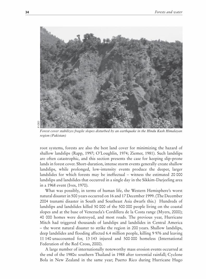
Forests and water34
Forest cover stabilizes fragile slopes disturbed by an earthquake in the Hindu Kush Himalayan region (Pakistan)
P. C
ECI
root systems, forests are also the best land cover for minimizing the hazard ofshallow landslips (Rapp, 1997; O’Loughlin, 1974; Ziemer, 1981). Such landslipsare often catastrophic, and this section presents the case for keeping slip-pronelands in forest cover. Short-duration, intense storm events generally create shallowlandslips, while prolonged, low-intensity events produce the deeper, largerlandslides for which forests may be ineffectual – witness the estimated 20 000landslips and landslides that occurred in a single day in the Sikkim-Darjeeling areain a 1968 event (Ives, 1970).
What was possibly, in terms of human life, the Western Hemisphere’s worstnatural disaster in 500 years occurred on 16 and 17 December 1999. (The December2004 tsunami disaster in South and Southeast Asia dwarfs this.) Hundreds oflandslips and landslides killed 50 000 of the 500 000 people living on the coastalslopes and at the base of Venezuela’s Cordillera de la Costa range (Myers, 2000);40 000 homes were destroyed, and most roads. The previous year, HurricaneMitch had triggered thousands of landslips and landslides in Central America– the worst natural disaster to strike the region in 200 years. Shallow landslips,deep landslides and flooding affected 6.4 million people, killing 9 976 and leaving11 140 unaccounted for, 13 143 injured and 500 000 homeless (InternationalFederation of the Red Cross, 2000).
A large number of internationally noteworthy mass erosion events occurred atthe end of the 1980s: southern Thailand in 1988 after torrential rainfall; CycloneBola in New Zealand in the same year; Puerto Rico during Hurricane Hugo
“Red flag” forest situations 35
in 1989; and the Philippines in 1990. Most damage was due to slope failures inhundreds or thousands of shallow landslips, with some large landslides. It isinteresting to note that devastation in southern Thailand and the Philippines wasblamed on logging, although most of the failures were on land cleared for crops(Rao, 1988; Hamilton, 1992). It was the same in the 1999 Venezuelan catastrophe– almost all the landslips were on cleared land. Slope failures and high damageoccur periodically, generating much discussion and research on the role of forestcover in reducing the incidence or severity of these mass movements. Casestudy 8 gives a post-disaster analysis of the true causes of southern Thailand’sfloods in 1988.
It is difficult to distinguish human-caused slope failures from natural ones(Bruijnzeel and Bremmer, 1989). There is a common lay misperception that slopefailures do not occur in undisturbed forest lands, and popular confusion aboutthe types of mass movements that can be influenced by vegetation. The followingclassification was developed from studies in the United Republic of Tanzania andseems to be applicable in many locations (Rapp, Berry and Temple, 1972):
Class 1: numerous, small, 1 to 2 m-deep, 5 to 20 m-wide earthslides andmudflows, triggered by heavy rainstorms, occurring at intervals of about tento 20 years.Class 2: occasional, large earthslides, cutting many metres in depth into theweathered bedrock, below the anchoring effect of tree roots, and occurringat much longer intervals.
Much scientific attention has focused on the role of forest cover in reducingthe incidence and severity of shallow landslips (Class 1). It is accepted that thesecan both be reduced or even eliminated by good forest cover. Large, deep-seatedmass movements (Class 2) seem to be beyond the control of vegetation, butmost research has been done in temperate countries, especially Japan (protectionforests), New Zealand (pastureland and logging), Taiwan Province of China(protection forests) and the western United States (associated with logging).
In a study of land degradation in the Uluguru Mountains of the UnitedRepublic of Tanzania, Rapp (1997) examined numerous, small (1 to 2 m-deep, 5to 20 m-wide) earthslides and mudflows in a 75 km2 area, which occurred aftermore than 100 mm of rain had fallen in less than three hours, He found that of840 landslides only three started on slopes under forest cover – the remainderwere in cultivated or grazed areas on similarly steep slopes. The importance oftree roots in providing shear resistance in slip-prone soils has been demonstratedin studies by O’Loughlin (1974) and Ziemer (1981). This work and its subsequentconfirmation provide the basis for guidelines in this area.
All very steep lands benefit from being in forest cover, especially those inseismically active areas; pressure to clear land occurs where slopes are intermediatebut still slip-prone – and this is where the red flag needs to be raised. Prudent landuse could avoid many of the catastrophic results that were seen in Thailand in the1988 storm, when former forest land that had been cleared to establish rubberplantations failed in thousands of landslips. The subsequent ban on logging did
Forests and water36
CASE STUDY 8
Floods and landslips in southern Thailand
In November 1988, following an unprecedented downpour and flash floods, mud
slides descended from the hills surrounding Nakhon Si Thammarat province in
southern Thailand. Hundreds of landslides littered the hill slopes almost overnight,
killing 200 people, burying 300 houses under sand and knocking down hundreds of
fruit trees.
Floods uprooted trees along the path of their flow, and debris caused blockages
and dammed up water in some locations. As the rainfall continued, these blockades
broke up and the released waters coalesced and surged forward, carrying sand,
uprooted trees and other debris. This unprecedented flow scoured the streambanks,
flooded houses and fields and changed the course of rivers. The people affected
included small farmers cultivating rubber, fruit growers and the landless.
This area was originally covered by a typical tropical, moist forest with a complex of
vegetation consisting of the predominant trees, the dominant canopy, other layers of
trees, shrubs, climbers and undergrowth. Some areas were logged until some years ago,
when they were cleared and converted into rubber plantations, which were established
even on steep slopes. In most cases, there was no cover crop and very little vegetation to
protect the ground – just the rubber trees, many of which were only recently planted.
Several news reports attributed the flood damage to logging operations. The
outcry resulted in a government decree banning logging. A less sensational but more
realistic explanation for the flood damage is the combination of several factors that
together proved to be disastrous:
• The slopes where the slides occurred were steep, often with angles of more than 25º.
• The basic geological underpinning for the topsoil was deeply weathered and
extremely fractured granite formations, which are easily eroded.
• The soil blanket was not sufficiently anchored by the young rubber trees’ roots
– the most common vegetation in the area of the slides.
• The vegetation was sparse, with no vegetative cover between the rows of rubber trees.
• Records show that from 20 to 23 November 1988, hill areas of the province
received 1 022 mm of rainfall, which saturated the soil.
• The intense rainfall could not be absorbed, particularly on the steep upper
reaches, and the resulting sheet of water flowed downwards.
• Runoff and slope failures created landslides on the generally steep hill slopes.
The numerous scars and deep gullies that today mark the landscape of Nakhon Si
Thammarat province present an unrivalled opportunity to demonstrate how landslips can
be recovered and brought into productive use. In response to the Government of Thailand’s
request, FAO has approved a Technical Cooperation Programme project that will work with
foresters and agronomists in Thailand to attempt rehabilitation of some landslips.
Source: Adapted from Rao, 1988.

“Red flag” forest situations 37
not apply to land clearing (Hamilton, 1991). In several regions of New Zealandthat were largely cleared of native forest for grazing in the 1870s, slip-proneland has experienced serious erosion from major storm events. The erosion ratemeasured in the Wairarapa region was 2.8 percent per decade in the period 1938 to1977, and resulted in 56 percent eroded land in hill-slope scars in 1984 (Trustrum,Thomas and Douglas, 1984). This material appears as excessive sedimentation inwatercourses.
In September 2004, Hurricane Jeanne passed over the Dominican Republic,Puerto Rico and Haiti, resulting in landslips and flooding. Aide and Grau (2005)report that although these countries received similar levels of precipitation, therewere seven flood-related deaths in Puerto Rico, 24 in the Dominican Republic,and more than 3 000 in Haiti. There are complicating factors, but these authorsattribute the diverse landslip and flood damage to differences in vegetative cover,with forested areas and abandoned, reverting shrublands being less damaged byerosive agents.
The challenge is to identify these red flag areas in advance and to maintainthem in forest or woodland. The general factors that influence mass wasting areknown; presence of water, type of rock or mineral and state of weathering, numberand density of natural fracture planes, and structure and inclination of slope.Practical field guides are needed for identifying slip-prone areas where forestretention is desirable. Megahan and King’s 1985 guidelines are particularly goodfor this. They point out that in highly erosion-prone areas, the major hazards arefound on slopes greater than 45 to 55 percent, with maximum frequency of about70 percent; concave slopes, which concentrate water; and soils that are low incohesion. Shallow soils over bedrock or with pronounced discontinuity of textureor structure may become saturated, buoyant and slip-prone. Megahan and Kingdiscuss rainfall erosivity, and the difficulty of obtaining good data in the tropics.
Based on reported research worldwide, Blaschke, Trustrum and Hicks (2000)produced a map showing the approximate extent of areas where mass-movementerosion affects land productivity, as well as a table showing land use, rainfall, landform, area affected, duration of event and soil loss rate, by country or region.Good data are few and scattered. Studies such as Humphreys and Brookfield(1991) in Papua New Guinea report that shallow slope failures are by far the mostcommon erosion forms in cultivated steep lands. The result is not only reducedproductivity, but also sediment loads in watercourses, which impair water quality,have an impact on aquatic life and promote flooding.
Well-managed agroforestry or sylvopastoral systems with high percentages ofdeep-rooted trees would give more safety than crop or pasture alone, because ofroot shear strength. No research indicates the necessary tree density on slip-pronesites, but the more the trees, the greater the safety margin.
Roads associated with logging or other uses are often a triggering agent, becausethe cut and fill on side slopes further destabilizes these troublesome sites.
In summary, trees are the safest land cover where high-intensity or prolongedrainfall is characteristic of slopes of about 70 percent – but also as low as 45 percent
Forests and water38
– and that have spoon-shaped concavity or shallow, planar surfaces. When thereare no tree roots, there is high risk of slope failures. Clearing is inadvisable andshould only be sanctioned if there is the certainty of:
quick re-establishment of tree crops such as rubber or tree plantations(although there is a long vulnerable period until new tree roots becomeeffective);immediate terracing for crop production plus trees in an agroforesty system,assurance of adequate terrace maintenance and the ability to repair minorlandslip damage quickly; ora sylvopastoral system with abundant deep-rooted trees and conservativegrazing management.
Forest harvesting reduces the stabilizing ability of roots when cut trees die,and there is a vulnerable period of several years before new roots are effective. If aserious storm event occurs during this period, landslips may ensue. Logging roadsrepresent a further destabilizing force on these unstable sites.
Established in 2002 with its headquarters in Kyoto, Japan, the InternationalConsortium on Landslides (ICL) promotes landslide research for the benefit ofsociety and the environment. The interface between forests and water and the roleof forests in mitigating landslide risks and hazards are important components inICL’s activities.
GuidelinesSlip-prone areas are probably the most serious form of erosion that can beminimized by sound land-use policies and management. Tree roots impart a marginof safety by improving soil shear resistance. To reduce the occurrence and severityof shallow landslips, slip-prone areas need to be kept in forest cover, woodland oragroforestry/sylvopastoral systems with fairly dense tree cover. Such areas can beidentified in advance of land-use decisions, based on erosivity, slope, slope shape,and soil shallowness and cohesiveness. Roads are a particular problem.
RIPARIAN BUFFER ZONESVegetated strips along stream/riverbanks and lake/pond shores have importantwater-protection functions. Forested buffer zones fulfil these functions particularlywell because of their deep, strong root systems. Unlogged, undisturbed forests arebest, but logging with good conservation management does not seem to impairthese natural water-quality protection services. Riparian buffer zones form thevital link between watershed land uses and the stream system or standing waterbody.
Forest riparian buffers can stabilize the banks of flowing water bodies,minimizing erosion and thus reducing the sediment entering the water. Theforest floor and soil can also trap sediment moving towards the flowing waterfrom upslope areas outside the buffer. Forests with good understorey structureand density, along smaller streambanks and during high flows may disperseflood crests, reduce water velocity and thus reduce erosion. Harmful nutrients

“Red flag” forest situations 39
moving downslope in surface runoff or subsurface flow, such as those fromexcessive fertilizer application or pesticides, can be trapped, thus preventing thistype of water pollution, which is often harmful to both people and aquatic life(O’Laughlin and Belt, 1995). This trapping function is also performed by lake andpond buffer zones. It is thought that tree and other plant uptake, microbial activityand soil immobilization play roles in this process of reducing pollutants. Treemycorrhizal fungi absorb nutrients (especially nitrogen and phosphates) and keepthem out of adjacent water. Streams with forested banks have greater populationsof aquatic insects, which process more organic matter, nitrogen and phosphorusthan they do in streams with denuded banks, resulting in higher water quality(Margolis, 2004).
Tree or branch fall in forested riparian belts provides large woody debris thatincreases stream habitat variety for fish and other aquatic organisms. A hostof other benefits accrue, such as shade to influence water temperature, leaf andfruit debris for the fishery food chain, habitats for avian and terrestrial wildlife(cover with access to water and corridors for movement) and general biodiversityconservation.
These benefits and their function in conserving water quality mean that thesezones should have legally protected or protective status (Hamilton, 1997). Manycountries already have either guidelines or legislation on buffer zones of varyingwidths, where no or only restricted use of land or forests is permitted. Gregory et al.
(1991) reviewed recent thinking on the ecosystem services provided. Most official
Forest riparian buffers stabilize river banks, reduce erosion and filter lateral inflow from sediments and pollutants (Sierra Leone)
G. SO
NC
INI
Forests and water40
forest harvesting guidelines include the maintenance of no-logging strips of at least20 m from each bank of the stream (greater as the slope increases), such as thosefor Malaysia (Mok, 1986) or tropical Queensland, Australia (Cassells and Bonell,1986). For national forests in the United States, the Forest Ecosystem ManagementAssessment Team (FEMAT) considered that sediment-bearing overland flow fromlogging roads could be handled by 65-m buffers (FEMAT, 1993). Many states inthe United States have regulatory controls to reduce non-point source pollution(mainly sediment) through best management practices that focus on uncut riparianbuffer zones. In 1996, the United States Natural Resources Conservation Serviceestablished the National Conservation Buffer Initiative, which now involves morethan 100 conservation agencies, agribusinesses and agricultural and environmentalorganizations and promotes the use of conservation buffers (Randolph, 2004).
Box 5 provides an example of a logging code of practice from Papua NewGuinea.
BOX 5
Papua New Guinea Logging Codea
This code requires that buffer zones be identified, demarcated and observed by
stakeholders, particularly the timber industry, to ensure that forest harvesting is
conducted in ways that conserve water resources:
• For lakes, lagoons, coastal shoreline and swamps, the minimum buffer zone is
100 m, extending from the water body, high tide mark or edge of mangroves.
• The buffer zone for large, permanent rivers, considered Class 1, is 50 m on each
side of the watercourse.
• The buffer zone for small, permanent creeks or streams, considered Class 2, is
10 m on each side of the watercourse.
• The buffer zone for a stream (permanent or non-permanent) of any width used
by the community is 50 m on each side of the watercourse. Buffer zones for
culturally significant water sources require careful consideration, including the
exclusion of logging to protect the catchment area of the water source.
• Log ponds and wharves do not require buffer zones, but maximum shoreline
clearance is 100 m.
All buffer zones are marked in the field before logging activities are granted
approval. The buffer and water crossing points for logging roads are also shown on
the plans approved in the field by forestry officers.
a 97 percent of Papua New Guinea’s land is traditionally owned. Sustainable forest harvesting
requires forest management agreements between the owners and the State. Under these
agreements, which include riparian buffer-zone guidelines, forest areas with slopes of more than
30 percent are considered water catchment areas and are not logged.
Source: Kaip, 2002.

“Red flag” forest situations 41
How wide should a forest buffer be? In part, this depends on the goals of thelandowner or regulator. The recommended width for riparian buffer strips isconstantly being re-evaluated scientifically, and is generally increasing as moreis learned about their influence on water quality: from 20 to 30 m (Bosch andHewlett, 1982), through a minimum of 25 m (Megahan and Schweithelm, 1983)and up to 50 m (O’Laughlin and Belt, 1995). Width must also take the slope andproposed use into account, as indicated in the Papua New Guinea code and theFEMAT report. Given the many other values of riparian buffers, it is prudentto err on the side of excess width, despite some short-term economic loss fromforegoing forest products (but not usually NWFPs).
For the other wooded land category, including most agroforestry systems, itis reported that a 25 m-wide buffer of tree, shrub, herb and grass vegetation canremove 80 to 90 percent of the nitrogen, 85 to 95 percent of the sediment and morethan 90 percent of the herbicides running off crop fields (Schultz, 1996). Treesare especially important in this mix, because their rhizosphere usually supportsan abundance of microorganisms that can degrade herbicides, insecticides andsome other toxic compounds (Haselwander and Bowen, 1996). For naturallymeandering rivers and streams, the buffer needs to follow the channel. Buffers willnot constrain major meanders, so the initial buffer width on such watercoursesmay need to be substantially wider than that indicated. Recent studies in Canadahave shown that phosphorus and potassium from fertilizer applied as far as 2to 4 km away can have an impact on wetlands that are not adequately buffered(Houlahan and Findlay, 2004), leading to recommendations for much wider bufferzones in non-forested landscapes.
GuidelinesEstablishing vegetation (a combination of trees, shrubs and grasses) along rivercourses is one of the least expensive and most effective methods for protectingwater quality, particularly from sediment and nutrient influx. Forested riparianbuffer zones that shield perennial watercourses and other water bodies fromquality impairment should be identified and officially designated for specialtreatment in land use. The policy should be to maintain as much of the zone aspossible intact, so that it may fulfil its sediment- and pollution-minimizing roles.This will often entail a total ban on clearing and wood harvesting. NWFPs mayusually be removed safely. The buffer should be at least 30 m wide, and widerfor steep slopes prone to surface erosion or landslips, or where agriculturaluse predominates. Buffer zones also serve many other purposes, involvinggood aquatic and terrestrial wildlife habitats, biodiversity, aesthetic values andrecreation. For the best water quality, it is advisable to restore degraded or missingriparian buffers to forest.
MUNICIPAL WATER SUPPLY FORESTSLack of clean drinking-water and adequate sanitation reduces the quality of lifefor an estimated 1 billion city dwellers around the world, along with many people

Forests and water42
living in rural areas, principally in Africa, Asia and Latin America. Every year,2.2 million deaths – 4 percent of all global fatalities – are attributed to diseasescontracted as a result of the lack of pure drinking-water (United Nations HumanSettlements Programme, 2003). Supplying clean water consistently is one ofthe most urgent aims in development and poverty-reduction strategies. Waterpurification systems are capital-intensive and expensive to maintain, however,making potable water a high-value product beyond the reach of many localauthorities and individual consumers. The rich buy bottled water and the poorget sick.
The need to provide clean water on a tight budget is forcing many municipalitiesto explore innovative approaches to maintaining supplies of pure drinking-water.Increasingly, this includes examining the potential role of forested catchments insupplying urban drinking-water.
How forests can helpThe relationship between forests and water is complex and subject to mythand misinterpretation. Contrary to much popular opinion, most forests do notincrease water flow in catchments. In fact the reverse is true, as a vigorous youngforest usually returns more water to the atmosphere via evapotranspiration thangrassland or scrub does, thus reducing the flow reaching streams and rivers(Calder, 2000). Reducing the canopy closure through careful harvesting canyield more water, but some reduction in water quality may result (Hamilton and
Around 85 percent of San Francisco’s drinking-water comes from the Hetch Hetchy watershed in Yosemite National Park (United States of America)
C. C
AR
LIN
O

“Red flag” forest situations 43
King, 1983; Bruijnzeel, 1990) (see Chapter 2). An important exception is tropicalmontane cloud forest, where trees and their epiphytes can “harvest” horizontallymoving fog, which is an addition to vertical precipitation (Hamilton, Juvik andScatena, 1994).
There is also little evidence that forests can prevent catastrophic flooding,although they do cause some beneficial reduction in peak flow and delayed peaksat the local level (Hamilton and King, 1983). In spite of this, several governmentshave introduced logging bans after extreme flooding events on the main stems oflarge river systems.
Although most forests provide less total quantity of water, they almost alwaysincrease water quality, compared with most other land uses (Chapter 3). The waterdraining from natural forests is often exceptionally pure, thus radically reducingthe costs of purification for domestic use. To a large extent, this is because manyof the activities that create pollution are absent from natural forests. Leaf litter,ground vegetation, shrub layers and forest floor debris keep surface erosion (andtherefore sediment) to a minimum, and the dense humus layer in forests may alsoplay some role in filtering water.
The positive relationship between forests and water quality is already beingexploited to help supply clean drinking-water to millions of people around theworld. A survey of the world’s 105 largest cities, carried out for the World WideFund for Nature (WWF) and the World Bank in 2003, found that one-third drawa substantial amount of their drinking-water from protected forest catchments(Dudley and Stolton, 2003). Countless other smaller towns and cities do the same,and industries that need clean water are often deliberately located in the catchmentareas of natural forests.
What kind of protected forests?Many of the forests supplying drinking-water to the cities in the WWF/World Bankresearch are legally established protected areas recognized by the InternationalUnion for the Conservation of Nature (IUCN) and the Convention on BiologicalDiversity: national parks, wildlife reserves and wilderness areas. IUCN dividesprotected areas into six categories, depending on management objectives andranging from strictly protected reserves, where visitation is tightly controlled, tocultural landscapes, where protection takes place alongside settled communities.In many cases, legal protection was originally given for aesthetic reasons or toconserve natural features or biodiversity, and the water supply benefits wereincidental or recognized only later. Other forests are managed under multiple-useplans or for timber, but with emphasis on protecting their water services. Someforests remain in existence largely by accident, or because of official or unofficialpayments by water users.
Some examplesThe following examples show a variety of ways in which forests are (or are not)protecting municipal water supplies.

Forests and water44
Quito, Ecuador: Some 80 percent of the 1.5 million population receives drinking-water from the Antisana (120 000 ha) and Cayambe-Coca (403 103 ha) ecologicalreserves. Local water companies help pay for management of these reserves inreturn for clean water. The municipal government and a local non-governmentalorganization (NGO) are developing management plans to protect the watersheds,including stricter protection of the upper watershed, erosion prevention, and bankand slope stabilization (Echeverría, 2001).
São Paulo, Brazil: Drinking-water for the city’s 18 million inhabitants comes fromforests in six protected areas. The most important of these is Cantareira State Park(IUCN Category II, 7 900 ha), which supplies half the metropolitan area’s waterand is located in the remnants of the highly endangered Atlantic forest (Dudleyand Stolton, 2003).
Singapore: Half the island’s water comes from Bukit Timah National Park (whichis the remaining 3 percent of the original forest cover) and the central catchmentareas, which have been restored as natural forest (both IUCN Category IV,totalling 2 796 ha). The forests were originally protected to maintain water, but arenow also recognized as extremely important repositories of biodiversity (Bugna,2002).
Tokyo, Japan: The city draws almost all its water from two landscape protectedareas: Nikko National Park (IUCN Category V, 140 698 ha) and Chichibu-TamaNational Park (Titibu-Tama) (Category V, 121 600 ha). In these areas, conservationand recreation are balanced in the forest management carried out by the Bureau ofWaterworks of the Tokyo Metropolitan Government, which has the specific aimof maintaining water quality (Dudley and Stolton, 2003).
Nairobi, Kenya: Much of the city’s water comes from rivers originating in theAberdares (including Aberdares National Park, IUCN Category II, 76 619 ha)and the Mount Kenya National Park water catchment (Category II, 71 759 ha).Unfortunately, despite nominal protection, illegal encroachment and loggingare continuing to degrade the area, with a detrimental impact on the city’s watersupply. It is estimated that all forests of the Mount Kenya protected area have beenlogged at least once (Nakagawa et al., 1994).
New York City, United States (Case study 12 in Chapter 6): Rather than fundingconstruction of a new water purification plant through taxes, New Yorkersvoted to subsidize forest protection as a cheaper and more acceptable optionfor maintaining clean water supplies. Management applies a mosaic of differentapproaches, including complete protection, easements for landowners and low-impact, selective logging on some lands. Catskill State Park (IUCN Category V,99 788 ha) protects much of the Catskill/Delaware and Croton watersheds, thecity’s main sources (Perrot-Maître and Davis, 2001).

“Red flag” forest situations 45
Stockholm, Sweden: Lake Mälaren and Lake Bornsjön supply Stockholm’sdrinking-water. The water company, Stockholm Vatten, controls most of the5 543-ha watershed of Lake Bornsjön, of which 2 323 ha, or about 40 percent, isproductive forest certified by the Forest Stewardship Council. Although timber isextracted and sold, management focuses primarily on protecting water quality, andareas are designated for conservation and restoration (Soil Association, 1998).
Potential for economic benefitsIn all the cases outlined, forests are serving multiple functions. Soil and waterprotection also generally delivers biodiversity conservation, and vice versa. Incases such as New York and Stockholm (and the situation is similar in Beijing),a mosaic of different uses supplies good-quality drinking-water while supportingcommercial activities in protected areas, including tourism. Clearly, the addedvalue that clean water provides can help support land management activities thatwould otherwise be uneconomic, including those in many protected areas.
A team of researchers from Argentina, the Netherlands and the UnitedStates has put an average price tag of US$33 trillion a year on fundamentalecosystem services, nearly twice the value of the global gross domestic product(GDP) of US$18 trillion, with water regulation and supply estimated to beworth US$2.3 trillion (Costanza et al., 1997). Experience with payment forenvironmental services (PES) schemes has been increasing as in the case of Quito,mentioned earlier. PES refers to any system for ensuring that those who benefitfrom environmental services, such as clean water and carbon sequestration, paythose who make economic or social sacrifices to maintain natural ecosystems.PES works best where there are a few recipients (for instance, a water company,a factory or a municipal authority) and a clearly identified group of providers(such as land right holders who maintain high-quality forest) (Pagiola, Bishopand Landell-Mills, 2002). Many Latin American countries have developedsystems. For instance, small-scale hydropower users in Costa Rica are payinglandowners to maintain forests in their catchments. This topic is developed inChapter 6.
Lack of awareness of the benefits of forestsA few successful case studies do not add up to the general recognition thatprotected or carefully managed forests can help pay for themselves by supplyingclean water. PES schemes have a mixed history and are not always successful. TheWWF/World Bank study found that many water companies and city authoritieshave little understanding of the pros and cons of using forests to protect water.Some water providers have completely unrealistic ideas about the scale of benefitsthat accrue from healthy forests, while others do not even recognize that therewould be benefits. Decisions are often based on hearsay or partial information.Nevertheless, there are exceptions, where forest management strategies have beendrawn up using the best available information. These include the water companiesof New York City and Melbourne, Australia.

Forests and water46
GuidelinesAlthough forests are now increasingly viewed as water suppliers, much remainsto be learned and applied if these benefits are to be maximized. Various interestgroups, including water companies, forest owners, protected area managers andanyone involved in PES schemes, need technical guidance that explains the issuesand ensures the best possible land-use choices. This should be accompaniedby good educational and outreach materials on the benefits, highlighting thelinks among forest protection, good management and drinking-water. Well-thought-out financial and policy incentives are needed (and, where necessary,perverse incentives should be removed) to encourage good management forgood water.
VERNAL POOLSThere is increasing recognition of the importance of vernal pools in forestedareas for their role in restoring and conserving amphibian biodiversity. A forestor woodland vernal pool is a relatively small, shallow depression containing anisolated body of water that collects annually in a wooded area. The hydroperiodlasts at least through the spring season before drying up (Thompson andSorenson, 2000). The pool has no inlet or outlet that would permit the entryof fish. These ephemeral wetlands are generally less than 0.2 ha in size and lessthan 1 m in depth. These attributes prevent fish life, and thus fish predationon amphibians’ eggs and larvae – the two stages at which amphibians are mostvulnerable.
The amphibian life found in vernal pool habitats consists of salamanders,frogs and toads. Many amphibians are in threatened or endangered status, andglobally there numbers have declined in the last decade. This process of declineis characterizing amphibian populations everywhere, and not just in vernal pool.Of the 5 743 known species, 1 856 (nearly one-third) are in danger of extinction(Stolzenburg, 2005). Suggested causes include habitat loss, pesticides and otherwater pollutants, acid rain and other air pollutants, increased ultraviolet radiation,global warming, fungal and other pathogens, and combinations of several ofthese. For example, global warming seems to be implicated in the disappearanceof several frog and toad species, including the endemic golden toad, from CostaRica’s forests (Pounds, Fogden and Campbell, 1999). Amphibians are believed tobe one of the most sensitive indicators of ecosystem and even human health, ascanaries once were in mines.
Vernal pools have received relatively little study and regulation because of theirephemeral character. In addition, their small size makes them difficult to detect inaerial photos, even when taken at the peak of the wet season.
Most concern about vernal pool conservation originates in industrialized,developed countries, but even here there appear to be few nationwide regulationsfor their protection, unless a species is on the official endangered list. Somelarger vernal pools may be classified as official wetlands and may have regulatoryprotection. Massachusetts in the United States has a provision for designating and

“Red flag” forest situations 47
The importance of vernal pools in forested areas is increasingly recognized, especially for their role in restoring and conserving amphibian biodiversity (United States of America)
VER
NA
L POO
L ASSO
CIA
TION
/L.P. KEN
NEY
certifying vernal pools, which protects them from alteration and includes a forestbuffer strip (Westing, 2003). As forests worldwide are managed increasingly formultiple goods and services, those related to water resources and biodiversity willbecome more important. It would therefore be appropriate for governments andforest managers to turn their attention to vernal pools.
The main management measures needed are avoidance of the pools’ destructionor impairment and provision of a two-tiered buffer zone. These ephemeralpools may be difficult to identify after water levels have receded, but the cup-shaped basin, general lack of vegetation and thicker organic layer can revealtheir locations. These areas need to be identified, marked and mapped in thespring. Global positioning systems are useful in mapping. Vernal pools occurmore frequently and have greater carrying capacity for amphibians in deciduousbroadleaved forests than in conifer forests (Westing, 2003). Based on 16 fieldstudies compiled by Westing, a core buffer zone consisting of the flooded areaplus 15 m is recommended for protecting approximately the 0.5 ha of the largestpools. Within this area there should be no cutting, skidding or road construction.Trees in the buffer provide shade and wind screen to inhibit the pool’s drying out.Although a treeless vernal pool may seem ideal for the yarding of logs during dryperiods, this too must be avoided. It is also desirable to have a secondary buffer offorest about 15 m wide that is only lightly harvested or modified and that protectsagainst drying and extends the foraging habitat.

Forests and water48
GuidelinesBest and acceptable management practices and forest certification systems shouldrecognize these important ephemeral wetland components of forest land andshould establish criteria for effective buffer zone protection.
AVALANCHE PROTECTION FORESTSAvalanche protection represents an existential challenge for the inhabitants ofhigh mountain regions around the world (Box 6). It is one of the many andconsiderable risks of living and carrying out activities in these areas. During theperiod 1953 to 1988, three leading newspapers (the New York Times, the Toronto
Globe and Mail and The Times of London) reported 18 major avalanches, each ofwhich resulted in at least ten deaths, 50 injuries, and more than US$1 million ofdamage and emergency assistance from outside the damage zone (Hewitt, 1997).The avalanches were widely distributed: seven in Central and South America six in Europe, two in East Asia, two in Southwest and South Asia, and one inSoutheast Asia. Many other occurrences of great local impact, which were notcovered by these newspapers, involved small villages, a few skiers or climbersand rural mountain roads or railways. In spite of this, avalanches received littleattention in the International Decade for Natural Disaster Reduction (1990 to2000), and forests’ significant role in providing some defence against them waslargely ignored. Mountain hazard mapping should therefore include mass snowmovements, which are site-specific, and any protective forests designated forspecial treatment.
A forest belt protects a hydropower plant and transalpine railway from potential avalanches (Switzerland)
T. H
OFE
R

“Red flag” forest situations 49
BOX 6
International experiences: the avalanche winterof 1999 in the European Alpine region
The winter of 1999 claimed a total of 70 lives in Austria, France, Italy and
Switzerland, mainly in residential areas and to a lesser extent on roads. The mountain
village of Evolène in the Swiss canton of Valais was particularly badly hit, with the
loss of 12 lives; there were another 12 victims in Chamonix in the Savoy Alps of
France, and a total of 38 lives were lost in the villages of Ischgl/Valzur and Galtür in
the Paznau valley of the Austrian Tyrol. One life was lost in Morgex in Italy’s Aosta
valley. In Switzerland alone, approximately 1 000 destructive avalanches occurred
(Nothiger and Elsasser, 2004).
Problems involving the clearing of snow and/or the risk of avalanche led to
temporary closures of the international transit axes that cross the Alps, such as the
Gotthard motorway and railway, the Tauern motorway and railway, the Arlberg road
tunnel and the San Bernardino and Great St. Bernhard passes.
In the hundreds of areas within the Alpine region that were affected by
avalanches, many locations and entire valleys were completely isolated for days.
In some places, local residents and tourists had to be evacuated. This caused
some tourists, who were not directly at risk from avalanches but were marooned
in their holiday destinations, to perceive the mountain landscape – previously
viewed as a leisure paradise – as life-threatening. Some tourists could not cope
with the situation, which lasted for a considerable time. They wanted to be
rescued and, in many cases, the few available helicopters represented their only
hope of escape.
In addition to the lives lost, almost 1 billion Swiss francs of damage was caused
to residential and industrial buildings, Alpine barns and stables, avalanche defence
structures, energy cables, communications and transport infrastructure (including
cable railways) and mountain forests. Indirect economic losses arising from the
disruption of transport and supplies were estimated at 500 million Swiss francs – half
the cost of the material damage.
The emergency was exacerbated by the presence of hundreds of thousands of
tourists holidaying in the Alps in February. This led to spontaneous solidarity between
marooned tourists and local residents, who became increasingly dependent on each
other as the emergency progressed.
Source: Gremminger, 2005.
Formation of avalanchesA snow-covered slope is composed of layers of snow with recognizable boundaries.Depending on the properties of the boundary layers, creeping movements canoccur. Sliding movements can also occur, depending on the properties of the soil

Forests and water50
surface and snow cover. In the event of overload, these can lead to sliding of theentire snow cover. Such movements depend on the following site factors:
slope gradient;thickness of the snow;type of snow;properties of the boundary layers.
Slab avalanches are associated with:slopes of gradients in excess of 58 percent;weak layers and/or sliding areas;snow cover with homogeneous layers;bonded (cohesive) snow.
Loose-snow avalanches mainly arise on:slopes with gradients of 85 to 170 percent;weakly bonded snow.
Forest avalanches are those whose release zone is located in a forest. Theyoccur where there are large gaps in the forest, the size of which is a crucial factorin determining the scale of snow movements. In sub-alpine and high montanezones in particular, large and small gaps in forest stands are a component of near-natural forest structure, which is essential for forest regeneration. It is thereforeimpossible to control completely the movement of snow in forests.
Integrated avalanche risk reductionAn avalanche protection scheme should be based on a combination ofcomplementary measures:
avoidance of areas at risk from avalanche, by taking natural hazards intoaccount in spatial planning (hazard registers and hazard maps are essentialdecision aids in this);biological engineering measures to prevent avalanche release, such asreforestation or afforestation, and the maintenance of protective forests;technical and organizational measures for early warning of avalancheactivity, including avalanche forecasts and early warning of the build-up oflarge volumes of snow as a basis for evacuation and the closure of transportroutes;periodic checking, maintenance and repair of existing protective structures,including those for the protection of objects and avalanche release barriers.
The ski resort of Vail, in Colorado, the United States has a well plannedavoidance strategy, which includes the identification and mapping of snowavalanche hazard zones and the development and enforcement of zoning land-useregulations (Oaks and Dexter, 1987).
Protective forestForest also influences the formation of snow cover, and thus avalanche formation,through interception, cooler stand climates and the roughness of the soil causedby standing trees and by stems and branches on the ground.

“Red flag” forest situations 51
CASE STUDY 9
Forest avalanche protection in Switzerland
Human life and activity in the Alpine region of Switzerland would not be possible if
the mountains were not covered with forests, which protect more than 7 000 ha of
lower-lying residential and industrial zones and numerous transport routes against
natural hazards. Approximately 130 000 buildings and several hundred kilometres
of rail and road links benefit. Protective forests are particularly important on
slopes at risk of avalanche, in the direct watershed areas of mountain torrents and
on steep slopes vulnerable to soil erosion. Some 30 percent of the approximately
700 000 ha of mountain forest provide direct protection against avalanches and
rock fall.
About one-third of the Swiss Alpine region is under forest cover. At high
altitudes, up to the natural tree line 2 000 m above sea level, evergreen coniferous
forest provides the greatest avalanche protection in terms of area. Over the past
120 years, many slopes at risk of avalanche have been reforested. Millions of newly
planted trees are now rooted on steep slopes of between 28 and 45°, which would
be potential avalanche release zones without these forests. A mountain forest with
no large gaps between the trees prevents the development of an even slab of snow,
thus stabilizing the snow pack. Mountain forests protect against avalanche release in
several hundred square kilometres of this region.
Following the extreme avalanche winters of the early 1950s, the Alpine regions of
Austria, France, Germany, Italy and Switzerland have engaged in intensive avalanche
protection efforts, in which maintaining effective protective forests has played an
important role. Similar protection strategies were already being pursued in Austria,
Bavaria, Liechtenstein and Switzerland. The devastating winter of 1950/1951 claimed
98 avalanche victims in the Swiss Alpine region and destroyed nearly 1 500 buildings.
Most of these people were taken by surprise and crushed to death when their houses
were submerged by snow.
Owing to the boom in winter tourism and enormous growth in the transport
of people and goods across the Alps, the potential hazard zone is now far more
intensively used than it was in the 1950s. Thus, with a comparable level of avalanche
frequency in 1998/1999, about five times as many people were located in mountain
areas at particular risk than in the winter of 1950/1951. However, the loss of life and
damage caused by avalanches in that year were significantly lower than in 1950/1951.
The fact that this extreme avalanche winter did not claim more lives and cause more
damage to property cannot be explained by luck alone; it can be assumed that the
intensification of preventive measures since the 1950s provided excellent protection,
which paid off.
Source: Gremminger, 2005.
Forests and water52
Trees significantly reduce the likelihood of avalanche release (Case study 9).On forested slopes, release is expected only on gradients of at least 70 percent,compared with 58 percent on exposed slopes or slopes with larch stands. Feweravalanches can be expected in areas with extensive forest stands than on openareas, but if an avalanche is released in such an area it will be greater than it wouldhave been in an area without forest.
Trees at least twice as tall as the snow depth contribute to preventing snowavalanches. Short trees completely covered with snow (e.g. Swiss mountain pineand green alder) can actually promote avalanche formation through the elasticmovement of the branches. Deciduous tree species, which are bare in winter, areonly effective for low snowfall levels; their effect is limited for major snowfalls.Deciduous species are often planted along the boundaries of avalanche coursesbecause evergreen tree species are swept away by avalanches, owing to theirgreater air resistance.
In snow depths of 1 to 2 m, which merely affect the tree trunks, a forest canslow an avalanche down. When flow depths are deeper and speeds higher, such asin loose-snow avalanches, the forest will be destroyed, but it can exert a brakingeffect in the avalanche release zone if the speed of the moving snow is not too high.This reduces the scope of the avalanche.
In many developed countries, the collection of wood in wind throw areas is nolonger economically viable, so such wood is left on the ground. This practice is notrecommended for several reasons, including the risk of bark-beetle infestation, butthe wind throw often provides very efficient protection against snow movements.Dead wood, tree stumps, root masses and fallen stems create a surface structurethat has a positive influence on snow deposits, effectively anchoring the snowcover to the soil. This wood offers good protection in typical avalanche releasesituations, i.e. on slope gradients of 58 to 84 percent. In very steep locations andwhen there are exceptionally large volumes of snow, the wood may not withstandthe load, and the snow will move together with the wood. This risk increasesgradually owing to biological decomposition of the wood, and should be takeninto account in situations involving high risk of damage.
GuidelinesNational hazard mapping in mountain environments is gradually becomingstandard policy and procedure in many countries. Avalanche risk areas need to bepart of this effort.
Forests at high elevations of more than 58 percent slope in areas where enoughsnow falls to trigger slab or loose-snow avalanches are potential avalancheprotection forests. These are red flag zones, but protecting these forests is onlypart of the task. Establishing tree cover in open avalanche source areas abovethe tree line can also contribute to protection. With climate change, tree lines areshifting upwards naturally, making this increasingly feasible. Harvesting must becarried out with utmost care. The management of such forests is complex, and it isadvisable to consult the expert literature and experienced people before undertaking

“Red flag” forest situations 53
any forest disturbance. Uninformed and inadequate forest utilization can increaserisk in hazard-prone areas below the forest. Forests need to be regenerated as theyage and become more prone to degradation and loss of function. Wildlife has animpact on regeneration because many forms of wildlife find part of their habitatrequirements in avalanche chute areas. Monitoring and maintenance – of not onlythe forests but also the changing areas of concern (new avalanche-prone areas)– become even more urgent because of climate change.
An integrated avalanche protection programme should give priority tobiological measures for protective function and technical options for earlywarning systems.

The special case of mountainous small islands 55
5. The special case ofmountainous small islands
Chapters 2 and 3 described how forests’ effects on water quantity and qualitywere manifest mainly at the local level. This chapter describes how small islandsexemplify the “short pipeline” phenomenon, in which forests have a significantinfluence on hydrology and erosion.
Freshwater resources on small islands are often scarce and therefore precious.Forest management decision-makers must therefore be especially cautious aboutalterations or removals that impair water resources. Mountainous, small oceanislands may experience high rainfall in the uplands owing to orographic effects,along with rapid rainfall gradients, especially on the leeward side. Cloud forestsmay occur on the windward slopes and ridges even at relatively modest elevationsof 300 to 400 m, adding their captured water (Hamilton, Juvik and Scatena, 1994).(The first section of Chapter 4 discusses cloud forests’ important role in thehydrological cycle and as erosion minimization cover.) On steep slopes, if soils arethin (i.e. not deep volcanics), watersheds may respond quickly to rainfall events,and flash floods from even short-duration storms may be a problem. Hurricanesor intense storms can result in serious erosion, including mass soil movement inthe form of shallow landslips and landslides. The resulting sediment may not onlyimpair water quality and aggravate flooding on the island, but also deposit silt oncoral reefs, which are a major asset for many tropical islands.
The watersheds of small mountainous islands are of the size and nature referredto in Chapter 2 as microscale (less than 50 km2) or the lower end of mesoscale (50to 20 000 km2), with upland forest and land-use practices influencing streamflowand sediment discharge (Ives and Messerli, 1989) (Boxes 2 and 3 in Chapter 2).
Small islands’ size and need for self-sufficiency mean that forests must becleared for food production. Mountainous small islands are therefore well-suitedto agroforestry systems, which provide some soil and water protection fromtrees. An appropriate scale that avoids larger-scale industrialized agriculture ismore favourable to water quality, because it allows lower chemical inputs throughintegrated pest management (rather than reliance on pesticides). Any loggingshould observe the highest standards of soil and water conservation. In theseshort (and often steep) stream systems, adequate riparian buffer zones of forest orother dense vegetative cover are extremely important (section on Riparian bufferzones in Chapter 4) for keeping sediment out of the watercourse and off reefsystems. Islands are subject to ocean storm surges and tsunamis; coastal forestssuch as mangrove should be assigned a conservation status in recognition of theirprotective role.

Forests and water56
Small mountainous islands, especially those dominated by a single or a fewpeaks, lend themselves to a traditional, integrated watershed management system(Case study 10). The hydrological unit provides a good basis for land-use policyand management, because it integrates soil, water and human activities moreeffectively than other planning or management units can. These three linkedelements are especially important in small islands. An interesting traditionalsystem of land-use control in wedge-shaped watershed units (which are narrowestat the summit and widest at the coast), practised in Hawaii in what are calledahupua`a, is described in Case study 11 and illustrated in Figure 3.
CASE STUDY 10
Government/community watershed management on Pohnpei
In 1987, the state of Pohnpei in the Federated States of Micronesia enacted the
Pohnpei Watershed Forest Reserve and Mangrove Protection Act. This designated
5 200 ha of the central upland forest area (containing cloud forest) and 5 525 ha of
coastal mangrove forest as protected areas. Upland forest at between 450 and 780 m
above sea level was protected by government decree. Traditional clans were invited
to participate, and a community-based approach was developed.
The resulting management programme unites local community and traditional
institutions with municipal and state governments. The Division of Forestry is
the lead agency, with ultimate responsibility for developing and implementing
the management programme and regulating use within the Watershed Forest
Reserve. The Division of Forestry chief acts as chairperson of the Watershed
Steering Committee, which serves as the advisory board to the division and
its parent agency, the Department of Conservation and Resource Surveillance.
Municipal watershed protection officers liaise with the Division of Forestry and
the Watershed Steering Committee in watershed matters, particularly regarding
infrastructure development. Each of about ten watershed management units has a
local, autonomous watershed area management committee, consisting of the local
village chiefs or their delegates, who co-manage the watershed with the Division of
Forestry.
Following a community education programme in each unit, the Watershed
Steering Committee works with the watershed area managment committees to
develop and implement watershed unit plans, which cover the entire watershed unit
from the cloud forest to the reef. Outside the legally designated areas, the plans can
only recommend actions. Compliance is largely voluntary, but the involvement of
communities and their leaders is expected to generate support.
Source: Adapted from Raynor, 1994.

The special case of mountainous small islands 57
CASE STUDY 11
Hawaiian ahupua`a
Where possible, the ahupua`a extended from the highest mountain peaks to the
coast and beyond, usually to the outer edge of the offshore coral reef. Each was
designed to be a self-contained economic and environmental unit, providing for
the ali`i (the chiefs) and the maka` inana (the people). The upper forests provided
wood, bird feathers for capes, and various edible, medicinal and ceremonial plants.
The moderate slopes produced upland crops, and the lowlands were planted in
taro. Ocean products could be harvested from the shore and reef. Included within
the ahupua`a were freshwater and marine fish ponds, irrigation systems and the
communities’ homes and ceremonial buildings.
The ali`i, assisted by a konohiki (land agent), maintained both political and economic
control of the land and its resources. Political boundaries coincided with watershed
boundaries, and the hydrological delineation provided a unit that sustained livelihoods by
providing a variety of forest products and opportunities for agriculture and aquaculture.
Source: Adapted from Raynor, 1994.
Ecotone
Cloud forest (wao akua)
Spring, Punawai
Temporary habitation sites
GravesMauka-Makai Trail
Temple, heiau
Mid-elevation trail
Barren Iava
Caves
Ecotone
Coastal trailSacred grove
Place of refuge,Pu‘uhonua
Leaping placeof the soulsLeina-a-ka‘uhana
Burial dunesCanoe Landing,Paena Wa‘a
Fishpond
Canoe Halau
Fishing ground, Ko’a
fishing, shellfish, seaweed, limu,salt ponds, fishponds, fishtraps
Sea (kai)
Io’i
Fishing shrine, Ko’aTemple, Heiau
MakaiCoastal Zone (kahakai)
Habitation sites and Kauhale
PetroglyphHabitation sites and Kauhale
Fortress
Tree crop plantations(breadfruit, bananas, coconut)
Agricultural zone (wao kanaka)alluvial areas: taro patches, lo‘i, irrigatedby ditches, ‘auwai
Stream, Kahawai
Uplands: planting of potatoes and dry taro, kula lands
Mauka-Makai Trail
Holua slide
MaukaForest zone (wao nahele)forest products: firewood,timber, birds, plants
_
_
_ _
FIGURE 3Ahupua`a – typical land division in Hawaii
Source: Minerbi, 1999.

Forests and water58
GuidelinesOn mountainous small islands, the classic influences of forests on water quantityand quality prevail. The relative shortness of the streams leads to close upstream–downstream linkages; what happens in the uplands usually alters the quantity andquality of water, including through flooding, low flows, sedimentation and water-borne pollutants. For instance, cutting forests by more than 10 percent increasesstreamflow throughout the year, the effect increasing with the amount of treesremoved. Forest clearing may increase flood peaks, shift them forward in time andincrease stormflow volumes. It also increases dry-season yields. Cutting of cloudforests reduces water yield, because fog water capture is lost. Subsequent land usesthat substantially increase the area of impervious soil surface (e.g. overgrazing,roads, buildings) will aggravate flooding and diminish dry-season flows. Waterquality will almost inevitably suffer owing to increased erosion and sediment, andpossibly the pollutants that more intensive use often involves. Adequate riparianbuffer zones can help reduce impairment of water quality, which is important notonly for human and livestock use, but also for coastal reefs, fishponds and shallowwater fisheries.
On small islands, forests and water are more intimately related becauseeverything is local. Forests are the safest upland cover and merit legal watershedprotection status or very conservative use. Where food production is requiredin a less protective zone, agroforestry systems with significant tree componentsshould be considered for slip-prone land. Forested or densely vegetated, ungrazedriparian buffer zones are the highest priority.
Payments for environmental services 59
6. Payments for environmentalservices
Watersheddegradationhas ledtogreater recognitionof thenumerouswayswatershedssupport human well-being through ecosystem services and, consequently, to greatervalue being placed on them. These services may include provision of freshwaterfor various uses, regulation of both water and sediment flows, and maintenance ofnatural flow regimes that support entire ecosystems and ways of life.
Regulation of land-use practices alone has not ensured continued provision ofservices. It places a disproportionate share of the conservation costs on upstreamland users without giving them corresponding access to benefits. For example,States often claim ownership of forested areas and protect watersheds throughpolicies that exclude local populations from resources on which they havetraditionally relied. This may lead local people to engage in what have suddenlybecome illegal practices, or to occupy more marginal land areas (Tomich, Thomasand van Noordwijk, 2004; Blaikie and Muldavin, 2004).
Market-based arrangements are a way for upstream land users to recoverthe costs of maintaining forest cover, and a way of funding other land-management practices to protect watershed services. They are also advocated forlandscape approaches to conservation, which require the creation of incentives forconservation on privately held land.
Market-based approaches in which payments are contingent on achievingdesired outcomes can lead to more efficient resource allocation and more cost-effective solutions. However, there are a number of scientific and institutionalchallenges to their implementation, the transaction costs of which may makethese approaches impractical. Among the challenges is that of demonstratingand quantifying the actual benefits to those who are asked to pay for them. Thisrequires an understanding of complex ecosystem processes, over time in specificplaces, the identification of effective management actions to maintain these, andreasonable assurance that buyers will have access to benefits in the future. Findingthe most efficient and effective approaches also requires the capacity to learn andadjust to new information.
This chapter provides an overview of the range of services provided bywatersheds and the diverse payment arrangements tried. It concludes with adiscussion of implementation challenges and highlights key issues to consider inthe design and further development of such initiatives.
ECOSYSTEM SERVICES PROVIDED BY WATERSHEDSWatershed services are the products of ecosystem processes that provide variousdirect and indirect benefits, including:
Forests and water60
freshwater for diverse human uses;flow regulation and filtration, which control rates of surface runoff. Atlocal scales, control of runoff can provide a buffer against peak or floodflows; help to maintain base or dry-season flow; allow the recharge of waterstored in soil, groundwater, wetlands and floodplains; and control the levelof groundwater tables. Control of water runoff also controls the flow ofpollutants and sediment that affect water quality (FAO, 2002).
Watersheds also provide supporting services, including:maintenance of the natural flow and disturbance regimes that drive allecosystem processes, thereby maintaining habitat diversity and ecosystemresilience. River channels, wetlands, riparian habitats, mangroves, estuariesand coastal zone processes all support livelihoods in numerous ways and alldepend on the timing of water and sediment flows;conservation of cultural values, including aesthetic qualities that supporttourism, recreation and traditional ways of living.
These services are interdependent; the provision of freshwater for direct usesdepends on the maintenance of its regulatory and support services. For example,activities to increase the supply of freshwater and land use changes to increasethe supply of food often come at the expense of maintaining the natural flow anddisturbance regimes that ensure a regular supply of both. As these regulatory andsupport services decline, human well-being will increasingly depend on achievingan optimal balance between these trade-offs (Aylward et al., 2006). Site-specificassessments are needed to identify the benefits provided in a specific social andeconomic context, and the scales and economic significance of these benefits.Such assessments can also help avoid common misperceptions and generalizationsregarding forests’ role in the hydrological cycle: for example, the belief that theyincrease dry season flows and prevent large-scale floods (Hamilton and King,1983). Instead, forests should be regarded as one component of an integratedapproach to watershed management that includes land-use and managementpractices (FAO and CIFOR, 2005) (Chapter 2).
TYPES OF PAYMENT INITIATIVESA review of case studies conducted by the International Institute for Environmentand Development (IIED) in 2002 identified 287 initiatives involving payment forforest ecosystem services, of which 61 were specifically related to watersheds.The main concerns addressed in these initiatives were maintenance of dry-seasonflows, protection of water quality and control of sedimentation (Landell-Millsand Porras, 2002). The findings were generally consistent with other case studyreviews (Perrot-Maître and Davis, 2001; FAO, 2002; Rosa et al., 2003; FAO, 2004;Tognetti, Aylward and Mendoza, 2005).
PES initiatives take various forms depending on the characteristics of theservice, the scale of the ecosystem processes producing it, and the socio-economic and institutional context. They range from informal, community-basedinitiatives, through more formal, voluntary contractual arrangements between
Payments for environmental services 61
individual parties, to complex arrangements among multiple parties facilitated byintermediary organizations. In the last category, payments to landowners maytake the form of transfers from government or intermediary organizations offunds that have been pooled from diverse users with a common interest ratherthan from specific user groups.
Other commonly used approaches are the acquisition of easements thatrestrict land use, and tradable development rights that allow developers toexchange rights in one location for permits to develop at a higher density inother locations. Marketable permits allow for trading between different sourcesof pollution, to lower the cost of complying with regulatory standards or totalemissions caps, and can provide revenue for funding conservation practices.Certification that producers have adhered to specified management practices,which is indicated to consumers through labelling, may increase the marketshare of a product and/or result in a price premium. On a larger scale withmore diverse conditions, such as that of the New York City watershed (Casestudy 12), or when multiple services are covered, as in Costa Rica’s FondoNacional de Financiamiento Forestal (FONAFIFO) programme (Case study13), initiatives often use a mix of complementary market-based, regulatory andpolicy incentives.
Sources of funds are user or licence fees, taxes and donations. In general, userand licence fees are more feasible when it is possible to limit services to those whopay for them, such as domestic and industrial water users. Taxes and donationsare usually necessary to cover more generalized benefits, such as maintainingbiodiversity, for which the beneficiaries are less identifiable or more widelydispersed. Taxes may also be more appropriate for meeting policy objectivesthat increase equity. In Colombia, for example, taxes on all hydropower facilitiesfinance the protection of watersheds with no hydropower facility (Becerra andPonce De León, 1999).
Governments may play diverse roles: enforcing contractual agreements,creating regulatory caps, monitoring compliance, contracting service providers,providing technical assistance, and identifying priority conservation areas asa basis for funding allocation decisions. Some of these roles can be filled byNGOs, which may be more flexible and able to act more expediently. NGOs andstakeholder associations may also advocate on behalf of marginalized stakeholders,creating political pressure so that governments recognize rights and respond to theconcerns of these groups.
Benefits tend to be more tangible and contractual arrangements more feasiblewhen the scale is smaller and property rights and stakeholders are more easilydefined. On a larger scale, it is harder to link cause and effect and to define rightsand responsibilities. There is greater need to involve government and/or otherintermediaries to facilitate transactions among numerous stakeholders and toestablish priorities. However, this scale also offers a larger pool of buyers andsellers (Rose, 2002).

Forests and water62
CASE STUDY 12
New York City watershed agreement
The City of New York is investing up to US$1.5 billion over ten years (to 2013) in
several measures to protect the Catskill/Delaware and Croton watersheds and to
avoid the expense of constructing a filtration plant, which was estimated to be US$9
to 11 billion, including operating costs for ten years. The investment is being financed
through a 9 percent increase in charges to water users, which would have been at
least double that amount if the filtration plant had been built. The funds are being
used to implement an agreement among the City of New York, the United States
Environmental Protection Agency and a coalition of watershed towns. More detailed
reviews of the case can be found in Galusha (1999), Platt, Barten and Pfeiffer (2000)
and Pires (2004).
The key components of the agreement are:
acquisition of land or conservation easements near reservoirs, wetlands and
watercourses;
development and upgrading of infrastructure – including sewage systems,
water treatment plants and storm-water management facilities – and stream
corridor protection;
an economic development bank – to support upstream development consistent
with catchment protection – and environmental education;
support for the implementation of best management practices on farms and in
forests.
The agreement also gives the city greater authority to review and approve or
reject potentially harmful projects and to set standards and other requirements
pertaining to wastewater treatment plants, septic systems and storm-water control.
Key to acceptance of the new, upstream land-use restrictions were a payment
arrangement and the city’s undertaking to acquire land only from willing sellers at
fair market values. A separate agreement was reached with farmers, specifying that
their participation in developing farm management plans and adopting conservation
practices would be voluntary and that the programme would be managed by the
farmers themselves. All regulations were suspended except that restricting wilful
pollution.
The agreement was conditional on participation of 85 percent of the farms within
five years and on achieving goals for protection of the entire landscape rather than
of individual farms. These conditions were more than met (Appleton, 2004). Cost
sharing is offered to forest landowners to encourage them to develop and adhere
to forest management plans, which now cover 84 500 acres (about 34 210 ha). The
agriculture and forestry component is governed by a Watershed Agricultural Council,
which also supports and promotes small businesses based on farm and forest goods
produced using best management practices (www.nycwatershed.org/).

Payments for environmental services 63
PAYMENTS FOR ENVIRONMENTAL SERVICES IN PRACTICE – DEFININGWATERSHED SERVICESThe ability to demonstrate both the threats to existing services and the effectivenessof upstream land-use and management practices is key to building stakeholderconfidence and maintaining the willingness to pay for services. These depend notonly on the integrity of the ecosystem processes that support service provision,but also on the effectiveness of the institutional arrangements that ensureimplementation of appropriate practices, and on assured access to benefits forthose who pay for them.
However, the complexity and natural variability of watershed processes,which are dominated by randomly timed and extreme events, make it difficult,if not impossible, unequivocally to link all causes and effects. This requiresmonitoring and adjustment over time as lessons are learned. Making theinherent uncertainties explicit is even harder, but is critical to managing buyers’expectations and maintaining their cooperation in the long term. Uncertainty has
CASE STUDY 13
Costa Rica’s National Forestry Financing Fund
The Fondo Nacional de Financiamiento Forestal (FONAFIFO; National Forestry
Financing Fund) compensates forest owners who adhere to approved management
plans for services protecting freshwater, biodiversity and landscape beauty and for
carbon storage. FONAFIFO is financed by selling these services to different types of
buyers. Hydroelectric companies and municipalities may pay for watershed benefits,
tourism agencies for landscape beauty, and foreign energy companies for carbon
storage. Additional funds are derived from a fuel tax. The programme has been in
place for five years, building on lessons learned and institutions established for an
earlier ten-year payment for reforestation programme (Pagiola, 2002). FONAFIFO
has expanded its range of activities, most recently in 2002 when agroforestry and
indigenous reserves were added (Rosa et al., 2003).
A recent assessment of FONAFIFO’s social impacts in the Virilla watershed found
it has had significant benefits in terms of strengthened capacity for integrated
management of farm and forest resources, and has contributed to the protection of
16 500 ha of primary forest, sustainable management of 2 000 ha and reforestation
of 1 300 000 ha, with spin-off benefits for biodiversity conservation and prevention of
soil erosion. There are also high opportunity costs, however, particularly for smaller
landowners, who tend to rely more heavily on small areas of cleared forest and to
combine forestry with other activities such as shelter for cattle and shade coffee.
Farmers with larger tracts receive greater advantages because they are able to
maintain higher proportions of their land in forest.
Source: Miranda, Porras and Moreno, 2003.

Forests and water64
a cost, which must be considered if the distribution of costs and benefits is to beequitable.
A review of case studies indicates that there is a general absence of scientificdata to support the evaluation of trade-offs. A more detailed review of initiativesin Costa Rica by Rojas and Aylward (2003) found that most were based onconventional wisdom, secondary sources of information, and selective referenceto forest hydrology literature affirming that protection of forests increases wateryields, which is not always the case (Hamilton and King, 1983; Bruijnzeel, 2004;Calder, 1999). Payments are based on the opportunity costs of returning clearedland to forest cover, with no attempt to model relationships between land use andhydrology or to estimate the marginal value of water in specific consumption andproduction activities (Rojas and Aylward, 2003). Nor are the payments based onthe expected costs of alternative courses of action, willingness to pay and to acceptcompensation, or consistency with comprehensive management plans (Tognetti,Aylward and Mendoza, 2005). Given the time and effort required to gatherscientific information, reliance on these kinds of justifications may be unavoidableand even appropriate, provided that they are monitored.
Most payment initiatives have focused on links between upper watershedland-use practices and downstream urban water supplies and the sedimentationof hydropower dams and irrigation canals. However, it has generally beendifficult to demonstrate the economic significance of impacts at this scale. Evenwhen links between land use and hydrology can be identified and quantified, arecent literature review raises questions as to whether the magnitude of damagesor benefits is likely to be economically significant. This depends largely on thedownstream economic interests that rely on water and the scale of the impacts.Less attention has been given to local impacts within micro-watersheds, whereland and water relationships can be better understood and stakeholders moredirectly engaged. Although the values placed on water quality improvement aremodest, it has been suggested that land-use interventions for this purpose maybe justifiable as part of an integrated community resource management strategy(Johnson and Baltodano, 2004).
Almost none of the existing PES schemes are based on both good science(proper scientific measurement of the impact of projects/policies) and goodeconomics (reliable valuation of the benefits of these impacts).
INSTITUTIONAL CHALLENGESWhen there are no institutional arrangements for ensuring access to benefits forthose who pay the costs of management, economic value is only hypotheticaland there is no incentive to take the actions needed to ensure service provision.Institutional arrangements are essentially “rules of the game” that resolve conflictsamong competing demands for a limited resource; without them, the resourcewould be depleted or degraded. Key among these arrangements are various formsof property rights, decision-making processes and the intermediary organizationsneeded to reduce transaction costs when there are numerous buyers and sellers.

Payments for environmental services 65
Property rights play an important role in economic incentives because theydefine who has access to benefits and who has responsibility for the costs ofdelivering those benefits. If the distribution of costs and benefits is not perceivedas equitable, and if significant stakeholders are excluded or disadvantaged, theywill have little incentive to cooperate. For example, without clear land title, upperwatershed land users lack the authority to enter into contractual agreements andare thus unable to benefit from payments. They may also risk eviction as values areplaced on services to which they have no formal rights (Landell-Mills and Porras,2002). Some payments for watershed services have disproportionately benefitedthose who own larger tracts of forests or forest plantations, excluding smaller andmarginalized landholders, who tend to occupy the steepest slopes, do not havelarge forest areas for which to be compensated, and face higher opportunity costsfor foregone land uses on what little land they do own (Rosa et al., 2003).
Property rights range from informal rights or norms recognized by users, tovarious forms of formally recognized public and private ownership by individuals,groups or government entities. Failure to control access is often mistakenly referredto as a common property situation, but is actually an open access situation in whichno property rights are in effect (Ostrom, Gardner and Walker, 1994). A key problemin defining rights to watershed services is that the main upstream sources of off-site ordownstream impacts are usually marginal and unproductive areas such as steep slopes,river banks, paths and roads. Private landownership does not create an incentive forimplementing conservation practices in such areas, which cannot be expected togive landowners a significant return on investment. This makes these areas, in effect,situations of open access (Swallow, Garrity and van Noordwijk, 2001).
The use of payments as incentives in such situations is often accused ofviolating the “polluter-pays” principle. Given the low prices paid for agriculturalcommodities, however, direct payments for maintaining the landscape and waterquality can be regarded simply as recognition of the value of providing ecosystemservices. One way of addressing this is to maintain sanctions on wilful pollution(FAO, 2002) – an approach adopted in the New York City watershed agreement(Appleton, 2004) (Case study 12).
Buyers’ acceptance and cooperation may ultimately depend on whether allstakeholders can participate in decision-making regarding fund allocation. Forexample, in Brazil, where a nationwide river-basin management policy has beenadopted, domestic water users are willing to pay higher water fees if the revenueis invested in the basin where it was generated, and if they are able to participatein decisions on how it is spent (Porto, Porto and Azevedo, 1999).
One important obstacle to stakeholders’ effective participation in waterresources decision-making is the gathering and dissemination of informationto support that decision-making. The site-specific nature of watershed servicespresents the institutional challenge of developing an integrated and site-basedapproach to assessment, which engages stakeholders in developing feasibleoptions. This would also provides a basis for corrections as new informationbecomes available and lessons are learned.

Forests and water66
CONCLUSION: KEY CHALLENGES IN DESIGN AND DEVELOPMENTBecause it is difficult to demonstrate and quantify land and water linkages on alarge scale, the main focus is currently on small-scale pilot initiatives that couldbe scaled up as capacity develops. The Programa para la Agricultura Sostenibleen Laderas de América Central is an example. This involves ten hillside pilotinitiatives to improve small producers’ land and water management in El Salvador,Honduras and Nicaragua, and is helping develop markets for watershed servicesthrough the local municipalities (Pérez, 2003). The programme’s bottom-upapproach is generally expected to ensure that regional-level organizations are morerepresentative of and accountable to local livelihood interests. Many initiatives arealso developing action research and learning approaches that support capacitybuilding and knowledge exchange (IIED, 2004; Noordwijk, Chandler andTomich, 2004).
Payments for watershed services will not solve all problems of watersheddegradation, but can be an important component of a broader managementstrategy. They can also support a shift in water policy – from emphasis on thedevelopment of new sources of supply to the reallocation of existing supplies ofwater – to meet the fundamental needs of people and ecosystems and to recovercosts. Ultimately, this is a governance challenge and should be regarded as along-term process of developing the necessary institutional arrangements. Theuse of science to support site-based assessment presents both a research and aninstitutional challenge.
Recommendations 67
7. Recommendations
Water in adequate quantity and quality to meet human needs is essential, andforests have direct and indirect roles in providing such water. Managers of theforest estate should therefore adopt as many as possible of the guidelines givenat the end of every chapter in this document. The following are additionalrecommendations for protecting and maintaining the world’s precious water:
Forest and land-use policies and programmes should be based on soundscience rather than misperception. Key water supply areas and groundwateraquifer sites should be considered for forest retention, with minimumdisturbance. Although tree cutting (of at least 20 percent of the canopy)produces temporary increases in water yield, there are trade-offs that mustbe considered, such as reduced water quality, increased erosion and impacton wildlife and other biodiversity. Any forest product removal in theseareas should avoid soil compaction and bare soil exposure, to minimizesurface runoff and concomitant erosion. Best practice watershed harvestingguidelines should be strictly followed. The effects of forest restoration onwater yield also need to be considered.It is recommended that countries officially recognize the cloud or fog forestecosystem in their forest classification systems, and plan for its conservationby establishing it as legally protected forest or designating it for protectivepurposes, by 2010. Techniques similar to those employed in UNEP-WCMC’s global mapping can be used to estimate potential area in regionsthat lack ground or aerial surveys (section on Mountain cloud or fog forestsin Chapter 4) (Bubb et al., 2004).Planning authorities should identify slip-prone areas – perhaps using thecriteria suggested from Megahan and King in the section on Forests on siteswith high landslip risk in Chapter 4 – and red flag or zone them for forestretention or agroforestry/ sylvopastoral use with fairly dense tree cover. Suchareas may then be part of the protective forest estate.It is recommended that each country undertake an assessment of its keyriparian zones and classify them for conservation management, protection orrestoration. Adequate legislation on riparian buffer zone maintenance shouldbe established in each country; models are available from FAO. It is alsorecommended that countries report their national regulations or guidelinesfor maintenance in future FRAs.Swamp forests should be designated as environmentally sensitive areas wherethe maintenance of hydrological functions is a management and developmentpriority. These forests have a key role as water regulators.Forested areas with saline subsoils or groundwater should not be cleared in

Forests and water68
case this results in saline surface soil or saline drainage that affects off-siteareas.To ensure optimum water quality, drinking-water supply catchments shouldhave legal status as protected areas or be designated as protective forest.Payments for watershed services have significant potential and should beexplored further. Such payments can be part of a broader managementstrategy and can support a shift in water policy to reallocate existing supplies.This is ultimately a governance issue, involving development of the necessaryinstitutional arrangements. Site-specific assessment requires both researchand institutional adjustments.It is hoped that by the time of the next FRA (2010) countries will be reportingsubstantial increases in both their areas of forest (and other wooded land) inprotected areas and their areas of forest (and other wooded land) designatedfor protective purposes.Another measure of improvement for forests and water would be anincreased area of certified forest. The criteria for certification always ensurewater-friendly good practice, so increases in certification area would be goodfor water resources.
It is increasingly recognized that both the availability and the quality of waterare strongly influenced by forests and that water resources in many regionsare under growing threat from overuse, misuse and pollution. The relationshipbetween forests and water is therefore a critical issue that must be accorded highpriority. A key challenge for land, forest and water managers is maximizing thewide range of forest benefits without detriment to water resources and ecosystemfunction. To address this challenge, there is urgent need for better understandingof the interactions between forests/trees and water (particularly in watersheds), forawareness raising and capacity building in forest hydrology, and for embeddingthis knowledge and research findings in policies. There is also need to developinstitutional mechanisms to enhance synergies in forests and water issues, and toimplement and enforce national and regional action programmes (Calder et al.,
2007).The most recently established political platform is the Resolution on Forests
and Water, adopted in November 2007 by the Ministerial Conference for theProtection of Forests in Europe. This resolution has four parts: sustainablemanagement of forests in relation to water; coordinating policies on forests andwater; forests, water and climate change; and economic valuation of water-relatedforest services.
It is hoped that in the future the link between forests and water receivesincreasing attention at the national level and that decision-makers and experts inthe water and forestry sectors increase their cooperation. For future FRAs, it isrecommended that each country develop a list of national studies or publicationson forests and water and the interplay between them.

References 69
References
Aide, T.M. & Grau, H.R. 2005. Will rural-urban migration reduce floods? Arborvitae:
IUCN/WWF Forest Conservation Newsletter, 27: 11.Aldrich, M., Billington, C., Edwards, M. & Laidlaw, R. 1997. A global directory of
tropical montane cloud forests. Cambridge, UK, UNEP-WCMC.Appleton, A. 2004. Remarks made at the Session on Ecosystems for Sale in an
Unequal World of the Global Synthesis Workshop on Markets, Business andthe Environment, held at the IUCN Forum , Bangkok, 18–20 November 2004(meeting summary and draft report available at http://biodiversityeconomics.org/business/041117-837-838.htm).
Aylward, B., Bandyopadhyay, J., Belausteguigotia, J.C., Borkey, P., Cassar, A.Z.,Meadors, L., Saade, L., Siebentritt, M., Stein, R., Tognetti, S. & Tortajada, C.2006. Freshwater ecosystem services. In K. Chopra, R. Leemans, P. Kumar & H.Simons, eds. Ecosystems and human well-being: policy responses, Vol. 3. Findingsof the Responses Working Group of the Millennium Ecosystem Assessment.Washington, DC, Island Press.
Becerra, M.R. & Ponce De León, E. 1999. Financing the green plan (“plan verde”)in Colombia: challenges and opportunities. Paper presented at the Workshop onFinancing of Sustainable Forest Management, Croydon, UK, 11–13 October 1999.London, UNDP, Programme on Forests (PROFOR).
Bergkamp, G., Orlando, B. & Burton, I. 2003. Change: adaption of water resources
management to climate change. Gland, Switzerland, IUCN.Blaikie, P.M. & Muldavin, J.S.S. 2004. Upstream, downstream, China, India: the
politics of environment in the Himalayan region. Annals of the Association of
American Geographers, 94: 520–548.Blaschke, P.N., Trustrum, N.A. & Hicks, D.L. 2000. Impact of mass movement
erosion on land productivity: a review. Progress in Physical Geography, 24(1):21–52.
Bosch, J.M. & Hewlett, J.D. 1982. A review of catchment experiments to determinethe effect of vegetation changes on water yield and evapotranspiration. Journal of
Hydrology, 55: 3–23.Brooks, K.N., Ffolliott, P.F., Gregersen, H.M. & Thames, J.L. 1991. Hydrology and
the management of watersheds. Ames, Iowa, USA, Iowa State University Press.Bruijnzeel, L.A. 1990. Hydrology of moist tropical forests and effects of conversion: a state
of knowledge review. Paris, UNESCO International Hydrological Programme.Bruijnzeel, L.A. 2004. Hydrological functions of tropical forests: not seeing the soil
for the trees? Agriculture Ecosystems and Environment, 104: 185–228.Bruijnzeel, L.A. 2005. Tropical montane cloud forest: a unique hydrological case.
In M. Bonell and L.A. Bruijnzeel, eds. Forests, water and people in the humid
Forests and water70
tropics, pp. 462–483. UNESCO International Hydrology Series. Cambridge, UK,Cambridge University Press.
Bruijnzeel, L.A. & Bremmer, C.N. 1989. Highland-lowland interactions in the Ganges
Brahmaputra River Basin: a review of published literature. Occasional Paper No. 11.Kathmandu, International Centre for Integrated Mountain Development (ICIMOD).
Bruijnzeel, L.A. & Hamilton, L.S. 2000. Decision time for cloud forests. IHP HumidTropics Programme Series No. 13. Paris, UNESCO.
Bubb, P., May, I., Miles, L. & Sayer, J. 2004. Cloud forest agenda. UNEP-WCMCBiodiversity Series No. 20. Cambridge, UK, UNEP-WCMC.
Bugna, S.C. 2002. A profile of the protected area system in Singapore. Asian
Biodiversity, April June 2002: 30–33. (See also the case study by Wang Luan Kengin Dudley and Stolton, 2003.)
Calder, I.R. 1999. The blue revolution: land use and integrated water resources
management. London, Earthscan.Calder, I.R. 2000. Forests and hydrological services: reconciling public and science
perceptions. Land Use and Water Resources Research, 2: 2.1–2.12.Calder, I., Hofer, T., Vermont, S. & Warren, P. 2007. Towards a new understanding
of forests and water. Unasylva, 229: 3 10.Cassells, D.S. & Bonell, M. 1986. Logging operations in forest watersheds: an
Australian perspective. In A.J. Pearce and L.S. Hamilton, eds. Land use, watersheds
and planning in the Asia-Pacific Region, pp. 44–58. RAPA Report No. 1986/3.Bangkok, FAO.
Costanza, R., d’Arge, R., de Groot, R., Farber, S., Grasso, M., Hannon, B.,Limburg, K., Naeem, S., O’Neill, R.V., Paruelo, J., Raskin, R.G., Sutton, P. & vanden Belt, M. 1997. The value of the world’s ecosystem services and natural capital.Nature, 387: 253.
Dudley, N. & Stolton, S., eds. 2003. Running pure: the importance of forest protected areas
to drinking water. Gland, Switzerland, WWF and Washington, DC, World Bank.Echavarría, M. 2001. The FONAG: Quito’s water fund. Quito, The Nature
Conservancy.Economic Commission for Europe. 2004. Water-related ecosystems: features,
functions and the need for a holistic approach to ecosystem protection andrestoration. Meeting of the Parties to the Convention on the Protection and Useof Transboundary Watercourses and International Lakes. Geneva, United NationsEconomic and Social Council.
Ensign, S.H. & Mallin, M.A. 2001. Stream water quality changes following timberharvest in a coastal plain swamp forest. Water Research, 14: 3381–3390.
FAO. 1976. A framework for land evaluation. Soils Bulletin No. 32. Rome.FAO. 1988a. Nature and management of tropical peat soils, by J.P. Andriesse. FAO
Soils Bulletin No. 59. Rome.FAO. 1988b. The eucalypt dilemma. Rome.FAO. 2001. Land use impacts on water resources: a literature review, by B. Kiersch.
Discussion Paper No.1, FAO Electronic Workshop on Land-Water Linkages inRural Watersheds. Rome.
References 71
FAO. 2002. Land-Water Linkages in Rural Watersheds Electronic Workshop, 18Sept.–27 Oct, 2000. Land and Water Bulletin No. 9. Rome.
FAO. 2003. State of the world’s forests. Rome.FAO. 2004. Report of the Regional Forum on Payment Schemes for Environmental
Services in Watersheds, 9–12 June 2003, Arequipa, Peru. Land and Water DiscussionPaper No. 3. Rome.
FAO. 2006a. Global Forest Resources Assessment 2005 – progress towards sustainable
forest management. FAO Forestry Paper No. 147. Rome.FAO. 2006b. The new generation of watershed management programmes and projects.
FAO Forestry Paper No. 150. Rome.FAO & CIFOR. 2005. Forests and floods: drowning in fiction or thriving on facts?
RAP Publication No. 2005/03, Forest Perspectives No. 2. Bangkok, FAO andBogor Barat, Indonesia, CIFOR.
Farrington, P. & Salama, R. 1996. Controlling dryland salinity by planting trees in thebest hydro-geological setting. Land Degradation and Development, 7: 183–204.
FEMAT. 1993. Aquatic ecosystem assessment, pp. V25–V29. In Forest ecosystem
management: an ecological, economic and social assessment. Report of theForest Ecosystem Management Assessment Team. Washington, DC, UnitedStates Department of Agriculture, Forest Service.
Foster, S.S.D. & Chilton, P.J. 1993. Groundwater systems in the humid tropics.In M. Bonell, M.M. Hufschmidt and J.S. Gladwell, eds. Hydrology and water
management in the humid tropics, pp. 261–272. UNESCO International HydrologySeries. Cambridge, UK, Cambridge University Press.
FRIM, UNDP & GEF. 2004. Black water jewel: South-East Pahang Peat Swamp
Forest. Kuala Lumpur.Galusha, D. 1999. Liquid assets: a history of New York City’s water system. New York,
Fleischmanns, Purple Mountain Press.Ghassemi, F., Jakeman, A. & Nix, H. 1995. Salinization of land and water resources.
Sydney, Australia, University of New South Wales Press and Wallingford, UK,CAB International.
Gilmour, D.A. 1977. Logging and the environment, with particular reference to soiland stream protection in tropical rainforest situations. In Guidelines for watershed
management, pp. 223–236. Conservation Guide No. 1. Rome, FAO.Gioda, A., Acosta Baladon, A., Fontanel, P., Hernández Martín, Z. & Santos, A.
1992. L’arbre fontaine. La Recherche, 23(249): 1400–1408.Gregory, S.V., Swanson, F.S., McKee, W.A. & Cummins, K.W. 1991. An ecosystem
perspective of riparian zones. Bioscience, 41(8): 540–551.Gremminger, P. 2005. The key role of the protective forest in providing avalanche protection
in the Alps. Report to Forest Resources Assessment. Rome, FAO. (unpublished)Grip, H., Fritsch, J.-M. & Bruijnzeel, L.A. 2005. Soil and water impacts during forest
conversion and stabilisation to new land use. In M. Bonell and L.A. Bruijnzeel, eds.Forests, water and people in the humid tropics, pp. 561–589. UNESCO InternationalHydrology Series. Cambridge, UK, Cambridge University Press.
Hamilton, L.S. 1985. Overcoming myths about soil and water impacts of tropical
Forests and water72
forest land uses. In S.A. El-Swaify, W.C. Moldenhauer and A. Lo, eds. Soil erosion
and conservation, pp. 680–690. Ankeny, Iowa, USA, Soil Conservation Society ofAmerica.
Hamilton, L.S. 1988. The recent Bangladesh flood disaster was not caused bydeforestation alone. Environmental Conservation, 15(4): 369–370.
Hamilton, L.S. 1991. Tropical forests: identifying and clarifying the issues. Unasylva,166(42): 19–27.
Hamilton, L.S. 1992. Storm disasters – has logging been unfairly blamed? Further noteon Philippine storm disaster. IUCN Forest Conservation Programme Newsletter,
12(5) and 13(3).Hamilton, L.S. 1995. A campaign for cloud forests: unique and valuable ecosystems at
risk. IUCN Focus Series. Gland, Switzerland, IUCN.Hamilton, L.S. 1997. El desarollo sostenible en tierras altas y las áreas clave de control
para la conservación de montañas. In M. Liberman and C. Baied, eds. Desarollo
sostenible de ecosystemas de montaña: manejo de areas frágiles en los Andes, pp.269–276. La Paz, Instituto de Ecología.
Hamilton, L.S., Gilmour, D.A. & Cassells, D.S. 1997. Montane forests and forestry.In B. Messerli and J.D. Ives, eds. Mountains of the world: a global priority, pp.281–311. New York and Carnforth, UK, Parthenon Publishing Group.
Hamilton, L.S., Juvik, J.O. & Scatena, F.N., eds. 1994. Tropical montane cloud
forests. Ecological Studies Series, Vol. 110. New York, Berlin, London, Paris andTokyo, Springer-Verlag.
Hamilton, L.S. & King, P.N. 1983. Tropical forested watersheds: hydrologic and soils
response to major uses or conversions. Boulder, Colorado, USA, Westview Press.Hamilton, L.S. & Pearce, A.J. 1987. What are the soil and water benefits of planting
trees in developing country watersheds? In D.D. Southgate and J.F. Disinger, eds.Sustainable resource development in the third world, pp. 39–58. Boulder, Colorado,USA, Westview Press.
Haselwander, K. & Bowen, G.D. 1996. Mycorrhizal relations in trees for agroforestryand land rehabilitation. Forest Ecology and Management, 91: 1–17.
Heisig, P.M. 2000. Effects of residential and agricultural land uses on the chemical
quality of baseflow of small streams in the Croton watershed, southeastern New
York. WRIR 99-4173. Denver, Colorado, USA, United States Geological Service.Hewitt, K. 1997. Risk and disaster in mountain lands. In B. Messerli and J.D. Ives, eds.
Mountains of the world: a global priority, pp. 371–408. New York and Carnforth,UK, Parthenon Publishing Group.
Hewlett, J.D. 1982. Forests and floods in the light of recent investigation. InProceedings, Canadian Hydrological Symposium, pp. 543–560. Fredericton, NewBrunswick, Canada, 15 June 1982. Ottawa, National Research Council.
Hofer, T. & Messerli, B. 2006. Floods in Bangladesh: history, dynamics and rethinking
the role for the Himalayas. Tokyo, United Nations University Press.Houlahan, J. & Findlay, C.S. 2004. Estimating the “critical” distance at which
adjacent land use degrades wetland water and sediment quality. Landscape Ecology,19: 677–690.

References 73
Humphreys, G.S. & Brookfield, H. 1991. The use of unstable steeplands in the mountainsof Papua New Guinea. Mountain Research and Development, 11: 295–318.
Hurni, H. 1988. Degradation and conservation of soil resources in the Ethiopianhighlands. Mountain Research and Development, 8(2/3): 123–130.
IIED. 2004. Developing markets for watershed protection services and improved
livelihoods. Implementation Phase Planning Workshop Report. London.Immirzi, C.P., Maltby, E. & Vijanrnsorn, P. 1996. Development problems and
perspectives in the peat swamps of southern Thailand: results from a villager survey.In E. Maltby, C.P. Immirzi and R.J. Safford, eds. Tropical lowland peatlands of
Southeast Asia. Proceedings, Workshop on Integrated Planning and Management of
Tropical Lowland Peatlands, pp. 199–246. Cisarua, Indonesia, 8–9 July 1992. Gland,Switzerland, IUCN.
Ingram, H.A.P. 1983. Hydrology. In A.J.P. Gore, ed. Mires: swamp, bog, fen and
moor, pp. 67–158. General Studies. Vol. A. Amsterdam and New York, Elsevier.
International Federation of the Red Cross. 2000. Central America: Hurricane Mitch
emergency relief. Situational Report No. 4 (final). Geneva.International Forestry Cooperation Office. 2002. Proceedings of the International
Expert Meeting on Forests and Water. Shiga, Japan, 20 22 November 2002.IUCN. 2002. IUCN 2002 red list of threatened species. Gland, Switzerland. (also
available at www.redlist.org/)IUCN & WWF. 2000. Tropical montane cloud forests; bosques nublados tropicales de
las montañas; forets tropicales montagnardes de nuages. Arborvitae: IUCN/WWF
Forest Conservation Newsletter. Gland, Switzerland.Ives, J.D. 1970. Himalayan highway. Canadian Geographical Journal, 80(1): 26–31.Ives, J.D. & Messerli, B. 1989. The Himalayan dilemma: reconciling development and
conservation. United Nations University. London and New York, Routledge.Jacobs, M. 1988. The tropical rain forest. London, Springer-Verlag.Jacobsen, M.G. 2003. Wood versus water: timber plantations in semi-arid South
Africa. Journal of Forestry, 103(4): 31–35.Johnson, N.L. & Baltodano, M.E. 2004. The economics of community watershed
management: some evidence from Nicaragua. Ecological Economics, 49: 57–71.Kaip, D. 2002. Forests and water management in Papua New Guinea. In Proceedings,
International Expert Meeting on Forests and Water, pp. 204–206. Shiga, Japan.Tokyo, International Forestry Cooperation Office, Forestry Agency.
Kammer, R. & Raj, R. 1979. Preliminary estimates of minimum flows in Varaciva
Creek and the effect of afforestation on water resources. Technical Note No. 79/1.Suva, Fiji, Fiji Public Works Department.
Kellman, M.C. 1969. Some environmental components of shifting cultivation inupland Mindanao. Tropical Geography, 28: 40–56.
Landell-Mills, N. & Porras, I.T. 2002. Silver bullet or fool’s gold?: a global review of
markets for forest environmental services and their impact on the poor. London, IIED.Lee, H.S. & Chai, F. 1996. Production functions of peat swamp forests in Sarawak.
In E. Maltby, C.P. Immirzi and R.J. Safford, eds. Tropical lowland peatlands of
Southeast Asia. Proceedings, Workshop on Integrated Planning and Management of
Forests and water74
Tropical Lowland Peatlands, pp. 129–136. Cisarua, Indonesia, 8–9 July 1992. Gland,Switzerland, IUCN.
Long, A. 1994. The importance of tropical montane cloud forests for endemic andthreatened birds. In L.S. Hamilton, J.O. Juvik and F.N. Scatena, eds. Tropical
montane cloud forests, pp. 79–106. Ecological Studies Series, Vol. 110. New York,Berlin, London, Paris and Tokyo, Springer-Verlag.
Lugo, A.E., Brinson, M.M. & Brown, S. 1990. Synthesis and search for paradigms inwetland ecology. In A.E. Lugo, M. Brinson and S. Brown, eds. Forested wetlands,
pp. 853–885. Amsterdam, Elsevier.Maltby, E. 1997. Developing guidelines for the integrated management and sustainable
utilization of tropical lowland peatlands. In J.O. Rieley & S.E. Page, eds. Tropical
peatlands. Proceedings, International Symposium on Biodiversity, Environmental
Importance and Sustainability of Tropical Peat and Peatlands, pp. 9–18. Cardigan,UK, Samara Publishing.
Maltby, E. & Immirzi, C.P. 1996. The sustainable utilization of tropical peatlands.In E. Maltby, C.P. Immirzi and R.J. Safford, eds. Tropical lowland peatlands of
Southeast Asia. Proceedings, Workshop on Integrated Planning and Management
of Tropical Lowland Peatlands, pp. 1–14. Cisarua, Indonesia, 8–9 July 1992. Gland,Switzerland, IUCN.
Maltby, E. & Proctor, M.C.F. 1996. Peatlands: their nature and role in the biosphere.In E. Lappalainen, ed. Global peat resources, pp. 11–19. Jyska, Finland, InternationalPeat Society.
Margolis, A. 2004. Buggy water is cleaner. Northern Woodlands, 11(4): 43.Megahan, W.F. 1981. Nonpoint source pollution from forestry activities in the western
United States: results of recent research and research needs. In US forestry and water
quality: what course in the ‘80s?, pp. 92–151. Washington, DC, Water PollutionControl Federation (now Water Environment Federation).
Megahan, W.F. & King, P.N. 1985. Identification of critical areas on forest land forcontrol of nonpoint sources of pollution. Environmental Management, 9(1): 7–18.
Megahan, W.F. & Schweithelm, J. 1983. Guidelines for reducing negative impacts oflogging. In Tropical forested watersheds: hydrologic and soils response to major uses
or conversions, pp. 143–154. Boulder, Colorado, USA, Westview Press.Minerbi, L. 1999. Indigenous management models and protection of the ahupua`a.
Social Process Hawaii, 39: 208–225.Miranda, M., Porras, I.T. & Moreno, M.L. 2003. The social impacts of payments for
environmental services in Costa Rica: a quantitative field survey and analysis of the
Virilla watershed. London, IIED.Mitsch, W.J. & Gosselink, J.G. 1993. Wetlands, 2nd ed. New York, Van Nostrand
Reinhold.Mok, S.T. 1986. Sustained use and management of forests: a Malaysian perspective. In
A.J. Pearce and L.S. Hamilton, eds. Land use, watersheds and planning in the Asia-
Pacific Region, pp. 34–43. RAPA Report No. 1986/3. Bangkok, FAO.Mulligan, M. & Burke, S. 2005. Global cloud forests and environmental change in a
hydrological context. DFID FRP Project ZF0216. Final Technical Report.

References 75
Myers, L. 2000. Students raise funds for disaster relief in Venezuela. Cornell Chronicle,31(21): 1, 3.
Nakagawa, H., Ikebuchi, S., Kohsaki, S., Makhanu, K.S. & Wakabayashi, K.1994. 21st century water challenges in Kenya. Paper presented at the 20th Water,Engineering and Development Centre (WEDC) Conference, Affordable WaterSupply and Sanitation, Colombo, Sri Lanka.
Nik, A.R. 1996. Highland conservation and hydrological importance of tropical cloudforests. In Proceedings, Seminar on Management and Conservation of Highland
Areas in Malaysia, pp. 22–32. Kuala Lumpur, WWF-Malaysia.Nisbet, T.R. & McKay, H. 2002. Sustainable forestry and the protection of water in
Great Britain. In Proceedings, International Expert Meeting on Forests and Water,pp. 101–112. Shiga, Japan. Tokyo, International Forestry Cooperation Office,Forestry Agency.
Noordwijk, M., Chandler, F.J. & Tomich, T.P. 2004. An introduction to the conceptual
basis of RUPES: rewarding upland poor for the environmental services they provide.
Bogor, World Agroforestry Centre (ICRAF) – Southeast Asia. (also available atwww.worldagroforestry.org/sea/networks/rupes/download/working%/)
Nothiger, C. & Elsasser, H. 2004. Natural hazards and tourism: new findings on theEuropean Alps. Mountain Research and Development, 24(1): 24–27.
Oaks, S.D. & Dexter, L. 1987. Avalanche hazard zoning in Vail, Colorado: the useof scientific information in the implementation of hazard reduction strategies.Mountain Research and Development, 7(2): 157–168.
O’Laughlin, J. & Belt, G.H. 1995. Functional approaches to riparian buffer stripdesign. Journal of Forestry, 93(2): 29–32.
O’Loughlin, C.L. 1974. The effect of timber removal on the stability of forest soils.Hydrology, 13: 121–134.
O’Loughlin, E. & Sadanandan Nambiar, E.K. 2001. Plantations, farm forestry and
water: a discussion paper. Water and Salinity Issues in Agroforestry No. 8, RIRDCPublication No. 01/137. Canberra, Rural Industries Research and DevelopmentOrganization. (also available at www.rirdc.gov.au/fullreports/aft.html)
Ostrom, E., Gardner, R. & Walker, J. 1994. Rules, games, and common-pool resources.
Ann Arbor, Michigan, USA, University of Michigan Press.Pagiola, S. 2002. Paying for water services in Central America: learning from Costa
Rica. In S. Pagiola, J. Bishop and N. Landell-Mills, eds. Selling forest environmental
services: market-based mechanisms for conservation and development, pp. 37–61.London, Earthscan.
Pagiola, S., Bishop, J. & Landell-Mills, N., eds. 2002. Selling forest environmental
services: market-based mechanisms for conservation and development. London,Earthscan.
Pérez, C.J. 2003. Payment for hydrological services at a municipal level and its impacton rural development: the PASOLAC experience. Paper presented at the RegionalForum on Payment Schemes for Environmental Services in Watersheds, Arequipa,Peru, 9–12 June 2003.
Perrot-Maître, D. & Davis, P. 2001. Case studies of markets and innovative financial
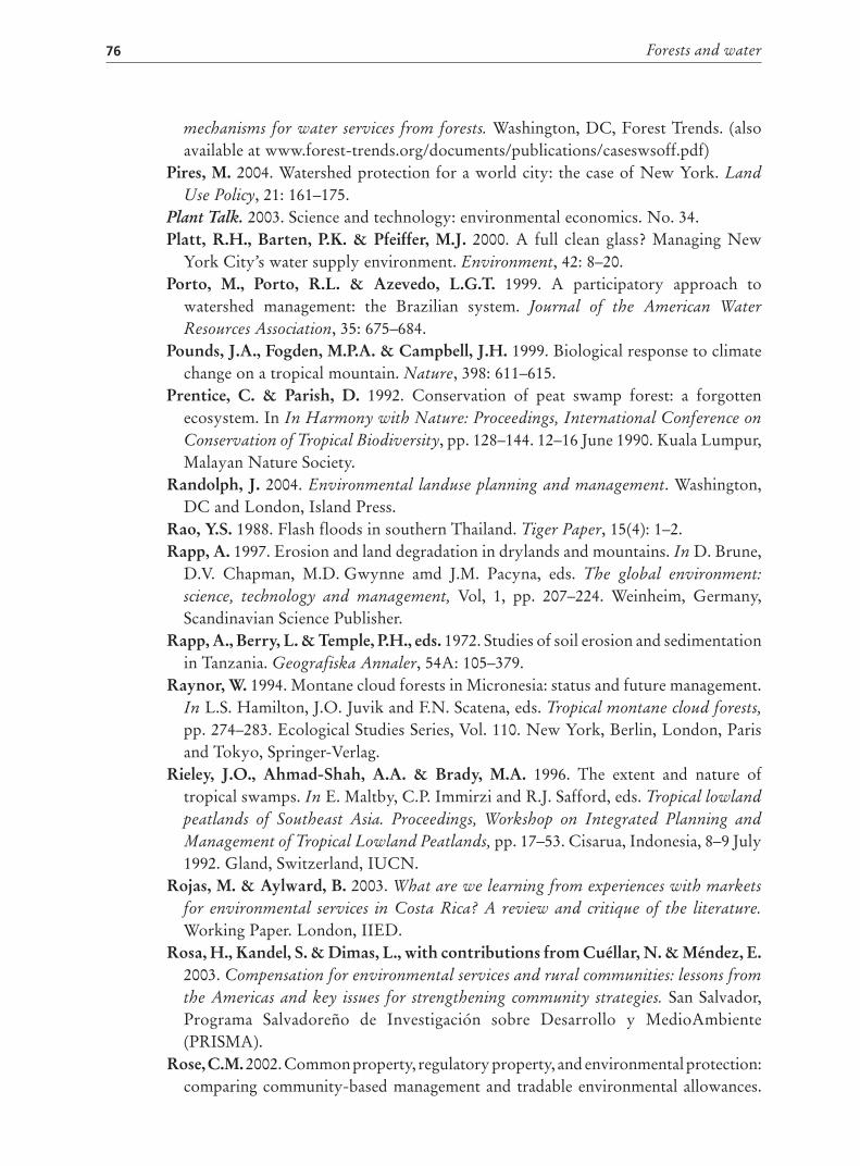
Forests and water76
mechanisms for water services from forests. Washington, DC, Forest Trends. (alsoavailable at www.forest-trends.org/documents/publications/caseswsoff.pdf)
Pires, M. 2004. Watershed protection for a world city: the case of New York. Land
Use Policy, 21: 161–175.Plant Talk. 2003. Science and technology: environmental economics. No. 34.Platt, R.H., Barten, P.K. & Pfeiffer, M.J. 2000. A full clean glass? Managing New
York City’s water supply environment. Environment, 42: 8–20.Porto, M., Porto, R.L. & Azevedo, L.G.T. 1999. A participatory approach to
watershed management: the Brazilian system. Journal of the American Water
Resources Association, 35: 675–684.Pounds, J.A., Fogden, M.P.A. & Campbell, J.H. 1999. Biological response to climate
change on a tropical mountain. Nature, 398: 611–615.Prentice, C. & Parish, D. 1992. Conservation of peat swamp forest: a forgotten
ecosystem. In In Harmony with Nature: Proceedings, International Conference on
Conservation of Tropical Biodiversity, pp. 128–144. 12–16 June 1990. Kuala Lumpur,Malayan Nature Society.
Randolph, J. 2004. Environmental landuse planning and management. Washington,DC and London, Island Press.
Rao, Y.S. 1988. Flash floods in southern Thailand. Tiger Paper, 15(4): 1–2.Rapp, A. 1997. Erosion and land degradation in drylands and mountains. In D. Brune,
D.V. Chapman, M.D. Gwynne amd J.M. Pacyna, eds. The global environment:
science, technology and management, Vol, 1, pp. 207–224. Weinheim, Germany,Scandinavian Science Publisher.
Rapp, A., Berry, L. & Temple, P.H., eds. 1972. Studies of soil erosion and sedimentationin Tanzania. Geografiska Annaler, 54A: 105–379.
Raynor, W. 1994. Montane cloud forests in Micronesia: status and future management.In L.S. Hamilton, J.O. Juvik and F.N. Scatena, eds. Tropical montane cloud forests,
pp. 274–283. Ecological Studies Series, Vol. 110. New York, Berlin, London, Parisand Tokyo, Springer-Verlag.
Rieley, J.O., Ahmad-Shah, A.A. & Brady, M.A. 1996. The extent and nature oftropical swamps. In E. Maltby, C.P. Immirzi and R.J. Safford, eds. Tropical lowland
peatlands of Southeast Asia. Proceedings, Workshop on Integrated Planning and
Management of Tropical Lowland Peatlands, pp. 17–53. Cisarua, Indonesia, 8–9 July1992. Gland, Switzerland, IUCN.
Rojas, M. & Aylward, B. 2003. What are we learning from experiences with markets
for environmental services in Costa Rica? A review and critique of the literature.
Working Paper. London, IIED.Rosa, H., Kandel, S. & Dimas, L., with contributions from Cuéllar, N. & Méndez, E.
2003. Compensation for environmental services and rural communities: lessons from
the Americas and key issues for strengthening community strategies. San Salvador,Programa Salvadoreño de Investigación sobre Desarrollo y MedioAmbiente(PRISMA).
Rose, C.M. 2002. Common property, regulatory property, and environmental protection:comparing community-based management and tradable environmental allowances.
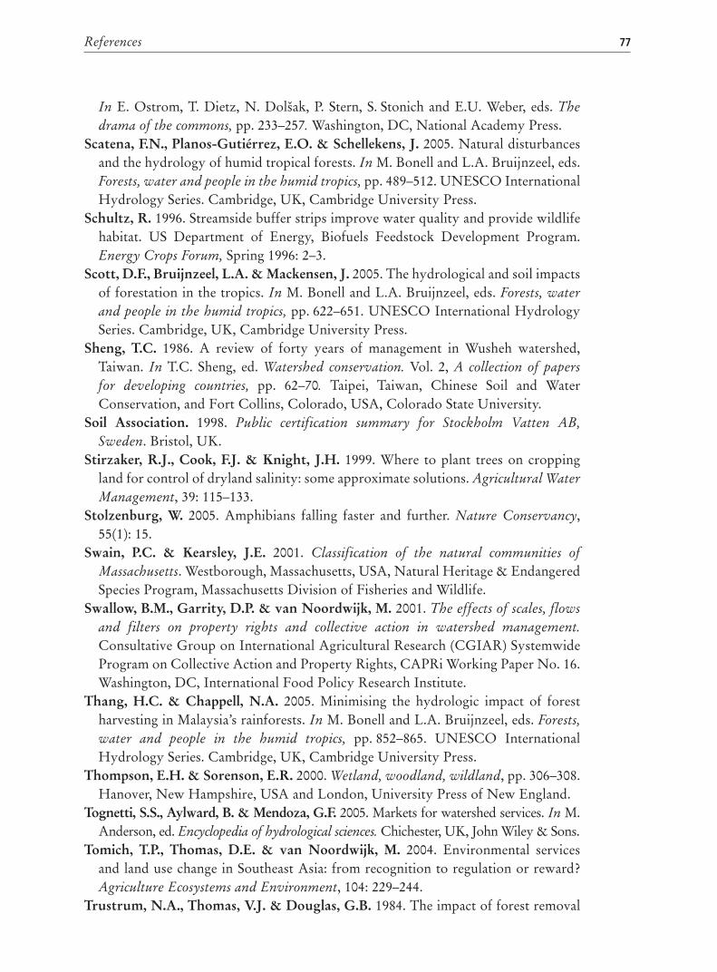
References 77
In E. Ostrom, T. Dietz, N. Dolšak, P. Stern, S. Stonich and E.U. Weber, eds. The
drama of the commons, pp. 233–257. Washington, DC, National Academy Press.Scatena, F.N., Planos-Gutiérrez, E.O. & Schellekens, J. 2005. Natural disturbances
and the hydrology of humid tropical forests. In M. Bonell and L.A. Bruijnzeel, eds.Forests, water and people in the humid tropics, pp. 489–512. UNESCO InternationalHydrology Series. Cambridge, UK, Cambridge University Press.
Schultz, R. 1996. Streamside buffer strips improve water quality and provide wildlifehabitat. US Department of Energy, Biofuels Feedstock Development Program.Energy Crops Forum, Spring 1996: 2–3.
Scott, D.F., Bruijnzeel, L.A. & Mackensen, J. 2005. The hydrological and soil impactsof forestation in the tropics. In M. Bonell and L.A. Bruijnzeel, eds. Forests, water
and people in the humid tropics, pp. 622–651. UNESCO International HydrologySeries. Cambridge, UK, Cambridge University Press.
Sheng, T.C. 1986. A review of forty years of management in Wusheh watershed,Taiwan. In T.C. Sheng, ed. Watershed conservation. Vol. 2, A collection of papers
for developing countries, pp. 62–70. Taipei, Taiwan, Chinese Soil and WaterConservation, and Fort Collins, Colorado, USA, Colorado State University.
Soil Association. 1998. Public certification summary for Stockholm Vatten AB,
Sweden. Bristol, UK.Stirzaker, R.J., Cook, F.J. & Knight, J.H. 1999. Where to plant trees on cropping
land for control of dryland salinity: some approximate solutions. Agricultural Water
Management, 39: 115–133.Stolzenburg, W. 2005. Amphibians falling faster and further. Nature Conservancy,
55(1): 15.Swain, P.C. & Kearsley, J.E. 2001. Classification of the natural communities of
Massachusetts. Westborough, Massachusetts, USA, Natural Heritage & EndangeredSpecies Program, Massachusetts Division of Fisheries and Wildlife.
Swallow, B.M., Garrity, D.P. & van Noordwijk, M. 2001. The effects of scales, flows
and filters on property rights and collective action in watershed management.
Consultative Group on International Agricultural Research (CGIAR) SystemwideProgram on Collective Action and Property Rights, CAPRi Working Paper No. 16.Washington, DC, International Food Policy Research Institute.
Thang, H.C. & Chappell, N.A. 2005. Minimising the hydrologic impact of forestharvesting in Malaysia’s rainforests. In M. Bonell and L.A. Bruijnzeel, eds. Forests,
water and people in the humid tropics, pp. 852–865. UNESCO InternationalHydrology Series. Cambridge, UK, Cambridge University Press.
Thompson, E.H. & Sorenson, E.R. 2000. Wetland, woodland, wildland, pp. 306–308.Hanover, New Hampshire, USA and London, University Press of New England.
Tognetti, S.S., Aylward, B. & Mendoza, G.F. 2005. Markets for watershed services. In M.Anderson, ed. Encyclopedia of hydrological sciences. Chichester, UK, John Wiley & Sons.
Tomich, T.P., Thomas, D.E. & van Noordwijk, M. 2004. Environmental servicesand land use change in Southeast Asia: from recognition to regulation or reward?Agriculture Ecosystems and Environment, 104: 229–244.
Trustrum, N.A., Thomas, V.J. & Douglas, G.B. 1984. The impact of forest removal
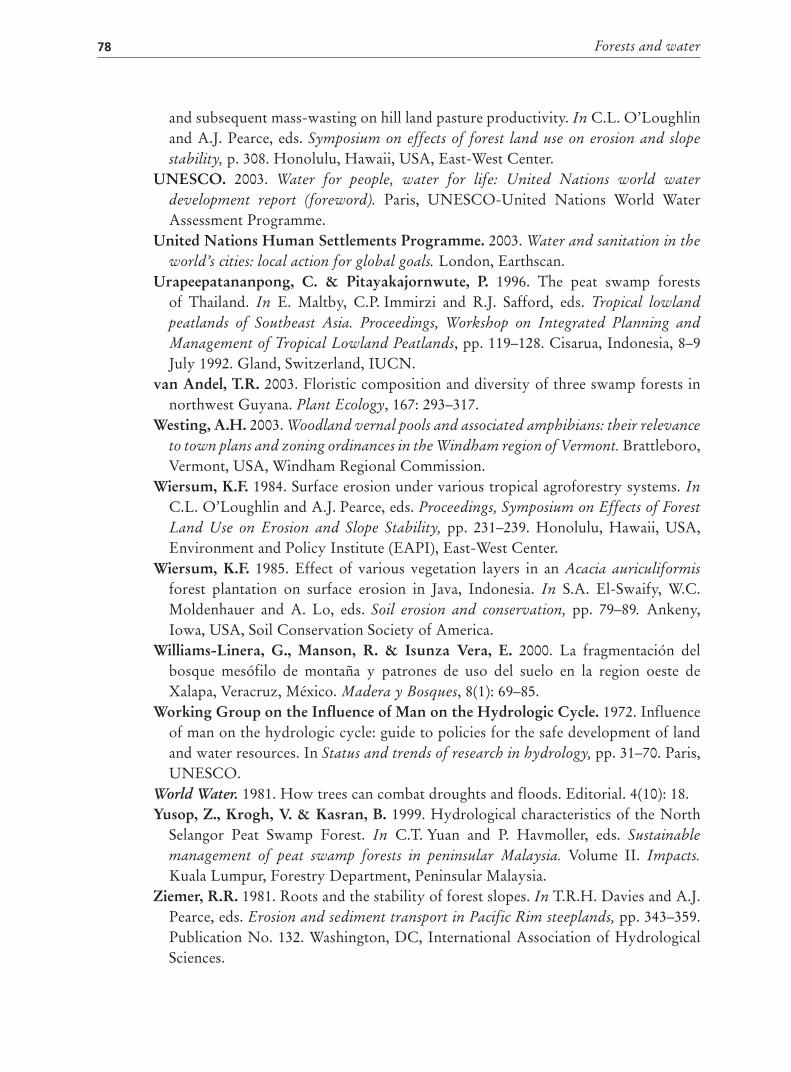
Forests and water78
and subsequent mass-wasting on hill land pasture productivity. In C.L. O’Loughlinand A.J. Pearce, eds. Symposium on effects of forest land use on erosion and slope
stability, p. 308. Honolulu, Hawaii, USA, East-West Center.UNESCO. 2003. Water for people, water for life: United Nations world water
development report (foreword). Paris, UNESCO-United Nations World WaterAssessment Programme.
United Nations Human Settlements Programme. 2003. Water and sanitation in the
world’s cities: local action for global goals. London, Earthscan.Urapeepatananpong, C. & Pitayakajornwute, P. 1996. The peat swamp forests
of Thailand. In E. Maltby, C.P. Immirzi and R.J. Safford, eds. Tropical lowland
peatlands of Southeast Asia. Proceedings, Workshop on Integrated Planning and
Management of Tropical Lowland Peatlands, pp. 119–128. Cisarua, Indonesia, 8–9July 1992. Gland, Switzerland, IUCN.
van Andel, T.R. 2003. Floristic composition and diversity of three swamp forests innorthwest Guyana. Plant Ecology, 167: 293–317.
Westing, A.H. 2003. Woodland vernal pools and associated amphibians: their relevance
to town plans and zoning ordinances in the Windham region of Vermont. Brattleboro,Vermont, USA, Windham Regional Commission.
Wiersum, K.F. 1984. Surface erosion under various tropical agroforestry systems. In
C.L. O’Loughlin and A.J. Pearce, eds. Proceedings, Symposium on Effects of Forest
Land Use on Erosion and Slope Stability, pp. 231–239. Honolulu, Hawaii, USA,Environment and Policy Institute (EAPI), East-West Center.
Wiersum, K.F. 1985. Effect of various vegetation layers in an Acacia auriculiformis
forest plantation on surface erosion in Java, Indonesia. In S.A. El-Swaify, W.C.Moldenhauer and A. Lo, eds. Soil erosion and conservation, pp. 79–89. Ankeny,Iowa, USA, Soil Conservation Society of America.
Williams-Linera, G., Manson, R. & Isunza Vera, E. 2000. La fragmentación delbosque mesófilo de montaña y patrones de uso del suelo en la region oeste deXalapa, Veracruz, México. Madera y Bosques, 8(1): 69–85.
Working Group on the Influence of Man on the Hydrologic Cycle. 1972. Influenceof man on the hydrologic cycle: guide to policies for the safe development of landand water resources. In Status and trends of research in hydrology, pp. 31–70. Paris,UNESCO.
World Water. 1981. How trees can combat droughts and floods. Editorial. 4(10): 18.Yusop, Z., Krogh, V. & Kasran, B. 1999. Hydrological characteristics of the North
Selangor Peat Swamp Forest. In C.T. Yuan and P. Havmoller, eds. Sustainable
management of peat swamp forests in peninsular Malaysia. Volume II. Impacts.
Kuala Lumpur, Forestry Department, Peninsular Malaysia.Ziemer, R.R. 1981. Roots and the stability of forest slopes. In T.R.H. Davies and A.J.
Pearce, eds. Erosion and sediment transport in Pacific Rim steeplands, pp. 343–359.Publication No. 132. Washington, DC, International Association of HydrologicalSciences.