FOR THE FEDERALLY ENDANGERED Indiana...
56
BIOLOGICAL ASSESSMENT FOR THE FEDERALLY ENDANGERED Indiana bat (Myotis sodalis) PROGRAMMATIC CONSULTATION BETWEEN UNITED STATES FISH AND WILDLIFE SERVICE FEDERAL HIGHWAY ADMINISTATION OHIO DEPARTMENT OF TRANSPORTATION September 1, 2006
-
Upload
hoanghuong -
Category
Documents
-
view
215 -
download
0
Transcript of FOR THE FEDERALLY ENDANGERED Indiana...

BIOLOGICAL ASSESSMENT FOR THE
FEDERALLY ENDANGERED
Indiana bat (Myotis sodalis)
PROGRAMMATIC CONSULTATION
BETWEEN
UNITED STATES FISH AND WILDLIFE SERVICE
FEDERAL HIGHWAY ADMINISTATION
OHIO DEPARTMENT OF TRANSPORTATION
September 1, 2006


TABLE OF CONTENTS
Chapter 1 Introduction 1.1 Purpose of the Programmatic Consultation…………………………………….1 1.2 Glossary of Terms……………………………………………………………....1 1.3 Objectives of the Programmatic Consultation………………………………….2 1.4 The Proposed Action……………………………………………………............3 1.5 Action Area…………………………………………………………………......3
Chapter 2 Description of the Proposed Action
2.1 Proposed Activities…………………………………………………………......8 2.2 Indiana bat Management Units………………………………………………....9 2.3 Proposed Management Measures……………………………………………...11
Chapter 3 Status of the Indiana bat
3.1 Description and Life History of the Indiana bat…………………………….....12 3.2 Current Status of the Indiana bat………………………………………………17 3.3 Environmental Baseline…….…………………………………………………21 3.4 Effects of the Continued Implementation of ODOT’s Statewide Program on the
Indiana bat……………………………………………………………………..23 3.5 Measures Proposed to Minimize Potential Adverse Effects…………………..29 3.6 Measures Proposed to Mitigate Potential Adverse Effects……………………29 3.7 Measures Proposed to Further Conservation and Recovery…………………..31
Chapter 4 List of Preparers……………………………………………………………..32 Chapter 5 References and Data Sources……………………………………………….33 List of Tables Table No. Title Page 1. List of Preparers…………………………………………………………....32 List of Figures Figure No. Title Page
1. Ecoregions of Ohio…………………………………………………….........6 2. Management Units………………………………………………………....10 3. Indiana bat Range…………………………………………………………..18 4. Indiana bat Range-wide Population Estimates……………………………..21
Appendix A: GIS Data Possible Forested Impacts in Ohio Counties…………...…..A-1 Appendix B: Ohio Habitat Assessment Form (OHAF)……….………………..…….B-1 Appendix C: Ohio Habitat Assessment Form Flowchart…….………………..…….C-1


Ohio Department of Transportation July 2006 Federal Highway Administration
- 1 -
Chapter 1
INTRODUCTION
1.1 Purpose of the Programmatic Consultation In accordance with the Endangered Species Act (ESA) of 1973, federal agencies are required “to insure that any action authorized, funded, or carried out by such agency is not likely to jeopardize the continued existence of any endangered or threatened species or result in the destruction or adverse modification of any habitat of such species determined to be critical unless an exemption has been granted.” The purpose of the Programmatic Consultation (PC) is to identify and discuss any potential impacts to the Federally endangered Indiana bat (Myotis sodalis) caused by activities of the Ohio Department of Transportation (ODOT) implemented under ODOT’s program of work and to establish a streamlined and predictable consultation process for those impacts.
This PC addresses only the Federally listed endangered species, the Indiana bat (Myotis sodalis).
1.2 Glossary of Terms The following terms have been defined for use in this PC.
1. FORAGING AREAS Those areas that have a food supply (insects) for adult Indiana bats and their young and may serve as night roosts for resting and digesting meals. These areas may be within or on the edge of forested areas, with an open subcanopy providing the best foraging habitat. Foraging areas occur along streams, in floodplain forests, in and around forested wetlands and impoundments. Streams are apparently not used if riparian trees have been removed. 2. ROOST TREE Indiana bat summer roosting habitat that may support roosting bats. Roost trees have the following habitat characteristics: Live or standing dead trees or snags over 8”diameter at breast height (dbh) with exfoliating, peeling or loose bark, split trunks and/or branches, or cavities. If the habitat characteristics are only found on the branches of the tree, the branches must be over 6” diameter at the site of the peeling bark, split in the branch, or cavity, etc.

Ohio Department of Transportation July 2006 Federal Highway Administration
- 2 -
3. MATERNITY ROOST TREE Indiana bat summer roosting habitat that may support maternity colonies (reproductive females and their young that may number 100 individuals or more). Maternity roost trees have the following habitat characteristics: Live or standing dead trees or snags over 16”diameter at breast height (dbh) with exfoliating, peeling or loose bark, split trunks and/or branches, or cavities. These characteristics must be plentiful enough to allow the colony to change locations along the tree to aid in thermoregulation. If the habitat characteristics are found only on the branches of the tree, the branches must be at least 8” in diameter at the site of the habitat characteristics. These trees must have some solar exposure and must be within sight distance of at least one other potential roost tree. These trees must be part of (forested area or within a fence row of trees at least two trees wide) or connected to a travel corridor or larger forested area.
4. ISOLATED MATERNITY ROOST TREE Trees with the habitat characteristics listed above, but that are not located within sight distance of one or more potential maternity roost trees. Isolated maternity roost trees may be trees within a small cluster of sporadic trees (ex. front yard trees) not connected to or part of a linear flight corridor. This type of tree may support a maternity colony in the short term, but the colony would have to find a new location when the tree fell over or lost the habitat characteristics and would be subjected to further stress because of lack of foraging areas. 5. SOLAR EXPOSURE Solar exposure is direct sunlight to the trunk or branches where suitable roosting habitat is found for all or part of the day. Maternity roosting trees require some solar exposure to provide thermoregulation to the young. This solar exposure can come from the tree being at the edge of a forested tract or because the tree is a super canopy tree (much taller than the trees around it). 6. TRAVEL CORRIDOR A contiguous linear wooded corridor at least two trees wide that connects roosting and foraging areas, and may be used during migration. These corridors may be riparian areas along streams, wooded fence rows, small wooded roads and paths, open-understory forest, or wooded residential areas. 7. HIBERNACULUM Area where bats hibernate during the winter. Hibernacula are typically caves, or abandoned mines that provide cool, humid, stable conditions for hibernation. 1.3 Objectives of the Programmatic Consultation
Objectives for this PC are to:

Ohio Department of Transportation July 2006 Federal Highway Administration
- 3 -
1. Comply with the requirements of the ESA, as amended, that actions by federal agencies (Federal Highway Administration and ODOT) shall not jeopardize the existence of the Indiana bat.
2. Describe ODOT’s Statewide Transportation Program; the Proposed Action. 3. Analyze the effects of implementing ODOT’s statewide program of work, including
standards and guidelines, on the Federally-listed endangered species, the Indiana bat. 4. Describe actions that ODOT will undertake to avoid, minimize, and mitigate for
impacts to the Indiana bat. 5. Describe actions that ODOT will undertake to contribute toward the recovery of the
Indiana bat. 6. Develop a streamlined consultation process to be used by the U.S. Fish and Wildlife
Service (USFWS), the Federal Highway Administration (FHWA), and ODOT for consultation on the Indiana bat.
1.4 The Proposed Action The proposed action is the continuing implementation of ODOT’s Statewide Transportation Program, in cooperation with FHWA. The action includes current and future projects over a five year period (2006 through 2011). These projects would include all forms of road construction and maintenance. It is not guaranteed that all ODOT projects that are scheduled today will be completed, therefore there is no way to know the details of every project that will be completed through 2011; the project schedules change daily in ODOT’s database. Any one project may also change in focus and purpose over time, there by changing the impacts and/or footprint of the project. Because of this lack of certainty, a snapshot of scheduled projects was extracted from the ODOT database in 2005, to give an overall estimation of the number and type of projects that may occur over a five year period. The anticipated effects to the Indiana bat include loss of habitat, specifically removal of possible roost trees and/or foraging areas. This Programmatic Consultation will concentrate on defining the project areas that have the potential to affect this habitat, i.e. projects that have the potential to remove trees. Major new projects (on new alignments) will likely have effects that fall outside of the scope of this PC, and therefore will be consulted on individually as they arise, though measures from this PC can be used to minimize impacts for any such projects. Before final implementation of this PC, an informal field training day was held with USFWS, FHWA, and ODOT staff. Discussion at the training meeting ensured that everyone involved understood how to apply the terms used within this document and other streamlining materials in real world examples of habitat (i.e. potential roost trees, flight corridor, etc.). Descriptions of ODOT project types and highway activities are found in Chapter 2, Proposed Activities.
1.5 Action Area

Ohio Department of Transportation July 2006 Federal Highway Administration
- 4 -
ODOT’s work encompasses the entire State of Ohio’s highway system. There are more than 121,000 linear miles of roads throughout the State, with many cities, counties, and parks maintaining their own roads. ODOT is responsible for road construction and maintenance on more than 17,000 linear miles of these roads throughout Ohio (McQuirt, ODOT, pers. comm.). The limited design detail (i.e., the unknown location of detour routes and staging areas) resulted in the action area being defined as the entire State of Ohio.
General descriptions of the various ecological sections (ecoregions) of Ohio follow (Figure 1).
Soils, Geology, Minerals, and Land Use Descriptions that coincide with the map below (Figure 1) (USEPA 2006).
EASTERN CORN BELT PLAINS This region is primarily a rolling plain with local end moraines; it had more natural tree cover and has lighter colored soils than the regions to the west. The region has loamier and better drained soils than the lake plain to the northeast and richer soils than the regions to the east. Glacial deposits of Wisconsinan age are extensive. They are not as dissected nor as leached as the pre-Wisconsin till which is restricted to the southern part of the region. Originally, beech forests were common on Wisconsinan soils while beech forests and elm-ash swamp forests dominated the wetter pre-Wisconsinan soils. Today, extensive corn, soybean, and livestock production occurs and has affected stream chemistry and turbidity.
SOUTHERN MICHIGAN/NORTHERN INDIANA DRIFT PLAINS Bordered by Lake Michigan on the west, this ecological region is less agricultural than the regions to the south, it is more well-drained and contains more lakes than the flat agricultural lake plain to the east, and it is not as nutrient poor as the region to the north. The region is characterized by many lakes and marshes as well as an assortment of landforms, soil types, soil textures, and land uses. Broad till plains with thick and complex deposits of drift, paleobeach ridges, relict dunes, morainal hills, kames, drumlins, meltwater channels, and kettles occur. Feed grain, soybean, and livestock farming as well as woodlots, quarries, recreational development, and urban-industrial areas are common.
HURON/ERIE LAKE PLAINS This region occupies a broad, fertile, nearly flat plain punctuated by relic sand dunes, beach ridges, and end moraines. Originally, soil drainage was typically poorer than in the adjacent more agricultural regions to the west, and elm-ash swamp and beech forests were dominant. Oak savanna was typically restricted to sandy, well-drained dunes and beach ridges. Today, most of the area has been cleared and artificially drained and contains highly productive farms producing corn, soybeans, livestock, and vegetables; urban and industrial areas are also extensive. Stream habitat and quality have been degraded by channelization, ditching, and agricultural activities.
ERIE/ONTARIO DRIFT AND LAKE PLAINS Once largely covered by a maple-beech-birch forest, except in the west where hemlock and pine were also present, much of this area is now in farms, mostly associated with dairy operations. Ecological regions to the west are flatter and more extensively cultivated, and

Ohio Department of Transportation July 2006 Federal Highway Administration
- 5 -
those to the south are hillier and less agricultural. The portion of this region within close proximity to the Great Lakes experiences an increased growing season, more winter cloudiness, and greater snowfall as compared to adjacent areas. Urban development and industrial activity are widespread.
WESTERN ALLEGHENY PLATEAU This region comprises a dissected plateau that was not muted by glaciation and is more rugged than the agricultural till plains of ecological regions to the north and west, but is less rugged and not as forested as ecoregions to the east and south. Extensive mixed mesophytic forests and mixed oak forests originally grew in this region, and today most of its rounded hills remain in forest; dairy, livestock, and general farms as well as residential developments are concentrated in the valleys. Horizontally-bedded sedimentary rock underlying the region has been mined for bituminous coal.
INTERIOR PLATEAU This is a diverse ecological region extending from southern Indiana and Ohio to northern Alabama. Rock types are distinctly different from the coastal plain sands and alluvial deposits to the west, and elevations are lower than the Appalachian ecoregions to the east. Mississippian to Ordovician-age limestone, chert, sandstone, siltstone and shale compose the landforms of open hills, irregular plains, and tablelands. The natural vegetation is primarily oak-hickory forest, with some areas of bluestem prairie and cedar glades. The region has a diverse fish fauna.

Ohio Department of Transportation July 2006 Federal Highway Administration
- 6 -
Ohio Department of Transportation July 2006 Federal Highway Administration
- 7 -
Forest and Aquatic Areas Ohio is approximately 28,701,440 acres, of which, land is about 25,900,160 acres and water and wetlands are about 2,801,280 acres (Sanders and Zimmerman 2000). The State is 30% forested today, and 96% of these forests are comprised of deciduous trees (ODNR 2006). Forests in Ohio today are highly fragmented, as seen by viewing the Ohio Land Cover Data Set created by the U.S. Geological Survey (USGS). Ohio’s largest section of forest is the only National Forest in the State, the Wayne National Forest (WNF). The WNF itself is fragmented by private and State lands, and is divided into three physically separated units which total approximately 238,000 acres (USFS 2006). There are over 4,000 different streams in Ohio that together create a network of an estimated 61,532 total miles of water (Sanders and Zimmerman 2000).
For the purposes of this PC, a GIS layer of forest cover in Ohio was overlaid with a layer of ODOT’s roadway projects for a five year period. The forest cover layer was extracted from the USGS created Ohio National Land Cover Data Set (OLCD), which is a subset of the National Land Cover Data Set (NLCD). The OLCD was revised in 2000 and originally used satellite imagery circa 1992 supplemented with other ancillary data (elevation data, aerial photos, wetland information, etc.) where available. The data set has a spatial resolution of 30 meters, meaning the smallest pixel of land cover is 30 meters squared. This level of data was used in defining 14 different land cover classes in Ohio. Two land cover classes were chosen from this list as possible Indiana bat habitat: woody wetlands and deciduous forest. In the OLCD, woody wetlands are defined as areas where forest or shrubland vegetation accounts for 25-100% of the cover and the soil or substrate is periodically saturated with or covered with water (USGS 2006). Deciduous forest is defined as areas dominated by trees where 75% or more of the tree species shed foliage simultaneously in response to seasonal change (USGS 2006). A project footprint was created around each linear project that was estimated to contain all the direct impacts of any road work that would be occurring within that area. The footprints that were assigned to project types were generous in nature, giving us a conservative estimate of aerial disturbance from direct impacts across the State. When the layers were overlaid, a figure could be computed for all the possible Indiana bat habitat that would be impacted due to road construction. The table of the GIS work is attached as Appendix A-1.

Ohio Department of Transportation July 2006 Federal Highway Administration
- 8 -
Chapter 2 DESCRIPTION OF THE PROPOSED ACTION
2.1 Proposed Activities ODOT construction and maintenance projects typically include several activities that may require the removal of trees from the landscape. These trees may be located on existing roadway right-of-way or newly acquired right-of way. Projects can vary greatly in the level of disturbance they may cause, and range from the removal of no to few trees (as in the case of a simple culvert replacement) to the removal of acres of wooded habitats (as in the case of construction of a major roadway on new location). The types of activities conducted by ODOT that may result in the removal of trees may include:
• Drainage improvement projects such as roadway ditch cleanouts and maintenance; • General roadway safety maintenance (such as removing dead or dying trees that
may be overhanging the roadway); • Construction of sidewalks; • Construction or replacement of right-of-way fence; • Construction of noise walls; • Construction of bike lanes on existing roadways, on new alignments, or along
abandoned railroads or canal towpaths; • Constructing overpasses or underpasses; • Culvert construction, replacement, or repair; • Bridge construction, replacement, or repair; • Widening of existing lanes along roadways; • Adding new lanes along existing roadways within existing right-of-way; • Adding turn lanes along existing roadways; • Repair of landslides or unstable slopes along a roadway; • Realigning existing roadways, intersections, or interchanges; • Constructing rest areas, outposts, or other facilities; • Constructing new interchanges; • Adding new lanes along existing roadways on new right-of-way; and • Constructing new roadways on new alignments.
In general, these activities have been ranked in order of their potential impacts to forested habitats, however, the degree of impacts that these projects may have could vary greatly based on the surrounding land cover/use, terrain, and extent of the project area (length of roadway, size of bridge, etc.). For example, the construction of a new four lane, divided, limited access highway in northwest Ohio may result in disturbances to an approximately 300 foot wide alignment on relatively flat, previously farmed lands, possessing few trees. However, a similar type of roadway constructed in a hilly, forested area of southeast Ohio,

Ohio Department of Transportation July 2006 Federal Highway Administration
- 9 -
could possibly require a variable alignment width due to the terrain (possibly ranging from 300 to 1,000 feet), and may result in a much greater number of forest habitat impacts.
The site specific variability inherently associated with each individual project makes it very difficult to predict the disturbance area associated with each work activity. In terms of project width, maintenance, rehabilitation, replacement, and minor widening activities would generally remain within 50 feet of the existing right-of-way (for example, heavy equipment would remain within 50 feet upstream or downstream of a bridge being replaced). Smaller (less than 4 lane) new alignment projects (new roads or relocations) would generally disturb an area less than 150 feet wide, while larger (four lanes or greater) new alignment projects would generally disturb an area less than 500 feet in width. While extremely variable due to terrain and other constraints, new interchange projects would generally disturb an area less than 2,000 feet in diameter. In each of these examples, the area of disturbance may be less than, or exceed, the predicted value based on project specific conditions, and would vary greatly based on the proposed length of the project.
2.2 Management Units For purposes of this PC, Ohio has been split into 5 Management Units (Figure 2). The Management Units were chosen by taking into account differing land use, vegetative land cover, and Indiana bat survey data (and thus, known suitable habitat) across the State. Major factors in choosing the boundaries for each unit are as follows:
West Unit: Majority of agricultural lands in Ohio, small, isolated wood lots (forested patches), largest hibernaculum, evidence of maternity colonies. Counties included are: Allen, Auglaize, Champaign, Clark, Darke, Defiance, Erie, Fulton, Greene, Hancock, Hardin, Henry, Huron, Logan, Lucas, Mercer, Miami, Montgomery, Ottawa, Paulding, Preble, Putnam, Sandusky, Seneca, Shelby, Van Wert, Williams, Wood, and Wyandot.
Central Unit: Transitional land cover between primarily agricultural in the West to more heavily forested in the East, evidence of maternity colonies. Counties included are: Crawford, Delaware, Fairfield, Fayette, Franklin, Knox, Licking, Madison, Marion, Morrow, Pickaway, and Union.
North East Unit: Forested, heavy in wetlands and woody wetlands, evidence of maternity colonies and hibernacula, some coal mining activity (and associated negative surveys). Counties included are: Ashland, Ashtabula, Cuyahoga, Geauga, Holmes, Lake, Lorain, Mahoning, Medina, Portage, Richland, Stark, Summit, Trumbull, and Wayne.
East Unit: Forested, one of the three National Forest Ranger Districts occurs in the East Unit, heavy coal mining activity (and associated negative surveys), no capture records to date. Counties included are: Belmont, Carroll, Columbiana, Coshocton, Guernsey, Harrison, Jefferson, Monroe, Morgan, Muskingum, Noble, Tuscarawas, and Washington.
South Unit: Most heavily forested section of Ohio, two of the three National Forest Ranger Districts occur in South, evidence of maternity colonies and hibernacula. Counties included

Ohio Department of Transportation July 2006 Federal Highway Administration
- 10 -
are: Adams, Athens, Brown, Butler, Clermont, Clinton, Gallia, Hamilton, Highland, Hocking, Jackson, Lawrence, Meigs, Perry, Pike, Ross, Scioto, Vinton, and Warren.
Figure 2. Management Units
LEGEND:
W = West Management Unit
C = Central Management Unit
NE = Northeast Management Unit
E = East Management Unit
S = South Management Unit

Ohio Department of Transportation July 2006 Federal Highway Administration
- 11 -
To minimize impacts to the Indiana Bat ODOT will implement different measures for avoidance, minimization, mitigation and recovery in each of the 5 Management Units. The management measures are listed in Section 2.3 as part of the proposed action and are defined for each of the Management Units in Sections 3.4 through Section 3.7. The implementation of these measures is explained more fully in Sections 3.4 through Section 3.7 and in Appendix B (OHAF).
2.3 Proposed Management Measures 2.3.1: Proposed Avoidance and Minimization Measures
• Minimizing project footprint on landscape as much as possible • Minimizing impacts to streams and wetlands (foraging and traveling areas for bat) • Minimizing impacts to forested areas (potential flight corridors and roosting areas) • Minimizing impacts to hibernacula, i.e. blasting noise (and related vibrations),
especially when large number of bats would be there from September 15 to April 15 • Seasonal cutting of potential roost trees that bats are likely to be using, in order to
avoid direct take of bats from April 15 through September 15
2.3.2: Proposed Mitigation Measures • Seek opportunities for purchasing conservation easements in vicinity of known or
suspected hibernacula and/or suitable habitat • Protection/restoration of riparian areas where Indiana bat forages • Protection/restoration of wetlands where Indiana bat forages • Native tree planting to create future suitable habitat • Invasive species plant control to create better quality suitable habitat • Conduct surveys on public/protected land in West and Central Management Units
2.3.3: Additional Measures to Contribute Toward Recovery of the Indiana Bat
• Research to aid in knowledge of bats habitat and characteristics • Education of contractors and public • Protection/restoration of riparian areas where Indiana bat may forage • Protection/restoration of wetlands where Indiana bat may forage • Native tree planting to create future suitable habitat • Spring telemetry study in vicinity of Preble county hibernaculum

Ohio Department of Transportation July 2006 Federal Highway Administration
- 12 -
Chapter 3 STATUS OF THE INDIANA BAT
3.1 Description and Life History of the Indiana Bat
3.1.1: Description and Life History
The Indiana bat is a member of the Myotis genus, and is quite small, weighing only three-tens of an ounce (USFWS 2002b). In flight, it has a wingspan of 9 to 11 inches. The fur is dark – brown to black – and the bat is similar in appearance to many other related species (USFWS 2002b). The most well recognized difference between Indiana bats and other similar Myotis species is that Indiana bats have a distinctly keeled calcar (cartilage that extends from the ankle to support the tail membrane). There are other minor differences, such as Indiana bats having smaller, more delicate feet, shorter feet hairs that do not extend past the toenails, and a pink nose.
The lifespan for Indiana bats is generally between 5 and 10 years (Thomson 1982), but individuals may live much longer, with the oldest known bat captured 20 years after it was first banded (LaVal and LaVal 1980). Based on a 13-year study, Humphrey and Cope (1977) found that the adult period of life is characterized by two distinct survival phases. The first is a high and apparently constant rate from 1 to 6 years after marking with 76% and 70% annual rates of survival of females and males, respectively. The
second phase is a much lower, constant rate after 6 years, with annual survival rates of 66% for females and up to 10 years and 36% for males. In one study in Indiana, survival of pups was found to be very high at 92% from birth to weaning (Humphrey et al. 1977). Post-weaning to age 1 survival is unknown, but believed to be low.
The key stages in the annual cycle of Indiana bats are: hibernation, spring staging, pregnancy, lactation, volation/weaning, migration, and swarming. While varying with
Common Name: Indiana bat Scientific Name: Myotis sodalis Family: Vespertilionidae Group: Mammals Historic Range: Eastern and Midwestern U.S.A Population To Which Status Applies: Entire Range Current Status: Endangered Date First Listed: March 11,1967 Critical Habitat: 17.95(a) Special Rules: N/A Recovery Plan: 1999, Revised Agency Draft Lead Region: Great Lakes-Big Rivers Region (3) Current Range: AL, AR, GA, IA, IL, IN, KS, KY, MD, MI, MO, MS, NC, NJ, NY, OH, OK, PA, SC, TN, VA, VT, WV
Source: USFWS 2006

Ohio Department of Transportation July 2006 Federal Highway Administration
- 13 -
weather and latitude, generally bats begin winter torpor in mid-September through late October and begin emerging in April. Females depart shortly after emerging and are pregnant when they reach their summer area. Birth of young occurs between mid-June and early July and then nursing continues until weaning, which is shortly after young become volant in mid to late July. Migration back to the hibernacula may begin in August and continue through September. Males depart later from the hibernacula in the spring and begin migrating back earlier than females in the fall.
Fall Swarming and Mating From late-August to mid-October, prior to entering the hibernacula, large numbers of bats fly in and out of cave or mine openings from dusk until dawn in a behavior called swarming. Swarming usually lasts for several weeks and mating occurs toward the end of this period. Male Indiana bats tend to be active for a longer period of time than females during swarming and will enter the hibernacula later than the females (USFWS 1999). Adult females store sperm through the winter thus delaying fertilization until early May. Females usually start grouping into larger maternity colonies by mid-May and give birth to a single young between late June and early July (Easterla and Watkins 1969; Humphrey et al. 1977). Temperature and relative humidity are important factors in the selection of hibernation sites. During the early autumn, Indiana bats roost in warm sections of caves and move down a temperature gradient as temperatures decrease. In mid-winter, Indiana bats tend to roost in portions of the cave where temperatures are cool (37 to 43 degrees Fahrenheit). Relative humidity in Indiana bat hibernacula tends to be high, ranging from 66 percent to 95 percent (Barbour and Davis 1969).
Female Maternity Colony and Summer Habitat
Upon emergence from the hibernacula in the spring, females migrate to their traditional maternity colony areas. Coloniality is a requisite behavior for reproductive success. Females usually start grouping into larger maternity colonies by mid-May and give birth to a single young between late June and early July (Humphrey et al. 1977). These colonies are typically located under the sloughing bark of live, dead and partially dead trees in upland and lowland forest (Humphrey et al. 1977; Gardner et al. 1991). Colony trees are usually large-diameter, standing dead trees with direct exposure to sunlight. The warmer temperature from sunlight exposure helps development of fetal and juvenile young (Racey 1982). A maternity roost may contain 100 or more adult females and their pups. Roost trees often provide suitable habitat as a maternity roost for only a short period of time. Roost trees are ephemeral in nature; suitable trees fall to the ground or lose important structural characteristic such as bark exfoliation (Gardner et al. 1991; Britzke et al. 2003). Dead trees retain their bark for only a certain period of time (about 2-8 years). Once all bark has fallen off a tree, it is unsuitable to the Indiana bat for roosting. Gardner et al. (1991) found that 31% of Indiana bat occupied roost sites were unavailable the summer following their discovery; 33% of the remaining occupied roost sites were unavailable by the second summer. For this reason, an area must provide a continual supply of suitable roost trees in order to support a colony over the long-term.

Ohio Department of Transportation July 2006 Federal Highway Administration
- 14 -
Female Indiana bats have shown strong site fidelity to both their summer maternity grounds and specific roost trees, and will use suitable roost trees in consecutive years, if they remain standing and have sloughing bark (Gardner et al. 1991; Callahan et al. 1997; Kurta and Murray 2002). Traditional summer areas are essential to the reproductive success of local populations. It is not known how long or how far female Indiana bats will search to find new roosting habitat if their traditional roost habitat is lost or degraded. If they are required to search for new roosting habitat, it is assumed that this effort places additional stress on pregnant females at a time when fat reserves are low or depleted and they are already stressed from the energy demands of migration.
It is unknown how many roosts are critical to the survival of a colony, but the temporary nature of the use of the roost trees dictates that several must be available in an area if the colony is to return to the same area and raise their young successfully. Indiana bats require many roost trees to fulfill their needs during the summer (Callahan et al. 1997). In Michigan, Indiana bats used two to four different roost trees during the course of one season (Kurta and Williams 1992). In Missouri, each colony used between 10-20 roost trees, and these were not widely dispersed (all within a circle ranging in size from 0.81 to 1.48 km) (Miller et al. 2002). The important factor associated with roost trees is their ability to protect individuals from the elements, and to provide thermal regulation of their environment. Maternity colonies have at least one primary roost, which is generally located in an opening or at the edge of a forest stand. Maternity colonies also use multiple alternate roosts which are located in the open or in the interior of forest stands. Exposure to sunlight is important during development of fetal and juvenile young. In Missouri, use of dead trees in the forest interior increased in response to unusually warm weather (i.e., shading provided a cooler thermal environment), and use of live trees and snags in interior forest increased during periods of precipitation (Miller et al. 2002). Maternity colonies in North Carolina and Tennessee used roosts located above the surrounding canopy (Britzke et al. 2003). Indiana bats have been found roosting in several different species of trees, and it appears that they choose roost trees based on their structural composition. Therefore, it is difficult to determine if one particular species of tree is more important than others. However, twelve tree species have been listed in the Habitat Suitability Index Model (Romme et al. 1995) as primary species (class 1 trees). These trees include silver maple (Acer saccharinum), shagbark hickory (Carya ovata), shellbark hickory (C. laciniosa), bitternut hickory (C. cordiformis), green ash (Fraxinus pennsylvanica), white ash (F. americana), eastern cottonwood (Populus deltoides), red oak (Quercus rubra), post oak (Q. stellata), white oak (Q. alba) slippery elm (Ulmus rubra), and American elm (U. americana). In addition to these species, sugar maple (A. saccharum), shingle oak (Q. imbricaria), and sassafras (Sassafras albidum) are listed as class 2 trees (Romme et al. 1995). The class 2 trees are those species believed to be less important, but that still have the necessary characteristics to be used as roosts. These tree species are favored by the Indiana bat, since as these trees age, their bark will slough.
Foraging habitat for females has been found to include forest habitats with open understories and canopy closures of 50 to 70 percent. However, other foraging habitat includes upland, bottomland, and riparian woodlands, as well as forest and cropland edges, fallow fields, and areas of impounded water (Kiser and Elliott 1996). Females tend to use larger foraging

Ohio Department of Transportation July 2006 Federal Highway Administration
- 15 -
areas than males during the summer. A post-lactating female has been recorded as having a foraging range of approximately 530 acres. Males have an area of approximately 140 acres (Kiser and Elliott 1996).
Male Roosting Some adult males use mature forests around and near their hibernacula for roosting and foraging from spring through fall. Others have been found migrating far from their hibernacula area (Hobson and Holland 1995; Timpone 2004). Male Indiana bats also exhibit summer habitat philopatry.
Roosting habitat for male Indiana bats appears similar to female bats, and males and females have been caught using the same general area (e.g., Fishhook Creek, Illinois, Gardner et al. 1991). However, there are often notable gender differences in roost tree size and the juxtapositioning of roosting and foraging areas. Male Indiana bats have been found roosting in trees as small as 6.4 cm (2.5 inch) dbh (Gumbert 2001), although the average diameters reported in literature are much larger: 38.1 cm (14.9 inch) in Indiana (n=14, Brack et al. 2004) and 28.6 cm (11.2 inch) in Kentucky (n=41, Gumbert 2001). As male bats roost solitarily or in small groups, the size of the roost tree in terms of its available roosting space, is not likely a limiting factor. Male bats must thermoregulate, thus roost tree size and other characteristics affecting the microclimate of the roost site are still germane. The connectivity between roosting and foraging sites may not be as critical for males as it is for maternity colonies because the latter must have prey close to their roost trees for nursing females and newly volant bats.
During a 1999 radio telemetry survey on the Athens District of the WNF, males were found roosting in American elm, red maple, shagbark hickory, and sugar maple trees. The average dbh of these trees was 11.8 inches and the average length of time within one year each tree was used was 2.3 days (Schultes 2002). In 2000, two male Indiana bats were found roosting in American elm, red maple, black oak (Quercus velutina), white oak, pignut hickory and shagbark hickory. The average dbh of these trees was 11.9 inches and the average length of time each tree was used was 1.9 days (Schultes 2002).
Foraging Indiana bats feed exclusively on flying aquatic and terrestrial insects. Although there are no consistent trends, diet appears to vary across their range, as well as seasonally and with age, sex and reproductive-status (Murray and Kurta 2002; Belwood 1979). Murray and Kurta (2002) found that diet is somewhat flexible across the range and that prey consumed is potentially affected by regional and local differences in bat assemblages and/or availability of foraging habitats and prey. For example, Lee and McCracken (2004) and Murray and Kurta (2002) found that adult aquatic insects (Trichoptera and Diptera) made up 25-81% of Indiana bat diets in northern Indiana and Michigan. However, in the southern part of the species range terrestrial insects (Lepidoptera) were the most abundant prey items (as high as 85%) (Brack and LeVal 1985; LaVal and LaVal 1980; Belwood 1979). Kiser and Elliot (1996) found that Lepidopterans (moths), Coleopterans (beetles), Dipterans (true flies) and Homopterans (leafhoppers) accounted for the majority of prey items (87.9% and 93.5%

Ohio Department of Transportation July 2006 Federal Highway Administration
- 16 -
combined for 1994 and 1995, respectively) consumed by male Indiana bats in their study in Kentucky. Diptera, Trichoptera, Lepidoptera, and Coleopterans also comprised the main prey of Indiana bats in Michigan (Murray and Kurta 2002), however, Hymenopterans (alate ants) were also taken when abundant.
The function of foraging habitat is to provide a source of food, but it also provides night roosts for resting and digesting meals between forays and shelter from predators. The few studies conducted to date indicate that (1) Indiana bats appear to be solitary foragers (2) individuals establish several foraging areas, likely in response to varying insect densities, and (3) individuals are faithful to their foraging areas (Kiser and Elliot 1996, Murray and Kurta 2004). Foraging areas may or may not overlap with day or night roosting areas, but individual foraging ranges commonly overlap (Menzel et al. 2001). Indiana bats generally prefer foraging in wooded areas (LaVal et al. 1976, Brack 1983, Gardner et al. 1991, Butchkoski and Hassinger 2002, and Murray and Kurta 2002), and are frequently associated with streams, floodplain forests, forested wetlands, and impounded water bodies (Garner and Gardner 1992, Murray and Kurta 2002). Woody vegetation with a width of at least 100 ft (30 m) on both sides of a stream has been characterized as excellent foraging habitat (Cope et al. 1974). Indiana bats forage and fly within air space from 6 to 100 ft (2-30 m) above ground level (Humphrey et al. 1977), typically in and around tree canopy and in openings (Humphrey et al. 1977, LaVal et al. 1976, Brack 1983, Garner and Gardner 1992, Gardner et al. 1996, Murray 1999).
Indiana bats will forage in small openings, but generally appear to avoid foraging over large open expanses and prefer forested areas (Humphrey et al. 1977, Brack 1983, Brack and LaVal 1985, Gardner and Gardner 1992, Murray and Kurta 2004). In Michigan, Murray and Kurta (2004) found that Indiana bats used wooded corridors for traveling and foraging, even when this required them to significantly increase their nightly commuting distance.
Another important aspect of Indiana bat habitat is mid-story cover. It is important to discuss forest clutter for two reasons. First, when foraging in clutter, bats must detect targets amid the echoes from non-target objects (Fenton 1990). The greater the density of non-target items the more noise bats must decipher. Second, the greater the physical and acoustical clutter, the more difficult it is for Indiana bats to maneuver to avoid collisions. Indiana bats navigate and forage on the wing. Foraging in less spatially complex habitats is likely to be less energetically expensive. Hence, it is acknowledged that a relatively open mid-story (<40% of trees are 2-4.7 in (5-12 cm) dbh) (Rommé et al. 1995) is an important feature of high quality Indiana bat foraging habitat.
Connectivity of the foraging area to the roosting area is also an important feature. Murray and Kurta (2002) suggested that within a home area, bats appear to be faithful to their travel corridors as they observed Indiana bats using the same corridors for more than 5 years. There have been reports of bats traveling through relatively open areas (e.g., bats documented crossing over or under bridges on I-70 in Indiana) to reach foraging habitat (USFWS 2002a; Butchkoski and Hassinger 2002). As explained previously it is unknown whether bats in these instances are specifically choosing to use the open areas or whether they have no other option. For lactating females and newly volant pups, the distance between foraging and roosting sites should be minimized to the extent possible. Murray and Kurta (2004) found that lactating females returned 2-4 times/night to their day roosts, presumably to nurse their young, while non-lactating females did not return to their day roosts. Barclay

Ohio Department of Transportation July 2006 Federal Highway Administration
- 17 -
(1991) and MacGregor (1999) have found that female bats chose roost sites based on high insect abundance in the area (along with other roost suitability criteria), so that foraging doesn’t come at too high an energetic cost.
The maximum distance that Indiana bats will travel to forage is unknown and studies have revealed a considerable range of movement capabilities. Foraging distances reported range between 1 and 7.8 km for females and 1 and 3 km for males (Gardner et al. 1991, Garner and Gardner 1992; Kiser and Elliot 1996). This great variability likely reflects differences in habitat quality and/or prey availability. Although the ideal configuration of a colony’s or individual bat’s home-range is unknown, it is reasonable to assume the closer the essential habitat elements are located, the better. Contiguous habitat elements reduce the travel time between foraging and day roosting areas, which will decrease exposure time to predation and reduce energetic costs of foraging.
3.2 CURRENT STATUS OF THE INDIANA BAT
3.2.1: Range-wide Status of the Indiana Bat The Indiana bat geographic range includes most of the eastern and midwestern United States. It occurs from Oklahoma, Iowa, and Wisconsin east to Vermont, and south to northwestern Florida (Barbour and Davis 1969). The majority (85%) of the range-wide population hibernates in ten Priority 1 (P1) hibernacula (sites that contain more than 30,000 individuals), which are located in Indiana (three sites), Kentucky (four sites), and Missouri (three sites). Priority 2 (P2) colonies (containing between 500 and 30,000 bats) are located in Arkansas, Illinois, New York, Ohio, Tennessee, Virginia, and West Virginia as well as in the Priority 1 States (USFWS, 1999).

Ohio Department of Transportation July 2006 Federal Highway Administration
- 18 -
Figure 3. Indiana Bat Range Historically and currently, the Indiana bat geographic range encompasses 27 States, but the majority of records are from the midwest. Although there is no administrative record, it is believed that the species was listed because of observed declines in numbers. The data regarding Indiana bat abundance prior to Federal listing are limited, but the information suggests that they were once far more abundant than they were in the 1960s. Tuttle and colleagues, for example, believe the overall abundance of Indiana bats likely rivaled that of the now extinct passenger pigeon (Tuttle et al. 2004). The basis for Tuttle’s and others estimates of millions of Indiana bats prior to European settlement is primarily based on historic accounts, extensive staining left on the ceilings of several historic hibernacula, and other paleontological evidence (Toomey et al. 2002). There is also other evidence indicating that Indiana bat numbers were once much higher. Based on a deposit of bones, it is estimated that a minimum of 300,000 Indiana bats were killed by a flood in Bat Cave, Edmonson County, Kentucky in 1937 (Hall 1962). Although we are never likely to know the true historical abundance of Indiana bats, it seems clear from the evidence above that Indiana bats were much more abundant than observed in 1960.

Ohio Department of Transportation July 2006 Federal Highway Administration
- 19 -
Background During the 1960s and 1970s, winter surveys of the largest Indiana bat populations known at that time were relatively few and far between and many medium-sized and large winter populations had not yet been discovered. Since the 1980s, with few exceptions, a standardized survey approach has been used to make biennial estimates of all known winter bat populations within the most populous hibernacula (i.e., P1s and P2s). Unfortunately, the 1983 guidelines for “Census Taking” (Appendix VI in USFWS 1983) failed to request bat surveyors to quantify, estimate, or report the amount of error associated with their respective population estimates and so cave-by-cave estimates of accuracy or bias are generally unavailable for use in assessing the overall confidence in range-wide population estimates made to date. Furthermore, multiple assumptions must be made before any reasonable range-wide population estimate can be generated; particularly for the earlier survey periods when many hibernacula had not yet been discovered. Collectively, these assumptions likely represent the single largest source of error when one attempts to calculate a range-wide estimate from the existing data set. Therefore, USFWS currently has no straight-forward means of assigning a confidence level to previous range-wide population estimates or statistically analyzing apparent range-wide population trends. To address this situation and other data deficiencies, USFWS primarily has been collaborating with Dr. Vicky Meretsky, a biostatistician and associate professor at Indiana University. In January 2006, USFWS sponsored and Dr. Meretsky led the five primary Indiana bat survey teams (representing IL, IN, KY, MO, and NY) through a winter survey exercise at the Magazine Mine in Illinois (King 2006). The results of this exercise will help USFWS identify and quantify different sources of variability associated with population estimates being made by different surveyors using similar and different survey techniques (e.g., in situ visual estimates of bat cluster sizes/densities vs. ex situ counts/estimates of bats within clusters captured in digital photographs). The forthcoming results of the Magazine Mine exercise (Meretsky et al. in prep) will ideally be used to calculate a confidence interval for the 2005 range-wide population estimate and future estimates and to assist the development of a new and improved winter survey protocol.
Apparent Trends The long-term decline in Indiana bat numbers range-wide has been discussed at length, and is attributed to many causes (USFWS 1983, Kurta and Kennedy 2002). Since the advent of systematic attempts to estimate population numbers, some specific drivers can be clearly linked to positive and/or negative trends in some hibernacula, but the causes of most changes in population estimates are unknown or incompletely known. In spite of the uncertainties surrounding various aspects of the winter population data, USFWS’s confidence in apparent positive and negative population trends observed within individual hibernacula and collectively in the long-term, range-wide decline remains relatively high for the following reasons: (1) continuity and consistency: with very few exceptions, the same highly qualified biologists have been surveying the same caves/mines using appropriate survey techniques since standardized surveys began in the 1980s, (2) surveyors have demonstrated high levels of attentiveness, thoroughness, and scientific integrity while completing the winter surveys through the years, and (3) other lines of evidence clearly point to large population changes in

Ohio Department of Transportation July 2006 Federal Highway Administration
- 20 -
numerous hibernacula. For example, consistently observed gradual population declines in numerous regional hibernacula and obvious population crashes (e.g., >50% declines and complete absence of Indiana bats in some cases) in other traditionally important hibernacula in the same region of the bat’s range (e.g., Missouri and Kentucky) is compelling evidence of a true decline, regardless of whether statistical significance can be applied to the numbers.
Indiana bat winter population surveys began in the late 1950s (Hall 1962). Since then, additional populations of hibernating Indiana bats have been discovered, and our knowledge of the distribution and status of the species has expanded. Many hibernating populations have decreased in size since range-wide monitoring began, especially in Kentucky and Missouri. By the time the plight of the Indiana bat was officially recognized in 1967, remaining populations represented a small portion of their historical numbers, were often confined to smaller caves, which likely had less thermal stability, fewer and less optimal roosting options, and had a higher risk of predation than traditional hibernacula. By 1985, more than 85% of the known, range-wide population hibernated in just eight caves and one mine.
Range-wide estimates, 2001 – 2005 Range-wide estimates of species numbers over the three most recent survey periods do not show the same declining trend seen in estimates spanning 1965-2000 (Figure 4). There is a 15% increase from the 2003 estimate of 393,000 bats to the 2005 rounded estimate of 457,000 bats (USFWS, unpublished data, 2006). Unfortunately, the interpretation of this apparent increase is somewhat confounded at this point in time because there has yet to be developed and implemented a standardized approach of measuring sources of variability and observer error in association with the standard winter survey methodology. Therefore, the different time frames, changes in methodology over time, and insufficient information on accuracy and variability of individual cave estimates make statistical testing of these differences inappropriate. Even so, because the individual biologists that have been conducting the winter bat surveys at high priority hibernacula have been very consistent over the past 20 years, there is some basis for believing the recent upward trend may in fact reflect reality.

Ohio Department of Transportation July 2006 Federal Highway Administration
- 21 -
Indiana Bat Rangewide Population Estimates
398,220
883,300
457,374
381,156
473,550
678,750
0
100,000
200,000
300,000
400,000
500,000
600,000
700,000
800,000
900,000
1,000,000
19651966196719681969197019711972197319741975197619771978197919801981198219831984198519861987198819891990199119921993199419951996199719981999200020012002200320042005
Year
No.of
Bats
(A. King 2006)
Figure 4. Indiana Bat Range-wide Population Estimates
Regional Population Trends and Climate Change It is nearly impossible to consider the geographic positions of States where Indiana bat populations are declining and States where they are stable or increasing without considering the possibility that regional and/or global climate change is driving some changes in Indiana bat populations. Clawson’s summary reveals a clear division in population trends between States in the northern part of the Indiana bat’s range versus States in the southern part of the range (2002). Overall, the southern population has apparently declined by 74% in the 45-year period from 1960 through the present. In contrast, there apparently has been an overall increase in population of 50% in the northern States over the same time. The role of climate change and its effect on temperatures in hibernacula, which then affect Indiana bat population trends, needs investigation. Although current data are not sufficient to definitively determine the cause of regional disparities, it appears that both protection of hibernacula and suitable temperature regimes, in concert, may be key to understanding trends in the overall population and recovery of the species.
3.3 ENVIRONMENTAL BASELINE
Regulations implementing section 7 of the ESA (50 CFR 402.02) define the environmental baseline as the past and present impacts of all Federal, State, or private actions and other human activities in the action area. The environmental baseline also includes the anticipated impacts of all proposed Federal projects in the action area that have undergone section 7
Ohio Department of Transportation July 2006 Federal Highway Administration
- 22 -
consultation, and the impacts of State and private actions that are contemporaneous with the consultation in progress. It does not include the effects of the action under review in this PC.
Status of Indiana Bat in Action Area All counties within Ohio have known or possible occurrences of the Indiana bat. Ohio is considered to be in the core maternity range of the species (USFWS 1999). Lewisburg Mine in Preble county is a Priority 2 hibernaculum, the largest hibernaculum in the State. It was discovered in 1994 and subsequently monitored every two years, having consistent Indiana bat counts between 9,000 and 10,000 individuals until 2006. When monitored in early 2006, the amount of Indiana bats hibernating in the mine dropped to 7,405 individuals. As explained in Chapter 3.2 there has been no standard method of surveying hibernacula across the species range and no estimation of error reported in the counts. But, the three known hibernacula in Ohio have consistently been surveyed (using the same methodology) by the same researchers since their discoveries in Lawrence, Hocking and Preble counties. Though it has no statistical significance, the drop in numbers in this year’s hibernacula counts are noted as a local winter population decline.
The local summer population of Indiana bats in Ohio, and maternity colonies in particular, is thought to be most stressed by the lack of or loss of available suitable habitat. Research has demonstrated that densities of tree-roosting bats are generally greater in old growth forests of temperate regions, where structural diversity provides more roosting options (Crampton and Barclay 1996, Brigham et al. 1997, Racey and Entwistle 2003). Within the range of the Indiana bat, particularly within the core maternity range in the Midwest (including Ohio) old growth forest has been virtually eliminated. While the forest cover in Ohio has increased since the Indiana bat became Federally-listed in 1967, the composition of these forests is primarily second growth forest. Clearly, an increase in forest quantity is not reliable indicator of forest quality and its suitability as Indiana bat habitat. Over time, second growth forest will mature and likely develop into higher quality Indiana bat habitat. Currently, high quality suitable Indiana bat habitat, especially for maternity colonies which typically utilize larger mature dead and dying trees, appears to be a significant limiting factor for this species based upon the current conditions of many forested areas throughout the state.
Degraded water quality in Ohio is also thought to play a large role in the apparent decline of the species. More than 1,300 miles of streams throughout the State are currently impacted by acid mine drainage, due to the large amount of past and present coal mining (and associated acid mine drainage) happening throughout the State, especially in the southern and eastern portions of Ohio (ODNR 2006). Elsewhere in the State, the legacy of industrial pollutants in the surface water is known to contribute to water of low quality, though the quality of many streams has markedly improved since point source pollution has been reduced through enforcement of various environmental laws (Sanders and Zimmerman 2000). Riparian areas that have low water quality may have a lower insect abundance available for Indiana bats foraging needs.
Based on the summarization and consideration of information in Chapters 3.1 and 3.2 of this PC, not all of the biological requirements of the Indiana bat and its habitat are being met in many of the forests, uplands, riparian areas, and stream corridors occupied by this species in Ohio. Improvements in the environmental conditions of this habitat, as well as protection

Ohio Department of Transportation July 2006 Federal Highway Administration
- 23 -
from further fragmentation may be necessary to meet the biological requirements for survival and recovery of this species. Further degradation of these conditions could appreciably reduce the likelihood of survival and recovery of the Indiana bat.
Threats and Limiting Factors Range-wide The causes for the population decline of the Indiana bat have not yet been definitively determined. However, the documented and suspected reasons for decline include disturbance and vandalism; improper cave gates and structures; natural hazards; microclimate changes; adverse land use practices; and chemical contamination.
Human disturbance of hibernating bats led to a decline in Indiana bat populations from the 1960s to the 1980s (USFWS 1999). Disturbance from recreational cavers and researchers entering hibernacula can cause bats to expend crucial fat reserves before they are able to forage in the spring. If disturbance occurs too often, fat reserves can be depleted before the species can begin foraging in the spring.
Changes in the microclimate of a cave or mine can affect temperature and moisture level, thereby affecting suitability of the hibernaculum or affecting bat physiology (Richter et al. 1993; Tuttle and Kennedy 2002). Blockage of entry points can alter airflow in a cave or mine. This poses serious consequences when a hibernaculum is on the warm edge of the species hibernating tolerance, or has less stable temperatures. In northern areas, changes in airflow could lead to areas of the mine or cave being too cold for the bat. In either case, changes in airflow and the microclimate could result in individuals having to use less optimal locations in the hibernaculum. This could leave them vulnerable to predation, freezing, or exhaustion of fat reserves. Improper gates have either rendered hibernacula unavailable to the Indiana bat, or have altered air flow causing hibernacula temperatures to be too high for bats to retain fat reserves through the winter (Richter et al. 1993). Cave entrances essential to proper cooling of key hibernating sites must be identified and protected from inadvertent closures, including those that may occur naturally (Tuttle and Kennedy 2002). Land use practices, fire suppression, and agricultural development have reduced available roosting and foraging habitat as well as reduced the abundance of insects for bat prey across its range. Ongoing research and monitoring is helping to enhance the understanding of habitat use and characteristics. When done properly, experts consider forestry practices to be compatible with Indiana bat conservation; however silvicultural methods need to maintain structural features important for roosting and foraging (BCI 2001). Bioaccumulation of environmental contaminants is suspected as a potential factor in the decline of the Indiana bat (USFWS 1999). Organochlorine insecticides became widely used after World War II; they are neurotoxic, synthetic chemicals of which many are resistant to metabolism in mammals (O’Shea and Clark 2002). Organochlorine insecticides may have resulted in chronic mortality of Indiana bats (O’Shea and Clark 2002). For example, guano collected from an Indiana bat roost in Indiana, in the 1970s, had concentrations of dieldrin in their guano comparable to the levels found in colonies of gray bats that suffered mortality from dieldrin poisoning (O’Shea and Clark 2002). Schmidt et al. (2002) measured levels of Polycyclic Aromatic Hydrocarbons (PAH) and organochlorine pesticides in surrogate bat

Ohio Department of Transportation July 2006 Federal Highway Administration
- 24 -
species to ascertain potential affects to the Indiana bat. At low concentrations, these chemicals cause cancer and cellular mutations in mammals, and may affect reproductive success by reducing viability of gametes or offspring. 3.4 EFFECTS OF THE CONTINUED IMPLEMENTATION OF ODOT’S STATEWIDE PROGRAM ON THE INDIANA BAT 3.4.1: Determination of Effects and Rationale A No Effect determination is appropriate when no impacts to the species are expected. A Not Likely to Adversely Affect determination is appropriate when effects on the species are expected to be discountable, insignificant, or entirely beneficial. Insignificant effects are defined as those that would not constitute a “take.” Discountable effects are those that are extremely unlikely to occur. Entirely Beneficial Effects are those effects of an action that are wholly positive, without any adverse effects (even in the short term), on the species or its habitat. A Likely to Adversely Affect determination is appropriate when direct or indirect effects will likely result in the “incidental take” of one or more Indiana bats.
ODOT and FHWA have determined that the majority of projects with minimal environmental impacts are not likely to adversely affect the Indiana bat. “Minimal environmental impacts” are defined as projects that clear 10 or fewer potential Indiana bat roost trees and no potential maternity roost trees in the West and Central Management Units, and projects that clear 20 or fewer potential Indiana bat roost trees and no potential maternity roost trees in the North East, East, and South Management Units. These projects will not alter the essential character, function, or suitability of the area for the Indiana bat. This is based on the fact that most ODOT projects are linear in nature, meaning the project would not lead to removal of all or a significant portion of a bat’s home range or foraging area. Forested areas outside of the heavily agricultural areas of Ohio (West and Central Management Units) tend to be denser in amount of trees and have more suitable roost trees available. Based on prior field experience and informal section 7 consultation, it is expected that any adverse effects to the Indiana bat, from projects with impacts of this size, will be discountable because the effects would be extremely unlikely to occur. The exception to this would be projects (with otherwise minimal environmental impacts) within 0.5 mile of a known or suspected Indiana bat hibernaculum. Projects that occur this close to a hibernaculum may adversely affect bats hibernating there by creating vibrations from the noise disturbances and thereby awaking the bats unnecessarily.
The only Indiana bat Management Unit for which we would routinely expect projects with minimal environmental impacts (defined above) to potentially adversely affect the Indiana bat and its habitat is the West unit. This area is primarily agricultural, and GIS land cover analysis shows the forested areas of this part of Ohio to be much smaller than elsewhere in the State. Thus, there is much less potentially suitable habitat in this unit than the other four units, therefore suitable habitat is a limiting factor in this unit. That being said, the West unit has Indiana bat capture records that indicate at least two maternity colonies have roosted there (Greene and Paulding counties) and the largest hibernaculum in Ohio occurs in Preble county. There are capture records in southern Michigan, just beyond the northwestern

Ohio Department of Transportation July 2006 Federal Highway Administration
- 25 -
border of Ohio. Indiana bats tend to migrate north to find their summer habitat, as demonstrated in most literature and field studies (USFWS 1983, 1999). For these reasons, the western portion of Ohio may serve as a migrating/foraging corridor as well as summering habitat. To date, there have been very few surveys conducted in this part of the State to attempt to verify the presence of Indiana bats.
As mentioned previously, the existing literature reports a great variability in the size of Indiana bat home ranges. Researchers have used different methodologies in attempting to describe the home range size. In comparing the most well known and cited home range studies, we chose a conservative number of acres as a surrogate for the amount of suitable habitat that would be necessary to support a maternity colony of Indiana bats. Using the studies performed by Brack et al. (2004), Butchkoski and Hassinger (2002), and Murray and Kurta (2004), we chose 100 acres as the minimum amount of suitable habitat needed to support an entire maternity colony. Any amount of suitable habitat under this number (100 acres) is more likely to provide migrating/foraging areas for females and juveniles, or support male Indiana bats.
For the purposes of this PC, we are defining “potential roost trees” as any (8 inches dbh or greater) species of living trees, standing dead trees, or snags (trees with less than 10% live canopy) with exfoliating, peeling or loose bark, split trunks and/or broken branches, or cavities. The same characteristics apply to “potential maternity roost trees” that are defined as 16 inches dbh or greater, with or without solar exposure. We realize these two numbers (8 and 16 inches dbh) are above the minimum size of trees that have served as roosting sites for Indiana bats. They are the average, or slightly below, the average size of roosting trees for Indiana bats in Ohio and across the range. Though in some cases single or few Indiana bats have been found roosting in trees with smaller diameters than the numbers we are using, they are considered to be rare, not the norm for the species. We consider the case of an Indiana bat roosting in a tree smaller than 8 inches dbh or a maternity colony of Indiana bats roosting in a tree smaller than 16 inches dbh to be highly unlikely to occur. Finding either of these cases within an ODOT project area is even more unlikely to occur based on the fact that high quality suitable habitat is generally not found within the right-of-way of roads.
Negative survey results may be interpreted differently given the quantity of suitable habitat present in the surrounding area. If there is only a small area of suitable Indiana bat habitat available (such as in the West or Central units), it should be easier to determine presence or absence because there is less area to cover. In these situations, negative survey results may be more readily accepted. Similarly, negative survey results in areas with marginal Indiana bat habitat may be more reliable than those with high quality Indiana bat habitat. Presumably, Indiana bats are less likely to be present in low quality habitats. It follows that in areas with high quality or larger areas of Indiana bat habitat, negative results may require more scrutiny. Negative survey results in these areas (such as in the South or North East units) may indicate that Indiana bats are absent or may be present, but in low numbers. For this reason, the seasonal tree cutting dates will be followed (in some cases) after a negative survey has been completed to assure there is no direct take of Indiana bats in these areas.
3.4.2: Activities with No Effect

Ohio Department of Transportation July 2006 Federal Highway Administration
- 26 -
ODOT and FHWA have determined that the following activities will have no effect on the Indiana bat and its habitat:
1. Any activity/project that will occur entirely in the GIS mapped urbanized area of Ohio that was created by ODOT and USFWS.
2. Any activity/project that will not remove any trees and will not occur within 0.5 mile of a known or suspected Indiana bat hibernaculum (Ashland, Athens, Hocking, Lawrence, Preble, and Summit counties).
3. Any activity/project that will remove trees, but the trees to be removed do not exhibit Indiana bat roost tree characteristics and are not in a riparian area within 10 miles of a known or suspected hibernaculum.
3.4.3: Activities with Potentially Beneficial Effects ODOT and FHWA have determined that the following activities may benefit the Indiana bat and its habitat:
1. Stream and/or wetland mitigation (that is in potential Indiana bat habitat) that aims to restore riparian/forested wetland areas and is completed in compliance with the Army Corps of Engineers Section 404 Permits and the Ohio Environmental Protection Agency’s 401 Water Quality Certification Process.
2. Native tree planting that will supply future suitable habitat for the Indiana bat. 3. Invasive species plant control that will create better quality suitable habitat for the
Indiana bat.
3.4.4: TIER 1 Consultation Activities that May Affect, but are Not Likely to Adversely Affect ODOT and FHWA have determined that the following activities may affect, but are not likely to adversely affect the Indiana bat and its habitat:
Programmatic Category 1 -- The following categories of project impacts require Tier 1, informal consultation with USFWS by submitting a coordination letter for concurrence:
PC1-a. Projects in the South, East, and North East Indiana bat Management Units that:
• will remove 20 or fewer potential roost trees; except isolated • will not remove potential maternity roost trees; except isolated • are farther than 0.5 mile from a known or suspected Indiana bat
hibernaculum; and • are not within 5 miles from an Indiana bat capture record.
PC1-b. Projects in the West and Central Management Units that:
• will remove 10 or fewer potential roost trees; except isolated • will not remove potential maternity roost trees; except isolated
Ohio Department of Transportation July 2006 Federal Highway Administration
- 27 -
• are farther than 0.5 mile from a known or suspected Indiana bat hibernaculum;
• are not within 5 miles of an Indiana bat capture record; and • occur in forested patches (or are connected to forested patches via a tree line)
that are smaller than 100 acres in size, or that are 100 acres or more in size but there is no perennial water source within 0.5 mile of potential roost trees.
Programmatic Category 2 -- The following categories of project impacts require Tier 1, informal consultation with USFWS by submitting a completed Indiana Bat Ohio Assessment Form (OHAF) and a coordination letter for concurrence. Conservation Measure A-1 will be followed ( See Section 3.5).
PC2-a. Projects in the West and Central Indiana bat Management Units that: • will remove 10 or fewer potential roost trees; except isolated • will not remove potential maternity roost trees; except isolated • are farther than 0.5 mile from a known or suspected Indiana bat
hibernaculum; • occur within a forested patch (or are connected to a forested patch) that is 100
acres or more in size, where a perennial water source is found within 0.5 mile of potential roost trees; and
• are not within 5 miles of an Indiana bat capture record.
PC2-b. Projects in the South, East, and North East Management Units that: • will remove 20 or fewer potential roost trees; except isolated • will not remove potential maternity roost trees; except isolated • are farther than 0.5 mile from a known or suspected Indiana bat
hibernaculum; and • are within 5 miles of an Indiana bat capture record.
PC2-c. Projects in the Central Management Unit that:
• will remove 10 or fewer potential roost trees; except isolated • will not remove potential maternity roost trees; except isolated • are farther than 0.5 mile from a known or suspected Indiana bat
hibernaculum; and • are within 5 miles of an Indiana bat capture record.
PC2-d. Projects in the West Management Unit that:
• will remove 10 or fewer potential roost trees; except isolated • will not remove potential maternity roost trees; except isolated • are farther than 0.5 mile from a known or suspected Indiana bat
hibernaculum; • are within 5 miles of an Indiana bat capture record; • will not remove any potential Indiana bat travel corridor; and • occur in a forested patch (or are connected to a forested patch) that is smaller
than 100 acres in size, or that is 100 acres or more in size where the project will remove 10% or less of the forest patch.

Ohio Department of Transportation July 2006 Federal Highway Administration
- 28 -
PC2-e. Projects in all Units that:
• will not remove potential maternity roost trees; except isolated • are within 5 miles of a known or suspected Indiana bat hibernaculum; and • are located between 5 and 10 miles of a known or suspected Indiana bat
hibernaculum
3.4.5: TIER 2, Activities that May Affect, and are Likely to Adversely Affect ODOT and FHWA have determined that the following activities may affect, and are likely to adversely affect the Indiana bat and its habitat. Programmatic Category 3 -- Actions resulting in the following categories of impacts require formal consultation with USFWS by submitting a Tier 2 letter for concurrence and completed copy of the OHAF, under the completed PC, outlining chosen conservation measures (from sections 3.5 and 3.6). In some cases, chosen conservation measures (refer to OHAF) may minimize the adverse effects of the action and take will not be likely to occur. In other cases, adverse effects may occur and unavoidable take will be reasonably certain to occur and will be covered under the Tier 2 letter for concurrence.
PC3-a. Projects in the West Management Unit that:
• will remove 10 or fewer potential roost trees; • will not remove potential maternity roost trees; • are farther than 0.5 mile from a known or suspected Indiana bat
hibernaculum; • are within 5 miles of an Indiana bat capture record; • occur in a forested patch (or are connected to a forested patch) that is smaller
than 100 acres in size, where the project will remove a potential Indiana bat travel corridor, or that is 100 acres or more in size, where the project will remove more than 10% of forest patch and/or will remove a potential Indiana bat travel corridor.
PC3-b. Projects in the West and Central Management Units that will remove more
than 10 potential roost trees. PC3-c. Projects in the South, East, and North East Management Units that will
remove more than 20 potential roost trees. PC3-d. Projects that remove one or more potential maternity roost trees that are not
isolated. PC3-e. Projects that remove potential roost trees and/or any trees in riparian areas
(exclusive of areas directly adjacent to existing roadways and bridges) that are within 5 miles of a known or suspected hibernaculum.
Ohio Department of Transportation July 2006 Federal Highway Administration
- 29 -
PC3-f. Projects that will involve blasting during construction that occur within 0.5 mile of a known or suspected hibernaculum.
3.4.6: Overall Effects Determination and Request for Formal Consultation for the Indiana Bat for ODOT’s Program Activities Some ODOT activities will be beneficial to the Indiana bat and some may have insignificant or discountable effects to the bat, and therefore would constitute a “May Affect - Not Likely To Adversely Affect” determination. However, continued implementation of ODOT’s statewide program, overall, has a “May Affect – Likely to Adversely Affect” determination. Since there is potential for direct and indirect take of the Indiana bat and its habitat through habitat modification and/or destruction during program activities, ODOT/FHWA are requesting formal consultation for the Indiana bat for the actions that we have determined are Likely to Adversely Affect the Indiana bat.
3.5 CONSERVATION MEASURES PROPOSED TO MINIMIZE POTENTIAL ADVERSE EFFECTS TO THE INDIANA BAT To minimize the potential effects to the Indiana bat, one or more of the following alternative measures will be incorporated into any ODOT project that 'May Affect and is Likely to Adversely Affect' the Indiana Bat. The OHAF will be used to determine which conservation measures will be chosen and a copy will be submitted to USFWS for coordination with the Tier 2 letter.
A-1. To avoid direct take of bats, potential roost trees will be cleared only between 15 September and 15 April.
A-2. To avoid direct take of bats when they are foraging (just before and after
hibernation) near a hibernaculum, potential roost trees and any trees in riparian areas (exclusive of areas directly adjacent to existing roadways or bridges) will be cleared only between 15 November and 15 March (when bats would be hibernating) within 5 miles of the hibernaculum, and between 15 September and 15 April within 10 miles of the hibernaculum.
A-3. Blasting or other loud road work that will cause vibrations will only be
performed 15 April to 15 September within 0.5 mile of a hibernaculum, when large numbers of bats would not be in the hibernaculum.
A-4. Mist-net surveys will be performed to determine presence in project area in
West and Central Management Units.

Ohio Department of Transportation July 2006 Federal Highway Administration
- 30 -
3.6 CONSERVATION MEASURES PROPOSED TO MITIGATE POTENTIAL ADVERSE EFFECTS TO THE INDIANA BAT To minimize the potential effects to the Indiana bat, one or more of the following alternative mitigation measures will be incorporated into any ODOT project that 'May Affect and is Likely to Adversely Affect' the Indiana Bat. The OHAF will be used to determine which conservation measures will be chosen and a copy will be submitted to USFWS for coordination with the Tier 2 letter.
M-1. Protection of land/habitat through conservation easement or deed restriction to offset loss of suitable habitat.
M-2. Protection/restoration of riparian areas where Indiana bat forages (close to
known capture) to offset loss of prey base and/or loss or foraging area.
M-3. Protection/restoration of forested wetlands where Indiana bat forages (close to known capture) to offset loss of prey base and/or loss of foraging area.
M-4. Tree planting to create future suitable habitat, create future travel corridors,
and restore connectivity of forested areas.
M-5. Invasive species plant control (i.e. clear understory of bush honeysuckle) to create better quality suitable habitat.
M-6. Conduct mist-net surveys (research bank) on public/protected land in West
and Central Management Units to refine knowledge of suitable habitat areas. Mitigation measures will be conducted within Management Unit that project occurs in where practicable; as listed below. Mitigation may be conducted in adjacent Management Unit if the project is near or crosses Management Unit Boundaries. Listed below are priority lists of mitigation activities for each Management Unit:
West Unit –
• M-6, research bank, monitor previous records • M-2, reforest stream corridors • M-1, protection of land/habitat • M-4, tree planting • M-5, invasive species plant control (i.e. bush honeysuckle)
Central Unit –
• M-2 and M-4, if less than 100 acres of total forested land (connected to project), reforest stream corridors

Ohio Department of Transportation July 2006 Federal Highway Administration
- 31 -
• M-6, if 100 acres or more of total forested land (connected to project), survey, research bank, monitor previous records
• M-1, protection of land/habitat • M-5, invasive species plant control (i.e. bush honeysuckle)
South Unit –
• M-2 and M-4, reforest stream corridors (except Monday Creek) • M-1, protection of land/habitat • M-5, invasive species plant control (i.e. bush honeysuckle in southwestern counties)
East Unit –
• M-2 and M-4, reforest stream corridors • M-1, protection of land/habitat
North East Unit –
• M-2, conservation easement, deed restriction or place in protected hands areas that are adjacent to other protected areas and protect/restore riparian areas and suitable habitat (acre to acre, priorities below)
1. forested stream corridors that are connected to protected areas 2. forested stream corridors 3. forested patches adjacent to protected areas 4. forested patches 5. stream restoration and tree planting
• M-3, protection of wetland foraging area
• M-1, protection of land/habitat
3.7 CONSERVATION MEASURES PROPOSED TO FURTHER CONSERVATION AND RECOVERY OF THE INDIANA BAT
• Develop education (video, pamphlet) focusing on the Indiana bat for road construction crews, public
• Research by Management Unit • Protection/restoration of riparian areas where Indiana bat may forage • Protection/restoration of forested wetlands where Indiana bat may forage • Native tree planting • Invasive species plant control

Ohio Department of Transportation July 2006 Federal Highway Administration
- 32 -
Chapter 4 LIST OF PREPARERS
The following persons were involved in the preparation of the Programmatic Consultation.
Name Agency/Organization Role in the PC Fredric Steck Ohio Department of Transportation Project coordination, review John Baird Ohio Department of Transportation Review Bill Cody Ohio Department of Transportation Information contributor, review Megan Michael Ohio Department of Transportation Information contributor, review Matt Raymond Ohio Department of Transportation Information contributor, review David Snyder Federal Highway Administration Information contributor, review
Christina S. Linterman U.S. Fish and Wildlife Service Primary author, information contributor, and review
Angela Zimmerman U.S. Fish and Wildlife Service Information contributor, review Sarena Selbo U.S. Fish and Wildlife Service Information contributor, review Troy Wilson U.S. Fish and Wildlife Service Map development
Table 1. List of Preparers

Ohio Department of Transportation July 2006 Federal Highway Administration
- 33 -
Chapter 5 REFERENCES AND DATA SOURCES
Barbour, R.W. and W.H. Davis. 1969. Bats of America. University of Kentucky Press, Lexington, Kentucky. 286 pp.
Barclay, R.M. 1991. Population structure of temperate zone insectivorous bats in relation to foraging behaviour and energy demand. Journal of Animal Ecology 60(1):165-178.
(BCI) Bat Conservational International. 2001. Bats in eastern woodlands. Austin, Texas. 311 pp.
Belwood, J.J. 1979. Feeding ecology of an Indiana bat community with emphasis on the endangered Indiana bat, Myotis sodalis. M.S. Thesis, University of Florida, Gainesville, Florida. 103 pp.
Brack, V.M., Jr. 1983. The nonhibernating ecology of bats in Indiana, with emphasis on the endangered Indiana bat, Myotis sodalis. Ph.D. Dissertation. Purdue University, W. LaFayette, Indiana. 280 pp.
Brack, V. and R.K. LaVal. 1985. Food habits of the Indiana bat in Missouri. Journal of Mammalogy 66:308-315.
Brack, V. Jr., J.O. Whitaker, Jr., and S.E. Pruitt. 2004. Bats of Hoosier National Forest. Proceedings of the Indiana Academy of Science 113(1):76-86.
Brigham, M.R., M.J. Vonhof, R.M.R. Barclay, and J.C. Gwilliams. 1997. Roosting behavior and roost-site preferences of forest-dwelling Californian bats (Myotis californicus). Journal of Mammalogy 78:1231-1239.
Britzke, E.R., M.J. Harvey, and S.C. Loeb. 2003. Indiana bat, Myotis sodalis, maternity roosts in the southern United States. Southeastern Naturalist 2(2):235-242.
Butchkoski, C.M. and J.D. Hassinger. 2002. Ecology of a maternity colony roosting in a building. Pages 130-142 In Kurta, A. and J. Kennedy, editors. The Indiana bat: biology and management of an endangered species. Bat Conservation International, Austin, Texas.
Callahan, E.V., R.D. Drobney, and R.L. Clawson. 1997. Selection of summer roosting sites by Indiana bats (Myotis sodalis) in Missouri. Journal of Mammalogy 78:818-825.
Clawson, R.L. 2002. Trends in population size and current status. Pages 2-8 In Kurta, A. and J. Kennedy, editors. The Indiana bat: biology and management of an endangered species. Bat Conservation International, Austin, Texas.
Cope, J.B., A.R. Richter, and R.S. Mills. 1974. A summer concentration of the Indiana bat, Myotis sodalis, in Wayne County, Indiana. Indiana Academy of Science 83:482-484.
Crampton, L.H. and R. Barclay. 1996. Habitat selection by bats in fragmented and unfragmented aspen mixedwood stands of different ages. Pp. 238-259 in R. Barclay and R. Brigham (eds.), Bats and Forests Symposium. Victoria, BC, Canada.

Ohio Department of Transportation July 2006 Federal Highway Administration
- 34 -
Easterla, D.A. and L.C. Watkins. 1969. Pregnant Myotis sodalis in Northwestern Missouri. Journal of Mammalogy 50:372-373.
Fenton, M.B. 1990. The foraging behaviour and ecology of animal-eating bats. Canadian Journal of Zoology 68:411-422.
Gardner, J.E., J.D. Garner, and J.E. Hofman. 1991. Summer roost selection and roosting behavior of Myotis sodalis, Indiana bat, in Illinois. Final report submitted to the Illinois Natural History Survey, Champaign, Illinois. 56 pp.
Gardner, J.E., J.E. Hofman, and J.D. Garner. 1996. Summer distribution of the federally endangered Indiana bat (Myotis sodalis) in Illinois. Transactions of the Illinois State Academy of Science 89:187-196.
Garner, J.D. and J.E. Gardner. 1992. Determination of summer distribution and habitat utilization of the Indiana bat (Myotis sodalis) in Illinois. Unpublished report prepared for Illinois Department of Conservation, Division of Natural Heritage, and Illinois Natural History Survey, Center for Biogeographic Information. 23 pp.
Gumbert, M.W. 2001. Seasonal roost tree use by Indiana bats in the Somerset Ranger District of the Daniel Boone National Forest, Kentucky. M.S. Thesis, Eastern Kentucky University, Richmond, Kentucky.
Hall, J.S. 1962. A life history and taxonomic study of the Indiana bat, Myotis sodalis. Reading Public Museum and Art Gallery. Reading, Pennsylvania. Gallery Publication 12:1-68.
Hobson, C.S. and J.N. Holland. 1995. Post-hibernation movement and foraging habitat of a male Indiana bat, Myotis sodalis (Chiroptera: Vespertilionidae), in western Virginia. Brimleyana 23:95-101.
Humphrey, S.R. and J.B. Cope. 1977. Survival rates of the endangered Indiana bat, Myotis sodalis. Journal of Mammalogy 58:32-36.
Humphrey, S.R., A.R. Richter, and J.B. Cope. 1977. Summer habitat and ecology of the endangered Indiana bat, Myotis sodalis. Journal of Mammalogy 58:334-346.
King, A. 2006. Deep in the bat cave. Inside Region 3. U.S. Fish and Wildlife Service, Fort Snelling, MN. March 2006. http://www.fws.gov/midwest/InsideRegion3
Kiser, J.D. and C.L. Elliot. 1996. Foraging habitat, food habits, and roost tree characteristics of the Indiana bats, Myotis sodalis, during autumn in Jackson County, Kentucky. Final Report for the Kentucky Department of Fish and Wildlife Resources. 65 pp.
Kurta, A. and J. Kennedy, editors. 2002. The Indiana bat: biology and management of an endangered species. Bat Conservational International, Austin, Texas.
Kurta, A. and S.W. Murray. 2002. Philopatry and migration of banded Indiana bats (Myotis sodalis) and effects of radio transmitters. Journal of Mammalogy 83(2):585-589.
Kurta, A. and K.J. Williams. 1992. Roosting habitat, microclimate, and behavior of the endangered Indiana bat (Myotis sodalis) in southern Michigan. Final report to the Michigan Department of Natural Resources. 17 pp.

Ohio Department of Transportation July 2006 Federal Highway Administration
- 35 -
LaVal, R.K., R.L.Clawson, M.L. LaVal, and W. Caire. 1976. Foraging behavior and nocturnal activity patterns of Misssouri bats, with emphasis on the endangered species Myotis grisescens and Myotis sodalis. Journal of Mammalogy
LaVal, R.K. and M.L. LaVal. 1980. Ecological studies and management of Missouri bats, with emphasis on cave-dwelling species. Terrestrial Series No. 8. Missouri Dept. of Conservation, Jefferson City. 52 pp.
Lee, Y.F. and G.F. McCracken. 2004. Flight activity and food habits of three species of Myotis bats (Chiroptera: Vespertilionidae) in sympatry. Zoological Studies 43(3):589-597.
MacGregor, J. 1999. Report to the Daniel Boone National Forest Management Team: Indiana bat roosts tree use monitoring – 1996-1997 Summary South Golden Cave and vicinity, Pulaski and McCreary Counties, Somerset Ranger District.
MacGregor, J., J.D. Kiser, M.W. Gumbert, T.O. Reed. 1999. Autumn roosting habitat of male Indiana bats (Myotis sodalis) in a managed forest setting in Kentucky. Pages 169-170 In Stringer, J.W. and D.L. Loftis, editors. Proceedings 12th Central Hardwood Forest Conference; 1999 Feb. 28 – March 1-2; Lexington, KY. General Technical Report SRS-24. Asheville, NC; U.S. Dept. of Agriculture, Forest Service, Southern Research Station. 293 pp.
McQuirt, J. 2006. Ohio Department of Transportation, Office of Technical Services. 9 March 2006. Personal and email communication with Jim McQuirt.
Menzel, M.A., J.M. Menzel, T.C. Carter, W.M. Ford, J.W. Edwards. 2001. Review of the forest habitat relationships of the Indiana bat (Myotis sodalis). USDA Forest Service, Pennsylvania.
Miller, N.E., R.D. Drobney, R.L. Clawson, and E.V. Callahan. 2002. Summer habitat in northern Missouri. Pages 165-171 In Kurta, A. and J. Kennedy, editors. The Indiana bat: biology and management of an endangered species. Bat Conservational International, Austin, Texas.
Murray, S.W. 1999. Diet and nocturnal activity patterns of the endangered Indiana bat, Myotis sodalis. M.S. Thesis. Eastern Michigan University, Ypsilanti, Michigan. 77 pp.
Murray, S.W. and A. Kurta. 2002. Spatial and temporal variation in diet. Pages 182-192 in A. Kurta and J. Kennedy, editors. The Indiana bat: biology and management of an endangered species. Bat Conservational International, Austin, Texas.
Murray, S.W. and A. Kurta. 2004. Nocturnal activity of the endangered Indiana bat (Myotis sodalis). Journal of Zoology 262:197-206.
(ODNR) Ohio Department of Natural Resources, Mineral Resources Management. Web page. 23 May 2006. Abandoned Mine Lands: Abandoned Mine Lands Problem Type. http://www.ohiodnr.com/mineral/abandoned/a2.html
(ODOT) Ohio Department of Transportation, Office of Technical Services. Web page. 1 July 2005. Roadway Inventory Report, System Mileage by Functional Class for each County. http://www.dot.State.oh.us/techservsite/availpro/Road_%20Infor/NHS_RI339/ri339TLS.htm
O’Shea, T.J. and D.R. Clark, Jr. 2002. An overview of contaminants and bats, with special reference to insecticides and the Indiana bat. Pages 237-253 In Kurta, A. and J. Kennedy,
Ohio Department of Transportation July 2006 Federal Highway Administration
- 36 -
editors. The Indiana bat: biology and management of an endangered species. Bat Conservation International, Austin, Texas.
Racey, P.A. 1982. Ecology of bat reproduction. Pages 57-104 in T.H. Kunz, editor. Ecology of Bats. Plenum Press, New York, New York.
Racey, P.A. and A.C. Entwhistle. 2003. Conservation ecology of bats: reproduction. Pp. 680-743 in T.H. Kunz and M.B. Fenton (eds.), Ecology of bats. University of Chicago Press, Chicago, IL.
Richter, A.R., S.R. Humphrey, J.B. Cope, and V. Brack, Jr. 1993. Modified cave entrances: thermal effect on body mass and resulting decline of endangered Indiana bats (Myotis sodalis). Conservation Biology 7(2):407-415.
Romme , R.C., K. Tyrell, V. Brack, Jr. 1995. Literature summary and habitat suitability index model – components of summer habitat for the Indiana bat, Myotis sodalis. Final Report for the Indiana Department of Natural Resources; Federal Aid Project E-1-7, Study No. 8. 39 pp.
Sanders, R.E. and R.J. Zimmerman. 2000. A Guide to Ohio Streams. Streams Committee, Ohio Chapter of the American Fisheries Society, Columbus, Ohio. 110 pp.
Schultes, K.L. 2002. Characteristics of roost trees used by Indiana bats (Myotis sodalis) and northern bats (Myotis septentrionalis) on the Wayne National Forest, Ohio. M.S. Thesis. Eastern Kentucky University, Kentucky.
Timpone, J.C. 2004. Roost site selection of bats in northwest Missouri with emphasis on the endangered Indiana bat (Myotis sodalis). M.S. Thesis. Southwest Missouri State University, Springfield, Missouri.
Thomson, C.E. 1982. Myotis sodalis. The American Society of Mammalogists. Mammalian Species No. 162. pp. 1-5.
Toomey, R.S., Colburn, M.L., and R.A. Olson. 2002. Paleontological evaluation of use of caves: a tool for restoration of roosts. In Kurta, A. and J. Kennedy, eds. The Indiana bat: biology and management of an endangered species. Bat Conservation International, Austin, Texas.
Tuttle, M.D., M.B. Fenton, and E. Bernard. 2004. Ecological role of bats in forest ecosystems. 2nd Bats and Forests Symposium and Workshop, March 9-12, 2004. Hot Springs, Arkansas.
Tuttle, M.D. and J. Kennedy. 2002. Thermal requirements during hibernation. Pages 68-78 In Kurta, A. and J. Kennedy, editors. The Indiana bat: biology and management of an endangered species. Bat Conservation International, Austin, Texas.
(USGS) U.S. Geological Survey. 2006. Web page. NLCD Products – Ohio. http://landcover.usgs.gov/nlcd/show_data.asp?code=OH&State=Ohio
(USFS) U.S.D.A. Forest Service, Wayne National Forest, Ohio. 2006. Web page. Wayne National Forest Releases Revised Forest Plan. http://www.fs.fed.us/r9/wayne/press_releases/revised_forest_plan.html

Ohio Department of Transportation July 2006 Federal Highway Administration
- 37 -
(USEPA) U.S. Environmental Protection Agency. 2006. Ecoregions of Indiana and Ohio. Web page. http://www.epa.gov/wed/pages/ecoregions/ohin_eco.htm
(USFWS) U.S. Fish and Wildlife Service. 1983. Recovery plan for the Indiana bat. Washington, D.C. 80 pp.
(USFWS) U.S. Fish and Wildlife Service. 1999. Agency draft Indiana Bat (Myotis sodalis) revised recovery plan. U.S. Fish and Wildlife Service, Fort Snelling, Minnesota.
(USFWS) U.S. Fish and Wildlife Service. 2002a. Biological opinion on the application for an incidental take permit for the federally endangered Indiana bat (Myotis sodalis) for the Six Points Road interchange and associated development. Bloomington Field Office. Bloomington, Indiana. 35 pp.
(USFWS) U.S. Fish and Wildlife Service. 2002b. Web page. Threatened and Endangered Species. Indiana bat (Myotis sodalis) http://www.fws.gov/midwest/reynoldsburg/endangered/pdf/inbat_3.pdf (USFWS) U.S. Fish and Wildlife Service. 2006. Web page. Indiana bat. http://ecos.fws.gov/species_profile/servlet/gov.doi.species_profile.servlets.SpeciesProfile?spcode=A000

Appendix A
GIS Data of Possible Forested Impactsin Ohio Counties
A-1

Indiana Bat Possible Impact Areas for ODOT projects over 5 year period, by Ohio County
County Name
Total Forest Cover Area
(km2)
Total Forest Cover Area
(acres)
Area within Impact (km2)
Area within Impact (acres)
% Forest Cover of
County within Impact
Adams 816.78 201830 0.49 122 0.06%Allen 101.02 24964 0.49 120 0.48%Ashland 343.59 84903 0.94 232 0.27%Ashtabula 944.57 233408 2.59 641 0.27%Athens 825.76 204049 1.94 479 0.23%Auglaize 84.31 20834 0.002 0 0.00%Belmont 575.28 142155 3.04 751 0.53%Brown 377.99 93402 0.70 172 0.18%Butler 243.65 60206 0.68 167 0.28%Carroll 519.31 128324 1.21 299 0.23%Champaign 110.26 27246 0.02 5 0.02%Clark 100.06 24726 0.16 40 0.16%Clermont 493.67 121989 1.08 267 0.22%Clinton 104.27 25767 0.12 30 0.11%Columbiana 560.39 138475 2.60 642 0.46%Coshocton 748.55 184971 1.91 472 0.26%Crawford 106.00 26193 0.19 48 0.18%Cuyahoga 337.74 83457 3.14 775 0.93%Darke 90.82 22441 0.003 1 0.00%Defiance 122.40 30245 0.79 195 0.65%Delaware 247.15 61073 1.79 443 0.73%Erie 138.09 34123 0.47 117 0.34%Fairfield 288.31 71242 0.71 175 0.25%Fayette 44.05 10884 0.03 6 0.06%Franklin 210.91 52118 2.96 732 1.40%Fulton 69.09 17072 0.01 3 0.02%Gallia 634.51 156791 0.55 135 0.09%Geauga 621.23 153508 1.47 362 0.24%Greene 123.29 30466 0.11 26 0.09%Guernsey 811.88 200619 4.47 1105 0.55%Hamilton 357.13 88248 2.23 551 0.62%Hancock 90.79 22435 0.62 152 0.68%Hardin 91.38 22581 0.08 21 0.09%Harrison 584.44 144417 3.79 937 0.65%Henry 49.88 12326 0.47 115 0.94%Highland 755.28 186634 0.16 40 0.02%Hocking 755.49 186685 1.38 340 0.18%
Page 1 of A-1

Indiana Bat Possible Impact Areas for ODOT projects over 5 year period, by Ohio County
County Name
Total Forest Cover Area
(km2)
Total Forest Cover Area
(acres)
Area within Impact (km2)
Area within Impact (acres)
% Forest Cover of
County within Impact
Holmes 399.01 98598 1.03 255 0.26%Huron 234.85 58034 0.25 63 0.11%Jackson 655.82 162056 1.10 273 0.17%Jefferson 583.03 144069 2.33 576 0.40%Knox 443.40 109566 0.48 118 0.11%Lake 273.51 67585 3.93 972 1.44%Lawrence 758.45 187416 2.10 520 0.28%Licking 616.39 152313 2.00 494 0.32%Logan 182.20 45022 0.08 20 0.04%Lorain 385.35 95223 1.36 337 0.35%Lucas 160.84 39743 0.68 168 0.42%Madison 53.23 13153 0.17 42 0.32%Mahoning 392.61 97017 1.86 460 0.47%Marion 85.86 21216 0.22 55 0.26%Medina 345.36 85340 1.42 350 0.41%Meigs 607.43 150099 0.71 175 0.12%Mercer 65.62 16214 0.04 10 0.06%Miami 88.21 21798 0.03 8 0.04%Monroe 720.06 177930 0.46 113 0.06%Montgomery 146.70 36251 0.30 74 0.21%Morgan 643.47 159005 0.76 187 0.12%Morrow 241.74 59736 0.29 71 0.12%Muskingum 844.15 208595 3.38 836 0.40%Noble 620.13 153237 1.34 331 0.22%Ottawa 61.69 15244 0.08 20 0.13%Paulding 60.74 15009 0.56 137 0.92%Perry 547.80 135365 1.21 300 0.22%Pickaway 106.73 26373 0.15 38 0.14%Pike 743.25 183662 0.55 136 0.07%Portage 598.45 147879 0.54 132 0.09%Preble 130.15 32161 0.12 30 0.09%Putnam 54.74 13527 0.08 19 0.14%Richland 408.37 100910 1.71 422 0.42%Ross 755.28 186634 0.88 217 0.12%Sandusky 84.87 20971 0.08 19 0.09%Scioto 1130.81 279429 2.32 574 0.21%Seneca 129.90 32099 0.22 54 0.17%
Page 2 of A-1
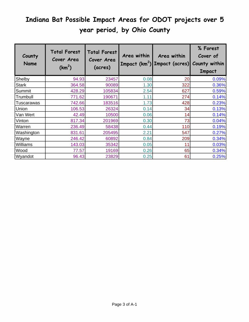
Indiana Bat Possible Impact Areas for ODOT projects over 5 year period, by Ohio County
County Name
Total Forest Cover Area
(km2)
Total Forest Cover Area
(acres)
Area within Impact (km2)
Area within Impact (acres)
% Forest Cover of
County within Impact
Shelby 94.93 23457 0.08 20 0.09%Stark 364.58 90089 1.30 322 0.36%Summit 428.29 105834 2.54 627 0.59%Trumbull 771.62 190671 1.11 274 0.14%Tuscarawas 742.66 183516 1.73 428 0.23%Union 106.53 26324 0.14 34 0.13%Van Wert 42.49 10500 0.06 14 0.14%Vinton 817.34 201969 0.30 73 0.04%Warren 236.49 58438 0.44 110 0.19%Washington 831.61 205495 2.21 547 0.27%Wayne 246.42 60892 0.84 209 0.34%Williams 143.03 35342 0.05 11 0.03%Wood 77.57 19169 0.26 65 0.34%Wyandot 96.43 23829 0.25 61 0.25%
Page 3 of A-1

Indiana Bat Impact Numbers for ODOT Projects over 5 year period, by Management Unit
County NameTotal Forest Cover Area
(acres)
Area within Impact (acres)
% Forest Cover of
County within Impact
Management Unit Name
Total Forest Cover (acres)
Total Impact (acres)
Total % Forest Cover of County in
Impact
West 675561 1565 0.23%Allen 24964 120 0.48%Auglaize 20834 0 0.00%Clark 24726 40 0.16%Darke 22441 1 0.00%Defiance 30245 195 0.65%Erie 34123 117 0.34%Fulton 17072 3 0.02%Greene 30466 26 0.09%Hancock 22435 152 0.68%Hardin 22581 21 0.09%Henry 12326 115 0.94%Huron 58034 63 0.11%Lucas 39743 168 0.42%Mercer 16214 10 0.06%Miami 21798 8 0.04%Montgomery 36251 74 0.21%Ottawa 15244 20 0.13%Paulding 15009 137 0.92%Preble 32161 30 0.09%Putnam 13527 19 0.14%Sandusky 20971 19 0.09%Seneca 32099 54 0.17%Shelby 23457 20 0.09%Van Wert 10500 14 0.14%Williams 35342 11 0.03%
Page 4 of A-2

Indiana Bat Impact Numbers for ODOT Projects over 5 year period, by Management Unit
County NameTotal Forest Cover Area
(acres)
Area within Impact (acres)
% Forest Cover of
County within Impact
Management Unit Name
Total Forest Cover (acres)
Total Impact (acres)
Total % Forest Cover of County in
Impact
Wood 19169 65 0.34%Wyandot 23829 61 0.25%
South 2870669 4679 0.16%Adams 201830 122 0.06%Athens 204049 479 0.23%Brown 93402 172 0.18%Butler 60206 167 0.28%Clermont 121989 267 0.22%Clinton 25767 30 0.11%Gallia 156791 135 0.09%Hamilton 88248 551 0.62%Highland 186634 40 0.02%Hocking 186685 340 0.18%Jackson 162056 273 0.17%Lawrence 187416 520 0.28%Meigs 150099 175 0.12%Perry 135365 300 0.22%Pike 183662 136 0.07%Ross 186634 217 0.12%Scioto 279429 574 0.21%Vinton 201969 73 0.04%Warren 58438 110 0.19%
Central 702459 2280 0.32%Crawford 26193 48 0.18%
Page 5 of A-2

Indiana Bat Impact Numbers for ODOT Projects over 5 year period, by Management Unit
County NameTotal Forest Cover Area
(acres)
Area within Impact (acres)
% Forest Cover of
County within Impact
Management Unit Name
Total Forest Cover (acres)
Total Impact (acres)
Total % Forest Cover of County in
Impact
Logan 45022 20 0.04%Knox 109566 118 0.11%Franklin 52118 732 1.40%Pickaway 26373 38 0.14%Marion 21216 55 0.26%Union 26324 34 0.13%Champaign 27246 5 0.02%Licking 152313 494 0.32%Fairfield 71242 175 0.25%Morrow 59736 71 0.12%Delaware 61073 443 0.73%Madison 13153 42 0.32%Fayette 10884 6 0.06%
North East 1695314 6370 0.38%Ashland 84903 232 0.27%Ashtabula 233408 641 0.27%Cuyahoga 83457 775 0.93%Geauga 153508 362 0.24%Holmes 98598 255 0.26%Lake 67585 972 1.44%Lorain 95223 337 0.35%Mahoning 97017 460 0.47%Medina 85340 350 0.41%Portage 147879 132 0.09%Richland 100910 422 0.42%
Page 6 of A-2

Indiana Bat Impact Numbers for ODOT Projects over 5 year period, by Management Unit
County NameTotal Forest Cover Area
(acres)
Area within Impact (acres)
% Forest Cover of
County within Impact
Management Unit Name
Total Forest Cover (acres)
Total Impact (acres)
Total % Forest Cover of County in
Impact
Stark 90089 322 0.36%Summit 105834 627 0.59%Trumbull 190671 274 0.14%Wayne 60892 209 0.34%
East 2170808 7224 0.33%Belmont 142155 751 0.53%Carroll 128324 299 0.23%Columbiana 138475 642 0.46%Coshocton 184971 472 0.26%Guernsey 200619 1105 0.55%Harrison 144417 937 0.65%Jefferson 144069 576 0.40%Monroe 177930 113 0.06%Morgan 159005 187 0.12%Muskingum 208595 836 0.40%Noble 153237 331 0.22%Tuscarawas 183516 428 0.23%Washington 205495 547 0.27%
Page 7 of A-2

Appendix B
Ohio Habitat Assessment Form (OHAF)
B-1

Prepared By: Date of Assessment:
Lat/Long coordinates approx. center of project: Decimal degrees, 5 decimal places (example 42.78963)
Latitude: Longitude:
W unit S unit C unit E unit NE unit
NO Project will have NO EFFECT on the Indiana bat and documentation filed at ODOT
YES Continue to #2.
NO
YES
NO
YES
No Continue to #5.
Yes Project LIKELY TO AFFECT the Indiana bat, Continue to Tier 2 ( Section 2: Part One)
NO
YES
2. Will any portion of project occur within 0.5 mile of a known or suspected hibernaculum?
Project MAY AFFECT the Indiana bat, follow Conservation Measure A-3 (Send Documentation to USFWS) and continue to #3
Roost trees are living trees (>8 inch dbh), standing dead trees or snags (trees with less than 10% live canopy) with exfoliating, peeling or loose bark, split trunks and/or branches, or cavities.
3. Will project clear any potential Indiana bat roost trees?
Continue to #3
Project MAY AFFECT the Indiana bat, continue to #5
6. Are all of the potential roost trees isolated?
Project will have NO EFFECT on the Indiana bat, documentation filed at ODOT (Unless answered yes on #2, then Project MAY AFFECT the Indiana bat, follow Conservation Measure A-3 (Send Documentation to USFWS) and continue to #4 );
4. Is the project within 5 miles of a known hibernaculum?
Indiana Bat Ohio Habitat Assessment Form (OHAF) for ODOT/USFWS use onlyto be used in conjunction with Indiana bat Programmatic Consultation, September 2006
1. Will any portion of project occur outside of the defined urban areas (GIS layer)?
to be used in conjunction with Indiana bat Programmatic Consultation, July 2006Section 1 ( Programmatic Consultation Tier 1)
Continue to #7
Project MAY AFFECT, NOT LIKELY TO ADVERSELY AFFECT the Indiana bat, send this OHAF documentation to USFWS for concurrence (seasonal cutting required if impacts do not meet PC1-a or PC1-b, or if any isolated maternity roost trees are being removed)
Project Name/Number:
Indiana bat Management Unit that Project primarily occurs in:
5. Is the project located between 5 and 10 miles of a hibernaculum?
No Continue to #6.
Yes Follow Conservation Measure A-3 Continue to #6.
OHAF Page 1 of 4

NO
YES
No
YES
NO
YES
NO
YES Project LIKELY TO AFFECT the Indiana bat, Continue to Tier 2 (Section 2; Part One)
NO
YES
NO
YES Project LIKELY TO aEFFECT the Indiana bat, Continue to Tier 2 (Section 2; Part One)
NO
YES Skip #14 & #15, Continue to #16.
NO
YES
NO
YES
(Trees >16 inch dbh, with some solar exposure; if not known, assume yes)
10. Will project remove more than 20 potential roost trees?
12. Will project remove more than 10 potential roost trees?
Project MAY AFFECT, NOT LIKELY TO ADVERSELY AFFECT the Indiana bat, Submit OHAF & project documentation to USFWS for concurrence.
Project MAY AFFECT, NOT LIKELY TO ADVERSELY AFFECT the Indiana bat, Submit OHAF & project documentation to USFWS and follow Conservation Measure A-1
Project MAY AFFECT, NOT LIKELY TO ADVERSELY AFFECT the Indiana bat, Submit OHAF documentation to USFWS for concurrence.
13. Will project occur within 5 miles of an Indiana bat capture record (including hibernacula records)?
14. Is the project area (that contains the potential roost trees) within a forest area of less than 100 acres, or connected to a forest area of less than 100 acres via a tree line (row of trees 2 or more wide)?
11. Will project occur within 5 miles of an Indiana bat capture record (including hibernacula records)?
9. Will project occur in W or C management unit?
Continue to #8
Continue to Tier 2 (Section 2; Part One)
7. Are any of the identified potential roost trees potential maternity roost trees?
Continue to #10
Skip 10 & 11, continue to #12
Continue to #11
8. Are any of the identified potential maternity roost trees isolated?
Continue to #9.
Continue to #15
15. Is there a perennial water source within 0.5 mile of potential roost trees (that are within a forest area of more than 100 acres)?
Project MAY AFFECT, NOT LIKELY TO ADVERSELY AFFECT the Indiana bat, Submit OHAF documentation to USFWS for concurrence.
Project MAY AFFECT, NOT LIKELY TO ADVERSELY AFFECT the Indiana bat, Submit OHAF documentation to USFWS for concurrence; follow Conservation Measure A-1
Continue to #14
Continue to #13
Project LIKELY TO AFFECT the Indiana bat, Continue to Tier 2 ( Section 2; Part one)
OHAF Page 2 of 4

NO
YES
NO Skip #18, Continue to #19
YES
NO
YES Project LIKELY TO AFFECT the Indiana batContinue to Tier 2 (Section 2; Part One)
NO
YES Project LIKELY TO AFFECT Indiana bat, Continue to Tier 2 (Section 2; Part One)
NO
YES Project LIKELY TO AFFECT Indiana bat, Continue to Tier 2 (Section 2; Part One)
Project MAY AFFECT, NOT LIKELY TO ADVERSELY AFFECT the Indiana bat, Submit OHAF documentation to USFWS for concurrence; follow Conservation Measure A-1
17. Is the project area (that contains the potential roost trees) within a forest area of less than 100 acres, or connected to a forest area of less than 100 acres via a tree line (row of trees 2 or more wide)?
Continue to #18
18. Will the project remove all, or a portion of, a potential Indiana bat travel corridor?
19. Will the project remove more than 10% of the forest area it is within (or connected to)?
20. Will the project remove all, or a portion of, a potential Indiana bat travel corridor?
Continue to #20
16. Will project occur in W management unit?
Continue to #17
Project MAY AFFECT, NOT LIKELY TO ADVERSELY AFFECT the Indiana bat, Submit OHAF documentation to USFWS for concurrence; follow Conservation Measure A-1
Project MAY AFFECT, NOT LIKELY TO ADVERSELY AFFECT the Indiana bat, Submit OHAF and/or NLAA documentation to USFWS for concurrence; follow Conservation Measure A-1
1 September 2006 CL, AZ, USFWS & ODOT
OHAF Page 3 of 4

NO
YES
NO
YES Choose Option #1 or Option #3
NO
YES
NO
YES
LIKELY TO ADVERSELY AFFECT; Continue to Part 2
LIKELY TO ADVERSELY AFFECT; Submit Tier 2 information to USFWS and follow applicable seasonal tree cutting date restrictions. If seasonal cutting dates can not be followed, request incidental take through Tier 2 submission. Follow Conservation Measures in PC to minimize adverse effects and mitigate by Management Unit (acre to acre) .
MAY AFFECT NOT LIKELY TO ADVERSELY AFFECT; Submit Tier 2 information to USFWS and if in S, E, or NE units, follow seasonal tree cutting dates. No seasonal cutting restrictions necessary in W or C units (unless otherwise noted in Tier 1). If appropriate seasonal cutting dates can not be followed request incidental take through Tier 2 submission.
MAY AFFECT NOT LIKELY TO ADVERSELY AFFECT; Submit Tier 2 information to USFWS and if in S, E, or NE units, follow seasonal tree cutting dates. No seasonal cutting restrictions necessary in W or C units (unless otherwise noted in Tier 1). If appropriate seasonal cutting dates can not be followed request incidental take through Tier 2 submission.
Option 3: Conduct mist net survey (in coordination with USFWS). Were Indiana bats caught during the survey?
Continue to #2 or #3
Indiana Bat Ohio Habitat Assessment Form (OHAF) for ODOT/USFWS use only
Coordinate with USFWS to choose measures that would be appropriate for minimizing harm to the maternity colony.
1 September 2006 CL, AZ, USFWS & ODOT
Part 21. Are Indiana bats caught that show signs of reproduction? (Female and juvenile Indiana bats only)
Part 1 Option 1: Assume presence (higher take in S, E, NE units)
Submit Tier 2 information, send to USFWS with the following conservation measures applied from the PC: A-1, and one or more of measures M-1, M-2, M-3, and M-4.
Option 2: Conduct emergence survey (one or few trees). Were bats observed during the survey?
to be used in conjunction with Indiana bat Programmatic Consultation,September 2006
Section 2 ( Programmatic Consultation Tier 2)
OHAF Page 4 of 4

Appendix C
Ohio Habitat Assessment Form Flowchart
C-1

Within the defined Urban Area GIS Layer? NO EFFECT (1)YES
Project within 5 miles of a known hibernaculum?
NO
Project within 0.5 mile of a hibernacuclum? YES YES
NO
Remove any potential roost trees?
NO
Will the project involve blasting during construction?
LIKELY TO ADVERSELY AFFECT (PC3-f), Tier 2 Consultation required.
Follow Conservation Measure A-3
YES
NO EFFECT (3)NO
YES LIKELY TO ADVERSELY AFFECT, Tier 2 Consultation required.
Are all of the potential roost trees isolated?
Project MAY AFFECT, NOT LIKELY TO ADVERSELY AFFECT, submit OHAF &
project documentation to USFWS for concurrence
YES
Are any of the identified potential roost trees
potential maternity roost trees?
NO
Project LIKELY TO ADVERSELY AFFECT
(PC3-d) Tier 2 Consultation required.
YES
Will project occur in W or C management unit?
Will project remove more than 10 potential
roost trees?
Will project remove more than 20 potential roost
trees?NO
YES
NOProject LIKELY TO
ADVERSELY AFFECT (PC3-c) Tier 2 Consultation
required.YES
Will project occur within 5 miles of an Indiana bat capture record (including hibernacula records)?
NO
Project MAY AFFECT, NOT LIKELY TO ADVERSELY AFFECT (PC2-b) tSubmit
OHAF & Project documentation to USFWS and follow Conservation Measure A-1
Project MAY AFFECT, NOT LIKELY TO ADVERSELY AFFECT (PC1-a) , Submit
OHAF & Project documentation to USFWS for concurrence.
YES
NO
Are the potential maternity roost trees isolated?
NO
YES
Will project occur within 5 miles of an Indiana bat capture
record?
NO
LIKELY TO ADVERSELY AFFECT (PC3-b), Tier 2 Consultation required.
YES
NO
Is the project area (that contains the potential roost trees) within a forest area of less than 100 acres, or connected to a forest area of less than 100 acres via a tree line (row of trees 2 or more wide)?
Will project occur in W management
unit?
YES
Project MAY AFFECT, NOT LIKELY TO ADVERSELY AFFECT (PC1-b)
Submit OHAF & Project documentation to USFWS for
concurrence.
YES
NO
Is there a perennial water source within 0.5 mile of potential roost trees (that are within a
forest area of more than 100 acres)?
NO
YES
Project MAY AFFECT, NOT LIKELY TO ADVERSELY AFFECT (PC2-a) the Indiana bat,
Submit OHAF documentation to USFWS for concurrence; follow Conservation Measure A-1
NO
YES
Is the project area (that contains the potential roost trees) within a forest area of
less than 100 acres, or connected to a forest area of less than 100 acres via a tree
line (row of trees 2 or more wide)?
YES
Will the project remove all, or a portion of, a potential Indiana bat
travel corridor?
NO
Will the project remove more than 10% of the forest area it is within (or
connected to)?
YES
NO
LIKELY TO ADVERSELY AFFECT (PC3-a), Tier 2 Consultation required.
Follow Conservation Measure A-3
Project MAY AFFECT, NOT LIKELY TO ADVERSELY AFFECT (PC2-d) the Indiana bat,
Submit OHAF documentation to USFWS for concurrence; follow Conservation Measure A-1
YES Will the project remove all, or a portion of, a potential Indiana bat
travel corridor?
NO
YES
NO
Project MAY AFFECT, NOT LIKELY TO ADVERSELY AFFECT (PC2-c) Submit
OHAF & project documentation to USFWS for concurrence; follow Conservation
Measure A-1
SE
PTE
MB
ER
1, 2
006
Project between 5 and 10 miles of a known
hibernaculum?
NO
YES
NO
Follow Conservation Measure A-3