for Proposed Walgreen’s 834 West Armitage Avenue -...
20
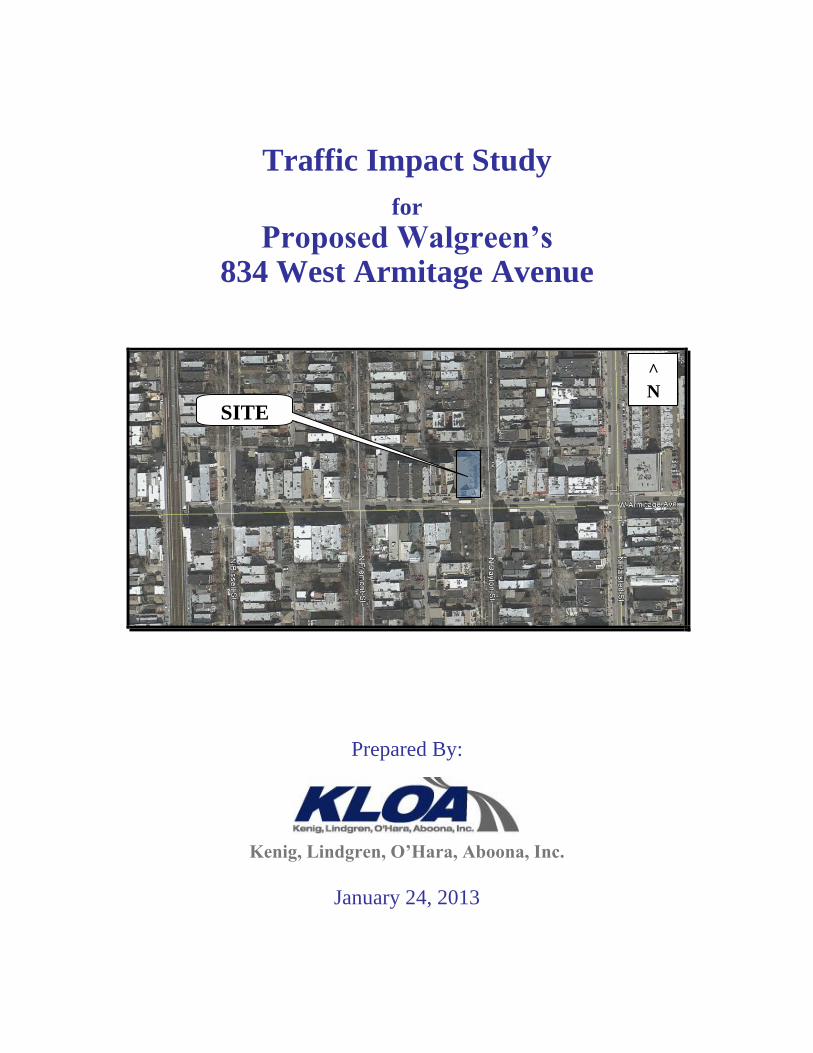
Traffic Impact Study for Proposed Walgreen’s 834 West Armitage Avenue Prepared By: Kenig, Lindgren, O’Hara, Aboona, Inc. January 24, 2013 ^ N SITE
Transcript of for Proposed Walgreen’s 834 West Armitage Avenue -...
Traffic Impact Study
for
Proposed Walgreen’s 834 West Armitage Avenue
Prepared By:
Kenig, Lindgren, O’Hara, Aboona, Inc.
January 24, 2013
^
N
SITE
834 West Armitage Avenue 1
Chicago, Illinois
Introduction
This report summarizes the methodologies, results and findings of a traffic impact study conducted
by Kenig, Lindgren, O’Hara, Aboona, Inc. (KLOA, Inc.) for the proposed Walgreen’s
neighborhood market store to be located at 834 West Armitage Avenue in Chicago, Illinois. The
existing site has been razed to accommodate this proposed development.
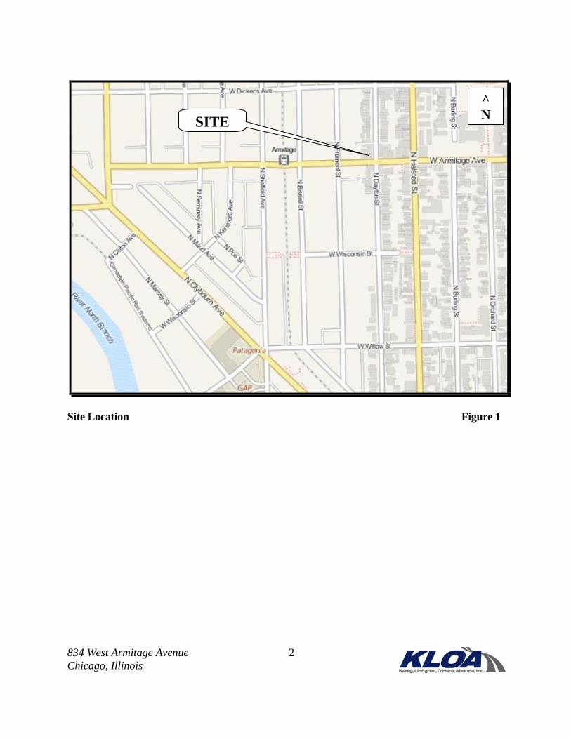
The site is bound by a public alley/residential to the north, Armitage Avenue to the south,
commercial/residential to the west, and Dayton Street to the east. The site is located in the Lincoln
Park area with commercial and residential buildings in the site vicinity. The Armitage CTA
elevated “L” transit line serving the Brown Line and the Purple Line Express is located
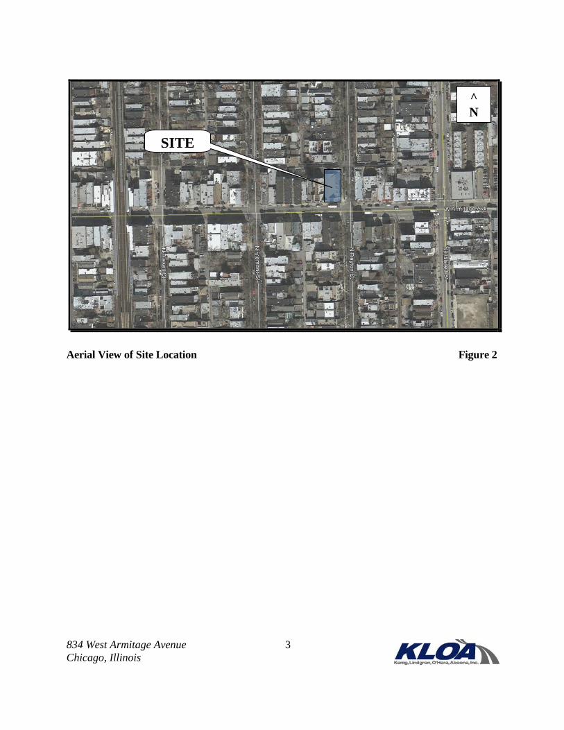
approximately two blocks west of the site. Figure 1 shows the location of the site in relation to the
area street system. Figure 2 shows an aerial view of the site area.
The development proposes an approximate 15,000 square-foot Walgreen’s store. Unlike the typical
suburban standalone store, this Walgreen’s store will serve the local, immediately surrounding
neighborhood and, as such, will not provide a pharmacy drive-through facility or off-street parking.
The construction of this proposed development is planned to begin within the next year. For the
purposes of this study, it is assumed that the development is completed and fully occupied in one
construction phase.
The purpose of this study includes the following.
Determine the existing traffic, pedestrian, bicycle, and public transportation conditions in
the area to establish a base condition.
Assess the impact that the proposed development will have on traffic, pedestrian, and
bicycle conditions in the area.
Determine if any street, access, bicycle, or pedestrian crossing improvements are necessary
to accommodate the proposed development plan.
834 West Armitage Avenue 2
Chicago, Illinois
Site Location Figure 1
^
N SITE
834 West Armitage Avenue 3
Chicago, Illinois
Aerial View of Site Location Figure 2
^
N
SITE
834 West Armitage Avenue 4
Chicago, Illinois
The following sections of this report present the following.
Existing street conditions.
A description of the proposed development plan.
Directional distribution of development-generated traffic.
Vehicle trip generation for the proposed development.
Traffic analyses for the weekday morning, weekday evening, and Saturday midday peak
hours for both the existing and future conditions.
Recommendations with respect to circulation to the surrounding street network and
pedestrian and bicycle features for the future condition.
Existing Conditions
Existing street and traffic conditions near the site were documented based on field visits and
traffic counts. The following provides a detailed description of the physical characteristics of the
streets including geometry and traffic control, adjacent land uses and peak hour traffic flows
along area streets.
Existing Area
The site is located in the Lincoln Park area. Armitage Avenue, in the proximity of the site, is
lined with retail shops and restaurants serving the neighborhood and the surrounding environs.
Off-street parking is generally not available to these businesses. The all-way stop intersections at
Fremont Street and at Dayton Street control the traffic speeds through the area and allow
pedestrians and bicycles to cross at a traffic-controlled intersection.
Existing Street System Characteristics
The characteristics of the existing streets near the site are illustrated in Figure 3 and described
below. All streets are under the jurisdiction of the Chicago Department of Transportation
(CDOT).
Armitage Avenue is a two-way east-west street providing one through lane in each direction and a
bike lane on both the north and south sides of the street. It is under all-way stop sign control at
its intersections with Dayton Street and Fremont Street. On-street parking is generally available
on both sides of the street. Armitage Avenue is served by CTA Bus Route #73 that has a bus
stop (sign only) at Fremont Street on the near side of the intersection for both directions of travel.
Dayton Street is a one-lane, one-way northbound local street that is under stop sign control at its
intersection with Armitage Avenue. On-street parking is generally permitted on both sides of the
street. Permit parking is required between 6:00 P.M. and 6:00 A.M. every day.

PROJECT: TITLE:
Job No: 12-192
Figure: 3
SITE
Proposed Walgreen’s
834 West Armitage Ave
Chicago, Illinois
N
NOT TO SCALE
LEGEND
P
- TRAVEL LANE
- STOP SIGN
- ON-STREET PARKING
- BIKE LANE
- CTA BUS STOP (SIGN ONLY)
- PEDESTRIAN CROSSWALK
P P
P
P
P
P
P
P
P P
P P
ARMITAGE AVE
FR
EM
ON
T S
T
DA
YT
ON
ST
ON
E-W
AY
ON
E-W
AY
Existing Street Characteristics
834 West Armitage Avenue 6
Chicago, Illinois
Fremont Street is a one-lane, one-way southbound local street that is under stop sign control at its
intersection with Armitage Avenue. On-street parking is generally permitted on both sides of the
street. Permit parking is required between 6:00 P.M. and 6:00 A.M. every day.
Existing Vehicle, Pedestrian, and Bicycle Traffic Volumes
In order to determine current traffic, pedestrian, and bicycle conditions near the proposed
development and on the surrounding streets, KLOA, Inc. conducted peak period traffic,
pedestrian, and bicycle counts at the following two intersections:
1. Dayton Street and Armitage Avenue
2. Fremont Street and Armitage Avenue
The counts were conducted on Wednesday, December 19, 2012 during the morning (7:00 to 9:00
A.M.), and the evening (4:00 to 6:00 P.M.) peak periods, and also on Saturday, January 5, 2013
between 11:30 A.M. and 1:30 P.M. The results of the traffic counts showed that the weekday
morning peak hour of traffic occurs between 7:15 and 8:15 A.M., the weekday evening peak hour
of traffic occurs between 5:00 and 6:00 P.M., and the Saturday midday peak hour occurs between
12:30 and 1:30 P.M.
Figure 4A illustrates the existing peak hour vehicle traffic volumes. Figure 4B illustrates the
existing peak hour pedestrian and bicycle volumes, showing the direction of travel.
Alternative Modes of Transportation
Accessibility to and from the area is enhanced by the various alternative modes of transportation
serving the area as summarized below.
Public Transportation. The CTA “L” has a local stop at the Armitage Station for the Brown
Line and Purple Line Express. The “L” is located near Sheffield, which is approximately two
blocks west of the site. The station provides easy access to this area and provides its residents
and local commuters with direct access to and from the Loop.
Further, CTA Bus Route #73 traverses Armitage Avenue, providing a bus stop (sign only) for
each direction of travel on the near side of the intersection at Fremont Street. This bus route
typically runs 12 or more hours per day, every day.
Pedestrian Facilities. Crosswalks are provided on all four approaches on Armitage Avenue at
its intersections with Fremont Street and Dayton Street. Sidewalks are also provided on the
surrounding street network.
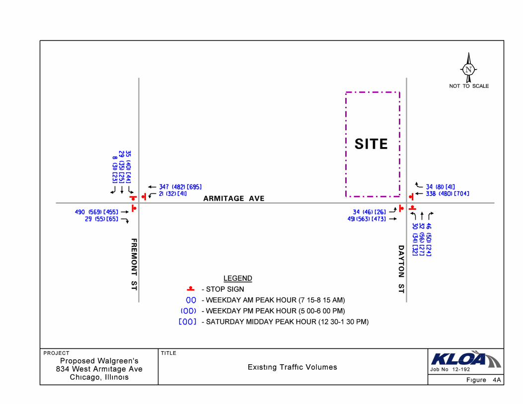
PROJECT: TITLE:
Existing Traffic Volumes Job No: 12-192
SITE
Proposed Walgreen’s
834 West Armitage Ave
Chicago, Illinois
34 (81) [41]
338 (480) [704]
34 (46) [26]
491 (563) [473]
347 (482) [695]
21 (32) [41]
490 (569) [455]
29 (55) [65]
LEGEND
00
(00)
[00]
- WEEKDAY AM PEAK HOUR (7:15-8:15 AM)
- WEEKDAY PM PEAK HOUR (5:00-6:00 PM)
- SATURDAY MIDDAY PEAK HOUR (12:30-1:30 PM)
N
NOT TO SCALE
- STOP SIGN
FR
EM
ON
T S
T
ARMITAGE AVE
DA
YT
ON
ST
Figure: 4A
35 (4
0) [4
4]
29
(35
) [25
]
8 (3
1) [2
3]
30
(34
) [32
]
32 (5
6) [2
7]
46
(50
) [24
]
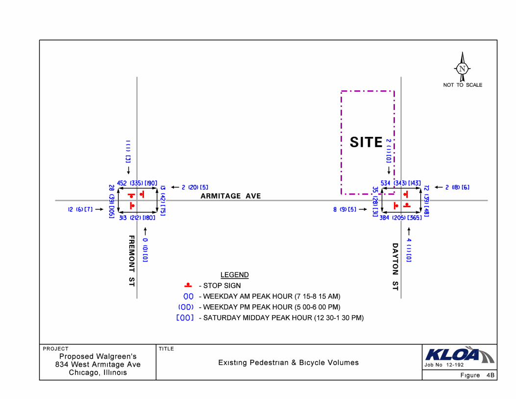
PROJECT: TITLE:
Job No: 12-192
SITE
Proposed Walgreen’s
834 West Armitage Ave
Chicago, Illinois
LEGEND
00
(00)
[00]
- WEEKDAY AM PEAK HOUR (7:15-8:15 AM)
- WEEKDAY PM PEAK HOUR (5:00-6:00 PM)
- SATURDAY MIDDAY PEAK HOUR (12:30-1:30 PM)
N
NOT TO SCALE
- STOP SIGN
FR
EM
ON
T S
T
ARMITAGE AVE
DA
YT
ON
ST
Figure: 4B
Existing Pedestrian & Bicycle Volumes
452 (335) [190]
313 (212) [180]
13
(42
) [75
]
2 (20) [5]
12 (6) [7]
28 (3
9) [1
05]
0 (
0) [
0]
534 (343) [143]
384 (205) [365]
72
(39
) [48
]
2 (18) [6]
8 (9) [5]
35
(28
) [31
]
2 ( 1
) [0]
4 ( 1
) [0]
1 ( 1
) [3]
834 West Armitage Avenue 9
Chicago, Illinois
Bicycle Facilities. As noted, established bike lanes are provided on Armitage Avenue for each
direction of travel on both sides of the street.
Traffic Characteristics of 834 West Armitage Avenue
To evaluate the impact of the subject development on the area street system, it was necessary to
quantify the number of vehicle trips the site will generate given the unique character of the
proposed Walgreen’s store where neither a drive-through pharmacy service nor off-street parking
will be provided.
Site Location
The site, which is currently vacant, is located in the Lincoln Park neighborhood, with primarily
residential land uses surrounding the site. Armitage Avenue is lined with retail stores and
restaurants through this corridor. Sidewalks, crosswalks, and established bike lanes are provided
on Armitage Avenue and the adjacent streets to promote pedestrian and bicycle activity.
Proposed Land Use Plan
The development proposes an approximate 15,000 square-foot Walgreen’s store. Unlike the typical
suburban standalone store, this Walgreen’s store will serve to the local, immediately surrounding
neighborhood and, as such, will not offer a pharmacy drive-through facility or any off-street
parking.
Parking
Off-street parking will not be provided for this development. As such, driveway access is not
proposed from either Armitage Avenue or Dayton Street. As noted, ample on-street parking is
provided on both the north and south sides of Armitage Avenue, providing approximately six to
eight parking spaces on either side of Armitage between Dayton Street and Fremont Street, with
additional on-street parking provided east of Dayton Street towards Halsted Street, and west of
Fremont Street towards Sheffield Avenue. Further, on-street parking is provided on both the east
and west sides of both Dayton Street and Fremont Street between 6:00 A.M. and 6:00 P.M. every
day. On-street parking on both Dayton Street and Fremont Street is restricted to permit parking
only between 6:00 P.M. and 6:00 A.M. every day.
834 West Armitage Avenue 10
Chicago, Illinois
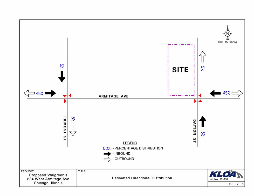
Directional Distribution of Site Traffic
The directional distribution of site-generated trips on the external streets (illustrated in Figure 5)
considers the existing traffic patterns, the one-way orientation of both Dayton Street and Fulton
Street, and the surrounding environs.
Site Traffic Generation
The estimates of traffic to be generated by the site are based upon the proposed land use type and
size. The volume of traffic generated was estimated using data published in the Institute of
Transportation Engineers (ITE) Trip Generation Manual, 8th
Edition. However, the ITE trip rates
are based on suburban rates where the primary mode of transportation is the automobile.
The development is served by the Armitage CTA Station (Brown and Purple Express Lines) and
CTA Bus Route #73 along Armitage Avenue. Further, pedestrian and bicycle facilities are
provided to encourage foot traffic to the store, rather than vehicle traffic. Lastly, the
development is not proposing any off-street/convenient parking because this store is catering to
the immediate surrounding environs, particularly the pedestrian commuters traversing to/from the
Armitage CTA “L” station, and the residential developments surrounding the site. All of these
components will greatly reduce the number of actual vehicles driving to/from the development
each day.
To quantify this reduction in trips that will be made to the proposed store, KLOA, Inc. utilized a
previous trip generation study conducted at a use similar to the proposed Walgreen’s, as follows:
Has a pharmacy
No off-street parking
No drive-through service
Near public transportation
Near other retail/commercial uses
Near residential areas
The survey, which was conducted to determine how many customers drove to the site, indicated
that only between nine percent of the customers on a weekday and twelve percent of the
customers on a Saturday drove with the remainder captured from the pedestrian activity in the
area, as well as from the residents and employees living and working within walking distance
from the site.
The site of this proposed Walgreen’s, as indicated earlier, is similar and is therefore anticipated
to exhibit similar travel characteristics with a similar small number of customers driving to the
store.
PROJECT: TITLE:
Job No: 12-192
SITE
Proposed Walgreen’s
834 West Armitage Ave
Chicago, Illinois
LEGEND
N
NOT TO SCALE
ARMITAGE AVE
Figure: 5
Estimated Directional Distribution
5%
45%
5%
5%
5%
45%
- PERCENTAGE DISTRIBUTION
- INBOUND
- OUTBOUND
00%
FR
EM
ON
T S
T
DA
YT
ON
ST
834 West Armitage Avenue 12
Chicago, Illinois
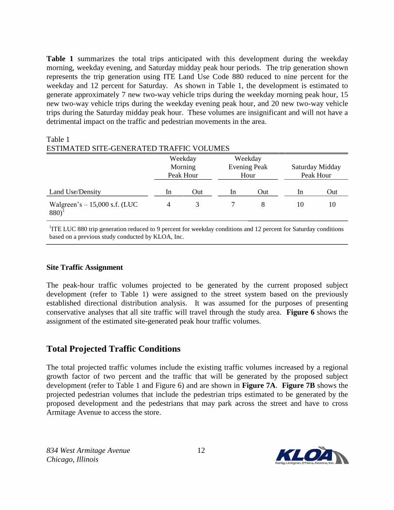
Table 1 summarizes the total trips anticipated with this development during the weekday
morning, weekday evening, and Saturday midday peak hour periods. The trip generation shown
represents the trip generation using ITE Land Use Code 880 reduced to nine percent for the
weekday and 12 percent for Saturday. As shown in Table 1, the development is estimated to
generate approximately 7 new two-way vehicle trips during the weekday morning peak hour, 15
new two-way vehicle trips during the weekday evening peak hour, and 20 new two-way vehicle
trips during the Saturday midday peak hour. These volumes are insignificant and will not have a
detrimental impact on the traffic and pedestrian movements in the area.
Table 1
ESTIMATED SITE-GENERATED TRAFFIC VOLUMES
Land Use/Density
Weekday
Morning
Peak Hour
Weekday
Evening Peak
Hour
Saturday Midday
Peak Hour
In Out In Out
In Out
Walgreen’s – 15,000 s.f. (LUC
880)1
4 3 7 8 10 10
1ITE LUC 880 trip generation reduced to 9 percent for weekday conditions and 12 percent for Saturday conditions
based on a previous study conducted by KLOA, Inc.
Site Traffic Assignment
The peak-hour traffic volumes projected to be generated by the current proposed subject
development (refer to Table 1) were assigned to the street system based on the previously
established directional distribution analysis. It was assumed for the purposes of presenting
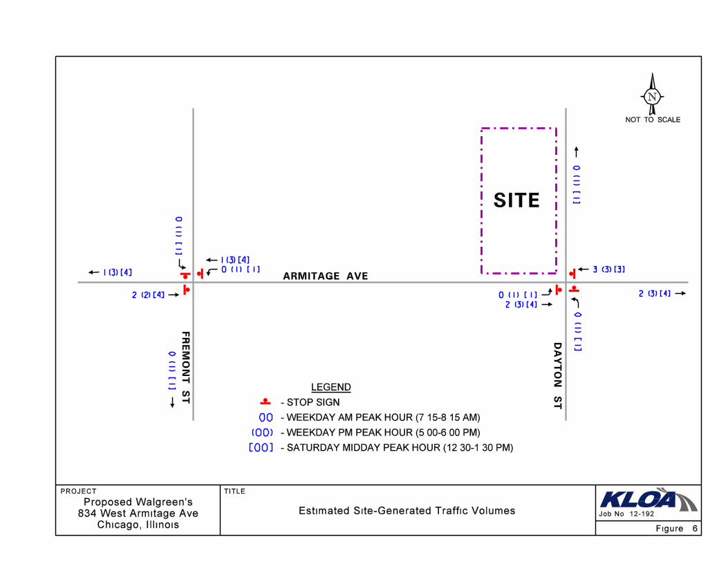
conservative analyses that all site traffic will travel through the study area. Figure 6 shows the
assignment of the estimated site-generated peak hour traffic volumes.
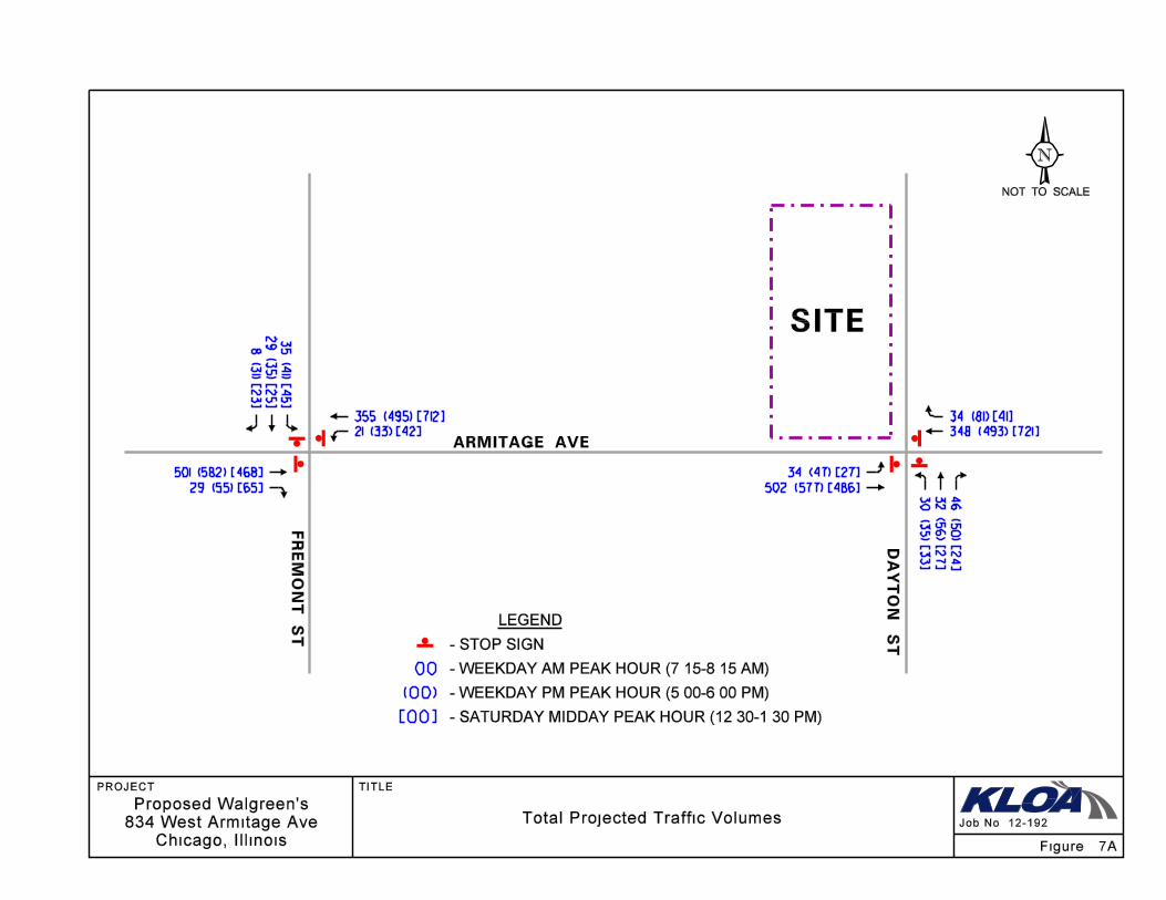
Total Projected Traffic Conditions
The total projected traffic volumes include the existing traffic volumes increased by a regional
growth factor of two percent and the traffic that will be generated by the proposed subject
development (refer to Table 1 and Figure 6) and are shown in Figure 7A. Figure 7B shows the
projected pedestrian volumes that include the pedestrian trips estimated to be generated by the
proposed development and the pedestrians that may park across the street and have to cross
Armitage Avenue to access the store.
PROJECT: TITLE:
Job No: 12-192
SITE
Proposed Walgreen’s
834 West Armitage Ave
Chicago, Illinois
LEGEND
00
(00)
[00]
- WEEKDAY AM PEAK HOUR (7:15-8:15 AM)
- WEEKDAY PM PEAK HOUR (5:00-6:00 PM)
- SATURDAY MIDDAY PEAK HOUR (12:30-1:30 PM)
N
NOT TO SCALE
- STOP SIGN
ARMITAGE AVE
Figure: 6
2 (2) [4]
1 (3) [4]
2 (3) [4]
2 (3) [4]
3 (3) [3]
Estimated Site-Generated Traffic Volumes
FR
EM
ON
T S
T
DA
YT
ON
ST
0 ( 1
) [ 1 ]
0 ( 1 ) [ 1 ]1 (3) [4]
0 ( 1
) [ 1 ]
0 ( 1
) [ 1 ]
0 ( 1
) [ 1 ]
0 ( 1 ) [ 1 ]
PROJECT: TITLE:
Job No: 12-192
SITE
Proposed Walgreen’s
834 West Armitage Ave
Chicago, Illinois
34 (81) [41]
348 (493) [721]
34 (47) [27]
502 (577) [486]
355 (495) [712]
501 (582) [468]
29 (55) [65]
LEGEND
00
(00)
[00]
- WEEKDAY AM PEAK HOUR (7:15-8:15 AM)
- WEEKDAY PM PEAK HOUR (5:00-6:00 PM)
- SATURDAY MIDDAY PEAK HOUR (12:30-1:30 PM)
N
NOT TO SCALE
- STOP SIGN
ARMITAGE AVE
35 (4
1) [4
5]
29
(35
) [25
]
8 (3
1) [2
3]
32
(56
) [27
]
46
(50
) [24
]
Total Projected Traffic Volumes
FR
EM
ON
T S
T
DA
YT
ON
ST
21 (33) [42]
30 (3
5) [3
3]
Figure: 7A

PROJECT: TITLE:
Job No: 12-192
SITE
Proposed Walgreen’s
834 West Armitage Ave
Chicago, Illinois
LEGEND
00
(00)
[00]
- WEEKDAY AM PEAK HOUR (7:15-8:15 AM)
- WEEKDAY PM PEAK HOUR (5:00-6:00 PM)
- SATURDAY MIDDAY PEAK HOUR (12:30-1:30 PM)
N
NOT TO SCALE
- STOP SIGN
FR
EM
ON
T S
T
ARMITAGE AVE
DA
YT
ON
ST
Figure: 7B
Projected Pedestrian & Bicycle Volumes
469 (365) [220]
320 (223) [190]
13 (4
2) [7
5]
2 (20) [5]
12 (6) [7]
28
(39
) [10
5]
0 (
0) [
0]
551 (373) [173]
384 (205) [365]
72
(39
) [48
]
2 (18) [6]
8 (9) [5]
42 (3
8) [4
1]
2 ( 1
) [0]
4 ( 1
) [0]
1 ( 1
) [3]

834 West Armitage Avenue 16
Chicago, Illinois
Traffic Analysis
Traffic analyses were performed to determine the operation of the existing street system, evaluate
the impact of the proposed development plan, and determine the ability of the existing street system
to accommodate projected traffic demands. Analyses were performed for the weekday morning,
weekday evening, and Saturday midday peak hours for both the existing traffic volumes and the
total projected traffic volumes upon development of the site.
The traffic analyses were performed using the methodologies outlined in the Transportation
Research Board’s Highway Capacity Manual (HCM), 2010 and modeled/analyzed using
Synchro/SimTraffic software.
The analyses for the unsignalized intersections determine the average control delay to vehicles at an
intersection. The methodology analyzes each intersection approach controlled by a stop sign and
considers traffic volumes on all approaches and lane characteristics.
The ability of an intersection to accommodate traffic flow is expressed in terms of level of
service, which is assigned a letter grade from A to F based on the average control delay experi-
enced by vehicles passing through the intersection. Control delay is that portion of the total delay
attributed to the traffic signal or stop sign control operation, and includes initial deceleration
delay, queue move-up time, stopped delay, and final acceleration delay. Level of Service A is the
highest grade (best traffic flow and least delay), Level of Service E represents saturated or at-
capacity conditions, and Level of Service F is the lowest grade (oversaturated conditions,
extensive delays).
The Highway Capacity Manual definitions for levels of service and the corresponding control delay
for unsignalized intersections are shown in Table 2. Summaries of the traffic analysis results for the
existing conditions and the future conditions are presented in Table 3 and Table 4, respectively. A
copy of the capacity analysis output sheets are included in the Appendix.
Table 2
LEVEL OF SERVICE CRITERIA
Unsignalized Intersections
Level of Service Average Control Delay (seconds per vehicle)
A 0 - 10
B > 10 - 15
C > 15 - 25
D > 25 - 35
E > 35 - 50
F > 50
Source: Highway Capacity Manual, 2010.
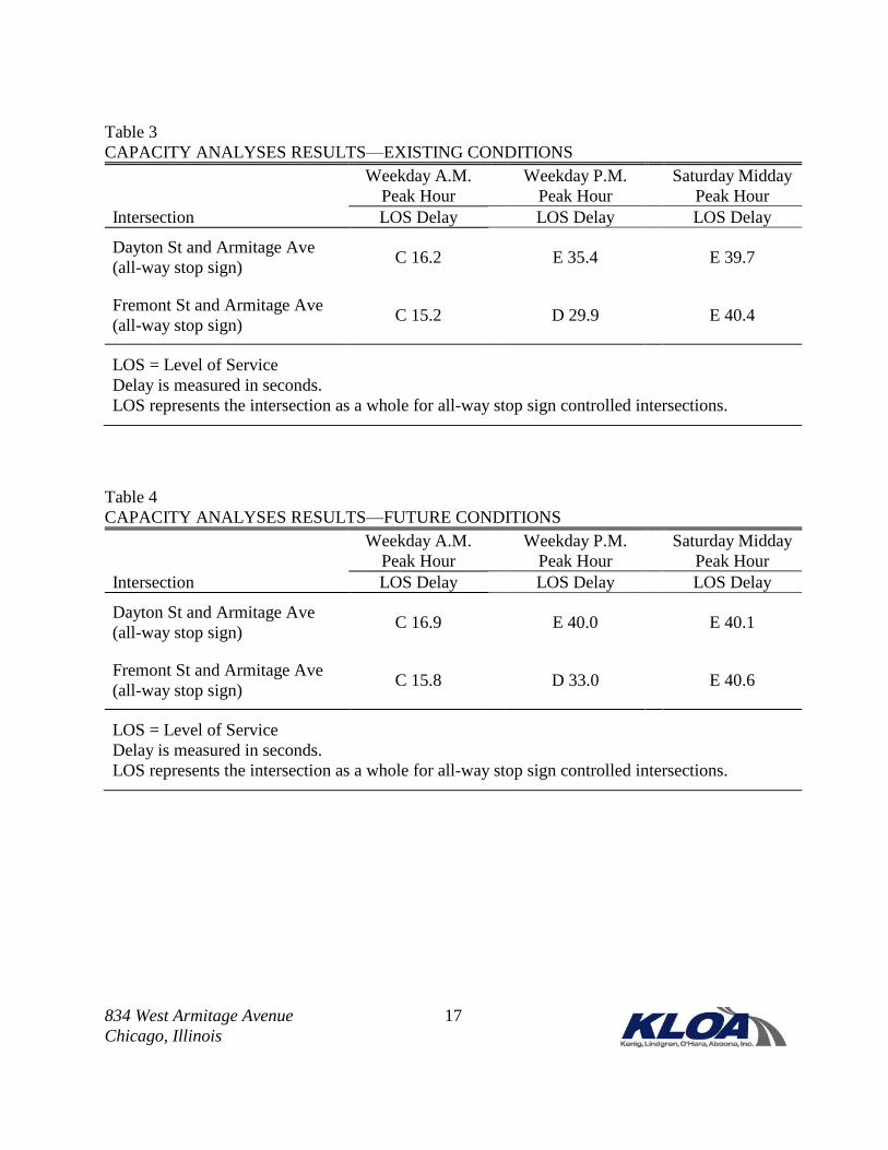
834 West Armitage Avenue 17
Chicago, Illinois
Table 3
CAPACITY ANALYSES RESULTS—EXISTING CONDITIONS
Weekday A.M.
Peak Hour
Weekday P.M.
Peak Hour
Saturday Midday
Peak Hour
Intersection LOS Delay LOS Delay LOS Delay
Dayton St and Armitage Ave
(all-way stop sign) C 16.2 E 35.4 E 39.7
Fremont St and Armitage Ave
(all-way stop sign) C 15.2 D 29.9 E 40.4
LOS = Level of Service
Delay is measured in seconds.
LOS represents the intersection as a whole for all-way stop sign controlled intersections.
Table 4
CAPACITY ANALYSES RESULTS—FUTURE CONDITIONS
Weekday A.M.
Peak Hour
Weekday P.M.
Peak Hour
Saturday Midday
Peak Hour
Intersection LOS Delay LOS Delay LOS Delay
Dayton St and Armitage Ave
(all-way stop sign) C 16.9 E 40.0 E 40.1
Fremont St and Armitage Ave
(all-way stop sign) C 15.8 D 33.0 E 40.6
LOS = Level of Service
Delay is measured in seconds.
LOS represents the intersection as a whole for all-way stop sign controlled intersections.
834 West Armitage Avenue 18
Chicago, Illinois
Discussion and Recommendations
Traffic capacity analyses were conducted for both the existing conditions and the future projected
condition, which considers the proposed development and an increase in existing traffic due to
regional growth in the area.
Both the intersections of Armitage Avenue at Dayton Street and at Fremont Street are under all-
way stop control and provide crosswalks on all four approaches with a bike lane on either side of
Armitage Avenue. The analyses show that these intersections, under future conditions, will
continue to operate at the same levels of service, with minimal increase in the overall delay. As
such, no geometric or traffic control improvements are needed at these intersections.
A review of both the existing and projected peak hour traffic volumes at these two intersections
indicates that a traffic signal is not warranted at either intersection.
Traffic observations that were made during the peak hours noted no significant queuing in either
direction on Armitage Avenue, and that Dayton Street and Fremont Street remained clear. The
two traffic signals at Sheffield Avenue to the west and at Halsted Street to the east effectively
platoon and gap the traffic entering this particular section of Armitage Avenue.
The small increase in traffic related to both the proposed Walgreen’s, as well as the increase in
regional traffic through the corridor will have a low impact on these two intersections.
Parking
As noted, the Walgreen’s store will not provide off-street parking, which is in character with the
other retail shops/restaurants in this area. Observations during peak hours noted ample on-street
parking on both sides of Armitage Avenue. Further, on-street parking is also provided on both
sides of both Dayton Street and on Fremont Street and is available between 6:00 A.M. and 6:00
P.M., which would coincide with peak demand at the Walgreen’s store.
Pedestrian Evaluation
The development is served by an adequate sidewalk system on the surrounding street network as
well as established crosswalks to aid pedestrians/bicycles to access the development with
minimal vehicle/pedestrian conflicts. The capacity analyses performed included an increase in
pedestrian volumes related to the Walgreen’s store development. The analyses show that with
the increase in pedestrians, these intersections will continue to operate at the same levels of
service.
834 West Armitage Avenue 19
Chicago, Illinois
Conclusion
The subject development, located at 834 West Armitage Avenue, is located in the Lincoln Park
neighborhood, with predominantly residential and commercial uses within the vicinity of the site.
Armitage Avenue is lined with retail stores and restaurants. Further, the Armitage CTA “L” station,
bus route, sidewalks, crosswalks, and bike lanes in the area help to create a pedestrian-friendly
environment.
The proposed 15,000 square-feet Walgreen’s store will serve the local neighborhood and will be
unique from the suburban stores in that it will not provide drive-through pharmacy service or off-
street parking. As a result, no driveway curb cuts are requested or needed, thereby preserving and
further promoting pedestrian activity in the area. The store will cater to pedestrians in the area
either living in the nearby area or commuting to/from the Armitage CTA “L” station. As such,
vehicle activity of patrons visiting the store is expected to be very low. In addition, observations of
the area during peak hour conditions noted ample on-street parking to support the low volume of
vehicles that may stop at the Walgreen’s store, most likely en route to another destination.
Traffic capacity analyses were conducted for both existing and future conditions. The future
conditions considered the low estimated traffic expected from the Walgreen’s store, in addition to
an increase in regional growth in traffic along the Armitage Avenue corridor, and an increase in
pedestrians accessing the store. The results show that the two studied intersections, Armitage
Avenue at Dayton Street and at Fremont Street, will continue to operate at the same overall level of
service with minimal increase in overall delay. The small amount of vehicle and pedestrian traffic
estimated to be added to these intersections as a result of the proposed development and regional
growth is minimal, and will be imperceptible to the average driver.
In conclusion, the proposed Walgreen’s development will have a very low traffic impact on the
surrounding environs. No geometric, traffic control, or pedestrian-focused improvements are
needed in conjunction with this proposed development.
12-192 Traffic Study for 834 Armitage (Walgreen's) in Chicago 01-24-2013 wrw lra.doc