Fontanine, Iulia; Costache, Romulus and Slãnic rivers, in ......Fontanine, Iulia; Costache, Romulus...
12
www.ssoar.info Using GIS techniques for surface runoff potential analysis in the Subcarpathian area between Buzãu and Slãnic rivers, in Romania Fontanine, Iulia; Costache, Romulus Veröffentlichungsversion / Published Version Zeitschriftenartikel / journal article Empfohlene Zitierung / Suggested Citation: Fontanine, I., & Costache, R. (2013). Using GIS techniques for surface runoff potential analysis in the Subcarpathian area between Buzãu and Slãnic rivers, in Romania. Cinq Continents, 3(7), 47-57. https://nbn-resolving.org/ urn:nbn:de:0168-ssoar-359776 Nutzungsbedingungen: Dieser Text wird unter einer CC BY-NC Lizenz (Namensnennung- Nicht-kommerziell) zur Verfügung gestellt. Nähere Auskünfte zu den CC-Lizenzen finden Sie hier: https://creativecommons.org/licenses/by-nc/4.0/deed.de Terms of use: This document is made available under a CC BY-NC Licence (Attribution-NonCommercial). For more Information see: https://creativecommons.org/licenses/by-nc/4.0
Transcript of Fontanine, Iulia; Costache, Romulus and Slãnic rivers, in ......Fontanine, Iulia; Costache, Romulus...
www.ssoar.info
Using GIS techniques for surface runoff potentialanalysis in the Subcarpathian area between Buzãuand Slãnic rivers, in RomaniaFontanine, Iulia; Costache, Romulus
Veröffentlichungsversion / Published VersionZeitschriftenartikel / journal article
Empfohlene Zitierung / Suggested Citation:Fontanine, I., & Costache, R. (2013). Using GIS techniques for surface runoff potential analysis in the Subcarpathianarea between Buzãu and Slãnic rivers, in Romania. Cinq Continents, 3(7), 47-57. https://nbn-resolving.org/urn:nbn:de:0168-ssoar-359776
Nutzungsbedingungen:Dieser Text wird unter einer CC BY-NC Lizenz (Namensnennung-Nicht-kommerziell) zur Verfügung gestellt. Nähere Auskünfte zuden CC-Lizenzen finden Sie hier:https://creativecommons.org/licenses/by-nc/4.0/deed.de
Terms of use:This document is made available under a CC BY-NC Licence(Attribution-NonCommercial). For more Information see:https://creativecommons.org/licenses/by-nc/4.0

USING GIS TECHNIQUES FOR SURFACE RUNOFF POTENTIAL ANALYSIS IN
THE SUBCARPATHIAN AREA BETWEEN BUZĂU AND SLĂNIC RIVERS, IN ROMANIA
Iulia FONTANINE Romulus COSTACHE
Contents: 1. INTRODUCTION ..................................................................................................................................................... 49 2. METHODOLOGY ..................................................................................................................................................... 50 3. RESULTS .................................................................................................................................................................... 54 4. CONCLUSIONS ........................................................................................................................................................ 56 5. REFERENCES ........................................................................................................................................................... 56
Cite this document: Fontanine, I., Costache, R., 2013. Using GIS techniques for surface runoff potential analysis in the Subcarpathian area between Buzău and Slănic rivers, in Romania. Cinq Continents 3 (7): 47-57 [Available online]| URL : http://www.cinqcontinents.uv.ro/3/3_7_Fontanine.pdf
Volume 3 / Numéro 7
Été 2013
ISSN: 2247 - 2290
p. 47-57
Faculty of Geography University of Bucharest
Cinq Continents Volume 3, Numéro 7, 2013, p. 47-57
[48]
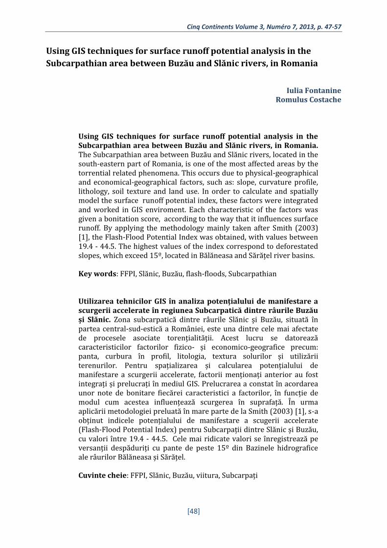
Using GIS techniques for surface runoff potential analysis in the
Subcarpathian area between Buzău and Slănic rivers, in Romania
Iulia Fontanine
Romulus Costache
Using GIS techniques for surface runoff potential analysis in the Subcarpathian area between Buzău and Slănic rivers, in Romania. The Subcarpathian area between Buzău and Slănic rivers, located in the south-eastern part of Romania, is one of the most affected areas by the torrential related phenomena. This occurs due to physical-geographical and economical-geographical factors, such as: slope, curvature profile, lithology, soil texture and land use. In order to calculate and spatially model the surface runoff potential index, these factors were integrated and worked in GIS enviroment. Each characteristic of the factors was given a bonitation score, according to the way that it influences surface runoff. By applying the methodology mainly taken after Smith (2003) [1], the Flash-Flood Potential Index was obtained, with values between 19.4 - 44.5. The highest values of the index correspond to deforestated slopes, which exceed 15º, located in Bălăneasa and Sărățel river basins. Key words: FFPI, Slănic, Buzău, flash-floods, Subcarpathian Utilizarea tehnicilor GIS în analiza potențialului de manifestare a scurgerii accelerate în regiunea Subcarpatică dintre râurile Buzău și Slănic. Zona subcarpatică dintre râurile Slănic și Buzău, situată în partea central-sud-estică a României, este una dintre cele mai afectate de procesele asociate torențialității. Acest lucru se datorează caracteristicilor factorilor fizico- și economico-geografice precum: panta, curbura în profil, litologia, textura solurilor și utilizării terenurilor. Pentru spațializarea și calcularea potențialului de manifestare a scurgerii accelerate, factorii menționați anterior au fost integrați și prelucrați în mediul GIS. Prelucrarea a constat în acordarea unor note de bonitare fiecărei caracteristici a factorilor, în funcție de modul cum acestea influențează scurgerea în suprafață. În urma aplicării metodologiei preluată în mare parte de la Smith (2003) [1], s-a obținut indicele potențialului de manifestare a scugerii accelerate (Flash-Flood Potential Index) pentru Subcarpații dintre Slănic și Buzău, cu valori între 19.4 - 44.5. Cele mai ridicate valori se înregistrează pe versanții despăduriți cu pante de peste 15º din Bazinele hidrografice ale râurilor Bălăneasa și Sărățel. Cuvinte cheie: FFPI, Slănic, Buzău, viitura, Subcarpați
I. FONTANINE, R. COSTACHE
1. INTRODUCTION
The importance of delimitating surfaces with high runoff potential consists in the
fact that the frequency of extreme meteorological events, such as torrential rainfall, has
grown significantly much, causing violent and rapid high-floods. Due to these type of
studies, measures can be taken more efficiently in order to diminish the severity of
flowing phenomena.
In Romania, the subject of runoff has been studied, in several writings, by
Chendeș (2007) [2], Zoccatelli et al. (2010) [3], Mătreaţă and Mătreaţă (2010) [4],
Zaharia et al. (2012) [5]. The aim of the present study is to analyze, by using GIS
techniques, the way that physical and economical-geographical factors influence the
potential to surface runoff occurrence. The importance of this study also consists in the
fact that, except important localities, such as Pătârlagele, Cernătești and Berca, the most
important touristic objectives are found in the study area: The Muddy Volcanoes, the
Natural Monument "La Grunj" on Slănic river, The Amber Museum from Colți. These
social-economical and cultural objectives could be harshly affected in case of runoff
associated phenomena occurrence.
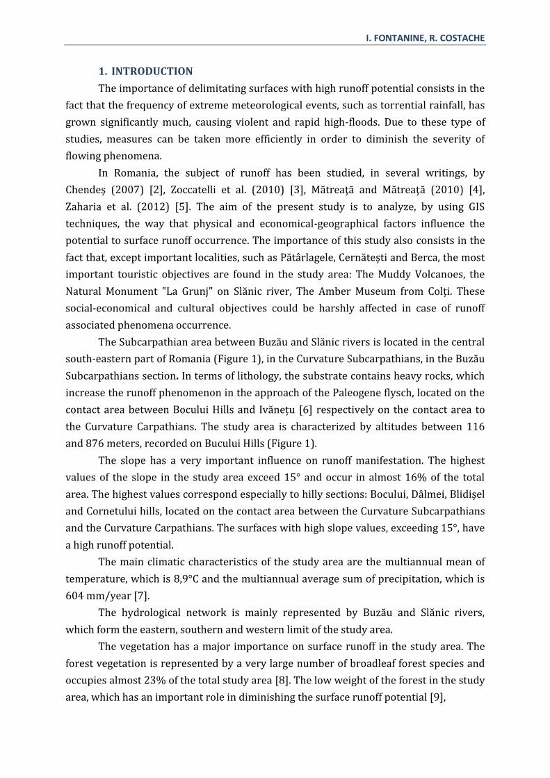
The Subcarpathian area between Buzău and Slănic rivers is located in the central
south-eastern part of Romania (Figure 1), in the Curvature Subcarpathians, in the Buzău
Subcarpathians section. In terms of lithology, the substrate contains heavy rocks, which
increase the runoff phenomenon in the approach of the Paleogene flysch, located on the
contact area between Bocului Hills and Ivănețu [6] respectively on the contact area to
the Curvature Carpathians. The study area is characterized by altitudes between 116
and 876 meters, recorded on Bucului Hills (Figure 1).
The slope has a very important influence on runoff manifestation. The highest
values of the slope in the study area exceed 15° and occur in almost 16% of the total
area. The highest values correspond especially to hilly sections: Bocului, Dâlmei, Blidișel
and Cornetului hills, located on the contact area between the Curvature Subcarpathians
and the Curvature Carpathians. The surfaces with high slope values, exceeding 15°, have
a high runoff potential.
The main climatic characteristics of the study area are the multiannual mean of
temperature, which is 8,9°C and the multiannual average sum of precipitation, which is
604 mm/year [7].
The hydrological network is mainly represented by Buzău and Slănic rivers,
which form the eastern, southern and western limit of the study area.
The vegetation has a major importance on surface runoff in the study area. The
forest vegetation is represented by a very large number of broadleaf forest species and
occupies almost 23% of the total study area [8]. The low weight of the forest in the study
area, which has an important role in diminishing the surface runoff potential [9],

Cinq Continents Volume 3, Numéro 7, 2013, p. 47-57
[50]
certifies the fact that the area between Buzău and Slănic rivers is highly exposed to
torrential associated phenomena.
Regarding the edafic cover, soil texture has a major influence on runoff
occurrence, because it influences water infiltration. In this case, the loamy-clay...clay
texture of the soil determines a high and very high potential to surface runoff and occurs
on 37% of the study area.
In 2006, according to the types of land use, forests represented almost 23% of the
total study area, while pastures represented 20% of the total study area. In terms of
surface runoff on the slopes, the following types of land use increase the phenomenon:
pastures, bare rocks and built areas.
2. METHODOLOGY
In order to realize this study, the flash-flood potential index was created and
spatially modeled for the area between Buzău and Slanic rivers. This index was
proposed by Smith in 2003 [1], and was calculated for Colorado river. After, the index
was adapted, used and improved by other researchers. In the present study, the index
I. FONTANINE, R. COSTACHE
was calculated by integrating five factors that influence the runoff process, by using GIS
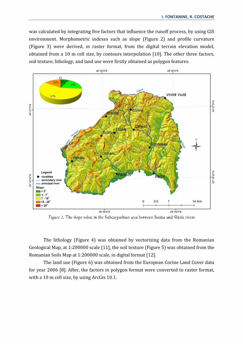
environment. Morphometric indexes such as slope (Figure 2) and profile curvature
(Figure 3) were derived, in raster format, from the digital terrain elevation model,
obtained from a 10 m cell size, by contours interpolation [10]. The other three factors,
soil texture, lithology, and land use were firstly obtained as polygon features.
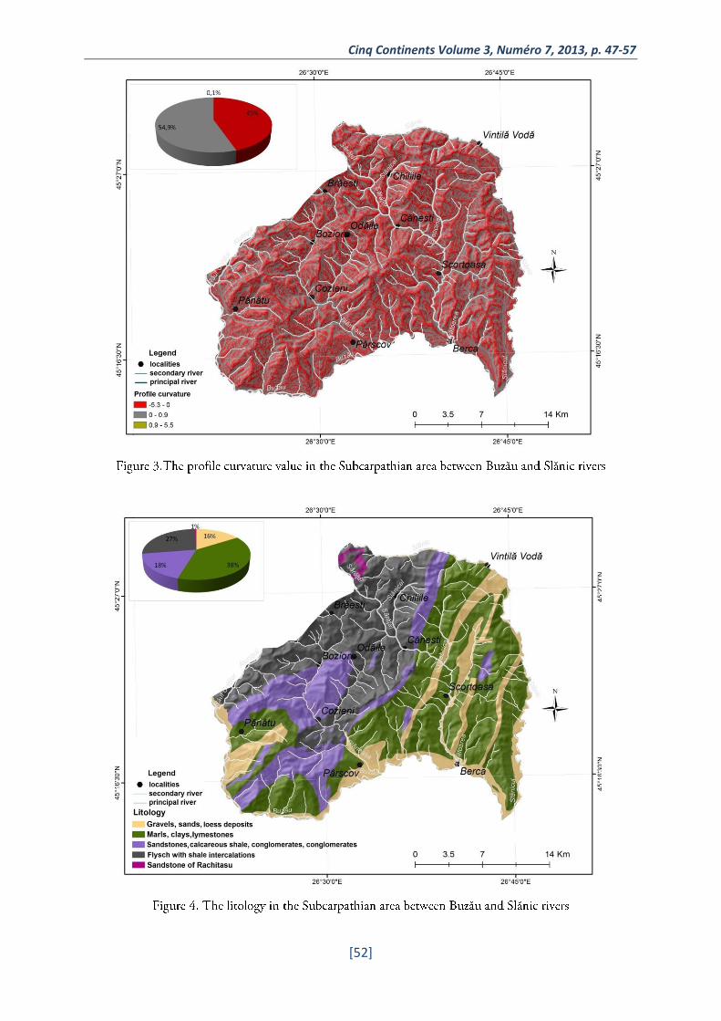
The lithology (Figure 4) was obtained by vectorizing data from the Romanian
Geological Map, at 1:200000 scale [11], the soil texture (Figure 5) was obtained from the
Romanian Soils Map at 1:200000 scale, in digital format [12].
The land use (Figure 6) was obtained from the European Corine Land Cover data
for year 2006 [8]. After, the factors in polygon format were converted to raster format,
with a 10 m cell size, by using ArcGis 10.1.
Cinq Continents Volume 3, Numéro 7, 2013, p. 47-57
[52]

I. FONTANINE, R. COSTACHE

Cinq Continents Volume 3, Numéro 7, 2013, p. 47-57
[54]
The factors were finally reclassified by establishing their bonitation scores
according to their influence on surface runoff (Table 1). Finally, by using the Weight
module of Idrisi Selva soft the weight of each factor was established in order to obtain
the FFPI values for the study area, by integrating the factors.
Parameters Types/Values Litology – 16.87%
Gravels, sands, loess deposits
Marls, clays, lymestones
Sandstones, calcareous shale, conglomerates
Flysch with shale intercalations
Sandstone of Răchitașu
Slope(º) – 24.09%
0-3 3-7 7-15 15-25 >25
Profile curvature – 18.93%
-5.3 - 0 0 – 0.9 0.9 – 5.5
Soil texture – 18.68%
Loamy-sandy...loamy
Loamy Varying textures, loamy...loamy-clay
Loamy-clay, loamy-clay..clay
Clay
Land use – 21.42%
Forests Transitional woodland-shrub
Agricultural zones, vineyards
Pastures Build areas, bare rocks
Bonitation score
1 2 3 4 5
FFPI class (1990, 2006)
19.4 – 24.4 24.4 – 29.4
29.4 – 34.5 34.5 – 39.5 39.5 - 44.5
3. RESULTS
By applying the methodology described above, the Flash Flood Potential Index
(FFPI) was obtained for the Subcarpathian area between Buzău and Slănic rivers. The
FFPI values are between 19.4 and 44.5 (Figure 7). The values were grouped in five
classes, by equal intervals. As a result, the first class of values, between 19.4 – 24.4,
corresponds to a very low potetial to surface runoff.
I. FONTANINE, R. COSTACHE
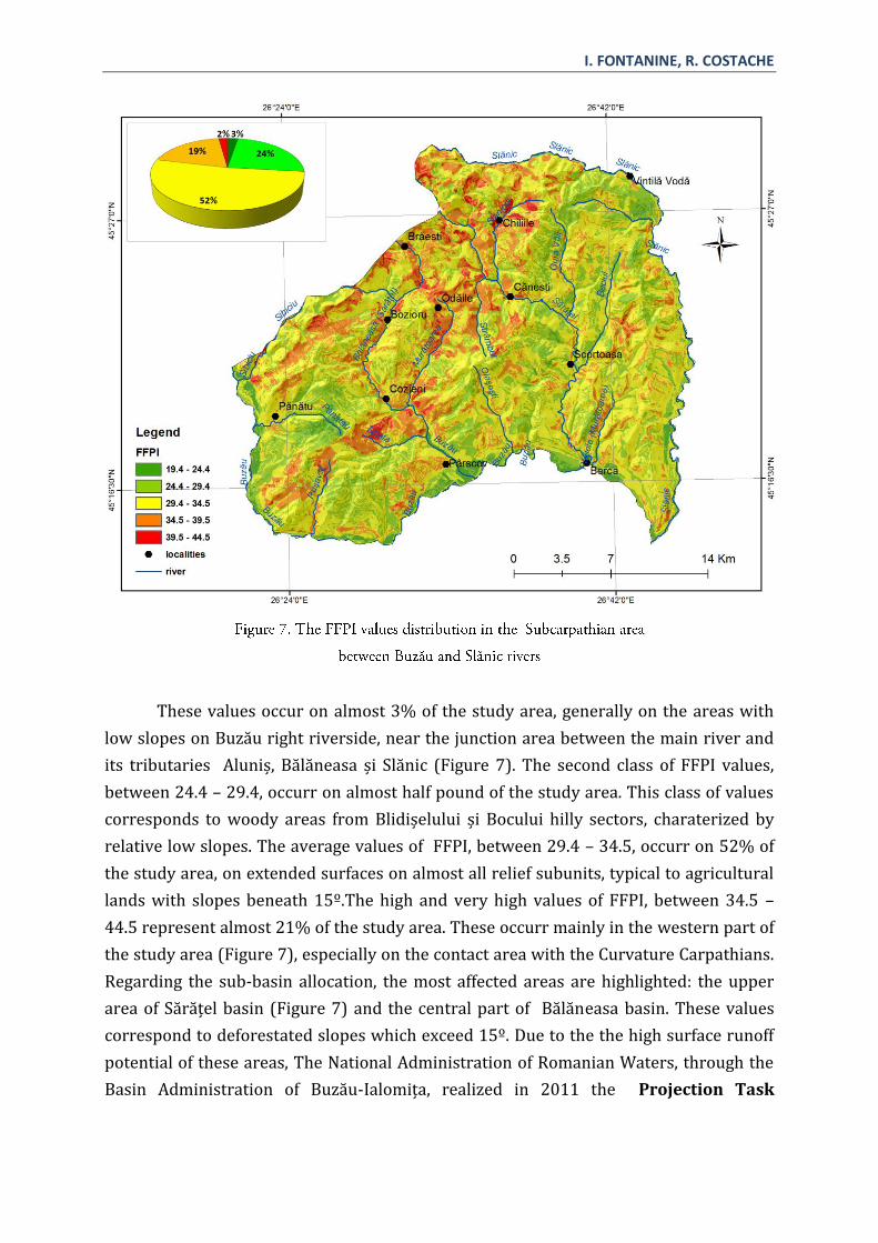
These values occur on almost 3% of the study area, generally on the areas with
low slopes on Buzău right riverside, near the junction area between the main river and
its tributaries Aluniș, Bălăneasa și Slănic (Figure 7). The second class of FFPI values,
between 24.4 – 29.4, occurr on almost half pound of the study area. This class of values
corresponds to woody areas from Blidișelului și Bocului hilly sectors, charaterized by
relative low slopes. The average values of FFPI, between 29.4 – 34.5, occurr on 52% of
the study area, on extended surfaces on almost all relief subunits, typical to agricultural
lands with slopes beneath 15º.The high and very high values of FFPI, between 34.5 –
44.5 represent almost 21% of the study area. These occurr mainly in the western part of
the study area (Figure 7), especially on the contact area with the Curvature Carpathians.
Regarding the sub-basin allocation, the most affected areas are highlighted: the upper
area of Sărățel basin (Figure 7) and the central part of Bălăneasa basin. These values
correspond to deforestated slopes which exceed 15º. Due to the the high surface runoff
potential of these areas, The National Administration of Romanian Waters, through the
Basin Administration of Buzău-Ialomița, realized in 2011 the Projection Task
Cinq Continents Volume 3, Numéro 7, 2013, p. 47-57
[56]
regarding:“Sărăţel river and its tributaries regulation near Berca, Scorţoasa, Căneşti,
Chiliile localities, Buzău county”[13].
4. CONCLUSIONS
Generally, the Subcarpathian area between Buzău and Slănic rivers is
charaterised by a medium potential to surface runoff associated hydric risk phenomena.
This fact is certified by the average values (29.4 – 34.5) of the FFPI on over 50% of the
total study area.
On the Chiliile, Odăile and Cozieni localities alignment, where high and very
values of the index occurr, the social-economical objectives are highly exposed to high
water and flooding.
The lowest values of the index occurr on the slopes with low declivity and
protective forest cover.
The present study also demonstrates the utility of GIS techniques for identifying
the areas exposed to natural risks and for a more efficient management of the crisis
situations.
5. REFERENCES
[1] SMITH, G. Flash flood potential: determining the hydrologic response of ffmp basins to heavy
rain by analyzing their physiographic characteristics. A white paper available from the NWS
Colorado Basin River Forecast Center web site at http://www.cbrfc.
noaa.gov/papers/ffp_wpap.pdf, 11 pp, 2003.
[2] CHENDEŞ, V. Scurgerea lichidă şi solidă în Subcarpaţii de la curbură. Teză de
doctorat, Academia Română, Institutul de Geografie, Biblioteca Institutului de
Geografie, Bucureşti, 2007.
[3] ZOCCATELLI D., BORGA M., ZANON F., ANTONESCU B., STÂNCALIE G. Which rainfall
spatial information for flash flood response modelling? A numerical investigation
based on data from the Carpathian range, Romania, Journal of Hydrology 394, 148–
161, 2010.
[4] MATREATA, M., MATREATA, S. Metodologie de estimare a potenţialului de producere
de viituri rapide în bazine hidrografice mici, Comunicări de Geografie, Vol. XIV,
Editura Universităţii din Bucureşti, Bucureşti, 2010.
[5] ZAHARIA L, MINEA G., TOROIMAC, G.I., BARBU R., SÂRBU I. Estimation of the Areas
with Accelerated Surface Runoff in the Upper Prahova Watershed (Romanian
Carpathians), Balwois, Republic of Macedonia, available on

I. FONTANINE, R. COSTACHE
http://ocs.balwois.com/index.php?conference=BALWOIS&schedConf=BW2012&pa
ge=paper&op=view&path%5B%5D=595&path%5B%5D=259, 2012.
[6] ROȘU A. Geografia Fizică a României, Editura Didactică și Pedagogică, București,
1980.
[7] *** Clima României, Administrația Natională de Meteorologie, Editura Academiei
Române Bucureşti, 2008.
[8] ***Corine Land Cover, raster data, European Environment Agency (eea.europa.eu),
2006.
[9] ARGHIRIADE, C. Rolul hidrologic al pădurii, Editura Ceres, București, 1977.
[10] *** http://srtm.csi.cgiar.org/
[11] *** www.geospatial.org
[12] *** The soils map in electronic format, 1:200,000, ICPA Bucureşti.
[13] *** www.rowater.ro/dabuzau/default.aspx