Fonds européen de développement régional (FEDER) Common platform for air quality assessment and...
13
Fonds européen de développement régional (FEDER) Common platform for air quality assessment and information in the Upper Rhine Valley Plate-forme commune d’évaluation et d’information sur la qualité de l’air dans la vallée du Rhin Supérieur
-
Upload
nataly-merritts -
Category
Documents
-
view
214 -
download
0
Transcript of Fonds européen de développement régional (FEDER) Common platform for air quality assessment and...

Fonds européen dedéveloppement régional
(FEDER)
Common platform for air quality assessment and information in the Upper
Rhine Valley
Plate-forme commune d’évaluation
et d’information sur la qualité de l’air
dans la vallée du Rhin Supérieur
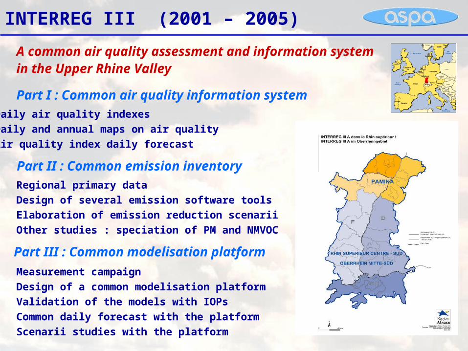
INTERREG III (2001 – 2005)
Part I : Common air quality information system
Part II : Common emission inventory
Part III : Common modelisation platform
Daily air quality indexes
Daily and annual maps on air quality
Air quality index daily forecast
Regional primary data
Design of several emission software tools
Elaboration of emission reduction scenarii
Other studies : speciation of PM and NMVOC
Measurement campaign
Design of a common modelisation platform
Validation of the models with IOPs
Common daily forecast with the platform
Scenarii studies with the platform
A common air quality assessment and information system in the Upper Rhine Valley
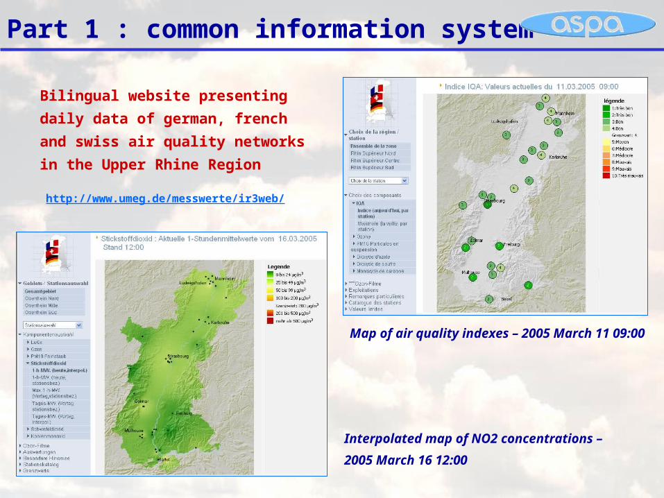
Part 1 : common information system
Bilingual website presenting daily
data of german, french and swiss air
quality networks in the Upper Rhine
Region
Interpolated map of NO2 concentrations –
2005 March 16 12:00
Map of air quality indexes – 2005 March 11 09:00
http://www.umeg.de/messwerte/ir3web/

Part 2 : common emission inventory
Development of tools to update the emissions on
the scale of the Upper Rhine
Database
EMISS’AIR
Hourly kilometric
land register
Primary data
Transborder inventory
Development of a tool to integrate the
emissions data into a common database
Development of a tool to distribute the
emissions per km2, per hour and per specie
German and Swiss inventories
Collecting data
CONIF’AIR, CIRCUL’AIR
ManagAir

The CONIF’AIR and CIRCUL’AIR tools
Cartographyspecies
settlement
Land Use
Land
registered
Emissions
Weather
Emission factors
biomass Database
CONIF’AIR : Biogenic Emissions
CIRCUL’AIR : Road transport Emissions
Cars Counting
Linear
Emissions
Roads characteristics

Emission cadaster : the ManagAir tool
Temporal distribution
Emission cadaster
Ponctual sources
Linear sources
Surfacic sources NMVOC and
PM speciation from CITEPA et IER (2004)
Land use
-gas-aerosol

Part 3 : common modelisation platform
Chemical modelisation :
4 square kilometerResolution grid
Chemical boundary
conditions :
Meteorological modelisation :
MM5
12x12 and 4x4 kilometer
resolution grids
Meteorological boundary
conditions : NCEP

Measuring campaign : May - June 2003
Data Exploitation
Data Exploitation
FTPFTP
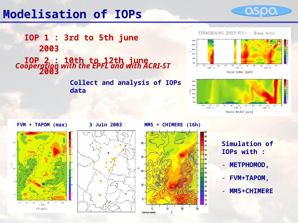
Modelisation of IOPs
Collect and analysis of IOPs data
3 Juin 2003FVM + TAPOM (max) MM5 + CHIMERE (16h)
Simulation of IOPs with :
- METPHOMOD,
- FVM+TAPOM,
- MM5+CHIMERE
Cooperation with the EPFL and with ACRI-ST
IOP 1 : 3rd to 5th june 2003
IOP 2 : 10th to 12th june 2003

Air quality forecast with the platform

Scenarii study with the platform
2000 Base : Reference scenario based on the transboundary emission inventory of 2000
2000 Urg : Application of Emergency Measures listed in the Circular of the 18th june 2004 2020 Fil : « Fil de l’eau » long term scenario 2020 Env : Environmental long term scenario
1 Definition of
measures included
in the different
scenarii
2 Assessment of
the impact of
measures on
emissions
3 Integration of
emission in the
CHIMERE-ACRI
platform
4 Running the
CHIMERE-ACRI
model
5 Interpretation of
results, analysis of
measure’s
efficiency
EmissionsModelisation
Scenario « 2000 Urg » : variation of VOC emissions
Reference scenario :anthropic VOCs
ManagAir
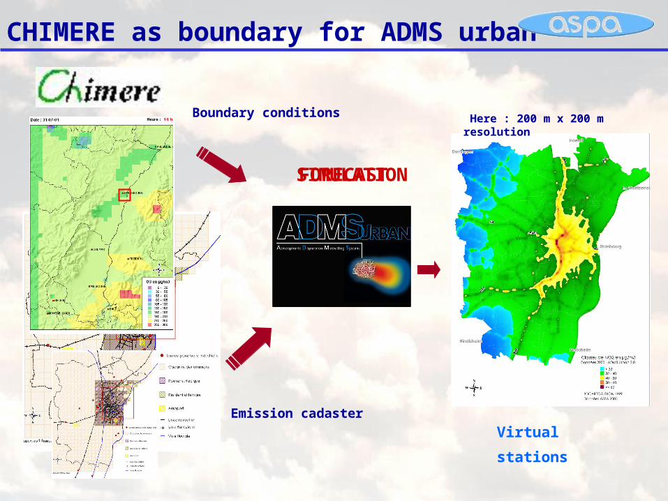
CHIMERE as boundary for ADMS urban
Emission cadaster
Boundary conditions Here : 200 m x 200 m resolution
Virtual
stations
Measur
esSIMULATIO
N
FORECAST