FOCUS ON Mozambique - UN-Habitat
48
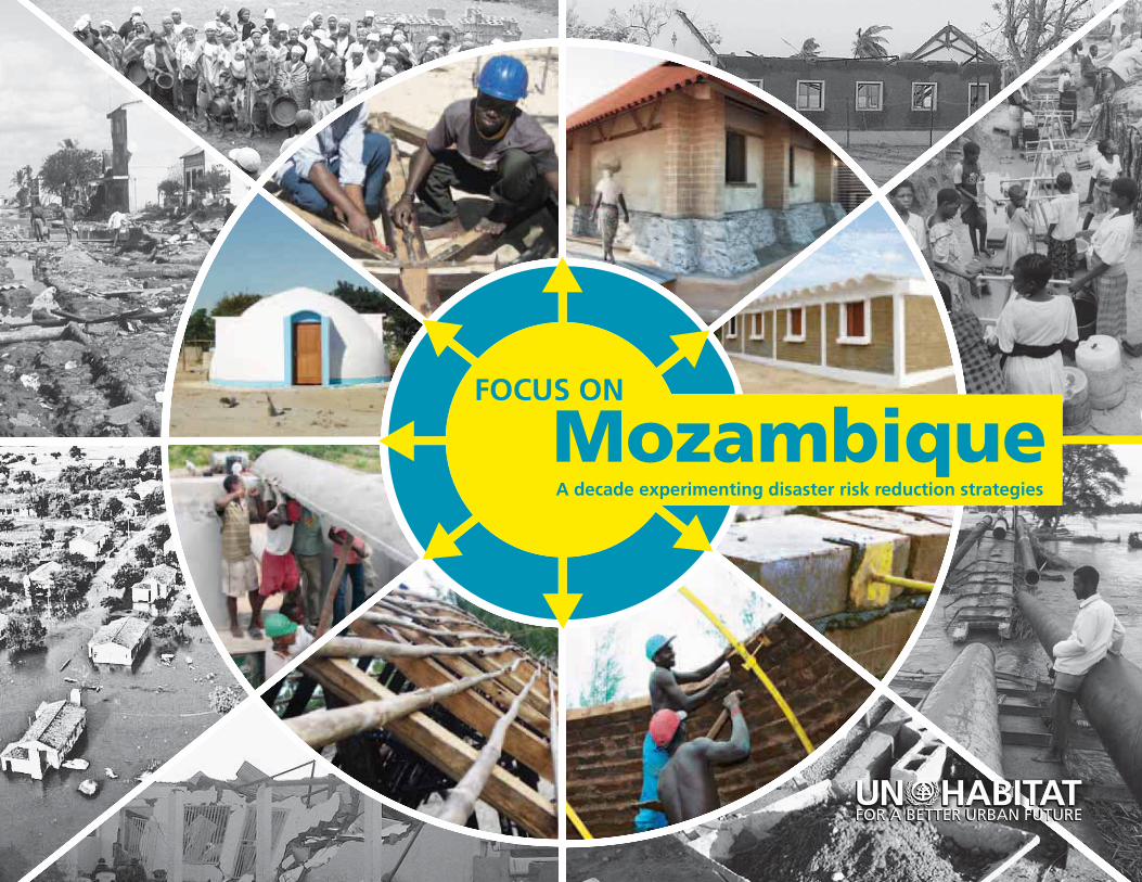
FOCUS ON A decade experimenting disaster risk reduction strategies Mozambique
Transcript of FOCUS ON Mozambique - UN-Habitat
FOCUS ON
A decade experimenting disaster risk reduction strategies
Mozambique
Focus on MozambiqueA decade experimenting disaster risk reduction strategies
Copyright © United Nations Human Settlement Programme (UN-Habitat) 2012
All rights reserved
United Nations Human Settlement Programme (UN-Habitat), P.O. Box 30030, GPO Nairobi 00100, Kenya.
Tel: 254 20 7623 120; Fax: 254 20 7624 266/7 (Central Office) Email: [email protected] Website: www.unhabitat.org
HS/059/12 ISBN: 978-92-1-132479-2 ISBNE (Electronic): 921-1-131496-8
DISCLAIMER
The designations employed and the presentation of the material in this publication do not imply the expression of any opinion whatsoever on the part of the Secretariat of the United Nations concerning the legal status of any country, territory, city or area, or of its authorities, or concerning delimitation of its frontiers or boundaries, or regarding its economic system or degree of development. The analysis, conclusions and recommendations of this publication do not necessarily reflect the views of the United Nations Human Settlement Programme, the Governing Council of the United Nations Human Settlement Programme, or its Member States.
Overall Coordinator: Mathias Spaliviero
Principal Author: Arianna Francioni
Civil Engineer: Silva Jacinto Magaia
Architects: Eduardo Feuerhake, Fernando Ferreiro, Wild do Rosário, Carlos Trindade and Arianna Francioni
Main Author of the Awareness Materials: Eduardo Feuerhake
Disaster Risk Reduction Specialists: Manuela Muianga and Pasquale Capizzi
Mapping Specialists: Paulo da Conceição Júnior and Sérgio Maló
Movie Director: Fabián Ribezzo
Photos: UN-Habitat Team and Pedro Sá da Bandeira (Centro de Documentação e Formacão Fotográfica)
The Ferrocement Channels technology was developed by the Auroville Earth Institute
The design of the Kindergarten in Vilankulo was inspired from the works of Julian Salas, Industrial Engineer
The design of the Dome House in Vilankulo was inspired from the works of Hassan Fathy, Architect
Author of the Painting in the Back Cover (“Africa, we’ll breathe always together to win” - Oil panted on canvas, cm 140 x 140, 1988): Bertina Lopes
Map of the lower Limpopo River basin: Courtesy of INGC, UEM-Department of Geography and FEWS NET MIND, 2003
Editor: Dominic O’Reilly
Design and Layout: Andrew Ondoo
Printing: UNON, Publishing Services Section, Nairobi, ISO 14001:2004-certified.
Acknowledgements
I
Mozambique FOCUS ON
A decade experimenting disaster risk reduction strategies
FOCUS ON MOZAMBIQUE: A decade experimenting disaster risk reduction strategiesII
Foreword
The UN-Habitat programme in Mozambique represents one of the best examples within the Agency’s portfolio on how diversified and in-depth interventions can provide concrete
solutions to the challenges of a country which is particularly vulnerable to natural disasters. This was possible thanks to the hard work produced by a dedicated and multi-disciplinary team of national and international professionals, which has been growing steadily since 2002.
The continuity of UN-Habitat’s operations could be ensured by establishing synergies between the different projects and programmes, which helped overcoming the difficulties determined by irregular funding. In this manner great impacts were achieved with relatively limited financial resources.
Two crucial aspects deserve to be highlighted regarding this country programme: participation and innovation.
The team in Mozambique has managed, through practical experience, to establish a participatory planning approach which today is almost institutionalised. It consists of involving the targeted communities directly in the decision-making process, while ensuring the presence of local and central authorities, the academia, the civil society and the private sector. This empowers the local population and provides a sense of ownership, which makes any local intervention more sustainable. Importantly, all identified solutions are fundamentally suggested by the community itself.
During the past decade, UN-Habitat in Mozambique was able to propose alternative and innovative solutions.
One example is the “living with floods” approach which, if appropriately applied, can improve the government’s policy of resettling people living in vulnerable areas. Other interventions consisted of building better in cyclone-affected areas or mainstreaming the use of rainwater harvesting in arid zones.
To achieve that, firstly, high-quality didactic tools were produced, able to transmit complex concepts through simple messages and to raise awareness at all levels.
Secondly, identified solutions were physically implemented through on-the job training of local communities and the establishment of live workshops, in a way that can be easily replicated.
As a result, some of the materials produced have become respected at the international level and are being widely disseminated, while the role of architecture in reducing disaster risk was highlighted in a unique manner thanks to the construction of pilot buildings. Importantly, these activities constitute important factors of decision-making in Mozambique today for redefining key policy, strategic and legislative tools in the field of disaster risk reduction, with a special focus on slum upgrading and urban development.
It is UN-Habitat’s hope to see its programme growing in the near future and its experiences being systematically transmitted to the national and local counterparts within the government and the local authorities.
The final objective is to contribute to the creation of resilient communities and to reinforce the institutional capacity at the different levels to cope with the harsh environmental conditions and socio-political challenges.
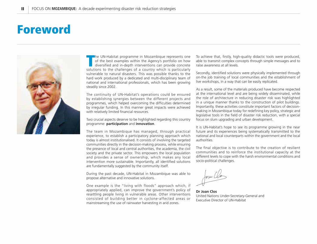
Dr Joan Clos United Nations Under-Secretary-General and Executive Director of UN-Habitat
IIITABLE OF CONTENTS
Table of Contents
CHAPTER
05
Working with Communities | Pages 19 - 24
CHAPTER
06
Demonstrative Interventions | Pages 25 - 38
Ten Years working in Mozambique | Page V
TEN YEARS working in Mozambique
CHAPTER
01
Mozambique at a glance | Pages 01 - 04
CHAPTER
02
UN-Habitat Activities | Pages 05 - 10
CHAPTER
03
Mapping the risk | Pages 11 - 14
CHAPTER
04
Innovation in Technical Features | Pages 15 - 18
Foreword | Page II
FOREWORD
FOCUS ON MOZAMBIQUE: A decade experimenting disaster risk reduction strategiesIV
VTEN YEARS WORKING IN MOZAMBIQUE
Ten years working in Mozambique
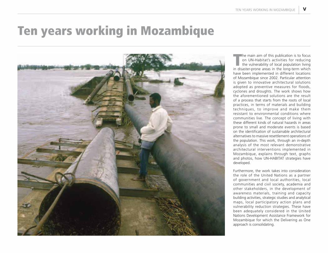
The main aim of this publication is to focus on UN-Habitat’s activities for reducing the vulnerability of local population living
in disaster-prone areas in the long-term which have been implemented in different locations of Mozambique since 2002. Particular attention is given to innovative architectural solutions adopted as preventive measures for floods, cyclones and droughts. The work shows how the aforementioned solutions are the result of a process that starts from the roots of local practices, in terms of materials and building techniques, to improve and make them resistant to environmental conditions where communities live. The concept of living with these different kinds of natural hazards in areas prone to small and moderate events is based on the identification of sustainable architectural alternatives to massive resettlement operations of the population. This work, through an in-depth analysis of the most relevant demonstrative architectural interventions implemented in Mozambique, explains through text, graphs and photos, how UN-HABITAT strategies have developed.
Furthermore, the work takes into consideration the role of the United Nations as a partner of government and local authorities, local communities and civil society, academia and other stakeholders, in the development of awareness materials, training and capacity building activities, strategic studies and analytical maps, local participatory action plans and vulnerability reduction strategies. These have been adequately considered in the United Nations Development Assistance Framework for Mozambique for which the Delivering as One approach is consolidating.
FOCUS ON MOZAMBIQUE: A decade experimenting disaster risk reduction strategiesVI FOCUS ONN MOMOMOMMMM ZAZAAZAZAZAAZAAMMMMMMMMMMMMMBIBBBBIBIBIBIBBIBBBIBIBIIIIQUQUQUQUQQUQQUQUQUQUQUQUQUQUQUQUQQQQQUQUQQQQUQQUQUE:E:E:E:EEEE:::EE:EE:E:EE::::E:E:: A AAAAAAAAA decade expxpxpxpxppxpppppppppppppppereeeeeeeeeeeee imentinngngngngngngngngngngngngngnngggngngnggngnggngngnggngnnggngggngggngggnnggnggngnngngggngggnnnggngnnngggg ddddddddddddddd ddd ddd ddddddddddddddddddd ddddddissssisississssssssisissssssisissssisssssississssisisssasasasasasasasasasaaasaaasaaaasasasassssasasaasasasasasssssasasaasasasaaasasasasasasaaasssaaaasasaaaaaaasaassssstetteteteteteteteteteteteteteteteteteteeetetetetetettetetetteteetttttteteteetettteeeteteetettteeeerrrrrrrrrrrrrrrrrrrrrrrrrrr r r r rrrrr r r ririririrrirrririrrrriiiiiirrrirrrr skskskskskskskssssksssskskskskskkksssskskskkssssssskskksksksskkkkkkksk reduction ssss strtrtttrtrtrtrtrtrttrrrrrrrttttrrrrtrtrtrratatatatttataaatatttatttataaaaaaaaatttatatatataaaaaaaategeggegegegeegeggeggegegegeggegeeegggggggggggeeggegeggegegegegeeeeeegeggegegeeegieeieeeeeeeiieieeeeeieeieeiei ssssssssssssssssssssssssVI
01MOZAMBIQUE AT A GLANCE
Mozambique at a glance CHAPTER
01
DroughtCyclonesFloods
Area: Total: 799,380 sq km Land: 786,380 sq km Water: 13,000 sq km
Land boundaries: Total: 4,571 km Coastline: 2,470 km
Population: 23,515,934 (July 2012 est.)
Age structure: 0 - 14 years: 45.9% (male 5,295,776/female 5,245,485)
15 - 64 years: 51.1% (male 5,550,501/female 6,174,668)
65 years and over: 3% (male 313,892/female 368,536) (2011 est.)
Urbanization: Urban population: 38% of total population (2010)
Rate of urbanization: 4% annual rate of change (2010-15 est.)
Major cities - population: Maputo (capital) 1.589 million; Matola 761,000 (2009)
Drinking water source:
Improved:Urban: 77% of population Rural: 29% of population Total: 47% of population
Unimproved:Urban: 23% of population Rural: 71% of population Total: 53% of population (2008)
Sanitation facility access:
Improved: Urban: 38% of population Rural: 4% of population Total: 17% of population
Unimproved:Urban: 62% of population Rural: 96% of population Total: 83% of population (2008)
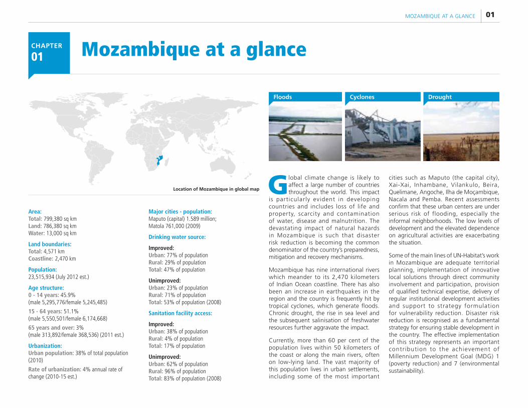
Location of Mozambique in global map Global climate change is likely to affect a large number of countries throughout the world. This impact
is particularly evident in developing countries and includes loss of life and property, scarcity and contamination of water, disease and malnutrition. The devastating impact of natural hazards in Mozambique is such that disaster risk reduction is becoming the common denominator of the country’s preparedness, mitigation and recovery mechanisms.
Mozambique has nine international rivers which meander to its 2,470 kilometers of Indian Ocean coastline. There has also been an increase in earthquakes in the region and the country is frequently hit by tropical cyclones, which generate floods. Chronic drought, the rise in sea level and the subsequent salinisation of freshwater resources further aggravate the impact.
Currently, more than 60 per cent of the population lives within 50 kilometers of the coast or along the main rivers, often on low-lying land. The vast majority of this population lives in urban settlements, including some of the most important
cities such as Maputo (the capital city), Xai-Xai, Inhambane, Vilankulo, Beira, Quelimane, Angoche, Ilha de Moçambique, Nacala and Pemba. Recent assessments confirm that these urban centers are under serious risk of flooding, especially the informal neighborhoods. The low levels of development and the elevated dependence on agricultural activities are exacerbating the situation.
Some of the main lines of UN-Habitat’s work in Mozambique are adequate territorial planning, implementation of innovative local solutions through direct community involvement and participation, provision of qualified technical expertise, delivery of regular institutional development activities and support to strategy formulation for vulnerability reduction. Disaster risk reduction is recognised as a fundamental strategy for ensuring stable development in the country. The effective implementation of this strategy represents an important contr ibut ion to the achievement of Millennium Development Goal (MDG) 1 (poverty reduction) and 7 (environmental sustainability).
FOCUS ON MOZAMBIQUE: A decade experimenting disaster risk reduction strategies02
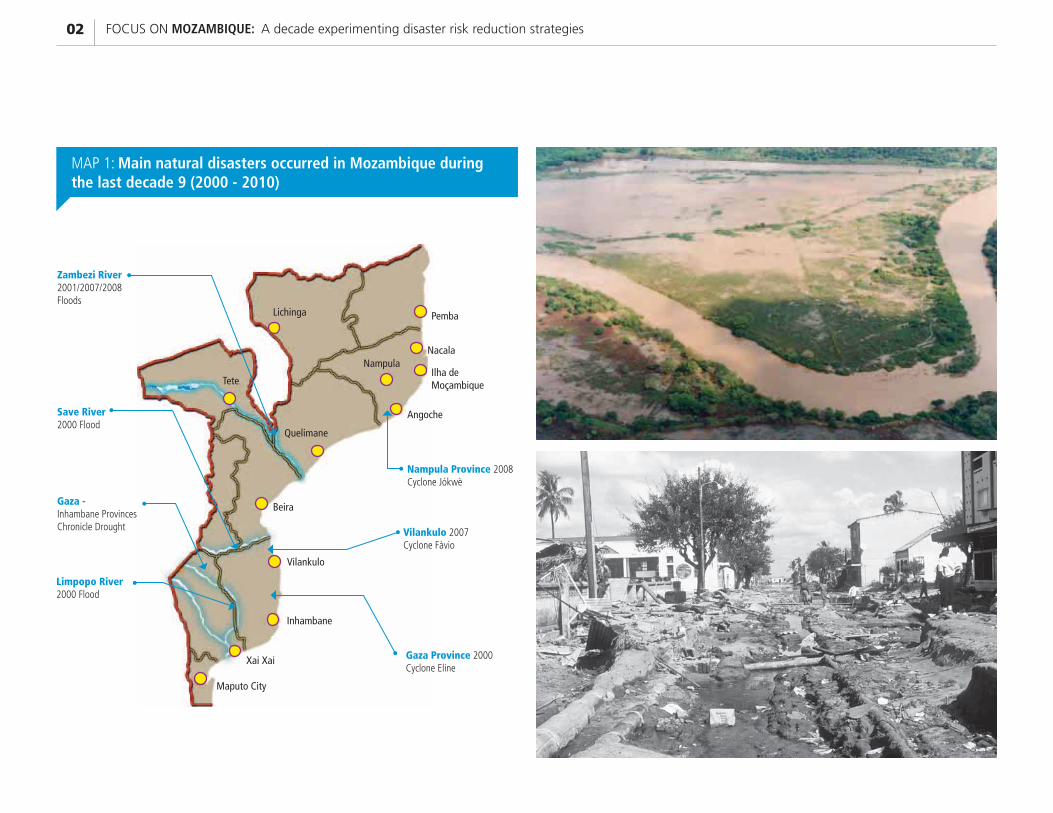
Zambezi River 2001/2007/2008 Floods
Save River 2000 Flood
Gaza - Inhambane Provinces Chronicle Drought
Limpopo River 2000 Flood
Gaza Province 2000 Cyclone Eline
Vilankulo 2007 Cyclone Fàvio
Nampula Province 2008 Cyclone Jókwè
Pemba
Nampula
Angoche
Nacala
Ilha de Moçambique
Lichinga
Tete
Quelimane
Beira
Vilankulo
Inhambane
Xai Xai
Maputo City
MAP 1: Main natural disasters occurred in Mozambique during the last decade 9 (2000 - 2010)
03MOZAMBIQUE AT A GLANCE
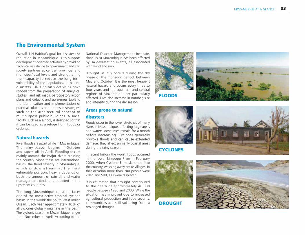
Overall, UN-Habitat’s goal for disaster risk reduction in Mozambique is to support development-oriented activities by providing technical assistance to government and civil society partners at central, provincial and municipal/local levels and strengthening their capacity to reduce the long-term vulnerability of the populations to natural disasters. UN-Habitat’s activities have ranged from the preparation of analytical studies, land risk maps, participatory action plans and didactic and awareness tools to the identification and implementation of practical solutions and proposed strategies, such as the architectural concept of multipurpose public buildings. A social facility, such as a school, is designed so that it can be used as a refuge from floods or cyclones.
Natural hazardsRiver floods are a part of life in Mozambique. The rainy season begins in October and tapers off in April. Flooding occurs mainly around the major rivers crossing the country. Since these are international basins, the flood severity in Mozambique, wh i ch i s downs t ream a t the mos t vulnerable position, heavily depends on both the amount of rainfall and water management decisions adopted in the upstream countries.
The long Mozambique coastline faces one of the most active tropical cyclone basins in the world: the South West Indian Ocean. Each year approximately 10% of all cyclones globally originate in this basin. The cyclonic season in Mozambique ranges from November to April. According to the
National Disaster Management Institute, since 1970 Mozambique has been affected by 34 devastating events, all associated with wind and rain.
Drought usually occurs during the dry phase of the monsoon period, between May and October. It is the most frequent natural hazard and occurs every three to four years and the southern and central regions of Mozambique are particularly affected. Fires also increase in number, size and intensity during the dry season.
Areas prone to natural
disastersFloods occur in the lower stretches of many rivers in Mozambique, affecting large areas and waters sometimes remain for a month before decreasing. Cyclones generally provoke floods and can cause extended damage; they affect primarily coastal areas during the rainy season.
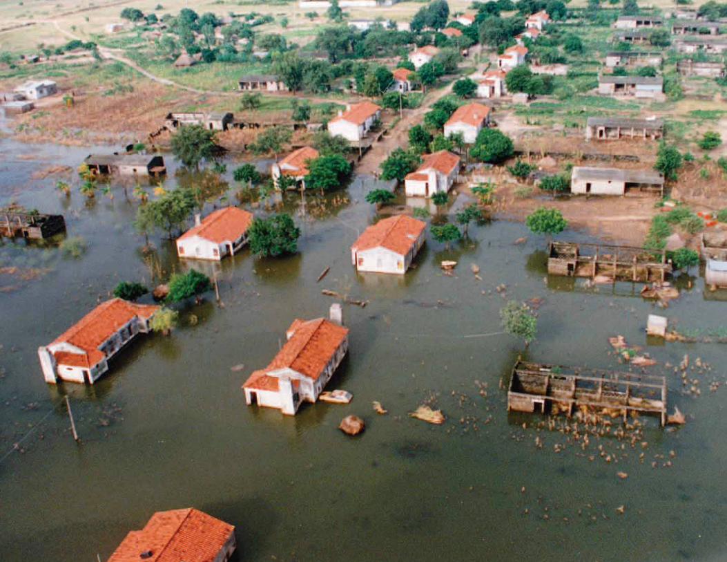
In recent history the worst floods occurred in the lower Limpopo River in February 2000, when Cyclone Eline slammed into the country, washing away entire villages. In that occasion more than 700 people were killed and 500,000 were displaced.
It is estimated that drought contributed to the death of approximately 40,000 people between 1980 and 2000. While the situation has improved due to increased agricultural production and food security, communities are still suffering from a prolonged drought.
FLOODS
CYCLONES
DROUGHT
The Environmental System
FOCUS ON MOZAMBIQUE: A decade experimenting disaster risk reduction strategies04
05UN-HABITAT ACTIVITIES
CHAPTER
02 UN-HABITAT ACTIVITIES
UN-Habitat’s approach to disaster risk reduction in Mozambique
For a better description of the type of activities carried out by UN-Habitat in Mozambique since 2002, some background information regarding
the institutional evolution of the national disaster risk reduction strategy in recent years is needed. The National Disaster Management Institute is the governmental body responsible for regulating and coordinating disaster risk reduction activities at the national level. It has a special focus on disaster prevention, preparedness and assistance to the affected population. It was established by Cabinet Decree n. 38/99 on 10 June 1999, which also created the Disaster Management Coordination Council and the Disaster Management Technical Council. The same Decree delineates the principles of the Disaster Management Policy, which is being implemented through a national ten-year action plan, annual contingency plans and other correlated inter-sectorial planning tools and strategies.
It was after the massive floods in 2000, mainly in the lower Limpopo River, that visible results of a coordinated effort between the government, the United Nations and non-governmental organisations started to emerge. This resulted in the preparation of plans and coping strategies to address floods, drought and cyclones.
In 2002 UN-Habitat joined the discussions around disaster risk reduction through the creation and implementation of two projects to reduce vulnerability to floods: a subregional initiative involving the four riparian countries of the Limpopo River basin (Mozambique, South Africa, Zimbabwe and Botswana), and another project targeting flood-prone slum areas in four main urban settlements of the country (Maputo, Chókwè, Tete, and Quelimane). As a result of preparing participatory action plans and awareness tools, delivering training and capacity building activities, supporting the elaboration of strategies and carrying out concrete interventions, UN-Habitat became relevant in the disaster management scene in Mozambique.
Activities during the 2007 and 2008 floods and cyclones helped to consolidate its proposed approaches to disaster risk reduction, especially while coordinating the Shelter Cluster - a working group in which government institutions and NGOs participate to organise the sectorial emergency response and early recovery strategy.
Additional projects dealt with disaster risk reduction with the support of the European Commission and through UN joint programming. Over the years, UN-Habitat has provided consistently innovative planning, architectural solutions and alternative strategies which are now positively influencing the policy-making processes.
UN-Habitat has also built a strategic partnership with the Faculty of Architecture and Physical Planning at the Eduardo Mondlane University in Maputo, particularly through its Centre for Habitat Studies and Development. The Centre has provided important contributions in the areas of slum upgrading, territorial planning and architectural innovation for disaster mitigation. Strengthening this partnership, which is now also targeting the Faculty of Engineering at the same university, will be instrumental for ensuring adequate transfer to and sharing of technical knowledge accumulated through the developed solutions, tools and strategies.

FOCUS ON MOZAMBIQUE: A decade experimenting disaster risk reduction strategies06
MAP 3: Flood-prone areas in Mozambique
ZAMBEZIA
NAMPULA
CABO DELGADO
NIASSA
TETE
SOFALA
MANICA
INHAMBANE
GAZA
Maputo cityMAPUTO
LichingaPemba
Ilha de Moçambique
Nacala
Nampula
Angoche
Quelimane
Tete
Beira
Vilankulo
Inhambane
Xai Xai
NATIONAL BOUNDARIES
Limpopo River Basin
Save River Basin
Zambezi River Basin
UN-HABITAT Activity Sites
PROVINCE BOUNDARIES
Main Urban Settlements
MAP 2: UN-Habitat Activities in Mozambique

07UN-HABITAT ACTIVITIES
MAP 4: Cyclone-prone areas in Mozambique MAP 5: Drought-prone areas in Mozambique
FOCUS ON MOZAMBIQUE: A decade experimenting disaster risk reduction strategies08
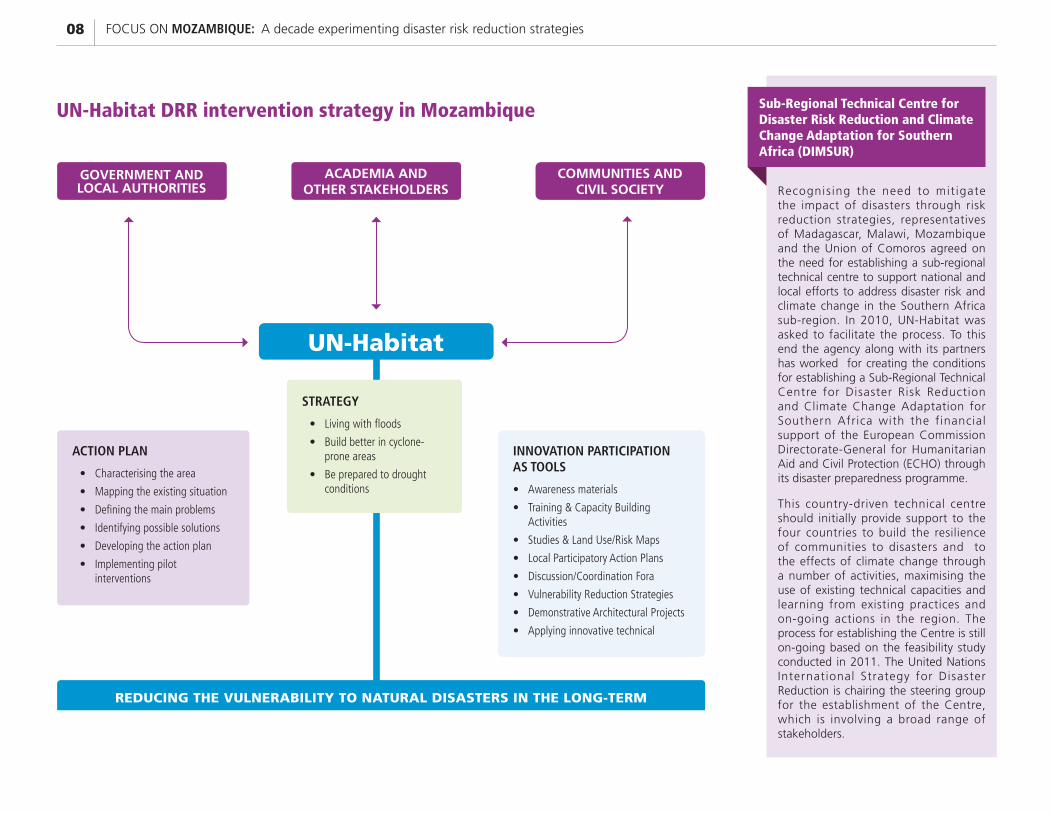
Recognis ing the need to mit igate the impact of disasters through risk reduction strategies, representatives of Madagascar, Malawi, Mozambique and the Union of Comoros agreed on the need for establishing a sub-regional technical centre to support national and local efforts to address disaster risk and climate change in the Southern Africa sub-region. In 2010, UN-Habitat was asked to facilitate the process. To this end the agency along with its partners has worked for creating the conditions for establishing a Sub-Regional Technical Centre for Disaster Risk Reduction and Climate Change Adaptation for Southern Africa with the financial support of the European Commission Directorate-General for Humanitarian Aid and Civil Protection (ECHO) through its disaster preparedness programme.
This country-driven technical centre should initially provide support to the four countries to build the resilience of communities to disasters and to the effects of climate change through a number of activities, maximising the use of existing technical capacities and learning from existing practices and on-going actions in the region. The process for establishing the Centre is still on-going based on the feasibility study conducted in 2011. The United Nations International Strategy for Disaster Reduction is chairing the steering group for the establishment of the Centre, which is involving a broad range of stakeholders.
UN-Habitat DRR intervention strategy in Mozambique Sub-Regional Technical Centre for Disaster Risk Reduction and Climate Change Adaptation for Southern Africa (DIMSUR)
ACADEMIA AND OTHER STAKEHOLDERS
COMMUNITIES AND CIVIL SOCIETY
GOVERNMENT AND LOCAL AUTHORITIES
UN-Habitat
REDUCING THE VULNERABILITY TO NATURAL DISASTERS IN THE LONG-TERM
ACTION PLAN
Characterising the area
Mapping the existing situation
Defining the main problems
Identifying possible solutions
Developing the action plan
Implementing pilot interventions
INNOVATION PARTICIPATION AS TOOLS
Awareness materials
Training & Capacity Building Activities
Studies & Land Use/Risk Maps
Local Participatory Action Plans
Discussion/Coordination Fora
Vulnerability Reduction Strategies
Demonstrative Architectural Projects
Applying innovative technical
STRATEGY
Living with floods
Build better in cyclone-prone areas
Be prepared to drought conditions
09UN-HABITAT ACTIVITIES
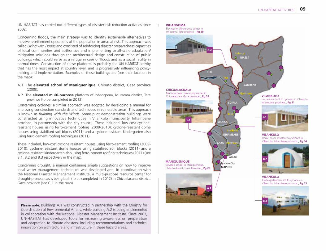
UN-HABITAT has carried out different types of disaster risk reduction activities since 2002.
Concerning floods, the main strategy was to identify sustainable alternatives to massive resettlement operations of the population in areas at risk. This approach was called Living with Floods and consisted of reinforcing disaster preparedness capacities of local communities and authorities and implementing small-scale adaptation/mitigation solutions through the architectural design and construction of public buildings which could serve as a refuge in case of floods and as a social facility in normal times. Construction of these platforms is probably the UN-HABITAT activity that has the most impact at country level, and is progressively influencing policy-making and implementation. Examples of these buildings are (see their location in the map):
A.1. The elevated school of Maniquenique, Chibuto district, Gaza province (2008);
A.2. The elevated multi-purpose platform of Inhangoma, Mutarara district, Tete province (to be completed in 2012);
Concerning cyclones, a similar approach was adopted by developing a manual for improving construction standards and techniques in vulnerable areas. This approach is known as Building with the Winds. Some pilot demonstration buildings were constructed using innovative techniques in Vilankulo municipality, Inhambane province, in partnership with the city council. These included, low-cost cyclone-resistant houses using ferro-cement roofing (2009-2010); cyclone-resistant dome houses using stabilised soil blocks (2011) and a cyclone-resistant kindergarten also using ferro-cement roofing techniques (2011).
These included, low-cost cyclone resistant houses using ferro-cement roofing (2009-2010); cyclone-resistant dome houses using stabilised soil blocks (2011) and a cyclone-resistant kindergarten also using ferro-cement roofing techniques (2011) (see B.1, B.2 and B.3 respectively in the map).
Concerning drought, a manual containing simple suggestions on how to improve local water management techniques was developed and, in coordination with the National Disaster Management Institute, a multi-purpose resource center for drought-prone areas is being built (to be completed in 2012) in Chicualacuala district, Gaza province (see C.1 in the map).
Please note: Buildings A.1 was constructed in partnership with the Ministry for Coordination of Environmental Affairs, while building A.2 is being implemented in collaboration with the National Disaster Management Institute. Since 2003, UN-HABITAT has developed tools for increasing awareness on preparation and adaptation to climate disasters, including recommendations and technical innovation on architecture and infrastructure in these hazard areas.
A.2
C.1
A.1
B.3
B.2
B.1
SOFALA
TETE
NIASSALichinga
Tete
Beira
Vilankulos
Quelimane
Inhambane
Xai Xai
MANICA
INHAMBANE
GAZA
Maputo CityMAPUTO
ZAMBEZIA
INHANGOMA Elevated multi-purpose center in Inhagoma, Tete province _ Pg 29
CHICUALACUALA Multi-purpose community center in Chicualacuala, Gaza province _ Pg 35
MANIQUENIQUE Elevated school in Maniquenique, Chibuto district, Gaza Province _ Pg 25
VILANKULO Houses resistant to cyclones in Vilankulo, Inhambane province _ Pg 31
VILANKULO Dome house resistant to cyclones in Vilankulo, Inhambane province _ Pg 34
VILANKULO Kindergartenresistant to cyclones in Vilankulo, Inhambane province _ Pg 33
FOCUS ON MOZAMBIQUE: A decade experimenting disaster risk reduction strategies10
11MAPPING THE RISK
Mapping the risk CHAPTER
03
River Dynamics
Paved Road
2000 Flood Extent
Villages
Unpaved Road
Nhacomene
BundzulaneMahelene
Chilaulene
Cumbane
Xai Xai
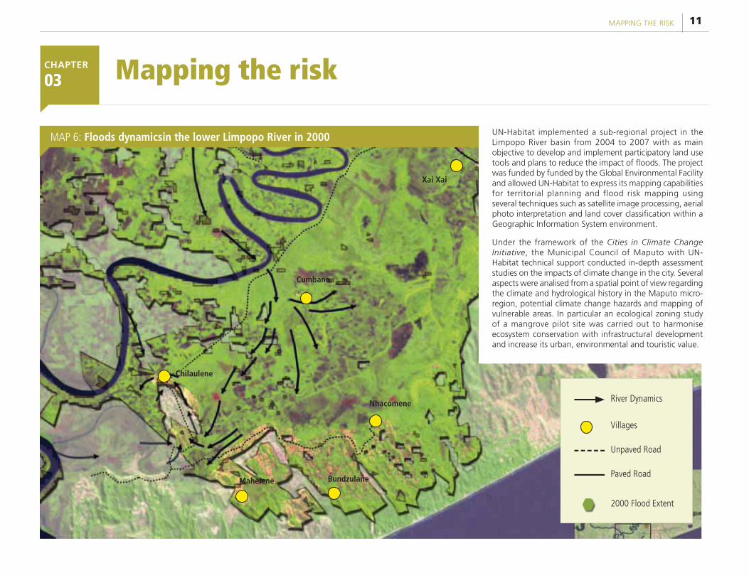
UN-Habitat implemented a sub-regional project in the Limpopo River basin from 2004 to 2007 with as main objective to develop and implement participatory land use tools and plans to reduce the impact of floods. The project was funded by funded by the Global Environmental Facility and allowed UN-Habitat to express its mapping capabilities for territorial planning and flood risk mapping using several techniques such as satellite image processing, aerial photo interpretation and land cover classification within a Geographic Information System environment.
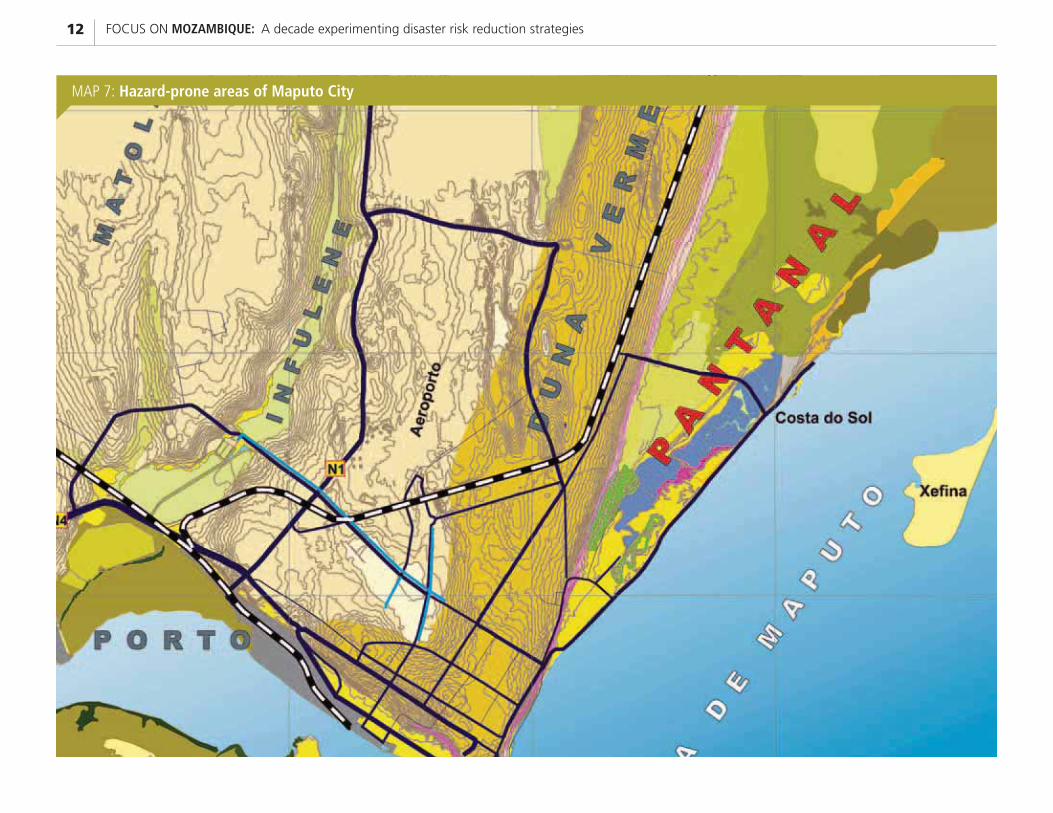
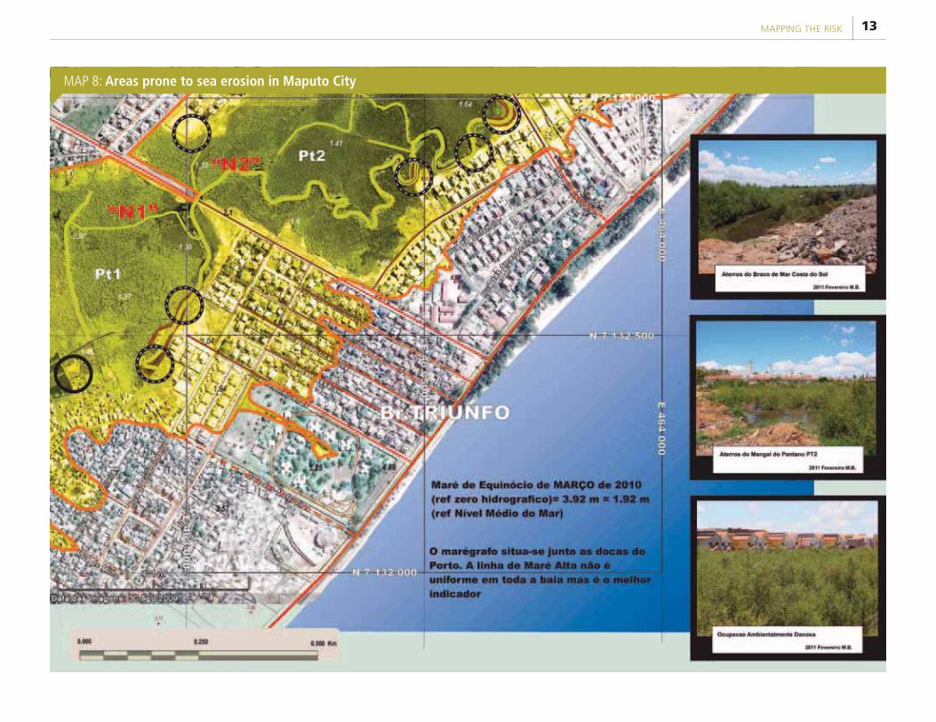
Under the framework of the Cities in Climate Change Initiative, the Municipal Council of Maputo with UN-Habitat technical support conducted in-depth assessment studies on the impacts of climate change in the city. Several aspects were analised from a spatial point of view regarding the climate and hydrological history in the Maputo micro-region, potential climate change hazards and mapping of vulnerable areas. In particular an ecological zoning study of a mangrove pilot site was carried out to harmonise ecosystem conservation with infrastructural development and increase its urban, environmental and touristic value.
MAP 6: Floods dynamicsin the lower Limpopo River in 2000
FOCUS ON MOZAMBIQUE: A decade experimenting disaster risk reduction strategies12
MAP 7: Hazard-prone areas of Maputo City
13MAPPING THE RISK
MAP 8: Areas prone to sea erosion in Maputo City
FOCUS ON MOZAMBIQUE: A decade experimenting disaster risk reduction strategies14
15INNOVATION IN TECHNICAL FEATURES
INNOVATION IN TECHNICAL FEATURES CHAPTER
04
The Change
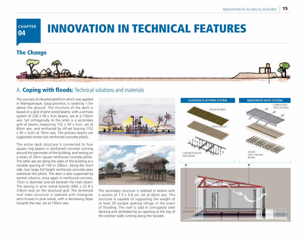
The concept of elevated platform which was applied in Maniquenique, Gaza province, is raised by 1.5m above the ground. The structure of the deck is based on a grid of pine wood beams, with a primary system of 228 x 50 x 5cm beams, set at a 150cm axis. Set orthogonally to the latter is a secondary grid of beams measuring 152 x 50 x 5cm, set at 60cm axis, and reinforced by off-set bracing (152 x 50 x 5cm) at 70cm axis. The primary beams are supported onsite-cast reinforced concrete pilotis.
The entire deck structure is connected to four square ring beams in reinforced concrete running around the perimeter of the building, and resting on a series of 20cm square reinforced concrete pilotis. The latter are set along the sides of the building at a variable spacing of 150 or 300cm. Along the short side, two large full height reinforced concrete piers substitute the pilotis. The deck is also supported by central columns, once again in reinforced concrete, 15cm in diameter and set beneath the main beam. The paving in pine wood boards (660 x 22.8 x 3.8cm) rests on the structural grid. The reinforced roof main structure is realised with triangular semi-trusses in pine wood, with a decreasing slope towards the rear, set at 150cm axis.
The secondary structure is realised in beams with a section of 7.5 x 3.8 cm, set at 60cm axis. This structure is capable of supporting the weight of at least 50 people seeking refuge in the event of flooding. The roof is clad in corrugated steel decking and ventilated by an opening at the top of the exterior walls running along the facades.
A. Coping with floods: Technical solutions and materials
FLOOD LEVEL
ELEVATED PLATFORM SYSTEM
WOOD BOARDS
WOOD BEAMS
CONCRETE PILOTIS AND BEAMS
CORRUGATED STEEL DECKING
WOOD SEMI -TRUSSED BEAMS
REINFORCED ROOF SYSTEM
FOCUS ON MOZAMBIQUE: A decade experimenting disaster risk reduction strategies16
REINFORCED ROOF
ELEVATED PLATFORM
RAINWATER HARVESTING SYSTEM
REINFORCED CONCRETE PREFABRICATED ROOF
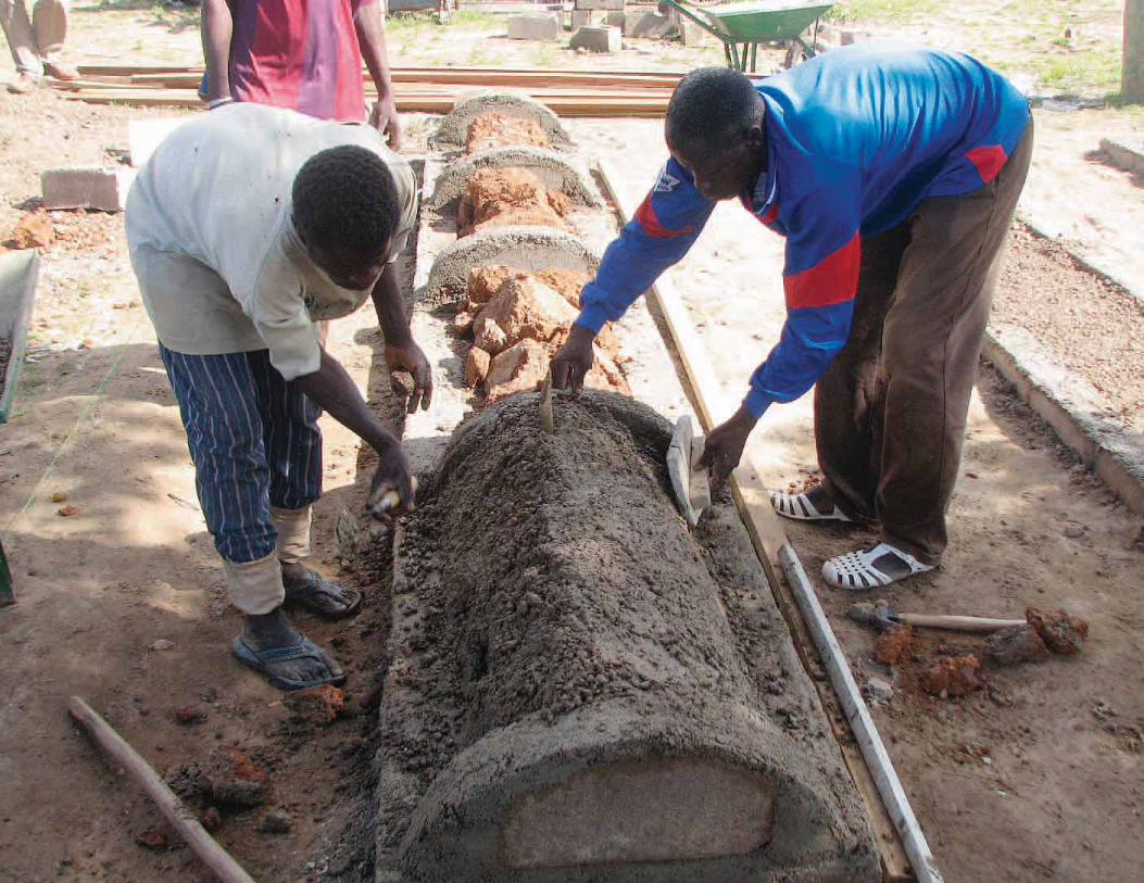
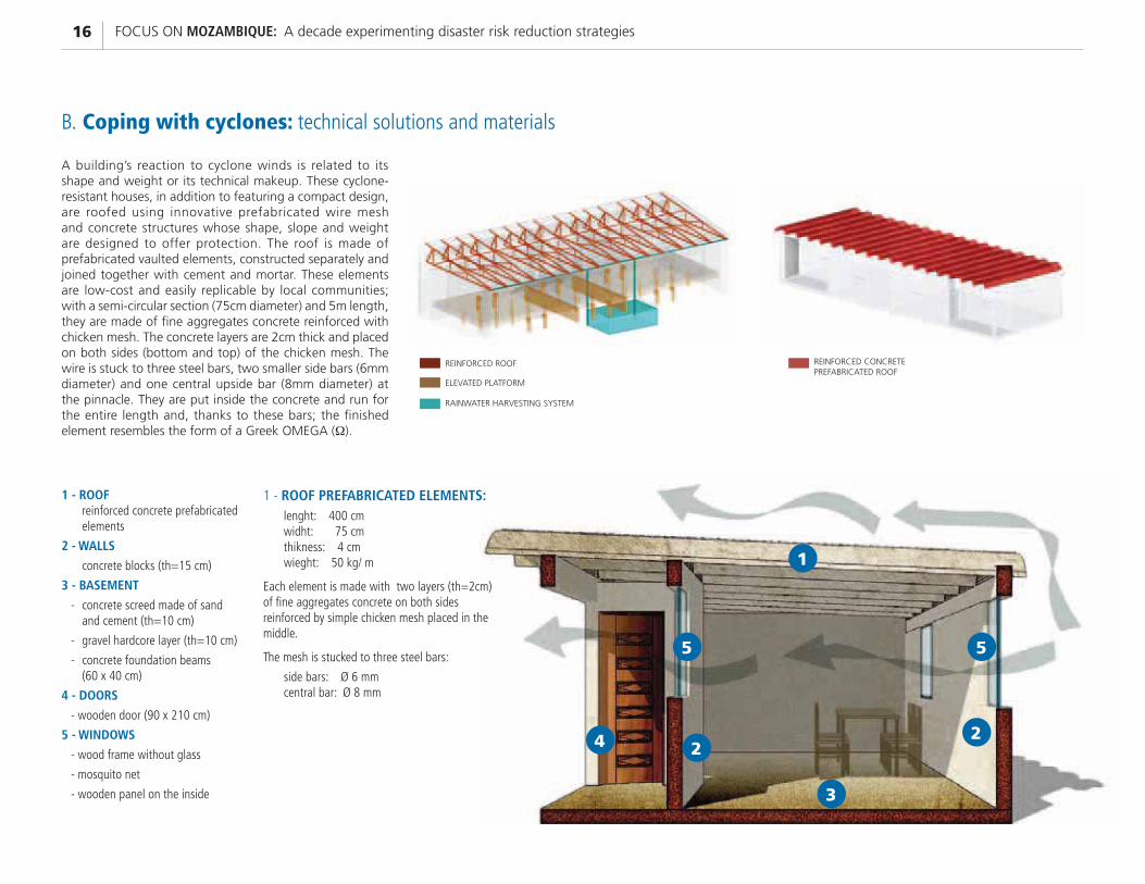
A building’s reaction to cyclone winds is related to its shape and weight or its technical makeup. These cyclone-resistant houses, in addition to featuring a compact design, are roofed using innovative prefabricated wire mesh and concrete structures whose shape, slope and weight are designed to offer protection. The roof is made of prefabricated vaulted elements, constructed separately and joined together with cement and mortar. These elements are low-cost and easily replicable by local communities; with a semi-circular section (75cm diameter) and 5m length, they are made of fine aggregates concrete reinforced with chicken mesh. The concrete layers are 2cm thick and placed on both sides (bottom and top) of the chicken mesh. The wire is stuck to three steel bars, two smaller side bars (6mm diameter) and one central upside bar (8mm diameter) at the pinnacle. They are put inside the concrete and run for the entire length and, thanks to these bars; the finished element resembles the form of a Greek OMEGA (�).
B. Coping with cyclones: technical solutions and materials
1 - ROOF reinforced concrete prefabricated
elements
2 - WALLS
concrete blocks (th=15 cm)
3 - BASEMENT
- concrete screed made of sand and cement (th=10 cm)
- gravel hardcore layer (th=10 cm)
- concrete foundation beams (60 x 40 cm)
4 - DOORS
- wooden door (90 x 210 cm)
5 - WINDOWS
- wood frame without glass
- mosquito net
- wooden panel on the inside
1 - ROOF PREFABRICATED ELEMENTS:lenght: 400 cmwidht: 75 cmthikness: 4 cmwieght: 50 kg/ m
Each element is made with two layers (th=2cm) of fine aggregates concrete on both sidesreinforced by simple chicken mesh placed in the middle.
The mesh is stucked to three steel bars:
side bars: Ø 6 mmcentral bar: Ø 8 mm
24
5 5
2
1
3
17INNOVATION IN TECHNICAL FEATURES
SIMPLE COMPRESSION
STATE
SIMPLE TENSION
STATE
SIMPLE BENDING
STATE
CATENARY SHAPE (simple tension state)
ARCH SHAPE (simple compression state)
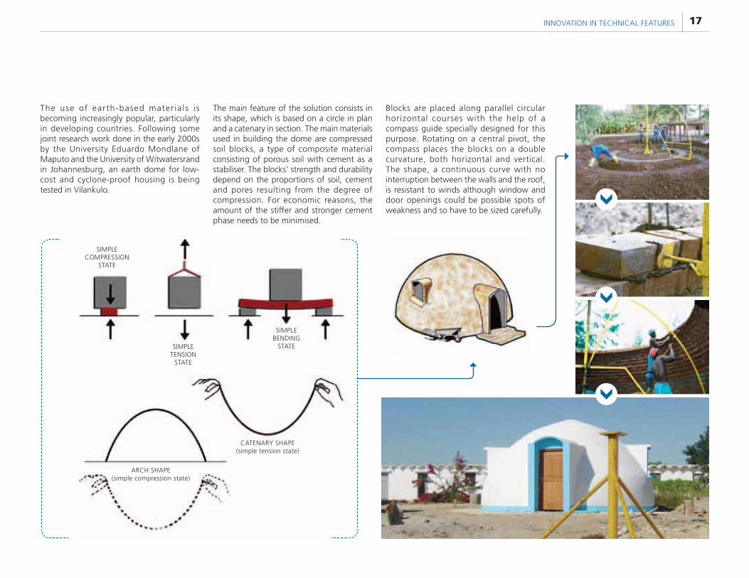
The use of earth-based mater ia ls i s becoming increasingly popular, particularly in developing countries. Following some joint research work done in the early 2000s by the University Eduardo Mondlane of Maputo and the University of Witwatersrand in Johannesburg, an earth dome for low-cost and cyclone-proof housing is being tested in Vilankulo.
The main feature of the solution consists in its shape, which is based on a circle in plan and a catenary in section. The main materials used in building the dome are compressed soil blocks, a type of composite material consisting of porous soil with cement as a stabiliser. The blocks’ strength and durability depend on the proportions of soil, cement and pores resulting from the degree of compression. For economic reasons, the amount of the stiffer and stronger cement phase needs to be minimised.
Blocks are placed along parallel circular horizontal courses with the help of a compass guide specially designed for this purpose. Rotating on a central pivot, the compass places the blocks on a double curvature, both horizontal and vertical. The shape, a continuous curve with no interruption between the walls and the roof, is resistant to winds although window and door openings could be possible spots of weakness and so have to be sized carefully.
FOCUS ON MOZAMBIQUE: A decade experimenting disaster risk reduction strategies18
1 concrete dome (th=5 cm)
2 concrete blocks (th=15 cm)
3 concrete beam (15x15cm)
4 concrete foundation plynth (20x40 cm)
5 concrete pillar (15x15cm - fe Ø 6mm and 12 mm)
6 concrete (th=6cm) reinforced with double steel mesh (th=12 mm)
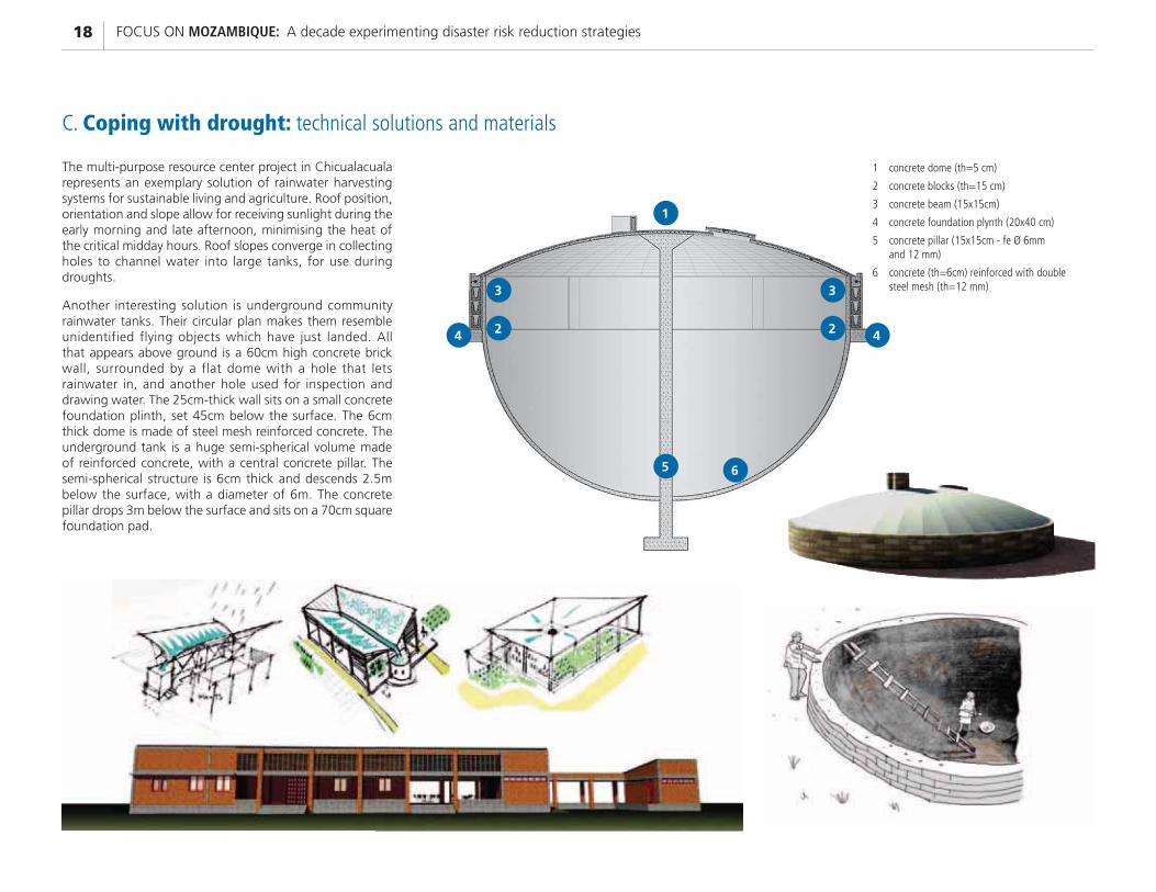
The multi-purpose resource center project in Chicualacuala represents an exemplary solution of rainwater harvesting systems for sustainable living and agriculture. Roof position, orientation and slope allow for receiving sunlight during the early morning and late afternoon, minimising the heat of the critical midday hours. Roof slopes converge in collecting holes to channel water into large tanks, for use during droughts.
Another interesting solution is underground community rainwater tanks. Their circular plan makes them resemble unidentified flying objects which have just landed. All that appears above ground is a 60cm high concrete brick wall, surrounded by a flat dome with a hole that lets rainwater in, and another hole used for inspection and drawing water. The 25cm-thick wall sits on a small concrete foundation plinth, set 45cm below the surface. The 6cm thick dome is made of steel mesh reinforced concrete. The underground tank is a huge semi-spherical volume made of reinforced concrete, with a central concrete pillar. The semi-spherical structure is 6cm thick and descends 2.5m below the surface, with a diameter of 6m. The concrete pillar drops 3m below the surface and sits on a 70cm square foundation pad.
C. Coping with drought: technical solutions and materials
1
65
42
3
2
3
4
19WORKING WITH COMMUNITIES
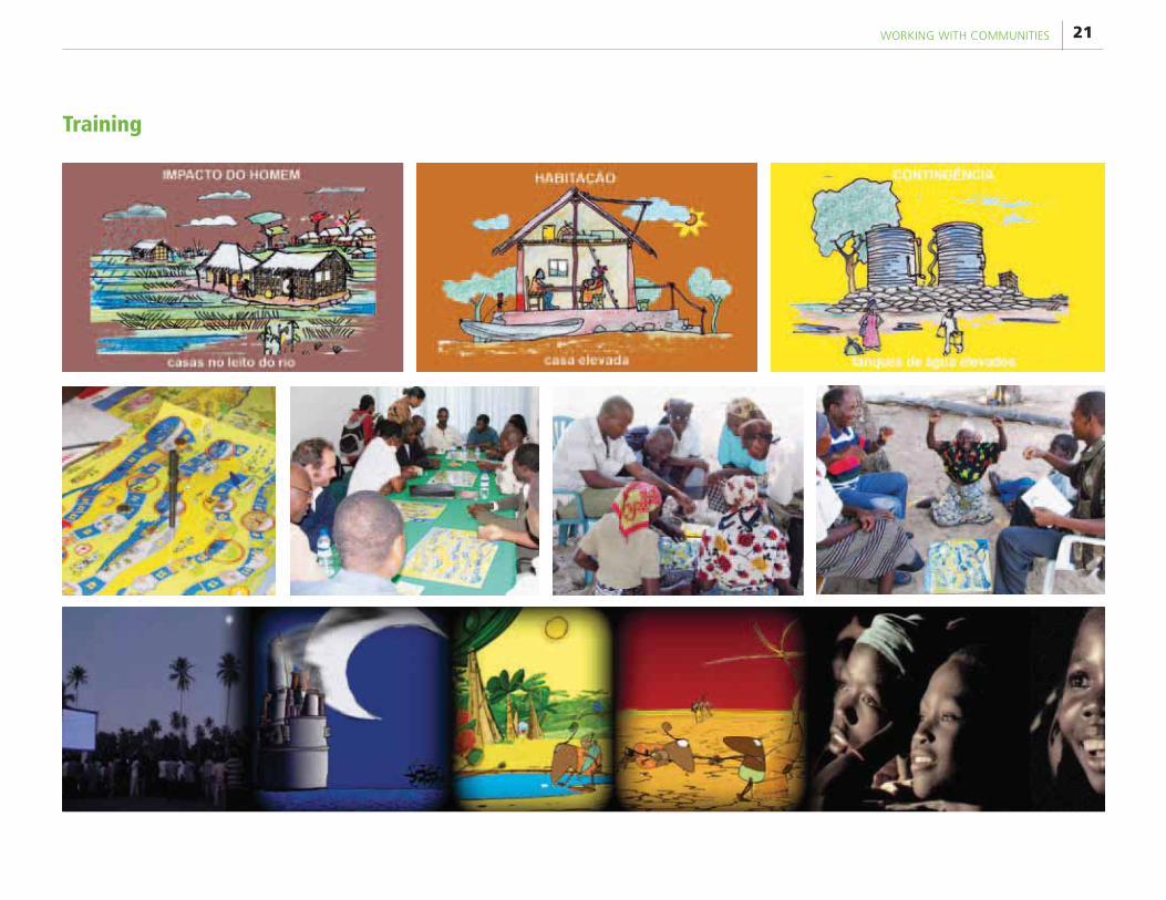
Since 2003, UN-Habitat has developed several tools for increasing awareness on preparation and adaptation to natural hazards, as well as giving recommendations
and technical innovation regarding the way of thinking about architecture and infrastructure solutions in vulnerable settlements.
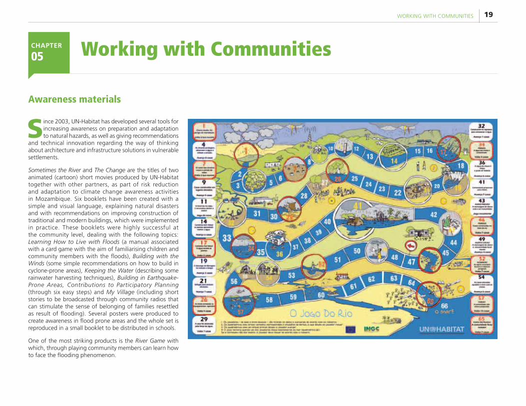
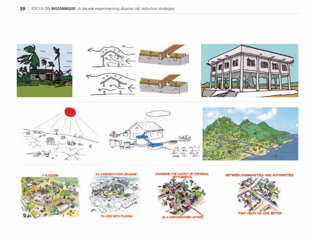
Sometimes the River and The Change are the titles of two animated (cartoon) short movies produced by UN-Habitat together with other partners, as part of risk reduction and adaptation to climate change awareness activities in Mozambique. Six booklets have been created with a simple and visual language, explaining natural disasters and with recommendations on improving construction of traditional and modern buildings, which were implemented in practice. These booklets were highly successful at the community level, dealing with the following topics: Learning How to Live with Floods (a manual associated with a card game with the aim of familiarising children and community members with the floods), Building with the Winds (some simple recommendations on how to build in cyclone-prone areas), Keeping the Water (describing some rainwater harvesting techniques), Building in Earthquake-Prone Areas, Contributions to Participatory Planning (through six easy steps) and My Village (including short stories to be broadcasted through community radios that can stimulate the sense of belonging of families resettled as result of flooding). Several posters were produced to create awareness in flood prone areas and the whole set is reproduced in a small booklet to be distributed in schools.
One of the most striking products is the River Game with which, through playing community members can learn how to face the flooding phenomenon.
Working with Communities CHAPTER
05
Awareness materials
FOCUS ON MOZAMBIQUE: A decade experimenting disaster risk reduction strategies20
21WORKING WITH COMMUNITIES
Training
FOCUS ON MOZAMBIQUE: A decade experimenting disaster risk reduction strategies22
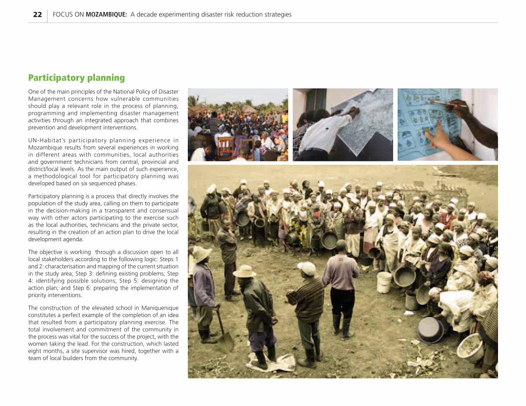
Participatory planning One of the main principles of the National Policy of Disaster Management concerns how vulnerable communities should play a relevant role in the process of planning, programming and implementing disaster management activities through an integrated approach that combines prevention and development interventions.
UN-Habitat’s participatory planning experience in Mozambique results from several experiences in working in different areas with communities, local authorities and government technicians from central, provincial and district/local levels. As the main output of such experience, a methodological tool for participatory planning was developed based on six sequenced phases.
Participatory planning is a process that directly involves the population of the study area, calling on them to participate in the decision-making in a transparent and consensual way with other actors participating to the exercise such as the local authorities, technicians and the private sector, resulting in the creation of an action plan to drive the local development agenda.
The objective is working through a discussion open to all local stakeholders according to the following logic: Steps 1 and 2: characterisation and mapping of the current situation in the study area; Step 3: defining existing problems; Step 4: identifying possible solutions; Step 5: designing the action plan; and Step 6: preparing the implementation of priority interventions.
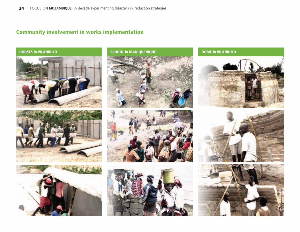
The construction of the elevated school in Maniquenique constitutes a perfect example of the completion of an idea that resulted from a participatory planning exercise. The total involvement and commitment of the community in the process was vital for the success of the project, with the women taking the lead. For the construction, which lasted eight months, a site supervisor was hired, together with a team of local builders from the community.
23WORKING WITH COMMUNITIES
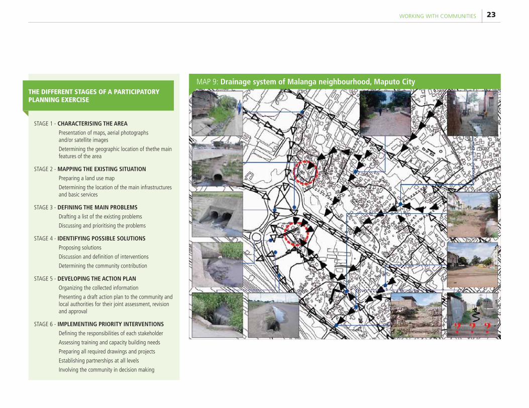
STAGE 1 - CHARACTERISING THE AREA
Presentation of maps, aerial photographs and/or satellite images
Determining the geographic location of thethe main features of the area
STAGE 2 - MAPPING THE EXISTING SITUATION
Preparing a land use map
Determining the location of the main infrastructures and basic services
STAGE 3 - DEFINING THE MAIN PROBLEMS
Drafting a list of the existing problems
Discussing and prioritising the problems
STAGE 4 - IDENTIFYING POSSIBLE SOLUTIONS
Proposing solutions
Discussion and definition of interventions
Determining the community contribution
STAGE 5 - DEVELOPING THE ACTION PLAN
Organizing the collected information
Presenting a draft action plan to the community and local authorities for their joint assessment, revision and approval
STAGE 6 - IMPLEMENTING PRIORITY INTERVENTIONS
Defining the responsibilities of each stakeholder
Assessing training and capacity building needs
Preparing all required drawings and projects
Establishing partnerships at all levels
Involving the community in decision making
THE DIFFERENT STAGES OF A PARTICIPATORY PLANNING EXERCISE
MAP 9: Drainage system of Malanga neighbourhood, Maputo City
FOCUS ON MOZAMBIQUE: A decade experimenting disaster risk reduction strategies24
HOUSES in VILANKULO
Community involvement in works implementation
SCHOOL in MANIQUENIQUE DOME in VILANKULO

25DEMONSTRATIVE INTERVENTIONS
Demonstrative Interventions CHAPTER
06
1. Elevated school in Maniquenique, Chibuto district, Gaza provinceFunded by: Global Environment Facility (GEF)
Implemented by: Government of Mozambique (Ministry for Coordination of Environmental Affairs)
Maniquenique, in the district of Chibuto, Gaza province, is an isolated area in the midst of the
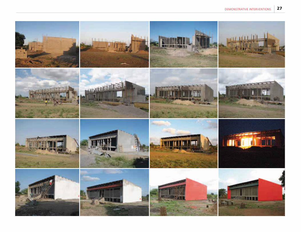
lower Limpopo River floodplain, characterised by cyclical floods. The elevated school constructed by UN-Habitat there was the first implementation of the support-platform concept, in response to the local population’s need for a school. The schools can shelter 850 people in case of floods and was built using local labour.
The building is characterised by a rectangular plan measuring 9 x 22.5 m, with a total floor area of approximately 200 m2. The interior is subdivided into two large classrooms of approximately 60 m2 each and a central space in correspondence to the entrance, for use by teaching staff. The floor slab is raised 1.5 m above the ground, hence above the level reached by the Limpopo River during the great 2000 floods.
FOCUS ON MOZAMBIQUE: A decade experimenting disaster risk reduction strategies26
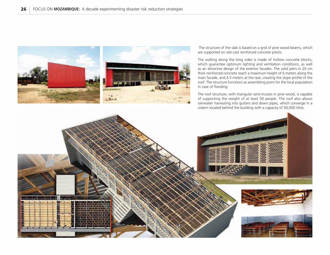
The structure of the slab is based on a grid of pine wood beams, which are supported on site-cast reinforced concrete pilotis.
The walling along the long sides is made of hollow concrete blocks, which guarantee optimum lighting and ventilation conditions, as well as an attractive design of the exterior facades. The solid piers in 20 cm thick reinforced concrete reach a maximum height of 6 meters along the main facade, and 4.5 meters at the rear, creating the slope profile of the roof. The structure functions as assembling point for the local population in case of flooding.
The roof structure, with triangular semi-trusses in pine wood, is capable of supporting the weight of at least 50 people. The roof also allows rainwater harvesting into gutters and down pipes, which converge in a cistern located behind the building with a capacity of 50,000 litres.
27DEMONSTRATIVE INTERVENTIONS
FOCUS ON MOZAMBIQUE: A decade experimenting disaster risk reduction strategies28
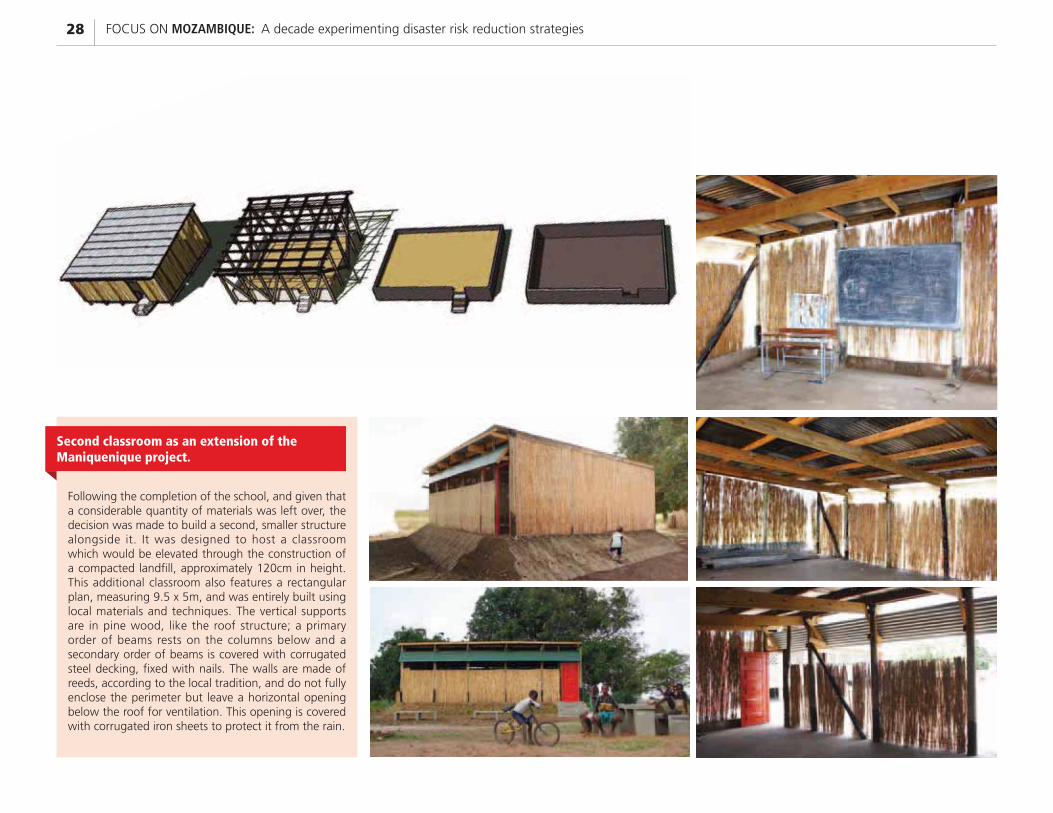
Following the completion of the school, and given that a considerable quantity of materials was left over, the decision was made to build a second, smaller structure alongside it. It was designed to host a classroom which would be elevated through the construction of a compacted landfill, approximately 120cm in height. This additional classroom also features a rectangular plan, measuring 9.5 x 5m, and was entirely built using local materials and techniques. The vertical supports are in pine wood, like the roof structure; a primary order of beams rests on the columns below and a secondary order of beams is covered with corrugated steel decking, fixed with nails. The walls are made of reeds, according to the local tradition, and do not fully enclose the perimeter but leave a horizontal opening below the roof for ventilation. This opening is covered with corrugated iron sheets to protect it from the rain.
Second classroom as an extension of the Maniquenique project.
29DEMONSTRATIVE INTERVENTIONS
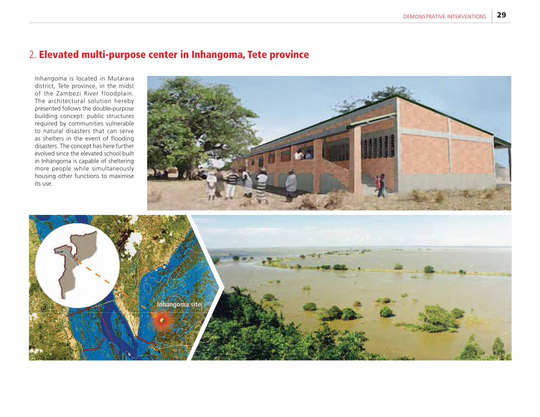
Inhangoma is located in Mutarara district, Tete province, in the midst of the Zambezi River floodplain. The architectural solution hereby presented follows the double-purpose building concept: public structures required by communities vulnerable to natural disasters that can serve as shelters in the event of flooding disasters. The concept has here further evolved since the elevated school built in Inhangoma is capable of sheltering more people while simultaneously housing other functions to maximise its use.
Inhangoma site
2. Elevated multi-purpose center in Inhangoma, Tete province
FOCUS ON MOZAMBIQUE: A decade experimenting disaster risk reduction strategies30
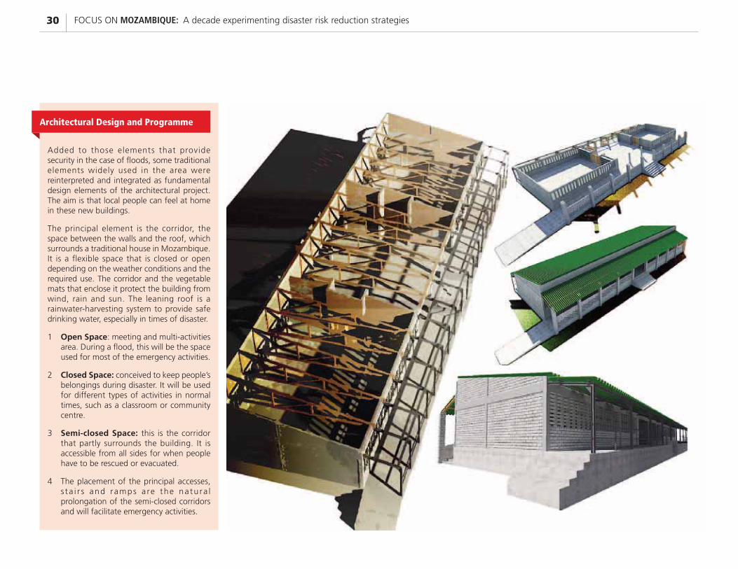
Added to those elements that provide security in the case of floods, some traditional elements widely used in the area were reinterpreted and integrated as fundamental design elements of the architectural project. The aim is that local people can feel at home in these new buildings.
The principal element is the corridor, the space between the walls and the roof, which surrounds a traditional house in Mozambique. It is a flexible space that is closed or open depending on the weather conditions and the required use. The corridor and the vegetable mats that enclose it protect the building from wind, rain and sun. The leaning roof is a rainwater-harvesting system to provide safe drinking water, especially in times of disaster.
1 Open Space: meeting and multi-activities area. During a flood, this will be the space used for most of the emergency activities.
2 Closed Space: conceived to keep people’s belongings during disaster. It will be used for different types of activities in normal times, such as a classroom or community centre.
3 Semi-closed Space: this is the corridor that partly surrounds the building. It is accessible from all sides for when people have to be rescued or evacuated.
4 The placement of the principal accesses, s ta i r s and ramps a re the na tu ra l prolongation of the semi-closed corridors and will facilitate emergency activities.
Architectural Design and Programme
31DEMONSTRATIVE INTERVENTIONS
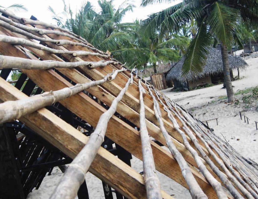
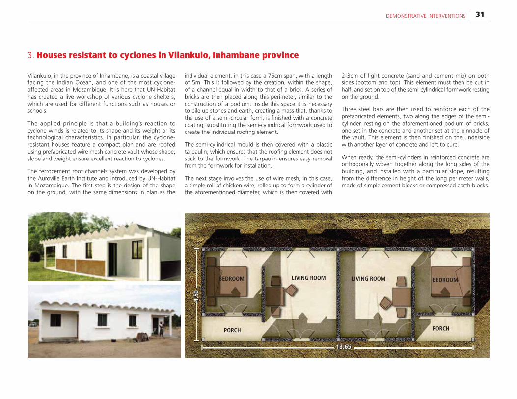
3. Houses resistant to cyclones in Vilankulo, Inhambane province
Vilankulo, in the province of Inhambane, is a coastal village facing the Indian Ocean, and one of the most cyclone-affected areas in Mozambique. It is here that UN-Habitat has created a live workshop of various cyclone shelters, which are used for different functions such as houses or schools.
The applied principle is that a building’s reaction to cyclone winds is related to its shape and its weight or its technological characteristics. In particular, the cyclone-resistant houses feature a compact plan and are roofed using prefabricated wire mesh concrete vault whose shape, slope and weight ensure excellent reaction to cyclones.
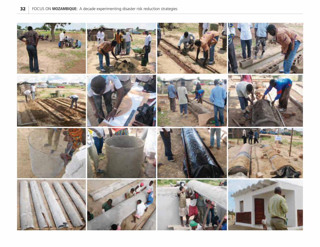
The ferrocement roof channels system was developed by the Auroville Earth Institute and introduced by UN-Habitat in Mozambique. The first step is the design of the shape on the ground, with the same dimensions in plan as the
individual element, in this case a 75cm span, with a length of 5m. This is followed by the creation, within the shape, of a channel equal in width to that of a brick. A series of bricks are then placed along this perimeter, similar to the construction of a podium. Inside this space it is necessary to pile up stones and earth, creating a mass that, thanks to the use of a semi-circular form, is finished with a concrete coating, substituting the semi-cylindrical formwork used to create the individual roofing element.
The semi-cylindrical mould is then covered with a plastic tarpaulin, which ensures that the roofing element does not stick to the formwork. The tarpaulin ensures easy removal from the formwork for installation.
The next stage involves the use of wire mesh, in this case, a simple roll of chicken wire, rolled up to form a cylinder of the aforementioned diameter, which is then covered with
2-3cm of light concrete (sand and cement mix) on both sides (bottom and top). This element must then be cut in half, and set on top of the semi-cylindrical formwork resting on the ground.
Three steel bars are then used to reinforce each of the prefabricated elements, two along the edges of the semi-cylinder, resting on the aforementioned podium of bricks, one set in the concrete and another set at the pinnacle of the vault. This element is then finished on the underside with another layer of concrete and left to cure.
When ready, the semi-cylinders in reinforced concrete are orthogonally woven together along the long sides of the building, and installed with a particular slope, resulting from the difference in height of the long perimeter walls, made of simple cement blocks or compressed earth blocks.
LIVING ROOM LIVING ROOM BEDROOMBEDROOM
PORCH PORCH
4.50
13.65
FOCUS ON MOZAMBIQUE: A decade experimenting disaster risk reduction strategies32
33DEMONSTRATIVE INTERVENTIONS
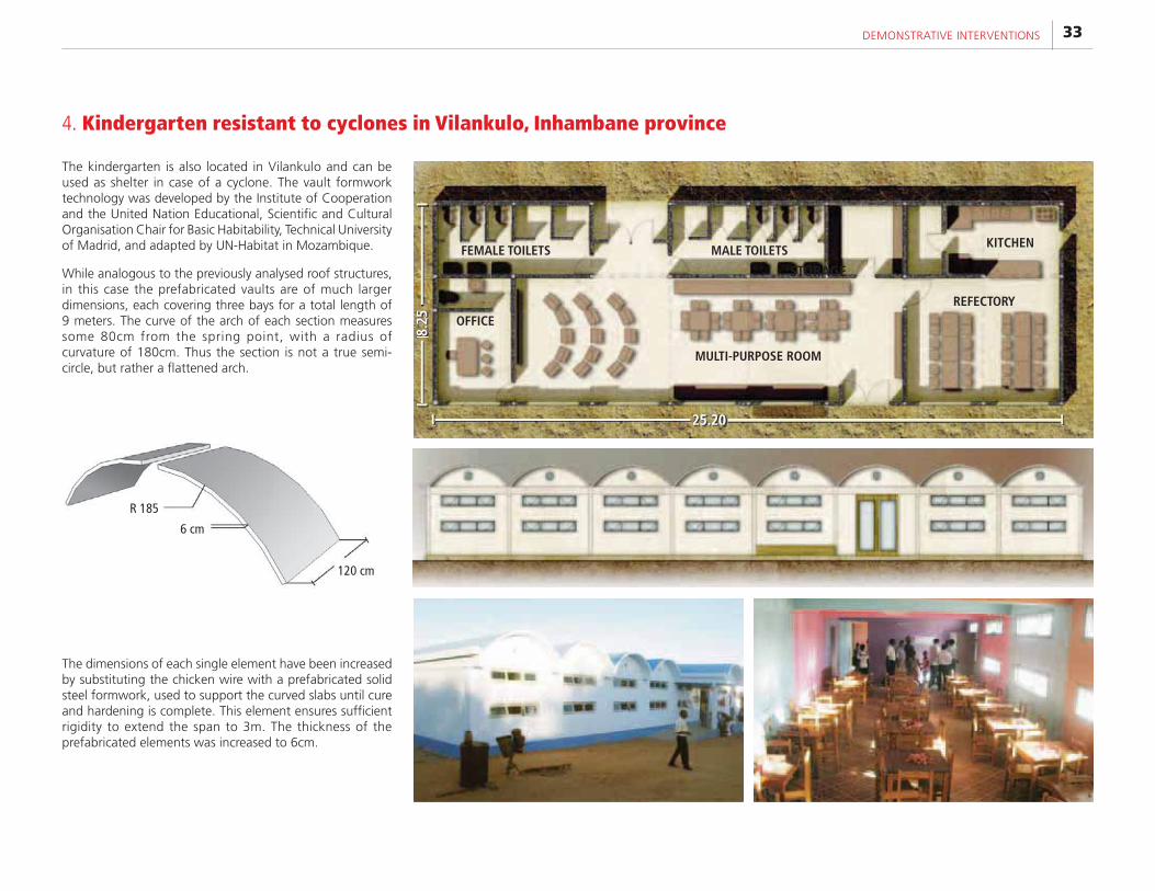
The kindergarten is also located in Vilankulo and can be used as shelter in case of a cyclone. The vault formwork technology was developed by the Institute of Cooperation and the United Nation Educational, Scientific and Cultural Organisation Chair for Basic Habitability, Technical University of Madrid, and adapted by UN-Habitat in Mozambique.
While analogous to the previously analysed roof structures, in this case the prefabricated vaults are of much larger dimensions, each covering three bays for a total length of 9 meters. The curve of the arch of each section measures some 80cm from the spring point, with a radius of curvature of 180cm. Thus the section is not a true semi-circle, but rather a flattened arch.
The dimensions of each single element have been increased by substituting the chicken wire with a prefabricated solid steel formwork, used to support the curved slabs until cure and hardening is complete. This element ensures sufficient rigidity to extend the span to 3m. The thickness of the prefabricated elements was increased to 6cm.
R 185
6 cm
120 cm
4. Kindergarten resistant to cyclones in Vilankulo, Inhambane province
25.208.
25
FEMALE TOILETS MALE TOILETS
STORAGE
KITCHEN
REFECTORY
OFFICE
MULTI-PURPOSE ROOM
FOCUS ON MOZAMBIQUE: A decade experimenting disaster risk reduction strategies34
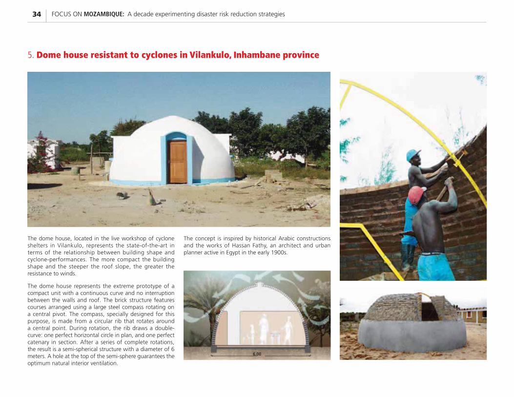
The dome house, located in the live workshop of cyclone shelters in Vilankulo, represents the state-of-the-art in terms of the relationship between building shape and cyclone-performances. The more compact the building shape and the steeper the roof slope, the greater the resistance to winds.
The dome house represents the extreme prototype of a compact unit with a continuous curve and no interruption between the walls and roof. The brick structure features courses arranged using a large steel compass rotating on a central pivot. The compass, specially designed for this purpose, is made from a circular rib that rotates around a central point. During rotation, the rib draws a double-curve: one perfect horizontal circle in plan, and one perfect catenary in section. After a series of complete rotations, the result is a semi-spherical structure with a diameter of 6 meters. A hole at the top of the semi-sphere guarantees the optimum natural interior ventilation.
The concept is inspired by historical Arabic constructions and the works of Hassan Fathy, an architect and urban planner active in Egypt in the early 1900s.
6.00
5. Dome house resistant to cyclones in Vilankulo, Inhambane province
35DEMONSTRATIVE INTERVENTIONS
Funded by: Government of Spain through the Millennium Development Goals Trust Fund; Implemented by the National Institute for Disaster Management, through its National Directorate for Arid and Semi-Arid Areas, and the District Government of Chicualacuala.
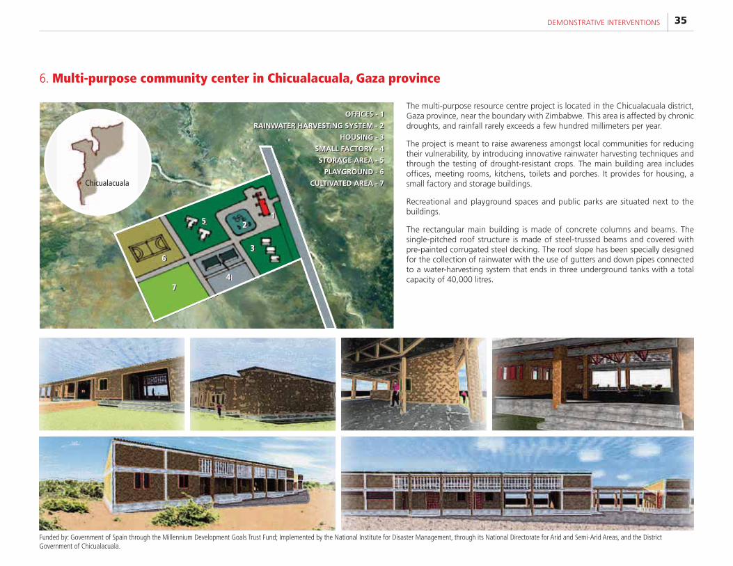
The multi-purpose resource centre project is located in the Chicualacuala district, Gaza province, near the boundary with Zimbabwe. This area is affected by chronic droughts, and rainfall rarely exceeds a few hundred millimeters per year.
The project is meant to raise awareness amongst local communities for reducing their vulnerability, by introducing innovative rainwater harvesting techniques and through the testing of drought-resistant crops. The main building area includes offices, meeting rooms, kitchens, toilets and porches. It provides for housing, a small factory and storage buildings.
Recreational and playground spaces and public parks are situated next to the buildings.
The rectangular main building is made of concrete columns and beams. The single-pitched roof structure is made of steel-trussed beams and covered with pre-painted corrugated steel decking. The roof slope has been specially designed for the collection of rainwater with the use of gutters and down pipes connected to a water-harvesting system that ends in three underground tanks with a total capacity of 40,000 litres.
6. Multi-purpose community center in Chicualacuala, Gaza province
12
3
4
5
6
7
Chicualacuala
OFFICES - 1
RAINWATER HARVESTING SYSTEM - 2
HOUSING - 3
SMALL FACTORY - 4
STORAGE AREA - 5
PLAYGROUND - 6
CULTIVATED AREA - 7
OFFICES - 1
RAINWATER HARVESTING SYSTEM - 2
HOUSING - 3
SMALL FACTORY - 4
STORAGE AREA - 5
PLAYGROUND - 6
CULTIVATED AREA - 7
FOCUS ON MOZAMBIQUE: A decade experimenting disaster risk reduction strategies36
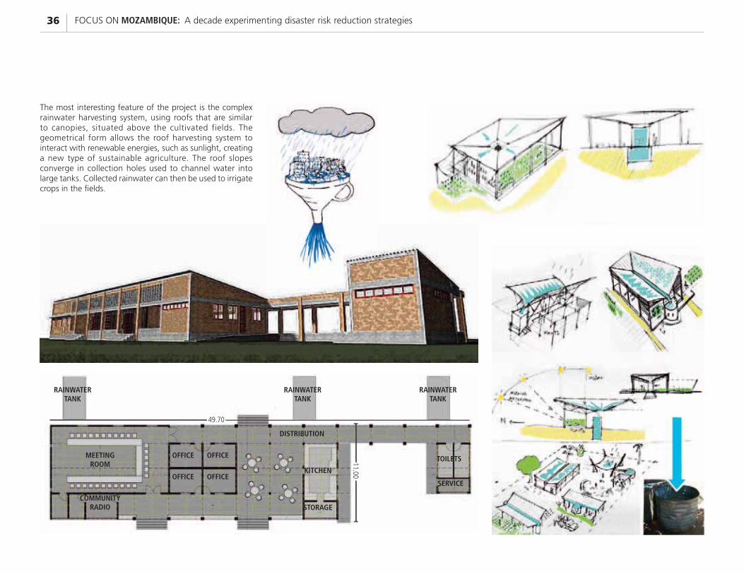
The most interesting feature of the project is the complex rainwater harvesting system, using roofs that are similar to canopies, situated above the cultivated fields. The geometrical form allows the roof harvesting system to interact with renewable energies, such as sunlight, creating a new type of sustainable agriculture. The roof slopes converge in collection holes used to channel water into large tanks. Collected rainwater can then be used to irrigate crops in the fields.
OFFICE OFFICE
OFFICEOFFICE
MEETING ROOM
COMMUNITY RADIO
RAINWATER TANK
RAINWATER TANK
DISTRIBUTION
KITCHEN
STORAGE
TOILETS
SERVICE
RAINWATER TANK
49.70
11.00
37DEMONSTRATIVE INTERVENTIONS
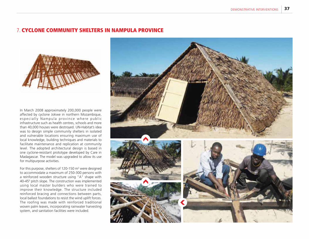
In March 2008 approximately 200,000 people were affected by cyclone Jokwe in northern Mozambique, e spec i a l l y Nampu la p rov ince whe re pub l i c infrastructure such as health centres, schools and more than 40,000 houses were destroyed. UN-Habitat’s idea was to design simple community shelters in isolated and vulnerable locations ensuring maximum use of local knowledge, building techniques and materials to facilitate maintenance and replication at community level. The adopted architectural design is based in one cyclone-resistant prototype developed by Care in Madagascar. The model was upgraded to allow its use for multipurpose activities.
For this purpose, shelters of 120-150 m2 were designed to accommodate a maximum of 250-300 persons with a reinforced wooden structure using "A" shape with 40-450 pitch slope. The construction was implemented using local master builders who were trained to improve their knowledge. The structure included reinforced bracing and connections between parts, local ballast foundations to resist the wind uplift forces. The roofing was made with reinforced traditional woven palm leaves, incorporating rainwater harvesting system, and sanitation facilities were included.
7. CYCLONE COMMUNITY SHELTERS IN NAMPULA PROVINCE
FOCUS ON MOZAMBIQUE: A decade experimenting disaster risk reduction strategies38
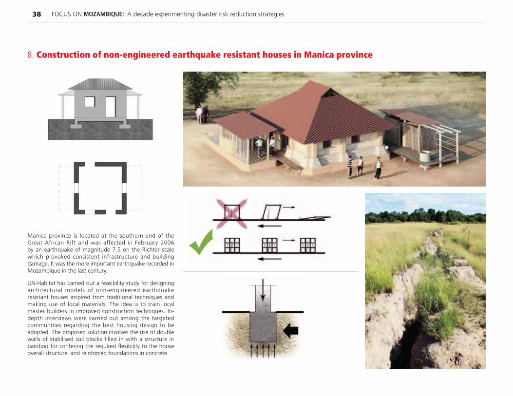
Manica province is located at the southern end of the Great African Rift and was affected in February 2006 by an earthquake of magnitude 7.5 on the Richter scale which provoked consistent infrastructure and building damage. It was the more important earthquake recorded in Mozambique in the last century.
UN-Habitat has carried out a feasibility study for designing architectural models of non-engineered earthquake resistant houses inspired from traditional techniques and making use of local materials. The idea is to train local master builders in improved construction techniques. In-depth interviews were carried out among the targeted communities regarding the best housing design to be adopted. The proposed solution involves the use of double walls of stabilised soil blocks filled in with a structure in bamboo for confering the required flexibility to the house overall structure, and reinforced foundations in concrete.
8. Construction of non-engineered earthquake resistant houses in Manica province

UNITED NATIONS HUMAN SETTLEMENTS PROGRAMME P.O.Box 30030,Nairobi 00100,Kenya; Tel: +254-20-7623120; Fax: +254-20-76234266/7 (Central office) [email protected] www.unhabitat.org
HS/059/12 ISBN: 978-92-1-132479-2 ISBNE (Electronic): 921-1-131496-8
The United Nations Human Settlements Programme (UN-Habitat) in Mozambique concerns all the strategic areas of intervention of the Agency and, therefore, is probably one of the most complete in the world.
This publication presents only part of the work which is being carried out by UN-Habitat in Mozambique, by focusing essentially on disaster risk reduction interventions, which proved to be highly innovative and are considered among the best practices of the Agency. Other activities concern sustainable urban planning, urban legislation and policy formulation, slum upgrading through delivery of basic services, municipal capacity development, climate change adaptation and mitigation, urban economy and municipal finance, studies and research, advocacy, technical support to several governmental and non governmental bodies and organisations, and coordination within the United Nations system in Mozambique. Hence, the main objective of this publication is to showcase the importance of country activities and how these can positively influence the normative work of the Agency at the global level.
There is little doubt that the urban agenda has become a top priority in modern history, especially in the African continent, hence UN-Habitat is more needed today than ever. The programme in Mozambique can show the way to many others.