FME Workbench Transformers Quick-Reference Booklet
40
FME ® Workbench Transformers Quick-Reference Booklet www.safe.com
-
Upload
netahedberg -
Category
Documents
-
view
213 -
download
11
Transcript of FME Workbench Transformers Quick-Reference Booklet

FME® Workbench Transformers Quick-Reference Booklet
www.safe.com

1FME Workbench Transformers Quick-Reference Booklet
3D . . . . . . . . . . . . . . . . . . . . . . . . . . . . . . . . . . . . . . . . 1 These transformers create and modify three-dimensional surface and solid geometries.
CALCULATORS . . . . . . . . . . . . . . . . . . . . . . . . . . . . . 1 These transformers calculate a value and supply it to a new attribute on a feature.
COLLECTORS . . . . . . . . . . . . . . . . . . . . . . . . . . . . . . . 4 These transformers operate on collections of features at the same time. The collection of features may be replaced by new features based upon them, have their attributes or geometries merged, or have their orders altered.
DATABASE . . . . . . . . . . . . . . . . . . . . . . . . . . . . . . . . 5 These transformers allow interaction with external databases. Data can be extracted from databases and merged into the feature stream or merged onto features.
FILTERS . . . . . . . . . . . . . . . . . . . . . . . . . . . . . . . . . . . 6 These transformers perform tests on feature geometry and/or attributes, and allow the feature to be routed to different destinations.
GEOMETRIC OPERATORS . . . . . . . . . . . . . . . . . . . 7 These transformers operate on the geometry of individual features or groups of features.
INFRASTRUCTURE . . . . . . . . . . . . . . . . . . . . . . . . 11 These transformers provide interaction with the underlying FME translation engine facilities.
KML . . . . . . . . . . . . . . . . . . . . . . . . . . . . . . . . . . . . . 13 These transformers manipulate feature geometry and/or attributes for output using the OGCKML Writer.
LINEAR REFERENCING . . . . . . . . . . . . . . . . . . . . 13 These transformers work with linear referencing data structures on FME features. Some transformers allow you to create and apply measure-related information held in attributes onto the geometry of FME features.
LISTS . . . . . . . . . . . . . . . . . . . . . . . . . . . . . . . . . . . . 14 These transformers operate on FME attribute lists.
MANIPULATORS . . . . . . . . . . . . . . . . . . . . . . . 15 These transformers modify (manipulate) the geometry or attributes of individual features in isolation from other features.
MRF . . . . . . . . . . . . . . . . . . . . . . . . . . . . . . . . . . 22These transformers manipulate feature geometry and/or attributes for output using the OGCKML Writer.
NETWORK . . . . . . . . . . . . . . . . . . . . . . . . . . . . 23These transformers operate on linear features that are connected in a network, performing operations such as priority calculation and orientation correction.
RASTERS . . . . . . . . . . . . . . . . . . . . . . . . . . . . . . 23 These transformers create, use, and output rasters. They operate on data consisting of a regularly spaced grid of values.
STRINGS . . . . . . . . . . . . . . . . . . . . . . . . . . . . . . 25 These transformers operate on character strings held in FME attributes.
SURFACES . . . . . . . . . . . . . . . . . . . . . . . . . . . . . 27 These transformers create, use, and output surfaces. They operate on data that defines a surface through the z coordinate, and then either outputs this surface in a variety of ways or applies the surface to other data.
WEB SERVICES . . . . . . . . . . . . . . . . . . . . . . . . 28 These transformers access web services using the HTTP protocol.
WORKFLOW . . . . . . . . . . . . . . . . . . . . . . . . . . . 29 These transformers run workspaces either locally or on an FME Server.
XML . . . . . . . . . . . . . . . . . . . . . . . . . . . . . . . . . . 30These transformers work with XML data by mapping XML elements into FME features, using stylesheets to convert XML documents, and querying collections of XML data.
CONTENTS
FME® Workbench Transformers Quick-Reference BookletThis booklet contains a high-level summary of each transformer’s functionality. For detailed information, you can select FME Transformers from the Workbench Help menu, or visit www.safe.com/support/onlinelearning/documentation.php
CONTENTS

2
Properties button
What is a Transformer?A transformer is an FME Workbench object that carries out the restructuring of features. FME contains over 300 different transformers to carry out different types of restructuring. In the Workbench interface, transformers are stored in the Transformer Gallery and grouped in categories applicable to their associated functionality.
The Basics: Placing and Editing TransformersThere are many ways to place a transformer on the Workbench canvas. To start, however, you can simply double-click the transformer name and it will appear in the workspace.
Every transformer has a Properties button on the right of the transformer.
This button is color-coded to show the status of the settings.
� If the Properties button is the same color as the transformer, you can use the transformer with its existing parameters.
� A yellow Properties button indicates that the transformer contains default settings, but you have not yet accepted them. You can use the transformer in this state, but your workspace may produce unexpected results.
� A red Properties button means that there is at least one parameter for which FME cannot supply a default value. You must provide a value for all required fields before you can use the transformer in the workspace.
When you click a Properties button, the dialog that appears will usually have some of the common elements shown in this example. The content of this dialog depends on the transformer, and sometimes even on connections to the transformer. Most transformers have some common user interface elements, however, and those are described here.
You can edit the default transformer name.
Many transformers allow you to group results according to selected attributes.
Required fields are highlighted. If this field is not filled in, the OK button is disabled.
Click OK to accept changes and close the dialog. (This button is disabled if required fields have not been populated.)The Defaults menu allows you to replace FME
defaults for this transformer with your own parameter defaults. You can always reset the dialog to FME defaults.
Click to open the FME Workbench
Transformer help topic.

1FME Workbench Transformers Quick-Reference Booklet
3D – These transformers create and modify three-dimensional surface and solid geometries.
CSGBuilder Creates Constructive Solid Geometry (CSG) from pairs of solid geometry features.
CSGEvaluator Replaces the geometry of a feature that has CSG.
Extruder Creates long, surface or solid geometries with a fixed cross-sectional profile taken from the original geometry of the feature.
FaceReplacer Replaces the geometry of a feature from donut or polygon to face. A face is a planar area in 3D space. The planar structure can be a raster, a polygon, or a donut.
SurfaceReverser Reverses surfaces and solids. On surfaces, it will reorder the coordinates of the surface such that the normal of the output surface is the opposite of the input surface. Vertex normals that exist on the surface will be also be reversed. On solids, it will reverse the underlying surfaces, in effect causing the solid to be turned inside-out.
CALCULATORS – These transformers calculate a value and supply it to a new attribute on a feature.
AngularityCalculator Calculates the angularity of a linear or area feature. Angularity indicates the degree of curvature of a feature—the higher the value, the more curved its geometry.

2
AreaCalculator Calculates the area of a polygonal object and stores the value in an attribute. The area is calculated in square ground units (the units of the feature’s coordinates).
AttributeRounder Rounds off an attribute to the specified number of decimal places.
BaseConverter Converts an attribute’s value from one numeric system (base) to another, putting the resulting value in a new attribute.
BoundsExtractor Extracts the minimum and maximum values of the feature’s coordinates into new attributes.
CircularityCalculator Calculates the circularity of an area feature, which indicates how elongated the feature is.
CoordinateConcatenator Retrieves the value of all of the feature’s coordinates into an attribute, separated by the delimiter characters.
CoordinateCounter Stores the number of a feature’s coordinates into an attribute.
CoordinateExtractor Retrieves the value of the x, y, and z coordinates at the specified index into attributes.
Counter Adds a numeric attribute to a feature and assigns a value.
CRCCalculator Calculates a Cyclic Redundancy Check (CRC) value as directed for a feature and places that value into the specified attribute.
DateFormatter Reformats and replaces date or time strings into a new date format. The source string can be in almost any date and/or time format. Some valid examples include:
� 20091206 15:05 � 20091206150500 � December 6, 2009 � 06 December 09, 15:05 � 3:05pm
DecimalDegreesCalculator Calculates a decimal degree value from separate degrees, minutes, and seconds (DMS) values, stored in attributes.

3FME Workbench Transformers Quick-Reference Booklet
DEMDistanceCalculator Calculates the distance between a number of input vector lines and the elevation values of a reference DEM raster. Outputs a new DEM raster per input line. The data contained in the resulting DEM consists of the 3D distance between the line being considered and the corresponding point on the reference DEM.
DensityCalculator Determines the density of a group of CANDIDATE features based on the area of a corresponding AREA feature.
DimensionExtractor Returns the dimension of the feature as a new attribute.
DMSCalculator Calculates degrees, minutes, and seconds (DMS) from a decimal degrees value stored in an attribute.
ElevationExtractor Extracts the elevation of the first coordinate and assigns it to the named attribute.
EnvironmentVariableFetcher Fetches the specified environment variable and includes it in a new attribute.
ExpressionEvaluator Evaluates an arbitrary Tcl 8.5.2 expression and returns the result in a new attribute.
HoleCounter Adds a new attribute whose value is the number of holes in the feature.
InsidePointExtractor Adds attributes holding the coordinates of a point guaranteed to be inside the area feature. The geometry of the feature is not changed by this transformer.
LeftRightSpatialCalculator Computes relative position of the CANDIDATE input features relative to the BASE input features. The geometry of a CANDIDATE feature is restricted to point and area, whereas BASE features can only be lines.
LengthCalculator Calculates the length of a feature and adds it as a new attribute.
ModuloCounter Adds an attribute holding the next integer in a sequence and restarts the count at 0 whenever the sequence reaches a defined maximum value.
OrientationExtractor Determines the feature’s orientation and returns it in the specified Orientation Attribute.
RandomNumberGenerator Generates a random number between the values in the Minimum Value and Maximum Value parameters. The random number is rounded to the number of digits specified in the Decimal Places parameter.
ReprojectAngleCalculator Converts a given angle from one coordinate system to another. The transformer calculates the reprojected angle of a line starting at the first coordinate in the feature, with the given length and angle.
ReprojectLengthCalculator Converts a given distance from one coordinate system to another. The transformer calculates the reprojected length of a line starting at the first coordinate in the feature, with the given length and angle.
SpatialRelator Determines topological (spatial) relationships between sets of features. It tags, but otherwise does not change features when they have certain relationships, such as touches, overlays, intersects, and so forth.
StatisticsCalculator Calculates statistics based on a designated attribute of the incoming features.
TextureCoordinateSetter Assigns texture coordinates to surfaces.

4
COLLECTORS – These transformers operate on collections of features at the same time. The collection of features may be replaced by new features based upon them, have their attributes or geometries merged, or have their orders altered.
2DGridAccumulator Replaces the input features with a grid of two-dimensional point or polygon features that have the specified spacing and which cover (at least) the bounding box area of all features that enter the transformer.
Aggregator Combines feature geometries into aggregates. One aggregate feature is output for each unique combination of values of the attributes specified in the Group By parameter.
AttributeAccumulator Combines feature attributes. One feature is output for each unique combination of values of the attributes specified in the Group By parameter. The output feature will have no geometry.
BoundingBoxAccumulator Takes a set of point, linear, polygonal, and/or aggregate features and creates a two-dimensional bounding box, which contains all features.
CommonSegmentFinder Tests to see which of the CANDIDATE features have even one segment in common with any BASE feature.
ConvexHullAccumulator Creates convex hulls for groups of features.

5FME Workbench Transformers Quick-Reference Booklet
Deaggregator Decomposes an aggregate feature into its components.
FeatureHolder Stores incoming features until they have all arrived and then releases them in their original order.
FeatureMerger Moves the attributes and/or geometry from one feature to another feature.
NeighborFinder Finds the closest CANDIDATE feature within some maximum distance of at each BASE feature. The maximum distance is measured in the units of coordinates of the input features.
NeighborhoodAggregator Creates aggregates of features based on their proximity to each other.
NeighborPairFinder Finds the closest two CANDIDATE features within some maximum distance of each BASE feature and some minimum separation in heading between the CANDIDATEs and the BASE.
Sorter Sorts features by an attribute’s value.
DATABASE – These transformers allow interaction with external databases. Data can be extracted from databases and merged into the feature stream, or merged onto features. You can also execute arbitrary SQL statements.
ArcSDEQuerier Performs queries on an ArcSDE spatial database. The queries can have both a spatial and a nonspatial component.
Joiner Joins attributes from an external database to other spatial or nonspatial features as they are processed through a translation. Most popular databases are supported.
OracleQuerier Performs spatial queries against an Oracle Spatial database. The queries can have both a spatial component and a nonspatial component.
SchemaMapper Maps the schema (attributes and feature types) of features based on a schema mapping table.
SQLExecutor Runs an arbitrary SQL statement against a database.

6
FILTERS – These transformers perform tests on feature geometry and/or attributes, and allow the feature to be routed to different destinations depending on the outcome of the test.
AggregateFilter Routes features differently depending on whether their geometry consists of an aggregate of several primitive geometries or a simple, single piece of geometry.
AttributeFilter Routes features to different output ports depending on the value of an attribute.
AttributeRangeFilter Performs a lookup on a range-based lookup table and routes the feature to the appropriate output port.
ChangeDetector Detects changes between two sets of input features.
ConvexityFilter Determines whether areas, surfaces, and solids are convex or concave. A polygon is simple when it is not self-intersecting and has a non-zero area. Simple polygons are convex if every internal angle is less than or equal to 180 degrees. All other polygons are considered concave.
DuplicateRemover Detects duplicate features based on the value of a key attribute.
FeatureTypeFilter Routes input features to different output ports based on their original feature type.
GeometryFilter Routes a feature based on its geometry type.
GeometryOGCValidator Evaluates the simplicity or validity of a geometry feature and routes the feature according to the outcome of the tests.
IndividualGeometriesFilter Filters aggregate features based on the type of aggregate.
Matcher Detects features that are matches of each other. Features are declared to match when they have matching geometry, matching attribute values, or both.
PlanarityFilter Filters features based on their planarity. To be planar, a geometry must have all of its points situated in the same plane.
Sampler Preserves either a total number of features or a sampling of features, depending on the Sampling Type selection.

7FME Workbench Transformers Quick-Reference Booklet
SpatialFilter Filters features based on spatial relationships. Each input CANDIDATE feature is compared against all BASE features, based on the selected tests to perform.
Tester Evaluates one or more tests on a feature and routes the feature according to the outcome of the tests. The tests can consist of any FME-allowed operands.
TestFilter Filters features by test conditions to one or more output ports.
GEOMETRIC OPERATORS – These transformers operate on the geometry of individual features, or groups of features. A wide variety of operations are available, including overlays, snapping, line labeling, clipping, and intersection.
AffineWarper Performs warping operations on the spatial coordinates of features. It is used to adjust a set of observed features so they more closely match some set of reference features.
AnchoredSnapper Takes a series of features that match the input specification and performs snapping on the features that lie within the specified tolerance from other features that match the input specification.
AreaBuilder Takes a set of topologically connected linework and creates topologically correct polygon features where the linework forms closed shapes.
AreaOnAreaOverlayer Performs an area-on-area overlay. All input areas are intersected against each other, and resulting area features are created and output. The resulting areas have all of the attributes from all the original features in which they are contained.

8
Clipper Performs a geometric clipping operation.
Dissolver Dissolves area features by removing common boundaries to create larger areas.
DonutBridgeBuilder Builds connections between donut holes with the outer boundary of a donut, resulting in a polygon-equivalent representation of the input donut.
DonutBuilder Cuts holes in polygonal features by making polygons completely enclosed in other polygons into holes of the containing polygon.
DonutHoleExtractor Splits an area feature that has holes into its component rings.
Intersector Computes intersections between all input features, and breaks lines and polygons wherever an intersection occurs.

9FME Workbench Transformers Quick-Reference Booklet
Labeller Interpolates labels along a linear or polygonal feature.
LineJoiner Takes non-intersecting lines and connects them into longer lines whenever doing so does not remove a significant node.
LineOnAreaOverlayer Performs a line-on-area overlay. Each input line is split at any area boundaries it intersects.
LineOnLineOverlayer Performs a line-on-line overlay. During the overlay, all input lines are intersected against each other, and resulting line features are created and output.
NeighborColorSetter Assigns colors to areas in a coverage such that adjacent areas are colored differently and the total number of colors used is kept small.
NetworkTopologyBuilder Finds the connected lines that belong to the same network graph.
PathBuilder Connects input linear features (arcs and lines) in the order they enter, forming path features.
PointConnector Connects input point features in the order they enter, forming linear or polygonal features.

10
PointOnAreaOverlayer Performs an overlay of points on areas.
PointOnLineOverlayer Performs an overlay of points on lines. Each input line is split at its closest place to any point within the specified point tolerance.
PointOnPointOverlayer Performs an overlay of points on points.
PolygonBuilder Forms polygons from lines.
RubberSheeter Performs warping operations on the spatial coordinates of features. It is used to adjust a set of observed features so they more closely match a set of reference features.
SelfIntersector Checks each feature and removes self-intersections.
Snapper A Snapper snaps end-points or vertex-points of features together if they are within a certain distance of each other and (optionally) if they have one or more attributes in common.
11FME Workbench Transformers Quick-Reference Booklet
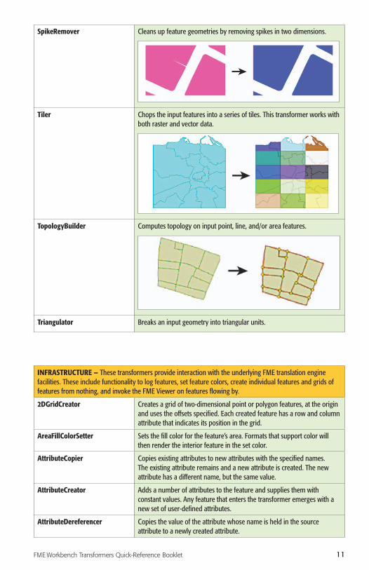
SpikeRemover Cleans up feature geometries by removing spikes in two dimensions.
Tiler Chops the input features into a series of tiles. This transformer works with both raster and vector data.
TopologyBuilder Computes topology on input point, line, and/or area features.
Triangulator Breaks an input geometry into triangular units.
INFRASTRUCTURE – These transformers provide interaction with the underlying FME translation engine facilities. These include functionality to log features, set feature colors, create individual features and grids of features from nothing, and invoke the FME Viewer on features flowing by.
2DGridCreator Creates a grid of two-dimensional point or polygon features, at the origin and uses the offsets specified. Each created feature has a row and column attribute that indicates its position in the grid.
AreaFillColorSetter Sets the fill color for the feature’s area. Formats that support color will then render the interior feature in the set color.
AttributeCopier Copies existing attributes to new attributes with the specified names. The existing attribute remains and a new attribute is created. The new attribute has a different name, but the same value.
AttributeCreator Adds a number of attributes to the feature and supplies them with constant values. Any feature that enters the transformer emerges with a new set of user-defined attributes.
AttributeDereferencer Copies the value of the attribute whose name is held in the source attribute to a newly created attribute.

12
AttributeExposer Exposes hidden attributes so that they can be used by other transformers.
AttributeFileReader Reads the contents of a file and stores them as the value for the specified attribute.
AttributeFileWriter Writes the contents of the specified attribute to a file.
AttributeRenamer Renames selected attributes.
AttributeSetter Sets an existing attribute to a constant value or to the value of another attribute.
Cloner Makes the specified number of copies of the input features and outputs all copies through its single output port.
Creator Creates features using the parameters supplied and sends them into the workspace for processing.
FeatureTypeExtractor Adds an attribute containing the original feature type of a feature.
FMEFunctionCaller Calls the specified FME function, optionally putting the resulting value in the Result Attribute.
GeometryNameExtractor Retrieves the name of geometry and sets it on the specified attribute.
GeometryNameRemover Removes the name of the geometry. The component parts of aggregate geometries remain unchanged.
GeometryNameSetter Applies a name to the geometry of a feature.
IndividualGeometriesSetter Provides the ability to set up an aggregate where each part is independent from the others and is its own complete geometry.
Logger Logs each feature to the translation log. All attributes and geometry of the feature will be output.
ParameterFetcher Adds an attribute to the feature and supplies it with the value of a previously published parameter.
PenColorSetter Sets the pen color of the feature.
Player Retrieves features stored in an FME Feature Store file and outputs them into the workspace.
PythonCaller Processes FME Features using a Python function or class, which can be written in the PythonCaller’s source code editor or stored in an external Python module.
PythonCreator Generates FME features using a Python object referenced by the symbol name parameter. The handler object can be a Python function, a Python class, or any Python object that understands the FME Factory protocol.
RandomColorSetter Sets a random color for each incoming feature.
Recorder Saves a copy of all features that enter to a disk file.
SummaryReporter Writes a summary report of incoming features to a disk file. Features are sorted before they are summarized.
SystemCaller Runs a program and waits for it to exit before continuing the translation.
TCLCaller Runs a Tool Command Language (Tcl) command and assigns its return value to an attribute.
Terminator Causes the translation to end and prints the specified message in the translation log as the reason for the termination.
TransporterReceiver Provides a mechanism to receive features from another FME workspace running in a different process, which may be located on the same or on a different computer. Used in conjunction with the TransporterSender.

13FME Workbench Transformers Quick-Reference Booklet
TransporterSender Provides a mechanism for transporting features to another FME workspace running in a different process, which may be located on the same or on a different computer. Used in conjunction with the TransporterReceiver.
VariableRetriever Reads the specified variable and puts its value into the specified attribute.This variable must have been previously set using the VariableSetter transformer.
VariableSetter Creates and sets the specified variable to the specified value. The variable can later be read back into an attribute using the VariableRetriever transformer.
Visualizer Sends features to the FME Universal Viewer for inspection.
KML – These transformers manipulate feature geometry and/or attributes for output using the OGCKML Writer.
KMLPropertySetter Sets common properties for groups of vector and raster features that are destined for the OGCKML Writer.
KMLRegionSetter Sets the region-related KML attributes for a group of features that are destined for the OGCKML Writer.
KMLStyler Creates a common style for a group of features that are destined for the OGCKML Writer.
KMLTimeSetter Sets the time-related KML attributes for a group of features that are destined for the OGCKML Writer.
KMLTourBuilder Generates a KML Tour from the input features. The tour consists of tour stops that correspond to each input feature.
KMLViewSetter Sets the view-related KML attributes for a group of features that are destined for the OGCKML Writer. Creation of LookAt or Camera views are supported.
LINEAR REFERENCING – These transformers work with linear referencing data structures on FME features. Transformers are provided for creating and applying measure-related information held in attributes onto the geometry of FME features.
LengthToPointCalculator Calculates the length of a feature from its start until the closest spot to a point and adds it as a new attribute. The point coordinates are taken from attributes in the original feature.
MeasureExtractor Extracts the measures of geometries that match the given type, and places them in attributes or list attributes.
MeasureGenerator Creates a comma-separated list of values where each value is the distance from the start of the line up to the vertex in the line.
MeasureRemover Removes measures from a feature’s geometry.

14
MeasureSetter Sets measures on a point, line, arc, area geometry, or a vertex of a linear geometry to attribute values of given attributes or list attributes.
Snipper Shortens the geometry of a line feature by snipping off specified distances, indices, or measure values from the ends. It operates on features with simple line geometry and polygons without holes.
LISTS – These transformers operate on FME attribute lists. Transformers are provided for creating, exploding, searching, and extracting from FME attribute lists.
AttributeExploder Creates a new pair of attributes (attribute name/attribute value) from each attribute on the input feature and either outputs these on a new feature or adds them as a list element to the original feature. In both cases, it is possible to either conserve or delete the original attributes and geometry.
ListBuilder Combines attributes of the input features into a single list structure.
ListConcatenator Concatenates all values of a list into a single attribute.
ListCopier Copies a complete attribute list, including all nested attributes, from one list name to another.
ListDuplicateRemover Removes all duplicate values from a list attribute. In the resulting list, only distinct values for the list attribute will be present.
ListElementCounter Stores the number of member elements found in the specified list into an attribute.
ListExploder Explodes each list member on each input feature out into its own feature.
ListHistogrammer Computes a histogram of the values found in a list and returns these in a new list attribute on the feature.
ListIndexer Demotes the attributes of the list element specified by the index to become main attributes of the feature.
ListPopulator Takes a series of user attributes attached to a feature and creates a list attribute from them.
Example: myattrib0 myattrib1 myattrib2becomes a list myattrib{} containing entries myattrib{0}, myattrib{1}, myattrib{2}
ListRangeExtractor Extracts the minimum and maximum values found in a list.
ListRemover Removes a list from incoming features.
ListRenamer Renames the components of a list or the list name.
ListSearcher Searches a list to find a value and returns the index of the value in the list.
ListSorter Sorts the elements of the given list into a new list.
ListSummer Computes the sum of all elements of a list.

15FME Workbench Transformers Quick-Reference Booklet
MANIPULATORS – These transformers modify (manipulate) the geometry or attributes of individual features in isolation from other features.
2DArcReplacer Replaces the geometry of the feature with a two-dimensional arc whose shape is set by the parameters, which can be either constant floating point values or the values of existing attributes.
2DBoxReplacer Replaces the geometry of the feature with a two-dimensional box whose minimums and maximums are fixed values or are taken from attributes in the original feature.
2DEllipseReplacer Replaces the feature’s geometry with a two-dimensional ellipse whose shape is set by the parameters, values, or the values of existing attributes.
2DForcer Removes any elevation z coordinates that may or may not have been present on the original feature.
2DPointAdder Adds a two-dimensional point as the last vertex of the feature. If the feature turns into a closed polygon as a result of adding the point, it will be tagged as an area feature. Otherwise, it will be tagged as a line.
2DPointReplacer Replaces the feature’s geometry with a two-dimensional point whose coordinates are taken from attributes in the original feature.
3DAffiner Performs 3D affine transformation on the coordinates of the feature. An affine transformation preserves parallelism of lines and planes in geometry. Affine transformations include translations, rotations, scalings, and reflections.
3DArcReplacer Replaces the feature’s geometry with a two-dimensional arc whose shape is set by the parameters, which can be either constant floating point values or the values of existing attributes.
3DForcer Turns two-dimensional data into three-dimensional data by adding a z-value to every coordinate.
3DInterpolator Interpolates elevation values along a non-aggregated linear feature from a starting value to an ending value. The resulting feature’s elevation monotonically increases (or decreases) from the starting value to the ending value. If the feature was two-dimensional, it becomes three-dimensional. If the feature was three-dimensional, its previous elevations are removed and replaced.
3DPointAdder Adds a three-dimensional point as the last vertex of the feature. If the feature turns into a closed polygon as a result of adding the point, it will be tagged as an area feature; otherwise,it will be tagged as a line. However, if this was the first point added, it will be tagged as a point.

16
3DPointReplacer Replaces the geometry of the feature with a three-dimensional point whose ordinates are taken from attributes in the original feature. If the feature was originally a text feature, it remains a text feature, but its insertion point is moved. All other features become point features.
Affiner Performs an affine transformation on the feature’s coordinates.
AngleConverter Converts angles of a feature’s geometry and/or attributes from one representation to another.
ArcEstimator Replaces the geometry of the feature with a two-dimensional circular arc whose shape is estimated from the first, middle, and last point of the linear feature passed in.
ArcPropertyExtractor Sets the given attributes to the properties of an arc geometry and works on a single feature at a time.
ArcPropertySetter Modifies the properties of an arc geometry.
ArcSDEGridSnapper Simulates the ArcSDE conversion on a feature by performing ArcSDE translation, scaling, and coordinate snapping. Also removes duplicate vertices that result from snapping multiple, formerly separate, vertices to the same grid point.
ArcStroker Converts arc features into lines replacing the feature geometry with a series of edges interpolated along the arc boundary. Ellipse features are converted into polygons by interpolating edges along the elliptical boundary.
AttributeExpressionRemover Removes all attributes on incoming features that match a given regular expression. It can also be used to remove large numbers of attributes that have common naming.
AttributeKeeper Removes all attributes from the feature, except the ones that are selected from the attribute list. This transformer is useful when features have large numbers of unnecessary attributes.
AttributePrefixer Adds a prefix or suffix to all attributes coming into the transformer.This transformer is useful when you need to quickly rename all attributes. It can be placed before other transformers that may overwrite incoming attributes.
AttributeRangeMapper Performs a lookup on a range-based lookup table and stores the resulting value, or writes the value to, a new output attribute.
AttributeRemover Removes the selected attributes from the feature.
AttributeReprojector Reprojects attributes from one coordinate system to another.

17FME Workbench Transformers Quick-Reference Booklet
BoundingBoxReplacer Replaces the geometry of the feature with either its two-dimensional bounding box or its two-dimensional minimum oriented bounding box.
Bufferer Replaces the geometry of a feature with one that represents the original, padded by a specified width. Each point in the output geometry is the specified distance away from the original geometry.
CenterLineReplacer Replaces an area feature with its medial axis, straight skeleton, or a centerline. This transformer works best with long, narrow areas.
CenterOfGravityReplacer Replaces the feature’s geometry with a point that is the center of mass distribution of the feature. The resulting point may be far outside of the original feature, depending on the feature’s shape.
CenterPointReplacer Replaces the feature’s geometry with a point that is in the center of the feature’s bounding box.

18
Chopper Ensures that all features output have less than or equal to the specified maximum number of vertices. This is useful when you’re outputting to a format that has limitations on the number of points in lines or areas. It can also be used to crudely simplify complex objects.
ConvexHullReplacer Replaces the geometry of the feature with a polygon representing its convex hull.
CoordinateRemover Removes one or more coordinates from the geometry of the feature.
CoordinateRounder Rounds off the feature’s coordinates to the specified number of decimal places. Any consecutive points that become duplicates as a result of the rounding are thinned by removing the redundant points.
CoordinateSystemDescription Converter
Converts coordinate systems between FME and AutoDesk WKT, EPSG, ESRI WKT, MapInfo, OGC WKT, Oracle SRID, and PROJ.4 representations.
CoordinateSystemExtractor Retrieves the feature’s coordinate system into an attribute.
CoordinateSystemRemover Removes the coordinate system from all input features. This transformer does not reproject features or otherwise modify their geometry.
CoordinateSystemSetter Tags all features with the specified coordinate system. It does not reproject features or otherwise modify their geometry.

19FME Workbench Transformers Quick-Reference Booklet
Curvefitter Smoothes lines derived from line segments, points, or raster data, and replaces a series of line segments with the optimal combination of straight lines and embedded arc segments required to create smooth curving lines. This process provides a truer representation of real-world features and can reduce file sizes by up to 80%. In addition to processing simple line features, the Curvefitter preserves feature topology when smoothing boundaries of adjacent area features.
Densifier Adds vertices to the feature by interpolating new coordinates along its definition at some interval of distance. The interval may be along only one of the two primary axes, or it may be along the length of the line segments.
Displacer Solves proximity conflicts between features using a variant of the Nickerson displacement algorithm.
DuplicateCoordinateRemover Checks all geometry elements that are lines for duplicate coordinates. Any consecutive coordinates with the same location are reduced to a single coordinate.
EllipsePropertyExtractor Sets the given attributes to the properties of an ellipse geometry.
EllipsePropertySetter Sets the properties of an ellipse geometry as specified.
ESRIReprojector Reprojects feature coordinates from one coordinate system to another using the ESRI® reprojection library.
Extender Creates two-point extensions to linear features that extend the feature by a user-specified length. This transformer can also output the original feature with the first and last segments stretched by a user-specified amount.
FilenamePartExtractor Extracts a part of a filename path and returns the result as a string.

20
Generalizer There are four algorithm types: � Generalizing algorithms reduce the density of coordinates by removing
vertices. � Smoothing algorithms determine a new location for each vertex. � Measuring algorithms calculate the location of points and return a list
of these points (for example, to measure the sinuosity of a feature). � Fitting algorithms replace the original geometry completely, with a new
feature fitted to a specified line (for example, to minimize the orthogonal distance to the original).
GeometryCoercer Resets the geometry type of the feature.
GeometryExtractor Extracts the geometry of a feature according to the setting of the geometry encoding parameter. The resulting encoded geometry is added to the feature in an attribute. This attribute can later be restored as the feature’s geometry using the GeometryReplacer transformer.
GeometryRefiner Performs the following refinements on the feature’s geometry: � Any homogeneous IFMEAggregate becomes a multi (IFMEMultiCurve,
IFMEMultiArea, IFMEMultiPoint, or IFMEMultiText). � Any IFMEAggregate or multi with only one member is replaced by its
single part. � Any IFMEDonut with no holes becomes an IFMEPolygon or
IFMEEllipse. � Any IFMEPath with only one segment is replaced by that segment. � Consecutive IFMELine segments within an IFMEPath are combined.
GeometryRemover Completely removes the feature’s geometry; for example, when you want to turn spatial data into nonspatial data.
GeometryReplacer Replaces the feature’s geometry according to the setting of the geometry encoding parameter. This transformer is typically used to restore geometry previously extracted into an attribute by the GeometryExtractor.
GeometryTraitExtractor Copies the specified geometry traits into feature attributes with the same names.
GeometryTraitRemover Removes geometry traits from a feature’s geometry.
GeometryTraitSetter Copies attributes from a feature into geometry traits.
GMLFeatureExtractor Constructs GML2 documents from the input features and stores them in the specified attribute for the features that are output by the GML2 port.
GMLFeatureReplacer Constructs features out of GML documents that are stored in an attribute of the input features.
GridInQuestReprojector Reprojects feature coordinates from one coordinate system to another using the Grid InQuest reprojection library.

21FME Workbench Transformers Quick-Reference Booklet
GtransAttributeReprojector Reprojects attributes holding coordinate values from one coordinate system to another using the Gtrans reprojection library (from the National Land Survey of Sweden) and the specified translation file.
GtransReprojector Reprojects features to and from SWEREF99 using the Gtrans reprojection library (from the National Land Survey of Sweden) and the specified translation file.
InsidePointReplacer Replaces the area feature’s geometry with a point that is guaranteed to be inside the area, and outputs the result.
LabelPointReplacer Replaces the feature’s geometry with a label point. For polygons, the text is guaranteed to be inside the original object. For lines or points, the text is guaranteed to be on the original object.
LatLongToMGRSConverter Calculates a Military Grid Reference System (MGRS) code based on the latitude and longitude values supplied in a feature’s attributes.
LineCloser Turns input linear features into areas by adding their start point as the end point.
MGRSGeometryExtractor Calculates a Military Grid Reference System (MGRS) code based on the feature’s geometry.
MGRSGeometryReplacer Converts MGRS code to longitude and latitude coordinates. The geometry of an input feature is replaced with a point at the longitude/latitude values obtained from the MGRS code.
MGRSToLatLongConverter Converts MGRS code to longitude and latitude coordinates. Converts MGRS code to longitude and latitude coordinates.
MinimumAreaForcer Ensures that features with polygon geometry have an area that is equal to, or in excess of, the specified minimum area.
MinimumSpanningCircle Replacer
Replaces feature’s geometry with a polygon representing its minimum spanning circle. The minimum spanning circle is defined as the smallest circle that encloses all vertices of the passed in feature.
Offsetter Adds offsets to the feature’s coordinates so that the feature shifts by the specified amount.
Orientor Adjusts the orientation of a polygonal feature or the direction of a linear feature.

22
PartCounter Returns the number of parts in the geometry. For multis and aggregates, this is the number of parts, and for paths, this is the number of segments.
PathSplitter Decomposes a path feature into its component segments.Each output feature contains a copy of the source feature’s attributes.
PDFStyler Sets the common PDF style attributes for a group of features destined for the GeoSpatial PDF Writer.
Reprojector Reprojects feature coordinates from one coordinate system to another.
Rotator Rotates features in a counterclockwise direction about the specified point by the rotation angle (measured in degrees).
Scaler The Scaler scales objects to make them bigger or smaller.
SecondOrderConformer Performs a second-order conformal transformation on the feature’s geometry. Depending on the input geometry, a 2D or 3D transformation is performed.
TextAdder Sets the feature’s geometry to text with the previous geometry as the text location.
TextLocationExtractor Sets a text feature’s geometry to the location of the text.
TextPropertyExtractor Sets the given attributes to a text geometry’s properties.
TextPropertySetter Sets the properties of a text geometry to the specified properties.
TextStroker Takes as input a text string, rotation, height and width multiplier, then outputs aggregates that describe the outline of the text.
MRF – These transformers repair geometry, particularly during data migration from CAD to GIS. They are built upon the MRFCleanFactory, which is an integration of MRF Geosystems Corporation’s cleaning technology into FME. All of the transformers in this category are available as an extra-cost package from Safe Software.
MRF2DCleaner Fixes geometric problems in input data, such as line overshoots and undershoots within the user-specified tolerance. It is useful for multi-layer and multi-tolerance two-dimensional data cleaning.
MRF2DConflator Changes a feature’s geometry to match that of another when both have approximately the same shape and location, and have matching endpoints.
MRF2DDangleRemover Removes features that have at least one free endpoint and have lengths smaller than the specified amount.
MRF2DDuplicateRemover Deletes duplicated features. Features are considered to be duplicates if their geometries are within tolerance. Only features with a smaller tolerance remain after cleaning.
MRF2DExtender Extends arcs and lines that are within the specified tolerance to correct undershoots while maintaining line-work direction.

23FME Workbench Transformers Quick-Reference Booklet
MRF2DGeneralizer Removes a number of vertices from lines. The number of vertices removed is controlled by a weeding tolerance.
MRF2DIntersector Computes intersections between all input features, breaking arcs and lines wherever an intersection occurs.
MRF2DJoiner Joins connected features to form longer ones. A pair of linear features becomes a candidate for joining only when the two are connected at a given node or end point.
MRF2DShortGeometryRemover Removes features that have lengths smaller than the specified tolerance.
MRF3DCleaner Fixes geometric problems in input data such as line overshoots and undershoots within the user-specified tolerance. It is useful for multi-layer and multi-tolerance three-dimensional data cleaning.
NETWORK – These transformers operate on linear features that are connected in a network, performing operations such as priority calculation and orientation correction.
NetworkCostCalculator Computes and assigns the cost of the shortest path from a source object to each connected object as the Z-values or measure values of the input features.
NetworkFlowOrientor Fixes the flow (direction) of each edge or linear feature in the network to fit the downstream direction to the destination node.
ShortestPathFinder Computes the shortest path from a source node to a destination node in a network based on the length of the input or the weight of the edges.
StreamOrderCalculator Computes the order (Strahler or Horton) of streams in a river network.
StreamPriorityCalculator Calculates the primary and secondary streams of multiple stream networks.
RASTERS – These transformers create, use, and output rasters. They operate on data consisting of a regularly spaced grid of values.
ImageRasterizer Draws input point, line, and polygon features onto a color raster filled with the background color.
NumericRasterizer Draws input point, line, and polygon features onto a numeric raster filled with the background value. The z coordinates of the input vector features are used to generate pixel values.
PointOnRasterValueExtractor Takes in a number of point features and a single reference raster. For each input point feature, a point is created after the reference raster and output.
RasterBandAdder Adds a new band to a raster. The added band will have the same value in all cells and the same raster-level properties as other bands in the raster.
RasterBandCombiner Merges multiple overlapping raster features into a single raster feature.
RasterBandInterpretation Coercer
Alters the underlying interpretation of the selected bands of the raster geometry on the input features, using the specified conversion options.
RasterBandKeeper Removes all bands of a raster, except for those that are selected. The RasterSelector can be used to modify the selection.

24
RasterBandMinMaxExtractor Extracts the band minimum and maximum values, palette minimum and maximum keys, and palette minimum and maximum values of a raster feature, and exposes them as attributes.
RasterBandNameSetter Sets the name of selected bands on a raster.
RasterBandNodataRemover Removes any existing nodata values from the selected bands of a raster feature.
RasterBandNodataSetter Identifies the nodata value on a raster feature at the band level. All selected bands on an input raster feature receive the same specified nodata value.
RasterBandOrderer Specifies the order of bands in a raster. Bands are reordered according to the input band indices.
RasterBandPropertiesExtractor Extracts the band and palette properties of a raster feature and exposes them as attributes.
RasterBandRemover Removes the selected bands of a raster.
RasterBandSeparator Separates the bands and palettes from each input raster feature into one or more output raster features based on the number of input bands and palettes.
RasterCellCoercer Decomposes all input numeric raster features into individual points or polygons.
RasterCellOriginSetter Sets the raster’s cell origin.
RasterCellValueCalculator Performs an arithmetical operation on a pair of rasters.
RasterCellValueReplacer Replaces a range of values in the source raster with a new single value.
RasterCheckpointer Sets a checkpoint in the raster processing, which forces previous processing to occur immediately and saves the current state to disk when complete.
RasterConsumer Requests all the tiles from the raster geometry.
RasterExpressionEvaluator Evaluates expressions on each cell in a raster, such as algebraic operations or conditional statements.
RasterExtentsCoercer Replaces the geometry of input raster features with a polygon that covers the extents of the raster.
RasterExtractor Serializes the geometry of the feature into the Raster Blob Attribute based on the selected writer format.
RasterGCPExtractor Extracts the coordinate system and the Ground Control Points (GCPs) from the raster feature and exposes them as attributes.
RasterGCPSetter Sets the GCP on a raster with the specified Column (pixel), Row (line), x Coordinate, y Coordinate and z Coordinate.
RasterGeoreferencer Georeferences a raster with the specified parameters.
RasterInterpretationCoercer Alters the underlying interpretation of the bands of the raster geometry on the input features, using the specified conversion options.
RasterMosaicker Mosaics multiple raster features into a single raster feature.
RasterNumericCreator Creates a feature with a raster of the specified size with a numeric value and sends it into the workspace for processing. This transformer is useful for creating a very large image with a user-specified width and height.
RasterPaletteAdder Creates a palette from an attribute and adds this palette to all selected bands on a raster.
RasterPaletteExtractor Creates a string representation of an existing palette and saves it to an attribute.

25FME Workbench Transformers Quick-Reference Booklet
RasterPaletteGenerator Generates a palette out of the selected bands of a raster.
RasterPaletteInterpretation Coercer
Alters the underlying interpretation of the palettes of the raster geometry on the input features, using the specified conversion options.
RasterPaletteNodataSetter Identifies the nodata value on a raster feature at the palette level.
RasterPaletteRemover Removes the selected palettes of a raster.
RasterPaletteResolver Resolves the palettes of the selected bands of the input raster features by using the band cell values to look up the corresponding palette values, which then replace the original band cell values in the raster.
RasterPropertiesExtractor Extracts the geometry properties of a raster feature and exposes them as attributes.
RasterPyramider Creates a series of pyramid levels for each input raster feature by specifying either the smallest pyramid level size or the number of pyramid levels to generate.
RasterReader Reads and outputs raster features from the specified format and dataset.
RasterReplacer Replaces the feature’s geometry with the geometry held in the Raster Blob Attribute. The blob is decoded according to the selected raster format.
RasterResampler Resamples a raster, given either the desired dimensions of the raster or the desired cell size in ground units.
RasterRGBCreator Creates a feature with a raster of the specified size with an RGB value and sends it into the workspace for processing.
RasterRotationApplier Applies the raster rotation angle on the input raster properties to the rest of the raster properties and data values.
RasterSelector Selects specific bands and palettes of a raster for subsequent transformer operations.
RasterSingularCellValue Calculator
Performs an arithmetic operation on two operands: the cell values of a raster and a numeric value.
RasterSubsetter Reduces a raster to a subset of its original size. This is essentially a clipping operation using pixel bounds instead of ground coordinates.
RasterTiler Splits each input raster into a series of tiles by specifying either a tile size or a number of tiles.
VectorOnRasterOverlayer Overlays vector features onto a single raster feature by drawing them onto the resulting output raster. The properties of the output raster are identical to that of the input raster.
WebMapTiler Creates a series of image tiles that can be used by Microsoft Virtual Earth®. This is done by resampling rasters to various different resolutions and then splitting them into tiles.
STRINGS – These transformers operate on character strings held in FME attributes. Transformers are provided for searching, replacing, changing case, and extracting character encodings from strings held in FME attributes.
AttributeClassifier Tests if the contents of the source attribute are entirely of a particular character classification, and routes the feature accordingly.

26
AttributeSplitter Splits a selected attribute into a list attribute. Each item in the list contains a single token split from the list. For example, you can use this transformer to separate an attribute that has a comma-separated value list into its component pieces
AttributeTrimmer Removes leading and trailing trim characters from the selected attributes.
AttributeValueMapper Looks up and assigns attribute values based on other attributes, and stores the looked-up value in a new attribute.
CaseChanger Changes the case of text attributes to UPPERCASE, lowercase, Title case, or Full Title Case.
CharacterCodeExtractor Extracts the integral character code of the first character in the source string attribute, and adds its integer value in the character set to the feature as another attribute. This can be used to obtain the ASCII code of any character, including non-printable ones.
CharacterEncoder Sets the result attribute to the character whose numeric code was contained in the source code attribute (or the entered integer).
GOIDGenerator Calculates a Geographic Object IDentifier (GOID) for each incoming feature, and adds it as a new attribute. The GOID is a unique 128-bit number that incorporates the position of a feature with other numbers. The result is a unique value that may be used to distinguish features from each other.
HexDecoder Decodes the given attribute into a new attribute, by converting its encoded hexadecimal value into a new ASCII string. Each hexadecimal couplet in the input attribute is converted into a single byte in the output string.
HexEncoder Encodes the given attribute into a new attribute, by converting its ASCII value into a hexadecimal string.
NullAttributeReplacer Checks all the selected attributes and sets them to the value given in the Default Value parameter if they were null (if they had no value).
StringConcatenator Concatenates the values of any number of attributes and constants, and stores the result in a new attribute. It complements Workbench’s fanout capability by allowing you to fan out by more than one attribute simultaneously.
StringFormatter Reformats the data held in each specified attribute according to the Tcl format command, which is similar to the C printf function. Attribute values can be formatted into strings, characters, or numbers.
StringLengthCalculator Calculates the length of the string in Source Attribute.
StringPadder Pads the given attributes with spaces, either on the right or left side.
StringPairReplacer Replaces characters in the value contained in the source attribute based on the replacement key-value pairs.
StringReplacer Replaces substrings matching a string or regular expression in the string contained in the source attribute.
StringSearcher Performs a regular expression match on the value of the specified attribute.
SubstringExtractor Extracts a substring from the source attribute.
TimeStamper Adds a time stamp to a feature as a new attribute. The format of the time stamp is set as a parameter of the transformer.
27FME Workbench Transformers Quick-Reference Booklet
UUIDGenerator Calculates a Universally Unique IDentifier (UUID) for each incoming feature, and adds it as a new attribute. An example UUID looks like:7672aac8-fa0b-464c-b0b8-3efa9ae9cd86
SURFACES – These transformers create, use, and output surfaces. They operate on data that defines a surface through the z coordinate, and then either outputs this surface in a variety of ways or applies the surface to other data.
AppearanceAdder Adds appearance style(s) to the front, back or both sides of surfaces. You can also set the texture coordinates of the surfaces.
AppearanceExtractor Extracts appearance styles from front, back, or both sides of the surface geometry of the input features.
AppearanceRemover Extracts appearance styles from front, back, or both sides of the surface geometry of the input features.
AppearanceStyler Creates an appearance style that’s applied to a surface later, using the Appearance Adder transformer, for example.
ContourGenerator Generates contours from the underlying surface, which is defined by the input POINTS, 3D_LINES, and BREAKLINES.
DEMGenerator Generates a Digital Elevation Model (DEM) as a regularly spaced set of output DEM points from the input POINTS, BREAKLINES, and 3D_LINES.
RasterDEMGenerator Generates a DEM represented as Raster from the input POINTS, BREAKLINES, and 3D_LINES.
SectorGenerator Inputs point features with the following data contained in the chosen attributes: site name, sector name (optional), azimuth, and radius. Within points having the same site name, points have their geometry changed to polygons approximating sector shapes.
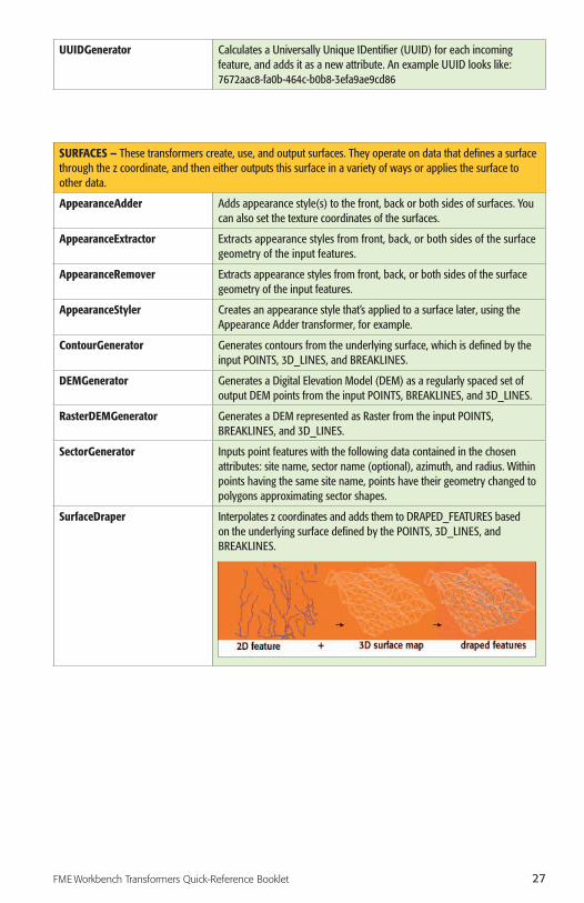
SurfaceDraper Interpolates z coordinates and adds them to DRAPED_FEATURES based on the underlying surface defined by the POINTS, 3D_LINES, and BREAKLINES.

28
SurfaceModeller Builds and queries surfaces, drapes features, or changes the surface representation between Digital Elevation Model (DEM), Triangulated Irregular Network (TIN), and CONTOURS. You can go from any representation to any other representation. This transformer is useful when you need to get several things from a defined surface.
TINGenerator Generates a Delaunay surface model and outputs the defining Triangulated Irregular Network (TIN). The TIN is output as both Triangles and TIN Edges.
VoronoiCellGenerator Generates a Voronoi diagram that represents the closest points around point locations. The diagram is such that the Voronoi cells only radiate out from the cell at a distance specified by the radius parameter.
VoronoiDiagrammer Generates a Voronoi diagram or Thiessen polygon from the input POINTS.A Voronoi diagram is a set of polygons that represent proximity information about a set of input points. Each polygon in the diagram defines the area of space that is closest to a particular input point.
WEB SERVICES – These transformers access web services using the HTTP protocol.
Decelerator Slows down the flow of features through the workspace.
DirectTweeter Sends a direct Twitter™ message from Workbench.
GeoRSSFeatureExtractor Constructs GeoRSS documents from the input features and stores them in the specified attribute for the features that are output by the GeoRSS port.

29FME Workbench Transformers Quick-Reference Booklet
GeoRSSFeatureReplacer Constructs features out of GeoRSS documents and URLs that are stored in a specified attribute of the input features. The features from the GeoRSS document and URL can be output with the attributes from the original feature and merged.
HTTPDeleter Deletes a target by performing an HTTP DELETE operation on the specified URL, storing the results in the specified target attribute.
HTTPFetcher Fetches a target by performing an HTTP GET operation on the specified URL, storing the results in the specified target attribute.
HTTPFileUploader Uploads a file’s contents by performing a HTTP PUT or HTTP POST operation on the specified URL, storing the results in the specified target attribute.
HTTPUploader Uploads a message by performing an HTTP PUT or HTTP POST operation on the specified URL, storing the results in the specified target attribute.
ImageFetcher Fetches an image by performing an HTTP GET operation on the specified URL, and then returning the resulting data as the geometry of a raster feature.
JSONExploder Extracts portions of JSON (JavaScript Object Notation) formatted text into new FME features.
JSONExtractor Extracts portions of JSON formatted text into feature attributes.
ProxixGeocoder Geocodes addresses using a Proxix Geospatial Enterprise Real-Time (GSERT) server.
Tweeter Sends a Twitter status update from Workbench.
TweetSearcher Runs a search for Twitter entries that contain the given query.
TwitterStatusFetcher Retrieves the Twitter status updates for a particular user.
URLDecoder Decodes a string from its URL-encoded form and stores the result in an attribute.
URLEncoder Converts a string value to its URL-encoded form and stores the result in an attribute.
WebCharter Creates a URL that can be used to obtain a chart of the specified data as a PNG image from the GoogleTM Chart API. One URL is created for each feature that enters the transformer. Use of the Google Chart API is subject to the Terms of Service for the API.
WhiteStarLeaseBuilder Posts a query to a WhiteStar Legal2Map™ WebServices (W3) server to obtain points or polygons that match a list of legal land descriptions.
WORKFLOW – These transformers run workspaces either locally or on an FME Server. To use these transformers, you may need access to an FME Server.
FMEServerJobSubmitter Submits FME Spatial ETL jobs to be run on an FME Server. A job consists of a workspace (housed within a repository on an FME Server) together with values for each of its published parameters.
FMEServerJobWaiter Waits until submitted FME Spatial ETL jobs are completely processed by an FME Server. The list of jobs to wait for is identified by the job IDs of the input features. When a job that the transformer is waiting for is completed, it outputs the corresponding feature immediately.

30
FMEServerWorkspaceRunner Submits FME Spatial ETL jobs to be run on an FME Server, and downloads the resulting data to a specified location. You can optionally upload files used for the job, and download results locally when the FME Server job is complete.
WorkspaceRunner Runs another FME Workbench workspace on the local computer by spawning a new FME process. This transformer is useful for batch processing, especially in conjunction with the Directory and File Reader.
XML – These transformers work with XML data by mapping XML elements into FME features, using stylesheets to convert XML documents, and querying collections of XML data.
XMLFeatureMapper Constructs features from XML documents.
XMLTemplater Populates an XML template with feature attribute values.
XQueryExploder Extracts portions of XML text using XQuery expressions into new FME features.
XQueryExtractor Extracts portions of XML text using XQuery expressions into feature attributes.
XQueryUpdater Provides updates to an XML document using XQuery Update expressions.
XSLTProcessor Uses an eXtensible Stylesheet Language (XSL) stylesheet to convert an XML document. Common output formats include text, RSS, SVG, and CSV.

31FME Workbench Transformers Quick-Reference Booklet
INDEX OF TRANSFORMERS
AAffiner (Manipulators category), 16
AffineWarper (Geometric Operators category), 7
AggregateFilter (Filters category), 6
Aggregator (Collectors category), 4
AnchoredSnapper (Geometric Operators category), 7
AngleConverter (Manipulators category), 16
AngularityCalculator (Calculators category), 1
AppearanceAdder (Surfaces category), 27
AppearanceExtractor (Surfaces category), 27
AppearanceRemover (Surfaces category), 27
AppearanceStyler (Surfaces category), 27
ArcEstimator (Manipulators category), 16
ArcPropertyExtractor (Manipulators category), 16
ArcPropertySetter (Manipulators category), 16
ArcSDEGridSnapper (Manipulators category), 16
ArcSDEQuerier (Database category), 5
ArcStroker (Manipulators category), 16
AreaBuilder (Geometric Operators category), 7
AreaCalculator (Calculators category), 2
AreaFillColorSetter (Infrastructure category), 11
AreaOnAreaOverlayer (Geometric Operators category), 7
AttributeAccumulator (Collectors category), 4
AttributeClassifier (Strings category), 25
AttributeCopier (Infrastructure category), 11
AttributeCreator (Infrastructure category), 11
AttributeDereferencer (Infrastructure category), 11
AttributeExploder (Lists category), 14
AttributeExposer (Infrastructure category), 12
AttributeExpressionRemover (Manipulators category), 16
AttributeFileReader (Infrastructure category), 12
AttributeFileWriter (Infrastructure category), 12
AttributeFilter (Filters category), 6
AttributeKeeper (Manipulators category), 16
AttributePrefixer (Manipulators category), 16
AttributeRangeFilter (Filters category), 6
AttributeRangeMapper (Manipulators category), 16
AttributeRemover (Manipulators category), 16
AttributeRenamer (Infrastructure category), 12
AttributeReprojector (Manipulators category), 16
AttributeRounder (Calculators category), 2
AttributeSetter (Infrastructure category), 12
AttributeSplitter (Strings category), 26
AttributeTrimmer (Strings category), 26
AttributeValueMapper (Strings category), 26
BBaseConverter (Calculators category), 2
BoundingBoxAccumulator (Collectors category), 4
BoundingBoxReplacer (Manipulators category), 17
BoundsExtractor (Calculators category), 2
Bufferer (Manipulators category), 17
CCaseChanger (Strings category), 26
CenterLineReplacer (Manipulators category), 17
CenterOfGravityReplacer (Manipulators category), 17
CenterPointReplacer (Manipulators category), 17
ChangeDetector (Filters category), 6
CharacterCodeExtractor (Strings category), 26
CharacterEncoder (Strings category), 26
Chopper (Manipulators category), 18
CircularityCalculator (Calculators category), 2
Clipper (Geometric Operators category), 8
Cloner (Infrastructure category), 12
CommonSegmentFinder (Collectors category), 4
ContourGenerator (Surfaces category), 27
ConvexHullAccumulator (Collectors category), 4
ConvexHullReplacer (Manipulators category), 18
ConvexityFilter (Filters category), 6
CoordinateConcatenator (Calculators category), 2
CoordinateCounter (Calculators category), 2
CoordinateExtractor (Calculators category), 2
CoordinateRemover (Manipulators category), 18
CoordinateRounder (Manipulators category), 18
CoordinateSystemDescriptionConverter
(Manipulators category), 18
CoordinateSystemExtractor (Manipulators category), 18
CoordinateSystemRemover (Manipulators category), 18
CoordinateSystemSetter (Manipulators category), 18
Counter (Calculators category), 2
CRCCalculator (Calculators category), 2
Creator (Infrastructure category), 12
CSGBuilder (3D category), 1
INDEX OF TRANSFORMERS

32
CSGEvaluator (3D category), 1
Curvefitter (Manipulators category), 19
DDateFormatter (Calculators category), 2
Deaggregator (Collectors category), 5
Decelerator (Web Services category), 28
DecimalDegreesCalculator (Calculators category), 2
DEMDistanceCalculator (Calculators category), 3
DEMGenerator (Surfaces category), 27
Densifier (Manipulators category), 19
DensityCalculator (Calculators category), 3
DimensionExtractor (Calculators category), 3
DirectTweeter (Web Services category), 28
Displacer (Manipulators category), 19
Dissolver (Geometric Operators category), 8
DMSCalculator (Calculators category), 3
DonutBridgeBuilder (Geometric Operators category), 8
DonutBuilder (Geometric Operators category), 8
DonutHoleExtractor (Geometric Operators category), 8
DuplicateCoordinateRemover (Manipulators category), 19
DuplicateRemover (Filters category), 6
EElevationExtractor (Calculators category), 3
EllipsePropertyExtractor (Manipulators category), 19
EllipsePropertySetter (Manipulators category), 19
EnvironmentVariableFetcher (Calculators category), 3
ESRIReprojector (Manipulators category), 19
ExpressionEvaluator (Calculators category), 3
Extender (Manipulators category), 19
Extruder (3D category), 1
FFaceReplacer (3D category), 1
FeatureHolder (Collectors category), 5
FeatureMerger (Collectors category), 5
FeatureTypeExtractor (Infrastructure category), 12
FeatureTypeFilter (Filters category), 6
FilenamePartExtractor (Manipulators category), 19
FMEFunctionCaller (Infrastructure category), 12
FMEServerJobSubmitter (Workflow category), 29
FMEServerJobWaiter (Workflow category), 29
FMEServerWorkspaceRunner (Workflow category), 30
GGeneralizer (Manipulators category), 20
GeometryCoercer (Manipulators category), 20
GeometryExtractor (Manipulators category), 20
GeometryFilter (Filters category), 6
GeometryNameExtractor (Infrastructure category), 12
GeometryNameRemover (Infrastructure category), 12
GeometryNameSetter (Infrastructure category), 12
GeometryOGCValidator (Filters category), 6
GeometryRefiner (Manipulators category), 20
GeometryRemover (Manipulators category), 20
GeometryReplacer (Manipulators category), 20
GeometryTraitExtractor (Manipulators category), 20
GeometryTraitRemover (Manipulators category), 20
GeometryTraitSetter (Manipulators category), 20
GeoRSSFeatureExtractor (Web Services category), 28
GeoRSSFeatureReplacer (Web Services category), 29
GMLFeatureExtractor (Manipulators category), 20
GMLFeatureReplacer (Manipulators category), 20
GOIDGenerator (Strings category), 26
GridInQuestReprojector (Manipulators category), 20
GtransAttributeReprojector (Manipulators category), 21
GtransReprojector (Manipulators category), 21
HHexDecoder (Strings category), 26
HexEncoder (Strings category), 26
HoleCounter (Calculators category), 3
HTTPDeleter (Web Services category), 29
HTTPFetcher (Web Services category), 29
HTTPFileUploader (Web Services category), 29
HTTPUploader (Web Services category), 29
IImageFetcher (Web Services category), 29
ImageRasterizer (Rasters category), 23
IndividualGeometriesSetter (Infrastructure category), 12
IndividualGeometriesFilter (Filters category), 6
InsidePointExtractor (Calculators category), 3

33FME Workbench Transformers Quick-Reference Booklet
InsidePointReplacer (Manipulators category), 21
Intersector (Geometric Operators category), 8
JJoiner (Database category), 5
JSONExploder (Web Services category), 29
JSONExtractor (Web Services category), 29
KKMLPropertySetter (KML category), 13
KMLRegionSetter (KML category), 13
KMLStyler (KML category), 13
KMLTimeSetter (KML category), 13
KMLTourBuilder (KML category), 13
KMLViewSetter (KML category), 13
LLabeller (Geometric Operators category), 9
LabelPointReplacer (Manipulators category), 21
LatLongToMGRSConverter (Manipulators category), 21
LeftRightSpatialCalculator (Calculators category), 3
LengthCalculator (Calculators category), 3
LengthToPointCalculator (Linear Referencing category), 13
LineCloser (Manipulators category), 21
LineJoiner (Geometric Operators category), 9
LineOnAreaOverlayer (Geometric Operators category), 9
LineOnLineOverlayer (Geometric Operators category), 9
ListBuilder (Lists category), 14
ListConcatenator (Lists category), 14
ListCopier (Lists category), 14
ListDuplicateRemover (Lists category), 14
ListElementCounter (Lists category), 14
ListExploder (Lists category), 14
ListHistogrammer (Lists category), 14
ListIndexer (Lists category), 14
ListPopulator (Lists category), 14
ListRangeExtractor (Lists category), 14
ListRemover (Lists category), 14
ListRenamer (Lists category), 14
ListSearcher (Lists category), 14
ListSorter (Lists category), 14
ListSummer (Lists category), 14
Logger (Infrastructure category), 12
MMatcher (Filters category), 6
MeasureExtractor (Linear Referencing category), 13
MeasureGenerator (Linear Referencing category), 13
MeasureRemover (Linear Referencing category), 13
MeasureSetter (Linear Referencing category), 14
MGRSGeometryExtractor (Manipulators category), 21
MGRSGeometryReplacer (Manipulators category), 21
MGRSToLatLongConverter (Manipulators category), 21
MinimumAreaForcer (Manipulators category), 21
MinimumSpanningCircleReplacer
(Manipulators category), 21
ModuloCounter (Calculators category), 3
MRF2DCleaner (MRF category), 22
MRF2DConflator (MRF category), 22
MRF2DDangleRemover (MRF category), 22
MRF2DDuplicateRemover (MRF category), 22
MRF2DExtender (MRF category), 22
MRF2DGeneralizer (MRF category), 23
MRF2DIntersector (MRF category), 23
MRF2DJoiner (MRF category), 23
MRF2DShortGeometryRemover (MRF category), 23
MRF3DCleaner (MRF category), 23
NNeighborColorSetter (Geometric Operators category), 9
NeighborFinder (Collectors category), 5
NeighborhoodAggregator (Collectors category), 5
NeighborPairFinder (Collectors category), 5
NetworkCostCalculator (Network category), 23
NetworkFlowOrientor (Network category), 23
NetworkTopologyBuilder
(Geometric Operators category), 9
NullAttributeReplacer (Strings category), 26
NumericRasterizer (Rasters category), 23
OOffsetter (Manipulators category), 21
OracleQuerier (Database category), 5
OrientationExtractor (Calculators category), 3
Orientor (Manipulators category), 21

34
PParameterFetcher (Infrastructure category), 12
PartCounter (Manipulators category), 22
PathBuilder (Geometric Operators category), 9
PathSplitter (Manipulators category), 22
PDFStyler (Manipulators category), 22
PenColorSetter (Infrastructure category), 12
PlanarityFilter (Filters category), 6
Player (Infrastructure category), 12
PointConnector (Geometric Operators category), 9
PointOnAreaOverlayer (Geometric Operators category), 10
PointOnLineOverlayer (Geometric Operators category), 10
PointOnPointOverlayer (Geometric Operators category), 10
PointOnRasterValueExtractor (Rasters category), 23
PolygonBuilder (Geometric Operators category), 10
ProxixGeocoder (Web Services category), 29
PythonCaller (Infrastructure category), 12
PythonCreator (Infrastructure category), 12
RRandomColorSetter (Infrastructure category), 12
RandomNumberGenerator (Calculators category), 3
RasterBandAdder (Rasters category), 23
RasterBandCombiner (Rasters category), 23
RasterBandInterpretationCoercer (Rasters category), 23
RasterBandKeeper (Rasters category), 23
RasterBandMinMaxExtractor (Rasters category), 24
RasterBandNameSetter (Rasters category), 24
RasterBandNodataRemover (Rasters category), 24
RasterBandNodataSetter (Rasters category), 24
RasterBandOrderer (Rasters category), 24
RasterBandPropertiesExtractor (Rasters category), 24
RasterBandRemover (Rasters category), 24
RasterBandSeparator (Rasters category), 24
RasterCellCoercer (Rasters category), 24
RasterCellOriginSetter (Rasters category), 24
RasterCellValueCalculator (Rasters category), 24
RasterCellValueReplacer (Rasters category), 24
RasterCheckpointer (Rasters category), 24
RasterConsumer (Rasters category), 24
RasterDEMGenerator (Surfaces category), 27
RasterExpressionEvaluator (Rasters category), 24
RasterExtentsCoercer (Rasters category), 24
RasterExtractor (Rasters category), 24
RasterGCPExtractor (Rasters category), 24
RasterGCPSetter (Rasters category), 24
RasterGeoreferencer (Rasters category), 24
RasterInterpretationCoercer (Rasters category), 24
RasterMosaicker (Rasters category), 24
RasterNumericCreator (Rasters category), 24
RasterPaletteAdder (Rasters category), 24
RasterPaletteExtractor (Rasters category), 24
RasterPaletteGenerator (Rasters category), 25
RasterPaletteInterpretationCoercer (Rasters category), 25
RasterPaletteNodataSetter (Rasters category), 25
RasterPaletteRemover (Rasters category), 25
RasterPaletteResolver (Rasters category), 25
RasterPropertiesExtractor (Rasters category), 25
RasterPyramider (Rasters category), 25
RasterReader (Rasters category), 25
RasterReplacer (Rasters category), 25
RasterResampler (Rasters category), 25
RasterRGBCreator (Rasters category), 25
RasterRotationApplier (Rasters category), 25
RasterSelector (Rasters category), 25
RasterSingularCellValueCalculator (Rasters category), 25
RasterSubsetter (Rasters category), 25
RasterTiler (Rasters category), 25
Recorder (Infrastructure category), 12
ReprojectAngleCalculator (Calculators category), 3
ReprojectLengthCalculator (Calculators category), 3
Reprojector (Manipulators category), 22
Rotator (Manipulators category), 22
RubberSheeter (Geometric Operators category), 10
SSampler (Filters category), 6
Scaler (Manipulators category), 22
SchemaMapper (Database category), 5
SecondOrderConformer (Manipulators category), 22
SectorGenerator (Surfaces category), 27
SelfIntersector (Geometric Operators category), 10
ShortestPathFinder (Network category), 23
Snapper (Geometric Operators category), 10
Snipper (Linear Referencing category), 14

35FME Workbench Transformers Quick-Reference Booklet
Sorter (Collectors category), 5
SpatialFilter (Filters category), 7
SpatialRelator (Calculators category), 3
SpikeRemover (Geometric Operators category), 11
SQLExecutor (Database category), 5
StatisticsCalculator (Calculators category), 3
StreamOrderCalculator (Network category), 23
StreamPriorityCalculator (Network category), 23
StringConcatenator (Strings category), 26
StringFormatter (Strings category), 26
StringLengthCalculator (Strings category), 26
StringPadder (Strings category), 26
StringPairReplacer (Strings category), 26
StringReplacer (Strings category), 26
StringSearcher (Strings category), 26
SubstringExtractor (Strings category), 26
SummaryReporter (Infrastructure category), 12
SurfaceDraper (Surfaces category), 27
SurfaceModeller (Surfaces category), 28
SurfaceReverser (3D category), 1
SystemCaller (Infrastructure category), 12
TTCLCaller (Infrastructure category), 12
Terminator (Infrastructure category), 12
Tester (Filters category), 7
TestFilter (Filters category), 7
TextAdder (Manipulators category), 22
TextLocationExtractor (Manipulators category), 22
TextPropertyExtractor (Manipulators category), 22
TextPropertySetter (Manipulators category), 22
TextStroker (Manipulators category), 22
TextureCoordinateSetter (Calculators category), 3
3DAffiner (Manipulators category), 15
3DArcReplacer (Manipulators category), 15
3DForcer (Manipulators category), 15
3DInterpolator (Manipulators category), 15
3DPointAdder (Manipulators category), 15
3DPointReplacer (Manipulators category), 16
Tiler (Geometric Operators category), 11
TimeStamper (Strings category), 26
TINGenerator (Surfaces category), 28
TopologyBuilder (Geometric Operators category), 11
TransporterReceiver (Infrastructure category), 12
TransporterSender (Infrastructure category), 13
Triangulator (Geometric Operators category), 11
Tweeter (Web Services category), 29
TweetSearcher (Web Services category), 29
TwitterStatusFetcher (Web Services category), 29
2DArcReplacer (Manipulators category), 15
2DBoxReplacer (Manipulators category), 15
2DEllipseReplacer (Manipulators category), 15
2DForcer (Manipulators category), 15
2DGridAccumulator (Collectors category), 4
2DGridCreator (Infrastructure category), 11
2DPointAdder (Manipulators category), 15
2DPointReplacer (Manipulators category), 15
UURLDecoder (Web Services category), 29
URLEncoder (Web Services category), 29
UUIDGenerator (Strings category), 27
VVariableRetriever (Infrastructure category), 13
VariableSetter (Infrastructure category), 13
VectorOnRasterOverlayer (Rasters category), 25
Visualizer (Infrastructure category), 13
VoronoiCellGenerator (Surfaces category), 28
VoronoiDiagrammer (Surfaces category), 28
WWebCharter (Web Services category), 29
WebMapTiler (Rasters category), 25
WhiteStarLeaseBuilder (Web Services category), 29
WorkspaceRunner (Workflow category), 30
XXMLFeatureMapper (XML category), 30
XMLTemplater (XML category), 30
XQueryExploder (XML category), 30
XQueryExtractor (XML category), 30
XQueryUpdater (XML category), 30
XSLTProcessor (XML category), 30

36

Suite 2017, 7445 - 132 Street, Surrey, BC, Canada V3W 1J8Tel: 604-501-9985 E-mail: [email protected]
www.fmeusercentral.com
Copyright © Safe Software Inc. 2010. All rights are reserved.
FME is a registered trademark of Safe Software Inc. All other product names may be trademarks or registered trademarks of their respective owners.
MRF Geosystems Corporation (www.mrf.com) has produced cleaning software and made it available to FME users to apply to data as it is transformed between arbitrary input and output formats. Portions of work in the MRF transformers are the intellectual property of the MRF Geosystems Corporation and are used under license. Copyright © 2006 MRF Geosystems Corporation. All rights reserved.
The SpatialRelator, SpatialFilter and Bufferer transformers use functionality from the GEOS library (http://geos.refractions.net/), which is distributed under the terms of the Free Software Foundation’s LGPL license (http://www.gnu.org/licenses/lgpl.html). To comply with the terms of the LGPL, Safe Software Inc. has set up a website (http://www.safe.com/foss) to provide further information and to distribute source code as required.
Printed in Canada 0102-100-A