FLOWER GARDEN BANKS NATIONAL MARINE SANCTUARY … · FLOWER GARDEN BANKS NATIONAL MARINE SANCTUARY...
17
DRAFT DRAFT DRAFT DRAFT DRAFT DRAFT FLOWER GARDEN BANKS NATIONAL MARINE SANCTUARY DRAFT - POST HURRICANE IKE QUICK LOOK CRUISE REPORT OCTOBER 17, 2008 Prepared by Emma L. Hickerson (Image credits: FGBNMS/E. L. Hickerson, unless otherwise noted) OVERVIEW A “quick look” assessment cruise was conducted October 9 th to 11 th by FGBNMS staff and volunteers to determine the impacts of Hurricane Ike at the East and West Flower Garden Banks. Significant impacts were documented by photographs and videotape, including sponge injuries, mechanical injury to the Madracis fields on East Flower Garden Bank, and extraction and movement of up to 4m coral colonies. No coral bleaching was encountered. Buoys and scientific instrumentation were in place, but water quality instruments are in need of recovery and re-placement. Observations and photographs are included in this report, as well as discussion and recommendations. BACKGROUND During the late afternoon of September 12, 2008, Hurricane Ike traversed the East Flower Garden Bank, located at approximately 27°54'33" N, 93°35'59" W, in the northwestern Gulf of Mexico. At the time of passage over the FGBNMS, the storm was a Category 2 on the Saffir-Simpson Hurricane Scale, with sustained winds of 105mph, and atmospheric pressure at 955mb. The highest winds recorded by TABS Buoy V, located close to the East Flower Garden Bank, were 52.14 knots (60.0mph) at midnight on September 12 th . The storm was moving WNW at 12mph. (http://www.stormpulse.com/hurricane-ike-2008 , http://tabs.gerg.tamu.edu/tglo/ ) Figure 1. Satellite image of Hurricane Ike as the eye nears the location of the Flower Garden Banks National Marine Sanctuary. Image credit: NOAA Visualization Lab.
Transcript of FLOWER GARDEN BANKS NATIONAL MARINE SANCTUARY … · FLOWER GARDEN BANKS NATIONAL MARINE SANCTUARY...

DRAFT DRAFT DRAFT
DRAFT DRAFT DRAFT
FLOWER GARDEN BANKS NATIONAL MARINE SANCTUARY
DRAFT - POST HURRICANE IKE QUICK LOOK CRUISE REPORT OCTOBER 17, 2008
Prepared by Emma L. Hickerson
(Image credits: FGBNMS/E. L. Hickerson, unless otherwise noted)
OVERVIEW
A “quick look” assessment cruise was conducted October 9th
to 11th
by FGBNMS staff
and volunteers to determine the impacts of Hurricane Ike at the East and West Flower
Garden Banks. Significant impacts were documented by photographs and videotape,
including sponge injuries, mechanical injury to the Madracis fields on East Flower
Garden Bank, and extraction and movement of up to 4m coral colonies. No coral
bleaching was encountered. Buoys and scientific instrumentation were in place, but
water quality instruments are in need of recovery and re-placement. Observations and
photographs are included in this report, as well as discussion and recommendations.
BACKGROUND
During the late afternoon of September 12, 2008, Hurricane Ike traversed the East Flower
Garden Bank, located at approximately 27°54'33" N, 93°35'59" W, in the northwestern
Gulf of Mexico. At the time of passage over the FGBNMS, the storm was a Category 2
on the Saffir-Simpson Hurricane Scale, with sustained winds of 105mph, and
atmospheric pressure at 955mb. The highest winds recorded by TABS Buoy V, located
close to the East Flower Garden Bank, were 52.14 knots (60.0mph) at midnight on
September 12th
. The storm was moving WNW at 12mph.
(http://www.stormpulse.com/hurricane-ike-2008, http://tabs.gerg.tamu.edu/tglo/)
Figure 1. Satellite image of Hurricane Ike as the eye nears the location of the Flower
Garden Banks National Marine Sanctuary. Image credit: NOAA Visualization Lab.

DRAFT DRAFT DRAFT
DRAFT DRAFT DRAFT
The 2.25 m Texas Automated Buoy (TABS) http://tabs.gerg.tamu.edu/tglo/ at Site V
survived a direct hit. As seen in the graphics below, the waves decreased and winds
reversed direction as the storm passed (Source, Geochemical and Environmental
Research Group, GERG, TAMU). The maximum wave height during the storm was
recorded at around 8m at Buoy V.
Figure 2. Passage of Hurricane Ike, in relation to TABS buoys. Image credit:
GERG/TAMU
Figure 3. Oceanographic parameters reported by TABS Buoy V during passage of
Hurricane Ike. Image credit: GERG/TAMU

DRAFT DRAFT DRAFT
DRAFT DRAFT DRAFT
Figure 4. Recorded wind speeds and gusts at East Flower Garden Bank during the
passage of Hurricane Ike.
Weather conditions, vessel availability, and personal property recoveries inhibited the
FGBNMS staff to assess the condition of the coral reefs at the sanctuary for several
weeks after the storm. On October 9, 2008, FGBNMS staff and volunteers joined the
crew of the M/V EAGLE RAY on a day trip to the FGBNMS to make a quick look
assessment of the impacts to the resources. The trip mobilized out of Lake Charles,
Louisiana, located approximately 3 hours from Galveston, Texas.
Emma Hickerson, FGBNMS Research Coordinator, was joined by Marissa Nuttall,
FGBNMS Research Assistant and TAMUG (AAUS) Diver, and volunteer and TAMUG
(AAUS) Diver, Eric McHugh. Vessel support was provided by Darrell Walker, owner
and operator of the 48’ catamaran, M/V EAGLE RAY, and second Captain, Dean
Hennigan.
Figure 5. M/V EAGLE RAY.

DRAFT DRAFT DRAFT
DRAFT DRAFT DRAFT
The cruise departed from the Calcasieu Point Boat Launch around midnight on Thursday,
October 9, 2008 and arrived around 8am at the East FGB. Three dives were made at the
FGBNMS on Friday, October 10, and returned back on the dock at around 1am on
Saturday, October 11.
OBSERVATIONS
Three mooring buoys were on site at the EFGB (#’s 2, 5, and 6), and two at WFGB (#’s 1
and 2). Five buoys were in place at the EFGB prior to the storm, and three at WFGB.
At the time of the surveys, water temperature at depth was 81F. Little current was
encountered at EFGB, but moderate current was experienced at the WFGB. Horizontal
visibility ranged from around 90’ to 60’. A cooler water layer was observed at the top 40
feet, although no measurements were taken. No coral bleaching was observed, and very
little plague-like disease was encountered.
Surveys were conducted at EFGB buoy #’s 2 and 5, and at WFGB buoy #2. Multiple
large boulder colonies had been dislodged and moved across the reef, leaving large
craters and paths of impact along the track of displacement. Barrel sponges
(Xestospongia muta) were sheared off, either completely, or partially, although some
were observed with no injuries. Scouring of approximately 3’ from the sand flats and
around bases of coral outcroppings were evidenced. The Madracis fields on the eastern
flank of the EFGB had experienced significant breakage. Blowout holes around boulder
colonies in the Madracis field were numerous. The Acropora palmata on the EFGB
appears to have suffered branch loss, and the WFGB A. palmata is exhibiting a malady
of some kind, although doesn’t seem to have suffered mechanical injury.
The SE corner post on the long-term monitoring study site at EFGB was in place,
although bent. It is unknown at this time what the status is of the other corner posts.
Multiple long-term monitoring stations were observed, but many were bent. The study
site at WFGB was not surveyed. YSI and Seabird instruments were partially buried and
need to be lifted and repositioned on the sandflats at EFGB#4/5 and WFGB#2. The
acoustic receivers were both still intact and functioning.

DRAFT DRAFT DRAFT
DRAFT DRAFT DRAFT
IMPACT IMAGES AND DESCRIPTIONS
East Flower Garden Bank Buoy #2
Figure 6. Eric McHugh hovers over a large upturned boulder coral very close to EFGB
mooring #2 (October 2008).
Figure 7. Field of yellow pencil coral (Madracis mirabilis) are seen broken in place due
apparently to downward forces produced by the storm. This field was in similar
condition after Hurricane Rita in 2005, but had recovered substantially by August 2008,
prior to Hurricane Ike (October 2008).
DRAFT DRAFT DRAFT
DRAFT DRAFT DRAFT
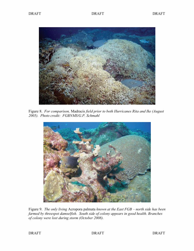
Figure 8. For comparison, Madracis field prior to both Hurricanes Rita and Ike (August
2005). Photo credit: FGBNMS/G.P. Schmahl
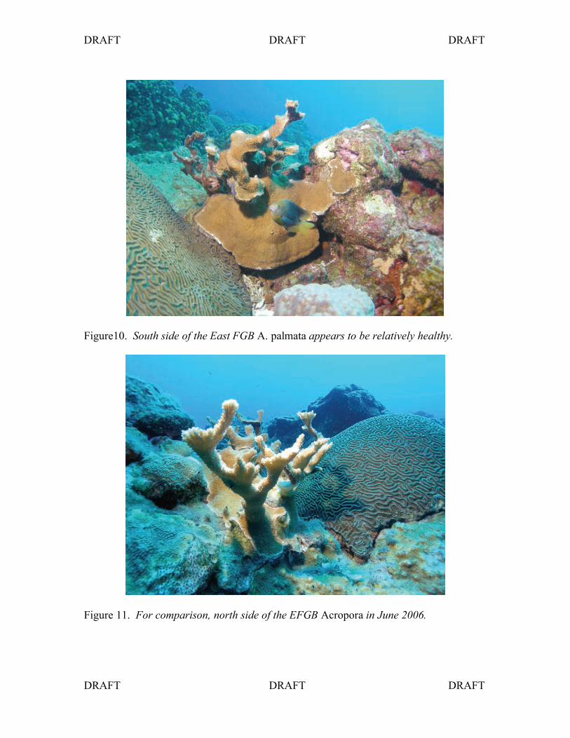
Figure 9. The only living Acropora palmata known at the East FGB – north side has been
farmed by threespot damselfish. South side of colony appears in good health. Branches
of colony were lost during storm (October 2008).
DRAFT DRAFT DRAFT
DRAFT DRAFT DRAFT
Figure10. South side of the East FGB A. palmata appears to be relatively healthy.
Figure 11. For comparison, north side of the EFGB Acropora in June 2006.

DRAFT DRAFT DRAFT
DRAFT DRAFT DRAFT
Figure 12. SE corner marker of the study site at the East FGB, slightly askew (October
2008).
Figure 13. Long term monitoring repetitive station pin, bent in place (October 2008).

DRAFT DRAFT DRAFT
DRAFT DRAFT DRAFT
East Flower Garden Bank buoy #5.
Figure 14. Remains of recruitment rack, study site for University of Calgary student,
Sarah Davies (October 2008).
Figure 15. Recruitment rack as it was at the end of August 2008.

DRAFT DRAFT DRAFT
DRAFT DRAFT DRAFT
Figure 16. YSI and Seabird water quality instruments at EFGB (October 2008).
Figure 17. Scouring around a large coral outcropping on the sand flat between buoy
numbers 4 and 5 at the EFGB (October 2008).

DRAFT DRAFT DRAFT
DRAFT DRAFT DRAFT
Figure 18. Captain Darrell scooters over a large brain coral colony (Colpophyllia
natans) toppled in the sand flat (October 2008).
West Flower Garden Bank buoy #2
Figure 19. The YSI and Seabird water quality instrument partially buried in sandflat at
buoy #2 on WFGB (October 2008).

DRAFT DRAFT DRAFT
DRAFT DRAFT DRAFT
Figure 20. Giant barrel sponge, Xestospongia muta, exhibiting exposed tissue where
portions of the barrels have been sheared off during the storm. This is the sponge that is
on the southeast side of the West FGB Acropora palmate (October 2008).
Figure 21. The only known living Acropora palmata on the West Flower Garden Bank,
tucked in behind the sponge as shown in Figure 20 (October 2008).

DRAFT DRAFT DRAFT
DRAFT DRAFT DRAFT
Figure 22. A similar shot of the WFGB Acropora and sponge taken in February 2005 –
pre-Rita.
Figure 23. Same colony of WFGB Acropora in June 2006, nine months after the passage
of Hurricane Rita. The barrels on the left side of the giant barrel sponge (Xestospongia
muta) were sheared off.

DRAFT DRAFT DRAFT
DRAFT DRAFT DRAFT
Figure 24. A similar shot of the WFGB Acropora and sponge taken in July 2008. You
can see the barrels on the upper left side are recovering nicely after impacts caused by
Hurricane Rita in 2005.
Figure 25. Eric McHugh and Marissa Nuttall hover over large boulders of dislodged
corals close to the WFGB#2 mooring (October 2008).

DRAFT DRAFT DRAFT
DRAFT DRAFT DRAFT
Figure 26. Eric McHugh shoots video inside a crater left behind by a dislodged boulder
coral (October 2008).
Figure 27. Inside the crater looking
southwest towards the coral colony that
was dislodged, approximately 25 feet
away (October 2008).

DRAFT DRAFT DRAFT
DRAFT DRAFT DRAFT
Discussion
The impacts from Hurricane Ike are reminiscent of the impacts observed and documented
after Hurricane Rita in September of 2005. However, in general the observations suggest
that a higher degree of mechanical damage has occurred as a result of the passage of
Hurricane Ike. On a positive note, the lack of bleaching may mean that the reef is in a
better position to rebound from this natural impact, than after Rita.
In August 2008, the FGBNMS research team dove on the Madracis field at EFGB and
had commented on the healthy condition observed – an indication that the species was
recovering from the injury after Rita in 2005. We have also been observing the regrowth
of the large barrel sponges, Xestospongia muta, since Rita. Based on the post-Rita and
Ike observations on the reef crest at the Flower Garden Banks, we have a better
understanding of what has shaped the reef over thousand of years, what is driving the
shape of the individual colonies, and the level of resilience and recovery capabilities this
coral reef has.
Figure 28. On the right the exposed tissue of the sponge caused by shearing during
Hurricane Ike is seen, the left side of the sponge shows the recovery of barrels that were
sheared off in September 2005 during Hurricane Rita. In the foreground, details of the
malady exhibited around the “horn” of the WFGB Acropora palmata is shown (October
2008).
DRAFT DRAFT DRAFT
DRAFT DRAFT DRAFT
RECOMMENDATIONS
The objective of this cruise was to take a quick look at the coral reef caps at the East and
West Flower Garden Banks so that we can plan and prepare for more rigorous,
quantitative assessment cruises in the near future. Not only is it imperative that a full
assessment of the reef cap be undertaken by divers, but resources be made available to
conduct deeper water assessments both within the sanctuary using ROV and mapping
technology, and at surrounding reefs and banks in the northwestern Gulf of Mexico of
interest to the Flower Garden Banks NMS, as identified through the sanctuary
Management Review process.
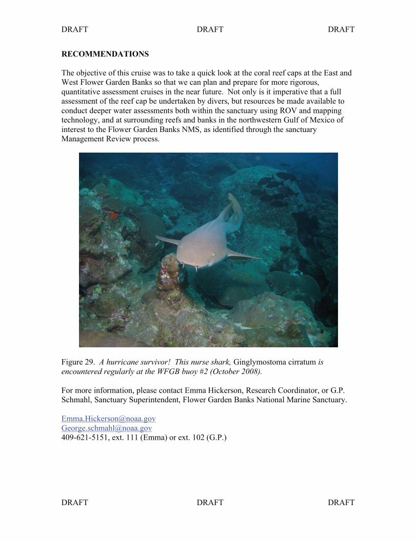
Figure 29. A hurricane survivor! This nurse shark, Ginglymostoma cirratum is
encountered regularly at the WFGB buoy #2 (October 2008).
For more information, please contact Emma Hickerson, Research Coordinator, or G.P.
Schmahl, Sanctuary Superintendent, Flower Garden Banks National Marine Sanctuary.
409-621-5151, ext. 111 (Emma) or ext. 102 (G.P.)